kenneth w. hudnut usgs, pasadena, ca west newport beach association public forum, newport beach city...
TRANSCRIPT

Kenneth W. Hudnut USGS, Pasadena, CA
West Newport Beach AssociationPublic Forum, Newport Beach City Hall
March 5, 2003
Coping withCoping with‘‘quakesquakes

What is an earthquake?What is an earthquake?What is an earthquake?What is an earthquake?
Sudden slip of one block of rock across another
Produces shaking as one of its effects
The shaking is what you feel

Earthquakes are driven by plate Earthquakes are driven by plate tectonic motiontectonic motion
As the Farallon plate subducted, the San Andreas fault was born
In the past 5 million years, this motion has been steady at about 2 inches per year (that’s 15 feet per century or 30 miles per million years!)
Movie by T. Atwater, UCSB
QuickTime™ and aAnimation decompressorare needed to see this picture.

Earthquakes are driven by plate Earthquakes are driven by plate tectonic motiontectonic motion
In the past 5 million years, this motion has been steady at about 2 inches per year (that’s 15 feet per century or 30 miles per million years!)
Yes, LA will be in San Francisco
No, LA will not fall into the sea
Movie by T. Atwater, UCSB
QuickTime™ and aAnimation decompressorare needed to see this picture.
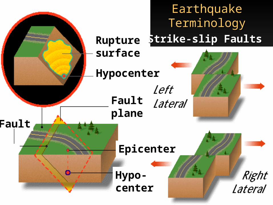
Earthquake Earthquake TerminologyTerminology
Strike-slip FaultsStrike-slip FaultsRupturesurface
Hypocenter
Hypo-center
Epicenter
Faultplane
Fault

strike-slipstrike-slip - Hector Mine (M - Hector Mine (Mww7.1)7.1)
Photo by Paul ‘Kip’ Otis-Diehl,USMC, 29 Palms

‘A rip in the desert canvas’- Los Angeles Times
Katherine Kendrick, USGS
Chris Walls, Earth Consultants International

What Controls theWhat Controls theLevel of Shaking?Level of Shaking?What Controls theWhat Controls theLevel of Shaking?Level of Shaking?
Magnitude– More energy released
Distance– Shaking decays with distance
Local soils– Amplify the shaking

Undamaged buildings on the faultUndamaged buildings on the fault
1906San Francisco

Damage at Damage at great great
distancedistance
The Bay Bridge
1989 Loma Prieta
The Marina District

Probabilistic Seismic Hazard AnalysisProbabilistic Seismic Hazard AnalysisProbabilistic Seismic Hazard AnalysisProbabilistic Seismic Hazard Analysis
Determine the rate of earth-quakes
Probable earthquake forecast for 30-year time frame for the southern California region

California has many faults!California has many faults! San Andreas fault
carries about 2/3 of the plate boundary motion
Faults such as the Newport-Inglewood and ‘blind thrust’ faults also pose significant hazards

Los Angeles metro region faultsLos Angeles metro region faults
The Newport-Inglewood (NIF) is one of many faults that pose hazard to Newport Beach
NIF has been seriously considered as a potential source for a devastating earthquake
QuickTime™ and aTIFF (Uncompressed) decompressorare needed to see this picture.

Newport-Inglewood faultNewport-Inglewood fault
Killed 120 people in the 1933 earthquake; 70th anniversary next Monday
Oil production from six
fields led to very detailed mapping and subsurface imaging


San Joaquin Hills faultSan Joaquin Hills fault
Grant et al. - suggested on basis of deformed and uplifted marine terraces
Hazard impact is uncertain but official hazard maps will attempt to include it in future revisions


Living with earthquakesLiving with earthquakeswithout without predictionprediction
Living with earthquakesLiving with earthquakeswithout without predictionprediction
Build to withstand earthquakesEarthquakes don’t kill people—buildings do
Evaluate earthquake rates “Climate” not prediction
State-of-the-Art Earthquake Monitoring Improve earthquake response Earthquake early warning
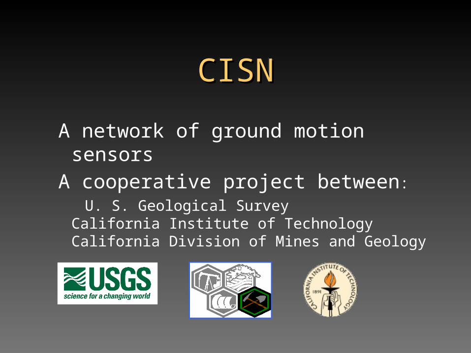
CISNCISNCISNCISN
A network of ground motion sensorsA cooperative project between:
U. S. Geological SurveyCalifornia Institute of Technology California Division of Mines and Geology

The SCIGN array uses GPS The SCIGN array uses GPS to measure the buildup and to measure the buildup and
release of strain on the release of strain on the fault system in southern fault system in southern
CaliforniaCalifornia

Improved responseImproved responseImproved responseImproved response
Post-disaster mitigation
Reducing actual losses
–Fires
–Aftershocks and foreshocks
–Search and rescue


EarthScopeEarthScopeand ANSSand ANSS
CISN and SCIGN in SoCal (since 1994 Northridge earthquake) are state-of-the-art arrays
Prototypes for deployment at large-scale in ANSS and EarthScope

http://pasadena.wr.usgs.gov/
http://www.scign.org/
http://www.trinet.org/
For additional information –
Arthur C. Clarke's 2nd Law:
"The only way of discovering the limits of the possible
is to venture a little way past them into the impossible."
USGS photoby John Galetzka