kayenta township multimodal transportation study - final ... · 2012 multimodal transportation...
TRANSCRIPT

KAYENTA TOWNSHIP MULTI-MODAL TRANSPORTATION STUDY PROPOSED SCOPE OF WORK
9 JUNE 2011 Page 0 of 15
Kayenta Township 2012 Multimodal Transportation Study
Final Report 28 June 2012
Prepared By:
ADOT MPD Task Assignment 23‐11(c) / Contract # T08‐49‐U0001

Kayenta Township
2012 Multimodal Transportation Study Final Report
Prepared for: Kayenta Township
ADOT-MPD Task Assignment 23-11(C)
Contract # T08-49-U0001 28 June 2012
Prepared by:
Monument Valley Close


July 6, 2012 Don Jackson, Town Engineer The Kayenta Township P.O. Box 1490 Kayenta, AZ 86033 Subject: 2012 Kayenta Township Multimodal Transportation Study Draft Final Report Compatibility with Kayenta Comprehensive Plan Dear Don: The purpose of this letter is to establish compatibility between the aforementioned study and the Kayenta Comprehensive Plan completed in 2011 and adopted by the Kayenta Township, Navajo Nation. I am writing this letter both as a Kayenta Township General Plan and Zoning Ordinance consultant and as a member of the 2012 Kayenta Township Multimodal Transportation Study Technical Advisory Committee. Representatives from ADOT and from the EPS Group, Inc, the consultant team working on this study, were engaged in the Kayenta Comprehensive Plan process from its inception. Their involvement included attendance to an initial kick-off meeting, Community Conversations and the week-long Design Charrette as well as ongoing communications. Don Sneed with ADOT and Paul Basha with the EPS Group were acting members of the Kayenta Comprehensive Plan Stakeholders Team. Don Sneed joined The Planning Center and Arrowhead Engineering during an initial walkabout of Kayenta Township and a tour of its road network at early stages of the Kayenta Comprehensive Plan planning process. Paul Basha and Elijah Williams with the EPS group attended the Comprehensive Plan Design Charrette. In addition, as the Town Engineer, you provided excellent lines of communication for both project teams. Prior to finalizing the Comprehensive Plan, conceptual drawings were submitted to the EPS Group and ADOT for review and comment and revised in accordance with their comments. As a result of this ongoing collaboration, both teams worked closely. In addition, both teams were cognizant of the need for such collaboration in order to ensure Kayenta Township’s long-range success. After reviewing the Kayenta Township 2012 Multimodal Transportation Study Draft Final Report provided by Paul Basha during our last TAC meeting, the result of this collaboration is obvious. Most public involvement comments provided during this process are consistent with those provided during the Comprehensive Plan. The study furthers the policy direction of several elements of the Comprehensive Plan by prioritizing transportation-related improvements and by listing additional recommended studies as part of its prioritized Implementation Plan. The Multimodal Transportation Study is a major step towards Comprehensive Plan implementation. It was a pleasure to serve Kayenta Township as a member of the TAC for this project and a pleasure to work with you, Don Sneed, Paul Basha and Elijah Williams during the duration of both projects. We enjoy working as a team with our clients. If you have any questions, please don’t hesitate to contact me. We hope to continue to assist Kayenta Township in becoming a sustainable destination. Sincerely, THE PLANNING CENTER
Maria Masque Principal CC: Don Sneed, ADOT; Paul Basha, EPS Group; Elijah Williams, EPS Group.

i
2012 Kayenta Township Multimodal Transportation Study Final Report
ADOT-MPD Task Assignment 23-11(C) Contract # T08-49-U0001
Table of Contents
STUDY BACKGROUND ....................................................................................................................................... 1 Introduction and Objective ................................................................................................................................ 1 Project Management Team and Technical Advisory Committee ...................................................................... 1 Location ............................................................................................................................................................ 3
CURRENT AND FUTURE CONDITIONS ............................................................................................................ 5 Current Population and Demographic Conditions ............................................................................................ 5 Current Roadways ............................................................................................................................................ 5 Recent Roadway Improvements ....................................................................................................................... 9 Current Traffic Volume ...................................................................................................................................... 9 Historic Traffic Collisions ................................................................................................................................ 17 Existing Land Use ........................................................................................................................................... 22 Current Transit Services ................................................................................................................................. 24 Current Non-Motorized Transportation Services ............................................................................................ 28 Current Environmental Conditions .................................................................................................................. 28
A. Introduction ......................................................................................................................................... 28 B. Environmental Justice ......................................................................................................................... 28 C. Topography and Soils ......................................................................................................................... 33 D. Visual Resources ................................................................................................................................ 33 E. Air Quality ........................................................................................................................................... 33 F. Noise Impacts ..................................................................................................................................... 34 G. Water Quality ...................................................................................................................................... 34 H. Floodplains .......................................................................................................................................... 35 I. Biological Resources .......................................................................................................................... 35 J. National Parks, Recreation Areas, Wilderness Areas, and Other Special Status Lands .................... 39 K. Section 4(f) Properties (parks, recreation areas, refuges) .................................................................. 39 L. Cultural Resources/Section 4(f) Properties ......................................................................................... 41
Stakeholder Interviews ................................................................................................................................... 44 Future Population and Demographic Conditions ............................................................................................ 45 Future Land Use ............................................................................................................................................. 45 Future Transit Services ................................................................................................................................... 54 Future Non-Motorized Transportation Services .............................................................................................. 59 Future Environmental Conditions ................................................................................................................... 60
20-YEAR IMPROVEMENT PLAN ....................................................................................................................... 63 Recommended Transportation Improvement Projects ................................................................................... 63 Project Evaluation Criteria .............................................................................................................................. 66 Implementation Plan ....................................................................................................................................... 70 Public Involvement .......................................................................................................................................... 74 Functional Classification ................................................................................................................................. 75 Access Management ...................................................................................................................................... 77 Transportation Funding Sources .................................................................................................................... 81

ii
2012 Kayenta Township Multimodal Transportation Study Final Report
ADOT-MPD Task Assignment 23-11(C) Contract # T08-49-U0001
List of Figures
Figure 1: Navajo Nation Agencies ........................................................................................................................ 3 Figure 2: Western Agency – Kayenta Chapter ..................................................................................................... 4 Figure 3: Kayenta Township Multimodal Transportation Study Boundary ............................................................ 5 Figure 4: Traffic Signal Locations ......................................................................................................................... 7 Figure 5: Existing Roadway Type and Surface Proportion ................................................................................... 8 Figure 6: Unpaved Roadway ................................................................................................................................ 8 Figure 7: Traffic Measurement Locations ............................................................................................................. 9 Figure 8: Current Daily Traffic Volumes .............................................................................................................. 11 Figure 9: Current Morning Peak Hour Traffic Volumes ....................................................................................... 12 Figure 10: Current Evening Peak Hour Traffic Volumes ..................................................................................... 13 Figure 11: Current Average Speeds ................................................................................................................... 14 Figure 12: Current 85th Percentile Speeds ......................................................................................................... 15 Figure 13: Current Vehicle Classification Percentages ...................................................................................... 16 Figure 14: Collisions per Year ............................................................................................................................ 17 Figure 15: 1999 to 2010 Manner of Collision ...................................................................................................... 18 Figure 16: 1999 to 2010 Collision Cause ............................................................................................................ 19 Figure 17: 1999 to 2010 Collision Time .............................................................................................................. 20 Figure 18: 1999 to 2010 Collision Location ........................................................................................................ 21 Figure 19: Kayenta Township Existing Generalized Land Uses ......................................................................... 22 Figure 20: Kayenta Township Existing Generalized Land Use Proportions ....................................................... 23 Figure 21: Current Kayenta Transit Services Schedule ...................................................................................... 24 Figure 22: Hypothetical Transit Route ................................................................................................................ 25 Figure 23: Latent Transit Demand – Graphical Methodology ............................................................................. 27 Figure 24: Kayenta Township Census Tract ....................................................................................................... 30 Figure 25: Kayenta Township Future Generalized Land Uses ........................................................................... 47 Figure 26: Kayenta Township Future Generalized Land Use Proportions ......................................................... 48 Figure 27: Kayenta Township Future Primary Street System ............................................................................. 49 Figure 28: Traffic Analysis Zones ....................................................................................................................... 50 Figure 29: Comprehensive General Plan Build-out Estimated Future Daily Traffic Volumes ............................. 51 Figure 30: Comprehensive General Plan Build-out Estimated Future Morning Peak Hour Traffic Volumes ...... 52 Figure 31: Comprehensive General Plan Build-out Estimated Evening Peak Hour Traffic Volumes ................. 53 Figure 32: Future Potential Transit Route ........................................................................................................... 54 Figure 33: Future Transit Demand – Graphical Methodology ............................................................................. 57 Figure 34: Typical Mini-bus – External View ....................................................................................................... 58 Figure 35: Typical Mini-bus – Internal View ........................................................................................................ 59 Figure 36: Recommended Improvement Project Locations ................................................................................ 73 Figure 37: Existing Intersection Spacing Improvement Locations ...................................................................... 79

iii
List of Tables Table 1: Project Management Team .................................................................................................................... 1 Table 2: Technical Advisory Committee ............................................................................................................... 2 Table 3: Recent Notable Street Improvement Projects ........................................................................................ 9 Table 4: Road Segment Daily Factors ................................................................................................................ 10 Table 5: US-160 / US-163 Intersection Daily Factors ......................................................................................... 10 Table 6: Annual Collision Data – Navajo DOT and ADOT .................................................................................. 17 Table 7: Current Anticipated Transit User Populations ....................................................................................... 25 Table 8: Existing Transit Demand Service Factors ............................................................................................. 26 Table 9: Existing Latent Transit Demand ............................................................................................................ 26 Table 10: Transit Demand – Graphic Methodology ............................................................................................ 27 Table 11: 2010 Census Racial and Ethnic Demographics ................................................................................. 32 Table 12: 2010 Census Disadvantaged Populations .......................................................................................... 32 Table 13: USFWS Listed Species in Navajo County and Occurrence Potential ................................................ 36 Table 14: Cultural Resources Within the Kayenta Multimodal Transportation Study Area ................................. 42 Table 15: Traditional Cultural Properties Within the Kayenta Multimodal Transportation Study Area ................ 43 Table 16: Generalized Land Use Categories ...................................................................................................... 46 Table 17: Potential Transit Route Schedule ....................................................................................................... 55 Table 18: Future Predicted Transit User Populations ......................................................................................... 56 Table 19: Future Predicted Transit Demand Service Factors ............................................................................. 56 Table 20: Future Predicted Transit Demand ....................................................................................................... 56 Table 21: Transit Demand – Graphic Methodology ............................................................................................ 58 Table 22: Recommended Improvement Evaluation Matrix – Equestrian, Multi-use, and Transit ....................... 67 Table 23: Recommended Improvement Evaluation Matrix – Residential Neighborhoods, Other, BIA Roads, and
Navajo Nation Roads .................................................................................................................................. 68 Table 24: Recommended Improvement Evaluation Matrix – US-163 and US-160 ............................................ 69 Table 25: Prioritized Recommended Improvement Projects .............................................................................. 71 Table 26: Prioritized Recommended Improvement Projects .............................................................................. 72
List of Appendices Kayenta Township Documents ............................................................................................................................ A Navajo Nation Ordinance .................................................................................................... A.1 Kayenta Township Resolution ............................................................................................. A.2 Weekday Traffic Count Adjustment Calculations ................................................................................................. B Road Segment Approach and Departure Traffic Counts .................................................... B.1 US-160 / US-163 Intersection Approach and Departure Traffic Counts.............................. B.2 Traffic Speed Data ............................................................................................................................................... C Environmental References .................................................................................................................................. D Public Involvement Summary Report – Phase 1 ................................................................................................. E Public Involvement Summary Report – Phase 2 .................................................................................................. F

2012 Kayenta Township Multimodal Transportation Study Final Report
Page 1 of 91
STUDY BACKGROUND
Introduction and Objective
The Kayenta Township Multimodal Transportation Study was funded through the Arizona Department of Transportation (ADOT) Planning Assistance for Rural Areas (PARA) Program. The Kayenta Township study addresses a broad range of local and regional planning issues related to roadway, transit, and non-motorized transportation modes. This report contains planning level recommendations for improvements over 5-, 10-, and 20-year periods, and a long range transportation plan incorporating both roadway and multimodal needs of the Township area. The Kayenta Township exists as part of the Kayenta Township Pilot Project (KTPP). This is a unique status within the Navajo Nation that grants Kayenta greater autonomy in the planning and development of future economic and infrastructure growth policies. This unique status enhances the need and usefulness for Comprehensive General Planning and analysis studies. There have been two recent studies completed regarding future transportation in Kayenta Township. The Navajo Nation Long Range Transportation Plan, completed in 2009, addressed a broad range of transportation issues related to all areas within the Navajo Nation, including Kayenta. A Draft Kayenta Township Comprehensive General Plan was also completed in 2011 which addressed future planning issues, including general transportation elements. This study will build upon previous reports and aid in Kayenta’s system performance and preservation; mobility and access for people and goods; environment and quality of life; community planning and coordination; mobility and economic competiveness; tourism; recreation; safety; accessibility; and resource conservation. The Kayenta Multimodal Transportation Study has also been accomplished in cooperation and collaboration with the Kayenta Township Comprehensive General Plan and Zoning Ordinance planning process with the assistance of the firms of Arrowhead Engineering and The Planning Center.
Project Management Team and Technical Advisory Committee
A Project Management Team (PMT) oversaw the monthly activities of the study process and worked to ensure that scope of work tasks were accomplished. The PMT consisted of the individuals listed in Table 1.
Table 1: Project Management Team
Kayenta Township Don Jackson, Kayenta Township, Town Engineer Gabriel Yazzie, Kayenta Township, Development Services Director Philbert Tso, Kayenta Township, Building Official Martha Bailey, Kayenta Township, Executive Assistant Geneva Luna, Kayenta Township, Administrative Assistant
Arizona Department of Transportation Don Sneed, ADOT, MPD, Tribal Planning and Coordination, Senior Planner Rodney Wigman, ADOT, CCP, Holbrook District Community Relations Officer
EPS Group (Technical Consultant) Darrell Truitt, PE, EPS Group, Project Principal Elijah Williams, PE, EPS Group, Project Manager Paul Basha, PE, PTOE, EPS Group, Senior Traffic Engineer

2012 Kayenta Township Multimodal Transportation Study Final Report
Page 2 of 91
Intrinsic (Public Involvement Consultant) Dexter Albert, Intrinsic (Project Manager) Jason Hurd, Intrinsic (Project Coordinator) A Technical Advisory Committee (TAC) was also established to closely coordinate, advise, and review the Study. The TAC consisted of the individuals listed in Table 2.
Table 2: Technical Advisory Committee
Kayenta Township Don Jackson, Township Engineer Andre Cordero, Township Manager Gabriel Yazzie, Development Services Director Philbert Tso, Building Official
Kayenta Township General Plan and Zoning Ordinance Consultants Merwin Yellowhair, P.E., Principal Engineer, Arrowhead Engineering, Inc. Maria Masque, Principal Planner, The Planning Center
Kayenta Chapter Stanley Clitso, Chapter President (or his representative)
Navajo County Leo Sheppard, Engineering Transportation Liaison
Navajo Division of Transportation Paulson Chaco, Director (or his representative) Darryl Bradley, P.E., Principal Civil Engineer
Navajo Transit System Lee Bigwater, Department Manager
BIA Western Navajo Agency Roland Becenti, P.E. Supervisory Highway Engineer Henry Begay, Highway Engineer
Northern Arizona Council of Governments Chris Fetzer, Planning Director
Arizona Department of Transportation Don Sneed, Senior Planner, Multimodal Planning Division Rodney Wigman, Holbrook District Community Relations Officer Lynn Johnson, District Engineer, Holbrook District Office (or his representative) Ondrea Barber, Environmental Planning Group
United States Environmental Protection Agency Adhir Kackar, USEPA Office of Sustainable Communities Ryan Bouma, AECOM Consultant

2012 Kayenta Township Multimodal Transportation Study Final Report
Page 3 of 91
Location
Kayenta Township is located within the Kayenta Chapter, the Tuba City (Western) Agency, and the Navajo Nation. It is the only municipally structured government within the Navajo Nation and is regarded as a political sub-division of the Nation that operates under the management of a five-member Board of Commissioners. Kayenta Township is also within Navajo County in the State of Arizona. The Navajo Nation granted township status to Kayenta on 26 January 1996. Kayenta township Home Rule was established by the Kayenta Township Commission on 9 May 2005. Appendix A.1 provides a copy of the Navajo Nation Ordinance and Appendix A.2 provides a copy of the Kayenta Township resolution. The Navajo Nation consists of five agencies as indicated in Figure 1. Agencies are similar to states in the United States political jurisdiction. They are an intermediary form of government between the Navajo Nation and the Chapters. The Western Agency office is located in Tuba City. The Western Agency extends into the state of Utah, the Shiprock Agency extends into the states of Utah and New Mexico, and the Eastern Agency extends into the state of New Mexico.
Figure 1: Navajo Nation Agencies
Navajo Nation Agencies
SHIPROCK AGENCY(NORTHERN)
EASTERN AGENCY
TUBA CITY AGENCY(WESTERN)
CHINLE AGENCY(CENTRAL)
FORT DEFIANCE AGENCY(SOUTHERN)
HOPI
KAYENTA
N.T.S.
N

2012 Kayenta Township Multimodal Transportation Study Final Report
Page 4 of 91
Within the five agencies are 110 chapters – 16 of which are in the Western Agency. Chapters are partially analogous to the typical United States political jurisdiction of counties or parishes. Each Chapter elects officers and adheres to conventional parliamentary procedures. Figure 2 depicts the chapters within the Western Agency and indicates Kayenta Chapter. In accordance with the Navajo Nation Local Governance Act of 27 April 1998, Chapter government can authorize by resolution, consistent with Navajo law and subject to local rules and regulations, the issuance of leases, contracts with the Navajo Nation and other Chapters, the appropriation and reallocation of funds, the establishment of administrative procedures, the levying of local taxes, the development and amendment of land use plans, the acquisition of property by eminent domain, the acquisition and administration of capital improvement project funds, the issuance of community bonds, and the enactment of zoning and regulatory ordinances. [Adapted from: Navajo Nation Government, Fourth Edition, Office of Navajo Government Development, Window Rock, Navajo Nation.] Figure 2: Western Agency – Kayenta Chapter
N.T.S.
N
KAYENTA

2012 Kayenta Township Multimodal Transportation Study Final Report
Page 5 of 91
CURRENT AND FUTURE CONDITIONS
Current Population and Demographic Conditions
According to the 2010 United States Census, Kayenta Township had a total population of 5,189 persons with 1,602 housing units. Of these persons, 92% were American Indian, 4.5% were white, 2.5% self-identified as two or more races, and 1% were other. Approximately 47% of the population resided in owner-occupied homes, and 53% resided in rented homes. Approximately 39% of the Kayenta Township population is under 18 years old, 22% are between 18 and 35, 19% are between 35 and 50, 15% are between 50 and 65, and 5% are over 65 years old.
Current Roadways
As indicated in Figure 3, Kayenta Township is served primarily by US-160 and US-163.
Figure 3: Kayenta Township Multimodal Transportation Study Boundary
Multimodal Transportation Study Boundary
Study Boundary
TOWNSHIPBOUNDARY
N.T.S.
N
163
160

2012 Kayenta Township Multimodal Transportation Study Final Report
Page 6 of 91
Two primary Bureau of Indian Affairs (BIA) routes also exist within the Kayenta Township borders – Route 6485 serves northwest Kayenta Township and continues west to a diversion dam and then south to intersect with US-160 approximately 8.8 miles west of US-163. BIA Route 591 extends south from the US-163 / US-160 intersection approximately 16.7 miles to the community of Chilchinbeto. US-160 is the primary east-west route in the Navajo Nation. This route extends from SR-89, west of Tuba City, to the New Mexico state line – a distance of approximately 160 miles. US-160 serves as the primary access to Kayenta from the south, southwest, and southeast. This roadway also currently serves local Kayenta Township businesses in the immediate vicinity of the US-163 / US-160 intersection. In the future, it is also anticipated to provide local access to Kayenta Township properties on all four corners of the US-163 / US-160 intersection. Currently US-160 consists of one-through travel-lane-per-direction with left-turn lanes at intersections and major accesses, and right-turn lanes at some intersections. US-160 has a posted speed limit of 45 miles-per-hour east and west within approximately one-quarter mile of US-163. The posted speed limit increases on US-160 to 55 miles-per-hour approximately one-quarter mile west of US-163 and to 65 miles-per-hour approximately one-half mile east of US-163 within Kayenta Township limits. US-160 is currently constructed on the north portion of the corridor alignment right-of-way. This location enables US-160 to be readily expanded to a divided four-lane facility without disrupting existing traffic, with the current lanes becoming the westbound two-lanes at the completion of the new eastbound lanes. The only traffic signal on US-160 in Kayenta Township and its vicinity is at the US-163 and US-160 intersection. US-163 is the primary street in Kayenta Township. This route extends from its intersection with US-160 through Kayenta Township to Monument Valley and to the Utah state line – a distance of approximately 23 miles. US-163 is posted at 40 miles-per-hour through Kayenta Township, except in the vicinity of the school where it is posted at 35 miles-per-hour. US-163 also serves as the main street of the Township. Reflecting its purpose as both a through state route and a local township street, US-163 consists of two-through-lanes-per-direction with a center-two-way-left-turn lane. This configuration accommodates both through traffic and local access.

2012 Kayenta Township Multimodal Transportation Study Final Report
Page 7 of 91
Figure 4: Traffic Signal Locations
In addition to the signalized intersection of US-163 and US-160, there are two other signalized intersections on US-163 within Kayenta Township. The intersection of US-163 and the Kayenta Unified School District complex access is signalized. This access serves Kayenta Elementary School, Kayenta Middle School, and Monument Valley High School. The intersection of US-163 and BIA-6485 is signalized. The signal locations are depicted in Figure 4.
160
163
Traffic Signal Locations
N.T.S.
N

2012 Kayenta Township Multimodal Transportation Study Final Report
Page 8 of 91
While US-163 and US-160 are the primary access roads in Kayenta Township and its vicinity, these two roadways are a relatively small portion of the total roadways within Kayenta Township. Figure 5 illustrates the relative mileage of the four paved roadway types and unpaved roadway in Kayenta Township. US-163 and US-160 are approximately 7% and 8% respectively of the roadway miles within Kayenta Township. The largest roadway type is roads other than state and BIA routes representing 48% of the total street miles. Approximately 34% of the road miles in Kayenta Township are unpaved. Figure 5: Existing Roadway Type and Surface Proportion Figure 6: Unpaved Roadway
Figure 6 depicts an existing roadway in the residential area northwest of the intersection of US-163 and BIA-6485.
Unpaved Roadway
Other paved48%
Unpaved34%
US‐1608%
US‐1637% BIA Routes
3%

2012 Kayenta Township Multimodal Transportation Study Final Report
Page 9 of 91
Recent Roadway Improvements
In the past 20 years, four notable roadway improvement projects have occurred on US-160 and US-163 as indicated in Table 3.
Table 3: Recent Notable Street Improvement Projects PROJECT AS-BUILT PLAN DATE
US-160: Length of Kayenta: Pavement Resurfacing 2009
US-163: Laguna Wash Pedestrian Bridge (New Construction) 2006
US-163: US-160 to 2 miles north: Lighting 2003
US-160: Length of Kayenta: Pavement Resurfacing 1992
Current Traffic Volume
Current traffic volume, speed, and classification data for US-160 and US-163 was collected in January 2012 by the ADOT Multimodal Planning Division as indicated in Figure 7. Complete data were obtained at three locations on US-163 and two locations on US-160. Volume only data were obtained at the four approaches and departures of the US-163 and US-160 intersection. Figure 7: Traffic Measurement Locations Due to inclement weather conditions, traffic counts were not collected on portions of Monday and Tuesday. Therefore, the average of Sunday and Wednesday was used to estimate the missing hourly traffic volumes for Monday and Tuesday. Daily traffic factors were developed based on the daily road segment and US-160 / US-163 intersection traffic volumes for all seven days of the week. Table 4 provides the calculated road segment daily traffic factors and Table 5 provides the calculated US-160 / US-163 intersection daily traffic factors.
Traffic Measurement Locations
160
163
N.T.S.
N
Directional Volume, Speed, and Classification
Directional Volume Only

2012 Kayenta Township Multimodal Transportation Study Final Report
Page 10 of 91
Table 4: Road Segment Daily Factors
These data indicate atypical traffic patterns. Typically Tuesday, Wednesday, and Thursday are the days most representative of the week. For the Kayenta Township road segments; Monday, Tuesday, and Saturday are the most representative days. The highest volume days within Kayenta are Wednesday and Friday, with Sunday the lowest volume day.
Table 5: US-160 / US-163 Intersection Daily Factors These data also indicate atypical traffic patterns. For the road segments immediately adjacent to the primary intersection of US-163 and US-160; Thursday is the most representative day. Wednesday is the highest volume day and Sunday is the lowest volume day. Figure 8 provides the current daily traffic volumes. Figure 9 and Figure 10 provide the current morning and evening peak hour traffic volumes, respectively. The morning peak hour generally occurred from 11:45 AM to 12:45 PM, and the evening peak hour generally occurred from 12:00 PM to 1:00 PM. Appendix B provides the detailed count data. Appendix B.1 provides the road segment approach and departure traffic volumes, and Appendix B.2 provides the US-160 and US-163 intersection approach and departure traffic volumes.
ALL COUNT LOCATIONS
TOTAL VOLUME DAILY FACTOR
SUNDAY 16,855 1.49
MONDAY 25,369 0.99
TUESDAY 24,791 1.01
WEDNESDAY 28,485 0.88
THURSDAY 26,564 0.94
FRIDAY 28,299 0.89
SATURDAY 25,133 1.00
AVERAGE 25,071
ALL COUNT LOCATIONS
TOTAL VOLUME DAILY FACTOR
SUNDAY 17,696 1.40
MONDAY 23,450 1.06
TUESDAY 23,924 1.03
WEDNESDAY 31,714 0.78
THURSDAY 24,995 0.99
FRIDAY 27,667 0.89
SATURDAY 23,771 1.04
AVERAGE 24,745

2012 Kayenta Township Multimodal Transportation Study Final Report
Page 11 of 91
Figure 8: Current Daily Traffic Volumes
Current Daily Traffic
Volumes
160
163

2012 Kayenta Township Multimodal Transportation Study Final Report
Page 12 of 91
Figure 9: Current Morning Peak Hour Traffic Volumes
Current Morning Peak Hour Traffic Volumes
160
163

2012 Kayenta Township Multimodal Transportation Study Final Report
Page 13 of 91
Figure 10: Current Evening Peak Hour Traffic Volumes
Current Evening Peak Hour Traffic Volumes
160
163

2012 Kayenta Township Multimodal Transportation Study Final Report
Page 14 of 91
Figure 11 provides the current average speeds and Figure 12 provides the current 85th percentile speeds. Appendix C provides the detailed speed data. The 85th percentile speed is a useful measure of traffic data often used in roadway design s and speed limit determination. This statistic represents the speed at which 85% of the vehicles are traveling at or below. It also is the speed at which 15% of the vehicles are traveling above.
Figure 11: Current Average Speeds
Current Average Speeds
AVERAGE SPEEDS160
163
N.T.S.
N

2012 Kayenta Township Multimodal Transportation Study Final Report
Page 15 of 91
Figure 12: Current 85th Percentile Speeds
Current 85th
Percentile Speeds
85TH PERCENTILE SPEEDS160
163
N.T.S.
N

2012 Kayenta Township Multimodal Transportation Study Final Report
Page 16 of 91
Figure 13 provides the current vehicle classifications by percentage of cars, personal trucks, and the combined delivery vans, busses, and large trucks. The percentage of the combined large vehicles was observed to increase on US-163 in the northbound direction. This is mostly caused by regional truck traffic performing right-in-right-out turning movements.
Figure 13: Current Vehicle Classification Percentages
Current Vehicle ClassificationPercentages
WEEKLY VEHICLE CLASSIFICATION
160
N.T.S.
N
163

2012 Kayenta Township Multimodal Transportation Study Final Report
Page 17 of 91
Historic Traffic Collisions
Table 6: Annual Collision Data – Navajo DOT and ADOT Two data collision data sources were obtained for this study – the Navajo Division of Transportation (Navajo DOT) and the Arizona Department of Transportation (ADOT). These data sources are intended to be identical or at a minimum, similar. However, the data from the two sources is not consistent. Table 6 provides a comparison of the annual data from the two sources. From the 11 years of data, Navajo DOT has approximately 25% more collision reports than ADOT with the annual percentage varying from 31% fewer collision reports to 45% more collision reports. The Navajo DOT data provides limited collision information from 1999 to 2006. It provides complete collision information for the years 2007 to 2010. The ADOT data provides complete information from 1999 to 2010. The ADOT data includes the category of “Manner of Collision”, while the Navajo DOT data includes the category of “Collision Cause”. Recognizing that the Navajo DOT data includes a larger number of collisions, its data is provided in Figure 14. The ADOT data category of Manner of Collision is provided in Figure 15. The Navajo DOT data category of Collision Cause is provided in Figure 16.
Figure 14: Collisions per Year Source: Navajo Division of Transportation
Crashes
Year NDOT ADOT Difference
1999 44 31 ‐13 ‐30%
2000 52 43 ‐9 ‐17%
2001 58 33 ‐25 ‐43%
2002 28 18 ‐10 ‐36%
2003 32 28 ‐4 ‐13%
2004 47 36 ‐11 ‐23%
2005 42 23 ‐19 ‐45%
2006 27 22 ‐5 ‐19%
2007 13 17 4 31%
2008 15 15 0 0%
2009 27 22 ‐5 ‐19%
2010 35 28 ‐7 ‐20%
TOTAL 420 316 ‐104 ‐25%
0
15
30
45
60
1999 2000 2001 2002 2003 2004 2005 2006 2007 2008 2009 2010

2012 Kayenta Township Multimodal Transportation Study Final Report
Page 18 of 91
The year-to-year total collision history indicates relatively typical fluctuation without discernible patterns. The maximum number of collisions (58) per year occurred in 2001 and the minimum number of 13 occurred in 2007.
Figure 15: 1999 to 2010 Manner of Collision Source: Arizona Department of Transportation
The largest manners of collisions in 11 years were single-vehicle collisions at 30% and rear-end collisions at 28%. Typically, these types of collisions are related to travel speeds. Single-vehicle collisions are often caused by excessive speeds, and rear-end collisions often result from large speed differential. Typically angle and left-turn collisions can be resolved through roadway analysis and design – these respectively represent 6% and 5% of total collisions in 12 years.
0%
5%
10%
15%
20%
25%
30%
35%
SingleVehicle
Rear End Other SideswipeSame
Direction
Left Turn Angle(Other
Than LeftTurn)
Head On SideswipeOpposite
Direction
Rear ToSide
Unknown

2012 Kayenta Township Multimodal Transportation Study Final Report
Page 19 of 91
Figure 16: 1999 to 2010 Collision Cause Source: Navajo Division of Transportation
The three largest portions of collision cause were alcohol at 22%, driver inattention at 17%, and mechanical defects at 10% – representing approximately one-half of the total collisions in the most recent 12 years. These collisions types are difficult to prevent through roadway analysis and design.
0
0.05
0.1
0.15
0.2
0.25

2012 Kayenta Township Multimodal Transportation Study Final Report
Page 20 of 91
Figure 17: 1999 to 2010 Collision Time Source: Navajo Division of Transportation
Generally the collisions in Kayenta Township occur during daylight hours – approximately 74% of the total collisions in 12 years occurred between 6:00 AM and 8:00 PM.
0 0.02 0.04 0.06 0.08 0.1 0.12 0.14 0.16 0.18
20:00 to 21:59
22:00 to 23:59
0:00 to 1:59
2:00 to 3:59
4:00 to 5:59
6:00 to 7:59
8:00 to 9:59
10:00 to 11:59
12:00 to 13:59
14:00 to 15:59
16:00 to 17:59
18:00 to 19:59

2012 Kayenta Township Multimodal Transportation Study Final Report
Page 21 of 91
Figure 18 identifies the approximate location of the collisions in Kayenta according to the Navajo Division of Transportation records. Collisions at major intersections are indicated with a cross symbol. Collisions between major intersections are indicated with an oval symbol. The largest percentage of intersection collisions occurred at the US-160 and US-163 intersection and on US-160 at an unsignalized intersection approximately one-half mile north of US-160. The largest percentage of collisions between major intersections occurred on US-163 in the one-half mile segment north of US-160 and the three-quarter mile segment south of ADOT Road.
Figure 18: 1999 to 2010 Collision Location Source: Navajo Division of Transportation
1999 to 2010 Collision LocationStudy Boundary
163
N.T.S.
N
160
4%
6%
2%
1%
9%
2%
17%
9%
9%
2%
5%
4%
5%
11%
9%
2%4%

2012 Kayenta Township Multimodal Transportation Study Final Report
Page 22 of 91
Existing Land Use
Figure 19 indicates the existing land uses in the Kayenta planning area – an area approximately 8% larger than the Township boundaries. This 6.44 square mile area is the area considered in the current Kayenta Township Comprehensive General Plan.
Figure 19: Kayenta Township Existing Generalized Land Uses
Kayenta Township Existing Generalized
Land Uses
TOWNSHIP BOUNDARY
GENERAL PLAN BOUNDARY
RESIDENTIAL
COMMERCIAL
INSTITUTIONAL
VACANT
685
333
352
2,752
1.07
0.52
0.55
4.30
ACRES SQUARE MILESAREA
160
163
TOTAL 4,122 6.44
N.T.S.
N

2012 Kayenta Township Multimodal Transportation Study Final Report
Page 23 of 91
Figure 20 indicates the relative proportion of the current land use in Kayenta. Approximately two-thirds of the planning area is currently vacant.
Figure 20: Kayenta Township Existing Generalized Land Use Proportions
Residential17%
Institutional8%
Commercial8%Vacant
67%

2012 Kayenta Township Multimodal Transportation Study Final Report
Page 24 of 91
Current Transit Services
Currently, Kayenta Township is served by the Navajo Transit System (NTS). Figure 21 provides the current schedule for service. It indicates that two transit stops exist in Kayenta Township, one at the Police Department and one at the Mustang Store. Buses pick up and drop off passengers at both locations in the morning and in the evening. It is appropriate to estimate latent transit demand for the Kayenta Township Study Area – that is, the number of people who would utilize greater transit service if it were available. The typical procedure is provided in the Transit Cooperative Research Program (TCRP) Report 3, Workbook for Estimating Demand for Rural Passenger Transportation. This workbook provides a methodology for estimating transit demand for rural systems, using population data for the year service is proposed to be implemented and assumptions of service area size and route lengths. Figure 21: Current Kayenta Transit Services Schedule

2012 Kayenta Township Multimodal Transportation Study Final Report
Page 25 of 91
The TCRP workbook contains two methodologies: one for estimating future demand for expansion of an existing system and one for estimating future demand for a new system. As the purpose of this task is to identify potential demand for local transit service as well as the service currently provided by the NTS, the methodology for a new system was utilized. This approach requires that a hypothetical system be developed for analysis purposes only. For Kayenta, the hypothetical system used was a loop circulator following a route consisting of the proposed Comprehensive General Plan’s New Loop Road and the segment of US-163 that completes the loop, as depicted in Figure 22. Figure 22: Hypothetical Transit Route The hypothetical system would operate as a deviated fixed route circulator, completing 12 trips per day, Monday through Friday, for a total of 60 trips-per-week. As the proposed loop is approximately six miles in length, this service would equate to 360 miles-per-week, or 18,270 miles-per-year. In addition to developing a hypothetical system, the methodology requires that a service area be defined to calculate vehicle-miles-per-square-mile, an important metric for modeling purposes. The Study Area includes only 6.44 square-miles, while the Census Designated Place (CDP) comprises 13.2 square-miles. To be consistent with the Census data, the CDP area of 13.2 square-miles was used as the service area. The service of 18,270 miles-per-year divided by 13.2 square-miles yields 1,418 vehicle-miles-per-square-mile. The TCRP estimations were developed based on specific population groups within the service area. These population groups are typically referred to as transit-dependent populations, and statistically are the most likely to use transit if available. The groups include (as defined by the Census); persons aged 65 or over, persons aged 16 to 64 with mobility limitations, and persons aged 64 or under residing in households with incomes below the poverty level. Table 7 indicates the total current populations for each group in the service area.
Table 7: Current Anticipated Transit User Populations POPULATION GROUP POPULATION
Persons aged 65 or over ..................................................................................................... 253
Persons aged 16 to 64 with mobility limitations .................................................................. 629
Persons aged 64 or under in households with incomes below poverty level ................... 1,768
Hypothetical Transit Route
N.T.S.
N
160
163
New Loop Road

2012 Kayenta Township Multimodal Transportation Study Final Report
Page 26 of 91
The transit service of 1,418 vehicle miles-per-square-mile (vmpsm) is entered into a formula provided in the TCRP workbook to create a service factor for each population group. These formulae rely on given factors which are related to the vehicle miles per square mile. Table 8 indicates the calculation of the service factors necessary for calculating the transit demand estimate.
Table 8: Existing Transit Demand Service Factors TCRP #1 TCRP #2 SERVICE FACTOR POPULATION GROUP VMPSM (multiplied) (added) (per million)
Persons 65 or over .............................. 1,418 ............. 2.682 ....................... 376 ............ 0.00417956
Persons with mobility limitations .......... 1,418 ............... 1.57 .................... 1,010 ............ 0.00323655
Persons with low income ..................... 1,418 ............... 2.45 ....................... 525 ............ 0.00399959 These derived service factors, based on the frequency of service and size of the service area, are part of the final calculations to estimate transit demand. Table 9 provides the estimated transit demand by population group and total. This methodology estimates a total yearly demand (all trips made during one year) for the Kayenta Service Area of 12,201 trips, an average of approximately 39 trips-per-day (assuming 312 days of service).
Table 9: Existing Latent Transit Demand TCRP SERVICE ANNUAL POPULATION GROUP FACTOR POPULATION FACTOR DEMAND
Persons 65 or over ........................... 1,200 .................. 253 ............... 0.00417956 .............. 1,269
Persons with mobility limitations ....... 1,200 .................. 629 ............... 0.00323655 .............. 2,444
Persons with low income .................. 1,200 ............... 1,768 ............... 0.00399959 .............. 8,488
TOTAL 12,201 The TCRP workbook includes an alternative method for estimating transit demand. This alternative method provides a secondary demand estimate that can be compared against the first. This alternative method is based on pre-calculated trip rate curves created from research and analysis of other rural transit programs. The chart compares vehicle-miles-per-square-mile (derived as described above) against annual-trips-per-person. The trip rates for the Kayenta service based on 1,418 vehicle-miles-per-square-mile for each population group are overlaid on the TCRP workbook chart as depicted in Figure 23.

2012 Kayenta Township Multimodal Transportation Study Final Report
Page 27 of 91
Figure 23: Latent Transit Demand – Graphical Methodology The estimated trip rates from Figure 23 are used to estimate the demand for each population group as indicated in Table 10.
Table 10: Transit Demand – Graphic Methodology TRIP ANNUAL POPULATION GROUP POPULATION RATE DEMAND
Persons 65 or over ........................................... 253 ................................. 4.22 ..................... 1,068
Persons with mobility limitations ....................... 629 ................................. 3.54 ..................... 2,227
Persons with low income ............................... 1,768 ................................. 3.25 ..................... 5,746
TOTAL 8,941 The total estimated demand with this alternative graphic method is 8,941 annual trips, or approximately 29 trips per day (assuming 312 service days). Therefore, the existing latent transit demand is approximately 9,000 to 12,000 annual trips or 30 to 40 daily trips.
Latent Transit Demand –Graphical
Methodology
4.22
3.54
3.25
0
1
2
3
4
5
6
0 200 400 600 800 1,000 1,200 1,400 1,600 1,800 2,000
AN
NU
AL
TR
IPS
PE
R P
ER
SO
N
ANNUAL VEHICLE-MILES PER SQUARE-MILE
OVER 65 YEARS OLD MOBILITY LIMITED BELOW POVERTY KAYENTA TOWNSHIP

2012 Kayenta Township Multimodal Transportation Study Final Report
Page 28 of 91
Current Non-Motorized Transportation Services
There are approximately 13.2 miles or 69,500 linear feet of sidewalk in Kayenta Township. Of this total: 23,000 linear feet is immediately adjacent to US-163; 2,200 linear feet is immediately adjacent to US-160; 33,000 linear feet is within subdivisions; 7,500 linear feet is within the school properties; and 3,500 linear feet is adjacent to US-163 north of the township limits. There are no bicycle lanes or paths in Kayenta Township. There are also no designated equestrian trails in the Township.
Current Environmental Conditions
A. Introduction Coordination with federal, tribal, and local agencies was conducted to obtain information about the environmental resources in the study area. Specific information was also obtained to define the existing social, economic, and environmental characteristics of the study area and to assist the study team in identifying particular constraints to be considered in the development and preliminary analyses of transportation alternatives. Based on a review of the study area, there is no prime or unique farmland, sole source aquifer, wetlands, designated critical habitat, or wild and scenic rivers present in the study area. These resources are not addressed further in this document. The following sections summarize the current information and identify the level of concern or sensitivity for each environmental issue. B. Environmental Justice Title VI of the Civil Rights Act of 1964 and related statutes ensure that individuals are not excluded from participation in, denied the benefit of, or subjected to discrimination under any program or activity receiving federal financial assistance on the basis of race, color, national origin, age, sex, and disability. Executive Order 12898 directs that federal programs, policies, and activities do not have disproportionately high and adverse human health and environmental effects on minority and low-income populations. Data from the 2010 U.S. Decennial Census (2010 Census) were recently released and were used, where possible, to provide the most current information on the presence of protected populations. However, due to changes in the format of the Decennial Census, the 2010 Census did not collect the same information collected during the 2000 U.S. Decennial Census (2000 Census). Therefore, multiple sources of data were needed to fill in the gaps. The most recent data available were used for each population category of interest, as follows:
Summary File 1 of the 2010 Census1 was used to obtain information on the presence of racial and ethnic minorities, the elderly, and female heads of household (Census Bureau 2010).
The 2005–2009 American Community Survey2 (ACS) was used to obtain information on the presence of persons living below the poverty level (Census Bureau 2009).
1 Summary File 1 is the only 2010 Census data set at the census tract level released at the time of this analysis. The 2010 Census is a
nearly complete survey of the entire U.S. population but did not collect information on persons living below the poverty level or disabled persons.
2 The ACS is sent every year by the U.S. Census Bureau to a subset of the U.S. population and is intended to monitor social and economic trends. Data from the ACS are only available at the census tract level as a 5-year collective estimate. The latest 5-year ACS data set at the time of this analysis was 2005–2009. The ACS is used in this document to supplement the Decennial Census by providing information about persons living below the poverty level.

2012 Kayenta Township Multimodal Transportation Study Final Report
Page 29 of 91
Summary File 3 of the 2000 Census3 was used to obtain information on the presence of disabled persons (Census Bureau 2000).
Data used in this environmental justice analysis were obtained for the one census tract (CT 9425) that covers the study area (Figure 24). Socioeconomic data for Navajo County and the State of Arizona were used as comparison populations as indicated in Table 11 and Table 12. For the purpose of this analysis, the term “moderately higher” means that the percentage of a population of interest in any one census tract is higher than the comparison population but comparable (i.e., not enough difference to be distinguished as a protected population). When the percentage of a population of interest is comparable to that of the comparison population and does not represent a majority of the population in that census tract, it is not defined as a protected population. For the purpose of this analysis, the term “meaningfully higher” indicates that the percentage of a population of interest in any one census tract is notably higher than the comparison population. When the percentage of a population of interest is notably higher than the comparison population for that tract and/or it represents a majority of the population, that tract is considered a protected population. Total Minority (2010 Census data) For this environmental justice review, a racial or ethnic minority population is an aggregate composed of the following categories: Black/African-American, American Indian and Alaska Native, Asian, Native Hawaiian and Other Pacific Islander, Other Races, Two or More Races, and Hispanic. Data from the 2010 Census indicate that minority populations are present in CT 9425 (95.5%) and the percentage of total minority populations is meaningfully higher than the corresponding percentages for Navajo County (56.1%) and the State of Arizona (42.2%). The percentage of minorities in CT 9425 also represents a majority of the population in the tract. For this review, this tract is considered a protected population, warranting further environmental justice analysis, during the design of potential projects, to determine if proposed improvements create a disproportionately high or adverse human health and environmental impact on minority populations. 3 The most current information on disabled populations is the 2000 Census. This information is not available at the census tract level
with the current 2005–2009 ACS. The ACS collects information on disabled populations but, due to a 2008 change in methodology, this information is not yet available for the 5-year data set.

2012 Kayenta Township Multimodal Transportation Study Final Report
Page 30 of 91
Figure 24: Kayenta Township Census Tract

2012 Kayenta Township Multimodal Transportation Study Final Report
Page 31 of 91
Age 60 and Older (2010 Census data) Elderly residents are defined as age 60 and older. Data from the 2010 Census indicate that elderly residents are present in the selected tracts. However, the percentage of elderly residents in CT 9425 (8.6%) is less than the corresponding percentages for Navajo County (19.0%) and the State of Arizona (19.3%) and does not represent a majority of the population in this tract. Therefore, this population does not warrant further environmental justice analysis. Female Head of Household (2010 Census data) Female head of household is defined as a household with children younger than 18 and no husband present. Data from the 2010 Census indicate that these households occur in CT 9425. However, the percentage of households with a female head of house in CT 9425 (16.5%) is comparable to the corresponding percentages for Navajo County (8.8%) and the State of Arizona (7.1%) and does not represent a majority of the population in this tract. Therefore, this population does not warrant further environmental justice analysis. Below Poverty Level (ACS data) Data from the ACS indicate that individuals living below the poverty level reside in CT 9425. The percentage of persons living below the poverty level in CT 9425 (26.9%) is comparable to the corresponding percentages for Navajo County (24.6%) and the State of Arizona (14.7%) and does not constitute a majority of the population in this tract. Therefore, this population does not warrant further environmental justice analysis. Disabled (2000 Census data) Data from the 2000 Census indicate that persons with disabilities reside in CT 9425. The percentage of persons with disabilities that reside in CT 9425 (15.5%) is less than the corresponding percentages for Navajo County (22.4%) and the State of Arizona (19.3%) and does not represent a majority of the population in this tract. Therefore, this population does not warrant further environmental justice analysis.

2012 Kayenta Township Multimodal Transportation Study Final Report
Page 32 of 91
Table 11: 2010 Census Racial and Ethnic Demographics
Area Total
Population White
African American
Native American
Asian Pacific
Islander Other Race
Two or More Races
Hispanica
# % # % # % # % # % # % # % # % CT 9425 5,281 239 4.5 13 0.2 4,873 92.3 4 0.1 1 0.02 16 0.3 131 2.5 102 1.9 Navajo County
107,449 47,181 43.9 938 0.9 46,611 43.4 580 0.5 75 0.1 3,625 3.4 2,648 2.5 11,571 10.8
State of Arizona
6,392,017 3,695,647 57.8 259,008 4.1 296,529 4.6 176,695 2.8 12,648 0.2 761,716 11.9 218,300 3.4 1,895,149 29.6
Source: U.S. Department of Commerce Bureau of the Census. Census 2010, Summary File 1.
# = Number, % =%age, CT = Census Tract. a “Hispanic” refers to ethnicity and is derived from the total population, not as a separate race; i.e., it is calculated differently from the other columns in this table.
Table 12: 2010 Census Disadvantaged Populations
Area Total
Populationa
Total Minority*a
Ages 60 and Oldera
Total Population for Whom
Disabled Is Determinedb
Disabledb
Total Population for Whom Poverty Is
Determinedc
Below Poverty Levelc Householdsa
Female Head
of Householda
# % # % # % # % # % CT 9425 5,281 5,042 95.5 452 8.6 4,516 700 15.5 4,710 1,267 26.9 1,402 232 16.5 Navajo County
107,449 60,268 56.1 20,426 19.0 87,171 19,514 22.4 108,369 26,686 24.6 35,658 3,154 8.8
State of Arizona
6,392,017 2,696,370 42.2 1,232,791 19.3 4,667,187 902,252 19.3 6,204,965 914,040 14.7 2,380,990 169,397 7.1
Sources: aU.S. Department of Commerce Bureau of the Census. Census 2010, Summary File 1
bU.S. Department of Commerce Bureau of the Census. Census 2000, Summary File 3
cU.S. Department of Commerce Bureau of the Census. American Community Survey, 2005–2009
# = Number, % =%age, CT = Census Tract.
Orange shading indicates%ages notably higher than comparison areas’%ages. * “Total Minority” is composed of all people who consider themselves Non-White racially plus those who consider themselves White Hispanic
.

2012 Kayenta Township Multimodal Transportation Study Final Report
Page 33 of 91
C. Topography and Soils The study area lies on the Colorado Plateau between approximately 5,600 to 5,800 feet elevation4. The area can generally be characterized as flat to rolling with plateaus and mesas rising in the distance. Soils in the area are of the Fruitland-Camborthids-Torrifluvents Association. These are shallow to deep, moderately coarse to moderately fine-textured, well-drained soils found on nearly level to hilly upland plains. The plains are broken by occasional steep-sided drainages and scattered buttes. The soils are formed in thick to thin wind and water-laid mantle of alluvium weathered from sandstone and shale (Hendricks 1985). Component soils of this Association, found within the Kayenta area, include soils of the Berryhill family, Cauncelor-Moclom-Hawaikuh, Denzar-Sheppard-Lithic Torriorthents complex, Gotho-Aneth family complex, Rock outcrop-Needle-Lithic Torriorthents complex, Sanfeco-Sheppard complex, Sheppard-Massadona-Monue, Sheppard-Typic Haplargids complex, Urban land-Gotho-Tewa complex, and Urban land-Nakai Complex ((USDA-SCS 1988). D. Visual Resources The visual setting of the study area is dominated by the developed community of Kayenta and undeveloped flat to rolling terrain. Vegetation in the study area consists of sage scrub and grasses with pinyon-juniper scattered throughout the higher elevations. Along the drainages, vegetation density tends to be higher. The existing foreground and midground views consist of a flat to rolling sage scrub landscape, which includes the developed township of Kayenta and undeveloped lands. A series of transportation corridors intersect the study area, including the primary roadways of US-160, US-163, BIA-6485, and BIA-591; and secondary paved and unpaved roadways. Commercial development, traffic signals, and street lighting are primarily concentrated along the US-160 and US-163 corridors, with residential development and schools found on secondary roadways. The Kayenta Airport is in the southern study area limits. Background views are dominated by distant mountain peaks and mesas, which encircle the township of Kayenta. To the northeast, dominant background views include Monument Valley, with its numerous mesa and sandstone towers, and the volcanic outcrop of El Capitan Peak. Background views to the north include the “Five Toes” sandstone hills of the Kayenta formation, with the volcanic Church Rock visible east of the study area. Black Mesa dominates the background views to the southwest, and the red canyon walls of Skeleton Mesa make up the background views to the west. As the transportation study progresses and transportation improvements are identified, sensitivity to the local visual character and the surrounding scenic vistas should be considered. A visual impact assessment would need to address the anticipated change to visual character associated with the development of transportation improvements. E. Air Quality The Clean Air Act of 1970 and associated amendments in 1977 and 1990 established National Ambient Air Quality Standards (NAAQS) for six pollutants. These pollutants, referred to as the “Criteria Pollutants,” include carbon monoxide, nitrogen dioxide, ozone, particulate matter, sulfur dioxide, and lead. Primary and secondary standards for NAAQS were established for most of the criteria pollutants. The Clean Air Act Amendments of 1990 authorized the Environmental Protection Agency (EPA) to designate those areas that have not met the NAAQS as non-attainment and to classify them according to their degree of severity. Non-attainment and/or maintenance areas for one or more criteria pollutants are in nine of 14 counties in Arizona. The Kayenta Township study area lies well outside the boundaries of the non-attainment and maintenance areas for all criteria pollutants in Arizona and is in an area that complies with all NAAQS.
4 Elevations in this document are referenced to mean sea level.

2012 Kayenta Township Multimodal Transportation Study Final Report
Page 34 of 91
Improvements to the existing transportation network could affect air quality at individual receptors through a shift in traffic patterns. Adding capacity to existing facilities or constructing new roadways could reduce traffic congestion, thereby reducing air pollutant emissions. The development of other modes of transportation (e.g., transit, bicycle, pedestrian) could also reduce emissions by reducing the number of personal vehicles on the road system. A temporary increase in air pollutant emissions would be expected during construction of transportation improvements due to equipment operation and the slower traffic speeds associated with a construction zone. However, this would be a localized condition that would cease when construction is complete. F. Noise Impacts Noise, defined as undesirable sound, is federally regulated by the Noise Control Act of 1972. This act established a national policy to promote an environment for all Americans free from noise that jeopardizes health and welfare. The act gives the EPA the authority to prepare guidelines for acceptable ambient noise levels. It also requires that federal agencies having jurisdiction over any property or facility or engaging in any activity that results or may result in the emission of noise to comply with federal, state, interstate, and local requirements respecting control and abatement of environmental noise. The proposed study area includes the Township of Kayenta. A preliminary review of the study area has identified several sensitive receptors, including residential units, schools, hotels/inns, a public library, and churches. Several of these sensitive receptors are within 1,000 feet of primary roads, such as US-160, US-163, BIA-6485, and BIA-591. A qualitative or quantitative noise analysis would need to be conducted for the proposed transportation improvements to determine the nature and extent of noise impacts. G. Water Quality Sections 404 and 401 of the Clean Water Act Congress enacted the Clean Water Act in 1972 with a primary objective to restore and maintain the integrity of the nation’s waters (33 U.S. Code 1251–1387). Section 404 of the Clean Water Act established a program to regulate the discharge of dredged and fill material into Waters of the United States (Waters). Section 401 of the Clean Water Act grants states and certain tribes (including the Navajo Nation) the authority to issue certifications that water quality standards will not be violated by proposed excavation activities. Within the Navajo Nation, an Individual Section 401 certification is required for any action regulated under Section 404. A preliminary evaluation for the presence of potential jurisdictional Waters was conducted in the study area through a review of U.S. Geological Survey topographical maps and aerial photos. Approximately five “blue line” drainages cross or border the study area. “Blue line” drainages on these topographic maps typically exhibit the characteristics of jurisdictional Waters as regulated by the U.S. Army Corps of Engineers (Corps). The Kayenta Township Floodplain Management Study (FPMS), prepared by the U.S. Department of Agriculture Soil Conservation Service (USDA-SCS 1988), identified several smaller drainages with significant peak flows that cross the study area. These smaller drainages are tributaries of four of the blue line drainages, which flow north or northeast directly into Laguna Creek, the largest of the blue line drainages in the study area. Laguna Creek flows east along the northern border of the study area, eventually flowing into Chinle Creek outside of the study area. Chinle Creek is a tributary of the Colorado River. A jurisdictional determination of Waters would need to be conducted once transportation improvements have been determined. In addition to Section 404 permits from the Corps, individual water quality certifications under Section 401 of the Clean Water Act would be required from the Navajo Nation Environmental Protection Agency.

2012 Kayenta Township Multimodal Transportation Study Final Report
Page 35 of 91
National Pollutant Discharge Elimination System/Storm Water Pollution Prevention Plan Section 402 of the Clean Water Act authorizes the National and State Pollutant Discharge Elimination System programs. These permit programs are intended to maintain water quality by regulating discharges of pollutants into surface waters, including sediment and pollutants that can be generated during ground-disturbance activities and transported by stormwater runoff. Control measures to reduce soil erosion while containing and minimizing the release of construction pollutants are typically summarized in a Storm Water Pollution Prevention Plan. On the Navajo Nation, any construction that would disturb one or more acres would require a National Pollutant Discharge Elimination System (NPDES) permit. The NPDES permit would be obtained from the Navajo Nation Environmental Protection Agency. H. Floodplains Federal Emergency Management Agency (FEMA)–issued flood maps are not available for the study area. FEMA has designated the entire area “Zone D,” or an area with no special flood hazards. Zone D refers to “areas with possible but undetermined flood hazards” where no flood hazard analysis has been conducted (FEMA 2011). However, the Kayenta Township FPMS and the corresponding Flood Hazard Area Map indicate the presence of several floodplains throughout the study area. These floodplains cross the study area, including US-160 and US-163, from southwest to northeast. Based on the FPMS, the 100-year floodplain in the study area inundates about 960 acres. Floodplain impacts would need to be addressed as part of the transportation improvements evaluation. I. Biological Resources Biological Community The project is between approximately 5,600 to 5,800 feet elevation in rolling to mountainous terrain. The plant community is big sagebrush (Artemisia tridentata)–dominated sage scrub with other elements of Great Basin desertscrub (Turner and Brown 1994). Twoneedle pinyon (Pinus edulis)–juniper (Juniperus spp.)–dominated woodland representative of Great Basin conifer woodland (Turner and Brown 1994) dominates the higher elevations. Common plants in these communities include oneseed juniper (Juniperus monosperma), Utah juniper (Juniperus osteosperma), fourwing saltbush (Atriplex canescens), shadscale saltbush (Atriplex confertifolia), rubber rabbitbrush (Ericameria [Chrysothamnus] nauseosa), broom snakeweed (Gutierrezia sarothrae), plains pricklypear (Opuntia polyacantha), Indian ricegrass (Achnatherum hymenoides), red brome (Bromus rubens), cheatgrass (Bromus tectorum), and squirreltail (Elymus elymoides). Threatened and Endangered Species The U.S. Fish and Wildlife Service (USFWS) list of endangered, threatened, proposed, and candidate species for Navajo County (USFWS 2011) was reviewed by EcoPlan Associates, Inc. to determine which species may occur in the study area. Species included on the USFWS list for Navajo County but excluded from further evaluation are addressed in Table 13. This project will have no effect on the species listed and evaluated in the table.

2012 Kayenta Township Multimodal Transportation Study Final Report
Page 36 of 91
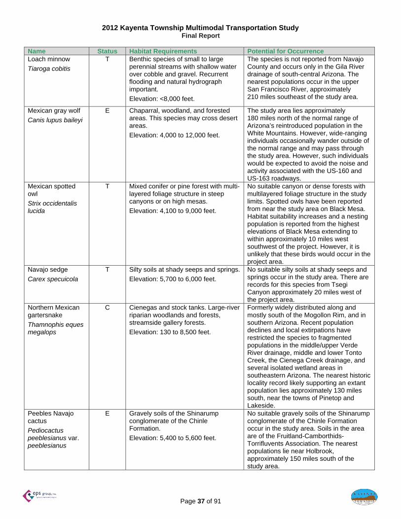
Table 13: USFWS Listed Species in Navajo County and Occurrence Potential
Name Status Habitat Requirements Potential for Occurrence Apache (Arizona) trout
Oncorhynchus gilae apache
T Streams and rivers generally above 6,000 feet elevation with adequate stream flow and shading; temperatures below 77°F; and substrate composed of boulders, rocks, gravel, and some sand and silt.
Elevation: >5,000 feet.
No suitable cold mountain streams with many low-gradient meadow reaches occur in the study area. The nearest known populations occur in the White Mountains, approximately 190 miles south of the study area.
Black-footed ferret
Mustela nigripes
E Grassland plains. Generally found in association with prairie dog colonies.
Elevation: <10,500 feet.
No suitable habitat lies in the project area. There are historic records for the species on the topographic quadrangle on which the study lies, but the species has since been extirpated from former habitat in Arizona, including the project area. Ferrets have been reintroduced to the Aubrey Valley in Coconino County, approximately 150 miles southwest of the project area, but the population has not expanded its range to include the project area.
California condor
Gymnogyps californianus
E High desert canyons and plateaus
Elevation: varies
Habitat within the study limits is marginal for the California condor. Large cliffs are present in close vicinity to the study area. The California condor is a rare species, but it has been reintroduced as an experimental/non-essential population at the Vermilion Cliffs, approximately 80 miles west of the study area. Habitat more suitable for the species is available near the reintroduction site. However, since the condor is prone to travel long distances from nesting sites, the species could occasionally be present in the vicinity while foraging.
Chiricahua leopard frog
Lithobates chiricahuensis
T Streams, rivers, backwaters, ponds, and stock tanks mostly free from introduced fish, crayfish, and bullfrogs.
Elevation: 3,300 to 8,900 feet.
No suitable habitat for the species lies in the study area. The nearest record of occurrence for the species lies along the southern Mogollon Plateau, well south of the Little Colorado River in southern Coconino and Navajo counties.
Little Colorado spinedace Lepidomeda vittata
T Moderate to small streams; found in pools and riffles with water flowing over fine gravel and silt substrate.
Elevation: 4,000 to 8,000 feet.
No potentially suitable perennial streams are in the study limits. The species is not known from drainages north of the Little Colorado River. The nearest records of occurrence lie along the Little Colorado River and tributaries south of the river, approximately 135 miles south of the study area.
2012 Kayenta Township Multimodal Transportation Study Final Report
Page 37 of 91
Name Status Habitat Requirements Potential for Occurrence Loach minnow
Tiaroga cobitis
T Benthic species of small to large perennial streams with shallow water over cobble and gravel. Recurrent flooding and natural hydrograph important.
Elevation: <8,000 feet.
The species is not reported from Navajo County and occurs only in the Gila River drainage of south-central Arizona. The nearest populations occur in the upper San Francisco River, approximately 210 miles southeast of the study area.
Mexican gray wolf
Canis lupus baileyi
E Chaparral, woodland, and forested areas. This species may cross desert areas.
Elevation: 4,000 to 12,000 feet.
The study area lies approximately 180 miles north of the normal range of Arizona’s reintroduced population in the White Mountains. However, wide-ranging individuals occasionally wander outside of the normal range and may pass through the study area. However, such individuals would be expected to avoid the noise and activity associated with the US-160 and US-163 roadways.
Mexican spotted owl
Strix occidentalis lucida
T Mixed conifer or pine forest with multi-layered foliage structure in steep canyons or on high mesas.
Elevation: 4,100 to 9,000 feet.
No suitable canyon or dense forests with multilayered foliage structure in the study limits. Spotted owls have been reported from near the study area on Black Mesa. Habitat suitability increases and a nesting population is reported from the highest elevations of Black Mesa extending to within approximately 10 miles west southwest of the project. However, it is unlikely that these birds would occur in the project area.
Navajo sedge
Carex specuicola
T Silty soils at shady seeps and springs.
Elevation: 5,700 to 6,000 feet.
No suitable silty soils at shady seeps and springs occur in the study area. There are records for this species from Tsegi Canyon approximately 20 miles west of the project area.
Northern Mexican gartersnake
Thamnophis eques megalops
C Cienegas and stock tanks. Large-river riparian woodlands and forests, streamside gallery forests.
Elevation: 130 to 8,500 feet.
Formerly widely distributed along and mostly south of the Mogollon Rim, and in southern Arizona. Recent population declines and local extirpations have restricted the species to fragmented populations in the middle/upper Verde River drainage, middle and lower Tonto Creek, the Cienega Creek drainage, and several isolated wetland areas in southeastern Arizona. The nearest historic locality record likely supporting an extant population lies approximately 130 miles south, near the towns of Pinetop and Lakeside.
Peebles Navajo cactus
Pediocactus peeblesianus var. peeblesianus
E Gravely soils of the Shinarump conglomerate of the Chinle Formation.
Elevation: 5,400 to 5,600 feet.
No suitable gravely soils of the Shinarump conglomerate of the Chinle Formation occur in the study area. Soils in the area are of the Fruitland-Camborthids-Torrifluvents Association. The nearest populations lie near Holbrook, approximately 150 miles south of the study area.

2012 Kayenta Township Multimodal Transportation Study Final Report
Page 38 of 91
Name Status Habitat Requirements Potential for Occurrence Roundtail chub
Gila robusta
C Cool to warm waters of rivers and streams; often occupy the deepest pools and eddies of large streams.
Elevation: 1,000 to 7,500 feet.
No potentially suitable perennial stream is in the study limits. The species is not known from drainages north of the Little Colorado River. The nearest records of occurrence lie along East Clear Creek south of the Little Colorado River, approximately 135 miles south of the study area.
Southwestern willow flycatcher
Empidonax traillii extimus
E Cottonwood/willow and tamarisk vegetation communities along rivers and streams.
Elevation: <8,500 feet.
There are records of occurrence for the species on the topographic quadrangle on which the study lies, likely from along Laguna Creek or another area of suitable habitat along a perennial stream in the vicinity. Individuals would not be expected to occur in the study area.
Yellow-billed cuckoo
Coccyzus americanus
C Large blocks of riparian woodlands (cottonwood, willow, or tamarisk galleries).
Elevation: <6,500 feet.
No suitable large blocks of cottonwood, willow, or tamarisk riparian gallery woodlands occur in the study area. The species has not been reported from Navajo County. The nearest known seasonal record for the species lies along the Rio Puerco, approximately 150 miles southeast of the study area.
C = Candidate, E = Endangered, T = Threatened (USFWS 2011)
In addition to the endangered, threatened, proposed, and candidate species listed above, the Navajo Nation Department of Fish and Wildlife’s natural heritage program also identifies those species that are on the Navajo Nation Endangered Species List (NESL). A response from the Navajo Nation, dated December 14, 2011, has identified the following Navajo Nation species of concern:
Common Name Scientific Name Status American peregrine falcon Falco peregrinus anatum NESL–Group 4Black footed ferret Mustela nigripes NESL–Group 2Ferruginous hawk Buteo regalis NESL–Group 3Golden eagle Aquila chrysaetos NESL–Group 3Kit fox Vulpes macrotis NESL–Group 4Mexican spotted owl Strix occidentalis lucida NESL–Group 3Mountain plover Charadrius montanus NESL–Group 3Northern leopard frog Northern saw-whet owl Southwestern willow flycatcher Parish’s alkali grass
Lithobetes pipiensAegolius acadicus Empidonax traillii extimus Puccinellia parishii
NESL–Group 2NESL–Group 4 NESL–Group 2 NESL–Group 4
NESL–Group 1 species are species that no longer occur in the Navajo Nation. NESL–Group 2 and 3 species are those species considered to be “endangered,” and whose prospects of survival or recruitment within the Navajo Nation are in jeopardy or are likely within the foreseeable future to become so. NESL–Group 4 species are species for which the Navajo Nation does not currently have sufficient information to support their being listed in Group 2 or Group 3. The study area is largely urbanized with few areas of undisturbed natural habitats. It is possible that some of the more mobile species (e.g., Golden Eagle, Ferruginous hawk, and Peregrine falcon) that may forage over a

2012 Kayenta Township Multimodal Transportation Study Final Report
Page 39 of 91
large area may over-fly Kayenta Township; however, nesting, roosting, and foraging opportunities would be extremely limited. Other species, notably the Kit Fox, Mountain plover, Northern leopard frog, and Northern saw-whet owl require habitat conditions which may be present regionally. These habitats are unlikely to occur in the largely urbanized Kayenta Township. Parish’s alkali grass would not be expected within the study area, because, wetlands do not occur within or adjacent to the Kayenta Township. Riparian and Aquatic Habitats Riparian and aquatic habitats are sensitive to the extent that they harbor a variety of species, and many such habitats are protected by federal regulation, including the Clean Water Act. No aquatic habitats are known in the study area. However, the xeroriparian habitat along the ephemeral washes in the study area, particularly Laguna Creek, would be expected to support an increase in vegetation density and species composition. To minimize the potential for indirect effects on riparian habitats and aquatic habitats of the Colorado River downstream of the study area, consideration would need to be given to the proper design of temporary and permanent erosion control measures at any crossings of washes in the study area. J. National Parks, Recreation Areas, Wilderness Areas, and Other Special Status Lands No national parks, recreation areas, designated wilderness areas, or other special status lands or Waters are present in the study area or vicinity. Monument Valley, a 30,000-acre Navajo Tribal Park, is on US-163 along the Arizona–Utah border. It is approximately 22 miles from the Township of Kayenta and would not be affected by any transportation improvements within the Township. K. Section 4(f) Properties (parks, recreation areas, refuges) Section 4(f) of the U.S. Department of Transportation Act of 1966 states that the Federal Highway Administration “…may approve a transportation program or project…requiring the use of publicly owned land of a public park, recreation area, or wildlife and waterfowl refuge of national, State, or local significance, or land of an historic site of national, State, or local significance (as determined by the Federal, State, or local officials having jurisdiction over the park, area, refuge, or site) only if…there is no prudent and feasible alternative to using that land; and…the program or project includes all possible planning to minimize harm to the park, recreation area, wildlife and waterfowl refuge, or historic site resulting from the use” (49 U.S.C. 303[c]). Parks and recreation areas must be open to the public and owned by a public entity. They can be leased to others for a public use from a government agency or can be owned by a private entity with an easement granted to a government entity for use in perpetuity for a park or recreation area open for public use. The resource must have legal interests held by a government entity to be considered a Section 4(f) resource. To be considered a Section 4(f) resource, a wildlife and waterfowl refuge must have a legal interest held by a governmental agency, with the primary use being that of a refuge. It does not need to be designated as a “refuge,” but if that is its use and the land is government-owned, leased from the government to another party for “refuge” use, or privately owned with an easement given to a government for refuge use, it is a Section 4(f) resource.

2012 Kayenta Township Multimodal Transportation Study Final Report
Page 40 of 91
A “use” of a Section 4(f) resource, as defined in 23 CFR § 771.135(p), occurs (1) when land is permanently incorporated into a transportation facility, (2) when there is a temporary occupancy of land that is adverse in terms of the statute’s preservationist purposes, or (3) when there is a constructive use of the land. A constructive use of a Section 4(f) resource occurs when the transportation project does not incorporate land from resources but the project’s proximity impacts are so severe that the protected activities, features, or attributes that qualify a resource for protection under Section 4(f) are substantially impaired. For example, a constructive use can occur when:
the project noise level increase, attributable to the project, substantially interferes with the use and enjoyment of a noise-sensitive facility of a resource protected by Section 4(f);
the proximity of the proposed project substantially impairs aesthetic features or attributes of a resource protected by Section 4(f), where such features or attributes are considered important contributing elements to the value of the resource; and/or
the project results in a restriction on access, which substantially diminishes the utility of a significant publicly owned park, recreation area, or historic site.
Because the Kayenta Township may use federal transportation funds for future transportation improvements, the presence of Section 4(f) resources were evaluated. The Kayenta Township Comprehensive General Plan (Kayenta 2011) lists several recreational properties in the study area, which may be considered Section 4(f) resources:
The Kayenta Elementary School Playground, in the north portion of the study area just north of US-163
The Bureau of Indian Affairs outdoor field, in the north portion of the study area just north of US-163
The Kayenta Middle School ball fields, in the central portion of the study area just south of US-163
The Kayenta Intermediate School playground, in the central portion of the study area just south of US-163
The Kayenta Unified School District Natatorium, in the central portion of the study area just south of US-163
The Mountain Valley High School football and ball fields, in the central portion of the study area just south of US-163
The Mountain Valley High School ropes course, in the central portion of the study area just south of US-163
Boys and Girls Club Township recreation park, in the central portion of the study area just south of US-163
The Navajo Housing Authority Recreation Center, in the south portion of the study area just east of US-163
A pedestrian path, which connects Mountain Valley High School to the Navajo Housing Authority Recreation Center, US-163, and adjacent residential areas

2012 Kayenta Township Multimodal Transportation Study Final Report
Page 41 of 91
L. Cultural Resources/Section 4(f) Properties Cultural resources are properties that reflect the heritage of local communities, states, and nations. Properties judged to be significant and to retain sufficient integrity to convey that significance are termed “historic properties” and are afforded certain protection in accordance with state and federal legislation. The National Historic Preservation Act (NHPA) of 1966, as amended, defines historic properties as sites, buildings, structures, districts (including landscapes) and objects included on, or eligible for inclusion on, the National Register of Historic Places, as well as the artifacts, records, and remains related to such properties. Section 106 of the NHPA requires federal agencies to consider the potential effects of their undertakings on historic properties. To be considered eligible for listing on the National Register of Historic Places, a property must meet at least one of the following criteria:
A: Is associated with events that have made a significant contribution to the broad patterns of our history
B: Is associated with the lives of persons significant in our past
C: Embodies the distinctive characteristics of a type, period, or method of construction or that represents the work of a master, or that possesses high artistic values, or that represents a significant distinguishable entity whose components may lack individual distinction
D: Has yielded, or may be likely to yield, information important in prehistory or history (36 CFR Part 60.4)
Eligible properties may include traditional cultural properties (TCPs). An eligible property may include contributing and non-contributing elements. In accordance with Section 106 of the NHPA, federal agencies are responsible for making eligibility determinations—in this case, the Federal Highway Administration (FHWA) assisted by the Arizona Department of Transportation (ADOT) and in cooperation with the Bureau of Indian Affairs (BIA). Those agencies must, in turn, consult with the Navajo Nation Tribal Historic Preservation Officer (THPO) and request concurrence with their determinations. Eligibility recommendations have been offered by recorders regarding the cultural resources identified in the records search area, but no record of consultation was obtained. Therefore, those properties are identified as “recommended” eligible or not eligible. Background research was conducted at the Navajo Nation Historic Preservation Department (NNHPD) on November 29–30, 2011. Cultural Resources Within the Records Search Area The inventory includes all cultural resources (Table 14) and TCPs (Table 15) identified within the Kayenta Multimodal Transportation Study Area. Cultural resource inventories conducted to date have covered approximately 65 percent of the study area.

2012 Kayenta Township Multimodal Transportation Study Final Report
Page 42 of 91
Table 14: Cultural Resources Within the Kayenta Multimodal Transportation Study Area No. Designation/Name Description Reference Eligibility 1 AZ J-22-4
(NNHPD) Historic (1960) Navajo Activity Center
Werito 1987a Recommended eligible, Criterion D
2 AZ J-22-5 (NNHPD)
Navajo (post-1970) sweat lodge
Werito 1987b Recommended eligible, Criterion D*; protected under AIRFA
3 AZ J-22-9 (NNHPD)
Historic Navajo (post-1970) single-dwelling
Werito 1987c Recommended eligible, Criterion D*
4 AZ J-22-10 (NNHPD)
Prehistoric artifact scatter Werito 1987b Recommended eligible, Criterion D
5 AZ J-22-12 (NNHPD)
Prehistoric and historic artifact scatter
Werito 1987a Recommended eligible, Criterion D
6 AZ J-22-13 (NNHPD)
Prehistoric artifact scatter Werito 1987a Recommended eligible, Criterion D
7 AZ J-22-14 (NNHPD
Navajo (post-1960) rodeo grounds
Werito 1987a Recommended eligible, Criterion D*
8 AZ J-22-16 (NNHPD)
Historic (post-1967) Navajo corral and trash scatter
Werito 1987b Recommended eligible, Criterion D*
9 AZ J-22-17 (NNHPD)
Prehistoric artifact scatter Werito 1987b Recommended eligible, Criterion D
10 AZ J-22-18 (NNHPD)
Prehisotirc artifact scatter/camp
Werito 1987b Recommended eligible, Criterion D
11 AZ J-22-19 (NNHPD)
Historic tourist center Werito 1987b Recommended eligible, Criterion D
12 AZ J-22-20 (NNHPD)
Historic (1973-1979) café Werito 1987b Recommended eligible, Criterion D*
13 AZ J-22-21 (NNHPD)
Historic Navajo camp Werito 1987b Recommended eligible, Criterion D
14 AZ J-22-22 (NNHPD)
Historic Navajo camp (post-1970)
Werito 1987b Recommended eligible, Criterion D*
15 AZ J-22-23 (NNHPD)
Historic (post-1950) Navajo multi-dwelling permanent camp
Werito 1987b Recommended eligible, Criterion D; protected under AIRFA
16 AZ J-22-24 (NNHPD)
Abandoned BIA Classroom building
Werito 1987b Recommended eligible, Criterion D
17 AZ J-22-25 (NNHPD)
Historic Livestock Pen (1940s)
Werito 1987b Recommended eligible, Criterion D
18 AZ J-22-26 (NNHPD)
Historic Trading Post Werito 1987b Recommended eligible, Criterion D
19 AZ J-22-27 (NNHPD)
Historic (post-1950) café Werito 1987b Recommended eligible, Criterion D
20 AZ J-22-28 (NNHPD)
Weatherill Memorial (graves)
Werito 1987b Recommended eligible, Criterion D
21 AZ J-22-29 (NNHPD)
Historic Navajo homesite Werito 1987b Recommended eligible, Criterion D
22 AZ J-22-39 (NNHPD)
Prehistoric artifact scatter NNHPD files Not evaluated
23 AZ J-22-41 (NNHPD)
Prehistoric artifact scatter NNHPD files Not evaluated
24 AZ J-22-47 (NNHPD)
Prehistoric artifact scatter NNHPD files Not evaluated

2012 Kayenta Township Multimodal Transportation Study Final Report
Page 43 of 91
No. Designation/Name Description Reference Eligibility 25 AZ J-22-50
(NNHPD) Anasazi camp site Werito 1991 Recommended eligible,
Criterion D 26 AZ J-22-66
(NNHPD) Prehistoric artifact scatter Gilbert 1996 Recommended eligible,
Criterion D 27 AZ J-22-106
(NNHPD) Prehistoric artifact scatter Neal 2005 Recommended eligible,
Criterion D 28 AZ J-23-1
(NNHPD) Prehistoric artifact scatter NNHPD files Not evaluated
29 AZ J-23-4 (NNHPD)
Prehistoric artifact scatter NNHPD files Not evaluated
30 AZ J-23-5 (NNHPD)
Historic Navajo sweat lodge Werito 1987b Recommended eligible, Criterion D*; protected under AIRFA
31 AZ J-23-6 (NNHPD)
Historic Navajo single-dwelling permanent camp
Werito 1987b Recommended eligible, Criterion D*; protected under AIRFA
32 AZ J-23-7 (NNHPD)
Historic Navajo single-dwelling permanent camp
Werito 1987b Recommended eligible, Criterion D*; protected under AIRFA
33 AZ J-22-8 (NNHPD)
Historic Navajo multi-dwelling permanent camp
Werito 1987b Recommended eligible, Criterion D*; protected under AIRFA
34 AZ J-23-31 (NNHPD)
Prehistoric special activity area/artifact scatter
Todea 2000 Recommended eligible, Criterion D
35 AZ J-23-33 (NNHPD)
Historic (post-1930) Navajo petroglyphs
Stone and Wright 1999
Recommended not eligible
36 AZ J-23-34 (NNHPD)
Prehistoric artifact scatter Stone and Wright 1999
Recommended eligible, Criterion D
37 AZ J-23-103 (NNHPD)
Prehistoric artifact scatter Begay 2004 Recommended eligible, Criterion D
38 AZ D:8:4 (ASM) Historic Navajo (abandoned) sweat lodge
Jeffers, Jr. 1983
Recommended eligible, Criterion D
Satisfies all criteria for NRHP consideration except the 50-year age test. AIRFA stands for the American Indian Religious Freedom Act.
Table 15: Traditional Cultural Properties Within the Kayenta Multimodal Transportation Study Area No. Designation/Name Description Reference 1 Chezhin Ii’hal Lava Rock/Black Knob NNHPD files 2 To Daneeshzhee’ Water Rills NNHPD files
Appendix D provides a list of the environmental reference sources used for the environmental discussion.

2012 Kayenta Township Multimodal Transportation Study Final Report
Page 44 of 91
Stakeholder Interviews
For the purposes of this transportation study, interviews were conducted with many potential stakeholders. These interviews provided data regarding perceived existing and future transportation-related issues, problems, or concerns from the stakeholder point of view. An extensive and varied stakeholder contact list was generated and includes:
Kayenta Township Commissioners Kayenta Chapter officials Neighboring Chapter officials (Shonto, Olijato, Dennehetso, Chilchinbeto) Kayenta Unified School District Other local schools Kayenta Township public services (i.e. law enforcement, post office, health services, etc.) Local businesses Navajo Nation public works divisions Navajo Nation public services Other potentially interested parties
Each stakeholder was contacted by either telephone or e-mail. A total of 42 stakeholders were contacted, of these 11 participated in the full interview. Those that participated in the full interview were asked to respond to each of the following questions, where applicable.
1. How often each day do you drive between locations in Kayenta Township? 2. How often each day do you walk between locations in Kayenta Township? 3. Would you walk more if there were more sidewalks or trails in Kayenta Township? 4. Do you think other people would walk more if there were more sidewalks or trails in Kayenta Township? 5. Do you have children that walk to school? If so, how many children? From where? 6. Would you use a bus system between locations in Kayenta Township? 7. Do you think other people would use a bus system in Kayenta Township? 8. How often do you ride a bicycle between locations in Kayenta Township? 9. How often do you see others riding bicycles between locations Kayenta Township? 10. Do you think there should be bicycle paths adjacent to streets in Kayenta Township? 11. Do you think there should be bicycle lanes in the streets in Kayenta Township? 12. Would you use bicycle paths or lanes in Kayenta Township if they existed? 13. Do you think other people would use bicycle paths or lanes in Kayenta Township if they existed? 14. How often do you ride a horse between locations in Kayenta Township? 15. How often do you see others riding horses between locations Kayenta Township? 16. Do you think there should be horse trails between locations in Kayenta Township? 17. Do you think there should be hitching posts and other horse facilities at businesses in Kayenta
Township? 18. What are the most difficult transportation safety issues in Kayenta Township? 19. Where are the most difficult transportation safety issues in Kayenta Township? 20. What are the most common hazards encountered during daylight hours? Nighttime hours? 21. What are the most immediate transportation issues in Kayenta Township? 22. What improvements to the transportation system in Kayenta Township would you like to see? 23. For business owners, do you have any thoughts on how this study can help promote your business?

2012 Kayenta Township Multimodal Transportation Study Final Report
Page 45 of 91
The following summarizes the responses to the observational or personal travel routine questions:
Almost every respondent reported daily driving within Kayenta Approximately one-half of respondents reported daily or frequent walking within
Kayenta, and almost all respondents favored more sidewalks or trails Of the respondents who had school-age children, most reported that their children
rode the school bus to and from school Most respondents used a bicycle never or only occasionally, and were generally
divided on whether or not bicycle lanes or paths would be a good idea Almost every respondent reported never to seldom using a horse within Kayenta, and
most respondents did not favor equestrian amenities within Kayenta The following summarizes the interview responses to questions of specific transportation-related issues.
Almost every respondent considered the high incidence of potholes and poor road maintenance (particularly on access roads off of US-163 and US-160) among the more immediate and prevalent transportation concerns
A majority of the respondents indicated school zones as requiring immediate attention with regards to safety (i.e. improved bus routes, fluorescent school signing, better pedestrian accommodations, etc.)
Several respondents reported concerns about the high incidence of “Driving Under the Influence”, speeding, livestock crossing traveled ways, lighting and security, and slow local enforcement reaction times
One of the local business owners suggested the installation of lighted billboards along US-160 as a method of promoting business, as current billboards are not lit
Future Population and Demographic Conditions
Future population projections were excluded from the Comprehensive General Plan and Zoning Ordinance process. The Comprehensive General Plan envisions dramatic changes to all land use categories thereby increasing both residential and employment opportunities. Therefore future population can only be generalized. The existing population of 5,189 persons is on approximately 685 acres is a ratio of 7.575 persons per acre. The residential area of the Comprehensive General Plan is 1,338 acres. Utilizing the current ratio, the population at build-out of the Comprehensive General Plan would be approximately 10,000 people.
Future Land Use
The current Comprehensive General Plan and Zoning Ordinance was prepared by the firms of Arrowhead Engineering and The Planning Center. This plan considers the 6.44 square mile area which was utilized by a 2008 Kayenta Market Study and as illustrated in Figure 19 of this report. This is the anticipated ultimate 2030 Township boundary and extends outside of the current Kayenta Township boundary. This Market Study also defined the recommended land uses. It should be noted that this planning area is significantly less than the Bureau of the Census considers as the “Census Designated Place” for Kayenta. The Census area is 13.2 square miles which includes lands with grazing permits and other purposes outside the current and anticipated developed Kayenta community. Additionally the area included in the Comprehensive General Plan includes portions of Kayenta Chapter beyond the Kayenta Township boundary. For planning purposes, these contiguous areas will impact the

2012 Kayenta Township Multimodal Transportation Study Final Report
Page 46 of 91
Kayenta Township transportation system regardless of jurisdiction. The specific land uses in the Comprehensive General Plan were generalized into five categories for purposes of future transportation planning. The comprehensive land use categories and their corresponding generalized land use categories are provided in Table 16. The correspondence was determined based upon trip generation characteristics rather than land use characteristics. For example medical services are often categorized as institutional land uses, however, their trip generation characteristics are more similar to employment.
Table 16: Generalized Land Use Categories COMPREHENSIVE GENERAL PLAN CATEGORY GENERALIZED CATEGORY
Low Density Residential .............................................................. Residential
Medium Density Residential ........................................................ Residential
High Density Residential ............................................................. Residential
Kayenta Township Core .............................................................. Commercial
Neighborhood Commercial .......................................................... Commercial
Highway Oriented Corridor .......................................................... Commercial
Technology and Innovation ......................................................... Employment
Industrial ...................................................................................... Employment
Employment ................................................................................ Employment
Medical Service ........................................................................... Employment
Kayenta Airport ............................................................................ Employment
Hospitality and Entertainment ..................................................... Employment
Corridor Development ................................................................. Employment
Transit Oriented Development .................................................... Employment
Regional Recreation, Parks, and Open Space ............................ Recreational
Resort / Golf Club ........................................................................ Recreational
Agricultural / Equestrian Oriented ............................................... Recreational
Kayenta Cemetery ....................................................................... Recreational
Civic / Institutional / Public Facilities ............................................ Institutional
Figure 25 provides these five land use categories within the Kayenta Township boundary. Indicated in this diagram is a new circulator street. This street is proposed in the Comprehensive General Plan and is intended to serve currently undeveloped portions of Kayenta Township with both private vehicle and transit facilities. Figure 26 provides the relative proportions of the generalized land use categories.

2012 Kayenta Township Multimodal Transportation Study Final Report
Page 47 of 91
Figure 25: Kayenta Township Future Generalized Land Uses
KayentaTownship Future
Generalized Land Uses
160
163
EMPLOYMENT
INSTITUTIONAL
RECREATIONAL
COMMERCIAL
1,150
611
581
441
1.07
0.95
0.91
0.69
ACRES SQUARE MILESAREA
TOTAL 4,122 6.44
TOWNSHIP BOUNDARY
GENERAL PLAN BOUNDARY
RESIDENTIAL 1,338 2.09
N.T.S.
N

2012 Kayenta Township Multimodal Transportation Study Final Report
Page 48 of 91
Figure 26: Kayenta Township Future Generalized Land Use Proportions The Comprehensive Land Use and Zoning Plan provides a 94% increase in residential property, 74% increase in institutional property, and a 32% increase in commercial property.
Residential32%
Employment28%
Institutional15%
Recreational14%
Commercial11%

2012 Kayenta Township Multimodal Transportation Study Final Report
Page 49 of 91
Figure 27 indicates the primary street system for Kayenta Township.
Figure 27: Kayenta Township Future Primary Street System Traffic Analysis Zones (TAZ) are theoretically boundaries used to group land use parcels to aid in the assignment of traffic volumes. A unique number was generated for each of the homogeneous land use parcel. Figure 28 provides the TAZ numbers for all future land use parcels. Figure 29 provides the estimated future build-out daily traffic volumes. Figure 30 and Figure 31 provide the estimated future build-out morning and evening peak hour traffic volumes, respectively. These traffic volumes correspond to the planned land uses indicated in the Comprehensive General Plan. There is not a horizon year associated with these traffic volumes.
KayentaTownship Future
Primary Street System
N.T.S.
N
160
163
New Loop Road

2012 Kayenta Township Multimodal Transportation Study Final Report
Page 50 of 91
Figure 28: Traffic Analysis Zones
Future Land Use
160
163
1
18
2
3
67
89 10
1312
14
15
1716
19
21
EMPLOYMENT
INSTITUTIONAL
RECREATIONAL
COMMERCIAL
1,150
611
581
441
1.07
0.95
0.91
0.69
ACRES SQUARE MILESAREA
TOTAL 4,122 6.44
TOWNSHIP BOUNDARY
GENERAL PLAN BOUNDARY
5 11
20
22
RESIDENTIAL 1,338 2.09
4

2012 Kayenta Township Multimodal Transportation Study Final Report
Page 51 of 91
Figure 29: Comprehensive General Plan Build-out Estimated Future Daily Traffic Volumes
Comprehensive Plan Build‐out Estimated Future Daily
Traffic Volumes
160
163
4,800
4,400
3,800
4,000
3,000
3,300

2012 Kayenta Township Multimodal Transportation Study Final Report
Page 52 of 91
Figure 30: Comprehensive General Plan Build-out Estimated Future Morning Peak Hour Traffic Volumes
Comprehensive Plan Build‐out Estimated
Future Morning Peak Hour Traffic Volumes
160
163
530
160
250
380
110
350

2012 Kayenta Township Multimodal Transportation Study Final Report
Page 53 of 91
Figure 31: Comprehensive General Plan Build-out Estimated Evening Peak Hour Traffic Volumes
Comprehensive Plan Build‐out Estimated
Future Evening Peak Hour Traffic Volumes
160
163
220
520
450
570
370
240

2012 Kayenta Township Multimodal Transportation Study Final Report
Page 54 of 91
Future Transit Services
In the Existing Conditions section of this Working Paper, a hypothetical transit route was developed for the transit demand estimating procedure. This six-mile route consisted of a circulator following a loop route consisting of the proposed New Loop Road and the segment of US-163 that completes the loop as indicated in Figure 22. For future transit service, a modified and expanded circulator route, as indicated in Figure 32, was analyzed. This potential route includes service to the Kayenta Airport and to a planned resort southwest of the US-160 and US-163 intersection. This modified circulator route would be approximately 7.6 miles in length and would be completed in less than an hour. The system could operate as either fixed route or deviated fixed route.
Figure 32: Future Potential Transit Route
Future Potential Transit Route

2012 Kayenta Township Multimodal Transportation Study Final Report
Page 55 of 91
The proposed schedule for the transit route is provided in Table 17. The elapsed time between stops provides “dwell” time for loading and unloading at each stop. The schedule would operate Monday through Friday, or 60 trips per week.
Table 17: Potential Transit Route Schedule Future transit demand in the Kayenta Study area was estimated using the TCRP Report 3, Workbook for Estimating Demand for Rural Passenger Transportation, similar to the process utilized for a hypothetical current system in the Current Transit Services of this report. The potential future system would operate as a circulator route, completing 12 trips-per-day, Monday through Friday, for a total of 60 trips-per-week. As the proposed loop is approximately 7.6 miles in length, this service would equate to 456 miles-per-week, or 23,712 miles-per-year. In addition to developing a hypothetical system, the methodology requires that a service area be defined to calculate vehicle-miles-per-square-mile, an important metric for modeling purposes. The Study Area includes only 6.44 square-miles, while the Census Designated Place (CDP) comprises 13.2 square-miles. To be
TIME
STOP LOCATIONS MILES (minutes) MORNING TRIPS
Township Hall 7:00 AM 8:00 AM 9:00 AM 10:00 AM 11:00 AM 12:00 PM
Airport 1.10 0:06 7:06 AM 8:06 AM 9:06 AM 10:06 AM 11:06 AM 12:06 PM
Planned Resort 1.00 0:05 7:11 AM 8:11 AM 9:11 AM 10:11 AM 11:11 AM 12:11 PM
Rodeo Grounds 0.67 0:04 7:15 AM 8:15 AM 9:15 AM 10:15 AM 11:15 AM 12:15 PM
Hospital 0.33 0:03 7:18 AM 8:18 AM 9:18 AM 10:18 AM 11:18 AM 12:18 PM
Urban Core 3.50 0:15 7:33 AM 8:33 AM 9:33 AM 10:33 AM 11:33 AM 12:33 PM
Township Hall 1.00 0:05 7:38 AM 8:38 AM 9:38 AM 10:38 AM 11:38 AM 12:38 PM
TOTAL 7.60 0:38
TIME
STOP LOCATIONS MILES (minutes) AFTERNOON TRIPS
Township Hall 1:00 PM 2:00 PM 3:00 PM 4:00 PM 5:00 PM 6:00 PM
Airport 1.10 0:06 1:06 PM 2:06 PM 3:06 PM 4:06 PM 5:06 PM 6:06 PM
Planned Resort 1.00 0:05 1:11 PM 2:11 PM 3:11 PM 4:11 PM 5:11 PM 6:11 PM
Rodeo Grounds 0.67 0:04 1:15 PM 2:15 PM 3:15 PM 4:15 PM 5:15 PM 6:15 PM
Hospital 0.33 0:03 1:18 PM 2:18 PM 3:18 PM 4:18 PM 5:18 PM 6:18 PM
Urban Core 3.50 0:15 1:33 PM 2:33 PM 3:33 PM 4:33 PM 5:33 PM 6:33 PM
Township Hall 1.00 0:05 1:38 PM 2:38 PM 3:38 PM 4:38 PM 5:38 PM 6:38 PM
TOTAL 7.60 0:38

2012 Kayenta Township Multimodal Transportation Study Final Report
Page 56 of 91
consistent with the Census data, the CDP area of 13.2 square-miles was used as the service area. The service of 23,712 miles-per-year divided by 13.2 square-miles yields 1,796 vehicle-miles-per-square-mile. The TCRP estimations were developed based on specific population groups of persons aged 65 or over, persons aged 16 to 64 with mobility limitations, and persons aged 64 or under residing in households with incomes below the poverty level. The projected future build-out population of the Kayenta Township study area of 10,000 was separated into transit user groups in the same ratios as the current Census indicates. Table 18 indicates the estimated future transit user populations at time of general plan build-out for each group in the service area.
Table 18: Future Predicted Transit User Populations POPULATION GROUP POPULATION
Persons aged 65 or over ..................................................................................................... 480
Persons aged 16 to 64 with mobility limitations ............................................................... 1,192
Persons aged 64 or under in households with incomes below poverty level ................... 3,349 The transit service of 1,796 vehicle miles-per-square-mile is entered into a formula provided in the TCRP workbook to create a service factor for each population group. These formulae rely on given factors which are related to the vehicle miles per square mile. Table 19 indicates the calculation of the service factors necessary for calculating the transit demand estimate.
Table 19: Future Predicted Transit Demand Service Factors TCRP #1 TCRP #2 SERVICE FACTOR POPULATION GROUP VMPSM (multiplied) (added) (per million)
Persons 65 or over .............................. 1,796 ............. 2.682 ....................... 376 ............ 0.00519385
Persons with mobility limitations .......... 1,796 ............... 1.57 .................... 1,010 ............ 0.00383029
Persons with low income ..................... 1,796 ............... 2.45 ....................... 525 ............ 0.00492609 These derived service factors, based on the frequency of service and size of the service area, are part of the final calculations to estimate transit demand. Table 20 provides the estimated transit demand by population group and total. This methodology estimates a total yearly demand (all trips made during one year) for the Kayenta Service Area of 28,264 trips, an average of approximately 39 trips-per-day (assuming 260 days of service).
Table 20: Future Predicted Transit Demand TCRP SERVICE ANNUAL POPULATION GROUP FACTOR POPULATION FACTOR DEMAND
Persons 65 or over ........................... 1,200 .................. 480 ............... 0.00519385 .............. 2,992
Persons with mobility limitations ....... 1,200 ............... 1,192 ............... 0.00383029 .............. 5,477
Persons with low income .................. 1,200 ............... 3,349 ............... 0.00492609 ............ 19,795
TOTAL 28,264

2012 Kayenta Township Multimodal Transportation Study Final Report
Page 57 of 91
This methodology estimates a total annual demand (all trips made during a year period) for the Kayenta Service Area of 28,264 trips, an average of approximately 109 trips per day (assuming 260 days of service). The TCRP workbook alternative graphical method for estimating transit demand was also utilized for a secondary future predicted transit demand estimate for comparison purposes. This alternative method is based on pre-calculated trip rate curves created from research and analysis of other rural transit programs. Utilizing a predicted service of 1,976 vehicle-miles-per-square-mile determines the transit demand for each population group is determined as depicted in Figure 33.
Figure 33: Future Transit Demand – Graphical Methodology The estimated trip rates from Figure 33 are used to estimate the demand for each population group as indicated in Table 21.
Future Transit Demand –Graphical
Methodology
5.01
4.06
3.84
0
1
2
3
4
5
6
0 200 400 600 800 1,000 1,200 1,400 1,600 1,800 2,000
AN
NU
AL
TR
IPS
PE
R P
ER
SO
N
ANNUAL VEHICLE-MILES PER SQUARE-MILE
OVER 65 YEARS OLD MOBILITY LIMITED BELOW POVERTY KAYENTA TOWNSHIP

2012 Kayenta Township Multimodal Transportation Study Final Report
Page 58 of 91
Table 21: Transit Demand – Graphic Methodology TRIP ANNUAL POPULATION GROUP POPULATION RATE DEMAND
Persons 65 or over ........................................... 480 ................................. 5.01 ..................... 2,405
Persons with mobility limitations .................... 1,192 ................................. 4.06 ..................... 4,840
Persons with low income ............................... 3,349 ................................. 3.84 ................... 12,860
TOTAL 20,105 The total estimated demand with this alternative graphic method is 20,105 annual trips, or approximately 77 trips per day (assuming 260 service days). Therefore, the predicted future transit demand is approximately 20,000 to 28,000 annual trips or 80 to 110 daily trips. Utilizing 12 daily trips, this equates to an average of 6.7 to 9.2 riders per trip. A standard van might accommodate ridership. A 16-passenger mini-bus with two wheelchair seats would better prepare the operation for peak loads. Mini-buses are also easier to board and disembark, enabling the driver to remain seated rather than having to open passenger doors to assist riders at each stop. The mini-buses would also have more room for luggage storage. Figure 34 and Figure 35 depict external and internal views of a typical vehicle.
Figure 34: Typical Mini-bus – External View Source: Thor Industries Commercial Bus Division

2012 Kayenta Township Multimodal Transportation Study Final Report
Page 59 of 91
Figure 35: Typical Mini-bus – Internal View Source: Arizona Bus Sales
Future Non-Motorized Transportation Services
Sidewalks are desired adjacent to all paved streets in Kayenta Township. Bicycle trails would be appropriate adjacent to US-163, US-160, BIA-6485, BIA-591, and the proposed loop road. Bicycle routes would be applicable as appropriate on all other streets, including N-106. Equestrian trails would be beneficial adjacent to US-163, US-160, the proposed recreational area parallel and north of the airport, and the proposed recreational area perpendicular to the north loop road extending from the airport to the northern Township boundary. It is anticipated that these bicycle and equestrian facilities will connect with similar facilities in Kayenta Chapter, outside of Kayenta Township. Currently, a sidewalk exists west of and adjacent to US-163 at the bridge over Laguna Wash. This sidewalk includes a curved fence. The fence is not high enough to permit equestrian use. The curved fence should be raised to accommodate equestrians. An additional bridge with a curved fence should be provided east of and adjacent to US-163. Either these bridges should provide separate bicycle and equestrian facilities or separate bicycle and equestrian bridges should be constructed. A “Safe Routes to School” study has been desired by Kayenta Township for several years. Township residents and officials have expressed their desire to have improved school-age pedestrian crossing of US-163 in the vicinity of the three schools. ADOT representatives have indicated that signalized crossings would be too close to the existing signal serving the schools. Recognizing the relatively unusual combination of unfamiliar drivers in through vehicles on an otherwise uninterrupted state highway in a small isolated community with three immediately adjacent schools, a crosswalk in relatively close proximity to the traffic signal might be appropriate. This type of traffic control would be inappropriate in a typical urban, suburban, or large town environment; but may have application in Kayenta. A comprehensive “Safe Routes to School” study would examine the need for improved school-age pedestrian crossings, and if the need exists, to determine potential locations for the crossings. The study would examine the concerns of signals in close proximity and determine if an exception is justified for the particular conditions on US-163 in Kayenta Township. The study would also determine if non-signalized improvements would be beneficial or necessary.

2012 Kayenta Township Multimodal Transportation Study Final Report
Page 60 of 91
A “Safe Routes to School” study should be completed to investigate potential improvements to US-163 that would provide safer crossing for students entering and exiting the Kayenta Elementary School, the Kayenta Middle School, and the Monument Valley High School. Options to be considered should include: pedestrian traffic signals, High Intensity Activated Crosswalk (HAWK) signals, solar-powered timed and activated school zone speed limit signs, school warning signs, and other traffic control options. North and east of the school property, a resort with a recreational theme is anticipated in the Comprehensive General Plan. This resort should include both bicycle and equestrian facilities which connect to similar facilities throughout Kayenta Township. Southeast of the US-160 and US-163 intersection, is the Kayenta Rodeo Grounds. Equestrian facilities should connect to this property. The signalized intersection should include pushbuttons at heights suitable for individuals on horseback.
Future Environmental Conditions
For this study, future environmental conditions would be related to proposed transportation improvements, including the proposed loop road; potential population growth; and development in the Kayenta Township, including a proposed resort and new development in areas that are currently undeveloped. A summary of future environmental conditions follows. Environmental Justice Data from the 2010 Census indicate that minority populations are present in CT 9425 (95.5 percent) and the percentage of total minority populations is meaningfully higher than the corresponding percentages for Navajo County and the State of Arizona. This tract is considered a protected population. As transportation improvements are developed, further environmental justice analysis may be warranted to determine if proposed improvements create a disproportionately high or adverse human health and environmental impact on minority populations, and to identify any mitigation measures to address significant and adverse environmental effects on this protected population. Transportation improvements to the township would be expected to improve operational efficiency, reduce traffic congestion, and improve access for motorists, bicyclists, and pedestrians. Topography and Soils New development, changes in land use, and construction of new transportation structures would modify existing landforms and convert land uses, such as agriculture, to commercial or residential use. Sensitivity to topography (steep or unstable slopes) and soil conditions (low strength soils or highly erodible soils) would need to be considered during the design of proposed transportation improvements to minimize excavation, minimize erosion, and prevent structure failures. Visual Resources Ongoing development in the Kayenta Township, changes in land use, and construction of proposed transportation improvements would detract from the surrounding natural setting and increase the urban character of the visual environment. As the transportation study progresses and transportation improvements are identified, sensitivity to the local visual character and the surrounding scenic vistas should be considered. A visual impact assessment would need to address the anticipated change to visual character associated with the development of transportation improvements.

2012 Kayenta Township Multimodal Transportation Study Final Report
Page 61 of 91
Air Quality Population growth in the area could increase traffic levels, thereby increasing the level of air pollutants emitted from vehicles. Improvements to the existing transportation network could affect air quality at individual receptors in the study area through a shift in traffic patterns. However, adding capacity to existing facilities or constructing new roadways, such as the new proposed loop road, could reduce traffic congestion, thereby reducing air pollutant emissions. The development of other modes of transportation (e.g., transit, bicycle, pedestrian) could also reduce emissions by reducing the number of personal vehicles on the road system. A temporary increase in air pollutant emissions would be expected during construction of transportation improvements due to equipment operation and the slower traffic speeds associated with a construction zone. However, this would be a localized condition that would cease when construction is complete. Noise Impacts Sensitive receptors are located in the study area. Several of these sensitive receptors are within 1,000 feet of primary roads. As population growth continues in the Kayenta Township, noise levels in the study would be expected to increase due to increased traffic. Construction of a proposed loop road may divert some traffic noise away from sensitive receptors along US-160, US-163, BIA-6485, and BIA-591. A qualitative or quantitative noise analysis would need to be conducted for the proposed transportation improvements to determine the nature and extent of noise impacts. Temporary noise impacts would be experienced during construction of proposed transportation improvements. Some sensitive receptors could be affected by construction noise if they are immediately adjacent to the project. Typically, construction noise levels continually change as construction phases are completed. Water Quality Construction of new transportation improvements and continued development in the area would contribute to the loss of permeable surface areas to absorb stormwater flows as well as contribute to a related increase in quantity and a decrease in quality of surface water runoff. New transportation structures would also impact drainages through the placement of fill within Waters. A jurisdictional determination of Waters would need to be conducted once transportation improvements have been determined. In addition to Section 404 permits from the Corps, individual water quality certifications under Section 401 of the Clean Water Act would be required from the Navajo Nation Environmental Protection Agency. Impacts to Waters would need to be minimized through the incorporation of Best Management Practices and erosion control measures. On the Navajo Nation, any construction that would disturb one or more acres would require a National Pollutant Discharge Elimination System (NPDES) permit. The NPDES permit would be obtained from the Navajo Nation Environmental Protection Agency. Floodplains Continued development in the area and the construction of transportation improvements may impact 100-year floodplains in the study area. Floodplain impacts would need to be addressed as part of the transportation improvements evaluation. Transportation improvements should be designed to minimize floodplain encroachment and maintain flood-carrying capacity of the drainages being impacted. Biological Resources Proposed transportation improvements would have no effect on threatened and endangered species listed for Navajo County and would have no effect on the California condor or its habitat. Similarly, proposed improvements would have no effect on NESL Group 2, NESL Group 3, or NESL Group 4 species. Ongoing development in the study area and construction of new transportation improvements, including the new loop road, would, however, reduce or degrade available wildlife habitat in the study area, particularly in

2012 Kayenta Township Multimodal Transportation Study Final Report
Page 62 of 91
areas that are currently undeveloped or where improvements would impact drainages. To minimize the potential for indirect effects on riparian habitats and aquatic habitats of the Colorado River downstream of the study area, consideration would need to be given to the proper design of temporary and permanent erosion control measures at any crossings of washes in the study area. National Parks, Recreation Areas, Wilderness Areas, and Other Special Status Lands Monument Valley is approximately 22 miles from the Township of Kayenta and would not be affected by any transportation improvements in the Township. Section 4(f) Properties (parks, recreation areas, refuges) The study area contains potential 4(f) resources that may be impacted by proposed transportation improvements. As the study progresses and transportation improvements are determined, future environmental analyses and documentation will need to consider whether any future projects could result in a use of these potential Section 4(f) properties. Cultural Resources/Section 4(f) Properties Increased development in the area, as well as construction of proposed transportation improvements, has the potential to impact 38 known cultural resources and two TCPs. Of the 38 properties, none are currently listed in the NRHP. Five properties have not been evaluated for NRHP eligibility, 32 of the properties have been recommended eligible under Criterion D, and the remaining properties are recommended not eligible for inclusion in the NRHP. Of the 32 properties recommended eligible under Criterion D, 10 are less than 50 years old. The Navajo Nation requires all abandoned cultural sites to be recorded and treated as archaeological sites, regardless of age (NNHPD 2010). Information regarding the eligibility of the two TCPs was not provided. As the transportation study progresses, additional cultural resources inventory will be required. Efforts to arrive at definitive eligibility assessments, including assessing whether the portions of eligible properties subject to potential effect are contributing or noncontributing, will be required. It is possible that an agreement document (a Memorandum of Agreement or a Programmatic Agreement) will be developed to demonstrate Section 106 compliance. If adverse effects to cultural resources valued for in-place preservation (typically those determined eligible under Criteria A, B, or C and including TCPs) cannot be avoided, a Section 4(f) alternatives evaluation will be required to explore the potential for a prudent and feasible alternative that will not result in a Section 4(f) use. Summary of Notable Issues In conclusion, the following is a summary of the known environmentally notable issues that will need to be considered in the development and evaluation of potential transportation improvements:
Presence of populations protected under Executive Order 12898
Potential visual impacts
Potential water quality impacts
Preservation of wildlife habitat, habitat connectivity, and wildlife movement corridors
Presence of known and unknown cultural resources
Possible Section 4(f) impacts to recreational properties and cultural resources in the study area
Potential impacts to floodplains
Potential for noise impacts
Potential for air quality impacts
2012 Kayenta Township Multimodal Transportation Study Final Report
Page 63 of 91
20-YEAR IMPROVEMENT PLAN
Recommended Transportation Improvement Projects
This section presents the Improvement Plan developed to address transportation needs within the Kayenta Township for the next 20 years. The Improvement Plan is multimodal and is designed to complement the recently completed Kayenta Township Comprehensive General Plan. The first step in creating a prioritized Improvement Plan was to develop a comprehensive list of recommended transportation-related improvements. The following presents the list of recommended projects, with descriptions, organized by type. Equestrian
Increase Canopy Height of Existing Laguna Wash Westside Pedestrian Bridge – The existing Laguna Wash Pedestrian Bridge includes an overhead fence that is too low to accommodate equestrians. This project would increase its height.
Equestrian Height Pushbuttons at Signals – Project would install pushbuttons at height of horseback-riders at existing traffic signals.
Equestrian Facilities Study – This project would examine the community and its desires to identify projects at specific locations to develop equestrian facilities.
Multi-use
Multi-use Trail Study – The Kayenta Township Comprehensive General Plan suggests that Kayenta Township wishes to promote bicycle, equestrian, hiking, and walking trail use throughout the community. This project would examine the community and its desires to identify projects at specific locations to develop multi-use trail facilities.
New Laguna Wash Eastside Pedestrian Bridge – The existing Laguna Wash Pedestrian Bridge exists only on the west side of US-163, thereby requiring people on the east side to cross or walk in the motor vehicle travel lanes. This project would design and construct a second bridge (of height to accommodate horse-back riders).
Transit
Additional Navajo Transit System Stops – The existing Navajo Transit System includes only two stops in Kayenta Township – the Police Department and the Mustang Store. This project would determine and create additional transit stops with shelters within Kayenta Township.
Westbound Morning and Eastbound Evening Navajo Transit System Routes – The existing Navajo Transit System route from Shonto arrives in Kayenta at 5:55 AM and 6:00 AM, then continues eastbound to Fort Defiance; and from Fort Defiance arrives in Kayenta at 6:55 PM and 7:00 PM then continues westbound to Shonto. This project would provide opposite direction routes in the morning and evening.
Late Morning and Early Evening Navajo Transit System Route – The existing Navajo Transit System route from Shonto arrives in Kayenta at 5:55 AM and 6:00 AM, then continues eastbound to Fort Defiance; and from Fort Defiance arrives in Kayenta at 6:55 PM and 7:00 PM, then continues westbound to Shonto. This project would provide a second eastbound route approximately two to four hours later in the morning and a second westbound route approximately three to five hours earlier in the evening.
US-163 north-south Navajo Transit System Route – Currently, there is no north-south transit route through Kayenta Township from US-160 to north of Kayenta Township. This route would provide that service.
Initial Circulator Transit Route – This project requires the construction of the Loop Road identified in the Kayenta Township Comprehensive General Plan. It would provide 12 bus trips per day, at one-hour

2012 Kayenta Township Multimodal Transportation Study Final Report
Page 64 of 91
intervals in a one-way circular loop consisting of the new Loop Road and the portion of US-163 between the two ends of the Loop Road.
Expanded Circulator Transit Route – This project would expand the initial Loop Road Circulator Transit Route by providing additional stops at future constructed businesses and activity centers.
Residential Neighborhoods
Residential Neighborhood Sidewalks and Streetlights – This project would provide sidewalks or streetlights in the Kayenta Township residential neighborhoods where they do not currently exist.
Residential Road Maintenance Program – This project would create an ongoing program to fund regular maintenance of residential paved and unpaved roads.
Paving Residential Streets – Several of the Kayenta Township residential neighborhoods have unimproved dirt roads. This project would provide improved gravel or paved roadways with sidewalks and drainage features.
Residential Street Name Signs – This project would provide street name signs in the residential neighborhoods where they do not currently exist.
Half-street Improvements northwest of US-163 and US-160 – This project would provide the missing half-street improvements in the northernmost and westernmost streets in this residential neighborhood.
Other
Safe Routes to School Study – This project would develop a complete study in accordance with federal criteria and guidelines. It would include the planning, design, and construction or installation of appropriate improvements.
Loop Road – The Kayenta Township Comprehensive General Plan envisioned a new loop road east of US-163 at BIA-6485, east of the airport, intersecting US-160, south of US-160, and intersecting N-591 south of US-160.
Improve Truck Circulation and Parking at High-Truck-Demand Businesses – Currently, several paved and unpaved parking areas within the Kayenta Township commercial areas are utilized by large trucks for overnight or multiple-hour parking. This project would examine these practices and develop appropriate facilities or prohibit the practice with effective barricades and other devices.
Update Airport Master Plan – An Airport Master Plan was completed in November 2005. This project would reevaluate the Master Plan in recognition of the development envisioned by the Kayenta Township Comprehensive General Plan.
BIA Roads
BIA-6485 Pavement and Drainage Improvements – This project would identify, plan, design, and construct roadway improvements to BIA-6485 from its current intersection with US-163 west to the Kayenta Township limits.
BIA-6485 Roadway Beautification and Landscaping – This project would identify, plan, design, and construct roadside improvements to BIA-6485 from its current intersection with US-163 west to the Kayenta Township limits.
Navajo Nation Roads
N-591 Sidewalk and Streetlights – This project would identify, plan, design, and construct these roadway improvements to N-591 from US-160 south to the Kayenta Township limits.
N-106 Pavement and Drainage Improvements – This project would identify, plan, design, and construct roadside improvements to N-106 from its current intersection with US-163 to the west.
N-106 and N-591 Roadway Beautification and Landscaping – This project would identify, plan, design, and construct roadside improvements to both roadways within Kayenta Township limits.

2012 Kayenta Township Multimodal Transportation Study Final Report
Page 65 of 91
US-163 and US-160 Crosswalk on US-163, north of US-160 – This project would study the need, location, and type of a
crosswalk. The study would determine if the crosswalk(s) should be a minimal painted crosswalk, static signs, dynamic signs, used-activated signs, pedestrian-only signal, or conventional signal. After study completion, if appropriate, the project would plan, design, and construct the crosswalk(s).
Median on US-163, US-160 to BIA-6485 – This project would study the need, location, and type of median for US-163 between US-160 and BIA-6485. The study would also determine median opening locations. After study completion, the project would plan, design, and construct the median.
US-160 Advance US-163 Intersection Warning Devices – This project would study the need, location, and type of advance intersection warning and speed reduction devices. The study would determine if pavement markings, static warning signs, flashing-light warning signs, dynamic warning signs, dynamic speed measurement and notification signs, speed limit reduction signs, or other devices are appropriate. After study completion, the project would plan, design, and construct the devices.
US-163 and US-160 Streetlight Study – This project would conduct a complete illumination study of the two state highways that serve the commercial districts of Kayenta Township to determine if additional or different lighting is necessary or appropriate. If necessary, the project would also plan, design and construct the recommended improvements.
Roadway Drainage Improvements – This project would study the drainage patterns throughout Kayenta Township as they affect the entire transportation system. It would also plan, design, construct, and maintain the drainage control system.
Prohibit or Accommodate Tourist Parking on US-163, north of US-160 – Currently tourists frequently stop in or very near the travel lanes on US-163 and on US-160. This project would identify vehicle turn-outs at scenic locations or post signs prohibiting stopping, parking, or standing. The project would include planning, design, and construction or installation.
US-163 and US-160 Access Consolidation – Currently, the commercial and vacant properties on both routes away from their intersection have multiple accesses. This project would analyze this condition and identify, develop, plan, design, and conduct appropriate solutions.
Right-turn Deceleration Lanes on US-163 and US-160 – This project would study the location and need for right-turn deceleration lanes for the businesses on US-163 and US-160 in Kayenta Township. After study completion, the project would plan, design, and construct the deceleration lane(s).
Improve Access and Circulation in northwest corner of US-163 and US-160 – Currently, the commercial areas in this intersection quadrant have uncontrolled access with the state highways, without defined driveways and without defined on-site circulation paths. This project would analyze this condition and identify, develop, plan, design, and construct appropriate solutions.
Improve Access and Circulation in northeast corner of US-163 and US-160 – Currently, the commercial areas in this intersection quadrant have uncontrolled access with the state highways, without defined driveways and without defined on-site circulation paths. This project would analyze this condition and identify, develop, plan, design, and construct appropriate solutions.
Improve Access and Circulation in southwest corner of US-163 and US-160 – Currently, the commercial areas in this intersection quadrant have uncontrolled access with the state highways, without defined driveways and without defined on-site circulation paths. This project would analyze this condition and identify, develop, plan, design, and construct appropriate solutions.
US-163 and US-160 Roadway Beautification and Landscaping – This project would identify, plan, design, and construct roadside improvements to US-163 and US-160 within and adjacent to Kayenta Township.
Second Post Office Access – Currently there is only one access to the post office from US-163, which becomes congested certain time periods each month. This study would determine if a second access is necessary and appropriate, and plan, design, and construct the access.

2012 Kayenta Township Multimodal Transportation Study Final Report
Page 66 of 91
Bike Paths on US-163 North of US-160 – This project would investigate the need for bicycle paths for both northbound and southbound travel directions separated from the motor vehicle lanes for the entire US-163 length within Kayenta Township.
There are also two recommended signing-only improvement projects that were identified:
Business signs on US-163 and US-160 – Currently there are no advance signs for Kayenta Township businesses on the state highways approaching Kayenta Township. This project would identify and install possible legal and appropriate signs. Potential signs would include, “FOOD, GAS, LODGING IN XX MILES”.
Prohibit use of Non-Designated Roads – Currently, off-road vehicles are creating new roads from existing roads. This project would provide signs and barriers at these locations that would prohibit the use of these non-designated roads and prevent their creation in other locations.
Project Evaluation Criteria
The next step created evaluation criteria to prioritize the recommended improvements. The criteria were weighted to ensure that the projects addressing the most important criteria received the highest priorities and would appear earliest in the improvement program. The following lists the prioritization criteria with a brief description.
SAFETY IMPROVEMENT – Provides a substantial benefit to the safety of one or more transportation mode.
IMMINENT NEED – Project is needed in less than five years (should be in five-year plan). COMMUNITY DESIRE – Project has been identified as a high priority or large issue in township
commission meetings, stakeholder interviews, public involvement meetings, or comment cards. PEOPLE WITH DISABILITIES IMPACT – Project assists people who use wheelchairs, walkers, or
crutches; or who are blind or deaf, or encourages people with disabilities to travel. ELDERLY IMPACT – Project assists people of advanced age or encourages people of advanced age
to travel. PEDESTRIAN IMPACT – Project assists people who walk or encourages people to walk. TRANSIT IMPACT – Project assists people who use transit or encourages people to use transit. EMERGENCY RESPONSE TIMES – Project reduces emergency response times. ECONOMIC AND TOURISM IMPACT – Project benefits or promotes economic development or tourist
visits. CONSTRUCTION DISRUPTION IMPACT TO COMMUNITY – Project causes significant disruption to
businesses or residents due to its duration, location, or extent. OPERATION AND MAINTENANCE EXPENSE – Subsequent to construction or installation, project is
expensive to operate or maintain, regardless of funding source. FUTURE NEED – Project is needed in 5 to 15 years (should be in 10-year plan). BICYCLIST NEET – Project assists people who bicycle or promotes bicycling. EQUESTRIAN NEED – Project assists people who ride horses or promotes horseback-riding. INITIAL EXPENSE – Design and construction cost is very expensive, regardless of the funding source. DISTANT FUTURE NEED – Project is needed in more than 15 years (should be in 20-year plan).
A matrix was developed to rank the recommended improvements based on the prioritized evaluation criteria. Ranking is an integer from 5 to 1 with 5 representing a highly desirable value for the particular criteria and 1 representing an undesirable value for the particular criteria; with 4, 3, and 2 as gradations between the extremes. Table 22, Table 23, and Table 24 present the evaluation matrix by type. Also included are the ranking integers for each recommended improvement.

2012 Kayenta Township Multimodal Transportation Study Final Report
Page 67 of 91
Table 22: Recommended Improvement Evaluation Matrix – Equestrian, Multi-use, and Transit
KAYENTA MULTIMODAL TRANSPORTATION STUDY
PROJECT TYPE EQUESTRIAN MULTI-USE TRANSIT T
RE
AT
ME
NT
W
EIG
HT
E
ques
tria
n H
eigh
t Pus
hbut
tons
at S
igna
ls
In
crea
se H
eigh
t of E
xist
ing
Lagu
na W
ash
Wes
tsid
e P
edes
tria
n B
ridge
M
ulti-
use
Tra
il S
tudy
and
Equ
estr
ian
Fac
ilitie
s S
tudy
N
ew L
agun
a W
ash
Eas
tsid
e M
ulti-
use
Brid
ge
In
itial
Circ
ulat
or T
rans
it R
oute
E
xpan
ded
Circ
ulat
or T
rans
it R
oute
A
dditi
onal
Nav
ajo
Tra
nsit
Sto
ps
W
estb
ound
Mor
ning
and
Eas
tbou
nd E
veni
ng N
avaj
o T
rans
it B
us
La
te M
orni
ng a
nd E
arly
Eve
ning
Nav
ajo
Tra
nsit
Bus
ses
N
orth
-Sou
th N
avaj
o T
rans
it R
oute
P
avin
g R
esid
entia
l Roa
ds
CRITERIA
Safety Improvement 12 5 5 5 5 3 2 3 3 3 3 5
Imminent Need 11 1 1 5 2 1 1 3 3 3 2 5
Community Desire 10 3 5 5 3 4 4 4 4 4 3 5
People With Disabilities Impact 9 1 1 5 4 5 5 5 5 5 3 2
Elderly Impact 9 1 1 5 3 5 5 5 5 5 4 2
Pedestrian Impact 8 1 1 5 5 1 1 1 1 1 1 3
Transit Impact 8 1 1 1 1 5 5 5 5 5 5 1
Emergency Response Times 7 1 1 1 1 1 1 1 1 1 1 5
Economic and Tourism Impact 6 4 5 5 5 2 3 4 4 4 4 2
Construction Disruption to Community 5 4 5 5 2 2 2 5 5 5 5 1
Operation and Maintenance Expense 5 3 3 1 3 1 1 2 1 1 1 1
Future Need 4 3 4 4 4 3 3 4 4 4 5 5
Bicyclist Impact 2 1 1 5 5 1 1 1 1 1 1 3
Equestrian Impact 2 5 5 5 5 1 1 1 1 1 1 1
Initial Expense 1 3 3 1 1 1 1 1 1 1 1 1
Distant Future Need 1 5 5 3 5 5 5 5 5 5 5 5
TOTAL 100 233 268 410 327 281 275 339 334 334 290 324

2012 Kayenta Township Multimodal Transportation Study Final Report
Page 68 of 91
Table 23: Recommended Improvement Evaluation Matrix – Residential Neighborhoods, Other, BIA Roads, and Navajo Nation Roads
KAYENTA MULTIMODAL TRANSPORTATION STUDY
PROJECT TYPE RESIDENTIAL NEIGHBORHOODS OTHER BIA ROADS NAVAJO NATION ROADS
TR
EA
TM
EN
T
W
EIG
HT
R
esid
entia
l Nei
ghbo
rhoo
d S
tree
tligh
ts
H
alf-
Str
eet I
mpr
ovem
ents
Nor
thw
est o
f US
-160
and
US
-163
R
esid
entia
l Str
eet N
ame
Sig
ns
R
esid
entia
l Roa
d M
aint
enna
ce P
rogr
am
P
rohi
bit U
se o
f Non
-Des
igna
ted
Roa
ds
S
afe
Rou
tes
to S
choo
l Stu
dy a
nd U
S-1
63 B
icyc
le P
aths
Lo
op R
oad
U
pdat
e A
irpor
t Mas
ter
Pla
n
Im
prov
e T
ruck
Circ
ulat
ion
and
Par
king
at H
igh
Tru
ck D
eman
d B
usin
esse
s
B
IA-6
485
Roa
dway
Bea
utifi
catio
n an
d La
ndsc
apin
g
B
IA-6
485
Pav
emen
t and
Dra
inag
e Im
prov
emen
ts
N
-591
Sid
ewal
k an
d S
tree
tligh
ts
N
-106
Pav
emen
t and
Dra
inag
e Im
prov
emen
ts
N
-591
and
N-1
06 R
oadw
ay B
eaut
ifica
tion
and
Land
scap
ing
C
ross
wal
k on
US
-163
nor
th o
f US
-160
CRITERIA
Safety Improvement 12 5 4 4 5 4 5 3 1 4 2 5 5 4 2 5
Imminent Need 11 5 1 4 5 4 5 5 5 3 2 5 3 5 2 5
Community Desire 10 5 2 3 5 4 5 5 3 4 3 5 3 4 3 5
People With Disabilities Impact 9 3 2 2 2 1 4 2 1 1 1 1 5 2 2 4
Elderly Impact 9 3 1 1 1 1 2 3 1 1 1 2 3 3 4 4
Pedestrian Impact 8 5 4 3 3 1 5 2 1 1 3 5 5 3 4 5
Transit Impact 8 1 1 1 1 1 1 2 1 1 1 1 1 1 1 1
Emergency Response Times 7 3 3 5 5 1 1 4 3 3 1 5 1 4 1 2
Economic and Tourism Impact 6 5 1 4 3 1 1 4 5 4 3 3 4 2 4 3
Construction Disruption to Community 5 2 2 3 2 1 2 3 4 2 4 1 3 2 2 2
Operation and Maintenance Expense 5 1 2 2 1 2 2 1 1 2 2 1 2 2 2 3
Future Need 4 5 2 5 5 3 5 5 5 4 5 5 4 3 3 3
Bicyclist Impact 2 4 2 2 3 1 5 4 1 1 3 3 5 4 4 3
Equestrian Impact 2 1 1 1 1 1 1 2 1 1 3 1 3 1 2 1
Initial Expense 1 1 1 1 1 3 2 1 2 1 2 1 1 1 1 2
Distant Future Need 1 5 3 5 5 2 5 5 5 5 5 5 5 1 5 2
TOTAL 100 369 211 297 326 215 339 328 238 246 220 337 337 304 251 366

2012 Kayenta Township Multimodal Transportation Study Final Report
Page 69 of 91
Table 24: Recommended Improvement Evaluation Matrix – US-163 and US-160
KAYENTA MULTIMODAL TRANSPORTATION STUDY
PROJECT TYPE US-163 AND US-160
TR
EA
TM
EN
T
W
EIG
HT
P
rohi
bit o
r A
ccom
mod
ate
Tou
rists
Sto
ppin
g on
US
-163
Nor
th o
f US
-160
R
ight
-Tur
n D
ecel
erat
ion
Lane
s on
US
-163
and
US
-160
Im
prov
e A
cces
s an
d C
ircul
atio
n in
Nor
thw
est C
orne
r of
US
-163
and
US
-160
Im
prov
e A
cces
s an
d C
ircul
atio
n in
Nor
thea
st C
orne
r of
US
-163
and
US
-160
Im
prov
e A
cces
s an
d C
ircul
atio
n in
Sou
thw
est C
orne
r of
US
-163
and
US
-160
U
S-1
63 a
nd U
S-1
60 A
cces
s C
onso
lidat
ion
B
usin
ess
Sig
ns o
n U
S-1
60 a
nd U
S-1
63
S
econ
d P
ost O
ffice
Acc
ess
M
edia
n on
US
-163
from
US
-160
to B
IA-6
485
U
S-1
63 a
nd U
S-1
60 R
oadw
ay B
eaut
ifica
tion
and
Land
scap
ing
R
oadw
ay D
rain
age
Impr
ovem
ents
U
S-1
63 a
nd U
S-1
60 S
tree
tligh
t Stu
dy
U
S-1
60 A
dvan
ce In
ters
ectio
n W
arni
ng D
evic
es
CRITERIA
Safety Improvement 12 5 4 4 4 4 4 1 4 5 2 4 5 5
Imminent Need 11 4 4 3 3 3 2 3 3 3 3 5 5 3
Community Desire 10 4 4 3 3 3 3 4 3 4 4 5 4 4
People With Disabilities Impact 9 1 1 1 1 1 3 1 1 4 1 2 2 4
Elderly Impact 9 1 1 1 1 1 3 1 1 4 1 1 3 4
Pedestrian Impact 8 1 1 3 3 3 3 1 1 5 3 4 4 5
Transit Impact 8 1 1 1 1 1 1 1 1 1 1 1 1 1
Emergency Response Times 7 4 4 4 4 4 3 4 3 4 4 5 4 3
Economic and Tourism Impact 6 5 3 3 3 3 3 5 2 3 4 4 4 4
Construction Disruption to Community 5 2 1 1 1 1 2 5 2 1 2 2 2 1
Operation and Maintenance Expense 5 2 2 2 2 2 3 3 2 3 2 2 2 2
Future Need 4 5 5 4 4 4 4 4 4 4 4 5 3 4
Bicyclist Impact 2 1 1 3 3 3 3 1 1 1 1 2 3 3
Equestrian Impact 2 1 1 1 1 1 1 1 1 1 1 1 3 1
Initial Expense 1 2 2 1 1 1 1 3 1 1 2 1 1 2
Distant Future Need 1 5 5 5 5 5 5 5 5 5 5 5 1 5
TOTAL 100 287 258 252 252 252 280 245 224 345 246 331 338 344

2012 Kayenta Township Multimodal Transportation Study Final Report
Page 70 of 91
Implementation Plan
The evaluation matrix was reviewed by the Study Project Management Team and Kayenta Township Officials approved the prioritization of listed. The following list of prioritized improvement projects, in order of descending priority, is presented in Table 25. Table 25 is presented in four separate colors corresponding to a specific priority time period described below:
Red indicates near term recommended improvements (5-year plan) Orange indicates mid-term recommended improvements (10-year plan) Green indicates long term recommended improvements (20-year plan) No color indicates recommended improvements beyond the 20-year plan
The recommended implementation time periods developed in Table 25 are based upon current known conditions and probable timeframes. The timing of actual implementation for any project is subject to change. Table 26 provides the prioritized improvement projects with an estimation of the cost to implement each project. The cost estimations are based on 2012 material and construction costs and do not reflect right-of-way costs. These cost estimations are to be used for planning level purposes only.
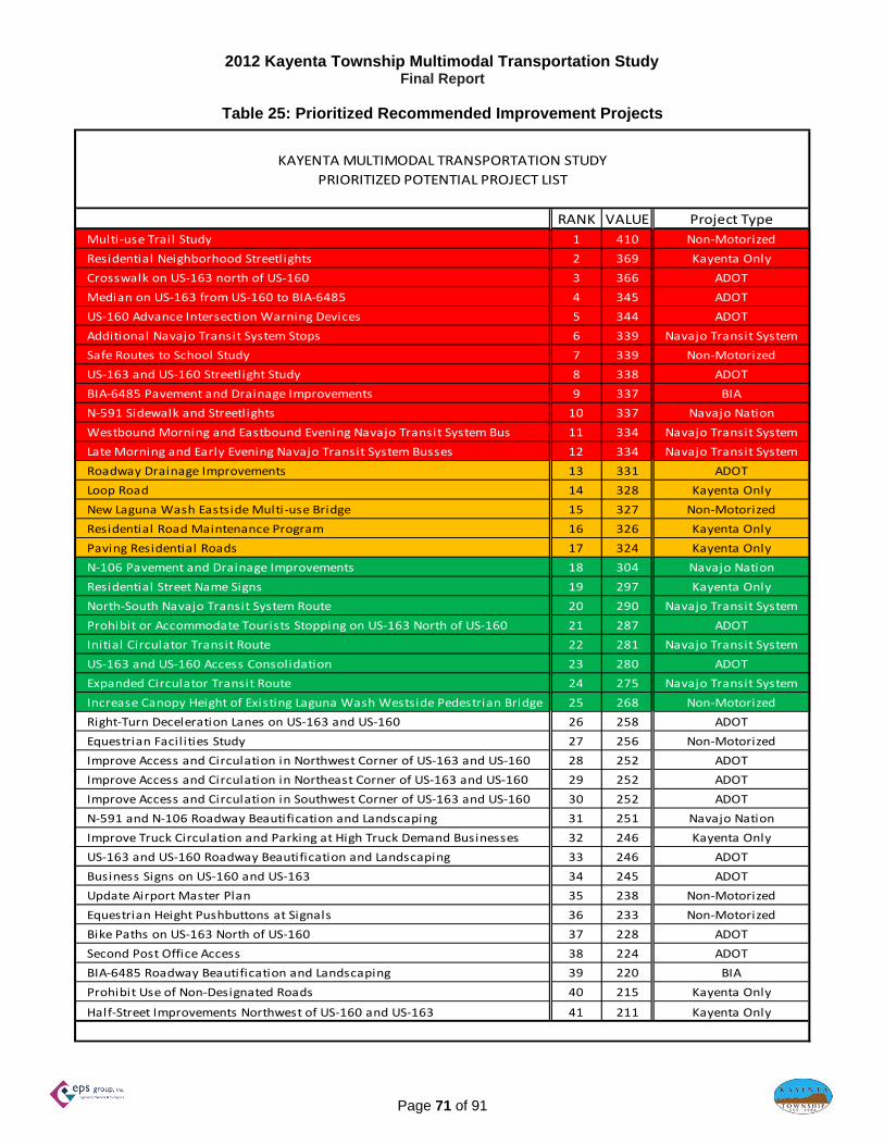
2012 Kayenta Township Multimodal Transportation Study Final Report
Page 71 of 91
Table 25: Prioritized Recommended Improvement Projects
KAYENTA MULTIMODAL TRANSPORTATION STUDY
PRIORITIZED POTENTIAL PROJECT LIST
RANK VALUE Project Type
Multi‐use Trail Study 1 410 Non‐Motorized
Residential Neighborhood Streetlights 2 369 Kayenta Only
Crosswalk on US‐163 north of US‐160 3 366 ADOT
Median on US‐163 from US‐160 to BIA‐6485 4 345 ADOT
US‐160 Advance Intersection Warning Devices 5 344 ADOT
Additional Navajo Transit System Stops 6 339 Navajo Transit System
Safe Routes to School Study 7 339 Non‐Motorized
US‐163 and US‐160 Streetlight Study 8 338 ADOT
BIA‐6485 Pavement and Drainage Improvements 9 337 BIA
N‐591 Sidewalk and Streetlights 10 337 Navajo Nation
Westbound Morning and Eastbound Evening Navajo Transit System Bus 11 334 Navajo Transit System
Late Morning and Early Evening Navajo Transit System Busses 12 334 Navajo Transit System
Roadway Drainage Improvements 13 331 ADOT
Loop Road 14 328 Kayenta Only
New Laguna Wash Eastside Multi‐use Bridge 15 327 Non‐Motorized
Residential Road Maintenance Program 16 326 Kayenta Only
Paving Residential Roads 17 324 Kayenta Only
N‐106 Pavement and Drainage Improvements 18 304 Navajo Nation
Residential Street Name Signs 19 297 Kayenta Only
North‐South Navajo Transit System Route 20 290 Navajo Transit System
Prohibit or Accommodate Tourists Stopping on US‐163 North of US‐160 21 287 ADOT
Initial Circulator Transit Route 22 281 Navajo Transit System
US‐163 and US‐160 Access Consolidation 23 280 ADOT
Expanded Circulator Transit Route 24 275 Navajo Transit System
Increase Canopy Height of Existing Laguna Wash Westside Pedestrian Bridge 25 268 Non‐Motorized
Right‐Turn Deceleration Lanes on US‐163 and US‐160 26 258 ADOT
Equestrian Facil ities Study 27 256 Non‐Motorized
Improve Access and Circulation in Northwest Corner of US‐163 and US‐160 28 252 ADOT
Improve Access and Circulation in Northeast Corner of US‐163 and US‐160 29 252 ADOT
Improve Access and Circulation in Southwest Corner of US‐163 and US‐160 30 252 ADOT
N‐591 and N‐106 Roadway Beautification and Landscaping 31 251 Navajo Nation
Improve Truck Circulation and Parking at High Truck Demand Businesses 32 246 Kayenta Only
US‐163 and US‐160 Roadway Beautification and Landscaping 33 246 ADOT
Business Signs on US‐160 and US‐163 34 245 ADOT
Update Airport Master Plan 35 238 Non‐Motorized
Equestrian Height Pushbuttons at Signals 36 233 Non‐Motorized
Bike Paths on US‐163 North of US‐160 37 228 ADOT
Second Post Office Access 38 224 ADOT
BIA‐6485 Roadway Beautification and Landscaping 39 220 BIA
Prohibit Use of Non‐Designated Roads 40 215 Kayenta Only
Half‐Street Improvements Northwest of US‐160 and US‐163 41 211 Kayenta Only

2012 Kayenta Township Multimodal Transportation Study Final Report
Page 72 of 91
Table 26: Prioritized Recommended Improvement Projects
KAYENTA MULTIMODAL TRANSPORTATION STUDY
PRIORITIZED POTENTIAL PROJECT COST ESTIMATES
RANK Project Type Cost
Multi‐use Trail Study 1 Non‐Motorized 20,000$
Residential Neighborhood Streetlights 2 Kayenta Only 2,100,000$
Crosswalk on US‐163 north of US‐160 3 ADOT 7,000$
Median on US‐163 from US‐160 to BIA‐6485 4 ADOT 350,000$
US‐160 Advance Intersection Warning Devices 5 ADOT 3,000$
Additional Navajo Transit System Stops 6 Navajo Transit System 20,000$
Safe Routes to School Study 7 Non‐Motorized 9,000$
US‐163 and US‐160 Streetlight Study 8 ADOT 6,000$
BIA‐6485 Pavement and Drainage Improvements 9 BIA 170,000$
N‐591 Sidewalk and Streetlights 10 Navajo Nation 110,000$
Westbound Morning and Eastbound Evening Navajo Transit System Bus 11 Navajo Transit System 500,000$
Late Morning and Early Evening Navajo Transit System Busses 12 Navajo Transit System 500,000$
Roadway Drainage Improvements 13 ADOT 1,500,000$
Loop Road 14 Kayenta Only 10,500,000$
New Laguna Wash Eastside Multi‐use Bridge 15 Non‐Motorized 950,000$
Residential Road Maintenance Program 16 Kayenta Only 920,000$
Paving Residential Roads 17 Kayenta Only 9,500,000$
N‐106 Pavement and Drainage Improvements 18 Navajo Nation 34,000$
Residential Street Name Signs 19 Kayenta Only 16,000$
North‐South Navajo Transit System Route 20 Navajo Transit System 300,000$
Prohibit or Accommodate Tourists Stopping on US‐163 North of US‐160 21 ADOT 2,000$
Initial Circulator Transit Route 22 Navajo Transit System 286,000$
US‐163 and US‐160 Access Consolidation 23 ADOT 45,000$
Expanded Circulator Transit Route 24 Navajo Transit System 202,000$
Increase Canopy Height of Existing Laguna Wash Westside Pedestrian Bridge 25 Non‐Motorized 40,000$
Right‐Turn Deceleration Lanes on US‐163 and US‐160 26 ADOT 320,000$
Equestrian Facil ities Study 27 Non‐Motorized 6,000$
Improve Access and Circulation in Northwest Corner of US‐163 and US‐160 28 ADOT 15,000$
Improve Access and Circulation in Northeast Corner of US‐163 and US‐160 29 ADOT 15,000$
Improve Access and Circulation in Southwest Corner of US‐163 and US‐160 30 ADOT 15,000$
N‐591 and N‐106 Roadway Beautification and Landscaping 31 Navajo Nation 120,000$
Improve Truck Circulation and Parking at High Truck Demand Businesses 32 Kayenta Only 30,000$
US‐163 and US‐160 Roadway Beautification and Landscaping 33 ADOT 600,000$
Business Signs on US‐160 and US‐163 34 ADOT 13,000$
Update Airport Master Plan 35 Non‐Motorized 35,000$
Equestrian Height Pushbuttons at Signals 36 Non‐Motorized 6,000$
Bike Paths on US‐163 North of US‐160 37 ADOT 20,000$
Second Post Office Access 38 ADOT 63,000$
BIA‐6485 Roadway Beautification and Landscaping 39 BIA 61,000$
Prohibit Use of Non‐Designated Roads 40 Kayenta Only 4,000$
Half‐Street Improvements Northwest of US‐160 and US‐163 41 Kayenta Only 400,000$

2012 Kayenta Township Multimodal Transportation Study Final Report
Page 73 of 91
The prioritized improvement projects are presented in Figure 36 by location. The numbers correspond to rank as shown in Table 25 and each number is color-coded to correspond to the primary agency or benefited user.
Figure 36: Recommended Improvement Project Locations
Kayenta Township Multimodal
Transportation Study Boundary
ALL RESIDENTIAL
N.T.S.
N163
160
1
2
3
4
5
5
6
7
8
9
10
11
12 13
14
15
16
17
18
19
20
21
22
23
24
25
26
27
2728
29
30
30
31
32
32
0
33
34
37
35
36
0
37
37
TOWNSHIP‐WIDE
D D
D
DD
D
Non‐motorized
ADOT
Navajo Transit
Kayenta Only
Navajo Nation
BIA
0

2012 Kayenta Township Multimodal Transportation Study Final Report
Page 74 of 91
Public Involvement
A two-phase public involvement process was implemented for this study. The first phase occurred from February to March 2012, and the second phase occurred from March to May 2012. The first phase consisted of various outreach methods to inform the public of the study purpose and objectives, and to obtain public comment of transportation concerns and potential solutions. The second phase consisted of presenting the recommended priority projects to determine if they addressed public concerns, and soliciting additional comment. The complete first and second phase public involvement summary reports are included in Appendix E and Appendix F, respectively. Two separate public outreach meetings occurred in Kayenta. The first public outreach meeting was held on Thursday, 16 February 2012. The study purpose and objectives were presented followed by detailed discussions on the existing conditions for the study area including:
Streets by type Arterial and local road networks Historical collision data by year, location, cause, and time of day Arterial road daily, and morning and evening peak hour traffic volumes Arterial road average speeds, 85th percentile speeds, and vehicle classifications Current and future general land use plans
Several verbal comments were documented. Written comment forms were also provided for completion, return, and documentation. The comments were compiled by improvement type and tabulated in order of importance. Appendix E provides the detailed comments. The second public outreach meeting was held on Thursday, 19 April 2012. The existing conditions presented in the first public outreach meeting were reintroduced. The public survey topics with 75 percent or higher identification as a high priority were presented with the recommended project implementation year within the Implementation Plan as listed: TRANSPORTATION CONCERN RECOMMENDED IMPLEMENTATION YEAR
Improved school pedestrian travel ......................................................................... 5 Improved BIA-6485 ............................................................................................... 5 Improved Township transportation ........................................................................ 5 Reduced collisions near schools ........................................................................... 5 Pave dirt roads ..................................................................................................... 10 Resurface paved roads ........................................................................................ 10 Bike paths on US-163 .......................................................................................... 5# Street lighting on US-160 ...................................................................................... 5 Opposite direction Navajo Transit System Route ................................................. 5 More Navajo Transit System busses on Existing Route ....................................... 5 New Transit in Township ...................................................................................... 20
# Incorporated into the Safe Routes to School project included subsequent to meeting.
Improved chapter and area transportation, and new transit service in both the chapter and area also received greater than 75% ranking as a high priority. However, the Kayenta Township Multimodal Transportation Study is limited to the Kayenta Township jurisdiction. The public survey topics with 75 percent or higher identification as a large issue were also presented with the recommended project implementation year within the Implementation Plan as listed:

2012 Kayenta Township Multimodal Transportation Study Final Report
Page 75 of 91
TRANSPORTATION ISSUE RECOMMENDED IMPLEMENTATION YEAR
Travel on BIA-6485 ............................................................................................... 5 High speeds on US-163 ....................................................................................... 5# High speeds on US-160 ......................................................................................... 5 Collisions between vehicles and pedestrians ....................................................... 5 Collisions between vehicles and bicycles ............................................................. 5
# Not in program at public meeting, included subsequent to meeting.
The project evaluation criteria was presented from highest to lowest priority as listed below:
Safety Improvement Imminent Need (less than five years) Community Desire People with Disability Impact Elderly Impact Pedestrian Impact Transit Impact Emergency Response Time Economic and Tourism Impact Operation and Maintenance Expense Construction Disruption Near Future Need (5 to 15 years) Bicyclist Impact Equestrian Impact Initial Expense Distant Need (more than 15 years)
A draft recommended 5, 10, and 20 year project list was presented. Projects were also identified by category – including Residential, Transit, Multi-use, Equestrian, and ADOT. Appendix F provides the detailed comments, prioritized potential project criteria, and recommended project list.
Functional Classification
State Functional Classification Functional classification is the process by which streets and highways are grouped into classes, according to the character of service they provide. Section 1006 of the 1991 Intermodal Surface Transportation Act (ISTEA) required that each state functionally reclassify its public roads and streets. According to lSTEA roads that are a part of a state’s public road system are to be functionally classified as an integral system regardless of jurisdictional control of those roads. In Arizona all federal and state highways, and some county roads, city streets, National Forest Service roads, and Bureau of Indian Affairs (BIA) roads are part of the state public road system.
Standards for roads owned and maintained by the Arizona Department of Transportation (ADOT) are designed and classified according to the ADOT Roadway Design Guidelines and the FHWA Functional Classification Guidelines. Also in Arizona the process for functional classification certification of public system roads is accomplished through the use of the Arizona Functional Classification Guidelines. The current functional classifications for ADOT roads within Navajo County and the study area include:

2012 Kayenta Township Multimodal Transportation Study Final Report
Page 76 of 91
US-160 classified as a Principal Arterial US-163 classified as a Major Collector
BIA Functional Classification
The Indian Reservation Roads (IRR) Program provides guidelines for the functional classification of BIA and Navajo Nation owned and maintained roads. The most recent guidelines available are contained within 25 CFR Part 170 which is in the IRR Program Final Rule dated 19 July 2004. Specifically functional classification is addressed in Appendix D to Subpart C of the Final Rule which provides the Coding Guide and Instructions for updates to the IRR Inventory. The current functional classifications for BIA and Navajo Nation roads within Navajo County include:
BIA 6485 classified as a Rural Collector (this route is also classified as a Minor Collector under the State/FHWA classification system)
N-106 classified as a Rural Collector N-591 classified as a Rural Collector
It should be noted that the Bureau of Indian Affairs is currently conducting a review and process alignment of the IRR functional classification system so that it may be brought in line with the FHWA classification system. The purpose for this alignment process is to determine which non-BIA and non-tribal roads included in the tribal inventories meet the definition of a Federal-aid highway and are eligible for federal-aid funding. This in turn will determine the road’s percentage contribution into the IRR Cost to Construct and Vehicle Miles Traveled factors of the IRR Relative Need Distribution Factor (RNDF). The total funding available to each BIA region for IRR transportation planning, design, and construction projects is based on each region’s RNDF (Kayenta Township is located within the BIA Navajo Region). It is expected that BIA Regions will begin using the new functional classification alignment factors in FY 13.
Another important consideration regarding functional classification is that in order for a BIA route to receive federal Surface Transportation Program (Federal-Aid) funding through the state it must have FHWA functional classification certification. In Arizona this process is coordinated through the appropriate regional Council of Government (COG) for the Kayenta Township/Navajo Nation this is the Northern Arizona Council of Governments (NACOG). The general steps are that the Township/Nation makes a functional reclassification request for a specified BIA route through NACOG. NACOG in turn reviews and determines feasibility of the request then if approved it will be submitted to the ADOT Multimodal Planning Division (MPD). ADOT-MPD reviews and approves the request then submits the request to the FHWA Arizona Division for review, approval and final certification. Navajo County Functional Classification Navajo County provides criteria for the development of roadways by functional classification within the County that are not currently owned or maintained by ADOT, BIA, or Navajo Nation. The following criteria are provided in the Navajo County Road Maintenance Policy: It is the policy of the Public Works Department to classify all roads in the Navajo County Maintained Road System according to their Level of Development. The following defines the LOD Classification System that will be used to determine the nature and frequency of maintenance activities on a road. LEVEL OF DEVELOPMENT A – Major Collectors These roads qualify for federal funding assistance. They serve through traffic between arterial roads and other major collectors or they link neighborhoods.

2012 Kayenta Township Multimodal Transportation Study Final Report
Page 77 of 91
LEVEL OF DEVELOPMENT B – Minor Collectors { > 400 vehicles per day (vpd)} These roads serve through traffic within local areas, provide connection to local roads and link major collectors and arterials. LEVEL OF DEVELOPMENT C – Subdivision Roads These are local roads built to County standards in accordance with the subdivision approval process. LEVEL OF DEVELOPMENT D – Minor Collectors { < 400 vpd}. These roads serve through traffic within local areas and may provide connection to local roads and streets. The category is separated into the following subcategories based on ADT.
D-1--Minor Collectors with >250 and < 400 vpd D-2--Minor Collectors with >100 and < 250 vpd D-3--Minor Collectors with <100 vpd
LEVEL OF DEVELOPMENT E – Local Roads { >100 and < 250 vpd} These roads serve as access to farm, residence, business or other abutting property. Through traffic is local in nature and extent. LEVEL OF DEVELOPMENT F – Very Low Volume Roads These roads serve various functions and experience very low traffic volumes, typically less than 100 vpd. They serve as access to public lands, farms, ranches, or residences. The following full roadway width right-of-way preservation guidelines are also included:
Level of Development A – 100 feet Level of Development B and D – 66 feet Level of Development C – based on subdivision approval process Level of Development E and F – 50 feet
Additionally, provisions and right-of-way preservation for current and future pedestrian, bicycle, and transit facilities are recommended on all study roads. Evaluation should be conducted, based upon any programmed improvements, to determine the location and impact to area roads.
Access Management
Access Management policies are recommended for implementation to better address area needs and safety issues. Access Management policies include:
Consolidation of access onto through roads Minimum spacing requirements for accesses Restriction of specific turning movements at accesses Addition or reduction of traffic control devices Roadway realignment
Access Management policies can be employed to increase or decrease the access preference to conflicting users of a roadway. A greater degree of access control to the minor street users generally yields greater capacity and less conflict with the major street through traffic. Consideration must be given to the tradeoff that occurs between the access preference given to the minor street versus the major street.

2012 Kayenta Township Multimodal Transportation Study Final Report
Page 78 of 91
ADOT is currently in the process of developing a statewide access management program. The most recent available access management policies are contained within the ADOT Traffic Engineering Policies, Guidelines, and Procedures manual and the ADOT Roadway Design Guidelines. Both manuals provide general access management procedures based upon the functional classification of the road, but specific location strategies are developed at the district level. Formal access management procedures are not currently available for Navajo and BIA owned and maintained roads. According to the 2009 Navajo Nation Long Range Transportation Plan, “Currently the Navajo DOT and BIA work with the State DOT district engineers to comply with the state highway access permitting policies and requirements”. Typical urban divided high speed, high capacity arterial roads limit full access intersection spacing to 660 feet, where possible. Additional limited access intersections, such as right-in, right-out only, are typically limited to 330 feet. This spacing allows adequate room to accommodate the design elements of deceleration turn lanes and provides a safe distance from upstream and downstream signalized intersections. Figure 37 presents existing areas that have been identified for improvement through access management measures based upon intersection spacing.

2012 Kayenta Township Multimodal Transportation Study Final Report
Page 79 of 91
Figure 37: Existing Intersection Spacing Improvement Locations The locations depicted in Figure 37 are recommended for further evaluation as new area infrastructure projects are constructed. It is also recommended to develop area wide access management policies to improve existing and future planned access intersections.
Access Management
N.T.S.
N
163
160
APermitted Full Access Intersections With Spacing of Less Than 200 Feet
CPermitted Full Access Intersections With Spacing of Less Than 660 Feet
BPermitted Full Access Intersections With Spacing of Less Than 330 Feet
A
C
C
B
B
B
A
B
A
B
B
B
C
AA

2012 Kayenta Township Multimodal Transportation Study Final Report
Page 80 of 91
Title VI and Environmental Justice The recommended projects were evaluated by type and location relative to Title VI of the Civil Rights Act of 1964. In July 1964 Congress passed the Civil Rights Act of 1964. Title VI of the Civil Rights Act states that "No person in the United States shall, on the ground of race, color, or national origin, be excluded from participation in, be denied the benefits of, or be subjected to discrimination under any program or activity receiving Federal financial assistance." In February 1994, President Clinton issued Executive Order 12898, "Federal Actions to Address Environmental Justice in Minority Populations and Low-Income Populations." In a separate memorandum, President Clinton identified Title VI as one of several federal laws already in existence that can help "to prevent minority communities and low-income communities from being subject to disproportionately high and adverse environmental effects." Preliminary Assessment The following highlights the directives from Title VI and Executive Order 12898: Title VI
Title VI prohibits recipients of federal financial assistance (e.g., states, universities, local governments) from discriminating on the basis of race, color, or national origin in their programs or activities.
Title VI is a federal law that applies to federal financial assistance recipients (i.e., persons or entities that receive federal financial assistance) and not to a federal agency itself as the Executive Order does.
Title VI allows persons to file administrative complaints with the federal departments and agencies that provide financial assistance alleging discrimination based on race, color, or national origin by recipients of federal funds.
Under Title VI, a federal agency has a responsibility to ensure that its funds are not being used to subsidize discrimination based on race, color, or national origin. This prohibition against discrimination under Title VI has been a statutory mandate since 1964.
Executive Order 12898
Executive Order 12898 generally calls on each federal agency to achieve "environmental justice ... by identifying and addressing, as appropriate, disproportionately high and adverse human health or environmental effects of its programs, policies, and activities on minority populations and low-income populations...."
Executive Order 12898 applies to federal agency actions and directs agencies, to the extent permitted by law, to identify and address, as appropriate, disproportionately high and adverse human health or environmental effects on minority populations and low-income populations.
Executive Order 12898 is a directive from the President of the United States to federal agencies intended to improve the internal management of the federal government.
The Executive Order establishes a federal agency’s policy on environmental justice. While this Order is mandated, and federal agencies work to comply with this mandate, the Executive
Order affords no right, enforceable by any member of the public against a federal agency, should the federal agency fail to live up to this mandate.
Census data is typically utilized to properly evaluate Title VI considerations. In the Navajo Nation generally, and in Kayenta Township specifically, appropriate census data is not available on a street level scale. In the Navajo Nation, the census level with necessary Title VI evaluation data is the Census Tract level. For Kayenta Township the tract number is 9425 (refer to Figure 25). This Census Tract encompasses Kayenta Township and much of its surrounding area. Therefore, each specific potential project cannot be evaluated for Title VI considerations on a street by street basis.
2012 Kayenta Township Multimodal Transportation Study Final Report
Page 81 of 91
Additionally, Title VI requires that public improvement projects not unfairly impact protected populations. Census Tract 9425 is entirely a designated minority population, and therefore protected. All projects within populated areas of Kayenta Township impact a protected population. Therefore, by definition, each project does not unfairly impact a protected population. Each of the listed projects (crosswalks, multi-use pathways, pedestrian bridges, sidewalks, bus stops and routes, intersection warning devices, streetlights, pave residential streets, drainage improvements, road maintenance, street signing, landscaping, access improvements) would have a beneficial impact to this protected population. Each of the projects would create temporary minor impacts during construction in the immediate vicinity. These impacts may include:
Temporary constraint to street accessibility Increased traffic through the area Increased vehicular noise Decreased air quality Transit route and schedule change Travel time change Temporary constraint to bus stop location Expansion of right-of-way
Each project would have permanent beneficial impacts on all protected populations in the project area. Therefore, no disproportionately high or adverse impacts to protected populations are anticipated as a result of these projects. The only project that could conceivably unfairly impact a protected population is the loop road project which would construct a road where none currently exists. The property in the immediate vicinity of this proposed road is vacant. The new loop road would connect to existing roads. These connections might negatively impact some Kayenta residents more than other Kayenta residents. There may also be negative impacts to visitors in the area. When detailed project planning begins for the loop road, specific Title VI evaluations on a neighborhood, and potentially individual property, basis would be required.
Transportation Funding Sources
Financing the Kayenta Township Transportation Study improvement plan and implementing its recommendations will require an analysis of funding sources (including combinations of sources), determination of long-term cost feasibility, and coordination of a number of agencies, depending on the source. Communication, cooperation, coordination and consultation are key elements in assuring that projects deemed feasible for implementation can be carried out.
The Arizona State Constitution restricts making state tax revenues, e.g. state gas, motor vehicle registration and vehicle license taxes, directly available to tribes. However, most federally funded transportation programs are administered by the states, and Tribes are eligible for those funds. Certain federal funding processes are also coordinated through the regional Council of Government. For Kayenta Township this is the Northern Arizona Council of Governments. Compensation from most federally-funded transportation programs is on a reimbursement basis i.e. tribal entities must have funding available to cover upfront project expenditures then bill for reimbursement of those costs.
It should also be noted that a number of the existing federal transportation funding programs available are subject to the 2012 reauthorization of the federal highway bill. The Safe, Accountable, Flexible, Efficient Transportation Equity Act: A Legacy for Users (SAFETEA-LU) highway authorization bill is scheduled to expire

2012 Kayenta Township Multimodal Transportation Study Final Report
Page 82 of 91
on June 30, 2012. A new reauthorization bill will extend the surface transportation programs through 2014. At this point in time it is expected that the new reauthorization will be titled Moving Ahead for Progress in the 21st Century (MAP-21). Also under this legislation the Indian Reservation Roads Program will be re-titled to the Tribal Transportation Program. It is therefore recommended that the Kayenta Township personnel keep advised on the status of this national legislative effort.
The potential sources of funding that currently exist to address the recommended projects which include grants, loans, subsidies, and aid from various tribal, local, regional, county, state, federal institutions. A summary of program descriptions, eligibility requirements, eligible project types and contact information is provided below. Township leadership and technical personnel are encouraged to make contact with the various funding source program management contacts to begin the process of determining feasible strategies to access funding for its transportation improvement projects. The most prominent and widely available programs include: Federal Lands Highway (FLH) The Office of Federal Lands Highway is a part of the US Department of Transportation (USDOT), Federal Highway Administration (FHWA). The Office of Federal Lands Highway (FLH) provides program stewardship and transportation engineering services for planning, design, construction, and rehabilitation of the highways and bridges that provide access to and through federally owned lands. FHWA's initial partnership began with the US Forest Service in 1914 and expanded to the National Park Service in 1926. The Federal Lands Highway Program (FLHP) was created by the 1982 Surface Transportation Assistance Act and signed by President Reagan on January 6, 1983. The primary purpose of the FLHP is to provide financial resources and technical assistance for a coordinated program of public roads that service the transportation needs of Federal and Indian lands. The FLH currently provides transportation engineering and related services in all 50 states, the District of Columbia, Puerto Rico, and the Virgin Islands. One of the major factors associated with the success of the program is the Federal Highway Administration's strong relationship with Federal, State, local, and tribal partners. See contacts for the Indian Reservation Roads Programs and the Public Land Highway Discretionary Program. These programs are administered under the Federal Lands Highway Program. Indian Reservation Roads / Bridges (IRR) The Indian Reservation Roads Program addresses transportation needs of tribes by providing funds for planning, design, construction, and maintenance activities. The program is jointly administered by the Federal Highway Administration’s Federals Lands Highway Office and the Bureau of Indian Affairs (BIA) in accordance with an interagency agreement. IRR funds are distributed to 12 BIA regional offices. In Arizona there is the Navajo Regional Office which serves the Navajo Nation and the Western Regional Office which serves all other tribes in Arizona and the tribes in Nevada and Utah. The Indian Reservation Roads are public roads which provide access to and within Indian reservations, Indian trust land, restricted Indian land, and Alaska native villages. IRR roads by definition include BIA, state, county, and other local government public roads. Approximately 25,000 miles are under the jurisdiction of BIA and tribes and another 24,000 are under State and local ownership. IRR funds can be used for any type Title 23 transportation project providing access to or within Federal or Indian lands and may be used for the State/local matching share for apportioned Federal-aid Highway Funds.

2012 Kayenta Township Multimodal Transportation Study Final Report
Page 83 of 91
The BIA and Tribal governments undertake most of the design and construction of IRR projects. Under Public Law 93-638 contracts, Tribal governments can develop and operate portions of the IRR Program within its boundary. Contact: Harold Riley, Acting Division Manager
Division of Transportation BIA Navajo Region P.O. Box 1060 Gallup, NM 87305 P: (505) 863-8281 F: (505) 863-8355 E: [email protected]
Indian Reservation Roads / Bridges High Priority Projects (IRR HPP) The IRR HPP is a special funding pool that can be used for:
Tribes or governmental subdivision whose annual allocation is insufficient to complete its highest priority project;
Emergency/disaster on any IRR facility The project must meet minimum IRR requirements:
Inventory Highest Priority by Tribe Dollar Amount must be greater than Tribe's Annual IRR Allocation and less than $1,000,000.00
Contact: Harold Riley, Acting Division Manager Division of Transportation BIA Navajo Region P.O. Box 1060 Gallup, NM 87305 P: (505) 863-8281 F: (505) 863-8355 E: [email protected] Public Lands Highway Discretionary (PLHD) Program
PLHD funds are available for any kind of transportation project eligible for assistance under Title 23, United States Code, which is within, adjacent to, or provides access to Federal lands or facilities. PLHD funds are available for transportation planning, research, engineering, and construction of the highways, roads, and parkways, and of transit facilities within the Federal public lands. Priority is given to requests that increase livability, e.g. increase transportation choices. Contact: Cindi Ptak
Office of Federal Lands Highway P: (202) 366-1586 E: [email protected]

2012 Kayenta Township Multimodal Transportation Study Final Report
Page 84 of 91
Tribal Transit Program (TTP) The Public Transportation on Indian Reservations Program (Tribal Transit Program) was created under SAFETEA-LU and provides a total of $45 million in direct funding to federally recognized tribes for the purpose of supporting tribal public transportation in rural areas. Only Federally-recognized tribes are eligible recipients under the Tribal Transit Program. However, tribes which are not federally recognized remain eligible to apply to the State as a sub recipient for funding under the State's apportionment. Federally recognized tribes may use the funding for capital, operating, planning, and administrative expenses for public transit projects that meet the growing needs of rural tribal communities. Examples of eligible activities include: capital projects; operating costs of equipment and facilities for use in public transportation; and the acquisition of public transportation services, including service agreements with private providers of public transportation services. Funds are available the year appropriated plus two years (total of three years). The Tribal Transit Program is funded as a takedown under the Section 5311 program. On an annual basis FTA conducts a national competitive selection process. There is no federal requirement for a local match. Contact: FTA Region 9 Office
201 Mission Street, Suite 1650 San Francisco, CA 94105-1839 P: (415) 744-3133 F: (415) 744-2726
Cathy Monroe, Tribal Transit Program P: (816) 329–3929 E: [email protected]
Jason Kelly, Mobility Management Planner Northern Arizona Council of Governments 119 East Aspen Avenue Flagstaff, AZ 86001 P: (928) 830-0127 E: [email protected]
Coordinated Mobility Programs The Federal Transit Administration provides ADOT formula FTA and Surface Transportation Program (STP) funds annually through the capital assistance program. The Section 5310 – Elderly & Persons with Disabilities Transportation Program, Section 5316 – Job Access and Reverse Commute (JARC) Transportation Program, and Section 5317 – New Freedom Transportation Program are collectively known as the Coordinated Mobility Programs. The Section 5310 – Elderly & Persons with Disabilities Transportation Program provides funds used for capital assistance, and for the purchase of vehicles and related equipment statewide. In addition, mobility management awards are available to assist agencies and communities with their coordination efforts. For FY 2012 the matching ratio is 90% Federal Funds with a 10% Local Match. Eligible recipients include private non-profit and public agencies that provide transportation to the elderly and disabled. Examples include senior centers and programs for the physically, mentally {including seriously mentally ill (SMI)} and developmentally disabled (DD) populations. The utilization of special transportation includes:

2012 Kayenta Township Multimodal Transportation Study Final Report
Page 85 of 91
Medical Appointments Nutrition Appointments Adult Day Care Facilities Education and Training Service Appointments such as Banking, Social Services, etc. Shopping Trips Employment
Section 5316, the Job Access and Reverse Commute (JARC) Transportation Program, is a grant program that provides operating and capital assistance to develop new or expanded transportation services that connect welfare recipients and other low-income persons to jobs and employment-related activities. ADOT manages two distinct JARC funding amounts, one for the rural portions of the state and the other for the small Urbanized Areas between 50,000 and 200,000 population. Section 5317, the New Freedom Transportation Program, is a grant program that provides operating and capital assistance to public transportation services focused on persons with disabilities, and to address needs that go beyond those required by the Americans with Disabilities Act (ADA). New Freedom funds may be used to provide new transportation services to jobs, medical services and to meet other needs. ADOT manages two distinct New Freedom funding amounts, one for rural areas and the other for Urbanized Areas with populations between 50,000 and 200,000. All projects funded under this program must be derived from a locally developed, coordinated public transit-human services transportation planning process. Coordination is a key element which is now required for all Federal Transit Authority (FTA0 programs. To be awarded grant assistance, successful applicants must be included in the Regional Coordination Plan for their area and have participated in related coordination activities such as coordination meetings. The Multimodal Planning Division (MPD) of the ADOT administers for the State of Arizona three Federal Transit Administration (FTA) grant programs that comprise the Coordinated Mobility Programs. ADOT works with regional transportation planning agencies to solicit, review, and award grant applications under the Coordinated Mobility Programs. In rural areas of Arizona these agencies are the Council of Governments (COG). In urbanized areas, Metropolitan Planning Organizations (MPO) serve this role. Contact: Dan Harrigan, Coordinated Mobility Program Manager
ADOT Multimodal Planning Division 206 S 17th Ave MD 340B Phoenix, AZ 85007 P: (602) 712-8232 F: (602) 712-3046 E: [email protected]
Jason Kelly, Mobility Management Planner Northern Arizona Council of Governments 119 East Aspen Avenue Flagstaff, AZ 86001 P: (928) 830-0127 E: [email protected]

2012 Kayenta Township Multimodal Transportation Study Final Report
Page 86 of 91
Transportation Enhancement (TE) The Transportation Equity Act for the 21st Century (TEA-21) is currently under the third highway bill entitled SAFETEA-LU. The program was developed to enhance surface transportation activities by developing more involved and sophisticated projects than typical of most transportation departments. All projects must be surface transportation related. Eligibility requirements are screened through the program application process and validated by ADOT staff and the Transportation Enhancement Review Committee (TERC). Proposed projects must qualify in one of the 12 listed eligible activities to be eligible for enhancement funding. The estimated annual TE funds available to Arizona are currently approximately $14 million per year. The ADOT Statewide Project Management Group, Transportation Enhancement and Scenic Roads Section administers the FHWA funded program. The TE Program is not a grant program, it is a reimbursement program. Project sponsors must be prepared to pay for all costs incurred and then request reimbursement for expenditures as specified in the required Joint Project Agreement (JPA). Requests for reimbursement may be submitted no more often than monthly. All projects require a minimum of 5.7% hard cash match. The project sponsor is responsible for payment of project actual costs exceeding approved cost. The sponsor also is responsible for items that do not qualify for TE funding. Projects start at the local level as an idea for a specific enhancement. The people developing the ideas – whether a government entity, group, or individual – must submit their ideas to their local MPO / COG representative for evaluation. Any federal, state, tribal, or local government, group, or individual may apply for enhancement funding. However, a governmental body must sponsor the project. This restriction is necessitated by project development and financial administration requirements. Contact: Chris Fetzer, Director
Northern Arizona Council of Governments (NACOG) Transportation & Transit Planning 119 East Aspen Avenue Flagstaff, AZ 86001 P: (928) 774-1895, ext. 1142 E: [email protected]
Website: http://www.azdot.gov/Highways/SWProjMgmt/enhancement_scenic/enhancement/Enhancement_Common/Implement_Workshop.asp Highway Safety Improvement Program (HSIP) The current legislation, the Safe Accountable Flexible Efficient Transportation Equity Act – A Legacy for Users (SAFETEA-LU), established the HSIP as a core Federal-aid program under 23 U.S.C. 148. SAFETEA-LU nearly doubled the funds for infrastructure safety, allowed increased flexibility in program funding (10% Flex), and required a focus on results. Railway-Highway Grade Crossing Program (23 U.S.C. 130) and High Risk Rural Roads Program (HRRRP) are set-aside provisions. The specific purpose of the Highway Safety Improvement Program (HSIP) is to achieve a significant reduction in traffic fatalities and serious injuries on public roads. This is to be accomplished through the development and implementation of the Strategic Highway Safety Plan (SHSP) which is a statewide-coordinated safety plan that provides a comprehensive framework for reducing highway fatalities and serious injuries on all public roads. SHSP is intended to identify the State's key safety needs and guide HSIP investment decisions.
2012 Kayenta Township Multimodal Transportation Study Final Report
Page 87 of 91
The SHSP is required to be data-driven and developed in collaboration with a broad range of stakeholders. It is performance-based with the adoption of strategic and performance goals which are coordinated with other state safety programs. ADOT is ultimately responsible for the SHSP and the State HSIP projects and programs should be aligned with the emphasis areas of the SHSP. Contact: Mark Poppe, State Safety Engineer
Arizona Department of Transportation Traffic Safety Section 1615 W. Jackson Street Phoenix, AZ 85007 P: (602) 712-8496 F: (602) 712-3243 E: [email protected]
Website: http://www.azdot.gov/highways/traffic/TSS/HSIP/AzHSIP2010.pdf The High Risk Rural Roads Program (HRRRP) The SAFETEA-LU introduced a new set-aside provision known as the High Risk Rural Roads Program (HRRRP), which provides set-aside funds for construction and operational improvements on high risk rural roads. High Risk Rural Roads are defined as any roadway functionally classified as a rural major or minor collector or a rural local road:
on which the crash rate for fatalities and incapacitating injuries exceeds the statewide average for those functional classes of roadway; or
that will likely have increases in traffic volume that are likely to create a crash rate for fatalities and incapacitating injuries that exceeds the statewide average for those functional classes of roadway.
Implementation of the HRRRP requires comprehensive roadway and crash data for all public roads. For States that do not currently have the capability of locating crashes on all public roadways, the State may adopt interim practices that utilize the best available data resources until a comprehensive statewide roadway and crash data system is implemented. Contact: Mark Poppe, State Safety Engineer
Arizona Department of Transportation Traffic Safety Section 1615 W. Jackson Street Phoenix, AZ 85007 P: (602) 712-8496 F: (602) 712-3243 E: [email protected]
Website: http://www.azdot.gov/highways/traffic/TSS/HSIP/AzHSIP2010.pdf Safe Routes To School (SRTS) Tribal Planning Assistance Program (TPAP) The Safe Routes To School (SRTS) Tribal Planning Assistance Program (TPAP) is for elementary and middle schools and school districts within Arizona’s federally recognized tribal communities. The intent of the program is to provide the applicant with technical resources needed to plan and implement their own Safe Routes To School projects. As a condition of TPAP, the applicant is required to apply for the next cycle of SRTS infrastructure and/or non-infrastructure funding.

2012 Kayenta Township Multimodal Transportation Study Final Report
Page 88 of 91
This is not a program to:
Improve school pick-up/drop-off areas for the benefit of cars and buses; Construct only sidewalks Install only crosswalks
This also is not a program for applicants who wish to implement only one strategy. Eligible programs and projects must be:
Focused on elementary and middle schools, Within a two-mile radius of the school Focused on an existing school, not a future/planned school
Contact: Brian Fellows, SRTS Program Coordinator Arizona Department of Transportation 1615 W. Jackson St., MD EM10 Phoenix, AZ 85007 P: (602) 712-8010 F: (602) 712-3347 E: [email protected] Surface Transportation Program (STP)
The Surface Transportation Program provides funding for construction, transit, safety, intelligent transportation systems, management systems, environmental, transportation planning and enhancement on roads with functional classifications of urban collector, major rural collector or higher. Tribal governments will need to work through the regional Council of Governments to determine project eligibility.
Contact: Chris Fetzer, Director Northern Arizona Council of Governments (NACOG) Transportation & Transit Planning 119 East Aspen Avenue Flagstaff, AZ 86001 P: (928) 774-1895, ext. 1142 E: [email protected]
Navajo Fuel Excise Tax This fund is used for both construction and maintenance activities on Navajo Nation roadways and other transportation infrastructure. The Kayenta Township will need to coordinate project planning and programming with the Navajo Division of Transportation. Contact: Darryl Bradley, Principal Civil Engineer
Navajo Division of Transportation PO Box 4620
Window Rock, AZ 86515 P: (505) 371-8300/8301 F: (505) 371-8399 E: [email protected]

2012 Kayenta Township Multimodal Transportation Study Final Report
Page 89 of 91
Indian Community Development Block Grant (ICDBG) Program This program provides funding for infrastructure construction, e.g., roads, water and sewer facilities; single or multipurpose community buildings; and, housing and economic development projects. There are also Imminent Threat Grants to provide solutions to a problem of an urgent nature. Contact: Southwest Office of Native American Programs
Phoenix Office One North Central Avenue, Suite 600 Phoenix, AZ, 85004-2361 P: (602) 379-7200 F: (602) 379-3101
Transportation, Community, and System Preservation Program This program provides funding for planning and implementation grants, and research regarding the relationships among transportation, community, and system preservation plans and practices and to identify initiatives. Contact: Wesley Blount
Office of Human Environment P: (202) 366-0799 E: [email protected]
Planning Assistance for Rural Areas (PARA) Program
PARA funds may be applied to address a broad range of planning issues related to roadway and non-motorized transportation modes. Funds may be also be applied to studies dedicated solely to the planning of public transportation services. Funds are limited to planning applications, and may not be used for the design or construction of transportation facilities.
Contact: Justin Feek, PARA Program Manager ADOT Multimodal Planning Division 206 S. 17th Avenue Phoenix, AZ 85007 P: (602) 712-6196 E: [email protected]
Website: http://mpd.azdot.gov/mpd/systems_planning/PDF/PARA/PARAs.asp Project Development Activity Funds (PDAF) PDAF Project Development Activity Funds (subcategory of 12.6%) are intended to assist in project development activities including: major investment or corridor studies, design concept reports, engineering and design studies right-of-way acquisition, and non-traditional studies. These funds are limited to arterial projects.

2012 Kayenta Township Multimodal Transportation Study Final Report
Page 90 of 91
Contact: Chris Fetzer, Director Northern Arizona Council of Governments (NACOG) Transportation & Transit Planning 119 East Aspen Avenue Flagstaff, AZ 86001 P: (928) 774-1895, ext. 1142 E: [email protected] Indian Highway Safety Program This program promotes the following: safe communities, alcohol countermeasures, occupant protection, police traffic services (primarily enforcement), emergency medical services, traffic records, motorcycle safety, pedestrian and bicycle safety, roadway safety, and speed control. Contact: Paul Holley, Administrator Patricia Abeyta, Program Coordinator BIA Highway Safety Office P: (505) 563-5371
Injury Prevention Program This program is intended to build tribal capacity for preventing any type of identified injury problem facing a tribal government. Develop, implement, and evaluate proven or promising injury prevention intervention programs. Projects include, but are not limited to programs designed to reduce alcohol related injuries, e.g. supporting initiatives to reduce drinking and driving. Other projects include seat belt promotion campaigns, pedestrian safety, and child passenger safety. Contact: Siona Willie, Area Injury Prevention Specialist Navajo Area Indian Health Service P.O. Box 9020 Window Rock, AZ 86515 E: [email protected] P: (928) 871-1335 ADOT Road Safety Assessment (RSA) Program The ADOT RSA program will conduct road safety assessments on state, local and tribal road facilities. An RSA is defined as a formal examination of user safety of a future or existing roadway by an independent multidisciplinary audit team, which includes qualified experienced members. The RSA Team works to identify safety related strategies and project needs for the specified route or routes. Contact: Mike Blankenship, P.E., ADOT RSA Program Manager ADOT Traffic Safety Section 1615 West Jackson Street, Mail Drop 065R Phoenix, AZ 85007-3217 P: (602) 712-7601 F: (602) 712-3243 Email: [email protected]

2012 Kayenta Township Multimodal Transportation Study Final Report
Page 91 of 91
Tribal Traffic Safety Funding Guide The Tribal Traffic Safety Funding Guide was developed through the Arizona Transportation Research Center - Research Program. The guide is a comprehensive reference source of transportation safety funding programs. It summarizes various transportation safety programs that can be used to address tribal traffic safety issues. The guide can be obtained through the ATRC website. Website: http://www.azdot.gov/TPD/ATRC/publications/project_reports/PDF/AZ592s.pdf National Scenic Byway Program There are eight categories under the National Scenic Byway Program including: State and Tribal Programs; Corridor Management Plans; Safety Improvements; Byway Facilities – includes construction of facility for pedestrians and bicyclists, rest area, turnout, shoulder, overlook, or interpretive facility; Access to Recreation; Resource Protection; Interpretive Information; and Marketing Programs. This Program provides discretionary funds for projects along highways designated as National Scenic Byways, All-American Roads, State scenic byways or Indian Tribe Scenic Byways. This Program can fund bicycle facilities along highways and priority is given to projects that create new jobs. Contacts: Geri Arviso, Navajo Nation Scenic Byway Coordinator Navajo Tourism Office PO Box 663 Window Rock, AZ 86515 P: (928) 871-6436 E: [email protected] Gary Jensen, Team Leader FHWA Headquarters P: (202) 366-2048 E: [email protected] Meesa Otani, Environmental Coordinator FHWA AZ Division P: (602) 382-8976 E: [email protected] Website: http://www.bywaysonline.org/grants/