kate brown, governor capitol st. n.e., floor · 2017-09-21 · complete raptor nest surveys within...
TRANSCRIPT

Staff Report on Agenda Item L Page 1 of 8
550 Capitol St. N.E., 1st Floor Salem, OR 97301‐3737Phone: (503) 378‐4040
Toll Free: 1‐800‐221‐8035FAX: (503) 373‐7806
www.Oregon.gov/ENERGY
Kate Brown, Governor
To: Energy Facility Siting Council From: Sarah Esterson, Senior Siting Analyst Date: September 7, 2017 Subject: Agenda Item L ‐ Montague Wind Power Facility Pre‐Construction Update Staff
Report for the September 21‐22, 2017 EFSC Meeting: Pre‐Construction Wildlife Survey Results; Finalization of Habitat Mitigation Plan; Revegetation Plan; and, Wildlife Monitoring & Mitigation Plan
Attachments: See List of Attachments at end of Staff Report
Introduction The Montague Wind Power Facility is an approved, but not yet constructed, wind energy generation facility with a capacity of up to 404 megawatts (MW), to be located on private land south of the City of Arlington, in Gilliam County. In accordance with the site certificate construction commencement deadline, construction of the facility must start on or before September 14, 2017. In anticipation of the start of facility construction, Montague Wind Power Facility, LLC (certificate holder) must demonstrate compliance with pre‐construction site certificate conditions imposed to satisfy the requirements of applicable Energy Facility Siting Council (EFSC or Council) standards, rules and statutes. The certificate holder began submitting information and reports to satisfy the requirements of pre‐construction conditions in June 2017; the Department has been working with local and state agencies in the review the pre‐construction compliance submittals, as applicable, and continues to review and verify compliance of submittals in anticipation of the commencement of facility construction by the September 14, 2017 deadline. The site certificate was originally issued in September 2010, and has been amended three times. Due to recognized changes in final facility design and layout prior to facility construction, site certificate conditions require the certificate holder to conduct certain pre‐construction wildlife surveys and submit the results of those surveys to the Department for review and approval, documenting that impacts to wildlife habitat were appropriately considered and mitigated in accordance with site certificate and Council standards. The Montague Wind Power Facility site certificate also contains a site certification requirement directing the Department to

Staff Report on Agenda Item L Page 2 of 8
present the results of the pre‐construction wildlife surveys to the Council. Results of the pre‐construction wildlife surveys are provided in Attachments A through D of this staff report and are summarized below. In addition, pre‐construction requirements necessary to satisfy the Council’s Fish and Wildlife Habitat standard and imposed through site certificate conditions 91, 93, and 94 include finalizing the Habitat Mitigation Plan; Revegetation Plan; and, Wildlife Monitoring and Mitigation Plan. Changes between the plans, as evaluated in 2010 and 2015, and the final plans are described below in this staff report and presented in the attached red‐line versions of the plans (see Attachments E‐1, E‐2, and E‐3). Pre‐Construction Wildlife Survey Results Raptor Nest Surveys Site Certificate condition 95(e) states:
Before beginning construction, certificate holder’s qualified professional biologist shall complete raptor nest surveys within the raptor nest survey area as described in the Final Order on the Application. The purposes of the survey are to identify any sensitive raptor nests near construction areas and to provide baseline information on raptor nest use for analysis as described in the Wildlife Monitoring and Mitigation Plan referenced in Condition 91. The certificate holder shall provide a written report on the raptor nest surveys and the surveys to the Department and to ODFW. If the surveys identify the presence of raptor nests within the survey area, the certificate holder shall implement appropriate measures to assure that the design, construction and operation of the facility are consistent with the fish and wildlife habitat mitigation goals and standards of OAR 635‐415‐0025, as approved by the Department, in consultation with ODFW.
In compliance with condition 95(e), the certificate holder contracted with CH2M Hill Engineers, Inc. (CH2M) and Tetra Tech, Inc. (Tetra Tech) to conduct pre‐construction raptor nest surveys. The 2017 surveys consisted of two rounds; the first, an early season aerial survey (conducted between March 1 and April 15, 2017), and the second, a ground‐based survey conducted later in the season (between April 15 and May 30, 2017) to follow up on nests located during the aerial surveys and to search for new nest locations. The survey protocol used by the certificate holder’s team of qualified biologist, accepted by ODFW on April 7, 2017, established a survey area including a 2‐mile buffer from proposed turbine locations and a 0.5‐mile buffer from the transmission line route currently under review through Change Request 3.1
1 During pre‐construction Washington ground squirrel surveys conducted in 2016, the certificate holder identified active burrow locations within the previously approved transmission line route and corridor. Because active burrows are considered category 1 habitat, the certificate holder requested Department review of a differing

Staff Report on Agenda Item L Page 3 of 8
The 2017 pre‐construction surveys detected 24 raptor nests within the survey area. Of the 24 nests, 7 were categorized as active, 11 were inactive, 4 were “alternate nests” (a term specific to golden eagle), and 2 that were categorized as unknown. The raptor nests identified as active were used by ferruginous hawks, prairie falcons, red‐tailed hawks, and Swainson’s hawks. The 4 alternate nests were used by two golden eagles; one, whose southern territory encompassed 3 of the alternate nests, and the second, whose southeastern territory included one alternate nest. These results are shown in Attachment A, the complete 2017 Raptor Nest Survey Report. Site certificate Condition 96 limits construction activity within 1,300‐feet of potentially active nest sites during sensitive breeding seasons, including Swainson’s hawks, ferruginous hawks, and burrowing owls. One active Swainson’s hawk nest was identified within 1,300 feet of proposed construction activity. As such, the certificate holder shall avoid all construction activities during the sensitive season (April 1 to August 15) within 1,300 feet of that nest. The other active raptor nests identified during the surveys were more than 1,300 feet away from the proposed construction activities. 2010 Avian Use Study Update Site Certificate condition 95(d) states:
Before beginning construction, certificate holder's qualified professional biologist shall complete the avian use studies that began in September 2009 at six plots within or near the facility site as described in the Final Order on the Application. The certificate holder shall provide a written report on the avian use studies to the Department and to ODFW.
As presented above, Condition 95(d) requires the certificate holder to complete avian use studies that began in 2009, prior to construction. The certificate holder completed the avian use studies in 2010 and in order to satisfy the pre‐construction requirement, submitted a technical memorandum (tech memo) in 2017 summarizing the results of the 2010 study results (see Attachment B Technical Memo of the Summery of 2010 Avian Use Surveys). As explained in the tech memo, three rounds of avian use surveys were conducted in 2009‐2010. The flight paths of special‐status species and raptors were hand plotted on topographic maps in the field, and later used to aid in the determination of spatial use of identified special status species and there relation to the proposed turbine locations.
transmission line route and corridor though still within the previously‐approved site boundary, in specific segment locations, to allow avoidance of impacts to category 1 habitat. The change in transmission line corridor is currently under review by the Department through evaluation of the certificate holder’s Change Request 3, submitted on August 4, 2017.

Staff Report on Agenda Item L Page 4 of 8
The 2010 avian use study detected sixteen species of birds; however, no federal‐ or state‐ listed threatened or endangered species were observed. The Swainson’s hawk, listed as a State Sensitive‐Vulnerable Raptor Species was detected 29 times during the 2010 summer surveying, The Ferruginous hawk, listed as a State Sensitive‐Critical Raptor Species, was incidentally observed by the surveyors were in transit between the 2010 summer survey locations. The certificate holder states that the potential impacts to the identified raptor species posed by the construction and operation of the facility were extensively discussed in previous reports prepared for the facility. The 2010 Avian Study determined that the two aforementioned raptor species were at some risk of colliding with turbines due to the number of individuals observed. NWC’s observation of numerous Swainson’s hawks and Ferruginous hawks exemplified the abundance of raptor species within or near the facility. Numerous species of raptors (including the Swainson’s hawk and Ferruginous hawk) are present at other wind facilities in the Oregon Columbia Plateau Ecoregion. Threatened and Endangered Species Surveys Site Certificate Condition 95(b) states:
Before beginning construction, but no more than two years prior to the beginning of construction, the certificate holder shall hire a qualified professional biologist to conduct a survey of all areas to be disturbed by construction for threatened and endangered species. The certificate holder shall provide a written report of the survey and a copy of the survey to the Department, the Oregon Department of Fish and Wildlife (ODFW), and the Oregon Department of Agriculture (ODA). If the surveys identify the presence of threatened or endangered species within the survey area, the certificate holder shall implement appropriate measures to avoid a significant reduction in the likelihood of survival or recovery of the species, as approved by the Department, in consultation with ODA and ODFW.
In compliance with condition with 95(b), the certificate holder conducted surveys for threatened and endangered plant species, Washington ground squirrel, and burrowing owls.2 Threatened and Endangered Plants The certificate holder contracted with CH2M to conduct a 2017 pre‐construction rare plant species survey, which was conducted between May 23 and June 1, 2017 to coincide with the optimal bloom time for the target species. The certificate holder provided the Department, ODFW, and ODA a copy of the 2017 Rare Plant Survey on July 17, 2017. The survey report included the results of the survey and the survey methodology. (See Attachment C to this staff report, 2017 Rare Plant Surveys for Montague Wind Power Facility – Phase 1).
2 It is noted that burrowing owls are not an ODFW‐listed threatened or endangered species.

Staff Report on Agenda Item L Page 5 of 8
The 2017 pre‐construction rare plant survey area included all areas to be disturbed during construction that are not currently in agricultural production, or consisting of residential or farm operation facilities. Based on pre‐survey literature review, and consistent with the Council’s 2010 Final Order on the Application for Site Certificate (ASC), the certificate holder identified one state‐listed plant species (Laurent’s milkvetch) and two state‐listed candidate3 plant species (sessile mousetail and dwarf evening primrose) with the potential to occur in the site boundary. The 2017 survey did not identify any of these three species.
Washington Ground Squirrel and Burrowing Owl Surveys In compliance with condition with 95(b), the certificate holder contracted with CH2M to conduct a 2017 pre‐construction Washington Ground Squirrel survey. The certificate holder provided the Department and ODFW a copy of the Washington Ground Squirrel surveys and Habitat Mapping Report on July 17, 2017. The report contained both the survey methodology and the results of the 2017 survey effort (Attachment D contains the full survey report, 2017 Washington Ground Squirrel Surveys and Habitat Mapping for Montague Wind Power Facility). The Washington ground squirrel survey area was defined as areas of potentially suitable habitat within 1,000 feet of proposed facility component locations or construction disturbance. Within the survey area, 12 active Washington ground squirrel colonies were detected. After identifying the active Washington ground squirrel sites, the certificate holder buffered each site by 785 feet, and excluded habitat not suitable for WGS foraging or burrow establishment. The buffered sites represent Category 1 WGS habitat, as defined by condition 94. In accordance with the Council’s Fish and Wildlife Habitat standard, Category 1 habitat cannot be impacted by the facility. As such, the certificate holder has redesigned its facility layout to avoid Category 1 habitat. The survey did not find any burrowing owls or signs of burrowing owls (pellets, calls). Mitigation Plan Finalization The Council previously imposed site certificate conditions requiring that the certificate holder implement mitigation plans to satisfy the requirements of the Council’s Fish and Wildlife Habitat standard, specifically Conditions 91, 92 and 93. Condition 91 requires implementation of a final Wildlife Monitoring and Mitigation Plan; Condition 92 requires implementation of a final Revegetation Plan; Condition 93 requires implementation of a final Habitat Mitigation Plan. The Council previously reviewed each of these plans during the application for site
3 It is noted that candidate species are not covered by the Council’s Threatened and Endangered Species standard.

Staff Report on Agenda Item L Page 6 of 8
certificate phase and issuance of the 2010 Final Order on the ASC; the changes between previous and final version of the plans are summarized below and presented in red‐line format in Attachment E (see Attachments E‐1 through E‐3).
Habitat Mitigation Plan The final Habitat Mitigation Plan (final HMP) identifies the permanent and temporary impacts that, based on final facility design/layout, require compensatory mitigation. The final HMP identifies the area of impact (in acres and habitat category), habitat enhancement actions required based on impacted habitat, monitoring procedures, and the success criteria to be applied to ensure that habitat enhancement and preservation methods sufficiently mitigate for permanent and temporary habitat impacts resulting from facility construction and operation. The final HMP identifies that the total mitigation area required for permanent facility impacts, based on final facility design/layout, is 16.15 acres, or 17 acres when rounded. The 17 acre mitigation area accounts for permanent impacts to Category 2, 3 and 4 habitat. The mitigation area includes 2 acres for every 1 acre of Category 2 habitat permanently impacted, and 1 acre for every 1 acre of permanent impacts to Category 3 and 4 habitat impacts. The mitigation area also includes 0.5‐acre for every acre of Category 2 or 3 sagebrush shrub‐steppe habitat temporarily impacted during construction. While the area of permanent and temporary impact has changed in the final HMP as a result of final facility design/layout, the mitigation ratios applied have not changed since the Council previously reviewed the plan. The Habitat Enhancement Actions have not changed since the Council previously reviewed the plan, with the exception of the removal of tree planting which applied to impacts to juniper woodland habitat, which are no longer impacted as a result of final facility design/layout. Habitat enhancement actions in the final HMP include: modification of livestock grazing practices; shrub planting; weed control; fire control; nest platforms, and habitat protection. The monitoring and reporting procedures have not changed since the Council previously reviewed the plan, with the exception of the removal of the assessment of the survival rate and growth of planted juniper trees which was previously required to monitor the success of enhancement actions for juniper woodland habitat impacts, which are longer impacted as a result of final facility design/layout. The final HMP includes success criteria establishing that mitigation of permanent and temporary habitat impacts of the facility may be considered successful when the certificate holder is able to demonstrate that they have protected and enhanced sufficient habitat to meet the ODFW goals of no net loss of habitat in Categories 2, 3 and 4 and a net benefit in habitat quantity or quality for impacts to Category 2 habitat. This success criteria have not changed since the Council previously reviewed the plan.

Staff Report on Agenda Item L Page 7 of 8
Revegetation Plan The final Revegetation Plan (final reveg plan) identifies the methods; success criteria; and, monitoring and reporting requirements for restoration of areas temporarily disturbed during facility construction. Changes in the final reveg plan include administrative and substantive edits. Administrative edits primarily include addition of tables presenting the temporarily impacted habitat, by habitat category and subtype. Substantive edits include a requirement that the certificate holder complete pre‐revegetation consultation with representatives from the Department, ODFW, and the Gilliam County Weed Control Authority prior to the completion of construction; increased frequency in reporting both revegetation records (every 6‐months for the first 5‐years following construction) and investigator inspection reports (within 60‐days of receipt by the certificate holder) to the Department; and identification and selection of reference sites, to be approved by ODFW, prior to construction. Substantive edits also include additional detail on methods and procedures for topsoil management and restoration, as topsoil management and restoration contribute significantly to the early and ongoing success of revegetation activities. The success criteria identifies that a wildlife habitat area is successfully revegetated when its habitat quality is equal to, or better than, the habitat quality of the reference site as measured by the site conditions listed above, which has not changed in the final reveg plan. The Department, however, has included clarifying language that if the landowner were to convert an impacted wildlife habitat area to a use inconsistent with the success criteria, prior to that area reaching the success criteria, that the certificate holder would be obligated to provide compensatory mitigation for the impacted wildlife habitat area consistent with the Council’s Fish and Wildlife Habitat standard.
Wildlife Monitoring and Mitigation Plan The final Wildlife Monitoring and Mitigation Plan (final WMMP) includes post‐construction wildlife monitoring and mitigation requirements including: avian and bat fatality monitoring program (Year 1 and Year 5 following first full year of operation); short‐ and long‐term raptor nesting surveys (Year 1 and Year 4 following completion of construction; 5‐years thereafter for life of facility); Washington ground squirrel surveys (Year 1 after construction; every 3 years thereafter for life of facility); and wildlife reporting and handling system (ongoing). The changes to the final WMMP were primarily administrative in nature, but included minor substantive revisions that have been reviewed and approved by the Department in consultation with ODFW. Minor substantive revisions included removal of aerial surveys for raptor nest surveys, relying solely upon ground‐based surveys; and, removal of carcass placement protocol for the removal trial component of the avian and bat mortality study. The certificate holder is required to propose mitigation in response to the results of the surveys required under the final WMMP, if the results indicate that facility operation has significantly

Staff Report on Agenda Item L Page 8 of 8
impacted the habitat of an affected species, which would require an amendment of the plan to identify additional mitigation and monitoring requirements. List of Attachments: Attachment A: Montague Phase 1 Wind Project Raptor Nest Survey Report Attachment B: Summary of 2010 Avian Use Surveys for the Montague Wind Power
Facility Attachment C: 2017 Rare Plant Surveys for Montague Wind Power Facility – Phase 1 Attachment D: 2017 Washington Ground Squirrel Surveys and Habitat Mapping for
Montague Wind Power Facility – Phase 1 Attachment E: Mitigation Plans
E‐1 Habitat Mitigation Plan (As finalized Sept 2017) E‐2 Revegetation Plan (As finalized Sept 2017) E‐3 Wildlife Monitoring and Mitigation Plan (As finalized Sept 2017)

Attachment A: Montague Phase 1 Wind Project Raptor Nest Survey Report

TO: CH2M Hill Engineers, Inc.
FROM: Tetra Tech
DATE: June 8, 2017
CORRES. NO.: TTCES-PTLD-2017-068
SUBJECT: Montague Phase 1 Wind Project Raptor Nest Survey Report
Introduction
Avangrid Renewables (Avangrid) is developing Phase 1 of the Montague Wind Power Facility (Montague Phase 1) in Gilliam County, Oregon. Avangrid is committed to environmental due diligence and contracted with CH2M Hill Engineers, Inc. (CH2M) and Tetra Tech, Inc. (Tetra Tech) to conduct raptor nest surveys at Montague Phase 1. The purpose of the survey was to provide baseline information on raptor nest use at Montague Phase 1 and to identify sensitive raptor nests near construction areas. Of particular importance was determining whether or not there are any active nests of sensitive raptor species within a half-mile of any areas that would be disturbed during construction. The raptor nest survey area was defined as a 2-mile buffer from the proposed Montague Phase 1 turbines and a 0.5-mile buffer of the transmission line (Survey Area).
Tetra Tech requested locations of documented nests of eagles and other raptors within the Survey Area in March and April 2017 from the Oregon Biodiversity Information Center (ORBIC) and the U.S. Fish and Wildlife Service (USFWS). ORBIC was unable to provide exact locations of golden eagle nests due to data sharing agreements with USFWS. On April 4, 2017 USFWS provided locations of golden eagle nests within the Survey Area and stated that there are no known bald eagle nests within the Survey Area, although the bald eagle nest data has not been updated in recent years. Golden eagle nest data provided by USFWS indicated that one historic golden eagle nest (Nest 3) was situated just within the boundary of the Survey Area to the south (see attached figure). In addition to the data provided from the agencies, Tetra Tech also incorporated historic raptor nest locations from surveys performed by Northwest Wildlife Consultants, Inc. at the Montague Wind Power Facility in 2010 (NWC 2010).
Tetra Tech used standardized protocols for the raptor nest surveys that were designed to be responsive to the level of effort required by the conditions of the Energy Facility Siting Council Site Certificate for the Montague Wind Power Facility (EFSC 2010), as well as recommendations in Tier 3 of the voluntary Land-Based Wind Energy Guidelines (WEG; USFWS 2012) and Stage 2 of the Eagle Conservation Plan Guidance (ECP Guidance; USFWS 2013). Tetra Tech submitted the survey protocol to the Oregon Department of Fish and Wildlife (ODFW) who approved the protocol on April 7, 2017. This report describes the aerial and ground-based raptor nest surveys conducted in spring 2017.
Tetra Tech, Inc. 1750 Harbor Way, Suite 400, Portland, OR 97201
Tel 503.221.8636 Fax 503.227.1287 www.tetratech.com

Montague Phase 1 Raptor Nest Survey Report Page 2
Methods
The nest survey approach consisted of two rounds to facilitate a complete inventory and accurate occupancy determination of raptor nests within the Survey Area. One early season (between March 1 and April 15, 2017) aerial survey was planned to occur before leaves emerged on trees. An additional ground-based survey was planned for later in the season (between April 15 and May 30, 2017) to follow-up on the nests located during the aerial nest survey and locate new raptor nests.
During the aerial survey which was performed on April 14, 2017, surveyors checked on the status of known nests and searched for and documented new raptor nests within the Survey Area. The helicopter flew along north to south oriented transects spaced 1-mile apart within the Survey Area. During the survey, the helicopter flew at low altitudes of approximately 200 feet above ground level, and lower for inspection and photography of nests or areas of interest. The aerial survey was flown in a Bell 206 Jet Ranger helicopter with two of Tetra Tech’s qualified surveyors to minimize the chance of missing nests. An email update of the results of the aerial survey was provided to CH2M and Avangrid on May 3, 2017.
The ground-based raptor nest survey was conducted on May 10 and 11, 2017, within 30 days after the aerial survey had been completed. The surveyors checked on the status of raptor nests located during the aerial survey and historic nests, and searched for and documented new raptor nests within the Survey Area. The surveyors drove accessible roads within the Survey Area and were equipped with a spotting scope to better identify distant nests.
Data Collection
To aid in navigation and data recording, tablets with topographic maps, built in global positioning system (GPS), and built in data forms for electronic data collection were used during both rounds of the surveys. High-resolution photographs of nest were taken with an optically stabilized camera.
For each raptor nest, the following data were collected during the survey:
• Nest Identification Number: corresponding with GPS waypoint number.
• Raptor Species: Using four-letter American Ornithologists’ Union codes (e.g., RTHA = red-tailed hawk, GHOW = great horned owl).
• Adult Present: Proximity of the adult to the nest (e.g., on nest, nearby, or unknown).
• Eggs or Young: Number of eggs or young observed.
• Nest Substrate: Structure in which nest was located (e.g., broadleaf tree, cut bank, transmission pole, etc.).
• Nest Height: Height relative to the structure it is on (e.g., on top of transmission pole, 3/4 of height of tree).
• Nest Status: To assess nest status, the following criteria were used (Postupalsky 1974, USFWS 2013, and USFWS 2016).

Montague Phase 1 Raptor Nest Survey Report Page 3
o In-Use: Defined by the presence of one or more eggs, dependent young, or adults on the nest in the past 10 days during the breeding season, including the period when adults are displaying courtship behaviors and are building or adding to the nest in preparation for egg-laying.
o Alternate: One of potentially several nests within an eagle nesting territory that is not an in-use nest at the current time. When there is no in-use nest, all nests in the territory are alternate nests. This term is specific to eagle nests.
o Inactive: Defined by the absence of any adult, egg, or dependent young at the nest. This term is specific to non-eagle nests.
o Unknown: A nest that could not be visited (e.g., road or access limitations) or that was visually obscured (e.g., vegetation around the nest site obscured the view of nest, wind speeds too high to determine status, etc.).
o No Longer Present: A nest that was located during a previous survey, but has subsequently been found to be destroyed and no longer exists. No evidence remains.
• Nest Condition: To assess nest condition, the following criteria were used (Postupalsky 1974, USFWS 2013):
o Excellent: defined cup or nest bowl with a well-maintained rim; adult or young present.
o Good: nest bowl intact and rim defined; minor repair needed for nest to be used; margins of nest in loose configuration, minor slumping occurring.
o Fair: nest bowl intact and nest not dilapidated; but needs significant repair in order to be used; material is slumping or sliding.
o Poor: loose structure of nest bowl still present; nest walls and side falling out; nest is in need of major repair to be used.
o Remnant: nest bowl not defined; scant material remaining and not usable unless fully rebuilt.
Results and Discussion
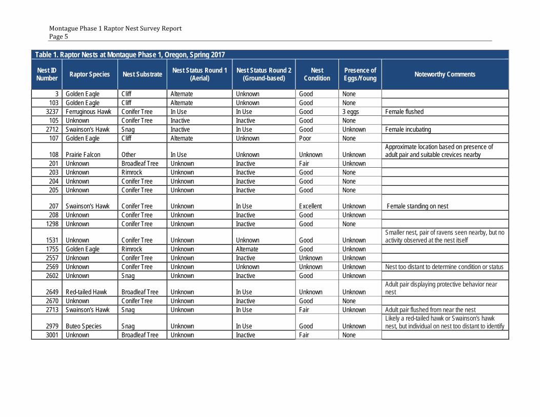
A total of 24 raptor nests were detected within the Survey Area (Table 1). These nests included 7 categorized as in-use (i.e., active), 11 categorized as inactive, 4 categorized as alternate (eagle-specific term), and 2 categorized as unknown nest status (see attached figure, Table 1). The in-use nests were used by ferruginous hawks, prairie falcons, red-tailed hawks, and Swainson’s hawks. There were no in-use eagle nests within the Survey Area. The 4 alternate nests were divided among one golden eagle territory with three alternate nests (Nest 03, Nest 103 and Nest 108) at the southern edge of the Survey Area, and one golden eagle territory with one alternate nest (Nest 1755) in the southeast of the Survey Area (see attached figure). The status of two of the nests (Nest

Montague Phase 1 Raptor Nest Survey Report Page 4
1531 and Nest 2569) could not be determined because nest visibility was obscured by dense vegetation. Many of the raptor nests located during the ground-based nest survey were not identified during the aerial nest survey due to the difficulty in detecting raptor nests within coniferous trees (specifically, Juniperus spp.) from the air. Small portions of the Survey Area were not visible to surveyors during the ground-based nest surveys (see attached figure), but were covered during the aerial nest survey. Most of the known raptor nest locations from the 2010 survey effort were not detected during either round of the survey and are most likely no longer present.
As stated above, there appear to be two separate golden eagle territories within the Survey Area. The three alternate nests located within the golden eagle territory located approximately 2 miles to the south of Montague Phase 1 varied in condition ranging from excellent to poor. Nest 03 was considered in excellent condition, but no sign of use during the current breeding season was evident, nor were any golden eagles observed in the area. The alternate nest (Nest 1755) located within the golden eagle territory located approximately 0.5 miles east of Montague Phase 1 was in good condition. This nest was of sufficient size and construction that it was categorized as an alternate golden eagle nest, but lacked signs of being used in the current season.
As part of Avangrid’s Site Certificate conditions (Condition 96), construction activity during certain periods shall be avoided within 1,300 feet of potentially active nests sites of Swainson’s hawks, ferruginous hawks, and burrowing owls. One active Swainson’s hawk nest (Nest 207) was identified within the 1,300-foot buffer of Montague Phase 1 infrastructure, specifically the transmission line. All other active raptor nests were located more than 1,300 feet away from proposed infrastructure where construction activity is anticipated, and all other raptor nests located within this buffer were categorized as inactive (see attached figure). Depending on the timing of construction and the status of Nest 207 at that time, additional measures as indicated in the permit conditions may be necessary to ensure that the nest will not be disturbed.
Montague Phase 1 Raptor Nest Survey Report Page 5
Table 1. Raptor Nests at Montague Phase 1, Oregon, Spring 2017
Nest ID Number Raptor Species Nest Substrate Nest Status Round 1
(Aerial) Nest Status Round 2
(Ground-based) Nest
Condition Presence of Eggs/Young Noteworthy Comments
3 Golden Eagle Cliff Alternate Unknown Good None 103 Golden Eagle Cliff Alternate Unknown Good None
3237 Ferruginous Hawk Conifer Tree In Use In Use Good 3 eggs Female flushed 105 Unknown Conifer Tree Inactive Inactive Good None
2712 Swainson's Hawk Snag Inactive In Use Good Unknown Female incubating 107 Golden Eagle Cliff Alternate Unknown Poor None
108 Prairie Falcon Other In Use Unknown Unknown Unknown Approximate location based on presence of adult pair and suitable crevices nearby
201 Unknown Broadleaf Tree Unknown Inactive Fair Unknown 203 Unknown Rimrock Unknown Inactive Good None 204 Unknown Conifer Tree Unknown Inactive Good None 205 Unknown Conifer Tree Unknown Inactive Good None
207 Swainson's Hawk Conifer Tree Unknown In Use Excellent Unknown Female standing on nest 208 Unknown Conifer Tree Unknown Inactive Good Unknown
1298 Unknown Conifer Tree Unknown Inactive Good None
1531 Unknown Conifer Tree Unknown Unknown Good Unknown Smaller nest, pair of ravens seen nearby, but no activity observed at the nest itself
1755 Golden Eagle Rimrock Unknown Alternate Good Unknown 2557 Unknown Conifer Tree Unknown Inactive Unknown Unknown 2569 Unknown Conifer Tree Unknown Unknown Unknown Unknown Nest too distant to determine condition or status 2602 Unknown Snag Unknown Inactive Good Unknown
2649 Red-tailed Hawk Broadleaf Tree Unknown In Use Unknown Unknown Adult pair displaying protective behavior near nest
2670 Unknown Conifer Tree Unknown Inactive Good None 2713 Swainson's Hawk Snag Unknown In Use Fair Unknown Adult pair flushed from near the nest
2979 Buteo Species Snag Unknown In Use Good Unknown Likely a red-tailed hawk or Swainson's hawk nest, but individual on nest too distant to identify
3001 Unknown Broadleaf Tree Unknown Inactive Fair None

Montague Phase 1 Raptor Nest Survey Report Page 6
References
EFSC (Energy Facility Siting Council of the State of Oregon). 2010. Site Certificate for the Montague Wind Power Facility. September 10. Amended June 21, 2013 and December 4, 2015.
NWC (Northwest Wildlife Consultants, Inc.). 2010. GIS shapefiles of raptor nest locations detected in 2010. Data provided on April 7, 2017 by Tyler Hoffbuhr, Avangrid Renewables.
Postupalsky, S. 1974. Raptor reproductive success: some problems with methods, criteria, and terminology. Raptor research report 2: 21-31.
USFWS (United States Fish and Wildlife Service). 2012. Land-based Wind Energy Guidelines. March 2012.
USFWS. 2013. Eagle Conservation Plan Guidance. Module 1 – Land-based Wind Energy, Version 2. April 2013.
USFWS. 2016. Eagle Permits; Revisions to Regulations for Eagle Incidental Take and Take of Eagle Nests. Federal Register Vol 81. No. 242. Pp 91494-91554. December 16, 2016.

#*
#*
$+$+
#*#*
$+#*
#*
$+
#*
#*
#*
#*
#*
#*
#*
#*
#*
#*
#*
#*
#*
#*#*
%,
%,
%,
%,
%,
%,
%,
%,
%,
%,
%,
%,
%,
%,
%,%,
%,
%,
%,
%,
%,
%,
%,
%,
%,
%,
%,%,
%,
%,
%,
%,
%,
%,
%,
%,
%,
%,
%,
%,
%,
%,
%,
%,
%,%,
%,
%,
%,
%,
%,
%,
%,
%,
%,
%,%,
%,%,%,
%,
%,
%,
%,%,
%,
%,
%,
%,%,
%,
%,
%,
%,%,
%,
%,
%,
%, %,
%,
%,
%,%,
%,
%,
%,
%,
%,
%,
%,%,
%,
%,
%,
%,%,%,
%,
%,%,
%,
%,%,
2670
205
207
105
2557
1755
2569
2602
3001
15312649
2712
2713
2979
201
203
204
¬«74
¬«19
§̈¦84
Canada
O R
W A
C A N V
I D
Reference Map
WGS 1984 UTM Zone 10N1:85,000O 0 1 2 3 40.5Miles
Montague Phase 1 Proposed Infrastructure%, Turbine
Access Road
Collector Line
Staging Area
Substation
O+M Facility
Transmission Line
Alternate Transmission Line
Survey Area2-mile Buffer of Turbines
.5-mile buffer of Transmission Line
1300ft Buffer of Proposed Infrastructure
Unobservable Area From Ground Survey
Nest Species, Nest Status$+ Golden eagle, Alternate
#* Buteo Species, In-use
#* Ferruginious hawk, In-use
#* Prairie Falcon, In-use
#* Red-tailed Hawk, In-use
#* Swainson's hawk, In-use
#* Unknown, Inactive
#* Unknown, Unknown
GILLIAM COUNTY, OR
Montague Phase 1
2017 Raptor NestSurvey Results
P:\GIS_PROJECTS\Avangrid\Montague\MXDs\Avian\2017\Avangrid_MontagueI_RNS_ReportFigure_11i17i_20170608.mxd
CLIENT LOGO
#*
#*
#*208
1298
3237
$+
$+
$+
#*
3
108
107
103

Attachment B: Summary of 2010 Avian Use Surveys for the Montague Wind
Power Facility

T E C H N I C A L M E M O R A N D U M
PR0630171552PDX 1
Summary of 2010 Avian Use Surveys for the Montague Wind Power Facility
PREPARED FOR: Avangrid Renewables, LLC
COPY TO: Carrie Konkol/Tetra Tech Irina Makarow/HDR
PREPARED BY: CH2M HILL Engineers, Inc.
DATE: July 19, 2017
1.0 Introduction CH2M HILL Engineers, Inc. (CH2M) was retained by Avangrid Renewables, LLC (Avangrid), to summarize the results of Northwest Wildlife Consultants, Inc. (NWC) 2010 avian use surveys for the Montague Wind Power Facility (Facility). This technical memorandum reports the results of the summer 2010 surveys conducted by NWC, which were completed after two previous reports (NWC, 2010a and 2010b) were prepared and provided to Avangrid. Further, this memorandum is prepared to address site certificate Condition 95. Condition 95(d) reads as follows:
“(d) Before beginning construction, certificate holder's qualified professional biologist shall complete the avian use studies that began in September 2009 at six plots within or near the facility site as described in the Final Order on the Application. The certificate holder shall provide a written report on the avian use studies to the Department and to ODFW.”
2.0 Methods Three rounds of avian use surveys were conducted in 2009-2010 and described in a report provided to the Oregon Department of Energy and the Oregon Department of Fish and Wildlife in September 2010. A fourth round of surveys was in progress as the 2010 report was being prepared for submittal; data collection methods were the same as those described and approved for the earlier three rounds (NWC, 2010b). The protocol followed for avian use surveys at the Facility was consistent with similar baseline studies conducted at other wind power projects in the Columbia Basin and more broadly, throughout the United States. The protocol for the study follows that described by Reynolds et al. (1980) and is effective for describing habitat use by large birds. Five 800-meter (m; approximately 0.5 mile [mi]) radius survey plots (AA, BB, EE, FF, GG; see the attachment to this memorandum, titled Montague Wind Power Facility Avian Use Study Overview, for plot locations) were located to provide good coverage of the proposed Facility as well as relatively unobstructed viewing conditions. A sixth plot (HH) was surveyed during the initial three rounds as reported in NWC (2010b), but was not included in the fourth round due to its location outside of the Facility site boundary. Ten surveys were conducted at each point from June 8 to August 9, 2010, for a total of 50 surveys.
During avian use surveys, experienced avian observers positioned at the center of the plot recorded all wildlife seen or heard over a 20-minute period, noting species, number of individuals, and distance from plot center, flight height, and habitats utilized for each observation. Flight paths of special-status species and raptors were hand-plotted on topographic maps in the field to later aid in determination of spatial use of these species in relation to proposed turbine sites. Efforts were made to avoid double counting of

SUMMARY OF 2010 AVIAN USE SURVEYS FOR THE MONTAGUE WIND POWER FACILITY
2 PR0630171552PDX
individuals; however, given the difficulty in tracking multiple individual birds simultaneously, some double counting was likely (NWC, 2010a).
Average weather conditions (wind speed/direction, temperature, cloud cover and level of precipitation) were noted for each survey plot visit. Efforts were made to vary the survey times for individual plots throughout each survey season to provide a full spectrum of avian activity during all daylight hours. While all avian detections were recorded, it should be noted that the survey protocol and plot placements used here emphasize the accurate detection of large, uncommon birds over a large area (i.e., raptors) while still providing a useful, though less precise measure of smaller, more abundant bird species (Reynolds et al., 1980).
Methods implemented for this investigation follow the methods used in the biological surveys for the previous layout of the Facility (2008-2009) as presented in Exhibit P of the Application for Site Certificate (IBR, 2010). Methods are also the same as used for the amended site boundary for Leaning Juniper IIB in 2008–2009 (LJWP, 2009; NWC, 2009), and for the Wildlife Baseline Study for the Leaning Juniper Wind Power Facility and supplemental studies conducted over the period 2004–2006 (Kronner et al., 2005; Attachment P-2 in LJWP, 2006); these sites are adjacent to the Facility. Methods follow standards set forth for preproject assessment in the Oregon Columbia Plateau Ecoregion wind energy siting and permitting guidelines (USFWS, 2008).
3.0 Results 3.1 Avian (Raptor) Use Sixteen species of birds were identified during point count surveys within the five study plots during the summer 2010 effort (June 8 to August 9, 2010; Table 1). Two additional species were observed in-transit to surveys that were not observed during avian use surveys within or outside of 800-meter plots: ferruginous hawk and prairie falcon (Table 2). No federal or state threatened or endangered species were observed during or incidental to surveys. A total of 107 groups (flocks) comprising a total of 263 individual birds were observed during the summer 2010 surveys (some individuals may have been counted more than once; Table 1). Summer season mean use (5.260 birds/20-minute [min.] survey) was significantly lower than fall season mean use (12.727 birds/20 min.) and was slightly higher than both winter (4.238 birds/20 min.) and spring (2.917 birds/20 min.) season use overall (Table 3).
As raptors are the primary focus of this memorandum, further survey results on the other avian groups (e.g., passerines) are not discussed. Raptor use during summer (mean use 0.880/20 min.) was higher than in winter (mean use 0.404 birds/20 min.), fall (mean use 0.273 birds/20 min.), or spring (0.167 birds/ 20 min.; Table 3). Raptors overall, had the second highest (second to passerines) frequency of occurrence as a group in fall, winter, and spring surveys and this pattern held true for summer surveys (Table 4). Rough-legged hawk was the most abundant species of raptor at the six plots surveyed during two of the four seasons with the highest use in winter season (0.298 birds/20 min.) and spring season (0.056 birds/20 min.). In fall, red-tailed hawk was the raptor species with highest use (0.091) followed by rough-legged hawk and northern harrier (both 0.068 birds/20 min.) In spring, ferruginous hawk had the second highest mean use of 0.042 birds/20 min. Other raptor species observed during these surveys include Swainson’s hawk, American kestrel, prairie falcon, and golden eagle. Two additional raptor species, Cooper’s hawk and great-horned owl, were observed while in-transit to surveys.
During summer surveys, Swainson’s hawk had significantly higher use than other raptors (0.760 birds/ 20 min.) and this accounted for the high mean use exhibited by raptors in general (0.880 birds/20 min.) during summer. A total of 29 groups of Swainson’s hawks, including 38 individuals, were observed during the summer surveys. Among raptors, Swainson’s hawk were the most numerous species observed during any one season, followed by rough-legged hawk (34 individuals during winter). No rough-legged hawks were observed during the summer surveys as they breed north of the Facility.

SUMMARY OF 2010 AVIAN USE SURVEYS FOR THE MONTAGUE WIND POWER FACILITY
PR0630171552PDX 3
Conversely, no Swainson’s hawks were observed during winter surveys as they spend the winter months in southern South America.
3.2 Spatial Use by Raptors At the five summer 2010 study plots, overall avian mean use ranged from 0.300 birds/ 20 min. at plot EE to 1.600 birds/20 min. at plot BB (Table 4). The range of all three seasons and all groups combined was fairly similar between plots ranging from 4.359 birds/20 min. at plot BB to 7.243 birds/ 20 min. at plot GG (Table 7). No one single plot showed consistently higher use than others in all seasons surveyed.
All six study plots surveyed during fall, winter, and spring as well as the five plots surveyed during the summer had some raptor use, with the lone exception of plot EE, which had no raptor use in winter season. Plots BB and FF exhibited the highest number of raptors observed (32 and 25 individuals, respectively) throughout all four seasons and plot EE exhibited the lowest number of raptor observations (8 individuals).
3.3 Special-status Raptor Species No federal- or state-listed threatened or endangered species were observed during the avian use surveys at the five study plots during summer 2010.
Swainson’s hawk (State Sensitive-Vulnerable) was detected 29 times (38 individuals) during summer surveys.
Ferruginous hawk (State Sensitive-Critical) was observed eight times while surveyors were in transit between survey locations; however, no observations occurred during summer surveys.
4.0 Impacts Discussion 4.1 Raptors In previous reports prepared for the Facility (NWC, 2010a and 2010b), the potential impacts to raptor species posed by the construction and operation of the Facility were discussed extensively. In general, locally nesting raptor species (e.g., Swainson’s hawk, ferruginous hawk, red-tailed hawk, and American kestrel) are most at risk of colliding with turbines due to their frequent presence in the survey area, and the fact that they have been found as fatalities at other wind projects in the Oregon Columbia Plateau Ecoregion, including nearby Leaning Juniper I (Gritski et al., 2008). Data gathered during the summer 2010 surveys were consistent with the information provided in the prior three seasons of avian use surveys and therefore there is no change to the previous analysis (NWC, 2010a and 2010b).
4.2 Special-status Raptors Consistent with findings reported during 2009 summer surveys, Swainson’s hawk (State Sensitive-Vulnerable) is at some risk of collision due to the number of individuals observed using the Facility during the summer 2010 avian use surveys (see Attachment P-7 in IBR, 2010). Data gathered during the summer 2010 surveys were consistent with the information provided in the prior three seasons of avian use surveys and therefore there is no change to the previous analysis (NWC, 2010a and 2010b).
Ferruginous hawk (State Sensitive-Critical) is at some risk of collision due to the number of individuals observed using the Facility during the summer 2010 (see Attachment P-7 in IBR, 2010). This finding also is consistent with the 2009 summer surveys. Data gathered during the summer 2010 surveys were consistent with the information provided in the prior three seasons of avian use surveys and therefore there is no change to the previous analysis (NWC, 2010a and 2010b).

SUMMARY OF 2010 AVIAN USE SURVEYS FOR THE MONTAGUE WIND POWER FACILITY
4 PR0630171552PDX
5.0 References Gritski, B. K. Kronner, and S. Downes. 2008. Leaning Juniper Wind Power Project, 2006–2008. Wildlife Monitoring Final Report. Prepared for PacifiCorp Energy, Portland, Oregon. Prepared by Northwest Wildlife Consultants, Inc., Pendleton, Oregon.
Iberdrola Renewables, Inc. (IBR). 2010. “Exhibit P: Fish and Wildlife Habitat and Species.” In: Application for Site Certificate for Montague Wind Power Facility. Prepared by CH2M HILL for Iberdrola Renewables, Inc. January.
Kronner, K., B. Gritski, J. Baker, V. Marr, G. Johnson, and K. Bay. 2005. Wildlife Baseline Study for the Leaning Juniper Wind Power Facility. Prepared for PPM Energy, Portland, Oregon, and CH2M HILL, Portland, Oregon. Prepared by Northwest Wildlife Consultants, Inc., Pendleton, Oregon, and WEST, Inc., Cheyenne, Wyoming.
Leaning Juniper Wind Power II LLC (LJWP). 2006. Application for Site Certificate, Leaning Juniper Wind Facility. Submitted to the Oregon Energy Facility Siting Council in September 2006.
Leaning Juniper Wind Power II LLC (LJWP). 2009. Request for Amendment No. 1 to the Site Certificate for the Leaning Juniper II Wind Power Facility. Submitted to the Oregon Energy Facility Siting Council on June 26, 2009.
Northwest Wildlife Consultants, Inc. (NWC). 2009. Supplemental 2008–2009 Study to the 2005 Leaning Juniper Wildlife Baseline Study. Conducted for Request for Amendment No. 1 to the Site Certificate for the Leaning Juniper II Wind Power Facility (dated June 18, 2009). Prepared for Iberdrola Renewables, Inc., Portland, Oregon.
Northwest Wildlife Consultants, Inc. (NWC). 2010a. Wildlife and Habitat Studies for Montague Wind Power Facility. Prepared for Iberdrola Renewables, Inc., Portland, Oregon.
Northwest Wildlife Consultants, Inc. (NWC). 2010b. Montague Wind Power Facility Supplemental Wildlife and Habitat Studies. Prepared for Iberdrola Renewables, Inc., Portland, Oregon. September 22.
Reynolds, R.T., J.M. Scott, and R.A. Nussbaum. 1980. “A Variable Circular-plot Method for Estimating Bird Numbers.” Condor. No. 82. pp. 309–313.
U.S. Fish and Wildlife Service (USFWS). 2008. Oregon Columbia Plateau Ecoregion Wind Energy Siting and Permitting Guidelines. September 29. Available online at: http://www.fws.gov/oregonfwo/LandAndWater/WindEnergy/Documents/OR%20wind%20siting%20guidelines%2009-29-08.pdf.

Tables

PR0630171552PDX
Table 1. Species Observed during Summer 2010 Avian Use Surveys
Species/Groups
Summer 2010
# Grps # Ind
Raptors 44
Harriers 2
northern harrier 1 2
Buteos 41
red-tailed hawk 3 3
Swainson’s hawk 29 38
Falcons 1
American kestrel 1 1
Doves 42
mourning dove 3 4
rock pigeon 4 38
Gamebirds 1
ring-necked pheasant 1 1
Shorebirds 3
long-billed curlew 3 3
Passerines 173
Songbirds 155
Brewer’s blackbird 1 1
cliff swallow 1 10
European starling 3 4
loggerhead shrike 1 1
horned lark 33 106
unidentified passerine 1 7
unidentified swallow 1 2
western kingbird 3 3
western meadowlark 11 21
Corvids 18
common raven 7 18
Totals 107 263

PR0630171552PDX
Table 2. In-transit Avian Observations Recorded at Montague Wind Power Facility during Summer 2010
Common Namea Observed Only
In-Transit Summer
2010
American kestrel 1
ferruginous hawk 8 0
loggerhead shrike 15
long-billed curlew 1
prairie falcon 1 0
red-tailed hawk 1
Swainson’s hawk 12
Total 9 30
a Table includes species of interest (such as raptors and special-status species) that were observed incidentally while traveling in-transit near survey plots. As with the plot observations, for species with more than one recorded, individuals may have been counted more than once.
Summer: June 8 through August 9, 2010

PR0630171552PDX
Table 3. Mean Use, Percent Composition, and Percent Frequency of Occurrence for Avian Species and Groups at the Montague Wind Power Facility, 2009–2010
Species/Groups
Fall 2009a Winter 2009 - 2010 Spring 2010 Summer 2010
Mean Useb % Compc % Freqd Mean Use % Comp % Freq Mean Use % Comp % Freq Mean Use % Comp % Freq
Raptors 0.273 2.14 25.00 0.404 9.24 38.60 0.167 5.71 15.28 0.880 16.73 54.00
Harriers 0.068 0.54 6.82 0.026 0.60 2.63 0.000 0.00 0.00 0.040 0.76 2.00
northern harrier 0.068 0.54 6.82 0.026 0.60 2.63 0.000 0.00 0.00 0.040 0.76 2.00
Buteos 0.182 1.43 15.91 0.316 2.73 29.82 0.139 4.76 12.50 0.820 15.59 50.00
ferruginous hawk 0.000 0.00 0.00 0.000 0.00 0.00 0.042 1.43 2.78 0.000 0.00 0.00
red-tailed hawk 0.091 0.71 6.82 0.018 0.40 1.75 0.028 0.95 2.78 0.060 1.14 6.00
rough-legged hawk 0.068 0.54 6.82 0.298 6.83 28.07 0.056 1.90 5.56 0.000 0.00 0.00
Swainson’s hawk 0.023 0.18 2.27 0.000 0.00 0.00 0.014 0.48 1.39 0.760 14.45 50.00
Falcons 0.023 0.18 2.27 0.035 0.80 3.51 0.000 0.00 0.00 0.020 0.38 2.00
American kestrel 0.023 0.18 2.27 0.009 0.20 0.88 0.000 0.00 0.00 0.020 0.38 2.00
prairie falcon 0.000 0.00 0.00 0.026 0.60 2.63 0.000 0.00 0.00 0.000 0.00 0.00
Eagles 0.000 0.00 0.00 0.018 0.40 1.75 0.000 0.00 0.00 0.000 0.00 0.00
golden eagle 0.000 0.00 0.00 0.018 0.40 1.75 0.000 0.00 0.00 0.000 0.00 0.00
Other raptors 0.000 0.00 0.00 0.009 0.20 0.88 0.028 0.95 2.78 0.000 0.00 0.00
unidentified hawk 0.000 0.00 0.00 0.009 0.20 0.88 0.028 0.95 2.78 0.000 0.00 0.00
Doves 0.000 0.00 0.00 0.351 8.03 9.65 0.028 0.95 2.78 0.840 15.97 14.00
mourning dove 0.000 0.00 0.00 0.000 0.00 0.00 0.014 0.48 1.39 0.080 1.52 6.00
rock pigeon 0.000 0.00 0.00 0.351 8.03 9.65 0.014 0.48 1.39 0.760 14.45 8.00
Gamebirds 0.000 0.00 0.00 0.000 0.00 0.00 0.014 0.48 1.39 0.020 0.38 2.00
ring-necked pheasant 0.000 0.00 0.00 0.000 0.00 0.00 0.014 0.48 1.39 0.020 0.38 2.00
Shorebirds 0.000 0.00 0.00 0.000 0.00 0.00 0.278 9.52 11.11 0.060 1.14 6.00
long-billed curlew 0.000 0.00 0.00 0.000 0.00 0.00 0.278 9.52 11.11 0.060 1.14 6.00
Wading birds 0.023 0.18 2.27 0.000 0.00 0.00 0.000 0.00 0.00 0.000 0.00 0.00
great blue heron 0.023 0.18 2.27 0.000 0.00 0.00 0.000 0.00 0.00 0.000 0.00 0.00
Passerines 12.432 97.68 95.45 3.614 82.73 69.30 2.431 83.33 87.50 3.460 65.78 74.00
Songbirds 11.614 91.25 90.91 3.140 71.89 56.14 2.167 74.29 84.72 3.100 58.94 72.00
American pipit 0.523 4.11 9.09 0.000 0.00 0.00 0.000 0.00 0.00 0.000 0.00 0.00
bank swallow 0.000 0.00 0.00 0.000 0.00 0.00 0.014 0.48 1.39 0.000 0.00 0.00
barn swallow 0.000 0.00 0.00 0.000 0.00 0.00 0.056 1.90 2.78 0.000 0.00 0.00
Brewer’s blackbird 0.000 0.00 0.00 0.000 0.00 0.00 0.000 0.00 0.00 0.020 0.38 2.00
brown-headed cowbird 0.000 0.00 0.00 0.000 0.00 0.00 0.014 0.48 1.39 0.000 0.00 0.00
cliff swallow 0.000 0.00 0.00 0.000 0.00 0.00 0.028 0.95 1.39 0.200 3.80 2.00

PR0630171552PDX
Table 3. Mean Use, Percent Composition, and Percent Frequency of Occurrence for Avian Species and Groups at the Montague Wind Power Facility, 2009–2010
European starling 0.545 4.29 6.82 0.430 9.84 10.53 0.111 3.81 6.94 0.080 1.52 6.00
loggerhead shrike 0.000 0.00 0.00 0.000 0.00 0.00 0.014 0.48 1.39 0.020 0.38 2.00
horned lark 4.431 34.11 79.55 2.246 51.41 44.74 1.403 48.40 77.78 2.120 40.30 66.00
mountain bluebird 0.068 0.54 2.27 0.000 0.00 0.00 0.000 0.00 0.00 0.000 0.00 0.00
savannah sparrow 0.000 0.00 0.00 0.000 0.00 0.00 0.028 0.95 2.78 0.000 0.00 0.00
Say’s phoebe 0.000 0.00 0.00 0.000 0.00 0.00 0.042 1.43 4.17 0.000 0.00 0.00
Townsend’s solitaire 0.023 0.18 2.27 0.000 0.00 0.00 0.000 0.00 0.00 0.000 0.00 0.00
tree swallow 0.000 0.00 0.00 0.000 0.00 0.00 0.069 2.38 1.39 0.000 0.00 0.00
unidentified blackbird 0.000 0.00 0.00 0.167 3.82 0.88 0.000 0.00 0.00 0.000 0.00 0.00
unidentified passerine 5.795 45.54 36.36 0.254 5.82 2.63 0.000 0.00 0.00 0.140 2.66 2.00
unidentified sparrow 0.000 0.00 0.00 0.000 0.00 0.00 0.014 0.48 1.39 0.000 0.00 0.00
unidentified swallow 0.000 0.00 0.00 0.000 0.00 0.00 0.000 0.00 0.00 0.040 0.76 2.00
violet-green swallow 0.000 0.00 0.00 0.000 0.00 0.00 0.056 1.90 1.39 0.000 0.00 0.00
western flycatcher 0.000 0.00 0.00 0.000 0.00 0.00 0.014 0.48 1.39 0.000 0.00 0.00
western kingbird 0.000 0.00 0.00 0.000 0.00 0.00 0.000 0.00 0.00 0.060 1.14 6.00
western meadowlark 0.227 1.79 9.09 0.044 1.00 3.51 0.306 10.48 20.83 0.420 7.98 18.00
white-crowned sparrow 0.068 0.54 2.27 0.000 0.00 0.00 0.000 0.00 0.00 0.000 0.00 0.00
yellow-rumped warbler 0.023 0.18 2.27 0.000 0.00 0.00 0.000 0.00 0.00 0.000 0.00 0.00
Corvids 0.818 6.43 52.27 0.474 10.84 28.07 0.264 9.05 18.06 0.360 6.84 14.00
black-billed magpie 0.000 0.00 0.00 0.018 0.40 0.88 0.000 0.00 0.00 0.000 0.00 0.00
common raven 0.818 6.43 52.27 0.456 10.44 29.19 0.264 9.05 18.06 0.360 6.84 14.00
Totals 12.727 100.00 95.45 4.368 100.00 88.60 2.917 100.00 93.06 5.260 100.00 90.00

PR0630171552PDX
Table 4. Number of Individuals and Mean Use by Plot for Avian Groups at the Montague Wind Power Facility during Summer 2010
Avian Group
Study Plots
AA BB EE FF GG
# Ind Mean Use # Ind Mean Use # Ind Mean Use # Ind Mean Use # Ind Mean Use
Raptors 5 0.500 16 1.600 3 0.300 14 1.400 6 0.600
Doves/Pigeons 0 0.000 0 0.000 13 1.300 0 0.000 29 2.900
Gamebirds 0 0.000 0 0.000 1 0.100 0 0.000 0 0.000
Shorebirds 0 0.000 3 0.300 0 0.000 0 0.000 0 0.000
Passerines 18 1.800 41 4.100 42 4.200 36 3.600 36 3.600
Songbirds 16 1.600 36 3.600 38 3.800 35 3.500 30 3.000
Corvids 2 0.200 5 0.500 4 0.400 1 0.100 6 0.600
Total All Groups 23 2.300 60 6.000 59 5.900 50 5.000 71 7.100
Summer: June 8 through August 9, 2010; 10 visits to AA, BB, EE, FF, GG= 50 surveys.

Attachment Overview Map Showing Plot Locations

Figure 3. Montague Wind Power Facility Avian Use Study Overview
Montague Wind Power Facility Supplemental Wildlife and Habitat Studies 78 NWC, Inc. September 22, 2010

Attachment C: 2017 Rare Plant Surveys for Montague Wind Power Facility –
Phase 1

S U R V E Y RE P O R T
2017 Rare Plant Surveys for Montague Wind Power Facility— Phase 1
Prepared for
Avangrid Renewables, LLC, d/b/a Montague Wind Power Facility, LLC
July 2017
CH2M HILL Engineers, Inc. 2020 SW 4th Avenue, Suite 300 Portland, OR 97201

III
Contents Section Page
Acronyms and Abbreviations .............................................................................................................. v
1.0 Introduction .......................................................................................................................... 1
2.0 Methodology ......................................................................................................................... 1 2.1 Data Search ......................................................................................................................... 1 2.2 Field Surveys ....................................................................................................................... 1
2.2.1 Survey Protocol ...................................................................................................... 1 2.2.2 Survey Practice....................................................................................................... 2
3.0 Results ................................................................................................................................... 3 3.1 Data Search ......................................................................................................................... 3
3.1.1 Database Search .................................................................................................... 3 3.1.2 Plant Species Information and Habitat Requirements .......................................... 5 3.1.3 Adjacent Project Information ................................................................................ 9
3.2 Field Surveys ....................................................................................................................... 9
4.0 Conclusion ........................................................................................................................... 12
5.0 References ........................................................................................................................... 12
Figure
1 2017 Rare Plant Survey Map
Tables
1 Special-status Plant Species Potentially Found in the Analysis Area for the Montague Facility ..... 4 2 Rare Plant Species Information and Habitat Requirements ............................................................ 6 3 Plant Species Observed During Field Surveys Conducted May 23-26 and May 31-June 1, 2017 .... 9

V
Acronyms and Abbreviations CH2M CH2M HILL Engineers, Inc.
d/b/a doing business as
ESA Endangered Species Act
Facility Montague Wind Power Facility
LJIIA Leaning Juniper IIA
LJIIB Leaning Juniper IIB
Montague Montague Wind Power Facility, LLC
NWC Northwest Wildlife Consultants
ODA Oregon Department of Agriculture
OESA Oregon Endangered Species Act of 1987
ORBIC Oregon Biodiversity Information Center
USFWS U.S. Fish and Wildlife Service

1
1.0 Introduction CH2M HILL Engineers, Inc. (CH2M) was retained by Avangrid Renewables, LLC, d/b/a Montague Wind Power Facility, LLC (Montague), to conduct rare plant surveys of all areas to be disturbed by construction of the proposed Montague Wind Power Facility Phase 1 (Facility) site boundary (Phase 1 study area) (Figure 1).
This report is intended to meet Condition 95(b) of the Montague Wind Power Facility Site Certificate (Energy Facility Siting Council, 2010) for potentially occurring threatened and endangered (rare) plant species. A separate report was prepared to address threatened and endangered wildlife in accordance with this condition (CH2M, 2017). This rare plant report summarizes the vegetation data collected within the Phase 1 study area during surveys completed between May 23 and June 1, 2017. The rare plant survey methodology and results are documented in this report.
2.0 Methodology 2.1 Data Search In advance of the field surveys, CH2M consulted the U.S. Fish and Wildlife Service (USFWS) county lists of Federally Listed and Proposed Endangered and Threatened Species, Candidate Species and Species of Concern for (USFWS, 2017) for Gilliam County, Oregon, the Oregon Department of Agriculture (ODA) Oregon Listed Plants by County (ODA, 2017), and the Oregon Biodiversity Information Center (ORBIC) database (ORBIC, 2017), to identify special-status species that potentially occur within the Facility site boundary and a 5-mile-radius analysis area.
Information on special-status plants with potential to occur in the analysis area was compiled before the field surveys. The information included habitat requirements, any known associated species, and elevation ranges. Field botanists used this information to focus the level of survey intensity in areas where site conditions indicated species habitat requirements may occur.
In addition to reviewing the above information sources, CH2M reviewed the following documents from several previously studied wind energy facilities located near the proposed Facility:
· Leaning Juniper IIA (LJIIA). Final Order for the Leaning Juniper II Wind Power Facility (ODOE, 2007)
· Leaning Juniper IIB (LJIIB). Supplemental 2008–2009 Study to the 2005 Leaning Juniper Wildlife Baseline Study. Appended to the Request for Amendment No. 1 to the Site Certificate for the Leaning Juniper II Wind Power Facility (NWC, 2009)
· Shepherds Flat. Final Order for the Shepherds Flat Wind Farm (ODOE, 2008)
· Pebble Springs. Pebble Springs Wind Project: Application for Conditional Use Permit (PPM Energy, 2006)
2.2 Field Surveys 2.2.1 Survey Protocol Surveys were floristic in nature and were conducted according to the U.S. Department of Interior Bureau of Land Management Survey Protocols for Survey and Manage Strategy 2 Vascular Plants (Whiteaker et al., 1998). Two survey methods were used. An Intuitive Controlled Survey was conducted throughout

2017 RARE PLANT SURVEYS FOR MONTAGUE WIND POWER FACILITY— PHASE 1
2 EN0630161110PDX
the Facility site, and a Complete Survey was conducted in areas of high potential habitat. The protocol for these methods is described in Sections 2.2.1.1 and 2.2.1.2.
2.2.1.1 Intuitive Controlled Survey An Intuitive Controlled Survey was conducted throughout the Phase 1 study area. The field botanist traversed the Phase 1 study area over representative cross-sections of all the major habitats and topographic features, looking for the target species while en route between different areas. When the field botanist arrived at an area of high potential (defined in the prefield review or encountered during the field visit), a survey for the target species was conducted.
2.2.1.2 Complete Survey In areas with high probability of detecting sensitive species, the field botanist conducted a Complete Survey in which vascular plant taxa encountered were recorded in the field. Nearly all plant species found were identified to the level needed to determine whether they qualify as special-status plants. Collections were made of specimens that could not be identified readily in the field. Final determinations were made by keying specimens using standard references such as Vascular Plants of the Pacific Northwest: Parts 1 through 5 (Hitchcock et al., 1955–1969). Plant identification was also aided by current taxonomic guides and other standard references.
2.2.2 Survey Practice Plant surveys were conducted May 23 to 26 and May 31 to June 1, 2017, by teams led by qualified botanists with experience in vegetation of the Columbia Plateau region. The Phase 1 study area is defined as all areas within the proposed Facility footprint, as shown on Figure 1, not currently in agricultural production, or consisting of residential or farm operation facilities. The survey time was selected to coincide with the optimum bloom time for the target species. Lists of all vascular plant taxa encountered were recorded in the field. Plant species found were identified to the level needed to determine whether they qualify as special-status plants. Collections were made of specimens that could not be identified readily in the field. Final determinations were made by keying specimens using standard references, including the following:
· Field Guide to the Rare Plants of Washington (WNHP, 2017) · Flora of the Pacific Northwest (Hitchcock and Cronquist, 1973) · Manual of Grasses of the United States (Hitchcock, 1971) · Vascular Plants of the Pacific Northwest: Parts 1 through 5 (Hitchcock et al., 1955-1969) · Natural Vegetation of Oregon and Washington (Franklin and Dyrness, 1973) · Northwest Weeds (Taylor, 1990) · Oregon Flora Project Rare Plant Guide (OFP, 2017) · Oregon Threatened or Endangered Plant Field Guide (ORBIC, 2009) · Rare and Endangered Plants of Oregon (Eastman, 1990) · Threatened and Endangered Vascular Plants of Oregon (Meinke, 1982) · Weeds of the West (Whitson, 2000) · Wetland Plants of Oregon and Washington (Guard, 1995)

2017 RARE PLANT SURVEYS FOR MONTAGUE WIND POWER FACILITY—
PHASE 1
EN0630161110PDX 3
3.0 Results 3.1 Data Search 3.1.1 Database Search A search of the USFWS county lists (USFWS, 2017), ODA state list (ODA, 2017), and ORBIC database (ORBIC, 2017) identified 27 special-status species as potentially occurring in the analysis area (Table 1). Review of habitat requirements for all species identified nine special-status species with potential to occur within the Phase 1 study area. Target species for the surveys consisted of three species listed as state or federally threatened or endangered or as candidates for such listing. These were the state-listed threatened plant species, Laurent’s milk-vetch (Astragalus collinus var. laurentii), and the state candidate species, sessile mousetail (Myosurus sessilis) and dwarf evening primrose (Camissonia pygmaea).

2017 RARE PLANT SURVEYS FOR MONTAGUE WIND POWER FACILITY— PHASE 1
4 EN0630161110PDX
Table 1. Special-status Plant Species Potentially Found in the Analysis Area for the Montague Facility 2017 Rare Plant Surveys for Montague Wind Power Facility—Phase 1
Scientific Name Common Name Federal Status
ODA/ ORBIC Status
Potential Habitat Present
Abronia mellifera White sand verbena -- --/3 No
Allium robinsonii Robinson’s onion SoC -- / 2-ex No
Artemesia borealis ssp. Wormskioldi Northern wormwood C LE / 1-ex No
Astragalus collinus var. laurentii Laurent’s milk-vetch SoC LT / 1 Yes
A. conjunctus var. conjunctus Idaho milk-vetch -- --/3 Yes
A. pulsiferaie var. suksdorfii Ames’ milk-vetch SoC -- / -- No
A. scleroscarpus Stalked-pod milk-vetch -- -- / 3 Yes
A. succumbens Columbia milk-vetch -- -- / 4 Yes
Boechera cusickii Cusick’s rockcress -- --/3 Yes
Calochortus longebarbatus var. longebarbatus
Long-beared sego lily SoC -- / 4 No
Camissonia pygmaea Dwarf evening primrose SoC C / 1 Yes
Cryptantha leucophaea Gray cryptantha -- -- / 2-ex No
Cypripedium fasciculatum Clustered lady’s-slipper SoC C / 2 No
Lesquerella douglasii Columbia bladderpod -- -- / 3 Yes
Lomatium suksdorfii Suksdorf’s desert-parsley SoC C / 1 No
L. watsonii Watson’s desert-parsley -- -- / 2 Yes
Meconella oregano White meconella SoC C / 1 No
Mimulus evanescens Disappearing monkeyflower SoC C / 1 No
Mimulus jungermannioides Hepatic monkeyflower SoC C / 4 No
Myosurus sessilis Sessile mousetail SoC C / 1 Yes
Penstemon barrerttiae Barrett’s beardtongue SoC C / 1 No
Pinus albicaulis Whitebark pine SoC -- / No
Ranunculus reconditus (= triternatus) Obscure buttercup SoC LE / 1 No
Rorippa columbiae Persistent sepal yellowcress SoC C / 1 No
Spiranthes diluvialis Ute ladies’-tresses LT -- / -- No
Sysyrhinchium sarmentosum Pale blue-eyed grass SoC C / 1 No
Texosporium sancti-jacobi Woven spore lichen SoC -- / 2 No
Status Definitions LE Listed Endangered. Taxa listed by the USFWS as endangered under the Endangered Species Act (ESA), or by the
Oregon Departments of Agriculture (ODA) under the Oregon Endangered Species Act of 1987 (OESA). Endangered taxa are in danger of becoming extinct within the foreseeable future throughout all or a significant portion of their range.
LT Listed Threatened. Taxa listed by the above agencies as threatened; defined as those taxa likely to become endangered within the foreseeable future.
C Candidate. Candidate taxa for which USFWS have sufficient information to support a proposal to list under the ESA,

2017 RARE PLANT SURVEYS FOR MONTAGUE WIND POWER FACILITY—
PHASE 1
EN0630161110PDX 5
Table 1. Special-status Plant Species Potentially Found in the Analysis Area for the Montague Facility 2017 Rare Plant Surveys for Montague Wind Power Facility—Phase 1
Scientific Name Common Name Federal Status
ODA/ ORBIC Status
Potential Habitat Present
or which is a candidate for listing by the ODA under the OESA. SoC Federal species of concern. ORBIC List 1 – Threatened or endangered throughout range. ORBIC List 2 – Threatened, endangered, or extirpated from Oregon; secure elsewhere. ORBIC List 3 – Review. ORBIC List 4 – Watch. Ex – Believed extirpated.
3.1.2 Plant Species Information and Habitat Requirements Information on special-status plants with potential to occur in or near the site boundary was compiled before the field visits. The information included habitat requirements, any known associated species, and elevation ranges (Table 2). This information was used to focus the level of survey intensity in areas where site conditions indicated species habitat requirements may occur.

6
Table 2. Rare Plant Species Information and Habitat Requirements 2017 Rare Plant Surveys for Montague Wind Power Facility—Phase 1
Scientific Name Common Name Family Habitat Elevation Comments
Abronia mellifera White sand verbena
Nyctaginaceae Shrub-steppe. Dunes and sandy soils at low elevations. Unknown Endemic to the Pacific northwestern states: Wyoming, Oregon, Washington, and Idaho. Locally common.
Allium robinsonii Robinson’s onion Liliaceae Sand and gravel deposits along the Columbia River from near Vantage, Washington, to about the mouth of the John Day River, Oregon, apparently restricted to the bottom and lower benches of the river valley.
60 to 650 feet
Believed extirpated from Oregon.
Artemesia borealis ssp. wormskioldi
Northern wormwood
Asteraceae Arid sites generally supporting shrub-steppe vegetation. Grows on basalt, compacted cobble, and sand in generally flat terrain.
Unknown Believed extirpated from Oregon.
Astragalus collinus var. laurentii
Laurent’s milk-vetch
Fabaceae Occurs on dry slopes, in sandy or rocky substrates. Endemic to the Columbia Plateau, in Gilliam, Morrow, and Umatilla counties, Oregon, and possibly Sherman County as well.
1,800 to 3,300 feet
Documented within the site boundary during surveys conducted for Leaning Juniper IIB.
A. conjunctus var. conjunctus
Idaho milk-vetch Fabaceae Found on dry rocky slopes, scablands, and hilltops throughout the sagebrush desert.
Above 2,000 feet
None
A. pulsiferaie var. suksdorfii
Ames’ milk-vetch Fabaceae Found in generally flat or very gentle terrain in coarse textured substrates; occurs in relatively open ponderosa pine forests with bitterbrush.
1,800 to 1,900 feet
None
A. scleroscarpus Stalked-pod milk-vetch
Fabaceae Dunes and sandy barrens. 200 to 600 feet
Documented within the site boundary during surveys conducted for Leaning Juniper IIB.
A. succumbens Columbia milk-vetch
Fabaceae Sandy places and rocky sagebrush desert, from the Columbia River to the lower foothills.
300 to 700 feet
Documented within the site boundary during surveys conducted for Leaning Juniper IIB.
Boechera cusickii Cusick’s rockcress Brassicaceae Sagebrush flats to open Ponderosa pine forests; often on lithosol.
1,970 to 5,900 feet
None
Calochortus longebarbatus var. longebarbatus
Long-beared sego lily
Liliaceae Clay loams in vernally moist sites in meadows, forest meadow edges, and within semi-open areas within coniferous woods dominated by grasses and forbs.
1,800 to 3,000 feet
None
Camissonia pygmaea Dwarf evening primrose
Onagraceae Found on unstable soil or gravel in steep talus, dry washes, banks, and roadcuts. Occurs in habitats that are maintained in an open condition by erosion and the generally harsh
500 to 1,800 feet
Flowering period is extended enough so that flowers and fruits have been observed on the same plant. The species

2017 RARE PLANT SURVEYS FOR MONTAGUE WIND POWER FACILITY—
PHASE 1
EN0630161110PDX 7
Table 2. Rare Plant Species Information and Habitat Requirements 2017 Rare Plant Surveys for Montague Wind Power Facility—Phase 1
Scientific Name Common Name Family Habitat Elevation Comments environment. is generally recognizable between June
and August.
Cryptantha leucophaea Gray cryptantha Boraginaceae Sandy substrate along the Columbia River within the Columbia Basin physiographic province; especially unstable sand dunes.
300 to 2,500 feet
Historical ORBIC record located outside of site boundary.
Cypripedium fasciculatum
Clustered lady’s-slipper
Orchidaceae Mid- to late-seral Douglas-fir forest. 1,200 to 5,000 feet
None
Lesquerella douglasii Columbia bladderpod
Brassicaceae Sandy and gravelly soils in sagebrush and into arid juniper or ponderosa pine woodlands.
200 to 800 feet
Documented outside of the site boundary during surveys conducted for Leaning Juniper IIB. Historical ORBIC record located outside of site boundary.
Lomatium suksdorfii Suksdorf’s desert-parsley
Apiaceae Semi-open to open dry, rocky hillsides on moderate to steep slopes.
350 to 3,500 feet
None
L. watsonii Watson’s desert-parsley
Apiaceae Arid, open, often rocky hillsides. Often found amongst sagebrush.
Unknown Historical ORBIC record located outside of site boundary.
Meconella oregano White meconella Papaveraceae Occurs in open grasslands and grassland/woodland mosaic on gentle to steeply sloping sites.
100 to 450 feet
None
Mimulus evanescens Disappearing monkeyflower
Scrophulariaceae Occurs within sagebrush-juniper-dominated vegetation zones. Occurs in drying pools, along streambeds, adjacent to pond margins, in wet areas near boulders, etc. Occurs in moist gravelly, rocky areas, and low, wet fields, in sagebrush-juniper zones.
3,900 to 5,600 feet
Only two existing sites: Moll Reservoir in Lassen County, California; and Drews Reservoir in Lake County, Oregon.
Mimulus jungermannioides
Liverwort monkeyflower
Scrophulariaceae Occurs in basalt crevices in seepage zones of vertical cliff faces and canyon walls.
500 to 3,300 feet
Documented in Wasco County, Oregon. Moist, shaded basaltic cliffs adjacent to the water. Plants are generally under an overhanging area of rock; bottom slope; filtered shade; moist; basalt cliffs. Associated species: Mimulus guttatus, Huechera cylindrica.
Myosurus sessilis Sessile mousetail Ranunculaceae Occurs in vernal pools and alkali flats. Unknown Documented within the site boundary during surveys conducted for Pebble Springs and LJIIB projects. Additional

2017 RARE PLANT SURVEYS FOR MONTAGUE WIND POWER FACILITY— PHASE 1
8 EN0630161110PDX
Table 2. Rare Plant Species Information and Habitat Requirements 2017 Rare Plant Surveys for Montague Wind Power Facility—Phase 1
Scientific Name Common Name Family Habitat Elevation Comments areas of potentially suitable habitat identified within site boundary in 2009.
Penstemon barrerttiae Barrett’s beardtongue
Scrophulariaceae Crevices along basalt cliff faces, on rock outcrop ledges, open talus, and occasionally on well-drained roadsides.
Below 3,200 feet
None
Pinus albicaulis Whitebark pine Pinaceae Grows in exposed subalpine zone near treeline. Subalpine zone
None
Ranunculus reconditus (= triternatus)
Obscure buttercup
Ranunculaceae Upper elevations of Columbia Hills; meadow-steppe habitat dominated by perennial xerophytic bunchgrass and broad-leaved herbs.
2,240 to 3,220 feet
None
Rorippa columbiae Persistent sepal yellowcress
Brassicaceae Observed near all types of bodies of water. Known from a wide variety of soil types, including clay, sand, gravel, sandy silt, cobblestones and rocks. Individuals are usually found in open habitats that have low vegetative cover. A common feature of all of the known sites is inundation for at least part of the year.
3 to 7 feet None
Spiranthes diluvialis Ute ladies’-tresses Orchidaceae Grows along riparian edges, gravel bars, old oxbows, high flow channels, and moist to wet meadows along perennial streams. It typically occurs in stable wetland and seepy areas associated with old landscape features within historical floodplains of major rivers, as well as in wetlands and seeps near freshwater lakes or springs.
720 to 1,830 feet
None
Sysyrhinchium sarmentosum
Pale blue-eyed grass
Iridaceae The species occurs in meadows and small openings. 1,600 to 4,200 feet
None
Texosporium sancti-jacobi
Woven spore lichen
Caliciaceae Grows in arid to semi-arid shrub-steppe, grassland or savannah communities.
Up to 3,300 feet
None

EN0630161110PDX 9
3.1.3 Adjacent Project Information During surveys of LJIIA, four populations of the Oregon candidate species, sessile mousetail, were identified in areas that overlap with the Montague site boundary (ODOE, 2007; ODOE, 2008). In addition, during the information review of Shepherds Flat, sessile mousetail was identified within the analysis area, but outside of the site boundary and outside of the Montague site boundary (Caithness Shepherds Flat, 2007).
In spring 2009, Northwest Wildlife Consultants (NWC) conducted surveys for state- and federally listed and nonlisted special-status plants in areas of the Montague site boundary that overlap with the site boundary for Pebble Springs (PPM, 2006). In spring 2009, NWC conducted similar surveys for LJIIB (NWC, 2009). One state-listed threatened plant species, Laurent’s milk-vetch, was documented at LJIIB and within the Montague site boundary during surveys conducted for LJIIB. In addition, one population of the Oregon candidate plant species, sessile mousetail, was identified within the Montague site boundary during surveys conducted for LJIIB (NWC, 2009) and two populations of this species were identified within the site boundary during surveys conducted for Pebble Springs (PPM Energy, 2006).
Two rare plant species with no listed status that are monitored by the ORBIC, stalked-pod milk-vetch (Astragalus scleroscarpus) and Columbia milk-vetch (Astragalus succumbens), were identified within the Montague site boundary during surveys for LJIIB (NWC, 2009). Three additional rare species monitored by the ORBIC, Columbia bladderpod (Lesquerella douglasii) (historical – 1938), gray cryptantha (Cryptantha leucophaea) (historical – 1882), and Watson’s desert parsley (Lomatium watsonii) (historical – 1938), were identified in the vicinity, but outside of the Montague site boundary, during surveys for LJIIB (NWC, 2009). Columbia bladderpod was also identified within the analysis area, but outside of the Montague site boundary during surveys conducted for LJIIB (NWC, 2009).
3.2 Field Surveys The objective of the rare plant survey was to determine whether special-status plant species occur onsite. Field surveys were conducted May 23 to 26 and May 31 to June 1, 2017. All plant species encountered in the Phase 1 study area were identified to at least genus and to the level necessary to ensure that they were not special-status plant species. Table 3 provides a comprehensive list of all plant species encountered during the field surveys. No threatened or endangered plant species were found.
Table 3. Plant Species Observed During Field Surveys Conducted May 23-26 and May 31-June 1, 2017 2017 Rare Plant Surveys for Montague Wind Power Facility—Phase 1
Family Scientific Name Common Name Native Non-native
Apiaceae
Lomatium dissectum Fernleaf biscuitroot X
Lomatium macrocarpum Bigseed biscuitroot X
Lomatium sp. Biscuitroot X
Asteraceae Achillea millefolium Common yarrow X
Antennaria dimorpha Low pussytoes X
Artemisia tridentata Big sagebrush X
Balsmorhiza caryana Cary's balsamroot X
Centaurea diffusa Diffuse knapweed
X
Centaurea sp. Knapweed
X

2017 RARE PLANT SURVEYS FOR MONTAGUE WIND POWER FACILITY— PHASE 1
10 EN0630161110PDX
Table 3. Plant Species Observed During Field Surveys Conducted May 23-26 and May 31-June 1, 2017 2017 Rare Plant Surveys for Montague Wind Power Facility—Phase 1
Family Scientific Name Common Name Native Non-native
Chaenactis douglasii Douglas' dustymaiden X
Cirsium undulatum Wavyleaf thistle X
Ericameria nauseosa Gray rabbitbrush X
Erigeron divergens Spreading fleabane X
Erigeron poliospermus Purple cushion fleabane X
Erigeron pumilis Shaggy fleabane X
Gutierrezia sarothrae Broom snakeweed X
Lactuca serriola Prickly lettuce
X
Lagophylla ramosissima Branched lagophylla X
Matricaria discoidea Disc mayweed
X
Nothocalais troximoides Desert false-dandelion X
Sonchus arvensis Field sowthistle
X
Tragopogon dubius Yellow salsify
X
Boraginaceae Amsinckia lypcopsoides Tarweed fiddleneck X
Amsinckia menziesii Menzie's fiddleneck X
Lappula occidentalis Flatspine stickseed X
Brassicaceae Chorispora tenella Crossflower
X
Crepis acuminata Tapertip hawksbeard X
Crepis modocensis Modoc hawksbeard X
Descurainia sophia Herb sophis
X
Lepidium perfoliatum Clasping pepperweed
X
Sisymbrium altissimum Tall tumblemustard
X
Caryophyllaceae Holosteum umbellum Jagged chickweed
X
Chenopodiaceae Salsola tragus Russian thistle
X
Convolvulaceae Convolvulus arvensis Field bindweed
X
Cupressaceae Juniperus occidentalis Western juniper X
Fabaceae Astragalus collinus var. collinus Collin's milkvetch X
Astragalus filipes Basalt milkvetch X
Astragalus purshii Woolypod milkvetch X
Lupinus argenteus Silvery lupine X
Lupinus lepidus Pacific lupine X

2017 RARE PLANT SURVEYS FOR MONTAGUE WIND POWER FACILITY—
PHASE 1
EN0630161110PDX 11
Table 3. Plant Species Observed During Field Surveys Conducted May 23-26 and May 31-June 1, 2017 2017 Rare Plant Surveys for Montague Wind Power Facility—Phase 1
Family Scientific Name Common Name Native Non-native
Lupinus sericeus Silky lupine X
Oxytropus lagopus Haresfoot locoweed X
Geraniaceae Erodium cicutarium Redstem stork's bill
X
Hydrophyllaceae Phacelia hastata Silverleaf phacelia X
Liliaceae
Allium acuminatum Tapertip onion X
Calochortus macrocarpus Sagebrush mariposa lily X
Linaceae Linum lewisii Lewis flax X
Loasaceae Mentzelia albicaulis Whitestem blazingstar X
Malvaceae Sphaeralcea grossulariifolia Gooseberryleaf globemallow X
Onagraceae
Epilobium brachycarpum Tall annual willowherb X
Phlox diffusa Spreading phlox X
Plantaginaceae Plantago patagonica Wooly plantain X
Poaceae
Achnatherum hymenoides Indian ricegrass X
Aegilops cylindrica Jointed goatgrass
X
Agropyron cristatum Crested wheatgrass
X
Bromus hordeaceus ssp. hordeaceus Soft brome
X
Bromus tectorum Cheatgrass X
Elymus elymoides Squirreltail X
Elymus lanceolatus Thickspike wheatgrass X
Festuca idahoensis Idaho fescu
Hesperostipa comata Needle and thread X
Hordeum murinum Mouse barley
X
Koeleria macrantha Prairie junegrass X
Poa bulbosa Bulbous bluegrass
X
Poa secunda Sandberg's bluegrass X
Pseudoroegneria spicata Bluebunch wheatgrass X
Secale cereale Cereal rye
X
Taeniatherum caput-medusae Medusahead
X
Triticum aestivum Wheat
X
Ventenata dubia North Africa grass
X
Vulpia myuros Annual fescue
X

2017 RARE PLANT SURVEYS FOR MONTAGUE WIND POWER FACILITY— PHASE 1
12 EN0630161110PDX
Table 3. Plant Species Observed During Field Surveys Conducted May 23-26 and May 31-June 1, 2017 2017 Rare Plant Surveys for Montague Wind Power Facility—Phase 1
Family Scientific Name Common Name Native Non-native
Vulpia octoflora Sixweeks fescue X
Polemoniaceae
Collomia grandiflora Grand collomia X
Phlox hoodii Spiny phlox X
Phlox longifolia Logleaf phlox X
Physara sp. Bladderpod X
Polygonaceae Eriogonum sp. Buckwheat X
Ranunculaceae Ceratocephala testiculata Curveseed butterwort
X
4.0 Conclusion The field surveys conducted in May and June of 2017 found no rare or special-status plants within the Montague Phase 1 study area, and the previous rare plants found by NWC during the 2009 survey are not within the current Phase 1 construction footprint. No further plant surveys are recommended.
5.0 References Caithness Shepherds Flat, LLC. 2007. Application for a Site Certificate for the Shepherds Flat Wind Farm
(SFWF). Prepared for Oregon Energy Facility Siting Council. Amended February 2007.
CH2M HILL Engineers, Inc. (CH2M). 2017. 2017 Washington Ground Squirrel Surveys and Habitat Mapping for Montague Wind Power Facility—Phase 1. Prepared for Montague Wind Power Facility, LLC.
Eastman, Donald C. 1990. Rare and Endangered Plants of Oregon. Beautiful America Publishing, Wilsonville, Oregon.
Energy Facility Siting Council of the State of Oregon (EFSC). 2010. Site Certificate for the Montague Wind Power Facility. September 10.
Franklin, J.F. and C.T. Dyrness. 1973. Natural Vegetation of Oregon and Washington. Oregon State University Press, Corvallis, Oregon.
Guard, B.J. 1995. Wetland Plants of Oregon and Washington. Lone Pine Publishing, Renton, Washington.
Hitchcock, C.L. 1971. Manual of Grasses of the United States, Volumes I and II. Dover Publications, New York, New York.
Hitchcock, C.L. and A. Cronquist. 1973. Flora of the Pacific Northwest. University of Washington Press, Seattle & New York.
Hitchcock, C.L., A. Cronquist, M. Ownbey, and J.W. Thompson. 1969. Vascular Plants of the Pacific Northwest. Part 1: Vascular Crytograms, Gymnosperms, and Monocotyledons. University of Washington Press, Seattle, Washington.

2017 RARE PLANT SURVEYS FOR MONTAGUE WIND POWER FACILITY—
PHASE 1
EN0630161110PDX 13
______.1964. Vascular Plants of the Pacific Northwest. Part 2: Salicaceae to Saxifragaceae. University of Washington Press, Seattle, Washington.
______. 1961. Vascular Plants of the Pacific Northwest. Part 3: Saxifragaceae to Ericaceae. University of Washington Press, Seattle, Washington.
______. 1959. Vascular Plants of the Pacific Northwest. Part 4: Ericaceae through Campanulaceae. University of Washington Press, Seattle, Washington.
______. 1955. Vascular Plants of the Pacific Northwest. Part 5: Compositae. University of Washington Press, Seattle, Washington.
Meinke, Robert J. 1982. Threatened and Endangered Vascular Plants of Oregon: an Illustrated Guide. Oregon State University Press, Corvallis, Oregon.
Northwest Wildlife Consultants (NWC). 2009. Supplemental 2008–2009 Study to the 2005 Leaning Juniper Wildlife Baseline Study Conducted for the Request for Amendment No. 1 to the Site Certificate for the Leaning Juniper II Wind Power Facility. Prepared for Iberdrola Renewables, Inc.
Oregon Department of Agriculture (ODA). 2017. Oregon Listed Plants by County: Gilliam County. http://www.oregon.gov/ODA/programs/PlantConservation/Pages/ListedPlants.aspx
Oregon Department of Energy (ODOE). 2007. Final Order for the Leaning Juniper II Wind Power Facility. September 21.
Oregon Department of Energy (ODOE). 2008. Final Order for the Shepherds Flat Wind Farm. July 25.
Oregon Flora Project (OFP). 2017. Rare Plant Guide. Department of Botany and Plant Pathology, Oregon State University, Corvallis, Oregon. http://www.oregonflora.org/rareplants.php.
Oregon Biodiversity Information Center (ORBIC). 2016. Oregon Rare, Threatened, and Endangered Species: Vascular Plant List. Institute for Natural Resources, Portland State University, Portland, Oregon. http://inr.oregonstate.edu/orbic/rare-species/rare-species-oregon-publications
Oregon Biodiversity Information Center (ORBIC). 2017. Database Search.
PPM Energy. 2006. Pebble Springs Wind Project: Application for Conditional Use Permit. Presented to the Gilliam County Planning Department.
Taylor, Ronald J. 1990. Northwest Weeds. Mountain Press, Missoula, Montana.
U.S. Fish and Wildlife Service (USFWS). 2017. Species by County Report: Gilliam County, Oregon. Environmental Conservation Online System (ECOS). https://www.fws.gov/endangered/.
Washington Natural Heritage Program (WNHP). 2017. Field Guide to the Rare Plants of Washington. Washington State Department of Natural Resources, Olympia. http://www.dnr.wa.gov/NHPfieldguide.
Whiteaker, L, J. Henderson, R. Holmes, L. Hoover, R. Lesher, J. Lippert, E. Olson, L. Potash, J. Seevers, M. Stein, and N. Wogen. 1998. Survey Protocols for Survey and Manage Strategy 2 Vascular Plants. U.S. Department of Interior Bureau of Land Management.
Whitson, T. (ed.). 2000. Weeds of the West. Western Society of Weed Science, University of Wyoming, Laramie.

Figure

!(
!(
!(
!(
!(
!(
!(
!(
!(
!(
!(
!(
!(
!(
!(
!(
!(
!(
!(
!(
!(
!(
!(
!(
!(
!(
!(
!(
!(
!(
!(
!(
!(
!(
!(
!(
!(
!(
!(
!(
!(
!(
!(
!(
!(
!(
!(
!(
!(
!(
!(
!(
!(
!(
!(
!(
!(
!(
!(
!(
!(
!(
!( !(
!(
!(
!(
!(
!(
!(
!(
!(
!(
!(
!(
!(!(
!(
!(
!(
!(
!(
!(
")
")
!(
#*
#*
Rattlesnake Rd
Berth
old R
d
Fren
chC h
arlie
Rd
BaselineRd
Montague Rd
Bottimiller Rd
Eightmile Canyon Rd
Weath
erfor
d Rd
Cedar Springs Ln
Blalock Canyon Rd
Barnett Rd
Fourmile Rd
Maso
nRd
Davidson Rd
MiddleRock
CreekLn
UpperRock
Creek Rd
FairviewRd
Mcnabb RdOlex Rd
Lone Tree Rd
Fourmile Rd
Columbia River
§̈¦84
¬«14
¬«19
¬«19
¬«74
¬«74GILL
IAM
COUN
TY
GILLIAM COUNTY, ORKLICKITAT COUNTY, WAArlington
MORR
OW C
OUNT
Y
0 2 41Miles
-
\\galt\proj\Avangrid\683329\MapFiles\Rare_Plants\Montague_Ph1_Survey_Corridor_170801.mxd 7/31/2017 12:06:22 PM kgrant1
Figure 12017 Rare Plant Survey Map
Montague Wind Power Facility Legend
Survey CorridorApproved Site BoundaryApproved Micrositing Corridor
") Existing Shared LJIIB O&M Building!( Turbine#* Meteorological Tower
230-kV Transmission Line34.5-kV Collector LineAccess Road
Existing Facilities")
Bonneville Power AdministrationSlatt Interconnection SubstationInterstate/HighwayPublic RoadOther RoadMajor Railroad LineState BoundaryCounty Boundary
Basemap Source: ESRI World Terrain Base
!(
!(
!(
WASHINGTON
OREGON
Facility LocationGilliam County, OR
_̂
Salem
Yakima
Portland

Attachment D: 2017 Washington Ground Squirrel Surveys and Habitat Mapping
for Montague Wind Power Facility – Phase 1

S U R V E Y R E P O R T C O N F I D E N T I A L — D O N O T D I S T R I B U T E
2017 Washington Ground Squirrel Surveys and Habitat Mapping for Montague Wind Power Facility— Phase 1
Prepared for
Avangrid Renewables, LLC, d/b/a Montague Wind Power Facility, LLC
July 2017
CH2M HILL Engineers, Inc. 2020 SW 4th Avenue, Suite 300 Portland, OR 97201

EN0630161110PDX III
Contents Section Page
Acronyms and Abbreviations .............................................................................................................. v
1.0 Introduction .......................................................................................................................... 1
2.0 Methodology ......................................................................................................................... 1 2.1 Washington Ground Squirrel Surveys ................................................................................. 1 2.2 Burrowing Owl Surveys ....................................................................................................... 2 2.3 Habitat Mapping ................................................................................................................. 2
3.0 Results ................................................................................................................................... 3 3.1 Washington Ground Squirrel Surveys ................................................................................. 3 3.2 Burrowing Owl Surveys ....................................................................................................... 4 3.3 Habitat Mapping ................................................................................................................. 4
4.0 Discussion .............................................................................................................................. 6
5.0 References ............................................................................................................................. 6
Appendixes
A 2017 Washington Ground Squirrel Survey and Habitat Map, and 2017 Habitat Category Maps B Correspondence with Oregon Department of Fish and Wildlife
Tables
1 2017 Active Washington Ground Squirrel Sites within the 2017 Phase 1 Study Area .................... 3 2 Habitat Types and Categories within the 2017 Phase 1 Study Area ................................................ 4

EN0630161110PDX V
Acronyms and Abbreviations CH2M CH2M HILL Engineers, Inc.
d/b/a doing business as
EFSC Energy Facility Siting Council (of the State of Oregon)
Facility Montague Wind Power Facility
GNSS global navigation satellite system
Montague Montague Wind Power Facility, LLC
ODFW Oregon Department of Fish and Wildlife
WGS Washington ground squirrel

EN0630161110PDX 1
1.0 Introduction CH2M HILL Engineers, Inc. (CH2M) was retained by Avangrid Renewables, LLC, d/b/a Montague Wind Power Facility, LLC (Montague) to conduct Washington ground squirrel (Spermophilus washingtoni) (WGS) surveys and habitat mapping within portions of the Montague Wind Power Facility (Facility) site boundary where permanent Facility components are planned or where construction disturbance may occur (Phase 1 study area). Montague plans to build the Facility in two phases; this report covers the first phase.
Condition 94 of the Site Certificate for the Montague Wind Power Facility (EFSC, 2015) requires that Montague determine the boundaries of Category 1 WGS habitat prior to construction. This report summarizes wildlife and habitat data collected during the 2017 active WGS season (March 1 to May 31). The WGS survey methodology, results, and associated Oregon Department of Fish and Wildlife (ODFW) Category 1 habitat mapping are documented in this report consistent with the methods described in Exhibit P of the Application for Site Certificate (Iberdrola, 2010). This report also documents burrowing owl observations and provides an update to previous mapping of wheat fields.
2.0 Methodology 2.1 Washington Ground Squirrel Surveys Before initiating field surveys, CH2M reviewed earlier data from WGS surveys conducted in 2005-2010, along with aerial photography and previous habitat data. In addition, in 2016, CH2M conducted preliminary assessments of WGS activity within the Facility area in order to assist with micrositing of Facility components. The 2016 surveys were not intended to be protocol-level surveys and as a result, the findings are not included with this preconstruction survey report. However, WGS sites identified in 2016 were rechecked in 2017 as appropriate to focus and support identification and avoidance of Category 1 habitat.
WGS field surveys were conducted using a systematic transect approach described by Morgan and Nugent (1999) and Greene (1999), in which qualified biologists walked evenly spaced transects searching for burrow openings and WGS sightings, listening for vocalizations, and looking for other signs such as scat and soil disturbance. Transect surveys were completed twice, at least 2 weeks apart with the transects of the second-round survey perpendicular or offset to the first round. ODFW reviewed and approved the survey methodology before surveys were conducted (Cherry, 2017, pers. comm.).
Survey areas were generally defined as areas of potentially suitable habitat within 1,000 feet of the proposed turbine locations, transmission line, and access roads. Survey areas were expanded beyond 1,000 feet in some areas to provide micrositing flexibility where suitable WGS habitat was more widespread. In total, the 2017 WGS Phase 1 study area encompassed approximately 4,820 acres. Surveys were not conducted in unsuitable WGS habitat (for example, paved roads and active agriculture fields) within the 2017 Phase 1 study area because these areas are not suitable for foraging or borrow establishment.
Surveys were completed during the active squirrel season (March 1 to May 31) when WGS were most likely to be detected. Three qualified biologists walked meandering transects spaced approximately 165 feet (50 meters) apart using iPads (i.e., global navigation satellite system [GNSS]) and paper maps to maintain transect spacing. Walking meandering transects reduces the risk of missing WGS sites that are located in between transect lines. When potential burrows were located, surveyors notified each other and slowed their walking pace or stopped near the area to listen and scan for signs of squirrel presence.

2017 WASHINGTON GROUND SQUIRREL SURVEYS AND HABITAT MAPPING FOR MONTAGUE WIND POWER FACILITY— PHASE 1
2 EN0630161110PDX
When an active burrow was found or a WGS was heard, the biologists convened and walked concentric rings to determine the extent of the colony and assess whether the burrows represented an active colony as evidenced by WGS observations, vocalizations, scat, and scrapings at burrow entrances.
The presence of WGS was confirmed when individuals were visually detected, squirrel calls were heard, or fresh WGS scat (interior of the dropping is green or moist) was found near burrows. When potential squirrel burrows (freshly dug, structurally sound, and appropriately sized) were detected, that area was searched for additional squirrel signs by looking for scat on the ground surface or by roughly sifting through soil within 3 feet of the burrows. When WGS presence was confirmed, squirrel activity centers (vocalizations and WGS observations) and the extent of active burrows were documented with an iPad synced to a Trimble R1 GNSS receiver unit with submeter accuracy capabilities. Information recorded for each colony included habitat characteristics, locations of activity centers and colony boundaries, approximate number of burrows, number of scat, the time and weather conditions at which the colony was discovered, how the colony was first discovered, and representative photographs of burrows, scat, and habitat at active colonies.
Surveys started early in the morning and ended in the early-afternoon during optimal temperatures for WGS detection (typically 1 hour after sunrise until 3:00 p.m.). When winds steadily exceeded 15 miles per hour according to the Beaufort Wind Scale (e.g., small branches sway; dust rises), surveyors continued surveys in areas sheltered from the wind (for example, valleys) to confirm that vocalizations would not be masked by the wind.
Before initiating surveys, biologists visited known reference sites along Eightmile Road (Site J in Appendix A, Figure 1) that have active WGS colonies. The purpose of the reference site visits was to confirm that WGS were active during the time of year when surveys were conducted, and to establish inter-observer quality control in the identification of auditory and visual signs.
2.2 Burrowing Owl Surveys Biologists conducted burrowing owl surveys concurrently with WGS surveys in areas with suitable habitat and documented any observations or sign of burrowing owls. Burrowing owl habitat was considered active by an observation of at least one burrowing owl, or, alternatively, its molted feathers, cast pellets, prey remains, or eggshell fragments at or near a burrow entrance. Actively farmed areas are not considered suitable habitat for burrowing owl and were not surveyed.
2.3 Habitat Mapping Habitat mapping was conducted in areas previously not surveyed, and previous habitat mapping was updated concurrently with the WGS surveys. To identify broad habitat types, biologists reviewed historical land cover maps from the Oregon Gap Analysis Program. Fine-scale habitat mapping, preliminary field reconnaissance, and verification were conducted within the Facility site boundary during 2008 and 2009, and reviewed during the current survey effort to determine whether changes had occurred. For previously unsurveyed areas, habitat category ratings were assigned pursuant to Oregon Administrative Rule (OAR) 635-415-0025, based on a combination of vegetative structure, habitat functionality, and overall ecological condition for wildlife. Habitat subtypes and their assigned ODFW wildlife habitat categories as defined in OAR 635-415-0025 are discussed in Section 3.3.
The habitat mapping was conducted in two parts, desktop survey and field survey. The desktop survey delineated potential habitat units using aerial photo imagery. The field survey ground-truthed and refined the desktop mapping as necessary by walking transects through potential habitat units.

2017 WASHINGTON GROUND SQUIRREL SURVEYS AND HABITAT MAPPING FOR MONTAGUE WIND POWER FACILITY— PHASE 1
EN0630161110PDX 3
3.0 Results 3.1 Washington Ground Squirrel Surveys CH2M documented 12 active WGS colonies (multiple burrows) between April 3 and May 29, 2017 (Table 1). No single or individual WGS sites were identified. Figure 1 in Appendix A shows active 2017 WGS sites and associated Category 1 habitat.
Weather was a factor on two workdays (April 6 and 7, 2017) when wind speeds exceeded 15 miles per hour. As a result, surveys for those days were moved to valleys with slower wind speeds. Temperatures were moderate during the April and May surveys, ranging from 49 to 78 degrees Fahrenheit between early morning and afternoon. WGS activity identified daily at nearby reference sites confirmed WGS were active on the same days WGS surveys were conducted.
Figure 1 in Appendix A shows the site names and locations corresponding to active WGS sites identified in Table 1.
Table 1. 2017 Active Washington Ground Squirrel Sites within 2017 Phase 1 Study Area
Site Name Survey Date Habitat Type Comments
B 4/6/2017; 4/24/2017 Non-native Annual Grassland More than 20 WGS burrows and vocalizations
C 4/6/2017; 4/24/2017 Sagebrush Shrub-steppe More than 20 WGS burrows and vocalizations
D 4/4/2017; 4/25/2017 Sagebrush Shrub-steppe More than 20 WGS burrows and vocalizations
E 4/4/2017; 4/25/2017 Sagebrush Shrub-steppe More than 20 WGS burrows and vocalizations
F 4/4/2017; 4/25/2017 Exotic Annual Grassland More than 20 WGS burrows and vocalizations
G 4/4/2017; 4/25/2017 Exotic Annual Grassland More than 20 WGS burrows and vocalizations
J 4/4/2017; 4/25/2017 Non-native Annual Grassland More than 20 WGS burrows, more than 10 sightings, and numerous vocalizations
L 4/8/2017; 4/24/2017 Native Perennial Grassland More than 20 WGS burrows and vocalizations
N 4/3/2017; 4/25/2017 Native Perennial Grassland More than 20 WGS burrows and vocalizations
O 4/4/2017; 5/8/2017 Rabbitbrush Shrub-steppe 4 WGS burrows and vocalizations
P 4/3/2017; 4/25/2017 Rabbitbrush Shrub-steppe More than 20 WGS burrows and vocalizations
Q 5/8/2017; 5/29/2017 Exotic Annual Grassland Single WGS sighting, burrows, and vocalizations

2017 WASHINGTON GROUND SQUIRREL SURVEYS AND HABITAT MAPPING FOR MONTAGUE WIND POWER FACILITY— PHASE 1
4 EN0630161110PDX
3.2 Burrowing Owl Surveys Approximately 9,470 acres of land in the Phase 1 study area is being actively farmed based on 2017 habitat mapping and on ground observations, and therefore is not considered suitable habitat for burrowing owl. Within the 4,820 acres of area containing suitable habitat, no burrowing owls or sign (pellets, calls) were identified within the Phase 1 study area.
3.3 Habitat Mapping The updated agricultural areas are shown on Figure 1 in Appendix A.
To derive the habitat category, the qualified biologists used vegetative structure, habitat functionality, and overall ecological condition for wildlife, in particular for special-status species, and the results of special-status wildlife surveys (as previously stated). Habitat category ratings were assigned to all lands using 2008-2010 wildlife survey results and updated within the approved micrositing survey corridors based on surveys conducted in 2017.
Habitat types were classified into six categories as defined in OAR 635-415-0025. This rule defines six habitat categories and establishes mitigation goals and implementation standards for each category. Table 2 identifies and describes the habitat types and categories within the Facility site boundary. Figure 2 in Appendix A depicts the habitat categories in relation to the site boundary.
Table 2. Habitat Types and Categories within 2017 Phase 1 Study Area
General Land Cover Type and
Codes
Specific Habitat Type (“Subtype”)
and Mapping Codes Specific Habitat Type Description
Acres within 2017 Phase 1
Study Area
Developed (D) Old Field (DB) Previously cultivated but likely not DC (see below), currently occupied by a variety of common non-native and native vegetation plants (rabbitbrush shrubs/annual grasses and weeds). Native vegetation is minor component. Common species: horned lark (HOLA), western meadowlark (WEME) foraging, may occasionally include savannah sparrow (SVSP).
7.5
CRP or Other Planted Grassland (DC)
Planted grassland on previously farmed or other disturbed lands that may be enrolled in the Conservation Reserve Program. Residual (not previously plowed) native vegetation patches in a few locations. Old grass stands contain rabbitbrush or other shrubs but are not dominant (see SSB below). May support white-tailed jackrabbits (WTJ). Common species include WEME and grasshopper sparrow (GRSP) where grassland is mature.
481.1
Irrigated Agriculture (DI)
Agricultural crop or livestock pasture fields that are irrigated for all or a portion of the growing season. The use was determined by presence of farm crop and onsite irrigation implements such as pipes, sprinklers, pumps, and motors.
39.0
Dryland Wheat or Other Small Grain (DW)
Agricultural fields currently in small grain production or fallow. Common species include HOLA and mourning dove in winter stubble or when fallow.
7,811.2
Other (DX) Developed/disturbed areas including farming/ranching home and shop sites, corrals, structures, feedlots, inactive and active gravel quarries, pastures, roads, rights-of-way, and waste areas associated with ongoing human activities. Not considered of significant value to native wildlife species.
60.6

2017 WASHINGTON GROUND SQUIRREL SURVEYS AND HABITAT MAPPING FOR MONTAGUE WIND POWER FACILITY— PHASE 1
EN0630161110PDX 5
Table 2. Habitat Types and Categories within 2017 Phase 1 Study Area
General Land Cover Type and
Codes
Specific Habitat Type (“Subtype”)
and Mapping Codes Specific Habitat Type Description
Acres within 2017 Phase 1
Study Area
Exposed Rock (ER)
Escarpment (ESC) Linear Columbia River Basalt outcroppings approximately 3 to 15 meters (10 to 50 feet) in height, found on steeper slopes that bound canyon edges and shoulders. Plant diversity and cover is very low on escarpments. Provides critical nesting substrate and perching sites for raptors and crevices for bats. Provides shade and thermal cover for deer in summer and serve as good windbreaks. May also provide home sites for wood rats and marmots.
1.9
Grassland (G) Steppe dominated by native and/or non-native grasses (<20% shrub cover)
Exotic Annual Grassland (GA)
Dominated by exotic annual grass and/or weeds. Open, low shrubs present in larger blocks. Some GA sites support long-billed curlew (LBCU), WGS. Common bird species include HOLA.
350.9
Native Perennial Grassland (GB)
Dominated by native perennial bunchgrass. Shrubs, if present, are an inconspicuous component. May support WGS, WTJ, burrowing owl. Important nesting habitat for ground-nesting birds such as GRSP, SVSP, and vesper sparrow. Common bird species include WEME and HOLA. This is an Oregon Conservation Strategy habitat.
1,198.5
Shrub-steppe (SS) Steppe dominated by shrubs (>20% shrub cover)
Sagebrush Shrub-steppe (SSA)
Big sage sagebrush/bunchgrass-annual grass. Offers high-quality breeding habitat for shrub obligate species including loggerhead shrike (LOSH). May also support WGS and WTJ. Common species include WEME and mourning dove. Sage sparrow, Brewer’s sparrow and lark sparrow are present in larger blocks. This is an Oregon Conservation Strategy habitat.
243.0
Rabbitbrush-Snakeweed Shrub-steppe (SSB)
Rabbitbrush-snakeweed-buckwheat/bunchgrass-annual grass. Most of these areas are formerly SSA (sagebrush-rabbitbrush-snakeweed/bunchgrass - annual grass) attempting to recover from recent fire or are older DC/CRP and have significant shrub component. Many sites contain mature big sagebrush cover in patches approx. 2 acres and less in area. Can support LBCU, WTJ, and WGS. Common species include HOLA and WEME. Lark sparrow occasionally found nesting.
1,850.0
Woodland (W) With >10% tree cover
Juniper Woodland (WJ)
Open canopy woodland consisting of western juniper trees in more concentrated distribution (vs. scattered individual trees in other habitat types). Often with significant big sage and grass understory component. Potential habitat for nesting ferruginous hawk and Swainson’s hawk, foraging and nesting loggerhead shrike, foraging and breeding short-horned and sagebrush lizards. Migrating and wintering habitat for American robins, Townsend’s solitaire, waxwings, and mountain bluebirds. Mourning dove nesting habitat. Recent wildfires have killed some juniper trees in the Eightmile Canyon area.
12.3
Riparian Woodland (WR)
Riparian woodland is limited to one narrow intermittent linear stream course in Eightmile Canyon. Willow is the dominant deciduous tree of the overstory. Provides important roosting habitat for bats; important thermal cover for mule deer; important nesting and migration habitat for passerines.
0.0
Total 12,056.1

6 EN0630161110PDX
2017 WASHINGTON GROUND SQUIRREL SURVEYS AND HABITAT MAPPING FOR MONTAGUE WIND POWER FACILITY— PHASE 1
4.0 Discussion Montague buffered the 12 active WGS sites found in 2017 by 785 feet, excluding habitat not suitable for WGS foraging or burrow establishment, to represent the Category 1 WGS habitat defined by Condition 94 of the site certificate. Montague has designed the Facility to avoid temporary or permanent impacts on Category 1 habitat mapped in 2017 (Figure 1 in Appendix A). The site certificate defines the construction period of the Facility as between September 14, 2017 (Condition 24) and September 14, 2020 (Condition 25). Given that ODFW considers WGS survey results to be valid for 3 years (Cherry, 2017, pers. comm.; see Appendix B), Montague will use the Category 1 areas shown on Figure 1 as avoidance areas for the duration of construction. If construction activities are planned in areas of potentially suitable WGS habitat not covered by this report, then Montague will complete protocol-level surveys and seek ODFW concurrence prior to ground disturbance.
5.0 References Cherry, Steve, Oregon Department of Fish and Wildlife. 2017. Personal communication by email with Forrest Parsons, CH2M. March 3.
Energy Facility Siting Council of the State of Oregon (EFSC). 2015. Site Certificate for the Montague Wind Power Facility. December 4.
Greene, E. 1999. Abundance and Habitat Associations of Washington Ground Squirrels in North-Central Oregon. M.S. Thesis, Oregon State University, Corvallis, OR. 59 pp.
Iberdrola Renewables, Inc. (Iberdrola). 2010. Application for Site Certificate for the Montague Wind Power Facility. January 21.
Morgan, R.L., and M. Nugent. 1999. Status and Habitat Use of the Washington Ground Squirrel (Spermophilus washingtoni) on State of Oregon Lands, South Boeing, Oregon in 1999. Report to the Oregon Department of Fish and Wildlife.

Appendix A 2017 Washington Ground Squirrel Survey and Habitat Map, and 2017
Habitat Category Maps


Appendix B Correspondence with Oregon
Department of Fish and Wildlife

From: Steve CherryTo: Parsons, Forrest/PDX; Steve CherryCc: Walsh, Brian; Eng, Linnea/SEA; Hutchinson, Matthew; Sarah J Reif ([email protected])Subject: RE: Montague Wind Energy Project – Washington Ground Squirrel Surveys (Condition #94) and Raptor IssuesDate: Monday, April 03, 2017 1:22:33 PM
Forest I have looked through your bullets below and think that they accurately summarize our phoneconversation. I did add a little bit of language to your third bullet to try to clarify what I believe youwere stating and what we discussed during our conference call. Please let me know if you needanything else. Steve
From: Parsons, Forrest/PDX [mailto:[email protected]] Sent: Monday, April 03, 2017 8:47 AMTo: Steve CherryCc: Walsh, Brian; Eng, Linnea/SEA; Hutchinson, MatthewSubject: RE: Montague Wind Energy Project – Washington Ground Squirrel Surveys (Condition #94) andRaptor Issues Hi Steve, Thank you for taking the time to discuss the Montague Wind Energy Project on Tuesday March 14,2017. We have summarized notes from the call below. We would greatly appreciate your review ofthese notes and written concurrence that these statements are accurate.
· ODFW considers the results of protocol-level WGS surveys valid for 3 years.· ODFW would not consider reconnaissance-level surveys to be sufficient to identify Category
1 habitat for purposes of the Montague II amendment request, even if full protocol-levelsurveys were implemented prior to construction.
· Avangrid will consult with ODOE regarding the interpretation of site condition No. 94. ODFWprotocol states that surveys are valid for 3 years, such that annual protocol-level surveysdescribed in Condition 94 should not require a complete re-survey every year. ODFWrecommends that annual surveys during that three year period after protocol level surveyshave been completed only need to be conducted in areas where WGS were identified duringprotocol-level surveys to see if locations have changed.
· ODFW suggests that the project develop permanent infrastructure needed to accessfacilities in areas where potentially suitable WGS habitat occurs as it is difficult to predictwhere WGS will occur in the future.
· Avangrid will submit raptor survey protocol for ODFW review as soon as possible. Surveymethods will be similar to those used during previous Montague raptor surveys.
· Avangrid recently submitted an email to ODOE regarding compliance with Site CertificateConditions 95 and 96. ODOE may reach out to ODFW for comment. ODFW agreed that avianmonitoring should not be required for construction that begins after the August 15 sensitiveperiod.
Based on this discussion, Avangrid will conduct protocol-level surveys this year for all areas that may

be considered for facility infrastructure in areas of suitable WGS habitat. Please don’t hesitate to contact me if you have questions or edits. Regards, Forrest Parsons, PWS¦CH2M¦desk 503.736.4065 ¦cell 503.708.3937 -----Original Appointment-----From: [email protected] [mailto:[email protected]] Sent: Monday, March 13, 2017 1:43 PMTo: [email protected]; [email protected]; [email protected];[email protected]: Montague Wind Energy Project – Washington Ground Squirrel Surveys (Condition #94) andRaptor IssuesWhen: Tuesday, March 14, 2017 4:00 PM-5:00 PM (UTC-08:00) Pacific Time (US & Canada).Where: Call in number 1-866-203-7023 and participant code 9507111968. I appreciate everyone’s flexibility to attend this call on such short notice. An agenda will be sent out prior to the call. Call in information is in the subject line. Please let me know if you have any questions. Thank you, Forrest Parsons, PWS¦CH2M¦desk 503.736.4065 ¦cell 503.708.3937

Attachment E: Mitigation Plans

Attachment E‐1: Habitat Mitigation Plan (As finalized Sept 2017)

MONTAGUE WIND POWER FACILITY PROPOSED FINAL ORDER – ATTACHMENT CG CG-1
Montague Wind Power Facility: Habitat Mitigation Plan [AUGUST 2017]
I. Introduction 1
This plan describes methods and standards for preservation and enhancement of an area 2 of land near the Montague Wind Power Facility (MWPF) to mitigate for the impacts of the 3 facility on wildlife habitat.1 The certificate holder will construct the facility in two phases. This 4 plan addresses mitigation for both the permanent impacts of facility components and the 5 temporal impacts ofassociated with the first phase (Phase 1) of facility construction. The 6 certificate holder shall protect and enhance the mitigation area as described in this plan. This 7 plan specifies habitat enhancement actions and monitoring procedures to evaluate the success of 8 those actions. Remedial action may be necessary if progress toward habitat enhancement success 9 is not demonstrated in the mitigation area. 10
II. Description of the Impacts Addressed by the Plan 11
The estimated land area that could will be occupied by permanent facility components 12 (the “footprint”) is approximately 256 79 acres, based on the expected final design configuration 13 for Phase 1 of the MWPF. In addition to the footprint impacts, construction of Phase 1 of the 14 facility could disturb approximately 1,778766658 acres. Although much of the area is cropland, 15 habitat that could will be affected by construction disturbance includes areas of perennial 16 bunchgrass, and desirable shrubs and juniper trees. After disturbance, the recovery of perennial 17 bunchgrass species to a mature stage might take five to seven years; recovery of juniper trees and 18 desirable shrubs such as bitterbrush and sagebrush might take ten to 30 years to reach maximum 19 height and vertical branching. Even where recovery of these habitat subtypes is successful, there 20 is a loss of habitat quality during the period of time needed to achieve recovery (temporal 21 impact). 22
III. Calculation of the Size of the Mitigation Area 23
The actual footprint and construction disturbance areas cannot be determined until the 24 final design layout of the facility is known. Before beginning construction on Phase 1 of the 25 facility, the certificate holder shall provide to the Oregon Department of Energy (Department) a 26 map showing the final design configuration of Phase 1 of the facility and a table showing the 27 estimated areas of permanent impacts and construction area impacts on habitat (by category, 28 habitat types and habitat subtypes). The certificate holder shall calculate the size of the 29 mitigation area, as illustrated below, based on the final design configuration of Phase 1 of the 30 facility. The certificate holder shall implement the habitat enhancement actions described in this 31 plan, after the Department has approved the size of the mitigation area. This plan does not 32 address additional mitigation that might beis required under the Montague Wind Power Facility 33 Wildlife Monitoring and Mitigation Plan. 34
The mitigation area must be large enough to meet the habitat mitigation goals and 35 standards of the Oregon Department of Fish and Wildlife (ODFW) described in OAR 635-415-36
1 This plan is incorporated by reference in the site certificate for the Montague Wind Power Facility and must be understood in that context. It is not a “stand-alone” document. This plan does not contain all mitigation required of the certificate holder.

Montague Wind Power Facility: Habitat Mitigation Plan [DATE][AUGUST 2017]
MONTAGUE WIND POWER FACILITY PROPOSED FINAL ORDER – ATTACHMENT CG CG-2
0025. The ODFW goals require mitigation to achieve “no net loss” of habitat in Categories 2, 3 1 and 4 and a “net benefit” in habitat quantity or quality for impacts to habitat in Categories 2 and 2 5. The MWPF would not have any impacts on Category 1 or Category 5 habitats. 3
For the footprint impacts, the mitigation area includes two acres for every one acre of 4 Category 2 habitat affected (a 2:1 ratio) and one acre for every acre of footprint impacts to 5 Category 3 and 4 habitat (a 1:1 ratio). The 2:1 ratio for Category 2 is intended to meet the 6 ODFW goals of “no net loss” and “net benefit” of habitat quantity for impacts to Category 2 7 habitat. The 1:1 ratio for the footprint impacts to Category 3 and 4 habitat is intended to meet the 8 ODFW goal of “no net loss” of habitat in these categories. 9
To mitigate for construction impacts outside the footprint, the mitigation area includes ½ 10 acre for every acre of Category 2 or Category 3 SSA (Ssagebrush shrub- steppeshrub-steppe-11 sagebrush) and WJ (juniper woodland) habitat affected (a 0.5:1 ratio). This portion of the 12 mitigation area is intended to address the temporal loss of habitat quality during the recovery of 13 SSA and WJ habitat disturbed during construction. The size of this portion of the mitigation area 14 is based on the assumptionassumes that restoration of disturbed SSA and WJ habitat is 15 successful, as determined under the Montague Wind Power Facility Revegetation Plan. If the 16 revegetation success criteria are not met in the affected areas, then the Council may require the 17 certificate holder to provide additional mitigation. 18
Areas of potential impact within each affected habitat category and the corresponding 19 mitigation area for each category are calculated as follows, based on maximum habitat impact 20 estimates for Phase 1:2 21
Category 2 22
Footprint impacts: to SSA: 52.743.770.133.77 acress 23
Temporary impacts to SSA and WJ: 112.64 1.4233 acres 24
Mitigation area requirement: (52.743.770.133.77 acress x 2) + (112.64 1.4233 acres x 25 0.5) = 161.798.970.98848.978.26 acress 26
Category 3 27
Footprint impacts: to SSA: 88.115.300.095.30 acress 28
Temporary impacts to SSA and WJ: 3.62 0.53133 acres 29
Mitigation area requirement: 88.115.300.095.30 acress + (3.62 0.53133 acres x 0.5) = 30 5.57889.935.830.356 5.56 acress 31
Category 4 32
Footprint impacts: 8.532.33 acres 33
Mitigation area requirement: 8.532.33 acres 34
Total mitigation area for Phase 1 of the MWPF (rounded up to nearest whole acre): 35 260 172 (16.8715.1934) acress 36
2 The maximum impact estimates are shown in Table 7 of the Draft Proposed Order.

Montague Wind Power Facility: Habitat Mitigation Plan [DATE][AUGUST 2017]
MONTAGUE WIND POWER FACILITY PROPOSED FINAL ORDER – ATTACHMENT CG CG-3
IV. Description of the Mitigation Area 1
The certificate holder shall has selected a mitigation area in proximity to the facility 2 where habitat protection and enhancement are feasible consistent with this plan.3 The applicant 3 has identified a 440-acre parcel in a relatively remote setting where habitat protection and 4 enhancement are feasible.4 Conservation easements for other wind energy facilities have been 5 established within the 440-acre parcel, and the applicant has an option for establishing a 6 conservation easement for the MWPF on the remaining acres.5 If sufficient land for Phase 1 of 7 the MWPF mitigation area is not acquired within the 440-acre parcel, the certificate holder shall 8 select other land that is suitable for meeting the mitigation area requirement consistent with this 9 plan. Before beginning construction of Phase 1 of the facility, the certificate holder shall 10 determine the final size of the mitigation area needed for Phase 1 of the facility. The certificate 11 holder shall determine the location and boundaries of the mitigation area in consultation with 12 ODFW and the affected landowners and subject to the approval of the Department. The final 13 mitigation area must contain suitable habitat to achieve the ODFW goals of no net loss of habitat 14 in Categories 2, 3 and 4 and a net benefit in habitat quantity or quality for impacts to Category 2 15 habitat through appropriate enhancement actions. Before beginning construction of Phase 1 of 16 the facility, the certificate holder shall acquire the legal right to create, maintain and protect the 17 habitat mitigation area for the life of the facility by means of an outright purchase, conservation 18 easement or similar conveyance and shall provide a copy of the documentation to the 19 Department.6 20
V. Habitat Enhancement Actions 21
The objectives of habitat enhancement are to protect habitat within the mitigation area from 22 degradation and to improve the habitat quality of the mitigation area. By achieving these goals, 23 the certificate holder can address the permanent and temporal habitat impacts of Phase 1 of the 24 MWPF and meet the ODFW goals of no net loss of habitat in Categories 2, 3 and 4 and a net 25 benefit in habitat quantity or quality for impacts to Category 2 habitat. The certificate holder 26 shall initiate the habitat enhancement actions for Phase 1 of the facility as soon as the final 27 design configuration is known and the size of the mitigation area has been determined and 28 approved by the Department. The certificate holder shall implement the following enhancement 29 actions: 30
1) Modification of Livestock Grazing Practices. The certificate holder shall restrict grazing 31 within the habitat mitigation area. Eliminating livestock grazing within the mitigation 32 area during most of the year will enable recovery of native bunchgrass and sagebrush in 33 areas where past grazing or recent (2008) wildfires have occurred, resulting in better 34
3 OAR 635-415-0005 defines “in-proximity habitat mitigation” as follows: “habitat mitigation measures undertaken within or in proximity to areas affected by a development action. For the purposes of this policy, ‘in proximity to’ means within the same home range, or watershed (depending on the species or population being considered) whichever will have the highest likelihood of benefiting fish and wildlife populations directly affected by the development.” 4 The 440-acre parcel is described in Section IV.4.(b)(F) of the Final Order on the Application for the Leaning Juniper II Wind Power Facility, September 21, 2007, pp. 97-100. 5 The 440-acre parcel is shown in Figures P-10 and P-11 of the MWPF site certificate application. 6 As used in this plan, “life of the facility” means continuously until the facility site is restored and the site certificate is terminated in accordance with OAR 345-027-0110.

Montague Wind Power Facility: Habitat Mitigation Plan [DATE][AUGUST 2017]
MONTAGUE WIND POWER FACILITY PROPOSED FINAL ORDER – ATTACHMENT CG CG-4
vegetative structure and complexity for a variety of wildlife. Reduced livestock grazing 1 may be used as a vegetation management tool, limited to the period from February 1 2 through April 15. 3
2) Shrub Planting. The certificate holder shall plant sagebrush shrubs in locations where 4 existing sagebrush is stressed or where recent (2008) wildfires have occurred. The 5 certificate holder shall determine the size of the shrub-planting areas based on the 6 professional judgment of a qualified biologist after a ground survey of actual conditions. 7 The size of the shrub-planting areas will depend on the available mitigation area and 8 opportunity for survival of planted shrubs. The shrub survival rate at four years after 9 planting is an indicator of successful enhancement of habitat quality to Category 2. The 10 certificate holder shall plant at least 2 acres of sagebrush on a total of at least 10 acres. 11 Although a minimum 102-acre area of shrub planting is anticipated, the certificate holder 12 may choose to plant a larger area. The certificate holder shall complete the initial 13 sagebrush planting within one year after the beginning of construction of Phase 1 of the 14 MWPF. Supplementing existing, but disturbed, sagebrush areas with sagebrush seedlings 15 would assist the recovery of this valuable shrub-steppe component. The certificate holder 16 shall obtain shrubs from a qualified nursery or grow shrubs from native seeds gathered 17 from the mitigation area. The certificate holder shall identify the area to be planted with 18 sagebrush shrubs after consultation with ODFW and subject to final approval by the 19 Department. The certificate holder shall mark the planted sagebrush clusters at the time 20 of planting for later monitoring purposes and shall keep a record of the number of shrubs 21 planted. 22
3) Tree Planting. If areas of juniper woodland are disturbed during construction, the 23 certificate holder shall plant juniper trees in the mitigation area in locations of deeper 24 soils near canyon bottoms. The certificate holder shall assess specific locations and 25 provide a map of possible planting locations to ODFW and the Department before 26 planting begins. The certificate holder shall determine the number and size of the juniper 27 tree plants based on the professional judgment of a qualified biologist after a ground 28 survey of actual conditions. The size of the tree-planting area will depend on the 29 available mitigation area and opportunity for survival of planted trees. The tree survival 30 rate at four years after planting is an indicator of successful enhancement of habitat 31 quality to Category 2. The certificate holder shall obtain trees from a qualified nursery or 32 suitable transplants from MWPF construction zones. The certificate holder shall identify 33 the area to be planted with juniper trees after consultation with ODFW and subject to 34 final approval by the Department. The certificate holder shall mark the planted trees at 35 the time of planting for later monitoring purposes and shall keep a record of the number 36 of trees planted. 37
4)3) Weed Control. The certificate holder shall implement a weed control program. 38 Under the weed control program, the certificate holder shall monitor the mitigation area 39 to locate weed infestations. The certificate holder shall continue weed control monitoring, 40 as needed, for the life of the facility. As needed, the certificate holder shall use 41 appropriate methods to control weeds. Weed control on the mitigation site will reduce the 42 spread of noxious weeds within the habitat mitigation area and on any nearby grassland, 43 CRP or cultivated agricultural land. Weed control will promote the growth of desirable 44 native vegetation and planted sagebrush. The certificate holder may consider weeds to be 45

Montague Wind Power Facility: Habitat Mitigation Plan [DATE][AUGUST 2017]
MONTAGUE WIND POWER FACILITY PROPOSED FINAL ORDER – ATTACHMENT CG CG-5
successfully controlled when weed clusters have been eradicated or reduced to a non-1 competing level. Weeds may be controlled with herbicides or hand-pulling. The 2 certificate holder shall notify the landowner of the specific chemicals to be used on the 3 site and when spraying will occur. To protect locations where young desirable forbs may 4 be growing, spot-spraying may be used instead of total area spraying. 5
5)4) Fire Control. The certificate holder shall implement a fire control plan for wildfire 6 suppression within the mitigation area. The certificate holder shall provide a copy of the 7 fire control plan to the Department before starting habitat enhancement actions. The 8 certificate holder shall include in the plan appropriate fire prevention measures, methods 9 to detect fires that occur and a protocol for fire response and suppression. The certificate 10 holder shall maintain fire control for the life of the facility. If any part of the mitigation 11 area is damaged by wildfire, the certificate holder shall assess the extent of the damage 12 and implement appropriate actions to restore habitat quality in the damaged area. 13
6)5) Nest platforms. The certificate holder shall construct at least one artificial raptor 14 nest platform in the mitigation area tailored to the opportunities of the site, using best 15 professional judgment of raptor use in the general area. The certificate holder may 16 construct more than one nest platform based on the availability of suitable locations. The 17 certificate holder shall maintain the nest platforms for the life of the facility. 18
7)6) Habitat Protection. The certificate holder shall restrict uses of the mitigation area 19 that are inconsistent with the goals of no net loss of habitat in Categories 2, 3 and 4 and a 20 net benefit in Categories 2 habitat quantity or quality. 21
VI. Monitoring 22
1. Monitoring Procedures 23
The certificate holder shall hire a qualified investigator (an independent botanist, wildlife 24 biologist or revegetation specialist) to conduct a comprehensive monitoring program for the 25 mitigation area. The purpose of this monitoring is to evaluate on an ongoing basis the protection 26 of habitat quality, the results of enhancement actions and the use of the area by avian and 27 mammal species, especially during the wildlife breeding season. 28
The investigator shall monitor the habitat mitigation area for the life of the facility 29 beginning in the year following the initial sagebrush planting. The investigator shall visit the site 30 as necessary to carry out the following monitoring procedures: 31
1) Annually assess vegetation cover (species, structural stage, etc.) and progress toward 32 meeting the success criteria. 33
2) Annually record environmental factors (such as precipitation at the time of surveys 34 and precipitation levels for the year). 35
3) Annually record any wildfire that occurs within the mitigation area and any remedial 36 actions taken to restore habitat quality in the damaged area. 37
4) Annually assess the success of the weed control program and recommend remedial 38 action, if needed. 39
5) Assess the recovery of native bunchgrass and natural recruitment of sagebrush 40 resulting from removal of livestock grazing pressure and recovery post-fire by 41

Montague Wind Power Facility: Habitat Mitigation Plan [DATE][AUGUST 2017]
MONTAGUE WIND POWER FACILITY PROPOSED FINAL ORDER – ATTACHMENT CG CG-6
comparing the quality of bunchgrass and sagebrush cover at the time of each 1 monitoring visit with the quality observed in previous monitoring visits and as 2 observed when the mitigation area was first established. The investigator shall 3 establish photo plots of naturally recovering sagebrush and native bunchgrass during 4 the first year following the beginning of construction of the MWPF. The investigator 5 shall take comparison photos in the first year and in every other year thereafter until 6 the subject vegetation has achieved mature stature. The investigator shall determine 7 the extent of successful recovery of native bunchgrass based on measurable indicators 8 (such as signs of more abundant seed production) and shall report on the progress of 9 recovery within in the monitoring plots. The investigator shall report on the timing 10 and extent of any livestock grazing that has occurred within the mitigation area since 11 the previous monitoring visit. 12
6) Assess the survival rate and growth of planted sagebrush. At the time of planting, 13 sagebrush clusters will be marked for the purpose offor monitoring. The investigator 14 shall select several planted clusters for photo monitoring and shall take close-up and 15 long-distance digital images of each selected cluster during monitoring visits. The 16 certificate holder shall determine the number of clusters to be photo-monitored at the 17 time of planting in consultation with the Department and ODFW, based on the 18 number of clusters planted. The investigator shall take comparison photos in the first 19 year following the initial sagebrush planting and in every other year thereafter until 20 the surviving planted sagebrush has achieved mature stature. In each monitoring year, 21 the investigator shall determine and report the survival rate of planted sagebrush. 22 Based on past experience of restoration specialists for other sagebrush planting 23 projects, a survival rate as high as 50 percent can be achieved if there are years of 24 high soil moisture, but a more typical survival rate is 2 surviving shrubs per 10 25 planted (20 percent) after four years. Shrub planting will be considered successful if a 26 20-percent survival rate is achieved after four years. The investigator shall 27 recommend remedial action when, in the investigator’s judgment, the survival rate of 28 planted sagebrush is inadequate to demonstrate a trend toward an improvement in 29 habitat quality. 30
7) Assess the survival rate and growth of planted juniper trees. At the time of planting, 31 juniper trees will be marked for the purpose of monitoring. The investigator shall 32 select several planted trees for photo monitoring and shall take close-up and long-33 distance digital images of each selected tree during monitoring visits. The certificate 34 holder shall determine the number of trees to be photo-monitored at the time of 35 planting in consultation with the Department and ODFW, based on the number of 36 trees planted. The investigator shall take comparison photos in the first year following 37 planting and in every other year thereafter until the surviving planted trees have 38 achieved mature stature. In each monitoring year, the investigator shall determine and 39 report the survival rate of planted trees and shall note overall vigor, height of tree and 40 the extent of branching. Based on past experience of restoration specialists, one in 41 five planted juniper trees may typically survive. Juniper planting will be considered 42 successful when, in the investigator’s judgment, one in five has survived. The 43 investigator shall recommend remedial action when, in the investigator’s judgment, 44 the survival rate is inadequate to demonstrate a trend toward an improvement in 45 habitat quality. 46

Montague Wind Power Facility: Habitat Mitigation Plan [DATE][AUGUST 2017]
MONTAGUE WIND POWER FACILITY PROPOSED FINAL ORDER – ATTACHMENT CG CG-7
8)7) Between April 21 and May 21 beginning in the first spring season after the 1 beginning of construction of Phase 1 of the MWPF, the investigator will conduct an 2 area search survey of avian species. An “area search” survey consists of recording all 3 birds seen or heard in specific areas (for example, square or circular plots that are 5 to 4 10 acres in size). Area searches will be conducted during morning hours on days with 5 low or no wind. The investigator shall determine the number searches and the number 6 of search areas in consultation with ODFW. The investigator shall repeat the area 7 search survey every five years during the life of the facility. 8
9)8) Beginning in the first year after the beginning of construction of Phase 1 of the 9 MWPF and repeating every five years during the life of the facility, the investigator 10 shall record observations of special status plant or wildlife species (federal or state 11 threatened or endangered species and state sensitive species) during appropriate 12 seasons for detection of these species. 13
The certificate holder shall report the investigator’s findings and recommendations 14 regarding the monitoring of the mitigation area to the Department and to ODFW on an annual 15 basis. In the annual mitigation area report, the certificate holder shall describe all habitat 16 mitigation actions carried out during the reporting year. The mitigation area report may be 17 included as part of the annual report on the MWPF that is required by the site certificate. 18
2. Success Criteria 19
Mitigation of the permanent and temporal habitat impacts of the facility may be 20 considered successful if the certificate holder protects and enhances sufficient habitat within the 21 mitigation area to meet the ODFW goals of no net loss of habitat in Categories 2, 3 and 4 and a 22 net benefit in habitat quantity or quality for impacts to Categories 2 habitat. The certificate 23 holder must protect the quantity and quality of habitat within the mitigation area for the life of 24 the facility. ODFW has advised the Department that protection of habitat alone (without 25 enhancement activity) will not meet the intent of the “net benefit” goal. 26
The certificate holder must protect a sufficient quantity of habitat in each category to 27 meet the mitigation area requirements calculated under Section III based on the final design 28 configuration for Phase 1 of the facility. The certificate holder shall determine the actual 29 mitigation area requirements for Phase 1 of the facility, subject to Department approval, before 30 beginning construction of Phase 1 of the facility. If the land selected for the mitigation area does 31 not already contain sufficient habitat in each category to meet these requirements, then the 32 certificate holder must demonstrate improvement of habitat quality sufficient to change lower-33 value habitat to a higher value (for example, to convert Category 3 habitat to Category 2). The 34 certificate holder may demonstrate improvement of habitat quality based on evidence of 35 indicators such as increased avian use by a diversity of species, survival of planted shrubs and 36 juniper trees, more abundant seed production of desirable native bunchgrass, natural recruitment 37 of sagebrush, and successful weed control. If the certificate holder cannot demonstrate that the 38 habitat mitigation area is trending toward the habitat quality goals described above within four 39 years after the initial sagebrush planting, the certificate holder shall propose remedial action. The 40 Department may require supplemental planting or other corrective measures. 41
After the certificate holder has demonstrated that the habitat quantity goals have been 42 achieved, the investigator shall verify, during subsequent monitoring visits, that the mitigation 43

Montague Wind Power Facility: Habitat Mitigation Plan [DATE][AUGUST 2017]
MONTAGUE WIND POWER FACILITY PROPOSED FINAL ORDER – ATTACHMENT CG CG-8
area continues to meet the ODFW “no net loss” and “net benefit” goals described above. The 1 investigator shall recommend remedial action if the habitat quality within the mitigation area 2 falls below the habitat quantity goals listed above. The Department may require supplemental 3 planting, other corrective measures and additional monitoring as necessary to ensure that the 4 habitat quantity goals are achieved and maintained. 5
VII. Amendment of the Plan 6
This Habitat Mitigation Plan may be amended from time to time by agreement of the 7 certificate holder and the Oregon Energy Facility Siting Council (“Council”). Such amendments 8 may be made without amendment of the site certificate. The Council authorizes the Department 9 to agree to amendments to this plan. The Department shall notify the Council of all amendments, 10 and the Council retains the authority to approve, reject or modify any amendment of this plan 11 agreed to by the Department. 12

Attachment E‐2: Revegetation Plan (As finalized Sept 2017)
*To be provided to Council under separate cover prior to the September 21 & 22
EFSC Meeting

Attachment E‐3: Wildlife Monitoring and Mitigation Plan (As finalized Sept
2017)

MONTAGUE WIND POWER FACILITY PROPOSED FINAL ORDER – ATTACHMENT AE AE-1
Montague Wind Power Facility: Wildlife Monitoring and Mitigation Plan [AUGUST 2017]
This plan describes wildlife monitoring that the certificate holder shall conduct during 1 operation of the Montague Wind Power Facility (MWPF).1 The monitoring objectives are to 2 determine whether the facility causes significant fatalities of birds and bats and to determine 3 whether the facility results in a loss of habitat quality. 4
The certificate holder shall use experienced and properly trained personnel (the 5 “investigators”) to conduct the monitoring required under this plan. The professional 6 qualifications of the investigators are subject to approval by the Oregon Department of Energy 7 (Department). For all components of this plan except the Wildlife Reporting and Handling 8 System, the certificate holder shall hire independent third party investigators (not employees of 9 the certificate holder) to perform monitoring tasks. 10
The Wildlife Monitoring and Mitigation Plan for the MWPF has the following 11 components: 12
1) Fatality monitoring program including: 13
a) Removal trials 14
b) Searcher efficiency trials 15
c) Fatality search protocol 16
d) Statistical analysis 17
2) Raptor nesting surveys 18
3) Washington ground squirrel surveys 19
4) Wildlife Reporting and Handling System 20
Based on the results of the monitoring programs, mitigation of significant impacts may be 21 required. The selection of the mitigation actions should allow for flexibility in creating 22 appropriate responses to monitoring results that cannot be known in advance. If the Department 23 determines that mitigation is needed, the certificate holder shall propose appropriate mitigation 24 actions to the Department and shall carry out mitigation actions approved by the Department, 25 subject to review by the Oregon Energy Facility Council (Council). 26
1. Fatality Monitoring 27
(a) Definitions and Methods 28
Seasons 29
This plan uses the following dates for defining seasons: 30
1 This plan is incorporated by reference in the site certificate for the MWPF and must be understood in that context. It is not a “stand-alone” document. This plan does not contain all mitigation required of the certificate holder.

Montague Wind Power Facility: Wildlife Monitoring and Mitigation Plan [[DATE]AUGUST 2017]
MONTAGUE WIND POWER FACILITY PROPOSED FINAL ORDER – ATTACHMENT AE AE-2
Season Dates Spring Migration March 16 to May 15 Summer/Breeding May 16 to August 15 Fall Migration August 16 to October 31 Winter November 1 to March 15
Search Plots 1
The investigators shall conduct fatality monitoring within search plots. The certificate 2 holder, in consultation with the Oregon Department of Fish and Wildlife (ODFW), shall select 3 search plots based on a systematic sampling design with a random starting point (WTG) that 4 ensures that the selected search plots are representative of the habitat conditions in different parts 5 of the site. Each search plot will contain one turbine. Search plots will be square or circular. 6 Circular search plots will be centered on the turbine location and will have a radius equal to the 7 maximum blade tip height of the turbine contained within the plot. “Maximum blade tip height” 8 is the turbine hub-height plus one-half the rotor diameter. Square search plots will be of 9 sufficient size to contain a circular search plot as described above. The certificate holder shall 10 provide maps of the search plots to the Department before beginning fatality monitoring at the 11 facility. The certificate holder shall use the same search plots for each search conducted during a 12 monitoring year. 13
Scheduling 14
Fatality monitoring will begin one month after commencement of commercial operation 15 of the facility. Subsequent monitoring years will follow the same schedule (beginning in the 16 same calendar month in the subsequent monitoring year). 17
In each monitoring year, the investigators shall conduct fatality monitoring searches at 18 the rates of frequency shown below. Over the course of one monitoring year, the investigators 19 will conduct 16 searches, as follows: 20
Season Frequency Spring Migration 2 searches per month (4 searches) Summer/Breeding 1 search per month (3 searches) Fall Migration 2 searches per month (5 searches) Winter 1 search per month (4 searches)
Sample Size 21
The sample size for fatality monitoring is the number of turbines searched per monitoring 22 year. The investigators shall conduct fatality monitoring during each monitoring year in search 23 plots at one-third of the turbines that are built or 50 turbines, whichever is greater. If fewer than 24 50 turbines are built, the certificate holder shall search all turbines. 25
As described in the site certificate, the certificate holder may choose to build the MWPF 26 using turbine types in two size classes: 27
· Small: turbines having a rotor diameter of 82 meters or less 28 · Large: turbines having a rotor diameter greater than 82 meters 29

Montague Wind Power Facility: Wildlife Monitoring and Mitigation Plan [[DATE]AUGUST 2017]
MONTAGUE WIND POWER FACILITY PROPOSED FINAL ORDER – ATTACHMENT AE AE-3
If the final design of the MWPF includes both small and large turbines, the certificate 1 holder shall consult with an independent expert with experience in statistical analysis of avian 2 fatality data to determine whether it would be possible to design a turbine sample with a 3 sufficient number of turbines in each size class to allow a statistical comparison of fatality rates 4 for all birds as a group. The certificate holder shall submit the expert’s written analysis to the 5 Department. If the expert’s analysis shows that a comparison study is possible and if the 6 Department approves, the certificate holder shall sample the appropriate number of turbines in 7 each class and conduct the comparison study. The certificate holder may choose to sample more 8 than 50 turbines in each monitoring year, if a larger sample size would allow the comparison 9 study to be done. 10
Duration of Fatality Monitoring 11
The investigators shall perform one complete monitoring cycle during the first full year 12 of facility operation (Year 1). At the end of the first year of monitoring, the certificate holder will 13 report the results for joint evaluation by the Department, the certificate holder and ODFW. In the 14 evaluation, the certificate holder shall compare the results for the MWPF with the thresholds of 15 concern described in Section 1(g) of this plan and with comparable data from other wind power 16 facilities in the Columbia Basin, as available. If the fatality rates for the first year of monitoring 17 at the MWPF do not exceed any of the thresholds of concern and are within the range of the 18 fatality rates found at other wind power facilities in the region, then the investigators will 19 perform a second year of monitoring in Year 5 of operations. 20
If fatality rates for the first year of monitoring at the MWPF exceed any of the thresholds 21 of concern or exceed the range of fatality rates found at other wind power facilities in the region, 22 the certificate holder shall propose additional mitigation for Department and ODFW review 23 within 6 months after reporting the fatality rates to the Department. Alternatively, the certificate 24 holder may opt to conduct a second year of fatality monitoring immediately if the certificate 25 holder believes that the results of Year 1 monitoring were anomalous. If the certificate holder 26 takes this option, the investigators still must perform the monitoring in Year 5 of operations as 27 described above. 28
(b) Removal Trials 29
The objective of the removal trials is to estimate the length of time avian and bat 30 carcasses remain in the search area. Estimates of carcass removal rates will be used to adjust 31 carcass counts for removal bias. “Carcass removal” is the disappearance of a carcass from the 32 search area due to predation, scavenging or other means such as farming activity. 33
The investigators shall conduct carcass removal trials within each of the seasons defined 34 above during the first year of fatality monitoring. For each trial, the investigators shall use 10 to 35 15 carcasses of small- and large-bodied species. Trial carcasses shall be placed at least 1,000 feet 36 from any search plots and distributed proportionately within habitat categories and subtypes 37 similar to the search plots. 38
After the first year of fatality monitoring, the investigators may reduce the number of 39 removal trials and the number of removal trial carcasses during any subsequent year of fatality 40 monitoring, subject to the approval of the Department. The investigators must show that the 41 reduction is justified based on a comparison of the first -year removal data with published 42 removal data from nearby wind energy facilities. 43

Montague Wind Power Facility: Wildlife Monitoring and Mitigation Plan [[DATE]AUGUST 2017]
MONTAGUE WIND POWER FACILITY PROPOSED FINAL ORDER – ATTACHMENT AE AE-4
The investigators shall use game birds or other legal sources of avian species as test 1 carcasses for the removal trials, and the investigators may use carcasses found in fatality 2 monitoring searches. The investigators shall select species with approximately the same 3 coloration and size attributes as species found within the site boundary. If suitable trial carcasses 4 are available, trials during the fall season will include several small brown birds to simulate bat 5 carcasses. Legally obtained bat carcasses will be used if available. 6
Trial carcasses will be marked discreetly for recognition by searchers and other 7 personnel. Carcasses will be placed in a variety of postures to simulate a range of conditions. For 8 example, birds will be: (1) placed in an exposed posture (e.g., thrown over the shoulder), (2) 9 hidden to simulate a crippled bird (e.g., placed beneath a shrub or tuft of grass) or (3) partially 10 hidden. The trial carcasses will be placed randomly within the carcass removal trial plots. Trial 11 carcasses will be left in place until the end of the carcass removal trial. 12
An approximate schedule for assessing removal status is once daily for the first 4 days, 13 and on days 7, 10, 14, 21, 28 and 35. This schedule may be adjusted depending on actual carcass 14 removal rates, weather conditions and coordination with the other survey work. The condition of 15 scavenged carcasses will be documented during each assessment, and at the end of the trial all 16 traces of the carcasses will be removed from the site. Scavenger or other activity could result in 17 complete removal of all traces of a carcass in a location or distribution of feathers and carcass 18 parts to several locations. This distribution will not constitute removal if evidence of the carcass 19 remains within an area similar in size to a search plot and if the evidence would be discernable to 20 a searcher during a normal survey. 21
Before beginning removal trials for any subsequent year of fatality monitoring, the 22 certificate holder shall report the results of the first yearfirst-year removal trials to the 23 Department and ODFW. In the report, the certificate holder shall analyze whether four removal 24 trials per year, as described above, provide sufficient data to accurately estimate adjustment 25 factors for carcass removal. The number of removal trials may be adjusted up or down, subject to 26 the approval of the Department. 27
(c) Searcher Efficiency Trials 28
The objective of searcher efficiency trials is to estimate the percentage of bird and bat 29 fatalities that searchers are able to find. The investigators shall conduct searcher efficiency trials 30 on the fatality monitoring search plots in both grassland/shrub-steppe and cultivated agriculture 31 habitat types. A pooled estimate of searcher efficiency will be used to adjust carcass counts for 32 detection bias. 33
The investigators shall conduct searcher efficiency trials within each of the seasons 34 defined above during the years in which the fatality monitoring occurs. Each trial will involve 35 approximately 4 to 15 carcasses. The searchers will not be notified of carcass placement or test 36 dates. The investigators shall vary the number of trials per season and the number of carcasses 37 per trial so that the searchers will not know the total number of trial carcasses being used in any 38 trial. In total, approximately 80 carcasses will be used per year, or approximately 15 to 25 per 39 season. 40
For each trial, the investigators shall use small- and large-bodied species. The 41 investigators shall use game birds or other legal sources of avian species as test carcasses for the 42 efficiency trials, and the investigators may use carcasses found in fatality monitoring searches. 43

Montague Wind Power Facility: Wildlife Monitoring and Mitigation Plan [[DATE]AUGUST 2017]
MONTAGUE WIND POWER FACILITY PROPOSED FINAL ORDER – ATTACHMENT AE AE-5
The investigators shall select species with approximately the same coloration and size attributes 1 as species found within the site boundary. If suitable test carcasses are available, trials during the 2 fall season will include several small brown birds to simulate bat carcasses. Legally obtained bat 3 carcasses will be used if available. The investigators shall mark the test carcasses to differentiate 4 them from other carcasses that might be found within the search plot and shall use methods 5 similar to those used to mark removal test carcasses as long as the procedure is sufficiently 6 discreet and does not increase carcass visibility. 7
The certificate holder shall distribute trial carcasses in varied habitat in rough proportion 8 to the habitat types within the facility site. On the day of a standardized fatality monitoring 9 search (described below) but before the beginning of the search, investigators will place 10 efficiency trial carcasses randomly within search plots (one to three trial carcasses per search 11 plot) within areas to be searched. If scavengers appear attracted by placement of carcasses, the 12 carcasses will be distributed before dawn. 13
Efficiency trials will be spread over the entire season to incorporate effects of varying 14 weather and vegetation growth. Carcasses will be placed in a variety of postures to simulate a 15 range of conditions. For example, birds will be: (1) placed in an exposed posture (thrown over 16 the shoulder), (2) hidden to simulate a crippled bird or (3) partially hidden. 17
The number and location of the efficiency trial carcasses found during the carcass search 18 will be recorded. The number of efficiency trial carcasses available for detection during each 19 trial will be determined immediately after the trial by the person responsible for distributing the 20 carcasses. Following plot searches, all traces of test carcasses will be removed from the site. 21
If new searchers are brought into the search team, additional searcher efficiency trials 22 will be conducted to ensure that detection rates incorporate searcher differences. The certificate 23 holder shall include a discussion of any changes in search personnel and any additional detection 24 trials in the reporting required under Section 5 of this plan. 25
Before beginning searcher efficiency trials for any subsequent year of fatality monitoring, 26 the certificate holder shall report the results of the first yearfirst-year efficiency trials to the 27 Department and ODFW. In the report, the certificate holder shall analyze whether the efficiency 28 trials as described above provide sufficient data to accurately estimate adjustment factors for 29 searcher efficiency. The number of searcher efficiency trials for any subsequent year of fatality 30 monitoring may be adjusted up or down, subject to the approval of the Department. 31
(d) Fatality Monitoring Search Protocol 32
The objective of fatality monitoring is to estimate the number of bird and bat fatalities 33 that are attributable to facility operation as an indicator of the impact of the facility on habitat 34 quality. The goal of bird and bat fatality monitoring is to estimate fatality rates and associated 35 variances. The investigators shall perform fatality monitoring using standardized carcass 36 searches according to the schedule described above. 37
Personnel trained in proper search techniques (“the searchers”) will conduct the carcass 38 searches by walking parallel transects approximately 6 meters apart within the search plots. A 39 searcher will walk at a rate of approximately 45 to 60 meters per minute along each transect, 40 searching both sides out to 3 meters for casualties. Search area and speed may be adjusted by 41 habitat type after evaluation of the first searcher efficiency trial. 42

Montague Wind Power Facility: Wildlife Monitoring and Mitigation Plan [[DATE]AUGUST 2017]
MONTAGUE WIND POWER FACILITY PROPOSED FINAL ORDER – ATTACHMENT AE AE-6
Searchers shall flag all avian or bat carcasses discovered. Carcasses are defined as a 1 complete carcass or body part, 10 or more feathers or three or more primary feathers in one 2 location. When parts of carcasses and feathers from the same species are found within a search 3 plot, searchers shall make note of the relative positions and assess whether or not these are from 4 the same fatality. 5
All carcasses (avian and bat) found during the standardized carcass searches will be 6 photographed, recorded and labeled with a unique number. Searchers shall make note of the 7 nearest two or three structures (turbine, power pole, fence, building or overhead line) and the 8 approximate distance from the carcass to these structures. The species and age of the carcass will 9 be determined when possible. Searchers shall note the extent to which the carcass is intact and 10 estimate time since death. Searchers shall describe all evidence that might assist in determination 11 of cause of death, such as evidence of electrocution, vehicular strike, wire strike, predation or 12 disease. When assessment of the carcass is complete, all traces of it will be removed from the 13 site. 14
Each carcass will be bagged and frozen (assuming the necessary permits have been 15 acquired) for future reference and possible necropsy or (if the carcass is fresh and whole) for use 16 in trials. A copy of the data sheet for each carcass will be kept with the carcass at all times. For 17 each carcass found, searchers will record species, sex, and age when possible, date and time 18 collected, location, condition (e.g., intact, scavenged, feather spot) and any comments that may 19 indicate cause of death. Searchers will photograph each carcass as found and will map the find 20 on a detailed map of the search area showing the location of the wind turbines and associated 21 facilities. The certificate holder shall coordinate collection of state endangered, threatened, 22 sensitive or other state protected species with ODFW. The certificate holder shall coordinate 23 collection of federally listed endangered or threatened species and Migratory Bird Treaty Act 24 protected avian species with the U.S. Fish and Wildlife Service (USFWS). The certificate holder 25 shall obtain appropriate collection permits from ODFW and USFWS. 26
The investigators shall calculate fatality rates using the statistical methods described in 27 Section (f), except that the investigators may use different notation or methods that are 28 mathematically equivalent with prior approval of the Department. In making these calculations, 29 the investigators may exclude carcass data from the first search of each turbine plot (to eliminate 30 possible counting of carcasses that were present before the turbine was operating). 31
The investigators shall estimate the number of avian and bat fatalities attributable to 32 operation of the facility based on the number of avian and bat fatalities found at the facility site. 33 All carcasses located within areas surveyed, regardless of species, will be recorded and, if 34 possible, a cause of death determined based on blind necropsy results. If a different cause of 35 death is not apparent, the fatality will be attributed to facility operation. The total number of 36 avian and bat fatalities will be estimated by adjusting for removal and searcher efficiency bias. 37
On an annual basis, the certificate holder shall report an estimate of fatalities in eight 38 categories: (1) all birds, (2) small birds, (3) large birds, (4) raptors, (5) grassland birds, (6) 39 nocturnal migrants, (7) state and federally listed threatened and endangered species and State 40 Sensitive Species listed under OAR 635-100-0040 and (8) bats. The certificate holder shall 41 report annual fatality rates on both a per-MW and per-turbine basis. 42

Montague Wind Power Facility: Wildlife Monitoring and Mitigation Plan [[DATE]AUGUST 2017]
MONTAGUE WIND POWER FACILITY PROPOSED FINAL ORDER – ATTACHMENT AE AE-7
(e) Incidental Finds and Injured Birds 1
The searchers might discover carcasses incidental to formal carcass searches (e.g., while 2 driving within the project area). For each incidentally discovered carcass, the searcher shall 3 identify, photograph, record data and collect the carcass as would be done for carcasses within 4 the formal search sample during scheduled searches. If the incidentally discovered carcass is 5 found within a formal search plot, the fatality data will be included in the calculation of fatality 6 rates. If the incidentally discovered carcass is found outside a formal search plot, the data will be 7 reported separately. The certificate holder shall coordinate collection of incidentally discovered 8 state endangered, threatened, sensitive or other state protected species with ODFW. The 9 certificate holder shall coordinate collection of incidentally discovered federally-listed 10 endangered or threatened species and Migratory Bird Treaty Act protected avian species with the 11 USFWS. 12
The certificate holder shall develop and follow a protocol for handling injured birds. Any 13 injured native birds found on the facility site will be carefully captured by a trained project 14 biologist or technician and transported to a qualified rehabilitation specialist approved by the 15 Department.2 The certificate holder shall pay costs, if any, charged for time and expenses related 16 to care and rehabilitation of injured native birds found on the site, unless the cause of injury is 17 clearly demonstrated to be unrelated to the facility operations. 18
(f) Statistical Methods for Fatality Estimates 19
The estimate of the total number of wind facility-related fatalities is based on: 20
(1) The observed number of carcasses found during standardized searches during the 21 two monitoring years for which the cause of death is attributed to the facility.3 22
(2) Searcher efficiency expressed as the proportion of planted carcasses found by 23 searchers. 24
(3) Removal rates expressed as the estimated average probability a carcass is expected 25 to remain in the study area and be available for detection by the searchers during 26 the entire survey period. 27
Definition of Variables 28
The following variables are used in the equations below: 29
ci the number of carcasses detected at plot i for the study period of interest (e.g., one 30 year) for which the cause of death is either unknown or is attributed to the facility 31
n the number of search plots 32
k the number of turbines searched (includes the turbines centered within each 33 search plot and a proportion of the number of turbines adjacent to search plots to 34 account for the effect of adjacent turbines on the search plot buffer area) 35
c the average number of carcasses observed per turbine per year 36
2 Approved specialists include Lynn Tompkins (wildlife rehabilitator) of Blue Mountain Wildlife, a wildlife rehabilitation center in Pendleton, and the Audubon Bird Care Center in Portland. The certificate holder must obtain Department approval before using other specialists. 3 If a different cause of death is not apparent, the fatality will be attributed to facility operation.

Montague Wind Power Facility: Wildlife Monitoring and Mitigation Plan [[DATE]AUGUST 2017]
MONTAGUE WIND POWER FACILITY PROPOSED FINAL ORDER – ATTACHMENT AE AE-8
s the number of carcasses used in removal trials 1
sc the number of carcasses in removal trials that remain in the study area after 35 2 days 3
se standard error (square of the sample variance of the mean) 4
ti the time (days) a carcass remains in the study area before it is removed 5
t the average time (days) a carcass remains in the study area before it is removed 6
d the total number of carcasses placed in searcher efficiency trials 7
p the estimated proportion of detectable carcasses found by searchers 8
I the average interval between searches in days 9
p̂ the estimated probability that a carcass is both available to be found during a 10 search and is found 11
mt the estimated annual average number of fatalities per turbine per year, adjusted 12 for removal and observer detection bias 13
C nameplate energy output of turbine in megawatts (MW) 14
Observed Number of Carcasses 15
The estimated average number of carcasses ( c ) observed per turbine per year is: 16
k
cc
n
iiå
== 1 . (1) 17
Estimation of Carcass Removal 18
Estimates of carcass removal are used to adjust carcass counts for removal bias. Mean carcass 19 removal time ( t ) is the average length of time a carcass remains at the site before it is removed: 20
c
s
ii
ss
tt
-=
å=1 . (2) 21
This estimator is the maximum likelihood estimator assuming the removal times follow an 22 exponential distribution and there is right-censoring of data. Any trial carcasses still remaining at 23 35 days are collected, yielding censored observations at 35 days. If all trial carcasses are 24 removed before the end of the trial, then sc is 0, and t is just the arithmetic average of the 25 removal times. Removal rates will be estimated by carcass size (small and large), habitat type 26 and season. 27

Montague Wind Power Facility: Wildlife Monitoring and Mitigation Plan [[DATE]AUGUST 2017]
MONTAGUE WIND POWER FACILITY PROPOSED FINAL ORDER – ATTACHMENT AE AE-9
Estimation of Observer Detection Rates 1
Observer detection rates (i.e., searcher efficiency rates) are expressed as p, the proportion 2 of trial carcasses that are detected by searchers. Observer detection rates will be estimated by 3 carcass size, habitat type and season. 4
Estimation of Facility-Related Fatality Rates 5
The estimated per turbine annual fatality rate (mt) is calculated by: 6
p̂cmt = , (3) 7
where p̂ includes adjustments for both carcass removal (from scavenging and other means) and 8
observer detection bias assuming that the carcass removal times it follow an exponential 9
distribution. Under these assumptions, this detection probability is estimated by: 10
( )( )
^ exp 1
exp 1
It p t
I I pt
pé ù-× ê ú
= × ê ú- +ê ú
ë û
. (4) 11
The estimated per MW annual fatality rate (m) is calculated by: 12
tmmC
= . (5) 13
The final reported estimates of m, associated standard errors and 90% confidence 14 intervals will be calculated using bootstrapping (Manly 1997). Bootstrapping is a computer 15 simulation technique that is useful for calculating point estimates, variances, and confidence 16 intervals for complicated test statistics. For each iteration of the bootstrap, the plots will be 17 sampled with replacement, trial carcasses will be sampled with replacement, and c , t , p, p̂ and 18 m will be calculated. A total of 5,000 bootstrap iterations will be used. The reported estimates 19 will be the means of the 5,000 bootstrap estimates. The standard deviation of the bootstrap 20 estimates is the estimated standard error. The lower 5th and upper 95th percentiles of the 5000 21 bootstrap estimates are estimates of the lower limit and upper limit of 90% confidence intervals. 22
Nocturnal Migrant and Bat Fatalities 23
Differences in observed nocturnal migrant and bat fatality rates for lit turbines, unlit 24 turbines that are adjacent to lit turbines and unlit turbines that are not adjacent to lit turbines will 25 be compared graphically and statistically. 26
(g) Mitigation 27
The certificate holder shall use a worst-case analysis to resolve any uncertainty in the 28 results and to determine whether the data indicate that additional mitigation should be 29 considered. The Department may require additional, targeted monitoring if the data indicate the 30 potential for significant impacts that cannot be addressed by worst-case analysis and appropriate 31 mitigation. 32

Montague Wind Power Facility: Wildlife Monitoring and Mitigation Plan [[DATE]AUGUST 2017]
MONTAGUE WIND POWER FACILITY PROPOSED FINAL ORDER – ATTACHMENT AE AE-10
Mitigation may be appropriate if fatality rates exceed a “threshold of concern.” 4 For the 1 purpose of determining whether a threshold has been exceeded, the certificate holder shall 2 calculate the average annual fatality rates for species groups after each year of monitoring. Based 3 on current knowledge of the species that are likely to use the habitat in the area of the facility, the 4 following thresholds apply to the MWPF: 5
Species Group Threshold of Concern (fatalities per MW)
Raptors (All eagles, hawks, falcons, and owls, including burrowing owls.) 0.09
Raptor species of special concern (Swainson’s hawk, ferruginous hawk, peregrine falcon, golden eagle, bald eagle, burrowing owl and any federal threatened or endangered raptor species.)
0.06
Grassland species (All native bird species that rely on grassland habitat and are either resident species occurring year round or species that nest in the area, excluding horned lark, burrowing owl and northern harrier.)
0.59
State sensitive avian species listed under OAR 635-100-0040 (Excluding raptors listed above.) 0.2
Bat species as a group 2.5
If the data show that a threshold of concern for a species group has been exceeded, the 6 certificate holder shall implement additional mitigation if the Department determines that 7 mitigation is appropriate based on analysis of the data, consultation with ODFW and 8 consideration of any other significant information available at the time. In addition, the 9 Department may determine that mitigation is appropriate if fatality rates for individual avian or 10 bat species (especially State Sensitive Species) are higher than expected and at a level of 11 biological concern. If the Department determines that mitigation is appropriate, the certificate 12 holder, in consultation with the Department and ODFW, shall propose mitigation measures 13 designed to benefit the affected species. This may take into consideration whether the mitigation 14 required or provided in conjunction with raptor nest monitoring, habitat mitigation, or other 15 components of the Wildlife Monitoring and Mitigation Plan or Habitat Mitigation Plan, would 16 also benefit the affected species. 17
The certificate holder shall implement mitigation as approved by the Department, subject 18 to review by the Council. The Department may recommend additional, targeted data collection if 19 the need for mitigation is unclear based on the information available at the time. The certificate 20 holder shall implement such data collection as approved by the Council. 21
4 The Council adopted “thresholds of concern” for raptors, grassland species, and state sensitive avian species in the Final Order on the Application for the Klondike III Wind Project (June 30, 2006) and for bats in the Final Order on the Application for the Biglow Canyon Wind Farm (June 30, 2006). As explained in the Klondike III order: “Although the threshold numbers provide a rough measure for deciding whether the Council should be concerned about observed fatality rates, the thresholds have a very limited scientific basis. The exceeding of a threshold, by itself, would not be a scientific indicator that operation of the facility would result in range-wide population level declines of any of the species affected. The thresholds are provided in the Wildlife Monitoring and Mitigation Plan to guide consideration of additional mitigation based on two years of monitoring data.”

Montague Wind Power Facility: Wildlife Monitoring and Mitigation Plan [[DATE]AUGUST 2017]
MONTAGUE WIND POWER FACILITY PROPOSED FINAL ORDER – ATTACHMENT AE AE-11
The certificate holder shall design mitigation to benefit the affected species group. 1 Mitigation may include, but is not limited to, protection of nesting habitat for the affected group 2 of native species through a conservation easement or similar agreement. Tracts of land that are 3 intact and functional for wildlife are preferable to degraded habitat areas. Preference should be 4 given to protection of land that would otherwise be subject to development or use that would 5 diminish the wildlife value of the land. In addition, mitigation measures might include: 6 enhancement of the protected tract by weed removal and control; increasing the diversity of 7 native grasses and forbs; planting sagebrush or other shrubs; constructing and maintaining 8 artificial nest structures for raptors; improving wildfire response; and conducting or making a 9 contribution to research that will aid in understanding more about the affected species and its 10 conservation needs in the region. 11
If the data show that the threshold of concern for bat species as a group has been 12 exceeded, the certificate holder shall implement additional mitigation if the Department 13 determines that mitigation is appropriate based on analysis of the data, consultation with ODFW 14 and consideration of any other significant information available at the time. For example, if the 15 threshold for bat species as a group is exceeded, the certificate holder may contribute to Bat 16 Conservation International or to a Pacific Northwest bat conservation group to fund new or 17 ongoing research in the Pacific Northwest to better understand wind facility impacts to bat 18 species and to develop possible ways to reduce impacts to the affected species. 19
2. Raptor Nest Surveys 20
The objectives of raptor nest surveys are: (1) to estimate the size of the local breeding 21 populations of raptor species that nest on the ground or aboveground in trees or other 22 aboveground nest locations in the vicinity of the facility; and (2) to determine whether operation 23 of the facility results in a reduction of nesting activity or nesting success in the local populations 24 of the following raptor species: Swainson’s hawk, golden eagle, ferruginous hawk, and 25 burrowing owl. 26
The certificate holder shall conduct short-term and long-term monitoring. The 27 investigators will use aerial and ground surveys to evaluate nest success by gathering data on 28 active nests, on nests with young and on young fledged. The investigators will analyze the data 29 as described in Section 3(c) and will share the data with state and federal biologists. 30
(a) Short-Term Monitoring 31
Short-term monitoring will be done in two monitoring seasons. The first monitoring 32 season will be in the first raptor nesting season after completion of construction of the facility. 33 The second monitoring season will be in the fourth year after construction is completed. The 34 certificate holder shall provide a summary of the first-year results in the monitoring report 35 described in Section 5. After the second monitoring season, the investigators will analyze two 36 years of data compared to the baseline data. 37
For Raptor Species that Nest Aboveground 38
During each monitoring season, the investigators will conduct a minimum of one aerial 39 and one ground survey for raptor nests in late May or early June and additional surveys as 40 described in this section. The survey area is the area within the facility site and a 2-mile buffer 41 zone around the site. For the ground surveys while checking for nesting success (conducted 42

Montague Wind Power Facility: Wildlife Monitoring and Mitigation Plan [[DATE]AUGUST 2017]
MONTAGUE WIND POWER FACILITY PROPOSED FINAL ORDER – ATTACHMENT AE AE-12
within the facility site and up to a maximum of ½ mile from the facility site), nests outside the 1 leased project boundary will be checked from an appropriate distance where feasible, depending 2 on permission from the landowner for access. 3
All nests discovered during pre-construction surveys and any nests discovered during 4 post-construction surveys, whether active or inactive, will be given identification numbers. Nest 5 locations will be recorded on U.S. Geological Survey 7.5-minute quadrangle maps. Global 6 positioning system (GPS) coordinates will be recorded for each nest. Locations of inactive nests 7 will be recorded because they could become occupied during future years. 8
Determining nest occupancy may require one or two visits to each nest. Aerial surveys 9 for nest occupancy will be conducted within the facility site and a 2-mile buffer. For occupied 10 nests, the certificate holder will determine nesting success by a minimum of one ground visit to 11 determine the species, number of young and young fledged within the facility site and up to ½ 12 mile from the facility site. “Nesting success” means that the young have successfully fledged 13 (the young are independent of the core nest site). 14
For Burrowing Owls 15
If burrowing owl nest sites are discovered, the investigators will monitor them according 16 to the following protocol. This species is not easily detected during aerial raptor nest surveys. 17 The investigators shall record active burrowing owl nest sites in the vicinity of the facility as 18 they are discovered during other wildlife monitoring tasks. Any nests discovered during post-19 construction surveys, whether active or showing signs of intermittent use by the species, will be 20 given identification numbers. Nest locations will be recorded on U.S. Geological Survey 21 7.5-minute quadrangle maps. Global positioning system coordinates will be recorded for each 22 nest site. Coordinates for ancillary burrows used by one nesting pair or a group of nesting pairs 23 will also be recorded. Locations of inactive nests will be recorded because they could become 24 occupied during future years. 25
The investigators shall conduct burrowing owl monitoring in the same years as the raptor 26 nest surveys described above. For occupied nests, the investigators shall determine nesting 27 success by a minimum of one ground visit to determine species, number of young and young 28 fledged. “Nesting success” means that the young have successfully fledged (the young may or 29 may not be independent of the core nest site). Three visits to the nest sites may be necessary to 30 determine outcome. Nests that cannot be monitored due to the landowner denying access will be 31 checked from a distance where feasible. 32
If burrowing owl nests are discovered during the first year of post-construction raptor 33 nest surveys (the first raptor nesting season after construction is completed), the investigators 34 shall monitor those nest locations during the second year of surveys in the fourth year after 35 construction is completed. Thereafter, the investigators shall monitor all known burrowing owl 36 nest locations as a part of the long-term raptor nest monitoring program described in Section 2(b) 37 below. 38
(b) Long-Term Monitoring 39
In addition to the two years of post-construction raptor nest surveys described in Section 40 2(a), the investigators shall conduct long-term raptor nest surveys at 5-year intervals for the life 41

Montague Wind Power Facility: Wildlife Monitoring and Mitigation Plan [[DATE]AUGUST 2017]
MONTAGUE WIND POWER FACILITY PROPOSED FINAL ORDER – ATTACHMENT AE AE-13
of the facility.5 Investigators will conduct the first long-term raptor nest survey in the first raptor 1 nesting season that is at least 5 years after the completion of construction and is in a year that is 2 divisible by five (i.e., 2020, 2025, 2030); and will repeat the survey at 5-year intervals thereafter. 3 In conducting long-term surveys, the investigators will follow the same survey protocols as 4 described above in Section 2(a) unless the investigators propose alternative protocols that are 5 approved by the Department. In developing an alternative protocol, the investigators will consult 6 with ODFW and will take into consideration other monitoring conducted in adjacent areas. The 7 investigators will analyze the data and report after each year of long-term raptor nest surveys. 8
(c) Analysis 9
The investigators will analyze the raptor nesting data to determine whether a reduction in 10 either nesting success or nest use has occurred in the survey area. If the analysis indicates a 11 reduction in nesting success or nest use by Swainson’s hawks, ferruginous hawks, or burrowing 12 owls, then the certificate holder will propose appropriate mitigation for the affected species as 13 described in Section 2(d) and will implement mitigation as approved by the Department, subject 14 to review by the Council. 15
Reductions in nesting success or nest use could be due to operation of the MWPF, 16 operation of another wind facility in the vicinity or some other cause. The investigators shall 17 attribute the reduction to operation of the MWPF if the wind turbine closest to the affected nest 18 site is an MWPF turbine, unless the certificate holder demonstrates, and the Department agrees, 19 that the reduction was due to a different cause. At a minimum, if the analysis shows that a 20 Swainson’s hawk, ferruginous hawk or burrowing owl has abandoned a nest territory within the 21 facility site or within ½ mile of the facility site or has not fledged any young over two successive 22 surveys within that same area, the investigators will assume the abandonment or unsuccessful 23 fledging is due to operation of the facility unless another cause can be demonstrated 24 convincingly. 25
Given the low raptor nesting densities in the area and the presence of other wind energy 26 facilities nearby, statistical power to detect a relationship between distance from an MWPF wind 27 turbine and nesting parameters (e.g., number of fledglings per reproductive pair) will be very 28 low. Therefore, impacts may have to be judged based on trends in the data, results from other 29 wind energy facility monitoring studies and literature on what is known regarding the 30 populations in the region. 31
(d) Mitigation 32
If the analysis shows a reduction in nesting success or nest use, the certificate holder shall 33 implement mitigation if the Department determines that mitigation is appropriate. The certificate 34 holder shall propose mitigation for the affected species in consultation with the Department and 35 ODFW and shall implement mitigation as approved by the Council. In proposing appropriate 36 mitigation, the certificate holder shall advise the Department if any other wind project in the area 37 is obligated to provide mitigation for a reduction in raptor nesting success at the same nest site. 38 Mitigation should be designed to benefit the affected species or contribute to overall scientific 39 knowledge and understanding of what causes nest abandonment or nest failure. Mitigation may 40
5 As used in this plan, “life of the facility” means continuously until the facility site is restored and the site certificate is terminated in accordance with OAR 345-027-0110.

Montague Wind Power Facility: Wildlife Monitoring and Mitigation Plan [[DATE]AUGUST 2017]
MONTAGUE WIND POWER FACILITY PROPOSED FINAL ORDER – ATTACHMENT AE AE-14
be designed to proceed in phases over several years. It may include, but is not limited to, 1 additional raptor nest monitoring, protection of natural nest sites from human disturbance or 2 cattle activity (preferably within the general area of the facility) or participation in research 3 projects designed to improve scientific understanding of the needs of the affected species. 4 Mitigation may take into consideration whether the mitigation required or provided in 5 conjunction with other components of the Wildlife Monitoring and Mitigation Plan or Habitat 6 Mitigation Plan would also benefit the raptor species whose nesting success was adversely 7 affected. 8
3. Washington ground squirrel surveys 9
The certificate holder shall conduct long-term post-construction surveys to collect data on 10 Washington ground squirrel (WGS) activity within the site boundary. Qualified professional 11 biologists will monitor the locations within the facility site where WGS were detected in pre-12 construction surveys (beginning in 201708). The survey area includes the identified burrow areas 13 and the buffer areas within 785 feet in suitable habitat. The investigators will walk standard 14 protocol-level transects twice between late March and late May and record level of use, notes on 15 natal sites, physical extent of the sites and any noticeable land use or habitat changes that may 16 have occurred since the preconstruction survey in 201710. The investigators shall report any new 17 WGS detections. 18
The certificate holder shall conduct surveys during the year following construction and 19 every three years thereafter for the life of the facility. After each survey, the certificate holder 20 shall report the results to ODFW and to the Department and shall include maps of the areas 21 surveyed and detection locations. 22
4. Wildlife Reporting and Handling System 23
The Wildlife Reporting and Handling System (WRHS) is a monitoring program to search 24 for and handle avian and bat casualties found by maintenance personnel during operation of the 25 facility. Maintenance personnel will be trained in the methods needed to carry out this program. 26 This monitoring program includes the initial response, handling, and reporting of bird and bat 27 carcasses discovered incidental to maintenance operations (“incidental finds”). 28
All avian and bat carcasses discovered by maintenance personnel will be photographed 29 and data will be recorded as would be done for carcasses within the formal search sample during 30 scheduled searches. If maintenance personnel discover incidental finds, the maintenance 31 personnel will notify a project biologist. The project biologist (or the project biologist’s 32 experienced wildlife technician) will collect the carcass or will instruct maintenance personnel to 33 have an on-site carcass handling permittee collect the carcass. The certificate holder’s on-site 34 carcass handling permittee must be a person who is listed on state and federal scientific or 35 salvage collection permits and who is available to process (collect) the find on the day it is 36 discovered. The find must be processed on the same day as it is discovered. 37
During the years in which fatality monitoring occurs, if maintenance personnel discover 38 incidental finds outside the search plots for the fatality monitoring searches, the data will be 39 reported separately from fatality monitoring data. If maintenance personnel discover carcasses 40 within search plots, the data will be included in the calculation of fatality rates. The maintenance 41 personnel will notify a project biologist. The project biologist will collect the carcass or will 42 instruct maintenance personnel to have an on-site carcass handling permittee collect the carcass. 43

Montague Wind Power Facility: Wildlife Monitoring and Mitigation Plan [[DATE]AUGUST 2017]
MONTAGUE WIND POWER FACILITY PROPOSED FINAL ORDER – ATTACHMENT AE AE-15
As stated above, the on-site permittee must be available to process the find on the day it is 1 discovered. The certificate holder shall coordinate collection of state endangered, threatened, 2 sensitive or other state protected species with ODFW. The certificate holder shall coordinate 3 collection of federally-listed endangered or threatened species and Migratory Bird Treaty Act 4 protected avian species with the USFWS. 5
5. Data Reporting 6
The certificate holder will report wildlife monitoring data and analysis to the Department 7 for each calendar year in which wildlife monitoring occurs. Monitoring data include fatality 8 monitoring program data, raptor nest survey data, WGS survey data, WGS incidental observation 9 and assessment reports, and WRHS data. The certificate holder may include the reporting of 10 wildlife monitoring data and analysis in the annual report required under OAR 345-026-0080 or 11 submit this information as a separate document at the same time the annual report is submitted. 12 In addition, the certificate holder shall provide to the Department any data or record generated in 13 carrying out this monitoring plan upon request by the Department. 14
The certificate holder shall notify USFWS and ODFW immediately if any federal or state 15 endangered or threatened species are killed or injured on the facility site. 16
Within 30 days after receiving the final versions of reports that are required under this 17 plan, the Department will make the reports available to the public on its website and will specify 18 a time in which the public may submit comments to the Department.6 19
6. Amendment of the Plan 20
This Wildlife Monitoring and Mitigation Plan may be amended from time to time by 21 agreement of the certificate holder and the Council. Such amendments may be made without 22 amendment of the site certificate. The Council authorizes the Department to agree to 23 amendments to this plan and to mitigation actions that may be required under this plan. The 24 Department shall notify the Council of all amendments and mitigation actions, and the Council 25 retains the authority to approve, reject or modify any amendment of this plan or mitigation action 26 agreed to by the Department. 27
6 The certificate holder may establish a Technical Advisor Committee (TAC) but is not required to do so. If the certificate holder establishes a TAC, the TAC may offer comments to the Council about the results of the monitoring required under this plan.