karl f. hasselmann chair in geological engineering
TRANSCRIPT

Lecture 3Lecture 3
SSubsidence and ubsidence and SSilt:ilt:Why Are They So Important?Why Are They So Important?
J. David Rogers, Ph.D., P.E., R.G.J. David Rogers, Ph.D., P.E., R.G.Karl F. Karl F. HasselmannHasselmann Chair in Geological EngineeringChair in Geological Engineering
Missouri University of Science & TechnologyMissouri University of Science & Technologyfor thefor the
First Annual Levee School Symposium First Annual Levee School Symposium Louisiana State UniversityLouisiana State UniversityBaton Rouge, LouisianaBaton Rouge, Louisiana
November 28, 2007 November 28, 2007

•• Between 1932Between 1932--1990 an average of 35 square miles of land was 1990 an average of 35 square miles of land was being lost to the sea each year in the Mississippi Delta; and anbeing lost to the sea each year in the Mississippi Delta; and anaverage loss of 44 square miles/year of wetlandsaverage loss of 44 square miles/year of wetlands. .
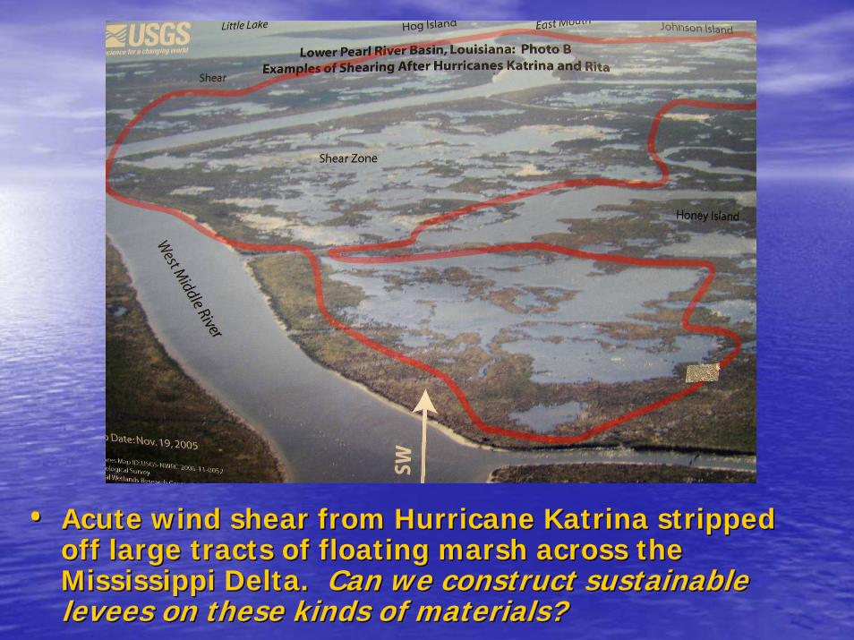
•• Acute wind shear from Hurricane Katrina stripped Acute wind shear from Hurricane Katrina stripped off large tracts of floating marsh across the off large tracts of floating marsh across the Mississippi Delta. Mississippi Delta. Can we construct sustainable Can we construct sustainable levees on these kinds of materials?levees on these kinds of materials?

•• During Hurricane Katrina, 115 square miles of land During Hurricane Katrina, 115 square miles of land area was lost. This shows area was lost. This shows ““land lossland loss”” in Breton Sound in Breton Sound (in light blue) after the 2005 hurricane season. (in light blue) after the 2005 hurricane season.

MECHANISMS MECHANISMS DRIVING GROUND DRIVING GROUND
SETTLEMENTSETTLEMENT•• The causes of ground settlement are a The causes of ground settlement are a
contentious issue in coastal Louisianacontentious issue in coastal Louisiana•• There appear to be many different There appear to be many different
causes, briefly summarized in the causes, briefly summarized in the following slidesfollowing slides

•• Block diagram illustrating various types of Block diagram illustrating various types of subaqueous subaqueous sediment instabilities in the Mississippi River Deltasediment instabilities in the Mississippi River Delta, , taken from Coleman (1988).taken from Coleman (1988).

FLUID FLUID EXTRACTION OF EXTRACTION OF OIL, GAS, AND OIL, GAS, AND
WATERWATERR.A. Morton of the USGS has blamed oil and gas extraction for the subsidence of the Mississippi Delta. Morton has constructed convincing correlations between petroleum withdrawal and
settlement rates on the southern fringes of the delta, near the settlement rates on the southern fringes of the delta, near the mouth of the Mississippi, but this theory fails to account for mouth of the Mississippi, but this theory fails to account for marked settlement further north, where little or no deep marked settlement further north, where little or no deep withdrawal of oil or gas has been carried out.withdrawal of oil or gas has been carried out.

•• Geologic cross Geologic cross section through section through the Gulf Coast Salt the Gulf Coast Salt Dome Basin, taken Dome Basin, taken from Adams from Adams (1997). (1997).
•• This shows the This shows the retrogressive retrogressive character of character of lystriclystric normal normal faultsfaults cutting cutting coastal Louisiana, coastal Louisiana, from north to from north to south. south.
•• The faults foot in a The faults foot in a basementbasement--saltsalt--decollementdecollementsurface of middle surface of middle Cretaceous ageCretaceous age. .
Growth FaultsGrowth Faults

•• This plot illustrates the enThis plot illustrates the en--echelon belts of echelon belts of growth faultsgrowth faults forming forming more or less parallel to the depressed coastline. The more or less parallel to the depressed coastline. The Baton Rouge Baton Rouge Fault ZoneFault Zone (shown in orange) has emerged over the past 50 years, (shown in orange) has emerged over the past 50 years, north and west of Lake Pontchartrain (data from Woody north and west of Lake Pontchartrain (data from Woody GaglianoGagliano, , Coastal Research).Coastal Research).

SaucierSaucier’’ss 1994 structural geology map of the Mississippi 1994 structural geology map of the Mississippi Delta, published by the Corps of Engineers. This shows Delta, published by the Corps of Engineers. This shows salt basinssalt basins, , salt domessalt domes, and active , and active growth faultsgrowth faults that that pervade the delta region. pervade the delta region.

•• Draining lowlands and Draining lowlands and backswampsbackswamps for agricultural or for agricultural or urban development increases the effective stress on urban development increases the effective stress on underlying sediments and hastens rapid biochemical underlying sediments and hastens rapid biochemical oxidation of organic materials, causing settlement of oxidation of organic materials, causing settlement of these these surficialsurficial soilssoils.

•• New Orleans was built on New Orleans was built on compressible peaty soilscompressible peaty soils. This . This isopachisopach map shows the areal distribution of the map shows the areal distribution of the surficialsurficial peaty peaty soils (contour interval = 4 feet). From Gould and Morgan soils (contour interval = 4 feet). From Gould and Morgan (1962) and Kolb and Saucier (1982).(1962) and Kolb and Saucier (1982).

Compaction of Compaction of SurficialSurficial SedimentsSediments
The The interdistributaryinterdistributary sediment package covering the old sediment package covering the old back swamps around New Orleans are under back swamps around New Orleans are under consolidated, and they exhibit gross settlements.consolidated, and they exhibit gross settlements.
These examples are from the Lakeview area adjacent to These examples are from the Lakeview area adjacent to the 17the 17thth St. Canal failure, where the ground appears to St. Canal failure, where the ground appears to have settled 10 to 16 inches since 1956. have settled 10 to 16 inches since 1956.

Most residential structures in New Orleans are founded Most residential structures in New Orleans are founded on wood pilings 6 to 8 inches in diameter, driven 30 feet on wood pilings 6 to 8 inches in diameter, driven 30 feet deep. The ground beneath these postdeep. The ground beneath these post--1950 homes has 1950 homes has settled 10 to 18 inches. settled 10 to 18 inches.
The mechanisms driving this settlement are likely The mechanisms driving this settlement are likely drainage of neardrainage of near--surface soils, by dewatering and surface soils, by dewatering and interception of storm water runoff, which is collected interception of storm water runoff, which is collected and conveyed to the cityand conveyed to the city’’s pump stations.s pump stations.

Industrial and municipal Industrial and municipal groundwater withdrawal groundwater withdrawal
As groundwater levels are depressed by withdrawal of As groundwater levels are depressed by withdrawal of groundwater, organicgroundwater, organic--rich peaty soils are oxidized, and the rich peaty soils are oxidized, and the ground settles. This settlement creates depressed zones ground settles. This settlement creates depressed zones below the grade of adjacent watercourses, which creates below the grade of adjacent watercourses, which creates challenges for providing flood control. challenges for providing flood control.

•• Record of Record of historic settlementhistoric settlement in the town of Kenner, which is underlain by 6.5 in the town of Kenner, which is underlain by 6.5 to 8 feet of to 8 feet of surficialsurficial peaty soils. peaty soils.
•• The steps in these curves were triggered by The steps in these curves were triggered by groundwater withdrawalgroundwater withdrawal for for industrial use and urban developmentindustrial use and urban development. This area was covered by dense . This area was covered by dense cypress swamps prior to development. cypress swamps prior to development.

Much of New Orleans lies below sea level, Lake Much of New Orleans lies below sea level, Lake PonchartrainPonchartrain, , and the Mississippi River, making it particularly vulnerable to and the Mississippi River, making it particularly vulnerable to flooding. The Mississippi levee crest is 24.5 feet, while the flooding. The Mississippi levee crest is 24.5 feet, while the Pontchartrain levee crest is 13.5 feet, above mean gulf level.Pontchartrain levee crest is 13.5 feet, above mean gulf level.

• Topographic map with one foot contours prepared under the direction of New Orleans City Engineer L.W. Brown in 1895. This map was prepared using the Cairo Datum, which is 21.26 feet above Mean Gulf Level

•• Map Map showing showing relative relative elevation elevation change change between between 1895 and 1895 and 1999/20021999/2002, , from URS from URS (2006).(2006).
•• The net The net subsidence subsidence was was between 2 between 2 and 10+ and 10+ feet, feet, depending depending on location. on location.

STRUCTURAL STRUCTURAL SURCHARGINGSURCHARGING
•• An interesting aspect of the URSAn interesting aspect of the URS--FEMA settlement FEMA settlement study is the marked increase in settlement in the study is the marked increase in settlement in the Central Business District, where tall structures are Central Business District, where tall structures are founded on deep piles. This area settled 5 inches in founded on deep piles. This area settled 5 inches in 100 years, but the settlement was much less away 100 years, but the settlement was much less away from the heavy structures from the heavy structures
•• Even the sandy river levees have settled 2 inchesEven the sandy river levees have settled 2 inches; ; likely due to surcharging by MR&T levee heightening likely due to surcharging by MR&T levee heightening between 1928between 1928--6060

Mechanisms of Ground Settlement Mechanisms of Ground Settlement --11
•• 1) Elastic deformation1) Elastic deformation of Mississippi of Mississippi Delta from silt deposition (Delta from silt deposition (isostasyisostasy))
•• 2) Tectonic compaction2) Tectonic compaction caused by caused by formation of pressure ridges and foldingformation of pressure ridges and folding
•• 3) Subsidence on seaward side of 3) Subsidence on seaward side of lystriclystricgrowth faultsgrowth faults
•• 4) Drainage4) Drainage of old swamp and marsh of old swamp and marsh deposits increasing stress on underlying deposits increasing stress on underlying claysclays
•• 5) Biochemical oxidation5) Biochemical oxidation of peaty soils of peaty soils

Mechanisms of Ground Settlement Mechanisms of Ground Settlement --22•• 6) Consolidation of compressible soils6) Consolidation of compressible soils
caused by surcharging with fillcaused by surcharging with fill•• 7) Surcharging7) Surcharging by structural by structural
improvementsimprovements•• 8) Reduced groundwater recharge8) Reduced groundwater recharge in in
developed areas because of developed areas because of impermeable surfacesimpermeable surfaces
•• 9) Extraction of oil, gas, and water9) Extraction of oil, gas, and watercausing pressure depletioncausing pressure depletion
•• 10) 10) SolutioningSolutioning of salt domes and of salt domes and seaward migrationseaward migration of low density of low density materials (salt and shale) materials (salt and shale)

Coastal land loss in LouisianaCoastal land loss in Louisiana is also exacerbated by is also exacerbated by sea sea level riselevel rise, which averaged about 1 foot during the last , which averaged about 1 foot during the last 100 years. This value could accelerate during the 21100 years. This value could accelerate during the 21stst
Century, to as much as 3 feet. Century, to as much as 3 feet.

The National Debate that has The National Debate that has erupted since Katrinaerupted since Katrina……..
•• Can we build levees that wonCan we build levees that won’’t fail?t fail?•• Should we, as a society, allow or encourage Should we, as a society, allow or encourage
urban development of lands that are either: 1) urban development of lands that are either: 1) below sea level; or, 2) barely above sea level?below sea level; or, 2) barely above sea level?
•• People who choose to live in high risk areas People who choose to live in high risk areas should pay greater insurance premiums for should pay greater insurance premiums for the privilege of living in those areasthe privilege of living in those areas
•• Should we bother trying to save the Should we bother trying to save the Mississippi Delta? Why? Mississippi Delta? Why? New Orleans ships New Orleans ships the greatest volume of exported goods from the greatest volume of exported goods from the USA, mostly wheat, corn, and soy.the USA, mostly wheat, corn, and soy.

Is it within the grasp of our Is it within the grasp of our society to save the Mississippi society to save the Mississippi
Delta?Delta?•• One modern analog One modern analog –– The Netherlands, The Netherlands,
following the 1953 floods; but this also involved following the 1953 floods; but this also involved a substantial investment, almost 30% of their a substantial investment, almost 30% of their GNP for 20 years.GNP for 20 years.
•• Can we apply 21Can we apply 21stst Century technology to help Century technology to help solve these immense challenges?solve these immense challenges?
•• Diverting sediments onto the land will require a Diverting sediments onto the land will require a much greater investment in operations and much greater investment in operations and maintenance, several orders of magnitude more maintenance, several orders of magnitude more than wethan we’’ve spent heretofore. ve spent heretofore.

Can we do a better job Can we do a better job of retarding land loss of retarding land loss
in the Mississippi in the Mississippi Delta?Delta?
We need to think We need to think outside the boxoutside the box

•• The Mississippi River drains approximately 41% of the The Mississippi River drains approximately 41% of the continental United States, discharging about 580 kmcontinental United States, discharging about 580 km33
of water each year (420 billion of water each year (420 billion gpdgpd).).•• Almost 50% of the water comes from the Ohio River, Almost 50% of the water comes from the Ohio River,
which has 1/6which has 1/6thth of the watershed. of the watershed. •• The Missouri River encompasses 43% of total The Missouri River encompasses 43% of total
watershed area, but only contributes 12% of the watershed area, but only contributes 12% of the discharge.discharge.

•• Prior to 1700, the average sediment discharge was about Prior to 1700, the average sediment discharge was about 440 million tons/year, mostly from the Missouri River 440 million tons/year, mostly from the Missouri River watershed.watershed.
•• This figure has decreased about 50% since 1950, because of This figure has decreased about 50% since 1950, because of dams constructed on Missouri and Arkansas Rivers. dams constructed on Missouri and Arkansas Rivers.
•• This loss somewhat compensated by 5 to 10 fold increase in This loss somewhat compensated by 5 to 10 fold increase in sediment load carried down the Ohio River, because of row sediment load carried down the Ohio River, because of row farming and deforestation. farming and deforestation.

•• The river has deposited enormous deltaic lobes The river has deposited enormous deltaic lobes during the late Holocene: during the late Holocene: BalizeBalize (550 yrs); (550 yrs); Plaquemines (750Plaquemines (750--500); Lafourche (1000500); Lafourche (1000--3000); St. Bernard (25003000); St. Bernard (2500--1000); 1000); TecheTeche (3500(3500--2800); 2800); CocodrieCocodrie (4600(4600--3500); and Sole3500); and Sole--CypremontCypremont (>4600).(>4600).
BalizeBalize
PlaqueminesPlaquemines
St. BernardSt. Bernard
SoleSole--CypremontCypremont
LafourcheLafourche
TecheTeche
CocodrieCocodrie

Dynamic Dynamic Environment:Environment:
Chandelier Chandelier Islands; before Islands; before
and after and after KatrinaKatrina
•• Wave erosion stripped Wave erosion stripped off sandy off sandy cohensionlesscohensionless deposits deposits during Hurricane during Hurricane KatrinaKatrina
•• 4000 people were 4000 people were killed in this area in killed in this area in the 1915 hurricanethe 1915 hurricane

Land Loss Land Loss BaratariaBarataria
QuadrangleQuadrangle•• Coastal land Coastal land
loss has loss has been been accelerating accelerating since 1950since 1950
•• Annual Annual sediment sediment volume volume averaged averaged ~440 million ~440 million tons/yr prior tons/yr prior to 1950 to 1950

Coastal land Coastal land Loss Loss –– EmpireEmpire
quadranglequadrangle•• Since 1950, the Since 1950, the
average sediment average sediment load of the load of the Mississippi River Mississippi River has been reduced has been reduced to about ~215 to about ~215 million tons per million tons per year. year.
•• But, most of this is But, most of this is lost out the jettieslost out the jetties

•• Coastal Land Loss since 1932 (red) and land gain Coastal Land Loss since 1932 (red) and land gain (green). We are losing about 50X more land mass than (green). We are losing about 50X more land mass than we are saving at present, even with the 2050 plan. we are saving at present, even with the 2050 plan. (data from Ray Dokka at LSU).(data from Ray Dokka at LSU).

The physical situation:The physical situation:the river runs down in a the river runs down in a
deep holedeep hole……The design problem:The design problem: how how can we lift sediment from can we lift sediment from a below sea level channel a below sea level channel onto the subsiding land onto the subsiding land
surface?surface?

•• There is significant hydraulic sorting of There is significant hydraulic sorting of materials deposited on either side of these materials deposited on either side of these levees.levees.
•• Most of the sediment is deposited during Most of the sediment is deposited during brief periods of flood flow; with great brief periods of flood flow; with great percentage occurring 5 to 10 times per percentage occurring 5 to 10 times per century century
•• We will have to become much more We will have to become much more opportunistic about how we manage the riveropportunistic about how we manage the river

Hahnville is Hahnville is just upstream just upstream
of New of New OrleansOrleans
•• Note classic Note classic birdfootbirdfootpattern of pattern of sandsand--filled filled distributarydistributarychannels, channels, shown in shown in yellowyellow
•• Note Note developmentdevelopment

Profile of the Lower MississippiProfile of the Lower Mississippi
The bed of the Mississippi River is below sea level during the last 450 miles of its course, up to Greenville, Mississippi. We can only extract meaningful amounts of sediment during short-lived periods of high flow.

Can we come up with a Can we come up with a viable scheme for viable scheme for
diverting siltdiverting silt--laden laden waters during brief waters during brief
periods of high flow?periods of high flow?
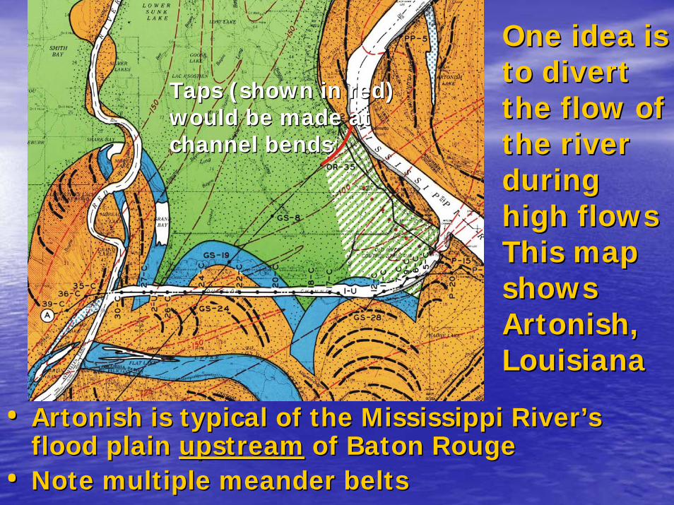
One idea is One idea is to divert to divert the flow of the flow of the river the river during during high flowshigh flowsThis map This map shows shows ArtonishArtonish, , LouisianaLouisiana
•• ArtonishArtonish is typical of the Mississippi Riveris typical of the Mississippi River’’s s flood plain flood plain upstreamupstream of Baton Rougeof Baton Rouge
•• Note multiple meander beltsNote multiple meander belts
Taps (shown in red) Taps (shown in red) would be made at would be made at channel bendschannel bends

•• This section shows a pair of proposed This section shows a pair of proposed ““tunnel tunnel tapstaps”” 1 and 1.8 miles long,1 and 1.8 miles long,
•• PrecastPrecast concrete liners could be jacked through concrete liners could be jacked through the overbank sediments, beneath the riverthe overbank sediments, beneath the river’’s s levees, similar to the Boston Big Dig. levees, similar to the Boston Big Dig.

Jacking of Jacking of precast precast
concrete tunnel concrete tunnel boxesboxes
•• During the Boston During the Boston Big Dig, the worldBig Dig, the world’’s s largest precast largest precast concrete box tunnel concrete box tunnel section, for section, for Interstate 90, was Interstate 90, was hydraulically jacked hydraulically jacked into position, into position, beneath existing rail beneath existing rail lines and bridges lines and bridges

Ability to Ability to shift linesshift lines
•• Distributor Distributor alignments alignments would need would need to be to be flexible, to flexible, to accommodaccommodate even ate even distribution distribution of sedimentof sediment
•• Flexibility Flexibility will be key will be key aspect aspect
DistributorsDistributors

So, what portion of the So, what portion of the lower Mississippi River lower Mississippi River could be targeted for could be targeted for
massive flow diversions massive flow diversions and be a receptacle for and be a receptacle for
new sediment ?new sediment ?

Atchafalaya Atchafalaya RiverRiver
Red River entrance versus 480 kilometers for the Red River entrance versus 480 kilometers for the Mississippi). Mississippi).
•• Under natural conditions, the Mississippi River would Under natural conditions, the Mississippi River would probably have switched its course to the Gulf of probably have switched its course to the Gulf of Mexico via the Atchafalaya Mexico via the Atchafalaya distributarydistributary between 1965 between 1965 and 1975, if not for the levees. and 1975, if not for the levees.
•• The Atchafalaya now drains about 30% of the The Atchafalaya now drains about 30% of the combined flows of the Mississippi and Red rivers to combined flows of the Mississippi and Red rivers to the Gulf of Mexico. the Gulf of Mexico.
The Atchafalaya River is The Atchafalaya River is both steeper than the both steeper than the Mississippi (3:1 ratio in Mississippi (3:1 ratio in bed slope) and shorter bed slope) and shorter (225 kilometers to the (225 kilometers to the Gulf of Mexico from theGulf of Mexico from the

•• Profiles of the Atchafalaya River. Its steeper Profiles of the Atchafalaya River. Its steeper gradient would be much more efficient for gradient would be much more efficient for sediment diversion, transport, and sediment diversion, transport, and distrbutiondistrbutionthan the lower Mississippi River. than the lower Mississippi River.

Sediment Sediment Accretion at Accretion at Grand Lake Grand Lake 19171917--19501950
•• The Atchafalaya Basin The Atchafalaya Basin is our best analog is our best analog model for sediment model for sediment accretion in the deltaaccretion in the delta
•• Historic data on Historic data on sediment accretion sediment accretion here needs to be here needs to be analyzed and analyzed and thoroughly understoodthoroughly understood

The Likely TargetThe Likely Target
•• Every physical factor save one, would Every physical factor save one, would seem to favor the Atchafalaya River for seem to favor the Atchafalaya River for a prototype sediment deposition a prototype sediment deposition scheme involving the lower Mississippi scheme involving the lower Mississippi RiverRiver
•• The sediment has be diverted from the The sediment has be diverted from the Mississippi channel. Mississippi channel.
•• We should probably begin by evaluating We should probably begin by evaluating enhancements; options that would use enhancements; options that would use existing facilities, like the Old River existing facilities, like the Old River Diversion Structures Diversion Structures