kalman filter to regional ocean modeling associated with ... · kalman filter to regional ocean...
TRANSCRIPT

Applications of an ensemble
Kalman Filter to regional
ocean modeling associated
with the western boundary
currents variations
Miyazawa, Yasumasa (JAMSTEC)
Collaboration with Princeton University
AICS Data Assimilation Workshop 2013.02.27

Western boundary currents
RMS variability of sea surface height estimated by satellite altimetry
Kuroshio
Loop Current
Very active ocean current variability concentrated near the western parts of the
continents
Over past 10 years physical oceanographers have developed numerical ocean
forecast systems for investigation of the predictability of the western boundary
currents. Recently we have started to implement LETKF in the forecast systems in
the Kuroshio south of Japan and Loop Current in Gulf of Mexico.
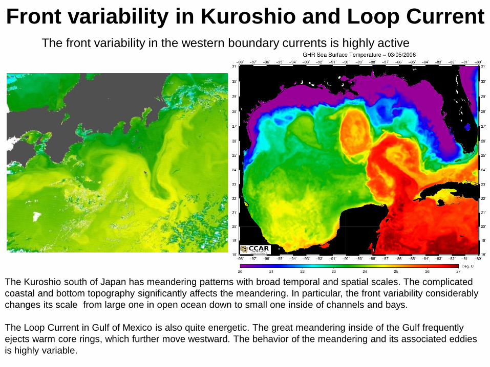
Front variability in Kuroshio and Loop Current The front variability in the western boundary currents is highly active
The Kuroshio south of Japan has meandering patterns with broad temporal and spatial scales. The complicated
coastal and bottom topography significantly affects the meandering. In particular, the front variability considerably
changes its scale from large one in open ocean down to small one inside of channels and bays.
The Loop Current in Gulf of Mexico is also quite energetic. The great meandering inside of the Gulf frequently
ejects warm core rings, which further move westward. The behavior of the meandering and its associated eddies
is highly variable.

Observations Most important observation data for ocean forecasting are obtained by satellites.
Satellite altimetry (SSH) is measured by micro wave penetrating into clouds and provides
useful information about subsurface oceanic condition. Sea surface temperature
measured by infrared sensors provides high-resolution data but it is easily contaminated
by existence of clouds.
Temporal and spatial frequency of in-situ data is very law and then remote sensing data
are most important for usual operations.

Operational ocean forecast systems Japan Coastal Ocean Predictability Experiment
(JCOPE) Princeton regional Ocean Forecast
System (PROFS)
By assimilating the available observation data into numerical ocean general circulation models, we have
developed operational ocean forecast systems focusing on the predictability of the western boundary currents
variability. Our group of JAMSTEC has developed the forecast system for the Western North Pacific ocean, called
JCOPE. Our colleagues in Princeton University have also developed a similar forecast system, called PROFS,
covering the Western North Atlantic ocean.
We are weekly updating 2-month lead forecast. Typical spatial scale of the meandering and eddies is O(100km).
Temporal scale is O(10days). Predictability limit is maximum 2 months. Data assimilation methods of both
systems are based on the static methods such as 3DVAR and optimum interpolation.

From static to dynamic assimilation
in ocean forecasting
Present versions of our operational ocean forecast systems are using ‘static’
data assimilation methods (3DVAR/OI) based on an assumption of temporally
constant and spatially isotropic forecast error covariance.
Recent developments of parallel computers systems (PC Clusters) and efficient
EnKF algorithms (LETKF) motivated us to test EnKF for the predictability studies
on the western boundary currents.
EnKF allows to represent spatiotemporally varying forecast error covariance that
is crucial for skill improvements in the representation of highly variable western
boundary currents.
We have actually implemented the LETKF code (Miyoshi et al. 2010) in both the
forecast systems to investigate the impacts of EnKF on the reproducibility and
predictability of the Kuroshio and Loop Current.

LETKF analysis for Kuroshio Ocean General Circulation Model with 1/36 deg. grid
driven by NCEP GFS base surface forcing (Parallelized Princeton Ocean Model; Jordi and Wang, 2012)
20 numbers of ensemble forecasts
Each 2-day lead forecasts are updated with 2-day
interval to provide the forecast error covariance.
Test Period: 8 – 20 February 2010
Assimilation data: Satellite Sea Surface Height (SSH), Satellite Sea Surface
Temperature (SST), In-situ temperature and salinity profiles
Examine the skill of the analysis products

Assimilation effects using the LETKF system developed for
investigation of the Kuroshio variation south of Japan
Synthetic observation SST maps provided by the local fishery agencies
14 Feb. 2010 20 Feb. 2010 26 Feb. 2010
EnKF analyses
The small meander of the Kuroshio moved eastward during the period, and the variation
of the Kii Channel Front was generally reproduced.
Kii
Channel

‘Flow-dependent’ forecast error
covariance on 18 February 2010
Kii
Peninsula
Observation
point Kii
Channel
To confirm the effects of error
covariance represented by EnKF,
we visualized the forecast error
covariance between the surface
temperature observed near the
western coast of the Kii Peninsula
and surface temperature forecast
around the observation point.
The positive region inside of the
Kii Channel indicates warming of
the warmer side of the Kii
Channel Front. The effect of the
temperature data assimilation on
this point completely disappeared
within the colder part of the Kii
Channel Front.

Comparison between 3DVAR and LETKF
3DVAR (Miyazawa et al. 2009) LETKF
200km scale isotropic
static error covariance
un-isotropic
time dependent error covariance
Isotropic and time constant error covariance smoothed the horizontal gradient of the front
Flow dependent error covariance represented by EnKF was responsible for the
representation of the steep Kii Channel Front
Coastal
Sea
Channel
Open
Ocean
SST and surface flow analyses
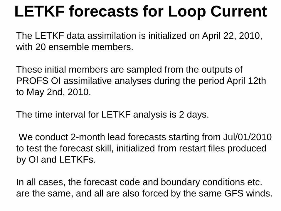
LETKF forecasts for Loop Current
The LETKF data assimilation is initialized on April 22, 2010,
with 20 ensemble members.
These initial members are sampled from the outputs of
PROFS OI assimilative analyses during the period April 12th
to May 2nd, 2010.
The time interval for LETKF analysis is 2 days.
We conduct 2-month lead forecasts starting from Jul/01/2010
to test the forecast skill, initialized from restart files produced
by OI and LETKFs.
In all cases, the forecast code and boundary conditions etc.
are the same, and all are also forced by the same GFS winds.
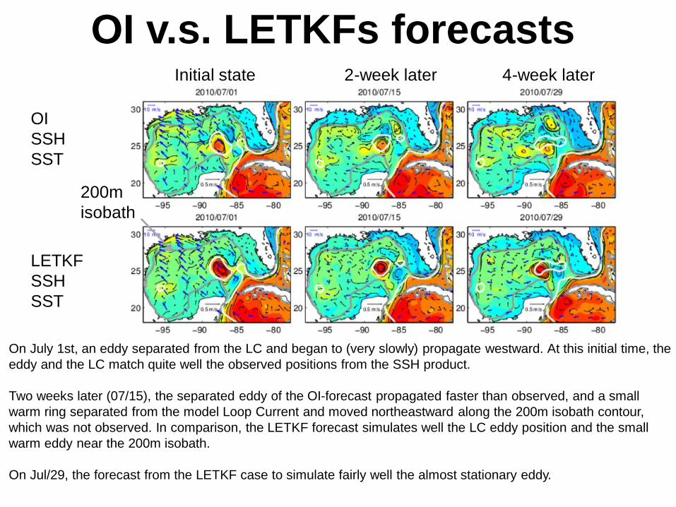
OI v.s. LETKFs forecasts
OI
SSH
SST
LETKF
SSH
SST
On July 1st, an eddy separated from the LC and began to (very slowly) propagate westward. At this initial time, the
eddy and the LC match quite well the observed positions from the SSH product.
Two weeks later (07/15), the separated eddy of the OI-forecast propagated faster than observed, and a small
warm ring separated from the model Loop Current and moved northeastward along the 200m isobath contour,
which was not observed. In comparison, the LETKF forecast simulates well the LC eddy position and the small
warm eddy near the 200m isobath.
On Jul/29, the forecast from the LETKF case to simulate fairly well the almost stationary eddy.
Initial state 2-week later 4-week later
200m
isobath

Skill comparison (OI vs LETKF forecasts)
The forecasts from some LETKF cases have 25% smaller RMS errors than the OI
forecast.
At all time during the forecast period, the LETKF forecasts have higher skills than the OI
forecast.
RMS errors between models and observation Sea Surface Height
Persistence of SSH data
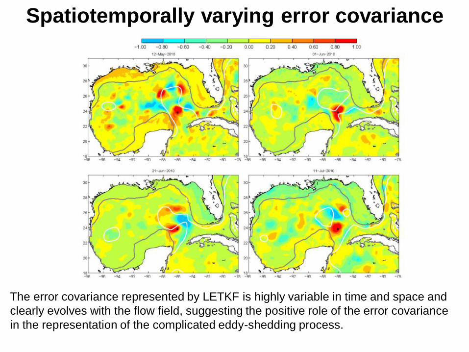
Spatiotemporally varying error covariance
The error covariance represented by LETKF is highly variable in time and space and
clearly evolves with the flow field, suggesting the positive role of the error covariance
in the representation of the complicated eddy-shedding process.

SSH/SST assimilation effects on current Ocean current observation (ADCP), Apr.2009-Nov.2011
Obs OI LETKF Obs OI LETKF
Mean STD
LETKF produce larger mean and variance in better
agreement with observation. The shedding eddy
has strong nonlinearity, thus its movement was
governed by the flow of the eddy itself.
Better forecast skill of LETKF on the eddy
movement is due to the better representation of
the flows from subsurface to deep levels, caused
by the better representation of the error covariance
between the assimilated variables and model
current.
(This observation data are not assimilated into the model)

Summary LETKF is applied to the parallelized version of the Princeton Ocean Model to
investigate variations of the western boundary currents including the Kuroshio
south of Japan and Loop Current in Gulf of Mexico.
The coastal and open seas interactions such as the channel front variation in
the Kuroshio region, and eddy-shedding from the Loop Current in Gulf of
Mexico are well captured by LETKF.
LETKF is effective for detection of the open and coastal seas interactions
because of its ‘seamless’ representation of the forecast error covariance from
larger (open ocean) to smaller (coastal) scales.
LETKF has better ability to extract the information required for well
representation of ocean current from the satellite observation of Sea Surface
Height and Sea Surface Temperature than OI, and leads to better forecast skill
on the movement of shedding eddy.
(Miyazawa et al. 2012, Ocean Dynamics; Miyazawa et al. 2013, remote sensing)
(Xu et al. 2013, Ocean Modelling)