kailash sacred landscape conservation initiative
TRANSCRIPT
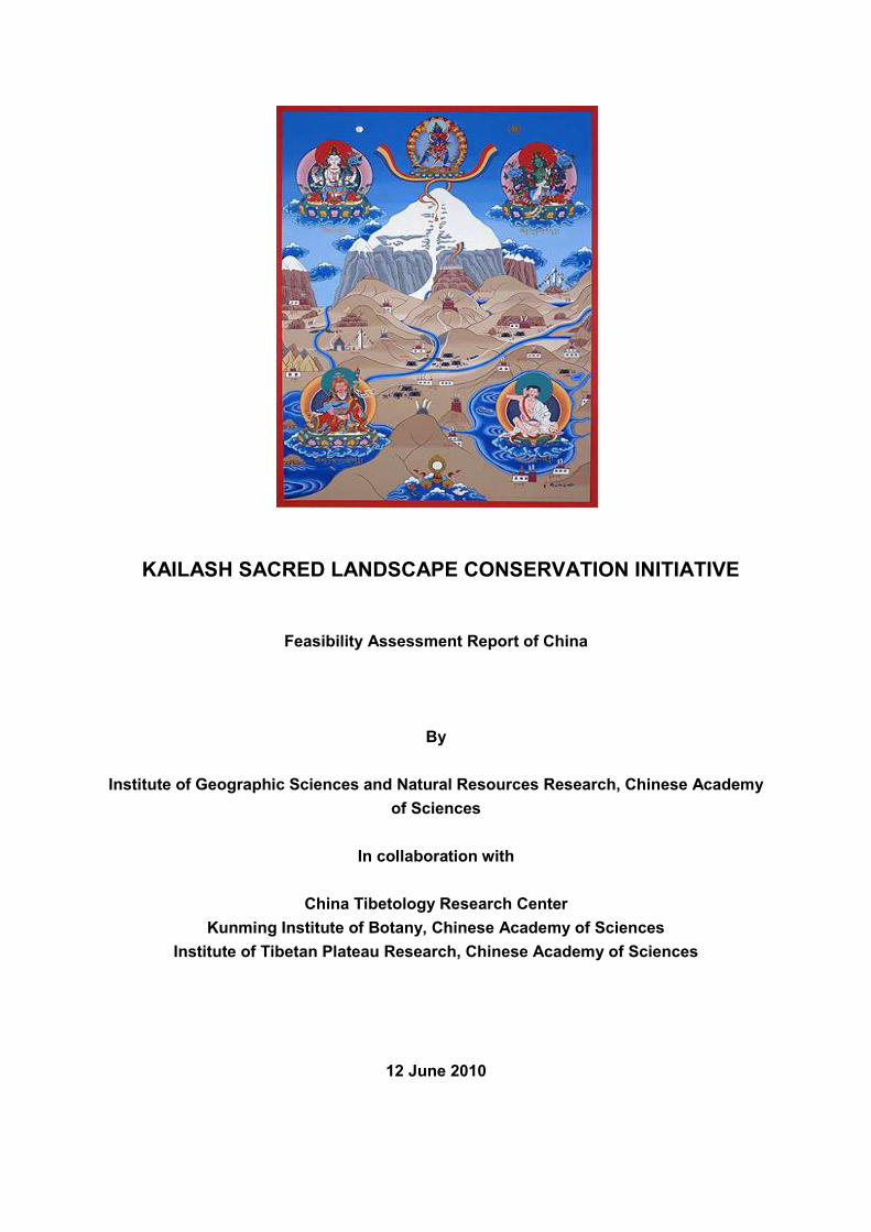
KAILASH SACRED LANDSCAPE CONSERVATION INITIATIVE
Feasibility Assessment Report of China
By
Institute of Geographic Sciences and Natural Resources Research, Chinese Academy
of Sciences
In collaboration with
China Tibetology Research Center
Kunming Institute of Botany, Chinese Academy of Sciences
Institute of Tibetan Plateau Research, Chinese Academy of Sciences
12 June 2010
Contents
1. Description of Target Landscape ······································································· 1
2. Resource Status of Target Landscape ································································ 3
2.1 Land Cover ······························································································································· 3
2.2 Land Use and Agricultural Production Systems ································································· 5
2.3 Land Use and Agricultural Production Systems ································································· 6
2.4 Hydrology and Water Resources ·························································································· 8
2.5 Biological Diversity of Flora and Fauna ············································································· 11
2.6 Wildlife and Wildlife Habitats ······························································································· 19
2.7 Protected Areas ····················································································································· 21
2.8 Forest Development, Utilization and Management ·························································· 22
2.9 Rangelands and Rangeland Management ········································································ 23
2.10 Settlements and Demographic Patterns ············································································ 23
2.11 Socio-economic, Livelihood, Poverty and Gender Issues ·············································· 24
2.12 Cultural and Religious Heritage Sites ················································································ 28
2.13 Tourism ··································································································································· 35
3. Status Report on Environmental Degradation and Cultural Integrity ······················ 38
3.1 Overview of general status of KSL-China in terms of environmental degradation as evidenced
by land use change, forest cover, wildlife habitat, land degradation, agricultural productivity,
loss of biodiversity and genetic resources········································································· 38
3.2 Land Cover Changes and Trends ······················································································ 39
3.3 Water Resources ·················································································································· 41
3.4 Biological Diversity of Flora and Fauna ············································································· 41
3.5 Wildlife and Wildlife Habitats ······························································································· 41
3.6 Forests ···································································································································· 41
3.7 Rangelands and Rangeland Management ········································································ 42
3.8 Cultural and Religious Heritage Sites ················································································ 42
3.9 Tourism ··································································································································· 42
3.10 Observations, Perceptions and Projections of Climate Change, and/or Other Environmental
Change Processes ················································································································ 42
4. Identification of Priorities for KSL-China ···························································· 44
4.1 Threats to Biodiversity and Biodiversity Conservation ···················································· 44
4.2 Environmental Monitoring and Degraded Ecosystem Rehabilitation ···························· 45
4.3 Kailash Landscape Protection and Pollution Controls ····················································· 45
4.4 Traditional Knowledge and Bio-Cultural Diversity Conservation ··································· 45
4.5 Alternative Livelihoods for Local Stakeholders ································································· 46
4.6 Renewable Energy Demonstration and Use ····································································· 46
4.7 Capacity Building and Participatory Ecosystem Management ······································· 47
4.8 Adaptation to Climate Change ···························································································· 48
5. Community Perceptions ·················································································· 48
5.1 Community Perceptions on Biodiversity and Cultural Value ·········································· 48
5.2 Best-Suited Livelihood Options ··························································································· 49
5.3 Perception of Environment Pollution ·················································································· 49
5.4 Perception of Enabling Policies and Plans ········································································ 50
6. Enabling Environment ····················································································· 50
7. Gap Assessment ····························································································· 52
7.1 Biodiversity and Cultural Diversity Status and Conservation ········································· 52
7.2 Kailash Landscape Protection ····························································································· 53
7.3 Traditional Knowledge of Diversity Conservation ····························································· 53
7.4 Alternative Livelihoods ········································································································· 54
7.5 Policies and Regulations ······································································································ 54
7.6 Capacity Building and Stakeholder Participation ····························································· 54
Annex 1. List of tables in Feasibility Assessment Report ··········································· 56
Table 1. Land cover classifications for KSL-China. ··················································· 56
Table 2. Land cover of Kailash Sacred Landscape in 2009. ······································· 57
Table 3. Protected animals in Manasarovar Wetland Protected Area. ··························· 58
Table 4. Index of economy in Burang County (×104 RMB Yuan). ································· 59
Table 5. Status of farmers and herdsmen‘s earnings (Units: RMB Yuan). ···················· 59
Table 6. Statistics of gompas (monasteries) in Burang County. ··································· 60
Table 7. Land cover changes in KSL-China from 1999 to 2009. ································ 61
1
1. Description of Target Landscape
Mount Kailash is a peak in the Gangdisê Mountains, which are part of the Himalayas. Mt
Kailash and the associated Mansarovar Watershed is located in Burang County1, Ngari
Prefecture, in the western part of the Tibet Autonomous Region (TAR) of China. It is named
as Gang Rinpoche གངས་རིན་པོ་ཆེ in Tibetan and ―冈仁波齐峰‖ in Chinese (and hereafter referred to
as Kailash). It lies near the source of some of the longest rivers in Asia: Indus River, Sutlej
River (a major tributary of the Indus River), Brahmaputra River, and Karnali River2 (a major
tributary of the Ganges River). It is considered as a sacred mountain in five religions:
Hinduism, Buddhism, Jainism, Sikh, and the Bön faith. Every year, tens of thousands of
pilgrims make a pilgrimage to Kailash, following a tradition dated back to thousands of years.
Pilgrims of the above religions believe that circumambulating (walking around) Mt Kailash will
remove sins and bring good fortune. Near Mount Kailash, there lie two famous holy lakes, i.e.
Lake Manasarovar3 and Lake Rakshastal4. These two lakes are located near each other in
the Manasarovar Basin. Therefore, we identified Manasarovar Basin as an important part of
Kailash Sacred Landsape (KSL), with the delineation of this part following along the boundary
of Manasarovar Basin.
Pulan, known as Burang in Tibetan, is the main township in Burang County. It is situated to
the south of Mount Kailash, near the border with India and Nepal. The town lies at an altitude
of 3,880m. It is known by Nepalis and Indians as Taklakot (from Tibetan 'Takla Khar'), and is
a very ancient trading post and staging point for pilgrims to Mount Kailash. It lies in the valley
of the Karnali River (or the Peacock River in Chinese) beside the famous Mount Gurla
Mandhata 5 . The Karnali River, literally holy water from the sacred mountain, is a
transboundary perennial river which originates in Burang County near Lake Manasarovar. It
cuts through the Himalayas from China to Nepal on its way to the confluence with the Sarda
River at Brahmaghat in India, where it joins the Ganges River. It is the longest (507 km in
length) and largest river in Nepal. The upper reaches of the Karnali River (Chinese section) is
about 95 km in length. Due to the relatively better hydro-thermal conditions along the river,
croplands, urban areas (Burang town) and villages are concentrated along the riverside. The
Karnali Basin represents an important part of the lower Kailash region, and the delineation of
this part was along the boundary of Karnali Basin.
For the feasibility assessment of Kailash Sacred Landscape Conservation Initiative, and
development of the Regional Cooperation Framework (RCF), the technical delineation of the
1 Burang County is located in Ngari Prefecture of TAR, which is known as Pulan County (普兰县) in Chinese.
2 Karnali River is known as Peacock River (Chinese: 孔雀河) in Burang.
3 Lake Manasarovar is known as Mapam Yumco (Chinese: 玛旁雍错) in Tibet ( ).
4 Lake Rakshastal is known as La'nga Co (Chinese: 拉昂错) in Tibet ( )
5 Mt. Gurla Mandhata is Memo Nani (Chinese: 納木那尼峰).
2
area is an essential and critical first step. Following the guidelines of Kailash Sacred
Landscape Conseravation Initiative (KSLCI), the criteria applied to delineate the Chinese part
of KSL region are mainly considered as below:
Transboundary ecosystem services and ecosystem contiguity
Key biodiversity areas, including migratory habitats and biodiversity corridors
Endemism (biodiversity and culture)
Indicator/flagship, and rare, endangered and threatened species (and their ranges)
Protected areas/Ramsar sites and other conservation priority areas
Cultural heritage sites and pilgrimage routes; and existing and potential ecotourism sites
Linkages of livelihoods of mountain communities
Vulnerability of the area (globalization, migration and other change processes)
Urbanization and infrastructure development
Watershed and river basin coverage for the headwater areas of major rivers originating
from the landscape
Ecological zones.
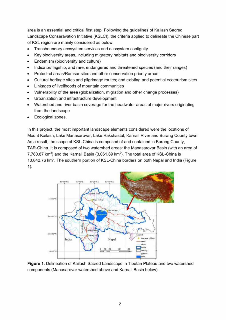
In this project, the most important landscape elements considered were the locations of
Mount Kailash, Lake Manasarovar, Lake Rakshastal, Karnali River and Burang County town.
As a result, the scope of KSL-China is comprised of and contained in Burang County,
TAR-China. It is composed of two watershed areas: the Manasarovar Basin (with an area of
7,780.87 km2) and the Karnali Basin (3,061.89 km2). The total area of KSL-China is
10,842.76 km2. The southern portion of KSL-China borders on both Nepal and India (Figure
1).
Figure 1. Delineation of Kailash Sacred Landscape in Tibetan Plateau and two watershed
components (Manasarovar watershed above and Karnali Basin below).
3
2. Resource Status of Target Landscape
2.1 Land Cover
1) Classification of Land Cover in Kailash Sacred Landscape
Land cover classification is the basis for analysis of land cover patterns and changes.
According to land cover classification capability of Landsat images in KSL-China, and using
ground data from the field survey in the summer of 2009, land cover was classified into two
levels based on the Land Cover Classification System 2.4.5 (developed by FAO), which is
the common standard adopted by the KSLCI. The first level is composed of eight major
classes: croplands, grasslands, shrublands, wetlands, water bodies, urban areas and
villages, glaciers, and barren lands. There is no forest distribution because the minimum
altitude of the region (3,630m) is above treeline. The second level is composed of 16 classes.
―Grasslands‖ is divided into three classes in second level: ―sparse grasslands‖ (vegetation
cover is between 5% and 20%), ―open grasslands‖ (vegetation cover 20-60%), and ―close
grasslands‖ (vegetation cover more than 60%). ―Shrublands‖ is divided into two classes in
second level: ―sparse shrublands with sparse herbaceous‖ and ―open shrublands with sparse
to open grasses‖. ―Wetlands‖ is divided into two classes in second level: ―permanently
flooded wetlands‖ and ―seasonally flooded wetlands‖. ―Barren lands‖ is divided into two
classes in second level: ―bare rocks‖ and ―bare soils‖. ―Urban area and villages‖ is divided
into two classes in second level: ―urban‖ and ―villages‖. Among the eight first-level classes,
grasslands and shrublands are the most important and widely distributed land cover types in
Kailash region. Consequently, for the analysis and mapping of the land cover in KSL-China,
second-level classes for ―grasslands‖ and ―shrublands‖ were included, while first-level
classes were used for other classes. A detailed description of land cover types for the
selected classes is given in Table 1.
Table 1. Land cover classifications for Kailash region
Code Type Implication
1 Croplands Agricultural lands, including old and new cultivated lands, fallow land,
crop-grass rotation field, agro-fruit land and agro-forestry land.
2 Sparse Grasslands Lands with herbaceous types of cover. Tree and shrub cover is less than
20%. Grassland coverage is between 5% and 20%.
3 Open Grasslands Lands with herbaceous types of cover. Tree and shrub cover is less than
20%. Grassland coverage is between 20% and 60%.
4 Close Grasslands Lands with herbaceous types of cover. Tree and shrub cover is less than
20%. Grassland coverage is more than 60%.
5 Sparse Shrublands Lands with medium and dwarf shrub. Herbaceous cover is less than
20%. Shrubland coverage is less than 20%.
6 Open Shrublands Lands with medium and dwarf shrub. Herbaceous cover is less than
60%. Shrubland coverage is between 20%.
7 Wetlands Lands with permanent and seasonal mixture of water and herbaceous
vegetation.
4
8 Water bodies Lakes and rivers. Can be either fresh or salt-water bodies.
9 Glaciers Lands under snow/ice cover throughout the year.
10 Urban and village Land covered by buildings and other human-made structures.
11 Barren lands Lands with exposed soil, sand, rocks, or snow and never has more than
2% vegetated cover during any time of the year.
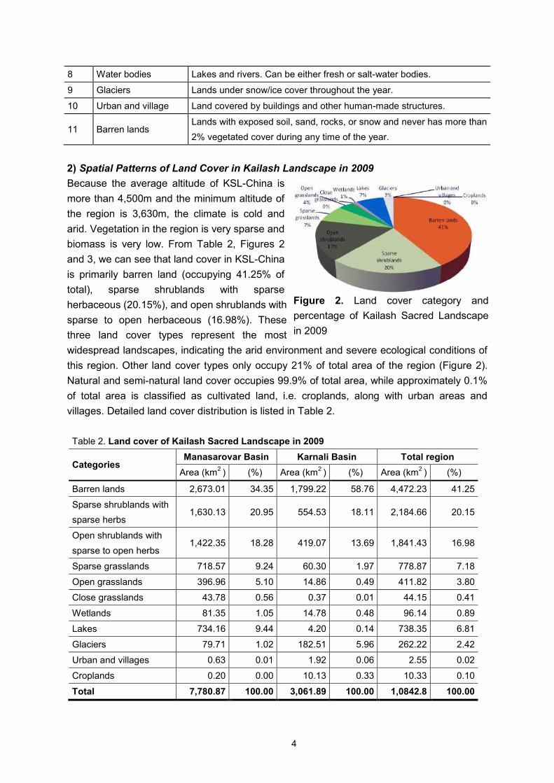
2) Spatial Patterns of Land Cover in Kailash Landscape in 2009
Because the average altitude of KSL-China is
more than 4,500m and the minimum altitude of
the region is 3,630m, the climate is cold and
arid. Vegetation in the region is very sparse and
biomass is very low. From Table 2, Figures 2
and 3, we can see that land cover in KSL-China
is primarily barren land (occupying 41.25% of
total), sparse shrublands with sparse
herbaceous (20.15%), and open shrublands with
sparse to open herbaceous (16.98%). These
three land cover types represent the most
widespread landscapes, indicating the arid environment and severe ecological conditions of
this region. Other land cover types only occupy 21% of total area of the region (Figure 2).
Natural and semi-natural land cover occupies 99.9% of total area, while approximately 0.1%
of total area is classified as cultivated land, i.e. croplands, along with urban areas and
villages. Detailed land cover distribution is listed in Table 2.
Table 2. Land cover of Kailash Sacred Landscape in 2009
Categories Manasarovar Basin Karnali Basin Total region
Area (km2 ) (%) Area (km
2 ) (%) Area (km
2 ) (%)
Barren lands 2,673.01 34.35 1,799.22 58.76 4,472.23 41.25
Sparse shrublands with
sparse herbs 1,630.13 20.95 554.53 18.11 2,184.66 20.15
Open shrublands with
sparse to open herbs 1,422.35 18.28 419.07 13.69 1,841.43 16.98
Sparse grasslands 718.57 9.24 60.30 1.97 778.87 7.18
Open grasslands 396.96 5.10 14.86 0.49 411.82 3.80
Close grasslands 43.78 0.56 0.37 0.01 44.15 0.41
Wetlands 81.35 1.05 14.78 0.48 96.14 0.89
Lakes 734.16 9.44 4.20 0.14 738.35 6.81
Glaciers 79.71 1.02 182.51 5.96 262.22 2.42
Urban and villages 0.63 0.01 1.92 0.06 2.55 0.02
Croplands 0.20 0.00 10.13 0.33 10.33 0.10
Total 7,780.87 100.00 3,061.89 100.00 1,0842.8 100.00
Figure 2. Land cover category and
percentage of Kailash Sacred Landscape
in 2009
5
2.2 Land Use and Agricultural Production Systems
1) Agricultural Land Use
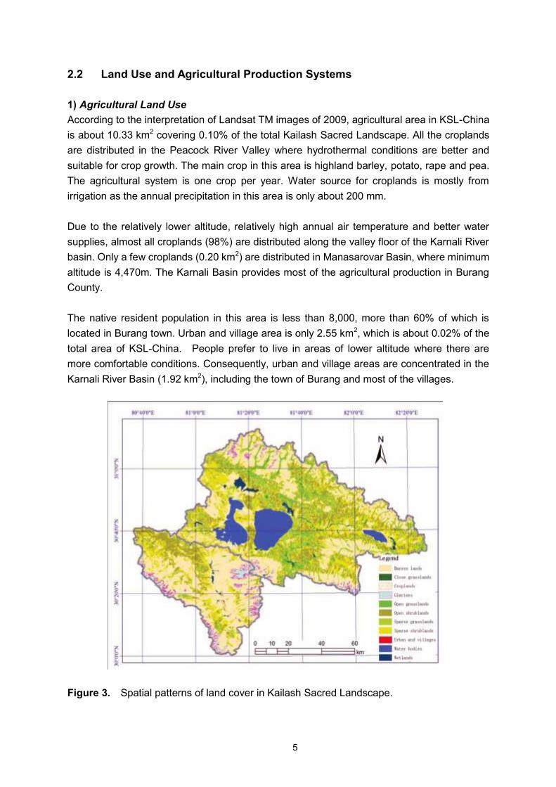
According to the interpretation of Landsat TM images of 2009, agricultural area in KSL-China
is about 10.33 km2 covering 0.10% of the total Kailash Sacred Landscape. All the croplands
are distributed in the Peacock River Valley where hydrothermal conditions are better and
suitable for crop growth. The main crop in this area is highland barley, potato, rape and pea.
The agricultural system is one crop per year. Water source for croplands is mostly from
irrigation as the annual precipitation in this area is only about 200 mm.
Due to the relatively lower altitude, relatively high annual air temperature and better water
supplies, almost all croplands (98%) are distributed along the valley floor of the Karnali River
basin. Only a few croplands (0.20 km2) are distributed in Manasarovar Basin, where minimum
altitude is 4,470m. The Karnali Basin provides most of the agricultural production in Burang
County.
The native resident population in this area is less than 8,000, more than 60% of which is
located in Burang town. Urban and village area is only 2.55 km2, which is about 0.02% of the
total area of KSL-China. People prefer to live in areas of lower altitude where there are
more comfortable conditions. Consequently, urban and village areas are concentrated in the
Karnali River Basin (1.92 km2), including the town of Burang and most of the villages.
Figure 3. Spatial patterns of land cover in Kailash Sacred Landscape.
6
2) Rangelands and High Pastures
Rangelands and alpine pastures cover about 5,357 km2, almost half (49.4%) the total area of
KSL-China. Rangelands and alpine pastures are mainly composed of six land cover types:
sparse shrublands with sparse herbs (occupying 20.15% of total cover), open shrublands
with sparse to open herbaceous (16.98%), sparse grasslands (7.18%), open grasslands
(3.80%), close grasslands (0.41%) and wetlands (0.89%). Although the total area of
rangelands and high pastures is very large, the most widely distributed land cover types, i.e.
sparse shrublands and sparse grasslands, produce little biomass for livestock due to low
coverage and productivity. Open grasslands, close grasslands, open shrublands and
wetlands provide more preferable forage grasses for livestock and native animals than
sparse grasslands and sparse shrublands do, but only cover 22% of the area.
From Table 2, it is clear that ecological conditions in Manasarovar Basin are much better than
in Karnali Basin. Rangelands in Manasarovar Basin account for about 55.1% of total cover of
the basin, while grasslands in Karnali Basin cover no more than 35% of the total area.
Although barren lands are the most common land cover in both basins due to the cold and
arid climatic conditions, there is an obvious difference between them. The cover of barren
lands in Karnali Basin is about 59% of total land cover, which is much more than that in
Manasarovar basin where barren lands occupy 34% of total land. In addition, wetlands in the
two basins may also implicate hydrological conditions of the region. The area of wetlands in
Manasarovar Basin is obviously more than in the Karnali Basin.
Rangeland management is a combination of nomadic and captive livestock breeding. Total
livestock population in this area is more than 150,000. Marketing rate of fattened stock is
more than 33%.
2.3 Land Use and Agricultural Production Systems
1). Description and Distribution of Agricultural Production and Cropping Systems
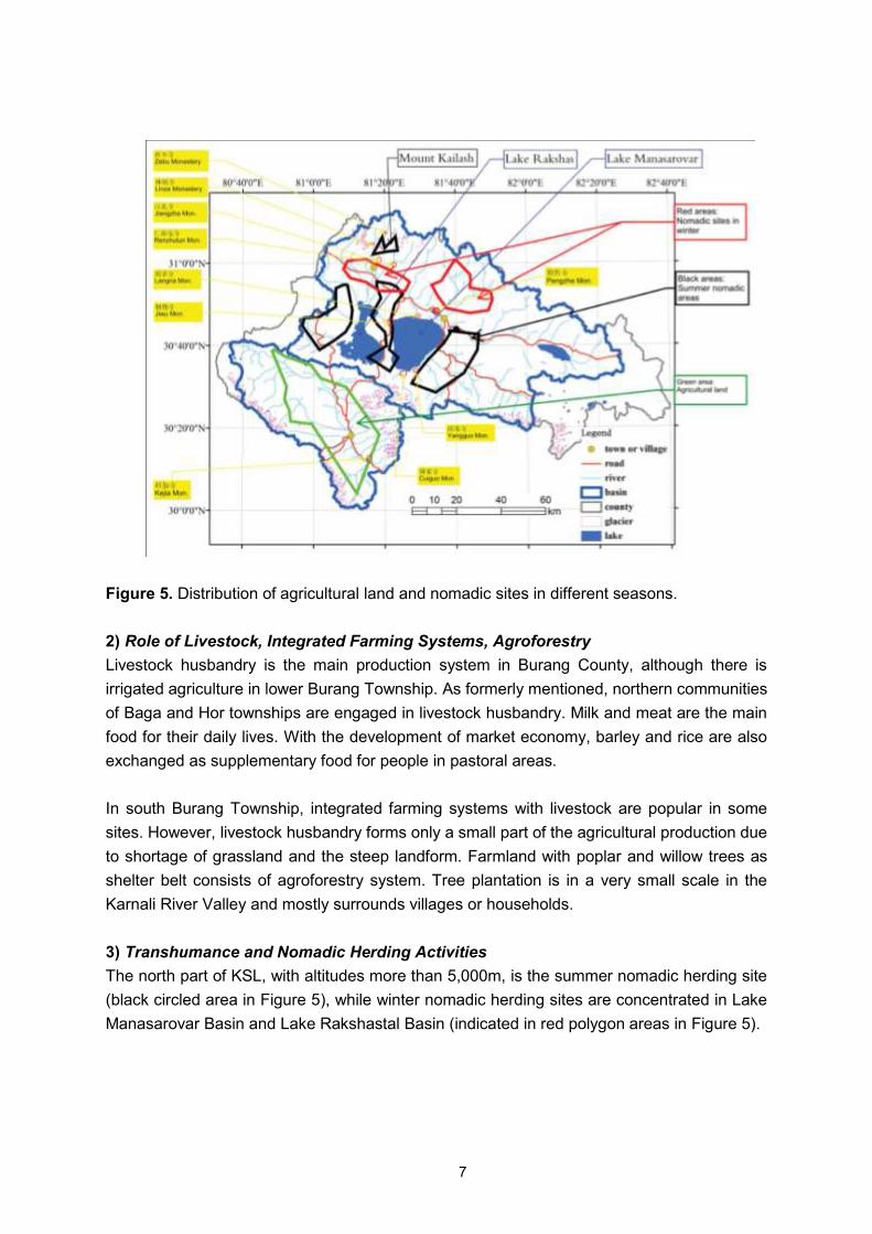
All croplands are distributed in the Peacock River Valley, which is located in Burang
Township. This area has altitude less than 4,000m with hydrothermal conditions in the valley
suitable for crop growth (green polygon area indicated in Figure 5). The main crop system is
one crop system per year. Highland barley, potato, pea and rape are the main crops
cultivated. Winter barley is the main food for local people in Burang Township, although
spring barley is also cultivated in some households. Water sources for croplands are mostly
from irrigation because annual precipitation in this area is only about 200 mm.
7
Figure 5. Distribution of agricultural land and nomadic sites in different seasons.
2) Role of Livestock, Integrated Farming Systems, Agroforestry
Livestock husbandry is the main production system in Burang County, although there is
irrigated agriculture in lower Burang Township. As formerly mentioned, northern communities
of Baga and Hor townships are engaged in livestock husbandry. Milk and meat are the main
food for their daily lives. With the development of market economy, barley and rice are also
exchanged as supplementary food for people in pastoral areas.
In south Burang Township, integrated farming systems with livestock are popular in some
sites. However, livestock husbandry forms only a small part of the agricultural production due
to shortage of grassland and the steep landform. Farmland with poplar and willow trees as
shelter belt consists of agroforestry system. Tree plantation is in a very small scale in the
Karnali River Valley and mostly surrounds villages or households.
3) Transhumance and Nomadic Herding Activities
The north part of KSL, with altitudes more than 5,000m, is the summer nomadic herding site
(black circled area in Figure 5), while winter nomadic herding sites are concentrated in Lake
Manasarovar Basin and Lake Rakshastal Basin (indicated in red polygon areas in Figure 5).
8
2.4 Hydrology and Water Resources
1) Glaciers and Ice
Due to the wide range of mountains and high altitude in this area, there are numerous
glaciers in the region. Total glacial area is approximately 262 km2, covering 2.42% of
KSL-China. More than 80% of the glaciers are oriented to the north. Because of the semi-arid
conditions on the plateau, the average altitude of the glacier termini is very high, about
5,200m.
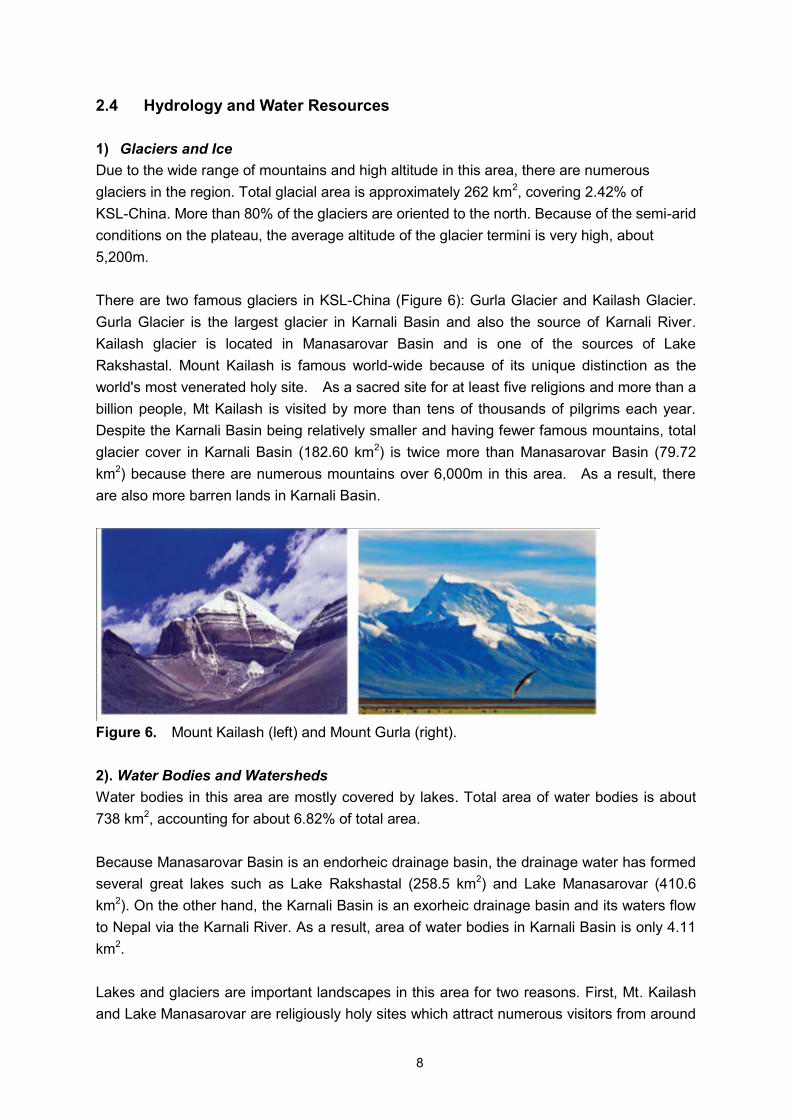
There are two famous glaciers in KSL-China (Figure 6): Gurla Glacier and Kailash Glacier.
Gurla Glacier is the largest glacier in Karnali Basin and also the source of Karnali River.
Kailash glacier is located in Manasarovar Basin and is one of the sources of Lake
Rakshastal. Mount Kailash is famous world-wide because of its unique distinction as the
world's most venerated holy site. As a sacred site for at least five religions and more than a
billion people, Mt Kailash is visited by more than tens of thousands of pilgrims each year.
Despite the Karnali Basin being relatively smaller and having fewer famous mountains, total
glacier cover in Karnali Basin (182.60 km2) is twice more than Manasarovar Basin (79.72
km2) because there are numerous mountains over 6,000m in this area. As a result, there
are also more barren lands in Karnali Basin.
Figure 6. Mount Kailash (left) and Mount Gurla (right).
2). Water Bodies and Watersheds
Water bodies in this area are mostly covered by lakes. Total area of water bodies is about
738 km2, accounting for about 6.82% of total area.
Because Manasarovar Basin is an endorheic drainage basin, the drainage water has formed
several great lakes such as Lake Rakshastal (258.5 km2) and Lake Manasarovar (410.6
km2). On the other hand, the Karnali Basin is an exorheic drainage basin and its waters flow
to Nepal via the Karnali River. As a result, area of water bodies in Karnali Basin is only 4.11
km2.
Lakes and glaciers are important landscapes in this area for two reasons. First, Mt. Kailash
and Lake Manasarovar are religiously holy sites which attract numerous visitors from around
9
the world. Second, lakes and glaciers supply water for vegetation, animals and people
throughout the year (especially during the arid season) because annual precipitation is only
ca. 200 mm.
Lake Manasarovar
Lake Manasarovar, Mapam Yumco, (Tibetan: ; Chinese:玛旁雍错 ), is a
freshwater lake in TAR of China with 2,000 km (ca. 200 miles) from Lhasa. To the west of
Lake Manasarovar is Lake Rakshastal, and towards the north is Mt. Kailash. It is the highest
freshwater body in the world. As per Hindu theology, Lake Manasarovar is the abode of purity
and one who touches the earth of Manasarovar will go to paradise; one who drinks water
from the lake will go to the heaven of Lord Shiva; and s/he will be cleansed of his sins
committed over a hundred lifetimes.
Like Mt Kailash, Lake Manasarovar is a place of pilgrimage attracting religious people from
India, Nepal, Tibet and the neighboring countries. Bathing in Manasarovar and drinking its
water is believed to cleanse all sins. Pilgrimage tours are organized regularly, especially from
India, the most famous of which is the Kailash Manasarovar Yatra which takes place every
year. Pilgrims come to take ceremonial baths in the cleansing waters of the lake.
Manasarovar Lake has long been viewed by pilgrims as the source of four of the greatest
rivers of Asia namely Brahmaputra, Karnali, Indus and Sutlej. Thus, it is an axial point which
has been thronged by pilgrims for thousands of years. The region was initially closed to
pilgrims from outside and no foreigners were allowed between 1949 and 1980. However,
after the 1980s, it was open and has again become a part of the Indian pilgrim trail.
According to Hindu religion, the lake was first created in the mind of Lord Brahma. Hence, in
Sanskrit it is called "Manasarovar" which is a combination of the words manas (mind) and
sarovara (lake). The lake, in Hindu religious belief, is also supposed to be the summer abode
of swans. Considered as sacred birds, swans (Sanskrit: hansa) are an important element in
the symbology of the subcontinent representing wisdom and beauty. It is also believed that
Devas descend to bathe in the lake between 3 and 5 am, the time of the day known as
Brahmhi muhurta.
Buddhists also associate the lake with the legendary lake known as Anavatapta in Sanskrit
and Anotatta in Pali, where Queen Maya is believed to have conceived Buddha. The lake has
eight monasteries on its shores, the most notable of which is the ancient Chiu Gompa
(Monastery) built right onto a steep hill. The monastery appears to have been carved right out
of the rock. Jains and Bonpas of Tibet equally revere this spot with great enthusiasm.

10
Lake Rakshastal
Lake Rakshastal (officially: La'nga Co; Tibetan: ; Chinese: 拉昂错) is a lake in TAR,
China situated close to the western side of Lake Manasarovar and Mount Kailash. The Sutlej
River originates at Rakshastal's northwestern tip. Despite its close proximity to Lake
Manasarovar—over the road to Burang County, Lake Rakshastal does not share the lore of
worship with its eastern neighbor. Named 'lake of the demon', Lake Rakshastal is considered
to be the residence of Ravana, the ten-headed demon king of Ceylon in Hindu mythology.
In Buddhism, Lake Manasarovar, which is round like the sun, and Lake Rakshastal, shaped
as a crescent, are regarded respectively as 'brightness' and 'darkness'. Its salty water, a stark
contrast to the fresh waters of Lake Manasarovar, produce no waterweeds or fish and is
considered poisonous by locals.
According to Hindu mythology, this lake was created by the demon King Ravana for the
express purpose of garnering superpowers through acts of devotion and meditation to Lord
Shiva who was presiding on Mt Kailash. It was upon the banks of a special island in this lake
that he would make daily offerings with one of his ten heads as a sacrifice to please Lord
Shiva. Finally, on the tenth day, Lord Shiva was moved by his devotion and granted him his
wish to obtain superpowers. This demon-created lake is in contrast to the sacred god-created
Lake Manasarovar.
However, despite its notoriety, Lake Rakshastal bears no less beauty than other lakes in
Tibet. Originally joined with Lake Manasarovar and later separated by geological movements,
it is still connected with Lake Manasarovar by a natural channel, Ganga Chhu. It covers a
total area of 70 sq.km. at an altitude of 4,752m. Though absent of nearby grasslands, the
white cobbles, dark red hills and island, and the deep blue lake water present another
distinctive picture absent from many of the places more frequented by visitors.
Karnali Basin
Karnali (or Ghaghara) is a transboundary perennial river originating on the Tibetan Plateau
near Lake Mansarovar. It cuts through the Himalayas in Nepal and joins the Sarda River at
Brahmaghat in India. Together they form the Ghaghra River, a major left bank tributary of the
Ganges. With a length of 507 km, it is the largest river in Nepal and one of the largest
tributaries of the Ganges. The total length of Karnali River up to its confluence with the
Ganges at Doriganj in Bihar is 1,080 km.
Karnali River is called Peacock River in Chinese; Kauriala, Manchu and Karnali (meaning
Turquoise River) in Nepali. In Uttarakhand, Pilibhit and Shahjanpur Districts of Uttar Pradesh,
India it is spelled Gogra, Ghaghra or Ghagraand Khakra, literally translating to holy water
from the sacred mountain. It rises in the southern slopes of the Himalayas in Tibet, in the
glaciers of Mapchachungo, at an altitude of about 3,962m. As the Karnali River, the river
flows south through one of the most remote and least explored areas of Nepal. The 202 km
11
Seti River drains the western part of the catchment and joins the Karnali River in Doti District,
north of Dundras hill.
The Karnali River Basin lies between the mountain ranges of Dhaulagiri in Nepal and Nanda
Devi in Uttarakhand, India. In the north, it lies in the rain shadow of the Himalayas. The basin
formed by the river has a total catchment area of 127,950 km2, of which 45% is in India. The
population of the Basin districts in Nepal increased from 1.9 million in 1971 to 4.7 million
people in 2001, almost a 250% increase over three decades.
2.5 Biological Diversity of Flora and Fauna
1) Overview of biodiversity
There is abundant biodiversity in Kailash-China. Vegetation is composed of north-temperate
flora. Dominant communities are alpine steppe, shrubs and desert. Dominant steppe or
meadow communities are Stipa purpurea, Stipa purpurea var. glareosa, Carex moorcroftii +
Leymus secalinus, and Stipa purpurea + Kobresia pygmaea. Some alpine shrubs are
dominated by Caragana versicolor and Potentila fruticosa var. pumila. Wetland vegetation
surrounding Manasarovar Lake area is dominated by communities including Triglochin
maritimum, Carex cryptostachys, Kobresia pygmaea, Carex moorcroftii + Polygonum
sibiricum var. thomsonii. Hydrophyte community is mostly dominated by Potamogeton
pectinatus.
There are more than 100 species of vertebrates belonging to 77 genera and 40 families of
fishes, amphibians, reptiles, birds and mammals in Burang County.
2) Spatial Distribution of Biodiversity by Ecozones, Altitude and Geographical
Location
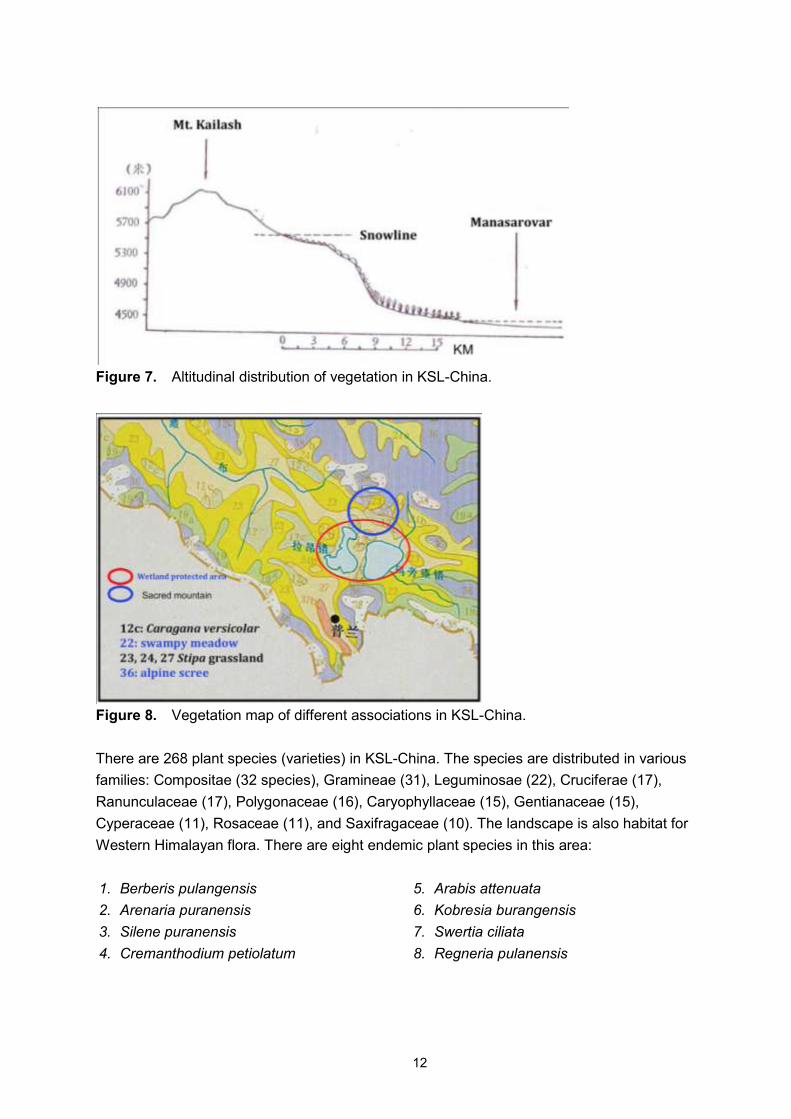
The northern part of Burang County, i.e. Kailash Mountains, is dominated by cushion plants,
shrubs and meadow, and alpine steppe. The middle part of the county surrounding
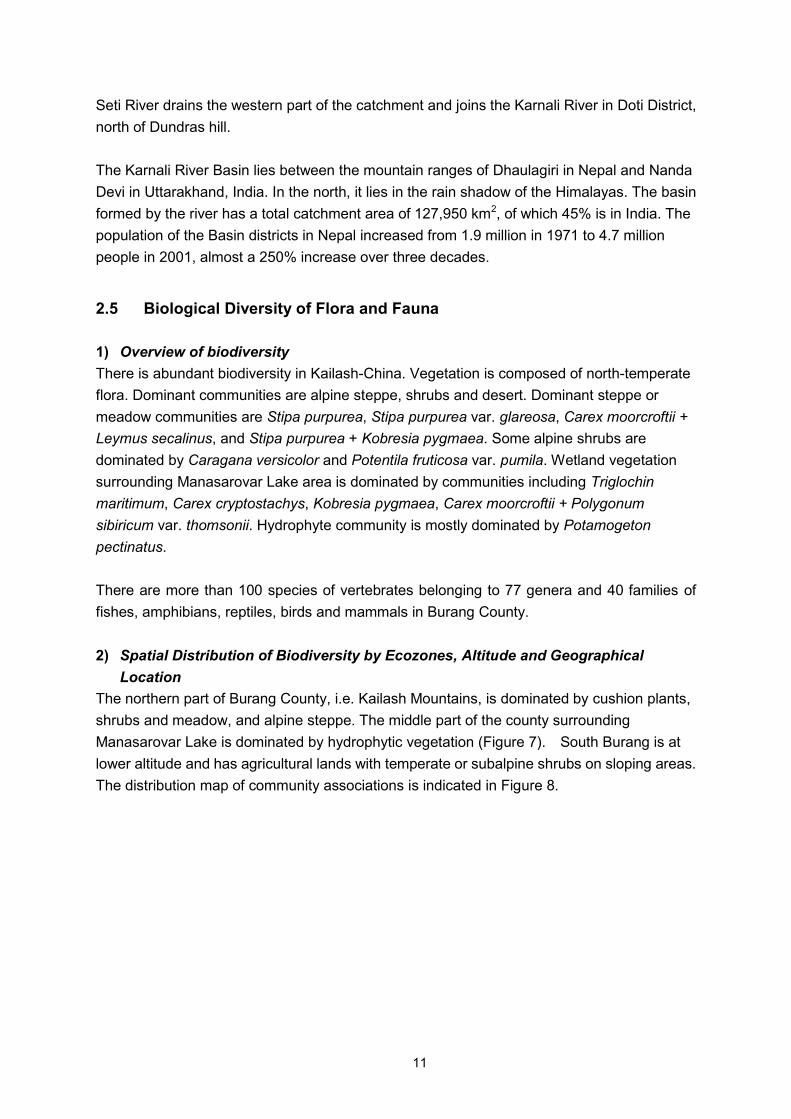
Manasarovar Lake is dominated by hydrophytic vegetation (Figure 7). South Burang is at
lower altitude and has agricultural lands with temperate or subalpine shrubs on sloping areas.
The distribution map of community associations is indicated in Figure 8.
12
Figure 7. Altitudinal distribution of vegetation in KSL-China.
Figure 8. Vegetation map of different associations in KSL-China.
There are 268 plant species (varieties) in KSL-China. The species are distributed in various
families: Compositae (32 species), Gramineae (31), Leguminosae (22), Cruciferae (17),
Ranunculaceae (17), Polygonaceae (16), Caryophyllaceae (15), Gentianaceae (15),
Cyperaceae (11), Rosaceae (11), and Saxifragaceae (10). The landscape is also habitat for
Western Himalayan flora. There are eight endemic plant species in this area:
1. Berberis pulangensis
2. Arenaria puranensis
3. Silene puranensis
4. Cremanthodium petiolatum
5. Arabis attenuata
6. Kobresia burangensis
7. Swertia ciliata
8. Regneria pulanensis
13
Fauna in KSL-China are of the Changthang Plateau sub-region of the Palaearctic region.
Wildlife is mainly distributed in the north and middle alpine areas of Burang County. More
than 20 species of animals are listed in national protected animals and CITES lists.
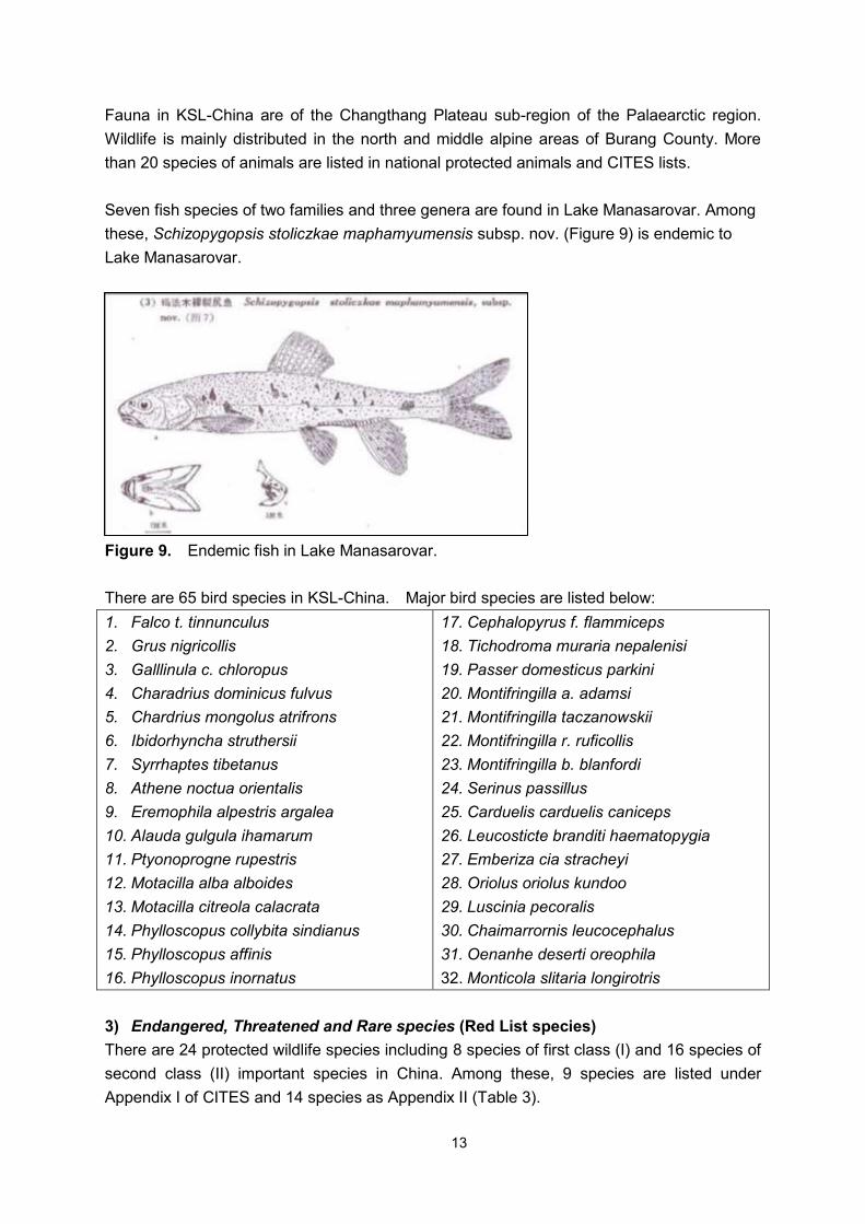
Seven fish species of two families and three genera are found in Lake Manasarovar. Among
these, Schizopygopsis stoliczkae maphamyumensis subsp. nov. (Figure 9) is endemic to
Lake Manasarovar.
Figure 9. Endemic fish in Lake Manasarovar.
There are 65 bird species in KSL-China. Major bird species are listed below:
1. Falco t. tinnunculus
2. Grus nigricollis
3. Galllinula c. chloropus
4. Charadrius dominicus fulvus
5. Chardrius mongolus atrifrons
6. Ibidorhyncha struthersii
7. Syrrhaptes tibetanus
8. Athene noctua orientalis
9. Eremophila alpestris argalea
10. Alauda gulgula ihamarum
11. Ptyonoprogne rupestris
12. Motacilla alba alboides
13. Motacilla citreola calacrata
14. Phylloscopus collybita sindianus
15. Phylloscopus affinis
16. Phylloscopus inornatus
17. Cephalopyrus f. flammiceps
18. Tichodroma muraria nepalenisi
19. Passer domesticus parkini
20. Montifringilla a. adamsi
21. Montifringilla taczanowskii
22. Montifringilla r. ruficollis
23. Montifringilla b. blanfordi
24. Serinus passillus
25. Carduelis carduelis caniceps
26. Leucosticte branditi haematopygia
27. Emberiza cia stracheyi
28. Oriolus oriolus kundoo
29. Luscinia pecoralis
30. Chaimarrornis leucocephalus
31. Oenanhe deserti oreophila
32. Monticola slitaria longirotris
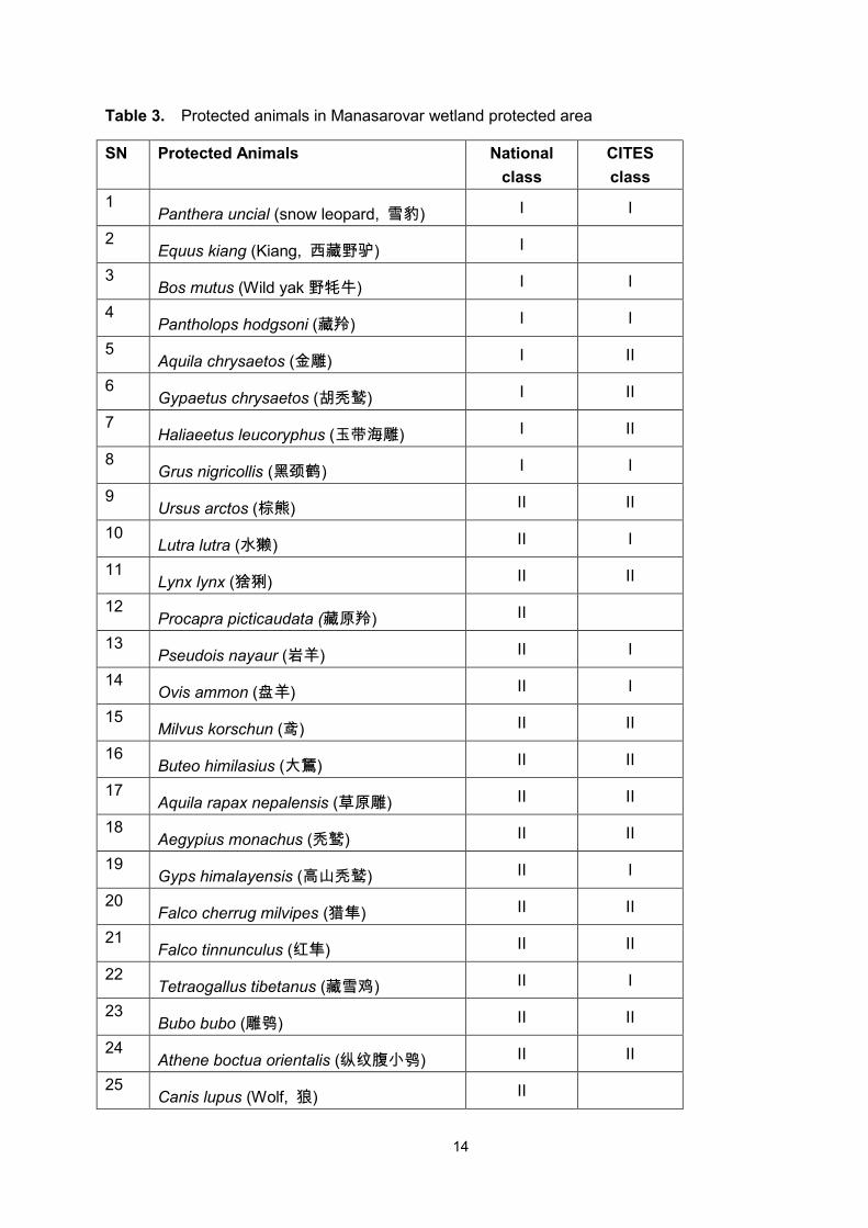
3) Endangered, Threatened and Rare species (Red List species)
There are 24 protected wildlife species including 8 species of first class (I) and 16 species of
second class (II) important species in China. Among these, 9 species are listed under
Appendix I of CITES and 14 species as Appendix II (Table 3).
14
Table 3. Protected animals in Manasarovar wetland protected area
SN Protected Animals National
class
CITES
class
1 Panthera uncial (snow leopard, 雪豹) I I
2 Equus kiang (Kiang, 西藏野驴) I
3 Bos mutus (Wild yak 野牦牛) I I
4 Pantholops hodgsoni (藏羚) I I
5 Aquila chrysaetos (金雕) I II
6 Gypaetus chrysaetos (胡秃鹫) I II
7 Haliaeetus leucoryphus (玉带海雕) I II
8 Grus nigricollis (黑颈鹤) I I
9 Ursus arctos (棕熊) II II
10 Lutra lutra (水獭) II I
11 Lynx lynx (猞猁) II II
12 Procapra picticaudata (藏原羚) II
13 Pseudois nayaur (岩羊) II I
14 Ovis ammon (盘羊) II I
15 Milvus korschun (鸢) II II
16 Buteo himilasius (大鵟) II II
17 Aquila rapax nepalensis (草原雕) II II
18 Aegypius monachus (秃鹫) II II
19 Gyps himalayensis (高山秃鹫) II I
20 Falco cherrug milvipes (猎隼) II II
21 Falco tinnunculus (红隼) II II
22 Tetraogallus tibetanus (藏雪鸡) II I
23 Bubo bubo (雕鸮) II II
24 Athene boctua orientalis (纵纹腹小鸮) II II
25 Canis lupus (Wolf, 狼) II
15
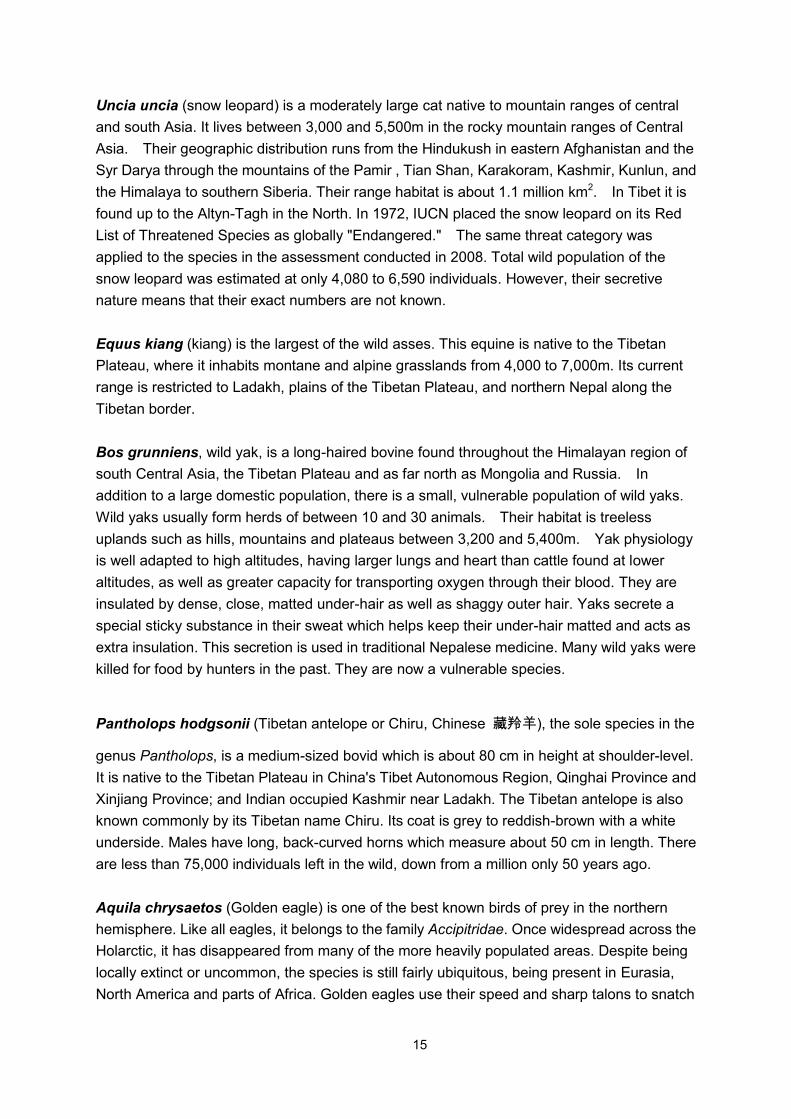
Uncia uncia (snow leopard) is a moderately large cat native to mountain ranges of central
and south Asia. It lives between 3,000 and 5,500m in the rocky mountain ranges of Central
Asia. Their geographic distribution runs from the Hindukush in eastern Afghanistan and the
Syr Darya through the mountains of the Pamir , Tian Shan, Karakoram, Kashmir, Kunlun, and
the Himalaya to southern Siberia. Their range habitat is about 1.1 million km2. In Tibet it is
found up to the Altyn-Tagh in the North. In 1972, IUCN placed the snow leopard on its Red
List of Threatened Species as globally "Endangered." The same threat category was
applied to the species in the assessment conducted in 2008. Total wild population of the
snow leopard was estimated at only 4,080 to 6,590 individuals. However, their secretive
nature means that their exact numbers are not known.
Equus kiang (kiang) is the largest of the wild asses. This equine is native to the Tibetan
Plateau, where it inhabits montane and alpine grasslands from 4,000 to 7,000m. Its current
range is restricted to Ladakh, plains of the Tibetan Plateau, and northern Nepal along the
Tibetan border.
Bos grunniens, wild yak, is a long-haired bovine found throughout the Himalayan region of
south Central Asia, the Tibetan Plateau and as far north as Mongolia and Russia. In
addition to a large domestic population, there is a small, vulnerable population of wild yaks.
Wild yaks usually form herds of between 10 and 30 animals. Their habitat is treeless
uplands such as hills, mountains and plateaus between 3,200 and 5,400m. Yak physiology
is well adapted to high altitudes, having larger lungs and heart than cattle found at lower
altitudes, as well as greater capacity for transporting oxygen through their blood. They are
insulated by dense, close, matted under-hair as well as shaggy outer hair. Yaks secrete a
special sticky substance in their sweat which helps keep their under-hair matted and acts as
extra insulation. This secretion is used in traditional Nepalese medicine. Many wild yaks were
killed for food by hunters in the past. They are now a vulnerable species.
Pantholops hodgsonii (Tibetan antelope or Chiru, Chinese 藏羚羊), the sole species in the
genus Pantholops, is a medium-sized bovid which is about 80 cm in height at shoulder-level.
It is native to the Tibetan Plateau in China's Tibet Autonomous Region, Qinghai Province and
Xinjiang Province; and Indian occupied Kashmir near Ladakh. The Tibetan antelope is also
known commonly by its Tibetan name Chiru. Its coat is grey to reddish-brown with a white
underside. Males have long, back-curved horns which measure about 50 cm in length. There
are less than 75,000 individuals left in the wild, down from a million only 50 years ago.
Aquila chrysaetos (Golden eagle) is one of the best known birds of prey in the northern
hemisphere. Like all eagles, it belongs to the family Accipitridae. Once widespread across the
Holarctic, it has disappeared from many of the more heavily populated areas. Despite being
locally extinct or uncommon, the species is still fairly ubiquitous, being present in Eurasia,
North America and parts of Africa. Golden eagles use their speed and sharp talons to snatch
16
rabbits, marmots and ground squirrels. They also eat carrion, reptiles, birds, fish, and smaller
fare such as large insects. They have even been known to attack fully grown deer. Golden
eagle pairs maintain territories that may be as large as 155 sq.km. They are monogamous
and may remain together for several years or possibly for life. Golden eagles nest in high
places including cliffs, trees, or human structures such as telephone poles. They build huge
nests to which they may return for several breeding years. They are found from Southern
Kazakhstan to Manchuria and south-west China, and also in northern Pakistan, Kashmir and
western India.
Gypaetus barbatus (Bearded vulture-eagle) is an Old World vulture, the only member of the
genus Gypaetus. It breeds on crags in high mountains in southern Europe, Africa, India and
Tibet, laying one or two eggs in mid-winter which hatch at the beginning of spring. The
population is resident. Like other vultures it is a scavenger, feeding mostly from carcasses of
dead animals. It usually disdains rotting meat, however, and lives on a diet that is 90% bone
marrow. It will drop large bones from a height to crack them into smaller pieces. Its old name
of Ossifrage (bone breaker) relates to this habit. Live tortoises are also dropped in similar
fashion to crack them open.
Haliaeetus leucoryphus (Pallas's fish-eagle) is a large, brownish sea-eagle. It breeds in
Central Asia, between the Caspian Sea and the Yellow Sea, from Kazakhstan and Mongolia
to the Himalayas, Pakistan, northern India and Bangladesh. It is partially migratory, with
central Asian birds wintering among the southern Asian birds in northern India, and also
further west to the Persian Gulf. The conservation status of Pallas' fish-eagle is Vulnerable,
with a population of about 2,500 to 10,000 remaining. Besides direct persecution, humans
contribute to the decline of this species through habitat degradation, pollution, and draining or
overfishing lakes. In India, the species is also threatened by water hyacinth (Eichhornia spp.)
which spreads over lakes and makes finding prey difficult. Their large range is deceptive, as
Pallas's fish-eagle is rare and isolated throughout its territory and may not breed in large
areas of it.
Grus nigricollis (Black-necked crane or Tibetan crane) is a medium-sized crane native to
Asia. It is distributed in Pakistan, China, Himalayan regions of India, Bhutan and Vietnam. It
breeds on the Tibetan Plateau, with a small population in adjacent Ladakh and Kashmir
Valleys. It has therefore been designated as the "State bird of Jammu and Kashmir". The
Black-necked crane is one of the spiritual creatures for people of the area and is pictured
alongside many of their deities in the region's monasteries. The Black-necked crane is listed
as Vulnerable on the IUCN Red List of Threatened Species. It is listed on Appendix I and II of
CITES. The estimated population of Black-necked crane is between 5,600 and 6,000
individuals. The major threat to its survival is cultivation on its breeding grounds. Also the
opening up of Ladakh Valley to tourism has directly affected the crane's population over the
last few years. It is legally protected in China, India and Bhutan.
17
Ursus arctos (brown bear) is a large bear distributed across much of northern Eurasia and
North America. While the brown bear's range has shrunk, and it has faced local extinctions, it
remains listed as a species of least concern by IUCN with a total population of approximately
200,000.
Lutra lutra, also known as Eurasian otter, is a European and Asian member of the Lutrinae
or otter subfamily and is typical of freshwater otters. The European Otter declined across its
range in the second half of the 20th century primarily due to pollution from pesticides. Other
threats include habitat loss and hunting, both legal and illegal. They are listed as Near
Threatened by the 2001 IUCN Red List.
Lynx lynx (Eurasian lynx) is a medium-sized cat native to European and Siberian forests,
where it is one of the predators. The European lynx is native to the Chinese provinces of
Gansu, Qinghai, Sichuan, and Shaanxi, as well as to Iran, Mongolia, Kazakhstan,
Uzbekistan, Turkmenistan, Kyrgyzstan, Tajikistan, and to Ladakh region of Jammu and
Kashmir.
Procapra picticaudata (Tibetan gazelle) is a species of antelope that inhabits the Tibetan
Plateau. They are grayish brown in color with a short, black-tipped tail in the center of a
heart-shaped white rump-patch. The thin and long legs of this elegant animal enhance its
running skill, which is required to escape from predators. Mating season is in December, with
young born the following May. Presently, gazelles are suffering not only from poor pasture
conditions, but also from problems associated with small populations such as lack of genetic
diversity, which makes them less resistant to diseases. Populations in both Ladakh and
Tibet seem to be declining precipitously and are threatened with extinction, at least in some
regions. Within India, a small population of gazelles also exists in northern Sikkim, at the
border between India and Chinese-controlled Territory, thus moving back and forth between
India and Chinese Territory.
Pseudois nayaur (bharal or Himalayan blue sheep) is a caprid found in the high Himalayas
of Nepal, TAR-China, Kashmir, Pakistan, Bhutan and India. It has horns that grow upwards,
curve out and then towards the back, somewhat like an upside down mustache. The bharal is
a major food species of the snow leopard. The Dwarf blue sheep (P. schaeferi) is sometimes
considered to be a subspecies of the bharal.
Aquila nipalensis (Steppe eagle) is a bird of prey. It is about 62–81 cm (24–32 inches) in
length and has a wingspan of 165–200 cm (65–79 inches). Females, weighing 2.3-4.9 kg
(5-10.8 lbs), are slightly larger than males, at 2-3.5 kg (4.4-7.7 lbs). Like all eagles, it belongs
to the family Accipitridae. It was once considered to be closely related to the non-migratory
Tawny eagle, Aquila rapax, and the two forms have previously been treated as co-specific.
They were split based on pronounced differences in morphology and anatomy; two molecular
18
studies, each based on a very small number of genes, indicate that the species are distinct
but disagree over how closely related they are.
Aegypius monachus (Cinereous vulture) is also known as Black vulture, Monk vulture, or
Eurasian black vulture. It is a member of the family Accipitridae, which also includes many
other diurnal raptors such as kites, buzzards and harriers. It breeds across southern Europe
and Asia from Spain to Korea, but is endangered throughout its European range. It is resident
except in those parts of its range where hard winters cause limited movement. It has the
typical vulture unfeathered bald head (actually covered in fine down), and dark markings
around the eye giving it a menacing skull-like appearance. The Cinereous vulture has
declined over most of its range in the last 200 years due to poisoning by eating poisoned bait
put out to kill dogs and other predators, and to higher hygiene standards reducing the amount
of available carrion. It is currently listed as near threatened. The decline has been the
greatest in the western half of the range, with extinction in many European countries and
northwest Africa. Trends in the small populations of Ukraine and European Russia, and in
Asian populations, are not well recorded. In the former USSR, it is still threatened by illegal
capture for zoos, and in Tibet by rodenticides.
Falco tinnunculus (Common kestrel) is a bird of prey belonging to the kestrel group of the
falcon family, Falconidae. It is also known as the Eurasian kestrel or Old World kestrel. This
species occurs over a large range. It is widespread in Europe, Asia, and Africa, as well as
occasionally reaching the east coast of North America. But although it has colonized a few
oceanic islands, vagrant individuals are generally rare; in the whole of Micronesia for
example, the species was only recorded twice each on Guam and Saipan in the Marianas.
Tetraogallus tibetanus (Tibetan snowcock) is a cock in the pheasant family Phasianidae of
the Order Galliformes. This species is found in the Western Himalayas of the Kashmir region
of Pakistan and India.
Bubo bubo (Eurasian eagle-owl) is a species of eagle owl resident in much of Europe and
Asia. It is also one of the largest types of owls. The Eagle owl is a large and powerful bird and
sometimes titled the world's largest owl, but so is Blakiston's fish owl which is slightly bigger
on average. It mainly feeds on small mammals, but can kill prey up to the size of foxes and
young deer.
4) Medicinal and Other Important Species
National Ministry of Forestry specially protects Pantholops hodgsoni and Grus nigricollis in
the Kailash region. In addition, there are more than 30 species with economic, scientific or
profitable value, and are listed below.
19
Amphibians (1 species):
1. Altirana parkeri
Reptiles (1 species):
1. Phrynocephalus theobaldi
Birds (30 species):
1. Podiceps cristatus
2. Phalacrocorax carbo
3. Anser indicus
4. Anas strepera
5. Todorna ferruginea
6. Aythya ferina
7. Aythya fuligula
8. Mergus merganser
9. Perdix hodgsoniae
10. Charadrius mongolus
11. Numenius arquata
12. Numenius ochropus
13. Tringa tetanus
14. Capella stenura
15. Calidris temminckii
16. Ibidorhyncha struthersii
17. Larus brunnicephalus
18. Sterna hirundo
19. Syrrhaptes tibetanus
20. Columba leuconota
21. Columba rupeatris
22. Upupa epops
23. Alauda gulgula
24. Eremophila alpestris
25. Motacilla alba
26. Motacilla cinerea
27. Motacilla citreola
28. Motacilla flava
29. Phylloscopus affinis
30. Carpodacus rubicilla
Mammals (3 species):
1. Vulpes vulpes
2. Vulpes ferrlata
3. Mustela altaica
The following five species are listed as second grade protected animals of TAR-China:
1. Anser indicus
2. Anas stepera
3. Todorna ferruginea
4. Mergus merganser
5. Vulpes ferrlata
2.6 Wildlife and Wildlife Habitats
1) Habitat for Migratory Species and Migration Corridors
As mentioned in 2.4, there are more than 30 wildlife species with economic and scientific
value. There are also 25 species of nationally and CITES protected animals.
KSL-China provides important habitats for wildlife, especially the wetlands of Lake
Manasarovar for migratory birds such as Black-necked crane (Grus nigricollis). Manasarovar
Lake is one of the western migration corridors of Black-necked crane. In winter, these cranes
migrate from southeastern Xinjiang Autonomous Region-China to western Qinghai and
Changthang, in north Tibet and then to Yalungzangbo River. A few cranes also cross the
Himalayas to Bhutan.
20
2) Wildlife Management
Environmental protection measures are adopted by China and TAR, China to protect wildlife
in Changthang National Protected Area. In 2008, Lake Manasarovar was established as
wetland protected area of TAR, China.
Vegetation and Wildlife Protection: Vegetation and wildlife protection measures are in
place to protect wildlife habitats and breeding sites, to increase forest coverage rate by
choosing the right seeds, to provide fuel to local residents so that deforestation and
grass-cutting can be avoided, and to build the ecosystem around the Peacock River
Watershed.
Constructing Manasarovar Wetland Natural Reserve: Manasarovar, the world's largest
high-altitude freshwater lake, is also a globally renowned sacred pilgrimage site and tourist
destination. In 2008, the Manasarovar Wetland Natural Reserve was declared. Meanwhile,
various measures have been taken to protect this wetland environment. For example,
wetlands which were once pastures have been reverted to wetlands and bars have been
constructed to protect small lakes and some environmentally sensitive wetlands.
3) Existing Local, National /Sub-national or International Conservation or
Management
i. Environmental conservation and management measures adopted by Central Government
and Tibet Autonomous Region
The Standing Committee of the People's Congress of TAR, China and the people's
government of the Autonomous Region have published a series of local laws and regulations,
as well as administrative rules and systems, covering the protection of environment and
natural resources in line with actual local conditions. Examples are "Regulations for the
Protection of Forests in the Tibet Autonomous Region", "Provisional Regulations of the Tibet
Autonomous Region on Administration of Grasslands" and "Notice of the People's
Government of the Tibet Autonomous Region on the Protection of Aquatic Resources". In the
field of wildlife protection alone, there are more than 20 documents on related regulations and
systems.
Tibetan Eco-security Shelter Construction: In February 2008, the Standing Committee of the
State Council discussed and approved ‗the program for Tibetan eco-security shield
construction (2008-2030)‘ which provides an overall 15.5 billion RMB investment to fulfill 10
eco-environmental protection projects within 5 ―5-year Plans‖ and a national arrangement for
Tibetan eco-environment improvement and response to global warming. Key
eco-environmental projects of the program include natural grassland conservation, forest fire
prevention, pest control management and wildlife protection. Meanwhile, great attention has
also been paid to construction of shield forests and artificial pasture system, improvement of
natural pastures, and soil retention.
21
Firewood Replacement Strategy: Firewood replacement strategy attempts to solve energy
deficiency and to improve the Tibetan eco-environment. By adopting the strategy, it is
expected that by 2015, reliance on traditional firewood will be reduced significantly and new
or renewable energy sources, such as solar power, hydro-power, bio-power, wind power,
geothermal power and so on, will be utilized to a larger extent. ‗The research on firewood
replacement strategy in Tibetan Autonomous Region‘ has proposed a detailed plan to
harness new and renewable energy in the region and provided financial subsidiary for
firewood replacement strategy.
Pilot Project on Grassland Ecological Efficiency Compensation Fund: In 2009, the Tibetan
Autonomous Region, as the first in China, allocated 200 million RMB in five counties to pilot
the Grassland Ecological Efficiency Compensation Fund project, which aims not only to
improve per capita income of the region, but also to protect grasslands and eco-environment
through building of the compensation mechanism. At the same time, people benefiting from
the mechanism will increase their awareness of environmental protection.
ii. Environmental Protection Measures adopted by Burang County
Strengthening Environmental Protection in Scenic Spots: Dustbins, garbage treatment
stations and outdoor toilets have been built to respond to junk littering and other polluting
behavior around scenic spots. Protection of scrubs has been a part of work of county and
village government. Also, regulations have been stipulated to prevent wood from being cut
while providing only for dung to be used as fuel by tourists and farmers. All these measures
have paved the way for future environmental protection.
Improved Grassland Management: Rest-grazing and grazing rotation have been adopted in
this area. Other measures to improve the quality of grasslands include quarrying and mining
prohibition, stock number control, artificial grass planting, comprehensive management of
deserted pastures, and irrigation improvement.
Protecting Environment by Promoting Tourism: Environmental pressure caused by
over-grazing and tourism garbage can be lessened by adjusting industrial structures of
surrounding areas. In practice, people living in this area can operate their own tourism
businesses, such as operating home inns, mom-stores, and transportation business, so as to
weaken their reliance on traditional ranching while providing services to tourists and pilgrims.
2.7 Protected Areas
1) Existing Protected Areas Within or Nearby KSL-China
The Changthang Protected Area, with an area of 298,000 km2 covering part of Burang
County, was established in 1993 and upgraded in 2000 as a national protected area in order
to protect important animals such as Tibetan antelope (Pantholops hodgsonii), Tibetan wild
ass (Asinus kiang), wild yak (Bos mutus), Tibetan gazelle (Procapra picticaudata), brown
bear (Ursus arctos), snow leopard (Uncia uncia) and black-necked crane (Grus nigricollis). In
2008, Manasarovar watershed was established as a wetland protected area of TAR, China in
22
order to protect Lakes Manasarovar and Rakshastal and their wetland vegetation, fishes and
wildlife.
2) Potential Conservation Corridors linking Protected Areas
There is a potential corridor linking Changthang National Protected Area in the north to Lake
Manasarovar Wetland Protected Area in the south. Large animals and migratory birds can
freely migrate through this corridor in KSL-China.
3) Local, National or International Conservation Efforts or Organizations Active in
KSL-China
The Changthang Protected Area was established in 1993 and upgraded to a national
protected area in 2000 in order to protect important wildlife. Similarly, in 2008, Manasarovar
watershed was established as a wetland protected area in order to protect Lakes
Manasarovar and Lake Rakshas and their wetland ecosystems.
2.8 Forest Development, Utilization and Management
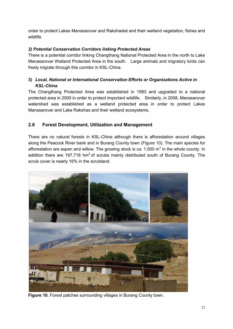
There are no natural forests in KSL-China although there is afforestation around villages
along the Peacock River bank and in Burang County town (Figure 10). The main species for
afforestation are aspen and willow. The growing stock is ca. 1,500 m3 in the whole county. In
addition there are 197,718 hm2 of scrubs mainly distributed south of Burang County. The
scrub cover is nearly 16% in the scrubland.
Figure 10. Forest patches surrounding villages in Burang County town.
23
2.9 Rangelands and Rangeland Management
There are 757,440 hm2 of rangeland in Burang County, in which 630,400 hm2 are available
rangelands for livestock use. According to remote sensing analysis, rangelands and high
pastures in KSL-China is about 5,357 km2 and covers almost half (49.4%) the total area.
Rangelands and high pastures are mainly composed of six land cover types: sparse
shrublands with sparse herbaceous (20.15% of total area), open shrublands with sparse to
open herbaceous (16.98%), sparse grasslands (7.18%), open grasslands (3.80%), close
grasslands (0.41%) and wetlands (0.89%). Although the total area of rangeland and high
pastures is very large, the widely distributed land cover types, i.e. sparse shrublands and
sparse grasslands, can produce only little biomass for livestock due to low coverage and
productivity. Open grasslands, close grasslands, open shrublands and wetlands provide
more preferable forage grasses for livestock and wildlife, but they cover only 22% of the area.
Dominant vegetation types are alpine steppe dominated by Stipa purpurea and Kobresia
pygemeae. Production of rangelands is less than 800 kg.hm-2. In Lake Manasarovar Basin,
vegetation is dominated by shrubs and the area is usually used as summer pastureland. In
winter, herding activities are concentrated in lower altitudes in the northern mountains of
Baga and Hor Townships.
2.10 Settlements and Demographic Patterns
1) Spatial Distribution of Settlements
According to Burang County Annals, infant death rate before 1959 was very high. Most
families had only one or two children and the population had low growth rate. From 1960 to
1980, Burang County experienced stable political situation along with economic development
and improvement in living and sanitary conditions, thus population increased. After 1980,
family planning was brought into practice; population growth was gradually restricted and was
transformed to ‗low birth rate, low death rate, and low growth rate‘. Population growth can
indirectly reflect progress on quality of life, medicine, epidemic prevention, etc.
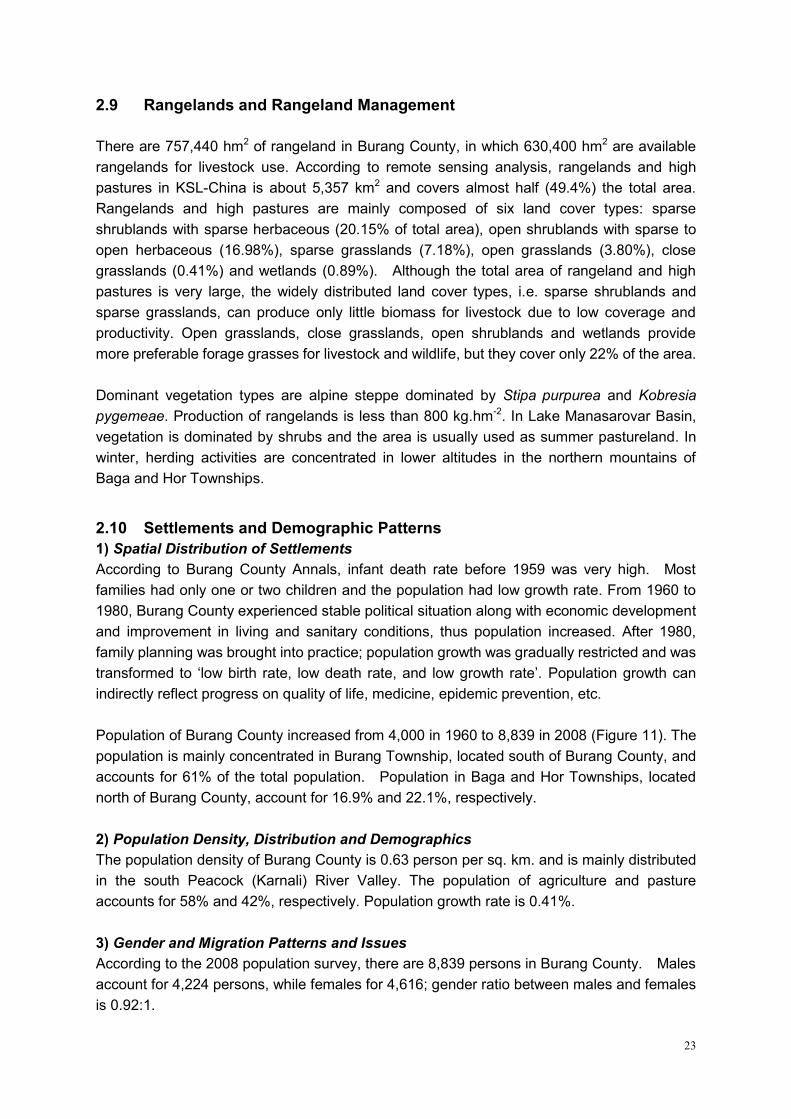
Population of Burang County increased from 4,000 in 1960 to 8,839 in 2008 (Figure 11). The
population is mainly concentrated in Burang Township, located south of Burang County, and
accounts for 61% of the total population. Population in Baga and Hor Townships, located
north of Burang County, account for 16.9% and 22.1%, respectively.
2) Population Density, Distribution and Demographics
The population density of Burang County is 0.63 person per sq. km. and is mainly distributed
in the south Peacock (Karnali) River Valley. The population of agriculture and pasture
accounts for 58% and 42%, respectively. Population growth rate is 0.41%.
3) Gender and Migration Patterns and Issues
According to the 2008 population survey, there are 8,839 persons in Burang County. Males
account for 4,224 persons, while females for 4,616; gender ratio between males and females
is 0.92:1.
24
Figure 11. Population dynamics of Burang County since 1958.
2.11 Socio-economic, Livelihood, Poverty and Gender Issues
1) Main Sources of Livelihood
From 2001 to 2008, gross earning for farmers and herdsmen has been increasing
continuously, but income per capita is still low. Income structure for farmers and herdsmen in
Burang County indicates that their incomes are relatively stable. The dominant income is
from livestock husbandry, accounting for almost 50% of total income. Transportation and
supplementary occupations are playing a significant role in income generation.
Burang County has cultivated land of 9,551 ha6, while grassland area is 946 million ha7. It is
also a resource base for grand and edible oil in the Ngari region. Grand and edible oil
productions have occupied 60 percent of the whole province. Burang County also hosts
several tourism resources including sacred Mt. Kailash, Manasarovar Lake, and the famous
Khorzhak Monastery among others.
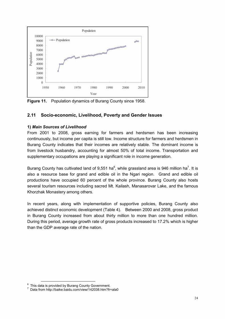
In recent years, along with implementation of supportive policies, Burang County also
achieved distinct economic development (Table 4). Between 2000 and 2008, gross product
in Burang County increased from about thirty million to more than one hundred million.
During this period, average growth rate of gross products increased to 17.2% which is higher
than the GDP average rate of the nation.
6 This data is provided by Burang County Government.
7 Data from http://baike.baidu.com/view/142038.htm?fr=ala0
25
Table 4. Index of economy in Burang County (×104 RMB Yuan)8.
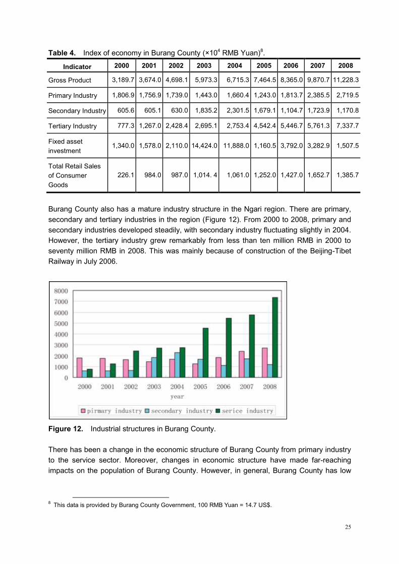
Indicator 2000 2001 2002 2003 2004 2005 2006 2007 2008
Gross Product 3,189.7 3,674.0 4,698.1 5,973.3 6,715.3 7,464.5 8,365.0 9,870.7 11,228.3
Primary Industry 1,806.9 1,756.9 1,739.0 1,443.0 1,660.4 1,243.0 1,813.7 2,385.5 2,719.5
Secondary Industry 605.6 605.1 630.0 1,835.2 2,301.5 1,679.1 1,104.7 1,723.9 1,170.8
Tertiary Industry 777.3 1,267.0 2,428.4 2,695.1 2,753.4 4,542.4 5,446.7 5,761.3 7,337.7
Fixed asset
investment 1,340.0 1,578.0 2,110.0 14,424.0 11,888.0 1,160.5 3,792.0 3,282.9 1,507.5
Total Retail Sales
of Consumer
Goods
226.1 984.0 987.0 1,014. 4 1,061.0 1,252.0 1,427.0 1,652.7 1,385.7
Burang County also has a mature industry structure in the Ngari region. There are primary,
secondary and tertiary industries in the region (Figure 12). From 2000 to 2008, primary and
secondary industries developed steadily, with secondary industry fluctuating slightly in 2004.
However, the tertiary industry grew remarkably from less than ten million RMB in 2000 to
seventy million RMB in 2008. This was mainly because of construction of the Beijing-Tibet
Railway in July 2006.
Figure 12. Industrial structures in Burang County.
There has been a change in the economic structure of Burang County from primary industry
to the service sector. Moreover, changes in economic structure have made far-reaching
impacts on the population of Burang County. However, in general, Burang County has low
8 This data is provided by Burang County Government, 100 RMB Yuan = 14.7 US$.
26
income that is steadily growing every year, but it is also receiving increasing subsidies every
year from the government.
Figure 13. Comparison of subsidy income by government and budget income in Burang
County (1998-2008)
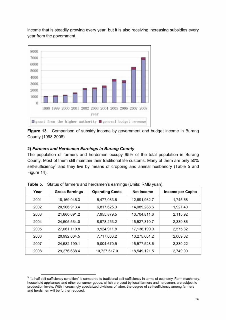
2) Farmers and Herdsmen Earnings in Burang County
The population of farmers and herdsmen occupy 95% of the total population in Burang
County. Most of them still maintain their traditional life customs. Many of them are only 50%
self-sufficiency9 and they live by means of cropping and animal husbandry (Table 5 and
Figure 14).
Table 5. Status of farmers and herdsmen‘s earnings (Units: RMB yuan).
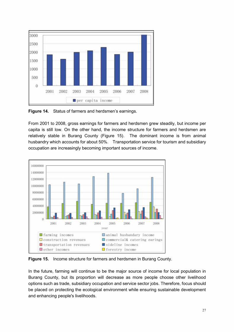
Year Gross Earnings Operating Costs Net Income Income per Capita
2001 18,169,046.3 5,477,083.6 12,691,962.7 1,745.68
2002 20,906,913.4 6,817,625.3 14,089,288.6 1,927.40
2003 21,660,691.2 7,955,879.5 13,704,811.6 2,115.92
2004 24,505,564.0 8,978,253.2 15,527,310.7 2,339.86
2005 27,061,110.8 9,924,911.8 17,136,199.0 2,575.32
2006 20,992,604.5 7,717,003.2 13,275,601.2 2,009.02
2007 24,582,199.1 9,004,670.5 15,577,528.6 2,330.22
2008 29,276,638.4 10,727,517.0 18,549,121.5 2,749.00
9 ―a half self-sufficiency condition‖ is compared to traditional self-sufficiency in terms of economy. Farm machinery,
household appliances and other consumer goods, which are used by local farmers and herdsmen, are subject to production levels. With increasingly specialized divisions of labor, the degree of self-sufficiency among farmers and herdsmen will be further reduced.
27
Figure 14. Status of farmers and herdsmen‘s earnings.
From 2001 to 2008, gross earnings for farmers and herdsmen grew steadily, but income per
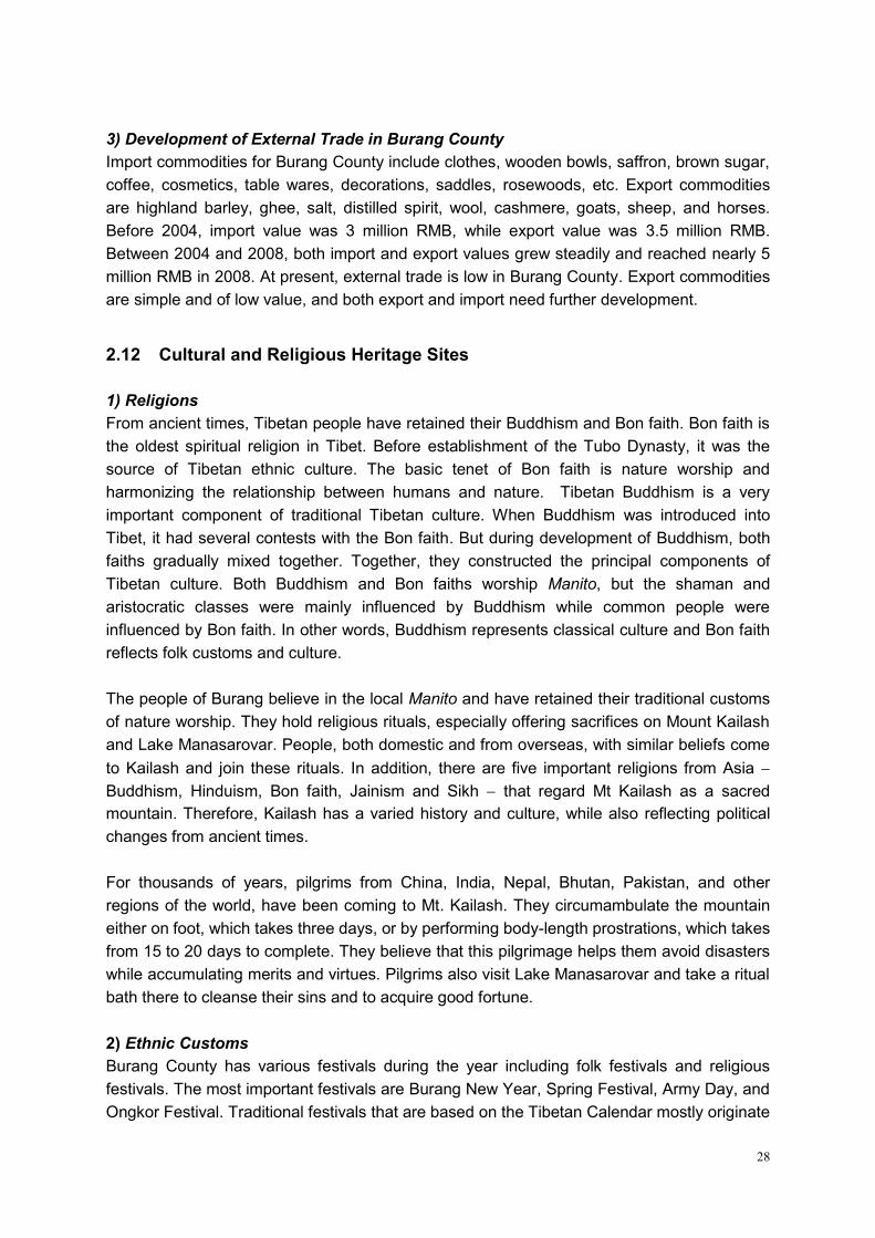
capita is still low. On the other hand, the income structure for farmers and herdsmen are
relatively stable in Burang County (Figure 15). The dominant income is from animal
husbandry which accounts for about 50%. Transportation service for tourism and subsidiary
occupation are increasingly becoming important sources of income.
Figure 15. Income structure for farmers and herdsmen in Burang County.
In the future, farming will continue to be the major source of income for local population in
Burang County, but its proportion will decrease as more people choose other livelihood
options such as trade, subsidiary occupation and service sector jobs. Therefore, focus should
be placed on protecting the ecological environment while ensuring sustainable development
and enhancing people's livelihoods.
28
3) Development of External Trade in Burang County
Import commodities for Burang County include clothes, wooden bowls, saffron, brown sugar,
coffee, cosmetics, table wares, decorations, saddles, rosewoods, etc. Export commodities
are highland barley, ghee, salt, distilled spirit, wool, cashmere, goats, sheep, and horses.
Before 2004, import value was 3 million RMB, while export value was 3.5 million RMB.
Between 2004 and 2008, both import and export values grew steadily and reached nearly 5
million RMB in 2008. At present, external trade is low in Burang County. Export commodities
are simple and of low value, and both export and import need further development.
2.12 Cultural and Religious Heritage Sites
1) Religions
From ancient times, Tibetan people have retained their Buddhism and Bon faith. Bon faith is
the oldest spiritual religion in Tibet. Before establishment of the Tubo Dynasty, it was the
source of Tibetan ethnic culture. The basic tenet of Bon faith is nature worship and
harmonizing the relationship between humans and nature. Tibetan Buddhism is a very
important component of traditional Tibetan culture. When Buddhism was introduced into
Tibet, it had several contests with the Bon faith. But during development of Buddhism, both
faiths gradually mixed together. Together, they constructed the principal components of
Tibetan culture. Both Buddhism and Bon faiths worship Manito, but the shaman and
aristocratic classes were mainly influenced by Buddhism while common people were
influenced by Bon faith. In other words, Buddhism represents classical culture and Bon faith
reflects folk customs and culture.
The people of Burang believe in the local Manito and have retained their traditional customs
of nature worship. They hold religious rituals, especially offering sacrifices on Mount Kailash
and Lake Manasarovar. People, both domestic and from overseas, with similar beliefs come
to Kailash and join these rituals. In addition, there are five important religions from Asia
Buddhism, Hinduism, Bon faith, Jainism and Sikh that regard Mt Kailash as a sacred
mountain. Therefore, Kailash has a varied history and culture, while also reflecting political
changes from ancient times.
For thousands of years, pilgrims from China, India, Nepal, Bhutan, Pakistan, and other
regions of the world, have been coming to Mt. Kailash. They circumambulate the mountain
either on foot, which takes three days, or by performing body-length prostrations, which takes
from 15 to 20 days to complete. They believe that this pilgrimage helps them avoid disasters
while accumulating merits and virtues. Pilgrims also visit Lake Manasarovar and take a ritual
bath there to cleanse their sins and to acquire good fortune.
2) Ethnic Customs
Burang County has various festivals during the year including folk festivals and religious
festivals. The most important festivals are Burang New Year, Spring Festival, Army Day, and
Ongkor Festival. Traditional festivals that are based on the Tibetan Calendar mostly originate
29
from the Bon faith. The Burang Tibetan people have also maintained their marriage customs.
Young people choose their own partners. After marriage, many young people choose
'walking marriage' in order to consolidate their family and to avoid out-flow of their property.
Walking marriage is especially common in rural areas. This unique type of marriage has an
important relation with the development of history.
3) Monasteries (Gomba)
There are fourteen monasteries (or gompas) in Burang County (Table 6). These include
seven gompas in Burang Township, six in Baga Township, and one in Hor Township (Figure
16). There are eight monasteries around Lake Manasarovar: Seralung Gompa in the east;
Yerngo Gompa in the southeast; Thrugo Gompa in the south; Gossul Gompa in the
southwest; Chiu Gompa in the west; Cherkip Gompa in the northwest; Bon Ri in the
northeast; and Langbona Gompa in the north. Seralung Gompa belongs to the Drikung
lineage, Yerngo Gompa to the Sakya lineage, and Bon-Ri to the Bon tradition. The remaining
monasteries were built by the Drukpa lineage.
Table 6. Gompas (monasteries) in Burang County.
Temple Names (Chinese
name)
Religious
Lineage
Locations
Khorzhak Gompa (科迦寺) Sakya lineage Kejia township, 15 kilometers to Burang Town
Tarchen (塔钦) South of Kailash, Start point of Kailash
circumambulating
Chukku Gompa (曲古寺) Southwest of Kailash
Dirapuk Gompa (止那普寺) North of Kailash
Zutulpuk Gomba (祖楚普寺) Southeast of Kailash
Silung Gompa (赛龙寺) South of Kailash
Gyengtak Gompa (江扎寺) Drukpa lineage South of Kailash
Chiu Gompa (齐悟寺) Drukpa lineage Northwest of Lake Manasarovar
Cherkip Gompa (迦吉寺) Drukpa lineage North of Lake Manasarovar
Langbona Gompa (朗那寺) Drukpa lineage North of Lake Manasarovar
Bon Ri Gompa (本日寺) Bon tradition Northeast of Lake Manasarovar
Sera Lung Gompa (色拉龙寺) Drikung lineage East of Lake Manasarovar
Yerngo Gompa (聂过寺) Sakya lineage South of Lake Manasarovar
Thrugo Gompa (楚古寺) Gelug lineage South of Lake Manasarovar
Tsepgyi Gompa (蔡切寺) Gelug lineage North of Lake Rakshastal
30
Figure 16. Distribution of monasteries in Burang County.
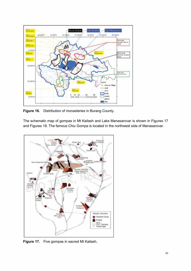
The schematic map of gompas in Mt Kailash and Lake Manasarovar is shown in Figures 17
and Figures 18. The famous Chiu Gompa is located in the northwest side of Manasarovar.
Figure 17. Five gompas in sacred Mt Kailash.
31
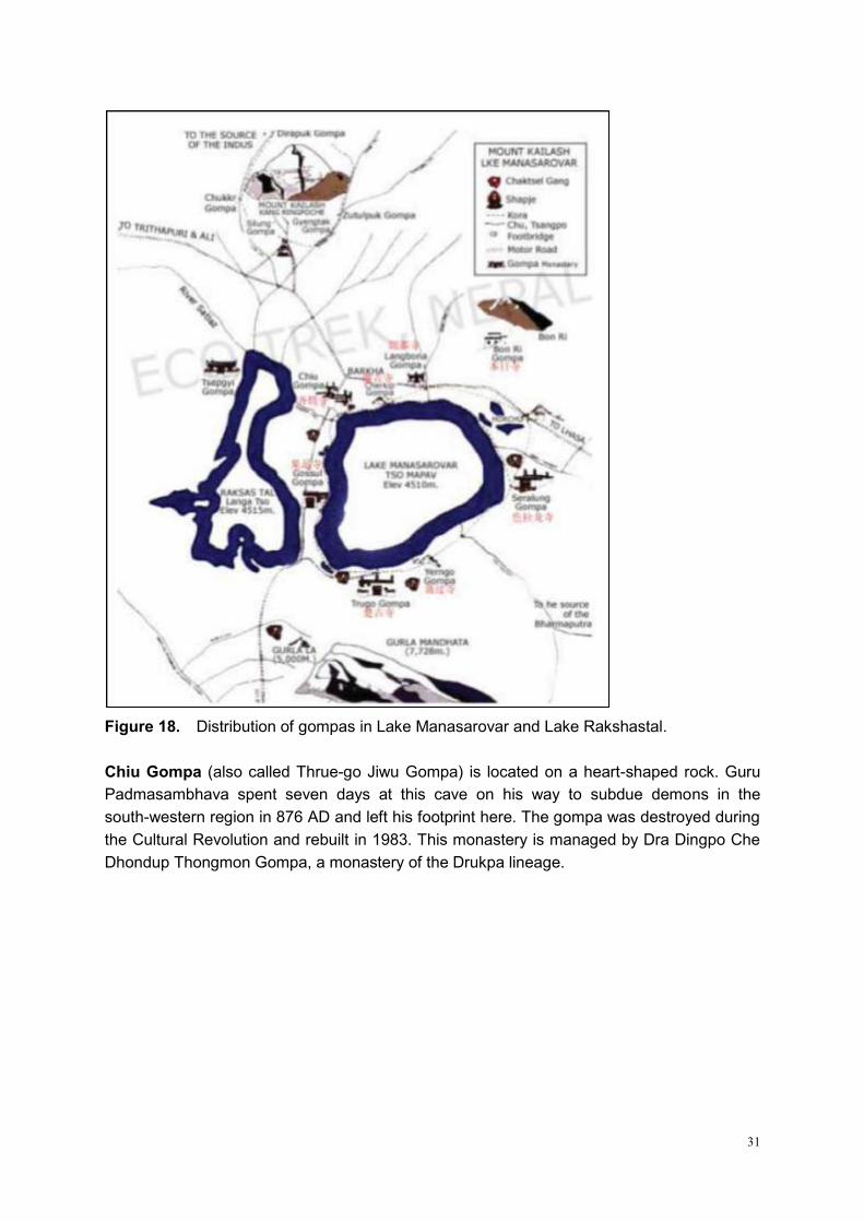
Figure 18. Distribution of gompas in Lake Manasarovar and Lake Rakshastal.
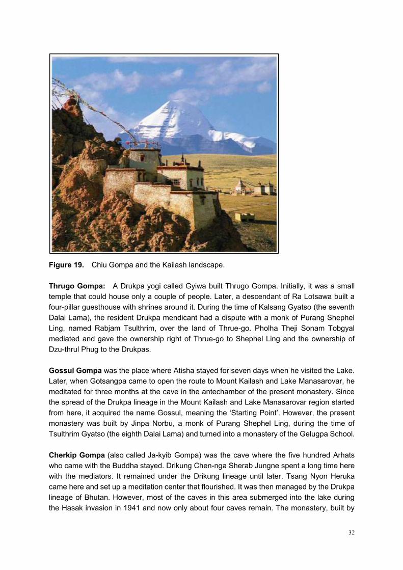
Chiu Gompa (also called Thrue-go Jiwu Gompa) is located on a heart-shaped rock. Guru
Padmasambhava spent seven days at this cave on his way to subdue demons in the
south-western region in 876 AD and left his footprint here. The gompa was destroyed during
the Cultural Revolution and rebuilt in 1983. This monastery is managed by Dra Dingpo Che
Dhondup Thongmon Gompa, a monastery of the Drukpa lineage.
32
Figure 19. Chiu Gompa and the Kailash landscape.
Thrugo Gompa: A Drukpa yogi called Gyiwa built Thrugo Gompa. Initially, it was a small
temple that could house only a couple of people. Later, a descendant of Ra Lotsawa built a
four-pillar guesthouse with shrines around it. During the time of Kalsang Gyatso (the seventh
Dalai Lama), the resident Drukpa mendicant had a dispute with a monk of Purang Shephel
Ling, named Rabjam Tsulthrim, over the land of Thrue-go. Pholha Theji Sonam Tobgyal
mediated and gave the ownership right of Thrue-go to Shephel Ling and the ownership of
Dzu-thrul Phug to the Drukpas.
Gossul Gompa was the place where Atisha stayed for seven days when he visited the Lake.
Later, when Gotsangpa came to open the route to Mount Kailash and Lake Manasarovar, he
meditated for three months at the cave in the antechamber of the present monastery. Since
the spread of the Drukpa lineage in the Mount Kailash and Lake Manasarovar region started
from here, it acquired the name Gossul, meaning the ‗Starting Point‘. However, the present
monastery was built by Jinpa Norbu, a monk of Purang Shephel Ling, during the time of
Tsulthrim Gyatso (the eighth Dalai Lama) and turned into a monastery of the Gelugpa School.
Cherkip Gompa (also called Ja-kyib Gompa) was the cave where the five hundred Arhats
who came with the Buddha stayed. Drikung Chen-nga Sherab Jungne spent a long time here
with the mediators. It remained under the Drikung lineage until later. Tsang Nyon Heruka
came here and set up a meditation center that flourished. It was then managed by the Drukpa
lineage of Bhutan. However, most of the caves in this area submerged into the lake during
the Hasak invasion in 1941 and now only about four caves remain. The monastery, built by
33
Drukpa followers of Bhutan, was destroyed during the Cultural Revolution and has not been
rebuilt since.
Langbona Gompa is located on a hillock resembling the trunk of an elephant. Hence its
name 'Langbona' meaning ‗Elephant‘s trunk‘. It was built by Nyemowa Samten Phuntsok,
belonging to the Middle Drukpa lineage, after spending many years in retreat in Mount
Kailash. Later his reincarnation Kunga Lodo Nyingpo built the monastery modeled on Drikung
Yangri Gar Gompa. Langbona Gompa was partially rebuilt in 1986, following its destruction
during the Cultural Revolution.
4) Cultural Heritage
In Burang County, there are many historical monuments and ruins left from ancient times
including the Tubo era, Yuan Dynasty, Ming Dynasty and Qing Dynasty. Burang County has
special custom in response to its geographic environment and population structure. It has
accumulated non-material cultural heritage, such as women‘s clothing, Tibetan opera, and
folk dance. In addition, Burang Tibetan people have their own distinctive artistic expressions
for dancing and singing which represent religious activities.
Khorzhak Monastery (Kejia 科加寺) is a Buddhist monastery in Khorzhak (Korqag) town, 15
km south of Burang county town. The town and temple are known as Kojanath in Nepal. The
village is situated on a beautiful spot at a bend of the Karnali River, from where one can see
the large red wall of the temple facing the river with a huge inscription on it of the six-syllable
mantra, ― ‖ (Om Mani Padme Hum).
Figure 20. Khorzhak Monastery.
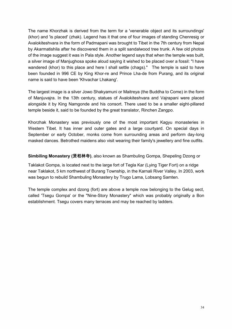
34
The name Khorzhak is derived from the term for a 'venerable object and its surroundings'
(khor) and 'is placed' (zhak). Legend has it that one of four images of standing Chenresig or
Avalokiteshvara in the form of Padmapani was brought to Tibet in the 7th century from Nepal
by Akarmatishila after he discovered them in a split sandalwood tree trunk. A few old photos
of the image suggest it was in Pala style. Another legend says that when the temple was built,
a silver image of Manjughosa spoke aloud saying it wished to be placed over a fossil: "I have
wandered (khor) to this place and here I shall settle (chags)." The temple is said to have
been founded in 996 CE by King Khor-re and Prince Lha-de from Purang, and its original
name is said to have been 'Khvachar Lhakang'.
The largest image is a silver Jowo Shakyamuni or Maitreya (the Buddha to Come) in the form
of Manjuvajra. In the 13th century, statues of Avalokiteshvara and Vajrapani were placed
alongside it by King Namgonde and his consort. There used to be a smaller eight-pillared
temple beside it, said to be founded by the great translator, Rinchen Zangpo.
Khorzhak Monastery was previously one of the most important Kagyu monasteries in
Western Tibet. It has inner and outer gates and a large courtyard. On special days in
September or early October, monks come from surrounding areas and perform day-long
masked dances. Betrothed maidens also visit wearing their family's jewellery and fine outfits.
Simbiling Monastery (贤柏林寺), also known as Shambuling Gompa, Shepeling Dzong or
Taklakot Gompa, is located next to the large fort of Tegla Kar (Lying Tiger Fort) on a ridge
near Taklakot, 5 km northwest of Burang Township, in the Karnali River Valley. In 2003, work
was begun to rebuild Shambuling Monastery by Trugo Lama, Lobsang Samten.
The temple complex and dzong (fort) are above a temple now belonging to the Gelug sect,
called 'Tsegu Gompa' or the "Nine-Story Monastery" which was probably originally a Bon
establishment. Tsegu covers many terraces and may be reached by ladders.
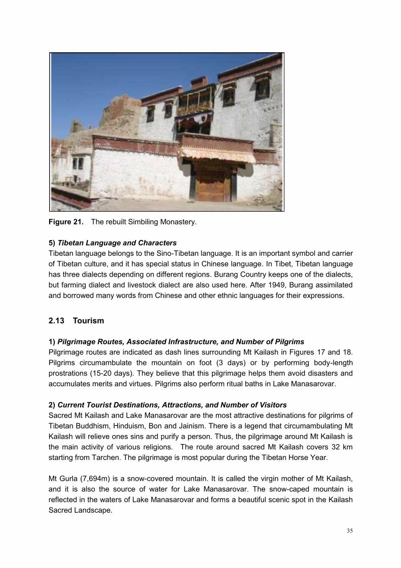
35
Figure 21. The rebuilt Simbiling Monastery.
5) Tibetan Language and Characters
Tibetan language belongs to the Sino-Tibetan language. It is an important symbol and carrier
of Tibetan culture, and it has special status in Chinese language. In Tibet, Tibetan language
has three dialects depending on different regions. Burang Country keeps one of the dialects,
but farming dialect and livestock dialect are also used here. After 1949, Burang assimilated
and borrowed many words from Chinese and other ethnic languages for their expressions.
2.13 Tourism
1) Pilgrimage Routes, Associated Infrastructure, and Number of Pilgrims
Pilgrimage routes are indicated as dash lines surrounding Mt Kailash in Figures 17 and 18.
Pilgrims circumambulate the mountain on foot (3 days) or by performing body-length
prostrations (15-20 days). They believe that this pilgrimage helps them avoid disasters and
accumulates merits and virtues. Pilgrims also perform ritual baths in Lake Manasarovar.
2) Current Tourist Destinations, Attractions, and Number of Visitors
Sacred Mt Kailash and Lake Manasarovar are the most attractive destinations for pilgrims of
Tibetan Buddhism, Hinduism, Bon and Jainism. There is a legend that circumambulating Mt
Kailash will relieve ones sins and purify a person. Thus, the pilgrimage around Mt Kailash is
the main activity of various religions. The route around sacred Mt Kailash covers 32 km
starting from Tarchen. The pilgrimage is most popular during the Tibetan Horse Year.
Mt Gurla (7,694m) is a snow-covered mountain. It is called the virgin mother of Mt Kailash,
and it is also the source of water for Lake Manasarovar. The snow-caped mountain is
reflected in the waters of Lake Manasarovar and forms a beautiful scenic spot in the Kailash
Sacred Landscape.
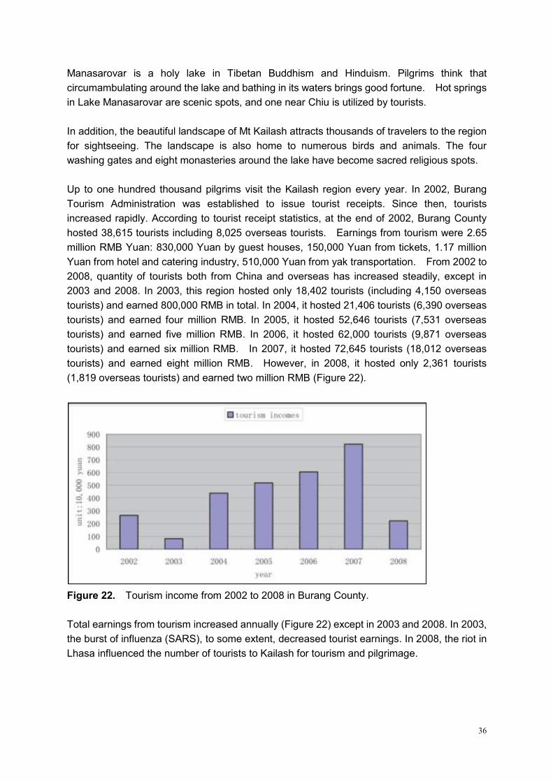
36
Manasarovar is a holy lake in Tibetan Buddhism and Hinduism. Pilgrims think that
circumambulating around the lake and bathing in its waters brings good fortune. Hot springs
in Lake Manasarovar are scenic spots, and one near Chiu is utilized by tourists.
In addition, the beautiful landscape of Mt Kailash attracts thousands of travelers to the region
for sightseeing. The landscape is also home to numerous birds and animals. The four
washing gates and eight monasteries around the lake have become sacred religious spots.
Up to one hundred thousand pilgrims visit the Kailash region every year. In 2002, Burang
Tourism Administration was established to issue tourist receipts. Since then, tourists
increased rapidly. According to tourist receipt statistics, at the end of 2002, Burang County
hosted 38,615 tourists including 8,025 overseas tourists. Earnings from tourism were 2.65
million RMB Yuan: 830,000 Yuan by guest houses, 150,000 Yuan from tickets, 1.17 million
Yuan from hotel and catering industry, 510,000 Yuan from yak transportation. From 2002 to
2008, quantity of tourists both from China and overseas has increased steadily, except in
2003 and 2008. In 2003, this region hosted only 18,402 tourists (including 4,150 overseas
tourists) and earned 800,000 RMB in total. In 2004, it hosted 21,406 tourists (6,390 overseas
tourists) and earned four million RMB. In 2005, it hosted 52,646 tourists (7,531 overseas
tourists) and earned five million RMB. In 2006, it hosted 62,000 tourists (9,871 overseas
tourists) and earned six million RMB. In 2007, it hosted 72,645 tourists (18,012 overseas
tourists) and earned eight million RMB. However, in 2008, it hosted only 2,361 tourists
(1,819 overseas tourists) and earned two million RMB (Figure 22).
Figure 22. Tourism income from 2002 to 2008 in Burang County.
Total earnings from tourism increased annually (Figure 22) except in 2003 and 2008. In 2003,
the burst of influenza (SARS), to some extent, decreased tourist earnings. In 2008, the riot in
Lhasa influenced the number of tourists to Kailash for tourism and pilgrimage.
37
3) Environmental Impacts of Tourism
The distinctive position of Kailash and Manasarovar in Lamaism, Hinduism, and indigenous
Bon religion, and the beautiful scenery of the sacred lake and mountain, attract pilgrims and
tourists from all over the world. Number of visitors averaged at 30,000 persons annually and
peaked at 100,000 persons in 2002. Thousands of tourists stay in the Kailash region and
produce a large amount of waste.
Pilgrims usually generate large quantities of garbage and endanger the eco-balance in the
area. Moreover, pilgrims believe that the waters of Lake Manasarovar washes away their sins
and purifies their souls, so they take ritual baths and shave their hair and throw used
belongings in the lake. These behaviors, together with lack of funds and insufficient
infrastructure, aggravate environmental stresses in the area.
It usually takes pilgrims 3 to 5 days to circumambulate around Kailash and Manasarovar.
During this time, a majority of pilgrims cut bushes to cook their food and warm themselves.
Vegetation in the region grows very slowly due to the high altitude and severe climatic
conditions. Cutting bushes greatly affects the fragile surrounding vegetation, and
consequently affects routine migration, mating and breeding of wildlife.
4) Potential/Need to Plan for Increased Tourism
Strengthening Environmental Protection in Scenic Spots: Dustbins, garbage treatment
stations and outdoor toilets have been built to respond to junk littering and other polluting
behavior around scenic spots. Protection of bush forests has been a part of work of county
and village government. Also, regulations have been stipulated to prevent wood from being
cut while providing only for dung to be used as fuel by tourists and farmers. All these
measures have paved the way for future environmental protection.
Protecting Environment by Promoting Tourism: Environmental pressure caused by
over-grazing and tourism garbage can be lessened by adjusting industrial structures of
surrounding areas. In practice, people living in this area can operate their own tourism
businesses, such as operating home inns, mom-stores, and transportation business, so as to
weaken their reliance on traditional ranching while providing services to tourists and pilgrims.
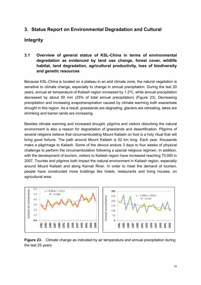
38
3. Status Report on Environmental Degradation and Cultural
Integrity
3.1 Overview of general status of KSL-China in terms of environmental
degradation as evidenced by land use change, forest cover, wildlife
habitat, land degradation, agricultural productivity, loss of biodiversity
and genetic resources
Because KSL-China is located on a plateau in an arid climate zone, the natural vegetation is
sensitive to climate change, especially to change in annual precipitation. During the last 20
years, annual air temperature of Kailash region increased by 1.2ºC, while annual precipitation
decreased by about 50 mm (25% of total annual precipitation) (Figure 23). Decreasing
precipitation and increasing evapotranspiration caused by climate warming both exacerbate
drought in this region. As a result, grasslands are degrading, glaciers are retreating, lakes are
shrinking and barren lands are increasing.
Besides climate warming and increased drought, pilgrims and visitors disturbing the natural
environment is also a reason for degradation of grasslands and desertification. Pilgrims of
several religions believe that circumambulating Mount Kailash on foot is a holy ritual that will
bring good fortune. The path around Mount Kailash is 52 km long. Each year, thousands
make a pilgrimage to Kailash. Some of the devout endure 3 days to four weeks of physical
challenge to perform the circumambulation following a special religious regimen. In addition,
with the development of tourism, visitors to Kailash region have increased reaching 70,000 in
2007. Tourists and pilgrims both impact the natural environment in Kailash region, especially
around Mount Kailash and along Karnali River. In order to meet the demand of tourism,
people have constructed more buildings like hotels, restaurants and living houses, on
agricultural area.
Figure 23. Climate change as indicated by air temperature and annual precipitation during
the last 25 years.
b a
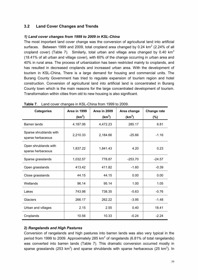
39
3.2 Land Cover Changes and Trends
1) Land cover changes from 1999 to 2009 in KSL-China
The most important land cover change was the conversion of agricultural land into artificial
surfaces. Between 1999 and 2009, total cropland area changed by 0.24 km2 (2.24% of all
cropland cover) (Table 7). Similarly, total urban and village area changed by 0.40 km2
(18.41% of all urban and village cover), with 60% of the change occurring in urban area and
40% in rural area. The process of urbanization has been restricted mainly to croplands, and
has resulted in decreased croplands and increased urban area. With the development of
tourism in KSL-China, There is a large demand for housing and commercial units. The
Burang County Government has tried to regulate expansion of tourism region and hotel
construction. Conversion of agricultural land into artificial land is concentrated in Burang
County town which is the main reasons for the large concentrated development of tourism.
Transformation within cities from old to new housing is also significant.
Table 7. Land cover changes in KSL-China from 1999 to 2009.
Categories Area in 1999
(km2)
Area in 2009
(km2)
Area change
(km2)
Change rate
(%)
Barren lands 4,187.06 4,472.23 285.17 6.81
Sparse shrublands with
sparse herbaceous 2,210.33 2,184.66 -25.66 -1.16
Open shrublands with
sparse herbaceous 1,837.22 1,841.43 4.20 0.23
Sparse grasslands 1,032.57 778.87 -253.70 -24.57
Open grasslands 413.42 411.82 -1.60 -0.39
Close grasslands 44.15 44.15 0.00 0.00
Wetlands 96.14 95.14 1.00 1.05
Lakes 743.98 738.35 -5.63 -0.76
Glaciers 266.17 262.22 -3.95 -1.48
Urban and villages 2.15 2.55 0.40 18.41
Croplands 10.56 10.33 -0.24 -2.24
2) Rangelands and High Pastures
Conversion of rangelands and high pastures into barren lands was also very typical in the
period from 1999 to 2009. Approximately 285 km2 of rangelands (6.81% of total rangelands)
was converted into barren lands (Table 7). This dramatic conversion occurred mostly in
sparse grasslands (253 km2) and sparse shrublands with sparse herbaceous (25 km2). In
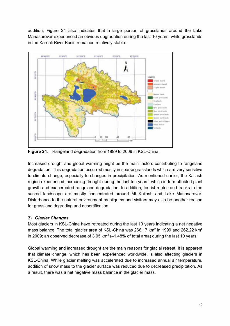
40
addition, Figure 24 also indicates that a large portion of grasslands around the Lake
Manasarovar experienced an obvious degradation during the last 10 years, while grasslands
in the Karnali River Basin remained relatively stable.
Figure 24. Rangeland degradation from 1999 to 2009 in KSL-China.
Increased drought and global warming might be the main factors contributing to rangeland
degradation. This degradation occurred mostly in sparse grasslands which are very sensitive
to climate change, especially to changes in precipitation. As mentioned earlier, the Kailash
region experienced increasing drought during the last ten years, which in turn affected plant
growth and exacerbated rangeland degradation. In addition, tourist routes and tracks to the
sacred landscape are mostly concentrated around Mt Kailash and Lake Manasarovar.
Disturbance to the natural environment by pilgrims and visitors may also be another reason
for grassland degrading and desertification.
3) Glacier Changes
Most glaciers in KSL-China have retreated during the last 10 years indicating a net negative
mass balance. The total glacier area of KSL-China was 266.17 km² in 1999 and 262.22 km²
in 2009; an observed decrease of 3.95 km2 (–1.48% of total area) during the last 10 years.
Global warming and increased drought are the main reasons for glacial retreat. It is apparent
that climate change, which has been experienced worldwide, is also affecting glaciers in
KSL-China. While glacier melting was accelerated due to increased annual air temperature,
addition of snow mass to the glacier surface was reduced due to decreased precipitation. As
a result, there was a net negative mass balance in the glacier mass.
41
3.3 Water Resources
The total area of lakes (including glacial lakes) in KSl-China has also decreased in the period
from 1999 to 2009. Total area of lakes was 743.98 km2 in 1999 and 738.35 km2 in 2009, an
observed decrease of 5.63 km2 (-0.76% of the total area) for 10 years. The biggest change in
lake size occurred in Lakes Rakshastal and Kunggyu. The area of Lake Rakshastal was
261.86 km2 in 1999 and 258.86 km2 in 2009, an observed decrease of 3.0 km2 for 10 years.
The area of Lake Kunggyu was 55.95 km2 in 1999 and 54.29 km2 in 2009, an observed
decrease of 1.66 km2 for 10 years. There was no obvious change for the biggest lake, i.e.
Lake Manasarovar. On the contrary, some small lakes (especially glacial lakes) experienced
an increase in the period from 1999 to 2009.
Expansion of some small lakes (especially glacial lakes) during the last 10 years may mainly
have resulted from the acceleration of glacier retreat. Increased melt water may generate
new lakes and lead to expansion of existing ones. On the other hand, retreat of the big lakes
may mainly be due to increased evaporation caused by climate warming, as well decreased
precipitation.
3.4 Biological Diversity of Flora and Fauna
Ranching is the mainstay industry of Burang County. However, over-grazing, the rapid growth
of productivity and population have caused grassland degradation and desertification, which
in turn have triggered lots of environmental problems, such as soil erosion, water loss, and
the lost of bio-diversity and etc. In addition, the move of soil dunk devours arable lands in the
valley, thus threatens the living environment and the sustainable development of the national
economy.
3.5 Wildlife and Wildlife Habitats
A great variety of wildlife inhabit Burang County, namely Tibetan wild ass, buffalo, argali,
snow leopard, and golden eagle among others. The wetland of Manasarovar, the biggest
freshwater lake, also provides good habitat for wildlife. Every breeding season, birds migrate
here to build nests, lay eggs, hatch, and nurse their offspring. Nevertheless, wildlife hunting,
stealing of bird eggs, and grassland degradation, together with the lack of protection
measures, endangers biodiversity in the area.
3.6 Forests
There are no natural forests in Burang County, but individual trees or tree patches are
distributed around villages or monasteries of Burang Township in the Karnali Basin. Salix and
Populus are the most common genera selected by local people for afforestation in lowland
Burang.
42
3.7 Rangelands and Rangeland Management
Ranching is the mainstay industry of Burang County. However, over-grazing and rapid growth
of productivity and population have caused grassland degradation and desertification, which
in turn have triggered numerous environmental problems such as soil erosion, water loss,
and biodiversity loss. In addition, movement of soil devours arable lands in the valley, thus
threatening the living environment and sustainable development of the national economy.
The influence of changing global environment is also manifest in KSL-China. As a result of
the destruction of the food chain, numerous rodents and hares have appeared in the region
and greatly endangered grasslands and exposing them to desertification.
3.8 Cultural and Religious Heritage Sites
With the large influx of tourists in KSL-China, historically significant cultural and religious
heritage sites are vulnerable to vandalism and destruction. Tourists also produce a large
amount of waste that threatened the environment of these heritage sites.
3.9 Tourism
Pilgrims in KSL-China usually generate large quantities of garbage that threaten the local
ecosystem. Moreover, their belief that bathing in holy lake waters purifies them and
removes their sins results in water pollution of the lake. These actions, coupled with lack of
sufficient funds and insufficient tourism infrastructure aggravate environmental problems in
this sacred landscape.
3.10 Observations, Perceptions and Projections of Climate Change, and/or
Other Environmental Change Processes
1) Climatic Change from Meteorological Data in Burang
Based on data from Burang Meteorological Station (located 30°17´N, 81°15´E, 3,900m),
annual air temperature is 3.5°C and annual precipitation is 153.7mm. Monthly precipitation
patterns show bimodal precipitation with two peaks in March and July-August. Higher
precipitation in July-August reflects a strong monsoon signal, which is a typical pattern in the
southern Tibetan Plateau.
KSL-China is experiencing significant climate warming. From 1973 to 2008, annual air
temperature varied from a low of 2.0°C in 1983 to a high of 4.9°C in 1999 with a 2.9°C of
maximum fluctuation. Linear regression showed a warming gradient of 0.48°C per decade.
The last 10 years has been the warmest of the past 36 years.
Annual precipitation shows strong fluctuations. Lowest precipitation record is only 68 mm in
1976 while highest precipitation is 265 mm in 1984. With apparent warming trends as
43
indicated by Burang meteorological record, annual precipitation generally shows a
decreasing trend. The period from 1973 to 1988 is a relatively wet period with average annual
precipitation of 177 mm. However, the climate became drier from 1999 to 2008 and annual
precipitation decreased by over 40 mm to 135 mm on average.
Therefore, the climate in Burang is becoming drier and warmer in the past two decades. With
higher temperature and lower precipitation, relative humidity has also decreased during this
period.
Climate change in the growing season from May to October also showed an apparent
warming trend with an increase of 0.28°C per decade, lower than the annual average
warming trend. Precipitation trend shows a similar pattern. From 1987, precipitation
decreased during the growing season, while relative humidity shows no such obvious trend.
Wind speed indicates two large fluctuations in the past 36 years: i) high wind speed value in
1976 decreased until 1989, and ii) high wind speed in 1990 decreased until 2008. Total
solar radiation hours increased from 1963 to 1988 and then decreased to 2008.
2) Ice Core Record of Glacier Change in Mt Gurla
A shallow ice core drilled at 6,100m from the Gurla Glacier in October 2008 was dated back
to eight years based on seasonal variations of oxygen isotopes. Annual glacial
accumulation is 790 mm at 6,100m of the glacier, over five times greater than at the
meteorological station in Burang, confirming that the higher elevation mountain regions
receive much more precipitation than valley regions. Fieldwork also found that higher
elevations have more snowfall than the low attitude Karnali Basin. Thus, precipitation data
from the meteorological station in the low valley region cannot represent the average
condition of KSL-China. Instrumental observations of annual temperature and precipitation
at different altitudes are necessary to better understand the impacts of climate change in the
region.
Due to global warming, ongoing glacial retreat in Mt Gurla is significant. Based on remote
sensing analysis, total glacier area decreased from 84.41 km2 to 77.29 km2 in the period from
1976 to 2003. This indicated an acceleration in glacial melting. Glacier areas shrank on
average by 0.17, 0.19 and 0.77km2 per year during the periods 1976–90, 1990–99 and
1999–2003, respectively.
Ice cores collected in 2006 from Gurla Glacier without radioactive horizon markers suggested
no net accumulation of mass (ice) since at least 1950. Gurla is the highest glacier (6,100m)
documented to be losing mass annually. This implies the possibility of similar mass loss on
other high-elevation glaciers in low and mid-latitudes under a warmer Earth scenario. This ice
mass loss of the Gurla Glacier is likely to result in the glacier shrinking much faster than
currently predicted and having substantial consequences for approximately half a billion
people downstream.
44
4. Identification of Priorities for KSL-China
Based on the above assessments of existing and potential threats and vulnerabilities within
the various thematic areas described, major issues were identified and prioritized within
KSL-China. Important criteria for prioritization included magnitude of threats to highly
vulnerable species, habitats, ecosystems, cultural and religious sites, ecosystem services
such as water, food security, and tourist potential.
Key issues of KSL-China are mostly manifested in biodiversity threats, grassland degradation
and decline of ecosystem services, environmental pollution, inadequate tourism facilities, and
degradation of cultural heritage.
4.1 Threats to Biodiversity and Biodiversity Conservation
KSL-China is a fragile area with sparse vegetation in the alpine areas. Soil depth is
commonly less than 20 cm. In the high alpine area, net primary production of alpine sparse
shrubs and alpine meadows is fairly low. In the past decades, major threats to biodiversity
include rangeland degradation due to grazing and mouse infestation. Global warming has
accelerated the trend of rangeland degradation and desertification. Goats are raised in an
increasing proportion of livestock husbandry in pursuit of benefits from cashmere production.
Goat-raising is a severe threat to alpine ecosystems, especially for steppe and sparse
meadows.
Shrub logging for firewood consumption is also common with the pressure of increased
pilgrims and travelers, and consequently it is the cause of the most direct destruction of
alpine vegetation. The destroyed ecosystems are subject to wind erosion and desertification.
Although the local government makes regulations to prohibit firewood logging, destruction of
sparse shrublands is still increasing resulting in reduced shrubland cover.
Establishment of the Changthang National Protected Area in the north of Kailash has
contributed significantly to an increase in the population of endangered wildlife. However,
herders are concerned about the competition between livestock and wildlife for habitat and
grasses. Solutions to this conflict are in progress. Fences for exclosure grazing are barriers to
wildlife migration and affect their reproduction. Wildlife poaching, especially of Tibetan
antelope for its fur, has never ceased despite it being prohibited in Tibet. Stealing of bird eggs
in the wetlands of Lake Manasarovar threaten reproduction of migrant birds. All of these
problems are new challenges for biodiversity conservation.
Monitoring population dynamics of flagship species and endangered wildlife and building a
biodiversity database in KSL-China is crucial for ecosystem management and biodiversity
conservation. In addition, it is necessary to disseminate the importance of biodiversity
conservation in the context of local religious beliefs and involvement of local communities in
achieving conservation and human sustainable development.
45
4.2 Environmental Monitoring and Degraded Ecosystem Rehabilitation
It was earlier mentioned that open grassland and sparse shrubland have decreased by 24.6%
and 1.2%, respectively. Overgrazing and feulwood collection are the main causes of alpine
ecosystem degradation. Global warming and reduced precipitation in the past decades have
accelerated desertification in the northwest TAR, China including KSL-China. However, there
are still no local and regional programs to monitor ecosystem changes except for the
meteorological observation station in Burang County. A transect survey of vegetation and
long-term environmental monitoring program, including establishing a monitoring station in
the Manasarovar watershed, is proposed for implementation of Kailash Sacred Landscape
Conservation Initiative in the next ten years.
Rehabilitation of degraded ecosystems is a long-term task of the fragile Kailash region.
Although there were some actions previously taken to fence some sites and protect degraded
rangelands by Exclosure Grazing for Grass (Returning Degraded Rangeland for Conservation)
program and Lake Manasarovar wetland conservation planning, limited achievements have
been received for degraded ecosystem rehabilitation because of relatively low input and
higher pressure of overgrazing and tourism. The Manasarovar watershed was established as
an international important wetland and wetland protected area of TAR, China. Exclosure
grazing and rotational grazing are proposed for promotion in the Kailash region. The inner
pilgrim route of Mt Kailash is also suggested for establishment as Kailash Nature Reserve by
the local government to prohibit from grazing. Wetlands surrounding Lake Manasarovar have
to be fenced for protection in accordance with regulations of Lake Manasarovar Wetland
Protected Area. Besides, ecosystems of the upper tributaries of Manasarovar watershed also
should be protected.
4.3 Kailash Landscape Protection and Pollution Controls
Kailash Sacred Landscape is a world renown sacred site. Tens of thousands of pilgrims visit
Mt Kailash and Lake Mansarovar in the region every year. However, due to inadequate
tourism facilities and management, wastes and rubbish are thrown both on the pilgrimage
route circling Kailash, as well as in the waters of Lake Manasarovar. Furthermore, wastes
from bathing in springs and other sites are also diverted into Manasarovar without any
treatment. All these activities are becoming severe threats in the area.
Tourism planning has just been implemented by Burang County for the Manasarovar
watershed. A philosophy of integrated landscape planning and ecosystem management is
needed that includes layout of scenic spots, architecture, wildlife habitat and migration route
protection, pollution and solid waste control, and involvement of local stakeholders to manage
and profit from the conservation initiative.
4.4 Traditional Knowledge and Bio-Cultural Diversity Conservation
46
Traditional knowledge is vital for sustainability. Tibetans possess ancient religious beliefs and
rich traditional knowledge. They have developed their culture, beliefs, knowledge, customs
and resource use systems through living practices from thousands of years. Through their
reliance on and interaction with nature and natural resources, communities have acquired an
immense knowledge of their natural environment. These have played a critical role in
conserving bio-cultural diversity and preserving livelihoods of local inhabitants. Yet this
traditional knowledge is rapidly disappearing in the face of modern culture.
Synergy between traditional ecological knowledge and science is a key to conservation
success. Traditional knowledge of livelihoods, beliefs of sacred mountains, holy lakes, sacred
flora and fauna is the basis for Tibetan people in conserving biodiversity and cultural diversity.
Documenting existing traditional knowledge and beliefs to meet the requirement of resource
management and bio-cultural diversity conservation will be important components when
developing the Regional Cooperation Framework and conservation strategies for KSL
Conservation Initiative.
4.5 Alternative Livelihoods for Local Stakeholders
Farmers and herdsmen comprise 95% of the total population in Burang County. Most of
them still maintain their traditional customs. Their main livelihood is from agriculture in the
Karnali Basin and livestock husbandry in the Manasarovar watershed. Food production
covers more than one third of Ngari District10, although Burang County contributes only 4.12%
of total land area of the District. 7.33 sq. km. of arable land produces 3,260 tons of food and
edible oil with an average of 4,450 kg per hm2 .
In the past ten years, gross earnings for farmers and herdsmen have increased steadily, but
income per capita is still low. Agricultural and pastoral incomes are the main sources of
income, accounting for 17.1% and 42.5% of the total gross income. With the development of
tourism, transportation and subsidiary occupation have become supplemental sources of
income and are steadily rising. In the future, although agro-pastoral production will still be the
dominant income source, more local people are likely to convert to service occupation for
sightseeing tourism and pilgrimage. Thus, service for tourism is a potential alternative
livelihood option in the future. Transboundary trading has also developed rapidly between
China with Nepal and India. This is expected to increase incomes of local people in Burang
County and foreign traders.
4.6 Renewable Energy Demonstration and Use
Ngari District, with average altitude over 4,500m, has abundant solar radiation energy
resources. Annual radiation hour is 3,700 hours and radiation is 189.3 kcal.cm-2. Thus, there
10
Ngari District of TAR-China includes 7 counties: Burang County, Zanda County, Gar County, Rutog County, Geji County, Gertse County, and Tsochen County. Total area of the District is 304,683 sq.km. Area of Burang County is 12,539 sq.km, accounting for 4.12% of the district.

47
is a high potential to develop solar energy for daily use by local people. Until recently,
Tibetans, who consider themselves "sons and daughters of the sun", have relied mostly on
straw, firewood, and cattle dung for fuel and shunned the use of solar energy despite its
abundance. The ―Sunlight Scheme‖ was launched in 1990s and "Electricity to Township
Program" in 2002 to make efficient use of solar energy and to protect the local environment.
Local Tibetans have profited from these programs and now know the advantages of solar
energy over traditional firewood and dung. Solar energy is cleaner, free-of-charge, and
pollution-free, and it can also be used to grow vegetables in greenhouses, as well as to cook
and heat. Herdsmen in high altitudes can use solar energy to watch TV in places where
electricity is not accessible.
Development and utilization of solar energy resources have not only changed ways of life and
production of Tibetan farmers and herdsmen, but it has also changed their environment.
Utilization of solar energy has an effective role in protecting pasture and rangeland. For these
reasons, solar energy should be considered as priority energy for tourism development in
KSL-China to meet the requirements of conservation.
Figure 25. A rural Tibetan from Burang County plants fruits in a solar greenhouse at
3,800m. Photo: Xinhua, 22 Sep 2007.
4.7 Capacity Building and Participatory Ecosystem Management
Ecotourism can be a promising and sustainable livelihood enterprise. But to deliver on its
promises, conditions must be created for communities to control the intensity of tourism,
retain autonomy, and develop tourism in accordance with conservation objectives and
compatible to environment protection. For successful ecotourism in KSL-China, more
attention should be paid to people and nature, to capacity building, to partnerships and then
these efforts must be supported by adequate infrastructure construction, stakeholder practice
and training. In order to develop community- based ecotourism, it is necessary to follow
conservation principles, regulate number of visitors, and closely monitor impacts.
48
To ensure ecotourism, capacity building in KSL-China should focus on transportation
networks construction for access to scenic spots of holy lakes and sacred mountain, logistical
conditions including lodging, water, electricity and communication facilities. Sanitary facilities
are especially required in the area including toilet building; water treatment; rubbish collection,
transportation and treatment; and environmental beautification.
A participatory ecosystem management by stakeholders is also very important. Stakeholders
strive for their livelihood improvement by participating in ecotourism, while governments seek
conservation goals from socio-economic development of local people. Biodiversity and
cultural heritage conservation is the basis for sustainable development, and development
further enhances conservation goals.
4.8 Adaptation to Climate Change
Adaptation to global warming and climate change consists of initiatives and measures to
reduce the vulnerability of natural and human systems against actual or expected climate
change effects. The capacity and potential for human systems to adapt is closely linked to
social and economic development. For Burang County in the arid continental climate, water
saving agriculture and irrigation systems are the choices for farmers in Karnali Basin. For the
higher altitude herders in Manasarovar watershed, enclosure grazing and rotation grazing to
protect and rehabilitate degraded rangelands is the best option.
5. Community Perceptions
5.1 Community Perceptions on Biodiversity and Cultural Value
Tibetan Buddhists view Mount Kailash as the pagoda palace of Demchog, the One of
Supreme Bliss, a tantric deity embodying the ultimate Buddhist goal of enlightenment. Shiva
is said to reside in his heaven on the summit of Kailash. Numerous cultures, both traditional
and modern, view mountains as gardens and paradises—heavens on earth, or center of the
world and universe. Mt Kailash is the headwaters of the Ganges, Indus and Yarlung Zangbo
Rivers. Kailash is a sacred place of multiple religions. Because of its sacred value, it is also
one of very few mountains that have never been climbed. Together with Lake Manasarovar,
they are called the sun and moon gods. The Kailash Sacred Landscape, including Mt Kailash
and Lake Manasarovar, is the abode of gods, deities, and diverse cultures and religions.
Kailash Sacred Landscape has abundant natural resources and biodiversity. In Bon faith,
people regard Lake Manasarovar as the dragon palace and believe its waters inhabit many
dragons, as well as other types of animals. This is the origin and belief of biodiversity in Bon
faith and Buddhism. Buddhists respect life in the lake. Therefore, the local government sends
personnel to the bird island in Manasarovar to protect eggs from wolves and foxes in the
winter. Local people also cherish Manasarovar because it provides them water for irrigation
49
and nurses wetlands and pastures for animal husbandry. This area is also a route for migrant
animals such as Tibetan antelope and Kiang. Tibetans live in harmony with animals in
Kailash and Manasarovar.
Local people generally attribute rangeland degradation to global warming and not to
overgrazing. They have directly perceived the increase in temperature and decrease in
precipitation, and their observations have been strengthened by media reports on climate
change. They believe that rangelands can support their livestock by natural reproduction.
Under pressure from overgrazing, some herdsmen near the lake also drain wetland meadows
such as hydrant Kobresia to form pasturelands. This accelerates degradation of wetlands
surrounding Lake Manasarovar.
5.2 Best-Suited Livelihood Options
Traditional livelihoods from grazing in Manasarovar watershed and cropping in Karnali Basin
is enough to support local people in Burang County because of higher production to low
population density ratio. Although Burang is called the 'food basket' of Ngari District of
TAR-China, local people hope to increase their cash incomes with development of tourism.
From 2004, Baga Township set up a yak transportation team. The town government enacted
the Regulation of Yak Transportation for Service to Tourists and Pilgrims. Service quality was
recognized by tourists and tourism was developed rapidly in recent years. Local people earn
more than 2,000 Yuan per capita from tourism service. Now, local people profit form tourism
and it has become a major alternative livelihoods for herdsmen in high altitude areas.
In lowland Karnali Basin, there are less opportunities for farmers to profit from tourism.
Greenhouse vegetable production is an alternative livelihood for rural farmers here. People
living in Burang Town can also engage in border trading and catering service for travelers.
5.3 Perception of Environment Pollution
Local people have hope that the government will help them in improving infrastructure
through tourism planning. They expect good sanitation facilities, such as garbage disposal
points and public toilets in the sacred area. They know that in the sacred Kailash region and
the holy lakes, people should cherish nature. They regard Kailash as a common tourism
resource for the world. Therefore, all buildings should be in consent with styles of religions
and natural landscape. They are not willing to let their sacred mountains and lakes be
polluted by pilgrims and travelers. They suggest more people be employed in collecting
rubbish and more toilets with treatment capacity be established en route Kailash and Lake
Manasarovar. They also regard firewood logging as destructive and subsequently causing
erosion. Thus, they hope that the government will invest enough in appropriate infrastructure.
Some also suggest that simple shops and restaurants need to be established along the
Kailash circuit. Polluted water from washing and bathing should also be treated in order to
maintain water quality of Lake Manasarovar.
50
5.4 Perception of Enabling Policies and Plans
Stakeholders indicated the great efforts made by the government in recent years to enforce
tourism development and environment protection in KSL-China. Monasteries and heritage
sites have been rebuilt, such as Khorzhak Monastery in the Karnali Basin and gompas in the
Kailash and Manasarovar circuits. The Ngari Airport, to be opened in July 2010, and the
high-grade highway from Lhasa to Burang provide convenience for tourists to Mt Kailash and
the holy lakes. Recently, Burang County submitted the planning of Kailash tourism
development to TAR. Local people cherish this opportunity and hope to profit from
socio-economic development.
Stakeholders insisted that the conservation status of Kailash be strengthened to conserve the
environment and cultural diversity, which might be negatively impacted due to high pressure
from increasing number of tourists. Stakeholders mentioned ecotourism under government
guidance and organization as alternative livelihoods for development. Perception of local
people and their aspirations and attitudes to participating in conservation and striving for
development provided effective ways for inclusion of stakeholders' views and ensured initial
participation in environmental planning and policy making.
6. Enabling Environment
The Chinese Government has been attaching importance to the protection and development
of Tibet for four decades. During recent years, with the promotion of Scientific Thinking on
Development, a series of policies have been made so that Kailash Sacred Landscape
Conservation Initiative moves smoothly through instruction of the policies, as well as the
security that these policies will provide.
In February 2009, the State Council Steering Meeting adopted ―The Eco-security Shelter
Construction and Protection Planning of Tibet Autonomous Region (2008—2030)‖. The CPC
Tibet Autonomous Regional committee and the Autonomous Tibet Government also jointly
issued ―The Implementation Proposals for the Eco-security Shelter Construction and
Protection Plan of TAR‖. In the eco-security construction planning document, it asserts that
the most significant work is to protect ecological environment focus on four aspects including
natural grassland protection, forest fire prevention, wildlife protection, and significant
wetlands and biodiversity conservation. Meanwhile, it is also important to enhance the
improvement of ecological environment and implement construction plan for ecological
environment which includes the construction of shelterbelt system, plantation, improvement
of the natural grassland, the project of combating desertification, and soil erosion control.
Governments from central to local levels will plan to invest 15.5 billion RMB to the program
and implement 10 items of the ecological environment conservation and construction within
25 years. The program is divided into five periods with the aim of building eco-security in
Tibet. In other words, it is one of important actions for China to adopt in order to adapt to
51
global warming which can promote ecosystem recovery and ensure security for ecosystem
goods and services.
In order to protect the extremely fragile alpine environment in Tibet, the People‘s Congress
and Tibetan Autonomous Region government promulgated a series of regulations including
―Environment Protection Ordinance of Tibetan Autonomous Region‖, ―Forest Protection
Regulations of Tibetan Autonomous Region‖, ―Regulations on Grassland Administration in
Tibetan Autonomous Region‖, ―People’s Government Announcement on the Protection of the
Water Resources in Tibetan Autonomous Region‖ and ―The Environmental Protection
Regulation of Construction Projects in Tibetan Autonomous Region‖. There are a number of
local regulations and administrative rules, including more than 20 documents on wildlife
protection, which underpin the legal basis to help strengthen environmental protection.
As for planning, central and local governments have formulated ―The Tibetan Autonomous
Region’s Tourism Development Planning‖, ―The Tibetan Autonomous Region’s Tourism
Management Regulations‖, ―Ngari District’s Tourism Development Planning of Mt. Kailash
and Lake Manasarovar (2008—2020)‖, ―The Feasibility Report of Greening and Beautifying
around the Holy Lake Manasarovar in Burang County‖ and ―Detailed Planning of Mt. Kailash
and Lake Manasarovar International Tourism Area Construction in Ngari District‖. These
documents provide important references and guidelines to initiate Kailash Sacred Landscape
Conservation Initiative.
The aforementioned policies, regulations, and planning are able to enhance good
cooperation in KSL-China. In other words, these regulations are helpful to implement Kailash
project from the point view of environmental protection.
In the detailed implementation level, central and local governments have made policies and
mechanisms on ecological compensation of grasslands and forests, formulated ―Strategy of
Energy Alternatives in the Tibetan Autonomous Region‖, and promoted use of renewable
energy such as biogas, solar energy (sun room, solar cookers), geothermal instead of
traditional fuel energy, with financial subsidies provided by government to make the strategy
work. The responsibility of protecting shrubs around scenic spots has been shouldered by the
local township administration which has formulated rules to prohibit deforestation by local
people. Meanwhile, regulations were also made to enhance rangeland management, change
traditional mode of grazing by exclosure grazing, rotating grazing and fencing for longer time.
In order to protect grasslands well, the exploitation of alluvial gold must be forbidden because
such activities could cause severe destruction of grassland vegetation. These policies and
implementation plans have created a favorable condition for further cooperation of KSLCI
project and provided the basis for implementation of alternative livelihood strategies.
As a member of the UNEP standing council, China has deliberated on ―Technical Support
and Capacity-building of the Bali Strategic Plan‖ which can provide a good international
environment for implementing KSL Conservation Initiative. Furthermore, many elements,
52
such as being located in the border area with India and Nepal, possessing both headwaters
of rivers and internationally significant places as one of South Asia‘s holy land, influence of
the international environment and vulnerability and sensitivity of its fragile ecological system,
help set up multilateral cooperation relationships with bordering countries and assure
possibility of international cooperation in the transboundary landscape.
International cooperation in environmental protection is considered to be part of China‘s
diplomatic work. International cooperation for environmental protection is conducive not only
to bringing in foreign capital, technology and management experience, but also to accelerate
development of environmental protection for China, and to safeguard China‘s legitimate
rights and interests, enhance China‘s international status and economic development, as well
as to create a relaxing external environment. In other words, as for international cooperation
on environmental protection, the Chinese government‘s ideology is conductive to help
develop and implement the project.
China is entering a strategic transition period oriented towards environment and
development. Fundamentally, the strategy will affect government management, the
company‘s operation in both domestic and international environments, decisions for China‘s
enrollment in environmental protection, and China‘s cooperation relationships in the
international and regional environment for sustainable development. As a result, it requires
alteration of the system, improvement of plans and management, and quest for new ways to
converse with technology. China also intends to enhance its capacity to fulfill international
conventions which are beneficial for the launching the project.
In short, laws, regulations, systems and policies, regardless of central or local ones, are
beneficial to environmental protection in Tibet. At the same time, they also conform to the
purpose of cooperation which refers to the protection and sustainable development of the
Kailash region. It is convinced that China has already stipulated to protect the environment
and provide a strong support to launch the KSL Conservation Initiative.
7. Gap Assessment
7.1 Biodiversity and Cultural Diversity Status and Conservation
Although biodiversity and cultural diversity are fairly abundant, there is little documentation on
the diversity in KSL-China. Current conditions of biodiversity are from flora and fauna records.
Their population, habitats, migrant routes, and protected status are unknown. For cultural
heritage and diversity, it is almost the same. Although Central and Tibetan Autonomous
Region government invest a lot to rebuild monasteries and Buddha statues, records of
cultural heritage are still few, and traditional knowledge of resource utilization is scarce. This
current condition is not beneficial to conservation of biodiversity and cultural diversity.
53
Although there is a meteorological observatory and some glacier monitoring for climate
change in Mt Gurla, there is no monitoring facilities and information on endangered and
protected species in Ngari District, especially in KSL-China, despite its significance. In the
coming decade, monitoring and survey of endangered species, flagship species, population
dynamics and their habitat identification would be priority subjects for biodiversity
conservation. There is a Tibetan medicine school led by a Swiss expert in Tarchen, but there
is little information on how local people and different religious beliefs use plants in their daily
life and for medicine.
Wildlife habitats are under great pressure from climate change and human disturbance in the
scenario of tourism development in Ngari District. The climate in western Tibet is becoming
drier and warmer, and this is likely to accelerate ecosystem degradation. However, there is
no assessment on threats to wildlife species and their vulnerability and adaptation to climate
change. Land cover changed rapidly but the conditions of wildlife habitats are not known.
Improvement of highway transportation and operation of Ngari Airport will bring more tourists
to Kailash area. Circumambulating activities will inevitably be the greatest threat to wildlife
habitats and migration patterns. The No.209 National Highway across the corridor of Kailash
and Lake Manasarovar affects animal migration from north to south. Effects of human
activities, especially tourism, await assessment.
Increasing goat numbers in livestock structure and harvesting of shrubs by pilgrims have
raised the issue of vegetation degradation. Bird egg stealing is also a threat to breeding birds.
Also not known are issues of commercial wildlife trade, illegal trade of CITES species, and
human-wildlife conflicts.
The Manasarovar Wetland Protected Area has no corridor linking it with the Changthang
National Protected Area in northern Kailash region. The ongoing fence for exclosure grazing
program is a barrier to wildlife migration and its reproduction. Endangered species and
wildlife face great challenges in the future.
7.2 Kailash Landscape Protection
The ongoing Mt Kailash and Lake Manasarovar planning aims to protect the landscape and
environment in the target area. How are the ideas of the planners compatible with religious
belief and Tibetan style of architecture and life? This should be considered and suggestions
of local stakeholders solicited in this aspect. Conflict between the two may become a concern
for environmental protection.
7.3 Traditional Knowledge of Diversity Conservation
In KSL-China, traditional knowledge plays a vital role in local resource management. As such,
traditional knowledge can be important for maintaining and enhancing biological diversity and
other essential ecosystem goods and services. Thus, identification and understanding of
existing or traditional knowledge is beneficial to conservation of biodiversity and cultural
54
diversity. Globalization and modern lifestyles pose threats to traditional knowledge of
indigenous peoples. Developing a plan for KSL without involving indigenous peoples is also a
threat. Loss or disappearance of traditional knowledge, particularly from indigenous peoples,
is rapidly occurring due to encroachment of market forces and loss of elders holding such
knowledge. Once lost, it is not easy to retrieve. Traditional knowledge is not known by
modern people today, especially local resource managers.
7.4 Alternative Livelihoods
Promising livelihood options are tourism and transboundary trade with India and Nepal.
However, the latter option is still slowly developing. This will cause imbalance of development
among Manasarovar watershed (Baga and Hor Townships) and Karnali Basin (Burang
Township) because more activities of tourism and pilgrimage are concentrated in Mt Kailash
and Lake Manasarovar. Attracting more travelers to lowland areas is one option. Another is to
export lowland human resources to Kailash area. Developing arts and crafts and local
specialties for tourists in Kailash area would be an alternative livelihood strategy. Equal
benefits from tourism need mediation from the government through relevant regulations.
7.5 Policies and Regulations
KSL-China borders with India and Nepal. There are some restrictions for scientific survey and
research. For grassland monitoring and remote sensing survey, scientific organizations or
NGOs must submit an application and solicit agreement from relevant departments in order
to determine the research possibility and feasibility. Cooperation between Chinese scientists
and foreign organizations must first obtain approval or documents authorized by the Tibet
Government or relevant departments and submit a report and register survey and mapping
results when activities are completed.
To establish meteorological observation facilities, reports must be submitted to the Tibetan
Autonomous Regional meteorological authorities for the record. If the period of observation is
over two years, a report must be submitted to National Meteorological Administration. Due to
the particular nature of meteorological data and geographical characteristics in Kailash, it will
involve other laws and institutions, subject to further verification and research.
Foreign scientists and NGOs who expect to conduct scientific research and survey face
restrictions from the Foreign Affair Office of TAR. They must first apply for Tibetan entry
permission for scientific survey and research, and then they must apply for a boundary pass if
they are to travel to boundary areas such as Kailash.
7.6 Capacity Building and Stakeholder Participation
Ecosystem degradation in KSL-China has serious consequences for plants and animals that
occur in alpine ecosystems including Mt Kailash and Lake Manasarovar. Despite this, local
55
stakeholders are not aware of the importance of habitats for biodiversity conservation.
Rangelands are overgrazed and parts of wetlands on the shores of Lake Manasarovar have
been drained for grazing. It is necessary to make stakeholders aware on the value of their
environment so that they can continue benefiting from wetland services and functions. This
can best be achieved by incorporating a comprehensive biodiversity monitoring program into
the management plan of KSL. The monitoring program could provide necessary information
to local governments and stakeholders. This information would guide the process of
formulating appropriate policies and aid in the design of development projects so that they
are in harmony with efforts to conserve culture and biodiversity in KSL-China. Capacity must
also be built to strengthen infrastructure, education and dissemination for tourism and
socio-economic development.