junior lyceum annual examinations 2011 directorate · pdf filejunior lyceum annual...
TRANSCRIPT
Geography (Option) – Junior Lyceum – Form 5 – 2011 Page 1 of 6
JUNIOR LYCEUM ANNUAL EXAMINATIONS 2011 Directorate for Quality and Standards in Education
Educational Assessment Unit
FORM 5 GEOGRAPHY (OPTION) TIME: 1h 45min Name: _____________________________________ Class: _______________ N.B. Answer all questions. Read carefully all the instructions for each question and use good English. The use of blank paper, pieces of string and calculators is allowed. 1. Study figure 1, Ordnance Survey map Malta West, of 1:25000 or 4cm = 1 km and answer the
following questions: a. What compass direction is the village of śebbiegħ from Māarr? ____________ (1)
b. In which grid square (4 figure reference) is the western part of Māarr situated? ____________ (1)
c. Give the 6 figure grid reference of the highest spot in Il-Ħotba ta’ San Martin? ____________ (1)
d. What is the straight line distance in kilometres or metres between Ras il-Waħx (395777) and Ras
il-Pellegrin (401758)? ____________ (1)
e. What is the distance along the coast between the two same places? ____________ (1)
f. What landform can be found on the South coast of Fomm ir-Riħ Bay? ____________ (1)
g. What landform can be found at Ras il-Pellegrin? _______________ (1)
h. It has been light wind from the east for three consecutive days. Would you expect the sea at
Fomm ir-Riħ to be calm; moderately rough; or very rough? ____________ (1)
i. The area in grid square 4274 has few contours and very little grey colour. What do you expect to
find there? ____________ (1)
j. Mention one historical place or monument shown in the map. _______________ (1)
k. In the blank space below, draw a cross-section along the line shown from Pellegrin
Trigonometrical Station (401753) to Lippija Tower (411757). (2)
cross-section
Page 2 of 6 Geography (Option) – Junior Lyceum – Form 5 – 2011
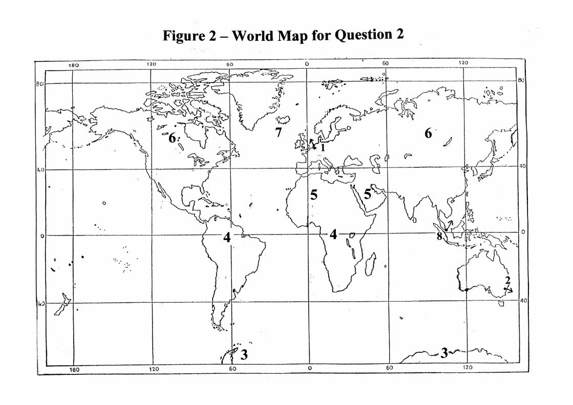
2. Study Figure 2 World Map and then fill in the name of the place and its relative number on the map in the two blank columns according to the following eight descriptions: (8 marks)
Description Name of Place Number
A large biome in the northern continents where millions of coniferous trees form the largest forest.
A large biome where rainfall and vegetation are very scarce and temperature is very high during the day.
A large biome where it is hot and rainy all year round. Trees and life are abundant.
The major European port. Its hinterland includes the Netherlands, Belgium, western Germany and northern France.
The largest city and port in Australia.
Asian port on the Equator which lies at the centre of trade routes in the East and handles most cargo in the world.
Large island in the northern Atlantic Ocean famous for its volcanoes and ice sheets.
The ice-covered land-mass that surrounds the South Pole. Few people live there.
3. In the blank space at the end of each of the following statement write down the type of climate
or biome to which it refers. Choose from the following four types: (12 marks) Equatorial Climate (or tropical rainforest) Tropical Continental Climate (or savanna grasslands) Mediterranean Climate Monsoon Climate a. This type of climate lies within the tropics between the desert and the equatorial forest.
__________________
b. Summers here are very hot and winters are very warm. There is summer rain and most areas are
grassland. __________________
c. In summer this area gets wet, onshore winds that bring about 2000 mm of rain in four months.
__________________
d. In this type of climate March to June is very hot and dry; June to October is hot and very wet;
October to March is cool and dry. __________________
e. The four seasons of the temperate lands are unknown here since it is hot and wet all year round.
__________________
f. Rain of the thunderstorm type falls on most days of the year, usually in the afternoon.
__________________
g. The weather here is hot and dry in summer. __________________
h. Vegetation here includes cork oak, figs, olives, myrtle, laurels and oleanders.
__________________

Geography (Option) – Junior Lyceum – Form 5 – 2011 Page 3 of 6
i. The forest here has a closely interlocked canopy of tree crowns, some of which are mahogany,
rosewood, greenheart, balsa, rubber and cacao. __________________
j. Central Chile, California, South-west Australia and South Australia’s coast have this type of
climate. __________________
k. The heavy summer rain such as in North-east India and Myanmar produces a rich forest of
ficus and teak. __________________
l. This type of climate is also called Sudan type. This biome is well-known for the baobab tree
and the large animal predators. __________________
4. Study the following Figure 3 – The Seasons, then answer the following questions briefly:
Figure 3 – The Seasons
a. The earth turns on its axis once every 24 hours. What is this movement called?
_______________ (2)
b. i. What is the main effect of the earth’s turning on its own axis? ____________________. (1)
ii. How does this come about?
_________________________________________________________________________
_______________________________________________________________________(1)
c. How many days does the earth take to complete one revolution or orbit around the sun?
__________ (1)
d. By how many degrees is the angle of the earth’s axis tilted from the perpendicular to the ‘plane
of the ecliptic’? __________ (1)
e. Give two effects of the revolution of the earth around the sun and the tilt of the axis together.
____________________________________________________________________________
__________________________________________________________________________ (2)

Page 4 of 6 Geography (Option) – Junior Lyceum – Form 5 – 2011
f. In the space below draw a simple diagram to show why in Malta, or in the northern hemisphere in general, we get longer days and shorter nights in June. (2)
5a. Complete the diagram in Figure 4 to show a glacier system. (6 marks)
Figure 4 – Glacier System
b. Define the following glacial terms in brief. (4)
i. cirque ___________________________________________________________________
_________________________________________________________________________
ii. arête ____________________________________________________________________
_________________________________________________________________________
iii. truncated spurs ____________________________________________________________
_________________________________________________________________________
iv. moraine __________________________________________________________________
_________________________________________________________________________

Geography (Option) – Junior Lyceum – Form 5 – 2011 Page 5 of 6
6a. Explain what each of these terms means. For the first three, give one example of each too.
i. primary industry ________________________________________________________ (2)
ii. secondary industry ______________________________________________________ (2)
iii. tertiary industry ________________________________________________________ (2)
iv. deindustrialisation ______________________________________________________
______________________________________________________________________ (1)
b. Study the triangular graph Figure 5 below, showing percentage of workers in each of the three
main sectors of industry in selected countries and then fill the information about the percentage of workers in the 3 countries listed in the table hereunder according to sector or type. (3)
Percentage workers
Country % primary % secondary % tertiary
Canada
Iran
Tanzania
Figure 5 – Percentage workers by type of industry

Page 6 of 6 Geography (Option) – Junior Lyceum – Form 5 – 2011
7a. What does the term multinational (or transnational) company mean? _____________________
_________________________________________________________________________ (2)
b. Give the name of two multinational companies.
______________________ ______________________ (2)
c. Give two reasons why multinational companies locate in different places.
____________________________________________________________________________
__________________________________________________________________________ (2)
d. Give two advantages of having multinational companies in the country.
____________________________________________________________________________
__________________________________________________________________________ (2)
e. Give two disadvantages of having multinational companies in the country.
____________________________________________________________________________
__________________________________________________________________________ (2)
8a. Define the term ecosystem. ______________________________________________________
__________________________________________________________________________ (2)
b. Name any two components of the non-living environment of an ecosystem.
______________________ ______________________ (2)
c. Why is the ecosystem under a leaf or stone called ‘micro level ecosystem’? ________________
__________________________________________________________________________ (1)
d. Below is a simple flow diagram of transfers of energy in an ecosystem. Fill in the 4 blank labels. (4)
Figure 6 – Transfers of Energy in an Ecosystem
9a. What is deforestation? _______________________________________________________ (1)
b. Give two main reasons for deforestation within the Amazon rainforest. (2)
______________________________ ________________________________
c. Give three simple ways by which a person can help lessen deforestation. (6)
____________________________________________________________________________
____________________________________________________________________________
____________________________________________________________________________

Geography (Option) – Junior Lyceum – Form 5 – 2011 Page 7 of 6
Page 8 of 6 Geography (Option) – Junior Lyceum – Form 5 – 2011