juneau fish habitat assessment revised 2012 - southeast alaska
TRANSCRIPT

Regional Information Report 5J12-03
Juneau Fish Habitat Assessment (Revised)
by
Mike Bethers,
Kristen Munk, and
Cheryl Seifert
March 2012
Alaska Department of Fish and Game Divisions of Sport Fish and Commercial Fisheries


,
JUNEAU FISH HABITAT·
ASSESSMENT
by
.. Mike Bethers Kris Munk.
Cheryl Seifert
Revised June 1995
. Alaska Department of Fish and Game Division of Sport Fish
Douglas,Alaska

The Alaska Department of Fish and Game administers all programs and activities free from discrimination based on race, color, national origin, age, sex, religion, marital status, pregnancy, parenthood, or disability. The department administers all programs and activities in compliance with Title VI of the Civil Rights Act of 1964, Section 504 of the Rehabilitation Act of 1973, Title II of the Americans with Disabilities Act of 1990, the Age Discrimination Act of 1975, and Title IX of the Education Amendments of 1972.
If you believe you have been discriminated against in any program, activity, or facility, or if you desire further information please write to ADF&G, P.O. Box 25526, Juneau, AK 99802-5526; U.S. Fish and Wildlife Service, 4040 N. Fairfax Drive, Suite 300 Webb, Arlington, VA 22203 or O.E.O., U.S. Department of the Interior, Washington DC 20240.
For information on alternative formats for this and other department publications, please contact the department ADA Coordinator at (voice) 907-465-6077, (TDD) 907-465-3646, or (FAX) 907-465-6078.

Contents Introduction ..................................... ~ ....................................................... 1
Species present in Juneau waters . Stream types
Developmental impacts
Chapter 1: Auke Creek ....................................................................... 11
Chapter 2: Auke Lake.........................................................................15
Chapter 3: Auke Nu Creek .................................................................17
Chapter 4: Bay Creek .........................................................................18
Chapter 5: Bear Creek ........................................................!' •••••••••••••••••••••••• 20
Chapter 6: Bessie Creek .....................................................................22
Chapter 7: Bessie Lake .................................................................... ~,. 24
Chapter 8: Bridget Cove Creek .........................................................25
Chapter 9: Campground Lake ...........................................................26
Chapter 10: Pederson Hill Creek (formerly Casa Del Sol Creek) ............... 27
Chapter 11 : Cove Creek ........................................................................29
Chapter 12: Cowee-Davies Creek .......................................................30
Chapter 13: Cropley Lake .................................•..................................34
Chapter 14: Crossbay Creek ...............................................................35
Chapter 15:· Duck Creek .......................................................................36
Chapter 16: Eagle Creek .....•......•.........................................................40
Chapter 17: Eagle River ........................................................... : ........... 41
Chapter 18: East Creek ........................................................................44
Chapter 19: Elevenmi/e Creek.............................................................45
Chapter 20: Falls Creek .......................................................................46
Chapter 21: Fish Creek ........................................................................47
Chapter 22: Float Plane Lake ..............................................................50
Chapter 23: Gold Creek .......................................................................51

Contents (continued)
Chapter 24: Grant Creek ....•........•..............••........•..........•....•...............53
Chapter 25: Hendrickson Creek..........................................................54
Chapter 26: Herbert River....................................................................56
Chapter 27: Johnson Creek...................................... ; .......................... 58
Chapter 28: Jordan Creek....................................................................60
Chapter 29: Kowee Creek ....................................................................63 .
Chapter 30: Lake Creek .......................................................................64
Chapter 31: Lake Two Creek ...............................................................66
Chapter 32: Lawson Creek ..................................................................67
Chapter 33: Lena Creek .......................................................................68
Chapter 34: Lemon Creek................................................~ ...................69
Chapter 35: Little Sheep Creek ...........................................................71
Chapter 36: Marshall Pond and Mitchell Pond ..................................72
Chapter 37: McGinnis Creek ...............................................................73
Chapter 38: Mendenhall Lake..............................................................75
Chapter 39: Mendenhall Ponds ...........................................................77 Dredge Lake Moose Lake I Crystal Lake Cashew Lake
/Louie Lake Norton Lake Glacier and Moraine lakes I
Chapter 40: Mendenhall River................................... ; ......................... 81
Chapter41: Montana Creek.................................................................83
Chapter 42: Neilson Creek ..................................................................86
Chapter 43: Ninemile Creek ................................................................87
Chapter 44: North Tee Creek ............................................................... 88
Chapter 45: Nugget Creek ................................................................... 90
ii

Contents (continued)
Chapter 46: Peterson Creek ................................................................91
Chapter 47: Peterson ('Outer Point') Creek ....................................... 94
Chapter 48: Peterson Lake .................................................................. 96
Chapter 49: Picnic Creek .....................................................................98
Chapter 50: Riverside Drive Pond ................................................... 100
Chapter 51: Salmon Creek ............................................................... f01
Chapter 52: Salmon Creek Reservoir................ : ............................. 103
Chapter 53: Sheep Creek .................................................................. 105
Chapter 54: Shrine Creek ................................................................. 108
Chapter 55:· Snowslide Creek ........................................................... 109
Chapter 56: Steep Creek .................................................................... 110
Chapter 57: Strawberry Creek........................................................... 112
Chapter 58: Switzer Creek.......... , ...................................................... 113
Chapter 59: Tee Creek ....................................................................... 117
Chapter 60: Twin Lakes ..................................................................... 118
Chapter 61: Vanderbilt Creek ........................................................... 120
Chapter 62 Wadleigh Creek............................................................. 123
Chapter 63: West Creek ..................................................................... 124
Chapter 64: Windfall Lake ................................................................ 126
iii

I
I I ,
1
JUNEAU FISH HABITAT ASSESSMENT
Mike Bethers Kris Munk
Cheryl Seifert
Introduction Many areas in Alaska have an
abundance ofexcellent fish habitat,large runs of fish, low levels of use, and exceptional fisheries. In other areas, especially near large population centers, productive fish habitat has often been degraded or lost through development without adequate consideration of fish habitat needs.
Ironically, demand for fish and recreational angling opportunities is greatest in large communities, yet these are often the areas which have experienced the greatest loss and degradation offish habi~ tat.
The Juneau area-i.e., the area accessible by the Juneau road systemlacks large river systems that produce great numbers of fish. Instead, fish production is based on small systems, many of which have been severely impacted by adverse land uses. All systems are still vulnerable to impacts from future development.
Sport fishing effort in the Juneau area increased from about92,OOO angler-days in 1977 to nearly 144,000 in 1993. Given the area's increasing population. one can see the interest in recreational angling and the value of local fish habitat in providing fish to local fisheries.
The objectives of this document are (l) to inform interested parties ofthe life histories and habitat needs of fish species produced in local waters; (2) to provide descriptions offish habitat in the
immediate Juneau area; and (3) to protect fish habitat remaining in the Juneau area by providing management recommendations for the area's streams.
Table 1 lists common names, scientific names, and abbreviations of all species discussed in this report.
A summary of Juneau area recre~
ational effort and the harvest of ·fish from streams is presented in table 2 (following page). Please keep in mind that catch-and-release fishing is becoming more popular and there are additional fish caught which are not harvested. This publication includes the most recent data available at time of printing (June 1994). Harvest data include the most recent data available. All escapement dataon streams are provided. Not all data were collected by the same methods for all species in all streams; consequently, in some streams there are more fish than these data show.
Species present in Juneau waters
Coho, pink. chum, and sockeye salmon; cutthroat. rainbow, and steethead trout; Dolly Varden and eastern brook trout are produced naturally in Juneau area waters. Few, if any, of the Juneau area streams contain all of these species; however. some species are found in almost every one of the local streams.
- Fish species can be classified as either anadromous or resident. Anadromous fish are those that are hatched in fresh water. eventually migrate to sea for some portion of their adult life. and return to fresh water to spawn. Resident fish are hatched in fresh water and live there throughout their entire lives. Some species, such as Dolly Varden and cutthroat trout, occur both in anadromous and resident populations.
Table I. Common names, scientific names, and abbreviations for species of fish discussed in this report.
COMMON NAME (ABBREVIATION) SCIENTIFIC NAME
Coho salmon (SS) Oncorhynchus kisll/ch Pink salmon (PS) Oncorhynchus gorbuscha Chum salmon (CS) Oncorhynchus kew Sockeye salmon (RS) Oncorhynchus nerka Cutthroat trout (CT) Oncorhynchus clarki Rainbow trout (RB) Oncorhynchus mykiss Steelhead trout (SH)* Oncorhynchus mykiss Dolly Varden (DV) Salvelinus malmo Eastern brook trout (BT) Salvelinus fon/inalis
* The /erm 'sleelhead' is applied 10 sea-run rainbow trout.

2
Tahle 2. Summary of angler effort and harvest in the Juneau recreational fishery from 1980 to 1993
(totals include harvests from Turner, Florence, and Hasselborg Lakes).
1980 1981 1982 1983 1984 1985 1986 1987 1988 1989 1990 1991 1992 1993
Angler days King salmon
(>28") King salmon
«28") Silver salmon Red salmon Pink salmon Chum salmon Dolly Vardon Steelhead Rainbow trout Cutthroat Brook trout
90,095 77,362 93,842 108,173 108,012 122,781 121,05; 114,756 108,860 115,360 122,045 113,913 149.382
6,518 5,670 6,697 4.629 7,640 9,044 6,244 8,430 6,259 8,751 14,442 15,444 11,841
0 1,231 2,472 168 III 407 315 3lJ 410 624 - 1,470 45 12,562 9.234 22,898 17,162 14.067 17,242 11,741 17,254 19,207 39,063 44.878 40,269 40.170
206 75 251 ;58 611 809 179 321 436 1,461 1,669 1.017 985 7,388 8,877 19,168 17,236 7,835 26,248 8,089 22,923 17,099 22,488 54,962 14,998 21..111
904 573 555 1,143 1,212 2,151 1,207 2,208 3,856 3,260 6,921 2,741 3.147 7,198 3,198 4,957 9,514 6,902 10,857 9,350 6,348 14,806 13,987 33,283 11,929 7,201
68 II 41 209 8 III 206 250 265 280 463 400 258 129 87 105 209 245 330 213 298 491 229 464 46 372
2,358 1,976 2,819 2,055 1,515 4,145 2,715 2,787 4,202 3,057 9,689 1.774 2,564 491 605 734 493 534 87 290 298 436 169 327 114 292
133.789
13.098
20 ]0.+28
2,530 9.216 J,453 7,923
258 167
5.516 182
In general, anadromous species can be
categorized as either rearing or non
rearing, depending on the length oftime
they remain in fresh water after they
hatch, Rearing species, such as coho
salmon and sleeJhead trout, spend I to 3
years in fresh water before they emigrate
to the ocean. Streams containing these species are often'referred to as ··rearing" streams. Non-rearing species, like pink and chum salmon, emigrate to sea almost immediately upon emerging from the gravel. Because non-rearing species use the streams primarily for spawning, these streams are often referred to as being primarily "spawning" streams.
Typically, rearing streams have a low gradient~ slower moving water, numerous pools, overhanging banks, and overhead and instream cover. Large organic debris (logs, limbs, etc.) form most of the instream cover which is critical to the production of rearing fish. A typical spawning stream is characterized by a higher gradient, fast water, few pools, few overhanging banks, and little overhead and instream cover.
Brief life histories of the important recreational species produced in Juneau area streams are presented below. The freshwater life histories ofspecies offish that rear in the Juneau area streams are summarized in table 3.
Each chapter in this document addresses a specific stream or lake accessed
by the Juneau road system. Chapters are arranged alphabetically by stream or lake name, Each contains a map ofthe system and a discussion ofwhat is known about the system-its location, anadromous stream catalog number, general description, fish species present. fish habitat, public use, land ownership, land uses, conclusions, and recommendations.
Coho Salmon
Coho salmon enter their spawning systems tram August through October, usually during periodsofhigh water(table 3). The adults hold in pools, ponds, or lakes for several weeks until they are mature, then move into shallow riffles with clean gravel to spawn. The female digs a depression into the gravel by turning on her side and using rapid body and tail motions. She protects her nest area. called a redd. and males frequently combat each other for occupancy ofthis area. Several redds may be dug and the spawning acts continue until the female has deposited her eggs-usually between 2,400 and 4,500.
The eggs develop slowly during the cold winter months and hatch in early spring. The embryos remain in the gravel and utilize their egg yolk material until they emerge in Mayor June. The young fry school in shallow areas along the stream shoreline, but soon establish individual territories which they defend from other juvenile coho with aggressive dis
plays. This territory is usually along the shoreline or behind a log or boulder where the young fish does not have to fight the current, but can dart out to reed on adult surface insects or drifting insect larvaeits principal source of food.
The juveniles grow rapidly during the summer months and find deeper pool areas or spring-fed side ponds to spend the winter. They will spend tram one to three winters in fresh water before migrating to sea in the early spring as "smaIts. "
Pink Salmon Adult pink salmon enter local spawn
ing streams between late June and mid-August (table 3). Different races or runs with differing spawning times frequently oc~ur in adjacent streams or even within the same stream. Mostpinksalmon spawn in lower sections ofstreams. com· manly within the intertidal zone at the stream mouth. Favored spawning areas are in shallow riffles. where tlowing water breaks over coarse gravel or cobblesize rock. and in downstream ends of pools.
The average female pink salmon carries 1,500 to 2,000 eggs, depending on her size. She digs a redd with her tail and releases the eggs in the redd. They are immediately fertilized by one or more males and then covered by further digging action by the female. The process is repeated several times until all the

3
Table 3. Timing of freshwater phases of life histories of recreational fish species produced in Juneau area waters.
Phase SS SH-RT RS PS OV CS CT
Adultretum Aug-Sept
Spawning Oct-Nov
Eggs incubating- Nov-Apr·· fry emergence
Length of juvenile 1-3yrs rearing in fresh water
Juvenile outmigration May-Jun
Adult outmigration none:'
Adult overwintering none:
Apr-May Jun-Aug Jul-Aug
May-Jun Aug"Sept: Jul-Aug
Jul-Aug Sept-Mar Aug-Mar
2-4yrs 2-Jyrs none
May-Jun May-Jun· Apr-May
May-Jun none.. none none none· none
Jul-Sept June-Aug Aug·Oct
Oct-Nov· Jul-Aug May-Jun
Nov-Apr Aug-Apr Jul-Aug
3 - 4yrs none 2 ·4 yrs
Apr-May Apr-May May-Jun
Apr'May none May-Jun
Oct-May none Oct-Jun
SS = silver salmon ·CT = cutthroat trout OV = Dolly Varden
SH = steelhead trout RS = red salmon CS -= chum .:mlman
RT = rainbow trout PS :::: pink salmon BT ~ brook troor
female's eggs have been released. As with all species ofsalmon, both male and female die after spawning.
During the fall and winter, the eggs hatch into "alevins," or fry, with yolk sacs attached. The fry feed on their yolk material and emerge in late winter or early spring, as the yolk material is depleted. The fry swim up out ofthe gravel and emigrate downstream to salt water.
The emergence andoutmigration offry is heaviest during hours of darkness and usually lasts for several weeks. Pink salmon fry do not rear in fresh water. Newly emigrantpinksalmon fry are commonly observed in large numbers in local estuaries and coves where tidal currents are not too strong.
Pink salmon almost invariably mature in 2 years, which means that odd-year and even-year populations are essentially unrelated. One cycle or the other (oddyear or even-year) will predominate in most systems although both odd- and even-year pink salmon are about equally abundant in other streams.
Chum Salmon Two types of chum salmon (based on
run timing) are found in Juneau area streams: summer-run and fall-run. Summer chum salmon enter fresh water in July and early August and spawn by the end of September (table 3). Fall chum
salmon enter freshwater streams from September through November and spawn from October through December.
Although chum salmon otten spawn in more upstream sections of streams compared to pink salmon,· chums also spawn in the same areas as pink salmon, including intertidal areas. Female chum salmon construct redds in the same manner as other Pacific salmon and deposit up to 2,700 eggs each. Churn salmon fry generally emerge from the gravel during March and April, then migrate to salt water. Chum salmon fry tend to stay in the intertidal estuaries a bit longer than pink salmon fry.
Sockeye Salmon In June and July, adult sockeye mi
grate from saltwater back to the freshwater systems where they originated (table 3). The system normally has a lake which the adults pass through to spawn in its headwater tributaries. However, some spawning may occur in the lake outlet and along the lake shore (beach spawners). While at sea, sockeye are bright and silvery. In fresh water, the adults acquire a characteristic bright red body and green head. The complete maturation process requires I to 2 months, and by late August most sockeye have spawned.
Upon maturing, the female digs a redd and deposits her eggs in the'downstream
portion of the redd, where they are fertilized by one or more males. During spawning, the female continues to enlarge the redd upstream, covering eggs previously deposited.
During fall and winter, the eggs incubate, hatch, and the young fry move into lakes in early spring. Juvenile sockeye spend 2 or 3 years in the lake before migrating to sea in the spring as smalt. The migration of smolt to salt warer is usually over by the end or June.
After 2. to 4 years in the ocean, maruce sockeye have usually attained weights varying from 4 to 8 pounds, but weights up to 15.5 pounds have been recorded. In Alaska, it is usually in their fourth. t1fth. or sixth year of life that adult sockeye return to fresh water to spawn. Some males mature after spending only I year in salt water and return as ·'jacks.'·
Cutthroat Trout Adult cutthroat trout normally over
winter in freshwater lakes. Mature cutthroat trout either move into small tributaries of the system they overwintered in for spawning, or migrate out of the overwintering area and back to their parenc stream for spawn ing.
Spawning normally occurs from May through early July, otten in the headwaters of very small streams(table 3). Anadromous cutthroat trout rear for 2 to
I

4
4 years in fresh water before emigrating to salt water. Some systems have popu- . lations of resident cutthroat trout that do not emigrate to saltwater. Cutthroat trout generally prefer slow-moving streams, beaver ponds, and lakes [crrearing, rather than high-gradient, fast-flowing streams.
Rainbow Trout Maturing rainbow trout seek out shal
low gravel riffles of suitable clearwater streams when water temperatures are on the rise during the spring to spawn. The sexually mature female rainbow are usually at least 3 years ofage, although males may mature earlier. Only a small percentage of resident rainbow survive to spawn more than three times.
The female prepares the nest or redd. The fertilized eggs are covered by the female as she enlarges the nest in an upstream direction. From 200 to 800 eggs may tinally be deposited, depending upon the size of the female.
Hatching normally takes place from a few weeks to as much as 4 months after spawning, depending upon thewatertemperature. A few more weeks may be required for the tiny fry to emerge from the streambed. The length ofthe fry upon their emergence ranges from 0.5 inch to I inch.
The small trout seek shelter along the stream margins or protected lakeshore, feeding vigorously on crustaceans, plant material, and aquatic insects and larvae. Atthe end oftheir tirst season, their total length is usually 2.5 inches or more, depending upon the productivity of their environment. Rainbow trout are carnivorous, and as the young trout grow larger, small fish are added to their diet.
Steelhead Trout
Steelhead, unlike salmon, do not necessarily die after spawning; however, many do because of bruising and infections incurred in freshwater. After spawning, steelhead move from spawning riffles into deep pools for several days prior to returning to saltwater.
The eggs incubate and develop in the gravel for 2 to 3 months. Young fry emerge from the gravel in late summer and seek out calm water with good protective cover. Juvenile steelhead will rear in fresh water for 2, 3, or 4 years before emigrating to the ocean. Steelhead normally rear in salt water for 2 or 3 years before returning to their parent stream to spawn. Repeat spawners may constitute up to 35°1J of the total return to
the stream.
Dolly Varden
Dolly Varden usually spawn instreams during October and November (table 3). The female, depending on her size, may deposit 600-6,000 eggs. The male usuaily takes no part in nest-building activities and spends most of his time fighting and chasing other males. When the female is ready to deposit her eggs, the male moves to her side and spawning begins.
The eggs develop slowly in the cold water. Hatching occurs in March, 4 to 5 months after fertilization. After hatching, the young Dolly Varden obtain food from their yolk sac and usually stay in the gravel until this food source is gone. Emergence typically occurs in April or May. The young Dolly Varden rear" in streams or lakes for 3 or 4 years before beginning their life in fresh water. During this period their growth is slow, a fact which may be attributed to their habitat.
Young Dolly Varden char often reMoststeelheadenterspawningstreams . main on the bottom, hidden from view
from mid-April through mid-May (table 3). Adults sometimes enter their natal streams in a mature spawning condition, some may remain for several days in deep pools or secluded areas prior to spawning. A female may dig several redds during spawning and will deposit a total of2,000-4,000 eggs, which are fertilized by an accompanying male.
under stones and logs or in undercut areas along the stream bank. These habitats are different from those of the more aggressive juvenile coho salmon. Coho young are usually seen swimming and feeding near the water surface, whereas young Dolly Varden seldom swim and appear to select most oftheir food from the stream bottom.
Dolly Varden migrate to sea in their third or fourth year when they are about 5 inches long. Migration usually occurs in Mayor June, although smaller numbers have been recorded migrating to sea in September and October. Once at sea, they begin a fascinating pattern ofmigration.
After their tirst seaward migration, Dolly Varden usually spend the rest of their life wintering in and migrating to and from lakes. Those hatched and reared in a lake system carry on annual feeding migrations to sea, returning to the lake each year to overwinter. However, Dolly Varden originating from non-lake systems must seek a lake in which to winter. Recent research indicate.s that cht!y tind lakes by random searching, mlsraring from one stream system to another until they tind one with a lake. Once a lake is found, these fish may continue to conduct annual seaward migrations in the spring, sometimes entering other stream systems in search of food.
Some streams have populations of resident Dolly Varden that do not emigrate to the ocean, but spend their entire lives in the streams in which they were hatched. Resident Dolly Varden attain lengths of 4- to 8 inches when mature.
At maturity. Dolly Varden return to
spawn in the stream from which rhey originated. They possess an ability to
find their -"home" stream without randomly searching, as was the case in their original search for a lake. Those that survive the rigors ofspawning return to the lake shortly thereafter tor overwintering.
Most Dolly Varden reach sexual maturity at 5 or 6 years of age. At this age, they may be 12-16 inches long and may weigh from 0.5 to I pound. Mortality after spawning varies. depending on the sex and age of the Dolly Varden. Males suffer a much higher mortality rate, partly due to fighting and the subsequent damage inflicted to each other. It is doubtful that many more than 50% of Dolly Varden live to spawn a second time, although a small number do live to spawn more than twice, and a few live longer than 8 years.

5
Eastern Brook Trout Eastern brook trout are available only
in Salmon Creek Reservoir and certain streams in the Juneau area where they were stocked. Their life history is similar to that of resident Dolly Varden.
Fish in Gold Creek appear to exhibit physical characteristics of both Dolly Varden and brook trout.
Stream Types The type of habitat found in a stream
dictates what species offish use the stream. (All fish require good spawning habitat; however. the non-rearing species do not require rearing habitat. as do species requiring several years of rearing in fresh water.)
Some streams have both spawning and rearing habitat and have good populations offish species that require freshwater rearing and species that outmigrate directly after emerging from the gravel. Montana Creek is a good example of such a stream.
Fish Creek, a stream of similar size has excellent spawning habitat; how-ever, it lacks slow water areas. woody debris, and the cover needed by rearing species of fish. Consequently. Fish Creek can be
expected to produce large numbers of pink and chum salmon (non-rearing species), but it will never produce more than a few coho salmon, which require extended freshwater rearing.
A list of the streams included in this document, including species' of fish and habitat present, is presented in table 4 (following page).
Developmental Impacts Nearly all streams in the Juneau area
have been impacted to some degree by adverse land uses in the past. Some streams have been impacted by only a single road crossing; however, others have been subjected to a multitude of adverse land uses [har have diminished their productive capability.
Historically, the habitat values of streams subject to development were not given the level of recogniti_on that they have received in more recent times. Public awareness of environmental quality has led to a more thorough review of land use penn it applications, which has been increasingly successful in protecting or mitigating habitat values of streams subject to development.
Considering the projected long-term increases in local population and the
•
shortage of real estate available for development, critical review of land use pennit applications will be necessary to adequately protect stream habitat values.
It should be noted that land use activities do not necessarily have to impact fish habitat values. In most instances, maintenance or improvement ofstreamside habitat and fishery values will add to the ultimate value of the proposed development. With proper timing, construction techniques, location of development, and mitigation in some instances, development can occur without adversely impacting fish habitat.
Development of new industry also mayor may not directly impact fish and wilJIlte resources and t'ishing and hunting opportunities in an area. However, it is alien the number of users that affect fish and wildlife populations, and any activity which attracts additional population to an area will indirectly impact fish and wildlife habitat as well as fishing and hunting opportunities, by creating more resource users for a given amount of resource. A list of local streams and land use activities which have impacted the streams and to which streams would be vulnerable in the future is presented in tilble 5 on pages 8-9. •
6
Table 4. List of streams, including species present and habitat type and quality.
STREAM
I Auke Creek 111-50-10420
2 Auke Lake
3 Auke Nu Creek 111-50-10350
4 Bay Creek 111-50-10390
5 Bear Creek 111-50-10850
6 Bessie Creek
, 114-10-10250 Bessie Lake
S Bridget Cove Creek 115-10-10230
9 Crunpground Lake ,.. 10 Pederson Hill Creek
I 1 Cove Creek 12 Cowee-Oavies Creek
13 Cropley Lake 14 Crossbay Creek 15 Duck Creek
111-50·\05·2002 16 Eagle Creek
111-40·10920 17 Eagle River
111-50-10070 18 East Creek
111-40-10960 19 Elevenmile Creek 20 Falls Creek
111-40·10940 21 fish Creek
111-50-10690 22 Floa[ Plane Lake 23 Gold Creek 24 Grant Creek
111-40-10910 2S Hendricksen Creek
111-50-10980 26 Herbert River
111-50-Hl070-2004 27 Johnson Creek
111-50-10660 28 Jordan Creek
HABITAT TYPE AND QUALITY
FISH SPECIES PRESENT ANA.OROMOUS FISH RESIDENT FISH F,su BARRIER
55 P5 C5 RS DV CT SH RB BT Spawning Rearing Spawning Rearing Location
X X X X X X X good good good good none
X X X X X X X good good good good none 111-50-10420-0010
X X good fair fair fair 1/4 mile
X X X good good good good none
X poor none fair fair tidewater
X X X fair poor good good 114 mile
X X none none fair exc . X X X X .X good good goot! good .
X X X none exc none ~,c none X X X X good exc good exc' west fork
111-50-10490-2013 above road -- .- .. - -- .. -- .. .. none none -- -- tidewater
X X X X X X X oxc good exc good none 115-20-10620 & 2003
X none none poor poor on outlet .. .. '- - - .. - .. _. - - none nonc tidewater X X X ·X X fair fair fair fair none
X X X fair poor good exc 1/8 mile
X X X X X ext: good exc good none
X X X fair poor fair poor none
-- -. .- -. .. .- .- .- .. none nune .. -- tide-water X X fair tair tair poor possibly 300
yards up X X X X X exc thir exc fair J mile:i
X X X X X none good none good none X ? poor none fair faiT tidewater X fair poor fair poor 5/8 mile
X X X X X good exc fair exc none
X X X X X X X X good good good good none
X X X X X X exc exc good exc nonl!
X X X X exc ext: exc- exc nonl!
I I
I I I I I 1
1
r
, ,
111-50-10620 29 Kowee Creek X X X good poor good poor head of
111-40-10900 tidewater 30 Lak"c Creek X X X X X X X exc faiT exc faiT none
111-50-10420-2010 31 Lake Two Creek X X X X X X X exc exc ext: exc none
111-50-10420 32 Lawson Creek X X X X X good poor good poor 1I2 mile
111-40-10890 33 Lena Creek X X X X fair poor faiT poor 250 ~ards
111-50-10300 34 Lemon Creek X X X X good poor good faiT none
111-40-10100
I

7
Tabl~ 4. (continued)
HABITAT TYPE AND QUALITY
FISH SPI!:CIES PRI!:SENT ANADROMOUS FISH RESIDENT FISH FISH BARRIER
STREAM SS PS CS RS·_ DV CT SH RB BT Spawning Rearing Spawning Rearing Location
3S Little Sheep Creek X X fair poor fair poor 300 yards 36 Marshall Pond!
Mitchell Pond " .. .. .. .. '. .. .. . . none none none good none 37 McGinnis Creek X X X X X X good good good good none
111·50·10500·2003·3006 38 Mendenhall Lake X X X X X X X X good fair good fair none
111·50·10500·0020 39 Mendenhall Ponds X X X X X fair exc fair exc none 40 Mendenhall River X X X X X X X X good fair good fair none
111-50·10500 41 Montana Creek X X X X X X X X exc exc exc exc none
I [1~50-10500-1003 -1.2 Neilson Crl!ek X X X poor poor poor poor .)(I() yards
111·40·10960 43 Nine Mile Creek X X X X fair exc good exc none
111·50·10670 44 North Tee Creek X X X X X good exc good good none
111·50·10200 45 Nugget Creek X none none poor poor mouth
111·50·10500·0020·2010 46 Peterson (25 mile) Creek X X X X X X X exc exc exc exc 1-1l2 mile
111·50-10100 47 Peterson (O.P.) Creek X X X X X exc exc exc exc none
111·50·10750 48 Peterson Lake X X good fair good fair none 49 Picnic Creek X X X X X exc exc 'xc exc highway
111·50·10310 culverts 50 Riverside Drive Pond X none poor none poor nont! 51 Salmon Creek X X X X X e:<c poor good good I/~ mile:
II \-40·10150 52 Salmon Creek Reservoir X none none poor gOllU nonc 53 Sheep Creek X X X X good poor good goou li~ mile:
111·40·10280 54 Shrine Creek X X X X t!.xc exc exc cXc none 55 Snowslide Creek .. .. .. .. .. .. .. .. .. .. none none none mouth 56 Steep Creek X X X X X exc good good fair 500 yurds
111·50·10500·2006 57 Strawberry Creek X X X X good exc exc exc none
111·50·1007-2004·3002 58 Switzer Creek X X X X X exc exc exc exc none
111-40·10070 59 Tee Creek .. .. .. .. .. .. .. " .. none none .. .. mouth 60 Twin Lakes X X X none none poor cxc tidewater 61 Vanderbilt Creek X X X X X good good good good nont!
111·40·10125 62 Wadleigh Creek X X X good poor good good tidewater
111·50·10370 63 West Creek· X X X fair poor poor poor none
111·40·10050 64 Windfall Lake X X X X X X X X exc exc exc exc nont!
111-50·10070·2004·3006·0016
., Pederson Hill Creek was listed as Casa del So I Creek in the 1993 habitat assessment.
SS silver salmon PS pink salmon CS chum salmon RS red salmon I}V Dolly Varden CT cutthroat trout SH steel head RB rainbow trout DT brook trout
X indicates species present in stream .. unknown
.

8
Table 5. List of streams, including present and future potential impacts to fish habitat.
PRESENT LAND USE IMPACTS FUTURE POTENTIAL LAND USE IMPACTS
Stream/Lake
ASCNumbel' WW GR RC FF MN LG UD ID CP WW GR RC FF MN LG UD ID CP
I Auke Creek X X X X X X X X X X X X I I 1·50·10
2 Auke Lake X X X X X X X X X X X X X
11·50·/0420.0010 3 Auke Nu Creek X X X X X X X
111·50-10350 4 Bay Creek X X X X X X X X X
111-50-10390 5 Bear Creek X X X X X X X X X X X
111-50-10850 6 Bessie Creek X X X X 0
7 Bessie Lake X X X " 8 Bridget Cove Creek X X X X X 9 Campground Lake X X X X X
10 Casa Del Sol Creek X X X· X X X X X X X X II Cove Creek X
115-20-W620 12 Cowee~Davis Creeks X X X X X X X X
115-20-10620-2003 13 Cropley Lake X X X X 14 Crossbay Creek X X 15 Duck Creek X X X X X X X X X X X X X X
111-50-060 16 Eagle Creek X X X X X X X X X
111·';0-10920 17 Eagle River X X X X X X X X
111·50.10070 18 East Crctlk X X X X X X X X X X
II I ·-10- I 09-10 19 Eleven Mile Creek X X 20 Falls Creek X X
111--10-10940 21 Fish Creek X X X X X X X X X
111·50·10690 22 Float Plane Lake X X X X X X X X X
111-50-/0690 23 Gold Creek X X X X X X X X X X X X X X X 24 Grant Creek X X X X X X X
111-40-10910 25 Hendricksen Creek X X X X X
I I 1·50-10980 26 Herbert River X X X X X X X
111-50·10070-2004 27 Johrison Creek X X X X
111-50-10660 28 Jordan Creek X X X X X X X X X X X X X X
I I 1-50-10620 29 Kowee Creek X X X X X X X X X X X
111·40-10900 30 Lake Creek X X X X X X X X X
111-50-10420.2010 31 Lake Two Creek X X X X X X X
I I 1-50-10420 32 Lawson Creek X X X X X X X X X X
I I 1·40-10890 33 Lena Creek X X X X X
111-50-10300
i
I (
I
9
Table 5. (continued)
PRESENT LAND USE IMPACTS FUTURE POTENTIAL LAND USE IMPACTS
Stream/Lake
ASCNumber WW GR RC FF MN LG UD ID CP WW GR RC FF MN LG un ID CP
34 Lemon Creek X X X X X X X X X X X X X X X X X X
/I1·~O-IOIOO
35 Little Sheep Creek X X
36 Marshall Pondl
37 McGinnis Creek Mitchell Pond X X X X X X X X X X
111-50-10500-2003-3006 X X X 38 Mendenhall Lake X X X X X
111-50-10500-0020 39 Mendenhall Ponds X X X X X ., -10 Mendenhall River X X X X X X X X X X X X X X'(
/11-50-10500 41 Montana Creek X X X X X X X
111-50-10500-0020-2010 42 Neilson Creek X X X X X
111-40-10960 43 Nine Mile Creek X X X X X
111-50-10670 44 North Tee Creek X X X X X X X X X
111-50-10200 45 Nugget Creek X X
111-50-10500-0020-2010 46 Peterson (25 mile) Creek X X X X X X X X X
111-50-10100 47 Peterson (Outcr Point) Cr. X X X X X X X X
/11-50-10750 48 Peterson Lake X X X '(
-19 Picnic Creek X X X X X '(
/I 1-50-10310 SO Riverside Drive Pond X X X X X X X X 5 I Salmon Creek X X X X X X X X X X X
I I 1-~0-10150 52 Salmon Creek Reservior X X X X 53 Sheep Creek X X X X X X X X X
111-40-10280 54 Shrine Creek X X
55 Snowsl-ide Creek X X
56 Steep Creek X X X 111-50-10500-2006
57 Strawberry Creek X X X X X X X X 58 Switzer Creek X X X X X X X X X X X X
/I1-~0-10070
59 Tee Creek X X 60 Twin Lakes X X X X X X X X X X X X 61 Vanderbilt Creek X X X X X X X X X X X X X X
111-40-10420 62 Wadleigh Creek X X X X X X X X
111-50-10370 63 West Creek X X X X. X X X X X X 64 Windfall Lake X X X
I I I -50-I 0070-2004-3006
Ww water withdrawal GR gravel removal RC road construction FF tilled in floodplains MN mining LG logging UD urban development ID industrial development CP chemical pollution

11
Chapter 1
Auke Creek (a/so refer to Auke Lake)
Anadromous Stream Catalog Number: 111-50-10420
Location: Lat. 58°22'51" N. Long. 134°38'25" W. (11.5 mile Glacier Highway)
Description Auke Creek flows about 0.3 miles
from Auke Lake to salt water in Auke Bay (figure 1.1). The stream has a fairly steep gradient. and the water is clear with a brown tint. A small fish hatchery was built on the stream in 1954 by the Terri· torial Sportsmen Club.
Since 1961, a weir has been in place on Auke Creek. The weir and hatchery are both are operated by the National Marine Fisheries Service. Wild fish stocks utilizing Auke Lake are counted at the Auke Creek weir, and only Auke Creek stocks of fish are reared in Auke Creek Hatchery.
Fish Species Present Auke Creek has populations of coho,
pink, chum, and sockeye salmon, cutthroat and rainbow trout, and Dolly Varden. Data on fish runs forthis system appear in tables 1.1 and 1.2.
A history of stocking in the Auke Creek/ Auke Lake system is presented in table 1.3. Data on the contribution of Auke Lake coho salmon to fisheries in northern Southeast Alaska are presented in tables 1.4 and 1.5.
Fish Habitat Auke Creek is used primarily as a
migration route to Auke Lake; however, the stream does provide good rearing and spawning habitat. The stream has many pools with heavy overhead vegetation,
which provides good cover. The upper section of the stream has been enhanced through channel stabilization and placement of high quality spawning gravel. This section of the stream is also an excellent rearing area.
Trap data collected at Auke Creek are summarized as follows (July 16, 1970): 7 minnow traps averaged 64 rearing coho and one Dolly Varden per trap.
King salmon smolts are imprinted at the mouth of Auke Creek annually, and adult fish provide a popular shore-based
fishery during summer. King salmon .scaping the fisheries are captured at the Auke Creek weir and given to charitable organizations.
There are no natural barriers to fish passage on Auke Creek.
Public Use Auke Creek is closed to sport fishing;
however, a major roadside sport tishery occurs in Auke Bay at the mouth ofAuke Creek. This fishery is supported by wild fish stocks destined for the Auke Lake system and production from the Auke
. Creek Hatchery.
Since 1986. king salmon sma Its from Snertisham Hatchery have been imprinted and released at the mouth of Auke Creek. The mouth of Auke Creek has proven to be an excellent release site, as the smolts survive well and contribute to both marine ~nd shore-based fisheries.
A record ofrecreational angling etTort and harvest at the mouth of Auke Creek is presented in table 1.6.
Land Ownership Auke Creek runs through state prop
erty, except for a small parcel of private property adjacent to [he stream mouth.
Table 1.1 Summary of Dolly Varden and cutthroat trout emigrants
from Auke Lake.
OUTMIGRANTS
No. OF No. OF
YEAR DOLLY VARDEN CUTTHROAT TROllT
1970 6,126 1980 3,057 1981 6,366 1982 3.789 1983 3,717 1984 4,512 1'185 3,052 1986 4,358 1987 6,443 1988 6,770
'1989 7,230 1990 6,425 1991 5,579 1992 6,839 1993 5,074 1994 7,600
-85
157 157 216 302 161 138 942 690 411 506 260 226 190 431

10
UAS campus
N
100 a
(soundi ngs in
100 200 m
meters)
Figure I.} Auke Lake and Auke Creek.

Table 1.1 A summary of Auke Lake salmon migrations. Tag recovery informalion on Auke Lake coho salmon are presented in Tables 1.3, 1.4, and 1.5.
PINK SALMON COHO SALMON SOCKEYE SALMON CHUM SALMON KING SALMON YEAR Ju\' .• Adult Juv.* Aduh lu .... ~ Aduil Ju \' .. Adult Adults
1961 - - - 90.000 - - - 1962 - - - - - - -
1963 - - - 29.052 6.191 - - 1964 - - - 62.389 5,465 - - 1965 - - - - 6,889 - - 1966 - - - - 10,986 - - 1967 - 3,761 390 - 5.909 - 78 1968 - 2,638 - 35,737 7,164 - - 1969 - - - 24,947 6,131 ""-- - 1970 - - - - 7,034 -- - 1971 - 2,090 916 - 7.673 - 10 1972 1'7,000 1,768 1,113 3,388 9,166 -- 47 1973 14,100 4,948 637 - 8,259 - 21 1975 268,000 6,260 1,147 15,399 4,371 - 5 1976 107,595 2,'25 460 51,972 6,153 - 16 1977 119.000 1',848 1,781 9,327 16,683 - 17 1978 129,194 18.410 699 .. 7,855 3,171 - 17 1979 23,270 19,003 596 .. - 6,022 --- I J 1980 14,047 20,187 9,951 644 .. 25,299 4,564 0 118 -1981 111,416 14,450 7,140 678 .. 9,183 4,089 0 109 1982 118,399 10,653 6.607 458 .. 1,719 1,334 0 251 1983 164,784 24.827 6,721 694 .. 3,170 1.805 0 JIO 1984 169,552 5,271 7,036 651 .. 20,25 I 975 0 1,927 -1985 110,001 26,317 5,601 942 •• 11,747 240 7, I !J8 1,852 1986 123,887 2,305 5,666 550 .. " 14,503 952 l:i::!3 1,392 1987 43,502 7,944 7,181 662 .. 17,598 2,829 14.U3') 1,883 1988 113,061 8,140 7,888 756 .. 19,157 l,ll7 S,U~,)( 1,093 1989 116,870 5,016 6,924 502 29,175 2,508 -" -1990 98,355 21,806 5,132 697 28,343 3,383 1,91 U 270 349 1991 243,037 6,857 5,722 804 25,987 5,408 75') 167 202 1992 100,613 22,101 6,271 1,020 13,248 4,85J 4,78) IJO 210 1993 237,616 1,696 8,103 S5'J 33,616 Y,I13 n 121 272 1994 II ,600 22,548 7,416 LH7 )2,009 6,~~3 117 868 Jl6
, Juvenile:.
u Since 1978. t.:uuub J/h;luJ'~ unl} i.tuull ~ullu and du nul Irldudc "Iud~ "

Public access is available along the beach Table 1.3. A history of fish stocking in Auke Lake.
and via the fish hatchery driveway.
DATE SPECIES NUMBER BROOD SOURCE
Land Uses 1919 pink salmon 600,000 0
Auke Creek has basically recovered 08/27/25 cutthroat trout 9,600 Lake Eva, WA
from the impacts ofthe construction of 09/20/27 eastern brook 4,780 ? 10125/27 eastern brook 7,030Glacier Highway and Fritz Cove Road.
1928 eastern brook 14,400 ? Auke Lake is vulnerable to many 09115/31 eastern brook 1,050
land uses that could occur in the upper 1950 grayling 125 Mcdonald Lk, BC
watershed. Water rights on file for the 08113/54 rainbow trout 61,000 Kodiak, AK 08118/56 rainbow trout 42,000 Kodiak, AKAuke Creek drainage include one per05122174 sockeye salmon 40,000 Auke Lk, AKmit for domestic use of lake water (500 05122174 sockeye salmon 20,000 Auke Lk, AK
gpd). Major threats could come from 06/06175 sockeye salmon 54,000 Auke Lk, AK
residential development and associated 11179 coho salmon 2,500 Auke Lk, AK activities in the lakes headwaters. High 04/26/83 cutthroat trout 1,256 Auke Lk, AK coliform counts have been documented 08/03183 cutthroat trout 4.078 Auke Lk. AK in water samples collected from Lake 11/21186 cutthroat trout 3.+89 Auke Lk. AK Two Creek. 08/21/87 cutthroat trout 1,725 Auke Lk, AK
05106/88 sockeye salmon 100,000 Auke Lk, AK 08/01/88 sockeye salmon 4,678 Auke Lk, AKConclusion 06/01189 sockeye salmon 11,200 Auke Lk, AK
Auke Creek is a small but very pro 11/06/91 cutthroat trout 2,483 Auke Lk, AK ductive stream. [tprovides a tremendous 1994 cutthroat trout 3,098 Auke Lk, AK
opportunity for fisheries research because of the hatchery and weir located
Table 1.4. Estimated total return, harvest by area, and escapementon the stream. The weir makes possible the evaluation of enhancement etforts of coho salmon to Auke Lake, 1978 and 1980-1983.
that is not possible on any other local AVG. (%)
stream. AREA 1978 1980 1981 1982 1983
Recommended Northern Outside - 30 ~8 19 212
Management 116.157,181. (3.8%) (5...\.%) (2.-1-°/0) lt9.lo/a)
183,186.189 Fish production should be designated Central Outside 30 7 38 24 19
as the top priority use ofthe Auke Creek! 113, 154 ( 1.9%) (0.9%) (4.3%) (3.0%) p.7%) Auke Lake system. Habitat values of this system should be given the maxi
Southern Outside 103, 104, 152
- - - - ~
(0.4%)mum level of protection.
Central Intermediate Protection of water quality is crucial 112,114 577 16 128 262 91
for fisheries research and for enhance (36.5%) (2.0%) (14.6%) (32.6%) (8.2%)
ment activities in the hatchery and Southern Inter~ maintenance ofwild fish stocks in Auke mediate - 5 - 23 7 Creek. 105,109,110 (0.7%) (2.8%) (0.6%))
The City and Borough of Juneau Lynn Canal 30 - 2 7 19
should complete the sewer system as 115
soon as possible, to serve residences Stephens Passage 261 34 17 22 65
from Goat Hill to the University of 111 (16.5%) (4.2%) ( 1.9%) (2.7%) (5.8%)
Alaska campus septic system drainfield. No. British - - 5 - -Failure in this area is common because Columbia (0.6%)
ofthe very high groundwater.table. • Total catch 898 94 238 357 417 (56.8%) (16.6%) (27.0%) (44.4%) (35.7%)
Escapement 683 698 644 447 694 (43.2%) (88.4%) (73.0%) (55.6%) (62.5%)
Total return 1,581 790 882 804 1,111
( 100%) (100%) ( 100%) (100%) (100%)
13
HATCHERY
.)
Lake Eva, WA Yes Bay, AK Yes Bay, AK
?
Yes Bay, AK
Auke Cr, AK Auke Cr, AK Auke Cr, AK Auke Cr, AK Auke Cr, AK Auke Cr, AK Auke Cr, AK Auke Cr. AK Auk!:! Cr. .-'\K .\uke Cr. .".K Auke Cr. AK Auke Cr, AK Auke Cr, AK Auke Cr, AK Auke Cr. AK
AVG. TOTAL
57 5.6
28 2.0.)
1 0.1
215 18.8
7 0.9
12 0.9
80 6.2
1 0.1
~Ol 35.5
633 64.5
1.034 100

14
Table 1.5. Estimated harvest by gear type, escapement, and total return of coho salmon returning to Auke Lake, 1978, 1980, 1981, and 1983.
FISHERY PURSE DRIFT TOTAL TOTAL
YEAR SAMPLE SIZE it TROLL SEINE GILLNET SPORT CATCH ESCAPEMENT RETURN
1978 32 778 (49.2%)
. 30 (1.9%)
90 (5.7%)
898 (56.8%)
683 (43.2%)
1,581 (100%)
1980 8 60 (7.6%)
. 17 (2.1%)
17 (2.1%)
94 (11.8%)
698 (88.2%)
792 (100%)
1981 35 215 (24.4%)
4 (0.5%) .
2 (0.2%)
17 (1.9%)
238 (27.0%)
644 (73.0%)
882 (100%)
1982 28 231 (28.8%)
97 (12.0%)
23 (2.9%)
6 (0.7%)
357 (44.4%)
447 (55.6%)
804 (100%)
1983 90 323 10 25 59 -117 r,94 , 1. ! ! I
Average number offish
Average %of total
(29.1%)
322
27.8
(2.2%)(0.9%)
22 19
2.7 1.9
(5.3%)
38
3.1
(37.5%)
401
35.5
[
(62.5%) (100%) I
633 1.034
64.5 100
• Includes only expandable random recoveries.
Table 1.6. Recreational angling effort and catch for Auke Creek mouth.
ROD PINK CHUM COHO KING DOLLY CUTTHROAT
DATE HOURS SALMON SALMON SALMON SAL"MON VARDEN TROUT
04117/83-10/01/83 3,152 2,485 0 45 0 0 0 07/27/84-09124/84 835 1,315 338 0 0 0 0 07107186-09128/86 852 440 0 0 11 6 0 04120/87-10111187 538 376 0 0 0 00 06120188·08114188 0 0 0 94- 0 0
1,41606119189- 10122/89 217 0 0 49 0 0 06/18/90-10107/90 2,363 628 271 91 0 48 20
1993 • 3,040 •• 344 108 241 502 58 0
• 1993 figures from Statewide Harvest Survey. ** Angler days.
1

15
Chapter 2
Auke Lake (refer also to Auke Creek)
Anadromous Stream Catalog Number: 111-50-10420
Location: Lat. 58°23'17" N. Long. 134°37'49" W. (11.5 mile Glacier Highway)
Fish Habitat Most spawning habitat is located in
the inlet streams; however, lake spawning has been documented offthe mouths ofLake Creek and Lake Two Creek and in various areas ofthe lake proper down to 30 feet in depth. Historically, sockeye were observed to spawn at the mouth of Hanna Creek.
Lake shorelines have good floating and overhead vegetation, which provides excellent rearing habitat for coho salmon; cutthroat trout, and Dolly Varden.
Auke Lake has one of only two po
Description Auke Lake is about one mile long and
y. mile wide with a surface area of 175 acres and a maximum depth of 113 feet. The lake's watershed drains an area of approximately 2,500 acres. The water is clear but has a'brownish tint. The lake bottom is primarily mud with gravel areas off the inlet streams. There are abundant lily pads and floating vegetation around the perimeter of the lake.
Six inlet streams enter the lake on the north and west shores-five are used for spawning. Lake Creek and Lake Two Creek (chapters 30 and 31) are the largest inlets. Three smaller unnamed spawning tributaries are unofficially named VAl, MB, and Hanna creeks. Figure 1.1 is a map of the Auke Creek drainage.
Fish Species Present
Auke Lake has populations of coho, pink, chum, and sockeye salmon, cutthroat trout and rainbow trout, and Dolly Varden. Additionally, the lake contains stickleback and cottids.
Fish populations in Auke Lake have remained fairly stable, with the exceptions of sockeye salmon and cutthroat trout.
Priorlo 1979, the yearly sockeye return averaged more than 7,400 adults; however, from 1980 through 1985, the run plummeted from 6,022 fish to 240. These very poor returns came from nor
mal to very strong parent runs. For some reason, production ofjuvenile sockeye in Auke Lake failed for several consecutive seasons. This production failure must have been due to pollution or other environmental factors that affected juvenile sockeye or their specific food chain, as. other' species of fish did not appear to be affected.
To counter the decrease in natural smalt production, sockeye gametes were hatched in Auke Creek Hatchery and fry released into Auke Lake for natural rearing from 1987 through 1989. This increased the number of sma Its leaving the lake and led to saltwater rearing of juvenile sockeye. In 1986, natural production of sockeye in Auke Lake began to improve on its own.
Historically, Auke Lake's cutthroat trout population was reported to have been much larger than today's population; it even supported a commercial fishery. Data taken at the Auke Creek weir on all species of fish using Auke Lake are shown in tables 1.1 and 1.2. Data on the contribution of Auke Lake coho salmon to the fisheries in northern Southeast Alaska are presented in tables 1.4 and 1.5.
A small hatchery was built on Auke Creek in 1954, and the Auke Lake system has a long history of fish stocking (see table 1.3). Cutthroat enhancement activities are currently in progress at Auke Lake.
tentially fishable stocks of sockeye on the Juneau road system. Juvenile sockeye tend to rear in offshore areas of the lake.
Public Use Auke Lake is the largest lake di
rectly accessible from the Juneau road system. It receives a low level of use by anglers; however, with enhancement of fish stocks it could provide significant angler opportunity. Most fish in the lake are anadromous; consequently. they are not readily available to anglers during summer.
In 1983. 400 angler-hours of dTort in Auke Lake provided a catch of nearly 300 cutthroat trout. The lake was closed to Dolly Varden angling in 1980, as local stocks were believed to be depressed and Auke Lake was a known Overwintering area where fish were especially vulnerable.
Auke Lake currently receives a moderate amount of pressure from ice fishermen targeting on cutthroat trout: however, this tishery has not been Inonitared to determine the catch or effort.
A hiking trail was recentlv built around the east shore of Auke Lake from Mendenhall Loop Road to Glacier Highway. The trail will provide good access for shoreline angling.
Fish produced in Auke Lake are important to the recreational tisheries at public and private boat docks in Auke Bay and along marine shorelines.

16
Land Ownership The south and southwest shore ofAuke
Lake are State land. The Juneau campus of the University of Alaska-Southeast is located on the southwest shore of the lake.
The northwest and north shorelines of the lake, accessible from Mendenhall Loop Road, are private land. Twelve to fifteen private homes are located on the shoreline of the lake in this area.
All of the east shore of the lake belongs to the City and Borough of Juneau. The eastern shoreline is quite steep.
Land Uses Auke L~ke is vulnerable to residen
tial development, road construction, mining, and water withdrawal, all of which are occurring in this watershed. There are many residences located in the Auke Lake watershed; however, relatively few are actually situated where they would have a direct effect on Auke Lake.
Most areas in the Auke Lake watershed have access to municipal water, but not to sewage systems; thus, sewage contamination is the main concern associated with residential development. Water rights currently on file for
this system include one permit for water use in the Auke Creek hatchery and one permit for 500 gpd for domestic Use.
Road construction has had definite detrimental impacts on fish habitat values of Auke Lake. [n the late 1960 's, sediment from construction of Mendenhall Loop Road is believed to have buried spawning habitat at the mouth of Hanna Creek.
In 1983, construction of the road to the UAS-Juneau housing project virtually eliminated one spawning creek that has only recently been reestablished. The construction of student housing was also responsible for large amounts of sedimentation in areas along the northwest shore of Auke Lake.
Hard rock mining has occurred in areas drained by Lake Creek. Chemical [eachates from mineral extraction are the main concern with mining activities.
Upper areas in the Auke Lake drainage are designated as L.U.D. III by the USFS; however, the area is not to be included in the timber base.
Conclusion Because of this lake's excellent ac
cessibility. potential for development
of recreational fisheries, and the fish hatchery located on the lake's outlet, this system should be given the highest level of protection. With development of recreational fisheries and public access, Auke Lake could easily become a major freshwater recreation area in the Juneau area.
Recommendations Spawning habitats in the Auke Lake
drainage should be reestablished where the potential exists. Water quality should be maintained at all costs. Landowners and developers should be urged to locate development as far as possible from the lake and inlet streams.
The east shoreline of Auke Lake is quite steep, and drainage from development in this area would be difficult to control. Deve[opment on the east side of Auke Lake should not occur in areas where the drainage would enter Auke Lake; i.e., a wide greenbelt of CBJ property should be provided.
The city sewer system should be extended to all areas adjacent to Auke Lake, as the area has a very high water table and high fecal coliform counts have been documented in local surface water.•
,

17
Chapter 3
Auke Nu Creek
Anadromous Stream Catalog Number: 111-50-10350
Location: Lat. 58°22'58" N. Long. 134°39'56" W. ( 13.2 mile Glacier Highway)
Description is clear with a brown tint. and the stream now is rapid. The stream
Auke Nu Creek drains a watershed bottom consists primarily of bedof approximately I square mile and is rock. The stream flows through a crossed by Glacier Highway, where it canyon for the first ,/, mile from its empties into the north side ofAuke Bay mouth, then starts to "stair-step" (figure 3. I). The stream averages about over small falls. Above the canyon, 1foot deep and 10 feet wide. The water the stream flows through a flat area,
(not to scale)
Pink and chum salmon spawning habitat in intertidal areas. Resident Dolly Varden aOQVe barrier.
AUKE NU CREEK
)
Figure 3.1 Auke Nu Creek.
where it has shallow banks with light brush cover.
Another canyon lies at the upper edge of the flatland, extending approximately ,/, mile. Its only tributary enters about 200 yards from the mouth and is accessible to fish for about 200 yards. There is an abandoned, flooded mine shaft at the confluence of the tributary and main stream.
Fish Species Present Auke Nu Creek contains Dolly Varden.
Five minnow traps fished on July I. 1970. averaged. I Dolly Varden per trap. An escapement survey in 1968 revealed 25 pink salmon spawning in the lower creek~ however, in some seasons many more spawning pinks were observed in the stream.
There are no fish stocking records for Auke Nu Creek.
Fish Habitat The stream has a steep gradient. and most
of the rearing habitat present is provided in pools below small falls and bedrock steps. The stream banks have heavy vegetative cover; however, the rearing potential of the stream is only fair. There appears to be a good intertidal spawning area below Glacier Highway.
The main stream and tributary offer poorto-fair spawning habitat due to the presence ofa large amount of bedrock and boulders. An impassable falls is located about ~. mile above Glacier Highway.
Public Use Steep banks and heavy brush make access
along the stream difficult. The mouth of Auke Nu Creek receives constant-but not heavy-use by sport anglers during the summer. The topography of the marine shoreline at the mouth of Auke Nu Creek is conducive to sport fishing. especially at low tide. Fish headed to Auke Nu Creek and other Auke Bay streams tend to mill off the stream mouth.
Fish produced in Auke Nu Creek are likely to be important contributors to the recreational fishery in Auke Bay. Auke Nu Creek has been closed to salmon fishing since 1962.
The mouth of Auke Nu Creek is also a favorite spot for clam digging.

18
Land Ownership Auke Nu Creek originate. on U.S.
Forest Service property and runs through property owned by the City and Borough of Juneau (CBJ). The stream mouth is located on state tidelands.
Land Use The upper reaches of Auke Nu Creek
are still in an essentially wild state and
have not been impacted by land use activities. The productivity ofthe stream may have been impacted at least for a short period by construction of Glacier Highway; however, fill areas have stabilized and are not presently a concern.
Conclusion Auke Nu Creek is probably most
important as a spawning system for non-rearing species-i.e., pink and
chum salmon. The stream provides only limited habitat for rearing species of salmonids.
Recommendations
Water quality of the stream should be maintained in order to protect the productive spawning habitats in the lower reaches of the creek and intertidal areas. •
Chapter 4
Bay Creek
Anadromous Stream Catalog Number: 111-50-10390
Location: Lat. 58°23'15" N. Long. 134°38'48" W. (12.4 mile Glacier Highway)
Public Use Bay Creek received little public
use except for fishing at the stream mouth until 1990, when an aquatic education trail was cons1ructed in the upper watershed. The trail heads at
·the Auke Bay Elementary School playground and receives heavy Use by teachers and students ofthe school. The Bay Creek drainage provides an . excellent location for an educational trail, and Bay Creek was the first such educational trail to be constructed in Juneau.
Description Bay Creek is located approximately
II miles northwest of Juneau and is crossed by Glacier Highway immediately above tidewater. It drains into the northernmost end of Auke Bay between DeHart's Store and Fishermen's Bend Marina (figure 4.1).
Bay Creek ranges from 2 to 5 feet in width and from 7 to 16 inches in depth. It is about '/z mile in length. Its gradient is moderate with numerous "stair-stepsll caused by low dams. The water is clear but has a brown tint.
Fish Species Present Bay Creek has populations of coho
and pink salmon and Dolly Varden. There are no fish stocking records for Bay Creek.
Fish Habitat Bay Creek is small but appears to be
very productive for its size. Most spawn
ing habitat is found in the lower 50 yards of the stream and in the intertidal area.
Smal! pockets of spawning substrate are found in the upper reaches of the stream. The stream has numerous pools. overhanging banks, logs, and dense overhead cover which provide excellent habitat for rearing species offish. There are several small dams (apparently manmade) that could be fish barriers at low water levels; however, at normal water levels, there are no barrierson Bay Creek.
Minnow trap data for Bay Creek are summarized below:
Bay Creek minnow trap data
No. Coho Dolly Cutthroat Date traps salmon Varden trout
7/22[70 5 16 3 a 5/22185 5 2 32 a 4/10/90 6 a 12 1
Land Ownership The lower reacht!s 0 f the stream are
mostly on State land and the upper reaches are on property owned by the City and Borough ofJuneau. Auk. Bay Elementary School is located on the east shore of Bay Creek and the U AS Student Housing complex is located directly above the headwaters. Two private residences are" located on the west side of the creek upstream from Glacier Highway. A CBl sewer pump statiCln is located alongside the stream downstream from Glacier Highway.
Land Uses Bay Creek has at least three small
man-made dams which could have minor effects on habitat values. It is believed that water withdrawal is occurring in two locations on Bay Creek. Two permits for water withdrawal are on file for this stream. Some intertidal areas adjacent to Bay Creek have been filled to provide useable uplands.

19
\ small falls pools with sand
... and fine gravel throughoutoverhanging shrubbery
/
-
excellent spawning gravel and bank coverage
larger gravel and rockssome impact on streamside
vegetation resulting from school construction
Scale: 1 inch = 265 ft (approx.)
Elementary schaolriliUkO Bay
" ~ Q
" .
BAY CREEK
intertidal spawning gravel
Figure 4.1 Bay Creek

20
Conclusion The entire length of Bay Creek has
been impacted by various land uses, yet the stream has generally recovered from the short-term effects, It is a small, but productive, stream and its fishery values are high given the stream's location in Auke Bay which is a major boating and fishing area.
Recommendations Future development in the Bay Creek
drainage should not be allowed to impact the fish habitat values and natural features in the drainage of Bay Creek. The stream should be given
streamside buffers that would protect habitat from fill encroachment and sedimentation.
Water quality should be maintained and considered extremely important. Additional water withdrawal should be prevented and current withdrawal curtailed as soon as possible.
Bay Creek should be maintained in its natural state to provide the educationa! opportunity made possible through development of the the aquatic education trail.
An opportunity to improve spawning habitat exists below Glacier
Highway. Enhancement could consist of excavating a pool at the downstream end of the existing highway culvert,
along with the importation and stabili
zation of high quality spawning grave! downstream of the pool for approximately 100 feet (the area currently used for spawning by anadromous pink and chum salmon).
The stream adjacent to the elementary school provides excellent fish habitat and could easily provide an outdoor classroom for the entire Juneau school district. •
Chapter 5
BearCreek
Anadromous Stream Catalog Number: 111-50-10850
Location: Lat. 58°16'51" N. Long. 134°46'47" W.
(flows under 3rd St., near IF' St. in Douglas)
Description Bear Creek, located on Douglas is
land, is a small stream with a steep gradient that flows approximately I Y, miles before emptying into Gastineau Channel (figure 5.1).
Bear Creek served as the water supply for· the City of Douglas for many years. A water diversion dam still exists about 'I. mile upstream from the stream mouth, but water is no longer being withdrawn from the stream.
Fish Species Present Bear Creek has not been surveyed.
The stream is presumed to have a resident population ofDolly Varden. Eastern
brook trout have been reported in the water reservoir, which would mean they are probably. in the stream too. Neither Doily Varden nor eastern brook trout popUlations have been confirmed. Pink salmon spawn intertidally below a barrier falls at the head of tidewater.
Salmon escapement counts have not been conducted at Bear Creek; however, the natural run probably numbers less than 100 adult pink salmon.
In recent years up to 1,000 or so pink salmon have occasionally milled in and around the stream mouth, but most of these are believed to be strays from private hatcheries in Gastineau Channel. There are no stocking records for Bear Creek.
Fish Habitat Bear Creek provides rearing habitat
in pools, however, the lower Vz mile of the stream has a steep gradient. Spawning habitat located in the intertidal area is of questionable value, as the substrate is mostly large cobbles. There is a barrier falls at the head of tidewater.
Public Use There is some recreational angling
activity targeting on pink salmon at the mouth of Bear Creek, but the stream itself is closed to fishing.
Bear Creek is located close to Gastineau Elementary School in Douglas. An aquatic educational trail which has been constructed for school use alongside the stream receives a high level of use.
Land Ownership
The upper reaches of Bear Creek are located on property owned by the City and Borough ofJuneau. The stream is bounded by private property within the City of Douglas and the tidelands are owned by the State.
Land Use Bear Creek has been impacted by its
use as a water supply. Stream banks in some sections of the lower creek have

21
intertidal spawning up to barriers
N
t
BEAR CREEK
Scale: 1 inch = 1 mi.
been stabilized by gab ion baskets and/or rip-rap. [n 1983, a water·use permit was granted to a private landowner for a small hydroelectric plant. The stream is vulnerable to impacts by further expansion of the City of Douglas.
Figure 5.1 Bear Creek.
Conclusion Given the steep gradient and
fish block at the head of tidewater, minimal tishery values ofBear Creek are presumed.
Recommendations The water quality of this stream
should be maintained, to preservt! instream fishery values and to prevent impact to intertidal spawning areas.•
22
Chapter 6
Bessie Creek (refer a/so to Bessie Lake)
Anadromous Stream Catalog Number: 115-10-10250
Location: Lat. 58°35'27" N. Long. 134°53'59" W. (35 mile Glacier Highway)
Description Bessie Creek !lows about2 'Iz miles
from Bessie Lake and enters salt water in Yankee Cove (figures 6.1 and 6.2). The stream averages IOta 12 feet wide and 6 to 20 inches deep. The water coloris clear, with aslight brown tint.
The stream !lows through re latively flat terrain near Bessie Lake; howa ever, most of the cre.ek has a steep gradient. The stream bed consists of rock, large gravel, and coarse sand. Glacier Highway crosses the creek about 'I, mile from the stream mouth. An impassable falls is located just upstream from Glacier Highway.
Fish Species Present Bessie Creek has populations of
cutthroat trout and Dolly Varden. There are no fish stocking records for Bessie Creek.
Trapping data on Bessie Creek are summarized below.
Fish Habitat There dfe numerous pools down~
stream from the falls, but they lack overhead cover and provide only fair rearing conditions. There is some in· tertidal spawning area at the creek mouth.
The stream is generally of a steep gradient from the falls to 1 mile below the lake. There are numerous chutes and small falls that would limit upstream movement of fish. This.section of stream was not surveyed but is presumed to contain populations of Dolly Varden and cutthroat trout.
Directly below Bessie Lake. the stream has a nat gradient. excellent streamside cover, and is undoubtedly important for both spawning and rearing. This area also shows signs of beaver activity.
Public Use Bessie Lake and the upper portion
of the creek are accessed by a 2·mile trail from Mile 35 Glacier Highway.
Bessie Creek trapping data
DATE No.
AREA TRAPS CATCH
9128/71 7/12184
below falls 2 4 Dolly Varden char below lake 4 25 cutthroat trout
The lake and upper cr~ek receive a moderate amount of recreational angling pressure. This is one of very few areas that provide angling opportunities in a remote wild setting that is accessible from the luneau road system.
There are no developed public facilities in the area. The mouth of Bessie Creek is a popular spot for fishing and other beach recreation.
Land Ownership Bessie Creek and Lake are primarily
located on U.S. Forest Service land. The trail directly above Glacier Highway skirts a parcel of private property. The stream also flows through private property near the stream mouth.
Land Uses Bessie Creek is virtually in a wild and
pristine condition, except for the Glacier Highway crossing. The highway construction was a source of heavy downstream sedimentation during con~ struction in 1968·69.
Be~sit: Creek would be especially vulnerable to logging and its associated activities which were proposed by the U.S. Forest Service in 1983. A proposed timber unit actually used tht: stream as rhe timber unit boundary. On July 17. 1984. the Alaska Department ofFish and Game made a requestto the U.S. Forest Service District Ranger to move the timber un it boundary away from the stream and to provide a buffer.
Conclusion The upper Bessie Creek and Lake
area provides a unique opportunity in the Juneau area, in that it is ont! of the last remote areas accessible from the road system wher_e one can expect to catch cutthroat trout and not encounter large numbers of people.
The overall level of use and harvest in this area is small: however. it is the small size of the area which makes it unique.

23
~North ~lsland
BRIDGET COVE
BESSIE CREEK
N
t Scale: 1 inch = 3600 It (approx.)
N
t
Idrainages
\
'\ grass/snag . I
Bridget Cove area, Bessie Creek, and Bessie Lake:
The area should be maintained in its current natural condition; i.e., any pro·
activities should be
.' , Upper dam -,' barrier
Bessie Creek V...." " CtTI~~+
"',', ( ,:' \J
BESSIE LAKE & UPPER BESSIE CREEK
/
Figure 6.1
Recommendations
posed logging
Sessie Creek and Lake.
cations. •
located so that they will not impact the physical and visual qualities of upper
The habitat values and water quality oflower Sessie Creek should be maintained through critical review ofland use permit appli.
Figure 6.2 Upper Bessie Creek
and Bess ie Lake

24
Chapter 7
Bessie Lake (refer also to Bessie Creek)
Anadromous Stream Catalog Number: None
Location: Lat 58°37' N. Long. 135°55' W.
(approximately 26 miles NW of Juneau)
Description Bessie Lake is a small pristine lake of .
approximately 5 acres. The lake is sur· rounded by mature spruce and hemlock (see figure 6.2, previous page). The shores of the lake are quite boggy, with floating grass mats and lily pads. The average depth of the lake is 9 to 10 feet. and its maximum depth is 16 feet. The bottom of the lake is mud with plant matter. Natural plant succession along the shorelines and encroachment into the lake is obvious.
Fish Species Present Bessie Lake has populations a f cut
throat trout and Dolly Varden.
Fish survey data collected at Bessie Lake are summarized below.
Fish Habitat Bessie Lake is a very small but quite
productive lake. Numerous fallen trees in the lower end and along the west shore of the lake, in addition to abundant emergent and tloating vegetation, provide excellent rearing habitat.
The lake has no major inlets; however, excellent spawning habitat is found in the upper section of the outlet of the lake and in two small inlets.
Public Use Bessie Lake is accessed by a 2-mile
trail beginning at Mile 35 G lacier Highway. The lake receives a moderate amount of angler USe for its small size. Bessie Lake is unique because it is one of only a few systems accessible from
Bessie Lake survey data
DATE GEAR CATCH
9/5/79
9/5/79
6 Gee minnow traps 18 Dolly Varden,100-21Smm in length 2 cutthroat trout. 10S-175mm in length
sunken gillnet 1 Dolly Varden. 230mm in length 3 cutthroat trout, 215-24Smm in length
the road where anglers can fish in a remote pristine setting. There are no developed public facilities in the area. Small intlatable boats or float tubes greatly assist anglers fishing Bessie Lake.
Land Ownership Bessie Lake is located entirely on
U.S. Forest Service property.
Land Uses Logging and associated activities
which have been proposed would pose the greatest threat to Bessie Lake and its unique setting. The drainage could also be impacted by mining.
Conclusion Upper Bessie Creek and Lake pro
vide a unique opportunity in the Juneau area, in thatthis is one ofthe last remote areas accessible from the road system where one can expect to catch cutthroat trout and not encounter large numbers of people. Bessie Lake appears to be a good study area for vegetative en l croachment and natural succession in lake environments.
Recommendations The Bessie Lake are. should bemain
tained in the cur-rent natural sdting; i.e., all proposed logging activities should be located so that they will not impact the physical and '{isual qualities of the area.
In addition, Bessie Lake would be an excellent location for a study of natural plant succession and its effects on a lake.•

25
BRIDGET COVE CREEK
N
t Scale: 1 inch = 3600 ft (approx.)
Figure ~.l Bridget Cove Creek.
Chapter 8
Bridget Cove Creek (unofficial)
Anadromous Stream Catalog Number: 115-10-10230
Location: Lat. 58°37'16" N. Long. 134°56'11" W. (37.3 mile Glacier Highway)
Description mouth. The lower mile of the stream has a low gradient and the stream is
This small stream is approximately 5 clear.
to 6 feet wide and I foot deep. It flows in a northwesterly direction forabout3 miles Fish Species Present before entering saltwater in the south end
Coho salmon have been docuof Bridget Cove (figure 8.1).
mented in Bridget Cove Creek, and The stream originates from a small the stream is also presumed to contain
lake situated at the 500 foot elevation Dolly Varden and perhaps cutthroat which has not been surveyed. trout.
An additional 30 rearing coho salmon were observed in the stream. There are no stocking records for this system.
Fish Habitat The stream provides excellent rearing
habitat downstream from the highway, with numerous logs, pools, and undercut banks. Above the highway, the stream begins to "stair-step" and provides fewer rearing af
eas. Spawning habitat is located primarily in the lower part of the stream. Pockels of spawning substrate are located throughout the remainder of the stream.
Public Use There are no records of public use of this
system; however, it could provide SOtn~ angling opportunity. The lower y, mile of the stream offers good potential for small stream angling.
Land Ownership The lower part of Bridget Cove Creek is
located on lands 'selected by the City and Borough of Juneau, and the upper reaches are located on the Tongass National Forest.
Land Uses This stream has no.t been impacted by
land use, except for the crossing of Glacier Highway. Potential logging and mining may pose the greatest threat to this system.
Conclusion This system is a small, but productive
stream which remains in a nearly natural condition.
Recommendations Excellent fish habitat is found throughout
this stream. Thus. it will be necessary to critically review land use permit applications and conduct on~site surveys to provide stipulations t9 protect its habitat values.
It is recommended that further surveys of this stream (and lake) be conducted to assess its fish values, angling potential, and magnitude of the spawning escapement.•
Glacier Highway crosses the stream One minnow trap set on August 28, . about 114 mile upstream from the stream 1971, caught 8 juvenile coho salmon.

26
Chapter 9
Campground Lake (unofficial)
Anadromous Stream Catalog Number: 111-50-10500-0020
Location: Lat. 58°24'46" N. Long. 134°29'32" W. (USFS Mendenhall Campground)
Description Fish Species Present Campground Lake is a small Fish species present include coho
clearwater pond ofabout 6 acres located salmon and Dolly Varden. Minnow in the U.S. Forest Service Mendenhall trap data was collected at Campground Campground (figure 9.1). A culvert Lake on June 25, 1982. Ten minnow under the campground road joins the traps captured 18 coho salmon and 3 pond to Mendenhall Lake. Campground Dolly Varden. Lake has a maximum depth ofapproxi
This lake has not been stocked.mately 12 feet..
o
'.'. , ', .
" , ,
..... . . ,'.
5'
.<"······ ", .. -'
-'0
.... ," _
road
Figure 9,1 Campground Lake.
Fish Habitat Campground Lake has good cover ex
tending from the shorelines with emergent vegetation in some areas. Good cover, along with the generally shallow lake depth and subsequent warm water, provides excellent rearing conditions.
A small channel attaches this pond to Mendenhall Lake. The culvert under the campground road is probably a block to fish passage at low water levels.
Public Use This small picturesque lake is located in
the center of a very popular campground. Consequently, the lake receives some angling pressure, even though fish ofacmchable size are in short supply during the summer. The level of angling pressure and harvest have not been documented.
Land Ownership The lake is located entirely on U,S, for
est Service property.
Land Use A gravel road runs adjacent to the lake.
Drainage and dust from the road probably has some effect on the lake: however, it has not been documented to be a problem,
Conclusion Other than the presence of the road. this
lake appears to be in a very natural condition. Because ofthe small size ofthe lake. its enhancement potential is very low, even though public access and growth ofstocked fish might be good. The small lake provides excellent rearing for anadromous tlsh and any stocking activities would likely be at the expense of the natural production.
Recommendations Habitat values of the lake should be
maintained. Dust control chemicals should not be used on the road. The culvert under the road should be checked periodically to ensure the channel does not block !Ish passage.•
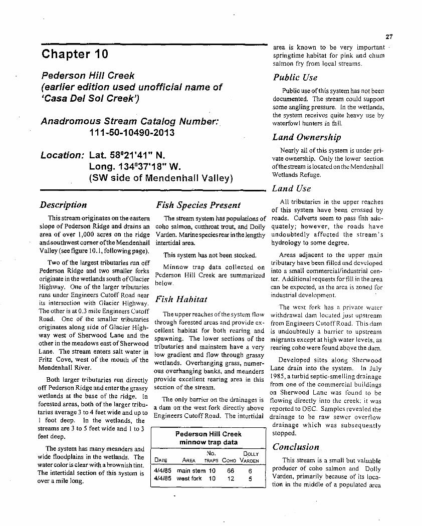
27
Chapter 10
Pederson Hill Creek (earlier edition used unofficial name of 'Casa Del Sol Creek')
Anadromous Stream Catalog Number: 111-50-10490-2013
Location: Lat. 58°21 '41" N. Long. 134°37'18" W. (SW side of Mendenhall Valley)
Description This stream originates on the eastern
slope of Pederson Ridge and drains an area of OVer 1,000 acres on the ridge andBouthwest comer ofthe Mendenhall Valley (see figure 10.1, following page).
Two ofthe largest tributaries run off Pederson Ridge and two smaller forks originate in the wetlands south ofGlacier Highway. One of the larger tributaries runs under Engineers Cutoff Road near its intersection with Glacier Highway. The other is at 0.3 mile Engineers Cutoff Road. One of the smaller tributaries originates along side of Glacier Highway west of Sherwood Lane and the other in the meadows east of Sherwood Lane. The stream enters salt water in Fritz Cove, west of the mouth of the Mendenhall River.
Both larger tributaries run directly off Pederson Ridge and enterthe grassy wetlands at the base of the ridge. In forested areas, both of the larger tributaries average 3 to 4 feet wide and up to I foot deep. In the wetlands, the streams are 3 to 5 feet wide and I to 3 feet deep.
Fish Species Present The stream system has populations of
coho salmon, cutthroat trout, and Dolly Varden. Marine species rear in the lengthy intertidal area.
This system has not been stocked.
Minnow trap data co IIected on Pederson Hill Creek are summarized below.
Fish Habitat
The upper reaches ofthe system tlow through forested areas and provide excellent habitat for both rearing and spawning. The lower sections of the tributaries and mainstem have a very low gradient and flow through grassy wetlands. Overhanging grass, numerous overhanging banks, and meanders provide excellent rearing area in this section of the stream.
The only barrier on the drainages is a dam on' the west fork directly above Engineers Cutoff Road. The intertidal
Pederson Hill Creek minnow trap data
The system has many meanders and No. DplLYwide floodplains in the wetlands. The
DATE AREA TRAPS COHO VARDENwatercolor is clear with a brownish tint.
4/4/85 main stem 10 66 6The intertidal section of this system is 4/4/85 west fork 10 12 5over a mile long.
area is known to be very important springtime habitat for pink and chum salmon fry from local streams.
Public Use Public use ofthis system has not been
documented. The stream could support some angling pressure. In the wetlands, the system receives quite heavy use by waterfowl hunters in fall.
Land Ownership Nearly all of this system is under pri
vate ownership. Only the lower section ofthe stream is located on the Mendenhall Wetlands Refuge.
Land Use All tributaries in the upper reaches
of this system have been crossed by roads. Culverts seem to pass tish adequately; however, the roads have undoubtedly affected the stream's hydrology to some degree.
Areas adjacent to the upper main tributary have been filled and developed into a small commercial/industrial center. Additional requests for fill in the area can be expected, as the area is zoned for industrial development.
The west fork has a private water withdrawal dam located just upstream from Engineers Cutoff Road. This dam is undoubtedly a barrier to upstream migrants except at high water levels, as rearing coho were found above the dam.
Developed sites along Sherwood Lane drain into the system. In July 1985, a turbid septic-smelling drainage from one of the commercial buildings on Sherwood Lane was found to be tlowing directly into the creek; it was reported to DEC. Samples revealed the drainage to be raw sewer overtlow drainage which was subsequently stopped.
Conclusion. This stream is a small but valuable
producer of coho salmon and Dolly Varden, primarily because of its location in the middle of a populated area

28
c UJ
bank and forest cover
undercut grass banks
PEDERSON HILL CREEK
Scale: 1 inch = 600 It (approx.)
."... Tidal influence to here
Uniformly shallow mud bottom, some gravel
(creek continues for 1/4 m1le) /
Glacier Highway
",wetland tributary
Pool~riff[e configurationexcellent spawning habitat,
Figure 10.1 Pederson Hill Creek.
/dam
"•oa:
•~ .S• Q)
where its fish production is in such high demand.
Land use that would degrade the fisheries values ofthis stream can be expected in the future, and stipulations offering maximum protection to the stream's fishery values must be provided.
Recommendations Excellentfish habitat is found through
out this stream; thus. critical review of land use permit applications and on-site surveys will be required to maintain habitat values. As mitigation for permitted crossings in the upper reaches, pools could
undercut grass banks
mud and sand suostrate
be e.xcavated in the stream for rearing and fish refuge during low nows. In the lowerareas, spawning substrate could be placed in the stream adjacent to culverts. The magnitude of the salmon spawning escapements in this system should be determ ined. •

29
Chapter 11
Cove Creek
Anadromous Stream Catalog Number: none
Location: Lat. 58°19'42" N. Long. 134°36'56" W. (9.4 mile North Douglas Highway)
Description
Cove Creek flows in a northerly direction for approximately I mile on Douglas Island and enters salt water in Fritz Cove at approximately 9.4 mile North Douglas Highway (figure ILl). The stream has a very steep gradient and a barrier falls at tidewater.
Fish Species Present
There may be resident fish above the falls, but because of the stream's very small size and its steep gradi~ ent, it has not been surveyed.
Auke Bay
GASTINEAU CHANNEL
Frit= Cove
Douglas
N Island
t Scale: 1 inch = 1 mi.
COVE CREEK
Public Use
No public use has been documented.
Land Ownership
The stream is located within the boundaries of the Tongass National Forest.
Land Uses
Cove Creek is crossed by the North Douglas Highway near tidewater.
Conclusion
Cove Creek presently has little value as a fish stream.
Recommendation
Cove Creek would be worthy of an investigation to determine the feasibility of using its water for imprinting salmon smolts to Fritz Cove. The marine shoreline topography would be suitable for the use of net pens in which tish could be retained for imprinting.
Its water quality should be maintained because ofthe potential impact· it could have on Fritz Cove. •
Figure 11.1 Cove Creek.

30
Chapter 12
Cowee-Davies Creek
Anadromous Stream Catalog Numbers: . 115-20-10620 &115-20-10620-2003
Location: Lat. 58°39'42" N. Long. 134°56'32" W. (40 mile Glacier Highway)
Description The Cowee-Davies system drains
an area of approximately 46 square miles and enters salt water in the south end of Bemers Bay (figure 12.1). The Cowee-Davies system runs semiglacial from spring to fall and clear during the colder months.
Cowee Creek averages 40 to 50 feet in width and 2 to 4 feet in depth near the highway bridge. Cowee Creek flows for approximately 9 miles in a westerly direction and has several tributaries, of which Davies Creek is the largest. Cowee Creek has a low to moderate gradient throughout its length.
Smaller tributaries include Canyon Creek and the south fork ofCo wee Creek (figure 12.1).
Davies Creek drains a basin approximately 2 miles north of Cowee Creek and enters Cowee Creek approximately \f, mile above the bridge. Davies Creek has a low gradient in the upper basin, assumes a steep gradient at the mouth of the basin and again flattens out prior to joining Cowee Creek.
Fish Species Present
The Cowee-Davies system has populations of coho, pink, and chum salmon, Dolly Varden, and cutthroat trout, and it is reported to have small runs of spring and fall steelhead.
ment surveys. The large drainage and .semi-glacial water condition are the main reasons for the lack of informa~ tion on its fish populations. The
Cowie-Davis Creek system might be one of the most productive systems on the Juneau road system. It is believed that the Cowie-Davis Creek system could have annual fish returns of the following magnitudes:
coho salmon 2,000 pink salmon 30,000 chum salmon 8,000 Dolly Varden 20.000 cutthroat trout 1,000 steelhead trout 100
Salmon escapement data are presented in table 12.1.
Juvenile fish trapping data are not available for this stream .
There are no tlsh stocking records for the Cowee-Davies Creek system.
Table 12.1. Summary of salmon escapement data for Cowee Creek.
YEAR COHO
1949 1950 1959 1960 1961 1962 1963 1964 1965 1966 1967 1968 1969 1970 1971 1980 1981 1982 1983 1984 1985 1986
1987 1988 1989 1990 1991
---
---
---
------
--
113 (10/21)
25 (10113) 15 (10/28)
19 (10/07) 7 (10/25)
-----
PINK
32 (08/26) 17 (08/26)
no fish observed no fish observed
no fish observed no fish observed no fish observed no fish observed no fish observed
no fish observed no survey
3,000 (08/20) 1,000 (07/28)
69 (10/21)
67 (10113) 0
18,285 (08/28)
-16,300 (08/06)
1,427 (08112) 4,656 (08/29)
--
CHUM
400 (08/26) 300 (08/26) 100 (08/22)
no fish observed no fish observed 1.200 (1011 I )
8 (0812l) no Iish observed no fish observed no fish observed no fish observed no fish observed
7 (10114) no fish observed no survey
8 (08/20) . -
190 (08/29) 141 (08/04)
-
38 (08112) 14 (08/15)
--
1992 10,000 (07/22) --Fish populations in this large sys1993 200 (07/21)- -tem have never been assessed, either 1994 19,150 (07/27)- 2,500 (07/20)through juvenile fish studies or escape- I
I
I

31
Berners~~ Bay. i . COWEE-OAVIES CREEK
~..
:'···4·......· ','';,•••• ', J, Scale: 1 inch = 1 mi.
"
. \\~. .
.... :.
\
/
/
--
Figure 12,1 Cowee-Davies Creek
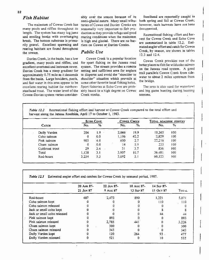
32
Fish Habitat
The mainstem of Cowee Creek has many pools and riffles throughout its length. The system has many log jams and eroding banks with overhanging brush. The bottom substrate is primarily gravel. Excellent spawning and rearing habitats are found throughout the stream.
Davies Creek, in the basin, has a low gradient, many pools and riffles, and excellent overhead and instreani cover. Davies Creek has a steep gradient for approximately 0.75 mile as it descends from the basin. Large boulders, pools, and fast water in this area appear to be excellent rearing habitat for rainbowsteelhead trout. The water level of the Cowee-Davies system varies consider
ably over the season because of its semi-glacial nature. Many small tributaries of Cowee and Davies Creeks are seasonally very important to fish production as they provide refuge and good rearing conditions when the mainstem is high and glacial. There are no barriers on Cowe. or Davies Creeks.
Public Use Cowee Creek is a popular location
for sport fishing on the Juneau road system. The stream provides a remote setting and sufficient area for anglers to disperse and avoid the "shoulder to shoulder" situation which prevails at some other favorite local fishing holes. Sport fisheries at Echo Cove are probably based to a high degree on Cowee Creek stocks.
Steelhead are reportedly caught in both spring and fall at Cowee Creek; however, such harvests have not been documented.
Recreational fishing effort and harvest for Cowee Creek and Echo Cove are summarized in table 12.2. Estimated angler effort and catch for Cowee Creek, by season, are shown in tab les 12.3 and 12.4.
Cowee Creek provides one of the better places to fish forwildcoho salmon on the Juneau road system. A good trail parallels Cowee Creek from tidewater to about 2 miles upstream from the bridge.
The area is also used for waterfowl and big game hunting during huming seasons.
Table 12.2 Recreational fishing effort imd harvest at Cowee Creek compared to the total effort and harvest along the Juneau Roadside, April 17 to October 1,1983.
ECHO COVE COWEE CREEK TOTAL ROADSIDE F1SHERY
CATCH No. % No. 0/0. No. %
Do Ily Varden 206 1.9 2,066 19.9 10,365 100 Coho salmon 0 0.0 1,196 42.2 2,829 100 Pink salmon 903 4.0 600 2.7 n,216 100 Chum salmon 0 0.0 14 5.9 235 100 Cutthroat trout 29 3.4 31 3.7 836 100 Total 1,138 3.1 3.907 10.7 36.481 100 Rod-hours 3,254 5.3 3,092 5.1 60,523 100
Table 12.3 Estimated angler effort and catches for Cowee Creek by seasonal period, 1987.
20 APR 87- 22 JUN 87- 10 AUG 87- 14 SEP 8721 JUN 87 9 AUG 87 13 SEP 87 IIOCTS7 TOT.\L
Rod-hours 487 2,473 890 1,221 5.071 Coho salmon kept 0 0 0 110 110 Coho salmon released 0 0 0 0 0 Jack or small coho kept 0 0 0 8 3 Jack or small coho released 0 0 0 44 44 Pink salmon kept 0 893 0 0 393 Pink salmon released 0 2,785 441 0 3.226 Chum salmon kept 0 300 0 0 300 Chum salmon released 0 343 0 0 343 Dolly Varden kept 0 120 264 93 . 477 Dolly Varden released 0 521 0 10 5"~J_

33
'" '" 0 ~
'" M
00 0'" 0'" '" 0
00 00 I.., 'n '" 0
00 0'"
M 0 '" '" M
11"\ ..... '" 0 '" 0 'n 'n 0'"
00 M Q 00 '" 0M
, '" -l:!'" o Q Q '"
r:: ....
.... 00 00 ,~ M 00 00= M'" "'
QQ Q Q 00Q '" ....'" '" '"
Q 0 00 o Q'" Q '" 0
Q 0 00Q '" Q '" '" '" '" '"
, .... '" '" M = '" '" '" '" '" '" '" '" '" 0 '" 0
;n;n
Public access from about 1 mile above the bridge to private property at the stream mouth presently occurs on U.S. Forest Service land.
Land Use
Cowee Creek has essentially recovered from construction of the Glacier Highway and an old road and bridge near the stream mouth. Logging and associated activities pose the greatest threat to the fishery habitat in the Cowee and Davies Creek drainages; both a native corporation and the U.S. Forest Service have proposed timber harvests in the area in the past.
Land Ownership The mouth of Cowee Creek is in private own
ership. However, there has been no' problem with public acess. From the private lands or [he stream mouth to upstream above the bridge. the land is administered by the U.S. Forest Service.
Conclusion Even though fishery values ofthis system have
not been fully investigated, it is apparent that the Cowee-Davies system has extremely high value as a producer of fish and local fishing opportunities. Proposed logging activities in the watershed could have detrimental effects on both the fish and fisheries. Roading activities could have major impacts on the hydrology throughout the watershed.
Recommendations
It is recommended that logging not be conducted in the Cowee-Davies watershed by any agency. The fishery and recreational values of this system are too great to subject them to potential impact from logging.
Research should be conducted on this watershed to fully assess its fishery resources. The speciesand numbers offish present. angler use. and the contribution ofCowee Creekstocks to northern Southeast fisheries should be determined. •

34
Chapter 13
Cropley Lake
Anadromous Stream Catalog Number: none
Location: Lat. 58°15'50" N. Long. 134°31'15" W.
Description
Cropley Lake is a small, alpine lake (approximately 15 acres) located at the 1.800-foot elevation at the headwaters of Fish Creek on Douglas Island (figure 13.1). There is a barrier to upstream fish movement directly below Cropley Lake.
This lake was used historically to provide water to the Treadwell ditch. The old dam at the outlet is still present.
Fish Species Present
Cropley Lake has a population ofresident Dolly Varden. The Dolly Varden appear to be stunted-i.~ .. very small for their age. There are no fish stocking records for this system.
Fish Habitat
Habitat is typical of a small alpine lake with a short productive growing season. The lake shorelines are muskeg
fish barrier falls
CROPLEY LAKE
4250 It (approx.)
I,, •\, •'- ,,
'''' ,~
·ro '"'0. ''''ro'=,
resident DOlly",
Scale: 1 inch =
Varden
Figure 13.1 Cropley Lake.
with some large rocks. The bottom ofthe lake is primarily mud and large rock.
Sufficient spawning areas are available in the small inlets and spring areas for maintenance of the fish population.
Public Use
Cropley Lake is the only truly alpine lake available from the Juneau road system and is now included in the Eagle Crest Ski Area. The lake is accessible by a I .8-mile-long trail which begins at the Eagle Crest Ski Lodge.
The lake receives light fishing pressure and is visited by numerous hikers every season. The fish are typically small (6-3 inches) but uften numerous.
Land Ownership
Cropley Lake is located in the Tongass. National Forest (U.S. Forest Service land).
Land Uses
Cropley Lake, until 1984, appeared to be very "natural, I, even though the outlet had historically been raised to store more water for use in the mines. In 1984. the outlet was raised farther and the lake became the source of water for the snowmaking machine at Eagle Crest Ski Area. Visible development at the lake has detracted tram the natural setting: however. water use is to be governed by stipulations issued to protect the fish and ensure that the lake is not drained below pre1984 levels.
Conclusion
Cropley Lake provides a unique. remote, alpine angling opportuniry.
Recommendations
Water withdrawal at Cropley Lake should be monitored to ensure that tish are not being adversely impacted. Water withdrawal and diversion should also be investigated to determine if it is impacting survival of eggs or tish in the anadromous section of lower Fish Creek.•

35
Chapter 14
Crossbay Creek
Anadromous Stream Catalog Number: none
Location: Lat. 58015'50" N. Long. 134031'15" w. (2.2 mile Thane Road)
CROSSBA Y CREEK
Scale: 1 inch = 1 mi.
N
t intertidal spawmng up to barriers
Description
Cross bay Creek flows nearly vertically down the face of Gastineau peak and into Gastineau Channel (figure 14.1). It is crossed by Thane Road at mile 2.2. The entire stream consists ofeither extremely steep gradient or falls.
Fish Species Present
Unknown.
Fish Habitat
Cross bay Creek has essentially no fish habitat values. The intertidal area could be used for spawning by non-rearing species, such as pink and chum salmon, but this has not been documented.
Public Use
There is no documented public use of Cross bay Creek.
Land Ownership
Crossbay Creek is on Bureau of Land Management property.
Land Uses
Historical and current land uses which may have impacted this system are unknown.
Conclusion
Crossbay Creek has essentially no fishery values. A small amount of intertidal spawning habitat may be present.
Recommendations
The water quality of this stre:lm should be maintained because of the possible negative impacts it could have on the intertidal area in Gastineau Channel. •
Figure 14.1 Crossbay Creek.

I 36 __________________________________________
Chapter 15
Duck Creek
Anadromous Catalog Number: 111-50-10500-2002
Location: Lat. 58°2.1'33" N. Long. 134°35'52" W.
(directly W of intersection at Egan Dr. and Loop Rd.)
Trap catches on January 14, 1985:
Coho Dolly Cutthroat
Trap smalt l fry Varden trout
I 12 2 1 0
2 1 4 0 0
3 10 32 0 0 4 4 29 0 0 5 4 17 0 0
Total 3 I 84 0
, Coho will smaIt in spring 1985.
A summary of fish stocking is presented in table 15.1, and a summary of salmon escapement counts appears in
Description
Duck Creek runs approximately 3 II, miles in a southerly direction through the middle of the Mendenhall Valley. [t enters the Mendenhall River directly upstream from the Juneau municipal airport runway (figure 15.1). The stream measures from 5 to 15 feet in width and from six inches to 2 reet in depth. The stream bed is essentially gravel and has been subjected to extensive gravel removal since historical times. Excavation has exposed iron deposits which often impart an orange co lor to the water.
Fish Species Present
Duck Creek has wild populations of pink, chum, and coho salmon, Dolly Varden and cutthroat trout. Historically, Duck Creek is reported to have had runs of up to 10,000 chum salmon. As late as
1966. the coho escapement was estimated to be 500 tish. In recent years. the water has been too discolored tram iron sediment to conduct salmon escapement surveys.
Minnow trap catches in Duck Creek adjacent to Mendenhall Mall, May 14, 1984:
Coho Dolly Cutthroat Trap smolt fry Varden trout
1 26 0 0 2 2 16. 0 3 15 0 4 55 0 2 0 5 14 0 0 3
Total 126 2 3 3
Over 100 coho smolt were observed around trap I, and 75 or so coho smolt and2 Dolly Varden were observed around trap 4.
table 15.2. Trapping data for rearing fish in Duck Creek are presented in table 15.3.
In April 1994, the National Marine Fisheries Service Auke Bay Laboratory investigated Duck Creek as part of a stream restoration project. An estimated 4.955 juvenile coho salmon were found to be rearing in the stream. Overwinter survival ranged from 79% in SuperBear Pond Gust north of Egan Drive) to 39% in more upstream areas.
During spring 1994. 3,399 coho smolts were c-oded wire tagged as they left the stream. In rail 1994. "I adult coho were counted in Duck Creek. Also trapped during the investigation \vae 235 Dolly Varden. 112 sockt!ye salmon juveniles, 24 cutthroat trout. Schum salmon try. and 5 pink salmon fry.
.. .cont'd
Table 15.1. Stocking record for Duck Creek.
DATE SPECIES NUMBER SIZE
1919-20 coho 50.000 fry 6119/53 brook 3,100 8/03/54 rainbow 1,000 fry 8/02157 rainbow 11.000 1958 rainbow 1.500 feeding fry 1959 rainbow 1.000 Ii'Y 1960 rainbow 1,000 fry 1960 rainbow 1.000 fry
5/05177 coho 50.000 try 5111177 coho 50,000 fry 5117177 coho 29.620 try 5/31/84 coho 93.747 try
BROOD SOURCE
--Kodiak C.C. Kodiak Kodiak Kodiak C.C. Kodiak C.C. Kodiak C.c. Mendenhall Mendenhall Mendenhall Salmon Creek
HATCHERY REMARKS
--
Auke Bay Auke Creek Auk. Creek Deer Mountain Deer Mountain Auke Bay Crystal Lake Crystal Lake Crystal Lake Sal mon Creek
USF&WS
NSRRA

37
Old. partially filled-in gravel pit high concentration af
suspended iron sediment in
DUCK CREEK
N
t (not to scale)
Potentially excellent spawning and rearing stream habitat found throughout. but is severely impacted by sediment deposition and low flows
Duck Creek
-
water
Old gravel pit - goad bank coverage
Figure 15.1 Duck Creek.

38
Fish Habitat
Duck Creek has been subjected to more physical land use impacts than any other stream in the Juneau area. Natural pools in the upper reaches have tilled in with sediment from polluted streamside drainage. Other larger ponds which were gravel pits still provide some rearing habitat. Most of these ponds have good overhanging cover along the shore q
lines. Emergent vegetation has encroached into the mainstem channels. There are several good riffle areas located throughout the stream which provide spawning habitat.
In 1984, lower Duck Creek from Berners Avenue to Glacier Highway was 'channelized' as stipulated by this Department in response to a Title 16 permit application. This section of the creek, which often went dry during low flows, now contains a good channel and refuge pools which should reduce loss of fish except during exceptionally dry periods.
Public Use Duck Creek originally served as a
source of fish to be used as mink feed by fur farmers located in the Mendenhall Valley. Several thousand fish, presumably coho and chum salmon were taken from the stream annually.
Historically the creek is reported to have produced excellent trout fishing. The stream is presently closed to fishing; however, the stream banks receive considerable use by children from adjacent residential areas.
Land Use
Upper reaches of Duck Creek are bordered by small private residential lots. The lower section of the stream flows through larger commercial parcels and airport property owned by the City and Borough of Juneau.
Duck Creek is located in, and adjacent to, major areas of development in the Mendenhall Valley and has been subjected to many forms of habitat abuse.
Table 15.2. Salmon spawning escapement countS in Duck Creek, 1940-1993.
YEAR COHO PINK CHUM
1940 1966 500 (...) 1969 I (...) 1973 120 (... )
2 (10/15) 1983 1978
13 ( 11/08) 1986 18 (10/27) 1987 17 (10/21) 1989 3 (10/26) 1990 13 (\0119) 1992 80 (11109) 1993 21 (10/04)
From historical times to the ~arly
1970's the stream was used as a local source of gravel, with little regard for fishery values. Gravel excavation exposed iron deposits in the upper drainage, which seasonally give a nearly opaque orange color to the water and affect light penetration and productivity.
Streamside excavation and drainage from local residential developments have produced heavy loads of sediment that have filled in most pools in the stream.
Water withdrawal is believed to be a
major problem for Duck Creek. Many residences in the Mendenhall Valley have wells which draw on this aquifer. These same homes are now hooked up to the CBJ sewer system which drains the valley through a pipe. This is believed to have an impact on water levels in valley streams.
The lower part of Duck Creek is often dry during extended warm, dry spells. . Duck Creek has reportedly gone dry periodically even in historical days.
Many roads cross and parallel Duck Creek, which provides a source ofsediment and other pollutants to the stream.
Conclusion
Duck Creek has suffered significantly from a multitude of land uses since historical times, but the stream still holds viable populations of fish. Major impacts from land use can now be prevented through the current permit application review process, and with
10,000
2 ( ... ) I ( ...)
the development of the municipal water system, more water should be available for Duck Creek.
Duck Creek was identified many years ago as an excellent stream for a community involvement restoration project. In 1989, the ADf&G Sport fish Division, in cooperation with the City and Borough of Juneau, cleared all the non-natural debris from Duck Creek. The slream's flow increased immediately and began to !lush built-
up sediment from the stream.
The Duck Creek restoration project was begun in fall 1993. The project is conducted by the Natiomal Marine Fisheries Service, Trout Unlimited. and other cooperators. The goal of the program is to assess the fish habitat and fish populations of Duck Creek and to work toward restoration of the stream.
Recommendations
It is recommended that stream cleanup program mented on Duck Creek.
an be
annual imple
A major factor in the future viability of Duck Creek will be the amount of water available for stream flow. It will be necessary to maintain a stream flow sufficient for the prevention of dry-up and low dissolved oxygen levels. in order to stabilize the water temperature and to reduce the infiltration of iron sediment.

39
Table 15.3. Summary of minnow trap data for Duck Creek, 1975-1989.
TRAPS COHO DOLLY VARDEN STICKLE
DATE SET SMOLT FRY TOTAL SMOLT FRY TOTAL BACK OTHER
6101175 6 1 0 1 1 3 4 45 ... 6109175 6 1 0 1 4 13 17 12 ... 6/20175 6 6 77 83 1 25 26 115 6127175 6 5 82 87 0 0 0 145 ... 6/30175 5 3 69 72 0 2 2 65 ... 7112175 5 8 68 76 - I 1 33 ... 7115175 4 0 101 101 0 0 0 15 ... 8/02175 4 3 96 99 0 .0 0 70 ... 8/04175 4 1 164 165 0 0 0 24 8112175 4 3 103 111 0 0 0 60 3120175 4 1 152 153 0 0 0 16 3/28175 ~ -I 130 134 0 0 0 -16 9103175 4 3 112 115 0 0 0 37 ... 5114/84 5 ... ... 128 3 .. ' ... ... 3 ct 6112/84 5 ... ... 6 1 ... ... ... .. . 6/22/84 5 ... ... 17 0 ... ... ... ... 6/22/84 2 ... ... 14 0 ... ... ... 7/24/84 10 ... ... 10 1 ... ... ... ... 7/24/84 6 ... ... 26 0 ... ... .. . 1/14/85 5 ... ... 115 0 ... ... ... .. . 4/02/85 4 ... ... 2 0 ... ... ... ... 4/02/85 6 ... ... 132 1 ... ... .. . 4/03185 5 ... ... 75 1 ... ... ... .. . 4103185 5 ... ... 104 0 ... ... .. . 4109185 4 ... ... 71 8 ... ... ... .109185 4 ... 39 0 ... ... 7131189 10 24 0 l..;t
Hydrologic analysis of the drainage and Mendenhall Valley should be conducted, to identifY water sources that could be routed to Duck Creek.
Once water flow is assured, the stream bed should be cleaned to remove build-ups of sediment and to loosen up gravel. Stream restoration and annual stream maintenance could be provided by volunteer groups and community involvement.
Further detrimental impact to Duck Creek should be prevented through:
(I) prevention of further sedimentation;
(2) requiring the filtering of all drainage onto the stream;
(3) maintenance of water quality;
(4) provision of streamside greenbelts of at least 50 feet on each side of the stream.
Pools should be excavated in lower Duck Creek to provide ref
uge for fish during dry periods. Such pools and improved'channels should be required as mitigation
on Title 16 permits. DuckCreck downstream from Cinema Drive would benefit from such pools and channel improvements. •

40
Chapter 16
Eagle Creek
Anadromous Stream Catalog Number: 111-40-10920
Location: Lat. 58°18'48" N. Long. 134°27'27" W. (2.4 mile North Douglas Highway)
mtertidal spawmng
fill and old'trailer court
to Juneau ...N. Douglas Highwa
Good habitat for resident fish species
(not to scale)
····--·1 Fair spawning and rearing habitat. plunge pools and good gravel
EAGLE CREEK
~ steep barrier faUs
Description
Eagle Creek, on Douglas Island, flows approximately 3 miles in a northerly direction and enters salt water in Gastineau Channel (figure 16.1).
The stream has a high gradient in the lower section and drains a watershed of approximately 3 square miles.
The stream cuts through a steep gorge above the North Douglas Highway. An upland muskeg is located upstream from the gorge. Downstream from the gorge, the stream is 12 to 20 feet wide and up to 3 feet deep in pools. The water is clear, with a brown tint during high flows.
Fish Species Present
Coho and pink salmon and Dolly Varden are present in Eagle Creek. The stream has not been stocked.
Minnow trap data and salmon escapement data for Eagle Creek are summarized below:
Eagle Creek minnow trap data I
DATE
No. TRAPS
DOLLY
VARDEN COHO l
08/16/70 08/16/85
2 2
5 17
1 4
Eagle Creek salmon escapement data
DATE PINK CHUM COHO
I 08/16/84 840 - - I 10/23/84 - - 14 I08/04/85 192 8 1988 118 1 1989 - - 1990 685 - 08/08/91 10 9 08/24/93 7 4 08/10/94 - 31 09/07/94 2182 -
Figure /6.1 Eagle Creek.
41
Fish Habitat
Fish habitat is limited in Eagle Creek due to a barrier falls located about 0.1 mile above tidewater. Coho salmon and Dolly Varden spawn and rear upstream from the North Douglas Highway culvert. The water velocity is swift and rearing pools are few. Bank cover is provided by marure stands ofspruce and hemlock.
Excellent rearing habitat .is found above the barrier falls, and it is presumed that resident Dolly Varden and perhaps cutthroat trout are present. Small pockets ofspawning gravel are found upstream from the highway and intertidal spawning habitat is found downstream from the highway.
Public Use Eagle Creek receives little public use
except at tidewater, where occasional
sport fishing has been observed. A good trail parallels the stream and is used mainly by deer and grouse hunters.
Land Ownership
The headwaters ofEagle Creek flow across U.S. Forest Service land, the middle section is on City and Borough of Juneau property, and private property bounds the stream in the lower section.
Land Uses Eagle Creek was impacted by con
struction of the North Douglas Highway crossing and some fill of adjacent tidelands at the stream mouth. The stream has mostly recovered from these activities and is in an essentially natural condition upstream from the highway. A large gravel pit lies adjacent to Eagle Creek; however, the pit is presently not affecting the stream.
Chapter 17
Eagle River
Anadromous Stream Catalog Number: 111-50-10070
Location: Lat. 58°31'20"N. Long. 134°48'13"W. (28.7 mile Glacier Highway)
Description
Eagle River originates from a lake at the base of the Eagle Glacier and flows about 5 miles across the forelands and into Lynn Canal (figure 17.1, next page).
The river has a high glacial content except from late fall to early spring. Thus, neither rearing nor spawning fish surveys have been conducted on the mainstem.
The river has at least 15 small clearwater tributaries and drains an area of approximately 26 square miles.
Fish Species Present Eagle River is known to have popu
lations ofcoho, pink, and chum salmon, Dolly Varden, and cutthroat trout. Eagle River is also reported to have been stocked with pink salmon eggs in 1919.
Water rights for 17,000 gallons per day are on file for Eagle Creek. Eagle Creek could be impacted by construction of the 'bench road' proposed by the City and Borough.
Conclusion Eagle Creek has been subjected to
some impacts from land use but is currently in a near-natural condition. The highest fish values are for production of non-rearing species, such as pink and chum salmon, in the anadromous section of the stream.
Recommendations Current habitat values should be
maintained through main[~nanct! of water quality, provision of greenbelts. and critical review of land use applications. Further evaluation of the stream above the barrier should be done to
. assess fish populations. •
Fish Habitat
The mainstem. the mouths of the clearwater tributaries, and the tributaries themselves provide good rearing and spawning habitat. Fish populations and habitat of the mainstem have not been assessed due to the glacial water. The deep pools in Eagle River and perhaps Eagle Lake may be used for overwintering by Dolly Varden and cutthroat trout.
Boulder Creek is the largest tributary entering Eagle River on the north shore. It is located about .2 miles upstream from the Glacier Highway bridge. The stream tlows approximately two miles and is from 6 to 10 feet in width and 4 to 8 inches deep. Two minnow traps set in Boulder Creek on August 26, 1970 caught 18 coho. 17 Dolly Varden, and an additional l-l rearing coho and 10 Dolly Varden were observed in the stream. Cursory stream surveys conducted in 1970 on several other small tributaries entering Eagle River on the north shore showed that

42 ... '\ \ .... .....,. Eagle Glacier-... /~
.-\:.\.~ #I
I
EAGLE RIVER
Scale: 1 inch = 0.5 mi.
.::::-' ~f"',
, / , , r. \.114',.. , ,H~rber\
Figure 17.1 Eagle River.

43
mosttributaries contained coho salmon and Dolly Varden.
Stream surveys have not been conducted on any tributaries entering Eagle River on the south shore.
Public Use
Eagle River has a good trail on the north shore that receives heavy public use. Recreational angling is conducted at the mouth of its clearwater tributaries (see map figure 17.1 on opposite page).
The magnitude of 'in-stream' angling pressure has not been quantified. Eagle River near salt water and the beach adjacent to the stream mouth have long been favorite locations for sport fishing.
A public picnic area situated on the north shore of the stream mouth receives heavy use. A Boy Scout Camp is operated on the south shore of Eagle River at its mouth.
Recreational angling effort and harvest data collected at Eagle Beach are presented below:
Eagle Beach harvest data
YEAR EFFORT HARVEST
1970 76 angler 66 fish hours (species
unknown) 1983 365 angler 366DV
hours 33 coho 33 cod
Eagle River Beach is a large area and provides ample space for anglers to spread out and avoid' crowded' conditions that exist at some popular fishing spots.
Land Ownership
Eagle River is located primarily on U.S. Forest Service properry; however, there are small private holdings near Glacier Highway. The properry on the south side ofEagle River near the mouch belongs to the Boy Scouts of America.
Land Uses In the past, Eagle River has been
impacted in the stream and on the flood plain by gravel removal, but gravel is not currently being mined in the system.
The Eagle River drainage is managed by the USFS, and will be managed in a roadless state for dispersed public activities. Roads or concentrated recreational development are not anticipated. Eagle River has been identified as a potential future source of gravel.
Conclusion Eagle River is one ofthe largest drain
ages in the Juneau area and has very high habitat values. The area receives a high level of public use.
Recommendations The current habitat values of Eagle
Rivershould be maintained. Gravel mining should not be permirted in the stream or anywhere in the flood plain where fishery resources may be impacted.
Upwelling areas have been identified in the moraine in front of Eagle Glacier. These should be investigated to determine their potential for use in fish habitat enhancement. Fishery resources in the Eagle River mainstem and tributaries should be investigated to identify fish species present and numbers of rearing and spawn Ing fish us ing the area. •
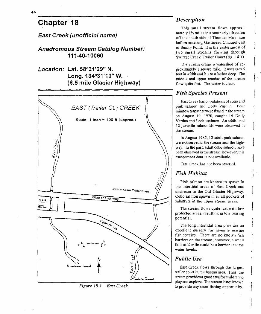
44
Chapter 18
East Creek (unofficial name)
Anadromous Stream Catalog Number: 111-40-10060
Location: Lat. 58°21'29" N. Long. 134°31'10" w. (6.5 mile Glacier Highway)
CAP. o tation
EAST (Trailer Ct.) CREEK
Scale: 1 inch = 100 It (approx.)
Sw'tzI ar Creek Trailer Court
Glacier Highway
" .... wetlands J." • >
N
t Figure lB. 1 East Creek.
-••-<.J
Description
This small stream flows approximately 1Yz miles in a southerly direction off the south side of Thunder Mountain before entering Gastineau Channel east of Sunny Point. It is the easternmost of
. two small streams flowing through Switzer Creek Trailer Court (fig. 18.1).
The stream drains a watershed of approximately 1 square mile. It averages 5 feet in width and is 2 to 8 inches deep. The middle and upper reaches of the stream flow quite fast. The water is clear.
Fish Species Present
East Creek has populations ofcoho and pink salmon and Dolly Varden. Four minnow traps that were fished in the stream on August 19, 1970, caught 16 Dolly Varden and 5 coho salmon. An additional 12 juvenile salmonids were observed in the stream.
In August 1985, 12 adult pink salmon were observed in the stream near the highway. In the past, adult coho salmon have been observed in the stream; however, this escapement data is not available.
East Creek has not been stocked.
Fish Habitat
Pink salmon are known to spawn in the intertidal areas of East Creek and upstream to the Old Glacier Highway. Coho salmon spawn in small pockets of substrate in the upper stream areas.
The stream flows quite fast with few protected areas, resulting in low rearing potential.
The long intertidal area provides an excellent nursery for juvenile marine fish species. There are no known tish barriers on the stream: however, a small falls at '!. mile could be a barrier at some water levels.
Public Use
East Creek flows through the largest trailer court in the Juneau area. Thus. the stream provides a good area for children to play and explore. The stream is not known to provide any sport fishing opportunity.
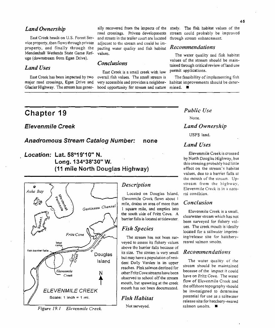
45
Land Ownership
East Creek heads on U.S. Forest Service property, then flows through private property, and finally through the Mendenhall Wetlands State Game Refuge (downstream from Egan Drive).
Land Uses
East Creek has been impacted by two major road crossings, Egan Drive and Glacier Highway. The stream has gener
ally recovered from the impacts of the road crossings. Private developments and streets in the trailer court are located adjacent to the stream and could be impacting water quality and fish habitat values.
Conclusions East Creek is a smali creek with low
overall t1sh values. The small stream is very accessible and provides a neighborhood opportunity for stream and nature
study. The fish habitat values of the stream could probably be improved through stream enhancement.
Recommendations The water quality and fish habitat
values of the stream should be maintained through critical review ofland use
permit applications.
The feasibility of implementing lish habitat improvements should be determined.•
Chapter 19
EJevenmile Creek
Anadromous Stream Catalog Number: none
Location: Lat. 58°19'10" N. Long. 134°38'30" W. (11 mile North Douglas Highway)
Public Use None.
Land Ownership
USFS land.
Land Uses
Elevenmile Creek is crossed by North Douglas Highway, but this crossing probably had little effect on the stream's habitat values, due to a barrier falls at
I:t Alike Bay
Gastineau Channel
Fritz Cove :-l\' ,-?-iL--,--1
."boat ~~
",~,~am~Pt:;;~~~~ 0; \ Q
<-' Douglas
Elevenmile Creek
Island
ELEVENMILE CREEK Scale: 1 inch = 1 mi.
Figure 19.1 Elevenmile Creek.
Description
Located on Douglas Island. Elevenmile Creek !lows about I mile, drains an area of more than I square mile, and empties into the south side of Fritz Cove. A barrier falls is located attidewater.
Fish Species
The stream has not been surveyed to assess its fishery values above the barrier falls because of its size. The stream is very small but may have a population ofresidem Dolly Varden· in its upper reaches. Pink salmon destined for other FritzCove streams have been observed to school off the stream mouth, but spawn ing at the creek mouth has not been documented.
Fish Habitat Not surveyed.
the mouth of the stream. Upstream from the highway. Elevenmile Creek is in J natural condition.
Conclusion
Elevenmile Creek is a small. clear...vater stream which has not been surveyed for tishery values. The creek mouth is ideally located for a saltwater imprinting/release site for hatcheryreared salmon sma Its.
Recommendations
The water quality of the stream should be maintained because of the impact it could have on Fritz Cove. The water flow of Elevenmile Creek and the offshore topography should be investigated to determine potential for use as a saltwater release site for hatchery-reared salmon smolts. •

46
Chapter 20
Falls Creek
Anadromous Stream Catalog Number: 111-40-10940
Location: Lat. 58°19'27" N. Lon.g.134°28'47" W. (3.5 mile North Douglas Highway)
fish barriar-3' drop with insufficient
Jump I
(not to scale)
Resident Dolly Varden
from highway to waterfall-
FALLS CREEK
frequent small rearing pools
majorspawning habitatsome nice plunge pools
numerous wlndfallsgood rBarmg, soma spawning
ff/J/I~'->",- shale cliff
Figure 20.1 Falls Creek.
Description Falls Creek is 5-12 feet wide, 6-12
inches deep, and flows for about 2 miles on Douglas Island. It enters Gastineau Channel at 3.5 mile North Douglas Highway (figure 20.1). The creek drains an area ofover 1square mile and has a steep gradient. The water color is clear with.a brown tint
Fish Species Present ·Falls Creek contains populations of
Dolly Varden and cutthroat trout.
Minnow trap data for Falls Creek are summarized below:
Falls Creek minnow trap data
No. OF DOLLY CUTTHROAT
DATE TRAPS VARDEN TROUT
06126/70 3 08/22/84 5
15. 28
2 o
Fish Habitat Most of the spawning and rearing
areas are located from tidewater up to the culvert that crosses under the North Douglas Highway. Limitedspawning habitat is located upstream from tht! highway.
Rearing habitat upstream from the highway is limited due to the steep gradient and fast water. A 3- to 5-toot drop at the lower end of the highway culvert and small falis about 200 yards above the highway are probably barriers to fish at certain water levels. Intertidal spawning
. has not been documented at Falls Creek.
Public Use
None documented.
Land Ownership
The headwaters of Falls Creek are located in the Tongass National Forest. Its middle reaches lie on City and Borough of Juneau property and private property adjacent to Douglas Highway.
The tidelands are part of the Mendenhall Wetlands State Game Refuge.

47
Land Uses
Falls Creek has been impacted by the construction ofNorth Douglas Highway, as the culvert was not properly installed and acts as a barrier to fish passage at certain water levels. Falls Creek could be impacted by the 'bench road' proposed to be constructed
through the stream's headwaters by the City and Borough of Juneau.
Conclusion
Falls Creek is a small stream with limited fishery values, mainly because of its steep gradient and existing fish barriers.
Recommendations
The water quality of the stream should be maintained because of the potential impacts it could have on Gastineau Channel. The intertidal area should be investigated to determine its potential for enhancement ofspawning
habitat.
Chapter 21
Fish Creek
Anadromous Stream Catalog Number: 111-50-10690
Location: Lat. 58°19'51" N. Long. 134 °35'39"W. (8.3 mile North Douglas Highway)
and also provided new shore-based king and coho fisheries at F ish Creek for Juneau anglers.
Six minnow traps set on June 2:2. 1970. caught 10 coho salmon and 19 Dolly Varden. An additional 84 coho fry were observed in the stream. Fish Creek is a major producer of local pink and chum salmon. Table 21.2 shows an extensive record of salmon escapements.
Fish Habitat
Description
Fish Creek originates from Cropley Lake on north Douglas Island. It flows approximately 6 miles, drains a watershed of about 14 square miles, and enters salt water on the south side of Fritz Cove (fig. 21.1, following page). The stream has a fairly steep gradient, but there are numerous pools in the first 21', miles above tidewater. The lower Y. mile, located downstream from North Douglas Highway, is intertidal.
Three tributary streams feed into Fish Creek. The first tributary is located just above the highway and is about 300 feet long. It is slough-like with a silty iron-colored mud bottom. The second tributary is about 1 Y. miles upstream and has a fish barrier 25 feet upstream from Fish Creek. Water in Fish Creek is nearlY'crystal clear.
Fish Species Present
1986, the old gravel pit which is connected to Fish Creek has been used as a release site for king and coho smolts released in the Juneau sponfishing enhancement program (table 21.1). Fish released from Fish Creek have contributed well to local marine sport fisheries
Fish Creek is primarily a spawning stream for pink and churn salmon, with limited rearing habitat in pools. The lower lY2 miles of the streambed is gravel of varying sizes. Excellent spawning habitatexisrs from the stream mouth upstream for 1/-1 In de and is used extensively by pink Jnd chum salmon.
Table 21.1_ Summary of "atchery-reared coho and chinook salmon salmon sma It released at Fish Creek, 1986-1994.
YEAR
NUMBER OF NUMBER OF
KING SALMON COHO SAL.\ION
1986
1987
1988
1989
1990
1991
1992
1993
1994
60.272
62,501
74,000
67,000
149,472
150,246
285,719
164,998
143,000
0
53.000
50.000
42,000
47,000
0
0
0
0
Total 1,157,208 192,000
Fish Creek has populations of coho, pink, and chum salmon, Dolly Varden and cutthroat and rainbow trout. Since

48
Gastineau Channel
fish barrierfalls
FISH CREEK
to Douglas
good spawning and rearing habitat-pool and riffle configuration
,-----.. _~ .. , .....---"..... --\_ ...., I,,,,,
I
,, " '-\ ,~
'ro'OlIe.,'''m\:. '0I;:; '0,::l"
Scale: 1 inch = 4250 It (approx.)
resident Dolly Varden
Figure 2].]
Good spawning habitat is interspersed between pools throughout the next 2Y, miles upstream. Good rearing habitat is located in large pools. Logs and treces provide some overhead and instream cover.
There is a narrow gorge 3 miles upstream and a series of rapids which are a barrier to upstream migration. Good habitat for resident species exists above the barrier.
Fish Creek.
Public Use Fish Creek has been a favorite fishing
location of local anglers since access was provided by the North Douglas Highway. The stream supports one of the largest freshwater fisheries in the immediate Juneau area. A good trail parallels the stream for about 3 miles and provides excellent angler access.
Fish bound for Fish Creek are also taken by anglers fishing along the shores
of Fritz Cove. Recreational angling and catch data for the Fish Creek sport fishery are presented in table 21.3.
Land Ownership Fish Creek originates from Cropley
Lake, located on the Tongass National Forest. The lower reaches of Fish Creek are located on Juneau City and Borough property.
Land Uses Both banks of Fish Creek down
stream from the highway were impacted by land use activities associated with the construction of the North Douglas Highway in the early 1970's. The area was used t"or a
construction base-Le., rock crusher. batch. plant, and gravel source. A portion ofthe intertidal area was filled in. The stream has essentially recovered from effects of the construction.
From 1974 to 1976, a road was constructed through the drainage to access the Eagle Crest ski area. Sediment from road fill was known to have drained intu the creek. In 1984. a snowmaking machine was installed at Eagle Crest. The machine draws water from Crop ley Lake: th is does not remove water from the drainage. but diverts it from the scream for a period oftime. During periods oflow precipitation, water use at Cropley Lake could easily impact.the survival ofeggs deposited in lower sections of Fish Creek.
Fish Creek could be SUbjected to further development of recreational facilities and road improvement. Future development of industrial areas on North Douglas Island could also negatively impact fishery values. .
Conclusion Fish Creek provides one of the larg
est freshwater fisheries (based on wild fish stocks) on the Juneau road system. The system has essentially recovered from impacts of past land use activities; however, it could be subjected to detrimental land uses in the tuture.

49
Recommendations Table 21.2. Salmon escapement data for Fish Creek, 1960-1994.
YEAR PINK CHUM COHO KI>lG
Fish Creek's tremendous fish values, excellent public access, and high public use warrant the highest level of habitat protection. Ideally, the Fish Creek system should be designated as a top priority fish stream, and fish production and public use would be the top priority use for the system. All other proposed land uses in the area should be given very critical review to ensure that fishery and recreational values are not affected.
Investigations should be conducted to determine if water withdrawal at Cropley Lake is having any detrimen~ tal effects on stream flows in lower Fish Creek during dry winter months. Water quality should be maintained at all times. All developments in the system should be located away from
, the stream to prevent direct impacts.
Fish Creek provides one ofthe best opportunities in the Juneau area for fishery enhancement. It is used as an imprint and release site for hatt;;hery~ reared king and coho salmon smolt.
Salmon returning to Fish Creek pass through ongoing commercial fisheries in outer areas and' home in' on th~ Outer Point-Fritz Cove areas, where they are available for some length of time to the marine sport fishery. Upon returning to Fish Creek, salmon are available to shore-based fishermen in the lower 2Y, miles of stream, which has excellent public access. •
--1,010 (08/1 0) 500 (08/10)1960 1961 801 (07125) -- -
1,500 (08/06)500 (08/06)1962 ---1963 -- -
946 (09/03) 107 (09/03 ) 1964 ----800 (08/20)600 (08120)1965 --1,219 (08/08)6,908 (08/08)1966 -750 (08/09) 4,500 (08/07)1967 -
245 (08/27)1968 6,000 (08/14) ---10,500 (08125) 1,200 (08/27)1969 -
-1970 28,000 (08/18) 150 (08/18) --130 (08/30)2,330 (08/30)1971 ---500 (08/23 ) 3,000 (07/31 ) 1972 --6.000 (07117) 1.500 (07117)1973 -1,200 (08107) -1974 2.000 (08/07) --935 (08104) 185 (08/04)1975 -1,342 (08/05)1976 500 (08/25) --850 (08/04)6,500 (08/04)1977 --1,366 (07/25) 39 (lO/l6)627 (08/03)1978 -1,360 (08/08) 31 (10/31)1979 13,166 (08/29)
3,200 (08/05)1980 5,244 (08/22) - --2 (11/02)5,303 (07/28) 1,200 (07128)1981
1,219 (08/02) I (10125)1982 9,450 (08117) --7 ( 11/03) 16,280 (08/08) 1,466 (08/08)1983 -320 (08/03) 3,380 (08/03) 50 (10/17)1984 -31 (10/28)56,140 (08119) 5,366 (08/08)'1985 -2,047 (08/08) 0 (10128)1986 1,006 (08/08) -281 (08/04) 0 (10/13)28,260 (08117)1987
66 ( 10116) -609 (08/12)1988 2.651 (08/12) 2 {OR. IS)1.187 (07/23) 237 Illi05)1989 5.363 (08108)
-1.486 (07/27) SO i 081 27)1990 37.612 (08/27) I (OS: [3)2.194 (08n3) 244 ( 10/22) 1991 3.832 (08/29)
15 (lOll?)10,478 (08/26) 1.839 (08111) ! 17 (08i26 )1992 - 356 (07121 )1993 540 (08/31 ) 639 (07/28) -1994 14,386 (09/08) 3,943 (08/03) 196 109/01)
Table 21.3. Recreational fishing effort and harvest data for Fish Creek, 1979-1994.
1979 1980 1983 1986 1987 1988 1989 1990 1991 1993 1994 5/1-9/3 6/1-8/31 4/19-9/29 617-9/29 4/20-10/11 9112-10/23 6/19-8/27 6/24-10/14
Angler hours 4,152 3,113 1,687 1,226 1,835 83 3,196 4,951 7.941 - -
HARVEST
Pink salmon 2,479 627 1.252 335 1,864 0 2,054 1.403 459 - -Chum salmon - - 92 23 - - - - 124 - -
King salmon - - - 0 0 0 437 137 274 81 92 Coho salmon - - - 28 0 3 I 1,365 l.405 1.276 - -
Dolly Varden - - 696 391 1,418 327 509 44 352 - -Cutthroat trout - - - 167 0 0 47 64 43 - -

50
Chapter 22
Float Plane Lake
Anadromous Steam Catalog Number: None
Location: Lat. 58°21 '15" N. Long. 134°35'00" W. (alongside runway at Juneau Airport)
Description Float Plane Lake was the original
source ofmaterial for the construction of the Juneau Municipal Airport runway. The lake is 0.85 mile long, 400 feet wide, and averages 4 to 5 feet deep, with a 30-foot deep pocket in the south end (figure 22.1).
The water level of the lake is controlled by a culvert which connects the
·lake with the lower Mendenhall River. The culvert has "flap" gates which allow salt water to enter the lake on high tides.
FLOA T PLANE LAKE
Scale: 1 inch = 612 It
Figure 22.1 Float Plane Lake.
The south side of the lake has extensive slough areas with emergent grass and overhanging willow and aider cover. The lakewater is often cloudy due to the high biological production.
Fish Species Present
Float Plane Lake contains populations of coho, pink, and chum salmon; cutthroat trout; Dolly Varden, and various marine fish species. The lake was reported to have been stocked with rainbow trout at one time; however. no documentation is available. [n 1972. when the lake was drained for construction, salmon ids from...J. to 10 inches were found in the lake. The Salmon Creek Hatchery released 182.60 I coho salmon fry in the lake in.I984 when the hatchery ceased its operations.
Fish Habitat Float Plane Lake !unctions as an estu
ary because of the intrusion of salt water during high tides. Such saline waters. along with the sloughs adjoining the lake and the good cover. provide a rich rearing environment tor limited numbers of salmonids. It is doubtful that the lake would support dense populations a f rearing fish because ofthe shallow depth and lack of overwintering areas.
Pink and chum salmon fry. presumably from the Mendenhall River system. are commonly found in the lake during the spring fryoutmigration. There are no known spawning areas in Float Plane Lake.

51
Public Use
The lake is reported to have historically provided a good sport fishery after it was stocked. Presently, Float Plane Lake receives high use by private and commercial float-equipped aircraft, and the Federal Aviation Administration discourages any 'nonaircraft' activity in the area, for safety reasons.
A public 'access corridor to the Mendenhall Wetlands State Game Refuge extends south of the airport from Radcliffe Street and along a dike at the west end of Float Plane Lake. This area receives a high level of use by hikers,
joggers, birdwatchers, waterfowl hunters, and a few anglers.
Land Ownership
Float Plane Lake is on City and Borough of Juneau property.
Land Uses
Float Plane Lake originated as a result of major construction: the Juneau Municipal Airport. The lake has generally recovered from construction, but currently receives pollutants from aircraft and petroleum products and wi11likely be used as a borrow site for fill in future airport expansion,
Chapter 23
Gold Creek
Anadromous Stream Catalog Number: None
Location: Lat. 58°18'00" N. Long. 134°25'10" W. (middle of Juneau)
Description
Go Id Creek originates on Sheep Mountain in the Juneau icefield and flows for about 5 miles before entering Gastineau Channel near the center of Juneau (figure 23.1).
The stream has a high gradient and numerous pools in the upper reaches. The channel substrate is gravel, large boulders, and bedrock. The water is generally clear; however, it is glacial during the warm summer months.
Downstream from Evergreen Park,
Gold Creek flows all the way to tidewater through a concrete flume.
Fish Species Present
Gold Creek has popUlations of resident Dolly Varden and perhaps eastern brook trout which were stocked in 1953.
A record of fish stocking in Gold Creek is presented here:
DATE SPECIES NUMBER
12117/52 king salmon 60,000 (eyed eggs)
06/23/53 brook trout 4,000 (fry)
12113153 king salmon 50,000 (eyed eggs)
Conclusions
Prior to heavy airplane traffic, Float Plane Lake provided a good opportunity for recreational fishery enhancement, but with heavy air traffic, the enhancement potential is no longer an option. In all likelihood, increased air traffic and associated pollution will have a detrimental effect on fish habitat values of the lake.
Recommendations
Maintain water quality of the system. Recommend fuel handling procedures to minimize the possibiliry of pollution. Take steps to minimize detrimental impacts to the lake's fish production.•
Small numbers of pink and chum salmon spawn in the intertidal area below the concrete flume. Twelve pink salmon and 28 chum salmon were observed actively spawning on 9/27/84 and 8115184, respectively, under and downstream from the Egan Drive Bridge. Gold Creek is reponed to have once been one of the 'great salmon creeks' in Gastineau Channel.
Fish Habitat
Upstream from Evergreen Park. Gold Creek is a typical high-gradient mountain stream. Large boulders provide cover, as do occasional overhang~ ing banks. Most spawning substrate is found in the lower ends of the pools.
The concrete flume through which the stream flows for the lower 'j, mile is a barrier!o upstream migration. as is a water diversion dam about I mile upstream from the mouth. Ebner Falls is a natural barrier, located about 2. miles upstream from the mouth.
Public Use
Gold Creek receives light fishing pressure, mostly in areas adjacent to Basin Road. The Perseverance Trail

52
I
GOLD CREEK
(not to scale)
water diversion dam" ,.
/
wooden flume,.",I'
/ /
/ /
/
Mainsr.
Figure 23.1
parallels Gold Creek for most of its length and provides excellent access to the upper reaches of picturesque Gold Creek.
Land Uses
Gold Creek has been subjected to a multitude ofdetrimental land uses. Consequently, its current !ish values are quite low. The concrete flume, constructed in the early 1960's, not only eliminated
Resident Dolly Vardengood bank coverage, poOl and riffle configuration
Gold Creek.
spawning habitat used by anadromous species, but also access to the upstream reaches.
Water diverted from the stream for hydroelectric power generation flows directly into Gastineau Channel rather than back into the stream. Consequently, water flow downstream from the diversion dam is variable and often very slight.
The City and Borough of Juneau developed a waterwell !ield for municipal
use in 1993-94, and pumps up to 25,000 gallons per day from the area.
Echo Bay has requested additional water from Gold Creek for use in development of the AJ mine. During the winters of 1993 and 1994, the stream was frrst observed to go dry during an extended cold, dry period. Resident Dolly Varden were known to have died during the low water flows.
The stream has also been identi!ied as a possible location for draining water from the AJ mine. Given the level of water withdrawal, the !ish habitat values of Gold Creek seem questionable.
The entire Gold Creek drainage has been subjected to major mining activIties. as it was the original site of gold discovery in the Juneau area. Upstream from the diversion dam, Gold Creek is presently in a quite natural condition, even though it is bordered by at least two gravel parking lots.
Land Ownership
Gold Creek runs through City and Borough ofJuneau and private property.
Conclusion
Gold Creek has been subjected to a multitude ofland uses which have greatly reduced its value as a fish stream. The upper reaches. which now through picturesque mountainous terrain. are very accessible and provide some angling for resident species.
Recommendation
The water quality of Gold Creek should be maintained because of the potential effects it could have on Gastineau Channel. The volume of water available in lower Gold Creek and the Alaska Electric Light and Power tailrace should be determined. It is believed that if the tailrace outflow were returned to Gold Creek channel directly below the power house, there would be increased water for spawning by anadromous tlsh at the stream mouth. •

53
Chapter 24
Grant Creek
Anadromous Stream Catalog Number: 111-40-10910
Location: Lat. 58°17'20" N. Long. 134°26'54" W. (1.3 mile North Douglas Highway)
Fish Habitat
Grant Creek is very small and provides a minimal amount of habitat for rearing species. The stream has nearly 75 yards of intertidal spawning habitat that is presumed to be used to some degree by pink and chum salmon.
A private water withdrawal system upstream from the highway could be a barrier to upstream migration at lower water levels. A series offalls about 0.6 mile upstream from the mouth are believed to be a barrier to upstream migration.
Description
Grant Creek flows about I mile on Douglas Island and enters Gastineau Channel at 1. 8 mile on North Douglas Highway (figure 24.1). The stream is 2 to 4 feet wide and 4 to 6 inches deep. It has a steep gradient, heavy vegetative cover, and contains much woody debris.
Fish Species Present
Grant Creek has a popUlation of anadromous Dolly Varden. There are no records of fish stocking for this stream. Four juvenile fish traps set on August 6, 1970, caught four Dolly Varden. Salmon spawning escapement surveys have not been conducted at Grant Creek.
Public Use
None known.
Land Ownership The upper reaches of Grant Creek
are located on City and Borough of Juneau property, and the lower reaches are bordered by private property.
Land Use
spawning up to barriers
GRANT CREEK
N
t Scale: 1 inch = 1 mi.
resarvoirdam
Grant Creek has been impacted by development of private water withdrawal systems and crossing by the North Douglas Highway. Ont! water use permit is on file for Grant Creek.
Conclusion
Grant Creek has a low value for rearing species of fish; it does, however, provide potential intertidal spawning habitat for non-rearing species of salmon ids.
Recommendations
The water quality of the stream should be maintained because of potential impacts to intertidal spawning areas. Escapement surveys should be conducted in the intertidal areas of Grant Creek to determine the magnitude of pink and/or chum salmon using the area.•
Figure 24.1 Grant Creek.

54
reaches of the creek are located on the
Chapter 25 Mendenhall Wetlands State Game Refuge.
Hendrickson Creek Land Uses
Anadromous Stream Catalog Number: 111-40-10980
Location: Lat. 58°29'26" N. Long. 134°31'15" W. (5.5 mile North Douglas Highway)
Description
Hendrickson ~reek originates in a muskeg area and runs for approximately I mile on Douglas Island before emptying into Gastineau Channel (figure 25.1). The stream is 4 to 5 feet wide and has pools up to 2 feet deep. The stream has a gentle gradient and the water is clear with a brown tint.
Fish Species Present
Hendrickson Creek has populations of coho, pink, and chum ~almon, Dolly Varden, and cutthroat trout. The stream has not been stocked and is very productive for its small size. Minnow trap data are presented in table 25.1.
The creek's Dolly Varden popUlation appears to be anadromous, and the cutthroat trout population appears to be resident. Few salmon escapement surveys have been conducted at Hendrickson Creek. A streamside resident reported that approximately 200 pinks spawned in the stream in 1983 and 24 pinks spawned there in 1984. In 1984, two chum and 2 I coho salmon were counted in the stream as well.
Fish Habitat
Most of the spawning habitat is located downstream from North Douglas Highway and above the intertidal area. The spawning substrate above the highway is quite limited. Rearing habitat is present throughout the stream. Cutthroat trout seem to prefer the upper
reaches, and Dolly Varden were found throughout the system.
The stream has numerous pools, undercut banks, logs, and overhanging grass which provide excellent cover in the lower reaches.
Public Use None known.
Land Ownership
The upper reaches of Hendrickson Creek are on City and Borough ofJuneau property. Private property lies adjacent to North Douglas Highway. and the lower
Hendrickson Creek is used as the water source for two private residences.
The stream was impacted by two road crossings. but it seems to have generally recovered from effects of that construction. Both culverts pass fish adequately.
This stream could be impacted by the 'bench road' proposed by the City and Borough of Juneau.
Conclusion
Hendrickson Creek is a small but productive fish stream and should be given the maximum level ofhabitat protection.
Recommendations I Excellent tish habitat occurs through
out this stream. Thus, itwill be necessary to critically review land-use permit applications and conduct on-site surveys to provide stipulations to protect its habitat values. Salmon escapement surveys should be conducted on this system to determine the magnitude of the spawning escapement. •
Tuble 25.1. Summary of juvenile fish trapping data for Hendrickson Creek.
Date: No. of traps: Catch:
Date: Location: No. of traps: Catch:
Date: Location: No. of traps: Catch:
Date: Location: Catch:
June 28, 1970 4 22 DV, 10 CT
August 3 I, 1985 private driveway (G. Hanna) upstream to highway. 4 7 SS, 27 DV, 9 CT,I cottid
August 31, 1985 private driveway (G. Hanna) upstream to highway. S 5 S8, 29 DV, 18 CT
August 31, 1985 intertidal area juvenile flounders, cottids, and shrimp.

55
major spawning and rearing habitatgood gravel cover
a';"
forest
o
good cutthroat reanngmany smal plunge pools, old growth forest qover
tidal influence
HENDRICKSON CREEK
Scale: 1 inch = 200 ft (approx.)
\
\.N
t C1) . \ ___ -__.......,..~'P=~;<;;:f.::: 'o'I
st \3.(\ ('"""' ~- ....,.. ....
~\--...r-
Figure 25.1 Hendrickson Creek.

56
Chapter 26
Herbert River (refer also to WindfaJ/ Lake and Strawberry Creek)
Anadromous Stream Catalog Number: 111-50-10070-2004
Location: Lat. 58°31'17" N. Long. 134°48'10" W. (28.2 mile Glacier Highway)
Description estuary as Eagle River, directly to the north (figure 26.1). Herbert River originates in a lake
at the base of the Herbert Glacier. It Herbert River drains an area of runs approximately 4 miles across the nearly 20 square miles and has two forelands and empties into the same major tributaries, Windfall Lake and
Strawberry Creek, which are covered in separate chapters. A small lake and numerOllS clearwater ponds are located on the moraine in front of the glacier. The ponds may be seasonally attached to the Herbert River. Herbert River runs very glacial, except during the winter months.
Fish Species Present
Herbert River contains populations of coho, pink, chum, and sockeye salmon; cutthroat and steelhead trout; and Dolly Varden. Fish populations in Herbert River have not been assessed. Thus, data on rearing populations and spawning escapements are not available.
In numerous clearwater tributaries. however. rearing coho salmon and Dolly Varden can be easily observed. On August 27, 1970, twenty adult sockeye salmon wete observed in the stream.
N
t
HERBERT RIVER
Scale: 1 inch = 2400 It (approx.)
Figure 26.1 Herbert River.

57
Fish Habitat
Fish habitat in Herbert River has not been assessed, but the system is known to have many clearwater tributaries and beaver pond systems which provide good environments for both spawning and rearing.
The lake at the base of Herbert Glacier is presumed to be an overwintering area for Dolly Varden.
Public Use Windfall Lake, the major tributary
system of Herbert River, is a popular freshwater fishing location. Herbert River itself receives light pressure, primarily because of the glacial nature of the water throughout the summer season. [t is presumed that a portion of the Dolly Varden caught at Eagle Beach are of Herbert River stock.
Herbert River and Herbert Glacier are accessed by a good trail system which receives heavy use throughout the summer and fall.
Land Ownership Herbert River is located primarily
in the Tongass National Forest, but it is bordered by private property downstream from the Glacier Highway Bridge.
Land Uses Herbert River is essentially in a
natural condition, especially in the upper reaches. The stream adjacent to the Herbert River road has been subjected to some gravel removal. Future mining andlor gravel extraction would probably pose the greatest threats to fish habitat in the Herbert River drainage.
Conclusion Herbert River is a large glacial sys
tem. Neither the mainstem nor the numerous clearwater tributaries have been fully assessed for determination of their fishery values, yet they are presumed to be very productive.
Recommendations
The water quality of the Herbert River drainage should be maintained. Gravel and placer mining activities should be located and conducted so that they will not impact the fishery values in the system.
Fishery values shou ld be fu lly assessed to determine the abundance and the distribution of rearing and spawning fish. •

58
Chapter 27
Johnson Creek
Anadromous Stream Catalog Number: 111'-50-10660
Location: Lat. 58°20'25" N. Long. 134°32'42" W. (6.3 mile North Douglas Highway)
Description
Johnson Creek flows approximately 2 miles in a northerly direction on Douglas Island and empties IOto
Gastineau Channel (figure 27.1). This stream is 5 to 8 feet wide and has pools to 24 inches deep.
About I mile of the stream is located below North Douglas Highway. This section of the stream has a low gradient and makes many meanders through the grasslands by Gastineau Channel.
Gastineau Channel
( /' / /, \ \ / ?
North Douglas Highway
... deep bend pool
...,. .......... ~} ~:or pink and chum
spawning habitat
good cutthroat rearingnumerous plunge pools, heavy old-growth forest cover
Excellent spawning ! and rearing habitat from here upstream
• ~
, muskeg ....
• •
•
JOHNSON CREEK •
Scale: 1 inch = 1600 It (approx.)
Figure 27.1 Johnson Creek.
Upstream from the highway. Johnson Creek has a higher gradient. and at least five small tributaries enter the mainstem. The water runs dl!:lf. with a brownish tint.
Fish Species Present
lohnson Creek has stocks ofcoho. pink, and chum salmon. Dolly Varden, and cutthroat trout. The Dolly Varden appear to be anadromous, and the cutthroat trout appear to be resident. There are no records of fish stocking for this stream.
Trap data are summarized in table 27.1. Salmon escapement data are summarized in table ?7.2.
Fish Habitat
Excellent spawning habitat is found in the intertidal area and upstream to North Douglas Highway. The long intertidal area has many pools and undercut banks with overhanging grass which would provide good rearing habitat.
Good spawning habitat is found in pockets throughout the mainstem above the highway and. to a lesser degree. in the tributaries .
Above the highway, the stream consists ofmany pools and steep riftle areas with good overhead cover \Vh ich pr~~ide for excellent rearing.
Public Use f Public use on this stream has not
been monitored. The intertidal area

59
is used by duck hunters and appears as though it could also provide some angling opportunity.
Land Ownership
The upper reaches of Johnson Creek are located on the Tongass National Forest. The stream then flows through an area ofprivate property adjacent to Douglas Highway, and the intertidal area is in the Mendenhall Wetlands State Game Refug~.
Land Uses Johnson Creek is in a nearly natu
ral condition, except for the Douglas Highway crossing-from which the stream has generally recovered. The habitat values of Johnson Creek are quite secure except for possible development on private land holdings, or road construction in the stream's headwaters.
Conclusion Johnson Creek is a small but prOductive stream and
should be given the maximum level of habitat protection.
Recommendations Excellent fish habitat is found throughout this stream.
Thus, it will be necessary to critically review land-use permit applications and conduct on-site surveys to provide stipulations to protect its habitat values.
The water quality of the system should be maintained and all development located away from the stream to prevent any detrimental effects to the stream's fish habitat.
Salmon escapement surveys should be conducted periodically from early Augustthrough September to determine the abundance of chum salmon spawning in the system. _
Table 27.1. Summary of juvenile fish trapping data for Johnson Creek.
CATCH OBSERVED
Date: Jul. 9, 1970 No. of traps: 12
Date: Aug. 30, 1984 No. of traps: I Location: pool below highway
culvert
Date: Aug. 30, 1984 No. of traps: 5 Location: upstream from
highway
10 coho 0 coho 15 Dolly Varden 6 Dolly Varden 25 cutthroat trout 12 unidentified
salmon ids 3 coho 3 Dolly Varden 0 cutthroat trout
7 coho 13 Dolly Varden 8 cutthroat trout
Table 27.2. Summary of peak salmon escapement counts for Johnson Creek.
DATE COHO PINK CHUM
1978 1981 1982 1983 1984 1985 1986 1987 1988 1989 1990
53 8
19 9
27 24
8 2
10
0
(10/23) N.S.' N.S. (10/02) N.S. N.S. ( 10/25) N.S. N.S. (12/21) N.S. N.S. ( 10111) 315 (08/30) N.S. (10125) lSI (10/25) N.S. (10/28) N.S. N.S. (10114) N.S. N.S. (10110) , N.S. N.S.
N.S. N.S. N.S. (11115) N.S. N.S.
I N.S. = no survey. 2 Estimated from skeletons.

60
Chapter 28
Jordan Creek
Anadromous Stream Catalog Number: 111-50-10620
Location: Lat. 58°21'12" N. Long. 134°34'7" W. (9.0 mile Egan Drive)
Description
Jordan Creek drains the eastern edge of the Mendenhall Valley. It drains an area ofabout 1,700 square acres, is about 3 miles in length, and enters Gastineau Channel through a culvert under the middle of the Juneau Airport runway (figure 28.1).
The stream's headwaters are springfed. Jordan Creek ranges from 5 to 20 feet in width and 4 inches to 6 feet in depth, with a low gradient and mild meanders throughout its length. The water is typically clear in the headwaters and develops a brownish tint midway to salt water.
Fish Species Present
Jordan Creek has wild stocks of coho and pink salmon, Dolly Varden, and cutthroat trout.
The stream was stocked with 3,000 eastern brook trout (char) in 1953 and 4,800 coho in 1970.
The fishery values of lordan Creek have been documented many times in the past. Recent juvenile fish trap data are presented in table 28.1. Salmon spawning escapement data are presented in table 28.2.
Fish Habitat The entire lordan Creek system con
sists of riffles and pools. Good spawning and rearing· habitat is found throughout the system. Some areas of marshy habitat with muddy bottom are found in the upper reaches. Most of the
stream is bounded by good overhanging vegetation, and the stream also cuntains abundant woody debris.
An active beaver colony is located about I mile upstream from Egan Drive. These ponds provide good overwinter habitat for rearing and resident fish.
During dry periods Jordan Creek pe- . riodically dries up downstream from Egan Drive. In this area, the value of fish
habitat ranges from excellent to zero depending on the presence ofwater. There are no barriers on lordan Creek.
Public Use
Jordan Creek above the airport runway has been closed to salmon fishing since 1962 and to all fishing since 1983. Jordan Creek was once a favorite iocation for cutthroat· trout angling. The mouth of Jordan Creek, downstream from the runway, still receives some angling pressure from anglers targeting coho salmon. The shores of upper lordan Creek receive considerable use by neighborhood children. Upper Jordan Creek is in a fairly natural condition and is used by waterfowl and furbearers.
Both Glacier Valley and Floyd Dryden schools are in close proximity to lordan Creek. In 1991, an aquatic education trail was built on Jordan Creek for use by the schools. The trail was constructed by the Division ofSport Fish and the Juneau Department of
Table 28.1. Summary of juvenile fish trap data for Jordan Creek.
DATE LOCATION No. OF TRAPS C.-\TCH
11113181 airport runway to just· above Yandukin Drive
4123182 mile-long stretch in beaver pond area behind Glacier Valley School
716184 from Egan Drive Bridge upstream to Nancy Street
719184 from Nancy Street upstream to Hayes Way
6 100 coho 30 Dolly Varden
10 340 coho fry 25 coho smolt
171 Dolly Varden
7 ..,.." --~ coho fry
40 Do lly Varden
9 ?' -~ coho fry
115 Dolly Varden
7110184 from lennifer Street upstream 6 63 coho fry to Amalga Street bridge 51 Dolly Varden
7120184 from Amalga Streetbridge 8 178 coho fry upstream to E. Fork headwaters '?J_ Dolly Varden
7122184 headwater tributaries - 108 coho fry above E. Fork 3 Dolly Varden
April 1994 two refuge ponds next to Shell 735 rearing coho Simmons Drive (population estimates of 3 age classes by NMFS Auke Bay Laboratory)
Also trapped were: 2:1 Dolly Varden 8 cutthroat trout
14 pink fry 6 chum fry I sockeye smolt

61
(not to scale)
-It ~ t "J,usKeg
Iupper spawning habitat, good rearing-riffle pOOls with Qverhanging willow
open, grassy floodplains; sand and mud bottom: some grave[good rearing habitat with overhanging willow
"J beaver ponds--excellent rearing
old clearcutslash in creek
IOJuneau -+
good spawn Ing and rearing habitat-riffle pools with overhanging willows
Good spawning and rearing habitat-riffle pools with overhanging grass and willow cover.} Severly impacted by encroaching industrialization.
JORDAN CREEK airport runway
Figure 28.1
Parks and Recreation. The trail is located at the end of lennifer Street.
Curriculum for use on the trail was developed by the Alaska Discovery Foundation with a grant from the Division of Sport Fish. Beginning in the 1991-92 school year, aquatic education and lordan Creek became important elements in the education of local children. Ideally, the aquatic education
Jordan Creek.
trail can be extended in the future to access more natural features in the area.
Land Ownership
lordan Creek originates on property owned by the City and Borough of luneau (CBl) and runs through private property from approximately Valley Boulevard downstream to the airport. lordan Creek then flows through CBl
Table 2B.2. Coho salmon escapement peak counts for lordan Creek.
DATE No. OF COHO
10114/69 60 10108176 50 10/31178 170 10/29179 51 10/20/80 31 10112182 482 10/31/83 367 10/22/83 182 10/26/84 184 10115/85 72 1011 3/86 163 10/22/87 251 10115/88 215 10113/89 133 10126/90 214 10/23/91 322 10/29/92 785 10/29/93 '"ryJ':-_
10119194 371
airport property and enters Gastineau Channel on the Mendenhall Wetlands State Game Refuge.
Land Use
Upstream from Egan Drive. Jordan Creek presently forms the eastern boundary of urban development. wirh the exception of the Coho Park housing project on the east side of the stream.
Jordan Creek near Nancy Street served as the boundary of a large timber clearcut which was harvested on the east side of the creek in the late 1960 1 s. Slash and logging debris still remain in the stream in this section: howe_ver, some has been removed.
A gravel pit over 70 feet deep was excavated on the westernmost headwater tributary just downstream from Thunder Mountain Trailer Court in the 1960's. For many years, the abandoned pit was used as a dump site for all types of refuse. including private household garbage. Water draining from the pit was determined to be very high in iron sediment and low in dissolved oxygen. Other chemical properties ofthe drainage are suspected

62
to have had detrimental effects on the production of upper Jordan Creek.
At the time of this writing, drainage from the pit has been diverted to Duck Creek, and the pit has been nearly filled in with soil and woody debris. It is unknown if polluted drainage is still leaching illto Jordan Creek.
Jordan Creek has been subjected to at least two illegal road crossings up· stream from Egan Drive. The only crossing currently existing above Egan Drive is at Amalga Street, and this bridge spans the entire flood plain.
Downstream from Egan Drive, Jordan Creek has been subjected to many land use activities which have had detrimental effects on fish habitat values. There are at least six roads crossing Jordan Creek downstream from Egan Drive. Over 200 feet of excellent fish habitat was replaced by a culvert in 1984 during reconstruction of old Glacier Highway. The culvert under the Juneau Municipal Airport is approximately 300 fee! long.
Bridges accessing the Jordan Creek Business Park area were required to span the entire flood plain. From Egan Drive downstream to below old Glacier Highway, a 1,000-yard-long section of the creek was channelized to provide development of streamside property. The "channelized" section oflawer Jordan Creek has essentially recovered from the excavation. It currently has overhanging banks and vegetation and is very productive fish habitat.
A culvert adjacent to the Mendenhall fire station was reportedly set too high
in elevation and has caused sedimentation to fill in some ofthe pools upstream from the culvert.
Sections of Jordan Creek go dry periodically during periods ofdry weather. A long-time resident of the area reports that the stream occasionally went dry in historical days but it now occurs more frequently. [t is presumed that the dewatering is caused in part by the iarge- volume of water that is being withdrawn from the aquifer adjacent to Jordan Creek for its entire length. The water withdrawn exits the Mendenhall Valley via the sewer system and does not filter back into local streams.
Currently, the greatest threats to the tish habitat of lordan Creek are a proposed road system, future housing east of the stream above Egan Drive, and continued development in the business area.
In 1989, the Division ofSport Fish, in cooperation with the City and Borough of Juneau, cleaned all non-natural debris from Jordan Creek. The stream flow immediately increased and began to flush built-up sediment from the stream.
Conclusion
Fish habitat values have been subjected to tremendous abuse by adverse land uses for many years. Much of the productive capability of lordan Creek has been lost; however, it is still one of the most productive fish streams in the
. Juneau area. Fishery values of this system are very vulnerable to impacts from f,flUre land use activities because of the stream's location in major urban and industrial districts.
Recommendations
Jordan Creek would be an excellent stream to designate as a community stream habitat restoration project. Programs should be implemented to reestablish fish habitat values at the expense of future streamside development.
The Juneau community, resource agencies, volunteer groups, and developers should all playa role in the reclamation of Jordan Creek.
Specific recommendations for the maintenance and protection of lordan Creek's habitat values would include:
1. Establish streamside habitat sanctuary areas to prevent any fill or disturbance within 50 feet uf the remaining tlood plain.
2. Urge those using private wellwater sources to hook up toCBJ's water system and stop drawing water from the aquifer.
3. Locate all new development away from the stream and ensure that the drainage from all new development meets water quality standards priur to entering the stream.
.t. Study the feasibility of removing sediment from the pools and loosening up the bottom gravel. (If found feasible. this treatment could enhance the fish production of Jordan Creek.)
5. Remove all non-natural debris from the stream and conduct annual clean-up programs to maintain the stream} s clean condition. _

63
Chapter 29
Kowee Creek
Anadromous Stream Catalog Number: 111-40-10900
Location: Lat. 58°17'54" N. Long. 134°25'57" W.
. (on Douglas Island immediately W of Douglas Bridge)
Description
Kowee. Creek flows in a northerly direction on Douglas Island for about 2 miles before entering Gastineau Channel in 'West' Juneau (figure 29.1). The stream drains a watershed of approximately 2'1, square miles. The stream has a high gradient, and the water is clear.
Kowee Creek is presently the site of a small private non-profit fish hatchery, owned by Douglas Island Pink and Chum Inc., which is now used for fishery research by the UAS Fisheries Depart
N
t
KOWEE CREEK Scale: 1 inch = 1 mi.
reservoir dam
pended and nearly 500 Dolly Varden were caught at Kowee Creek. In 1987. 235 angler hours were expended in catching a total of 469 Dolly Varden: and in 1990,327 hours were expended in catching 70 Dolly Varden. Kowee Creek is one of the better places in the Juneau area to fish for Dolly Varden in spring.
Land Ownership
Kowee Creek originates on U.S. Forest Service land, and the migdle and lower sections are on private property .
Land Uses
The west shore ofKowee Creek in the intertidal area has been rip-rapped to contain fill materiai on which an industrial area is located. The fill displaced some of the tide flat but confined the stream's flow to a single channel, which may have actually improved intertidal spawning.
Upstream from the falls, the stream flows through a steep gorge which has housing projects located right up to the edge. The stream has essentially recovered from any fill that may have entered the system during construction of the housing facilities. and the steep sides of the gorge are adequately vegetared. Kowee Creek could be vulnerable to further residential development in the upper reaches.
Two water withdrawal permits are on file for Kowee Creek, one for private use and one for the fish hatchery.
ment.
Fish Species Present
Kowee Creek has stocks of pink and chum salmon and Dolly Varden. The natural run of pink salmon numbers several hundred fish; and up to 50 chum salmon spawn in Kowee Creek annually. Hatchery production at Kowee Creek has contributed up to 13,600 pink and 1,800 chum salmon annually.
Fish Habitat
Kowee Creek is primarily a spawning stre~m with only a very limited amount of rearing area located at the base of a
Figure 29.1 Kowee Creek.
barrier falls some 200 yards upstream from the mouth. Approximately 100 yards of intertidal spawning habitat is present, and streamsidecover is minimal.
Public Use
Kowee Creek is closed to salmon fishing to protect the hatchery's brood stock; however, the stream and Gastineau Channel near the stream mouth do receive some sport fishing pressure-primarily by anglers targeting on Dolly Varden. In 1983, over 200 angler-hours were ex-
Conclusion
Kowee Creek is a small stream with limited natural production. located in a major residential area. A private hatchery located on the stream cou Id increase the annual runs of fish to Kowee Creek. ifthe facility were operating in a production mode.
Recommendations
The water quality of tlie stream must be maintained for hatchery use. Any future developments must be criti~ cally evaluated. to prevent degradation of the water sO,urce. •

64
Chapter 30
Lake Creek (also refer to Auke Creek)
Anadromous Stream Catalog Number: 111-50-10420-2010
Location: Lat. 58°23'29" N. Long. 134°37'52" W. (6.5 mile Mendenhall Loop Road)
Land Ownership The lower sections of Lake Creek
are bordered by private property. and the upper reaches are on the Tongass National Forest.
Land Uses
The lower section ofLake Creek has been channelized somewhat to prevent flooding of the adjoining private property. This actually confined the water to
a single channel and prevented the stream meandering as a natural stream does.
Description Lake Creek is the main tributary to
Auke Lake (figure 30.1). It drains an area of approximately 3 square miles and is about 4 miles in length. The stream is approximately 15 feet wide and 1 foot deep.
The streambed substrate is mostly gravel with some bedrock. The gradient is moderate, and the water generally runs clear but has a brownish tint during high flows.
Fish Species Present Lake Creek has runs of coho, pink,
and sockeye salmon, Dolly Varden, cutthroat and rainbow trout. Summaries of fish stocking data, salmon migrations, and Dolly Varden and cutthroat trout migrations for the Auke Lake system are presented in Chapter 1.
Eight juvenile fish traps set on May 7, 1970 caught 5 Dolly Varden, 3 cutthroat trout, and 38 coho salmon.
Fish Habitat
Lake Creek provides the primary spawning habitat in the Auke Lake drainage. The stream has an excellent gravel base and most salmon spawning is known to occur in the lower 2,000 feet of the stream.
Dolly Varden and cutthroat trout use habitat further upstream. The
stream does provide some rearing· in pools; however, the overall rearing potential of Lake Creek is low, because of its small pools, moderate gradient, and sparse cover. The water is gener~ ally clear, and rearing salmonids can easily be observed in the stream.
A barrier falls is located approximately IY. miles upstream from the mouth.
The instream flow in Lake Creek has been very low the last several years and, subsequently, spawning success in the stream has been variable. There has been insufficient water in the stream to provide for spawner access in some summers and the stream is believed to have possibly frozen-out during the winters. The reduced instream tlow may be due to a build-up of grave! in the stream bed.
Public Use
Lake Creek receives little sport fishing pressure. The Auke Lake drainage is closed to angling for sockeye salmon and Dolly Varden. Even though angling opportunities are restricted by regUlations, 750 angler-hours of effort were expended in 1983 and produced a catch of 720 cutthroat trout during the summer.
The mouth of Lake Creek in Auke Lake is a favorite fishing area, both in summer and during winter ice fishing.
The Lake Creek Bridge, which was constructed in 1969, may be responsible for instream flow problems that have occurred during the last :ievaal years; however, this has not been confirmed. Lake Creek could also be vulnerable to future residential development and associated activities on private property located upstream from Mendenhall Loop Road.
One water withdrawal permit is on file for Lake Creek.
Conclusion Lake Creek is the largest tributary to
Auke Lake and provides major spawning habi.tat for populations of Auke Lake salmon ids.
Recommendations
The water quality of Lake Creek must be maintained. Any future development along Lake Creek should be located away from the stream. A buffer of natural vegetation should be maintained alongside the stream.
All drainages should be drained away from the stream. Drainage should be filtered to remove sediment and pollutants prior to their entering the stream. All water withdrawal should be located as far away from the stream as possible.
The watershed should be given the highest level of habitat protection available. •

65
. ,
-
UAS campus
N
1a,;a===~a===_1_a",a;""==2",,aa
(soundings in meters)
" '.
m
Figure 30.1 Alike Lake, Lake Creek, and Lake Two Creek.
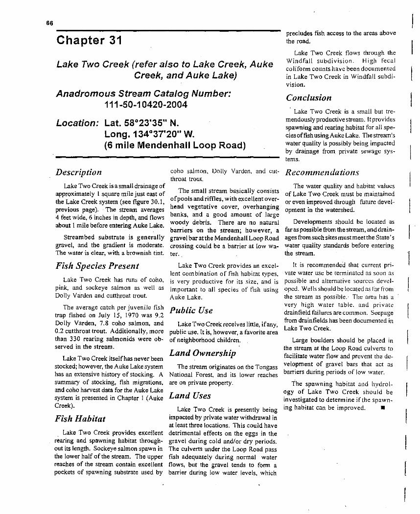
66
Chapter 31
Lake Two Creek (refer also to Lake Creek, Auke Creek, and Auke Lake)
Anadromous Stream Catalog Number: 111-50-10420·2004
Location: Lat. 58°23'35" N. Long. 134°37'20" W. (6 mile Mendenhall Loop Road)
Description
Lake Two Creek is a small drainage of approximately 1 square mile just east of the Lake Creek system (see figure 30.1, previous page). The stream averages 4 feet wide, 6 inches in depth, and flows about I mile before entering Auke Lake.
Streambed substrate is generally gravel, and the gradient is moderate. The water is clear, with a brownish tint.
Fish Species Present
Lake Two Creek has runs of coho. pink, and sockeye salmon as well as Dolly Varden and cutthroat trout.
The average catch per juvenile fish trap fished on July 15, 1970 was 9.2 Dolly Varden, 7.8 coho salmon, and 0.2 cutthroat trout. Additionally, more than 330 rearing salmonids were observed in the stream.
Lake Two Creek itself has never been stocked; however, the Auke Lake system has an extensive history of stocking. A summary of stocking, fish migrations, and coho harvest data for the Auke Lake system is presented in Chapter I (Auke Creek).
Fish Habitat
Lake Two Creek provides excellent rearing and spawning habitat throughout its length, Sockeye salmon spawn in the lower half of the stream. The upper reaches of the stream contain excellent pockets of spawning substrate used by
coho salmon, Dolly Varden, and cutthroat troU!.
The small stream basically consists ofpools and riffles, with excellent overhead vegetative cover, overhanging banks, and a good amount of large woody debris. There are no natural barriers on the stream; however, a gravel bar atthe Mendenhall Loop Road crossing could be a barrier at low water..
Lake Two Creek provides an excellent combination of fish habitat types, is very productive for its size. and is important to all species of fish using Auke Lake.
Public Use
Lake Two Creek receives little, ifany, public use. It is, however, a favorite area of neighborhood children.
Land Ownership
The stream originates on the Tongass National Forest, and its lower reaches are on private property.
Land Uses Lake Two Creek is presently being
impacted by private water withdrawal in at least three locations. This could have detrimental effects on the eggs in the gravel during cold and/or dry periods. The culverts under the Loop Road pass fish adequately during normal water flows, but the gravel tends to fonm a barrier during low water levels, which
precludes fish access to the areas above the road.
Lake Two Creek flows through the Windfall subdivision. High fecal co liform counts have been documented in Lake Two Creek in Windfall subdivision.
Conclusion
Lake Two Creek is a small but tremendously productive stream. It provides spawning and rearing habitat for all species offish usingAuke Lake. The stream's water quality is possibly being impacted by drainage from private sewage systems.
Reconznlendations
The water quality and habitat values of Lake Two Creek must be maintained or even improved through future development in the watershed.
Developments should be located as far as possible from the stream, and drainages from such sites must meet the State's water quality standards before entering the stream. [
It is recommendea that current private water use be terminated as soon as possible and alternative sources developed. Wells should be located 'lS far trom the stream as possible.· The area has a very high water table. and private drain field failures are common. Seepage from drain fields has been documented in Lake Two Creek.
Large boulders should be placed in the stream at the Loop Road culverts to facilitate water flow and prevent the development of gravel bars that act as barriers during periods of low water.
The spawning habitat and hydrology of Lake Two Creek should be investigated to determine if the spawning habitat can be improved. •

61
Chapter 32
Lawson Creek
Anadromous Stream Catalog Number; 111-40-10890
Location: Lat. 58°17'11" N. Long. 134°24'30" W. (1.1 mile Douglas Highway)
Description
Lawson Creek tlows in a northerly direction for about 2 miles on Douglas Island and empties into Gastineau Channel at about mile Lion the Douglas Highway (figure 32.1). The stream drains an area of about 3 square miles.
The stream has a fairly steep gradient, and the streambed is mostly bedrock and gravel.· The water is normally clear, with a brownish tint during high flow·s. A concrete dam is located approximately I mile' above the stream mouth.
Fish Species Present
Lawson Creek has runs of pink, chum, and coho salmon (table 32.1), Dolly Varden, and cutthroat trout. The average catch per trap of two minnow traps fished on June 23, 1970, was 2.0 Dolly Varden per trap.
Fish Habitat
Lawson Creek has a fairly steep gradient. Its greatest potential is for tish spawning rather than rearing. Fair intertidal spawning habitat exists at the stream mouth. Spawning habitat extends upstream from the mouth for about J/s mile.
Overall, the rearing potential is poor, due to the streambed substrate, steep gradient, and lack of slow-water areas. There is a barrier to upstream m igration about Y, mile upstream from the mouth. Fish populations above the barrier have not been investigated.
Public Use
Lawson Creek is located adjacent to residential areas and is known to provide sport tishing opportunities; however, angler effort and harvest have not been quantified.
Pink salmon are the primary target of anglers fishing Lawson Creek. Some Of the fish taken at the stream mouth may be destined for one of the hatcheries in Gastineau Channel.
Land Ownership
Lawson Creek originates on U.S. Forest Service property, then flows through a section of City and Borough of Juneau property and through private property near the mouth.
Land Uses
Tidelands adjacent to Lawson Creek have been filled for residential development. The stream channel on one side near the mouth has been rip-rapped to prevent erosion. The rip-rapped area has been vegetated and stabilized. Recent residential development upstream from the highway has contributed high levels of sediment to the stream during wet periods.
The major threat to the habitat values of Lawson Creek is further residential development adjacent to the stream. A dam once used to supply waterto IheCity of Douglas is now only used to divert water into the Bear Creek drainage. A permit is on file for 260,000 gallons to be diverted daily.
N
t Scale: 1 inch = 1 mi.
. spawning up to barriers
LA WSON CREEK
Figure 32.1 Lawson Creek.

68
ConclusionTable 32.1. Summary of salmon escapement in Lawson Creek, 1968-1990.
YEAR PINK SALMON CHUM SALMON COHO SALMON
1968 20 (08120)' ... ... 1969 25 (08/25) ... ... 1977 480 (08/10) ... ... 1979 875 (08/21) ... ... 1980 ... 8 (08/21 ) ... 1981 100 (08/21) ... ... 1982 276 (08/17) 10 (08117) ... 1983 758 (08/25) ... ... 1984 ... ... 12 (10112) 1985 2,500 (08/01) 190 (07/28) ... 1986 ... 141 (08/04) ... 1987 16,300 (08/06) ... ... 1988 1,427 (08112) 38 (07128) ... 1989 4,656 (08/29) 14 (08/05) ... 1990 2,058 (08/29) 237 (08/15) ... 1991 386 (08113) 374 (08/13) ... 1992 946 (08125) 1993 77 (08131) 27 (08/24) ... 1994 3,446 (09/07) 233 (08110) ...
I Lawson Creek was stocked with 1,000 eastern brook trout (char) on lune 20. 1953. Apparently the transplantwas unsuccessful, forno eastern brook trout have been reported in the stream.
Lawson Creek is primarily a spawning system used by pink salmon. [t is centrally located in a residentially developed area and could potentially provide substantial angling opportunity. Lawson Creek is vu[nerable to impacts from futlJre residential development .
Recommendations
Land use applications for stream-side development should be critically reviewed and stipulations provided to maintain the stream's water quality. The lower section of Lawson Creek provides fair spawning habitat. This area could be improved for intertidal spawning by stabilization of the stream channel and introduction ofgoodspawning graveL Perhaps this could be requested as mitigation for some [and use activity upstream in the watershed . •
Chapter 33
Lena Creek
Anadromous Stream Catalog Number: 111-50-10300
Location: Lat. 58°23'47" N. Long. 134°44'49" W. (17.2 mile Glacier Highway)
Description
Lena Creek drains a watershed of about Y, square mile and is about 1 mile in length. [t runs in a northwest direction and enters salt water at Lena Cove in Favorite Channel (tigure 33.1). The stream 'UDS!! to 12 feet wide, 1 foot deep, and has a steep gradient. The water runs clear, with a brownish tint.
The streambed is primarily bedrock and large gravel.
Fish Habitat
Most ofLena Creek's spawning habitatis found downstream from Glacier Highway. Above the highway, spawning substrate is found only in pools between bedrock areas.
Overall, the spawning and rearing potential is low because of the relatively steep gradient and lack of pools and slough areas. A barrier falls is located about 250 yards above the stream mouth.
LENA CREEK
somespawning
picniC area
1 Scale: 1 inch = 2650 It
(approx.) 1 Figure 33.1 Lena Creek.

69
Fish Species Present Lena Creek has populations of
coho and pink salmon, Dolly Varden, and cutthroat trout. Two minnow traps set on July 27, 1970, caught 18 Dolly Varden and 19 cutthroat trout. The Dolly Varden appeared to be anadromous. Pink salmon escapements in Lena Creek in 1990 and 1994 were 300 and 422, respectively.
Lena Creek has not been stocked.
Public Use The stream mouth is located in the
V.S. ForestService's Lena Cove Recreation Area. The beach area is used for various recreational activities, including fishing. The actual level of public use ofLen a Creek is unknown.
Land Ownership
Lena Creek originates on V .S. Forest Serviceproperty and flows through land owned by the City and Borough of Juneau. The land near the stream mouth is privately owned.
Land Use Lena Creek was impacted by the
construction of Glacier Highway. One water withdrawal structure is located in lower Lena Creek.
Conclusion
Lena Creek is a small stream with marginal fishery values in its natural condition. The stream mouth is located in a public beach area. There is some potential to enhance the fishery values of the lower section of Lena Creek through the stabilization of the stream channel and placement of high quality spawning substrate.
Recommendations
The water quality of the stream and its fish habitat values should be maintained ·through critical review ofland use permit applications.
Feasibility of enhancing spawning habitat downstream from Glacier Highway should be evaluated. •
Chapter 34
Lemon Creek
Anadromous Stream Catalog Number: 111-40-10100
Location: Lat. 58°21 '6" N. Long. 134°30'23" W. (5.9 Mile Egan Drive)
good rearing channel
Figure 34.1 Lemon Creek.
severely impacted due to gravel mrning
exceilentbut limited spawning--good bank COlier, partial clearcut
upstream
Lemon Creek's spawning and rearing habitat is pOSSibly limited to side channels and tributaries because of its velOCity and seasonal glacial turbidity.
\
.. ~ -',
... /,
LEMON CREEK Scale: 1 inch:; 2500 ft
'-....--Sawmill Creek
excellent spawning for pink and chum

70
Table 34.1. Salmon spawning escapement data for Lemon Creek.
YEAR COHO SALMON PINK SALMON CHUM SAU..lON
I (09/21)1946 ...... 2 (08115)1968 ... ...
10 (11/07)1975 ... '"
1976 10 ( 10/28) ... '"
5 (10/16) ... ...1978 1979 ...0 '"
1980 0 ... IS (09/02) 11 (08114) 18 (08/14)1981 0
1982 15 (10/20) ... '"
...1983 11 (10/28) '"
1984 9 (10116) ... '"
1985 2 (10/24) 80 (08/07) 280 (08/07) 1210 (08/02)1988 ......
17 (08/09)1989 ...... 1990 ... ... '"
1994 1 (09/07) ... '"
Description
Lemon Creek drains an area of approximately 25 square miles and runs about 6 miles in a southerly direction before draining into Gastineau Channel (figure 34.1, previous page). The stream's water level and flow varies considerably throughout the year, due to its glacial origin. In its lower sec~ tions, Lemon Creek runs from 30 to 50 feet wide and I to 3 feet deep during low flows.
The stream is fed by several large glaciers which cover nearly'30% of the watershed. The stream runs very glacial from spring through fall and clear during the cold winter months. The streambed substrate is mostly gravel, and its gradient is moderate.
Lemon Creek has at least 4 small clearwater tributaries that enter the mainstem from 1 to 3 miles upstream from the mouth.
Fish Species Present
Lemon Creek has stocks of Dolly Varden and coho, chum, and pink salmon. Four juvenile fish traps set on May 13, 1970 caught 14 Dolly Varden and 4 coho. An additional 300 Dolly Varden and 250 rearing coho were ob
served. Salmon spawning escapement data for Lemon Creek are summarized above in table 34.1.
Fish Habitat Only the lower two tributaries and
lower 3 miles of Lemon Creek have been surveyed. These two tributaries are known to be used for both spawning and rearing. The second tributary (about 2 miles upstream on the east side of Lemon Creek) is known to have numerous upwelling areas.
Chum and coho salmon have been observed spawning in Lemon Creek's mainstem during late summer and fall.
Excellent rearing habitat is found in the clearwater tributaries, which are about 3 to 4 feet wide, 6 inches deep, and up to y, mile long. Dolly Varden and coho are known to rear in the mainstem~ however, it is presumed to provide only fair rearing at best, as it has little' overhead cover and few rearing pools. There are no barriers on Lemon Creek.
Public Use
There is little public use of Lemon Creek except at the mouth of Lemon Creek in Gastineau Channel, which is a popular location for sport fishing.
Land Ownership
Lemon Creek originates on the Tongass National Forest. It flows through private property upstream t'rom Glacier Highway and enters salt water on the Mendenhall Wetlands State Game Refuge .
Land Uses
Lemon Creek has been used as a source of gravel since historical times. Gravel is removed annually from Lemon Creek upstream from Glacier Highway. This section ofthe streambed is nearly 15 feet lower than it was historically. A haul road parallels Lemon Creek from Glacier Highway up to a private gravel mining operation in the second basin.
A commercial 'sanitary landfill is located adjaeentto lower Lemon Creek. The refuse is surrounded by a large berm, but it is not known if this barrier is effective in preventing pollutants from leaking into lower Lemon Creek.
Conclusion Lemon Creek is a glacial stream of
moderate size compared to other local streams. Its fishery resources have never been thoroughly evaluated. The stream's fishery values have beenand continue to be-impacted by gravel' removal.
Recommendations
It is apparent that Lemon Creek will continue to be used as a source of gravel. Stipulations to specific gravel mining proposals should be issued to protect the stream's fishery resources. As permits expire gravel extractors should be urged to move to upland sources of material. The fishery resources in Lemon Creek and its tributaries should be assessed. •

71
Chapter 35
Little Sheep Creek
Anadromous Stream Catalog Number: None
Location: Lat. 58°14'40" N. Long. 134°17'30" W. (just past the end of Thane Road)
Description stream is about4 feet wide and I foot deep; stream flow has been estimated at 2 efs, Little Sheep Creek, a mile-long even during low flow periods in winter. clearwater stream with a steep gradient,
drains an area of over 1,12 square mile on Fish Species Present the south side of West Peak and empties into Gastineau Channel just beyond the Little Sheep Creek has a run of pink end of Thane Road (figure 35.1). The salmon and a popUlation ofDolly Varden.
N
t Scale: 1 inch = 1 mi.
cJ
intertidal spawning up to barriers
LITTLE SHEEP CREEK
Figure 35.1 Little Sheep Creek.
Fish Habitat
Pink salmon spawn intertidally in Little Sheep Creek. Spawning habitat is sparse in the upper reaches, yet there is a sufficient amount to
maintain a Dolly Varden population, which is assumed to consist of resident fish.
Little Sheep Creek offers little rearing habitat because of the steep gradient, poor overhead cover. and lack of slow-moving water. A barrier lies about 300 yards upstream from the mouth of the stream.
Public Use
The mouth of Little Sheep Creek receives some recreational angling pressure, even though the stream mouth is on private property.
Land Ownership
Little Sheep Creek originates on property administered by the Bureau of Land Management. The middle and lower reaches of Little Sheep Creek are located on private property.
Land Use
One private water supply IS IDeated in the lower section of Little Sheep Creek. OtherWise, the stream is in a nearly natural condition.
Conclusion
Little Sheep Creek is a smali, clear, fast~flowing stream with overall low natural fishery values. The documented stream tlow of 2 cts during the cold winter months indi~ ·cates that the stream is at least In
part spring- fed.
Recommendations
The water quality of the stream should be maintained. The stream mouth appears to have potential for use as a saltwater release site for salmon smelts: such use would require an agreement with the private landowner. •

72 ____________________~_______________________
Chapter 36
MarshaJ/ Pond and MitcheJ/ Pond
Anadromous Stream Catalog Number: None
Location: Lat. 58°23'47" N. Long. 134°34'25" W. (south side of Taku Blvd. in Hidden Lakes subdivision in Mendenhall Valley)
Description Marshall and Mitchell ponds are
two small ponds located in the Hidden Lakes subdivision (figure 36.1). Marshall Pond is about 3/4 acre in size and 10 feet deep. Mitchell Pond is about I acre in size. Both lakes are surrounded by private homes, and most of the natural vegetation along the ponds' shorelines has been left intact. Neither pond has inlets or outlets. The bottom substrate 0 f each is primarily mud.
Fish Species Present
Both ponds have good rearing habitat.
~~ac::re
Housing skirts both pond shores.
MARSHALL POND public
:=,1 acra
~,
Figure 36.1 Marshall Pond and Mitchell Pond.
(not to scale)
Table 36.1. Stocking data for Marshall Pond.
DATE SPECIES NUMBER S,ZE SOURCE
1954 1957 1958 1959 1960 1960 1961 1963 1967 1968 1969 1971 1974
rainbow 3,000 fry rainbow 1,100 fry rainbow 1,000 ? rainbow 1,000 fry rainbow \,000 fry rainbow 1,000 fry rainbow 1,000 fry rainbow 1,000 fry rainbow 5,000 fl)' rainbow 5,000 ? rainbow 2,000 fry rainbow 1,000 fl)' coho 976 sub-sma It
Kodiak Kodiak ? Deer Mountain, Ketchikan Auke Creek Deer Mountain. Ketchikan Auke Creek Fire Lake. Anchorage Fire Lake, Anchorage ? Fire Lake, Anchorage Fire Lake. Anchorage Mendenhall Ponds. Juneau
At present, neither pond is believed to contain any fish. These ponds have been stocked several times since 1954; however, the records are confusing. and it is difficult to identify which of the pond(s) were actually stocked. The stocking record for "Marshall Pond" (which includes information for both Marshall and Mitchell ponds) is presented in table 36.1.
Fish Habitat
There is no spawning habitat available in either pond. Both ponds are known to contain abundant insect life and are presumed to be capable of providing good rearing conditions for small populations of fish.
Public Use
Marshall and Mitchell ponds have been favorite locations for neighborhood residents to fish, swim, and ice skate for many years. Stocked fish supported sport tisheries in these ponds for several years. Th is division has received several requests to stock these ponds, especially since the area surrounding the porlds has become a major residential area.
Land Ownership
Mitchell Pond is surrounded by at least 13 private lots, one afwhich is owned by the City and Borough of Juneau and can be used for public access.

73
excell~nt { spawning
excellent spawning
:~"
floadplain
Marshall Pond is surrounded by II private lots, one of which' is also owned by the City and Borough of Juneau.
Land Uses
Both ponds are essentially surrounded by private homes. In some instances, rock fill has encroached into the lakes; however, the shorelines generally have fairly natural cover. Domestic drainage from these residences exits the area via the municipal sewage system, but the ponds are susceptible to pollution from surface drainage.
Conclusion
These two small lakes, each situated in the center of a residential development and having public access, provide some potential for developing two small neighborhood sport fisheries.
Recommendations
The feasibility of stocking these small ponds should be determined. Recreational fisheries could be best provided by stocking catchablesized fish rather than fry, as were generally stocked in the past. It is presumed that stocked fish would receive heavy angling pressure from local neighborhood children. These fisheries could only be maintained by annual releases of fish.
Water quality in the ponds should be maintained by requiring all drainage into the ponds to meet the state's water quality standards. _
Description
McGinnis Creek is the main tributary to Montana Creek (figure 37.1). It is about 3 miles long, 15 feet wide, and 2-5 feet deep, with a moderate gradient, swift flow, and numerous pools. The streambed substrate ranges from large boulders to small gravel. The stream is seasonally glacial. The stream flow in McGinnis
excellent rearing { habitat
lowland, extensive
excellent spawning and rearing habitat
Figure 37.1 McGinnis Creek.
Creek fluctuates greatly and moves a 1m of bedload and large woody debris during floods.
A clear, spring-fed tributary called (unofficially) Spring Creek enters McGinnis Creek about Y, mile above the confluence of McGinnis and Montana Creeks. The stream is about J4 mile long, 8 feet wide, and up to I foot deep.
McGINNIS CREEK Scale: 1 inch = 4400 ft (approx.)
good spawning and rearing habitat
pink and chum spawning
Chapter 37
McGinnis Creek (also see Montana Creek)
Anadromous Stream Catalog Number: 111-50-10500-2003-3006
Location: Lat_ 58°26'28" N_ Long. 134°38'40" W. (tributary of Montana Creek, near the end of Montana Creek Road)

74
Fish Species Present McGinnis Creek has populations of
coho, chum, and pink salmon, Dolly Varden, and cutthroat trout.
McGinnis Creek has not been investigated using juvenile fish traps; however, on July 31, 1970 the following observations of rearing fish were made: 13 Dolly Varden fry, 43 coho fry and I fingerling, and2 fry of undetermined species.
Salmon escapement data for this stream are presented in table 37.1.
Fish Habitat Excellent pockets ofspawning habitat
are found throughout the length of McGinnis Creek. Spring Creek, its largest tributary, also has excellent spawning habitat.
Little McGinnis, a small tributary of Montana Creek, actually serves as a high-
flow channel for McGinnis Creek. Little McGinnis provides spawning habitat for salmon and Dolly Varden.
Good rearing habitat is dispersed throughout McGinnis Creek. Overall, the stream has a moderate gradient and the water flows quite fast; however, the stream has many deep pools with excellent instream and overhead woody cover.
There are no fish barriers on McG innis Creek.
Public Use
McGinnis Creek receives some sport fishing pressure, especially in its lower reaches. The levels of effort and harvest are not known.
This stream is also used for reCreational placer mining, which is quite restricted in order to protect the creek's fishery values.
Land Ownership McGinnis Creek originates on
the Tongass National Forest. The [ower part of McGinnis Creek is located on State property.
Land Uses McGinnis Creek has been sub
jected to placer mining activity for many years. Historically, a large mining operation was located in the stream's headwaters. At present, gold mining is limited to recreational gold panning and by small dredges, which are permitted only during the month of June. The stream is relatively safe from land uses other than mining.
Conclusion McGinnis Creek is a moderate
gradient, high-flow stream with an, actively changing channel. The
Table 37.1. Salmon escapement counts for Montana and McG innis creeks. Counts include McGinnis, Spring, Little McGinnis, and Montana creeks upstream from the Back Loop Road bridge.
DATE COHO CHUM PINK SOCKEYE CHINOOK
1960 ... many ... ... 1962 ... 100 (8110) ... 1966 ... 331 (7/22) ... ... ... 1967 ... 400 (8111 ) ... ... ... 1968 ... 800 (7112) ... ... ... 1969 ... 500 (7/23) ... ... ... 1975 ... 80 (7/22) 50 (7/22) ... ... 1976 ... 25 (7/16) 0 ... 33 1977 ... 440 (7/26) 8 (8/09) ... 348 1978 7 (11/30) ... 0 ... ... 1979 ... 614 (7/08) 0 ... ... 1980 ... 451 (8/31 ) 0 ... ... 1981 227 (10/27) ... 0 ... 17 1982 545 (10/20) ... 0 ... ... 1983 636 (10110) I (8/31 ) 917 (8/31 ) 210 (8/31) ... 1984 581 (10/29) ... 0 ... ... 1985 810 (10/08) 2647 876 (7/30) ... ... 1986 60 (10/20) 320 (7/30) ... ... ... 1987 314 (10/08) 2913 (8/07) 773 (8/07) ... ... 1988 164 (10/21) 1397 (7/22) ... ... ... 1989 566 (10/23) 925 (7119) 114 (8111 ) 10 (7117) ... 1990 1711 (10/03) 305 (8/0 I) 4 (8/30) ... 3 (8/30) 1991 1425 (10116) 197 (8/07) 23 (8114) ... 4 (8/07) 1992 2512 (10112) 43 (8/04) 14 (8/05) 2 (7117) ... 1993 1352 (10/08) 806 (7/29) 8 (7/29) 5 (7/29) II (8116) 1994 1829 (09/30) 455 (7/27) 17 (8/03) ... ...
stream has an abundance of pools with excellent woody cover. McGinnis Creek is a very productive fish stream and provides a significant portion of the spawning habitat in the Montana Creek drainage.
Recommendations
The natural character and ~xcellent fish values ofthis stream should be maintained through critical review of land-use permit applications .
The entire Montana Creek drainage should be placed in a fish habitat reserve or refuge status to protect its fishery values. •
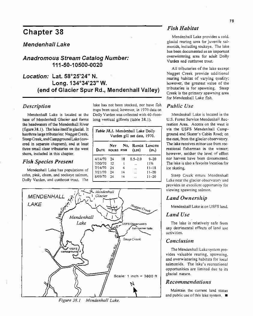
75
Chapter 38
Mendenhall Lake
Anadromous Stream Catalog Number: 111·50·10500·0020
Location: Lat. 58°25'24" N. Long. 134°34'23" W.
(end of Glacier Spur Rd., Mendenhall Valley)
lake has not been stocked, nor have fish Description traps been used: however. in 1970 data on
Mendenhall Lake is located at the Dolly Varden was collected with 40-footbase of Mendenhall Glacier and forms long vertical gillnets (table 38.1). the headwaters of the Mendenhall River (figure 38.1). The lake itself is glacial. [t has three large tributaries: Nugget Creek, Steep Creek, and Campground Lake (covered in separate chapters), and at least three small clear tributaries on the west shore, included in this chapter.
Fish Species Present
Mendenhall Lake has populations of coho, pink, chum, and sockeye salmon. Dolly Varden, and cutthroat trout. The
Table 38.1. Mendenhall Lake Dolly Varden gill net data, 1970.
NET No. RANGE LENGTH DATE HOURS FISH (LBS) (IN.)
4114170 24 18 0.5-2.0 9-20 7130170 12 I ... 11 y.. 7114170 24 4 ... 11-18 7/21170 24 14 11-20 8/09170 24 14 11-20
MENDENHALL
LAKE
Scale: 1 inch ~ 3800 It
Figure 38.1 Mendenhall Lake.
Fish Habitat
Mendenhall Lake provides a cold. glacial rearing area for juvenile salmonids, including sockeye. The lake has been documented as an important overwintering area for adult Dolly Varden and cutthroat trout.
All tributaries of the lake except Nugget Creek provide additional rearing habitat of varying quality; however; the greatest value of the tributaries is for spawning. Steep Creek is the primary spawning area for Mendenhall Lake fish.
Public Use
Mendenhall Lake is located in the U.S. Forest Service Mendenhall Recreation Area. Access on the west is via the USFS Mendenhall Campground and Skater's Cabin Road; on the east, from the glacier observatory. The lake receives minor use from recreational fishennan in the winter; however, neither the level of effort nor harvest have been documented. The lake is also a favorite location for ice skating.
Steep Creek enters Mendenhall Lake near the glacier observatory and provides an t::xcellent opponunity for viewing spawning salmon.
Land Ownership
Mendenhall Lake is on USFS land.
Land Use
The lake is relatively safe from any detrimental effects of land use activities.
Conclusion
The Mendenhall Lake system provides valuable rearing, spawning, and overwintering habitats for local salmon ids. The lake's recreational opportunities are limited due to its glacial nature.
Recommendations
Maintain the current land status and public use ofthis lake system. _

... ...
MENDENHALL
PONDS
\
\
"1----- --,
\ ,
,
... -. ' .., \ .
\
\
I
\
I
I J~:J:~~:W -.---- ..
Crystal Lake~--"~_
Dredge Lake
N
t 640 It
Figure 39 I Me"denhall Ponds.

77
Chapter 39
Mendenhall Ponds
Anadromous Stream Catalog Number: None
Location: Lat. 58°24' N. Long. 134°27' W. (south of Mendenhall Lake and north of Mendenhall Loop Road)
Description
The area known as 'Mendenhall Ponds' comprises nine lakes ranging in size from about 2 acres to nearly 10 acres (tigure 39.1). These lakes are located in the moraine area in front of Mendenhall Glacier. They are treated as a single watershed in this description, as all of them are located in the U.S. Forest Service Mendenhall Recreation Area, are subject to similar public and land use, and share a common outlet.
Four of the lakes are old gravel pits, . and five are natural ponds. The natural ponds have a sandy. glacial-till substrate, whereas the excavated ponds have a gravel base. Their sizes and depths are listed in table 39.1.
Fish Species Present
The fish species present and the fishery habitat values of the Mendenhall Ponds are presented in table 39.2. The Mendenhall Ponds have a long history of fish stocking, which is provided in table 39.3.
Fish Habitat
CASHEW LAKE (figure 39.2)-This small natural lake is located in the headwaters of Crystal Lake. Cashew Lake has a sandy, glacial-till substrate and retains water throughout the winter, unlike Crystal Lake (only 50 yards away).
Cashew Lake provides good natural rearing habitat. The lake is also known locally as Q.T. Lake.
63 It
CASHEW LAKE
Figure 39.2 Cashew Lake.
CRYSTAL LAKE (figure 39.3, next pagel-Located at the headwaters of Moose Lake, Crystal Lake is currently too shallow to recain water and sustain fish through the cold winter months. Observations through winter reveal that Crystal Lake drains subterraneously into the north ~nd of Moose Lake. where upwelling. can bt:' observed. Coho salmon common ty spawn in the upwelling area in the north end of Moose Lake. Crystal Lake is also known locally as Green's Pond.
Table 39.1. Name, size, and depth of lakes in the Mendenhall Ponds group.
SIZE DEPTH LAKE (ACRES) (FEET) COMMENT
Cashew 1.7 7 natural
Crystal 5.4 6 excavated Dredge 7.8 16 excavated Glacier 5.5 25 natural Holding 0.7 IS excavated
Pond Louie 1.7 6 natural Moose 9.7 14 excavated
Moraine 4.3 12 natural Norton 4.7 I I natural
Table 39,2. Fish species present and habitat types in Mendenhall Ponds.
FISH SPECIES REARING SP,\WNING
LAKE PRESENT ANADROMOUS HABITAT HAlllT.-\T
Cashew ? no good none Crystal ? no none none Dredge SS, PS, DV, CT yes excellent limited Glacier SS, DV, CT yes excellent limited Ho Iding Pond SS, PS, DV, CT yes excellent limited Louie ? yes poor none Moose 5S, PS, DV, CT yes excellent limited Moraine SS, DV, CT yes excellent limited Norton SS, PS, DV, CT yes excellent limited
SS = coho salmon PS =: pjnk salmon DV =: Dolly Varden CT = cutthroat trout

78 _.. ----
Fig. 39.3
Crystal 100 ft Lake.
\, -' ,.'
DREDGE LAKE (tigure 39.4)-The headwaters ofDredge Lake originate on Thunder Mountain, on the east side of the Mendenhall Valley. In this regard, Dredge Lake is unique; the other ponds in the system are fed by surface drainage from the immediate area.
Dredge Lake was originally included in the Mendenhall Ponds Salmon Rearing Facility, but it was dropped from rearing activities because the water flow fluctuated so drastically and rapidly that it could not be controlled_ Dredge Lake has irregular bottom contours and provides deep areas for overwintering and
CRYSTAL LAKE
shallower areas covered with ~mergent vegetation throughout the summer. The lake shores have good overhanging cover of alder and willow.
GLACIER AND MORAINE lAKES
(figure·39.5)-These two lakes are discussed together, because they are connected with a small channel and separated from the rest of the drainage by trickle dams. Glacier Lake runs into Moraine Lake, and Moraine Lake drains from both the north and south end. Trickle dams were placed in both ends of Moraine Lake
125 It
.: MORAINE LAKE :
GLACIER LAKE
Figure 39.5 Glacier Lake and Moraine Lake.
DREDGE LAKE
160 ft
(/
Figure 39.4 Dredge Lake.
in 1982 to retain stocked resident fish in the Glacier-Moraine lake system.
HOLDING POND (see figure 39.I}--This pond was excavated in 1972 and 1973 to serve as a source ofgravel for construction of a dike between the Mendenhall Ponds system and the Mendenhall River. It also served as a holding pond for adult salmon returning to the rearing facility.
The pond has control structures on the inlets from Dredge Lake and Moose Lake and on the outlet. Alder and willow growth along the shores of the holding pond have produced excellent overhanging cover.
LOUI~ LAKE (figure 39.6, next page)-This small lake is by far the most eutrophic of all the Mendenhall Ponds. It has tloating mats of thick. emergent vegetation along the shorelines, and the decomposition of natural matter is obvious from the strong odors at the lake. .
In the summer. this small lake is often opaque from its heavy plankton content. Extremely low levels of dissolved oxygen have been documented in winter.
I

79
.<::::;6'
<1'.,
N
t .£1!.
LOu/ELAKE
Figure 39.6 Louie Lake.
MOOSE LAKE(figure39.7)-the largest lake in this system. Its substrate is sand and gravel. Moose Lake receives flow from the lakes located farther up in the Mendenhall Ponds drainage.
Moose Lake was drained and sculptured in 1973 to facilitate seining king and coho salmon smaIts reared in the lake. Moose Lake was used for rearing activities fat 3 years. The lake has a control structure on the outlet that can be used to contain fish in the lake.
N
t
"
188 It I,
I, , ,, ',:. I ,. ,, MOOSE LAKE
.c=.,;; .. "",' __-_ __ J;'
Figure 39.7 Moose Lake.
Since excavation, the shorelines of Moose Lake have assumed a natural appearance and are covered with thick alder and willow. Control structures provide free movement of water and fish.
NORTON LAKE (figure 39.8)- Located in the headwaters of the Moose Lake drainage, N orton Lake was also included in the activities of the Mendenhall salmon rearing facility.
Norton Lake is in a natural condition and has excellent cover and emergent vegetation along its shorelines. Norton Lake flows into Moose Lake through a shallow, vegetationchoked drainage.
Public Use
The Mendenhall Ponds area, located directly north of the most populated area in Juneau, provides many fonns ofoutdoor recreation. The
. Mendenhall Ponds area has always provided local anglers with a significant opportunity to fish for wild stocks of coho salmon, Dolly Varden and cutthroat trout.
In 1987, Mendenhall Ponds was selected as a release site for inclusion
..•~. ; ., . '1, ,
,.
I , . '/
"
in the Juneau Sport Fishing Enhancement Plan. and since that time coho salmon smolts have been released annually into Dredge Lake. The site has proven to be an excellent imprinting site, and adult coho salmon from the Mendenhall Ponds releases have contributed well to local commercial and marine sport fisheries, as well as to the tenninal area sport fishery. Catch statistics for the 1988-90 terminal sport fishery at Mendenhall Ponds are presented below in table 39.4.
The Mendenhall Ponds have been closed to vehicle traffic since 1981; however, the old
NORTON LAKE
N
t 100 ft
Figure 39.8 Norton Lake.
road-system provides good hiking and jogging trails. The area also gets heavy use from waterfowl hunters and bird watchers.
Land Ownership
The Mendenhall Ponds system is included in the U.S. Fores( Service Mendenhall G lacier Recreation Area.
Land Uses
Historically, this area was subjected to major gravel mining activities, but at present it is not vulnerable to degradation through adverse land uses. The USFS manages the area for public recreation, with an emphasis on protection of fish and game resources.
Conclusion
The Mendenhall Ponds system has had a very active past. including gravel removal, high public use, and fish stOcking. This watershed provides over 35 surface acres ofgood fish habitat and one ofthe best opportunities for fishery enhancement in the Juneau area. All of the ponds cOntaining fish are easily accessible, have clear water, and could provide additional angling opportunities for resident and anadromous fish.

80
Table 39.3. History of fish stocking in the Mendenhall Ponds.
DATE SPECIES NUMBER SIZE SOURCE DATE SPECIES NUMBER SIZE SOURCE
CASHEW LAKE 6111168 grayling 50,000 fry Fire Lake, AK
8103154 eastern brook 1,000 ... Kodiak, AK 1974 rainbow 4,030 fry ."
1958 rainbow 1,000 try Kodiak, AK 1976 cutthroat trout 349 adult Shelter Lake.AK
1960 rainbow 2.000 ... -1982 cutthroat trout 354 adult Shelter Lake.AK
1961 rainbow 1.000 ... ... HOLDING POND 1963 rainbow 1,000 ... .. '
1964 rainbow 1,000 ... ... 9116174 king 124,309 2911b Crystal Lake. AK
1967 rainbow 2,000 ... ... 6124175 coho 96,679 3111b Crystal Lake, AK
1968 rainbow 2,500 ... ... 6176 coho 42,231 42kg Crystal Lake. AK
1969 rainbow 2,000 ... ... 5177 coho 22,816 46kg Crystal Lake. AK
1971 rainbow 1.000 ... Fire Lake. AK 4177 coho 10.097 68kg Crystal Lake. AK
DREDGE LAKE LOUIE LAKE
1931 eastern brook '" ... ... 6119153 eastern brook 1,000 ... Auke Creek, AK
6119153 eastern brook 2.000 ... Auke Creek, AK 1963 rainbow 5,000 fry Fire Lake. AK
8107173 caho 138,896 2601lb Blind Slough,AK 1965 rainbow 5,000 fry Auke Creek, AK
6107176 coho 545,300 45011b Dredge Lake,AK 1967 rainbow 2,400 fingerling Fire Lake. AK
5177 coho 11,095 49511b Crystal Lake.AK 1968 rainbow 2.500 ... ... 6101184 coho 199.893 fry Mtn Creek, AK 1969 rainbow 1.990 fingerling Fire Lake. AK
5117185 1987
coho coho
20,225 52,879
11.7 grlfish 3.4 gm
Speel Lilke, AK Speel Lake, AK
MOOSE LAKE
1988 coho 50,000 fry Speel Lake, AK 9125173 king 155,078 301lb Carson R .. WA 1989 coho 37,000 fry Speel Lake, AK 9116174 coho 209,485 ... Mendenhall. AK
11189 coho 30,000 fry Snettisham 6124175 coho 149.500 300/lb MendenhalL AK 6107176 coho 545.000 450llb Mendenhall. AK
GLACIER & MORAINE LAKES 5100177 coho 15.272 ~95kg MendenhalL AK
1954 rainbow 8.000 fry Kodiak. AK 11/89 coho 70.000 fry DIPAC 8108/55 rainbow 2.500 try Kodiak. AK NORTON LAKE 1956 rainbow 10.600 ... Kodiak, AK 1958 rainbow 9,000 Iry Kodiak. AK 6119153 eastern brook 1.000 Iry 1959 rainbow 8,000 try Deer Mountain.AK 1963 rainbow 5.000
1960 rainbow 8,000 fry Deer Mountain.AK 1965 rainbow 5.000 ... 1960 rainbow 5,000 fry Auke Creek, AK 8103167 rainbow 5.000 ... ... 1961 rainbow 10,000 fry Auke Creek, AK 7123168 rainbow 4.000 ... ...
1963 rainbow 10,000 fry Fire Lake, AK 1969 "rainbow 4.000 ...
1965 grayling 20,000 fry Fire Lake, AK 8107173 coho 120.848 264/lb Blind Slougb.AK 1965 rainbow 15,000 fry Fire Lake, AK
Recommendations
The fishery values ofthe Mendenhall
Ponds system should be enhanced and maintained for future fish production
and provision of angling opportunity.
Recreational fishery values could be improved'by stocking resident species
into Glacier and Moraine lakes and by
stocking coho salmon smolts into anadromous waters in the drainage.
Resident fish should be stocked annually to provide for yearlong sport fisheries.'
Table 39;4. Catch statistics for the 1988-1990 tenn inaI spar! tishery at Mendenhall Ponds.
ANGLER DATE HOURS
CATCH
DOLLY COHO VARDEN
1988 (09112-10123) 464 1989 (08128-11105) 740 1990 (09110-1114) 258
245 157 1074 107
155 10
Coho salmon would provide excel Coho salmon escaping the tisheries would lent seasonal fishing and would reduce spawn in Mendenhall Ponds and till the angling pressure on local wild stocks. rea~ing capacity ofthe area. •

81
Chapter 40
Mendenhall River
Anadromous Stream Catalog Number: 111-50-10500
Location: Lat. 58°21'28" N. Long. 134°36'23" W. (flows through center of Mendenhall Valley; crosses Glacier Hwy. at 10.0 mile)
Description
Mendenhall River is glacial and heads in Mendenhall Lake. It flows approximately 5 miles through the center of the Mendenhall Valley and enters salt water in Fritz Cove (figure 40.1, following page). Montana Creek (see Chapter 41) enters the Mendenhall River I mile upstream from Glacier Highway, and Duck Creek (see Chapter 15) enters the river near the Juneau airport.
Fish Species Present
Mendenhall River has populations of coho, pink, chum, and sockeye salmon; cutthroat and steelhead/rainbow trout; and Dolly Varden. Eulachon (smelt) can be found in the lower stretches in spring.
The river has not been stocked. The river is a migration route for Montana Creek and Steep Creek stocks of fish. Refer to chapters on those streams for spawning or escapement data on fish that use the Mendenhall River.
Fish Habitat
Because of its size and its glacial character, the fish habitat values of this river have never been fully assessed.
The mainstem of the Mendenhall River is used by fish primarily as a migration route to the spawning areas in the upperwatershed. As many as 15,000 salmon ofall species, and 30,000 Dolly Varden, migrateup the Mendenhall River annually. Coho salmon are known to
spawn in Mendenhall River between the outlet of Mendenhall Lake and Mendenhall Loop Road bridge.
The Mendenhall River provides significant amounts of rearing habitat for coho. luvenile Dolly Varden may be found in numerous small glacial sloughs and near the mouths ofsmall clear tributaries. There are no fish barriers on the Mendenhall River. The extensive'tidal wetlands adjacent to the river mouth are within the Mendenhall Wetlands State Game Refuge and are very important to juvenile salmonids making the Freshwater-saltwater adaptation.
Public Use
Mendenhall River provides good sport fishing at the mouth of Montana Creek and, to a lesser degree, at the mouth of Mendenhall Ponds. The glacial character ofthe Mendenhall River is not conducive to sport fishing.
A local tour business has recently begun float trips on the Mendenhall River during the summer season.
A trail system has been developed by this Division, in cooperation with the City and Borough of Juneau, which runs upstream along the river from Brotherhood Bridge to the mouth of Montana Creek.
Land Ownership
Mendenhall River heads on USFS land and flows downstream through private and City and Borough of Juneau holdings.
Land Use
Mendenhall River flows through the most densely populated area in Juneau. Thus, the river is vulnerable to many land use activities. Historically, gravel was mined from several gravel bars along the Mendenhall River. Many of the operations left depressions in which fish could be trapped and lost during low water levels. Gravel is no longer being removed from the Mendenhall River.
The banks of the river have been stabilized with rip-rap in some sections to prevent erosion of private property. ProbablY the greatest threat to the Mendenhall River is polluted drainage from residential areas and industrial sites adjacent to the river. The old Red-Samm gravel pit on the eastbank upstream from Glacier Highway is suspected to be a source of chemical pollutants that are draining into the river. The City and Borough's Mendenhall Valley sewage treatment plant is located by the river near the airport, and the treatment plant outfall lies in the river.
Conclusion
MendenhaU River is a large glacial river that runs through the center of a highly developed residential and industrial area. The river and wetlands near its mouth have very high fish and wildlife values. yet they are vulnerable to adverse impacts from many potential land uses that could occur in the watershed.
Recommendations
The water quality of the stream should be maintained. Streamside corridors should be acquired to provide protection to the natural stream banks, rather than eventually stabilizing them all with rip-rap.
A water quality monitoring program should be implemented in the lower river to determine levels of chemical pollutants present and to provide necessary data to enforce state water quality regulations. •

82
MENDENHALL
RIVER
Scale: 1 inch = 3800 It
I I
~-4... Mendenhall L I Glacier
\ ,\1 ~'I /L . \
\/~
Mendenhall Lake
} } \.
wetlands
Figure 40.1 Mendenhall River.

8:3
Chapter 41
Montana Creek
Anadromous Stream Catalog Number: 111-50-10500-2003
Location: Lat. 58°22'54" N. Long. 134°35'47" W. (west side of Mendenhall Valley)
excell~nt {spawning
excellent spawning
good spawning and rearing habitat
excellent rearing { :~\\ habitat
lowland, extensive floodplain
excellent "spawning and rearing habitat
excellent rearing habitat and
spawning for pi"nk and chum
pink and chum spawnmg
MONTANA CREEK have been documented through min-
Scale: 1 inch ~ 4400 It (approx.) now trap surveys and salmon
Description
Montana Creek is the largest tributary to the Mendenhall River. It originates in a high mountain meadow and flows for approximately 8 miles before entering the Mendenhall River about 1 mile upstream from Glacier Highway (figure 41.1).
The watershed drains a 15-squaremile area. The stream gradient varies from steep in the upper drainage to low in the lower section. The water is clear with a brownish tint.
McGinnis Creek (Chapter 37) is the main tributary of Montana Creek and actually provides more water to the Montana Creek system than the headwaters of Montana Creek.
Little McGinnis Creek (unofficial name) enters Montana Creek about 1/4
mile downstream from the end of the Montana Creek road. It is a clear, spring-fed stream approximately ,/, mile long and 6 feet wide at its mouth. McGinnis Creek at flood levels actually flows down Little McGinnis Creek.
Fish Species Present
Montana Creek has wild stocks of coho, pink, chum. and sockeye salmon. cutthroat and rainbowisteelhead trout, and Dolly Varden.
King salmon adults straying from the Mendenhall Ponds salmon rearing facility spawned in Montana Creek from 1976 through 1978 but did not produce a self-perpetuating run.
Montana Creek has a very small run of wild steelhead. In 1976. 19S6 and 1987, steelhead sma Its were released into Montana Creek to provide new sport fisheries~ however. these releases were not successful. and viable fisheries failed to develop.
Montana Creek fish populations
escapement counts. Minnow tish trap data for Montana Creek are presented in table 41.1.
Figure 41.1 Montana Creek.

84
Salmon escapement counts have been conducted on Montana Creek on an infrequent basis since 1960 (table 41.2). Montana Creek is a very important producer ofeoho and chum salmon for Juneau area fisheries.
A Dolly Varden mark and recapture population study conducted on Montana Creek in 1983 revealed that at least 19,000 Dolly Varden (ranging in length from
Table 41.1. Summary of rearing fish trapping results for Montana Creek.
DATE
SPECIES CAUGHT
No. COHO DOLLY CUTTHROAT
STREAM/LOCATION TRAPS SAL."~-10N VARDEN TROUT
08/03170 10/05177 09110/84 09111184 09111184 09117/84
various points rifle range area above Mendenhall Loop Rd. Beaver Slough Montana Creek Rd. slough above Montana Creek bridge
20 10
8
7 1 7
102 266 393 495 109 112
130 103
3 99 12 33
5 I 1 0 0 0
about 6 inches and larger) utilized Montana Creek during the summer season. This study, and the existing information on rearing fish, indicates that Montana Creek isamajorproducerofDolly Varden in the Juneau area.
In 1952 and 1953, Montana Creek was seeded with nearly 180,000 eyed king salmon eggs, in an attempt to develop a king salmon run in the stream.
The effort, however, was not successful. From 1986through 1989,Montana Creek was stocked with over 144,000 king salmon smalts which had been reared at Snettisham Hatchery. Montana Creek lacked a good "holding" area in which to imprint the king salmon smolts, and consequently, returns from thesmolt releases were poor. The king salmon stocking program in Montana Creek ended in 1989.
Approximately 31,000 steelhead smolts (total) were stocked into Montana Creek in 1986 and 1987, but returns were poor, and only a small return of adults to the stream was generated for one year. Approximately 6,000 steelheadsmolts from Snenisham Hatchery were released in 1990 into Montana Creek; however, this did not prove to be a viable enhancement program.
Fish H abi/at
The Montana Creek drainage provides a wide variety of fish habitat. [n the upper reaches, the water flows fast, and there are numerous pOQls with excellent overhead and instream woody cover.
In the middle section, the gradient is lower and the pools are larger. [n the lower section. the gradient is low. and the stream provides excellent rearing conditions for- coho salmon and cutthroat trout.
Chum and coho salmon, Do lly Varden, and cutthroat trout spawn in the middle and upper reaches, w ilh the heaviest spawning occurring in the uppermainstem of Montana, Little McGinnis, and McGinnis creeks .
Numerous small inlets are found in the wetlands adjacent to the lower, mainstem and they provide excellent seasonal rearing habitat.
Public Use
Montana Creek has been a favorite location for sport fishing for many years. Conservative Dolly Varden fishing regulations reduced angling effort for a period of years, and MontanaCreek is currently the only stream
Table 37.1. Salmon escapement counts for Montana and McGinnis creeks. Counts include McGinnis, Spring, Little McGinnis, and Montana creeks upstream from the Back Loop Road bridge.
DATE COHO CHUM PINK SOCKEYE CHINOOK
1960 ... many '" '" ... 1962 ' .. 100 (8110) ", .. '
1966 , .. 331 (7122) ", ", .. ,
1967 .. ' 400 (8111 ) .. , .. , ... 1968 ... 800 (7112) ... ... ... 1969 ... 500 (7/23) ... ... .. . 1975 ... 80 (7/22) 50 (7/22) ... ... 1976 ... 25 (7/16) a ... 33 1977 ... 440 (7/26) 8 (8/09) ... 348 1978 7 (11130) ... a ... ... 1979 ... 614 (7/08) 0 ... .. . 1980 ... 451 (8/31 ) 0 ... ... 1981 227 (10/27) ... a ... 17 1982 545 (10/20) ... 0 ... ... 1983 636 (10110) 1 (8/31 ) 917 (8/31 ) 210 (8/31 ) ... 1984 581 (10129) ... a ... .. . 1985 810 (10/08) 2647 876 (7130) .... ... 1986 60 (10/20) 320 (7/30) ... ... .. . 1987 314 (10/08) 2913 (8/07) 773 (8/07) ... ... 1988 164 (10/21) 1397 (7122) ... ... ... 1989 566 (10/23) 925 (7119) 114 (8111 ) 10 (7/17) ... 1990 1711 (10103) 305 (8/0 1) 4 (8130) ... 3, (8/30) 1991 1425 (10116) 197 (8/07) 23 (8/14) ... 4 (8/07) 1992 2512 (10/12) 43 (8/04) 14 (8/05) 2 (7117) ... 1993 1352 (10108) 806 (7/29) 8 (7129) 5 (7/29) 11 (8/16) 1994 1829 (09/30) 455 (7127) 17 (8/03) ... ...

85
Table 41.3. Angler effort and harvest data at Montana Creek, by species and sampling period, for years 1983, 1985,1986, and 1987.
SAMPLE ROD DOLLY CHUM PINK COHO CUTTHROAT
YEAR PERIOD HOURS VARDEN SALMON SALMON SAL:vION TROUT
1983 04/23-10101183 1,262 315 0 211 0 0
1985 07/08-10/27/85 529 653 64 10 0 0
1986 07/07-09/29/86 1,750 343 17 0 0 127
1987 04/20-10111187 2.316 292 0 0 26 93
TOTALS 5,857 1;603 81 221 26 220
open to sport fishing that is restricted to the use of artificial lures only.
Montana Creek presently provides thousands of angler hours of effort. It is a favorite place to fish for wild trout and salmon on the Juneau road system. Angling effort and sport catch data for Montana Creek are presented above in table 41.3.
The ADF&G Sport Fish Division, in cooperation with the City and Borough of Juneau (CBJ), constructed an angler access trail from the mouth ofMontana Creek upstream to the rifle range bridge in 1989. This trail is used extensively, both by anglers and by hikers. Montana Creek and its adjacent Ilood plains are also used by the public for outdoor study.
Land Ownership Montana Creek heads on U.S. For
est Service property and flows through state, private, and CBJ holdings.
Land Use
A gravel road impacts a section of Montana Creek. Sedimentation from the road and pollution t'rom three households on the floodplain currently pose the greatest habitat problem for Montana Creek.
There is some recreational gold mining activity in Montana Creek. Panning is allowed any time ofyear; however, the use of small dredges is allowed only during the month of June.
In the future, Montana Creek could be subjected to many land use activities that could impact its fisheries values. CBJ owns large parcels of stream bank property, and it would be advantageous for CBJ to hold the property for public recreation uses.
Conclusion Montana Creek is an excellent pro
ducer offish, provides excellent public
access, and presently receives a high level of public use. The stream is located close to the densely populated areas in Mendenhall Valley. Future land use development- could have impacts on the stream and its fishery values.
Recommendations
Montana Creek should be designated a top priority fish stream and given protective status to maintain its excellent tlshery values and public access. Proposals forstreamside development must be critically reviewed to prevent degradation of its habitat values.
The feasibility of excJvating a
streamside salmon smolt release facility should be determ ined. Such a pond would provide an excellent facility for imprinting hatchery-reared chinook and steelhead smolt to the Montana Creek system, and it would provide additional rearing habitat. •

86
limited spawning and rearing habitat-poor bank cover
Chapter 42
Neilson Creek
Anadromous Stream Catalog Number: 111-40-10960
Location: Lat. 58°19'57" N. Long. 134°29'51" W. (4.4 mile North Douglas Highway)
Description
Neilson Creek drains an area of about 2 square miles on Douglas Island. The stream runs for approximately I mile and flows into Gastineau Channel (figure 42.1). The stream has a high gradient and is 5-12 feet wide at the highway crossing.
The main streambed substrate is gravel and bedrock. The water is clear. with a brownish tint. Only the lower section of the stream was surveyed. The stream has a barrier falls approximately 300 yards above the stream mouth. Tidal influence extends
Gastineau Channel
I i, \1
\ \ I L ~\ \' \ I' \
, ) 4 ~ \ .
(not to scale) I ..,.
}/.~.
-:::=-.iI, \ \ I
North Douglas Highway
NEILSON CREEK
( /
upstream to the highway culvert.
Fish Species Present
Neilson Creek has populations or coho and pink salmon and Dolly Varden. It is presumed that • resident population ofDolly Varden exists above the barrier. The stream has not been stocked.
Juvenile fish data collected below the barrier at Neilson Creek are summarized as follows:
Neilson Creek minnow trap data
Date No.
traps Coho
salmon Dolly
Varden
6/29/70
9/7/85
2
3
0 10
35
Fish Habitat
The overall rearing potential in Neilson Creek i& low because of the high gradient. fast water, and lack of pools and cover. The main spawning habitat is located in the upper intertidal area. There is a barrier falls on the stream about 300 yards above the stream mouth.
Public Use
Neilson Creek itself receives little public use. Gastineau Channel, off the mouth ofNeilson Creek, is a popular location t'or sport fishing.
Fish taken in this area may be destined for other streams in Gastineau Channel: however, the tish tend to mill off the
Figure 42.1 Neilson Creek.

87
nearby heliport, because of the topography of Gastineau Channel and the creek's freshwater influence.
Land Ownership
Neilson Creek originates on U.S. Forest Service property and flows through private and City and Borough of Juneau property.
Land Use
Surface drainage from a subdivision on the east side of the stream could impact Neilson Creek. Construction of the proposed 'bench road' could also impact this stream. One water withdrawal permit is on file for Neilson Creek.
Conclusion
Neilson Creek is a small stream with limited fishery values, primarily due to a fish barrier and a lack of rearing area. The stream does provide a sufficient volume of water to support enhanced spawning habitat in the intertidal area.
Recommendations
Water quality in the stream should be maintained. The feasibility of enhancing intertidal spawning habitat through channel stabilization and placement of spawning substrate should be investigated. •
Chapter 43
Ninemile Creek
Anadromous Stream Catalog Number: 111-50-10670
Location: Lat. 58°20'13" N Long. 134°34'26" W (7.5 mile North Douglas Highway)
Gastineau Channel
'beach
~ large ~ cOtlrds &
\ shrimp
- .J 9. .~ ~ "j' • .-,' ~
'J, •
)~ :~
"'\ \ \
~
-
small cottids, shrimp, & flounder
.",!> \
spawning and limited rearmg
)
North Douglas Highway to Juneau -+ ---------~~~~~-------
N
t rearing habitatgood bank caver
NINEMILE CREEK
(not to scale)
Figure n.l Ninemile Creek.
88
Description
Ninemile Creek flows for approximately 1.5 miles in a northerly direction on Douglas Island before emptying into Gastineau Channel (figure 43.1, previous page). The lower Y,mile ofNinemile Creek is intertidal and meanders through open grassy meadows adjacent to Gastineau Channel. The stream is about 3 feet wide at the highway culvert and has pools up to 12 inches deep. Thewater is clear, with a brownish tint.
Streambed substrate in the upper section ofthe creek is primarily gravel; mud and silt dominate in its lower section.
Fish Species Present
N inemile Creek has popUlations of coho and chum salmon, Dolly Varden. and cutthroat trout. Several marine fish species are found in the long intertidal area. The stream has not been stocked.
Four fish traps set in Ninemile Creek on June 29, 1970 collected 23 cutrhroat trout and 5 Dolly Varden, but no juvenile
SalmonescapementdataforNinemile Creek are limited:
YEAR COHO CHUM
1976 2 1984 2 4
Fish Habitat
Ninemile Creek is small but provides good rearing habitat. The long intertidal area provides excellent rearing for juvenile marine species and is also an important factor in the survival ofanadromOllS salmon ids emigrating from Ninemile Creek and other streams in the Gastineau Channel area.
Spawning habitat is restricted to the upper intertidal area and small pockets in the upper reaches of the stream. The
stream bottom has heavy moss growth throughout the system. There is excellent overhead brush cover in the upper reaches and overhanging grass cover in the intertidal area. There are no known
coho. On August 29, 1984, a small dip' fish barriers on the stream. but several net was used to collect 33 juvenile coho log jams may be blocks to migration at and I Dolly Varden. some water levels.
Public Use
None known.
Land Ownership Ninemile Creek heads on U.S. For
est Service property and flows through private and state holdings.
Land Use Ninemile Creek is not vulnerable to
significant impacts from land use; however, the streamside property may be subjectto future residential development.
There is one private water supply on the creek.
Conclusion Ninemile Creek is small yet produc
tive for its size. Overall. its fishery values are low because of its small size.
Recommendations
Maintain water quality in the stream. Determine the feasibility of enhancing intertidal spawning habitat by stabilization ofthe streambed and by introduction of high quality spawning substrate. •
Chapter 44
North Tee Creek
Anadromous Stream Catalog Number: 111-50-10200
Location: Lat. 58°26'10" N. Long. 134°45'48" W.
(flows under Cohen Drive near Glacier Hwy.)
Description mouth, the stream is 3 to 4 feet wide
North Tee Creek flows south about and I foot deep. The water is clear, with I mile and enters salt water in the north a brownish tint. Stream gradient is modend ofTee Harbor (figure 44.1). At its erate throughout its length.
North Tee Creek branches into two main forks downstream from Cohen Drive. Each branch is 2 to <1 reet wide and up to 18 inches deep. At least tour small tributaries of North Tee Creek are crossed by Glacier Highway.
Fish Species Present
North Tee Creek has populations of coho. pink. and chum salmon. Do lly Varden,' and cutthroat trout. This stream has not been stocked.
Fish Habitat
·Good spawning habitat is found throughout North Tee Creek. Pink and chum salmon spawn from the intertidal area upstream to just below Cohen Drive. Coho salmon spawn from the intertidal area to above Cohen Drive.

89
North Tee Creek provides excellent rearing habitat throughout its length. [n its lower reaches, the stream has many pools with excellent overhead and instream cover. Upstream from Cohen Drive, the stream canopy is more open, with overhanging grass and many undercut banks. An old beaver colony exists on the left fork upstream from Cohen Drive.
The culvert under Cohen Drive on the right fork may be a barrier to upstream migration.
There are no historical escapement counts for this stream, but a survey conducted on August 23, 1985 revealed 1,996 pinkand 8 chum salmon in the stream, and on August 9, 1990, biologists counted 851 pink salmon in the stream.
Public Use
Not known
Land Ownership
North Tee Creek upstream from Cohen Drive is on City and Borough of Juneau (CBJ) property. Downstream from Cohen Drive, the stream runs. through private property.
Land Use
North Tee Creek was impacted by the construction of Cohen Drive. One culvert may be a barrier to fish migration. North Tee Creek runs near the center of a CBJ land disposal tract. Thus, residential developmentposes the greateslthreat to the stream's fishery values. In at least one instance, a private lot being filled was responsible for a heavy amount of sediment being washed into the stream. Several private water withdrawal systems are situated on the stream.
excellent ( reanng
.~ •
CI
•c
3
N
t Scale: 1 inch = 300 ft (approx.)
Figure 44.1
Conclusion
North Tee Creek is a small but valuable stream in regard to fish habitat. The stream' is actually much longer and drains a larger area than one would th ink, judging from the size of the stream at the mouth. To date, the stream has been impacted little from adverse land uses, but it could be exposed to significant land use impacts through residential development.
on stilts
NORTH TEE CREEK
good to excellent spawning and rearing habitat -plunge and riffle pools. excellent cover
major pink and chum spawning
North Tee Creek.
Recommendations
The fishery values of this stream should be maintained through critical review of land use permit applications. Development must be located as far from the stream as possible and buffers provided to allow natural filtering ofsurface drainage. Maintaining the excellent fisherr values of this small stream will add considerable value to the neighborhood through wh"ich it runs. •

90
Chapter 45
Nugget Creek
Anadromous Stream Catalog Number: 111-50-10500-2010
Location: Lat. 58°25'07" N. Long. 134°32'25" W. (east side of Mendenhall Lake)
Description
Nugget Creek heads at Nugget Glacier and runs approximately 5 miles in a westerly direction before entering Mendenhall Lake near the base of Mendenhall Glacier (figure 45.1; see also figure 40.1, page 82). A glacial stream, Nugget Creek drains an area of
approximately 15 square miles. It has a high gradient and a series of cascades at the mouth which are a barrier to upstream migration.
Fish Species Present
Nugget Creek has a popUlation of resident Dolly Varden. The stream has
Mendenhall Lake
. USFS Observatory a .r .r.:::::
'oJ fish barner failS
~ .s~ C""ee,f
Scale: 1 inch ~ 3800 It
NUGGET CREEK'
Figure 45.1 Nugget Cree/<.
not been trapped; however, 10 Dolly Varden up to 8 inches in length were observed in the stream in June 1970.
The stream was evidently stocked with eastern brook trout sometime prior to statehood, but records are lacking.
Fish Habitat
The r~aring potential In NU2:2et
Creek is quite low, due to its swift. col~ glacial water and lack of pools or slow-moving water. Perhaps the best 'pool' in Nugget Creek exists behind a 25-foot-high wooden dam constructed by the Juneau Gold Mining Company about Yz mile above the stream mouth.
Public Use
Nugget Creek receives attention from recreational gold miners and hikers who traverse the Nugget Creek Trail. The stream is not known to provide any sport fishing. but it could provide a good opportunity during non-glacial periods for fishing a small mountain stream.
Land Ownership
Nugget Creek is located on U.S. Forest Service property.
Land Use
Nugget Creek has been impacted by historic mining activities: however. the impacts on fish habitat values were probably slight because of the stream's low fishery values. Nugget Creek could be subjected to mining activities in the future.
Conclusion
Nugget Creek is a picturesque. t'astflowing. mountain stream with relatively low tishery values.
Recommendations
Maintain the natural water quality of the system. _

91
Chapter 46
Peterson Creek (25 Mile)
Anadromous Stream Catalog Number: 111-50-10100
Location: Lat. 58°29'45" N. Long. 134°46'44" W. (24.5 mile Glacier Highway)
()
N
t (approx.)
% mi I
PETERSON CREEK
, ,
Figure 46.1 Peterson Creek.
Description
Peterson Creek heads in Peterson Lake. north of Auke Mountain, and tlows for approximately 7 miles in a northwesterly direction before emptying into salt water in Favorite Channel (figure 46.1). A lagoon (Peterson Lagoon) lies directly upstream from salt water. It is inundated by salt water only on high tides.
The stream gradient is moderate to low from the lagoon to a lower barrier falls about I mile upstream. There are two branches between the lower falls and Glacier Highway. From the lower barrier falls upstream to Peterson Lake. the gradient ranges from moderate ro high with numerous bedrock pools. Several falls are located I mile downstream from
. the lake and are believed to be a barrier to upstream fish movement. Peterson Creek has at least six tributaries below the· lower barrier falls which provide excellent fish habitat.
Fish Species Present Peterson Creek has popUlations of
coho, pink, and chum salmon. rainbow! steelhead and cutthroat trout. and Dolly Varden. Juvenile rearing fish populations in Peterson Creek have been well documented in the past.
In 1970, Peterson Creek (tram Glacier Highway upstream to the barrier falls) was selected as a study area to determine habitat preferences and seasonal movements of rearing coho salmon. A summary of· juvenile fish trap data collected in the study is presented in table 46.1. Salmon spawning escapement data are presented in table 46.2.
Small rainbow trout Jre numerous upstream from the barrier falls and downstream from the lake; they can be easily observed in the pools. In the early 1960's. Peterson Lake was rehabilitated with rotenone and stocked with steelhead and rainbow trout to develop a rainbow fishery (table 46.3). The rehabilitation was not successful, and the lake presently contains popUlations of small Dolly Varden and a few rainbow trout.
Peterson Creek downstream from the barrier falls has provided the most
0 I

92
popular steelhead fishery on the Juneau road system for many years. The Sport Fish Division operated a steelhead weir on lower Peterson Creek from 1989 through 1991. Steelhead escapement data are also presented in table 46.2.
Rearing steelhead are not as numerous in the anadromous section of Peterson Creek as one wou Id think, given the level of adult escapement. Evidently, the lagoon at the mouth of Peterson Creek provides the major rearing habitat for juvenile steelhead on the Peterson Creek system.
Amalga Harbor, at the mouth of Peterson Creek, has been used as a release site by Douglas Island Pink and Chum Inc. for a cost recovery site 'lince 1990. Large numbers of chum salmon fry are released annually. A barrierescapement control net is used in the stream mouth to prevent over-escapement of chum salmon into the creek.
Fish Habitat Peterson Creek runs through a steep
sided gorge for.approximately 1;4 mile . downstream from the barrier falls. The
stream has a high gradient, with bedrock pools and larger boulder substrate in this area. Rainbow trout and Dolly Varden are the predominant rearing species in the gorge.
Downstream from the gorge to Glacier Highway, the stream has a low to moderate gradient and many pools interspersed with riffle areas, and the streambed substrate consists ofsmaller gravel. In this area, the stream has many overhanging banks with excellent overhead and instream woody cover. Coho salmon are the predominate rearing species below the gorge.
From Glacier Highway downstream to the saltwater lagoon, the stream gradient is low. This section runs through meadows and has nearly continuous overhanging banks with grass cover. The salt lagoon althe mouth ofPeterson Creek provides an excellent area for anadromous fish to undergo the ir freshwater-saltwater physiological changes. The salt lagoon, about 30 aCres in area, has a maximum depth of about 50 feet. Crabs and marine species
Table 46.1. Summary of minnow trap catch data collected at Peterson Creek, 6/2170 to 5/25171.
MEAN CATCH PER TRAP
No. COHO DATE TRAPS (age-O) (I & II) Total DV RT CT CO S8
06/02170 0 15.8 0.7 0.4 0.3 5.219 15.8 0 07/02/70 0.8 1.2 5.320 0.5 12.1 12.6 3.2 0.1
0.108/03170 2.6 10.8 4.7 2.019 13.4 1.5 a 09/04170 2.5 016 8.6 1l.2 19.8 3.6 0.3 a 10/02170 18 13.3 10.5 23.8. 1.4 0.7 2.-+ a0
1,411/03/70 20 20.4 6.8 27.3 0.3 0.2 a0 12/09/70 18 29.1 13.2 0.2 0.242.3 2.5 1.1 0 01111171 0.1 aII 28.4 9.5 37.8 1.2 0 0
0.1 .14 14.1 2.6 0.1 002119171 16.7 0.1 0 03119171 16 12.8 5.4 18.2 0.2 0.4 a 00 04/20171 6.8 5.020 11.8 0.1 0.2 0 aa OS/25171 7.0 1.8 0.2
AVERAGE 17.6 11.2 8.8 20.0 1.5 0.6 0.01 0.8 1.0
DV = Dolly Varden CT = cutthroat trout S8 = stickleback RT = rainbow trout CO = cottids
20 8.8 0.2 0 00
Table 46.2. Salmon and stee/head trout escapement data for Peterson Creek. Dates (month and day) of counts are shown in parentheses.
YEAR COHO PINK CHUM STEELHEAD
1962 ... 100 (08/27) ... 1963 1.625 (08/27) 1973 ... 730 (08/08) ... 1975 ... 250 (08/28) 1976 ".
1977 ... 510 (08111) ... 1978 38 ( 10/26) ... ... ... 1979 ... 5,003 (08/30) ...... 1981 183 ( 10/29) 706 (07/28) ... ... 1982 320 (10/15) 1,000 (08/05) ... '"
1983 2.19 (10/06) 1,500 (08i05) ...... 1984 189 (10111) 400 (08/09) ...'"
1985 276 (10/15) 5.650 (08/08) 2.675 (08/08) ... 1986 363 (10/13) 28 (O5!0~)'" '"
1987 204 ( 1 0107) 2.102 (08/20) 1.90 I (08nO) 35 (05/15) 1988 542 (10110) 500 (07/08) 3.366 (08/11 ) 0 1989 I 242 ( 10105) 1.353 (08/25) 874 (08/08) 2:!:! 1990 I 324 ( 10110) 2.834 (08/28) 1.980 (08118) 179 1991 I 420 ( 10115) 50 (07/31 ) 500 (07/31 ) 211 1992 2 403 (10/12) 427 (08/07) 760 )08/07) 15 (05fll) 1993 2 112 (10/21) 55 (08/31 ) 32 (08/31 ) 20 (05i03) 1994 2 318 (09127) 4,019 (08/03) 50.000 (07/20) 3 4 (04/26)
,
1 Number of steelhead countl!d into Peterson Creek thr'ough (hI! weir. not thl.! number of fish actually counted while spawning in the stream.
2 Numbers of steel head surveyed and elcctroshockt!d.
3 Aerial count of fish at stream mouth. enhancement returns.
.

93
Table 46.3. Record of fish stocked in the Peterson Creek system.
DATE SPECIES NUMBER SIZE SOURCE
1919 pink salmon 3,300,000 eyed eggs ... 061l 7/41 steelhead 8,600 eyed eggs ~ard Lake 061l7/41 steelhead 10,000 eyed eggs Ward Lake 1960-1962 grayling ... eyed eggs ... 081l0/61 steel head 14,300 ... ... 081l2/61 steelhead 4,615 ... ... 08/08/62 steelhead 6,500 I,IOO/Ib ... 07/30/63 steelhead 21,028 1,86511b ... 08/07/64 steelhead 17,388 700llb Pleasant Bay 08/00/66 steelhead 17,000 1,2001lb ... 08/00/66 steelhead 17,000 700llb ... 08/00/67 steelhead 12,000 800/lb '.,
1968 steelhead 15.000 ... ...
inhabit the bottom ofthe lagoon, which is inundated by high tides.
Public Use
Peterson Creek has been a favorite stream utilized for recreational angling since historical times. The stream has one of only three small runs of steelhead in the Juneau area. attracting a lot of attention in the spring.
The first recreational fishery harvest survey was conducted at Peterson Creek in 1983. Since that time surveys have been conducted in 1989 and 1990 (table 46.4).
It should be noted that, in 1983, Peterson Creek produced 100% of the steelhead taken on the Juneau road system. In its contribution of coho
salmon to the roadside fishery, it was second only to Cowee Creek.
Public access along Peterson Creek through private property is presently available upstream from Glacier Highwayan the west side of the stream; however, it could be eliminated should the property owners decide to post signs.
Land Ownership
Peterson Creek heads on the Tongass National Forest and flows through state and CBJ property trom the gorge to Amalga Harbor.
The property which lies downstream from G lacier Highway and around the salt lagoon' belongs to the City and Borough of Juneau.
Land Use
Peterson Creek has been impacted in the past through construction of Glacier Highway and Amalga Harbor road and logging on private property upstream from Glacier Highway. The area which was logged was purchased by the state to
protect the stream and small tributaries in the area.
Residential areas could be developed on the private holdings adjacent to the stream, upstream from Glacier Highway.
Conclusion
Peterson Creek is a very valuable producer of fish for local fisheries. and i( provides significant angling opportun ity . The stream is presently in a nearly natural condition, yet it is vulnerable to future impacts from highway and residential development.
Recommendations
The extremely high fish production and recreational values ofPeterson Creek should be maintained through a critical review of land use permit applications and enforcement of the State' s water quality regulations. The stream should be designated as a 'high value tish stream' and given the maximum level of protection possible.
Publicaceess should be required along both sides of Peterson Creek. Public access corridors along both shores of Peterson Creek should be acquired to protect these biologically rich areas for future public use. •
Table 46.4. Angler effort and harvest data by species and number of fish kept and released on Peterson Creek for sampling periods in 1983, 1989, and 1990.
DOLLY SILVER PINK CHUM CUTTHROAT STEELHEAD R-\INBOW
SAMPLE ROD VARDEN SALMON SALMON SALMON TROUT TROUT TROUT
PERIOD HOURS Kept ReI. Kept ReI. Kept ReI. Kept ReI. Kept ReI.Kept ReI. Kept ReI.
1,52604117-09128/83 9 205 104 54 9 0 0 0 9 18 18 0 0 9
14 2410102-10/29/83 192 10 15 0 0 0 0 0 00 0 0 0
03127-06/04189 2,121 181 457 0 0 0 0 0 0 0 48 22 17 10 22 2,581 81 2,24304102-06/05190 0 0 0 0 0 0 62 170 18 34 0 0
6,420 311 2,920TOTALS 118 78 9 0 0 0 71 236 58 51 10 31

94
Chapter 47
Peterson ('Outer Point') Creek
Anadromous Stream Catalog Number: 111-50-10750
Location: Lat. 58°17'45" N. Long. 134°40'30" W. (northwest end of Douglas Island)
way. A good trail parallels the upper mainstem of Peterson Creek from about 'I, mile above the mouth. The creek area is in a very close to natural condition and is visited by hikers and hunters. The stream receives some recreational fishing pressure; however, the level ofeffort and harvest have not been documented.
Land Ownership
The lower ';" mile of Peterson (' Outer Point') Creek is on pri vate property. The remainder of the drainage is on U.S. Forest Service, City and Borough of Juneau, and Goldbelt Native Corporation lands.
Land Uses
The lower ';" mile of the creek has been impacted by construction of several private bridges. The impacts to the stream in this area have been minimal.
Upstream from the private property, the creek is in a virtually natural condition. High public use of the trail that parallels the stream does not adversely affect the stream's habitat values:
Peterson Creek. and several of its tributaries. are vulnerable to significant detrimental impacts by future ~xtension of the North Douglas Highway or development of private property.
Two water-use permits are currently on file for Peterson (' Outer Point') Creek.
Conclusion
Peterson (,Outer Point') Creek is a small stream with excellent fishery values: it has not been subjectedto significant detrimental impacts from development.
Description
Peterson Creek (also known as 'Outer Point Creek') drains an area of about 6 square miles on the northwest end of Douglas Island (figure 47. 1). The stream enters salt water near Outer Po into The mainstem ofPeterson Creek parallels the shoreline of Douglas Island.
At least six tributaries draining the south side of Mt. Meek enter the mainstem in its middle and upper reaches. The numerous tributaries form a dense network of waterways throughout the upper drainage. Peterson (,Outer Point') Creek ranges from 5 to 12 feet wide and from 4 inches to 5 feet deep. The stream gradient is generally low and the stream has many meanders. The tributaries are typically 1 to 4 feet wide and up to 2· feet deep. The water is clear, with a brownish tint.
Fish Species Present
Peterson ('Outer Point') Creek has populations of coho, pink, and chum salmon, cutthroat trout, and Dolly Varden. The stream has not been stocked.
Peterson Creek is a small system with excellent fishery values. The stream is . located such that returning adults pass through popular marine sport fishing areas. Outer Point, a favorite fishing location, is locatedabout200yards northwest ofthe creek mouth. Juvenile trapping data for Peterson Creek are presented in table 47.1. Salmon escapement counts are presented in table 47.2.
Fish Habitat
The lower J/4 mile or"Peterson (. 'Outer Point') Creek has gravel substrate and provides both good rearing pools and spawning substrate in the riffle areas.
The middle section ofthe stream flows through forested meadows. The stream channel here has a primarily muddy substrate, and the water is 3 to 5 feet deep. This section provides good rearing habitat and ripening areas for maturing adult fish. The upper halfof the mainstem and the tributaries provide most of the system's spawning habitat. These areas also provide numerous pools for rearing.
Generally, one or both banks of Peterson Creek consist of overhanging vegetation. The middle and upper reaches also contain numerous log jams and instream cover. There are no fish barriers on Peterson Creek.
Public Use
Peterson Creek is accessed by a short trail from the end of north Douglas High-
Table 47.1. Juvenile trap catches from Peterson (,Outer Point') Creek.
DATE LOCATION No.
TRAPS StLVER CUTTHROAT DOLLY
SALMON TROUT VARDEN
04/08/86 04110/86 04115/86 04117/86 04118/86 04/22/86
Lower mainstem Upper mainstem Tributary # I Tributary #2 Tributary #3 Tributary #4
9 16 10 4 6 3
14 1 "~,199 24 78 89 7 33 13 5 21 29 8 13
5 5 3

--
TRIBUTARIES-good to excellent spawning and rearing habitat throughout; major coho spawning in upper tributaries and upper mainstem
~(----------~v~---------"
Long deep migration corridor; holding areas foar ripening fish; year-round rearing for Dolly Varden and cutthroat; pink and chum salmon spawning throughout mainstem
Tributary #2
MAINSTEMexcellent spawning and rearing throughout: pool and riffle configuration.
PETERSON ('OUTER POINT') CREEK
Scale: 1 inch 2000 It (approx·.)
upland flood plain, braided channels through alder and small conifers
t N
mU>keg-t-t:: :-,
, ,
.'
Figure n.! JJe1ersoll ('Oilier PO;I/t') Creek.
"' '"

96
Table 47.2. Salmon escapement counts for Peterson (,Outer Point') Creek. Dates (month and day) of counts are shown in parentheses.
YEAR PINK CHUM COHO
as have many small streams in the Juneau area. Future development ofprivate property in the watershed and extension of North Douglas Highway pose major threats to the stream's excellent habitat values.
Recommendations Peterson (' Outer Point') Creek should
be designated a top priority fish stream, and the watershed should be given maximum protection to maintain its fishery values. Excellent fish habitat is found throughout this stream. Thus, it will be necessary to critically review land use permit applications and conduct on-site surveys to provide stipulations to protect the habitat values.
Realizing that property owners on the south side of Douglas Island will want to access their property and that the logical route would be through the Peterson Creek drainage, plans should be made to locate the road extension near the beach. This would require only one crossing of the creek, rather than four to six crossings through the middle of the drainage. •
50 (07/20) ...1954 '"
115 (OS/30)_ 2S5 (OS/30) ...1963 1965 SOO (OS/27) ... 0 1969 200 (OS/04) ... 0 1970 1,500 (OSI13) ... 0 1973 500 (07/17) 100 (07117) 0
Q1975 450 (OS/II) 0 Q1976 0 0
1977 5,000 (OS/02) 0 0 1975 100 (OS/OI ) 15 ( 10127) 0
IS3 (10/29)19S1 1,000 (07/2S) 0 10 (07127) 2 (10/21 ) 19S2 700 (OSI1 5)
95 11(117)3.000 (08/2) 1 (08125)1983 ,0 I 50 (IU/1")200 (07/24)1984
144 ( 10/07) 1985 3,000 (10117) ... 44 (10114)1986 ...'"
1987 2,002 (OS/06) 5 (OS/06) 27 ( 10109) 1988 0 (07114) 0 ( 10/27) ...
7,500 (07/19)1989 441 (08115) ... 2,260 (08129) 9 (08/29)1990 ...
1991 2~0 (08/14) ... ... 1992 2,000 (08/19) ... ... 1993 300 (07/27) ... ...
Chapter 48
Peterson Lake
Anadromous Stream Catalog Number: None
Location: Lat. 58°26'45" N. Long. 134°44'00" W. (17 mile Glacier Highway)
Description
Peterson Lake (figure 48.1, opposite page}-Iocated in the headwaters of the Peterson Creek drainage about 17 miles north of Juneau-covers approximately 53 acres and consists of two basins: the north basin, 75 feet deep, and the south basin, 36 feet deep. The two basins are separated by a shallow productive area which is covered with aquatic vegeta
tion. Peterson Creek (see figure 46.1, page 91) is the lake's largest inlet and
'enters near the middle of the lake on the east shore. The lake also has six smaller inlets. The lake water is ciear, with a brownish tint.
Fish Species Present
Peterson Lake has populations of Dolly Varden and steelhead/rainbow
trout. The (ake was rehabilitated in 1961 in an attempt to replace the stunted Dolly Varden population with a rainbow/steelhead trout population.
The lake was stocked with steelhead annually from 1961 through 1968. A compl~te historical stocking record from 1919 for Peterson Lake is presented in table 48. I.
Fish Habitat
Spawning and rearing habitat is found in the lake's inlets and outlet. Brushy shorelines along the perimeter of the lake provide good overhead cover. There are several fish barriers to upstream migration on the outlet of Peterson Lake. The first series of barriers is approximately· y, mile below the lake, and the lower is about 2 miles below the lake.
The outlet of Peterson Lake has a gravel-boulder substrate and a moderate gradient. This area provides excellent rearing for small rainbow trout.

97
PETERSON LAKE Scale: 1 inch = 1440 It (approx.)
USFScabin
,,
,
I
Figure 48.1 Peterson Lake.
Public Use Peterson Lake has received public use
for many years, but its use has probably been somewhat limited by the 4-mile hike required to reach the lake from Glacier Highway. In recent years, the area has received increased public use becauseofanew USFS cabin constructed at the lake.
The trailhead was originally located on private property, and some public use was discouraged by trespass problems. Public use of the area increased in 1983, when the trailhead was moved from private property to adjoining CBJ property, with D·J funds from Sport Fish Division's Access Program.
In 1985, the USFS and Taku Conser· vation Society constructed the new public cabin at Peterson Lake.
Land Ownership
Peterson Lake is in the Tongass National Forest.
Land Use
Peterson Lake appears to be in a natural condition and free of impacts from detrimental land uses. An old mine is located on Peterson Creek about I.~ mile above Peterson Lake. It is reported that the mining operations had some detrimental impacts on the lake, but such impacts have not been documented.
Peterson Lake is in a U.S. Forest Service LUD III classification, which nonnallyallows for timber harvest. However, the Peterson Lake area is not to be included in the timber yield calculations.
Conclusion
Peterson Lake is asmall but productive fish system which provides needed recre· ational opportunity to Juneau residents .
Recommendations
Fish habitat values, recreational opportunities. and visual qualities of Peterson Lake should be maintained. This area should receive the highest level of protection to ensure that its attributes are maintained for future generations. •
Table 48.1. Complete stocking record for Peterson Lake.
DATE SPECIES· NUMBER SizE/LB. BROOD SOURCE HATCIIERY
1919 PS 3,300,000 eggs ... ' ... 06117/41 SH 8,600 eyed eggs Ward Lake ... 06/27/41 SH 10,000 eyed eggs Ward Lake ...
1960 GR ? ... ... ... 08/10/61 SH 14,300 ... remote SE lake Auke Creek 08112/61 SH 4,615 ... ... ... 08/08/62 SH 16,500 1,100!lb ? Auke Creek 07130/63 SH 21,028 1,865/1b ... Deer Mountain 08/07/64 SH 17,388 700llb Pleasant Bay Deer Mountain 08/00/65 SH 17,000 1,200!lb ... Auke Creek 08/00/66 SH 17,000 700llb ... Auke Creek 08/00/67 SH 12,000 800llb ... Auke Creek
1968 SH 15,000 ... ... ... ,.. PS = pink salmon SH ~ stedhcad GR ~ grayling
.

------------------------------98
Chapter 49
Picnic Creek (unofficial name)
Anadromous Stream Catalog Number: 111-50-10310
Location: Lat. 58°23'35" N. Long. 134°45'0" W.
(easternmost stream at head of Lena Cove)
Description
Picnic Creek runs for about I mile on the south side of Auke Mountain, drains an area of approximately 250 acres and enters salt water in Lena Cove, 13 miles north ofJuneau (figure 49.1). The stream is at least in part spring-fed. It ranges from 2 to 4 feet in width and up to 24 inches in depth. The stream gradient is low, and the water is clear, with a brownish tint. The stream branches into three tributaries that are crossed by Glacier Highway.
Fish Species Present
Picnic Creek has populations of coho, pink, and chum salmon, Dolly Varden, and cutthroat trout Neighborhood residents reported runs of up to 30 coho and 300 pink salmon annually until the late 1960's when a culvert was improperly placed at the stream mouth, which nearly prevented fish access to the stream. The runs offish were maintained by the local residents, who moved spawners trapped below the culvert to upstream areas. Division of Sport Fish staff moved 25 pink salmon in 1984 and 20 in 1985 from below the culvert to upstream areas. In May 1985, 13 juvenile fish traps set in the stream caught 4 Dolly Varden and II cutthroat trout.
In October 1985, a wooden fish pass was constructed at the outlet of the culvert by ADF&G and USFS personnel, to improve passage for all species of fish. This wooden fish pass was reconstructed out of concrete by the
USFS in 1992. At that time a small number of coho fry were stocked into the stream to speed up re-establishment of the run.
Fish Habitat
Excellent spawning and rearing areas are found throughout this small drainage. Heavy streamside vegetation and overhanging banks provide good overhead cover. Being spring-fed, the stream has good water flow all winter long, which should maximize the overwinter survival and rearing conditions. The mouth of the stream faces north and is exposed to heavy surf, which often deposits a gravel berm across the stream mouth. These berms normally exist for a period of time and are subsequently washed out by the stream. Water does flow through the porous gravel berms, but they act as barriers to fish passage when they are present.
Public Use
Upstream sections of Picnic Creek receive little public use. It enters Lena Cove in the USFS Lena Beach Picnic Area. Thus, the stream sides and beach area at the stream mouth receive heavy public use. There is sport fishing activity in salt water at the stream mouth.
Land Use
The mouth and upper reaches of Picnic Creek are on USFS property. The middle section flows through private property and City and Borough of Juneau property.
This small stream has been impacted by road crossings in five locations. Culverts under Glacier Highway on two of the upper branches may be barriers at certain water levels. The stream has essentially recovered from the impacts of culvert placement under Lena Loop Road. The culvert at the stream mouth had major impacts on upstream migration, as fish could only negotiare the culvert during extremely high tides when the stream was also at high flow.
There is at least one private water withdrawal system upstream from Glacier Highway.
Conclusion
This small streJm has excellem potential for producing fish. especially since construction of the concrete tlsh pass, which provides passage for all species of fish. It is anticipated that fish stocks in Picnic Creek should rebound with construction of the pass. These fish could provide good angling opportunities along the marine shorelines of Lena Cove.
Recommendations
Excellent fish habitat values are found throughout this system. Thus. it will be necessary to critically review land use permit applications and 'to conduct on~site surveys to provide stipulations to protect fishery values.
Conditions at the stream mouth should be monitored to ensure that gravel berms are not present during the spring outmigration and fall immigration periods.
Salmon escapement surveys should be conducted to determine the ellectiveness of the fish pass.
The feasibility ofusing Picnic Creek as an imprint site for hatchery-reared salmon smolt should be determined. The upper part of the fish pass would be a good place to tap water for piping to a net pen anchored off the stream mouth. •

--
99
Lena Beach Picnic Park
fish pass
"
Gl Lena Loo Rd. ai
-,-!b==~=============§~================~4 ~. I <C ~
~ W '<
Excellent spawning and rearing habitat throughout-pool and riffle configuration with excellent bank cover.
t Iv
Scale: 1 inch = 430 It (approx.)
PICNIC CREEK
Figure -/9.1 Picnic Creek.
100
Chapter 50
Riverside Drive Pond
Anadromous Stream Catalog Number: None
Location: Lat. 58 20' 0" N. Long. 13435' 10" W.
(east of Riverside Dr. between Parkwood and Steven Richards Memorial Drive)
Riverside Drive. The high iron .content of the water gives it an orange color.
Fish Species Present
Cohosalmon are known to be present in Riverside Drive Pond. As ofJune 25, 1982, three rearing coho salmon were mirinow-trapped. It is suspected that these fish entered Riverside Drive Pond from the Mendenhall River via the drainage ditches connecting the two. It is unknown how much dissolved oxygen the shallow pond contains, or how well fish survive during winter.
(not to scale)
RIVERSIDE DRIVE POND
•
f il"t l
••
Figure 50.1 Riverside Drive Pond.
Description
This small (about 3-acre) pond alongside Riverside Drive (figure 50.1) was excavated to provide gravel for the surrounding subdivision development. Riverside Drive Pond has a fairly uniform depth of 4 to 6 feet, with a maximum depth of 10 feet.
At least two cu[verts draining the surrounding area flow into the pond, and one culvert provides drainage from the pond under
Public Use
Property adjacent to Riverside Drive Pond has been developed into a park with hiking trails, lawn and play equipment which receives a high level of use in the summer.
Riverside Drive Pond receives some use in the winter by ice skaters. The pond is not known to support any fishing pressure.
Land Ownership
Riverside Drive Pond is located on City and Borough of Juneau property.
Land Uses
The pond was developed through the ~xtraction of gravel in the early 1970's. Residential development in the adjacent area is complete. and the pond and its surrounding area have been developed into a neighborhood park. Surface drainage into the pond would probab Iy pose the greatest threat to habitat values .
This small pond. located in a major residential area. presently has mini-mal fishery values; however, it could potentially produce some local neighbor-hood angling opportunities if it were stocked with tish .
Recommendations
The feasibility of developing a small tishery. through the release ofhatchery-reared 'catchable' size tish should be determined. The feasibility of any tishery development would depend on the water quality of the pond, devising a method to contain the fish in the pond, and the availability of fish.
The feasibility of using a flocculent to settle out suspended iron sediment should also be examined. Clear water would add significantly to the aesthetic quality and productivity of the pond. •

101
Chapter 51
Salmon Creek
Anadromous Stream Catalog Number: 111-40-10150
Location: Lat. 58°19'50" N. Long. 134°28'22" W. (4 mile Egan Drive)
SALMON CREEK
(not to scale)
resident brook trout (alsO in reservoir)
't fish barrier falls '<l
\ Gi'
p,n" and chum salmon f4l spawnong habotat1))"
. l~
N. Twin Lakl! . ' .. '
~. •
Salmon Creek.
lower
feet wide, with a fairly high gradient. The streambed in this area is primarily large gravel and bedrock substrate. Stream gradient decreases downstream from the fails, and the stream averages 30 feet wide and I Y, feet deep. The water color in Salmon Creek is clear.
Fish Species Present
Salmon Creek has populations of coho, pink, and chum salmon, Dolly Varden, and eastern brook trout. Rearing and spawning populations have been documented many times (table 51.1), and Salmon Creek has an extensive history ofstocking (tables 51.2 and 51.3).
Two juvenile fish traps set below the falls july 2, 1970 captured 15 Dolly Varden and 2 coho salmon. One trap fished on August 29, 1981 caught 3 Dolly Varden and 2 coho salmon.
The Salmon Creek Hatchery was operated by the Northern Southeast Regional Aquaculture Association until June 1984. A hatchery building using Salmon Creek water was located alongside the stream, and rearing species of fish were reared in net pens in South Twin Lake. near the stream mouth. The hatchery operation was not economically viable and consequently ceased operation.
Gastineau Hatchery. which operates on Salmon Creek water. is responsible for a portion of the adult salmon that spawn in Salmon Creek.
Fish Habitat Salmon Creek provides excellent
spawning habitat downstream from the barrier falls to the intertidal areas. This section of stream has good overhead vegetative cover, yet lacks the pools and slow water areas needed for rearing. Upstream from the falls. Salmon Creek has numerous bedrock pools with boulders and streamside vegetation for cover. Good sections of
_spawning gravel are found in pockets throughout the stream above the falls.
Public Use
Salmon Creek has long been a favorite urea for sport fishing, especially
Figure 51.1
Description
Salmon Creek originates on the northeast side of Mount Juneau and drains an area of about 9 square miles. After feeding Salmon Creekreservoir (a hydro
electric facility), the stream flows about 3 miles to salt water in Gastineau Channel (figure 51.1). A falls about '/8 mile above tidewater forms a total barrier to upstream fish migration. Above the barrier falls, Salmon Creek ranges from 6 to 20

102
downstream from the falls. This area Table 51.1. Salmon escapement counts in Salmon Creek. became even more popular once salmon
began returning from enhancement efforts. Recreational angling effort andYEAR PINK CHUM COHO harvest data for Salmon Creek are presented in table 51.4.
Land Ownership The lower section of Salmon Creek is
bounded by private property. The upper section has been selected by the City and Borough of Juneau. The upper Salmon Creek power house and dam are on property administered by the Federal Power Authority.
Land Uses
Salmon Creek, downstream trom Old Glacier Highway, was used as asource of gravel for local construction in the early 1970's. This section of the stream was , significantly impacted by the removal of prime spawning gravel.
Lower Salmon Creek has essentially recovered from the impacts of bridge construction on .old Glacier Highway and Egan Drive:
The major impacts to Salmon Creek's fishery values are caused by the local power company's use of water. The power company has had water rights on the stream since historical days. Water
Table 5/.3. Releases of salmon (by species and year) from Salmon Cr.
. Hatchery into Salmon Creek.
YEAR SPECIES NUMBER SIZE
1981 pink 500.000 fry chum 1.255.000 try
1982 pink 1.577,000 try chum 1.011.000 fry
1983 pink 881,000 try chum 2.683.000 Iry coho 163.839 smolt
1984 pink -1.811.849 tTy chum 3.350.846 fry coho -149,656 tTy coho 476.241 smelt
600 (09101)1960 01961
99 (08/17)1962 1963 0
365 (09/04)1964 200 (08/18)1965
1967 20 (08/11 ) 1.900 (08114)1968
1969 347 (08/28) 1971 108 (08127)
211 (09/08)1972 437 (08/08)1973
1974 150 (08114) 1975 285 (08/21) 1976 50 (08/03)
2,300 (08/10)1977 1978 472 (08/17) 1979 3,760 (08/21)
496 (08121)1980 1981 5.275 (08/14) 1982 550 (08/16)
4,856 (weir)1983 1.050 (08/27)1984
20.739 (08121)1985 1986 '"
,., 0 0". 0". 0". 0'"
0'"
0 0
'"
'"
0 70 (08/27)
'"
0 170 (08/0 I) 0 172 (08/08) 0 20 (08114) 0
105 (08/21 ) ()
25 (\ 0/27)
475 (08/03) 168 (08/03)
0 74 (08/03) 0 61 (07/23) 0 36 (07/23) 0
365 (weir) 12 (10/23) 45 (08/02) 5 (10/28)
297 (weir) 2 (10/15) 576 (07/24) 3 (09110)
2,220 (08/07) *2,600 ( 10/25) 2.189 (08/02) '"
26,681 (08/15) 14,729 (08/05) 0 (10/14)1987 1988 1 (07114) 4,940 (08/03) 8 (11/04)
22.230 (08/15) 3.922 (07/24)1989 ". 1,104 (07/25) .. ,1990 9,500 (09/07)
1991 1.462 (08/09) 2.205 (08/09) 904 ( 10105) 7,250 (08127) 3,045 (0811 0)1992 ."
1,674 ' (08131) 2.165 (08/18)1993 '"
6.740 (08/08)1994 33.055 (09109) ."
Table 51.2. Stocking record for Salmon Creek.
DATE SPECIES NUMBER SIZE SOURCE
1919 09109/31
1960 1961 1963 1964 1967 1968
05/30175 05/21176
1986 1987
pink salmon 200.000 fry eastern brook 9,300 fry rainbow- trout 2.000 '"
rainbow trout 1,000 '"
rainbow trout 1,000 ". rainbow trout 1.000 '" rainbow trout 2.000 ,"
rainbow trout 2.500 ". coho salmon 15.393 smalt coho salmon 21,500 18/lb coho salmon 20,422 smalt coho salmon 101,444 smalt
'"
McDonald Lake. AK '"
".
".
'"
".
'"
Crystal Lake. AK Crystal Lake. AK Snettisham Snettisham
* Salmon Creek Hatchery fish. Hatchery strays in 1985 were from Salmon Creek Hatchery and in 1991 from Gastineau Hatchery.
-
103
Table 51.4. Recreational angling effort and harvest data for Salmon Creek.
TIME ANGLER DOLLY YEAR PERIOD HOURS COHO PINK CHUM VARDEN
1984 07/27-10/28 4.963 2,099 1,420 741 308 1985 07/08-10/27 3,827 591 1,695 304 16 1986 07/27-09/29 4,477 600 1,387 1,481 ... 1987 06122-08109 600 1988 09/12-10/23 115 1989 08/28-11/05 74 1990 06118-11104 2,664
0 0 0 0
227 136 181 0 0 ...
1,332 0 ... 2,619 154 243
flow in the stream fluctuates greatly, depending on whether water is being retained Of released at Salmon Creek Reservoir. During dry periods, and when water is being released, water flows capable of scouring the channel are common.
Water withdrawn for power generation at Lower Salmon Creek Power House does not go back into Salmon Creek, but provides water for Douglas Island Pink and Chum Salmon Inc. fish hatchery on Gastineau Channel.
Chapter 52
Salmon Creek Reservoir
Anadromous Stream Catalog Number: None
Location: Lat. 58°20'30" N. Long. 134°24'20" W. (2.7 miles north of Juneau)
Description Salmon Creek Dam is a constant angle, concrete arch structure that is
Salmon Creek Reservoir (figure 52.1) 170 feet high and 648 feet across,
is a manmade lake (I,188-foot elevaincluding the spillway, The dam was
tion) located about 3 miles upstream built in 1915 by the Alaska Gastineau
from the mouth of Salmon Creek (see Mining Company to provide hydro
figure 51.1, following page). The lake is electric power for Juneau. It is now
deep, with steep sides, and the water is operated by Alaska Electric Light and
normally clear to slightly glacial green. Power Company (AEL&P).
The reservoir is about I mile long and has a storage capacity of 19,000 acre feet Since 1960, the Federal Energy when full (Armstrong and Reed, /980): Regulatory Commission required that
Conclusion
Salmon Creek's fishery values have been subjected to significam impacts from gravel removal and water use, but the stream still has good potejltial for natural prGduction ofpink and chum salmon". The stream mouth is very accessible, and it can be expected to provide significant angling opportunities.
Recommendations
The existing habitat values of Salmon Creek should be maintained. A water use program should be coordinated with the power company to
maintain a minimum flow of water in the stream. •
the lake level be kept at least 40 feet below the spillway so that the dam will withstand an earthquake of 3.0 on the Richter scale.
The lake level fluctuates as much as 100 feet with the demand for electrical power. It is usually at its lowest in May, nearly full by September, and at its highest level by early winter.
Salmon Creek Reservoir is fed by two main inlets at the east end of the lake and by several small, steep creeks along the north and south shores. The outlet is channeled through a pipe to the upper power house.
The release valve and spillway are also possible sources of water for Salmon Creek.
Fish Species Present
Eastern brook trout were planted in Salmon Creek Reservoir in 1917 and 1927. The 1927 plant of 13,150 brook trout was very successful and has been supporting itself with natural reproduction since that time (Wadman. 1962).

104
In 1976, research was done to establish the growth rates ofthese fish and to make a population estimate. This was done in conjunction with the lowering of the daily bag limit from 20 to 10 fish (and subsequent public pressure to increase the daily bag limit back to 20 fish).
A Schumacher mark-recapture program estimated a population of 1,250 catchable eastern brook trout (with an average condition factor of 1.06).
Fish Habitat
The two main inlets to Salmon Creek Reservoir provide limited spawning potential in their delta areas. Eastern brook trout do beach spawn in some areas; however, the success ofall spawning is jeopardized by the large fluctuations in water level. Water level fluctuations are such that the lake is fairly high during spawning in September and Octoberand very low during the spring (when emergence takes place).
Salmon Creek Reservoir has a limited rearing capability, primarily because of its fluctuating water level. Its shorelines lack cover, except at the reservoir's 'full' . level.
The two inlet streams are short and very fast-flowing and provide little rearing habitat.
Public Use
Salmon Creek Reservoir is accessed via a road from the lower Salmon Power House at Mile 3, Egan Drive. The road was constructed by the power company in 1983 and is open to public foot traffic. A good trail leads from the end of the road at the upper Salmon Creek power house to the reservoir. Some anglers access the reservoir by float plane.
The reservoir is reported to have provided excellent fishing for large eastern brook trout in the 1930's. Since that time, their average size has become smaller, with most of the fish in the 9- to IO-inch range.
Salmon Creek Reservoir receives moderately heavy fishing pressure during the summer months and -in the winter ice fishing (Armstrong and Reed, 1970).
Land Ownership
Salmon Creek Reservoir is located on property which is administered by the Federal Power Authority.
Land Uses
The primary use of Salmon Creek Reservoir is the storage and use ofwater for generating electricity. The brook trout fishery that has developed at the
SALMON CREEK RESERVOIR
(not to scale)
resident brook trout (also in reservoir)
Figure 52.1 Salmon Creek Reservoir.
reservoir is not a priority ofthe reservoir; however, it certainly benefits local anglers. The fluctuating water level in the reservoir is likely a major factor in fish production.
Conclusion
Salmon Creek Reservoir provides the only eastern brook trout tlshery in the immediate Juneau area. Fluctuating water levels in the reservoir have a major impact, both on angler use and fish production. Public access to the reservoir is provided by the Alaska Electric Light and Power Company.
Recommendations
The fishery values of Salmon Creek Reservoir should be maintained Qr even improved. through working with AEL&P to modify its water levels schedules to promote fish production in the reservoir. •

105
Chapter 53
Sheep Creek
Anadromous Stream Catalog Number: 111-40-10280
Location: Lat 58°15'40" N. Long. 134°19'24" W. (2_7 mile Thane Road)
A private non-profit salmon hatchery, operated by Douglas [sland Pink and Chum, Inc, (DlPAC), is located on Sheep Creek near the base of the falls.
Fish Species Present
Belowthe falls, Sheep Creek has populations of pink and chum salmon and Dolly Varden. Above the falls. Sheep Creek has a population of resident Dolly Varden. Eastern brook trout were stocked above the falls in 1931 (2,100 fry) and in 1953 (2,000 fry); however, the stocking is believed to have been unsuccessful.
The mouth ofSheep Creek (and justto the west from the mouth) has been used < Figure 53.1 as a release site for king and coho salmon
Gastineau smolts produced both at the Stare of Channel and Alaska Snettisham hatchery and the Sheep Creek DlPAC Sheep Creek hatchery. area.
A record of salmon spawning escapements for Sheep Creek is presented in table 53.1 below. A stocking record
sheep;yl
Scale: 1 inch = 1900 ft. (approx.)
Description
Sheep Creek originates in a glacier at the head of Sheep Creek Valley. The Resident Dolly Varden are stream flows in a westerly direction for found above the fish
barrier fallsapproximately 3 miles and drains an area of3.7 miles south of Juneau (figures 53.1 and 53.2).
Sheep Creek ranges from 4 to 15 feet wide in the upper valley. Downstream from a barrier falls approximately 200 SHEEP CREEK yards from·the stream's mouth, the creek averages 30 feet wide and 1 Y, feet deep. Stream gradient is moderate throughout its length except for a few areas with heavy rapids and the barrier falls. The water is generally clear, with a slight glacial coloration in the summer.
Figure 53.2 Sheep Creek.

106
Table 53.1. Sheep Creek salmon spawning escapements, 1960-1994.
Table 53.2. Salmon stocking record for Sheep Creek, downstream from falls.
DATE SPECIES NUMBER SIZE SOURCE AGE:>iCY
30 May 75 coho salmon 15,294 smaIt Crystal Lake ADF&G 21 May76 coho salmon 20,000 smolt Crystal Lake ADF&G
1981 pink salmon 1,041,000 fry DIPAC DIPAC 1982 pink salmon 9,000,000 fry DIPAC DlPAC
chum salmon 100,000 fry DIPAC DIPAC 1983 pink salmon 1.448.600 fry DIPAC DIPAC
chum salmon 700,000 fry DlPAC DIPAC 1984 pink salmon 32,022,579 fry DlPAC DIPAC
chum salmon 933,930 fry DIPAC DIPAC 1985 pink salmon 14,931,240 Iry DIPAC DIPAC
chum salmon 4,290,968· fry DIPAC DIPAC 1986 pink salmon 1,200,000 fry DlPAC DlPAC
king salmon 30,280 smalt Snettisham ADF&G 1987 pink salmon 15.034.000 fry DIPAC DIPAC
chum salmon 10.123.000 fry OIP.'\C DIP.\C king salmon 31,112 try Snt:ttisham ADF&G coho salmon 39,442 smolt Snettisham ADF&G
1988 pink salmon 29,775,868 fry DIPAC DIPAC chum salmon 10,122,835 fry DIPAC DIPAC king salmon 31,597 smalt Snettisharn ADF&G coho salmon 100.120 smalt Snettisham .-\DF&G
1989 pink salmon 0 fry DIPAC DIPAC chum salmon 26,697,200 fry DlPAC DIPAC king salmon 113,786 smalt Snettisham ADF&G coho salmon 41,760 smolt Snettisham ADF&G
1990 pink salmon 17,962,133 fry DIPAC DIPAC chum salmon 3,073 fry DlPAC IJIPAC king salmon 123.267 smolt Snettisham . ADF&G coho salmon 533.218 smolt DIPAC DlPAC
1991 p.ink salmon 16.258.086 fry DIPAC Dlp'-\C chum salmon 37.87-1.036 fry DII'AC DII'.\C king salmon 100.818 smalt Snettisham .·\DF&G coho salmon 505.287 sma It DIPAC DII' ..\C
1992 chum salmon 27,011.585 1993 chum salmon 27,002,939 ... ... 1994 chum salmon 14,635,458 ... '"
.. Since 1989, releases of king and coho salmon from ADF&G were conducted at Sheep Creek through a cooperative agreement with DlPAC.
YEAR PINK CHUM
1960 330 (09/01) ... 1961 50 (08117) ... 1962 3 (08/17) ... 1963 240 (09/01) ... 1964 36 (09103) ... 1966 450 (09/08) ... 1967 0 ... 1968 840 (08114) ... 1969 692 (08/26) ... 1971 280 (08127) 0 1972 300 (08/0 I) 27 (08/0 I) 1973 24 (08/08) 63 (08/08) 1974 173 (08109) 0 1975 55 (08128) 5 (08128) 1976 0 0 1977 280 (08112) 0 1978 0 2 (08/17) 1979 1,330 (08/12) 30 (08112) 1980 0 ... 1981 800 (08/11 ) 0 1982 650 (08/16) 36 (08/02) 1983 16,000 (08/17) 1 (08/25) 1984 1,500 (08113) 60 (07/11) 1985 49,S05 (OS/21) 1,034 (07/28) 1986 ... ... 1987 ... ... 1985 10,500 (08/15) 3.500 (08115) 1989 19.600 (08115) 6.000 (08/15)
1990 ... 6,000 (08/15)
1991 25,000 (08115) 6,000 (08115) 1992 2,346 (08/15) 1.003 (08/15) 1993 2,000 (08115) 4,000 (08/15) 1994 79.000 (08/15) 15,990 (08115)
of Sheep Creek downstream from the falls is presented in table 53.2. Table 53.3 contains com lete data on returnsP of hatchery salmon to Sheep Creek for the years 1984 to 1991.
Fish Habitat
Upstream from the falls, Sheep Creek has good streamside vegetation and undercut banks which provide good cover for resident fish. The streambed substrate is primarily gravel, which provides an abundance of spawning area.
Low stream flow in winter is probably the greatest limiting factor in this section ofthe stream. Downstream from the falls, Sheep Creek is primarily a spawn
ing stream with minimal streamside cover. A pool at the base of the falls provides the only rearing area.
Public Use
Sheep Creek downstream from the falls has been a favorite location for Dolly Varden and pink salmon fishing since historical days. In 1960, Sheep Creek accounted for 17.5% of anglers fishing local roadside streams.
Adult pink and chum salmon began returning to the Sheep Creek Hatchery
in 1983. Since 1983, Sheep Creek has provided the most active sport fishery on the Juneau road system. A summary of the recreational angler effort and harvest at Sheep Creek is provided in table 53.4. The area continues to be one ofthe most popular roadside fisheries in the Juneau area.
Land Ownership
The upper reaches of Sheep Creek are in federal ownership. Private property is located at the stream mou·th.

107
Table 53.3. Summary of returns to Sheep Creek Hatchery, 1984-1991.
PTNK SA~~ION CHUM SAL;\OION COHO SALMON
YEAR Harvest Escapement Harvest Escapement Harvest Escapement
1984 23,553 5,000 0 0 0 0 1985 268,000 73,500 0 I 0 500 1986 1,139 5,000 0 300 0 0 1987 560,000 85,000 0 2,178 0 0 1988 616 1,818 6,209 8,738 0 15 1989 21,532 6,253 9,263 4,217 0 400 1990 105,250 31,953 30,000 0 100 1991 152,067 25,000 42,891 25,000 0 250
Land Uses
Mining poses the greatest threat to fish habitat and recreational use of Sheep Creek. A proposal to reopen the old A-J Mirte according to the preferred alternative would turn Sheep Creek into a toxic tailings disposal site and discharge contaminated treatment water into Gastineau Channel near its mouth. Development of the tailings dam would essentially eliminate fish
and wildlife habitat in the valley and associated public uses. Water near the mouth of Sheep Creek would likely have detrimental impacts on the popular recreational angling and shellfish harvesting area.
Conclusion
Sheep Creek remains in fairly natural condition. Upper Sheep Creek provides the only opportunity in the
Juneau area to fish for landlocked Dolly Varden in a scenic, alpine environment.
A major roadside sport fishery has developed at the mouth ofSheep Creek, and this area also provides the most important personal-use crab fishery in the entire Juneau area.
Sheep Creek, its fishery habitat, and the high level of public use in the Sheep Creek area appear to be extremely vulnerable to impact from reopening the A-J Mine.
Recommendations
Sheep Creek water quality must be maintained for production of wi Id fish stocks and for use in the hatchery. Arrangements with the hatchery operator should be continued to provide the popular recreational sport fishery based on hatchery stocks.
Reopening the A:J Mine should proceed in such a way as to not affect the habitat values of upper or lower Sheep Creek orthe high levels ofpublic lIse of these areas. •
Table 53.4. Angler effort and harvest data at Sheep Creek, by species and sampling period, for years 1983, 1985, 1986, and 1987.
YEAR
SAMPLE Roo DOLLY CIIUM PINK COHO CUTTIlROAT
PERIOD HOURS VARDEN SALMON Sr\..LMON S,\LI'tl0N TROUT
1983 1984 1985 1986 1987
4/19-10/1 7,528 396 84 12,773 0 0 7/27-8/25 4,292 0 29 5,657 0 0 7/08-9/01 4,480 128 7 6,968 0 0 7/07-9/29 2,163 217 29 2,485 0 0 4120-9113 6,442 223 26 10,905 0 0
TOTAL 24,905 964 175 38,788 0 0

108
Chapter 54
Shrine Creek
Anadromous Stream Catalog Number: 111-50-10140
Location: Lat 58°28'15" N. Long. 134°47'00" W.
(25 mile Glacier Highway; enters salt water directly south of Shrine of St. Therese)
N
t
'go-.
,.
:.
SHRINE CREEK
Scale: 1 inch =1500 ft. (approx.)
good spawning and rearing habitat
)
high gradient-limited spawning and rearing habitat
excellent spawning and rearing habitat
Figure 54.1 Shrine Creek.
Description Shrine Creek originates in a valley
west of G lacier Highway and about 1 mile north of Tee Harbor. [t parallels G[acier Highway for about 2 miles, then crosses the highway and flows another I Y.miles before en.tering Favorite Channel immediately south of the Shrine of St. Therese (figure 54.1).
The upper stream has a higher gradient for 0.4 mile, then flattens out again in the lower reaches. From its mouth to Glacier Highway, the stream ranges from 6 to 10 feet wide and from I to 2 feet deep. Above the high-way, the stream averages 3 feet wide with pools to 2 feet deep. The water is clear. with a slight brownish tint.
Fish Species Present Shrine Creek has populations of
coho 'and pink salmon, cutthroat trout, and Dolly Varden. The stream has not bee(l stocked.
Juvenile fish trapping data collected at Shrine Creek are shown in table 54.1.
Escapement surveys were first conducted on this system in 1985: 707 pink salmon were counted in the lower stream on August 23. and an additional 150 were directly observed off the stream mouth.
Table 54,1, Juvenile fish trap data collected trom Shrine Creek.
DATE COHO DV CUTTHROAT
7/27170 44 57 10 7/3,5,8/85 14 61 13 7/3,5,8/85 44 162 27
Fish Habitat
Prime spawning habitat is located above Glacier Highway. Some sections of good habitat are also found downstream from the highway. Streamside cover is typically dense salmonberry and blueberry brush with evergreen cover overhead. The stream has many under

109
cut banks. There are no barriers in the lower system, but gravel bars above the highway may impede migration at low water levels. In-migrants may have trouble negotiating the relatively steep stream
mouth during low stream flows at low tide levels.
Public Use
Shrine Creek receives no public use, but the beach next to the stream mouth receives some angling pressure.
Land Ownership
The lower reaches ofShrine Creek !low through private property. The rest of the creek is on USFS land.
Land Use
Shrine Creek is in a near natural state. The only impact to fishery habitat is a 5-foot-diaIileter culvert which is presently located under G lacier Highway.
Conclusion
Shrine Creek is a small, productive stream, still in a nearly natural condition. It has a low gradient, which provides excellent habitat for rearing species.
.Recommendations
Excellent fish habitat is found throughout this stream. It will be necessary to critically review land use permit applications and conduct on-site surveys to provide stipulations for protection of its habitat values. •
C h a pte r 55
Snowslide Creek
Anadromous Stream Catalog Number: None
Location: Lat. 58°16'55" N. Long. 134°22'15" W. (2 mile Thane Road)
SNOWSLIOE CREEK Scale: 1 inch = 1 mi.
N
t
Figure 55.! Snows/ide Creek.
Description Public Use None.Snowslide Creek is a small, very steep
stream that drains the west side of Land UsesGastineau Peak (figure 55.1), which flows about I mile before entering salt water in The stream has been impacted by Gastineau Channel. The water is clear. placement ofa culvert under Thane Road
and also by excavation to divert snowFish Species Present slides. These land use activities have Fish have not. been documented in probably not hurt the tlshery values ofthe
this stream. system.
Fish Habitat Conclusion
Snowslide Creek has minimal fish Snowslide Creek could provide a habitat values because of its extremely source of water for activities such as steep gradient and a falls at tidewater. imprinting fish off the stream mouth. but The stream may provide some intertidal its instream fish values are minimal. spawning habitat.
Recommendations Land Ownership
Water quality in the stream should Snowslide Creek flows through private be maintained because of potential im
property. pacts on Gastineau Channel. •

-- - --
110
Chapter 56
Steep Creek
Anadromous Stream Catalog Number: 111-50-10500-2006
Location: Lat. 58°24'56" N. Long. 134°34'30" W. (1.3 mile Glacier Spur Road)
is clear. The gradient in the lower 500 Description yards is low to moderate.
Steep Creek drains the northwest side ofHeintzelman Ridge. The stream Fish Species Present flows approximately 3 miles and emp
Steep Creek has populations ofcoho,ties into Mendenhall Lake (figure 56.1). pink, chum, and sockeye salmon, Dolly The lower 500 yards of the stream Varden, and cutthroat trout. range from 12 to 20 feet wide and from
1 to 2 feet deep. This section of the Four juvenile fish traps set on July stream has two pools-one about y, acre 30, 1970 caught 2 rearing Dolly Varden and the other about II, acre. The water and 2 juvenile coho salmon. Steep
STEEP CREEK Scale: 1 inch = 380 ft. (approx.)
o USFS Visitor Center
Creek was stocked with sockeye salmon from Kodiak Island in the 1920's; however, it is believed that the stream had a population of sockeye prior to being stocked.
Steep Creek is the largest tributary of Mendenhall Lake, and it is usually the first to thaw in the spring. Most fish rearing in Mendenhall Lake proper probably imprint on Steep Creek, as it provides the major source of fresh water in springtime (when anadromous fish imprint).
Steep Creek has much larger spawning populations of salmon than could be produced by fish rearing in the stream alone. A summary of salmon escapement data for Steep Creek is presented in table 56.1.
Fish Habitat
Steep Creek is the major spawning area in the Mendenhall Lake drainage. Except for its two ponds, which provide excellent holding and maturing
Hemtzelman Ridge -+
,,', _ .f~hbarrjerfaIISPonds provide excellent
rearing habitat and ripening area for adults. .. n" Mainstem provides excellent spawning and fair rearing habitat.
Figure 56.1 Sleep Creek.

111
areas, Steep Creek consists almost entirely of spawning habitat. The streambed substrate is fine- to mediumsized gravel. The stream has good streamside cover and numerous undercut banks, which provide good rearing habitat. There is a 12-foot-high falls about liz mile above the stream mouth.
Public Use
Steep Creek is located adjacent to the Mendenhall Glacier Observatory, which is visited by thousands ofpeople. each year. Steep Creek provides an excellent opportunity for 'fish viewing' and is the only place on the roadside where colorful sockeye can be observed. Steep Creek has been closed to ·sport fishing since 1962 to provide for fish viewing in a natural setting.
Land Ownership Steep Creek is located entirely on
U.S. Forest Service property.
Land Uses
The major imp~cis to fish habitat values at Steep Creek were caused by placement of two culverts under the Glacier Spur road. During extremely low water, these culverts used to pose a low water barrier to fish migration.
A small dam was constructed (with local rock) in one culvert. This diverted more water through the other culvert, thus providing enough water to allow fish passage during low stream flows.
Conclusion
Steep Creek provides the major spawning area in the Mendenhall Lake drainage. Even though the stream is closed to fishing, it receives a very high level of public use through' fish viewing.'
Table 56.1. Summary of salmon escapement data for Steep Creek, 19601994 (day and month of counts appear in parentheses).
YEAR COHO PINK CHUM SOCKEYE
1960 ... 200 .. . 410 (08112)
1962 a ... ... 1,010 (08107) 1964 a ... ... 1,000 (08101) 1966 a 0 ... 5,000 (07122) 1968 0 ... ... 500 (08109) 1969 a ... ... 900 (07127) 1970 ... ... ... 857 (07130) 1971 ... ... a ... 1972 0 ... 50 (08102) 1,700 (08/02) 1973 a ... 8 (08/08) 654 (08/08) 1974 a ... a 600 (08108) 1975 131 (10129) ... I (08105) 770 (08/05) 1976 361 (11104) ... 14 (08105) 822 (08103 ) 1977 a ... 5 (07/21) 1,668 (08/09) 1978 73 ( 10126) ... a ... 1979 67 (10115) ... 99 (07/26) 796 (07124) 1980 147 (10120) ... a 1,345 (07122) 1981 515 (10120) ... a .. . 1982 232 (10121) ... 2 (08108) 1,226 (08108) 1983 171 (10131) ... 0 1,171 (07126) 1984 168 (10/19) ... 0 600 (07/05) 1985 186 ( 10128) ... 6 (07131) 1,313 (07131) 1986 247 (10123) ... ... 1.166 (08108) 1987 128 (10114) ... 2 (07131 ) 1,720 (0713 I) 1988 155 (10110) ... ... 520 (08/05) 1989 222 (11/0 I) ... ... 1.465 (08;04) 1990 185 (10126) ... 4 (08/03) 1.499 (08103) 1991 267 (10121) ... II (08106) I,.J I I (08/06) 1992 612 ( 11/06) ... II (08/05) 1.469 (08/05) 1993 471 (10/29) ... ... 2,055 (08124) 1994 200 (10114) ... ... 1,292 (08105)
Recommendations printing mechanism in anadromous fish.
The excellent fish habitat values of Steep Creek should be maintained. The It would be beneticial to develop a stream has much larger spawning popu fish viewing area for the public which lations than could be reared in the would be supported by stabilized banks. stream. It would provide an excellent This would reduce further degradation opportunity to do research on the im- of the stream banks. •

112
Chapter 57
Strawberry Creek
Anadromous Stream Catalog Number: 111-50-10070-2004-3002
Location: Lat. 58°31'14" N. Long. 134°48'04" W.
(south of Herbert River, west of Glacier Hwy. from Mile 25.5 to Herbert River Rd.)
Description branches draining the ridge east of Glacier Highway.
Strawberry Creek is an extensive netThe entire system is characterized bywork of small channels draining an area
numerous small tributaries draining the ofapproximately 3 square miles. Strawextensive meadows and muskegs through berry Creek is a tributary of the Herbert which it flows. The water in the stream River and enters the river about Y. mile is clear, with a dark brown tint. above its confluence with the Eagle River
(figure 57.1). The system generally has Near its mouth, Strawberry Creek a very low gradient and has four main ranges from 4 to 6 feet wide. In the lower
muskeg area, the stream is over 3 feet deep in many areas. The numerous small feeder streams are I to 3 feet wide and up to 2Y, feet deep.
Fish Species Present
Strawberry Creek has populations of coho, sockeye, and pink salmon, Dolly Varden, and cutthroat trout.
Salmon escapement data for this stream are not available; however, on October 21, 1981 one coho salmon was observed near the stream mouth.
The entire Strawberry Creek drainage was inventoried using juvenile fish traps in June 1985. Rearing salmon ids were found throughout Strawberry CreeK and all of its tributaries. In total, 73 traps were fished and 772 rearing coho, 271 Dolly Varden, and 9 cutthroat trout were caught.
Fish Habitat
Rearing habitat in Strawberry Creek is of excellent quality and is found
STRAWBERRY CREEK Scale: 1 inch = 1380 ft (approx.)
Excellent rearing \throughout; spawning , in forested hillside sections and just up \. from creek mouth. "'-0., '1
f /
Figure 57.1 Strawberry Creek.

113
throughoutthesystem. Spawninghabitat is found in the forested hillside sections of the four branches. Stream gradient increases in the headwaters of the four main branches, where most spawning habitat is located.
The lower creek provides several deep pools (the remains of a larger beaver pond system) that are used by adult salmon for holding and ripening. Vegetative cover within the flats con~ sists of overhanging grass mats and undercut banks. The forest cover is mostly spruce and hemlock, with low brushy vegetation and occasional windfalls. During dry periods, some of the smaller tributaries may go dry. There are no barriers on the stream.
Public Use Some sport fishing does occur at the
mouth of Strawberry Creek, but the level of effort and harvest are not known.
Land Ownership
Most of the Strawberry Creek drainage is located on undeveloped, privately owned property. There is a parcel of state property near the stream mouth, and the uppermost sections ofthe tributaries are located on U.S. Forest Service property.
Land Uses
Strawberry Creek has been crossed by Glacier Highway in at least ten locations, and sections ofsome ofthe creek's branches have been ditched along the highway. The stream has generally recovered from the effects of road construction.
Strawberry Creek is very vulnerable to impact from development of the adjacent private properties. The adjacent properties are low and wet; they will require a lot of fill to make the land usable. The very low gradient ofStraw
berry Creek will not allow sediments to flush out of the system very well.
Conclusion Strawberry Creek consists of an ex
tensive network ofsmal! stream channels, all of which are very productive fish rearing habitats. Most of the stream is located on flat, privately owned property. The stream is especially vulnerable to impacts from land development.
Recommendations
Fish habitat values of this extensive drainage must be maintained through careful review of land use permit applications. Because of its length and very low gradient. the system is ~specially
vulnerable to sedimentation from construction. Thus, it is necessary to identify all valuable stream channels and ensure adequate streamside buffers are maintained. Potential sediment pollution must also be adequately addressed. •
Chapter 58
Switzer Creek
Anadromous Stream Catalog Number: 111-40-10070
Location: Lat. 58°21'26" N. Long. 134°20'52" W. (6.4 mile Glacier Highway)
Description
Switzer Creek is a relatively small stream which flows approximately I mile before entering Gastineau Channel east of Sunny Point (figure 58.1, opposite page). The stream ranges from 2 feet in width in its upper reaches to 15 reet at the intertidal area. Its depth ranges to 2:;' feet. Switzer Creek has a moderate to low gradient, and the water is clear. The streaf!1 is spring-fed
a~ least in part and has one major pool approximately 50 feet wide by 100 feet long. The intertidal section of the stream is nearly I mile long. Streambed substrate is primarily gravel; some pools have sediment deposits.
Switzer Creek has at least four tributaries upstream from Old Glacier Highway. Two tributaries enter the mainstem in the meadow directly upstream from Old Glacier Highway, and
the other two enter the mainstem further upstream in the forested area (see figure 58.1, following page).
Fish Species Present
Switzer Creek has popUlations of coho, pink, and chum salmon, Dolly Varden, and cutthroat trout. The long intertidal area has populations of numerous marjne species.
Juvenile and spawning fish populations in Switzer Creek have been well-documented. Juvenile trapping data are presented in table 58.1.
Salmon escapement data are presented in table 58.2. As many as 1,000 Dolly Varden, an estimated 10% ofwhich were spawners. have been counted in Switzer Creek at one time.... during the salmon escapement surveys.
Coho smalt were tagged in Switzer Creek during April 13-15, 1982; in total. 340 smolt were tagged. In 1983,6 of tile tagged fish were recovered in fisheries and 2 were recovered in the escapement.

114
SWITZER CREEK
(not to scale)
N
t excellent spawning and rearing habitat
excellent rearingpink and chum spawning
Hi falls
ur" ~ iii 1ii iii
Lund 51. I!'i: to C BJ water
reservoir > "
<{
"! co..APtS
_..<:I._Sun..! 51. U
P;n~ 51. severely impactedfrom here upstream excellent
rearing habitat-pink and chum spawning
Mo n!~om ..,y St.
slough
. I
~! ~I
-+
excellent spawning -good ban k cover
excellent rearingoverhanging
$. banks
'"
Glacjel"Hi h IVa
marine juvenile and some salmonid rearing
Egan Drive
t..:.":"''-'""" Gruening Park
Figure 58.1 Switzer Creek.

115
Table 58.1. Switzer Creek juvenile fish trapping data.
No. DOLLY AREA DATE OF TRAPS CUTIHROAT VARDEN COHO
Mainstem' 7120/70 9 I 72 27 Area I' 7/25-817184 19 0 236 13 Area 23 7/25-817184 7 1 172 47 Area 3' 7/25-817184 3 0 24 120 Area 4' 7/25-817184 6 0 51 51 Area 56 7/25-817184 7 2 163 38 Area 6' 7/25-817184 3 0 28 31 Area 7' 7/25-817184 2 0 22 34
I An additional 32 coho, 23 Dolly Varden, and 30 unidentified fish were observed. 2 From Egan Drive upstream to Pine Street. l Pine Street to above Mountain Avenue (excluding Spring Pond). 4 Switzer Creek's Spring Pond. S Tributary # l(8). 6 Tributary #2 7 Tributary #4. 8 Tributary #4.
During the trapping period, a mark and recapture population estimate indicated th?t a total population of 1,697 coho smolt (atthe 95%confidence level) were in the stream. Undoubtedly, some sma It had already outmigrated from the stream before the estimate was made.
Of the coho smolt tagged, 51 % were l-year-olds and averaged 106.4 mm fork length. Two-year old coho smolt composed 49% of the popUlation and averaged 120.9 mm fork length.
Using the estimated marked/unmarked ratio ofsmolt leaving the system and commercial port sampling factors, one could estimate that Switzer Creek contributed 69 coho salmon in 1983 to the various fisheries; 66 fish would amount to 45% harvest rate for Switzer Creek coho. This is similar to harvest rates calculated for Auke Creek, where much more data on tagged fish are available. Tag recovery data on Switzer Creek coho are presented on table 58.3.
Switzer Creek has not been stocked. However, eyed king salmon eggs were planted in the stream in 1952 and 1953. Evidently these egg plants were not suc- . cessfu!'
Fish Habitat
Most of the Switzer Creek streambed s composed ofpotential spawning gravel, but some pools and low gradient areas have heavy deposits of sediment. Coho salmon spawn throughout the tributaries and mainstem upstream from Glacier Highway. Pink and chum salmon spawn throughout the intertidal area upstream to the Spring Pond (offLund Street). The entire creek drainage has excellent overhead, streamside, and instream cover and provides excellent rearing habitat.
The spring-fed water t10wing into Switzer Creek adds significantly to its fish habitat values. The stream maintains a good flow all winter long, while other non-spring-fed systems may freeze dry or experience extremely low flows.
The age classes ofcoho smoltand the large average size of age-I (106.4 mm) and age-2 (120.9 mm) smolt indicate that Switzer Creek has especially productive rearing habitat. Coho smolt of this size are generally older or reared in a wann lake environment
Public Use
Switzer Creek flows alongside a major residential area and provides an excellent area for neighbornood children to play and explore streamside ecology. A heavily used trail parallels the stream next to the residential area.
Because of its extremely high fishery values and accessibility, the Sport Fish Division uses the creek as an outdoor fisheries laboratory for 'Sea Week' activities every spring and for aquatic education purposes. The D'zantiki Heeni Middle School plans to construct an educational trail through the drainage for outdoor and aquatic education.
Switzer Creek is closed to sport lishing; however. the stream still receives some angling pressure from neighborhood children.
Land Ownership
Switzer Creek heads on USFS property and flows through private and
Table 58.3. Recoveries of tagged adult coho from Switzer Creek were made in the following areas in 1983.
LOCATION COMM. DISTRICT DATE FISHERY
Outside coast ( 1\6) Outside coast (\16) Outside coast ( I 13, I 14, \16) Stevens Passage (109) Inside waters (109)
. Lower Lynn Canal ( 115)
01125/85 08/26/83 09/01/83 08/01/83 08117183 0912\/83
commercial troll commercial troll commercial troll Juneau sport commercial troll commercial gillnet

116
Table 58.2. Salmon escapement counts for Switzer Creek.
YEAR COHO CHUM PINK
1960 ... ... 1 1961 .. , ...... 1962 ... .. .... 1963 ... ... ... 1964 ... ... ... 1965 ... ... ... 1966 ... ... ... 1967 ... ... ... 1968 0 ... 0 1969 ... ... ... 1970 ... ... ... 1971 ... ... ... 1972 ...... ... 1973 ... ... ... 1974 45 (11/04) 30 (11104) 0 1975 20 (10/21)15 (10/21) 0 1976 50 (10/08)93 (10/28) 0 1977 ... ... ... 1978 168 (10/24) 100 (10/16) 0 1979 19 (10/12) 0 0 1980 40 (10/14)7 (10/14) 0 1981 109 10/21) 72 ( 10/08) 6 1982 80 (10/20) 0 0 1983 308 (10/09)80 (10/26) 0 1984 123 (11101) 79 (10/09) 0 1985 122 (10/29) 38 (10/29) 1 (08/07) 1986 54 (101l0) 165 (10/10) ... 1987 48 ( 10/07) 342 (10107) ... 1988 51 (10/25) 19 (lOll 0) '"
1989 78 ( 101l9) 47 (10/04) '"
1990 82 ( 10/26) 40 (10/09) '"
1991 227 (10/28) 61 (10/03) 45 (10/03) 1992 93 (10113) 8 (10/06) ... 1993 94 (11/03) 44 ( 10106) '"
1994 198 ( 10/20) 272 (10/10) 485 (09/0 I)
municipal properties before entering Glacier Highway, and the other (an old Gastineau Channel in the Mendenhall logging road bridge) off Mountain Av-Wetlands State Game Refuge. enue.
A large 1960's clearcut in the headLand Uses waters of Switzer Creek is. believed to
Two major highways, Egan Drive and have been a major source of sediment Glacier Highway, cross Switzer Creek in which has been deposited in downthe intertidal area. The crossing at Gla stream pools and low gradient reaches cier Highway is believed to have been a of the stream. source of sediment in the stream down In 1970, Spring Pond was reported stream from the highway. to be over 8 feet deep. The pool is
Two other low-use bridges cross the presently less than half that depth. stream, one between Egan .Drive and There has been some bank erosion in
areas receiving heavy use by neighborhood children. Several surface water drainage systems from adjacent residences drain into the stream. A faulty fuel oil tank in an adjacent;housing development was responsible for an oil slick on the lower part ofSwitzer Creek in the early 1980's.
There is a bottled water company selling Switzer Creek water. The activity is properly pennitted; however, expansion of the activity should be regulated so as not to impact fish habitat values of the stream .
Conclusion
Switzer Creek is a small system but an exceptionai producer of fish. because of its excellent rearing habitat and springfed water source.
Because ofthe system's excellent tlsh production. it is a tremendous spot for nature study and use as an outdoor laboratory. Fish production ofthe stream has probably been impacted by sediment deposition from logging activities in its headwaters.
Recommendations
The tremendous fishery values of Switzer Creek should be maintained by critical review and response to land use permit applications. Wide buffers should be maintained between the stream and any future development. The high water quality of the stream should be maintained at all costs. The wetlands in the intertidal area between Egan Drive and Old Glacier Highway are especially vulnerable to fill and development. In this area, wide buffers along the stream should be provided. and clean rock dikes should be constructed prior to placement of any fill which could be a sediment source to the stream. The feasibility of removing sediment ITom the pools by using suction dredges should be determined. If possible, the pools in Switzer Creek should be cleaned. •

117
N
t
Lena Cove
TEE CREEK
Scale: 1 inch = 2650 ft (approx.)
some spawning
.~~~"tt- picnic , area
Figure 59.1 Tee Creek..
Chapter 59
Tee Creek
Anadromous Stream Catalog Number: None
Location: Lat. 58°23'45" N. Long. 134°44'45" W. (19.2 mile Glacier Highway)
Description
Tee Creek flows approximately I mile before entering salt water in Tee· Harbor (figure 59.1). The stream origi
. nates in a small lake and drains an area of nearly Y, square mile.
[n the lower reaches of Tee Creek, the stream gradient is high. The water in the creek is clear with a brownish tint.
Fish Species Present
Unknown. The upper portion of the stream above Glacier Highway has not been surveyed, and the stream has not been stocked.
Fish Habitat The upstream reaches of this stream
have not been surveyed. The lower· reaches provide essentially no rearing
habitat and minimal, ifany, intertidal spawning habitat. A 20-foot-high waterfall above the highway, and a 20-foot vertical drop below the culvert, are barriers to all fish migration.
Public Use
Tee Creek itself receives no public use; however, Tee Harbor, directly off the stream mouth, is a popular boating and fishing area.
Saltwater areas adjacent to the stream mouth are especially popular for spring chinook salmon fishing.
Land Ownership
Tee Creek is located on u.s. Forest Service property.
Land Uses
Tee Creek was undoubtedly impacted by the construction of Glacier Highway, but the habitat values ofthe lower stream were likely minimal before construction.
Conclusion
Tee Creek ilselfhas minimJl fishery values. The stream is id~ally
located in a high-use fishing ilrea and could prove to be an excellent source of fresh water for imprinting salmon smolt to Tee Harbor.
Recommendations
The water quality of Tee Creek should be maintained. and the feasibility of using the stream as a source of fresh water for imprinting salmon smolt in Tee Harbor should be determined. •

118
Chapter 60
Twin Lakes
Anadromous Stream Catalog Number: None
Location: Lat. 58°23'45" N. Long. 134°29' W.
Description Twin Lakes are two manmade lakes
formed during the construction ofEgan Drive. The fill on which Egan Drive is located isolated a section of Gastineau Channel inland ofthe expressway. The two basins are called North and South Twin Lakes, for the two basins are nearly separated by a point of land extending from the mainland.
North Twin Lake is the smaller of
TWIN LAKES
Scale: 1 inch = 950 It (approx.)
intertidal
South Twin Lake
intertidal
Figure 60.1 Twin Lakes.
the two basins and is bounded on the west end by Vanderbilt Hill Road. South Twin Lake is bounded on the east end by an earthen dike which separates it from Salmon Creek.
Both lakes have gate val ves on culverts under Egan Drive through which the lakes can be drained. Each lake also has an outlet contro I structure containing stop-logs. wh ich are used to regulate the water level, and screens to contain fish in the lakes. Both lakes receive fresh water from small streams that drain the upland adjacent to the lakes.
The Sport Fish Division began stocking Twin Lakes with landlocked coho salmon in 1982. In 1983. the development ora housing project uphill from North Twin Lake caused extreme turbidity and sediment deposition in the north basin. Since 1983. only South Twin Lake has been stocked.
The City and Borough of Juneau (CBJ) has developed South Twin Lake as an outdoor recreation area which receives heavy use.
From 1975 until 1984. the Northern Southeast Regional Aquaculture-Association operated a salmon hatchery on Salmon Creek and reared juvenile salmon in a net pen complex in the south end of South Twin Lake. The hatchery-reared fish were released into Salmon Creek.
Fish Species Present
Twin Lakes has wild populations of coho salmon. Dolly Varden. and cutthroat trout and has been stocked with

119
landlocked coho and king salmon, rainbow and steelhead trout, and Dolly Varden. Table 60.1 presents a history of fish stocking in Twin Lakes.
Fish Habitat The west, south, and east shores of
Twin Lakes are bounded by rip-rap dikes and are quite steep. They are developing alder and willow vegetation which will provide overhead cover.
The inland or northern shores of both lakes are quite shallow and generally have alder and willow growing along the water line; yet there are some areas where the shorelines are rocky. Reeds and emergent vegetation also grow along the inland shores of both lakes.
The northwest end of the north basin has a flooded meadow through which two inlets flow. This area was especially productive fish habitat prior to sediment pollution of the north basin.
The north and south basins are both quite shallow. with maximum depths of 5-7 feet, except for a pocket over 20 feet deep in the south end of the south basin from which the gravel was extracted.
The north basin has been choked with
Table 60.1. The stocking history of Twin Lakes, 1976-1994.
DATE SPECIES No. SIZE SrOCK HATCHERY
1976 RT 13,000 635gmlfish Ennis Crystal Lake 1977 RT 3,715 IISgm/fish Ennis CrystalLake 05127/82 SS 7,999 SashinCr LittlePort Walter 08/06/83 SS 3,972 SashinCr Salmon Creek 09/21/83 SS 5,285 6.8/1b Montana Cr Salmon Creek 06122/84 DV 1.895 7" Crescent Lk Snettisham 09/05/84 SS 3,997 171mm fl. Berners R Salmon Creek 05/28/85 SS 3,065 172mm r.1. Speel Lk Snettisham 02107/86 SS 5,010 35.3gm Speel Lk Snettisham 06117/87 SS 10,331 41.8gm '84 Snettisham Snettisham 10121/87 SS 4,100 68gm '84 Snettisham Snettisham 05119/88 SS 8,195 107gm '84 Snettisham Snettisham 1989 KS 10,000 178mm fl. '84 Snettisham Snettisham 1990 KS 9.200 77.Jgm/179mm Crystal Lake Snettisham 1991 KS 11.540 5 1.2g~/162mm Crystal Lake Sneltisham 1992 KS 10.900 163mm Crystal Lakl.! SOt;ni:;ham
1992 SH 1.445 0.3 Ibltish Sashin Cr Little Port Walter 1992 SH 150 5-10 Ib/fish Sashin Cr Little Port Walter 1992 SS 1,700 226mm Montana Cr DlPAC
Gastineau 1993 KS 10,736 78.7gm/fish Andrew Cr Snettisham 1993 SH 1,800 450gmltish Sashin Cr Little Port Walter 1993 SS 4,800 160mm Montana Cr DlPAC
Gastineau 1994 KS 10,000 72.5gmlfish Andrew Cr Snettisham 1994 KS 3,400 214mm Andrew ~r DIPAC
Gastineau
DV ~ Dolly Varden RT = rainbow trout SS ~ landlocked coho SH = steelhead trout
emergent and floating vegetation since about 1988 during the warm summer months. The heavy sediment deposition from uphill development gave the plant growth good substrate for attachment. This vegetation is also encroaching into the north end of South Twin Lake.
Public Use Both North and South Twin Lakes
provided excellent sport fishing until the aesthetic and fish habitat values ofNorth Twin Lake were lostthrough pollution in 1983. Since that time, North Twin Lake has received minimal public use, while the high use ofSouth Twin Lake and the adjoining recreation area continues.
The recreational sport fishery in Twin Lakes was established in May 1982, when the Division of Sport Fish, in cooperation with the National Marine Fisheries Service and Northern Southeast Regional Aquaculture Association, stocked 12,000 juvenile coho salmon in the lakes. This
enhancement project was well received by the angling public, and the lakes received immediate fishing pressure, even though the stocked fish were not conSidered to be a 'catchable' size.
A creel survey program was not conducted in 1982. Thus, catch estimates are based on routine observations of the Twin Lakes fishery and angler reports. Catch and release of stocked fish dominated the Twin Lakes fishery through the summer of 1982. By fall, anglers were keeping 'pan-size' fish and by the end of the ice fishery in February 1983, an estimated 5,000 to 8,000 fish had been taken from the lake.
In 1983, a creel survey (from April 4 through August 6) indicated a catch of 2,000 coho and 300 naturally produced Dolly Varden from Twin Lakes. Nearly 2,000 angler-trips were made to Twin Lakes at one time. A total of 1,500 angler-hours was expended during the
day, and an estimated 600 stocked coho and 20 Dolly Varden were harvested.
The kid's fishing derby was held on June 24, 1984; 70 I anglers under 16 years old fished 80 I hours and caught 450 stocked coho. 27 Dolly Varden. and 17 cutthroat trout.
Angler interest and harvest 0 f stocked fish continued to be high throughout 1984 and 1985. but the harvest levels were not estimated.
During the winter ice fishery. it was not uncommon to find 10 to 30 anglers tishing at South Twin Lake at one time.
A 'Family Fishing Day' has been held annually at Twin Lakes during National Fishing Week since 1989. This activity is sponsored by ADF&G and the Juneau Rotary Club. It is not uncommon to see between 1.000 and 2,000 people at the lake and catches of up to 3,000 stocked tish per event.

120
Land Ownership
Twin Lakes are surrounded by state highways. However, the City and Borough ofJuneau maintains a recreational area by South Twin Lake.
Land Uses
Twin Lakes were produced as a side benefit from highway construction. Rip-rap, which borders the lakesides, is becoming productive habitat with the growth of vegetation and deposition along the shorelines.
Sediment pollution from development uphill from North Twin Lake and pollution from residences on the north shore of [he lakes pose [he greatest threat to fish production. During development of the Mountainside Estates subdivision, heavy deposits ofclay were washed into North Twin Lake. The
deposits are several inches deep and have provided substrate for emergent vegetation to take root in.
Heavy algae grows in North Twin Lake during the warm summer months, and that lake consequently receives little public use.
It'has become obvious thatthe water flow through Twin Lakes is less than desirable for maihtenance of a healthy lake environment. Low flows, especially during the warm summer months, are partly responsible for growth of aquatic vegetation in the lakes.
Conclusion
Twin Lakes, and especially South Twin Lake, have proven to be very attractive to the public and have provided significant opportunity for sport fishing and other forms of recreation.
Recommendations Fish stocking of Twin Lakes should
be continued. Use of a species that would grow to a larger size than landlocked coho or king salmon should be investigated. Many anglers have commented that they support the stocking of smaller fish but would like to have the chance ofhooking something larger than the standard 7- to IO-inch fish.
Water quality at Twin Lakes should be maintained through a continual program to ensure that water quality is suitable for fish propagation and public use. The feasibility of capturing additional water for transfer through Twin Lakes should be investigated. Removal of the vegetation and deposited sedimt!nt in the North Basin should be investigated. and, if feasible, the developer of Mountainside Estates should assist in the project. •
Chapter 61
Vanderbilt Creek
Anadromous Stream Catalog Number: 111-40-10125
Location: Lat. 58°20'45" N. Long. 134°29'56" W. (5.5 mile Egan Drive)
Description
Vanderbilt Creek drains the eastern side of the Lemon Creek Valley and western slope of Blackerby Ridge.
The stream flows approximately I mile, entering salt water in Gastineau Channel near the intersection of Egan Drive and Vanderbilt Hill Road (figure 61.1).
Vanderbilt Creek has three tributaries, one of which drains a small pond system. The upper reaches of the tributaries have a steep gradient, while the gradient of the mainstem is quite low. The stream has an intertidal section of about y, mile. The water is clear, with a brownish tint. The mainstem of Vanderbilt Creek ranges from 4 to 8 feet wide and from 6 inches to 4 feet deep.
Fish Species Present
Vanderbilt Creek has popu lations of Dolly Varden and coho. pink. and chum salmon. The srream has not been stocked. Even though the fishery values of Vanderbilt Creek have been impacted by land use activities. it still produces good numbers ofcoho salmon and Dolly Varden.
Juvenile trapping data for Vanderbilt Creek appear in table 61.1. and salmon escapement counts are prest!nted in table 61.2.
Fish Habitat
Vanderbilt Creek originally provided an excellent combination ofpools and riffles with good streamside and instream cover. Much of the spawning habitat and rearing pools have been impacted by large quantities of sediment washed into the stream from a large gravel pit in the stream' s headwaters.

121
VANOERBIL T CREEK Godfrey Gravel Pit
muskeg
: Tributary #3
Qi :+- rerouting of Godfrey ~ . Gravel Pit drainage , ,c ,«
."'0_
~<Mormon Church pondsgood rearing habitat
excellent spawning and rearing habitat
intertidal spawning and rearing for juvenile marine species
(not to scale)
Figure 61.1 Vanderbilt Creek.

122
Table 61.1. Juvenile fish trapping data for Vanderbilt Creek.
No. OF DOLLY
AREAl DATE TRAPS VARDEN COHO
? 8108170 4 22 7 1 8115/84 10 163 54 2 8113/84 3 2 6
I Area i-Glacier Highway to the Godfrey gravel pit access road (many additional juvenile coho and Dolly Varden were observed-2 of the to traps had a fish gilled in the trap entrance, rendering it ineffective), Area 2-Mormon Church Pond.
Presently, pink and chum salmon spawn in the intertidal area and upstream to just above Glacier Highway, and coho salmon spawn throughout the drainage. Streamside and iosiream woody cover is excellent. There are 00
barriers on Vanderbilt Creek.
Public Use Vanderbilt Creek receives little, if
any, public use. The Lemon Creek trail (maintained by the U.S. Forest Service) parallels the stream and crosses the upper tributaries, which run off Blackerby Ridge.
Land Ownership
Vanderbilt Creek heads on U.S'. Forest Service property and flows through state and private land.
Land Uses The fish habitat values of
Vanderbilt Creek have been significantly degraded through the deposition of sediment from a large gravel pit and development of an industrial complex in the stream's headwaters. Drainage from the pit originally drained directly into the mainstem; however, the polluted drainage was tempo-rarily directed into a ditch alongside Jenkins Street and bypassed the most productive section of the stream.
Sedimented drainage re-entered Vanderbilt Creek directly below Old Glacier Highway.
duce good numbers ofcoho salmon and Dolly Varden.
The fish habitat values of this small but productive stream continue to be degraded to some degree by sediment contamination from upper areas of the drainage.
Recommendations
All drainage from the gravel pit and industrial area should be required to meet water quality standards prior to
entering the creek.
The feasibility of removing sedimentfrom the pools in lower Vanderbilt Creek should be determ ined. •
A section of the stream downstream
from Glacier Highway was re-established in the 1970's after being impacted by streamside commercial development.
Vanderbilt Creek is crossed by Egan Drive, Glacier Highway, and several private driveways,
Conclusion
Vanderbilt Creek is a small stream with potentially excellent fish-rearing qualities. The stream has been significantly impacted by adverse land uses, yet continues to pro-
Table 61.1. Salmon escapement counts for Vanderbilt Creek, 1978-1992 (day and month of count in parentheses).
YEAR COHO PtNK . CHUM
1978 4 (il/08) ... ." ...1979 ...
1980 ... ...... 4 (10/23) ...1981
1982 33 (10121) ... ... 1983 11 (11115) 2 ( 10116) ... 1984 I (08106)50 (10/27) ... 1985 15 (10124) ... ... 1986 7 (10/28) ... ... 1987 ... .. . 1988
... 6 (10110) ... ...
11 (10/26) ...1989 ." 1990 941 (08/28) ... 1991
... 23 ( 10/25) ... ...
4 (i01l8) ... ...1992

---
123
Chapter 62
Wadleigh Creek
Anadromous Stream Catalog Number: 11-50-10370
Location: Lat. 58°33'50" N. Long. 134°39'18" w. (12.8 mile Glacier Highway)
WADLEIGH CREEK N t
(not to scale)
Pink and chum salmon spawning habitat in intertidal areas. Resident Dolly Varden above barrier.
Figure 62.1
Description
Wadleigh Creek runs in a southerly direction for about 2 miles before entering salt water on the west side of Auke Bay (figure 62.1). The stream drains a watershed of approximately I square mile. Stream gradient is fairly steep in the upper reaches, and a barrier to fish migration is located at the
-head of tidewater. The water is clear with a brownish tint during high flows.
Wadleigh Creek.
The stream above Glacier Highway varies from 3 to 6 reet wide, with depths of up to 2 feet. Downstream from the highway, the stream is 10 to 20 feet wide with depths up to 2 feet.
Fish Species
Wadleigh Creek has populations of Dolly Varden and pink and chum salmon. Eastern brook trout may be present upstream from the barrier.
Two Dolly Varden were trapped February 9, 1983, in four minnow traps upstream from the barrier, and two Dolly Varden were trapped in three traps below the barrier.
The creek was stocked with 500 eastern brook trout on June20, 1953. It is not known if they are presently found in the system.
Salmon escapement data for Wadleigh Creek is presented in table 62.1.
Fish Habitat
The intertidal area of Wadleigh Creek originally provided fair to good spawning habitat for pink and chum salmon. In 1983. a water reservoir for a streamside condominium complex was constructed near the site of a barrier falls. As miti~ation for constructing the dam, the developers were required to enhance the spawn ing area downstream from the dam.
The enhanced area is located upstream from the best natural spawning substrate and it effectively increased the spawning area in the stream. The enhanced area has been scoured by heavy stream flows, but the area still provides better than original spawning habitat.
Upstream from Glacier Highway. Wadleigh Creek has quite a steep gradient and many pools that provide rearing habitat for resident Dolly Varden. Stre;:l.ITIside
Table 62.1. Salmonescapement cOunts for Wadleigh Creek, 1968.1994 (month and day of count in parentheses).
YEAR PINK CHUM
25 (09/0 I) 1968 --. 444 (09/04)1980 0
1982 800 (09119) 0 1983 1,653 (08/06) II (OSi03) 1984 400 (08120) 80 (OS/lO) 1985 2,000 (08/07) 70 (08/08) 1986 350 (08/25) 30 (08/25) 1887 1,222 (08/20) 1988 1,121 (08/07) 28 (08117) 1989 ... ...
2,450 (08128)1990 4 (08/28) 1991 210 (08/09) 127 (08/09) 1992 1,058 (08/ I 0) ...
50 (08/16)1993 33 (08/10) 1994 336 (08/03 ) 1.301 (08/03)

124
vegetation and abundant instream woody debris provide excellent cover. Numeroussmall falls above Glacier Hwy. would be barriers to upstream migration.
Public Use Wadleigh Creek has been closed to
salmon fishing since 1962 but does receive some angling pressure for Dolly Varden. The creek mouth (in Auke Bay) is a good location for pink salmon and Dolly Varden fishing.
Land Ownership Wadleigh Creek heads on USFS
land, and the downstream reaches flow through private property.
Land Uses Wadleigh Creek was impacted by the
Glacier Highway crossing. A drop of nearly 2 feet at the culvert outfall could be a barrier to upstream migration at lower water leve Is.
The dam described under Fish Habitat precludes access to the upper anadromous reaches; however, the en· hanced spawning area downstream from the dam provides more spawning area than was lost. Also, a minimum stream flow through the dam is required during low flow periods. Now that the condominium complex is on city water, the dam should be removed.
Wadleigh Creek is known to have several water withdrawal permits on file.
Conclusion Wadleigh Creek is a small stream
that originally had fairly low fishery values. The stream provided an example ofhow fishery values cOl)ld be enhanced through mitigation for development of adjacent a<eas.
Recommendations The enhanced spawning area in
Wadleigh Creek should be re·established. Heavy stream flows have washed out portions of the spawning substrate.
Water quality of the stream should be maintained through critical review of land use permit applications. •
Chapter 63
West Creek (unofficial name)
Anadromous Steam Catalog Number: 111-40-10050
Location: Lat. 58°21'27" N. Long. 134°31'21"W. (6.7 mile Glacier Highway)
Description
This small stream tlows in asouth· erly direction off the south side of Thunder Mountain for approximately I mile before entering Gastineau Channel just east of Sunny Point (figure 63.1). The westernmost of two small streams flowing through Switzer Creek trailer court, West Creek drains a watershed ofappro ximately I square mile and averages 4 feet in width and 6 inches in depth.
Fish Species Present
West Creek has populations of pink and coho salmon and Dolly Varden. Four juvenile tish traps fished in the stream on August 17, 1970 caught 5 Dolly Varden, and an additional 21 juvenile salmonids were observed in the stream.
In August 1985, 30 adult pink salmon were observed in the stream directly downstream from Glacier Highway. On August 30,1994,471 pink salmon and 75 chum salmon were counted in West Creek. In the past, adult coho have been observed in the stream during fall, but escapement data are not available.
West Creek has not been stocked.
Fish Habitat
Pink salmon are known to spawn in the intertidal areas and above to Glacier Highway. The stream flows quite fast, with few protected areas
above the highway. Thus. its overall rearing potential is low.
The long intertidal area provides an excellent nursery for juvenile rna· rine species. There are no known fish barriers on the stream. except a 5foot-high falls ';" mile upstream. which probably acts as an upstream barrier.
Public Use West Creek flows through t~e larg
est trailer court in the Juneau area. The stream provides a good area for neighborhood children to play and· explore stream habitats. \\l-:st Cre~k is not known to provide any sport fishing opportunity.
. Land Ownership
West Creek heads on U.S. Forest Service property. then flows through private property, tlnally crossing "rhe Mendenhall Wetland State Game Ret~ uge (downstream from Egan Drive).
Land Uses
West Creek has been impacted by two major road crossings. Egan Driv~ and Glacier Highway. The stream has recovered from the impacts of these crossings.
Private development and streets in the trailer court adjacent to the stream could be impacting the water quality and fish habitat values. Fish popula· tions are harassed by neighborhood children.

125
A water reservoir for the trailer park was in place for several years in the stream's headwaters. Heavy accumulations of gravel built up behind the dam, and when the dam was removed, the heavy deposits of gravel washed downstream and plugged culverts underOld Glacier Highway. The Division of Highways have been removing the gravel from the culverts after every
high water, and also from a good pool downstream from Old Glacier Highway. Continued gravel removal has impacted fish rearing in the [ower section of the stream.
Ideally, the gravel should be removed from the entire system so the remaining stream habitat could stabilize.
WEST (Trailer Ct.) CREEK
Scale: 1 inch = 100 ft (approx.)
Switzer Creek
Trailer Court
CAP.
o Station
GlaCier Highway
.. "" wetlands
"
N
t
••••
Figure 63.1 West Creek.
Conclusions West Creek is a small creek with
low fishery values. The stream is very accessible and provides a neighborhood opportunity for stream and nature study. Fish habitat values ofthe stream could likely be improved through enhancement.
Recommendations
The water quality of the stream and fish habitat values should be maintained through critical review of land use permit appl ications. The feasibility of implementing small fish habitat improvemems should be determined. Rather [han continually removing material from the lower stream, the material should be stabilized in the stream so itwould become productive habitat. •

126
Chapter 64
Windfall Lake
Anadromous Stream Catalog Number: 111-50-10070-2004-3006-0016
Location: Lat. 58°30'26" N. Long. 134°43'32" W. (18 miles NW of Juneau)
Windfall Lake has one major inlet: ihe Windfall Creek-Slate Creek system; which enters the south end of Windfall Lake.
Windfall Creek drains north from the same valley from which Montana Creek originates. They flow in opposite directions. Windfall Creek is approximately 3 miles long. The upper reaches of the stream have a steep gradient, and the lower reaches have a moderate to low gradient.
Fish Species Present
Description
The Windfall Lake system drains an areaofapproximately I square mile south of Herbert River (figure 64.1). Windfall Lake is connected to Herbert River by an outlet approximately Y, mile long. The outlet has a low gradient and ranges from 20 to 40 feet wide, with numerous riffles and pools up to 6 feet deep. Windfall
Lake is 0.8 mile in length. with a surface area of about 300 acres. Its maximum depth is about 35 feet. A large muskeg area containing numerous grass mats and small water channels and several beaver dams are· located at the south end ofthe lake. The water in the lake is clear, with a brownish tint. The lake shore is lined with lily pads, arrowhead, horsetail, and other aquatic vegetation.
The Windfall Lake system has populations ofcoho, pink. chum, and sockeye salmon. cutthroar and steelhead trouL
and Dolly Varden.
Rearing fish populations in the Windfall Lake system were well-documented in a trapping study conducted in the system from July 30 to August 2·, 1973. The findings of the study are summarized in table 64.1 below, and data on individual trap catches by area.
Table 64.1. Summary of Windfall Lake rearing coho salmon survey conducted from July 30 through August 2, 1973. Numbers in parentheses indicate mean catch per trap.
No. OF COila SALMON DOLLY CtJrnlll.OAJ'
LOCATION TRAPS AGE-O AGE-I AGE-II VARDEN TROUT OTHE.R
Windfall Lake outlet 9 140 (15.6) 117 (13.0) 6 (0.7) 18 (2.0) 5 (0.6) stickleback. cottids
Subtotal - coho salmon 263 (29.2)
Windfall Lake 20 14 (7.4) 210 (10.5) 7 (0.4) I (0.0+) I (0.0+) stickleback, I red salmon
(age-O) Subtotal - coho salmon 366 (18.3)
Windfall Lake inlet 3 15 (9.5) 26 (8.7) 0 50 (16.7) 0 ." stream
Subtotal - coho salmon 41 (13.7)
TOTALS 32 304 (9.5) 353 (11.0) 13 (0.4) 69 (2.2) 6 (0.2) I red salmon (age-O)
Total coho salmon - all ages combined 670 (20.9)
TOTAL - all species combined (SS, RS, DV, CT) 746 (23.3)

127
soak times, temperature. and fish size are on file in the Sport Fish Division area management office.
A sockeye salmon weir was operated on the outlet ofWindfaIi lake from June 12, 1989 through August 6, 1989, and 3,864 adult sockeye were counted through the weir. Anglers c'!Ught an additional 1,302 sockeye, of which 803 were retained.
Fish Habitat
The bottom substrate of Windfali Creek consists of sand and gravel. Water temperature was 8°C at the time of the survey. About 180 m upstream from the lake, the streani narrows to 2 m wide and 2 m deep. About 50 large Dolly Varden spawners (1 to 2.5 kg) were observed in this part of the stream.
Catches ofjuvenile coho salmon in the lake outlet were exceptional, averaging 29.2 fish per trap, and excellent in the lake, averaging 13.7 per trap (table 64.1).
The overall mean catch of 20.0 coho salmon juveniles per trap for lake, inlet, and outlet combined was excellent. The overall mean trap catch for all salmonids
WINDFALL LAKE
,~Ol!, W~I!,
S ~edraCk
o miles
'--./'1 ! .rC ((( I
\ ( Herbert ~ Glacier
'l {I\ (
pool and riffle 1..\;;;=0------- c::mfiguration
, l,
,
, ,
Figure 64.1 Windfall Lake.
combined (coho salmon. Dolly Varden, cutthroat trout. and sockeye salmon) was 23.3 fish per trap.
In the 32 traps set in Herbert River, 670 coho salmon juveniles, 69 Dolly Varden, 6 cutthroattrout, and I juvenile sockeye salmon were caught. The age composition of the 670 juvenile coho salmon was calculated by length groupings from scale samples and lengths from 94 fish. The age class composition of the total sample was estimated to be 45.4% age-O, 52.7% age-I, and 1.9% age-II.
The percentage of coho salmon in each age class and range in lengths differed among samples taken from the outlet, the inlet, and the lake.
In general, age-O and age-I fish were smaller in [ht!-colder
inlet stream and larger in the lake and outlet stream. AgeII fish were only present in Ihe lake and outlet stream.
Based on juvenile fish trap catches and an examination of the habitat, the Windfall Lake system would be classilied as a very important coho salmon producer. It is also important for sockeye salmon, Dolly Varden, and cutthroat trout. Further surveys for spawning coho' salmon should be conducted to learn the total number and distribution of spawners and their run tim ing.
Additionally, pink and chum salmon are known to spawn in the system .. On May 14, 1984 four steelhead were

128
Table 64.2. Salmon escapement survey data for Windfall Lake.
YEAR COHO SOCKEYE CHUM
1968 ... 2,000 1973 ... 1,285 1978 45 (11112) 0 1979 0 1,650 1980 0 1,518 1982 227 (11101) 0 1983 28 (11/01) 239 1984 19 ( 10/28) 0 1985 ... 1986 ... 1,114 1987 ... 1,724 1988 ... 925 1989 ... 1,766 1990 29 ( 10117) 1,433 1991 ... 87! 1992 29 (10117) 330 1993 ... 475 1994 ... 345
(07114) .. ,
...
(07/26) (07/25)
...
...
...
(07/29) ... ... ...
... (08/07) (08/1 0) (08112) (08/1 0) (08113) (08/15) (08/11) (08/25) (07/28)
...
...
... 4 (07108)
... ... ... ... ... ...
Table 64.3. Steelhead survey data for Windfall Lake outlet.
STEELHEAD STEELIIEAD YEAR OBSERVED REDDS
1989 1 (5/19) 11 (5/19) 1990 0 (6/12) 12 (6/12) 1991 0 (6/26) 15 (6/26) 1992 4 (5112) 26 (5118) 1993 7 (5/07) 14 (5/06) 1994 4 (4/26, 5/26) 28 (5/26)
observed in the outlet of Windfall Lake. A summary of salmon escapement data for Windfall Lake is presented in
table 64.2. Steelhead survey data is presented in table 64.3
Windfall Lake is also an important overwintering area for adult anadromous Dolly Varden and for cutthroat trout.
An extensive beaver colony in the inlet to Windfall Lake has several dams which have proven difficult or impossible for adult sockeye to cross in orderto getto Slate Creek, the main spawning tributary. The dams pose an especially serious problem during low water periods.
Public Use Windfall Lake has been a favorite place for sport fishing,
camping, and hiking for many years. The lake is accessed by float planes and by a trail that heads at the end of the Herbert River Road.
Creel survey data are not available for Windfall Lake because ofthe time required to aCCess the lake. In 1989, an ansite creel census was conducted at the sockeye salmon fishery at the outlet of Windfall Lake. From June 12 through August 6, 1989 anglers e.<pended 2,694 hours of angling in catching 1,302 sockeye salmon, of which 803 were retained .
It is estimated that more than 1,000 sockeye salmon and several hundred coho salmon, as well as Dolly Varden and cutthroat trout, are taken from the Windfall Lake system annually. The sockeye fishery became so popular in both 1990 and 1991 that the fishery was restricted or closed by emergency order in-season. to provide some protection to the small run ofsockeye. The sockeye salmon run remains depressed at the time of this report, and the sport fishery will likely be closed for several seasons to provide protection to returning spawners.
Land Ownership The Windfall Lake system is located in the Tongass
National Forest.
Land Uses The Windfall Lake system is in essentially natural
condition e.xcept for a small amount of placer mining activity on Slate Creek. The system would be vulnerable to
continued mining activities.
Conclusion
The Windfall Lake system is one of the most productive fish producers in the Juneau area. The system is accessible to the public, receives a high level of use, and remains in a natural condition.
Recommendations
Windfall Lake's excellent fish habitat and high level or' public use should be maintained and protected. The lake
·provides a major recreational opportunity in a natural setting. Because of the lake's tremendous fish production and recreational opportunity, it should be placed in a land use category that will maintain its current values. •