july-august 2007 - maricopa county,...
TRANSCRIPT

Study PurposeThe Flood Control District of Maricopa County (District), in association with the City of Phoenix (City), is conducting the Metro Phoenix Area Drainage Master Plan (Metro ADMP). The Metro ADMP is intended to quantify the extent of drainage and fl ooding problems within the study area and to develop proposed drainage plans to reduce fl ooding hazards. The City and the District will use these conceptual drainage plans to identify, defi ne, and budget future drainage improvement projects.
Purpose of the Public MeetingsThe purpose of this series of public meetings is twofold. The Metro ADMP study team will present the latest study developments, provide information on the alternative drainage measures, and solicit your comments regarding the proposed alternatives.
!"c$
!"a$
Iv
Að
?̧
!"a$
Iv
Aá
PHOENIX
PARADISEVALLEY
SCO
TTS
DA
LE
TEMPE
Cactus Road
Lower Buckeye Road
Bethany Home Road
Peoria Avenue
Thunderbird Road
Glendale Avenue
Dunlap Avenue
Northern Avenue
Buckeye Road
Indian School Road
Van Buren Street
Camelback Road
Broadway Road
Southern Avenue
McDowell Road
Thomas Road
27th
Aven
ue
32nd
Str
eet
24th
Str
eet
40th
Str
eet
7thS
tree
t
48th
Str
eet
16th
Str
eet
7thAv
enue
35th
Aven
ue
19th
Aven
ue
Greenway Road
Scot
tsda
leR
oad
Key
Study areaExisting floodplain areas
Supervisor Mary Rose Wilcox, District 5; Supervisor Andy Kunasek, District 3; Supervisor Don Stapley, District 2
www.fcd.maricopa.gov
Flo
od
Co
ntr
ol
Dis
tric
t o
f M
ari
co
pa
Co
un
ty
JULY-AUGUST 2007
Project Area
Secondly, information on the preliminary re-delineation of the boundary for the Cave Creek fl oodplain will be provided. This re-delineation will be submitted to the Federal Emergency Management Agency (FEMA), and if approved, the revised boundary may result in a number of properties being removed from the existing fl oodplain.
Study Area The Metro ADMP study area is located mainly within the City of Phoenix; however, it includes small portions of the Cities of Scottsdale and Tempe along its eastern boundary. The study area is approximately 90 square miles and specifi cally covers the older developed part of Phoenix that is located south of the Arizona Canal and north of the Salt River, between Interstate 17 (I-17) and the Papago Buttes.
Study ProgressSince the August 2006 public meeting, the Metro ADMP study team has completed the following tasks:
Developed a rainfall-runoff computer model of existing hydrologic conditionsReviewed the Cave Creek fl oodplain between Grand Canal and the Salt River Assessed environmental issuesEvaluated multi-use opportunities within the study areaFormulated and analyzed potential drainage alternativesCoordinated the involvement of local agencies and groups
▪
▪
▪▪
▪
▪

page 2
Flood-Prone Areas The Metro ADMP study team has identifi ed several fl ood-prone areas. These areas were identifi ed by analyzing the existing hydrologic conditions within the study area, reviewing citizen input from previous public meetings, and investigating drainage complaints fi led with the City.
Cave Creek Floodplain – This area incorporates the Cave Creek fl oodplain and its adjacent areas. Due to the topography of the area, runoff from large storms can exceed the capacity of the storm drain system and fl ood low-lying areas.
Old Cave Creek Floodplain – The area downstream of the Arizona Canal was part of the Cave Creek fl oodplain before the U.S. Army Corps of Engineers constructed the Arizona Canal Diversion Channel (ACDC) to divert fl oodwaters. This area exhibits much of the same shallow fl ooding problems associated with the Cave Creek fl oodplain area.
Grand Canal – During large storms, when the storm drain system capacity is exceeded, runoff builds up on the north side of the elevated banks of the Grand Canal and fl oods adjacent residential and commercial properties.
Downtown – The downtown area is subject to substantial fl ood fl ows, as evidenced by the August 2005 fl ood that seriously disrupted the downtown area. Flooding problems in this area are largely due to the lack of open, undeveloped land that can absorb water.
Durango Curve (I-17 at Durango Street) – Most of the study area drains into this location upstream of the Durango curve. If the capacity of the storm drain system in this area is exceeded, ponding of stormwater behind the elevated I-17 roadway results in fl ooding of a number of homes and businesses.
Arcadia/Old Crosscut Canal Watershed – The Arcadia area is subject to fl ooding from Camelback Mountain runoff. In addition, several properties located in the Old Crosscut Canal Watershed downstream of the Arizona Country Club have a history of fl ooding.
Airport North – Substantial fl oodwater accumulation occurs along the north side of Sky Harbor Airport. Similar to the Cave Creek fl oodplain, this area is characterized by wide, shallow fl ooding that extends westward toward I-10. Once the capacity of the storm drain system is exceeded, runoff accumulates and results in a fl ooding hazard for low-lying properties.
▪

page 3
!"c$
!"a$
Iv
Að
?̧
!"a$
Iv
Aá
Greenway Road
Scot
tsda
leR
oad
19th
Ave
nue
35th
Ave
nue
7thA
venu
e
16th
Stre
et
Thomas Road
McDowell Road
Southern Avenue
Broadway Road
Camelback Road
Van Buren Street
Indian School Road
Buckeye Road
Northern Avenue
Dunlap Avenue
Glendale Avenue
Thunderbird Road
48th
Stre
et
Peoria Avenue
Bethany Home Road
Lower Buckeye Road
Cactus Road
7thSt
reet
40th
Stre
et
24th
Stre
et
32nd
Stre
et
27th
Ave
nue
KeyStudy areaCave CreekOld Cave CreekGrand CanalDowntownDurango CurveArcadiaAirport NorthExisting floodplain areas
Map of Flood Prone Areas

page 4
!
!
!"c$
!"a$ Að
?̧
Palo VerdeGolf Course
EncantoGolf Course
Existingstorm drain
7thS
treet
7thA
venu
e
16tth
Stre
et
19th
Ave
nue
27th
Ave
nue
Thomas Road
Buckeye Road
Van Buren Street
Northern Avenue
McDowell Road
Glendale Avenue
Dunlap Avenue
Camelback Road
Indian School Road
Bethany Home Road
KeyFlood-prone areaADOT drainage tunnelProposed storm drainProposed floodwater storage100-year floodplain
! Connection to existingdrainage system
OLD CAVE CREEK FLOODPLAIN ALTERNATIVES
Storm Drain Alternative
Provide a 10-year level of protection by increasing the capacity of the storm drain system from the existing 2-year design Construct new storm drains in 21st, 15th, 3rd,and Central AvenuesEstimated cost: $76 million
Storm Drain Alternative with Floodwater Storage at Palo Verde Golf Course
Provide a 10-year level of protection by increasing the capacity of the storm drain system from the existing 2-year design Construct new storm drains in 21st, 15th, 3rd, and Central AvenuesReconstruct Palo Verde Golf Course to provide fl oodwater storage and enhance the playability of the courseDrain golf course storage into the existing 15th Avenue storm drainEstimated cost: $82 million
Floodproofi ng Alternative
Elevate residences or provide protective berms around properties Estimated cost depends on the number of requests for assistance
No Action Alternative
No improvementsEstimated cost: none
CAVE CREEK FLOODPLAIN ALTERNATIVES
Storm Drain Alternative
Storm drain improvements alone are not feasible for this area given constraints
Storm Drain Alternative with Floodwater Storage at Encanto Golf Course
Provide a 10-year level of protection by increasing the capacity of the storm drain system from the existing 2-year design Construct new storm drains in 18th, 15th,and 3rd AvenuesReconstruct Encanto Golf Course to provide fl oodwater storage and enhance the playability of the courseDrain golf course storage into the I-10 drainage systemEstimated cost: $79 million
Floodproofi ng Alternative
Elevate residences or provide protective berms around properties Estimated cost depends on the number of requests for assistance
No Action Alternative
No improvementsEstimated cost: none
▪
▪▪
▪
▪▪▪▪
▪▪
▪▪
▪
▪
▪▪
▪▪
▪
▪
▪▪
Cave Creek and Old Cave Creek Flood Prone Areas
page 5
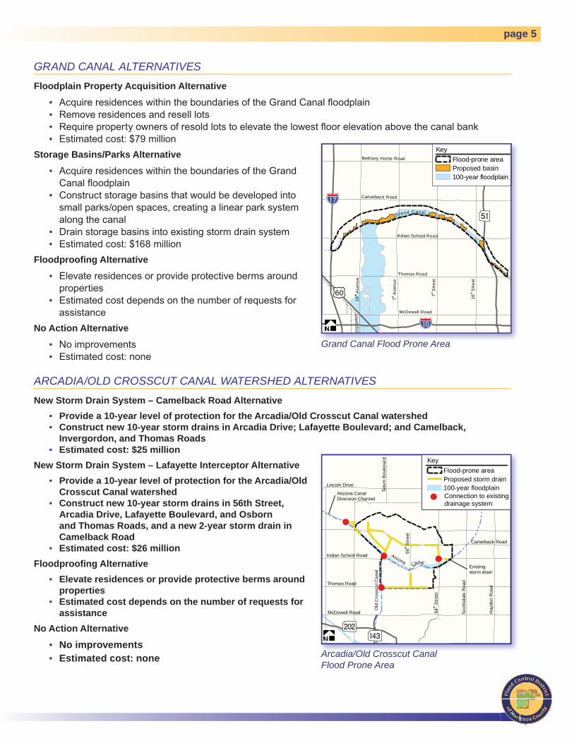
GRAND CANAL ALTERNATIVES
Floodplain Property Acquisition Alternative
Acquire residences within the boundaries of the Grand Canal fl oodplainRemove residences and resell lots Require property owners of resold lots to elevate the lowest fl oor elevation above the canal bankEstimated cost: $79 million
Storage Basins/Parks Alternative
Acquire residences within the boundaries of the Grand Canal fl oodplainConstruct storage basins that would be developed into small parks/open spaces, creating a linear park system along the canalDrain storage basins into existing storm drain systemEstimated cost: $168 million
Floodproofi ng Alternative
Elevate residences or provide protective berms around properties Estimated cost depends on the number of requests for assistance
No Action Alternative
No improvementsEstimated cost: none
ARCADIA/OLD CROSSCUT CANAL WATERSHED ALTERNATIVES
New Storm Drain System – Camelback Road Alternative Provide a 10-year level of protection for the Arcadia/Old Crosscut Canal watershedConstruct new 10-year storm drains in Arcadia Drive; Lafayette Boulevard; and Camelback, Invergordon, and Thomas RoadsEstimated cost: $25 million
New Storm Drain System – Lafayette Interceptor Alternative Provide a 10-year level of protection for the Arcadia/Old Crosscut Canal watershedConstruct new 10-year storm drains in 56th Street, Arcadia Drive, Lafayette Boulevard, and Osborn and Thomas Roads, and a new 2-year storm drain in Camelback RoadEstimated cost: $26 million
Floodproofi ng AlternativeElevate residences or provide protective berms around properties Estimated cost depends on the number of requests for assistance
No Action Alternative
No improvementsEstimated cost: none
▪▪▪▪
▪
▪
▪▪
▪
▪
▪▪
▪▪
▪
▪
▪
▪
▪
▪
▪▪
!"a$
?̧
!"c$
Iv
Camelback Road
Gran d C anal
7thS
treet
16th
Stre
et
7thA
venu
e
19th
Ave
nue
Thomas Road
McDowell Road
Indian School Road
Bethany Home Road
KeyFlood-prone areaProposed basin100-year floodplain
!
!
!
!
AðAá
Tatu
mB
oule
vard
McDowell Road
Thomas Road
Indian School Road
Camelback Road
Lincoln Drive
64th
Stre
et
56th
Stre
et
Sco
ttsda
leR
oad
Hay
den
Roa
d
ArizonaCanal
Old
Cro
sscu
tCan
al
Existingstorm drain
Arizona CanalDiversion Channel
KeyFlood-prone areaProposed storm drain100-year floodplain
! Connection to existingdrainage system
Grand Canal Flood Prone Area
Arcadia/Old Crosscut Canal Flood Prone Area

page 6
DOWNTOWN ALTERNATIVES
Storm Drain Alternative North of Railroad
Provide a 10-year level of protection by increasing the capacity of the storm drain system from the existing 2-year design Use excess capacity of existing storm drains in 19th, 15th, and 11th Avenues and 7th, 12th, and 16th StreetsConstruct new storm drains in 3rd and 9th Avenues and Fillmore Street that drain runoff into the Arizona Department of Transportation’s (ADOT) existing drainage facility Estimated cost: $31 million
Storm Drain Alternative South of Railroad
Provide a 10-year level of protection by increasing the capacity of the storm drain system’s from the existing 2-year design Use excess capacity of existing storm drains in 15th, 11th, and 7th AvenuesConstruct new storm drains in 7th Avenue and 7th Street that drain runoff into the Salt RiverConstruct new storm drain in 3rd Avenue that drains runoff into ADOT’s existing drainage facility Estimated cost: $18 million
Floodproofi ng Alternative
Not considered in this area
No Action Alternative
No improvementsEstimated cost: none
▪
▪▪
▪
▪
▪
▪
▪
▪
▪
▪▪
!
!
!
!
!
!"c$
!"a$
!"a$
Van Buren Street
Sky Harbor International Airport
Existingstorm drain
7thS
treet
Van Buren St
16th
Stre
et
McDowell Road
7thA
venu
e
19th
Ave
nue
Buckeye Road
27th
Ave
nue
SR-202
24th
St
32nd
St
Lower Buckeye Road
SR-202 Westbound
24th
Stre
et
KeyFlood-prone areaProposed storm drainProposed floodwater storageADOT drainage tunnel100-year floodplain
! Connection to existingdrainage system
DURANGO CURVE ALTERNATIVES
100-Year Collection System Alternative
Provide a 100-year level of protection for the Durango Curve areaConstruct a system of new large-diameter storm drains to collect fl oodwaters upstream of the Durango Curve Construct a new outlet double-barrel box culvert from the Durango Curve to the Salt RiverEstimated cost: $103 million
100-Year Collection System Alternative with Floodwater Storage at Durango Curve
Provide a 100-year level of protection for the Durango Curve areaConstruct a system of new large-diameter storm drains to collect fl oodwaters and drain them into a new multi-use fl oodwater storage basin at the Durango CurveConstruct a new 102-inch pipe to drain the storage basin into the Salt RiverEstimated cost: $77 million
▪▪▪▪
▪▪
▪▪
Downtown and “Durango Curve” Flood Prone Areas
page 7
100-Year Collection System Alternative with Floodwater Storage at Durango Curve and at the Union Pacifi c Railroad
Provide a 100-year level of protection for the Durango Curve areaConstruct a system of new large-diameter storm drains to collect fl oodwaters and drain them into two new multi-use fl oodwater storage basins: one at the Durango Curve and the other along the north side of the Union Pacifi c RailroadConstruct a new 102-inch pipe to drain the storage basins into the Salt RiverEstimated cost: $100 million
Floodproofi ng Alternative
Elevate residences or provide protective berms around properties Estimated cost depends on the number of requests for assistance
No Action Alternative
No improvementsEstimated cost: none
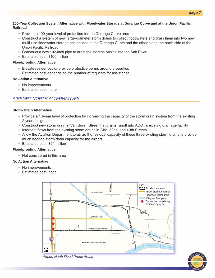
AIRPORT NORTH ALTERNATIVES
Storm Drain Alternative
Provide a 10-year level of protection by increasing the capacity of the storm drain system from the existing 2-year design Construct new storm drain in Van Buren Street that drains runoff into ADOT’s existing drainage facility Intercept fl ows from the existing storm drains in 24th, 32nd, and 40th StreetsAllow the Aviation Department to utilize the residual capacity of these three existing storm drains to provide much needed storm drain capacity for the airportEstimated cost: $24 million
Floodproofi ng Alternative
Not considered in this areaNo Action Alternative
No improvementsEstimated cost: none
▪▪
▪▪
▪▪
▪▪
▪
▪▪▪
▪
▪
▪▪
!
!
!
!"a$
Að
?̧
Aá
McDowell Road
Van Buren Street
Union Pacific Railroad
24th
Stre
et
32nd
Stre
et
40th
Stre
et
Sky Harbor International Airport
KeyFlood-prone areaADOT drainage tunnelProposed storm drain100-year floodplain
! Connection to existingdrainage system
Airport North Flood Prone Areas
page 8
Revision of Cave Creek Floodplain- Grand Canal to I-10 The Cave Creek fl oodplain review indicates that the average depth of fl oodwaters within the fl oodplain may not warrant a fl oodplain designation. In the area upstream of McDowell Road, fl oodwaters fl ow over a very wide area, spreading out between 19th Avenue and 7th Street. This wide, shallow fl ooding does not meet the criteria for a fl oodplain designation, which usually involves larger-scale, deeper fl ooding. The District’s study results indicate that the fl oodplain designation can be removed for the area between the Grand Canal and McDowell Road if the designation change is fi rst approved by FEMA. The overall fl ood risk for the area would not change without fl ood control measures being constructed regardless of whether or not the fl oodplain designation is removed. The drainage alternatives presented earlier in this handout are designed to reduce or alleviate the remaining fl ooding potential within the study area.
Next StepsThe Metro ADMP study team will complete the alternatives analysis, which will include descriptions, cost estimates, opportunities, and constraints of each alternative. Next, the District will schedule a workshop with the Metro ADMP study team to choose the recommended alternatives, incorporating comments received from the public meetings.
Once the recommended alternatives have been chosen, the Metro ADMP study team will further develop the recommended plan. These efforts will include preliminary engineering drawings of the elements of the plan, refi ned cost estimates for plan implementation, and graphic simulations of the more visible elements, such as reconfi guration of the golf courses and construction of new detention basins. The District will then schedule the fi nal series of public meetings to present the recommended plan to the public.
For More Information, contact:Afshin Ahouraiyan, P.E.Project ManagerFlood Control District of Maricopa County2801 W. Durango StreetPhoenix, AZ 85009Tel: 602-506-1501Fax: 602-506-4601E-mail: [email protected]