journal of historical geography
TRANSCRIPT
Drainage on the Grand Prairie: the birth of a hydraulic society on the Midwesternfrontier
Samuel J. Imlay and Eric D. Carter*
Grinnell College, 1118 Park St., Grinnell, IA 50112, United States
Abstract
The Grand Prairie of east central Illinois was notorious for a marshy environment that prevented dense agricultural settlement until late in the nineteenthcentury. While recent historicalegeographical scholarship has focused on innovations in drainage technology, drainage-related laws and institutions, andthe ecological impacts of wetland reclamation, it has largely failed to account for the persistence of agrarian structure, and its key component, land tenure,on the Grand Prairie. Late-nineteenth-century reclamation efforts were not quite so transformative as previously believed. The same landed elite thatdominated in the pre-drainage era quickly emerged atop a system of public drainage that held the key to the region’s economic future. In this paper, weextend Karl Wittfogel and Donald Worster’s theorizations about ‘hydraulic civilizations’ from the realm of irrigation to that of drainage. While drainagewas indeed important in shaping the history of east central Illinois, we argue that a distinctive social order in east central Illinois emerged from, and wasshaped by, an older agrarian structure that had developed in response to marshy, unpredictable conditions before drainage began in the late 1800s. Thebene!ciaries of the old order did not yield power easily, and instead skillfully capitalized on the new opportunities presented by drainage enterprises, tocreate a ‘hydraulic society’ on the prairie. The new order continued to rely on the exploitation of tenant farmers even as the landscape itself wastransformed into the intensely managed and highly productive Corn Belt of today.! 2011 Elsevier Ltd. All rights reserved.
Keywords: Illinois; Drainage; Wetlands; Agricultural settlement; Frontier settlement
Turner’s road not taken
In 1893, Frederick Jackson Turner presented his famous frontierthesis at a meeting of the American Historical Association. Standingbefore an audience in Chicago, he described the de!ning role of thewestern frontier in forging a uniquely American political culture. Bystripping the easterner of his traditional ways and stagnant institu-tions, the western frontier had, by Turner’s account, challenged andrejuvenated American society, fashioning both an ethos of individ-ualism and local innovations in democratic governance. But he lefthis audience unsettled: with the western frontier effectively ‘closed,’would democratic and egalitarian forms of government persist?1
Had Turner ventured south after the meeting, rather than northto hisWisconsin home, hemight witnessed the closing of one of theMidwest’s last internal frontiers, the Grand Prairie. The tracks of theIllinois Central Railroad would have carried him downstate, acrossthe Kankakee River, toward the "at terrain of east central Illinois.2
Outside the train windows, rows of tall July corn would haveechoed the rhythms of mechanized farming in a young Corn Belt,whose !elds stretched toward a distant horizon, punctuated onlyby silted streams and neat drainage ditches.3 Through the Pullmancar window, perhaps Turner would have glimpsed a crew ofimmigrant laborers cutting steep trenches into thick prairie sod.Manning a formidable ditching machine, or perhaps digging by
* Corresponding author.E-mail address: [email protected] (E.D. Carter).
1 F.J. Turner, The signi!cance of the frontier in American History, Report of the American Historical Association (1893) 199e227.2 Drainage was not widespread in central Wisconsin until a decade later, after the industry in white pine lumbering had died down. See H. Prince, Wetlands of the American
Midwest: A Historical Geography of Changing Attitudes, Chicago, 1997, 257. Indeed, the region’s environmental transformation might serve well as a case study in whatconstitutes fertile ground for Turner’s frontier. Fernand Braudel remarks, ‘In the new towns and clearings of the North [of Europe] there grew up a more free civilization onthe American pattern,’where ‘a pick and an axe might be enough.to make the soil productive.’ F. Braudel, The Mediterranean and the Mediterranean World in the Age of PhilipII, 2nd Edition, Berkeley, 1966, 75. Donald Worster similarly !nds that Turner’s theory might be ‘plausible for the history of Wisconsin or Ohio,’ but not the arid AmericanWest. D. Worster, Rivers of Empire: Water, Aridity, and the Growth of the American West, New York, 1985, 11. After 1900, however, drainage would alter central Wisconsin muchas it had the east central Illinois.
3 A.G. Bogue, From Prairie to Corn Belt: Farming on the Illinois and Iowa Prairies in the Nineteenth Century, Ames, Iowa, 1963, 239.
Contents lists available at SciVerse ScienceDirect
Journal of Historical Geography
journal homepage: www.elsevier .com/locate/ jhg
0305-7488/$ e see front matter ! 2011 Elsevier Ltd. All rights reserved.doi:10.1016/j.jhg.2011.11.017
Please cite this article in press as: Imlay SJ, Carter ED, Drainage on the Grand Prairie: the birth of a hydraulic society on the Midwestern frontier,Journal of Historical Geography (2011), doi:10.1016/j.jhg.2011.11.017
Journal of Historical Geography xxx (2011) 1e14
hand, the German and Dutch tenant workers might have carvedditches to carry water away from the estates of their wealthylandlords.4 Their toil in the mid-summer sun betrayed theincreasingly distant rung of farm ownership in the agriculturalladder of east central Illinois; they could only hope that drainagewould allow them to retain larger yields after their landlordextracted his ever-growing share of their annual crop.
Easing away from the scene, Turner’s train might haveprogressed across the unmarked boundary of a nearby drainagedistrict, crossing over the community’s main drainage channel. Thewaterway would have been planned by the local drainagecommission, whose latest round of special drainage taxes waschallenged by local landowners, but to no avail. Yet again, the localcourt had af!rmed the right of these districts to levy heavy taxes onarea landowners, who invariably transferred the burden onto therents of their tenants. Drawing toward a new set of peripheral!elds, Turner might have gazed upon the consequently modestproperties of such tenant farmers. Their sorry !nances precludedthe possibility of larger tracts, even as neighboring small ownerswent out of business or else gave up on prairie farming, leavingtheir old lands behind. These too would become property of thelarge landowner.5 Perhaps once they had repaid their hefty debts,these tenants hoped to pick up and move west as so many othershad done, in search of a more promising frontier where they mightwork for themselvesdnot for landlords or drainage taxassessorsdand under more democratic governance.
Would Turner have been surprised by what he saw?Turner’s de!ning hypothesis has won its adherents, yet it would
seem to stumble clumsily over east central Illinois in 1893. In fact,the area presents a challenge to theories of Midwestern frontiersettlement. William Cronon, fusing the insights of Turner, Johannvon Thünen, and central place theorists, has argued that regions ofdistinctive land uses arranged themselves in a spatially well-ordered pattern in symbiosis with the market demands of theMidwestern metropolis, Chicago. Railroads and investmentdecisions helped reinforce this zonal structure over time and space:livestock raising and forestry became industries of the far hinter-lands, while agriculture, especially wheat and corn, dominatedsomewhat closer to market centers.6 Meanwhile, government landpolicies helped to establish a relatively egalitarian land holdingpattern and along with it, the class of yeoman farmers that was socentral to Turner’s notion that the experience of the frontier rein-vigorates democratic institutions.
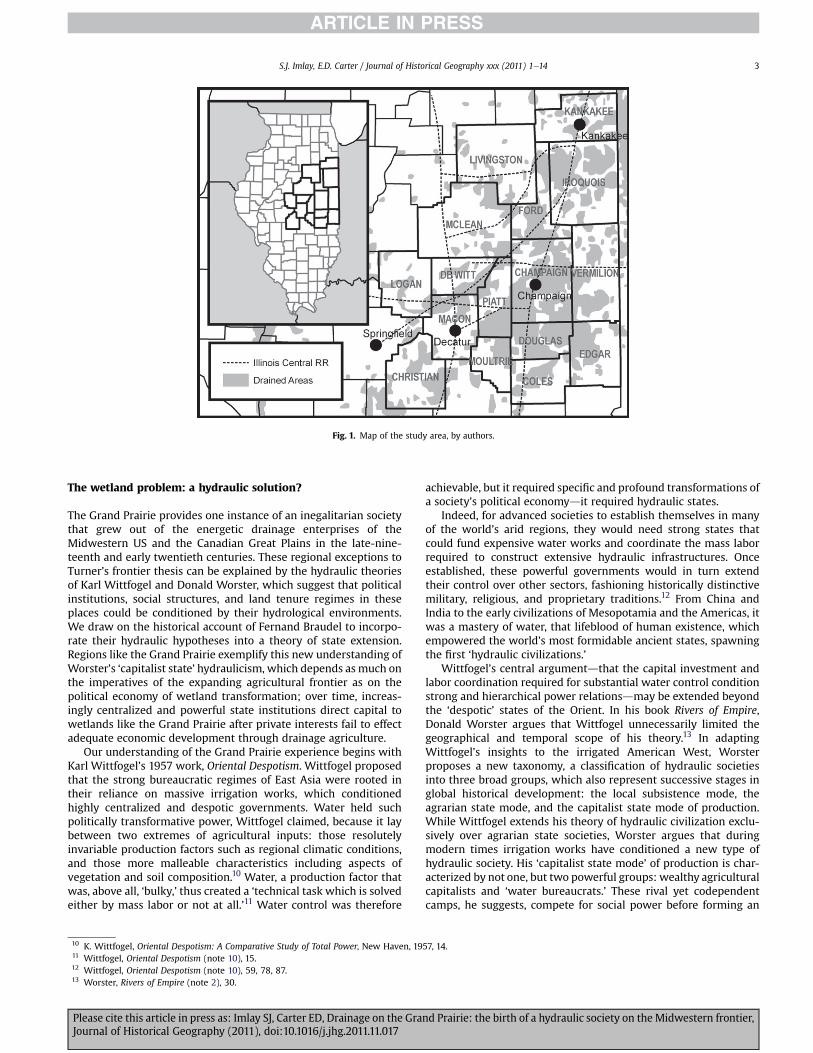
Yet east central Illinois, though just a few hours’ train ride fromChicago, was one of the last parts of the state to be densely popu-lated and exploited for agriculture (Fig. 1). Moreover, a landedagricultural elite dominated a tenant underclass there for decades,producing some of the highest rates of farm tenancy anywhereoutside of the southern U.S. and defying Turner’s generalizationsabout the dominance of an independent class of farmers workingsmall- to medium-sized parcels.
The obvious reason for the region’s slow development was itssetting on the swampy Grand Prairie: without modern drainagetechnologies and institutions to manage drainage effectively, settlersunderstandably skipped over east central Illinois well into the
nineteenth century, instead setting their sights on the more prom-ising terrain still available elsewhere. Indeed, other historical geog-raphers have covered this ground before, arguing that the region’sdaunting physical geography, along with settlers’ perceptions of itsdanger and unhealthfulness, prevented effective settlement untiltechnological breakthroughs and new institutional arrangements,especially drainage districts, made reclamation economical.7
Certainly, the impact of wetland reclamation via drainage in theUnited States has not received the attention it deserves in historicalscholarship, especially when compared with studies devoted toirrigation of arid lands. As Anthony E. Carlson points out, the amountof agricultural land reclaimed by drainage by 1920, mainly in theMidwest, far exceeded that opened by irrigation in the West.8
However, while drainage undoubtedly reshaped the landscape,late-nineteenth-century reclamation efforts in east central Illinoiswere not quite so socially transformative as previously believed.While historicalegeographical scholarship has focused on innova-tions in drainage technology, drainage-related laws and institutions,and the ecological impacts of wetland reclamation to explain theregion’s environmental and agricultural transformation, it has largelyfailed to account for the distinctive agrarian structures and landtenurepatterns that characterized theGrandPrairieduring this time.9
Elements of these structures persisted; the same landed elite thatdominated in the pre-drainage era quickly emerged atop a system ofpublic drainage that held the key to the region’s economic future.
Indeed, by 1893 east central Illinois featured some of the bestfarmland in the world, but transforming the wet prairie had beenno easy task. Rendering the prairie agriculturally productive meantsolving its drainage problem, which required substantial capitalinvestment coupled with effective mechanisms for organizinglabor. As the pressures of a layered frontier demanded a transitionfrom cattle-raising to corn-growing, the emergent need fordrainage produced a hydraulic society on the prairie, empoweringa class of wealthy landlords and cattlemen before the stategovernment implemented an equally strong bureaucracy of local-ized drainage districts in 1879.
Though the emergent order scarcely resembled the frontier ofTurner’s theory, the history of east central Illinois demonstrates thevalidity of his underlying logic. The evolution of any hydraulicsociety is intertwined with its frontier history because hydrauli-cism arises out of the choices states make in expanding their powerand territory. In this paper, we extend Karl Wittfogel and DonaldWorster’s theorizations about ‘hydraulic civilizations’ from therealm of irrigation to that of drainage. We illustrate the trans-formative potential of drainage and chronicle its importance inshaping the history of east central Illinois. At the same time, wedescribe how the distinctive social order of east central Illinoisemerged from, and was shaped by, an older agrarian structure thathad developed in response to marshy, unpredictable conditionsbefore drainage began in the late 1800s. The bene!ciaries of the oldorder did not yield power easily, and instead skillfully capitalizedon the new opportunities presented by drainage enterprises.The new order continued to rely on the exploitation of tenantfarmers even as the landscape itself was transformed into theintensely managed and highly productive Corn Belt of today.
4 M.B. Bogue, Patterns From the Sod: Land Use and Tenure in the Grand Prairie, 1850e1900, Spring!eld, 1959, 163.5 Bogue, Patterns From the Sod (note 4), 137, 150; Chicago Tribune, March 30, 1893.6 W. Cronon, Nature’s Metropolis: Chicago and the Great West, New York, 1991, 23e96.7 See Prince, Wetlands of the American Midwest (note 2); M.R. McCorvie and C.L. Lant, Drainage district formation and the loss of the Midwestern wetlands, 1850e1930,
Agricultural History 67 (1993) 13e39; R.A. Winsor, Environmental imagery of the wet prairie of east central Illinois, Journal of Historical Geography 13 (1987) 375e397;M. Urban, An uninhabited waste: transforming the Grand Prairie in nineteenth century Illinois, USA, Journal of Historical Geography 31 (2005) 647e665.
8 A.E. Carlson, The other kind of reclamation: wetlands drainage and national water policy, 1902e1912, Agricultural History 84 (2010) 452e453.9 On the importance of land tenure in shaping both landscape and society, see S. Salamon, Cultural dimensions of land tenure in the United States, in: Harvey Jacobs (Ed.),
Who Owns America? Social Con!icts Over Property Rights, Madison, 1998, 177.
S.J. Imlay, E.D. Carter / Journal of Historical Geography xxx (2011) 1e142
Please cite this article in press as: Imlay SJ, Carter ED, Drainage on the Grand Prairie: the birth of a hydraulic society on the Midwestern frontier,Journal of Historical Geography (2011), doi:10.1016/j.jhg.2011.11.017
The wetland problem: a hydraulic solution?
The Grand Prairie provides one instance of an inegalitarian societythat grew out of the energetic drainage enterprises of theMidwestern US and the Canadian Great Plains in the late-nine-teenth and early twentieth centuries. These regional exceptions toTurner’s frontier thesis can be explained by the hydraulic theoriesof Karl Wittfogel and Donald Worster, which suggest that politicalinstitutions, social structures, and land tenure regimes in theseplaces could be conditioned by their hydrological environments.We draw on the historical account of Fernand Braudel to incorpo-rate their hydraulic hypotheses into a theory of state extension.Regions like the Grand Prairie exemplify this new understanding ofWorster’s ‘capitalist state’ hydraulicism, which depends as much onthe imperatives of the expanding agricultural frontier as on thepolitical economy of wetland transformation; over time, increas-ingly centralized and powerful state institutions direct capital towetlands like the Grand Prairie after private interests fail to effectadequate economic development through drainage agriculture.
Our understanding of the Grand Prairie experience begins withKarl Wittfogel’s 1957 work, Oriental Despotism. Wittfogel proposedthat the strong bureaucratic regimes of East Asia were rooted intheir reliance on massive irrigation works, which conditionedhighly centralized and despotic governments. Water held suchpolitically transformative power, Wittfogel claimed, because it laybetween two extremes of agricultural inputs: those resolutelyinvariable production factors such as regional climatic conditions,and those more malleable characteristics including aspects ofvegetation and soil composition.10 Water, a production factor thatwas, above all, ‘bulky,’ thus created a ‘technical task which is solvedeither by mass labor or not at all.’11 Water control was therefore
achievable, but it required speci!c and profound transformations ofa society’s political economydit required hydraulic states.
Indeed, for advanced societies to establish themselves in manyof the world’s arid regions, they would need strong states thatcould fund expensive water works and coordinate the mass laborrequired to construct extensive hydraulic infrastructures. Onceestablished, these powerful governments would in turn extendtheir control over other sectors, fashioning historically distinctivemilitary, religious, and proprietary traditions.12 From China andIndia to the early civilizations of Mesopotamia and the Americas, itwas a mastery of water, that lifeblood of human existence, whichempowered the world’s most formidable ancient states, spawningthe !rst ‘hydraulic civilizations.’
Wittfogel’s central argumentdthat the capital investment andlabor coordination required for substantial water control conditionstrong and hierarchical power relationsdmay be extended beyondthe ‘despotic’ states of the Orient. In his book Rivers of Empire,Donald Worster argues that Wittfogel unnecessarily limited thegeographical and temporal scope of his theory.13 In adaptingWittfogel’s insights to the irrigated American West, Worsterproposes a new taxonomy, a classi!cation of hydraulic societiesinto three broad groups, which also represent successive stages inglobal historical development: the local subsistence mode, theagrarian state mode, and the capitalist state mode of production.While Wittfogel extends his theory of hydraulic civilization exclu-sively over agrarian state societies, Worster argues that duringmodern times irrigation works have conditioned a new type ofhydraulic society. His ‘capitalist state mode’ of production is char-acterized by not one, but two powerful groups: wealthy agriculturalcapitalists and ‘water bureaucrats.’ These rival yet codependentcamps, he suggests, compete for social power before forming an
Fig. 1. Map of the study area, by authors.
10 K. Wittfogel, Oriental Despotism: A Comparative Study of Total Power, New Haven, 1957, 14.11 Wittfogel, Oriental Despotism (note 10), 15.12 Wittfogel, Oriental Despotism (note 10), 59, 78, 87.13 Worster, Rivers of Empire (note 2), 30.
S.J. Imlay, E.D. Carter / Journal of Historical Geography xxx (2011) 1e14 3
Please cite this article in press as: Imlay SJ, Carter ED, Drainage on the Grand Prairie: the birth of a hydraulic society on the Midwestern frontier,Journal of Historical Geography (2011), doi:10.1016/j.jhg.2011.11.017
alliance that emerges as a new hydraulic order, encompassing bothpublic and private sectors, less limited than before in scope orambition.14
If Worster’s new regime type is the expression of hydraulicforces within a capitalist order, it should appear historicallyalongside early capitalist markets in theWest. Let us return, then, tothe regional conditions of ‘the Po Plain, of Venice, and of theNetherlands,’ where Wittfogel refused to extend his theory. Ratherthanwitnessing the political or geographical dominance that Chinaand India attained, these areas emerged as hydraulic regions ofa different class within the ‘nonhydraulic nexus’ of the continent.Fernand Braudel’s The Mediterranean, a masterful tour of earlymodern Europe, provides key insights into these cases. As urbanpopulations of the !fteenth and sixteenth centuries expanded andnobles looked to augment their power, both groups were eager tocreate productive regions from the stagnant waters of Europe’smalarial swamp lands.15 Across southern Europe governments andcapitalists alike shouldered the prohibitive investments in drainageand irrigation, beginning on the smaller plains and working theirway toward the larger ones with more extensive hydraulic projects.In Tuscany, the Po Delta, Naples, and Rome, governments beganland improvements. Wealthy capitalists were meanwhile respon-sible for the improvement of the vast plains of Lombardy andLanguedoc, where hydraulic social power over"owed into theprivate sector. In Venice, an urban hydraulic society was shaped bysymbiotic relationships maintained between patrician families andgovernment, which were often interlinked through mutuallyempowering channels of credit.
The emergent social patterns were clear: ‘The plains were theproperty of the nobleman’ in Braudel’s Mediterranean basind"at,waterloggedmarshlandswhere feudal structures persisted past theirtime. For their part, the nobles were such strong property holdersthat they constituted a state unto themselves. Even in Turkey theirdrainage efforts were evident in the çiftliks, ‘villages recognizablefrom the hovels clustering around the tall master’s house, thattowers and watches over them.’16 In Venice, where half of a land-owner’s property was exacted in payment should he fail to pay forthe administration’s planned improvements on his land, the burdenof government drainage was similarly onerous. Where privateinvestment was at work, absentee landlords ruled over a miserableclass of tenant laborers. On this point, Braudel and Worster sing indue harmony. On the low plains of Lombardy Braudel discovers the‘true rural proletariat’ in themigrant workers, tenant agriculturalists,and peasant farmers, the modern hydraulic state’s ‘wage-basedanswer to the corvée,’ later embodied in the immigrant !eld handswhoWorster !nds in the arid AmericanWest, ‘sweating every bit asmuch as the Egyptian fellahin did.’17
Braudel’s !ndings con!rm Worster’s new classi!cation, and gofurther, suggesting that drainagedwhich, like irrigation, confrontsthe ‘bulkiness’ of waterdis similarly capable of conditioning
hydraulic regimes. Though Worster rightly extends hydraulictheory to the modern West, like Wittfogel he denies that "oodcontrol is politically transformative, rejecting it as
.sporadic and unpredictable."ood protection by itself hasusually a limited, ambiguous impact on the structure ofsociety and power. Irrigation, on the other hand, is a type ofwater control that is constant, pervasive, and more sociallydemanding.The difference is between holding an umbrellaover your head when it rains and making the rain gosomewhere else. The !rst is a momentary defense, thesecond a concerted attempt to control and defeat a threatonce and for all.18
It would be hard to argue, however, that such an assertion holdsin Europe’s marshes or on the wet prairies of the Midwest, wherewater was an ever-present threat and the costs of a lost crop couldbe disastrous. Here agriculture required drainage works that, intheir extension, long-lasting effects on agro-ecology, and demandson social organization, more closely resemble irrigation systemsthan Worster’s ‘"ood protection’ works. Yet drainage does presentimportant differences: where irrigation canals often draw waterover great distances from sparse rivers to arid landscapes, drainageoperations direct water to nearby outlet streams, conditioninga localized hydraulicism that is perhaps closer to Wittfogel’s‘hydroagriculture.’19
Whether developed through irrigation or drainage, however, newhydraulic orders are a result of state expansion, prompted by thedemands of growing populations and their governments’ appetitesforwealth. States seek to extend their frontiers along thepathsof leastresistance, and thus circumnavigate geographical features thatrequire special expenditure to develop across. Yet rather thanbroaden its power, the economical state may instead ‘deepen’ itspower through stronger and more involved government where itsextension encounters insurmountable costs: when its frontier runsup against the limits imposed by diseconomies of scale inherent in itsown structure, when it confronts the military bounds of other states,or when it encounters natural features it cannot circumnavigate.20
Turner may, in fact, be the !rst to turn to on this latter point. In‘The Signi!cance of the Frontier’ he notes that east of where thefrontier stalledd‘the “fall line;” the Alleghany [sic] Mountains; theMississippi; the Missouri where its direction approximates northand south; the line of the arid lands.; and the Rocky Mountain-s’dthere cropped up those Eastern, traditionalist forces.21 No greatleap in logic is required to accept that where smaller, circum-navigable boundaries like the Grand Prairie emerged, the frontierwould progress around them, returning to colonize such ‘high cost’areas when more formidable obstacles presented themselvesfurther west.22
We can add to this formulation Turner’s ‘layered frontier’ or vonThünen’s ‘zones of industry’: just like the outer frontier, von
14 Worster, Rivers of Empire (note 2), 31.15 Braudel, The Mediterranean and the Mediterranean World in the Age of Philip II (note 2), 67, 70.16 Braudel, The Mediterranean and the Mediterranean World in the Age of Philip II (note 2), 69, 75e76; see also 724e725.17 Braudel, The Mediterranean and the Mediterranean World in the Age of Philip II (note 2), 75, 79; Worster, Rivers of Empire (note 2), 51.18 Worster, Rivers of Empire (note 2), 20.19 For more on this often-hazy distinction, see D.H. Price, Wittfogel’s neglected hydraulic/hydroagricultural distinction, Journal of Anthropological Research 50 (1994)187e204.20 Just so did Braudel’s Italian states revisit the lowland marshes when demand for new grain found them squeezed up against the military strength of their neighbors. Thesame reasoning supports Weber’s notion that the cramped territorial conditions of continental Europe were responsible for the divergent political economies of Britain andthe continent.21 Turner, Signi!cance of the frontier in American History (note 1), 202.22 J. Sheppard Smith puts it well: ‘In the development of our country it was only natural that the farm lands which were more readily susceptible to cultivation should havebeen occupied !rst, and that the over"owed and swamp lands should have been overlooked entirely for years. It was only after the absorption of the more desirable farmingland, which resulted from the increase of population, and after the consequent and more intensive development of the country, that attention was directed to the reclaimingof the over"owed lands.’ J.S. Smith, Reclamation of swamp lands and the modern drainage bond, Annals of the American Academy of Political and Social Science 88 (1920) 102.
S.J. Imlay, E.D. Carter / Journal of Historical Geography xxx (2011) 1e144
Please cite this article in press as: Imlay SJ, Carter ED, Drainage on the Grand Prairie: the birth of a hydraulic society on the Midwestern frontier,Journal of Historical Geography (2011), doi:10.1016/j.jhg.2011.11.017

Thünen’s zones will avoid marshland barriers as they pressoutward from core markets, returning to them later. More impor-tantly, wetland barriers pose different problems to the variousindustries of the layered frontier, especially impeding the devel-opment of agriculture after cattle-raising becomes unsustainable. Itis during this transition, then, that drainage becomes economicallynecessary and targeted hydraulic institutions become the mostef!cient means of maximizing state power. We have theorizeda dynamic of circumnavigation and ‘!lling in’; now Turner’s wavesand von Thünen’s zones suggest exactly which round of thisprocess will condition a strong hydraulicism.
Thus, Turner’s own history of the American frontier justi!es theexceptions found in east central Illinois and Worster’s irrigatedWest. Indeed, Turner’s and Worster’s logics converge from theperspective our model reveals. The emergent synthesis bringsfrontier change to hydraulic theory and, in turn, brings hydrauli-cism to the wet prairie frontier.
The wet prairie at midcentury
A combination of inaccessibility, poor agricultural prospects, andexaggerated popular imaginings of the Grand Prairie made eastcentral Illinois the last settlement frontier in the state. Theimpression the wet prairies made on the !rst frontier settlers hasbeen well documented: Easterners had seen nothing like the vast,"at tallgrass prairies before, and for newcomers it was a miserableand bewildering experience. Successive rounds of glaciation hadleft the region poorly drained, with few outlets or navigablestreams.23 The rich glacial soils that today render the region idealfor modern farming were during this time still thick muds, oftensubmerged, and would not yet take to the plow. Many easternsettlers mistook the area’s lack of trees for a sign of poor soil quality.Meanwhile, the landscape’s level slopes, which collected overa meter of stagnant water during the wet spring months, providedan excellent breeding ground for the anopheles mosquitoes thatbuzzed through the high bluestem grass. Wading through themalarial swamps, pioneers were often overcome with the feverish‘ague,’ supposedly fainting from loss of blood.24
Such exaggerated accounts of disease and the de!ciencies of theland prevented heavy settlement. It is telling that in Illinois,Livingston, Ford, Iroquois, and Champaign counties, populationdensity did not surpass Turner’s frontier criterion of two people persquaremile until after 1840, lagging behind all other counties in thestate.25 Euro-American pioneers in the region favored woodedupland tracts, and ventured cautiously onto small expanses of wetprairie.26 Not until the Illinois Central passed through the GrandPrairie did the region attract signi!cant settlement.
After midcentury, two pieces of legislation put substantialprairie lands to market, empowering a new capitalist overclass ofcattlemen and landlords. In 1850 the federal government allocatedone and one-half million acres of poorly drained prairie to Illinoisunder the Swamp Land Act, a perhaps naïve attempt to acceleratefrontier settlement.27 Though Congress intended that ‘theproceeds of said lands shall be applied, exclusively, so far asnecessary, to the purpose of reclaiming said lands by means oflevees and drains,’ drainage was not yet a priority for the state ofIllinois.28 Instead the state, which was heavily in debt, turned overswamp grant land to its counties in 1852, with the intention ofreducing this de!cit and using any surplus revenue to fund basicinfrastructural projects. In Champaign County, swamp grantrevenue funded schoolhouses and courthouses, not drainageschemes. Quick sales helped wealthy landowners consolidate theirholdings in vast, unimproved tracts.29
As per our state extension theory, the degree to which govern-ments were content to sell unimproved lands rather than drainthem was a product of their frontier prospects and cheaperextension options. These possibilities varied over time and space; inthe 1850s, local governments and their boosters alone voicedstrong opposition to the sales policy of the federal, state, and evencounty administrations because they were the only ones withoutexpansion-based development options. In 1858, an editor for theCentral Illinois Gazette expressed such concerns, declaring, ‘weconsider every acre that goes into the hands of non-resident, non-improving speculators as a positive detriment to the people.’30 Yetabove the local level, governments valued quick revenue over theproductive disposal of improved swamp land as long as moreef!cient alternatives for growth remained.
The limitations of drainage technology reinforced theseattitudes.Margaret Beattie Bogue notes that ‘if [counties] planned toimprove their holdings and bring them into production in the 1850sand 1860s they would have to spend large sums of money exper-imentingwithmethods of drainagewith little assurance of breakingeven or realizing a pro!t.’31 At this juncture, state development inIllinois was yet rudimentary, and it made little sense to gamblefunds on drainage when countiesdwhich were still developingtheirwoodedgroves and small prairiesdlacked basic infrastructure.
This development logic would change as that infrastructureimproved. Eighteen !fty also marked the year the Illinois CentralRailroad received its charter from the state.32 Like those of localgovernments, the Illinois Central’s economic prospects hinged, inpart, on the development of its !nite set of land, and thus it hada more pressing interest in seeing its two and one-half million rail-side acres in Illinois improved. The railroad’s policies thereforeencouraged settlement and drainage, in contrast to state swamp
23 H.R. Mount, Soil Survey of Champaign County, Illinois, Washington, 1982; Winsor, Environmental imagery of the wet prairie of east central Illinois (note 7), 375.24 Mount, Soil Survey of Champaign County, Illinois (note 23); Winsor, Environmental imagery of the wet prairie of east central Illinois (note 7), 375; Urban, An uninhabitedwaste (note 7), 652.25 A. Bogue, From Prairie to Corn Belt (note 3), 8; Winsor, Environmental imagery of the wet prairie of east central Illinois (note 7), 380e381; Urban, An uninhabited waste(note 7), 653.26 Prince, Wetlands of the American Midwest (note 2), 126e127; J.O. Cunningham, History of Champaign County, Chicago, 1905, 648; A. Meyer, The Kankakee “Marsh” ofnorthern Indiana and Illinois, Papers of the Michigan Academy of Science, Arts, and Letters 21 (1935).27 M.B. Bogue, The swamp land act and wet land utilization in Illinois, 1850e1900, Agricultural History 25 (1951) 170.28 B.H. Hibbard, Public Land Policies, Madison, 1965, 270. In fact, for the federal government itself, raising values of adjacent federal lands was a major motivation for the Act.29 Cunningham, History of Champaign County (note 26), 648; Bogue, The swamp land act and wet land utilization in Illinois, 1850e1900 (note 27), 171e173; Paul WallaceGates, Land policy and tenancy in the prairie states, Journal of Economic History 1 (1941): 62-3.30 Central Illinois Gazette, Urbana, October 13, 1858.31 Bogue, The swamp land act and wet land utilization in Illinois, 1850e1900 (note 27), 174.32 P.W. Gates, The promotion of agriculture by the Illinois Central Railroad, 1855e1870, Agricultural History 5 (1931) 58. While Illinois granted the northesouth IllinoisCentral two and one-half million acres of federal land accordingly, the nation’s eastewest lines would later receive even more generous grants from the federal government,‘the unprecedented liberality in the grants to the Paci!c roads due largely to the nature of the country through which the roads were to pass.’ Hibbard, Public Land Policies(note 28), 249.
S.J. Imlay, E.D. Carter / Journal of Historical Geography xxx (2011) 1e14 5
Please cite this article in press as: Imlay SJ, Carter ED, Drainage on the Grand Prairie: the birth of a hydraulic society on the Midwestern frontier,Journal of Historical Geography (2011), doi:10.1016/j.jhg.2011.11.017

grant policies that endowed eastern speculators and absenteeinvestors.33That the IllinoisCentral still emergeda!xtureof the largelandowner-dominated economy of the 1850s prairie attests to thepower of its soggy geography to impact economic development. Notuntil after the Civil War would these forces be manifest so plainly.
Of the Illinois Central’s hundreds of thousands of acres inchecker-boarded lands in Champaign County, many unsold sectionscoexisted with the large land holdings of farmers and landlordsthrough the 1860s.34 The Illinois Central’s grant stipulated railroadlands go at no less than $2.50 per acre, and their proximity to therailway fetched them between $7 and $15 per acre through the late1850s, while swamp grant lands sold for $1.25, $3, or $6 per acre inChampaign County, according to their assessed grade.35
In addition to high land prices, the prohibitive costs of privatedrainagemeant that the Illinois Central’s lands fell into the hands ofwealthy landowners, who had already "ocked to the region for itscheap lands and easy credit. Indeed, by 1870, most of Illinois’ largefarms ‘were in counties in which the Illinois Central had receivedlarge amounts of land.’36 Writes Gates, ‘A considerable part of theearly sales of the railroad were made to colony promoters andlandlords who were planning the creation of huge estates orbonanza farms.’37 The simple fact was that no one else could affordto buy on the railroad’s terms.
Even so, the Illinois Central went to considerable lengths topromote agricultural development and the prerequisite drainage inorder to secure settlement along its lines.38 The railroad evencollaborated with the State Agricultural Society to advertise theregion and its prospects. Yet its solutions to the drainage problemwere as capital intensive as any. In 1859, the railroad offered a $250prize for a workable ditching implement, yet ‘only large land-owners could afford such expensive machines and consequentlythe problem of draining the wet areas was not solved.’39
Nonetheless, the Illinois Central worked symbiotically withwealthy landowners to drain lands privately, once constructinga station near a 10,000 acre wetland tract in exchange for itsprivately funded drainage.40
The old regime
Such extensive drainage was not wholly characteristic of thesystem that arose after 1850, however. While the railroad’s heftyland prices and the cost of private drainage advanced the capital-ist’s in"uence, drainage schemes were the exception, not the rule,before the mid-1860s. Rather, the wet prairie produced a wealthyruling class for related but subtler reasons. As land marketsexploded after 1850, the many cattle ranchers on the prairie fron-tier were forced to purchase legally the lands their cattle hadheretofore grazed under informal tenure. Yet buying wet prairie
land was a high-risk investment, one only those with substantialresources could afford to make, and one money-poor governmentswith other development options were quite ready to accept.
Joining the cattlemen were eastern speculators, who took uplandlordismwhile seekingquick returns fromwestern land. After thelull in speculation that accompanied the Panic of 1837, investorsreturned to Illinois, gobbling up public lands through the 1840s andinto the mid-1850s. These were the landowners whose lack ofimprovement schemes provoked scathing criticism from localboosters. When their short-term plans did not pan out, manyinvestors and speculatorsdwhowanted some immediate returns toremain a"oat through poor credit cyclesdturned to tenancy asa meantime solution and morphed into a landed ruling class that‘forestalled and subsequently took tribute from actual settlers’ as itcrowded them out of land markets.41 Tenancy became widespreadon the prairies of the Midwest through the 1850s and early 1860s,and nowhere more so than in east central Illinois. In Ford andChampaign counties, rates of tenancy reached 40% and 45%,respectively, while one William Scully’s extensive operations boos-ted neighboring Logan County’s rate to a formidable 50%.42Whetherthey were seeking long- or short-term returns initially, by the 1850sthis landlord class was !rmly established, and it had adopted tenantfarming as a solution to the low yields of prairie land investments, anoutcome rooted in the natural features of the Grand Prairie itself.
Henry L. Ellsworth was one such landlord who intended to rentout his vast estates when he acquired them in the 1830s. Ellsworthbought 220,000 acres of Illinois and Indiana lands and began toadvertise for tenants soon afterward. His tenants came from theranks of immigrants making their way west, many of whom couldnot yet afford land on the prairie, since competition betweenspeculators and wealthy landowners ensured that land prices wereout of their reach. Others wanted to become acquainted with theland before committing to a parcel. These tenants might payEllsworth one-third of their annual crop during their stay, or up toone-half of their harvest in order to gain title after two to threeyears.43 Yet few tenants remained on the land; even with title, theprospects of prairie farming in the 1850s were daunting for a smallfarmer who could not furnish the capital to drain.
Nowhere was this clearer than on William Scully’s estates,where tenants were refused assistance in making improvements,leaving it ‘the most forlorn-looking estate in Illinois.’44 Scully’soperations showed the extremes of concentrated land and power ineast central Illinois. The Irishman, who in 1860 had been woundedin a ‘murderous assault’ while delivering evictions to a mob oftenants in Ireland, was known to charge extortionate rents andevict tenants without due cause.45 So severe were his perceivedabuses of power that the local press singled him out for criticism,while practically ignoring the misdeeds of other landed elites. As
33 Gates, The promotion of agriculture by the Illinois Central Railroad, 1855e1870 (note 32), 66.34 F.A. Schlipf, J.E. Koch and H.C. Grueneberg Jr. (Eds), Combined 1893, 1913, and 1929 Atlases of Champaign County, Illinois, Urbana, Illinois, 1997; Alexander Bowman map ofChampaign County, 1863. Champaign County Historical Archives, Urbana Free Library, Urbana, Illinois.35 Hibbard, Public Land Policies (note 28), 243; Bogue, The swamp land act and wet land utilization in Illinois, 1850e1900 (note 27), 171; Bogue, Patterns From the Sod(note 4), 32; Champaign County, Deed Record, T: 607, Champaign County Recorder of Deeds Of!ce, 1776 E. Washington St., Urbana, Illinois, 61802.36 Gates, The promotion of agriculture by the Illinois Central Railroad, 1855e1870 (note 32), 67; P.W. Gates, Large scale farming in Illinois, 1850e1870, Agricultural History 6(1932) 15.37 P.W. Gates, Landlords and Tenants on the Prairie Frontier: Studies in American Land Policy, Ithaca, 1973, 244.38 Sometimes literally, once providing two and a half miles of empty cars to accommodate agriculturalists and other attendees at the state fair. Gates, The promotion ofagriculture by the Illinois Central Railroad, 1855e1870 (note 32), 60.39 Gates, The promotion of agriculture by the Illinois Central Railroad, 1855e1870 (note 32), 73.40 For a fuller description of the Danforth agreement, see Gates, The promotion of agriculture by the Illinois Central Railroad, 1855e1870 (note 32), 74.41 Gates, Landlords and Tenants on the Prairie Frontier (note 37), 70.42 Gates, Land policy and tenancy in the prairie states (note 29), 80e81.43 Gates, Land policy and tenancy in the prairie states (note 29), 75; Gates, Landlords and Tenants on the Prairie Frontier (note 37), 133.44 Bloomington Pantagraph, Bloomington, Illinois, March 21, 1887. Reprint of an article originally published in the Chicago Tribune (note 5).45 Gates, Landlords and Tenants on the Prairie Frontier (note 37), 267.
S.J. Imlay, E.D. Carter / Journal of Historical Geography xxx (2011) 1e146
Please cite this article in press as: Imlay SJ, Carter ED, Drainage on the Grand Prairie: the birth of a hydraulic society on the Midwestern frontier,Journal of Historical Geography (2011), doi:10.1016/j.jhg.2011.11.017
the largest non-corporate landowner in Illinois, with 38,000 acresin Logan and Grundy counties alone, Scully came about as close asany to the absolute supremacy of Wittfogel’s hydraulic despots.46
The sheer weight of his power over the ‘miserable’ Polish andBohemian tenants who were ‘in a state of absolute serfdom underhis heartless alien rule,’ the unwarranted con!scation of theirlands, the full transfer of his tax burden onto them, and the utterabsence of help in making the improvements that were sometimesrequired of them to gain title all demonstrate ‘despotic’ arrange-ments that recall the feudal worlds of Wittfogel and Braudel.47
While Scully’s excesses were atypical for the Grand Prairie, theestates of Matthew T. Scott were largely representative of land-lordetenant relations on unimproved lands at midcentury.Between 1848 and 1859, Scott and a cadre of relatives purchased45,070 acres in Vermilion, Piatt, Livingston, and McLean counties.Scott was among the class of prairie landlords who ‘discarded thetheory that the best way to make money from raw prairie was tokeep expenditures at a minimum,’ the kind of landowner whowould survive the profound transitions of the next decade.Accordingly, he tenanted his lands and made impressive efforts todrain them, spending $5700 on labor alone in 18months during themid-1850s. Yet his tenants werewidely unsuccessful in gaining titleto what lands Scott might sell for pro!t, conveying a general trendin the region; notes Bogue, ‘in part the high percentage of failuresstemmed from the heavy costs of improving and operating land.’Meanwhile, Scott’s large capital outlays allowed him theimprovement schemes that catapulted him to local prominence.‘Indeed, if the economic life of Chenoa Township in the frontierperiodmay be said to have revolved around one person, that personwas Scott, its chief booster, landowner, and moneylender.’48 Thiswas the dominance of the 1850s landlord: on estates like those ofMatthew T. Scott, the wet prairie had arrived at its !rst incarnation.
Speculator-landlords de!ned the future of east central Illinoiswhen they adopted tenancy as a solution to their !nancial troubles,yet they were both outnumbered threefold and out-landed by thelarge-scale farmers and cattlemen ‘who exercised political power outof all proportion to their numbers,’ and formed the other half of eastcentral Illinois’ ruling class in the 1850s.49 The wet prairie favoredsuchmenof capital because the untillable terrain of largewet prairieswas useful only to cattlemen, who already required substantialholdings to make pro!ts. This constituted a weak selection for largelandowners, who became wealthy and powerful not because theyalone could afford to drain, but because theyalone could affordnot to.
While small farmers and settlers of modest means gravitatedtoward wooded tracts, the cattlemen of the 1840s and 1850s foundthe large prairies perfectly suitable for ranching. ‘The abundance oftall sweet grass,’ observes Gates, ‘made the prairies a natural areafor the cattle industry.’50 On the bluestem expanses of east centralIllinois, prairie cattle kings came to dominate, but initially requiredless capital than was necessary for private drainage, because theexpansive and semi-open range allowed their mobile cattle to takeadvantage of seasonally changing moisture conditions.51 In the
1850s, when new land acts and cheap credit induced a wave ofimmigration into the region, the cattle kings quickly bought up asmuch public land as they could, seeking to maintain their domi-nance in the prairie system. During later stages, landowners wouldlikewise take possession of lands left by insolvent neighbors.Though cattle enterprises did not confront the costs of drainage,they were still undertakings out of the newcomer’s reach, aninaccessible rung on the agricultural ladder of the wet prairie.52
Indeed, while cattlemen minimized investments in farm build-ings and land improvements, theirs was yet a wealthy man’s game,with risks and expenses only justi!ed by the commensurate pro!tsthat furnished them with ‘costly furniture, art treasures,’ and‘palatial country mansions.’53
Moreover, the cattle industry in east central Illinois becameincreasingly capital intensive in response to changes on thenational frontier. Initially, the cattle kings inhabited the edge of thefrontier, the outer rings of von Thünen’s concentric landscape. Yet,as William Cronon suggests, these rings expanded as the nationgrew, washing like waves over Turner’s stationary vantage point.54
For a time, the wet prairie of east central Illinois was an exception,a waterlogged frontier that agricultural development passed over,where the speculators, landlords, and cattlemen alone reigned. Oneis reminded of Braudel’s Lombardydeven he cannot omit ‘Thünen’slaw of circles’dwhere towns gaveway to noblemen’s castles, whichin turn gave way to the capitalists’ estates as one descended ontothe damp lower plains.55 Lagging in agricultural intensi!cation as ithad in initial settlement, the cattle-raising economy persisted onthe Grand Prairie, but eventually development caught up to eastcentral Illinois. As its ranchers could not compete with cattleenterprises further west, they were gradually forced to intensifytheir operations. The story of east central Illinois’ cattle industry inthe 1850s and 1860s was the story of that frontier progression, withits strong push and pull of economic forces.
WhenMichael L. Sullivant, a commercial farmer fromOhio, settledon the prairie of Illinois in 1854, havingbought 80,000 acres of federal,railroad, and swamp grant lands in Champaign, Piatt, and Fordcounties, he did not fully foresee these impending transitions. Hesurely possessed the ample land holdings required of prairiecattlemen, and hewas likewise ready to purchase equipment and hirelaborers in order to work his formidable lands. Upon arrival at hisBroadlands farm in early 1855, Sullivant was already supplied withthirty horses and nine wagons. And the 23,000 acre estate in thesoutheast corner of Champaign county hosted 5000 cattle and 4000horses by 1863.56 Yet by the mid-1860s, he and his cattle kingcomrades increasingly felt the economic pressures of a layered fron-tier, the strains that would ultimately put Sullivant out of business.
Drainage and Darwin: the wet prairie in transition
The American Civil War did not ravage the wet prairie as it did thebattle!elds of the east, yet the Grand Prairie and its landowner classnevertheless emerged profoundly altered in the post-bellumworld.
46 Prince, Wetlands of the American Midwest (note 2), 164.47 Gates, Land policy and tenancy in the prairie states (note 29), 76; Braudel, The Mediterranean and the Mediterranean World in the Age of Philip II (note 2), 76.48 Bogue, Patterns From the Sod (note 4), 85e106.49 Bogue, Patterns From the Sod (note 4), 85.50 Gates, Landlords and Tenants on the Prairie Frontier (note 37), 198.51 Bogue, Patterns From the Sod (note 4), 49.52 Bogue, Patterns From the Sod (note 4), 150; Gates, Landlords and Tenants on the Prairie Frontier (note 37), 133, 204.53 Prince, Wetlands of the American Midwest (note 2), 172; Bogue, Patterns From the Sod (note 4), 73.54 Cronon, Nature’s Metropolis (note 6), 54.55 Braudel, The Mediterranean and the Mediterranean World in the Age of Philip II (note 2), 61, 74.56 N. Bateman and P. Selby, Historical Encyclopedia of Illinois, Chicago, 1905, 613; Gates, Large scale farming in Illinois, 1850e1870 (note 36), 17; Gates, Landlords and Tenantson the Prairie Frontier (note 37), 226, 250.
S.J. Imlay, E.D. Carter / Journal of Historical Geography xxx (2011) 1e14 7
Please cite this article in press as: Imlay SJ, Carter ED, Drainage on the Grand Prairie: the birth of a hydraulic society on the Midwestern frontier,Journal of Historical Geography (2011), doi:10.1016/j.jhg.2011.11.017
As the frontier moved west across Chicago’s growing hinterland,Illinois land values and taxes increased steadily. Gradually, thecattlemen of the Grand Prairie found their blooded stock out-competed by the produce of ranchers on the outer frontier, whereland was cheap and taxes low.57 This was the logic of von Thünen’stheory: as rents increased in Illinois, revenues from cattle-raisingcould no longer compensate the substantial land purchases thoseenterprises demanded, especially in the face of western competi-tion. These new conditions called for a more intensive agriculture,one that required drainage, and ultimately necessitated a decisiveshift in land tenure patterns and the character of prairie tenancy. Nolonger would the wet prairie support capitalists who neglected itswaterlogged soils and stagnant pools. In themid-1860s, east centralIllinois had arrived at a crucial moment, when its hydraulicpotential was to be fully realized.
Wittfogel’s original theory of hydraulic civilization, contendsDonald Worster, represented ‘an environmental interpretation ofsociety and social change that had more of Darwin than of Marx init.’58 Rather than view the natural world as a passive canvass,hydraulic theory !nds ‘powerful determining forces’ in the physicalenvironment, which actively condition institutional changethrough the selective pressures they exert on our methods ofproduction. Yet Wittfogel and Braudel too often ‘!nd’ hydraulicsocieties already in place and fully evolved. The case of east centralIllinois affords the historian an opportunity to observe the strongselective process that empowered the truly wealthy landed elite.59
The Sullivants did not quite make the cut. Though Michael L.Sullivant intensi!ed production on his Broadlands farm, increasinghis acreage in corn through the 1850s and early 1860s, ultimately itwas his failure to invest early in drainage operations and otherimprovements that put him at the mercy of lenders’ credit andinterest rates. When he !nally did pay for improvements, he foundhimself $500,000 in debt, dooming the venture in 1866. By the timethe local drainage district purchased the right of way for a sixteen-foot wide ditch in 1883, Sullivant’s widow was living on a meager40 acres.60 Failure to drain was even more pronounced on his son’sneighboring 4600 acre Twin Groves estate in Vermilion County.Even after the sale of his father’s Broadlands farm, Joseph M. Sul-livant did not spend the large sums that would be required fordrainage improvements, instead developing a cattle ranch thatrewarded him with losses by the early 1870s. By 1877 he owed$57,500 and forfeited his lands.61
Yet many cattlemen did successfully transition into the neweconomy with the help of tenant labor and drainage schemes. Bythe late 1860s, the lines between the landlords and the cattlemenhad blurred, as both groups evolved programs of tenancy andintensi!ed grain farming. The emergent farmers were formercattlemen like John Sidell, who sold some of his cattle pasture tofund the drainage improvements required to put the vast majorityof his remaining holdings into corn!elds operated by !fty tenants.Likewise, William Foos of Champaign County sold 1200 acres,
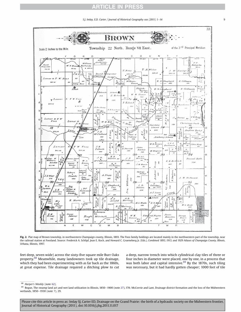
sharecropping on his remaining 4000 acres and carrying out $2000of drainage work before 1880. Still, he remained the largest land-owner in Brown township, with holdings of about 6 square miles in1893 (Fig. 2). After the loss of his Broadlands farm, even Michael L.Sullivant found greater success for a time at his enormous BurrOaks estate of 40,000 acres, where cattle-raising played a lesserrole, and he invested in a ditching plow, ‘a huge affair of eighteenfeet in length.worked by sixty-eight oxen and eight men.’62
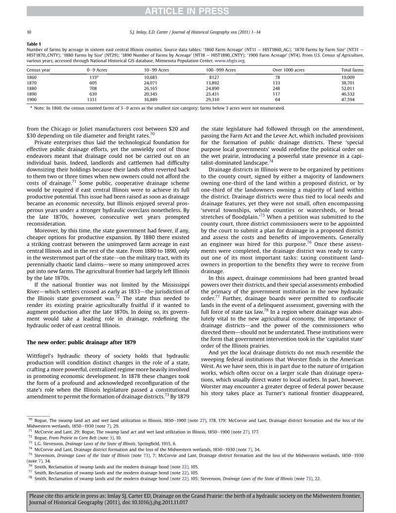
The experiences of Foos and Sullivant are a microcosm ofbroader trends in land holding in east central Illinois, and theprevalence of downsizing after drainage became necessary is borneout in census data. Even as the great cattle kings began to sell manyacres of their immense pasturelands to fund drainage and otherimprovements, the number of farms larger than 1000 acres in theregion tripled between 1860 and 1880 (Table 1). Writes HughPrince, ‘Draining large wet prairies in Illinois and Indiana led toterritorial aggrandizement by great estates; it fostered landedmonopolies.’63 But as costs of improvement caught up withfarmers, the very largest landowners surrendered some of theircompetitive advantage in labor and capital: after a spike between1870 and 1880, the number of very large farms (1000 acres ormore)dropped precipitouslydby 1900 only 64 such estates remained insixteen east central Illinois counties. While the requirements ofdrainage reduced the optimal farm size, land improvement stillfavored those of means. After 1880dwhen drainage was to becomea universalized expensedmost area holdings were large farms(100e999 acres), which increased in number from 1870.Meanwhile, tenancy increased as small farmers could not affordprivate drainage or the investments in machinery required formechanized farming; thus, farms of 10e99 acres dropped signi!-cantly after 1880. Moreover, the terms of tenancy became moreburdensome as sharecropping rents of one-third gave way totwo-!fths and then one-half of a tenant’s annual crop through the1870s.64
The new, distilled class of wealthy landowners was responsiblefor pioneering the drainage technologies that revolutionized agri-culture inwhat would become the heart of the Corn Belt. There was‘no !nancial shortcut’ to drainage, and early methods of privatedrainage were accordingly ‘prohibitive’ in cost.65 These includedlabor-intensive hand-dug ditching efforts and the equally miser-able mole plow technique, which entailed dragging a pointedmetalball through thick sod at a depth of 3e4 feet.66 One imagines thebackbreaking labor of Matthew T. Scott’s hired workers, carvinghand-dug ditches in the high heat of mid-summer, when the prairiemud dried enough to allow digging. It would seem that Braudel’sjudgment holds on the humid, malarial prairies of 1860s Illinois:‘Economic progress was assured, but at the price of social misery.’67
Soon landlords and other farmer-capitalists developed moreeffective yet similarly expensive drainage methods. In 1871Harper’s Weekly reported on Michael L. Sullivant’s goliath ditchingplow, which by then had dug 150 miles of shallow ditches (two
57 Bogue, Patterns From the Sod (note 4), 68e70.58 D. Worster, Natural history: an essay on theory and method, Paci"c Historical Review 53 (1984) 4.59 In Illinois, the transition to hydraulicism is also better documented than in Wittfogel’s ancient societies or Braudel’s early modern states. In both of their works, one getsthe impression that evidence was hard to come by.60 Gates, Landlords and Tenants on the Prairie Frontier (note 37), 251; Champaign County, Deed Record, 68: 412 and 70: 596, Champaign County Recorder of Deeds Of!ce.61 Bogue, Patterns From the Sod (note 4), 71, 72.62 Bogue, Patterns From the Sod (note 4), 70, 74, 76; Gates, Landlords and Tenants on the Prairie Frontier (note 37), 226; Harper’s Weekly (September 23, 1871) 898.63 Gates, Land policy and tenancy in the prairie states (note 29), 79; Prince, Wetlands of the American Midwest (note 2), 215.64 Bogue, The swamp land act and wet land utilization in Illinois, 1850e1900 (note 27), 178; Bogue, Patterns From the Sod (note 4), 167.65 Bogue, Patterns From the Sod (note 4), 96; McCorvie and Lant, Drainage district formation and the loss of the Midwestern wetlands, 1850e1930 (note 7), 29.66 McCorvie and Lant, Drainage district formation and the loss of the Midwestern wetlands, 1850e1930 (note 7), 29; Bogue, The swamp land act and wet land utilization inIllinois, 1850e1900 (note 27), 178.67 W.L. Powers and T.A.H. Teeter, Land Drainage, 2nd Edition, New York, 1932, 113; Braudel, The Mediterranean and the Mediterranean World in the Age of Philip II (note 2), 74.
S.J. Imlay, E.D. Carter / Journal of Historical Geography xxx (2011) 1e148
Please cite this article in press as: Imlay SJ, Carter ED, Drainage on the Grand Prairie: the birth of a hydraulic society on the Midwestern frontier,Journal of Historical Geography (2011), doi:10.1016/j.jhg.2011.11.017
feet deep, seven wide) across the sixty-!ve square mile Burr Oaksproperty.68 Meanwhile, many landowners took up tile drainage,which they had been experimenting with as far back as the 1860s,at great expense. Tile drainage required a ditching plow to cut
a deep, narrow trench into which cylindrical clay tiles of three orfour inches in diameter were placed, one by one, in a process thatwas both labor and capital intensive.69 By the 1870s, such tilingwas necessary, but it had hardly gotten cheaper; 1000 feet of tile
Fig. 2. Plat map of Brown township, in northwestern Champaign county, Illinois, 1893. The Foos family holdings are located mainly in the northwestern part of the township, nearthe railroad station at Foosland. Source: Frederick A. Schlipf, Jean E. Koch, and Howard C. Grueneberg Jr. (Eds.), Combined 1893, 1913, and 1929 Atlases of Champaign County, Illinois,Urbana, Illinois, 1997.
68 Harper’s Weekly (note 62).69 Bogue, The swamp land act and wet land utilization in Illinois, 1850e1900 (note 27), 178; McCorvie and Lant, Drainage district formation and the loss of the Midwesternwetlands, 1850e1930 (note 7), 29.
S.J. Imlay, E.D. Carter / Journal of Historical Geography xxx (2011) 1e14 9
Please cite this article in press as: Imlay SJ, Carter ED, Drainage on the Grand Prairie: the birth of a hydraulic society on the Midwestern frontier,Journal of Historical Geography (2011), doi:10.1016/j.jhg.2011.11.017
from the Chicago or Joliet manufacturers cost between $20 and$30 depending on tile diameter and freight rates.70
Private enterprises thus laid the technological foundation foreffective public drainage efforts, yet the unwieldy cost of thoseendeavors meant that drainage could not be carried out on anindividual basis. Indeed, landlords and cattlemen had dif!cultydownsizing their holdings because their lands often reverted backto them two or three times when new owners could not afford thecosts of drainage.71 Some public, cooperative drainage schemewould be required if east central Illinois were to achieve its fullproductive potential. This issue had been raised as soon as drainagebecame an economic necessity, but Illinois enjoyed several pros-perous years under a stronger hydraulic overclass nonetheless. Bythe late 1870s, however, consecutive wet years promptedreconsideration.
Moreover, by this time, the state government had fewer, if any,cheaper options for productive expansion. By 1880 there existeda striking contrast between the unimproved farm acreage in eastcentral Illinois and in the rest of the state. From 1880 to 1890, onlyin the westernmost part of the statedon the military tract, with itsperennially chaotic land claimsdwere so many unimproved acresput into new farms. The agricultural frontier had largely left Illinoisby the late 1870s.
If the national frontier was not limited by the MississippiRiverdwhich settlers crossed as early as 1833dthe jurisdiction ofthe Illinois state government was.72 The state thus needed torender its existing prairie agriculturally fruitful if it wanted toaugment production after the late 1870s. In doing so, its govern-ment would take a leading role in drainage, rede!ning thehydraulic order of east central Illinois.
The new order: public drainage after 1879
Wittfogel’s hydraulic theory of society holds that hydraulicproduction will condition distinct changes in the role of a state,crafting a more powerful, centralized regimemore heavily involvedin promoting economic development. In 1878 these changes tookthe form of a profound and acknowledged recon!guration of thestate’s role when the Illinois legislature passed a constitutionalamendment to permit the formation of drainage districts.73 By 1879
the state legislature had followed through on the amendment,passing the Farm Act and the Levee Act, which included provisionsfor the formation of public drainage districts. These ‘specialpurpose local governments’ would rede!ne the political order onthe wet prairie, introducing a powerful state presence in a capi-talist-dominated landscape.74
Drainage districts in Illinois were to be organized by petitionsto the county court, signed by either a majority of landownersowning one-third of the land within a proposed district, or byone-third of the landowners owning a majority of land withinthe district. Drainage districts were thus tied to local needs anddrainage features, yet they were not small, often encompassing‘several townships, whole counties or watersheds, or broadstretches of "oodplain.’75 When a petition was submitted to thecounty court, three district commissioners were to be appointedby the court to submit a plan for drainage in a proposed districtand assess the costs and bene!ts of improvements. Generallyan engineer was hired for this purpose.76 Once these assess-ments were completed, the drainage district was ready to carryout one of its most important tasks: taxing constituent land-owners in proportion to the bene!ts they were to receive fromdrainage.
In this aspect, drainage commissions had been granted broadpowers over their districts, and their special assessments embodiedthe primacy of the government institution in the new hydraulicorder.77 Further, drainage boards were permitted to con!scatelands in the event of a delinquent assessment, governing with thefull force of state tax law.78 In a region where drainage was abso-lutely vital to the new agricultural economy, the importance ofdrainage districtsdand the power of the commissioners whodirected themdshould not be understated. These institutions werethe form that government intervention took in the ‘capitalist state’order of the Illinois prairies.
And yet the local drainage districts do not much resemble thesweeping federal institutions that Worster !nds in the AmericanWest. As we have seen, this is in part due to the nature of irrigationworks, which often occur on a larger scale than drainage opera-tions, which usually direct water to local outlets. In part, however,Worster may encounter a greater degree of federal power becausehis story takes place as Turner’s national frontier disappeared,
Table 1Number of farms by acreage in sixteen east central Illinois counties. Source data tables: ‘1860 Farm Acreage’ (NT11 e HIST1860_AG); ‘1870 Farms by Farm Size’ (NT31 e
HIST1870_CNTY); ‘1880 Farms by Size’ (NT29); ‘1890 Number of Farms by Acreage’ (NT18 e HIST1890_CNTY); ‘1900 Farm Acreage’ (NT4). From U.S. Census of Agriculture,various years, accessed through National Historical GIS database, Minnesota Population Center, www.nhgis.org.
Census year 0e9 Acres 10e99 Acres 100e999 Acres Over 1000 acres Total farms
1860 119a 10,685 8127 78 19,0091870 605 24,071 13,892 133 38,7011880 708 26,165 24,890 248 52,0111890 639 20,345 25,431 117 46,5321900 1331 16,889 29,310 64 47,594
a Note: In 1860, the census counted farms of 3e9 acres as the smallest size category; farms below 3 acres were not enumerated.
70 Bogue, The swamp land act and wet land utilization in Illinois, 1850e1900 (note 27), 178, 179; McCorvie and Lant, Drainage district formation and the loss of theMidwestern wetlands, 1850e1930 (note 7), 29.71 McCorvie and Lant, 29; Bogue, The swamp land act and wet land utilization in Illinois, 1850e1900 (note 27), 177.72 Bogue, From Prairie to Corn Belt (note 3), 10.73 L.G. Stevenson, Drainage Laws of the State of Illinois, Spring!eld, 1915, 6.74 McCorvie and Lant, Drainage district formation and the loss of the Midwestern wetlands, 1850e1930 (note 7), 34.75 Stevenson, Drainage Laws of the State of Illinois (note 73), 7; McCorvie and Lant, Drainage district formation and the loss of the Midwestern wetlands, 1850e1930(note 7), 34.76 Smith, Reclamation of swamp lands and the modern drainage bond (note 22), 105.77 Smith, Reclamation of swamp lands and the modern drainage bond (note 22), 105.78 Smith, Reclamation of swamp lands and the modern drainage bond (note 22), 105; Stevenson, Drainage Laws of the State of Illinois (note 73), 22.
S.J. Imlay, E.D. Carter / Journal of Historical Geography xxx (2011) 1e1410
Please cite this article in press as: Imlay SJ, Carter ED, Drainage on the Grand Prairie: the birth of a hydraulic society on the Midwestern frontier,Journal of Historical Geography (2011), doi:10.1016/j.jhg.2011.11.017
which, Turner predicted, would prompt an intensi!cation ofgovernment as geographical outlets for its power become scarce.79
Meanwhile, drainage power dynamics remained local in scale untilthe federal government became similarly involved around the turnof the century through legislation like the Reclamation Act of 1902,in effect ‘revers[ing] the Swamp Land Act precedent of only stateand local involvement.’80
It not surprising, then, that in the 1880s Illinois drainagedistricts existed in tension with the interests of the old regime oflocal landlords and cattlemen. Indeed, the friction between landedcapitalists and the strong bureaucracies of hydraulic states iscentral to Worster’s capitalist state type, in which the groupsinitially ‘compete for the upper hand without lasting success.’81 Ineast central Illinois, the ruling class opposed drainage districtsbecause drainage taxes ‘would increase their obligations withoutbringing in commensurate returns.’82 For those who had alreadyexpended capital to drain privately, drainage assessments weremerely further outlays that would bene!t small farmers to thedetriment of the landowning overclass. The Scott brothers, aftertheir heavy investments in private drainage, took severalchallenges to drainage districts’ taxation power all the way to theIllinois Supreme Court.83
Drainage districts became increasingly autonomous andpowerful through the 1880s. The broad powers of drainage districtswere reasserted in an 1885 drainage law that was ‘to be liberallyconstrued’ in favor of district drainage; commissioners’ projectswere not to be ‘defeated by reason of any omission, imperfection’ ororganizational defect, technicalities large landowners often seizedupon in their own defense.84 Drainage districts were furthersupported by the judiciary: in fourteen cases against ChampaignCounty districts brought before the State Supreme Court before1901, the district’s position was af!rmed in thirteen of them,including the Scott brothers’ lawsuits.
Not surprisingly, such powerful institutions were soon politi-cized. In 1890 East Lake Fork Special Drainage Districtdone ofChampaign County’s most trouble-making districtsdwas sued bythe Wabash Eastern Railroad for trying to levy taxes on its lands.85
While the railroadsdespecially the landed Illinois Centraldwerelarge landowners and !xtures of the private drainage ordernaturally opposed to district drainage, it seems that drainagecommissions invited certain criticisms. Court records reveal thatthe East Lake Fork District had initially charged the WabashEastern’s roughly 40 acres one-eighth of the 31,735 acre district’s
$35,000 assessment, later reducing the due to one-sixteenth of thetotal.86 When the East Lake Fork District was vindicated ina Supreme Court ruling, drainage districts emerged as one of fewinstitutions that could successfully levy new taxes on the railroads,after the state government foolishly limited itself to a 7% tax rate inthe Illinois Central’s charter.87
Such a victory was not trivial during the ‘tax !ghting’ that tookplace in the latter decades of the century.88 As tax rates skyrocketedafter the Civil War, large landowners squabbled with tax collectors,often refusing to pay their share. Yet through the bickering,a resurgence of the old ruling class began to take shape. Some largelandowners used their clout to win low tax rates, while othersmerely passed the burden of drainage taxesdwhich ‘brought fortha greater volume of protest from large landowners and absenteesthan any other feature of the taxation system’donto their tenants,whose rents rose steadily into the 1890s.89 In this way, ‘the inex-orable demand for constantly increasing rents’ limited the amountof land tenants and small farmers could maintain, quilting thelandscapewith claims of 160 acres ormore even after the formationof drainage districts.90 By the 1890s, the Chicago Tribune couldreport a widespread exodus of tenants, who sought to escape the‘exorbitant rents’ of the wet prairie’s landed elite.91
Meanwhile, some large landowners began to use the drainagedistrict system to their own advantage. Notes Prince, ‘mostdrainage enterprises were initiated by landowners and farmers fortheir own private gain and “for no public purpose whatsoever.”’92
Benjamin J. Gifford, who purchased 7500 acres of swampy land innorthern Champaign County between 1879 and 1883, engaged inintensive drainage on his tenant-operated estate before pushing forthe expansion of the Big Slough Drainage District in 1885. Thesizeable district was to drain 30,000 acres over four townships, andGifford’s campaign encountered ‘violent opposition’ from land-owners who feared that it would soon swallow their properties. Itwas this expansion effort that Matthew T. and John W. Scottobjected to, citing a lack of disinterestedness within the petitioningparties.93 In fact, it seems that Gifford’s extensive holding wouldgain substantially at the expense of smaller landowners andincorporated properties that had already been privately drained.
Some major landowners capitalized on the expansion ofdrainage works by diversifying into local tile manufacturing andtile-laying businesses. Gifford used his ample resources toconstruct a tile factory, sinking $300,000 into the factory and theimprovements it enabled.94 During the 1880s and 1890s, local tile
79 Turner, Signi!cance of the frontier in American History (note 1), 3. In fact, it is dif!cult for Worster to disprove Turner’s argument about frontier freedom and democracywhen the bulk of his history in Rivers of Empire takes place after 1890, the year, writes Turner, the US Census announced that the American frontier had ground to a !nal halt.The case of east central Illinois better distinguishes between the government intensi!cation arising out of local conditions and the government presence attributable to theend of the national frontier and the closing of new outlets for federal power.80 G.A. Pavelis, Farm Drainage in the United States: History, Status, and Prospects, Washington, 18, 1987.81 Worster, Rivers of Empire (note 2), 51.82 Gates, Landlords and Tenants on the Prairie Frontier (note 37), 234.83 Bogue, The swamp land act and wet land utilization in Illinois, 1850e1900 (note 27), 179, 244; Supreme Court of Illinois, John W. Scott v. The People, 1887; Supreme Courtof Illinois, The People v. The Commissioners of the Wildcat Slough Drainage District, 1890; Supreme Court of Illinois, Miller v. Scott, 1890; F.B. Leonard, The drainage laws ofIllinois, in: A Preliminary Report on the Drainage Situation, Urbana, Illinois, 1921, 63e64.84 Leonard, The drainage laws of Illinois (note 83); quotation from Stevenson, Drainage Laws of the State of Illinois (note 73), 22.85 Supreme Court of Illinois, The Wabash Eastern Railway Company of Illinois v. Commissioners of East Lake Fork Special Drainage District, 1890.86 Supreme Court of Illinois, The Wabash Eastern Railway Company of Illinois v. Commissioners of East Lake Fork Special Drainage District (note 85); Schlipf, Koch andGrueneberg Jr., Combined 1893, 1913, and 1929 Atlases of Champaign County, Illinois (note 34); Cunningham, History of Champaign County (note 26), 648.87 Bogue, Patterns From the Sod (note 4), 232, 234; Hibbard, Public land policies (note 28), 249.88 Bogue, Patterns From the Sod (note 4), 167.89 Bogue, Patterns From the Sod (note 4), 237, 244.90 Gates, Land policy and tenancy in the prairie states (note 29), 80; Bogue, Patterns From the Sod (note 4), 251; Schlipf, Koch and Grueneberg Jr., Combined 1893, 1913, and1929 Atlases of Champaign County, Illinois (note 34).91 Chicago Tribune (note 5).92 Prince, Wetlands of the American Midwest (note 2), 208, quoting Ben Palmer, Swamp land drainage with special reference to Minnesota, Minneapolis, 1915, 56-57.93 Bogue, The swamp land act and wet land utilization in Illinois, 1850e1900 (note 27), 180; Supreme Court of Illinois, John W. Scott v. The People (note 83).94 Prince, Wetlands of the American Midwest (note 2), 214e215; Bogue, The swamp land act and wet land utilization in Illinois, 1850e1900 (note 27), 155, 180.
S.J. Imlay, E.D. Carter / Journal of Historical Geography xxx (2011) 1e14 11
Please cite this article in press as: Imlay SJ, Carter ED, Drainage on the Grand Prairie: the birth of a hydraulic society on the Midwestern frontier,Journal of Historical Geography (2011), doi:10.1016/j.jhg.2011.11.017

production rose considerably in east central Illinois, and contem-porary maps of the region show railroad tracks dotted with tilefactories, which supplied small tiles that drained individual !elds,as well as much larger varieties that fed drainage ditches.95
Indeed, the complementary nature of district ditching andprivate tile production forged a symbiotic relationship betweendrainage districts and wealthy landowners in the last decades ofthe century. Through the 1880s and 1890s, districts contractedwork out to private landowners and labor teams in order to dredgeand tile district ditches. In 1887 Gifford won a contract from BigSlough Special Drainage District for constructing 1650 feet of tiledrains, while in Beaver Lake Drainage District, commissioner G.W.Winchester exceeded his commissioner’s salary in district contractsfor tile in 1893.96 By 1890, when J.T. Harrisdscion of a family ofGrand Prairie ‘cattle kings’dcalled upon Beaver Lake to provide 460feet of tile drains ‘of suf!cient capacity’ to better drain his rail-sideinheritance, the district had constructed over 25,000 feet of tiledditches, at substantial expense.97 Indeed, the inexorable demandfor drains in newly (if reluctantly) incorporated propertiesbolstered a creeping expansion of drainage districts that was oftenunderlain by private tile. Districts made countless additionalassessments in order to drain branch and tributary ditches in theirperipheral sub-districts; in Camp Creek Special Drainage District,all but one of the district’s tributary ditches were tiled, using over87,800 feet of tile drains.98
Just as Worster describes, on the Grand Prairie capitalists andbureaucrats came to realize a powerful codependency, one whichtransformed the sodden prairie of east central Illinois into treasuredground at the heart of America’s Corn Belt. As the new ordermatured, the capitalist’s innovation combined with the state’sorganizational power, his tiles worked with its ditches, his powermerged with its authority. The results were impressive: by the turnof the century, over 1.8 million acres were drained by Illinoisdistricts.99 Forty years later, more than half the productive croplandin the state was arti!cially drained. In little over one hundred years,public drainage increased the value of Champaign County land oversix-hundredfold.100
Fig. 3. Tenant-operated farms as a percentage of all farms (chart). Source: US Census ofAgriculture, 1880e1900 (for more detail, see note 103).
Fig. 4. Rates of tenancy in U.S. farms, 1880e1900. Although the data breaks changefrom one map to the next, an equal number of counties are represented in eachinterval. Only counties with farms counted in all three censuses are shown; areas withno data, or no enumerated farms in any year, are shown in white. Source: US Census ofAgriculture, 1880e1900 (for more detail, see note 103).
95 Schlipf, Koch and Grueneberg Jr., Combined 1893, 1913, and 1929 Atlases of Champaign County, Illinois (note 34).96 Agreement of B.J. Gifford with Big Slough Special Drainage District, 1887; Annual Report of the Commissioners of Beaver Lake Drainage District, 1893, Champaign CountyCircuit Clerk Of!ce, Urbana, Illinois.97 Beaver Lake Drainage District, Records, 1884, Champaign County Circuit Clerk Of!ce, Urbana, Illinois.98 Petition to Organize Camp Creek Special Drainage District, 1906; Annual Report of the Commissioners of Embarras Special Drainage District, 1898, Champaign CountyCircuit Clerk Of!ce, Urbana, Illinois.99 W.L. Austin, Drainage of Agricultural Lands, Washington, 1932; McCorvie and Lant, Drainage district formation and the loss of the Midwestern wetlands, 1850e1930(note 7), 33.100 Stevenson, Drainage Laws of the State of Illinois (note 73), 33; Pavelis, Farm Drainage in the United States (note 80), 17.
S.J. Imlay, E.D. Carter / Journal of Historical Geography xxx (2011) 1e1412
Please cite this article in press as: Imlay SJ, Carter ED, Drainage on the Grand Prairie: the birth of a hydraulic society on the Midwestern frontier,Journal of Historical Geography (2011), doi:10.1016/j.jhg.2011.11.017
Yet the true measure of a hydraulic orderdand the trans-formative power of the wet prairie that conditioned itdlies in itssocial effects: the society that arose between 1850 and 1900 on theGrand Prairie of Illinois was in large part characterized bya permanent underclass, whose miserable struggle in the malarialtrenches endured for over half a century. By the close of the century,tenant rents had reached up to three-!fths and even two-thirds ofannual crop, while wages for farm labor reverted to 1850 levels orbelow, hovering near $22 a month.101 Indeed, never was there ‘aidto the farm laborer searching for a route to ownership or to tenantsstruggling to retain their step on the ownership ladder.’102
Again, evidence from historical censuses substantiates thedistinctive agrarian structure of east central Illinois. From 1880 to1900, east central Illinois counties had higher rates of tenancy, incomparison with Illinois and the U.S. as a whole (Fig. 3). (Thesteepness of the decline in tenancy, for all areas of the country, from1890 to 1900 may be a result of changing census methodology.103)Moreover, as shown by the time-series map (Fig. 4), east centralIllinois was always among the areas with the highest rates oftenancy in the U.S., in this respect sharing more in common withsouthern statesdwith their notoriously exploitative institution ofsharecropping, especially among AfricaneAmerican farmersdthanwith other parts of the Midwest. It may be true that, as SonyaSalamon points out, ‘In the Midwest, tenancy did not automaticallymean low social status and a marginal economic existence, as itoften did in the South.’104 However, wage stagnation and increas-ingly one-sided sharecropping and rental arrangements, in thecontext of generally increasing farm values, suggest that margin-alization was commonplace.
Conclusion
Today’s environmental historians, historical geographers, andrestoration ecologists often view the landscape of Illinois’s GrandPrairie with concern. Here, the largest wet prairie of the Midwestwas transformed, in the span of just a few decades, into a reorderedlandscape of straightened streams and drained !elds. The drainagetile revolution made it feasible to farm some of the world’s richestsoils, but in the process altered prairie hydrology and destroyedproductive habitat. In the end, an ecologically diverse and complexnatural system was reduced to the simpli!ed monoculture-oriented landscape we see today. Thus many scholars havetrained their sights on detailing this physical transformation. Whilewe agree that the wholesale alteration of these prairie wetlands iscause for lament, such a focus is just one way of reading thelandscape. Viewed from a different angle, the landscape of eastcentral Illinois also reveals a mostly hidden history of agrarianstructure and its key component, land tenure. To quote Salamonagain, ‘A history of culture shaping land tenure in a particular place
is revealed in the local landscape. [.] The land tenure systemrepresents the underlying social structure of any society because itis a mechanism for reproducing present gender, generational, andcommunity relations and maintaining continuity with what wasvalued in the past.’105
A close examination of the land tenure system and agrarianstructure in the east central Illinois region provides an insight that isat once straightforward but often forgotten: social structures are slowto change. Indeed, the drainage revolution produced a new agricul-tural order characterized as much by social continuities as byeconomic and environmental transformation. Most particularly,tenancy, whether by rental agreements, sharecropping, or otherarrangements, continued to be a dominant form of land tenure. Thisoutcome was not preordained, however. A landed elite was able tocapitalize on its already strong position by turning drainage policiesto its advantage, passing the costs of drainage onto tenants,transitioning from livestock raising to cash crops, and out-maneuvering competing interests, such as railroads. Tenancy andreductions in land holding went hand-in-hand after western ranch-ing competition, rising land taxes, and drainage taxesmade drainagenecessary and imposed serious costs on large landowners. Thesuccessful landlordswere thosewhocopedwith those costs bysellingsome of their lands and tenanting (and draining) the remainder.
While the risks and costs of early marshland settlement grantedthe Grand Prairie’s landed capitalists exclusive access to the wetprairiedsupporting an especially strong landowner class, whosechanging programs of tenancy and agriculture de!ned the drainagerevolution theredthe capital and labor coordination required ofdrainage enterprises across the Midwest produced similar effectselsewhere: in Iowa and southern Minnesota, drainage districtsinitiated by immigrant communities of small farmers began toconverge on the Grand Prairie model as banks and absentee ownersgained controlling interests in many district drainage schemes,while land holding sizes increased alongside rates of tenancy.106
Likewise, as geographer Alfred Meyer pointed out in a classicstudy, tenancy rates on the Kankakee Marsh of Illinois and Indianarose to remarkable heights after 1885, when the steam dredgebegan to work its meandering bottomland streams into tidy,permanent ditches.107 The disparity between tenancy rates onKankakee’s bottomlands and on its marginally elevated uplandprairies recalls the experience in Manitoba, where nearly imper-ceptible differences in elevation drew unambiguous political lineswhen drainage taxes became a highly contested political issuethere; ultimately those on more expensive ‘highland’ tractsemerged victorious when the provincial government agreed todirectly shoulder their share of drainage expenses.108
Indeed, the balance between government and capitalistinvolvement in collective drainage schemes varied across NorthAmerica, and perhaps thewidespread failure of drainage districts in
101 In some counties, wages were held to $15 or $18 a month, while cash rents surpassed $4 per acre. See Gates, Landlords and Tenants on the Prairie Frontier (note 37), 324;Bogue, Patterns From the Sod (note 4), 167.102 Gates, Landlords and Tenants on the Prairie Frontier (note 37), 324.103 The census introduced a number of new ownership categories for the 1900 census. We used only the categories ‘cash tenants’ and ‘share tenants’ to represent tenantfarmers, and so we may have underestimated real rates of tenancy (or, conversely, the census might have overestimated tenancy in earlier censuses, due to lack ofdiscrimination in their categories). 1880 US Census of Agriculture, NHGIS Dataset 1880 e US, State, and County, File HIST 1880_AG, Table ‘Farm Tenure by Size of Farm (NT32)’;1890 US Census of Agriculture, NHGIS Dataset 1890 e US, State, and County, File HIST1890_AG, Table ‘Type of Farm Operation by Farm Acreage (NT6)’; 1900 US Census ofAgriculture. NHGIS Dataset 1900 e US, State, and County, File HIST1900_AG, Table ‘Race of Farmer by Detailed Management (NT7).’ All from National Historical GIS database,Minnesota Population Center. Accessed online: http://www.nhgis.org.104 Salamon, Cultural dimensions of land tenure in the United States (note 9), 165.105 Salamon, Cultural dimensions of land tenure in the United States (note 9), 177.106 Writes Prince, ‘Owner-occupiers suffered more than tenants, but the conditions of tenancy also deteriorated. Long leases were almost completely replaced by annualarrangements, sharecrop rents rose steeply, and sharecropping itself was superseded by monetary payments, safeguarding the landlord’s income against effects of fallingprices.’ Prince, Wetlands of the American Midwest (note 2), 225e226.107 Meyer, The Kankakee “Marsh” of northern Indiana and Illinois (note 26), 372, 379.108 S.S. Bower, Watersheds: conceptualizing Manitoba’s drained landscape, 1895e1950, Environmental History 12 (2007) 801e802, 809e811.
S.J. Imlay, E.D. Carter / Journal of Historical Geography xxx (2011) 1e14 13
Please cite this article in press as: Imlay SJ, Carter ED, Drainage on the Grand Prairie: the birth of a hydraulic society on the Midwestern frontier,Journal of Historical Geography (2011), doi:10.1016/j.jhg.2011.11.017
Turner’s Wisconsin is a testament to the importance of this balancein Worster’s capitalist state model. In the northern forests ofWisconsin and Minnesota, the logging industry precluded theestablishment of an agricultural elite, and so drainage districtscould not rely on a landlord class to anchor the transition todrainage agriculture, just as they could not simply adopt thedrainage technologies that such a class might have pioneered andgradually !ne-tuned in the northern peat marshes. As a result,drainage districts in Wisconsin struggled agriculturally, and manyfailed to repay the loans advanced by state and county govern-ments, who in turn found themselves in possession of an ‘empire inthe swamps’ by default.109
From Turner’s perspective, it seems the Grand Prairie was justone example in this class of exceptional regions on the NorthAmerican frontier, a sizeable swath of prairie terrain where hisegalitarian democracy did not take hold. A hydraulic interpretationof the Grand Prairie experience offers a new lens through whichthese seemingly disparate marshland histories can be viewed.Indeed, perhaps the relevant measure of Turner’s frontier is foundnot in a region’s population density, but in the costs associated with
rendering such an area productive enough to support a state. Thetheory we have suggested incorporates these costs into Turner andvon Thünen’s hypotheses of frontier progression, reconcilingTurner’s democracy with the stark landlordetenant divides andstrong bureaucracies that took hold of east central Illinois after1850. Conversely, this model introduces crucial elements of frontierchange to Worster and Wittfogel’s hydraulic concepts, whichintended to resolve profound questions posed by the evolution ofthe modern West. Together, they illuminate the dialectical rela-tionships between nature, state, and social structure on the frontierof expanding states. By connecting their divergent theories, wehave hoped to shed some light on this transformative interplay.
Acknowledgments
The authors wish to acknowledge the Champaign County HistoricalArchives and the Champaign County Circuit Clerk Of!ce, Urbana,Illinois, for facilitating archival research. We also thank Hugh Princeand Michael Guenther for helpful comments on previous drafts ofthis paper.
109 Prince, Wetlands of the American Midwest (note 2), 273.
S.J. Imlay, E.D. Carter / Journal of Historical Geography xxx (2011) 1e1414
Please cite this article in press as: Imlay SJ, Carter ED, Drainage on the Grand Prairie: the birth of a hydraulic society on the Midwestern frontier,Journal of Historical Geography (2011), doi:10.1016/j.jhg.2011.11.017