joint public notice sam-2007-01383-cro u.s. … lobell march 7, 2013 sam-2007-01383-cro page 4 of 4...
TRANSCRIPT

DEPARTMENT OF THE ARMY U.S. ARMY ENGINEER DISTRICT, MOBILE DISTRICT
P.O. BOX 2288 MOBILE, ALABAMA 36628-0001
March 7, 2013
South Mississippi Branch Regulatory Division
JOINT PUBLIC NOTICE SAM-2007-01383-CRO U.S. ARMY CORPS OF ENGINEERS
MISSISSIPPI DEPARTMENT OF ENVIRONMENTAL QUALITY
OFFICE OF POLLUTION CONTROL
AFTER-THE-FACT IMPACTS ASSOCIATED WITH CONSTRUCTION OF A SINGLE-FAMILY RESIDENCE
BILOXI, HARRISON COUNTY, MISSISSIPPI
TO WHOM IT MAY CONCERN: This District has received an application for a Department of the Army permit pursuant to Section 404 of the Clean Water Act. Please communicate this information to interested parties. APPLICANT: Mr. Kenny Lobell 473 Walnut Street New Orleans, Louisiana 70118 AGENT: Coastal Environments, Inc. Attention: Mr. Randy Ellis 812 Water Street Biloxi, Mississippi 39530 WATERWAY: In wetlands adjacent to Biloxi Bay, south of Kennedy Lane, Section 24, Township 7 South, Range 10 West, Biloxi, Harrison County, Mississippi (Latitude 30.4277 North, Longitude -88.9382 West). WORK: The applicant requests after-the-fact authorization for a constructed retaining wall and backfilling +/- 0.082 acre of scrub-shrub wetlands adjacent to tidal waters in conjunction with the construction of a single-family residence and erosion control. EXISTING CONDITIONS: The project area consists of a maintained scrub-shrub wetland on the southern tip of the Lobell-Bay Cove property, bordered by tidal marsh. The land consists of a predominantly flat surface that gradually slopes from the Bay Cove Condominium development toward the Biloxi Back Bay. Natural vegetation with the project area has been largely displaced by domesticated grasses with a fringe of tidal marsh. An identified archeological site (22Hr1009) is located at the southernmost extent of the subject property. Surrounding area consists of developed condominiums and single-family residences. PROJECT PURPOSE: The project purpose, as stated by the applicant’s agent, “is to prevent further erosion and to enhance the applicant’s property.”

Kenny Lobell March 7, 2013 SAM-2007-01383-CRO Page 2 of 4 The U.S. Army Corps of Engineers (Corps) initially determined the basic project purpose is for construction of a single-family residence with amenities and would not be considered a water dependent activity. Additional review will be performed by the Corps and cooperating agencies. ALTERNATIVES: The Corps’ initial review of alternatives submitted by the applicant’s agent consists of “(1) obtaining regulatory authorization for the improvements, or (2) to restore to pre-construction conditions. The project, as built, provides protection against erosion and prevents silt runoff that would otherwise drain into a small, eroding, fringe Juncus Roemerianus marsh and the Biloxi Back Bay. The applicant has stated a significant investment is associated with the residential development and the existing retaining wall enhances and protects his property in addition to the shoreline. Restoring the property to its pre-construction conditions would not satisfy the purpose and need for the project according to the applicant. The impacts associated with the project, for through the purchase of offsite wetland mitigation credits at an approved mitigation site.” Additional review of alternatives will be performed by the Corps and cooperating agencies. MITIGATION: Mitigation for the unauthorized impacts to 0.08 acre of low quality scrub-shrub wetlands has been mitigated through the purchase of sufficient number of in-kind credits from the Wetlands Solutions Mitigation Bank. Additional review of mitigation requirements will be performed by the Corps and cooperating agencies. Final compensatory mitigation will be evaluated by the Corps and cooperating resource agencies throughout the review process for the after-the-fact project. The applicant has applied for certification from the State of Mississippi in accordance with Section 401(a)(1) of the Clean Water Act and upon completion of the required advertising; a determination relative to certification will be made. The State of Mississippi Department of Marine Resources in accordance with Section 57-15-6 of the Mississippi Code Annotated issued an After-the-fact Permit by letter dated October 22, 2012. (DMR-070207) This public notice is being distributed to all known interested persons in order to assist in developing facts on which a decision by the Corps can be based. For accuracy and completeness of the record, all data in support of or in opposition to the unauthorized work should be submitted in writing setting forth sufficient detail to furnish a clear understanding of the reasons for support or opposition. The decision whether to issue an after-the-fact permit will be based on an evaluation of the probable impact, including cumulative impacts, of the proposed activity on the public interest. That decision will reflect the national concern for both protection and utilization of important resources. The benefits, which reasonably may be expected to accrue from the proposal must be balanced against its reasonably foreseeable detriments. All factors, which may be relevant to the proposal, will be considered, including the cumulative effects thereof; among those are conservation, economics, aesthetics, general environmental concerns, wetlands, cultural values, fish and wildlife values, protected species, flood hazards, flood plain values, land use, navigation, shoreline erosion and accretion, recreation, water supply and conservation, water quality, energy needs, safety, food production and in general, the needs and welfare of the people.

Kenny Lobell March 7, 2013 SAM-2007-01383-CRO Page 3 of 4 The Corps is soliciting comments from the public; Federal, State and local agencies and officials; Indian Tribes; and other interested parties in order to consider and evaluate the impacts of this proposed activity. Any comments received will be considered by the Corps to determine whether to issue, modify, condition or deny a permit for this proposal. To make this decision, comments are used to assess impacts on endangered species, historic properties, water quality, general environmental effects and the other public interest factors listed above. Comments are used in the preparation of an Environmental Assessment and/or an Environmental Impact Statement pursuant to the National Environmental Policy Act. Comments are also used to determine the need for a public hearing and to determine the overall public interest of the proposed activity. Any person may request, in writing, within the comment period specified in this notice, that a public hearing be held for consideration of this application. Requests for public hearings shall state with particularity, the reasons for holding a public hearing. Evaluation of the probable impacts involving deposits of dredged or fill material into waters of the United States will include the application of guidelines established by the Administrator of the U.S. Environmental Protection Agency. In accordance with Section 106 of the National Historic Preservation Act and Appendix C of 33 CFR 325, the undertaking defined in this notice is being considered for the potential to effect cultural and historic properties within the permit area. We are seeking comment from the State Historic Preservation Officer regarding the existence or the potential for existence of significant cultural and historic properties within the permit area. In accordance with Appendix C of 33 CFR Part 325, the Corps has determined that the permit area is the full area of development for the overall project footprint. The Corps has been consulting with in-house expertise and the State Historic Preservation Officer to make a final determination based upon this review. The U.S. Fish and Wildlife Service lists 15 endangered, threatened or candidate species as occurring or potentially occurring in Harrison County, Mississippi. These include the gopher tortoise (T) (Gopherus polypemus), the Louisiana quillwort (E) (Isoetes louisianensis), the Mississippi gopher frog (E) (Rana capito sevosa), the Gulf sturgeon (TCH) (Acipenser oxyrinchus desotoi), the Red-cockaded woodpecker (E) (Picoides borealis), the Piping Plover (TCH) (Charadrius melodus), the West Indian manatee (E) (Trichechus manatus), the Louisiana black bear (T) (Ursus americanus luteolus), the Alabama red-belly turtle (E) (Pseudemys alabamensis), the Black pine snake (C) (Pituophis melanoleucus lodingi), the Brown pelican (E) (Pelecanus occidentalis), the Green sea turtle (T) (Chelonia), the leatherback sea turtle (E) (Dermochelys coriacea), the Kemp’s ridley sea turtle (E) (Lepidochelys kempii) and the Loggerhead sea turtle (T) (Caretta caretta). Preliminary review of this application and the U.S. Department of the Interior’s List of Endangered and Threatened Wildlife and Plants indicate the proposed activity may but is not likely to adversely affect listed endangered or threatened species. Correspondence concerning this Public Notice should refer to Public Notice Number SAM-2007-01383-CRO and should be directed to the District Engineer, U.S. Army Engineer District, Mobile, Attention: Ms. Maryellen J. Farmer, Post Office Box 2288, Mobile, Alabama 36628-0001, Attention: South Mississippi Branch, with a copy to the Mississippi Department of Environmental Quality, Office of Pollution Control, Attention: Ms. Florance Watson, P.E., Post Office Box 2261, Jackson, Mississippi 39225, in time to be received within 30 days of the date of this public notice.

Kenny Lobell March 7, 2013 SAM-2007-01383-CRO Page 4 of 4 If you have any questions concerning this publication, you may contact the project manager for this application, Ms. Farmer ([email protected]), (228) 523-4116. Please refer to the above Public Notice number. For additional information about our Regulatory Program, please visit our web site at www.sam.usace.army.mil/Missions/Regulatory.aspx. MOBILE DISTRICT U.S. Army Corps of Engineers Enclosures
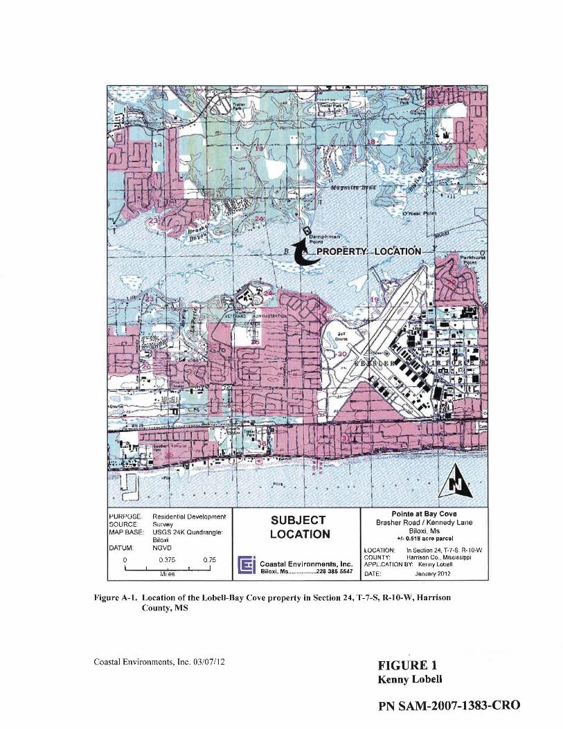
PURPOSE: SOURCE: MAP BASE·
DATUM:
0
Residential Development Survey USGS 24K Quadrangle Biloxi NGVO
0.375 0.75
Miles
SUBJECT LOCATION
[§. C~astal Environments, Inc. I B1lox1, Ms ......... .... .... 228-385-5547
Pointe at Bay Cove Brasher Road I Kennedy Lane
Biloxi, Ms +1- 0.5111 acre parcel
LOCATION : In Section 24, T-7-S, R-10-W COUNTY: Harrison Co .. Mississippi APPLICATION BY: Kenny Lobell
DATE: January 2012
Figure A-1. Location of the Lobeii-Bay Cove property in Section 24, T-7-S, R-10-W, Harrison County, MS
Coastal Environments, Inc. 03/07/12 FIGURE 1 Kenny Lobell
PN SAM-2007-1383-CRO

ur IRS
' '\ '
-- Mean High Water Line
-- Scrub/Shrub Wetland Line
\ I I I I I '
BACK BAY OF BILOXI
f<X:v{<xl Filled Wetland (+/- 3,582.5 Sq.Ft)
PURPOSE: Residential Development SOURCE: CEI Field Data MAP BASE: Patrick M. Martino, PLS Plot
Plan of Lot 4, Bay Cove DATUM: NAD83
0 20 40 60 80 -- Feet
Plot Plan of Lot 4 Bay Cove Subdivison
ii Coastal Environments, Inc. Biloxi, Me ................. 228-385-5647
NOW 0~ FORMERlY KENNEDY PROPERTY
DEED BOOK 288, PAGEI/i5.
DENOTES FLDDD ZONE LIMITS !TYPICAL)
i -<,/ ~I '-'II ~l ~I ~! ;.:..
~ l .~' I....:::
/ E: I ?·
,.,. OLD AXLE FOUI/0
Plot Plan of Lot 4, Bay Cove Drive +/- 0.518 Acre Parcel
LOCATION:
COUNTY: APPLICATION BY:
DATE:
In Section 24 T-7-S, R-10-W Harrison Co., Mississippi Kenny Lobell
January 2012
Figure A-2. Plan View of the Lobell-Bay Cove property in Section 24, T-7-S, R-10-W, Harrison County,MS
Coastal Environments, Inc. 03/07/12 FIGURE2 Kenny Lobell
PN SAM-2007-1383-CRO
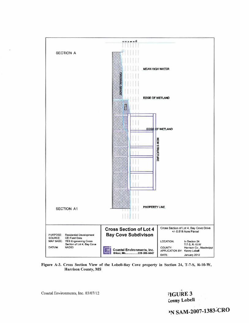
SECTION A
SECTION A1
PURPOSE: SOURCE: MAP BASE:
DATUM:
ResidenUal De~elopment CEI Field Data YES Engineering Cross Section of Lot 4, Bay Co~e NAD83
MEAN HIGH WATER
I I I ,,,
EDGE OF WETLAND
WETLAND
z ~ ;
PROPERTY LINE
Cross Section of Lot 4 Bay Cove Subdivison
&;;1" Coastal Environments, Inc. J.!: Biloxi, Ms ............ .. ... 228-386-5647
Cross Section of Lot 4, Bay Cove Drive +/- 0.518 Acre Parcel
LOCATION: In Section 24 T-7-S, R-10-W
COUNTY: Harrison Co., Mississippi APPLICATION BY: Kenny Lobell
DATE: January 2012
Figure A-3. Cross Section View of the Lobell-Bay Cove property in Section 24, T-7-S, R-10-W, Harrison County, MS
" Coastal Environments, Inc. 03/07112 ~'IGURE3 Cenny Lobell
,N SAM-2007-1383~CRO

r--, +/· 0.082 ac. of impacted serub/shurb L..._l wetlands ml!lgeted through the purchase of
credits through an approved miHgation bank
+/- 0.16 a c. of marsh restored and pr~ected thrOtJgh lhe conslruclion of a living shoreline
CJ +/- 0.65 ac. o1 mersh available for restoration (obO'Ie the MHW line) which represents the presetVBiion component or the resloretion plan
PURPOSE: Residential Development SOURCE: BP 2010 DOOOO
CEt Field Survey MAP BASE: P Martino PLS {March 24. 2006)
& True Color DOQQQ 1ft GSD Published (October 201 0)
DATUM: NAD83
0 300 600 1 ,200
Feet
RESTORATION AREAS
l'i!=l Coastal Environments. Inc. I!: Biloxi. MS ... 228-385-5547
Pointe at Bay Cove
Brasher Road I Kennedy Lane Biloxi. MS
Permit Information for+/- 0.518 acre parcel
LOCATION: In Section 24. T-7-S, R-10-W COUNTY Harrison Co .. Mississippi APPLICATION BY: Kenny Lobell DATE August 2012
Figure 2: Proposed on-site mitigation map of the Lobell Bay Cove property in Section 24, T-7-S, R-10-W, Harrison County, MS
FIGURE4 Kenny Lobell
PN SAM-2007-1383-CRO