johns prairie road proviso report · appendices 37 a stakeholders/community members ... d letter...
TRANSCRIPT

Johns Prairie Road
Proviso Report
Kevin Dayton Olympic Region Administrator
Paula Hammond Secretary of Transportation
June 23, 2010
Washington StateDepartment of Transportation

Mason Coupunty, City of Sproperty owne
Johns
Provi
In collShelton, Port oers, intereste
Ju
Prairie Ro
so Rep
laboration wiof Shelton, PUd community
ne 30, 2010
Washingt
oad
port
th UD 3, Mason y members, an
ton State De
Transit, businnd others.
epartment oOlympic Regi
5720 CaTumwate
nesses,
of Transportion Planning Oapitol Boulevaer, WA 98501
ationOfficeard SE‐5201

Johns Prairie Road Proviso Report 2 June 2010
Johns Prairie Road Proviso Report
EXECUTIVE SUMMARY
Why did WSDOT do this report? The 2009 Senate Substitute Bill Number 5352 Section 306(39) provided WSDOT legislative direction to “…conduct a public outreach process to identify and respond to community concerns regarding the portion of Johns Prairie Road that connects SR 3 and US 101. The process must include representatives from Mason County, the Legislature, area businesses, and community members. The department shall use this process to consider, develop, and design a project scope so that the community's needs are met for the lowest cost. The department shall provide a report on the process and outcome to the Legislature by June 30, 2010.” How was the study conducted? In order to better understand the nature of John Prairie Road issues, WSDOT conducted an outreach effort to identify and respond to community concerns. WSDOT identified a number of stakeholders and conducted interviews that included Mason County Commissioners, property owners, businesses, and community members, tribes, and Mason County and City of Shelton public works staff among others. In addition WSDOT scheduled and conducted two half‐day workshops; the purpose of these workshops was to collect input, identify potential solutions, and obtain feedback from stakeholders and community members alike. What is the final outcome of this study/report? For the west connection ‐ US 101/Wallace Kneeland Boulevard Interchange, this study references the approved US 101/Wallace Kneeland Boulevard Interchange Justification Report (IJR) study, the result of which identified a solution for traffic congestion that supports land use developments in that vicinity. The IJR recommends the following improvements:
• An offset diamond interchange. The northbound ramps will remain in place, although there will be widening to two right‐turn lanes onto Wallace Kneeland Boulevard, a left turn lane, and a shared through/left‐turn lane and signalization at the intersection with Wallace Kneeland Blvd.
• The southbound ramps will be relocated further south, and will be oriented toward the west. The southbound ramps will intersect a proposed extension of Wallace Kneeland Blvd at a roundabout intersection.
• The Wallace Kneeland Bridge over US 101 would be widened to two travel lanes in each direction with an eastbound left‐turn lane onto the northbound on‐ramp, increasing capacity on Wallace Kneeland Blvd and improving a key east/west link over US 101.
• At the Wallace Kneeland/Olympic Highway intersection, additional widening on Olympic Highway will occur in order to provide two northbound left‐turn lanes, and the existing traffic signal modified as necessary.
• Extend “K” Street across US 101 aligning with current K Street on the east side and connecting to the new north/south connector road on the west side of US 101 linking the local street system to development located to the west of US 101. This bridge would be a two‐lane bridge crossing US 101 and the road would widen at its approach to the Olympic Highway N intersection to include a center turn lane with frontage improvements.

Johns Prairie Road Proviso Report 3 June 2010
For the east connection ‐ SR 3/Johns Prairie Road intersection, this study considered nine alternative solutions developed by staff, stakeholders, and community members. Based on the results of community discussions and technical reviews, this study found three solutions to be the most promising:
1) A low cost solution that would install a signal at SR 3/Johns Prairie Road, and would introduce full movement access for that intersection by means of a new Roundabout improvement immediately north of the intersection.
2) A second, moderate cost solution would install a new frontage road and bridge at Johns Creek along the west side of SR 3 and north of the existing intersection. The new road would effectively move the intersection to a new, signalized location north of the service station and grocery store located north of Johns Creek Bridge, connecting to Johns Prairie road at a point immediately west of the existing intersection (which would be abandoned in the process).
3) A third solution is to build on the second solution by realigning John’s Prairie Road along an
alignment north of the current one, as part of a future Mason County project in conjunction with a potential gravel mine development on the property that was discussed during this planning process. Phasing the improvements is recommended as a way to better accommodate funding considerations.
Each solution has potential engineering challenges that would be evaluated once further funding is identified, including the implications of increased traffic due to improved intersection function on structural stability and critical environmental impacts.

Johns Prairie Road Proviso Report 4 June 2010
Table of Contents
EXECUTIVE SUMMARY 2 INTRODUCTION 5 Why did WSDOT develop this report? 5 What are the study limits? 5
What was the process used? 6 How was outreach conducted? 6
Stakeholders 6 Interviews 7 Workshops 7
Previous studies 7 BACKGROUND 8 Roadway conditions 8 Land use 9 Growth and development 9 Traffic history 11 Collision history 13 Constraints 16 CONNECTIONS AND POTENTIAL IMPROVEMENTS 18 West connection –US 101/ Wallace Kneeland Boulevard Interchange 18 East connection – SR 3/Johns Prairie Road 20 CONCLUSIONS 30 What is the final outcome of this study/report? 30 APPENDICES 37 A Stakeholders/Community Members 38 B Ideas Suggested at the Workshops 39 C Letter from Lower Elwha Klallam Tribe 41 D Letter from Skokomish Indian Tribe 42

Johns Prairie Road Proviso Report 5 June 2010
INTRODUCTION Why did WSDOT develop this report? The 2009 Senate Substitute Bill Number 5352 Section 306(39) provided WSDOT legislative direction to “…conduct a public outreach process to identify and respond to community concerns regarding the portion of Johns Prairie Road that connects SR 3 and US 101. The process must include representatives from Mason County, the Legislature, area businesses, and community members. The department shall use this process to consider, develop, and design a project scope so that the community's needs are met for the lowest cost. The department shall provide a report on the process and outcome to the Legislature by June 30, 2010.” Prior to development of this report, WSDOT staff discussed the report with Senator Tim Sheldon, and Mason County Commissioners. They stressed the importance of this corridor in terms of freight mobility, economic vitality, and growth and development. They identified safety concerns regarding the current configuration of the SR 3 and Johns Prairie Road intersection. What are the study limits? Study limits include the portion of Johns Prairie Road that connects State Route 3 and US 101. The western connection was identified as the area in the vicinity of the US 101/Wallace Kneeland Boulevard Interchange and the eastern connection was identified as the area in vicinity at the intersection of SR 3 and Johns Prairie Road.
“The department shall conduct a public outreach process to identify and respond to community concerns regarding the portion of John's Creek Road* that connects state route number 3 and state route number 101. The process must include representatives from Mason County, the legislature, area businesses, and community members. The department shall use this process to consider, develop, and design a project scope so that the community's needs are met for the lowest cost. The department shall provide a report on the process and outcomes to the legislature by June 30, 2010.”
2009 Senate Substitute Bill Number 5352 Section 306(39)
(*This should have read “Johns Prairie Road” in the above legislature text.)

Johns Prairie Road Proviso Report 6 June 2010
What was the process used? In response to the Johns Prairie Road legislative proviso, a public outreach process was conducted to identify and respond to community concerns. The public outreach process included representatives from Mason County, the legislature, area businesses, and community members. This process was used to consider, develop, and recommend alternatives to meet the community’s needs at the lowest cost. The process also included a review of studies that had previously been conducted within the study area. Two recent studies were identified, the Bremerton Economic Development Study (BEDS) and the US 101/Wallace Kneeland Interchange Study. How was the outreach conducted? The outreach effort was conducted through stakeholder interviews and two half‐day workshops that were scheduled. Stakeholders were invited to participate in the two half‐day workshops and to provide input, identify and comment on potential solutions. Letters were sent to six Tribes to apprise them of the study and extended an invitation to participate in the study process. Stakeholders Stakeholders and interested community members were identified through consultation with elected officials, representatives from Mason County, City of Shelton, Economic Development Council (EDC), and county and city staff. Stakeholders included state and local agencies, property owners, businesses, tribes, and community members who expressed an interest in participating in the process. (See Appendix A).
East Connection: SR 3/Johns Prairie Road
West Connection:
US 101/Wallace Kneeland Blvd Interchange

Johns Prairie Road Proviso Report 7 June 2010
Interviews Interviews were conducted with area businesses, staff from Mason County, City of Shelton, Mason Economic Development Council (EDC), Port of Shelton, Public Utility District (PUD) 3, Squaxin Island Tribe, and Skokomish Tribe. Property owners and developers who have planned developments within the area such as ADAGE, who has proposed developing a biomass plant within the vicinity of Johns Prairie Road were also contacted and interviewed. Those who were interviewed stressed the importance of this corridor in terms of freight mobility, economic vitality, and growth and development. Safety regarding SR 3/Johns Prairie Road intersection – skewed intersection, poor sight distance, steep grades, and safety perceptions to the point where some users avoid the intersection altogether was another major concern raised during the interviews. Workshops Two half‐day workshops were conducted on April 8th and April 21st at Mason County Public Works. The first of these workshops focused on purpose, process, east and west connections of Johns Prairie Road with SR 3 and US 101 respectively. Existing conditions, issues and identification of potential solutions were addressed with stakeholders. Attendees provided input and feedback on the development of possible solutions. The second and final workshop provided an opportunity to the stakeholders and community members to review potential solutions and to provide further input. The final workshop focused on addressing alternatives and other ideas suggested. Community input was considered and the final outcome and process is captured in this report. Previous studies Two recent studies conducted in this area are the Bremerton Economic Development Study (BEDS)1 and the US 101 / Wallace Kneeland Interchange Justification Report2 (IJR) study were reviewed for this report. The Bremerton Economic Development Study (SR 3/SR 16/US 101) is a planning study focused within the South Kitsap/North Mason County area. The study limits included US 101, beginning at the intersection of State Route (SR) 102 north of Shelton and continuing southward to its intersection with SR 3; SR 3 from US 101 north to Bremerton. One of the top priorities identified in this study was the realignment of Johns Prairie Road with SR 3 and improvement of the intersection. Improvements for US 101 and Wallace Kneeland Interchange were also recommended in terms of capacity and other improvements. The recently concluded US 101 / Wallace Kneeland Interchange Justification Report (IJR) study provides analysis towards finding a long‐term solution to the traffic operations in the vicinity of US 101 / Wallace Kneeland Boulevard as a result of potential impacts from the anticipated development in this area. The City of Shelton has a substantial amount of commercially‐zoned property available for development adjacent to or in the vicinity of the US 101 / Wallace Kneeland Boulevard interchange. Construction and occupancy of developments in this area is anticipated to impact the freeway ramp terminals, bridge over‐crossing, and potentially other intersections in the immediate vicinity of the interchange. The study identified a preferred solution to address the issues at the interchange. 1Bremerton Economic Development Study (BEDS). Draft Report, March 2010, WSDOT Urban Planning Office, Seattle. 2US 101/Wallace Kneeland Boulevard Interchange Justification Report, March, 2010, Shea, Carr & Jewell, Inc.

Johns Prairie Road Proviso Report 8 June 2010
BACKGROUND Roadway conditions Highway US 101 ‐ US 101 is a limited access highway that provides the primary highway connection between Olympia and Interstate 5 to the south and the Olympic Peninsula to the north. US 101 from Wallace Kneeland north to SR 102 is a two‐lane (one NB lane – one SB lane) undivided highway with posted speed of 45 MPH. US 101 from Wallace Kneeland south to Shelton‐Matlock Road is a two‐lane (two NB lane – one SB lane) undivided highway with posted speed of 60 MPH. US 101 is designated a Highway of Statewide Significance (HSS) and is part of the National Highway System (NHS). It has a freight classification of T2 (approximately 4.20 million tons). Wallace Kneeland Boulevard is the major east/west arterial through northern Shelton and It provides access to rural areas including the Port of Shelton industrial park properties north of Shelton, residential areas on the north Shelton plateau, and serves a substantial retail and commercial area adjacent to the east side of US 101 and along Olympic Highway North and Wallace Kneeland Boulevard – heading east Wallace Kneeland Boulevard becomes John Prairie Road within the City limits of Shelton. Olympic Highway North is a major north/ south arterial that terminates at Wallace Kneeland Boulevard just east of the US 101 / Wallace Kneeland Boulevard interchange.
Highway SR 3 – SR 3 is a state highway originating at its junction with US 101, south of the City of Shelton. From there, it runs northeast through Mason County and part of Kitsap County. SR 3 is a two‐lane undivided highway with posted speed of 40 MPH in the vicinity of Johns Prairie Road (SR 3, MP 6.57). SR 3 is a HSS and NHS route with a freight classification of T‐3
(approximately 2.99 million tons) in Mason County. Within the study area SR 3 is a managed access highway with a Class 2 designation with minimum access spacing of 660 feet. This section of SR 3 consists of primarily rolling terrain with the exception of the City of Shelton which has level terrain.

Johns Prairie Road Proviso Report 9 June 2010
Johns Prairie Road ‐ Johns Prairie Road is a major east/west two‐lane county arterial which turns into a city arterial, Wallace Kneeland Boulevard, within the city limits as the road proceeds westward from SR 3 and connects with US 101. Johns Prairie is a 40 MPH facility serving primarily commercial and, industrial designated land uses. The eastern terminus of Johns Prairie Road connects with SR 3 at a skewed angle with a downhill grade of about 10%. A climbing lane currently exists on the uphill side of the road, but does not extend down to the existing intersection. Currently the eastbound right turn from Johns Prairie Road is restricted and the northbound left turn from SR 3 while permitted, few travelers attempt the turn. It’s reported that eastbound vehicles heading south typically turn north, turning around at the Bayshore Golf Course entrance to return to southbound SR 3. Land use Johns Prairie Road falls partly in the Shelton Urban Grown Area to the east and partly within city limits to the west eventually turning into Wallace Kneeland Boulevard within the city limits. The west connection of Johns Prairie Road (US 101 at Wallace Kneeland Boulevard) is located within the City of Shelton. The land use designation within this area along Wallace Kneeland Boulevard is primarily commercial. Within the vicinity of the US 101/Wallace Kneeland Interchange the land is designated as Commercial (C), Commercial/Residential –Goose Lake (C/R‐G), and Commercial‐Industrial (C/I). The land to the west of the interchange (mixed use and commercial‐industrial) is mostly undeveloped. Other land use designations within the City of Shelton‐ zoning surrounding Johns Prairie include Public (P), Medical‐Educational (M/E), and Neighborhood Residential as one proceeds east towards the city limits. Within Shelton’s UGA along Johns Prairie the land has been designated Commercial‐Industrial (C/I) and Industrial (I). Within the county the land along Johns Prairie Road and the vicinity of the SR 3/Johns Prairie intersection is primarily Rural Residential with a density of 1 dwelling unit (du) per 5 acre (1:5). Other land use designations within the east connection of John Prairie Road include some Rural Commercial, Rural Natural Resource, and Rural Tourist. Some of the existing land uses include a mining operation owned by Manke Lumber and another mining operation north of Johns Creek owned by Bayshore Sand and Gravel; the Bayshore Golf Club, a gas station/convenient store, and the Bayshore residential community. Future land use development along Johns Prairie Road is expected to generate additional freight, truck and other traffic. Therefore full functioning intersection at SR 3/Johns Prairie Road is critical to better serve the industrial, commercial, and other uses along the corridor. Growth and development The commercial area within the vicinity of Wallace Kneeland Boulevard is appropriate for regional, automobile‐oriented retail commercial uses ‐ currently a Wal‐Mart is located in the NE quadrant of the interchange with a Fred Meyer store located in the SE quadrant along with their retail operations. To the west of US 101 are undeveloped commercial and mixed use zoned properties. The City of Shelton has recognized the future development potential of this largely undeveloped properties west of US 101 and expect near‐term development including “big box” retail and home improvement operations. The area west of the interchange is anticipated to be the largest employment center in the county and is expected to increase commercial and industrial traffic to the west of the US 101/Wallace Kneeland Blvd interchange.

Johns Prairie Road Proviso Report 10 June 2010
Port of Shelton’s John's Prairie Industrial Park is a 380 acre area located northeast of the City of Shelton along Johns Prairie Road. Heavy industrial tenants make use of the rail spur, natural gas, water and the flat buildable sites that are available. The Port of Shelton boasts excellent access to the I‐5 Corridor, and convenient multi‐modal transportation network, with on‐site rail and air, and interstate freeway access. One of the facilities featured on the Port’s website is truck compatible roads. The Port is actively engaged in attracting new tenants and businesses. The Port expects growth in truck and other traffic as it develops and grows its tenant base at the Johns Prairie Industrial Park. No traffic impact analysis is however available at this time. Mason County PUD 3 serves over 32,000 electric customers. It also provides wholesale telecommunications services. PUD 3 has out grown its current facility at the PUD warehouse on Olympic Highway North. It is relocating its operations center to Johns Prairie Road west of the railway tracks. The proposed Johns Prairie Operations Center project will consist of approximately 42,515 square feet of new building space to house administrative functions and meeting areas, and 8.2 acres to be utilized for storage and industrial work areas. A traffic impact analysis conducted in July 30, 2009 anticipated this project to generate a total of approximately 111 new trips in the peak hour. Occupancy is projected for 2011. Other future development include plans underway to build a $250 million biomass plant south of Johns Prairie Road and west of the rail road tracks. Once built, the power plant is expected to produce 55 megawatts of electricity. ADAGE expects 90% of fuel supplies of wood debris within 50 miles of the plant site. It is estimated to generate 50‐60 fuel supplies trucks a day. About 90% of these trucks are expected to arrive and depart the plant site from the west, primarily using the US 101/Wallace Kneeland Blvd Interchange, while 10% are expected from the east using SR 3/ Johns Prairie Road intersection. The project is expected to generate 700 direct and indirect jobs during the 2 ½ year construction. Daily operations would require about 100 employees collecting and transporting the woody debris with another couple dozen workers operating the plant. A traffic impact analysis is yet to be conducted. Ground breaking is planned for late this year pending environmental and land use approval.

Johns Prairie Road Proviso Report 11 June 2010
Traffic History Western Connection (US 101 at Wallace Kneeland) Traffic data for the west connection, US 101/Wallace Kneeland Boulevard Interchange, was available from a recent Interchange Justification Report (IJR) study and the Bremerton Economic Develop Study (BEDS). Both the IJR and BEDS studies used City of Shelton’s travel demand model for traffic data and analysis. Currently, the US 101 northbound ramp with Wallace Kneeland Boulevard operates poorly at Level of Service (LOS) F, because of the amount of traffic exiting US 101 through a stop control intersection. The analysis indicates that delay times are nearly three minutes per vehicle with the queue length exceeding 660 feet along the off ramp. Highway segment performance analysis in the BEDS study for highway corridors used the WSDOT ’Percent of Posted Speed’ methodology. Highway corridor segments are considered to be deficient when they operate below 70% of the posted speed during peak period. Analysis showed:
US 101 2008 AADT
2020 AADT
2030 AADT
2008 Travel Speed
(% Posted Speed)
2020 Travel Speed
(% Posted Speed)
2030 Travel Speed
(% Posted Speed)
North of Wallace Kneeland – South of SR 102
11,000 12,000 20,000 32 mph (71%) 31 mph (69%) 31 mph (69%)
South of Wallace Kneeland – North of Shelton Matlock Road
17,000 27,000 42 mph (70%) 16 mph (27%) 7 mph (12%)
South of Shelton Matlock Road ‐
15,000 18,000 27,000 42 mph (70%) 16 mph (27%) 7 mph (12%)
AADT = Annual Average Daily Traffic The traffic data analysis for the Interchange Justification Report addresses the need to find a long‐term solution to the traffic operations in the vicinity of the US 101/ Wallace Kneeland Boulevard interchange as a result of potential impacts from the anticipated development in this area. When combined with forecasted regional growth and existing traffic volumes from retail projects on the east side of US 101, the intersections near the US 101 / Wallace Kneeland Boulevard interchange are expected to experience peak hour blocking and poor level of service due to the high traffic volumes, close intersection spacing and additional access points to local retail land uses. The intersections at the US 101 ramps and Wallace Kneeland Boulevard, as well as nearby intersections in the local commercial zone (including Wal‐Mart and, Fred Meyer), under existing 2008 conditions, all intersections operate acceptably in terms of level of service and delay in both the AM and PM peak hours. (The City of Shelton has adopted LOS D for its urban arterials and intersections however; the city has set the level of service standard for the Olympic Highway N at Wallace Kneeland Boulevard intersection at LOS‐E.) Under 2030 conditions, however, all of these intersections are projected to see significant decreases in the level of service and increased delays in both AM and PM peak hours. A large factor in the 2030 baseline traffic operations is anticipated development on the west side of US 101.

Johns Prairie Road Proviso Report 12 June 2010
Traffic impact analysis conducted for the relocation of the PUD 3 operations center to Johns Prairie Road estimates 111 new PM peak hour trips to be generated by this Center. Eighty seven of these trips arrive from or depart to the west – a majority of which utilizes the Wallace Kneeland Boulevard while 24 are from and to the east using SR 3. This represents 78% of trips to and from the west and 22% to and from the east. Eastern Connection (SR 3 at Johns Prairie) BEDS data also was considered for the east connection – SR 3/Johns Prairie Road intersection. Johns Prairie Road currently operates at LOS F. Its intersection with SR 3 is skewed and has high left turning traffic onto SR 3. The Johns Prairie approach is stop controlled while SR 3 is free flowing which causes average wait time of nearly one minute per vehicle. Traffic signal warrants were met for this location in 2005. The following table describes 2008 weekday PM peak hour intersection turning movements at John Prairie Road. These post‐processed turning movements show very little traffic on the eastbound right and northbound left legs of the intersection.
Weekday PM Peak‐Hour Intersection Turning Movements (2008) Ctrl EB WB NB SB
L T R L T R L T R L T R OW 202 ‐ 002 ‐ ‐ ‐ ‐ 472 ‐ ‐ 289 189
Traffic volumes for 2020 were forecasted using City of Shelton travel demand model. This post process data show eastbound right as having a volume of 7 in the PM peak hour although this movement is restricted through no‐right‐turn signage. The model applied no turn penalties for the eastbound right and treated the intersection basically as a stop controlled T‐intersection. Northbound left volume is only 4, representing the unpopularity of this difficult turn.
By 2030, the eastbound right and northbound left reached only 10 and 5 respectively. However, raw model volumes for these movements in 2030 are 19 and 15 respectively.
PM Peak Traffic Intersection Turning Movements
Approach Eastbound Westbound Northbound Southbound
L T R L T R L T R L T R
2020 355 0 7 0 0 0 4 628 0 0 434 270
2030 491 0 10 0 0 0 5 867 0 0 600 373
Johns Prairie Road Proviso Report 13 June 2010
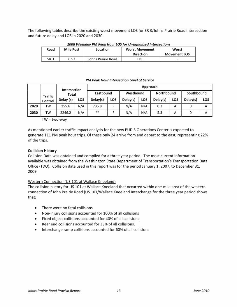
The following tables describe the existing worst movement LOS for SR 3/Johns Prairie Road intersection and future delay and LOS in 2020 and 2030.
PM Peak Hour Intersection Level of Service
Traffic Control
Intersection Total
Approach
Eastbound Westbound Northbound Southbound
Delay (s) LOS Delay(s) LOS Delay(s) LOS Delay(s) LOS Delay(s) LOS
2020 TW 155.6 N/A 735.8 F N/A N/A 0.2 A 0 A
2030 TW 2246.2 N/A ** F N/A N/A 5.3 A 0 A
TW = two‐way As mentioned earlier traffic impact analysis for the new PUD 3 Operations Center is expected to generate 111 PM peak hour trips. Of these only 24 arrive from and depart to the east, representing 22% of the trips. Collision History Collision Data was obtained and compiled for a three year period. The most current information available was obtained from the Washington State Department of Transportation’s Transportation Data Office (TDO). Collision data used in this report was for the period January 1, 2007, to December 31, 2009. Western Connection (US 101 at Wallace Kneeland) The collision history for US 101 at Wallace Kneeland that occurred within one‐mile area of the western connection of John Prairie Road (US 101/Wallace Kneeland Interchange for the three year period shows that;
• There were no fatal collisions • Non‐injury collisions accounted for 100% of all collisions • Fixed object collisions accounted for 40% of all collisions • Rear end collisions accounted for 33% of all collisions. • Interchange ramp collisions accounted for 60% of all collisions
2008 Weekday PM Peak Hour LOS for Unsignalized Intersections Road Mile Post Location Worst Movement
Direction Worst
Movement LOS SR 3 6.57 Johns Prairie Road EBL F

Johns Prair
The followwithin onInterchan
YEAR
2007
2008
2009
Under 23 UniWSDOT or the
Unag
Eastern CThe collisi(SR 3 at Jo
• Th• N• In• R• Fi• En
rie Road Provis
wing table ane‐mile area oge).
TOTAL
7
5
3
15 ited State Code‐See State of Washing
nder 23 United Stagainst the WSDOT
Connection (Sion history thohns Prairie R
here were noon‐injury colnjury collisionear end collisixed object cntering at ang
U
so Report
d figure summof the western
SEVERIT
INJURY FA
0
0
0
0 ection 409, this datgton. This disclaim
In
ate Code‐Section 4T or the State of Wa
R 3 at Johns hat occurred wRoad intersec
o fatal collisiolisions accounns accounted sions accountollisions accogle and enter
US 101 Mainline
marizes the sn connection
Collisions b
TY
ATALITY REE
0
0
0
0 ta cannot be used mer is for all accide
nterchange C
409, this data cannashington. This dis
Prairie Road)within one‐mtion) for the t
ns nted for 76% for 24% (6 coted for 44% oounted for 24ring from driv
60%
Interchange
14
everity, type,of John Prair
by Severity and
EAR ND
FIXEOBJEC
3 4
1 1
1 1
5 6in discovery or as ent data mentione
Collisions by
not be used in discsclaimer is for all a
) ile area of ththree year pe
of all collisioollisions)of allf all collisions4% of all collisveway collisio
20%
Overcrossing
, and locationrie Road (US 1
d Type
TYP
D CT
ENTERINAT ANG
0
1
0
1 evidence at trial i
ed in this report.
y Location
covery or as evidenaccident data men
e eastern coneriod shows t
ns collisions s ions ons each acco
20%
Interchange On
ns of collision101/Wallace K
PE
NG GLE SIDESW
0
1
0
1 in any action for da
nce at trial in any antioned in this repo
nnection of Johat;
unted for 12%
n and Off‐Ramps
June
s that occurreKneeland
WIPE OTHE
0
1
1
2 amages against th
action for damageort.
ohn Prairie Ro
% of all collisi
e 2010
ed
R
he
es
oad
ions.
Johns Prairie Road Proviso Report 15 June 2010
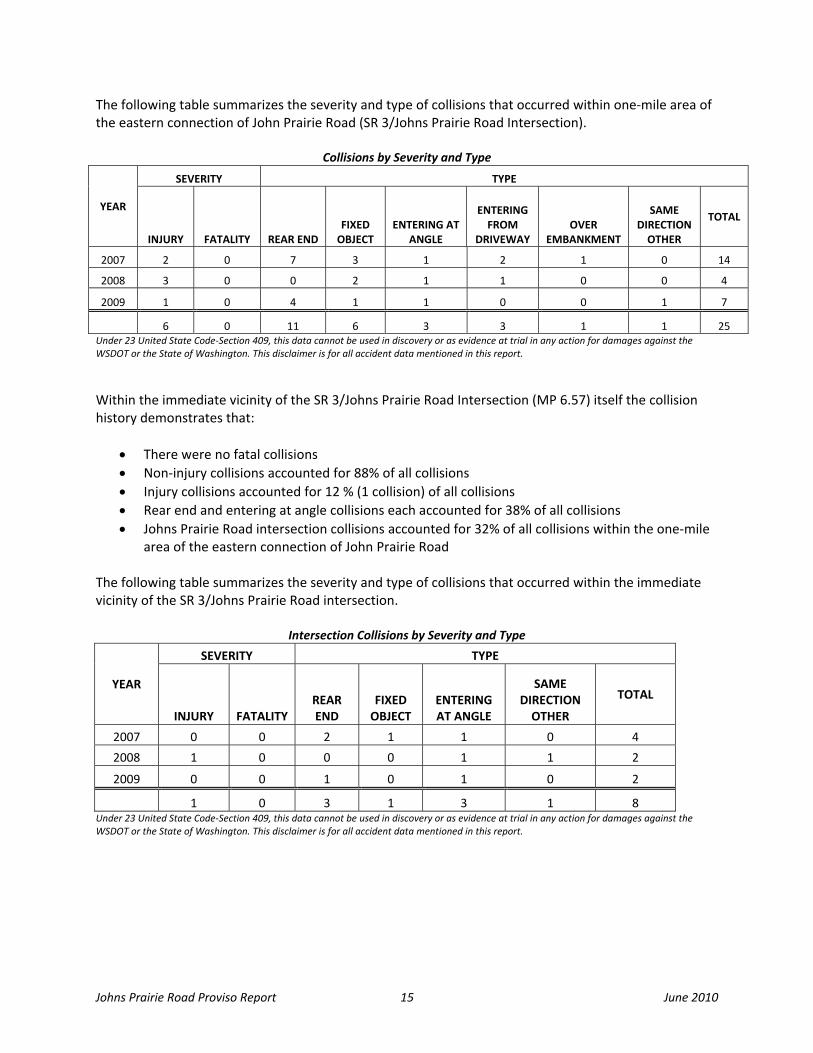
The following table summarizes the severity and type of collisions that occurred within one‐mile area of the eastern connection of John Prairie Road (SR 3/Johns Prairie Road Intersection).
Collisions by Severity and Type
YEAR
SEVERITY TYPE
INJURY FATALITY REAR END FIXED OBJECT
ENTERING AT ANGLE
ENTERING FROM
DRIVEWAY OVER
EMBANKMENT
SAME DIRECTION OTHER
TOTAL
2007 2 0 7 3 1 2 1 0 14
2008 3 0 0 2 1 1 0 0 4
2009 1 0 4 1 1 0 0 1 7
6 0 11 6 3 3 1 1 25 Under 23 United State Code‐Section 409, this data cannot be used in discovery or as evidence at trial in any action for damages against the WSDOT or the State of Washington. This disclaimer is for all accident data mentioned in this report.
Within the immediate vicinity of the SR 3/Johns Prairie Road Intersection (MP 6.57) itself the collision history demonstrates that:
• There were no fatal collisions • Non‐injury collisions accounted for 88% of all collisions • Injury collisions accounted for 12 % (1 collision) of all collisions • Rear end and entering at angle collisions each accounted for 38% of all collisions • Johns Prairie Road intersection collisions accounted for 32% of all collisions within the one‐mile
area of the eastern connection of John Prairie Road The following table summarizes the severity and type of collisions that occurred within the immediate vicinity of the SR 3/Johns Prairie Road intersection.
Intersection Collisions by Severity and Type
YEAR
SEVERITY TYPE
INJURY FATALITY REAR END
FIXED OBJECT
ENTERING AT ANGLE
SAME DIRECTION OTHER
TOTAL
2007 0 0 2 1 1 0 4
2008 1 0 0 0 1 1 2
2009 0 0 1 0 1 0 2
1 0 3 1 3 1 8 Under 23 United State Code‐Section 409, this data cannot be used in discovery or as evidence at trial in any action for damages against the WSDOT or the State of Washington. This disclaimer is for all accident data mentioned in this report.

Johns Prairie Road Proviso Report 16 June 2010
Constraints Numerous constraints exist towards improving the corridor and the connections. These include fish bearing Johns Creek, wetlands, shorelines (Oakland Bay), well protection zone areas; steep grades, hills and rolling terrain, limited capacity on Johns Creek Bridge, winter roadway weight restrictions, existing water tower, leaking underground storage tanks, and other environmental issues such as the endangered species act. Although mitigation measures are possible, relative risks and costs must be assessed before improvement alternatives can be moved forward. Johns Creek Bridge has a high enough sufficiency rating that it is unlikely to warrant replacement in the near future. However, if widening of the bridge is necessary it would have to be replaced with a new bridge since widening of the existing structure is not possible due to the bridge’s design.
Bridges and StructuresRdwy MP Bridge# Bridge Name Year Built Operating Tonnagea Sufficiency Ratingb
SR 3 6.59 3/8 Johns Creek 1948 54/F 84.67 a - 99 - is the operating rating tonnage
F - means the ratings are calculated by the load factor method. b - If the value in this column is < 50, the structure needs repair or replacement.
Johns Prairie Road provides an important corridor for trucks and freight traffic for Port of Shelton Industrial Park, and other commercial and industrial developments. The roadway has had weight restrictions imposed during two out of three recent winters for the duration of a month or so, east of the railroad tracks. Mason County enhanced the roadway west of the railway tracks and has plans to do the same east of the tracks to address the weight restriction issue. An at grade Puget Sound and Pacific Railroad (PSAP) crossing, approximately a mile west of SR 3, also poses as a constraint to uninterrupted traffic flow along Johns Prairie Road. This causes stops and delay to vehicular traffic on Johns Prairie Road during train crossings. Because of the terrain, it is unlikely that the roadway immediately west of SR 3 could be widened in place as part of a low cost improvement. The current roadway is only 30 to 32 feet wide between the SR 3 intersection and a location near the top of the hill. This limited width is not within the standard considered ideal for non‐motorized travel, and this condition needs to be further evaluated. The following figure illustrates some of the environmental constraints that would need to be addressed in order to realign Johns Prairie Road or revise the current roadway connections. It includes Johns Prairie Creek and surrounding buffer that runs along a general west‐east direction; wetlands, well protection zone areas, and shorelines; physical nature of terrain such as hills, steep slopes, ravines as represented by contour lines. Other physical constraints are Johns Creek Bridge, a water tower, other structures; and residential, commercial, and industrial properties.

Johns Prairie Road Proviso Report 17 June 2010

Johns Prairie Road Proviso Report 18 June 2010
CONNECTIONS AND POTENTIAL IMPROVEMENTS West connection –US 101/ Wallace Kneeland Boulevard Interchange The western connection of Johns Prairie Road and US 101 occurs at the US 101 / Wallace Kneeland Boulevard interchange (milepost 345.12) located in the northwest portion of the City of Shelton. The recommendations of US 101/Wallace Kneeland IJR facilitates the development of properties west of US 101 which would provide a regional economic boost in an economically‐depressed area of Shelton and would accommodate a future four‐lane facility on US 101.
• The proposed interchange design is essentially an offset diamond interchange. The northbound ramps will remain in place, although there will be widening to two right‐turn lanes onto Wallace Kneeland Boulevard, a left turn lane, and a shared through/left‐turn lane and signalization at the intersection with Wallace Kneeland Blvd.
• The southbound ramps will be relocated further south, and will be oriented toward the west. The southbound ramps will intersect a proposed extension of Wallace Kneeland Blvd at a roundabout intersection.
• The Wallace Kneeland Bridge over US 101 would be widened to two travel lanes in each direction with an eastbound left‐turn lane onto the northbound on‐ramp, increasing capacity on Wallace Kneeland Blvd and improving a key east/west link over US 101.
• At the Wallace Kneeland/Olympic Highway intersection, additional widening on Olympic Highway will occur in order to provide two northbound left‐turn lanes, and the existing traffic signal modified as necessary.
Extending “K” Street across US 101 aligning with current K Street on the east side and connecting to the new north/south connector road on the west side of US 101 will serve as an important improvement in linking the local street system to development located to the west of US 101. This bridge would be a two‐lane bridge crossing US 101 and the road would widen at its approach to the Olympic Highway N intersection to include a center turn lane with frontage improvements. It is anticipated that the improvements would be phased over a period of time.
Existing Condition
Wallace Kneeland Blvd. Proposed Improvements

Johns Prairie Road Proviso Report 19 June 2010
In addition, for the long range and based on the 2030 traffic analysis in the vicinity of US 101/Wallace Kneeland Boulevard Interchange, the BEDS study recommends the following as segments of US 101 falls below the 70% posted speed limit threshold criteria:
• Extending the existing limited access, four‐lane highway from south of SR 3 to the Wallace Kneeland Blvd interchange
• Widening the two‐lane section from Wallace Kneeland to SR 102 to a four‐lane highway with eight‐foot shoulders – two‐foot centerline median and rumble strips – limit all side street access to right‐in/right‐out only

Johns Prair
East ConnJohns Praserves theare skeweand long qtraffic and
New businindustrial,Road is likADAGE bi50‐60 fueintersectiexpect to One of th3/Johns Pcontrol su
rie Road Provis
nection – SR 3irie Road core commercialed intersectioqueues. In add make the in
Existin
nesses locatin, commercialkewise expectomass plant l supplies truon. Manke Lgrow their o
e top priorityPrairie Road puch as signal a
so Report
3/Johns Prairridor currentl, industrial, ron, grade issuddition, futurntersection op
ng condition
ng to the Port, and other trted to increason Johns Praicks a day. Houmber, Bayshperations and
y projects recoproject. It recoand channeliz
rie Road ly provides imesidential, anes, safety conre growth andperate poorly
t of Shelton’sraffic. Relocatse truck, custirie Road oncowever, only hore Sand and anticipate f
ommended bommends reazation as war
20
mportant connd other usesncerns, and thd developmeny.
s 380 acre Johtion of Masontomer, and eme constructed10% of thesed Gravel, andurther increa
by the Bremeraligning Johnsranted.
nections to Ss along the cohe existing stnt along the c
hns Prairie Indn County PUDmployee traffd and operatie trucks are esd other businease in truck an
rton Economs Prairie Road
R 3, US 101, aorridor. Problop control is corridor is exp
dustrial Park wD 3 operationfic. The propoional is estimstimated to cesses along Jond other traff
ic Developmed and providin
June
and beyond; ems being facausing delaypected to inc
will increase s to Johns Praosed $250 miated to genecome throughohns Prairie Rfic.
ent Study is thng intersectio
e 2010
and ced ys rease
airie llion rate h this Road
he SR on
Johns Prairie Road Proviso Report 21 June 2010
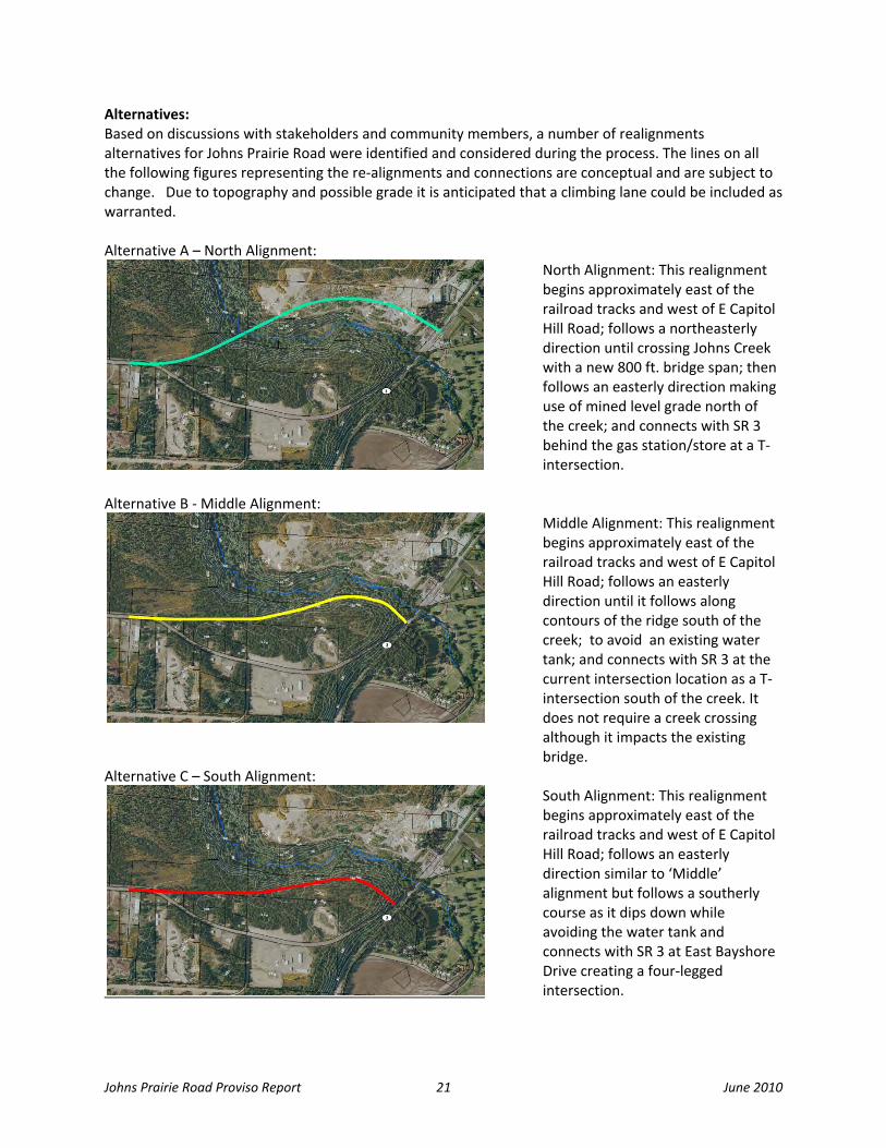
Alternatives: Based on discussions with stakeholders and community members, a number of realignments alternatives for Johns Prairie Road were identified and considered during the process. The lines on all the following figures representing the re‐alignments and connections are conceptual and are subject to change. Due to topography and possible grade it is anticipated that a climbing lane could be included as warranted. Alternative A – North Alignment:
North Alignment: This realignment begins approximately east of the railroad tracks and west of E Capitol Hill Road; follows a northeasterly direction until crossing Johns Creek with a new 800 ft. bridge span; then follows an easterly direction making use of mined level grade north of the creek; and connects with SR 3 behind the gas station/store at a T‐intersection.
Alternative B ‐ Middle Alignment:
Middle Alignment: This realignment begins approximately east of the railroad tracks and west of E Capitol Hill Road; follows an easterly direction until it follows along contours of the ridge south of the creek; to avoid an existing water tank; and connects with SR 3 at the current intersection location as a T‐intersection south of the creek. It does not require a creek crossing although it impacts the existing bridge.
Alternative C – South Alignment:
South Alignment: This realignment begins approximately east of the railroad tracks and west of E Capitol Hill Road; follows an easterly direction similar to ‘Middle’ alignment but follows a southerly course as it dips down while avoiding the water tank and connects with SR 3 at East Bayshore Drive creating a four‐legged intersection.
Johns Prairie Road Proviso Report 22 June 2010
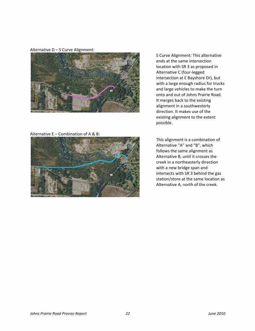
Alternative D – S Curve Alignment:
S Curve Alignment: This alternative ends at the same intersection location with SR 3 as proposed in Alternative C (four‐legged intersection at E Bayshore Dr), but with a large enough radius for trucks and large vehicles to make the turn onto and out of Johns Prairie Road. It merges back to the existing alignment in a southwesterly direction. It makes use of the existing alignment to the extent possible.
Alternative E – Combination of A & B:
This alignment is a combination of Alternative “A” and “B”, which follows the same alignment as Alternative B, until it crosses the creek in a northeasterly direction with a new bridge span and intersects with SR 3 behind the gas station/store at the same location as Alternative A, north of the creek.

Johns Prairie Road Proviso Report 23 June 2010
Intersection distance requirements and actual distances: The following figures illustrate intersection distance requirements and actual distances related to Alternative B, C, and D alignments and their connection with SR 3. NOT TO SCALE
NOT TO SCALE
Alternative B on creates an offset T‐intersection The required distance for a left turn receiving taper is 262’. The measured distance from the centerline of E Bayshore Dr to the bridge is actually 182’. About 80’ short and therefore impacts the bridge. The bridge cannot be widened due to design and therefore has to be replaced to accommodate any channelization needs.
Alternatives C and D would create a four‐legged intersection that aligns with the existing E Bayshore Dr. The required distance is 412’ from centerline of E Bayshore Dr to the bridge based on design criteria for state highways. The actual distance is 389’. About 23’ short and therefore impacts the bridge, requiring a bridge replacement under the Southern Alignment Alternative C) and the S‐Curve Alignment (Alternative D). Assume no deviations from standard.
´´
E Ba
ysho
re
ACTUAL DISTANCE
240’
50’
60’40’
John
s Prairie Ro
ad
182’
262’
John
s Prairie Ro
ad
100’
50’
240’
390’
40’ 60’
REQUIRED DISTANCE412’
389’
ACTUAL DISTANCE
412’
240’ 100’
390’
REQUIRED DISTANCE

Johns Prairie Road Proviso Report 24 June 2010
The resulting intersection of Johns Prairie Road with SR 3 under Alternative C and D (South and S Curve Alignment) would align with E Bayshore Drive creating a four‐way intersection and would operate better than the offset intersection that would be created under the Middle Alignment (Alternative B). Alternative B on creates an offset T‐intersection which when signalized could impact ingress/egress at E Bayshore Drive. Roadway grades: Roadway profiles grades were developed for the realignment alternatives A through E, using LiDAR surfaces (elevation data) and Inroads software. Roadway section features 12‐foot travel lane and 8‐foot shoulders with 2.4‐foot widening for guardrail per road section where warranted, were modeled with 2:1 cut/fill slope and maximum grade of 8%. Shaded areas in the following figure represent each realignment alternatives’ footprint. This enabled the project team to develop planning estimates of right‐of‐way needs as well as cut and fill requirements to assist in estimating earthwork costs.

Johns Prairie Road Proviso Report 25 June 2010
Besides realignment options WSDOT project team evaluated the following alternatives: Alternative F: Johns Prairie Road Extension (Frontage Road): This alternative removes the current skewed intersection with SR 3 by extending Johns Prairie Road north as a frontage road crossing Johns Creek with a new bridge west of the existing bridge. The frontage road would extend around the current gas station/convenient store connecting with SR 3 at a 90 degree angle north of the gas station with a signal and channelization as warranted.
Johns Prairie Road Proviso Report 26 June 2010
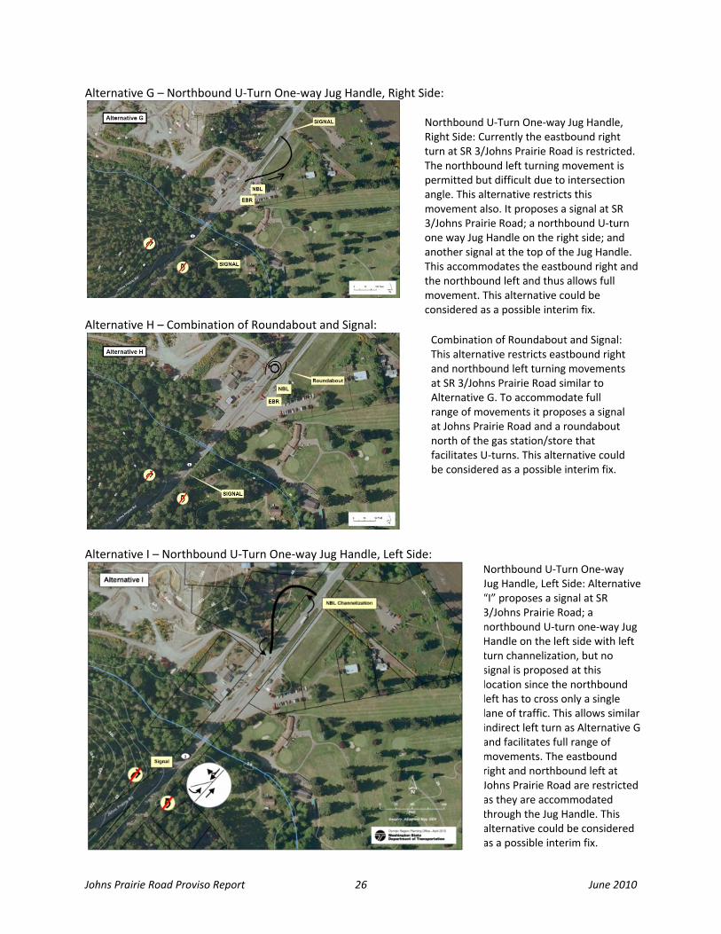
Alternative G – Northbound U‐Turn One‐way Jug Handle, Right Side:
Northbound U‐Turn One‐way Jug Handle, Right Side: Currently the eastbound right turn at SR 3/Johns Prairie Road is restricted. The northbound left turning movement is permitted but difficult due to intersection angle. This alternative restricts this movement also. It proposes a signal at SR 3/Johns Prairie Road; a northbound U‐turn one way Jug Handle on the right side; and another signal at the top of the Jug Handle. This accommodates the eastbound right and the northbound left and thus allows full movement. This alternative could be considered as a possible interim fix.
Alternative H – Combination of Roundabout and Signal: Combination of Roundabout and Signal:This alternative restricts eastbound right and northbound left turning movements at SR 3/Johns Prairie Road similar to Alternative G. To accommodate full range of movements it proposes a signal at Johns Prairie Road and a roundabout north of the gas station/store that facilitates U‐turns. This alternative could be considered as a possible interim fix.
Alternative I – Northbound U‐Turn One‐way Jug Handle, Left Side:
Northbound U‐Turn One‐way Jug Handle, Left Side: Alternative “I” proposes a signal at SR 3/Johns Prairie Road; a northbound U‐turn one‐way Jug Handle on the left side with left turn channelization, but no signal is proposed at this location since the northbound left has to cross only a single lane of traffic. This allows similar indirect left turn as Alternative G and facilitates full range of movements. The eastbound right and northbound left at Johns Prairie Road are restricted as they are accommodated through the Jug Handle. This alternative could be considered as a possible interim fix.

Johns Prairie Road Proviso Report 27 June 2010
During workshop discussions other ideas were raised by stakeholders and were take into account and researched by the study team. These included a Flyover and Cloverleaf, Realignment of SR 3, a North‐South Connection, which are addressed in Appendix B. None of these ideas were moved forward for further consideration.

Johns Prairie Road Proviso Report 28 June 2010
Cost Comparison: WSDOT‘s Planning Level Cost Estimating (PLCE) tool was used to estimate planning costs of the various alternatives. The resulting planning level total cost estimates includes preliminary engineering, right‐of‐way acquisition, and construction. The estimates do not include costs for wetland mitigation, noise walls, etc. The estimates are based on little to no design work and are 40% plus or minus accurate; hence the estimates are intended for planning purposes only. Some of the cost factors considered included the need for a creek crossing, length of bridge span, right‐of‐way needs, signalization, and amount of excavation necessary. Planning level cost estimates were developed for each improvement alternative for comparison purposes only. The lowest cost option among the realignment alternatives is the Middle Alignment (Alternative B), as it minimizes the amount of cuts and fills, and does not require a creek crossing. The Southern Alignment (Alternative C) involved the most amount of excavation and resulted in the highest cost. So too is the Northern Alignment (Alternative A) with a long bridge span (approximately 800 feet), and longer distance to connect with SR 3 north of the creek. The project team updated cost estimates based on discussions and input gathered at the two community workshops. The following table provides the result of the alternative cost comparison; for the purpose of this report the planning estimates were categorized into a series of cost ranges. These categories are:
Category 1 ‐ $2m ‐$5m Category 2 ‐ $5m ‐$10m Category 3 ‐ $10m ‐$20m Category 4 ‐ $20m ‐$30m
SR 3/Johns Prairie Road Alternatives ‐ Cost Comparisons
Length Right‐of‐Way Roadway Excavation Cost2 Alternative (Miles) (Acres) (Cubic Yards1) Category
Alternative "A" ‐ North Alignment 0.91 13.9 196,000 4
Alternative "B" ‐ Middle Alignment 0.78 17.2 363,000 3
Alternative "C" ‐ South Alignment 0.74 18.1 1,055,000 4
Alternative "D" ‐ S Curve Alignment 0.48 14.3 570,000 3
Alternative "E" ‐ Combination A&B Align. 0.89 16.6 299,000 3
Alternative "F" ‐ Johns Prairie Road Extension 0.20 2.3 Rolling 2 Alternative "G" ‐ Northbound U‐Turn (One‐way Jug Handle Right Side) 0.15 2.3 Rolling 1 Alternative "H" ‐ Signal and Roundabout U‐Turn (Intersection Control) 0.00 0.3 Rolling 1 Alternative "I" ‐ Northbound U‐ Turn (Indirect Left Side Jug Handle) 0.15 2.9 Rolling 1 1 Roadway Excavation estimated at $9.50 per cubic yard. If the material excavated is unsuitable (not gravel) and needs to be hauled, the cost per cubic yard could double 2 Preliminary Engineering is assumed to be approximately 20% of Construction NOTE: If a signal system is added, all inclusive costs range from $350,000 to $800,000 for construction (wetlands, sidewalks, channelization, ditch vs. enclosed drainage, etc.) NOTE: Cost of truck climbing lane/passing lane could range from $1.3 million to $7 million per mile. Assume additional costs per mile where climbing lanes are warranted
Johns Prairie Road Proviso Report 29 June 2010
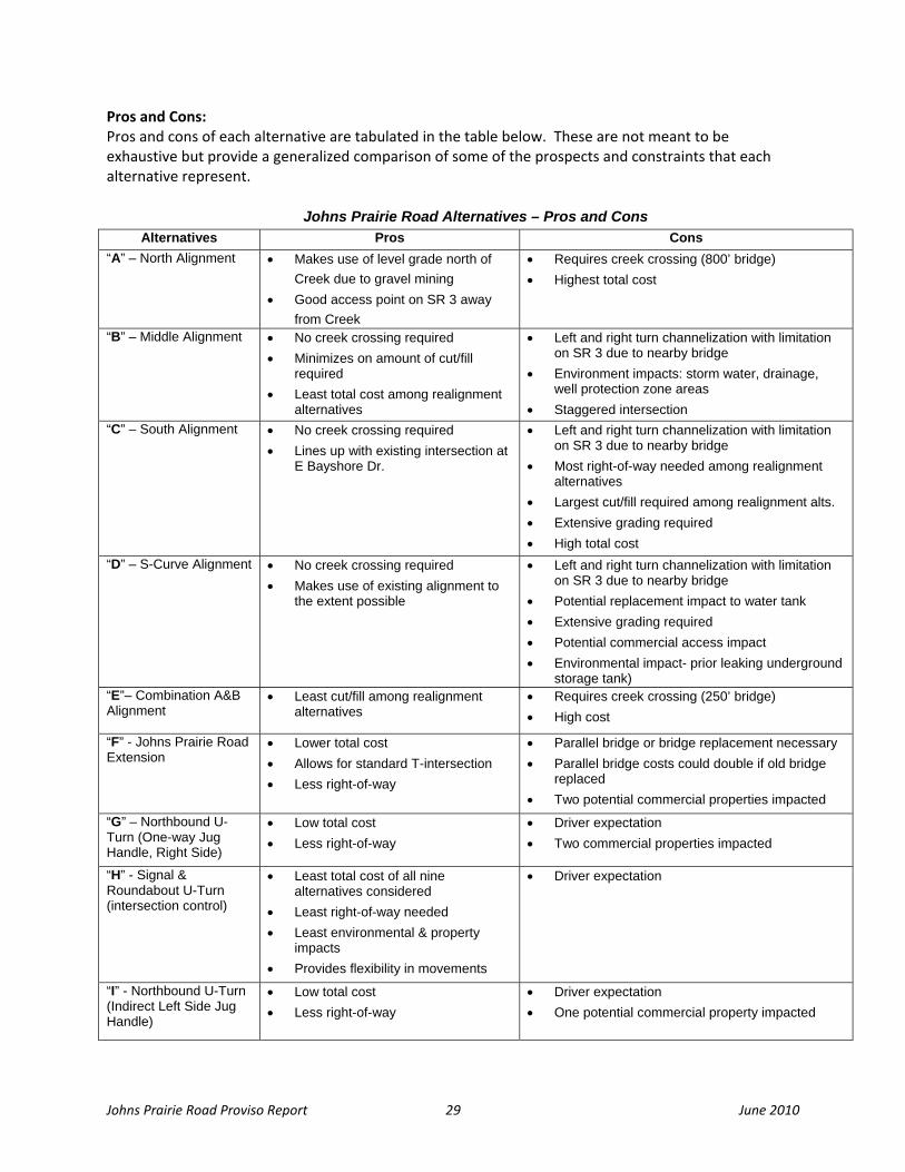
Pros and Cons: Pros and cons of each alternative are tabulated in the table below. These are not meant to be exhaustive but provide a generalized comparison of some of the prospects and constraints that each alternative represent.
Johns Prairie Road Alternatives – Pros and Cons Alternatives Pros Cons
“A” – North Alignment
• Makes use of level grade north of Creek due to gravel mining
• Good access point on SR 3 away from Creek
• Requires creek crossing (800’ bridge) • Highest total cost
“B” – Middle Alignment • No creek crossing required • Minimizes on amount of cut/fill
required • Least total cost among realignment
alternatives
• Left and right turn channelization with limitation on SR 3 due to nearby bridge
• Environment impacts: storm water, drainage, well protection zone areas
• Staggered intersection “C” – South Alignment
• No creek crossing required • Lines up with existing intersection at
E Bayshore Dr.
• Left and right turn channelization with limitation on SR 3 due to nearby bridge
• Most right-of-way needed among realignment alternatives
• Largest cut/fill required among realignment alts. • Extensive grading required • High total cost
“D” – S-Curve Alignment
• No creek crossing required • Makes use of existing alignment to
the extent possible
• Left and right turn channelization with limitation on SR 3 due to nearby bridge
• Potential replacement impact to water tank • Extensive grading required • Potential commercial access impact • Environmental impact- prior leaking underground
storage tank) “E”– Combination A&B Alignment
• Least cut/fill among realignment alternatives
• Requires creek crossing (250’ bridge) • High cost
“F” - Johns Prairie Road Extension
• Lower total cost • Allows for standard T-intersection • Less right-of-way
• Parallel bridge or bridge replacement necessary • Parallel bridge costs could double if old bridge
replaced • Two potential commercial properties impacted
“G” – Northbound U-Turn (One-way Jug Handle, Right Side)
• Low total cost • Less right-of-way
• Driver expectation • Two commercial properties impacted
“H” - Signal & Roundabout U-Turn (intersection control)
• Least total cost of all nine alternatives considered
• Least right-of-way needed • Least environmental & property
impacts • Provides flexibility in movements
• Driver expectation
“I” - Northbound U-Turn (Indirect Left Side Jug Handle)
• Low total cost • Less right-of-way
• Driver expectation • One potential commercial property impacted

Johns Prairie Road Proviso Report 30 June 2010
CONCLUSIONS What is the final outcome of this study/report? Johns Prairie Road provides an important corridor for trucks and freight traffic for Port of Shelton Industrial Park, and other commercial and industrial developments. The roadway is largely adequate to serve the traffic volume today, as well as volumes that can reasonably be expected in the future. However, the roadway has had weight restrictions imposed during two out of three recent winters for the duration of a month or so, east of the railroad tracks, and this situation would need to be addressed to ensure reliable service to local and regional trips as the area continues to develop. An at grade Puget Sound and Pacific Railroad (PSAP) crossing, approximately a mile west of SR 3, also poses as a constraint to uninterrupted traffic flow along Johns Prairie Road. This causes stops and delay to vehicular traffic on Johns Prairie Road during train crossings. The benefits of a grade separation improvement should be considered as part of any follow up to this report. It’s at both the east and west endpoints that the roadway would benefit most from potential improvements, and it’s these locations that this study concentrated. For the west connection ‐ US 101/Wallace Kneeland Boulevard Interchange, this study goes along with the solution identified by the US 101/Wallace Kneeland IJR that supports land use developments in that vicinity. The IJR recommends the following improvements:
• An offset diamond interchange. The northbound ramps will remain in place, although there will be widening to two right‐turn lanes onto Wallace Kneeland Boulevard, a left turn lane, and a shared through/left‐turn lane and signalization at the intersection with Wallace Kneeland Boulevard.
• The southbound ramps will be relocated further south, and will be oriented toward the west. The southbound ramps will intersect a proposed extension of Wallace Kneeland Blvd at a roundabout intersection.
• The Wallace Kneeland Bridge over US 101 would be widened to two travel lanes in each direction with an eastbound left‐turn lane onto the northbound on‐ramp, increasing capacity on Wallace Kneeland Blvd and improving a key east/west link over US 101.
• At the Wallace Kneeland/Olympic Highway intersection, additional widening on Olympic Highway will occur in order to provide two northbound left‐turn lanes, and the existing traffic signal modified as necessary.
• Extend “K” Street across US 101 aligning with current K Street on the east side and connecting to the new north/south connector road on the west side of US 101 linking the local street system to development located to the west of US 101. This bridge would be a two‐lane bridge crossing US 101 and the road would widen at its approach to the Olympic Highway N intersection to include a center turn lane with frontage improvements
Johns Prairie Road Proviso Report 31 June 2010
For the east connection ‐ SR 3/Johns Prairie Road intersection, this study considered nine alternative solutions developed by staff, stakeholders, and community members. Based on the results of community discussions and technical reviews, this study found the following three solutions to be the most promising. Phasing the improvements is recommended as a way to better accommodate funding considerations.
1) A low cost solution that would install a signal at SR 3/Johns Prairie Road, and would introduce full movement access for that intersection by means of a new roundabout improvement immediately north of the intersection.
2) A second, more moderate solution would install a new frontage road and bridge at Johns Creek along the west side of SR 3 and north of the existing intersection. The new road would effectively move the intersection to a new, signalized location north of the service station and grocery store located north of Johns Creek Bridge, connecting to John’s Prairie road at a point immediately west of the existing intersection (which would be abandoned in the process).
3) A third, longer range solution is to build on the second solution by realigning John’s Prairie Road along an alignment north of the current one, as part of a future Mason County project in conjunction with a potential gravel mine development on the property that was discussed during this planning process.
Each solution has potential engineering challenges that would be evaluated once further funding is identified, including the implications of increased traffic due to improved intersection function on structural stability and critical environmental impacts. These three ‘best prospects’ are illustrated below.

Johns Prairie Road Proviso Report 32 June 2010
Best prospects: The following set of alternatives appears to be the best prospects for further consideration. LOW‐COST AND NEAR‐TERM SOLUTION: Alternative H – Signal and Roundabout U‐Turn Combination of Signal and Roundabout: Alternative H is the lowest cost solution of the nine alternatives considered with few environmental and property impacts, and offers the best prospect as a low‐cost ($2m‐$5m) and near‐term solution. It starts with a signal at SR 3/Johns Prairie Road that assists the eastbound left movement; accommodates full range of movements by means of a roundabout immediately north of the intersection (near the gas station/store) that facilitates the northbound U‐turns effectively allowing the eastbound right turn from Johns Prairie Road and the northbound left turn from SR 3. Since these movements are performed immediately north, they are restricted at the SR 3/Johns Prairie Road intersection. The location of the roundabout is subject to change on further detailed investigation.
The community is supportive of a signal at Johns Prairie as a near‐term solution. It will ease the eastbound left movement from Johns Prairie Road onto SR 3 (it approaches SR 3 at a skewed angle) as it heads north on SR 3 with dedicated ‘green‐time’. Traffic signal warrants for this intersection were met in 2005. There is a potential however for increase in rear‐end collisions as a result of installing a traffic signal. So the benefits have to be weighed against costs. Overall, from an investment perspective, a combination of signal and roundabout (Alternative H) provides a better return on investment than either of the jug‐handles (Alternative I or Alternative G). This is due to least right‐of‐way need, lower environmental and property impact and less pavement, for Alternative H‐ combination of Signal and Roundabout.
Johns Prairie Road Proviso Report 33 June 2010
However, it was determined from an operational perspective a standalone signal would not allow the desired full movement at the intersection. Thus, Alternative H with its combination of Signal and Roundabout offers the full range of intersection turning movements that are currently unavailable. From a feasibility perspective, this low‐cost, low environmental impact alternative with near‐term benefits has higher funding potential. Other low‐cost and near‐term solutions like Alternative “I” and Alternative “G” were considered, but closer examination reveals they may present access issues and challenges in this Class 2 designated managed access section of SR 3. A separated southbound right turn lane channelization was also suggested with a possible truck climbing lane on Johns Prairie Road. However, the adjacent steep slopes and hills to the west and southwest and, proximity to the creek and bridge to the north present significant challenges and possibly requiring replacement of the existing bridge. This quickly escalates cost and renders it unfeasible as a low‐cost and near‐term solution. Other turning lane channelization at the current SR 3/Johns Prairie Road intersection, such as the eastbound right from Johns Prairie Road and northbound left from SR 3 present similar challenges. For these reasons a roundabout facilitating U‐turns north of the creek and bridge offer the best opportunities at the lowest cost. Driver expectation was identified as a possible constraint for this alternative. Signal and Roundabout in this rural section of highway may need advance warning by means of signage to address driver expectation. Currently there are no roundabouts in Mason County. Unfamiliarity with roundabouts and their operation may cause some apprehension but they are typically addressed through good awareness building, knowledge, and education. Modern roundabouts are designed to specific site requirements that take into account traffic conditions, all modes of travel as well as different types and sizes of vehicles including large trucks, low boy trailers, recreational vehicles, and so on. Roundabouts have been proven to prevent and reduce the severity of intersection collisions. The Federal Highway Administration has documented the safety benefits of roundabouts such as: up to a 90% reduction in fatalities, 76% reduction in injury collisions, 30 to 40% reduction in pedestrian collisions, and 75% fewer conflict points than other four‐way intersections.
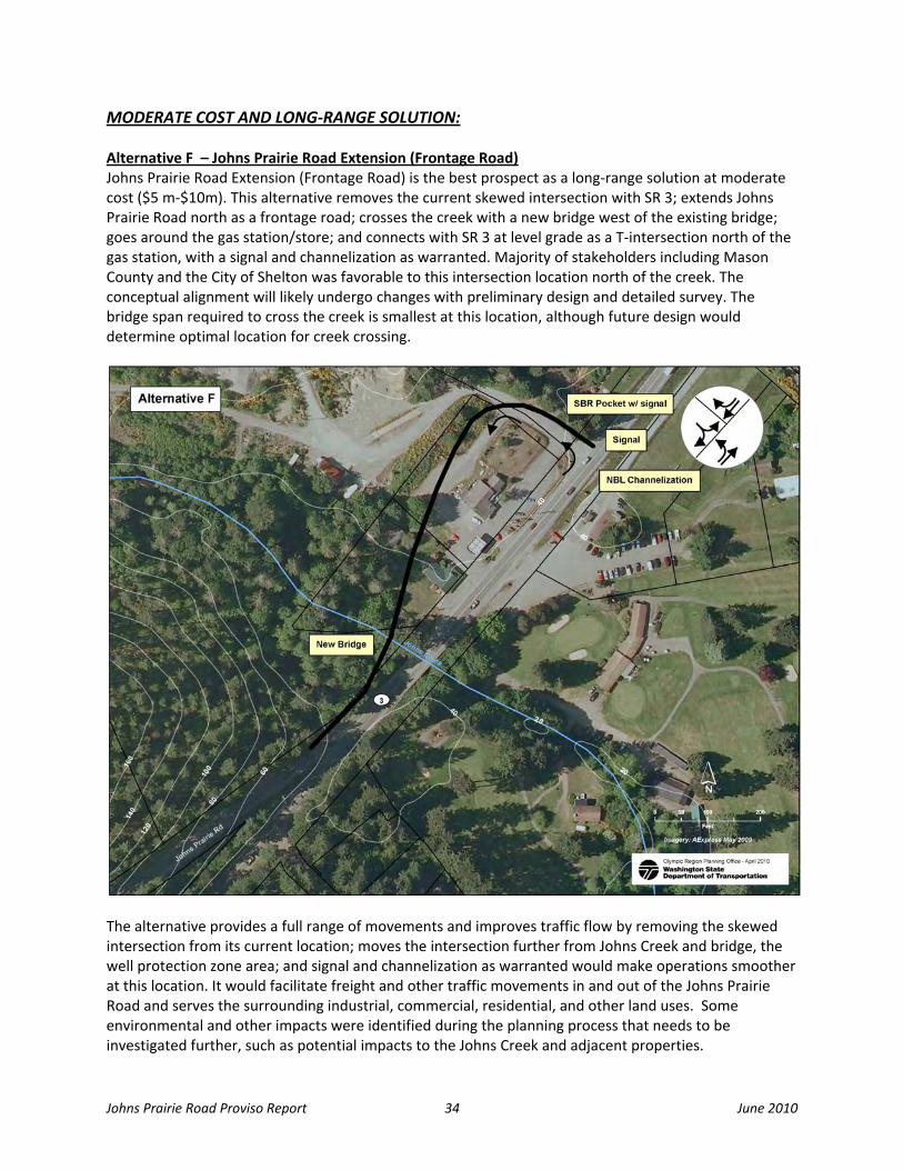
Johns Prairie Road Proviso Report 34 June 2010
MODERATE COST AND LONG‐RANGE SOLUTION: Alternative F – Johns Prairie Road Extension (Frontage Road) Johns Prairie Road Extension (Frontage Road) is the best prospect as a long‐range solution at moderate cost ($5 m‐$10m). This alternative removes the current skewed intersection with SR 3; extends Johns Prairie Road north as a frontage road; crosses the creek with a new bridge west of the existing bridge; goes around the gas station/store; and connects with SR 3 at level grade as a T‐intersection north of the gas station, with a signal and channelization as warranted. Majority of stakeholders including Mason County and the City of Shelton was favorable to this intersection location north of the creek. The conceptual alignment will likely undergo changes with preliminary design and detailed survey. The bridge span required to cross the creek is smallest at this location, although future design would determine optimal location for creek crossing.
The alternative provides a full range of movements and improves traffic flow by removing the skewed intersection from its current location; moves the intersection further from Johns Creek and bridge, the well protection zone area; and signal and channelization as warranted would make operations smoother at this location. It would facilitate freight and other traffic movements in and out of the Johns Prairie Road and serves the surrounding industrial, commercial, residential, and other land uses. Some environmental and other impacts were identified during the planning process that needs to be investigated further, such as potential impacts to the Johns Creek and adjacent properties.

Johns Prairie Road Proviso Report 35 June 2010
It addresses the issues at the existing intersection at a moderate cost and therefore represents a good investment with long term benefits. This solution received good stakeholder/public support. HIGH‐COST AND LONG‐RANGE SOLUTION: Alternative B – Middle Alignment (Modified) This third solution is a modification of the Middle Alignment alternative (Alternative B) that builds on Alternative F (Johns Prairie Road Extension) as a mid‐term improvement. In its initial concept Alternative B began east of the railroad tracks and west of the E Capitol Hill Road; follows an easterly direction along contours of the ridge south of the creek and connected with SR 3 at the current intersection location as a T‐intersection south of the creek. Intersection improvements included a signal and channelization. It also would require a new bridge due to channelization constraints
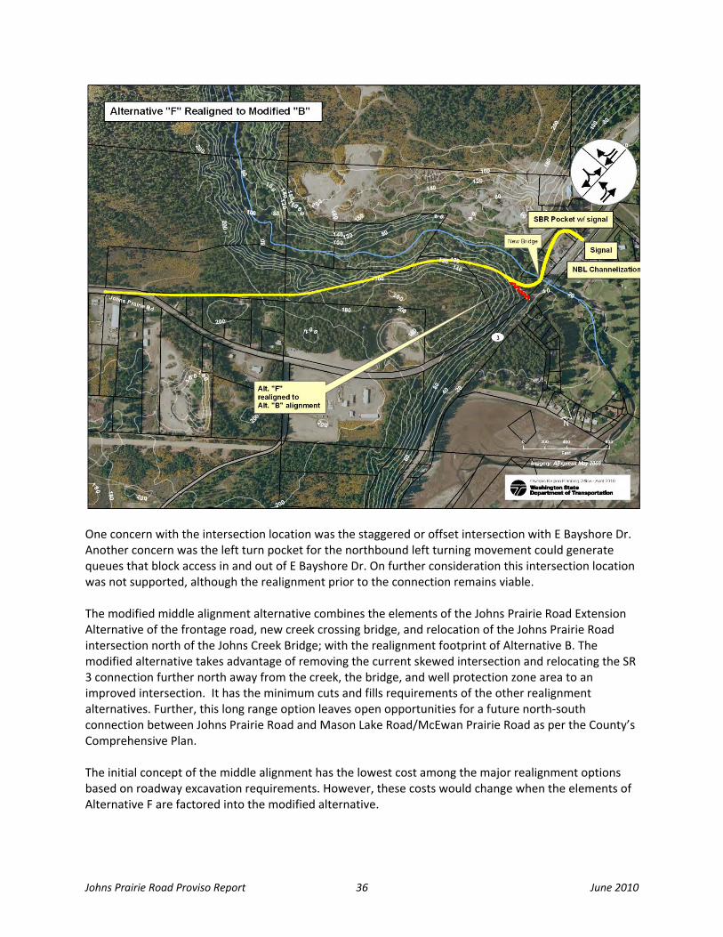
Johns Prairie Road Proviso Report 36 June 2010
One concern with the intersection location was the staggered or offset intersection with E Bayshore Dr. Another concern was the left turn pocket for the northbound left turning movement could generate queues that block access in and out of E Bayshore Dr. On further consideration this intersection location was not supported, although the realignment prior to the connection remains viable. The modified middle alignment alternative combines the elements of the Johns Prairie Road Extension Alternative of the frontage road, new creek crossing bridge, and relocation of the Johns Prairie Road intersection north of the Johns Creek Bridge; with the realignment footprint of Alternative B. The modified alternative takes advantage of removing the current skewed intersection and relocating the SR 3 connection further north away from the creek, the bridge, and well protection zone area to an improved intersection. It has the minimum cuts and fills requirements of the other realignment alternatives. Further, this long range option leaves open opportunities for a future north‐south connection between Johns Prairie Road and Mason Lake Road/McEwan Prairie Road as per the County’s Comprehensive Plan. The initial concept of the middle alignment has the lowest cost among the major realignment options based on roadway excavation requirements. However, these costs would change when the elements of Alternative F are factored into the modified alternative.

Johns Prairie Road Proviso Report 37 June 2010
APPENDICES

Johns Prairie Road Proviso Report 38 June 2010
APPENDIX A Stakeholders/Community Members
• Mason County Commissioners • Mason County Public Works • City of Shelton Community & Economic Development • City of Shelton Public Works • Port of Shelton • Port of Allyn • Economic Development Council of Mason County • Shelton Mason Chamber of Commerce • Mason County Public Utility District (PUD) #3 • Mason County Transit Authority • Skokomish Tribe • Squaxin Island Tribe • Suquamish Tribe • Port Gamble S’Klallam Tribe • Lower Elwha S’Klallam Tribe • Jamestown S’Klallam Tribe • Washington Department of Fish and Wildlife • Manke Lumber • ADAGE, LLC • Hall Equities Group • Island Enterprises • Sunlight Woodenworks, Inc. • Realtor’s Association • Bayshore Golf Club • Shell Station • Atlas Pellets • Brady Trucking • Wal‐Mart • Fred Meyer • Bayshore Sand & Gravel • Green Diamond Resources • Paul Reeves, property owner

Johns Prairie Road Proviso Report 39 June 2010
APPENDIX B Ideas Suggested at the Workshops: The following ideas were raised by stakeholders during workshop discussions. These ideas were taken into consideration and researched by the project team. Flyover and Cloverleaf: This would require an elevated structure touching down on SR 3 to allow eastbound left from Johns Prairie Road. To allow for an eastbound right the alternative includes a cloverleaf with a radius of 400 feet that accommodates a speed of 30 mph and ties in at SR 3. This cloverleaf however impacts the community of Bayshore; the radius could be tightened if lower speeds are adopted. This is only a conceptual look at what this might be. A rough cost estimate for this elevated structure is $35 million plus. Due to high costs and potential impacts to the Bayshore residences the idea was not recommended for further consideration.
Realignment of SR 3: This proposal would realign the current alignment of SR 3 to the east and would require a new bridge crossing. The purpose of the proposal is to allow more room to realign the Johns Prairie Road intersection. The assumption is the improvement cannot impact the shorelines. The Golf Course may be impacted. Cost estimate is not available for this alternative but would depend on property impacts and potential shoreline mitigation measures. This option has a potential to impact the nearby Golf Course. Any impact to the golf course could result in the acquisition of the entire 48 acres. Also reports suggest that the course may be up for sale for possible conservancy use. This idea
was not recommended for further consideration. North‐South Connection (vicinity of Oakes Road): A North‐South Connection concept is a one that the county and city has previously considered and is a long range vision identified in their comprehensive plan. This concept would create a north‐south connection from the vicinity of Oakes Road in the north and connecting up with Johns Prairie at some point in the south to allow access to Mason Lake Road. Eastbound Johns Prairie Road movement would be directed to Mason Lake Road. Right turn movement from SR 3 onto current Johns Prairie Road (southbound right) could still be allowed, however the northbound left turn would not.

Johns Prairie Road Proviso Report 40 June 2010
In essence Johns Prairie Road connection would become a one‐way access for southbound SR 3 traffic. The research identified that there are railroad tracks, and two creeks that would require crossing and numerous wetlands that would be difficult to avoid. Crossing Johns Creek itself would require approximately a 1,000 foot span. While a connection down the power lines was not looked at specifically; it would still require creek crossing at multiple locations; have numerous wetlands to address; as well as other major environmental impacts. There is also a Well Protection Zone Area in the vicinity of Mason Lake Road and the power lines. Due to these major environmental issues that would need to be addressed, this concept was not recommended for further consideration. However Mason County may wish to study this idea as they continue to evaluate transportation needs in the area. Standalone Signal: Stakeholder input suggested that a standalone signal at Johns Prairie Road be considered as a first step towards implementing Alternatives G, H or I. Upon consideration of signal operation issues, it was determined a standalone signal would not allow the desired full movement at the intersection due to geometric constraints, and that to allow full movement other improvements were necessary to allow for northbound U‐turns. The left or right side jug‐handles (Alternative I or Alternative G) or combination of Signal and Roundabout (Alternative H) were some of the options. The safety benefits perceived as a result of a standalone signal is quickly outweighed by potential risk associated with an increase in rear‐end collisions; and access and mobility constraints. Because of these shortcomings, this approach is not considered a reasonable approach to staging implementation of these solutions.
Johns Prairrie Road Provisso Report 41
A
June
APPENDIX
e 2010
C

Johns Prair
rie Road Provisso Report 42
A
June
APPENDIX
e 2010
D