january 24 esp 179 geo& soils
TRANSCRIPT

ESP 179- Winter 2012
Geology and SoilsJanuary 24, 2012
Instructor: Trevor Macenski

OutlineReview CEQA Checklist QuestionsSeismic Hazards in CAAlquist-Priolo Earthquake Fault Zoning Act Seismic Hazards Mapping ActCommon Geologic HazardsImpact Analysis ApproachSample Discussion and Analysis

Appendix G Checklist: Geology and Soils Expose people or structures to substantial adverse effects
Alquist-Priolo Fault Zone
Seismic ground Shaking
Ground failure/Liquefaction
Landslides
Loss of top soil
Lateral Spreading
Expansive Soils
Soils and Septic System
Geology and Soils
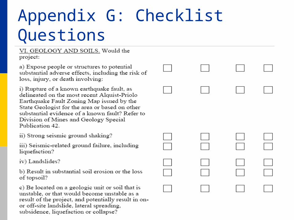
Appendix G: Checklist Questions
Projects that have large cut and fill. Redirecting water.

Appendix G: Checklist Questions

Seismic HazardsPose a substantial danger to property and
human safety. Seismic hazards present in California
include: Ground rupture along faults Strong seismic shaking Liquefaction, Lateral Spreading, Lurching Landsliding Slope failure Hazardous Minerals Tunamis
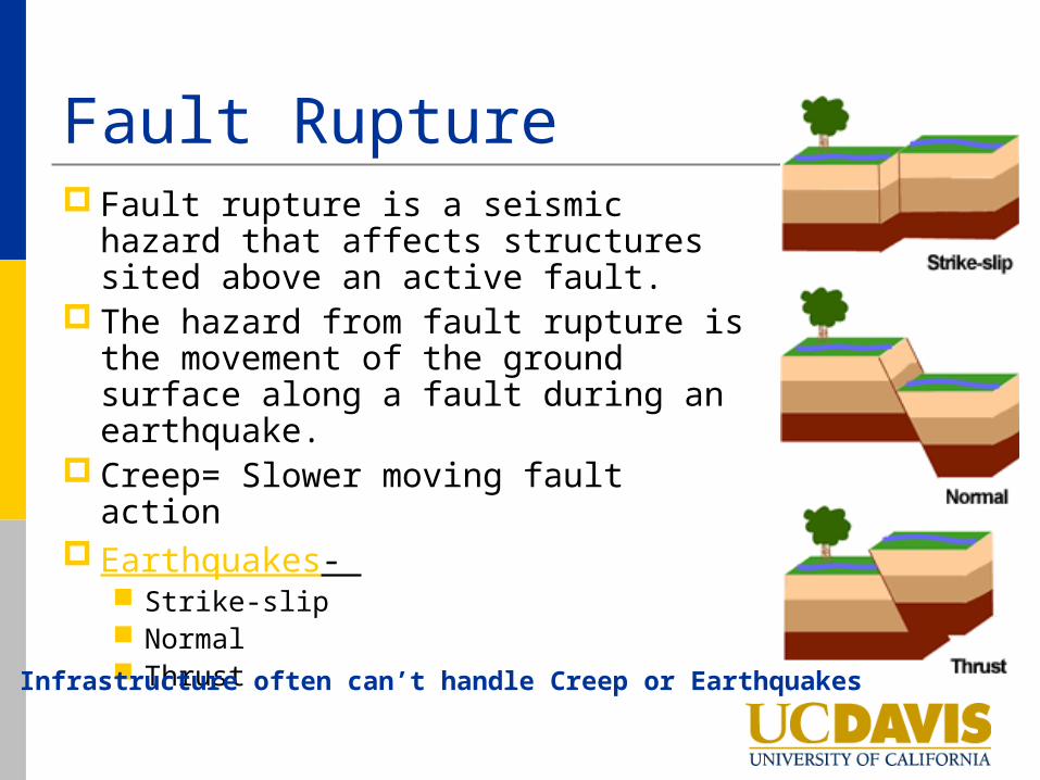
Fault Rupture Fault rupture is a seismic hazard that
affects structures sited above an active fault.
The hazard from fault rupture is the movement of the ground surface along a fault during an earthquake.
Creep= Slower moving fault action Earthquakes-
Strike-slip Normal Thrust
Infrastructure often can’t handle Creep or Earthquakes

Ground ShakingGround shaking depends on several
variables: Earthquake magnitude Epicenter distance Local geology and Soils Thickness Seismic wave-propagation properties of
unconsolidated Materials Groundwater conditions Topographic setting
Sample Modeling

Richter vs. MMI Richter Scale
Measurement comparison between earthquakes Evaluates magnitude used for scientific comparison Only accounts for the actual slip that is generated
Actual damage= Propagation of seismic or ground waves as a result of initial failure
Loose materials tend to amplify ground waves, while hard rock can quickly attenuate them, causing little damage to overlying structures.
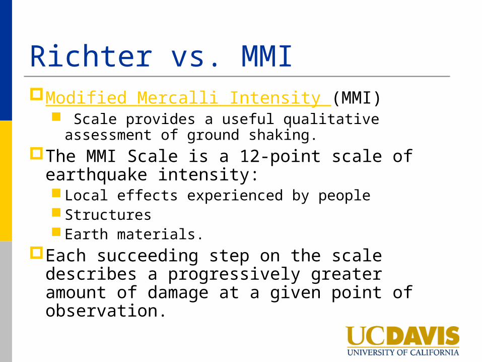
Richter vs. MMIModified Mercalli Intensity (MMI)
Scale provides a useful qualitative assessment of ground shaking.
The MMI Scale is a 12-point scale of earthquake intensity: Local effects experienced by people Structures Earth materials.
Each succeeding step on the scale describes a progressively greater amount of damage at a given point of observation.

Alquist-Priolo Earthquake Fault Zoning Act Passed in 1972Intent: to mitigate the hazard of surface
faulting to structures for human occupancy
Purpose: Direct result of the 1971 San Fernando Earthquake Extensive surface fault ruptures that damaged
numerous homes, commercial buildings, and other structures.

Alquist-Priolo Cont. Requires the State Geologist to establish
regulatory zones (known as Earthquake Fault Zones) around the surface traces of active faults and to issue appropriate maps.
The maps are distributed to all affected cities, counties, and state agencies for their use in planning and controlling new or renewed construction.
If an active fault is found, a structure for human occupancy cannot be placed over the trace of the fault and must be set back from the fault (generally 50 feet).
Project will require site specific geotech mitigation

Seismic Hazards Mapping ActPassed in 1990Intent: Directs the Department of
Conservation, California Geological Survey to identify and map areas prone to liquefaction, earthquake-induced landslides and amplified ground shaking.
Purpose: The SHMA was passed by the legislature following the 1989 Loma Prieta earthquake.

SHMA Cont. Geologists in the Seismic Hazard Zonation
Program gather existing geological, geophysical and geotechnical: Produce the Seismic Hazard Zone Maps.
Designate as Zones of Required Investigation (ZORI) Prone to liquefaction and earthquake–induced landslides.
The SHMA requires site-specific geotechnical investigations within ZORI’s To identify and evaluate seismic hazards and formulate
mitigation measures prior to permitting

Ground FailureGround failure includes:
Liquefaction Liquefaction-induced phenomena:
Lateral spreadingLurching
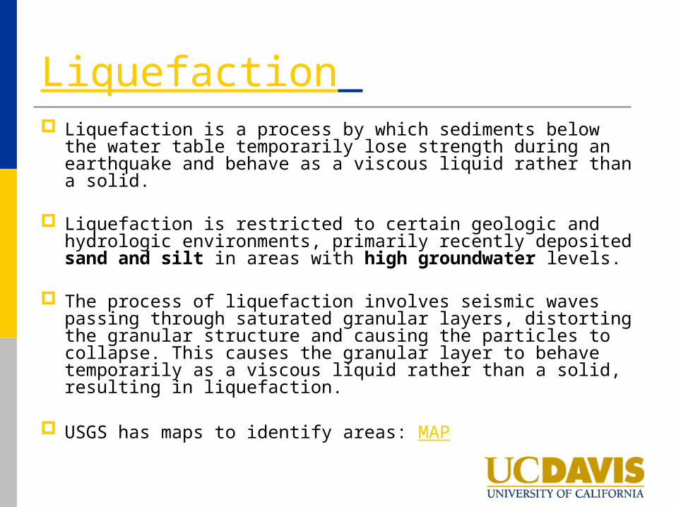
Liquefaction Liquefaction is a process by which sediments below the
water table temporarily lose strength during an earthquake and behave as a viscous liquid rather than a solid.
Liquefaction is restricted to certain geologic and hydrologic environments, primarily recently deposited sand and silt in areas with high groundwater levels.
The process of liquefaction involves seismic waves passing through saturated granular layers, distorting the granular structure and causing the particles to collapse. This causes the granular layer to behave temporarily as a viscous liquid rather than a solid, resulting in liquefaction.
USGS has maps to identify areas: MAP

Lateral Spreading and Lurching Lateral spreading
is lateral ground movement, with some vertical component, as a result of liquefaction.
The soil rides on top of the liquefied layer
Lurching is the movement of the ground
surface toward an open face when the soil liquefies. An open face could be a graded slope, stream bank, canal face, gully, or other similar feature.

Landslide Hazard Mapping Act Produced from 1986 through 1995, as
directed by the now-repealed Landslide Hazard Mapping Act.
Online Resource: MAPs
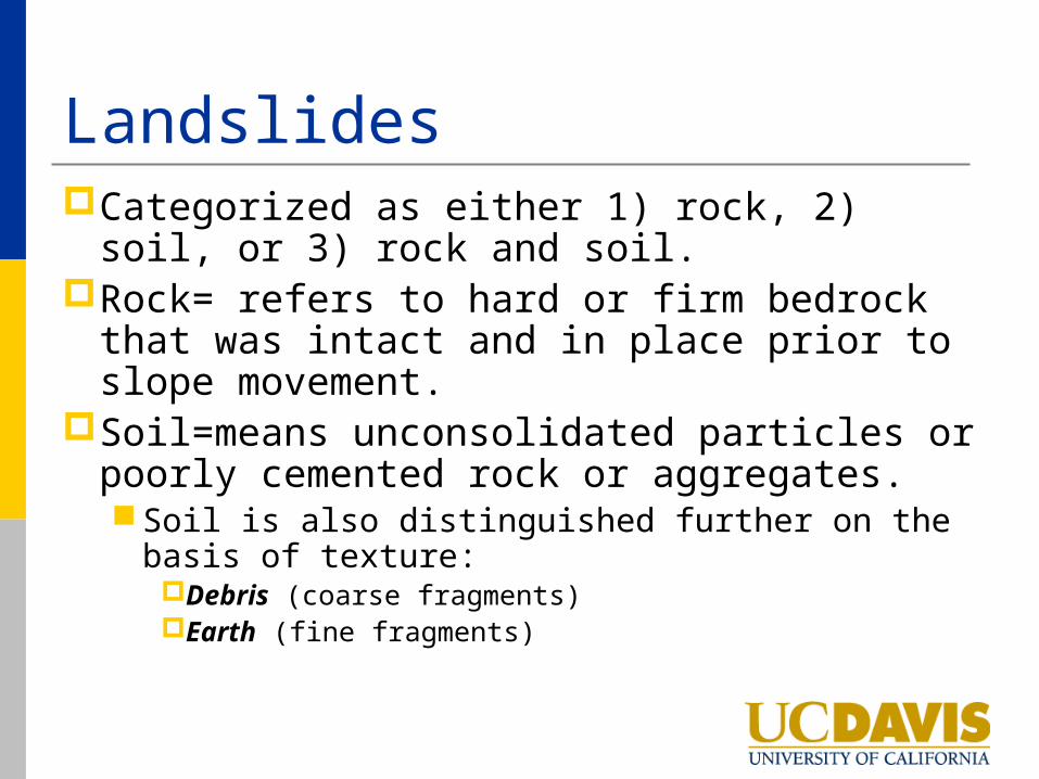
LandslidesCategorized as either 1) rock, 2) soil, or 3)
rock and soil. Rock= refers to hard or firm bedrock that
was intact and in place prior to slope movement.
Soil=means unconsolidated particles or poorly cemented rock or aggregates. Soil is also distinguished further on the basis of
texture:Debris (coarse fragments) Earth (fine fragments)
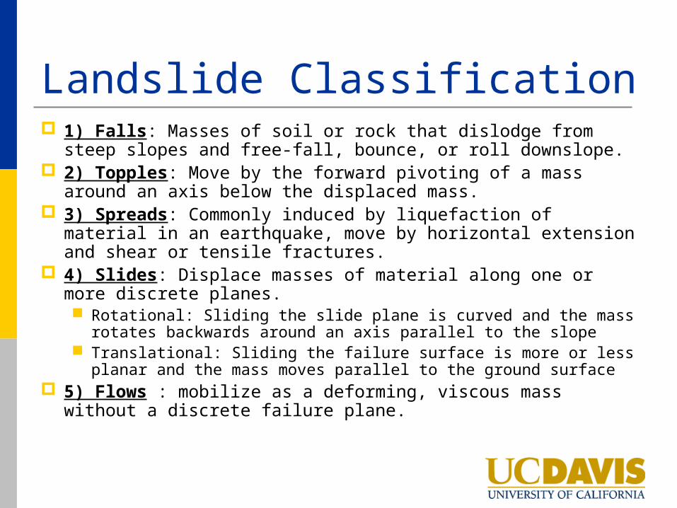
Landslide Classification 1) Falls: Masses of soil or rock that dislodge from steep
slopes and free-fall, bounce, or roll downslope. 2) Topples: Move by the forward pivoting of a mass
around an axis below the displaced mass. 3) Spreads: Commonly induced by liquefaction of material
in an earthquake, move by horizontal extension and shear or tensile fractures.
4) Slides: Displace masses of material along one or more discrete planes. Rotational: Sliding the slide plane is curved and the mass
rotates backwards around an axis parallel to the slope Translational: Sliding the failure surface is more or less planar
and the mass moves parallel to the ground surface 5) Flows : mobilize as a deforming, viscous mass without a
discrete failure plane.

Hazardous Minerals of CA Asbestos-Inhalation of asbestos fibers may
cause cancer. Most commonly, asbestos occurrences are associated
with serpentinite and partially serpentinized ultramafic rocks.
Mercury- Mercury from historic mercury mines or gold mines has entered a number of watersheds in California.
Radon- Gas is a naturally-occurring, radioactive gas that is invisible and odorless. It forms from the radioactive decay of small amounts of uranium and thorium naturally present in rocks and soils.
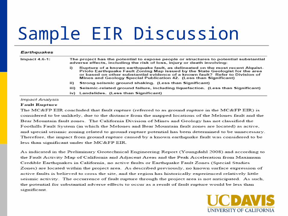
Sample EIR Discussion

Significant Geology and Soil Impacts? What are a few types of projects?
Residential project close to a fault Natural Gas Pipeline close to fault Oceanfront Development Other?

Questions?
Thank You