january 2005 final resume - co courtsjanuary 2005 resume page 1 of 41 attention! please consider...
TRANSCRIPT

January 2005 Resume Page 1 of 41
ATTENTION! Please consider receiving your resume electronically via the Internet or e-mail.
www.courts.state.co.us provides the monthly resume for all seven Water Divisions,
for free!
You can submit your e-mail address to [email protected] to receive yours via e-mail, for free!
The clerks in Water Division No. 1 would appreciate your consideration of this, as the cost and labor involved in the production of the monthly resume far outweighs
the fee we charge.
You can also renew your mail subscription, payable to Clerk of Courts, for $1 per month, or $12 per year. If you have already submitted payment, disregard this.
Water Division No. 1 P.O. Box 2038
Greeley, CO 80632 (970) 351-7300, ext. 4540

January 2005 Resume Page 2 of 41
DISTRICT COURT, WATER DIVISION 1, COLORADO JANUARY 2005 WATER RESUME TO: ALL PERSONS INTERESTED IN WATER APPLICATIONS IN WATER DIV. 1 Pursuant to C.R.S. 37-92-302, you are notified that the following is a resume of all water right applications and certain amendments filed in the Office of the Water Clerk during the month of January, 2005 for each County affected. 05CW001 Miscellaneous Water Court filings. 05CW002 DAVID AND KYM CRAIGIE, 4982 N. Lariat Dr., Castle Rock, CO 80108 (303-814-2127). APPLICATION FOR UNDERGROUND WATER RIGHT, IN DOUGLAS COUNTY. 2. Name of well: Existing Craigie Well, Permit #54148 (originally Gibbons). 3. Legal description: NE 1/4, NE 1/4, Sec. 22, T7S, R67W of 6th PM. Distance from section lines: 940 ft from N and 780 ft from E. Street address: 4982 N. Lariat Dr., Castle Rock, CO 80108. Subdivison: Happy Canyon, Lot 109. 4.A. Source: Lower Dawson aquifer. B. Depth: 600 ft. 5.A. Date of appropriation: 10/15/1980. B. How appropriation was initiated: well permit. C. Date water applied to beneficial use: 10/15/1980. 6. Amount claimed: 12 gpm, ABSOLUTE. Household use-one single family dwelling. Owners: applicants. 05CW003 RAYMOND R. AND CAROL J. MAXFIELD, 629 North County Road 3, Loveland, CO 80537 (970-667-7182). APPLICATION FOR SURFACE WATER RIGHTS, IN LARIMER COUNTY. 2. Name of structure: Sam Zeiler Ditch. 3. Legal Description: NW 1/4 SE 1/4 , Sec. 14, T5N, R68W of 6th PM in Larimer County. Distance from section lines: 1350 ft. from N and 1700 ft. from W. Street Address: 629 North County Road 3. The source of the water is a drain tile commending N of US Hwy 34 and W of Larimer County Road 3. (Generally the SW 1/4 Sec. 11, T5N, R68W.) This drainage accumulates in the Gerrard Seepage Pond (Ref. 02CW305). The Gerrard Seepage Pond discharges through a 15 inch stand pipe and headgate through a ditch, which runs south through a 3 ft by 4 ft culvert under the Great Western Railroad track and ROW. At this point (approximately 1350 ft S of the N Sec line of Sec 14 and 1700 ft W of the E Sec line of said Sec 14) the ditch enters the applicant’s property. The ditch continues through the Applicant’s property plus other properties to the Big Thompson River. The capacity of the Sam Zeiler Ditch and the amount claimed by Applicant is 1.0 cfs, ABSOLUTE. 4.A. Date of initiation of appropriation: July 1980, which is the date the applicant began diverting this water and applying it to beneficial use. B. How appropriation was initiated: This water is pumped out of the Sam Zeiler Ditch by a one HP electric pump with a 1 1/2 inch discharge into an approximately 1500 gal. earthen storage pool and them pumped for irrigation use. C. Date water applied to beneficial use: June 1980. 6. Amount claimed: 1.0 cfs, ABSOLUTE. A. Use or proposed use: This water has been and will continue to be used for the irrigation of lawn, trees, shrubs, garden, pasture, and wildlife preservation of approximately six acres on the Applicant’s property. B. Number of acres historically irrigated: six; proposed to be irrigated: six. Legal description of acreage: Generally the NW 1/4 of the SE 1/4 of Sec 14, T5N, R68W as recorded in the Larimer County Courthouse on June 20, 1980, Deed of Trust Book 2050, page 0418. Reception # 366210. 7. Name and address of owner: applicants. 05CW004 WESTERN WATER COMPANY, 102 Washington Avenue, Point Richmond, CA 91804 (510-234-7400) (Robert V. Trout, Esq. Douglas M. Sinor, Esq., Trout, Witwer & Freeman, P.C., 1120 Lincoln St., Ste. 1600, Denver, CO 80203 (303-861-1963).) APPEAL FROM STATE ENGINEER’S DECISION CONCERNING THE REQUEST FOR SUBSTITUTE WATER SUPPLY PLAN BY COTTONWOOD WATER AND SANITATION DISTRICT AND WESTERN WATER COMPANY.
January 2005 Resume Page 3 of 41
05CW005 (97CW339) (89CW204) SHAMBHALA INTERNATIONAL (VAJRADHATU) formerly known as Vajradhatu, Inc. d/b/a/ Rocky Mountain Dharma Center (“RMDC”) 4921 County Road 68C, Red Feather Lakes, CO 80545 Phone number: (970) 881-2184 x. 369 Fax: (970) 881-2909 Richard A. Swaback, Director of Facilities and Expansion, Shambhala Mountain Center. The applicant is a Colorado nonprofit corporation. On March 2, 2001, the applicant changed its corporate name to “Shambhala International (Vajradhatu)” by filing Amended and Restated Articles of Incorporation with the Colorado Secretary of State. Shambhala International (Vajradhatu) continues to use the registered trade name “Vajradhatu.” In July 2002, the name of Rocky Mountain Dharma Center (a doing business as or “dba” for Vajradhatu, Inc.) was changed to “Shambhala Mountain Center”. Thus, Shambhala International (Vajradhatu) now owns the water rights and property involved in these proceedings. APPLICATION FOR FINDING OF REASONABLE DILIGENCE, IN LARIMER COUNTY. 2. Name of Structure: Lake Sunyata. 3. Description of Conditional Water Rights: A. Date of Original Decree: December 30, 1991 in Case No. 85CW204, District Court, Water Division No. 1, Colorado. B. Location: NE ¼ of Section 23, T9N, R73W of the 6th P.M. in Larimer County. C. Source: Manhattan Ditch, natural drainage of the basin, and the wells described in 85CW204 will be used to fill the reservoir. The sources of this water are Manhattan Creek and Rio RMDC tributary to Elkhorn Creek. D. Appropriation Date: April 17, 1987. Amount: 3.89 acre-feet. E. Conditional Uses: In 97CW399 January 12, 1999 Findings of Fact, Ruling of Referee and Decree, for a Finding of Reasonable Diligence and to Make Conditional Water Rights Absolute. Lake Sunyata: 2.78 acre-feet; decreed absolute for irrigation. In 97CW399 conditionally decreed amounts remain as follows: 1.11 acre-feet for irrigation; 3.89 acre-feet for dust suppression, storage, augmentation and exchange. (In Case No. 85CW204, Lake Sunyata was decreed absolute for domestic, residential, camp, commercial, piscatorial, fire protection and recreational uses). 4. Outline of what has been done toward completion or for completion of the appropriation and application of water to a beneficial use as conditionally decreed. RMDC’s Phase I augmentations plan was separately decreed in Case No. 85CW204. RMDC has been making orderly and systematic progress on its development plans. During this diligence period RMDC requested to amend its existing use permit with Larimer County, and was granted amendments modifying the layout of the RMDC retreat and consolidating buildings within building concentration area. RMDC spent $800,000 on engineering fees and the installation of a water system to support fire protection, and domestic water for the Center, including an aeration system for the control of potable water for Radon, and chlorination building housing automated electronic controls to regulate Wells No. 3, 5, and 7, that are described in decree 85CW204. These wells and associated piping now supply water for the new potable water system. The new water distribution system has three, full-size fire hydrants, and ten new service connections, bringing the total number of service connections to twenty-nine. A pipe to put water into fire-truck tanks has been installed at Lake Sunyata. RMDC is part of the Poudre Canyon Fire Protection District and during this period has provided water to Poudre Canyon Fire Protection District Station #4, and other local Fire Departments for fighting fires—directly hydrants, and from Lake Sunyata. RMDC spent $10,000 on a quick response fire truck. During this period further substantial work has been done towards the completion of RMDC’s development plans. RMDC incurred costs of $850,000 constructing a 280-person capacity building, including office and meeting rooms. RMDC spent $4,829,000 on additional facilities including construction of Shambhala Lodge with a capacity for 50-60 people, construction of The Great Stupa of Dharmakaya; five manufactured residential housing units, including connections to potable water system, and installation of septic tank and infiltrator field. RMDC spent $105,000 on other improvements to properties and facilities, including a Botanic Gardens and Arboreta and a greenhouse and vegetable gardens and other irrigation uses. RMDC spent $68,000 on architectural and similar fees and expenses for future planned projects. During this diligence period RMDC increased guest “bed-nights” from 16,000 annually to 27,000 annually. To help accomplish both Phase I and Phase II development and related water use, RMDC has created a complete master plan of its future development. The plan includes location and sizing of new buildings, new roads, and RMDC Lake No. 2 (conditionally decreed in Case No. 89CW230A). RMDC intends to complete Phase I of its augmentation plan (as decreed in
January 2005 Resume Page 4 of 41
Case No. 85CW204) and initiate Phase II as soon as fundraising and the pace of construction allow. RMDC has not yet needed to use water for dust suppression. However, as major construction of roads and buildings progresses, some water likely will be needed for dust suppression. Therefore, RMDC desires to preserve this conditional right for future use. RMDC has been complying with the requirements of its augmentation plan, but has not yet been required to release water from Lake Sunyata for storage, augmentation and exchange purposes. There is a control gate installed in the bottom of Lake Sunyata for this purpose. RMDC desires to preserve this conditional right for future use. Wherefore applicant requests continuation of conditional water rights as the applicant has done reasonable diligence to claim those water rights. Shambhala International (Vajradhatu) formerly known as Vajradhatu, Inc., d/b/a Rocky Mountain Dharma Center (“RMDC”). By: Richard A. Swaback, Director of Facilities and Expansion, Shambhala Mountain Center, 4921 County Road 68C, Red Feather Lakes, CO 80545. Phone: (970) 881-2184 x. 369. 05CW006 (97CW340) (89CW230A) SHAMBHALA INTERNATIONAL (VAJRADHATU) formerly known as Vajradhatu, Inc. d/b/a/ Rocky Mountain Dharma Center (“RMDC”) 4921 County Road 68C, Red Feather Lakes, CO 80545 Phone number: (970) 881-2184 x. 369 Fax: (970) 881-2909 Richard A. Swaback, Director of Facilities and Expansion, Shambhala Mountain Center. The applicant is a Colorado nonprofit corporation. On March 2, 2001, the applicant changed its corporate name to “Shambhala International (Vajradhatu)” by filing Amended and Restated Articles of Incorporation with the Colorado Secretary of State. Shambhala International (Vajradhatu) continues to use the registered trade name “Vajradhatu.” In July 2002, the name of Rocky Mountain Dharma Center (a doing business as or “dba” for Vajradhatu, Inc.) was changed to “Shambhala Mountain Center”. Thus, Shambhala International (Vajradhatu) now owns the water rights and property involved in these proceedings. APPLICATION FOR FINDING OF REASONABLE DILIGENCE, IN LARIMER COUNTY. 2. Name of Structures: Weaver Lake; Lake Sheahan; Camp Amakulo Reservoir; Lake Sunyata, First Enlargement; RMDC Lake No. 2. 3. Description of Conditional water rights: A. Date of Original Decree: Dec. 30, 1991, Case No. 89CW230A, District Court, Water Division No. 1, Colorado. B. Location: Weaver Lake , RMDC filing, located in the SW ¼, SW ¼ of Sec. 18, T9N, R72W of the 6th P.M. in Larimer County; Lake Sheahan, RMDC filing, located in the NW ¼. NW ¼, of Sec. 23, T9N, R73W of the 6th P.M. in Larimer County; Camp Amakulo Reservoir, RMDC filing, located in the SW ¼ , SW ¼ of Sec. 14, T9N, R73W of the 6th P.M. in Larimer County; Lake Sunyata, First Enlargement, located in the NW ¼, NE ¼ of Sec. 23, T9N, R73W of the 6th P.M. in Larimer County; RMDC Lake No. 2, locted in the NE ¼, NE ¼ of Sec. 23, T9N, R73W of the 6th P.M. in Larimer County. C. Source. Weaver Lake. Coral Rock #3 Ditch will be used to fill the reservoir. The source of this water is Elkhorn Creek. Lake Sheahan, Manhattan Ditch is used to fill this reservoir. The source of this water is Manhattan Creek tributary to Elkhorn Creek. Camp Amakulo Reservoir. Natural drainage of basin is used to fill the reservoir. The source of this water is Manhattan Creek tributary to Elkhorn Creek. Lake Sunyata, First Enlargement. Manhattan Ditch, natural drainage of the basin, and the wells described in 89CW230A, paragraph 9, will be used to fill the enlargement. The sources of this water are Manhattan Creek and Rio RMDC, tributary to the Elkhorn Creek. RMDC Lake No. 2. Manhattan Ditch, natural drainage of the basin, and the wells described in 89CW230A, paragraph 9, will be used to fill the reservoir. The sources of this water are the Manhattan Creek and Rio RMDC, tributary to Elkhorn Creek. D. Appropriation Date: December 1, 1989. E. Amount and Use (all conditional): Weaver Lake, RMDC filing, 5.0 acre-feet conditional storage right for domestic, residential, camp, commercial, irrigation, fire protection, dust suppression, piscatorial, recreation, storage, augmentation, and exchange uses; Lake Sheahan, RMDC filing, 3.8 acre-feet conditional storage right for domestic, residential, camp, commercial, irrigation, fire protection, dust suppression, piscatorial, recreation, storage, augmentation, and exchange uses; Camp Amakulo Reservoir, RMDC filing, 2.0 acre-feet conditional storage right for domestic, residential, camp, commercial, irrigation, fire protection, dust suppression, piscatorial, recreation, storage, augmentation, and exchange uses; Lake Sunyata, First Enlargement, 20 acre-feet for domestic, residential, camp, commercial,

January 2005 Resume Page 5 of 41
irrigation, fire protection, dust suppression, piscatorial, recreation, storage, augmentation, and exchange uses; RMDC Lake No. 2, 20 acre-feet conditional storage right for domestic, residential, camp, commercial, irrigation, fire protection, dust suppression, piscatorial, recreation, storage, augmentation, and exchange uses. 4. Outline of what has been done toward completion or for completion of the appropriation and application of water to a beneficial use as conditionally decreed: RMDC said in its application for Case No. 89CW230 that this augmentation plan was long-term. It was stated in ¶ 11 of the Decree: “This plan is a Phase II plan for applicant’s future needs. Because of the applications of the United States for instream flows on Elkhorn Creek, it is necessary at the present time to attempt to anticipate future water needs for the Camp, although growth to this Phase II size is some years in the future.” In ¶ 19 it was stated: “Because of the anticipated phased development of the Camp, Applicant anticipates that the augmentation, change and exchange sought in this case will be conditional for some years.” RMDC’s Phase I augmentation plan was decreed in Case No. 85CW204. RMDC has been making orderly and systematic progress on its development plans. During this diligence period RMDC requested to amend its existing use permit with Larimer County, and was granted amendments modifying the layout of the RMDC retreat and consolidating buildings within building concentration area. RMDC spent $800,000 on engineering fees and the installation of a water system to support fire protection, and domestic water for the Center, including an aeration system for the control of potable water for Radon, and chlorination building housing automated electronic controls to regulate Wells No. 3, 5, 7, wells that are described in decree 85CW204. These wells and associated piping now supply water for the new potable water system. The new water distribution system has three, full-size fire hydrants and ten new service connections bringing the total number of service connections to twenty-nine. A pipe to put water into fire-truck tanks has been installed at Lake Sunyata. RMDC is part of the Poudre Canyon Fire Protection District and during this period RMDC has provided water to Poudre Canyon Fire Protection District Station #4, and other local Fire Departments for fighting fires—directly from hydrants, and from Lake Sunyata. RMDC spent $10,000 on a quick response fire truck. During this period further substantial work has been done towards the completion of RMDC’s development plans. RMDC incurred costs of $850,000 constructing a 280-person capacity building, including office and meeting rooms. RMDC spent $4,829,000 on additional facilities including construction of Shambhala Lodge with a capacity for 50-60 people; construction of The Great Stupa of Dharmakaya; five manufactured residential housing units, including connections to potable water system, and installation of septic tank and infiltrator field. RMDC spent $105,000 on other improvements to properties and facilities, including Botanic Gardens and Arboreta and a greenhouse and vegetable gardens and other irrigation uses. RMDC spent $68,000 on architectural and similar fees and expenses for future planned projects. During this diligence period RMDC increased guest “bed-nights” from 16,000 annually to 27,000 annually. To help accomplish both Phase I and Phase II development and related water use, RMDC has created a complete master plan of its future development. The plan includes location and sizing of new buildings, new roads, and RMDC Lake No. 2 conditionally decreed in Case No. 89CW230A. RMDC intends to complete Phase I of its augmentation plan and initiate Phase II as soon as fundraising and the pace of construction allow. Wherefore applicant requests continuation of conditional water rights as the applicant has done reasonable diligence to claim those water rights. Shambhala International (Vajradhatu) formerly know as Vajradhatu, Inc., d/b/a Rocky Mountain Shambhala Center (“RMDC”). By: Richard Swaback, Director of Facilities and Expansion, Shambhala Mountain Center 4921 County Road 68C, Red Feather Lakes, CO 80545. Phone: (970) 881-2184 x.369. 05CW007 ROBERT L. DILL, 300 Mountain Avenue, P.O. Box 452, Pierce, CO 80650 (970-834-2392). APPLICATION FOR CHANGE OF WATER RIGHT, IN WELD COUNTY. 2. Decreed name of structure for which change is sought: Nelson Well #12904. 3. Previous decree: Case No. 91CW48; Date entered: 11/27/1991; Water Division 1. Source: groundwater. Appropriation date: 03/20/1951; Amount 0.60 cfs=270 gpm. Historic use: Irrigation of 70 acres in the S 1/2 SW 1/4 of Sec 35, T8N, R65W. Proposed change: Change location from 1297 ft. from the S sec line and 58 ft from the W sec line

January 2005 Resume Page 6 of 41
to 1297 ft from the S sec line and 1000 ft from the W sec line. The use and amount will be the same, together with Wells #12905, #3995-F #12906 and #12907. The wells are augmented by the Poudre Plan: W7921 and W8086. Legal description of change in point of diversion: SW 1/4 SW 1/4 of Sec 35, T8N, R65W of 6th PM in Weld County. Distance from section lines: 1297 ft. from S; and 1000 ft. from W. 05CW008 JEFFERSON COUNTY SCHOOL DISTRICT R-1, 809 Quail Street, Building 4, Lakewood, Colorado 80215 (303) 982-2374 c/o James R. Montgomery and Gabriel D. Carter, Moses, Wittemyer, Harrison and Woodruff, P.C., P.O. Box 1440, Boulder, CO 80306 (303-443-8782). APPLICATION FOR FINDING OF REASONABLE DILIGENCE AND TO MAKE CONDITIONAL WATER RIGHTS ABSOLUTE, IN CLEAR CREEK AND JEFFERSON COUNTIES. 2. Names of structures: Haystack Reservoir No. 1, Haystack Reservoir No. 2 and Jackson Pond. 3. Description of conditional water rights: a. Original decree: Adjudicated January 4, 1999 in Case No. 97CW172, District Court for Water Division No. 1, State of Colorado. b. Subsequent decrees: Not applicable. The decree in Case No. 97CW172 entered January 4, 1999 indicates a diligence application for the conditional water rights for Haystack Reservoir No. 1, Haystack Reservoir No. 2 and Jackson Pond shall be filed on or before January 2005. c. Locations: i. Haystack Reservoir No. 1 is located in the NW3 SW3 of Section 4, Township 5 South, Range 72 West, 6th P.M., Clear Creek County. The right abutment of the dam is located at a point whence the northwest corner of Section 4 bears North 5° 45' West, a distance of 1,925 feet, more or less. ii. Haystack Reservoir No. 2 is located in the SW3 NW3 of Section 4, Township 5 South, Range 72 West, 6th P.M., Clear Creek County. The right abutment of the dam is located at a point whence the northwest corner of Section 4 bears North 4° 38' West, a distance of 1,755 feet, more or less. iii. Jackson Pond is located in the SW3 SW3 of Section 4, Township 5 South, Range 72 West, 6th P.M., Clear Creek County. The right abutment of the dam is located at a point which is approximately 300 feet from the south section line and 700 feet from the west section line of said Section 4. d. Source: Haystack Creek, a tributary of Bear Creek. e. Appropriation dates: i. Haystack Reservoir Nos. 1 and 2: December 31, 1906 and September 12, 1994. ii. Jackson Pond: September 12, 1994. f. Amounts: i. Haystack Reservoir No. 1: 0.1722 acre-feet, ABSOLUTE (see paragraph 3.g.i below). ii. Haystack Reservoir No. 2: 0.087 acre-feet, ABSOLUTE (see paragraph 3.g.i below). iii. Jackson Pond: 4.0 acre-feet, ABSOLUTE (see paragraph 3.g.ii below). g. Uses: i. Haystack Reservoir Nos. 1 and 2: Domestic, piscatorial, recreation, wildlife propagation and fire protection purposes, ABSOLUTE, with date of appropriation December 31, 1906. Augmentation, replacement and exchange purposes, CONDITIONAL, with date of appropriation September 12, 1994. ii. Jackson Pond: Piscatorial, wildlife propagation, recreation and fire protection purposes, ABSOLUTE. Augmentation, replacement and exchange purposes, CONDITIONAL with date of appropriation September 12, 1994. 4. A detailed outline of what has been done toward completion or completion of the appropriation and application of water to beneficial use as conditionally decreed, including expenditures is contained in the application. Storage releases for augmentation, replacement and exchange purposes from Haystack Reservoir Nos. 1 and 2 and Jackson Pond were first made on May 24, 2004. Applicant is the owner of land upon which structures are located, and upon which water is or will be placed to beneficial use. Therefore, applicant requests the Court to enter a decree making absolute all of the water storage rights for Haystack Reservoir No. 1, Haystack Reservoir No. 2 and Jackson Pond in their full decreed amounts for all their decreed uses. 5 pages. 05CW009 (98CW332) CITY OF ARVADA, 8101 Ralston Road, Arvada, CO 80002, (720) 898-7766. (Steven P. Jeffers, Esq., Ed R. Perkins, Esq., Bernard, Lyons, Gaddis & Kahn, P.C., P.O. Box 978, Longmont, CO 80502-0978, Telephone (303) 776-9900). APPLICATION FOR FINDING OF REASONABLE DILIGENCE, IN JEFFERSON COUNTY. 2. Name of structure: Highway 93 Lakes. 3. Describe conditional water right (as to each structure): A) Date of original decree, case no. and court: The original decree was entered in Case No. 89CW224, District Court, Water Division 1, on August 18,

January 2005 Resume Page 7 of 41
1992. A diligence decree was entered in Case No. 98CW332 on January 12, 1999. B) Location: Highway 93 Lakes is a series of lakes that will be created through the excavation of gravel. There will be no dams. Highway 93 Lakes will be located in the N½ and the N½ of the S½ of Section 34, Township 2 South, Range 70 West, of the 6th P.M in Jefferson County, Colorado. A map showing the location of the lakes and the structures to be used to fill the lakes is attached hereto as EXHIBIT A. Name of ditches and other structures used to fill reservoir, and legal description of each point of diversion: Clear Creek: Water will be diverted from Clear Creek through the Croke Canal, Farmers Highline Canal and/or Church Ditch (a/k/a The Golden City and Ralston Creek Ditch), diverted out of the ditches into Ralston Creek to flow down to applicant’s Croke Canal Pump Station on Ralston Creek, pumped from Croke Canal Pump Station up to Arvada Reservoir and pumped from Arvada Reservoir to Highway 93 Lakes. The Clear Creek head gates of the above-described ditches are located as follows: i) Croke Canal: On the north bank of Clear Creek in the NW¼ NE¼ of Section 26, Township 3 South, Range 70 West, of the 6th P.M., Jefferson County, Colorado. ii) Farmers Highline Canal: On the north bank of Clear Creek in the N½ SW¼ of Section 27, Township 3 South, Range 70 West, of the 6th P.M., Jefferson County, Colorado, about 860 feet South, 7°30´ East (magnetic bearing) from the northeast corner of the west ½ of said Section 27. iii) Church Ditch (a/k/a The Golden City and Ralston Creek Ditch): On the north bank of Clear Creek about one mile west of Golden, at a point in the SE¼ NW¼ NE¼ of Section 32, Township 3 South, Range 70 West, of the 6th P.M., Jefferson County, Colorado, South 69º30´ West, 1450 feet from the NE corner of said Section 32. Applicant’s Croke Canal Pump Station is located near the intersection of the Croke Canal and Ralston Creek, in the NW¼ NE¼ of Section 1, Township 3 South, Range 70 West, of the 6th P.M., Jefferson County, Colorado. In 2000, Applicant constructed its Church Ditch Pump Station to deliver water from the Church Ditch into Arvada Reservoir directly. The Church Ditch Pump Station is located near the intersection of the Church Ditch and Ralston Creek in the NE¼ SW¼ of Section 2, Township 3 South, Range 70 West, of the 6th P.M., Jefferson County, Colorado. Arvada Reservoir: The center line of the dam for Arvada Reservoir is described as follows: Commencing at the NE corner of Section 3, Township 3 South, Range 70 West, of the 6th P.M., Jefferson County, Colorado; thence at an angle to the right of 17º34´59" from the East line of said Section 3, a distance of 200.75 feet to the True Point of Beginning. Thence at a deflection angle to the right of 4º52´48", a distance of 1683.374 feet to a point of curvature; thence along a curve to the right, having a radius of 2585.813 feet, and delta of 26º7´37", a distance of 1179.134 feet to point of tangency; thence along the tangent of the before described curve, a distance of 819.242 feet to the point of ending. Leyden Creek: Water will be diverted from Leyden Creek into Highway 93 Lakes via pipeline and pump station to be located at a point along Leyden Creek that is approximately 1400 feet North 15º West from the SE corner of Section 27, Township 2 South, Range 70 West, of the 6th P.M., Jefferson County, Colorado. Coal Creek: Water will be diverted from Coal Creek into Highway 93 Lakes via pipeline and pump station to be located at a point along Coal Creek that is approximately 2900 feet South 15º East from the NW corner of Section 18, Township 2 South, Range 70 West, of the 6th P.M., Jefferson County, Colorado. Ralston Creek: Water will be diverted into Highway 93 Lakes via pipeline and pump station to be located next to Arvada Reservoir. The location of Arvada Reservoir is described above. C) Source: Clear Creek, Leyden Creek, Coal Creek, and Ralston Creek which are tributaries of the South Platte River, and surface runoff from the tributary drainage areas of the lakes. D) Appropriation: i) Date: December 14, 1989. ii) Amount: 6,000 acre-feet cumulative from all sources with the right to fill and refill, CONDITIONAL, with the maximum annual diversion limited to 9,000 acre-feet and a maximum cumulative rate of diversion for filling the lakes of 75 cfs. E) Uses: Municipal (including domestic, irrigation, commercial, industrial, manufacturing and firefighting), aesthetic, recreational (including fishing, fishery, boating and swimming), fish and wildlife propagation, irrigation and augmentation purposes. 4. Provide a detailed outline of what has been done toward completion or for completion of the appropriation and application of water to a beneficial use as conditionally decreed, including expenditures: During the subject diligence period, Applicant conducted the following work at a cost in excess of $1.8 million: A) Designed and constructed Arvada’s Church Ditch Pump Station and Pipeline in 2000 to deliver water to Arvada

January 2005 Resume Page 8 of 41
Reservoir at a cost of approximately $1,500,000. B) Conducted engineering studies, and obtained permits for an enlargement of Arvada Reservoir during 2002, 2003 and 2004 at a cost of approximately $300,000. C) Awarded a contract and began construction of Arvada Reservoir spillway improvements in 2004 to increase storage capacity in the reservoir. D) Adjudicated water court cases including Case No. 2000CW235 for a change of water rights associated with Arvada’s FRICO shares; Case No. 2001CW030 for diligence on the conditional water right for Arvada Reservoir/Tucker Lake Exchange; Case No. 2002CW012 for diligence on the conditional water right for Blunn Lake Reservoir – Seepage Control System; and Case No. 2004CW040 for diligence on Arvada Reservoir. E) Opposed numerous water court cases filed by others to protect from injury Applicant’s water rights, including the subject conditional water right, and incurred legal and engineering expenses in defense of this water right. 5. If a claim to make absolute, water applied to beneficial use: NA. 6) Names and addresses of owners or reputed owners of the land upon which any new diversion or storage structure or modification to any existing diversion or storage structure is or will be constructed or upon which water is or will be stored, including any modification to the existing storage pool: Applicant owns the land upon which the Highway 93 Lakes and the Leyden Creek and Ralston Creek diversion points will be located, and upon which water will be stored. Jefferson County Open Space, whose address is 700 Jefferson County Parkway, Suite 100, Golden, Colorado 80401, owns the land upon which the previously decreed Coal Creek diversion point would be located. No other new structures or modifications are required for this conditional water right. 05CW010 CITY OF THORNTON, Colorado, Infrastructure Department, 12450 Washington Street, Thornton, Colorado 80241, (720-977-6500) (Evan D. Ela, Collins, Cockrel & Cole, P.C., 390 Union Blvd., Suite 400, Denver, Colorado 80220-1556, 303-986-1551). APPLICATION FOR WATER RIGHTS OF THE CITY OF THORNTON, IN ADAMS, CLEAR CREEK, JEFFERSON AND WELD COUNTIES. 2. Introduction. Applicant, the City of Thornton, owns and operates an integrated municipal water and sewer system supplying water and sewer service to customers within its service area as it now exists or may grow in the future, and in accordance with extraterritorial contracts for water service and supply. Thornton has acquired water rights associated with shares in the Burlington Ditch, Reservoir and Land Company (“Burlington Company”) and the Wellington Reservoir Company (“Wellington Company”), some of which have been changed for municipal uses in Case Nos. 87CW107 and 90CW229, District Court, Water Division No. 1, and currently relies upon such rights for a portion of its municipal water supply. By this application, Thornton seeks to change the use of recently acquired shares in both companies to municipal uses and to provide for the diversion, storage and use of all rights owned by Thornton in these companies at structures owned or controlled by Thornton. 3. Change of Ditch Company Shares. By this application Thornton seeks to change 67.045 shares of the Burlington Company (“Burlington Company Water Rights”), represented by Share Certificate No. 3752, and 101.045 shares of the Wellington Company (“Wellington Company Water Rights”), represented by Share Certificate No. 1384, to the extent of its beneficial ownership therein. Thornton seeks changes to the water rights in the following respects: 3.1 A change in use from irrigation to irrigation, commercial, industrial, and all municipal uses as more fully described in paragraph 6.1 below; 3.2 A change in the manner of use of direct flow rights from direct flow to direct flow and storage; and 3.3 Changes in the place of diversion and use to certain alternate points of diversion and points of re-diversion after measurement and stream conveyance as identified in paragraphs 6.3 and 6.5 below. 4. Decreed name and point of diversion of structures for which change is sought. Thornton ownership interests identified in paragraph 3 above, have historically been diverted and used through the following structures: 4.1 Burlington Ditch: 4.1.1 Burlington Ditch South Platte Headgate: located on the east bank of the South Platte River in the SW ¼ of the NE ¼, Section 14, T3S, R68W, 6 P.M., Adams County, at a point approximately 2,200 feet West and 2,300 feet South of the Northeast corner of said Section. 4.1.2 Burlington Ditch First Creek Headgate: located in the NW ¼, Section 14, T2S, R67W, 6 P.M., Adams County. 4.1.3 Burlington Ditch Second Creek Headgate: located in the NW ¼, SW ¼, Section 6, T2S,
January 2005 Resume Page 9 of 41
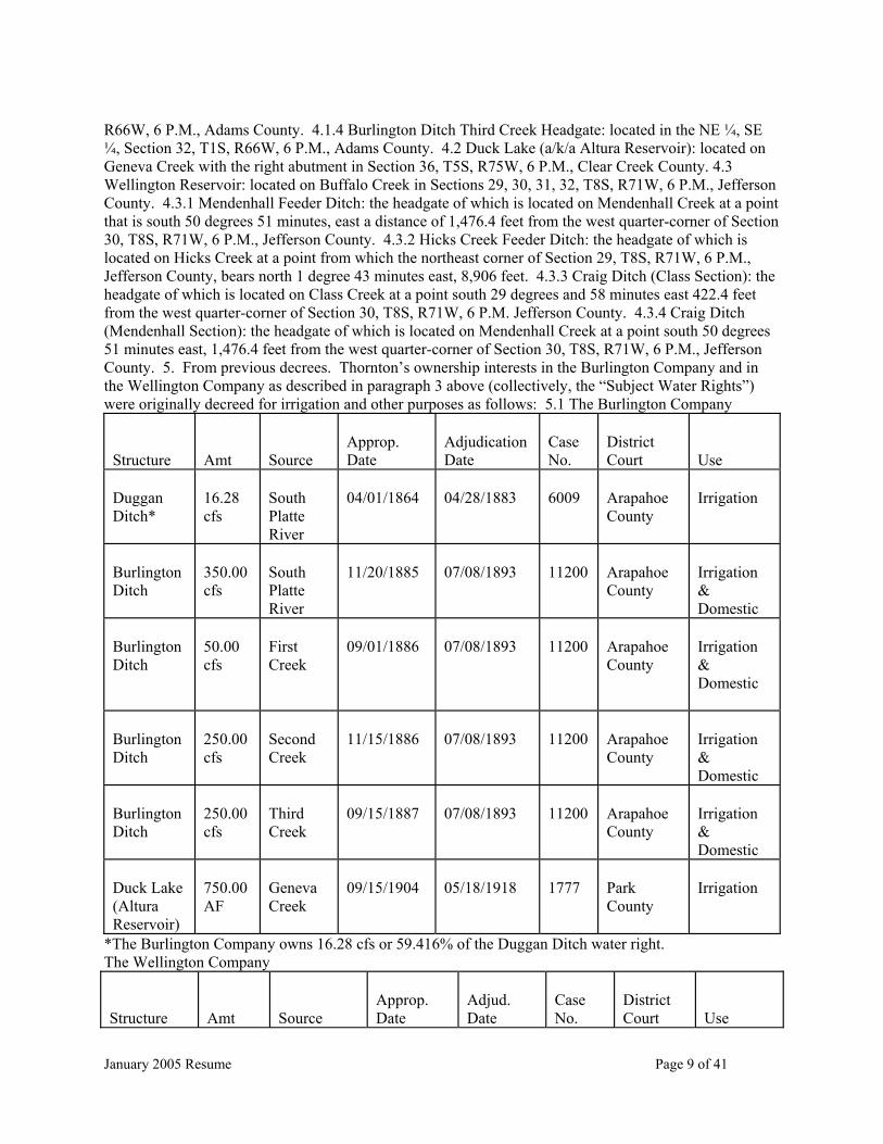
R66W, 6 P.M., Adams County. 4.1.4 Burlington Ditch Third Creek Headgate: located in the NE ¼, SE ¼, Section 32, T1S, R66W, 6 P.M., Adams County. 4.2 Duck Lake (a/k/a Altura Reservoir): located on Geneva Creek with the right abutment in Section 36, T5S, R75W, 6 P.M., Clear Creek County. 4.3 Wellington Reservoir: located on Buffalo Creek in Sections 29, 30, 31, 32, T8S, R71W, 6 P.M., Jefferson County. 4.3.1 Mendenhall Feeder Ditch: the headgate of which is located on Mendenhall Creek at a point that is south 50 degrees 51 minutes, east a distance of 1,476.4 feet from the west quarter-corner of Section 30, T8S, R71W, 6 P.M., Jefferson County. 4.3.2 Hicks Creek Feeder Ditch: the headgate of which is located on Hicks Creek at a point from which the northeast corner of Section 29, T8S, R71W, 6 P.M., Jefferson County, bears north 1 degree 43 minutes east, 8,906 feet. 4.3.3 Craig Ditch (Class Section): the headgate of which is located on Class Creek at a point south 29 degrees and 58 minutes east 422.4 feet from the west quarter-corner of Section 30, T8S, R71W, 6 P.M. Jefferson County. 4.3.4 Craig Ditch (Mendenhall Section): the headgate of which is located on Mendenhall Creek at a point south 50 degrees 51 minutes east, 1,476.4 feet from the west quarter-corner of Section 30, T8S, R71W, 6 P.M., Jefferson County. 5. From previous decrees. Thornton’s ownership interests in the Burlington Company and in the Wellington Company as described in paragraph 3 above (collectively, the “Subject Water Rights”) were originally decreed for irrigation and other purposes as follows: 5.1 The Burlington Company
Structure
Amt
Source
Approp. Date
Adjudication Date
Case No.
District Court
Use
Duggan Ditch*
16.28 cfs
South Platte River
04/01/1864
04/28/1883
6009
Arapahoe County
Irrigation
Burlington Ditch
350.00 cfs
South Platte River
11/20/1885
07/08/1893
11200
Arapahoe County
Irrigation & Domestic
Burlington Ditch
50.00 cfs
First Creek
09/01/1886
07/08/1893
11200
Arapahoe County
Irrigation & Domestic
Burlington Ditch
250.00 cfs
Second Creek
11/15/1886
07/08/1893
11200
Arapahoe County
Irrigation & Domestic
Burlington Ditch
250.00 cfs
Third Creek
09/15/1887
07/08/1893
11200
Arapahoe County
Irrigation & Domestic
Duck Lake (Altura Reservoir)
750.00 AF
Geneva Creek
09/15/1904
05/18/1918
1777
Park County
Irrigation
*The Burlington Company owns 16.28 cfs or 59.416% of the Duggan Ditch water right. The Wellington Company
Structure
Amt
Source
Approp. Date
Adjud. Date
Case No.
District Court
Use
January 2005 Resume Page 10 of 41
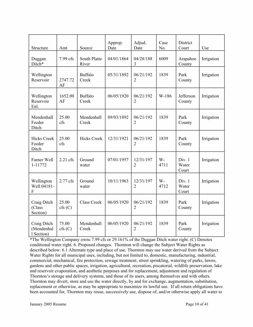
Structure
Amt
Source
Approp. Date
Adjud. Date
Case No.
District Court
Use
Duggan Ditch*
7.99 cfs
South Platte River
04/01/1864
04/28/1883
6009
Arapahoe County
Irrigation
Wellington Reservoir
2747.72 AF
Buffalo Creek
05/31/1892
06/21/1922
1839
Park County
Irrigation
Wellington Reservoir Enl.
1652.00 AF
Buffalo Creek
06/05/1920
06/21/1922
W-186
Jefferson County
Irrigation
Mendenhall Feeder Ditch
25.00 cfs
Mendenhall Creek
09/03/1892
06/21/1922
1839
Park County
Irrigation
Hicks Creek Feeder Ditch
25.00 cfs
Hicks Creek
12/31/1921
06/21/1922
1839
Park County
Irrigation
Farner Well 1-11772
2.21 cfs
Ground water
07/01/1957
12/31/1972
W-4711
Div. 1 Water Court
Irrigation
Wellington Well 04181-F
2.77 cfs
Ground water
10/11/1963
12/31/1972
W-4712
Div. 1 Water Court
Irrigation
Craig Ditch (Class Section)
25.00 cfs (C)
Class Creek
06/05/1920
06/21/1922
1839
Park County
Irrigation
Craig Ditch (Mendenhall Section)
75.00 cfs (C)
Mendenhall Creek
06/05/1920
06/21/1922
1839
Park County
Irrigation
*The Wellington Company owns 7.99 cfs or 29.161% of the Duggan Ditch water right. (C) Denotes conditional water right. 6. Proposed changes. Thornton will change the Subject Water Rights as described below: 6.1 Alternate type and place of use. Thornton may use water derived from the Subject Water Rights for all municipal uses, including, but not limited to, domestic, manufacturing, industrial, commercial, mechanical, fire protection, sewage treatment, street sprinkling, watering of parks, lawns, gardens and other public spaces, irrigation, agricultural, recreation, piscatorial, wildlife preservation, lake and reservoir evaporation, and aesthetic purposes and for replacement, adjustment and regulation of Thornton’s storage and delivery systems, and those of its users, among themselves and with others. Thornton may divert, store and use the water directly, by and for exchange, augmentation, substitution, replacement or otherwise, as may be appropriate to maximize its lawful use. If all return obligations have been accounted for, Thornton may reuse, successively use, dispose of, and/or otherwise apply all water to
January 2005 Resume Page 11 of 41
extinction. The effluent or other returns, such as from lawn irrigation, that is discharged or released by Thornton attributable to the exercise of the Subject Water Rights shall have associated with it the same rights of use, reuse, successive use and disposition, once all return flow obligations have been met. The water may be placed to use within the Thornton service area as it now exists or may exist in the future, and in any other locations in accordance with lease, trade, exchange or other agreements with other water supplying entities. 6.2 Alternate time of use. Subject to the terms of the court’s decree, Thornton may divert, store or use water derived from the Subject Water Rights throughout the calendar year. 6.3 Alternate points of diversion. In addition to their currently decreed points of diversion, each of the indicated direct flow Subject Water Rights described in paragraphs 4 and 5 above, may be diverted at one or more alternate points of diversion as follows: 6.3.1 Thornton South Platte Well Field No. 1: The Thornton South Platte Well Field No. 1 is the subject of a pending adjudication in the District Court, Water Division No. 1 under Case No. 02CW180. The locations of the existing and proposed wells in this well field occur on property that Thornton owns within parts of the tracts described below: 6.3.1.1 T. 2 S., R. 67 W., 6th P.M., Adams County, Colorado: 6.3.1.1.1 in the SW ¼ of Section 17; 6.3.1.1.2 in the E ½ of Section 19; 6.3.1.1.3 in the W ½ of Section 20; 6.3.1.1.4 in the W ½, and the NE ¼ of the SW ¼ of Section 30; and 6.3.1.1.5 in the W ½ of Section 31. 6.3.1.2 T.2 S., R. 68 W. 6th P.M., Adams County, Colorado: 6.3.1.2.1 in the SE ¼ of Section 25; and 6.3.1.2.2 in the E ½ of Section 36. 6.3.2 Lower Clear Creek Ditch: Combined headgate with the Colorado Agricultural Ditch, located on the north bank of Clear Creek in the SW ¼ of the SE ¼, Section 4, T3S, R68W, 6th P.M., Adams County, at a point approximately 1,200 feet North and 1,400 feet West of the Southeast corner of said section. 6.3.3 Cooley West Pit South Platte River Diversion: On the northwest bank of the South Platte River in the SW ¼ of the NW ¼, Section 20, T2S, R67W, 6th P.M., Adams County, at a point approximately 3,780 feet North and 15 feet East of the Southwest corner of said Section 20. 6.3.4 West Sprat-Platte Pit South Platte River Diversion: On the northwest bank of the South Platte River in the SW ¼ of the NW ¼, Section 20, T2S, R67W, 6th P.M., Adams County, at a point approximately 3,780 feet North and 15 feet East of the Southwest corner of said Section 20. 6.3.5 East Sprat-Platte Pit South Platte River Diversion A (Sprat-Platte Ranch East Pit): On the southeast bank of the South Platte River in the SW ¼ of the NW ¼, Section 20, T2S, R67W, 6th P.M., Adams County, at a point approximately 3,703 feet North and 136 feet East of the Southwest corner of said Section 20. 6.3.6 East Sprat-Platte Pit South Platte River Diversion B (North Dahlia Pit and Sprat-Platte Ranch East Pit): On the southeast bank of the South Platte River in the SW ¼ of the SE ¼, Section 19, T2S, R67W, 6th P.M., Adams County, at a point approximately 582 feet North and 2,073 feet West of the Southeast corner of said Section 19. 6.3.7 North Dahlia Pit South Platte River Diversion: On the southeast bank of the South Platte River in the SW ¼ of the SE ¼, Section 19, T2S, R67W, 6th P.M., Adams County, at a point approximately 582 feet North and 2,073 feet West of the Southeast corner of said Section 19. 6.3.8 South Dahlia Pit South Platte River Diversion (a.k.a the Dahlia Pit Diversion Structure): In Case No. 92CW164, District Court, Water Division 1, the Dahlia Pit Diversion Structure was decreed as three (3) alternate diversion points at locations on the South Platte River. Any of them would require pumping to divert water into storage in the South Dahlia Pit. The three locations are described below. 6.3.8.1 Thornton’s Proposed 88th Avenue South Platte Pump Station, Alternative 1: Near the point at which the South Platte river crosses the West section line of Section 30, Township 2 South, Range 67 West, of the 6th P.M., Adams County. 6.3.8.2 Thornton’s Proposed 88th Avenue South Platte Pump Station, Alternative 2: Near the point at which the South Platte River crosses the North section line of Section 30, Township 2 South, Range 67 West, of the 6th P.M., Adams County. 6.3.8.3 Thornton’s Proposed 88th Avenue South Platte Pump Station, Alternative 3: Near the point at which the South Platte River crosses from the SW/4 into the SE/4 of Section 19, Township 2 South, Range 67 West, of the 6th P.M., Adams County. 6.4 Storage and subsequent application of water diverted by exercise of the Subject Water Rights. Following diversion (and accounting for payment of appropriate return flow obligations) at one or more of the points described above in paragraph 6.3, rather than direct application to beneficial use, water diverted by exercise of the direct flow Subject Water Rights may be stored in and subsequently used in or from any storage
January 2005 Resume Page 12 of 41
structures owned, or in which Thornton has real property interests or rights to use, either now or in the future, capable of receiving deliveries from the points of diversion described in paragraph 6.3. Such storage structures include the following: 6.4.1 East Gravel Lakes (a.k.a Tani Lakes): located adjacent to the east bank of the South Platte River, in Sections 25 and 36, Township 2 South, Range 68 West, and Sections 30 and 31, Township 2 South, Range 67 West, of the 6th P.M., Adams County, Colorado. 6.4.2 West Gravel Lakes: located just West of the South Platte River in Sections 25 and 36, Township 2 South, Range 68 West, and Section 30, Township 2 South, Range 67 West, of the 6th P.M., Adams County, Colorado. 6.4.3 Brannan Lakes: located in the SW/4 of Section 35, Township 2 South, Range 68 West, of the 6th P.M., Adams County, Colorado. 6.4.4 South Dahlia Pit: located in the NE/4, the NW/4 of the SE/4, and the E/2 of the NE/4 of the SW/4 of Section 30, Township 2 South, Range 67 West, of the 6th P.M., Adams County, Colorado. 6.4.5 North Dahlia Pit: located in the S/2 of the NE/4, and the SE/4 of Section 19; the W/2 of the SW/4, and the S/2 of the NW/4 of Section 20, said sections in T. 2 S., R. 67 W., 6th P.M., Adams County, Colorado. 6.4.6 East Sprat-Platte Pit: located in the S/2 of the SW/4, and the SW/4 of the SE/4 of Section 17, and NW/4, and NW/4 of the NE/4 of Section 20, said sections in T. 2 S., R. 67 W., 6th P.M., Adams County, Colorado. 6.4.7 West Sprat-Platte Pit: located in the SW/4 of Section 17, and the NW/4 of the NW/4 of Section 20, said sections in T. 2 S., R. 67 W., 6th P.M., Adams County, Colorado. 6.4.8 Cooley East Pit: located in the S/2 of Section 9 and the NW/4 of Section 16, said sections in T. 2 S., R. 67 W., 6th P.M., Adams County, Colorado. 6.4.9 Cooley West Pit: located in the NE/4, the N/2 of the SE/4, the NE/4 of the SW/4, and the SE/4 of the NW/4 of Section 17, T. 2 S., R. 67 W., 6th P.M., Adams County, Colorado. 6.5 Downstream re-diversion after stream conveyance. In addition to the alternate points of diversion and places of storage described above, Thornton seeks to judicially confirm its statutory right under C.R.S. §§ 37-84-113 and 37-87-102, among others, to release water diverted (and for which return flow obligations have been accounted) under the changed Subject Water Rights, to convey by stream and to re-divert such at other locations for subsequent use and storage. Thornton’s release and re-diversion would be consistent with replacement, adjustment and regulation of Thornton’s storage and delivery systems, and those of its users, among themselves and with others, as described in paragraph 6.1 above. Specifically, Thornton intends to (1) divert its proportionate interests in the Burlington Company and the Wellington Company at the originally decreed and alternate points of diversion, (2) pay or suffer its pro rata share of ditch losses and meet return flow obligations as specified by this decree, (3) release the water back to the stream system from the Burlington Ditch or after delivery and storage in Thornton’s gravel pit lakes, (4) use the stream as a conveyance structure for such releases made, (5) suffer such stream losses as are normally determined by the Division Engineer through the stream reach used for conveyance, and (6) re-divert the water for storage or direct use at downstream locations, including but not limited to, the following locations: 6.5.1 Fulton Ditch. Headgate located on the east bank of the South Platte River in the NE ¼ of the SE ¼, Section 17, T2S, R67W, 6th P.M., Adams County, at a point approximately 2,815 feet South and 145 West of the Northeast corner of said Section 17. 6.5.2 Brantner Ditch. Headgate located on the north bank of the South Platte River in the NE ¼ of the SW ¼, Section 4, T2S, R67W, 6th P.M., Adams County, at a point approximately 2,721 feet South and 2,140 feet East of the Northwest corner of said Section 4. 6.5.3 United Diversion Facility No. 3: located on the East bank of the South Platte River in the SW/4 of section 26, Township 1 South, Range 67 West of the 6th P.M., Adams County, Colorado, at a point approximately 1,636 feet east of the West line and 1,531 feet north of the South line of said Section 26. 6.5.4 Hammer Pit South Platte River Diversion A: On the west bank of the South Platte River in the NE ¼ of the NW ¼ of Section 23, T1S, R67W, 6th P.M., Adams County, at a point approximately 1,100 feet south and 2,500 feet east of the Northwest corner of said Section 23. 6.5.5 Hammer Pit South Platte River Diversion B: On the west bank of the South Platte River in the SE ¼ of the NE ¼ of Section 14, T1S, R67W, 6th P.M., Adams County, at a point approximately 2,400 feet south and 580 feet west of the Northeast corner of said Section 14. 6.5.6 Brighton Ditch. Headgate located on the west bank of the South Platte River in the SE ¼ of the SE ¼, Section 11, T1S, R67W, 6th P.M., Adams County, at a point approximately 780 feet North and 1,120 feet West of the Southeast corner of said Section 11. 6.5.7 Rogers Pit South Platte River Diversion A: On the

January 2005 Resume Page 13 of 41
west bank of the South Platte River in the NE ¼ of the NE ¼, Section 1, T1S, R67W, 6th P.M., Adams County, at a point approximately 1,000 feet south and 50 feet west of the Northeast corner of said Section 1. 6.5.8 Rogers Pit South Platte River Diversion B: On the northwest bank of the South Platte River in the NW ¼ of the SW ¼, Section 6, T1S, R66W, 6th P.M., Adams County, at a point approximately 2,480 feet South and 300 feet East of the Northwest corner of said Section 6. 6.5.9 Lupton Bottom Ditch. Headgate located on the northwest bank of the South Platte River in the NW ¼ of the SW ¼, Section 19, T1N, R66W, 6th P.M., Weld County, at a point approximately 2,110 feet North and 56 feet East of the Southwest corner of said Section 19. 6.5.10 Villano Gravel Lakes South Platte River Diversion A: located in the W/2 of the NE/4 of Section 18, T1N, R66W, 6 P.M., Weld County. 6.5.11 Villano Gravel Lakes South Platte River Diversion B: located in the NE ¼ of the SW ¼ of Section 19, T1N, R66W, 6 P.M., Weld County. 6.5.12 Fort Lupton Pit South Platte River Diversion: Located on the west bank of the South Platte River in the SE¼ of the NW ¼, Section 18, T1N, R66W, 6th P.M., Weld County, at a point approximately 1,547 feet South and 3,769 feet West of the Northeast corner of said Section 18. 6.5.13 Farmers Independent Ditch: On the east bank of the South Platte River in the SW ¼ of Section 19, T3N, R66W, Weld County. 6.5.14 Western Mutual Ditch. Headgate located in the SE ¼ of the SE ¼ of the SW ¼ of Section 11, T3N, R67W, 6th P.M., Weld County. 6.5.15 Patterson Ditch. Headgate located on the north bank of the South Platte River in the NE ¼ of the NE ¼, Section 21, T5N, R65W, 6th P.M., Weld County, at a point approximately 641 feet South and 5,133 feet East of the Northwest corner of said Section 21. 6.6 Storage and subsequent application of water re-diverted after stream conveyance. Following re-diversion (after conveyance by the stream) at one or more of the points described above in paragraph 6.5, water re-diverted may be stored in and subsequently used in or from any storage structures owned, or in which Thornton has real property interests or rights to use, either now or in the future, capable of receiving deliveries from the points of diversion described in paragraph 6.5. Such storage structures include the United Gravel Pit (f.k.a. Brannon Pit), Rogers Pit, Hammer Pit, Doeringsfeld Pit, Fort Lupton Pit, and Villano Gravel Lakes. 7. Diversion Records. Pursuant to C.R.S. § 37-92-302(2)(a) summaries of records of diversions of the Burlington Company Water Rights and the Wellington Company Water Rights during the relevant study period are set forth in Exhibit 1 attached to this Application. 8. Map. Pursuant to C.R.S. § 37-92-302(2)(a), a map showing the approximate location of historical use of the Subject Water Rights is set forth in Exhibit 2 to this Application. 9. Names and addresses of owners of land on which structures are located: Structures named herein pertaining to the Subject Water Rights to be changed as well as those structures described as alternate points of diversion in paragraph 6.3, as places of storage after diversion in paragraph 6.4, as points at which water may be re-diverted following stream conveyance listed in paragraph 6.5, and as locations of storage after re-diversion in paragraph 6.6, are located on lands owned by the entities or persons listed below. It is neither feasible nor practical to list all owners of land within Thornton’s water service area upon which the water provided through Thornton’s municipal system will be used. 9.1 To the best of Thornton’s knowledge and belief, Brannan Lakes, West Gravel Lakes, East Gravel Lakes, North Dahlia Pit, South DahliaPit, East Sprat-Platte Pit, East Sprat-Platte Pit South Platte River Diversion A, East Sprat-Platte Pit South Platte River Diversion B, West Sprat-Platte Pit, West Sprat-Platte Pit South Platte River Diversion, Thornton South Platte Well Field No. 1, and Fort Lupton Pit are owned by the City of Thornton, 9500 Civic Center Drive, Thornton, Colorado 80229. 9.2 To the best of Thornton’s knowledge and belief, the location of the Fort Lupton Pit South Platte River Diversion is owned by Ken and Linda Jean Ogilvie, 4620 U.S. Highway 85, Fort Lupton, Colorado 80621. 9.3 To the best of Thornton’s knowledge and belief, the location of the North Dahlia Pit South Platte River Diversion is owned by Adams County, 450 S. 4th Ave., Brighton, Colorado 80601. 9.4 To the best of Thornton’s knowledge and belief, the Cooley West Pit, Cooley West Pit South Platte River Diversion, Cooley East Pit, Rogers Pit, Rogers Pit South Platte River Diversion A, Rogers Pit South Platte River Diversion B, Hammer Pit, Hammer Pit South Platte River Diversion A and Hammer Pit South Platte River Diversion B are owned by Aggregate Industries - West Central Region, Inc., 3605 South Teller Street, Lakewood, Colorado 80235. 9.5 To the best of Thornton’s knowledge and belief, the Doeringsfeld Pit and the Doeringsfeld Pit, First Enlargement are owned by:

January 2005 Resume Page 14 of 41
Doeringsfeld and Aratas, a partnership, 8120 Gage Street, Frederick, Colorado 80516; Walter W. Doeringsfeld Jr. et al., 8120 Gage Street, Frederick, Colorado 80516; and Varra Companies, Inc., P.O. Box 2049, Broomfield, Colorado 80038. 9.6 To the best of Thornton’s knowledge, information and belief, the site of the Villano Gravel Lakes is owned by: James L. and Gerald A. Adams c/o the Revocable Trust of Shirley Gray, P.O. Box 164, Goodland, Kansas 67735; Ida A Sasaki (½ interest) and Sasaki Family Holdings (½ interest), 1812 Weld County Road 27, Brighton, Colorado 80601; Villano Brothers Properties, Inc., 13050 Weld County Road 10, Fort Lupton, Colorado 80621; Watada Farms, Inc., 1426 41st Ave. Ct., Greeley, Colorado 80634; and Frank, May, and Thomas T. Yokooji, 12673 County Road 6, Brighton, Colorado 80603. 9.7 To the best of Thornton’s knowledge, information and belief, the Villano Gravel Lakes South Platte River Diversion A is owned by Donald L. and Suzanne Rittenhouse, 205 N. Patit Road, Dayton, Washington 99328. 9.8 To the best of Thornton’s knowledge, information and belief, the Villano Gravel Lakes South Platte Diversion B is owned by Ken and Linda Jean Ogilvie, 4620 U.S. Highway 85, Fort Lupton, Colorado 80621. 9.9 To the best of Thornton’s knowledge, information and belief, the United Gravel Pit (f/k/a Brannon Pit) is owned by Bromley District Water Providers, LLC, 5460 S. Quebec St., #110, Greenwood Village, Colorado 80111. 9.10 To the best of Thornton’s knowledge, information and belief, the Burlington Ditch South Platte Headgate, release structure from Burlington Ditch to Sand Creek, Combined Ditch, and O’Brian Division Structure are owned by the Farmers Reservoir and Irrigation Company, 80 South 27th Avenue, Brighton, Colorado 80601. 9.11 To the best of Thornton’s knowledge, information and belief, the Little Burlington Ditch structures, Burlington Ditch First Creek Headgate, Burlington Ditch Second Creek Headgate, Burlington Ditch Third Creek Headgate, and Duck Lake (a.k.a. Altura Reservoir) are owned by the Burlington Ditch, Land and Reservoir Company, c/o Harlan Wall, President, 80 South 27th Avenue, Brighton, Colorado 80601. 9.12 To the best of Thornton’s knowledge, information and belief, Wellington Reservoir, Mendenhall Feeder Ditch, Hicks Creek Feeder Ditch, Craig Ditch (Class Section) and Craig Ditch (Mendenhall Section) are owned by the Wellington Reservoir Company, c/o Barry Marrs, Secretary, P.O. Box 766, Brighton, Colorado 80601. 9.13 To the best of Thornton’s knowledge, information and belief, the Fulton Ditch is owned by the Fulton Irrigating Ditch Company, 13698 East 136th Avenue, Brighton, Colorado 80601. 9.14 To the best of Thornton’s knowledge, information and belief, the Brantner Ditch is owned by the Brantner Ditch Company, Alvin Dechant, President, 4936 Weld County Road 23, Ft. Lupton, Colorado 80621. 9.15 To the best of Thornton’s knowledge, information and belief, the Brighton Ditch is owned by the Brighton Ditch Company, c/o Don Rosenbrock, 3286 Weld County Road 23, Ft. Lupton, Colorado 80621. 9.16 To the best of Thornton’s knowledge, information and belief, the Clear Creek and Platte River Ditch (a.k.a. Lower Clear Creek Ditch) is owned by the Lower Clear Creek Ditch Company, 12450 Washington Street, Thornton, Colorado 80241. 9.17 To the best of Thornton’s knowledge, information and belief, the Patterson Ditch is owned by Delta Irrigation Co., 24576 Weld County Road 64, Greeley, Colorado 80631. 9.18 To the best of Thornton’s knowledge, information and belief, the Lupton Bottom Ditch is owned by the Lupton Bottom Ditch Company, Gene Wagner, President, 9990 Highway 23, Ft. Lupton, Colorado 80621. 9.19 To the best of Thornton’s knowledge, information and belief, the Western Mutual Ditch (f.k.a. Hewes and Cook Ditch) is owned by the Western Mutual Ditch Company, c/o Frank Eckhardt, President, 21454 Weld Count Road 33, LaSalle, Colorado 80645. 9.20 To the best of Thornton’s knowledge, information and belief, United Diversion Facility No. 3 is owned by Camas Colorado, Inc., 1707 Cole Blvd. Suite 100, Golden, CO 80401. 9.21 To the best of Thornton’s knowledge, information and belief, the Farmers Independent Ditch is owned by the Farmers Independent Ditch Company, Frank Eckhardt, President, 21454 Weld County Road 33, LaSalle, Colorado 80645. 10. Remarks: 10.1 Thornton seeks approval of changes to the Subject Water Rights as described in paragraph 6 herein. Thornton proposes such changes based on the terms and conditions utilized in its prior transfer decrees for shares in the same mutual ditch companies, namely: (1) Findings of Fact, Conclusions of Law and Decree in Case No. 87CW107, entered by this Court on February 9, 1990; and (2) Findings of Fact, Conclusions of Law and Decree in Case No. 90CW229, entered by this Court on July 13, 1990. 10.2 To further efficient operation and state administration of its water rights and

January 2005 Resume Page 15 of 41
municipal water system, Thornton intends to divert and store any water available to its entire proportionate ownership interest in the Burlington and Wellington companies, including the interests changed for municipal purposes in the prior cases, at the structures described herein. To the extent that the structures described herein differ from those decreed in Case Nos. 87CW107 and 90CW229, this application shall serve to establish the points of diversion and places of storage decreed herein as alternative points of diversion and places of storage for Thornton’s entire ownership interest in the Burlington and Wellington companies. 10.3 To meet its return flow obligation as a result of the changes sought in this Application, Thornton intends to use any lawful source of water whether now owned or controlled or hereafter acquired, including but not limited to, the consumptive use attributable to changed irrigation rights in the South Platte watershed, water rights to transmountain or transbasin sources, water rights to nontributary sources, water sources available to Thornton by contract, and including reusable wastewater effluent and lawn irrigation return flows generated by the use of all of the above-mentioned sources, and water rights that have been originally decreed for augmentation purposes whether owned by Thornton or others. (16 pages, 2 Exhibits) 05CW011 CHRISTOPHER M. GREENE, 25897 Snyder Avenue, Conifer, CO 80433 (303-816-2778). APPLICATION FOR UNDERGROUND WATER RIGHT, IN JEFFERSON COUNTY. 2. Name of well: GW-1, Well Permit #109590. 3. Legal description of well: SW 1/4 SW 1/4, Sec 12, T6S, R71W of 6th PM in Jefferson County. Distance from section lines: 200 ft from S, and 300 ft from W. Street address: 25897 Snyder Ave., Conifer, CO 80433. Subdivision: Aspen Park. Lot 1, 12, 13, 14; Block 38, Unit #3. 4.A. Source: Groundwater. B. Depth: 124 ft. 5.A. Date of appropriation: July 9, 1979. B. How appropriation was initiated: Applied for permit. C. Date water applied to beneficial use: February 13, 1981. 6. Amount claimed: 11 gpm, ABSOLUTE. 8. Proposed use: Non-irrigation: Household use only for single family dwelling. 9. Name of owner: Applicant. 05CW012 APPLICATION FOR FINDING OF REASONABLE DILIGENCE OF CLEAR CREEK SKIING CORPORATION, CLEAR CREEK COUNTY. Applicant CLEAR CREEK SKIING CORPORATION (“Applicant” or “Loveland”), through its attorneys Holland & Hart LLP, requests a finding of reasonable diligence pursuant to Colo. Rev. Stat. § 37-92-301(4)(1997). As grounds for this request, Applicant states as follows: 1. Name, address and telephone number of applicant: Clear Creek Skiing Corporation, Attn: Kenneth A. Abrahamson, General Manager, P.O. Box 899, Georgetown, CO 80444, (303) 571-5580. Please direct all correspondence to Anne J. Castle, Leah A. Kukowski, Holland & Hart, LLP, 555 Seventeenth Street, Suite 3200, P.O. Box 8749, Denver, CO 80201-8749, (303) 2985-8000. 2. Name of structure: Lower Loveland Snowmaking and Domestic Diversion. 3. Description of conditional water right: A. Date of Original Decree: February 1, 1990, Case No. 88CW247 (Water Div. 1). In Case No. 93CW138 (Water Div. 1), this Court granted Applicant an absolute water right for 11.0 c.f.s. of the 32.0 c.f.s conditional water right for storage of 60 acre-feet by exchange, pursuant to Exchange No. 1 as described in the decree dated January 3, 1997 in Case Nos. 93CW137 (Water Div. 1) and 88CW246 (Water Div. 1). This stored water was subsequently released for augmentation of snowmaking and domestic diversions at Loveland Basin and Loveland Valley ski areas. By decree dated January 19, 1999, in Case No. 96CW32 (Water Div. 1), this Court granted a finding of reasonable diligence as to all remaining conditional portions of the Lower Loveland Snowmaking and Domestic Diversion water right. B. Location: In the northwest quarter, southeast quarter of unsurveyed Section 22, Township 4 South, Range 76 West of the 6th P.M., Clear Creek County, Colorado, at a point located approximately 3,300 feet N48º30’ E of Benchmark 10779 and approximately 400 feet S47º30’ E of Benchmark 10633. Both benchmarks are identified on the USGS 7.5 Minute Loveland Pass topography map, 1958 edition, photo-revised in 1974. C. Source: Clear Creek, tributary to the South Platte River. D. Appropriation Date: December 30, 1988. E. Amount: 32.0 c.f.s (11.0 c.f.s. absolute and 21.0 c.f.s. conditional). F. Use: Domestic, municipal, commercial, recreation, and snowmaking, for storage of water by exchange, for augmentation, and for replacement of depletions. 4. Detailed Outline of What

January 2005 Resume Page 16 of 41
Has Been Done Toward Completion of the Appropriation and Application of Water to Beneficial Use. Applicant is the owner and operator of the Loveland Valley and Loveland Basin ski areas located in the upper Clear Creek Basin in Clear Creek County, Colorado. The Lower Loveland Snowmaking and Domestic Diversion is decreed for, among other purposes, “storage of water by exchange,” pursuant to the decree dated February 1, 1990 in Case No. 88CW247. Applicant was also granted a change in use for the Lower Loveland Snowmaking and Domestic Diversion Water Right to include reuse and successive use of the water in addition to the previously decreed uses in Case No. 93CW135 (Water Div.1). Water available for appropriation in priority under the Lower Loveland Snowmaking and Domestic Diversion water right has been diverted into storage in Clear Lake Reservoir by exchange, as allowed under the decree in Case No. 88CW247 and pursuant to an appropriative right of exchange decreed by this Court on January 3, 1997 in Case Nos. 93CW137 and 88CW246, identified in that decree as Exchange No. 1. The appropriative right of exchange allows the storage of water in Clear Lake Reservoir in exchange for the bypassing of the water available for diversion in priority from the Lower Loveland Snowmaking and Domestic Diversion water right. The right of exchange has an appropriation date of December 30, 1988 as to the first 60 acre feet stored by exchange and June 2, 1993 as to amounts in excess of 60 acre feet. The water diverted under the Lower Loveland Snowmaking and Domestic Diversion water right by exchange into Clear Lake Reservoir is released for augmentation of domestic and snowmaking diversions at the Loveland ski areas. Clear Lake Reservoir is formed by a dam across south Clear Creek and is located in the SW1/4 of section 29 and the NW1/4 of section 32, Township 4 South, Range 74 West of the 6th P.M. in Clear Creek County, Colorado. The capacity of the reservoir is 610 acre-feet. In Case No. 93CW138, this Court granted Applicant an absolute water right for 11.0 c.f.s. of the 32.0 c.f.s conditional water right for storage purposes of 60 acre-feet by exchange, pursuant to Exchange No. 1, and subsequently released for augmentation of snowmaking and domestic diversions at Loveland Basin and Loveland Valley ski areas. Until 2004, Applicant was a party to a lease agreement with the Green and Clear Lakes Company and Public Service Company of Colorado, the owners of Clear Lake Reservoir. This lease agreement originally allowed for the storage of up to 60 acre-feet of water by Loveland in the Reservoir and was subsequently amended to allow storage of up to 90 acre-feet. The amendment of the lease agreement to allow the storage of water in excess of 60 acre feet is evidence that Applicant is diligently working to complete the appropriation, and to make the Lower Loveland Snowmaking and Domestic Diversion water right absolute in a greater amount than is currently absolute. On October 30, 2003, Applicant filed an application with this Court to amend the decree in Case Nos. 93CW137 and 88CW246 confirming the appropriative right of exchange described as Exchange No. 1. That application is currently pending in Case No. 03CW361 (Water Div. 1). The application requests the addition of Golden Reservoirs Nos. 1, 2, and 3, a/k/a Guanella Reservoir, as described in the decree dated November 28, 1985 in Case No. 82CW469 and by decree dated August 18, 2004 in Case No. 02CW379, to the allowable locations of storage by exchange. Golden Reservoirs Nos. 1, 2, and 3 are located as follows: Golden Reservoir No. 1: In the NW1/4 SW1/4, Section 29 and the NE1/4 SE1/4, Section 30, Township 3 South, Range 74 West of the 6th P.M., Clear Creek County, Colorado. The right (south) abutment of the dam is located at a point whence the SE corner of Section 29, Township 3 South, Range 74 West of the 6th P.M. bears South 66° 25’ East a distance of 4,842 feet. The decreed capacity is: 450 acre feet active; 150 acre feet dead storage. Golden Reservoir No. 2: In the N1/2 SW1/4 and the NW1/4 SE1/4, Section 29, Township 3 South, Range 74 West of the 6th P.M., Clear Creek County, Colorado. The right (south) abutment of the dam is located at a point whence the SE corner of Section 29, Township 3 South, Range 74 West of the 6th P.M. bears South 56° 48’ East a distance of 2,792 feet. The decreed capacity is: 850 acre feet active; 150 acre feet dead storage. Golden Reservoir No. 3: In the N1/2 SE1/4, Section 29, Township 3 South, Range 74 West of the 6th P.M., Clear Creek County, Colorado. The right (south) abutment of the dam is located at a point whence the SE corner of Section 29, Township 3 South, Range 74 West of the 6th P.M. bears South 21° 44’ East a distance of 2,031 feet. The decreed capacity is: 875 acre feet active; 125 acre feet dead storage. Applicant and City of Golden entered into a lease agreement on March 15, 2004 for Applicant’s use of 90 acre-feet of storage capacity in Golden Reservoirs Nos. 1, 2,
January 2005 Resume Page 17 of 41
and 3. This lease agreement is for an initial term of fifteen (15) years, expiring on December 31, 2019, with an option for renewal for an additional ten (10) years by mutual agreement of the parties. This lease agreement evidences Applicant’s continued work toward the exercise of the exchange of the Lower Loveland Snowmaking and Domestic Diversion water right for storage of up to 90 acre-feet for augmentation of domestic and snowmaking diversions at the Loveland ski areas. Applicant’s agent’s and attorneys have monitored the monthly resumes of applications filed in Water Division No. 1 and have submitted statements of opposition where deemed necessary or advisable for the full protection of this water right. These steps constitute reasonable diligence toward the completion of the appropriation of the conditional water right for later release for augmentation of snowmaking and domestic diversions. Applicant seeks a finding that it has been reasonably diligent in completing the appropriation of the Lower Loveland Snowmaking and Domestic Diversion water right to the extent of 11.0 c.f.s. of such right. Applicant does not seek and is willing to abandon the remaining 21.0 c.f.s. of the Lower Loveland Snowmaking and Domestic Diversion water right. WHEREFORE, Applicant respectfully requests that this Court find that reasonable diligence has been exercised toward the completion of the Lower Loveland Snowmaking and Domestic Diversion conditional water right for the storage and later release for augmentation of snowmaking and domestic diversions in the amount of 11.0 c.f.s. of such right and continue that portion of the conditional water right in full force and effect. Applicant further requests that the remaining 21.0 c.f.s. of the Lower Loveland Snowmaking and Domestic Diversion water right be considered abandoned. 5 pages. 05CW013 TROY AND TRACY STEPHENSON, 5027 Garton Road Castle Rock, Colorado 80104, (303) 356-6697, CLIFFORD AND KIMBERLY CHANDLER, 5025 Garton Road, Castle Rock, Colorado 80104. Scott M. Huyler, Esq., Petrock & Fendel, P.C., 700 17th St., Ste. 1800, Denver, CO 80202 (303-534-0702). APPLICATION FOR UNDERGROUND WATER RIGHTS FROM NONTRIBUTARY AND NOT NONTRIBUTARY SOURCES AND FOR APPROVAL OF PLAN FOR AUGMENTATION, IN THE NONTRIBUTARY LOWER DAWSON, DENVER, ARAPAHOE, AND LARAMIE-FOX HILLS AND THE NOT NONTRIBUTARY UPPER DAWSON AQUIFERS, IN DOUGLAS COUNTY. 2. Well Permits: Well permits will be applied for prior to construction of the wells. 3. Legal Description of Wells and Subject Property: The wells which will withdraw groundwater from the not nontributary Upper Dawson and nontributary Lower Dawson, Denver, Arapahoe, and Laramie-Fox Hills aquifers will be located at any location on approximately 80 acres of land located in the N1/2NE1/4 and part of the E1/2N1/2N W1/4 of Section 8, T9S, R66W of the 6th P.M., as described and shown on Attachment A hereto ("Subject Property"). Applicants Troy and Tracy Stephenson are owners of 73 acres and Applicants Clifford and Kimberly Chandler are owners of 7 acres of the Subject Property. 4. Source of Water Rights: The source of the groundwater to be withdrawn from the Upper Dawson aquifer is not nontributary as described in 37-90-103(10.7) and 37-90-137(9)(c), C.R.S. The groundwater to be withdrawn from the Lower Dawson, Denver, Arapahoe, and Laramie-Fox Hills aquifers is nontributary groundwater as described in 37-90-103(10.5), C.R.S. 5. Estimated Amounts and Rates of Withdrawal: The wells will withdraw the subject amounts of groundwater at rates of flow necessary to efficiently withdraw the entire decreed amounts. Applicants will withdraw the subject groundwater through wells to be located at any location on the Subject Property. Applicants waive any 600 foot spacing rule as described in Section 37-90-137(2), C.R.S. for wells located on the Subject Property. The estimated average annual amounts of withdrawal available from the subject aquifers as indicated below, are based upon the Denver Basin Rules, 2 C.C.R. 402-6. Applicants estimate the following annual amounts are representative of the aquifers underlying the Subject Property: Saturated Annual Aquifer Thickness Amount Upper Dawson 185 feet 23 acre-feet Lower Dawson 80 feet 13 acre-feet Denver 425 feet 56 acre-feet
January 2005 Resume Page 18 of 41
Arapahoe 420 feet 56 acre-feet Laramie-Fox Hills 180 feet 21 acre-feet Applicants will reserve parts of the Upper Dawson aquifer water for use through exempt wells. 6. Well Fields: Applicants request that this Court determine that Applicants have the right to withdraw all of the legally available groundwater lying below the Subject Property, through the wells requested herein, which may be located anywhere on the Subject Property, and any additional wells which may be completed in the future as Applicants' well fields. As additional wells are constructed, applications will be filed in accordance with 37-90-137(10), C.R.S. Applicants request that water requested herein and underlying the Subject Property be withdrawn in combination with groundwater in the same aquifers as decreed to Applicants in Case No. 2002CW83, and underlying a contiguous parcel located in the N1/2NW1/4 of Section 8, T9S, R66W, through wells to be located on the Subject Property or wells to be located on the land which is the subject of Case No. 2002CW83. 7.Proposed Use: Applicants will use reuse, and successively use the water for domestic, industrial, commercial, irrigation, livestock watering, recreational, fish and wildlife, fire protection, and augmentation uses. 8. Jurisdiction: The Water Court has jurisdiction over the subject matter of this application pursuant to 37-92-302(2), and 37-90-137(6), C.R.S. 9. Description of plan for augmentation: A.Groundwater to be augmented: Part of the Upper Dawson aquifer groundwater requested herein as described in paragraph 5 above. B. Water rights to be used for augmentation: Return flows from the use of not nontributary and nontributary groundwater and direct discharge of nontributary ground water. C. Statement of plan for augmentation: Applicants will use approximately 7 acre-feet per year of the Upper Dawson water through individual wells for inhouse, irrigation, and stockwatering use on up to seven residential lots to be located on the 73 acres of the Subject Property owned by Troy and Tracey Stephenson. The wells will operate at a rate of flow of 15 gpm. For purposes of this application, each well will withdraw 1 acre-foot per year for inhouse use (0.4 acre-feet), irrigation of approximately 9000 square-feet of lawn, garden, and trees (0.55 acre-feet), and stockwatering of 4 large domestic animals (0.05 acre-feet). Applicants reserve the right to amend these amounts and values based on final planning. Sewage treatment for inhouse use will be provided by a non-evaporative septic system. Consumptive use associated with in-house use will be approximately 10% of water used and it is estimated that approximately 10% of water used for irrigation will be returned to the stream system. Stockwatering use is 100% consumptively used. Before any other type of sewage treatment is proposed in the future, including incorporation of the lots into a central sewage collection and treatment system, Applicants, or successors and assigns, will amend this decree prior to such change and thereby provide notice of the proposed change to other water users by publication procedures required by then existing law. During pumping Applicants will replace actual depletions to the affected stream system pursuant to 37-90-137(9)(c), C.R.S. Applicants estimate that depletions may occur to the Cherry Creek stream system. Return flows from use of the subject water rights via that stream system will accrue to the South Platte River system, and those return flows are sufficient to replace actual depletions while the subject groundwater is being pumped. Applicants will reserve an adequate amount of nontributary groundwater underlying the Subject Property to meet post-pumping augmentation requirements. 10. Remarks: A. Applicants claim the right to withdraw more than the average annual amounts estimated in paragraph 5B above pursuant to Rule 8A of the Statewide Rules, 2 C.C.R. 402-7.B. Although Applicants have estimated the amounts of water available for withdrawal from the subject aquifers based on estimates of relative values for specific yield and saturated thickness, Applicants request the right to revise the estimates upward or downward, based on better or revised data, without the necessity of amending this application or republishing the same. C. Applicants will withdraw part of the not nontributary Upper Dawson aquifer groundwater requested herein under the plan of augmentation requested herein pursuant to 37-90-137(9)(c), C.R.S. WHEREFORE, Applicants pray that this Court enter a Decree: 11.Granting the application herein and awarding the water rights claimed herein as final water rights, except as to those issues for which jurisdiction of the Court will be specifically retained;12. Specifically determining that: A. Applicants have complied with 37-90-137(4), C.R.S., and water is legally available for withdrawal by the wells proposed herein, but that jurisdiction will be retained with

January 2005 Resume Page 19 of 41
respect to the average annual amounts of withdrawal specified herein to provide for the adjustment of such amounts to conform to actual local aquifer characteristics from adequate information obtained from wells or test holes drilled on or near Applicants' property, pursuant to 37-92-305(11), C.R.S. and Denver Basin Rule 9.A.;B.The groundwater in the Upper Dawson aquifer is not nontributary and groundwater in the Lower Dawson, Denver, Arapahoe, and Laramie-Fox Hills aquifers is nontributary groundwater; C. Vested or conditionally decreed water rights of others will not be materially injured by the withdrawals of groundwater and the plan for augmentation proposed herein; D. No findings of diligence are required to maintain these water rights. 05CW014 BARBARA O. JACOBSEN, 6167 South Lakeview Street, Littleton, CO 80120, (303) 798-5671, through their attorneys, Petrock & Fendel, P.C., Scott M. Huyler, Atty. Reg. #27342, 700 Seventeenth Street, Suite 1800, Denver, Colorado 80202, Telephone: (303) 534-0702. APPLICATION FOR UNDERGROUND WATER RIGHTS FROM NOT NONTRIBUTARY SOURCES, IN THE NOT NONTRIBUTARY DAWSON, DENVER, ARAPAHOE AND LARAMIE-FOX HILLS AQUIFERS, IN DOUGLAS COUNTY. 2.Well Permits: Well permits will be applied for prior to construction of the wells. 3. Legal Description of Wells and Subject Property: The property which is the subject of this application is approximately 47.6 acres of land generally located in part of the W1/2W1/2 of Section 5 and the E1/2 NE 1/4 of Section 6, T9S, R67W of the 6th P.M., as described and shown on Attachment A hereto. The wells which will withdraw the subject groundwater will be located at any location on the Subject Property subject to Section 37-90-137(4), C.R.S. 4. Source of Water Rights: The source of the groundwater to be withdrawn from the Dawson, Denver, Arapahoe and Laramie-Fox Hills aquifers underlying the Subject Property is not nontributary as described in 37-90-103(10.7) and 37-90-137(9)(c), C.R.S. 5. Estimated Amounts: The estimated average annual amounts of withdrawal available from the subject aquifers as indicated below, are based upon the Denver Basin Rules, 2 C.C.R. 402-6. For purposes of this application, Applicant estimates that the following annual amounts are representative of the subject aquifers underlying the Subject Property: Saturated Annual Aquifer Thickness Amount Dawson 50 feet 4.7 acre-feet Denver 352 feet 28.5 acre-feet Arapahoe 284 feet 23.0 acre-feet Laramie-Fox Hills 178 feet 12.7 acre-feet Applicant will reserve parts of the aquifers which may be available for use through exempt wells pursuant to Section 37-92-602, C.R.S. 6. Well Fields: Applicant requests that this Court determine that Applicant has the right to withdraw all of the legally available groundwater lying below the Subject Property, through the wells requested herein and any additional wells which may be completed in the future as Applicant's well fields. As additional wells are constructed, applications will be filed in accordance with 37-90-137(10), C.R.S. 7. Proposed Use: The water will be used for domestic, industrial, commercial, irrigation, livestock watering, recreational, fire protection, and augmentation purposes. 8. Jurisdiction: The Water Court has jurisdiction over the subject matter of this application pursuant to 37-92-302(2), and 37-90-137(6), C.R.S. 9. Remarks: A. Applicant claims the right to withdraw more than the average annual amounts estimated in paragraph 5 above pursuant to Rule 8A of the Statewide Rules, 2 C.C.R. 402-7. B. Although Applicant has estimated the amounts of water available for withdrawal from the subject aquifers, Applicant requests the right to revise the estimates upward or downward, based on better or revised data, without the necessity of amending this application or republishing the same. WHEREFORE, Applicant prays that this Court enter a Decree: 10. Granting the application herein and awarding the water rights claimed herein as final water rights, except as to those issues for which jurisdiction of the Court will be specifically retained; 11. Specifically determining that: A. Applicant has complied with 37-90-137(4), C.R.S., and water is legally available for withdrawal by the wells proposed herein. B. The groundwater is not nontributary and the water will not be withdrawn until a plan for augmentation is

January 2005 Resume Page 20 of 41
approved by the Court; C. Vested or conditionally decreed water rights of others will not be materially injured by the withdrawals of groundwater proposed herein and no findings of diligence are required to maintain these water rights. 05CW015 NICHOLAS AND ROCHELLE COSTANZA and SHEILA PETERSON, 985 N. Bluff Drive, Franktown, CO 80116, (303) 663-0546, through their attorneys:Petrock & Fendel, P.C., Scott M. Huyler, Atty. Reg. #27342, 700 Seventeenth Street, Suite 1800, Denver, Colorado 80202, Telephone: (303) 534-0702. APPLICATION FOR UNDERGROUND WATER RIGHTS FROM NONTRIBUTARY AND NOT NONTRIBUTARY SOURCES AND FOR APPROVAL OF PLAN FOR AUGMENTATION, IN THE NONTRIBUTARY LOWER DAWSON, DENVER, ARAPAHOE AND LARAMIE-FOX HILLS AND THE NOT NONTRIBUTARY UPPER DAWSON AQUIFERS, IN DOUGLAS COUNTY. 2. Well Permits: Well permits will be applied for prior to construction of the wells. 3. Legal Description of Wells and Subject Property: The wells which will withdraw groundwater from the not nontributary Upper Dawson and nontributary Lower Dawson, Denver, Arapahoe and Laramie-Fox Hills aquifers will be located at any location on approximately 90 acres of land located in part of the SE1/4 of Section 5, T8S, R65W of the 6th P.M., as described and shown on Attachment A hereto ("Subject Property"). 4. Source of Water Rights: The source of the groundwater to be withdrawn from the Upper Dawson aquifer is not nontributary as described in 37-90-103(10.7) and 37-90-137(9)(c), C.R.S. The groundwater to be withdrawn from the Lower Dawson, Denver, Arapahoe and Laramie-Fox Hills aquifers is nontributary groundwater as described in 37-90-103(10.5), C.R.S. 5. Estimated Amounts and Rates of Withdrawal: The wells will withdraw the subject amounts of groundwater at rates of flow necessary to efficiently withdraw the entire decreed amounts. Applicants will withdraw the subject groundwater through wells to be located at any location on the Subject Property. Applicants will withdraw part of the water available to be decreed in the Upper Dawson aquifer through an existing well completed into the Upper Dawson aquifer as permitted in Well Permit No. 106424 which will be re-permitted to operate pursuant to the augmentation plan requested below, when necessary. Applicants waive any 600 foot spacing rule as described in Section 37-90-137(2), C.R.S. for wells located on the Subject Property. The estimated average annual amounts of withdrawal available from the subject aquifers as indicated below, are based upon the Denver Basin Rules, 2 C.C.R. 402-6. Applicants estimate the following annual amounts are representative of the subject aquifers underlying the Subject Property: Saturated Annual Aquifer Thickness Amount Upper Dawson 153 feet 27 acre-feet Lower Dawson 83 feet 15 acre-feet Denver 185 feet 28 acre-feet Arapahoe 263 feet 40 acre-feet Laramie-Fox Hills 202 feet 27 acre-feet Applicants will reserve part of the Upper Dawson aquifer water for use through exempt wells. 6. Well Fields: Applicants request that this Court determine that Applicants have the right to withdraw all of the legally available groundwater lying below the Subject Property, through wells which may be located anywhere on the Subject Property, and any additional wells which may be completed in the future as Applicants' well fields. As additional wells are constructed, applications will be filed in accordance with 37-90-137(10), C.R.S. 7. Proposed Use: The water will be used and reused for domestic, commercial, industrial, irrigation, stockwatering, fire protection and augmentation uses. 8. Jurisdiction: The Water Court has jurisdiction over the subject matter of this application pursuant to 37-92-302(2), and 37-90-137(6), C.R.S. 9. Description of plan for augmentation: A. Groundwater to be augmented: Approximately 6.5 acre-feet per year of Upper Dawson aquifer groundwater as describe in paragraph 5 above. Applicants reserve the right to revised this amount either up or down based on the final planning for the land. B. Water rights to be used for augmentation: Return flows from the use of not nontributary Upper Dawson aquifer water and return flows or direct discharge of nontributary ground water. C.

January 2005 Resume Page 21 of 41
Statement of plan for augmentation: Applicants will use the Upper Dawson water to supply up to 3 residences and for use in a barn and stable, through the existing and new wells, as necessary. The well or wells will operate at rate of flow necessary to withdraw the full amount herein. For purposes of this application, it is estimated that residences will require 1 acre-foot per year for inhouse use (0.4 acre-feet), irrigation/limited to 8000 square-feet of lawn, garden, and trees (0.5 acre-feet), and stockwatering of 8 large domestic animals (0.1 acre-feet). The remaining Upper Dawson aquifer water will be used in a barn and stable for sanitary facilities (0.3 acre-feet), fire protection (0.2 acre-feet), stockwatering of up to 50 large domestic animals (1 acre-foot) and irrigation of one acre of lawn, garden, pasture, or trees (2 acre-feet). Applicants reserve the right to amend these values without amending this application or republishing the same. Sewage treatment for inhouse and sanitary facilities use will be provided by a non-evaporative septic system. Consumptive use associated with that use will be approximately 10% of water used and it is estimated that approximately 10% of water used for irrigation will be returned to the stream system. Stockwatering and fire protection will be considered to be 100% consumptively used. Before any other type of sewage treatment is proposed in the future, including incorporation of the lots into a central sewage collection and treatment system, Applicants, or successors and assigns, will amend this decree prior to such change and thereby provide notice of the proposed change to other water users by publication procedures required by then existing law. During pumping Applicants will replace actual depletions to the affected stream system pursuant to 37-90-137(9)(c), C.R.S. Applicants estimate that depletions occur to the Cherry Creek stream system. Return flows from use of the subject water will accrue to the South Platte River stream system via that stream system, and those return flows are sufficient to replace actual depletions while the subject groundwater is being pumped. Applicants will reserve an equal amount of nontributary groundwater underlying the Subject Property to meet future post pumping augmentation requirements.10. Remarks: A. Applicants claim the right to withdraw more than the average annual amounts estimated in paragraph 5B above pursuant to Rule 8A of the Statewide Rules, 2 C.C.R. 402-7.B. Although Applicants have estimated the amounts of water available for withdrawal from the subject aquifers based on estimates of relative values for specific yield and saturated thickness, Applicants request the right to revise the estimates upward or downward, based on better or revised data, without the necessity of amending this application or republishing the same. C. Applicants will withdraw part of the not nontributary Upper Dawson aquifer groundwater requested herein through the existing and new wells under the plan of augmentation requested herein pursuant to 37-90-137(9)(c), C.R.S. WHEREFORE, Applicants pray that this Court enter a Decree:11. Granting the application herein and awarding the water rights claimed herein as final water rights, except as to those issues for which jurisdiction of the Court will be specifically retained;12. Specifically determining that: A. Applicants have complied with 37-90-137(4), C.R.S., and water is legally available for withdrawal from the aquifers herein, but that jurisdiction will be retained with respect to the average annual amounts of withdrawal specified herein to provide for the adjustment of such amounts to conform to actual local aquifer characteristics from adequate information obtained from wells or test holes drilled on or near Applicants' property, pursuant to 37-92-305(11), C.R.S. and Denver Basin Rule 9.A.; B. The groundwater in the Upper Dawson aquifer is not nontributary and groundwater in the Lower Dawson, Denver, Arapahoe, and Laramie-Fox Hills aquifers is nontributary groundwater; C. Vested or conditionally decreed water rights of others will not be materially injured by the withdrawals of groundwater and the plan for augmentation proposed herein. 05CW016 CROSS-ROADZ, LLC, 42115 Broken Horn Circle, Parker, Colorado 80138, through their attorneys Petrock & Fendel, P.C., 700 17th Street, Suite 1800, Denver, CO 80202. APPLICATION FOR UNDERGROUND WATER RIGHTS FROM NONTRIBUTARY AND NOT NONTRIBUTARY SOURCES AND FOR APPROVAL OF PLAN FOR AUGMENTATION, IN THE NONTRIBUTARY LOWER DAWSON, DENVER, ARAPAHOE AND LARAMIE-FOX HILLS AND THE NOT NONTRIBUTARY UPPER DAWSON AQUIFERS, IN ELBERT COUNTY. 2. Well Permits: Well

January 2005 Resume Page 22 of 41
permits will be applied for prior to construction of the wells. 3. Legal Description of Wells and Subject Property: The wells which will withdraw groundwater from the not nontributary Upper Dawson and nontributary Lower Dawson, Denver, Arapahoe and Laramie-Fox Hills aquifers will be located at any location on approximately 18.6 acres of land, being Tract A, Prairie Trail Ranches, which is generally located in part of the SE1/4 of Section 2, T7S, R65W of the 6th P.M., as shown on Attachment A hereto ("Subject Property"). 4. Source of Water Rights: The source of the groundwater to be withdrawn from the Upper Dawson aquifer is not nontributary as described in 37-90-103(10.7) and 37-90-137(9)(c), C.R.S. The groundwater to be withdrawn from the Lower Dawson, Denver, Arapahoe and Laramie-Fox Hills aquifers is nontributary groundwater as described in 37-90-103(10.5), C.R.S. 5.Estimated Amounts and Rates of Withdrawal: The wells will withdraw the subject amounts of groundwater at rates of flow necessary to efficiently withdraw the entire decreed amounts. Applicant will withdraw the subject groundwater through wells to be located at any location on the Subject Property. Applicant will withdraw part of the water available to be decreed in the Upper Dawson aquifer through an existing well completed into the Upper Dawson aquifer as permitted in Well Permit No. 158033 which will be re-permitted to operate pursuant to the augmentation plan requested below, when necessary. Applicant waives any 600 foot spacing rule as described in Section 37-90-137(2), C.R.S. for wells located on the Subject Property. The estimated average annual amounts of withdrawal available from the subject aquifers as indicated below, are based upon the Denver Basin Rules, 2 C.C.R. 402-6. Applicants estimate the following annual amounts are representative of the subject aquifers underlying the Subject Property: Saturated Annual Aquifer Thickness Amount Upper Dawson 164 feet 6.0 acre-feet Lower Dawson 44 feet 1.7 acre-feet Denver 302 feet 9.3 acre-feet Arapahoe 292 feet 9.0 acre-feet Laramie-Fox Hills 196 feet 5.4 acre-feet Applicant will reserve part of the Upper Dawson aquifer water for use through the existing exempt well. 6.Well Fields: Applicant requests that this Court determine that Applicant has the right to withdraw all of the legally available groundwater lying below the Subject Property, through wells which may be located anywhere on the Subject Property, and any additional wells which may be completed in the future as Applicant's well fields. As additional wells are constructed, applications will be filed in accordance with 37-90-137(10), C.R.S. 7.Proposed Use: The water will be used and reused for domestic, commercial, industrial, irrigation, stockwatering, fire protection and augmentation uses. 8.Jurisdiction: The Water Court has jurisdiction over the subject matter of this application pursuant to 37-92-302(2), and 37-90-137(6), C.R.S. 9.Description of plan for augmentation: A. Groundwater to be augmented: One acre-foot per year of Upper Dawson aquifer groundwater to be withdrawn over a 300 year pumping period as described in paragraph 5 above. B. Water rights to be used for augmentation: Return flows from the use of not nontributary Upper Dawson aquifer water and return flows or direct discharge of nontributary ground water.C.Statement of plan for augmentation: Applicant will use the Upper Dawson water to supply one residence through the existing or a new well at a rate of flow of 15 gpm. The well will be limited to 1 acre-foot per year for inhouse use (0.4 acre-feet), irrigation/limited to 8000 square-feet of lawn, garden, and trees (0.5 acre-feet), and stockwatering of 8 large domestic animals (0.1 acre-feet). Applicant reserves the right to amend these values without amending this application or republishing the same. Sewage treatment for inhouse use will be provided by a non-evaporative septic system. Consumptive use associated with in-house use will be approximately 10% of water used and it is estimated that approximately 10% of water used for irrigation will be returned to the stream system. Stockwatering uses will be considered to be 100% consumptively used. Before any other type of sewage treatment is proposed in the future, including incorporation of the lots into a central sewage collection and treatment system, Applicant, or successors and assigns, will amend this decree prior to such change and thereby provide notice of the proposed change to other water users by publication procedures required by
January 2005 Resume Page 23 of 41
then existing law.During pumping Applicant will replace actual depletions to the affected stream system pursuant to 37-90-137(9)(c), C.R.S. Applicant estimates that depletions occur to the Coal Creek and Running Creek stream systems. Return flows from use of the subject water will accrue to the South Platte River stream system via those stream systems, and those return flows are sufficient to replace actual depletions while the subject groundwater is being pumped. Applicant will reserve an equal amount of nontributary groundwater underlying the Subject Property to meet future post pumping augmentation requirements. 10. Remarks:A.Applicant claims the right to withdraw more than the average annual amounts estimated in paragraph 5B above pursuant to Rule 8A of the Statewide Rules, 2 C.C.R. 402-7.B.Although Applicant has estimated the amounts of water available for withdrawal from the subject aquifers based on estimates of relative values for specific yield and saturated thickness, Applicant requests the right to revise the estimates upward or downward, based on better or revised data, without the necessity of amending this application or republishing the same. C. Applicant will withdraw up to 1 acre-foot per year for 300 years of the not nontributary Upper Dawson aquifer groundwater requested herein through the existing well under the plan of augmentation requested herein pursuant to 37-90-137(9)(c), C.R.S. WHEREFORE, Applicant prays that this Court enter a Decree: 11. Granting the application herein and awarding the water rights claimed herein as final water rights, except as to those issues for which jurisdiction of the Court will be specifically retained;12.Specifically determining that: A. Applicant has complied with 37-90-137(4), C.R.S., and water is legally available for withdrawal from the aquifers herein, but that jurisdiction will be retained with respect to the average annual amounts of withdrawal specified herein to provide for the adjustment of such amounts to conform to actual local aquifer characteristics from adequate information obtained from wells or test holes drilled on or near Applicant's property, pursuant to 37-92-305(11), C.R.S. and Denver Basin Rule 9.A.; B. The groundwater in the Upper Dawson aquifer is not nontributary and groundwater in the Lower Dawson, Denver, Arapahoe, and Laramie-Fox Hills aquifers is nontributary groundwater; C. Vested or conditionally decreed water rights of others will not be materially injured by the withdrawals of groundwater and the plan for augmentation proposed herein. 05CW017 NO WORRIES, INC., c/o Dave Boulter, 20491 WCR 44, LaSalle, CO 80645. Telephone Numbers: (970) 284-5443 or (785) 393-2603, c/o Lind, Lawrence & Ottenhoff, LLO, 1011 11th Avenue, Greeley, CO, 80631, (970)356-9160. APPLICATION TO CHANGE THE LOCATION OF USE OF WATER RIGHTS, IN WELD COUNTY. 2. Decreed name of structure for which change is sought: Well No. 10639. 3. Previous Decree: Well No. 10639 was decreed in Water Division No. 1 on February 7, 1973 in Case W-2398 with an appropriation date of April 1, 1941 for the irrigation of 160 acres in the NE ¼ of Section 14, Township 4 North, Range 65 West of the 6th P.M., Weld County Colorado at a decreed flow rate of 3.45 cubic feet per second. The decreed point of diversion for Well No. 10639 is in the SE ¼ of the NE ¼ of said Section 14 at a point 10’ feet North and 6‘ West of the Center of said Section. 4. Historical Use: Well No. 10639 historically irrigated 160 acres in the NE ¼ of Section 14, Township 4 North, Range 65 West of the 6th P.M., Weld County Colorado. 5. Proposed change: Applicant desires to change the location of use of Well No. 10639 as follows: Well No. 10639 will continue to be used to irrigate 160 acres; however, 40 of the 160 acres will be located in the W ½ of Section 14 Township 4 North, Range 65 West and 120 acres will continue to be irrigated in the NE ¼ of Section 14. Well No. 10639 is included in the augmentation plan applied for by the Groundwater Management Subdistrict of the Central Colorado Water Conservancy District in case number 02CW335 and has been augmented under the same for the irrigation of 160 acres. 6. Well No. 10639 is owned by Applicant (50%) and Harry Strohauer, David E. Keiser, and Roger Boulter Inc. (50%). The W ½ of Section 14 is owned by Applicant. The NE ¼ of Section 14 is owned by Harry Strohauer, David E. Keiser and Roger Boulter, Inc. Applicant has an agreement with Harry Strohauer, David E. Keiser and Roger Boulter, Inc. regarding the use of the Well which is consistent with this Application. 05CW018 (96CW463) THE CITY OF BLACK HAWK, P.O. Box 17, Black Hawk, Colorado 80422,
January 2005 Resume Page 24 of 41
(303) 567-2314 (c/o Harvey W. Curtis, Esq., 8310 South Valley Highway, #230, Englewood, Colorado 80112, (303) 292-1144. APPLICATION FOR FINDING OF REASONABLE DILIGENCE AND TO MAKE PORTIONS OF CONDITIONAL WATER RIGHTS ABSOLUTE, IN GILPIN AND CLEAR CREEK COUNTIES. 2. Names of structures: 2.a. Hidden Valley Groundwater Diversion Point. 2.b. Hidden Valley Surface Water Diversion Point. 3. Describe conditional water rights giving the following from the Judgment and Decree: 3.a. Date of original decree: January 20, 1999, Case No. 96CW463, in the District Court, Water Division No. 1, State of Colorado. 3.b. Hidden Valley Groundwater Diversion Point. 3.b.(i) Location: In the SW quarter of the SE quarter of the NE quarter of Section 32, Township 3 South, Range 72 West of the 6th P.M., at a location 800 feet West of the East boundary of Section 32 and 2,030 feet South of the North boundary of Section 32, Clear Creek County, Colorado. 3.b.(ii) Source: Groundwater tributary to Clear Creek. 3.b.(iii) Appropriation Date: August 30, 1995. 3.b.(iv) Amount: 1.5 c.f.s., conditional. 3.b.(v) Decreed Uses: All municipal purposes, including domestic, irrigation, industrial, commercial, fire protection, stockwatering, recreation, piscatorial, storage and all other municipal purposes within the City of Black Hawk’s service area as it may exist both at the time of the decree and in the future. The water will also be used for exchange, for replacement, and for augmentation purposes, but only pursuant to a decreed augmentation or exchange plan or a State Engineer approved substitute water supply plan. 3.b.(vi) Depth (if well): Not applicable. The Hidden Valley Groundwater Diversion Point is an infiltration gallery on Clear Creek, permitted under Well Permits Nos. 48199-F, 52014-F and 56847-F. 3.c. Hidden Valley Surface Water Diversion Point. 3.c.(i) Location: In the SW quarter of the SE quarter of the NE quarter of Section 32, Township 3 South, Range 72 West of the 6th P.M., at a location 1,000 feet West of the East boundary of Section 32 and 2,140 feet South of the North boundary of Section 32, Clear Creek County, Colorado. 3.c.(ii) Source: Clear Creek. 3.c.(iii) Appropriation Date: August 30, 1995. 3.c.(iv) Amount: 1.5 c.f.s., conditional. 3.c.(v) Decreed Uses: All municipal purposes, including domestic, irrigation, industrial, commercial, fire protection, stockwatering, recreation, piscatorial, storage and all other municipal purposes within the City of Black Hawk’s service area as it may exist both at the time of the decree and in the future. The water will also be used for exchange, for replacement, and for augmentation purposes, but only pursuant to a decreed augmentation or exchange plan or a State Engineer approved substitute water supply plan. 3.c.(vi) Depth (if well): Not applicable. 4. Provide a detailed outline of what has been done toward completion or for completion of the appropriation and application of water to a beneficial use as conditionally decreed, including expenditures: 4.a. During the diligence period, the City of Black Hawk (“Black Hawk”) completed construction of the Hidden Valley Plant, including the diversion facilities for the water rights in this application. 4.b. During the diligence period, a pipeline was completed connecting the Hidden Valley Plant to Black Hawk, which in combination with its other water rights has allowed Black Hawk to serve in excess of 750,000 square feet of commercial space, including 452 hotel rooms. 4.c. During the diligence period, Black Hawk obtained decrees for other water rights in its integrated water system in Cases Nos. 92CW058, 92CW059, 93CW055 and 94CW036. Black Hawk successfully defended its conditional water storage decree for Black Hawk Chase Gulch Reservoir in the Colorado Supreme Court in Case No. 03SA295. 4.d. During the diligence period, Black Hawk obtained Well Permits Nos. 48199-F, 52014-F and 56847-F for the Hidden Valley Groundwater Diversion Point. As part of its well permit applications, Black Hawk negotiated a 600-foot spacing waiver from Eagle Warehouse Services. 4.e. During the diligence period, Black Hawk has participated as an objector in a number of Water Court proceedings in order to protect its water rights, including the Clear Creek appropriations which are the subject of this application. 4.f. During the diligence period, Black Hawk diverted 0.811 c.f.s. (364 g.p.m.) in priority at the Hidden Valley Groundwater Diversion Point and placed the water to beneficial use. 4.g. During the diligence period, Black Hawk diverted 0.075 c.f.s. (33.5 g.p.m.) in priority at the Hidden Valley Surface Water Diversion Point and placed the water to beneficial use. 4.h. During the diligence period, Black Hawk has also diverted water from the structures in this application, pursuant to a State Engineer-approved temporary substitute supply plan and pursuant to Black Hawk’s augmentation plan decree in Case No. 94CW036 and Black Hawk’s exchange decree in Case No. 92CW059. 4.i. As

January 2005 Resume Page 25 of 41
part of Black Hawk’s Cases Nos. 92CW058 and 92CW059, the Water Court ruled that Black Hawk’s water project, which includes the diversion points herein, is an integrated project, and that pursuant to C.R.S. section 37-92-301(4)(b), work on one or more of the separate components constitutes diligence for all. Between 1999 and 2005, the City of Black Hawk has spent in excess of $29,000,000 on its integrated water system as follows: (1) For the year ending December 31, 1999, Black Hawk expended $10,880,710 on its integrated water system, including $7,937,148 on capital projects. (2) For the year ending December 31, 2000, Black Hawk expended $4,946,993 on its integrated water system, including $1,425,475 on capital projects. (3) For the year ending December 31, 2001, Black Hawk expended $3,840,249 on its integrated water system, including $587,360 on capital projects. (4) For the year ending December 31, 2002, Black Hawk expended $3,734,105 on its integrated water system, including $362,778 on capital projects. (5) For the year ending December 31, 2003, Black Hawk expended $3,473,329 on its integrated water system, including $428,189 on capital projects. (6) For the year ending December 31, 2004, Black Hawk expended in excess of $3,000,000 on its integrated water system, including in excess of $1,000,000 on capital projects. 5. Water applied to beneficial use: Black Hawk requests that the Court decree the following water rights have been made absolute: 5.a. On July 16, 2001, 0.075 c.f.s. (33.5 g.p.m.) was diverted at the Hidden Valley Surface Water Diversion Point, and placed to beneficial use by Black Hawk. 5.b. On June 20, 2003, 0.811 c.f.s. (364 g.p.m.) was diverted at the Hidden Valley Groundwater Diversion Point, and placed to beneficial use by Black Hawk. Applicant further requests that the Court make absolute any additional portions of the conditional water rights identified above which may be diverted and placed to beneficial use prior to the date of the decree to be entered herein. (6 pages, 0 exhibits). 05CW019 SPARBOE SUMMIT FARMS, INC., 23577 MN Hwy. 22, P.O. Box 961, Litchfield, MN 55355, Telephone (320) 593-9635. APPLICATION FOR RIGHTS TO NONTRIBUTARY GROUNDWATER IN THE LARAMIE-FOX HILLS AQUIFER, IN WELD COUNTY, COLORADO. 2. Claim to Non-Tributary Ground Water in the Laramie-Fox Hills Aquifer: Applicant is the owner of 791.87 acres of land in Weld County, more specifically described in paragraph 4 below (the “Property”), and through this application seeks a determination of its right to withdraw nontributary ground water in the Laramie-Fox Hills aquifer underlying the Property pursuant to Colo.Rev.Stat. § 37-90-137(4). Applicant asserts that the withdrawal of Laramie-Fox Hills aquifer ground water in accordance with paragraph 5 herein will not result in material injury to the vested water rights of others and will not, within 100 years, deplete the flow of any natural stream at an annual rate greater than one-tenth of one percent of the annual rate of withdrawal and the ground water is nontributary as defined in Colo.Rev.Stat. § 37-90-103(10.5). 3. Legal description of overlying land: The Property consists of two contiguous parcels owned by the Applicant overlying the Laramie-Fox Hills aquifer. Applicant owns approximately 311.87 acres of land located in the E ½ of Section 35, Twp. 2N, Range 65W, 6th P.M. in Weld County (“Parcel A”). A detailed legal description of Parcel A is attached hereto as Exhibit A. Applicant also owns 480 acres of land adjacent to Parcel A located in the W ½ of Section 35, Twp. 2N, Range 65W, and the NE ¼ of Section 34, Twp. 2N, 6th P.M. in Weld County (“Parcel B”). A detailed description of Parcel B is attached as Exhibit B. 4. Location of wells, source, depth, pumping rate, and well fields: Applicant holds Well Permit Nos. 54648-F, for an existing well on Parcel A, which is subject to the decree in Case No. 99CW179, and 61225-F for a potential well on Parcel B that has not been drilled. (A) Location: Well LFH-1 (Permit No. 54648-F) is located approximately 2080 feet from the south section line and 1300 feet from the east section line of the NE ¼ of the SE ¼, Section 35, Twp. 2N, Range 65W, 6th P.M. in Weld County. The proposed well permitted under Well Permit No. 61225-F is located approximately 2100 feet from the south section line and 3960 feet from the east section line of the NE ¼ of the SW ¼, Section 35, Twp. 2N, Range 65W, 6th P.M. in Weld County. (B) Source: Nontributary groundwater from the Laramie-Fox Hills Aquifer underlying Applicant’s property. (C) Depth: Full penetration of the Laramie-Fox Hills Aquifer, estimated to be 780 feet. (D) Pumping rate: As necessary to efficiently withdraw the entire amount of nontributary groundwater legally available to the Applicant. Applicant seeks the right to

January 2005 Resume Page 26 of 41
construct additional wells on the Property as necessary to withdraw the nontributary ground water from the Laramie-Fox Hills aquifer to which it is allowed under Colo.Rev.Stat. § 37-90-137(4). Applicant seeks a determination, pursuant to Rule 11.B of the Statewide Non-Tributary Ground Water Rules, 2 C.C.R. 402-7, that Applicant has the right to withdraw all of the legally available ground water underlying the Property through existing wells and/or any additional wells that may be completed in the future. Applicant will apply for additional well permits prior to construction of any additional wells pursuant to Colo.Rev.Stat. § 37-90-137(10). Applicant waives any 600-foot spacing rule as described in Colo.Rev.Stat. § 37-90-137(2) for any well located on the overlying land. 5. Amount Claimed: Applicant seeks a decree confirming its right to withdraw nontributary ground water underlying the Property in the Laramie-Fox Hills aquifer in accordance with Colo.Rev.Stat. § 37-90-137(4). The total estimated average annual amounts of withdrawal from the Laramie-Fox Hills aquifer under both Parcel A and Parcel B is estimated to be total of 184.1 acre-feet. Applicant requests the right to revise the estimated amounts of water available from the subject aquifer upward or downward, based on better or updated data, without the necessity of amending or republishing this Application. Applicant requests confirmation of its right to withdraw the ground water in the subject aquifer in excess of the average annual amount determined, so long as the sum of the total withdrawals from the aquifer does not exceed the product of the total number of years since the date of issuance of the applicable well permit or the date of this Court’s decree, whichever occurs first, and the amount of the average annual withdrawal. 6. Proposed Use: Applicant intends to use the nontributary groundwater claimed herein for all beneficial purposes, including domestic, livestock, commercial, irrigation, augmentation, fire protection, fish and wildlife, recreation, and industrial, which includes dust control, egg processing and washing, and poultry water uses associated with the operation of a chicken and egg production farm. Such water may be used, re-used, successively used, leased, sold or otherwise disposed of in the foregoing beneficial uses. The right of successive use shall include the use and claiming of credit for any return flows generated, subject only to the provisions of Colo.Rev.Stat. § 37-82-106, and to Applicant’s obligation to consume no more than ninety-eight percent of the nontributary water withdrawn annually from the wells described herein, pursuant to Rule 8 of the Denver Basin Rules. Such water may be withdrawn for immediate use, for storage for subsequent use, for exchange, augmentation, or replacement of depletions. Such use and means of use may occur either on the overlying land or at other locations. 7. Remarks: The right to withdraw nontributary ground water underlying Parcel A was determined by decree in Case No. 99CW179, Division 1 Water Court. An existing well located on Parcel A was repermitted pursuant to the decree, under well permit no. 54648-F with an average annual withdrawal of 72.5 acre feet. Applicant subsequently purchased Parcel B, which is adjacent to Parcel A. Applicant also holds a permit for a proposed well under Well Permit No. 61225-F for an annual withdrawal of 111.6 acre-feet of nontributary Laramie-Fox Hills aquifer ground water underlying Parcel B. Applicant is seeking a new decree determining that it is allowed to withdraw 184.1 acre-feet of nontributary groundwater from the Laramie-Fox Hills Aquifer based on ownership of the combined 791.87-acre parcel. Applicant will seek to vacate the decree in Case No. 99CW179 upon entry of the new decree. WHEREFORE, Applicant requests this Court to enter a decree: 1. Granting the Application and determining rights to withdraw nontributary ground water from the Laramie-Fox Hills aquifer; 2. Determining that Applicant has complied with Colo.Rev.Stat. § 37-90-137(4) and water is legally available for withdrawal by Applicant from existing wells and/or any additional wells that may be permitted in the future; 3. Retaining jurisdiction to provide for adjustment of the amount of water available for withdrawal by Applicant based on actual local aquifer characteristics and authorizing Applicant to invoke the Court’s retained jurisdiction at any time after such data becomes available, pursuant to Colo.Rev.Stat. § 37-92-305(11); 4. Determining that the ground water in the Laramie-Fox Hills aquifer underlying the Property is nontributary ground water and that vested or conditionally decreed water rights of others will not be materially injured by withdrawal of such ground water; and 5. Such other relief as the Court deems appropriate.

January 2005 Resume Page 27 of 41
AMENDED APPLICATIONS 00CW261 FORT MORGAN RESERVOIR AND IRRIGATION COMPANY, FORT MORGAN LIVESTOCK COMPANY, a partnership, AND KEITH BATH, (Cynthia F. Covell, Esq., Andrea L. Benson, Esq., Alperstein & Covell, P.C., 1600 Broadway, Suite 2350, Denver, Colorado 80202, (303) 894-8191 Attorneys for Fort Morgan Reservoir and Irrigation Company, Fort Morgan Livestock Company, a partnership, and Keith Bath, and Heather A. Warren, Esq., Timothy R. Buchanan, P.C., 7703 Ralston Road, Arvada, Colorado 80002, (303) 431-9141 Attorneys for Fort Morgan Farms, LLC) AMENDMENT TO APPLICATION FOR WATER RIGHTS AND APPROVAL OF PLAN FOR AUGMENTATION OF FORT MORGAN FARMS, LLC, IN WELD AND MORGAN COUNTIES. 1. Name, Address and Telephone Number of Additional Co-Applicant: Fort Morgan Farms, LLC, 5821 West County Road 54, Bellvue, Colorado 80512 Telephone: 970-482-5789 2. Fort Morgan Farms, LLC (“Fort Morgan Farms”) is a Colorado Limited Liability Company. Fort Morgan Farms is the successor-in-interest to a portion of the water rights and structures owned by Mr. Keith Bath, that are described in the original application filed in this case by Fort Morgan Reservoir and Irrigation Company, Fort Morgan Livestock Company, a partnership, and Keith Bath, on December 29, 2000, in the District Court, Water Division No. 1, Weld County, Colorado. Specifically, Fort Morgan Farms has purchased the wells described in the original application, collectively referred to as the “Bath Wells,” which include Well No. 4-4902-F, Well No. 2-4873-F, and Well No. 3-04085-F. Mr. Keith Bath is a party to the original application filed by Fort Morgan Reservoir and Irrigation Company, Fort Morgan Livestock Company, a partnership, and Keith Bath. 3. The portion of the land described in the application filed in this case as owned by Keith Bath and Fort Morgan Livestock Company that was not transferred to Fort Morgan Farms, has been transferred to Keith Bath Farms, including but not limited to the Agreement filed on May 18, 2001 in the Books and Records of the Morgan County Clerk and Recorders Office under Reception No. 792063 in Book 1089 at page 880, between Fort Morgan Reservoir and Irrigation Company, Fort Morgan Livestock Company, a partnership, and Keith Bath. The legal description for the land acquired by Keith Bath Farms is described in Exhibit A of the original application. 4. A Motion for Joinder as a Co-Applicant, Substitution of Applicant, and Change of Caption to join Fort Morgan Farms, LLC as a co-applicant and to substitute Keith Bath Farms for Keith Bath and Fort Morgan Livestock Company is being filed concurrently with this Amendment. APPLICATION FOR GROUND WATER RIGHTS 5. In addition to the wells and water rights Fort Morgan Farms has acquired from Keith Bath, Fort Morgan Farms also owns two (2) additional wells which it wishes to include in the augmentation plan applied for in this matter. The description of the additional wells and water rights is as follows. 1. Name of Structure: Heit North Well, Permit No. 8630-R A. Location of Structure: The Heit North Well is located in the Southwest Quarter of the Southeast Quarter of Section 31, Township 4 North, Range 58 West, 6th Principal Meridian, approximately 1200 feet from the South section line and 2630 feet from the East section line in Morgan County, Colorado. B. Source: Groundwater tributary to the South Platte River. C. Date of Appropriation: January 17, 1953 D. How Appropriation was Initiated: Late Registration of Well E. Amount Claimed: 4.45 cfs (2000 gpm) F. Proposed Use: The water claimed has been and will be used for irrigation uses. 2. Name of Structure: Heit South Well, Permit No. 13995 A. Location of Structure: The Heit South Well is located in the Northwest Quarter of the Northwest Quarter of Section 6, Township 3 North, Range 58 West, 6th Principal Meridian, approximately 605 feet from the North section line, and 57 feet from the West section line in Morgan County, Colorado. B. Source: Groundwater tributary to the South Platte River. C. Date of Appropriation: May 26, 1969 D. How Appropriation was Initiated: Late Registration of Well E. Amount Claimed: 4.45 cfs (2000 gpm) F. Proposed Use: The water claimed has been and will be used for irrigation purposes. AMENDED APPLICATION FOR APPROVAL OF A PLAN FOR AUGMENTATION 7. Statement of Plan for Augmentation. The Application for Approval of a Plan for Augmentation filed by the Applicants in this case and published in the December 2000 resume for Water Division No. 1 is hereby amended to include additional irrigation wells and replacement water sources not previously included in the application. 8.

January 2005 Resume Page 28 of 41
Terms and Conditions. The terms and conditions of the Application as filed on December 29, 2000 and published, remain in effect, except additional structures to be augmented include the Heit North Well, Permit No. 8630-R and the Heit South Well, Permit No. 13995. 9. Sources of Replacement Water. Additional sources of replacement water include the following: a. Bijou Augmentation Credits. Fort Morgan Farms has contracted to receive augmentation credit generated by the augmentation operations of Bijou Irrigation Company (“Bijou”), which are the subject of Case No. 2003CW406, currently pending before the Division 1 Water Court. Delivery of such augmentation supplies is subject to the provisions of the application pending in Case No. 2003CW406 and the agreement between Fort Morgan Farms and Bijou. A copy of the agreement for augmentation credits is attached as Exhibit A. b. City of Greeley Lease. Fort Morgan Farms has entered into a lease with the City of Greeley (“Greeley”) providing that the delivery of a portion of fully consumable effluent owned by Greeley shall be credited to Fort Morgan Farms as replacement for depletions caused by Fort Morgan Farm’s wells. A copy of the letter from Greeley to Fort Morgan Farms accepting the lease is attached as Exhibit B. c. Excess Bijou Credits. An alternative, additional potential source of replacement water for the augmentation plan in this matter is excess augmentation credits that Fort Morgan Farms may purchase from Bijou, to the extent that any such credits may be available and are actually purchased from Bijou in accordance with written agreements between Fort Morgan Farms and Bijou. A copy of the agreement for excess credit between Bijou and Fort Morgan Farms is attached as Exhibit C. 10. Amendment Only. The purpose of this amendment is to add additional wells and replacement water sources to be augmented by the plan. All other components of the Applicants’ proposed plan shall remain unchanged, and the Applicants continue to assert the same rights asserted in the previously filed application. Nothing in this application shall prevent owners of the subject wells from subsequently petitioning the Court to remove any well or wells from this plan for augmentation or to operate said wells in accordance with a different decree of the Court. WHEREFORE, Fort Morgan Farms, LLC requests that the Court grant the application in Case No. 2000CW261 including this amendment and enter a decree in conformance therewith. (19 Pages, including exhibits) 02CW369 EASTPARK, a Colorado general partnership, c/o William Arnold, III, Eastpark Associates, P. O. Box 190, Boulder, CO 80306, (303)447-2655; c/o Paul J. Zilis, Esq. and Lisa C. Ledet, Esq., Vranesh and Raisch, P.O. Box 871, Boulder, Colorado 80306, (303)443-6151. AMENDMENT OF APPLICATION FOR UNDERGROUND WATER RIGHT, IN BOULDER COUNTY. Description of Amendment to Application: The original Application for Underground Water Right for Arnold Well No. 1 was filed on December 31, 2002. Since the application was filed, the Applicant has decided to change the location of Arnold Well No. 1. This Amendment provides the new legal description for Arnold Well No. 1 and the lands to be irrigated. Name of well and permit, registration, or denial number. (If permit applied for, but not acted upon, give date of permit application.) The name of the well is Arnold Well No. 1. A well permit application for the old well location was submitted on December 30, 2002. That application was denied. A new well permit application will be submitted after this Amendment is accepted for filing. Legal description of well. Arnold Well No. 1 will be located in the Northwest 1/4 Southwest 1/4, Section 11, Township 1 North, Range 69 West, 6th P.M. at a point approximately 2,000 feet from the South section line and 450 feet from the West section line of said Section 11 (as shown on the map attached as Exhibit 1), with maximum pumping capacity of 240 gpm. Proposed use: Arnold Well No. 1 will be used to irrigate approximately 5.06 acres initially and a total of 9.56 acres in the future when additional augmentation sources are provided. The land irrigated is located in the NE 1/4 of the SE 1/4 of Section 10, Township 1 North, Range 69 West, of the 6th P.M. Remarks: All other items in the Original Application shall remain as published in the December 2002 resume and all Statements of Opposition previously filed in this case shall apply without the need for further filing. 02CW383 EASTPARK, a Colorado general partnership, c/o William Arnold, III, Eastpark Associates, P. O. Box 190, Boulder, CO 80306, 303-447-2655; c/o Paul J. Zilis, Esq. and Lisa C. Ledet, Esq.,
January 2005 Resume Page 29 of 41
Vranesh and Raisch, LLP, P.O. Box 871, Boulder, Colorado 80306, (303)443-6151. AMENDMENT OF APPLICATION FOR PLAN FOR AUGMENTATION, IN BOULDER COUNTY. Description of Amendment to Application: The original Application for Amendment to Plan for Augmentation was filed on December 31, 2002. Since the application was filed, the Applicant has changed the location of Arnold Well No. 1. This Amendment provides the new legal description for Arnold Well No. 1, pumping limitations and the lands to be irrigated. Name and legal description of structure to be augmented: Arnold Well No. 1 will be located in the Northwest 1/4 Southwest 1/4, Section 11, Township 1 North, Range 69 West, 6th P.M. at a point approximately 2,000 feet from the South section line and 450 feet from the West section line of said Section 11 (as shown on the map attached as Exhibit 1), with maximum pumping capacity of 240 gpm. An application for an underground water right is currently pending for Arnold Well No. 1 in Case No. 02CW383, District Court, Water Division No. 1, and an amendment updating the legal description and proposed use is being filed concurrently herewith. A. Arnold Well No. 1 will be used to irrigate lands within a tract of land located in the Northeast 1/4 Southeast 1/4 of Section 10, 5.06 acres under this Plan for Augmentation, Township 1 North, Range 69 West, 6th P.M. more particularly described in Exhibit 1 attached hereto. B. Total water diversions from Arnold Well No. 1 will be approximately 9.35 acre feet per year. 4. Remarks: All other items in the Original Application shall remain as published in the December 2002 resume and all Statements of Opposition previously filed in this case shall apply without the need for further filing. 03CW195 LOGAN WELL USERS, INC., 1100 West Main, P.O. box 1172, Sterling, CO, 80751, (970)522-6511, c/o Kim R. Lawrence, Lind, Lawrence & Ottenhoff, LLP, 1011 11th Avenue, Greeley, CO, 80631, (970)356-9160. Name, Address and Telephone Number of Applicant: Logan Well Users, Inc, 1100 West Main, P.O. Box 1172, Sterling, CO, 80751, (970)522-6511. AMENDMENT TO APPLICATION FOR WATER RIGHTS, CHANGE OF WATER RIGHTS AND APPROVAL OF PLAN FOR AUGMENTATION, IN LOGAN, MORGAN & WASHINGTON COUNTIES. 2. The Application for Change of Water Rights and Approval of Plan of Augmentation is amended as follows: All claims not amended herein, remain as set out in the Application dated April 23, 2003. Application for Water Rights 3. Name of Structure: Prewitt Ranch Recharge Project. 3.1. Legal Description of Diversion Point: At the Prewitt Inlet Canal located in SW1/4, Section 24, Township 5 North, Range 55 West of the 6th P.M., Morgan County, Colorado. 3.2. Source of Water: The South Platte River and its tributaries. 3.4. Date of Initiation of Appropriation: August 30, 2001. 3.5. How Appropriation Was Initiated. Recharge area survey. 3.6. Description of Recharge. Water is diverted at the Prewitt Inlet Canal and delivered to the recharge sites and is allowed to percolate into the underground aquifer for Applicant's stated beneficial uses. The water so diverted may also be delivered either above or below the canal to facilities proximate to the ditch for the same purposes. The following additional sites have been identified. These sites may be modified and other sites added. 3.5.1. Prewitt Ranch Recharge/Reservoir Sites No. 1. In the S1/2 of Section 15, Township 5 North, Range 54 West of the 6th P.M., Washington County, Colorado. Surface area of high water line: 50 acres. Total active capacity in acre feet: 150 a.f. with 0 dead storage. 3.6. Amount Claimed: 50 c.f.s., conditional, at the South Platte River. 3.7. Use: Augmentation, recharge, replacement, irrigation, exchange for irrigation, municipal, recreation, wildlife and wildlife recovery. Applicant intends to fully utilize the water claimed 100% to extinction to the extent it is feasible to account for the same. 4. Name of Structure: Sterling Irrigation Company (SIC) Recharge Project. Additional diversion points and an additional recharge site are claimed. 4.1. Legal Description of Additional Diversion Points: 4.1.1. Section 19 Seep: In the SE SW of Section 19, Township 8 North, Range 52 West, 6th PM, Logan County, Colorado, where Section 19 Draw is intercepted by the Sterling Irrigation Ditch. 4.1.2. Community Spill: In the SW NE of Section 2, Township 8 North, Range 52 West, 6th PM, Logan County, Colorado. 4.2. Source of Water: The South Platte River and its tributaries. 4.3. Dates of Initiation of Appropriation: March 31, 2004. 4.3.1. How Appropriations Were Initiated: By field inspection. 4.4. Amounts Claimed: Section 19 Seep, 3.0 c.f.s., conditional; Community Spill, 6.0 c.f.s., conditional. 4.5. Use: Augmentation, recharge, replacement, irrigation, exchange for irrigation,

January 2005 Resume Page 30 of 41
municipal, recreation, wildlife and wildlife recovery. Applicant intends to fully utilize the water claimed 100% to extinction to the extent it is feasible to account for the same. 4.6. Description of Additional Recharge Site. 4.6.1. SIC Recharge/Reservoir Site No. 4(Manuello No. 3-Pasture Pond): In the SW NE of Section 2, Township 8 North, Range 52 West of the 6th P.M., Logan County, Colorado. Surface area of high water line: 20 acres. Total active capacity in acre feet: 60 a.f. with 0 dead storage. 5. Water Rights to be used for Augmentation. Additional sources are claimed. 5.1. Augmentation Credits available from Low Line Ditch Company, 03CW094; Monahan, 79CW366; Johnson & Edwards, 03CW423 and W-4298; Sterling Well Users 04CW026; Schuman Recharge, 86CW368; Sterling No. 2 Ditch, W-2093; BFM Corporation; 91CW014; Curlee, 92CW010; Hettinger/Propst, 93CW016; Karg, 96CW223; Hoogland Living Trust, 98CW227; Accamasso Bros, 98CW339. Application for Recharge Wells 6. Applicant deletes one recharge well and adds one recharge well. The claimed recharge wells are amended to claim only those in the following table.
No Name Permit/Receipt App Date
G.P.M.& A.F. Qtr/Qtr Sec Tnp Rng
1 Famm 59276-F 3/25/03 3000 NENE 25 7N 53W 2 Guenzi 59275-F 3/25/03 6000 SENE 18 6N 53W 3 Hessler 59273-F 3/25/03 4000 NWSW 3 6N 53W 4 Guenzi 59465-F 2/28/03 3000 SENE 18 6N 53W 5 Miller 59196-F 3/4/03 4000 SENE 28 7N 53W 6 Miller 59195-F 3/4/03 4000 SENE 28 7N 53W 7 Miller 59188-F 3/3/03 4000 SWNE 26 7N 53W 8 Ruff 58819-F 12/19/02 2500 SWSE 8 7N 52W 9 S.P.D. 60551-F 2/28/03 4000 NENE 25 6N 54W 10 S.P.D 506883N 2/28/03 4000 SWSW 19 6N 53W 11 Vollmer 59274-F 3/25/03 4000 NWNW 25 6N 54W 12 Curlee Pending 4/11/03 4000 SW 9 6N 53W
Application for Augmentation Wells 7. Applicant deletes 14 augmentation wells as shown in the following table.
No Name Permit/ReceiptApp Date
G.P.M.& A.F. Qtr/Qtr Sec Tnp Rng
4 Cottonwood Bollers 58054-F 8/16/02 2000 SW SE 20 6N 53W
12 Hettinger 58057-F 8/16/02 2000 SE SE 17 6N 53W 13 Hettinger 58558-F 10/29/02 2500 SE NE 20 6N 53W 17 Kautz 506883G 2/28/03 2500 SW NE 3 5N 54W 30 Quint, Ron 58559-F 10/29/02 2000 SW NW 31 6N 53W 33 Smith, R. 58056-F 8/16/03 2000 SE SW 29 6N 53W 34 S. Platte Grigsby 59343-F 2/28/03 2500 SW NW 2 5N 54W 35 S. Platte Helmut 59342-F 2/28/03 3000 SW SE 30 6N 53W 36 Sterling 58047-F 8/16/02 1500 SW SW 30 8N 52W 37 Sterling 58048-F 8/16/02 2000 NE NW 7 7N 52W 38 Sterling 58049-F 8/16/02 2000 SE NW 25 8N 53W 40 Vandemoer 506883D 2/28/03 2500 SW SW 35 6N 54W 41 Vandemoer 506883E 2/28/03 2500 SE NW 35 6N 54W 43 Vollmer 506881C 2/28/03 2500 NE NW 24 6N 54W
8. Applicant adds 11 augmentation wells to those listed in ¶9 herein, as shown in the following table. No Name Permit/Receipt App G.P.M.& Qtr/Qtr Sec Tnp Rng
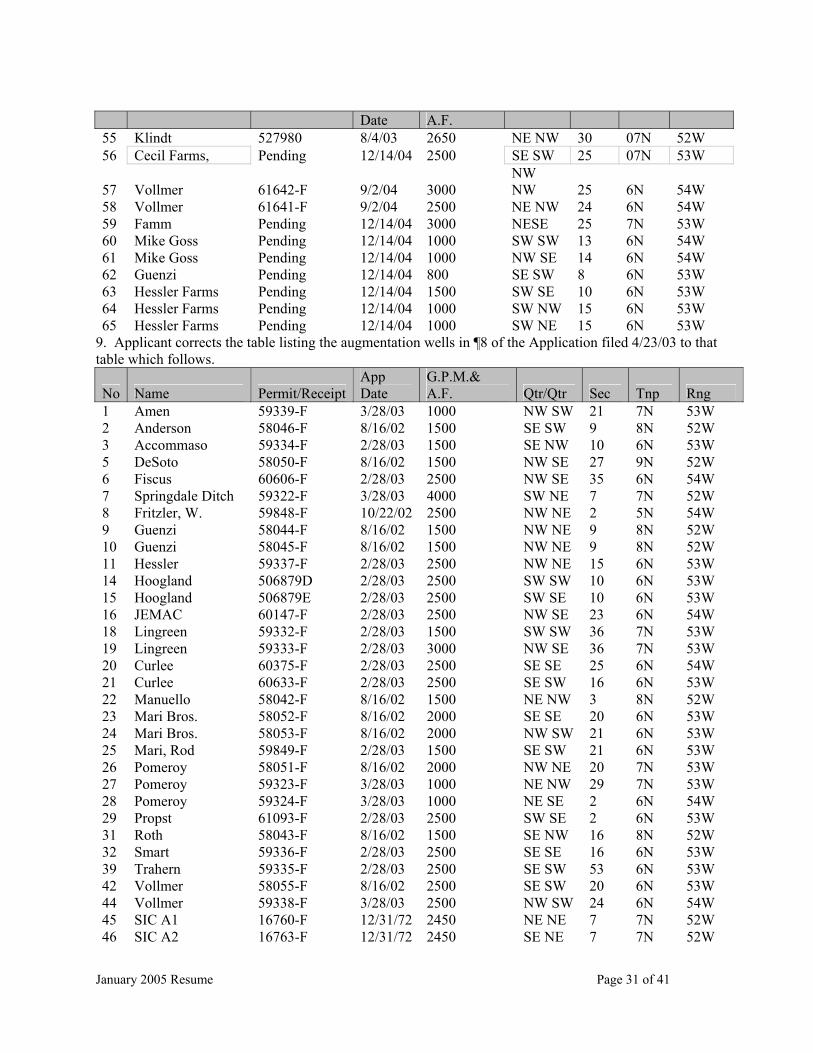
January 2005 Resume Page 31 of 41
Date A.F. 55 Klindt 527980 8/4/03 2650 NE NW 30 07N 52W 56 Cecil Farms, Pending 12/14/04 2500 SE SW 25 07N 53W
57 Vollmer 61642-F 9/2/04 3000 NW NW 25 6N 54W
58 Vollmer 61641-F 9/2/04 2500 NE NW 24 6N 54W 59 Famm Pending 12/14/04 3000 NESE 25 7N 53W 60 Mike Goss Pending 12/14/04 1000 SW SW 13 6N 54W 61 Mike Goss Pending 12/14/04 1000 NW SE 14 6N 54W 62 Guenzi Pending 12/14/04 800 SE SW 8 6N 53W 63 Hessler Farms Pending 12/14/04 1500 SW SE 10 6N 53W 64 Hessler Farms Pending 12/14/04 1000 SW NW 15 6N 53W 65 Hessler Farms Pending 12/14/04 1000 SW NE 15 6N 53W
9. Applicant corrects the table listing the augmentation wells in ¶8 of the Application filed 4/23/03 to that table which follows.
No Name Permit/ReceiptApp Date
G.P.M.& A.F. Qtr/Qtr Sec Tnp Rng
1 Amen 59339-F 3/28/03 1000 NW SW 21 7N 53W 2 Anderson 58046-F 8/16/02 1500 SE SW 9 8N 52W 3 Accommaso 59334-F 2/28/03 1500 SE NW 10 6N 53W 5 DeSoto 58050-F 8/16/02 1500 NW SE 27 9N 52W 6 Fiscus 60606-F 2/28/03 2500 NW SE 35 6N 54W 7 Springdale Ditch 59322-F 3/28/03 4000 SW NE 7 7N 52W 8 Fritzler, W. 59848-F 10/22/02 2500 NW NE 2 5N 54W 9 Guenzi 58044-F 8/16/02 1500 NW NE 9 8N 52W 10 Guenzi 58045-F 8/16/02 1500 NW NE 9 8N 52W 11 Hessler 59337-F 2/28/03 2500 NW NE 15 6N 53W 14 Hoogland 506879D 2/28/03 2500 SW SW 10 6N 53W 15 Hoogland 506879E 2/28/03 2500 SW SE 10 6N 53W 16 JEMAC 60147-F 2/28/03 2500 NW SE 23 6N 54W 18 Lingreen 59332-F 2/28/03 1500 SW SW 36 7N 53W 19 Lingreen 59333-F 2/28/03 3000 NW SE 36 7N 53W 20 Curlee 60375-F 2/28/03 2500 SE SE 25 6N 54W 21 Curlee 60633-F 2/28/03 2500 SE SW 16 6N 53W 22 Manuello 58042-F 8/16/02 1500 NE NW 3 8N 52W 23 Mari Bros. 58052-F 8/16/02 2000 SE SE 20 6N 53W 24 Mari Bros. 58053-F 8/16/02 2000 NW SW 21 6N 53W 25 Mari, Rod 59849-F 2/28/03 1500 SE SW 21 6N 53W 26 Pomeroy 58051-F 8/16/02 2000 NW NE 20 7N 53W 27 Pomeroy 59323-F 3/28/03 1000 NE NW 29 7N 53W 28 Pomeroy 59324-F 3/28/03 1000 NE SE 2 6N 54W 29 Propst 61093-F 2/28/03 2500 SW SE 2 6N 53W 31 Roth 58043-F 8/16/02 1500 SE NW 16 8N 52W 32 Smart 59336-F 2/28/03 2500 SE SE 16 6N 53W 39 Trahern 59335-F 2/28/03 2500 SE SW 53 6N 53W 42 Vollmer 58055-F 8/16/02 2500 SE SW 20 6N 53W 44 Vollmer 59338-F 3/28/03 2500 NW SW 24 6N 54W 45 SIC A1 16760-F 12/31/72 2450 NE NE 7 7N 52W 46 SIC A2 16763-F 12/31/72 2450 SE NE 7 7N 52W
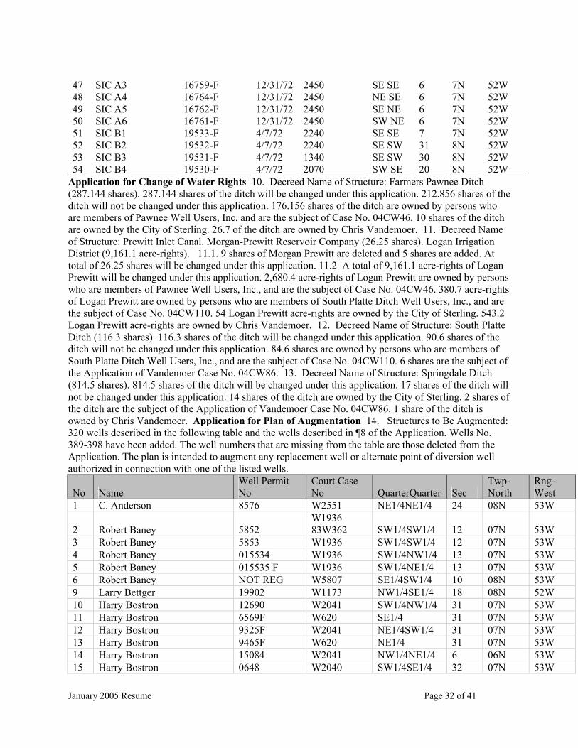
January 2005 Resume Page 32 of 41
47 SIC A3 16759-F 12/31/72 2450 SE SE 6 7N 52W 48 SIC A4 16764-F 12/31/72 2450 NE SE 6 7N 52W 49 SIC A5 16762-F 12/31/72 2450 SE NE 6 7N 52W 50 SIC A6 16761-F 12/31/72 2450 SW NE 6 7N 52W 51 SIC B1 19533-F 4/7/72 2240 SE SE 7 7N 52W 52 SIC B2 19532-F 4/7/72 2240 SE SW 31 8N 52W 53 SIC B3 19531-F 4/7/72 1340 SE SW 30 8N 52W 54 SIC B4 19530-F 4/7/72 2070 SW SE 20 8N 52W
Application for Change of Water Rights 10. Decreed Name of Structure: Farmers Pawnee Ditch (287.144 shares). 287.144 shares of the ditch will be changed under this application. 212.856 shares of the ditch will not be changed under this application. 176.156 shares of the ditch are owned by persons who are members of Pawnee Well Users, Inc. and are the subject of Case No. 04CW46. 10 shares of the ditch are owned by the City of Sterling. 26.7 of the ditch are owned by Chris Vandemoer. 11. Decreed Name of Structure: Prewitt Inlet Canal. Morgan-Prewitt Reservoir Company (26.25 shares). Logan Irrigation District (9,161.1 acre-rights). 11.1. 9 shares of Morgan Prewitt are deleted and 5 shares are added. At total of 26.25 shares will be changed under this application. 11.2 A total of 9,161.1 acre-rights of Logan Prewitt will be changed under this application. 2,680.4 acre-rights of Logan Prewitt are owned by persons who are members of Pawnee Well Users, Inc., and are the subject of Case No. 04CW46. 380.7 acre-rights of Logan Prewitt are owned by persons who are members of South Platte Ditch Well Users, Inc., and are the subject of Case No. 04CW110. 54 Logan Prewitt acre-rights are owned by the City of Sterling. 543.2 Logan Prewitt acre-rights are owned by Chris Vandemoer. 12. Decreed Name of Structure: South Platte Ditch (116.3 shares). 116.3 shares of the ditch will be changed under this application. 90.6 shares of the ditch will not be changed under this application. 84.6 shares are owned by persons who are members of South Platte Ditch Well Users, Inc., and are the subject of Case No. 04CW110. 6 shares are the subject of the Application of Vandemoer Case No. 04CW86. 13. Decreed Name of Structure: Springdale Ditch (814.5 shares). 814.5 shares of the ditch will be changed under this application. 17 shares of the ditch will not be changed under this application. 14 shares of the ditch are owned by the City of Sterling. 2 shares of the ditch are the subject of the Application of Vandemoer Case No. 04CW86. 1 share of the ditch is owned by Chris Vandemoer. Application for Plan of Augmentation 14. Structures to Be Augmented: 320 wells described in the following table and the wells described in ¶8 of the Application. Wells No. 389-398 have been added. The well numbers that are missing from the table are those deleted from the Application. The plan is intended to augment any replacement well or alternate point of diversion well authorized in connection with one of the listed wells.
No Name Well Permit No
Court Case No QuarterQuarter Sec
Twp-North
Rng-West
1 C. Anderson 8576 W2551 NE1/4NE1/4 24 08N 53W
2 Robert Baney 5852 W1936 83W362 SW1/4SW1/4 12 07N 53W
3 Robert Baney 5853 W1936 SW1/4SW1/4 12 07N 53W 4 Robert Baney 015534 W1936 SW1/4NW1/4 13 07N 53W 5 Robert Baney 015535 F W1936 SW1/4NE1/4 13 07N 53W 6 Robert Baney NOT REG W5807 SE1/4SW1/4 10 08N 53W 9 Larry Bettger 19902 W1173 NW1/4SE1/4 18 08N 52W 10 Harry Bostron 12690 W2041 SW1/4NW1/4 31 07N 53W 11 Harry Bostron 6569F W620 SE1/4 31 07N 53W 12 Harry Bostron 9325F W2041 NE1/4SW1/4 31 07N 53W 13 Harry Bostron 9465F W620 NE1/4 31 07N 53W 14 Harry Bostron 15084 W2041 NW1/4NE1/4 6 06N 53W 15 Harry Bostron 0648 W2040 SW1/4SE1/4 32 07N 53W
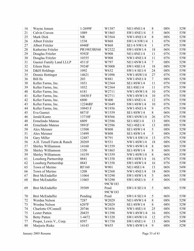
January 2005 Resume Page 33 of 41
16 Wayne Jensen 1-2699F W1387 NE1/4NE1/4 8 08N 52W 21 Calvin Craven 1089 W1865 SW1/4NE1/4 5 06N 53W 25 Mark Dick NR W3564 NW1/4NE1/4 8 08N 52W 26 Albert Fritzler 1538 W868 SW1/4 NW1/4 1 07N 53W 27 Albert Fritzler 6940F W868 SE1/4 NW1/4 1 07N 53W 28 Katherine Fritzler PR19853RF60 W2322 SW1/4SW1/4 18 06N 53W 29 Douglas Fritzler 9392F W908 NE1/4NE1/4 11 07N 53W 30 Douglas Fritzler 10355 W908 NW1/4NE1/4 11 07N 53W 31 Guenzi Family Land LLLP 4511F W797 NE1/4NW1/4 7 08N 52W 32 Eileen Hein 5924F W3008 SW1/4SE1/4 18 08N 52W 34 D&H Holdings 1092 W632 SW1/4 SE1/4 24 08N 53W 35 Dennis Hettinger 14621 W1096 NW1/4SW1/4 27 07N 53W 36 Bill Ils 203 W881 NW1/4NE1/4 7 08N 52W 38 Keller Farms, Inc. 1031 W2364 SE1/4SW1/4 11 07N 53W 39 Keller Farms, Inc. 1032 W2364 SE1/4SE1/4 11 07N 53W 40 Keller Farms, Inc. 6181 W2711 NW1/4NW1/4 10 07N 53W 41 Keller Farms, Inc. 10430 F W2711 NW1/4NW1/4 10 07N 53W 42 Keller Farms, Inc. 6800 W400 SW1/4NE1/4 12 07N 53W 43 Keller Farms, Inc. 12246RF W3649 SW1/4SW1/4 10 07N 53W 44 Keller Farms, Inc. 10945 F W1936 NW1/4NE1/4 9 07N 53W 45 Eva Guenzi 8871F W1559 SE1/4SW1/4 8 06N 53W 46 Jerald Kuntz 13710F W8566 SW1/4NW1/4 26 07N 53W 48 Ermelindo Mateus 6809 W2586 SE1/4SE1/4 13 08N 53W 49 Ermelindo Mateus 5891F W2586 NE1/4SE1/4 13 08N 53W 50 Alex Meisner 13500 W808 SE1/4SW1/4 5 08N 52W 51 Alex Meisner 13499 W808 SE1/4SW1/4 5 08N 52W 54 Gary Miller 12487 W791 NW1/4 SW1/4 13 07N 53W 56 A.H. Tetsell Farm & Ranch 20269 W531 NW1/4SW1/4 18 08N 52W 57 Shirley Williamson 14160 W1559 NW1/4NW1/4 8 06N 53W 58 Shirley Williamson 1350 W1865 SE1/4SW1/4 8 06N 53W 59 Shirley Williamson 14159 W1559 NW1/4SW1/4 8 06N 53W 61 Lousberg Partnership 0841 W1358 SW1/4SW1/4 16 07N 53W 62 Lousberg Partnership 0843 W1358 SW1/4SW1/4 16 07N 53W 65 Town of Merino RF160 W901 NE1/4SE1/4 13 06N 54W 66 Town of Merino 1208 W2368 NW1/4NE1/4 18 06N 53W 67 Bret McEndaffer 11064 W3290 SW1/4SW1/4 5 06N 53W 68 Bret McEndaffer 11065 W3290 SW1/4NE1/4 5 06N 53W
69 Bret McEndaffer 39309 99CW183 Pend SW1/4 SE1/4 5 06N 53W
70 Bret McEndaffer Pending 99CW183 Pend SW1/4 SE1/4 5 06N 53W
72 Werdna Nelson 7287 W2029 NE1/4NW1/4 8 08N 52W 73 Werdna Nelson 6207F W2029 SE1/4SW1/4 8 08N 52W 74 Charlotte O'Connell 20746 W3456 NW1/4SE1/4 25 08N 53W 75 Lester Patten 20435 W1398 NW1/4NW1/4 16 08N 52W 76 Betty Patten 1-4472 W1320 SW1/4NW1/4 12 07N 53W 77 Propst, Lewis V., Corp. 0597 W1750 SW1/4NE1/4 13 06N 54W 80 Marjorie Rieke 14143 W655 NW1/4NW1/4 9 08N 52W

January 2005 Resume Page 34 of 41
81 Victor Schroeder 14743 W813 NW1/4NW1/4 9 08N 52W 83 Monte Rogers 14168 W1549 NE1/4SE1/4 5 08N 52W 84 Gerald Ruf 20059-1 W1268 NW1/4NE1/4 18 08N 52W 85 Gerald Ruf 5754F W1268 NW1/4NE1/4 18 08N 52W 86 Gerald Ruf 20059-2 W1268 NW1/4NE1/4 18 08N 52W 89 Zella Sager 0821 W1654 NW1/4SW1/4 18 06N 53W 95 Joe Delaware RO1724 W5735 SW1/4SE1/4 33 07N 53W 98 Schlegel Ranch Partnership 4402-F W1809 NE1/4 NW1/4 24 06N 54W 99 Schlegel Ranch Partnership 5781F W1809 SE1/4SW1/4 13 06N 54W 106 Mergs Unlimited PO 2077 W1895 NW1/4 SW1/4 4 06N 53W 110 Daryle Vollmer RO1060 W693 NE1/4NW1/4 24 06N 54W 111 Daryle Vollmer 1 6546R W1456 NW1/4SW1/4 24 06N 54W 112 Daryle Vollmer R01695 W680 NW1/4NW1/4 25 06N 54W 113 Richard Walker 7172 W893 SE1/4 NE1/4 13 07N 53W 114 Richard Walker 1-5239F W1069 SE1/4NW1/4 18 07N 52W 116 Kenneth J. & Eva M. Guenzi 6034 W632 NW1/4 NW1/4 4 06N 53W 117 Christopher Smith 10836-F W5734 NE1/4NE1/4 24 06N 54W 118 Dave Lebsock 1765 W1098 NW1/4NE1/4 25 08N 53W 120 E. Nelson P15593 W1428 SW1/4SW1/4 28 07N 53W 121 Moira Jackson 6187R168 W1627 SW1/4SW1/4 7 06N 53W 122 Larry Taylor 2279 RF W760 NE1/4SW1/4 4 08N 52W 123 Sterling Country Club R16079 W5758 NW1/4NW1/4 36 08N 53W 124 Sterling Country Club 25864 82-CW-291 SW1/4NW1/4 36 08N 53W 125 Rex Monahan 2115F W821 NW1/4NW1/4 31 08N 52W 126 Rex Monahan 12692 W1936 NE1/4SW1/4 26 08N 53W 127 Rex Monahan 9147F W3731 NW1/4 26 08N 53W 128 Hettinger Farm & Ranch, Inc. 3916-2-1551 W860 SE1/4SE1/4 7 06N 53W 129 Hettinger Farm & Ranch, Inc. 3915 W860 SW1/4SW1/4 8 06N 53W 130 Hettinger Farm & Ranch, Inc. 14094 W860 NW1/4NW1/4 17 06N 53W 131 Hettinger Farm & Ranch, Inc. 03346F W860 NW1/4NW1/4 7 06N 53W 145 Albert Amen 1094 W632 SE1/4 SW1/4 34 06N 54W 146 Albert Amen R16396 W632 SE1/4 NW1/4 34 06N 54W 147 William Anderson 1094 W632 SE1/4 SW1/4 34 06N 54W 149 Lutin Curlee Family Part., Ltd. 16868 W497 SE1/4SE1/4 25 06N 54W 150 William Fritzler 30009-3586 W889 NW1/4NE1/4 2 05N 54W 159 Clinton Fiscus R 19900 W1762 NW1/4SE1/4 35 06N 54W 160 Mari Bros., Inc. 2974 F W1559 NW1/4SW1/4 21 06N 53W 162 Mari Bros., Inc. 12794 W1559 NW1/4SW1/4 20 06N 53W 163 Mari Bros., Inc. 1259 W792 SE1/4SW1/4 21 06N 53W 164 Mari Bros., Inc. 20715 W8166 SW1/4SE1/4 21 06N 53W 165 Propst, Lewis V., Corp. 0596 W1750 SE1/4SW1/4 19 06N 53W 166 Propst, Lewis V., Corp. 1803 W1750 SW1/4NE1/4 19 06N 53W 167 Propst, Lewis V., Corp. 6692 F W1750 SE1/4SW1/4 19 06N 53W 168 Propst, Lewis V., Corp.-stock 10825 W5704 NE1/4SW1/4 19 06N 53W 169 Propst, Lewis V., Corp.-stock 21830 W5704 NE1/4SW1/4 19 06N 53W 172 Daryle Vollmer 3142RF W1751 NE1/4SE1/4 25 06N 54W 173 Daryle Vollmer 1802 RF573 W1750 SW1/4NE1/4 19 06N 53W 174 Daryle Vollmer 0598 W1750 SE1/4SW1/4 20 06N 53W

January 2005 Resume Page 35 of 41
175 Daryle Vollmer 15971 W1760 SE1/4SW1/4 25 06N 54W 176 Smart Brothers, Inc. 0607 W1752 SW1/4NE1/4 21 06N 53W 177 Smart Brothers, Inc. 0608 W1752 SE1/4NE1/4 21 06N 53W 178 Smart Brothers, Inc. 8785 W1752 SE1/4SE1/4 16 06N 53W 179 Smart Brothers, Inc. 9148 F W1752 SW1/4NW1/4 22 06N 53W 181 Hessler Farms, Inc. R6342RF W687 SW1/4SE1/4 10 06N 53W 182 Hessler Farms, Inc. 5801 W687 SW1/4NW1/4 15 06N 53W 183 Hessler Farms, Inc. 14137 W687 SW1/4NE1/4 15 06N 53W 184 Hessler Farms, Inc. 4466F W687 NW1/4NE1/4 15 06N 53W 185 Robert Lingreen 10320RF W8712(77) NW1/4 NW1/4 6 06N 52W 186 Robert Lingreen 21283-F W8712(77) NW1/4 NW1/4 6 06N 52W 187 Lutin Curlee Family Part., Ltd. 041776-F W497 SE1/4 NW1/4 16 06N 53W 188 Lutin Curlee Family Part., Ltd. 041777-F W497 SE1/4SW1/4 16 06N 53W 189 Lutin Curlee Family Part., Ltd. 041778-F 92CW010 NE1/4 SW1/4 16 06N 53W 192 Hoogland Living Trust 19331 W1099 SW1/4SW1/4 10 06N 53W 193 Hoogland Living Trust R 5946 W1936 SW1/4 SE1/4 10 06N 53W 194 Hoogland Living Trust 38879-F 91CW014 SE1/4 NE1/4 10 06N 53W 195 Accomasso Bros. RF438 W3278 SE1/4 NE1/4 9 06N 53W 196 Accomasso Bros. P02687 W3278 SE1/4 NW1/4 10 06N 53W 197 Alberta Smart 5962 W3492 SW1/4SE1/4 35 07N 53W 198 Sunset Memorial Gardens 11883F-R W5649 NE1/4SE1/4 8 08N 52W 199 Alfred Vendegna 56980-F W991 SE1/4NW1/4 31 08N 52W 200 Elmer Wagner 9058F W794 NW1/4NE1/4 17 08N 52W 201 Elmer Wagner 6150 W794 NW1/4NE1/4 17 08N 52W 202 Jack Nixon R 00909 W790 SE1/4NW1/4 7 07N 52W 203 George Kloberdanz 2-19659 W1006 SW1/4SE1/4 1 07N 53W 204 George Kloberdanz 1-19659 W1006 SE1/4SE1/4 1 07N 53W 205 Frieda Knaub R00691 W864 NW1/4SE1/4 8 08N 52W 206 Sylvia Gregory 19867 RF W3130 SW1/4NE1/4 24 07N 53W 207 Carlton Wyckoff 5495 F W2474 NE1/4NW1/4 17 08N 52W 208 Stan Fry 1088RF391 W632 SW1/4NE1/4 24 07N 53W 209 Leon Fritzler 19520 W869 NW1/4NW1/4 7 07N 52W 210 Edward Fritzler 6261 W870 SW1/4SW1/4 1 07N 53W 212 John Amen 18050 W391 SW1/4SW1/4 7 07N 52W 213 Henry Schaffer 7076 W944 SW1/4NE1/4 7 07N 52W 214 Henry Schaffer 7075 W944 SW1/4NE1/4 7 07N 52W 215 Al Miller 12486-R W3861 SE1/4NW1/4 24 07N 53W 216 Al Miller 18765-F W3861 NE1/4NE1/4 26 07N 53W 217 Douglas Fritzler 4-2381-F W868 SW1/4 SE1/4 4 07N 53W 218 Douglas Fritzler 6742F W868 NW1/4 SE1/4 4 07N 53W 219 Allen Mitchek 6743 F W5736 SW1/4NW1/4 31 08N 52W 220 DJ & J Farms (FAMM farms) 1-04327 W796 NE1/4SE1/4 25 07N 53W 221 Dan Klindt R292 W1574 NW1/4SE1/4 35 07N 53W 222 Larry Michel R292 W1574 NW1/4SE1/4 35 07N 53W 223 Propst Brothers Inc 04428F W795 SW1/4SE1/4 2 06N 53W 224 Gary & Jerry Michel 04355F W1573 SE1/4NE1/4 3 06N 53W 225 Trahern Hay, Inc. 19901 W794 SE1/4SW1/4 2 06N 53W 226 Dean Rasmussen 20467 W3274 NE1/4NW1/4 30 07N 52W
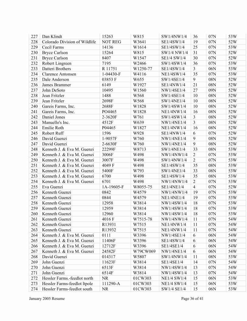
January 2005 Resume Page 36 of 41
227 Dan Klindt 15263 W815 SW1/4NW1/4 36 07N 53W 228 Colorado Division of Wildlife NOT REG W3641 SE1/4SW1/4 19 07N 52W 229 Cecil Farms 14136 W1614 SE1/4SW1/4 25 07N 53W 230 Bryce Carlson 15264 W815 SW1/4 NW1/4 31 07N 52W 231 Bryce Carlson 8407 W1547 SE1/4 SW1/4 30 07N 52W 232 Robert Lingreen 7195 W2466 SW1/4SW1/4 36 07N 53W 233 Datteri Brothers R 11751 W1250-77 SE1/4SW1/4 3 06N 53W 234 Clarence Antonsen 1-04430-F W4116 NE1/4SW1/4 35 07N 53W 235 Dale Anderson 03853 F W655 SW1/4SE1/4 9 08N 52W 236 James Brammer 6149 W1927 SE1/4NW1/4 21 08N 52W 237 John DeSoto 10495 W1560 NW1/4SE1/4 27 09N 52W 238 Jean Fritzler 1488 W568 SW1/4SE1/4 10 08N 52W 239 Jean Fritzler 2698F W568 SW1/4NE1/4 10 08N 52W 240 Gareis Farms, Inc. 2688F W1828 SW1/4SW1/4 10 08N 52W 241 Gareis Farms, Inc. PO4465 W1828 NE1/4NW1/4 16 08N 52W 242 Daniel Jones 2-3620F W761 SW1/4SW1/4 3 08N 52W 243 Manuello's Inc. 4512F W639 NW1/4NE1/4 3 08N 52W 244 Emilie Roth P04465 W1827 NE1/4NW1/4 16 08N 52W 245 Robert Ruff 1596 W928 SE1/4NW1/4 6 07N 52W 246 David Guenzi 1-9057F W760 NW1/4NE1/4 9 08N 52W 247 David Guenzi 2-6630F W760 NW1/4NE1/4 9 08N 52W 248 Kenneth J. & Eva M. Guenzi 22299F W8713 SW1/4NE1/4 33 08N 53W 249 Kenneth J. & Eva M. Guenzi 3006F W498 NW1/4NW1/4 2 07N 53W 250 Kenneth J. & Eva M. Guenzi 3007F W498 SW1/4NW1/4 2 07N 53W 251 Kenneth J. & Eva M. Guenzi 4049 F W498 SE1/4SW1/4 35 08N 53W 252 Kenneth J. & Eva M. Guenzi 5400F W793 SW1/4NE1/4 33 08N 53W 253 Kenneth J. & Eva M. Guenzi 6700 W498 SE1/4SW1/4 35 08N 53W 254 Kenneth J. & Eva M. Guenzi 6701 W498 NW1/4NW1/4 2 07N 53W 255 Eva Guenzi 1A-19605-F W8055-75 SE1/4NE1/4 4 07N 52W 256 Kenneth Guenzi 0842 W4579 NW1/4NW1/4 19 07N 53W 257 Kenneth Guenzi 0844 W4579 NE1/4NE1/4 19 07N 53W 258 Kenneth Guenzi 12958 W3814 NW1/4SW1/4 18 07N 53W 259 Kenneth Guenzi 12959 W3814 NW1/4SW1/4 18 07N 53W 260 Kenneth Guenzi 12960 W3814 NW1/4SW1/4 18 07N 53W 261 Kenneth Guenzi 4016 F W7515-78 NW1/4NW1/4 11 07N 54W 262 Kenneth Guenzi R13931 W7515 NE1/4NW1/4 11 07N 54W 263 Kenneth Guenzi R13932 W7515 NE1/4NW1/4 11 07N 54W 264 Kenneth J. & Eva M. Guenzi 0111 W3396 NW1/4SE1/4 6 06N 54W 265 Kenneth J. & Eva M. Guenzi 11406F W3396 SE1/4SW1/4 6 06N 54W 266 Kenneth J. & Eva M. Guenzi 12712F W3396 SE1/4SE1/4 6 06N 54W 267 Kenneth J. & Eva M. Guenzi 24582F W79CW069 NW1/4NE1/4 6 06N 54W 268 David Guenzi 014317 W5807 SW1/4NW1/4 11 08N 53W 269 John Guenzi 11623F W3814 SE1/4SE1/4 14 07N 54W 270 John Guenzi 6513F W3814 NW1/4SW1/4 13 07N 54W 271 John Guenzi 6514F W3814 NW1/4SW1/4 13 07N 54W 272 Hessler Farms.-feedlot north NR 01CW303 NE1/4 SW1/4 15 06N 53W 273 Hessler Farms-feedlot ltpole 111290-A 01CW303 NE1/4 SW1/4 15 06N 53W 274 Hessler Farms-feedlot south NR 01CW303 SW1/4 SE1/4 15 06N 53W

January 2005 Resume Page 37 of 41
275 Manuello's Inc. 043980-F SW1/4 NE1/4 3 08N 52W 276 Manuello's Inc. 25917 99CW0036 NE1/4 NW1/4 3 08N 52W 277 Manuello's Inc. 49223 99CW0036 NW1/4 NW1/4 3 08N 52W 278 Manuello's Inc. 53980-F SW1/4NE1/4 3 08N 52W 279 Manuello's Inc. N/R 99CW0036 SW1/4 NE1/4 3 08N 52W 280 Manuello's Inc. NR 99CW0036 SW1/4 NE1/4 3 08N 52W 281 Bornhoft Feedyards, Inc. 49693 W5813 SE1/4SE1/4 35 09N 53W 282 Bornhoft Feedyards, Inc. NOT REG W5813 SE1/4SE1/4 35 09N 53W 283 Bornhoft Feedyards, Inc. 032422F W5813 SE1/4SE1/4 35 09N 53W 284 Everett Duncan 7286 W1429 SW1/4SW1/4 30 08N 52W 285 Highland Park Water Co 14135 W2440 BLK 1, LOT 5 36 08N 53W 286 Ronald Ruff 20893 W405 SW1/4SE1/4 8 07N 52W
287 Lousberg Partnership 013083RF W1936 83CW73 SW1/4 9 07N 53W
288 Lousberg Partnership 26440-F W83CW073 NW1/4NW1/4 9 07N 53W 289 Lousberg Partnership 046767-F NE1/4NW1/4 16 07N 53W 290 Lousberg Partnership 11427RF W1358 NE1/4NE1/4 16 07N 53W 291 Lousberg Partnership 35463 W82CW194 NW1/4SW1/4 26 07N 53W 292 Lousberg Partnership 5011-F W82CW194 SW1/4 SW1/4 26 07N 53W 293 David Amen 7398 W492 NW1/4NW1/4 21 07N 53W 294 David Amen 7400 W492 NW1/4NW1/4 21 07N 53W 295 David Amen R7399-RF W492 NW1/4SW1/4 21 07N 53W 296 Robert Karg 12079F W2539 SW1/4SE1/4 9 06N 53W 297 Glen Pomeroy 6621 W620 NE1/4SE1/4 2 06N 54W 298 Glen Pomeroy 9464F W620 NW1/4 29 07N 53W 299 Kenneth Pomeroy 17958-1 W620 NW1/4NE1/4 20 07N 53W 300 Kenneth Pomeroy 17958-2 W620 SW1/4NE1/4 20 07N 53W 301 Perry Pomeroy III 9463F W620 S1/2NW1/4 29 07N 53W 302 Perry Pomeroy Jr. 4326F W620 NE1/4NE1/4 30 07N 53W 303 Alan Amen 14164 W1109 NW1/4SE1/4 13 07N 54W 304 Alan Amen 5010F W1109 NW1/4SE1/4 13 07N 54W 305 Lillian Amen Family Trust 10783 W3727 NW1/4NW1/4 18 07N 53W 306 Lillian Amen Family Trust 10784 W3727 NW1/4NW1/4 18 07N 53W 307 Lillian Amen Family Trust R10785 W3727 SW1/4NW1/4 12 07N 54W 308 Paul Lebsock, Jr. 7097 W894 SW1/4SW1/4 17 07N 53W 309 Paul Lebsock, Jr. 7098 W894 SW1/4SE1/4 17 07N 53W 310 Paul Lebsock, Jr. 3659 F W894 NW1/4SE1/4 16 07N 54W 311 Prewitt Ranch 6195F W1469 NE1/4NE1/4 14 05N 54W 312 Prewitt Ranch 6312-F W1469 NE1/4SE1/4 12 05N 54W 313 James Stephens-Mike Goss 0339 W2653 SW1/4SW1/4 13 06N 54W 314 James Stephens-Mike Goss 2-9447 W2653 NW1/4SE1/4 14 06N 54W 315 School Dist Re 1 Valley 11856F W5731 NE1/4SE1/4 29 08N 52W 316 School Dist Re 1 Valley 11857F W5731 SE1/4NW1/4 29 08N 52W 317 School Dist Re 1 Valley 25519 W5731 NW1/4NE1/4 21 08N 52W 318 School Dist Re 1 Valley 25520 W5731 NW1/4NE1/4 21 08N 52W 319 School Dist Re 1 Valley 23690F W5731 NE1/4SE1/4 30 08N 52W 320 School Dist Re 1 Valley 25521 W5731 NE1/4SE1/4 30 08N 52W 321 Logan County Court House 8900 W5732 NE1/4NW1/4 29 08N 52W

January 2005 Resume Page 38 of 41
322 Northeastern Junior College 035467-F W2105 SW1/4NW1/4 28 08N 52W 323 Northeastern Junior College 04010-F W-2105 NE1/4NW1/4 28 08N 52W 324 Northeastern Junior College 11061-F W-2105 NE1/4NW1/4 28 08N 52W 325 Northeastern Junior College 5425-F W-2105 NW1/4SE1/4 21 08N 52W 326 Sterling East Side Water Co. 013690-F W3839 NW1/4 NW1/4 26 08N 52W 327 Sterling East Side Water Co. 013691-F W3839 SE1/4 NE1/4 27 08N 52W 328 Richard Jackson 1516 W754 NW1/4NE1/4 11 08N 53W 329 C & F Company 2633F W2289 SE1/4NW1/4 28 08N 52W 330 McAtee Construction Co. 13644F W-2633 SE1/4 SE1/4 28 08N 52W 331 McAtee Construction Co. 13645F W-2633 SW1/4 SW1/4 27 08N 52W 332 McAtee Construction Co. 13646F W-2633 SW1/4 SW1/4 27 08N 52W 333 McAtee Construction Co. 13647F W-2633 SW1/4 SW1/4 27 08N 52W 334 McAtee Construction Co. 13648F W2633 SW1/4SW1/4 27 08N 52W 335 McAtee Construction Co. 13649F W2633 SW1/4SW1/4 27 08N 52W 336 McAtee Construction Co. 13650F W-2633 SW1/4 SW1/4 27 08N 52W 337 McAtee Construction Co. 13651F W2633 SE1/4SE1/4 28 08N 52W 340 Sandra Needham 3622F W4650 SW1/4NE1/4 18 08N 52W 341 Timothy Sonnenberg 1170 W5049 SE1/4NE1/4 19 08N 52W 342 Joel Nelson 0613 W2363 SE1/4SE1/4 18 08N 52W 343 L.A. Coakley 16317 W3528 NE1/4SE1/4 15 08N 52W 344 L.A. Coakley 24755 W3528 SE1/4SE1/4 15 08N 52W 345 L.A. Coakley 25306 W3528 SW1/4SE1/4 15 08N 52W 346 Ronald Timmerman GW-18843 LOTS 17-18 32 08N 52W 347 E. Nelson 012934 F W2289 SE1/4SE1/4 33 08N 53W 348 Mark Harrington 7219 W5808 SW1/4SW1/4 34 08N 52W 349 Garnie Johnson 14745 W1013 SE1/4 NE1/4 4 07N 52W 350 Allen Mitchek 0124 W2289 NE1/4NW1/4 9 07N 53W 351 Allen Mitchek 0125 W2289 NW1/4SW1/4 4 07N 53W 352 Allen Mitchek 15380 F W2289 SW1/4NW1/4 4 07N 53W 353 Allen Mitchek 3137 F W2289 NE1/4SE1/4 5 07N 53W 354 Allen Mitchek 6620 F W2289 SW1/4NW1/4 4 07N 53W 355 Allen Mitchek 9613 F W1936 SE1/4SE1/4 8 07N 53W 356 Atwood Commercial Feedlot NOT REG SE1/4NE1/4 36 07N 53W 357 Atwood Commercial Feedlot NR NE1/4NE1/4 36 07N 53W 360 Kidz Ark 046826 NE1/4NW1/4 24 08N 53W 361 Kidz Ark 41360 NE1/4NW1/4 24 08N 53W 362 Kidz Ark 71472 NE1/4NW1/4 24 08N 53W 363 Platte Valley Real Estate, LLC 5868RF1214 W2093 SW1/4NW1/4 33 08N 52W 364 Fairfield Management, Inc. 0063 W529 SW1/4NE1/4 4 06N 53W 365 Fairfield Management, Inc. 2262-F W529 SW1/4NE1/4 4 06N 53W 366 David Naibauer 11607F W1872 SE1/4N1/2 18 07N 53W 367 David Naibauer 11609F W1872 SE1/4NW1/4 18 07N 53W 368 David Naibauer RF1024 W1872 SW1/4NW1/4 18 07N 53W 369 Allen Hutt 042328-F W4579 NW1/4NE1/4 30 07N 53W 370 Mark Brunkhardt 10459 W3814 NE1/4NE1/4 24 07N 54W 371 John Pivonka 8536 W1936 SW1/4NW1/4 17 07N 53W 372 John Pivonka 8537 W1936 SW1/4NW1/4 17 07N 53W 373 Atwood Commercial Feedlot N/R NE1/4NE1/4 36 07N 53W
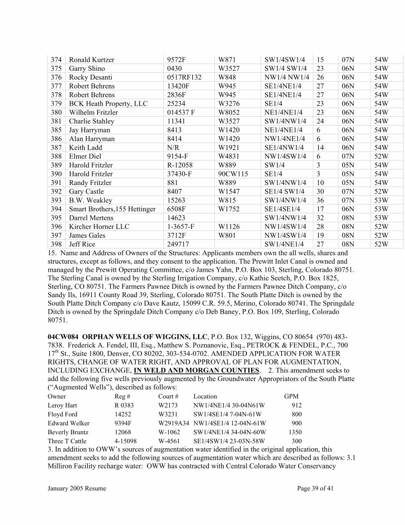
January 2005 Resume Page 39 of 41
374 Ronald Kurtzer 9572F W871 SW1/4SW1/4 15 07N 54W 375 Garry Shino 0430 W3527 SW1/4 SW1/4 23 06N 54W 376 Rocky Desanti 0517RF132 W848 NW1/4 NW1/4 26 06N 54W 377 Robert Behrens 13420F W945 SE1/4NE1/4 27 06N 54W 378 Robert Behrens 2836F W945 SE1/4NE1/4 27 06N 54W 379 BCK Heath Property, LLC 25234 W3276 SE1/4 23 06N 54W 380 Wilhelm Fritzler 014537 F W8052 NE1/4NE1/4 23 06N 54W 381 Charlie Stahley 11341 W3527 SW1/4NW1/4 24 06N 54W 385 Jay Harryman 8413 W1420 NE1/4NE1/4 6 06N 54W 386 Alan Harryman 8414 W1420 NW1/4NE1/4 6 06N 54W 387 Keith Ladd N/R W1921 SE1/4NW1/4 14 06N 54W 388 Elmer Diel 9154-F W4831 NW1/4SW1/4 6 07N 52W 389 Harold Fritzler R-12058 W889 SW1/4 3 05N 54W 390 Harold Fritzler 37430-F 90CW115 SE1/4 3 05N 54W 391 Randy Fritzler 881 W889 SW1/4NW1/4 10 05N 54W 392 Gary Castle 8407 W1547 SE1/4 SW1/4 30 07N 52W 393 B.W. Weakley 15263 W815 SW1/4NW1/4 36 07N 53W 394 Smart Brothers,155 Hettinger 6508F W1752 SE1/4SE1/4 17 06N 53W 395 Darrel Mertens 14623 SW1/4NW1/4 32 08N 53W 396 Kircher Horner LLC 1-3657-F W1126 NW1/4SW1/4 28 08N 52W 397 James Gales 3712F W801 NW1/4SW1/4 19 08N 52W 398 Jeff Rice 249717 SW1/4NE1/4 27 08N 52W
15. Name and Address of Owners of the Structures: Applicants members own the all wells, shares and structures, except as follows, and they consent to the application. The Prewitt Inlet Canal is owned and managed by the Prewitt Operating Committee, c/o James Yahn, P.O. Box 103, Sterling, Colorado 80751. The Sterling Canal is owned by the Sterling Irrigation Company, c/o Kathie Seetch, P.O. Box 1825, Sterling, CO 80751. The Farmers Pawnee Ditch is owned by the Farmers Pawnee Ditch Company, c/o Sandy Ils, 16911 County Road 39, Sterling, Colorado 80751. The South Platte Ditch is owned by the South Platte Ditch Company c/o Dave Kautz, 15099 C.R. 59.5, Merino, Colorado 80741. The Springdale Ditch is owned by the Springdale Ditch Company c/o Deb Baney, P.O. Box 109, Sterling, Colorado 80751. 04CW084 ORPHAN WELLS OF WIGGINS, LLC, P.O. Box 132, Wiggins, CO 80654 (970) 483-7838. Frederick A. Fendel, III, Esq., Matthew S. Poznanovic, Esq., PETROCK & FENDEL, P.C., 700 17th St., Suite 1800, Denver, CO 80202, 303-534-0702. AMENDED APPLICATION FOR WATER RIGHTS, CHANGE OF WATER RIGHT, AND APPROVAL OF PLAN FOR AUGMENTATION, INCLUDING EXCHANGE, IN WELD AND MORGAN COUNTIES. 2. This amendment seeks to add the following five wells previously augmented by the Groundwater Appropriators of the South Platte (“Augmented Wells”), described as follows: Owner Reg # Court # Location GPM Leroy Hart R 0383 W2173 NW1/4NE1/4 30-04N61W 912 Floyd Ford 14252 W3231 SW1/4SE1/4 7-04N-61W 800 Edward Welker 9394F W2919A34 NW1/4SE1/4 12-04N-61W 900 Beverly Bruntz 12068 W-1062 SW1/4NE1/4 34-04N-60W 1350 Three T Cattle 4-15098 W-4561 SE1/4SW1/4 23-03N-58W 300 3. In addition to OWW’s sources of augmentation water identified in the original application, this amendment seeks to add the following sources of augmentation water which are described as follows: 3.1 Milliron Facility recharge water: OWW has contracted with Central Colorado Water Conservancy

January 2005 Resume Page 40 of 41
District and the Ground Water Management Subdistrict of the Central Colorado Water Conservancy District (“Central”) to obtain the use of a portion of the water available under Central’s water rights as decreed in Case Nos. 81CW382, 93CW24 and 00CW081, Weld County District Court, Weld County, State of Colorado. 3.2 Kiowa Facility recharge water: OWW has contracted with Central to obtain the use of a portion of the water available under Central’s water rights as decreed in Case Nos. 81CW382, 93CW24 and 00CW081, Weld County District Court, Weld County, State of Colorado. 3.3 Weldon Valley Ditch Company water: OWW has contracted with 3T Cattle Company, Inc. to obtain the use of five shares of the Weldon Valley Ditch Company water rights as decreed in Case No. 433 in the Weld County District Court, Weld County, State of Colorado. 3.4 Applicant also proposes to use for augmentation hereunder water available to Applicant from any other source legally available for augmentation and which can be provided in the amount, at the time and at the location required for augmentation. Prior to use of any such water for augmentation hereunder, Applicant shall provide written notification to State water administration officials of the source of water to be used and the method of delivery of such water. 4. In addition to OWW’s recharge structures identified in the original application, this amendment also seeks to add the following recharge sites which are described as follows: 4.1 Milliron Facility Reaches 1a, 2a and 3a: Reach 1a, 2a and 3a recharge sites are located at the Milliron Facility owned by Central and decreed in Case Nos. 81CW382, 93CW24 and 00CW081. Recharge ponds have been constructed in Reaches 1a, 2a and 3a, and additional recharge ponds may be constructed in the future. The water source for the recharge sites is the South Platte River and its tributaries diverted through the Bijou Canal. Reaches 1a, 2a and 3a are located on a tract of land situated in Sections 16 and 21, Township 4 North, Range 60 West of the 6th P.M, Morgan County, Colorado. 4.2 Kiowa Facility Reaches 1b, 2b, 3b and 4b: Reach 1b, 2b, and 3b recharge sites are located at the Kiowa Facility owned by Central and decreed in Case Nos. 81CW382, 93CW24 and 00CW081. A fourth recharge site shall be constructed by Applicant in Reach 4b at the Kiowa Facility which was decreed in Case Nos. 81CW382, 93CW24 and 00CW081. On May 23, 2004, Applicant purchased the property where the Reach 4b recharge site shall be located. Recharge ponds have been constructed in Reaches 1b, 2b, and 3b, and additional recharge ponds shall be constructed in Reaches 1b, 2b, 3b, and/or 4b. The water source for the recharge sites is the South Platte River and its tributaries diverted through the Bijou Canal. Reaches 1b, 2b, 3b, and 4b are located on a tract of land situated in Sections 10, 11, 14, 15, 22 and 23, all in Township 4 North, Range 60 West of the 6th P.M., Morgan County, Colorado. 4.3 Smith Pond: The Smith pond is located in portions of the W ½ of Section 18, Township 4 North, Range 60 West of the 6th P.M., Morgan County, Colorado, and the N 1/2 SE 1/4, NE 1/4 SW 1/4, SE 1/4 NE 1/4, and N 1/2 NE 1/4 of Section 13, Township 4 North, Range 61 West of the 6th P.M., Weld County, Colorado. The Smith Pond has a surface area of 20 acres. The water source is the South Platte River diverted through a recharge well located within 100 feet of the live stream. 4.4 Maps showing the locations of the recharge sites are filed with the Amended Application and are available for inspection with the Water Court and the Applicant. CHANGE OF WATER RIGHTS 5. With this amended application, OWW seeks to change the use and place of use of additional water rights to be used as additional sources of augmentation water, which are described as follows: 5.1 Water Rights to be Changed: 5 shares of the Weldon Valley Ditch Company stock owned by a member of OWW. 5.1.1 Prior Decrees: Originally decreed November 21, 1895, Case No. 433, Weld County District Court. 5.1.2 Priorities and amounts: OWW is entitled to use a 5/640 of the October 26, 1881 priority for 165 cfs; OWW is entitled to its pro rata share of the recharge water diverted by the Weldon Valley Ditch Company under 2002CW377. 5.1.3 Use: Irrigation; 5.1.4 Point of Diversion: The decreed headgate location is on the north bank of the South Platte River in the SW ¼ NW ¼ SE ¼ of Section 13, Township 4 South, Range 61 West of the 6th P.M., Weld County, Colorado. 5.1.5 Source: South Platte River. 5.1.6 Historical Use: The irrigated land is located in the NW ¼ of Section 1, Township 4 North, Range 59 West of the 6th P.M., Morgan County, Colorado and in the NE ¼ of Section 2, Township 4 North, Range 59 West of the 6th P.M., Morgan County, Colorado. 5.1.7 Proposed Change: Uses will include commercial and irrigation. Manner of use will include direct flow, storage, augmentation of irrigation and commercial uses, including augmentation by recharge of ground water for
January 2005 Resume Page 41 of 41
delayed credit. Place of use will include the irrigated lands owned by OWW’s members. 5.1.8 The following documents are attached: a summary of diversion records and map of the approximate location of the historic irrigated acreage. 6. Owners of land on which structures are located: 6.1 Kiowa Facility Reaches 1b, 2b, and 3b: Central Colorado Water Conservancy District and the Ground Water Management Subdistrict of the Central Colorado Water Conservancy District, 3209 West 28th Street, Greeley, CO 80631. 6.2 Milliron Facility Reaches 1a, 2a, and 3a: Central Colorado Water Conservancy District and the Ground Water Management Subdistrict of the Central Colorado Water Conservancy District, 3209 West 28th Street, Greeley, CO 80631. 6.3 Weldon Valley Ditch: Weldon Valley Ditch Company, P.O. Box 626, Weldona, CO 80653. 6.4 Augmented Wells, Smith Pond and Kiowa Facility Reach 4b are located on lands owned by members of OWW. 7. All other matters remain as presented in the original application. 04CW309 SOUTH METRO WATER SUPPLY AUTHORITY FOR CONDITIONAL DIRECT FLOW AND STORAGE WATER RIGHTS IN ARAPAHOE, DENVER, DOUGLAS, PARK, AND JEFFERSON COUNTIES, COLORADO. (Name of attorney: Mary Mead Hammond, Reg. No. 9851, Lee H. Johnson, Reg. No. 18852, Beth Ann J. Parsons, Reg. No. 32128, 1700 Lincoln Street, Suite 3900, Denver, Colorado 80203-4539, Phone: 303-861-9000; Fax: 303-861-9026, E-mail: [email protected]). FIRST AMENDMENT TO APPLICATION FOR CONDITIONAL DIRECT FLOW AND STORAGE RIGHTS (SURFACE), IN ARAPAHOE, DENVER, DOUGLAS, PARK, AND JEFFERSON COUNTIES. 1. The Application for Conditional Direct Flow and Storage Water Rights filed herein is amended by the deletion of paragraph 2.2.7, the Centennial South Platte Alluvial Well Field No. 2, a/k/a the “Ensor” Well Field, located in the E½ of Section 31, Township 5 South, Range 68 West of the 6th P.M., Arapahoe County, Colorado, as an alternate point of diversion for the conditional direct flow water right sought herein, and the deletion of all other references to the Ensor Well Field in the Application. 2. In all other respects the Application remains as originally filed. THE WATER RIGHTS CLAIMED BY THESE APPLICATIONS MAY AFFECT IN PRIORITY ANY WATER RIGHTS CLAIMED OR HERETOFORE ADJUDICATED WITHIN THIS DIVISION AND OWNERS OF AFFECTED RIGHTS MUST APPEAR TO OBJECT WITHIN THE TIME PROVIDED BY STATUTE OR BE FOREVER BARRED. YOU ARE HEREBY NOTIFIED that any party who wishes to oppose an application, or an amended application, may file with the Water Clerk, P. O. Box 2038, Greeley, CO 80632, a verified Statement of Opposition, setting forth facts as to why the application should not be granted, or why it should be granted only in part or on certain conditions. Such Statement of Opposition must be filed by the last day of MARCH 2005 (forms available on www.courts.state.co.us or in the Clerk’s office), and must be filed as an Original with triplicate copies and include $70.00 filing fee. A copy of each Statement of Opposition must also be served upon the Applicant or Applicant’s Attorney and an affidavit or certificate of such service of mailing shall be filed with the Water Clerk.