iv. environmental impact analysis f. land use
TRANSCRIPT
FASHION SQUARE EXPANSION PROJECT IV. ENVIRONMENTAL IMPACT ANALYSIS ENV 2007-9914-EIR F. LAND USE, PLANNING AND URBAN DECAY
PAGE 217
IV. ENVIRONMENTAL IMPACT ANALYSIS F. LAND USE, PLANNING AND URBAN DECAY The following analysis of land use impacts considers a range of land use issues, including the compatibility of the Proposed Project with surrounding land uses, the nature of the entitlements requested, and consistency with applicable plans and policy documents. The land use analysis is based upon a range of local and regional planning documents and the Analysis of Potential “Urban Decay” as a Consequence of the Proposed Expansion of the Westfield Fashion Square Shopping Center, prepared by HR&A Advisors, Inc. and dated March 2008 (see Appendix H: Urban Decay Study of this DEIR. The local and regional plans evaluated in this analysis are available on-line at the noted agency websites. Relevant portions of those plans, including applicable goals, objectives and policies, have been summarized below for the consistency analysis. 1. ENVIRONMENTAL CONDITIONS a. Physical Setting (1) Existing On-Site Land Uses The 28.8-acre project site, located at 14006 Riverside Drive in Sherman Oaks, is currently developed with the existing Fashion Square shopping center, which is comprised of approximately 867,000 gross leasable square feet (GLSF) of retail shops and restaurants, and parking uses within multi-level parking structures and surface lots. The main mall building is a two-story structure anchored by two three-story department stores (Bloomingdale’s and Macy’s). Three parking structure buildings, ranging between two- and four-levels above grade, are located to the south and east of the mall structures. Building heights range between 49 to 76 feet (as defined by Building and Safety) at their tallest elevations. The project site has been developed with the existing shopping center since the early 1960s. Two renovations, including one which added 41,000 GLSF to the original 826,000 GLSF development, were completed in the 1990’s. (2) Local Context and Surrounding Land Uses The project site is located within the Sherman Oaks community of the City of Los Angeles, approximately 13 miles northwest of downtown Los Angeles and 12 miles northeast of the Pacific Ocean. The project area is characterized as urbanized and largely built out with a mix of commercial and residential uses. The project site is currently surrounded by developed properties on all sides, as shown in Figure 35: Existing Surrounding Land Uses. Land uses in the surrounding area are summarized as follows:

FASHION SQUARE EXPANSION PROJECTENV 2007-9914-EIR
IV. ENVIRONMENTAL IMPACT ANALYSISF. LAND USE, PLANNING AND URBAN DECAY
PAGE 218
FIG
UR
E 3
5E
XIS
TIN
G S
UR
RO
UN
DIN
G L
AN
D U
SES
NO
RT
H
M
AP
SOU
RCE:
WES
TFIE
LD
FASHION SQUARE EXPANSION PROJECT IV. ENVIRONMENTAL IMPACT ANALYSIS ENV 2007-9914-EIR F. LAND USE, PLANNING AND URBAN DECAY
PAGE 219
North (immediate north, across Riverside Drive) - Land uses to the north, across Riverside Drive, include multi- and single-family residential properties, offices and a high-rise (Downey Savings) bank building. Northeast (at intersection of Riverside Drive at Woodman Avenue) – Land uses include retail uses on the 3.0-acre NAP parcel, also known as the Riverside Woodman Shopping Center (including Linens n’ Things, Ross for Less, KB Toys, and Bank of America). The Notre Dame High School is located on the northeast corner of the intersection of Riverside Drive and Woodman Avenue. The High School periodically shares parking on the shopping center’s surface parking lot along Woodman Avenue; the details of the shared parking arrangements are described in Section IV: Environmental Impact Analysis: J-Traffic, Circulation and Access. Other retail and office uses are located at this intersection. East (immediate east, across Woodman Avenue) - Land uses include commercial and office along Woodman Avenue. South (adjacent to property site boundary) - The project site is bordered by the Ventura (Highway 101) Freeway along its entire southern edge. Mixed intensity residential uses are located further south, on the opposite site of the freeway. The Los Angeles River, running parallel to the project site, is also located just south of the freeway West (immediate west, across Hazeltine Avenue) - Land uses include offices, including the Sunkist building. Northwest (at intersection of Riverside Drive and Hazeltine Avenue) – Land uses include a mix of retail and office, and the City of Los Angeles Department of Water and Power office.
b. Regulatory and Policy Setting (1) Local Plans and Regulations Several local plans and regulatory documents guide development of the project site. The Van Nuys-North Sherman Oaks Community Plan (Community Plan), a component of the City of Los Angeles General Plan (General Plan), is the primary planning document for the project site area. The Community Plan implements city-wide land use policy standards of the General Plan, as well as establishes specific policies to address the unique character of the Van Nuys-North Sherman Oaks community. The LAMC governs land use through building standards and development restrictions determined by the underlying property zoning. Recently (May 2007), the project site also became subject to the Los Angeles River Revitalization Master Plan (LARRMP) and its pending implementation companion document the River Improvement Overlay (RIO)1, which guides development throughout the Los Angeles River corridor. These plans and regulatory documents are described below.
1 The River Improvement Overlay (RIO) will be the implementation component of the Los Angeles River Revitalization Master Plan. The RIO is anticipated to be adopted by the Los Angeles City Council in late 2008. The discussion in this EIR references an in-progress draft of the RIO, dated April 2008.
FASHION SQUARE EXPANSION PROJECT IV. ENVIRONMENTAL IMPACT ANALYSIS ENV 2007-9914-EIR F. LAND USE, PLANNING AND URBAN DECAY
PAGE 220
(a) City of Los Angeles General Plan and Van Nuys-North Sherman Oaks Community Plan
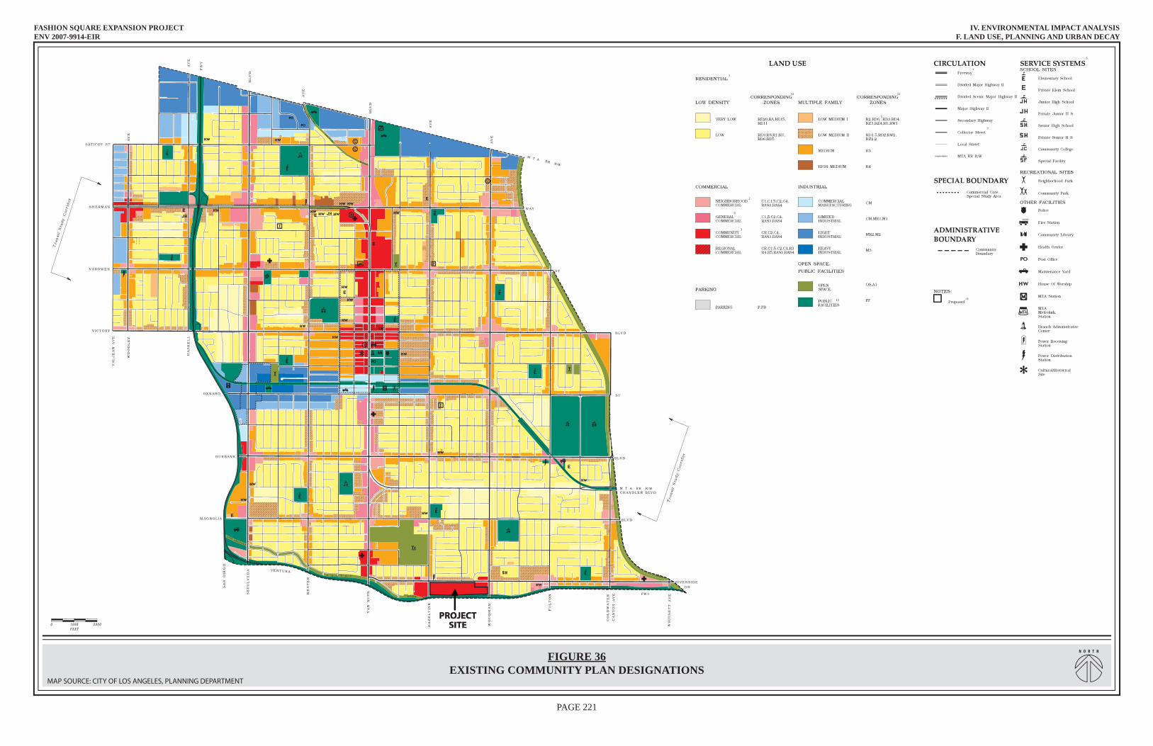
The primary land use plan for this area is the City of Los Angeles General Plan. The General Plan of the City of Los Angeles is a policy document originally adopted in 1974 that serves as a comprehensive strategy for long-term growth and development in the City. The General Plan responds to State and federal mandates to plan for the future. The City of Los Angeles used population forecasts provided by the Southern California Association of Governments (SCAG) for developing the General Plan to ensure consistency with other regional programs. California State law (Government Code Section 65300) requires that each city prepare and adopt a comprehensive, long-term general plan for its future development. This plan is mandated to include seven elements, including land use, circulation, housing, conservation, open space, noise and safety. In addition to these, State law permits cities to include optional elements in their general plans, thereby providing local governments with the flexibility to address the specific needs and unique character of their jurisdictions. The Los Angeles General Plan is comprised of eleven elements, including the seven mandated elements and four optional elements, include those for Air Quality and Service System. In addition, the General Plan is comprised of 35 local area plans, known as Community Plans, as well as plans for the Los Angeles World Airport and the Port of Los Angeles. The General Plan was updated and refined through adoption of the General Plan Framework Element in 1995, and re-adopted in August 2001. The Framework Element sets forth a citywide comprehensive long-range growth strategy. It defines citywide policies that will be implemented through subsequent amendments of the City's community plans, zoning ordinances, and other pertinent programs. In many respects, the Framework Element is an evolution of the original General Plan, often referred to as the Centers Concept, which was adopted in 1974 and is now superseded by the Framework. However, specific land use designations are determined by the community plans and the Framework does not supersede the more detailed community and specific plans, some of which were established prior to the Framework. The Van Nuys-North Sherman Oaks Community Plan, adopted in 1998 and last updated May 16, 2007, is the guiding community plan for the project site and surrounding area. The Community Plan identifies goals, objectives and policies related to the different land uses within the planning area. Development on the project site is subject to the Community Plan. The intent of the Community Plan is to promote an arrangement of land uses, circulation, and services that will encourage and contribute to the economic, social and physical health, safety, welfare and convenience of the people who live in the community. Major issues addressed in the Community Plan include preservation and protection of single-family neighborhoods and residential properties, enhancement of street frontages and community space through quality urban design, and retention and advancement of economic stability. According to the Van Nuys-North Sherman Oaks Community Plan, the project site is currently designated as Community Commercial (see Figure 36: Existing Community Plan Designations). The existing shopping center at the project site is consistent with this land use designation, as it
FASHION SQUARE EXPANSION PROJECTENV 2007-9914-EIR
IV. ENVIRONMENTAL IMPACT ANALYSISF. LAND USE, PLANNING AND URBAN DECAY
PAGE 221
FIGURE 36EXISTING COMMUNITY PLAN DESIGNATIONS
1
5
11 11
2
2
3
13
6
7
7
6
N O R T H
MAP SOURCE: CITY OF LOS ANGELES, PLANNING DEPARTMENT
PROJECTSITE
PROJECTPROJECTPROJECTSITESITESITE

FASHION SQUARE EXPANSION PROJECT IV. ENVIRONMENTAL IMPACT ANALYSIS ENV 2007-9914-EIR F. LAND USE, PLANNING AND URBAN DECAY
PAGE 222
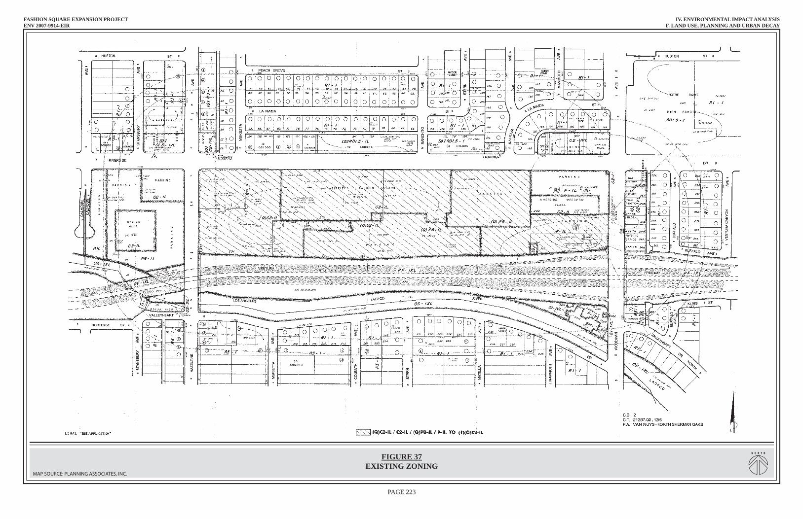
provides commercial uses consistent with the permitted corresponding zoning (e.g., retail, restaurant, etc.). The Community Commercial designation is within Height District 1L, which permits structures up to six stories in height. Surrounding properties are designated a mix of commercial, residential and public facility land uses through the Community Plan. Properties immediately to the west of the project site (across Hazeltine Avenue) and to the northeast (along the west frontage of Woodman Avenue at Riverside Drive) are designated Community Commercial with a 1L Height District. Properties immediately to the east (across Woodman Avenue) of the project site are designated Neighborhood Commercial. Properties immediately to the north of the project site (directly across Riverside Drive) are designated primarily Low Medium II (Multiple Family) Residential, and Low (Low Density) Residential. Properties to the northwest of the project site, north of Riverside Drive at the intersection of Hazeltine Avenue, are designated Neighborhood Commercial. Properties to the northeast of the project site, north of Riverside Drive and east of Woodman Avenue, are designated Low Medium II Residential and Senior High School. The residential land use designations are within Height District 1, which permits up to two stories. All Community Commercial land uses are assigned Height District 1L (up to six stories), while the Neighborhood Commercial is within Height District 1VL (up to three stories). The Community Plan includes goals, objectives and policies (collectively referred to as policy statements) for each major land use category (residential, commercial, industrial and public/institutional) as well as policy statements addressing community based services (i.e., police, fire and parks) and infrastructure (i.e., transportation). The Community Plan also addresses urban design and includes design policies for individual projects and overall community design and landscaping guidelines. Specific land use related policies that are applicable to the project are listed later in this section under the Consistency with Adopted Plans and Policies discussion. Identification of applicable policy statements and consistency discussions for urban design, community services and transportation are addressed in other topic-specific sections of this DEIR. Please refer to Sections IV: Environmental Impact Analysis: A-Aesthetics and Visual Resources, IV: Environmental Impact Analysis: H-Public Services: Fire and Police Protection, and IV: Environmental Impact Analysis: J-Traffic, Circulation and Access, respectively, this DEIR. (b) Los Angeles Municipal Code (LAMC) The project site is currently zoned (Q)C2-1L, C2-1L, (T)(Q)PB-1L, (Q)PB-1L, and P-1L (see Figure 37: Existing Zoning). All of the existing zones tied to the project site are permitted under the existing Community Commercial General Plan designation, which permits a range of commercial and related zones including CR, C1.5, C2, C4, P, and PB. The C2 zone permits a wide range of commercial retail uses to address community needs. In the C2 zone, uses may include small and large-scale retail, business/consumer services, offices, restaurants, certain automotive services and sales, churches, schools and theaters/auditoriums.

FASHION SQUARE EXPANSION PROJECTENV 2007-9914-EIR
IV. ENVIRONMENTAL IMPACT ANALYSISF. LAND USE, PLANNING AND URBAN DECAY
PAGE 223
FIGURE 37EXISTING ZONING
N O R T H
MAP SOURCE: PLANNING ASSOCIATES, INC.

FASHION SQUARE EXPANSION PROJECT IV. ENVIRONMENTAL IMPACT ANALYSIS ENV 2007-9914-EIR F. LAND USE, PLANNING AND URBAN DECAY
PAGE 224
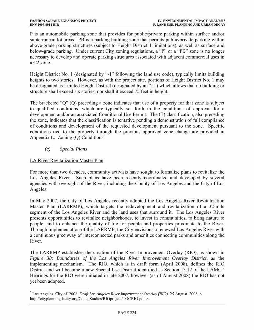
P is an automobile parking zone that provides for public/private parking within surface and/or subterranean lot areas. PB is a parking building zone that permits public/private parking within above-grade parking structures (subject to Height District 1 limitations), as well as surface and below-grade parking. Under current City zoning regulations, a “P” or a “PB” zone is no longer necessary to develop and operate parking structures associated with adjacent commercial uses in a C2 zone. Height District No. 1 (designated by “-1” following the land use code), typically limits building heights to two stories. However, as with the project site, portions of Height District No. 1 may be designated as Limited Height District (designated by an “L”) which allows that no building or structure shall exceed six stories, nor shall it exceed 75 feet in height. The bracketed “Q” (Q) preceding a zone indicates that use of a property for that zone is subject to qualified conditions, which are typically set forth in the conditions of approval for a development and/or an associated Conditional Use Permit. The (T) classification, also preceding the zone, indicates that the classification is tentative pending a demonstration of full compliance of conditions and development of the requested development pursuant to the zone. Specific conditions tied to the property through the previous approved zone change are provided in Appendix L: Zoning (Q) Conditions. (c) Special Plans LA River Revitalization Master Plan For more than two decades, community activists have sought to formalize plans to revitalize the Los Angeles River. Such plans have been recently coordinated and developed by several agencies with oversight of the River, including the County of Los Angeles and the City of Los Angeles. In May 2007, the City of Los Angeles recently adopted the Los Angeles River Revitalization Master Plan (LARRMP), which targets the redevelopment and revitalization of a 32-mile segment of the Los Angeles River and the land uses that surround it. The Los Angeles River presents opportunities to revitalize neighborhoods, to invest in communities, to bring nature to people, and to enhance the quality of life for people and properties proximate to the River. Through implementation of the LARRMP, the City envisions a renewed Los Angeles River with a continuous greenway of interconnected parks and amenities connecting communities along the River. The LARRMP establishes the creation of the River Improvement Overlay (RIO), as shown in Figure 38: Boundaries of the Los Angeles River Improvement Overlay District, as the implementing mechanism. The RIO, which is in draft form (April 2008), defines the RIO District and will become a new Special Use District identified as Section 13.12 of the LAMC.2 Hearings for the RIO were initiated in late 2007, however (as of August 2008) the RIO has not yet been adopted. 2 Los Angeles, City of. 2008. Draft Los Angeles River Improvement Overlay (RIO). 25 August 2008 < http://cityplanning.lacity.org/Code_Studies/RIOproject/TOCRIO.pdf >.
FASHION SQUARE EXPANSION PROJECTENV 2007-9914-EIR
IV. ENVIRONMENTAL IMPACT ANALYSISF. LAND USE, PLANNING AND URBAN DECAY
PAGE 225
FIG
UR
E 3
8B
OU
ND
AR
IES
OF
TH
E L
OS
AN
GE
LE
S R
IVE
R IM
PRO
VE
ME
NT
OV
ER
LAY
DIS
TR
ICT
NO
RT
H
M
AP
SOU
RCE:
RIV
ER IM
PRO
VEM
ENT
OVE
RLAY
, DRA
FT 2
007
FASHION SQUARE EXPANSION PROJECT IV. ENVIRONMENTAL IMPACT ANALYSIS ENV 2007-9914-EIR F. LAND USE, PLANNING AND URBAN DECAY
PAGE 226
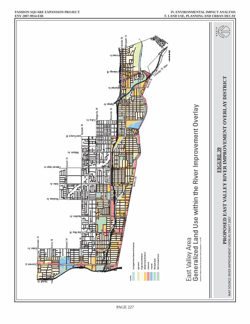
The RIO extends from Topanga Canyon Boulevard, located just west of the headwaters of the Los Angeles River, westerly and then southerly to the point at which it flows out of the City of Los Angeles at 26th Street in the Boyle Heights area. The RIO is applicable to an area adjacent to the River corridor that is roughly defined as between one block to a one-half mile on either side of the River. The Los Angeles River parallels the Ventura Freeway immediately south of the project site and then traverses to the north side of the freeway westerly of Hazeltine Avenue and the project site, as well as surrounding properties, are included within the new RIO District. It is the goal of the RIO to: (1) Promote sustainability of the Los Angeles River, the Greenway, the City of Los Angeles and the Region; (2) Establish a positive interface between Greenway adjacent property and the River Greenway; and (3) Create active pedestrian streets leading to the River. It is the intent of the LARRMP and RIO that the Los Angeles River Greenway becomes a public thoroughfare that seeks to promote increased levels of activity coupled with an increased awareness of the relationship between the urban lifestyle and the natural environment. Properties that are proximate to the Greenway have the unique opportunity to interface with the River and establish an orientation to both the street frontages and the Greenway. The street network within the RIO plays an important role in enhancing and supporting pedestrian, bicycle and vehicular mobility as a means of extending the City to the Greenway and vice versa. The RIO recognizes this role through the designation of “green streets” that link areas of the RIO District to the River Greenway. The RIO establishes requirements for private property and publicly owned facilities to comply with design categories addressing watershed, urban design and mobility alternatives. A project’s compliance is evaluated based on an established threshold of points. These requirements are presented in more detail in the impact analysis discussion of this section. The project site and surrounding properties are located within the East Valley Area of the RIO. The generalized land uses with in the proposed East Valley River Improvement Overlay is shown on Figure 39: Proposed East Valley River Improvement Overlay District. (2) Regional Plans While the local planning and regulatory documents identified above establish policy at a site-specific level, regional plans also establish operational guidelines for development to enhance quality of life and manage resources on a region-wide basis. Regional land use plans that address the project area include the Southern California Association of Governments’ (SCAG), Regional Comprehensive Plan (RCP), the Los Angeles County Congestion Management Plan (CMP) administered by the Los Angeles County Metropolitan Transportation Authority (MTA), and the Air Quality Management Plan (AQMP) administered by the South Coast Air Quality Management District (SCAQMD). These policy documents are described below. (a) SCAG Regional Comprehensive Plan The site is located within the planning area of the Southern California Association of Governments (SCAG), a joint powers agency with responsibilities pertaining to regional issues.
FASHION SQUARE EXPANSION PROJECTENV 2007-9914-EIR
IV. ENVIRONMENTAL IMPACT ANALYSISF. LAND USE, PLANNING AND URBAN DECAY
PAGE 227
FIG
UR
E 3
9PR
OPO
SED
EA
ST V
AL
LE
Y R
IVE
R IM
PRO
VE
ME
NT
OV
ER
LAY
DIS
TR
ICT
NO
RT
H
M
AP
SOU
RCE:
RIV
ER IM
PRO
VEM
ENT
OVE
RLAY
, DRA
FT 2
007
FASHION SQUARE EXPANSION PROJECT IV. ENVIRONMENTAL IMPACT ANALYSIS ENV 2007-9914-EIR F. LAND USE, PLANNING AND URBAN DECAY
PAGE 228
SCAG utilizes the Regional Comprehensive Plan and Guide (RCP) to address regional growth. The RCP is a policy document that sets broad goals for the Southern California region and identifies strategies for agencies at all levels of government to use as a decision-making guide with respect to significant issues and changes, including growth management, that are anticipated by the year 2015 and beyond. The RCP was adopted in 1996 and is currently undergoing an update process with a newly adopted RCP anticipated in 2008. Adopted policies related to land use are contained primarily within the Growth Management chapter of the RCP. The primary goal of the Growth Management Chapter is to address issues related to growth and land consumption by encouraging local land use actions that could ultimately lead to the development of an urban form that will help minimize development costs, save natural resources and enhance the quality of life in the region. In order to monitor implementation of the RCP, SCAG staff review EIRs of certain significant projects to determine consistency of such projects with applicable policies of the RCP and other related regional plans. Applicable land use related policies of the RCP that may be relevant to the Proposed Project are listed later in this section under the Consistency with Adopted Plans and Policies discussion. (b) SCAQMD Air Quality Management Plan The Air Quality Management Plan (AQMP) is the region’s plan for improving air quality in the region and is prepared by the South Coast Air Quality Management District (SCAQMD) and the SCAG. The AQMP provides policies and control measures that reduce emissions to attain both state and federal ambient air quality standards by their applicable deadlines. Although primarily an air quality management document, the AQMP indirectly addresses land use issues as the proximate location, type and intensity of land uses has a direct relationship to the generation of air pollutant emissions. Because the AQMP is derived from growth expectations defined in the RCP, from a land use perspective, development is generally consistent with the AQMP if it is consistent with the regional growth forecasts and policy statements defined through the RCP. See also Section IV: Environmental Impact Analysis: B-Air Quality, of this DEIR for a more detailed discussion of the AQMP. (c) MTA Congestion Management Plan The Congestion Management Program (CMP) is a state-mandated program that was enacted by the State Legislature with the passage of Proposition 111 in 1990 to address the impact of local growth on the regional transportation system. The County of Los Angeles Metropolitan Transportation Authority (MTA) developed the 2004 Congestion Management Program for Los Angeles County (July, 2004). The primary purpose of the CMP is to establish procedures for assessing and determining the potential impacts on designated monitoring locations (both intersections and roadway segments) on the CMP highway system. Although primarily a traffic congestion management document, the CMP indirectly addresses land use issues as the proximate location, type and intensity of land uses has a direct relationship to the generation of vehicle trips and traffic congestion. Because the CMP is derived from growth expectations defined in the RCP, from a land use perspective, development is generally consistent with the
FASHION SQUARE EXPANSION PROJECT IV. ENVIRONMENTAL IMPACT ANALYSIS ENV 2007-9914-EIR F. LAND USE, PLANNING AND URBAN DECAY
PAGE 229
AQMP if it is consistent with the regional growth forecasts and policy statements defined through the RCP. See also Sections IV: Environmental Impact Analysis: B-Air Quality and IV: Environmental Impact Analysis: J-Traffic, Circulation and Access of this DEIR for a more detailed discussion of the CMP. 2. THRESHOLDS OF SIGNIFICANCE Unless otherwise indicated, the thresholds of significance identified in this section and used to determine the proposed project environmental effects are based on direction from the Los Angeles CEQA Thresholds Guide (as adopted 2006). The following factors are set forth in the LA CEQA Thresholds Guide for consideration, on a case-by-case basis, of the significance of potential environmental impacts: Land Use Consistency
● Whether the proposal is inconsistent with the adopted land use/density designation in the Community Plan, redevelopment plan or specific plan for the site; and
● Whether the proposal is inconsistent with the General Plan or adopted environmental
goals or policies contained in other applicable plans. Land Use Compatibility
● The extent of the area that would be impacted, the nature and degree of impacts, and the type of land uses within that area;
● The extent to which existing neighborhoods, communities, or land uses would be
disrupted, divided or isolated, and the duration of the disruptions; and
● The number, degree, and type of secondary impacts to surrounding land uses that could result from implementation of the proposed project.
Urban Decay The LA CEQA Thresholds Guide does not identify criteria for determining the potential significance for urban decay. The criteria below were developed for the purpose of the Urban Decay study (see Appendix H: Urban Decay Report), and are derived from the discussion in the State CEQA Guidelines Sections 15358, 15064 and 15382. When a proposed development project is subject to CEQA, both direct and indirect (or “secondary”) impacts of the project on the physical environment must be analyzed.3 Economic and social impacts of a project, though they may be included in a CEQA document, are not to be
3 Section 15358. California Governor’s Office of Planning and Research (OPR). 2007 (as amended). California Environmental Quality Act: Guidelines. 1 May 2008 <http://ceres.ca.gov/ceqa/guidelines/>.
FASHION SQUARE EXPANSION PROJECT IV. ENVIRONMENTAL IMPACT ANALYSIS ENV 2007-9914-EIR F. LAND USE, PLANNING AND URBAN DECAY
PAGE 230
treated as “significant” impacts on the physical environment4, as defined.5 To the extent that there is a direct or indirect causal connection between a change in economic or social circumstances and a change in the physical environment, the economic or social change may be used to establish whether the physical change is “significant.”6 With this statutory and interpretive guidance in mind, the courts have recognized that there is a potential for a proposed new retail development to trigger economic competition with existing retailers in the project’s host community. If existing retailers are adversely affected by this competition, declines in sales could directly result in and/or lead to disinvestment, business closures, abandonment and other forms of physical deterioration that are indicative of “urban decay.” If the severity of this change in physical circumstances is so substantial that it adversely affects appropriate use of the area or otherwise threatens the public health, safety or general welfare, this situation may cross a threshold that defines a “significant impact” under CEQA, such that mitigation capable of reducing the impact on that physical environment must be considered. Thus, for urban decay to be an issue within the meaning of CEQA, there must first be an adverse economic circumstance that is likely to be caused by a Proposed Project. If such an adverse effect is identified, then the severity of this economic impact must be evaluated for its potential to cause a significant change in the physical environment (i.e., “decay”). 3. ENVIRONMENTAL IMPACTS a. Relevant Project Characteristics The Proposed Project includes the addition of 280,000 GLSF of new area of retail and restaurant uses represented by approximately 108,000 GLSF of remaining unbuilt entitled uses (per a previous approval in 1995) and an approval for an additional 172,000 GLSF (new entitlement under the current request). The actual building area proposed will be larger than the total gross leasable area. Accounting for mechanical/electrical equipment rooms, emergency access, tenant storage space, corridors, and other City requirements, 280,000 GLSF is equivalent to approximately 426,556 net square feet or approximately 482,740 gross square feet. It should be noted that GLSF is used throughout this EIR to define the overall project entitlement and as a basis for certain analysis (i.e., traffic) as appropriate. Net and gross square feet values, another way to define the size of the Proposed Project, are used for throughout the EIR as appropriate as the basis for certain analysis that rely on this level of information. For purposes of this EIR, and in accordance with the definitions provided in Section II: Project Description; C-Project Background of this EIR, the values of 280,000 GLSF, 426,556 net square feet, an 482,740 gross square feet, are the equivalent representation of the Proposed Project. Total new uses would include 240,000 GLSF (i.e., 355,227 gross SF) of new “in-line” retail space and 40,000 GLSF (i.e., 71,329 gross SF) of new restaurant space, in additional to approximately 1,235 new parking spaces to be contained in new parking structures.
4 Sections 15064 and 15382. California Governor’s Office of Planning and Research (OPR). 2007 (as amended). California Environmental Quality Act: Guidelines. 1 May 2008 <http://ceres.ca.gov/ceqa/guidelines/>. 5 “A substantial or potentially substantial adverse change in the environment.” (Public Resources Code § 21068). The focus on physical changes in the environment is further reinforced by §§ 21100 and 21151. 6 See, in general, CEQA Guidelines §§ 15131(a) and (b), and their associated discussion section. California Governor’s Office of Planning and Research (OPR). 2007 (as amended). California Environmental Quality Act: Guidelines. 1 May 2008 <http://ceres.ca.gov/ceqa/guidelines/>.
FASHION SQUARE EXPANSION PROJECT IV. ENVIRONMENTAL IMPACT ANALYSIS ENV 2007-9914-EIR F. LAND USE, PLANNING AND URBAN DECAY
PAGE 231
The Proposed Project involves a request for approval of the following entitlements:
● Zone Change from (Q)C2-1L, C2-1L, (T)(Q)PB-1L, (Q)PB-1L, and P-1L to (T)(Q)C2-1L
● Site Plan Review for the modification of two existing parking structures,
reconfiguration of site driveways and internal circulation, construction of 280,000 GLSF retail space within a new two-level structure, and construction of a new six-level and a four-level parking structures.
● Conditional Use Permit for construction of a “Major Development Project” (MDP) of
approximately 280,000 square feet (GLSF) which exceeds the established threshold of 100,000 square feet for non-residential uses (MDP)
● Conditional Use Permit for Commercial Corner7 development and deviation from
select development standard requirements including: (1) the 45-foot height limit to provide a building and parking structure with maximum height of 75 feet, which is no taller than the existing Macy’s building, (2) allowable hours of operation (7:00 a.m. to 11:00 p.m.) to permit uses from 5:30 a.m. to 12 midnight, (3) a requirement to provide a five foot landscaped area immediately adjacent to all street frontages; (4) the requirement to provide a minimum of fifty percent coverage with transparent windows along the first floor retail, and instead provide no glass along the Riverside Drive frontage; and (5) the restriction on tandem parking by providing tandem parking spaces in association with valet service.
● Zone Variance request to deviate from the 45-foot height limit of the Commercial
Corner regulations.
● Conditional Use Permit for the on-site sale and consumption of a full line of alcoholic beverages (CUB)
● Request for Shared Parking Review
● Zone Variance to reduce on-site parking below code requirements during
construction.
● Haul Route approval from the Building and Safety Commission for construction phase operations
7 Pursuant to section 12.03 of the Los Angeles Zoning Code a Commercial Corner development is, “[a]ny commercially used corner lot located in a C or M zoned in Height District Nos. 1, 1-l, 1-VL, or 1-XL, the lot line of which adjoins, is separated only by an alley adjacent to or is located across the street from, any portion of a lot zoned A or R, or improved with any residential use (except in an M zone)”. The only corner lot at the center is the lot containing the Bloomingdale’s departments store. This lot is not owned by the applicant and is not being affected by the Proposed Project. As such the project may not be subject to the Commercial Corner restrictions. However, in consultation with the Planning Department and the applicant it has been determined that because of the reciprocal access easements between the property owners on the site, the unified nature of the center, and for a worst case analysis of potential impacts for this DEIR, it will be assumed that the Proposed Project is subject to the Commercial Corner restrictions.
FASHION SQUARE EXPANSION PROJECT IV. ENVIRONMENTAL IMPACT ANALYSIS ENV 2007-9914-EIR F. LAND USE, PLANNING AND URBAN DECAY
PAGE 232
● Zone Variance to reduce on-site parking below code requirements during phase one of construction
● Other approval or permits necessary for the project including, but not limited to,
grading and building permits and other minor permits from the Departments of Building and Safety and Public Works, and other ancillary approvals or permits including, but not limited to, lot line adjustments, public works permits or variances, conditional use permits necessary to fully implement the Proposed Project.
The analysis assumes that the following Project Design Features are supported by the Proposed Project:
● The Proposed Project design seeks to promote a “high end” atmosphere, both through the type of tenants that will be located within the development and through the attention to architectural detail and landscape enhancements that promulgate a positive community ambience.
● The Proposed Project would incorporate architecture and landscape design features
that will be sensitive and non-intrusive to the surrounding residential community.
● The Proposed Project design incorporates features targeted to effectuate an appropriate transition between large-scale commercial development and the nearby single-family residential neighborhoods.
● The Proposed Project design incorporates a substantial setback and building stepback
(of the east parking structure) that ensures the project interfaces with residential uses would be compatible in scale by complying with required height limitations and incorporating building setbacks.
● The Proposed Project incorporates architectural building façade treatment and
landscaping that would break up and minimize the scale of both new and existing commercial structures fronting Riverside Drive.
● The Proposed Project building development would enhance and bolster the existing
land use buffer between the Ventura (US 101) Freeway and residential areas to the north. The shopping center development functions as a physical barrier from the freeway; new construction would further reinforce this buffer as the new east parking structure (south of Macy’s department store) would interrupt the line-of-sight of the freeway from the residential neighborhood, thereby reducing visual and noise effects from traffic along the freeway.
● The Proposed Project would promote community and neighborhood revitalization by
reinforcing the economic vitality of the project area, which in turn contributes toward the overall longevity of the residential neighborhoods.
FASHION SQUARE EXPANSION PROJECT IV. ENVIRONMENTAL IMPACT ANALYSIS ENV 2007-9914-EIR F. LAND USE, PLANNING AND URBAN DECAY
PAGE 233
● The Proposed Project, through the provision of a broader range of commercial retail and restaurant uses, would expand the availability of complementary commercial services, thereby maintaining the relationship of a commercial center within convenient proximity to community residents and reinforcing the community core concept.
● The Proposed Project would establish new commercial in-fill development within a
long established commercial anchor of the Sherman Oaks community, thereby resulting in a more efficient utilization of the limited land resources within the community and avoiding the potential displacement of other land uses.
● The Proposed Project would provide architectural, landscape, signage and access
improvements that would facilitate and distinguish the identity of the shopping center, while reflecting a modernized and distinctive character for the local community.
● The Proposed Project would support pedestrian activity through implementation of
site access and circulation improvements that minimize pedestrian conflicts through consolidated driveways and facilitating pedestrian accessibility through and increased number and improved design of mall entrances. Pedestrian friendliness would be enhanced through an extensive landscape treatment along the Riverside Drive and Hazeltine Avenue frontages that would create a pleasant street experience for pedestrians, encourage improved natural surveillance for a safer environment, and upgrade adjacent transit stops with attractive and comfortable street furniture.
● The Proposed Project and ongoing operation of the shopping center would provide
benefits equivalent to a Business Improvement District (BID) at the project site because the current mall association provides continued security, site monitoring for safety and general state of conditions, litter removal and maintenance of the physical facilities in a manner that mirrors, if not exceeds, the level of benefit that would be provided through an independent BID.
● The Proposed Project would be maintained as a closed mall campus with controlled
access points and operational hours.
● The Proposed Project would provide sufficient off-street parking for all building employees and anticipated patrons and visitors, thereby minimizing the potential for parking conflicts on off-site locations.
● The Proposed Project would incorporate a range of “green strategy” project design
features for water quality and hydrologic impacts that would include site design, source control, and treatment control BMPs that would be incorporated into the project.
● The Proposed Project would be located within close proximity (less than ½ mile) from other key community services, thereby adding to efficient development densities and community connectivity within the North Sherman Oaks community. Further, the Proposed Project development and other proximate services would be
FASHION SQUARE EXPANSION PROJECT IV. ENVIRONMENTAL IMPACT ANALYSIS ENV 2007-9914-EIR F. LAND USE, PLANNING AND URBAN DECAY
PAGE 234
conveniently accessible by local residents through an improved pedestrian access plan (i.e., cross walk at Matilija Avenue/Riverside Drive, and aesthetic treatment along Riverside Drive frontage), and accessible by more distant residents and employees through enhanced public transit options/amenities (i.e., upgraded bus stops, and coordinated bus schedules through MTA). Efficient development densities, accomplished through the consolidation and intensity of community services in the project area, contributes toward improved energy efficiency, vehicle trip reduction, vehicle miles traveled reduction, air pollutants reduction, and consistency with local and regional planning programs.
● The Proposed Project would be located within approximately 2 miles from the Metro
Orange Line (Express Busway) Valley College and Woodman Stations and adjacent to stops for the MTA Routes 96 (Downtown LA to Sherman Oaks) and 158 (Chatsworth to Sherman Oaks), and LADOT Dash Route for Van Nuys/Studio City, thereby making the project site a reasonable distance to access a range of alternative transportation options for public transportation access.
● The Proposed Project would develop and implement a construction waste
management plan (CWMP) that identifies the materials to be diverted from disposal and whether the materials will be sorted on-site or commingled. A minimum of 50% of the construction and demolition debris (exclusive of excavated soils and organic debris) would be recycled and/or salvaged. Excavated/exported soil would be transferred off-site as clean fill rather than landfilled. Organic landclearing debris (i.e., trees to be removed) would be processed as greenwaste. The CWMP would consider recycling cardboard, metal, brick, acoustical tile, concrete, plastic, clean wood, glass, gypsum wallboard, carpet and insulation and other similar materials used during the construction phase. The CWMP would designate a specific area(s) on the construction site for segregated or commingled collection of recyclable materials, and track recycling efforts throughout the construction process. Further, the CWMP would identify construction haulers and recyclers to handle the designated materials. Consistent with the intent to minimize waste, the CWMP would also establish a minimum project goal of 10% (post-consumer and ½ pre-consumer) for recycled content construction materials and identify material suppliers that can achieve this goal. During construction, the developer would ensure that the specified recycled content materials would be installed. The CWMP would also establish a project goal (10% minimum) for locally sourced construction materials and would identify materials and material suppliers that can achieve this goal. During construction, the developer would ensure that the specified local materials would be installed and quantify the total percentage of local materials installed.
● The Proposed Project includes the provision of a new community room which would
be made available to the surrounding Sherman Oaks community and offset a potential increase demand on recreational facilities for community meeting space needs.
● The Proposed Project would provide new landscaping treatment along the Hazeltine
Avenue, Riverside Drive and Woodman Avenue frontages that would enhance the
FASHION SQUARE EXPANSION PROJECT IV. ENVIRONMENTAL IMPACT ANALYSIS ENV 2007-9914-EIR F. LAND USE, PLANNING AND URBAN DECAY
PAGE 235
visual interest along these road way corridors and the shopping center perimeter through the addition of a sophisticated landscape treatment that includes color, depth, volume and variety.
● The Proposed Project would provide funds for the implementation of a Neighborhood
Protection Program (NPP) that focuses on the prevention of “cut through” traffic in the residential neighborhoods north of the project site (across Riverside Drive). The NPP would seek to maintain the quality of the residential area through traffic control and traffic calming measures.
● The Proposed Project would provide an improved pedestrian crossing at the proposed
Riverside Drive/Matilija Avenue intersection, a landscape-enhanced pedestrian corridor along Riverside Drive, and more efficient and safer site driveway entrances that strengthen community linkages to surrounding uses and support non-motorized vehicle travel options.
● The Proposed Project Landscape Plan will incorporate wall-hugging vines and
bamboo screening as CPTED strategies which function as graffiti deterrents, minimization of hidden spaces, and creation of more open area for natural surveillance.
● The Proposed Project would result in the addition of more building access points that
would improve public access and circulation throughout the mall and minimize walking distances from remote parking areas, thereby improving public safety (through natural access control, natural surveillance and territorial reinforcement features) and pedestrian activity (through improved convenience and accessibility).
● The Proposed Project would incorporate treatment control BMPs that will minimize
urban runoff and associated impacts to receiving water quality and specifically address the identified pollutants of concern. Many BMP alternatives can be easily integrated into planned landscaping, right-of-ways, and planned infrastructure. BMP alternatives that would be implemented with the Proposed Project include: (1) vegetated treatment BMPs, (2) onsite storage and reuse, (3) permeable paving, (4) roof top BMPs, and (5) media filters.
● The Proposed Project would incorporate a number of vegetated treatment BMPs,
including swales, filter strips, bioretention and planter boxes. When properly designed and maintained, vegetated BMPs are among the most effective, cost efficient treatment approaches for dry and wet-weather runoff. Treatment occurs through sedimentation, filtration, adsorption to organic matter, and vegetative uptake. Additionally, vegetated treatment systems would reduce runoff volumes through soil soaking, infiltration, and evapotranspiration. On-site implementation of these systems would be integrated into surface conveyances and on-site landscaping in innovative ways that provide dual-functional site amenities.
FASHION SQUARE EXPANSION PROJECT IV. ENVIRONMENTAL IMPACT ANALYSIS ENV 2007-9914-EIR F. LAND USE, PLANNING AND URBAN DECAY
PAGE 236
● The Proposed Project would incorporate permeable (porous) pavement material in pavement areas (such as roadways, driveways, parking areas, and walkways). The permeable (porous) pavement materials would allow water to drain down to the underlying soil and reduce the volume of wet weather urban runoff. The Proposed Project would incorporate a mix of porous concrete, pervious asphalt, pervious pavers, grass/gravel pavers, and crushed stone, into the landscape plan and design of surface parking areas as functionally appropriate.
● The Proposed Project would employ rooftop BMPs for filtering and/or capturing
stormwater in order to contribute toward the reduction of small storm events peaks and the overall runoff volume via inter-event evaporation and transpiration. Rooftop BMPs incorporated into the project design include planters and landscaping on the rooftop portion of the new parking structures, and hanging planters along the parking building tiers and along the Riverside Drive mall elevation.
● The Proposed Project would employ media filtration to separate and filter fine
particulates and associated pollutants from captured stormwater.
● The Proposed Project would provide bicycle racks at a ratio of 2% of the total number of parking spaces on-site, as well as lockers, changing rooms and showers inside the shopping center. A minimum of 20 additional bicycle spaces (in racks) would be provided at multiple locations through out the site. Four showers (two per each gender) would be provided in a dedicated shower facility area. Lockers would be provided in conjunction with the shower facilities.
● The Proposed Project would designate an area for recyclable collection and storage
that is appropriately sized and located in a convenient area to serve mall tenants. The Fashion Square Mall Association would consider employing cardboard balers, aluminum can crushers, recycling chutes and other waste management technologies to further enhance and manage a recycling program at the shopping center.
● The Proposed Project would install carbon monoxide and airflow measurement
equipment that would transfer the information to the HVAC system and/or Building Automation System to trigger corrective action, if applicable, and/or use the measurement equipment to trigger alarms that inform building operators or occupants of a possible deficiency in outdoor air delivery. Installation of such a system in areas where carbon monoxide concentrations may escalate (such as in the vicinity of loading docks or valet parking drop-offs) would improve both indoor and localized “hotspot” air quality.
The analysis assumes that the Proposed Project will be constructed and operated in accordance with all applicable codes, regulations and standard practices, including the following:
● The Proposed Project must obtain the appropriate approvals, including zone change, variances and conditional use permits, prior to commencing project development.
FASHION SQUARE EXPANSION PROJECT IV. ENVIRONMENTAL IMPACT ANALYSIS ENV 2007-9914-EIR F. LAND USE, PLANNING AND URBAN DECAY
PAGE 237
Attainment of such approvals shall in turn ensure that the Proposed Project is in full compliance with local codes, procedures and regulations.
● The Proposed Project shall comply with the draft RIO and/or adopted RIO in effect at
the time of project approval.
● In accordance with the SUSMP requirements, the Proposed Project shall meet (or exceed) all minimum site design and source control BMPs.
● The Proposed Project shall adopt an erosion and sediment control plan for the project
site during the construction phase that would employ strategies such as temporary and permanent seeding, mulching, earth dikes, silt fencing, sediment traps and sediment basins. The erosion and sediment control plan shall comply with U.S. Environmental Protection Agency (EPA) Document No. EPA 832/R-92-005 (September 1992), Storm Water Management for Construction Activities, Chapter 3 (or the local agency equivalent erosion and sedimentation control standards and codes) and shall address soil loss, stormwater runoff, wind erosion, sedimentation, and fugitive dust at a minimum. The erosion and sediment control plan shall contribute to minimizing water quality impacts and may indirectly minimize aesthetic effects during the construction phase.
● Consistent with California laws, the Proposed Project shall prohibit smoking in the
shopping center buildings, public areas, or exterior areas within 25 feet from entries, outdoor air intakes and operable windows, unless such areas are specifically designated and properly ventilated as a dedicated “smoking area”.
b. Project Impacts Based on the IS, potential impacts for a number of environmental issues were determined to be less than significant. The scope of the following analysis focuses only on those impacts that were determined through the NOP and IS process to have a potential significant environmental effect. Issues related to Land Use, Planning and Urban Decay that were determined to be less than significant, and not analyzed further, include: habitat/natural community conservation plans, or other approved local, regional, or state habitat conservation plan because there are no such plans that affect the project site. An explanation supporting this conclusion is provided in Section VI: Other Environmental Considerations: A-Effects Not Found To Be Significant of the DEIR. (1) Land Use Compatibility The determination of Land Use Compatibility includes a review of many environmental and policy factors. The analysis below focuses on a review of the Land Use Policies intended to ensure compatibility of adjacent uses. Analysis of physical factors which are related to Land Use Compatibility are provided elsewhere in this document. Specifically, discussion of visual compatibility is provided in Section IV: Environmental Impact Analysis: A-Aesthetics and Visual Resources. Discussion of air quality issues is provided in Section IV: Environmental
FASHION SQUARE EXPANSION PROJECT IV. ENVIRONMENTAL IMPACT ANALYSIS ENV 2007-9914-EIR F. LAND USE, PLANNING AND URBAN DECAY
PAGE 238
Impact Analysis: B-Air Quality. Discussion of noise compatibility is provided is Section IV: Environmental Impact Analysis: G-Noise. Discussion of land use impacts associated with traffic and circulation is provided in Section IV: Environmental Impact Analysis: J- Traffic, Circulation and Access.
(a) Type and Intensity of Use The project site is situated within an existing commercial area that buffers residential land uses to the north from the Ventura Freeway (south of the project site). The Proposed Project involves an addition of commercial retail/restaurant uses that are consistent with those that already occur at the project site. Hence, the Proposed Project would not introduce new uses or result in a substantial change in use of the subject property that would conflict with, or adversely impact, surrounding land uses. The existing use of the property is also consistent with land use patterns found elsewhere within the Community Plan area, as well as throughout the City of Los Angeles. The Proposed Project incorporates several project design features (PDFs) that will further ensure that the physical development is compatible with the surrounding community. Even with the proposed addition of 280,000 GLSF of commercial use, total development at the project site would be underutilized in comparison to the intensity of the ultimate use permitted through the current zoning. Revitalization and intensification of commercial uses at the currently underutilized site could ultimately serve to minimize the potential for land use conflicts because implementation of the Proposed Project offers an opportunity to enhance the integration of the shopping center with the surrounding uses. The Proposed Project would not exceed the development standards specified for this zone, except for minor variances requested to facilitate a more efficient project design as noted below. The floor area ratio of the shopping center at project’s completion would be approximately 1.13:1, which is substantially less than the permitted 1.5 FAR. Development of the Proposed Project at the existing shopping center would not physically disrupt, divide or isolate existing land uses in the project area or encroach upon residential uses, nor physically alter the overall character of the area. In fact, implementation of several of the PDFs could bring about a more cohesive development within the project site that affords improved access and linkages with the surrounding community and integrates visually with future green streets, creating a more pedestrian-friendly environment. This analysis considers both the direct and indirect effects of the Proposed Project on land use compatibility. Potential noise, aesthetic or access impacts are not, by themselves, considered land use compatibility impacts unless such impacts affect the functional capacity of adjacent uses. This land use analysis considers impacts such as noise, aesthetics and access only to the extent that they affect the ability of the adjacent land uses to continue their existing function. Direct impacts due to noise, aesthetics and access are addressed in greater detail in Sections IV: Environmental Impact Analysis: G-Noise, IV: Environmental Impact Analysis: A-Aesthetics and Visual Resources, and IV: Environmental Impact Analysis: J-Traffic, Circulation and Access of this DEIR, respectively.
FASHION SQUARE EXPANSION PROJECT IV. ENVIRONMENTAL IMPACT ANALYSIS ENV 2007-9914-EIR F. LAND USE, PLANNING AND URBAN DECAY
PAGE 239
The Proposed Project’s physical characteristics or associated activities would not prevent or substantively impair existing adjacent land uses to continue their function. Adjacent residential land uses would not be altered or physically disrupted due to the development of the Proposed Project.
(b) Hours of Operation To operate as proposed, the Proposed Project also requires CUP approval to allow the development to operate from 5:30 a.m. to 12:00 a.m. (midnight), rather than the current permitted hours of 7:00 a.m. to 11:00 p.m. Typical operating hours of the restaurants, which include both lunch and dinner service, would extend from approximately 10:00 a.m. to 11:00 p.m. Monday through Saturday, and 11:00 a.m. to 9:00 p.m. Sunday. However, on special occasions or holidays, the restaurant uses may be open from 5:30 a.m. to 12 midnight, consistent with the request for hours of operation overall for the shopping center. Although the requested operational hours would expand the length of time that the mall could be actively used during a single day, the extended hours are not anticipated to result in a significant change to the operational activity currently experienced at the shopping center. The expanded hours are primarily requested to accommodate the restaurant uses, which will be located on the south side of the mall. Retail stores, which are the primary use and attractant of patrons to the shopping center, would continue to operate under the existing store hours, except during special holiday hours.
(c) Consumption of Alcoholic Beverages Pursuant to LAMC Section 12.24.W1, a specific Conditional Use Permit, referred to as a CUB, is required for the on-site sale and consumption of a full line of alcoholic beverages. The requested CUB for on-site sale and consumption of alcohol is in conjunction only with the anticipated four new sit-down restaurants proposed with the Proposed Project. The sale of alcohol would be incidental to the main use of the established shopping center. A substantial concentration of facilities that sell alcoholic beverages does not exist in the immediate community. The addition of new restaurant uses at the project site that could serve alcoholic beverages is not anticipated to constitute an undue concentration of the sale and service of alcoholic beverages in the area. As required of any establishment offering alcoholic beverages, the sale and service of such beverages is age-restricted and would not pose an opportunity for underage students. Further, all restaurant activities, including the sale of alcoholic beverages, would take place indoors at restaurants at the shopping center. The sale and consumption (restricted to on-site) of alcoholic beverages in association with restaurant uses at the shopping center would not detrimentally affect nearby residential or school uses, and impacts would be less than significant.
FASHION SQUARE EXPANSION PROJECT IV. ENVIRONMENTAL IMPACT ANALYSIS ENV 2007-9914-EIR F. LAND USE, PLANNING AND URBAN DECAY
PAGE 240
(d) Construction Activities Construction activities can be a source of compatibility concerns. Construction of the Proposed Project would result in temporary disturbances associated with noise, localized air quality, aesthetics and traffic, which as a result may adversely impact surrounding land uses. Measures to address any adverse impacts related to these physical environments are discussed in their respective sections in this DEIR. However, construction impacts would be short-term and would be physically coordinated and scheduled to avoid and/or minimize to the extent reasonable disruption of nearby residents, local businesses and existing on-site commercial uses. Because of the precautions that would be taken to coordinate construction activities, and due to the short-term nature of such activities, potential land use impacts during the construction phase would be less than significant. (2) Urban Decay An analysis was completed to evaluate the potential for the operation of the Proposed Project to directly or indirectly cause “urban decay” of existing commercial retail businesses in the local area. This study, titled Analysis of Potential “Urban Decay” as a Consequence of the Proposed Expansion of the Westfield Fashion Square Shopping Center, Sherman Oaks, California, dated March 2008 and prepared by HR&A Advisors, Inc., is included in Appendix H: Urban Decay Report to this EIR. A summary and conclusions of the urban decay analysis are provided below. Urban decay is described as a chain reaction of store closures and long term vacancies, ultimately destroying existing neighborhoods and leaving decaying shells in their wake. Under some circumstances, urban decay can occur due to the natural evolution of community due to a decline in economy. In other cases, decay can occur in localized areas when the economic activity of a community shifts to different area and there is not enough economic demand to support both areas. In order to predict if a new development project may result in urban decay, it must be determined whether the new retail development will attract retail sales away from existing and/or other planned future retail centers to any significant degree. Also, if sales will be attracted away, it must be determined whether the severity of this change in economic circumstances will cause disinvestment such that it is reasonably foreseeable that significant business closures, abandonment or other forms of physical deterioration such that “decay” will result. Per CEQA Guidelines Section 15131, economic and social concerns by themselves are not considered physical impacts to the environment and do not need to be addressed through an EIR unless the impacts to social/economic circumstances leads to a measurable physical change to the environment. However, it could be argued that a project which competes with other existing commercial uses to the detriment of the viability of those uses and leads to urban decay, that a range of environmental impacts would be indirectly triggered, including a disruption of existing communities, and potential increase in crime within those areas undergoing urban decay. The analysis considered the local market area through a comparison of the relative growth in demand for retail goods, as measured by the change in supportable retail space for particular retail store categories, with the amount of proposed additions to the supply of retail space
FASHION SQUARE EXPANSION PROJECT IV. ENVIRONMENTAL IMPACT ANALYSIS ENV 2007-9914-EIR F. LAND USE, PLANNING AND URBAN DECAY
PAGE 241
through the Proposed Project and other recently approved, pending and foresable future projects. In particular, the analysis focused on whether the proposed amount of floor area in each major retail and dining use category planned for the Proposed Project would exceed the likely increase in demand for those uses within the relevant market area(s) around the shopping center, as measured by the anticipated growth in population and per capita personal income that would be available for expenditure on specified retail goods and dining opportunities. The analysis considered the regional market area (RMA) of the Proposed Project, which consists of the land area represented by all or a portion of 26 ZIP codes comprising a radius of approximately 5 miles and including all or portions of the following cities and communities: Sherman Oaks; Toluca Lake; North Hollywood; Valley Village; Encino; Studio City; Van Nuys; Valley Glen; Tarzana; Bel Air Estates; Mount Olympus; Trousdale Estates; Beverly Glen; Brentwood; Hollywood; Hollywood Hills; City of Beverly Hills; and City of Burbank. For Eating and Drinking Facilities, it is likely that patrons of the dinner restaurants will come from a more localized area than the RMA defined above; therefore, the market area for all of the Eating and Drinking Facilities space was defined as a more limited three-mile radius around the existing shopping center. Based on an analysis of this RMA, the net addition of 240,000 GLSF of shopper goods space in the Proposed Project is projected to capture 43% of the market shares of the anticipated growth in demand for Apparel and Accessories space; 9% of the Furniture, Furnishings and Appliances space; and 8% of the Specialty or “Other” retail space over the period between the years 2007 through 2012. The proposed net addition of Eating and Drinking Facility space is projected to capture 8% of the market shares of the anticipated growth in the demand for Fast Food Restaurants and 25% of the Restaurants with Alcohol space. The analysis concludes that, while the Proposed Project may add some new competitive retail and restaurant facilities to the regional market area, there would be no reasonable likelihood that the operation of the Proposed Project would result in significant adverse economic competition within the regional market area to the degree that this competition would lead to urban decay. Since the Proposed Project would not result in an adverse economic circumstance, the economic effects of the project would not create significant changes in the physical environment (i.e., decay). The Proposed Project would not result in a significant effect to the environment, as defined by CEQA. (3) Zoning (LAMC) Compliance
(a) Zoning The Proposed Project includes a request for a zone change to (T)(Q)C2-1L, which is consistent with the existing Community Commercial designation of the General Plan/Community Plan, over the entire project site to consolidate and make consistent zoning across the project site. A zone change, pursuant to LAMC Section 12.32, is requested to implement the Proposed Project as proposed. The requested zone change is from the existing mix of (T)(Q)C2-1L,
FASHION SQUARE EXPANSION PROJECT IV. ENVIRONMENTAL IMPACT ANALYSIS ENV 2007-9914-EIR F. LAND USE, PLANNING AND URBAN DECAY
PAGE 242
(Q)C2-1L, C2-1L, (T)(Q)PB-1L, (Q)PB-1L, and P-1L to (T)(Q)C2-1L. This request would not necessarily provide for a change in the nature of the land uses on-site, but rather would consolidate and make consistent the zoning across the entire shopping center property and eliminate the patchwork zoning currently governing the site. Specifically, a zone change of approximately 3.8 acres currently zoned as P-1L and approximately 9.8 acres currently zoned as (Q)PB-1L to (T)(Q)C2-1L is requested to facilitate the development of the proposed retail, restaurant and parking uses. Additionally, a zone change of approximately 13.3 acres currently zoned as C2-1L and (Q)C2-1L to (T)(Q)C2-1L is requested to facilitate the development of retail and restaurant uses. Approximately 1.9 acres of the project site is currently zoned (T)(Q)C2-1L and would not require a zone change. However, for consistency of “Q” conditions across the site, this area will be rezoned with the new “Q” conditions applied to the rest of the site. The Proposed Project would not exceed the development standards specified for this zone, except for minor variances requested to facilitate a more efficient project design as noted below. At a total requested buildout entitlement of 280,000 GLSF, the floor area ratio of the E.P. would be approximately 1.13:1, and would be substantially less than the permitted 1.5 FAR. Major development projects exceeding 100,000 SF are permitted in the C2 zone by CUP, through which specific design and/or operational conditions may be imposed and enforced by the City. The CUP process is discussed below. Because the Proposed Project is consistent with the permitted uses of the C2 zone, complies with the adopted development standards, and would be appropriately conditioned through a CUP for Major Development Project, the Proposed Project would have a less than significant impact with regard to zoning compliance.
(b) Major Development Project – Conditional Use Permit While the retail uses proposed with the Proposed Project are consistent and permitted with the requested zone change and existing general plan designation, a Conditional Use Permit (CUP) for a “Major Development Project” is requested. Per LAMC Section 12.24.U.14, a Major Development Project (MDP) CUP is required for construction of any project greater than 100,000 square feet of non-residential development necessary to ensure that the development is compatible with the surrounding neighborhoods. As the Proposed Project would exceed 100,000 square feet of commercial development, the MDP CUP requirement is triggered. In approving any conditional use, the decision-maker must find that the proposed use is proper in relation to adjacent uses, will not be materially detrimental to the immediate neighborhood, and will be in harmony with the General Plan. By definition, the purpose of such a CUP is to afford decision-makers the opportunity to impose any special conditions deemed necessary to protect the best interests of the surrounding property or neighborhood, to ensure that the development is compatible with the surrounding properties or neighborhood, and to lessen or prevent any detrimental effect on the surrounding property or neighborhood or to secure appropriate development in harmony with the objectives of the General Plan/Community Plan. The
FASHION SQUARE EXPANSION PROJECT IV. ENVIRONMENTAL IMPACT ANALYSIS ENV 2007-9914-EIR F. LAND USE, PLANNING AND URBAN DECAY
PAGE 243
Proposed Project, conditioned in accordance with the intent of the MDP CUP, would result in a less than significant impact related to land use consistency and compatibility. A CUP related to Commercial Corner development is also requested and is discussed separately below in association with project variances.
(c) Hours of Operation – Conditional Use Permit To operate as proposed, the Proposed Project also requires through the CUP approval to allow the development to operate from 5:30 a.m. to 12:00 a.m. (midnight), rather than the current permitted hours of 7:00 a.m. to 11:00 p.m. Typical operating hours of the restaurants, which include both lunch and dinner service, would extend from approximately 10:00 a.m. to 11:00 p.m. Monday through Saturday, and 11:00 a.m. to 9:00 p.m. Sunday. However, on special occasions or holidays, the restaurant uses may be open from 5:30 a.m. to 12 midnight, consistent with the request for hours of operation overall for the shopping center. Although the requested operational hours would expand the length of time that the mall could be actively used during a single day, the extended hours are not anticipated to result in a significant change to the operational activity currently experienced at the shopping center. The expanded hours are primarily requested to accommodate the restaurant uses, which will be located on the south side of the mall. Retail stores, which are the primary use and attractant of patrons to the shopping center, would continue to operate under the existing store hours, except during special temporary extended holiday hours (which would be consistent with the overall operational hours of the shopping center).
(d) Consuption of Alcoholic Berverages – Conditional Use Permit Pursuant to LAMC Section 12.24.W1, a specific Conditional Use Permit, referred to as a CUB, is required for the on-site sale and consumption of a full line of alcoholic beverages. The requested CUB for on-site sale and consumption of alcohol is in conjunction with new sit-down restaurants proposed with the Proposed Project and would be incidental to the main use of the established shopping center. The request for on-site sale and consumption of alcoholic beverages would provide for both a full line of alcoholic beverages and “wine and beer only” in conjunction with new restaurant and Dining Terrace uses, respectively, within the shopping center. Such restaurant uses would be incidental to the main shopping center use at the project site and would not be a separate stand alone use. Hence, the operation of the restaurants would be within the overall umbrella of operations defined for the shopping center. A substantial concentration of restaurant facilities that sell alcoholic beverages does not exist in the immediate (i.e., one-quarter mile radius) community. Currently, there are three restaurants and one store within 600 feet of the project site that sell a full line of alcoholic beverages. Two of these restaurants, Bloomingdale’s 59th & Lex and California Pizza Kitchen, are located at the shopping center. Up to 28,000 GLSF of the total 40,000 GLSF of new restaurant uses would be permitted to serve alcoholic beverages. This increase in alcohol-serving restaurant area is not
FASHION SQUARE EXPANSION PROJECT IV. ENVIRONMENTAL IMPACT ANALYSIS ENV 2007-9914-EIR F. LAND USE, PLANNING AND URBAN DECAY
PAGE 244
anticipated to constitute an undue concentration of the sale and service of alcoholic beverages in the area. Residential properties are located across Riverside Drive from the subject site. However, the shopping center is not known to have detrimentally affected the nearby residential properties due to those uses that include the sale and service of alcoholic beverages. The only school within a potential area of influence is the Notre Dame High School located at the northeast corner of the Riverside Drive and Woodman Avenue intersection. As required of any establishment offering alcoholic beverages, the sale and service of such beverages is age-restricted and would not pose an opportunity for underage students. Further, all restaurant activities, including the sale of alcoholic beverages, would take place indoors at the shopping center. The sale and consumption (restricted to on-site) of alcoholic beverages in association with restaurant uses at the shopping center would not detrimentally affect nearby residential or school uses, and impacts would be less than significant.
(e) Variances Although the Proposed Project would be in substantial compliance with the permitted uses and development standards of the C2 zone (see discussion above), several minor variances are requested to facilitate a more efficient project design. Some of these variances are addressed through the Conditional Use Permit process, in particular that associated with a “Commercial Corner”, while other variances would be addressed as deviations to the development standards associated with the C2 zone. While the Commercial Corner designation may not apply to the site since the legal parcel on which the project is located does not extend to the separate parcels at Riverside Drive and Woodman Avenue or Riverside Drive and Hazeltine Avenue, the Proposed Project application conservatively assumes the applicability of the Commercial Corner designation due to: (1) the functional integration of the project center with the Bloomingdale’s store located on the parcel at the corner of Riverside Drive and Hazeltine Avenue; (2) the commercial zoning designation; and (3) the relationship of the site to residential properties located north of the site, across Riverside Drive. The Commercial Corner designation relates to the site proximity and relationship to the corner intersections of Riverside Drive and Woodman Avenue and Riverside Drive and Hazeltine Avenue. Pursuant to LAMC Section 12.24.W27, for Commercial Corner developments not in conformance with the requirements established in LAMC Sections 12.22.A23(a)(2), 12.22.A23(a)(4)(i), 12.22.A23(a)(10)(i), and 12.22.A23(b)(3), a CUP is required to implement the Proposed Project. The CUP will address development standards of the “Commercial Corner” designation triggered by the location of the Bloomingdale’s department store, from: (1) the 45-foot height limit to provide a building and parking structure with maximum height not to exceed 75 feet, and which would be no greater than the existing Macy’s building with a maximum elevation of 722 feet above sea level, (2) allowable hours of operation (7:00 a.m. to 11:00 p.m.) to permit uses from 5:30 a.m. to 12 midnight, (3) a requirement to provide a five foot landscaped area immediately adjacent to all street frontages; (4) the requirement to provide a minimum of fifty percent transparent windows along the first floor retail by providing approximately no glass
FASHION SQUARE EXPANSION PROJECT IV. ENVIRONMENTAL IMPACT ANALYSIS ENV 2007-9914-EIR F. LAND USE, PLANNING AND URBAN DECAY
PAGE 245
along the Riverside Drive frontage; and (5) the restriction on tandem parking by providing tandem parking spaces in association with valet services. The Proposed Project proposes modifications to the current access and internal circulation of the project site (see Section II: Project Description, for a detailed description of the proposed access and circulation). Under the proposed site plan, a deviation from a required five foot landscape area along all adjacent street frontages is requested to facilitate the new access plan and accommodate pedestrian access and improved traffic flow. Although the five foot landscape area along the street frontage is not proposed, the Proposed Project proposes an enhanced landscape program along street frontages that incorporates the building façade and planters along the building perimeter. A detailed discussion of the proposed landscape program is provided in Section IV: Environmental Impact Analysis: A-Aesthetics and Visual Resources of this DEIR. Even with granting of a variance to omit a five foot landscaped area along street frontages, through implementation of the proposed Landscape Plan, the Proposed Project meets the intent of providing adequate landscaping along street frontages. The variances include a request to exceed the 45-foot height limit associated with a parcel identified as a Commercial Corner. The intent of such a height restriction is to minimize the massing at key commercial corners, thereby improving visibility and reducing building mass at key intersections. Existing buildings already developed on the project site, including the mall buildings and parking structures, exceed the 45-foot height limit. The Proposed Project entails construction of new structures that would be consistent with the 75 foot maximum height of the existing buildings. Additionally, the new construction would be located along the south half of the project site and would not be physically situated at the actual corners of the property that abut Riverside Drive. Ultimately, the existing building elevations at the Riverside Drive intersections of Hazeltine Avenue and Woodman Avenue would not be altered from what is currently observed. As an exceedence of the 45-foot height limit is an existing condition and the Proposed Project does not include a proposal to modify any portion of the building elevations that are located directly at the qualifying commercial corners, a deviation of this height restriction would be less than significant. Because the findings can be made that the requested site plan and building design variances can be supported without detriment to the environment (as demonstrated above), approval and implementation of the requested variances related to building height, landscaped areas, parking, operational hours and building facade treatments would be less than significant.
(f) Other LAMC Approvals Shared Parking, pursuant to LAMC Section 12.24.X20, is requested to accommodate a range of varied commercial uses. Prior development approvals at the shopping center (under ZA-95-0899-CUZ and CPC-94-0287-ZC) established a parking requirement for the entire site at 4.5 parking spaces per 1,000 square feet of GLSF which is applicable, but not limited to, retail, restaurant, and office uses. However, the project includes a request for Shared Parking to provide parking at a ratio of up to 4.5 parking spaces per 1,000 GLSF, providing approximately 5,148 parking spaces across the entire site.
FASHION SQUARE EXPANSION PROJECT IV. ENVIRONMENTAL IMPACT ANALYSIS ENV 2007-9914-EIR F. LAND USE, PLANNING AND URBAN DECAY
PAGE 246
Because the Proposed Project proposes an on-site parking ratio of up to 4.5 parking spaces per 1,000 SF of retail use, which is less than the current code requirement, a Shared Parking review and approval is required. Project parking impacts are addressed in Section IV: Environmental Impact Analysis: J-Traffic, Circulation and Access of this DEIR. As discussed in that section, the analysis concludes that potential impacts due to a shared parking program are less than significant because adequate parking will be provided to accommodate the proposed uses under the reduced parking requirements. Since adequate parking is available, potential land use conflicts that could arise from project users parking off-site along local residential streets are not anticipated. A haul route during the construction phase will be reviewed, and established prior to the initiation of demolition and/or construction to accommodate the export of approximately 147,016 cubic yards of earth and transport of building materials. The potential impacts associated with a future haul route are discussed in Section IV: Environmental Impact Analysis: J-Traffic, Circulation and Access, and were determined to be less than significant. In summary, with approval of the requested entitlements identified above, continued use of the project site for retail/restaurant commercial uses under the Proposed Project would be in accordance with zoning regulations and result in a less than significant impact relative to zoning. (4) Consistency with Applicable Plans and Policies (a) Van Nuys-North Sherman Oaks Community Plan As discussed previously, the Community Plan designates the Proposed Project site as Community Commercial. Continued use of the project site for shopping center uses (including retail, restaurant and related parking) would be consistent with this land use designation, as would be the requested underlying zone change to (T)(Q)C2-1L, which is a compatible zone under the Community Commercial designation. The Proposed Project is consistent with the adopted land use and density designation for the subject project and would not result in impact relevant to land use consistency as determined by the adopted Community Plan. However, a project must also be consistent with the related goals and policies of the Community Plan. This section assesses the Proposed Project’s consistency with the applicable policy statements contained within the Community Plan. The Proposed Project does not propose any change to adopted Plans or policies, nor reclassification of applicable designations. The applicable land use related goals, objectives and policies of the Van Nuys-North Sherman Oaks Community Plan are provided in Table 20: Consistency with Community Plan Land Use Related Goals, Objectives and Policies, along with a discussion of the project consistency with each applicable component.
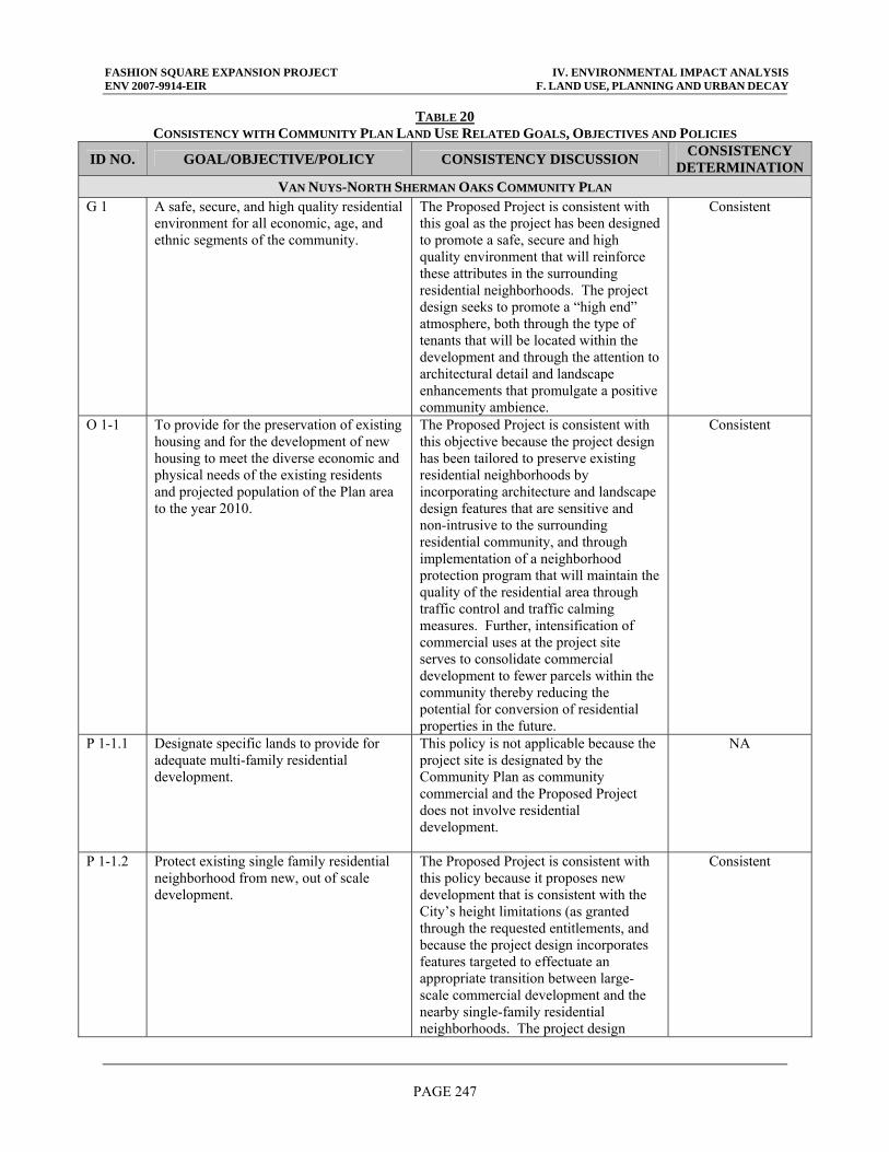
FASHION SQUARE EXPANSION PROJECT IV. ENVIRONMENTAL IMPACT ANALYSIS ENV 2007-9914-EIR F. LAND USE, PLANNING AND URBAN DECAY
PAGE 247
TABLE 20 CONSISTENCY WITH COMMUNITY PLAN LAND USE RELATED GOALS, OBJECTIVES AND POLICIES
ID NO. GOAL/OBJECTIVE/POLICY CONSISTENCY DISCUSSION CONSISTENCY DETERMINATION
VAN NUYS-NORTH SHERMAN OAKS COMMUNITY PLAN G 1 A safe, secure, and high quality residential
environment for all economic, age, and ethnic segments of the community.
The Proposed Project is consistent with this goal as the project has been designed to promote a safe, secure and high quality environment that will reinforce these attributes in the surrounding residential neighborhoods. The project design seeks to promote a “high end” atmosphere, both through the type of tenants that will be located within the development and through the attention to architectural detail and landscape enhancements that promulgate a positive community ambience.
Consistent
O 1-1 To provide for the preservation of existing housing and for the development of new housing to meet the diverse economic and physical needs of the existing residents and projected population of the Plan area to the year 2010.
The Proposed Project is consistent with this objective because the project design has been tailored to preserve existing residential neighborhoods by incorporating architecture and landscape design features that are sensitive and non-intrusive to the surrounding residential community, and through implementation of a neighborhood protection program that will maintain the quality of the residential area through traffic control and traffic calming measures. Further, intensification of commercial uses at the project site serves to consolidate commercial development to fewer parcels within the community thereby reducing the potential for conversion of residential properties in the future.
Consistent
P 1-1.1 Designate specific lands to provide for adequate multi-family residential development.
This policy is not applicable because the project site is designated by the Community Plan as community commercial and the Proposed Project does not involve residential development.
NA
P 1-1.2 Protect existing single family residential neighborhood from new, out of scale development.
The Proposed Project is consistent with this policy because it proposes new development that is consistent with the City’s height limitations (as granted through the requested entitlements, and because the project design incorporates features targeted to effectuate an appropriate transition between large-scale commercial development and the nearby single-family residential neighborhoods. The project design
Consistent
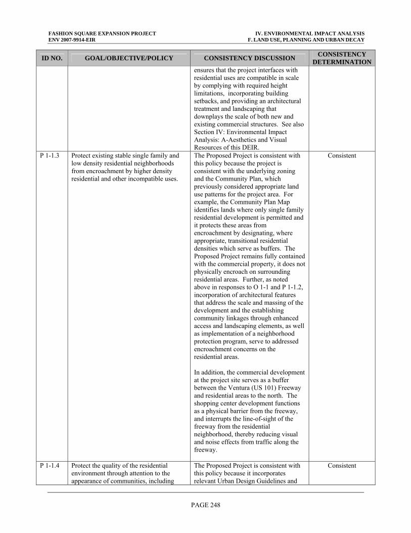
FASHION SQUARE EXPANSION PROJECT IV. ENVIRONMENTAL IMPACT ANALYSIS ENV 2007-9914-EIR F. LAND USE, PLANNING AND URBAN DECAY
PAGE 248
ID NO. GOAL/OBJECTIVE/POLICY CONSISTENCY DISCUSSION CONSISTENCY DETERMINATION
ensures that the project interfaces with residential uses are compatible in scale by complying with required height limitations, incorporating building setbacks, and providing an architectural treatment and landscaping that downplays the scale of both new and existing commercial structures. See also Section IV: Environmental Impact Analysis: A-Aesthetics and Visual Resources of this DEIR.
P 1-1.3 Protect existing stable single family and low density residential neighborhoods from encroachment by higher density residential and other incompatible uses.
The Proposed Project is consistent with this policy because the project is consistent with the underlying zoning and the Community Plan, which previously considered appropriate land use patterns for the project area. For example, the Community Plan Map identifies lands where only single family residential development is permitted and it protects these areas from encroachment by designating, where appropriate, transitional residential densities which serve as buffers. The Proposed Project remains fully contained with the commercial property, it does not physically encroach on surrounding residential areas. Further, as noted above in responses to O 1-1 and P 1-1.2, incorporation of architectural features that address the scale and massing of the development and the establishing community linkages through enhanced access and landscaping elements, as well as implementation of a neighborhood protection program, serve to addressed encroachment concerns on the residential areas. In addition, the commercial development at the project site serves as a buffer between the Ventura (US 101) Freeway and residential areas to the north. The shopping center development functions as a physical barrier from the freeway, and interrupts the line-of-sight of the freeway from the residential neighborhood, thereby reducing visual and noise effects from traffic along the freeway.
Consistent
P 1-1.4 Protect the quality of the residential environment through attention to the appearance of communities, including
The Proposed Project is consistent with this policy because it incorporates relevant Urban Design Guidelines and
Consistent
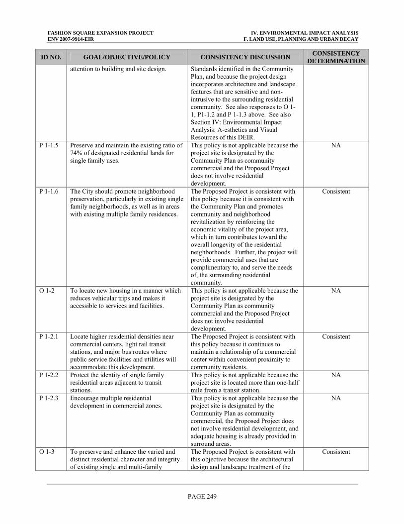
FASHION SQUARE EXPANSION PROJECT IV. ENVIRONMENTAL IMPACT ANALYSIS ENV 2007-9914-EIR F. LAND USE, PLANNING AND URBAN DECAY
PAGE 249
ID NO. GOAL/OBJECTIVE/POLICY CONSISTENCY DISCUSSION CONSISTENCY DETERMINATION
attention to building and site design. Standards identified in the Community Plan, and because the project design incorporates architecture and landscape features that are sensitive and non-intrusive to the surrounding residential community. See also responses to O 1-1, P1-1.2 and P 1-1.3 above. See also Section IV: Environmental Impact Analysis: A-esthetics and Visual Resources of this DEIR.
P 1-1.5 Preserve and maintain the existing ratio of 74% of designated residential lands for single family uses.
This policy is not applicable because the project site is designated by the Community Plan as community commercial and the Proposed Project does not involve residential development.
NA
P 1-1.6 The City should promote neighborhood preservation, particularly in existing single family neighborhoods, as well as in areas with existing multiple family residences.
The Proposed Project is consistent with this policy because it is consistent with the Community Plan and promotes community and neighborhood revitalization by reinforcing the economic vitality of the project area, which in turn contributes toward the overall longevity of the residential neighborhoods. Further, the project will provide commercial uses that are complimentary to, and serve the needs of, the surrounding residential community.
Consistent
O 1-2 To locate new housing in a manner which reduces vehicular trips and makes it accessible to services and facilities.
This policy is not applicable because the project site is designated by the Community Plan as community commercial and the Proposed Project does not involve residential development.
NA
P 1-2.1 Locate higher residential densities near commercial centers, light rail transit stations, and major bus routes where public service facilities and utilities will accommodate this development.
The Proposed Project is consistent with this policy because it continues to maintain a relationship of a commercial center within convenient proximity to community residents.
Consistent
P 1-2.2 Protect the identity of single family residential areas adjacent to transit stations.
This policy is not applicable because the project site is located more than one-half mile from a transit station.
NA
P 1-2.3 Encourage multiple residential development in commercial zones.
This policy is not applicable because the project site is designated by the Community Plan as community commercial, the Proposed Project does not involve residential development, and adequate housing is already provided in surround areas.
NA
O 1-3 To preserve and enhance the varied and distinct residential character and integrity of existing single and multi-family
The Proposed Project is consistent with this objective because the architectural design and landscape treatment of the
Consistent
FASHION SQUARE EXPANSION PROJECT IV. ENVIRONMENTAL IMPACT ANALYSIS ENV 2007-9914-EIR F. LAND USE, PLANNING AND URBAN DECAY
PAGE 250
ID NO. GOAL/OBJECTIVE/POLICY CONSISTENCY DISCUSSION CONSISTENCY DETERMINATION
neighborhoods. new construction and existing building facades would establish a community-friendly scale that creates an appropriate interface with existing residential neighborhoods to the north and south, and other commercial development in the project site vicinity. See also responses G1, O 1-1, P 1-1.2, P 1-1.3, and P 1-1.4 above. See also Section IV: Environmental Impact Analysis: A-Aesthetics and Visual Resources of this DEIR.
P 1-3.1 Require a high degree of architectural compatibility with articulated landscaping for new in-fill development to protect the character and scale of existing residential neighborhoods.
The Proposed Project is consistent with this policy because the architectural design and landscape treatment of new construction and existing building facades would establish a community-friendly scale that creates an appropriate interface with existing residential neighborhoods to the north and south. The proposed landscaping concept provides for an enhanced and interesting views along the project perimeter by adding color, depth, volume and variety to the border street frontages. See also responses G1, O 1-1, P 1-1.2, P 1-1.3, and P 1-1.4 above. See also Section IV: Environmental Impact Analysis: A-Aesthetics and Visual Resources of this DEIR.
Consistent
P 1-3.2 Consider factors such as neighborhood character and identity, compatibility of land uses, impact on livability, impacts on services and public facilities, and impacts on traffic levels when changes in residential densities are proposed.
This policy is not applicable because the project site is designated by the Community Plan as community commercial and the Proposed Project does not involve residential development.
NA
O 1-4 To preserve and enhance neighborhoods with a distinctive and significant historical character.
This policy is not applicable because the project site is not located within, nor adjacent to, a neighborhood of known distinctive or significant historical character.
NA
P 1-4.1 Encourage the identification and documentation of the area's historic resources.
This policy is not applicable because the project site, nor existing development, is not recognized an historic resource.
NA
O 1-5 To promote and ensure the provision of adequate housing for all persons regardless of income, age, or ethnic background.
This policy is not applicable because the project site is designated by the Community Plan as community commercial and the Proposed Project does not involve residential development.
NA
P 1-5.1 Promote greater individual choice in type, quality, price, and location of housing.
This policy is not applicable because the project site is designated by the Community Plan as community
NA

FASHION SQUARE EXPANSION PROJECT IV. ENVIRONMENTAL IMPACT ANALYSIS ENV 2007-9914-EIR F. LAND USE, PLANNING AND URBAN DECAY
PAGE 251
ID NO. GOAL/OBJECTIVE/POLICY CONSISTENCY DISCUSSION CONSISTENCY DETERMINATION
commercial and the Proposed Project does not involve residential development.
P 1-5.2 Promote housing in mixed use projects in transit corridors.
This policy is not applicable because the project site is designated by the Community Plan as community commercial and the Proposed Project does not involve residential development. Further, the project site is not located along a significant transit corridor.
NA
P 1-5.3 Ensure that new housing opportunities minimize displacement of the residents.
This policy is not applicable because the project site is designated by the Community Plan as community commercial and the Proposed Project does not involve residential development.
NA
P 1-5.4 Provide for development of townhouses and other similar condominium type housing units to increase home ownership options.
This policy is not applicable because the project site is designated by the Community Plan as community commercial and the Proposed Project does not involve residential development.
NA
G 2 A strong and competitive commercial sector which best serves the needs of the community through maximum efficiency and accessibility while reserving the historic commercial and cultural character of the community.
The Proposed Project is consistent with this goal because a key objective of the project is to enhance the long-term sustainability of the shopping center through a stronger (expanded) commercial base and by responding to community needs through a broader variety of commercial and restaurant uses. The project would be integrated with surrounding land uses through sensitive site planning and building design to ensure that the existing character is retained and complemented.
Consistent
O 2-1 To conserve and strengthen viable commercial development.
The Proposed Project is consistent with this objective because a key goal of the project is to enhance and revitalize the shopping center through physical site improvements and the intensification and diversification of commercial uses on-site. The shopping center has been a key commercial component of the Sherman Oaks community since the 1960’s, and would be conserved and enhanced through the Proposed Project.
Consistent
P 2-1.1 New commercial uses shall be located in existing established commercial areas or existing shopping centers.
The Proposed Project is consistent with this policy because the project site is designated by the Community Plan as community commercial, and proposed new commercial development would be located within a long established
Consistent
FASHION SQUARE EXPANSION PROJECT IV. ENVIRONMENTAL IMPACT ANALYSIS ENV 2007-9914-EIR F. LAND USE, PLANNING AND URBAN DECAY
PAGE 252
ID NO. GOAL/OBJECTIVE/POLICY CONSISTENCY DISCUSSION CONSISTENCY DETERMINATION
commercial anchor within the Sherman Oaks community. The Proposed Project serves to expand the economic base within the community through what is essentially in-fill development. As a result, other established uses within the community would not be displaced and the project would achieve a more efficient utilization of the land.
P 2-1.2 Require that projects be designed and developed to achieve a high level of quality, distinctive character, and compatibility with existing uses and development.
The Proposed Project is consistent with this policy because the project would include incorporation of architectural features that address the scale and massing of the development and the establishing community linkages through enhanced access and landscaping elements that reflect a high quality and reinforce the distinctive character of the local community. The shopping center is recognized as a distinctive community center because of it’s origins as a high-end, community-oriented commercial development. As with the current Proposed Project proposal, previous development at the project site has been shaped by community input to ensure compatibility and sensitivity with surrounding uses. Further, the Proposed Project incorporates applicable Urban Design guidelines for commercial development which address this policy.
Consistent
O 2-2 To enhance the identity of distinctive commercial districts.
The Proposed Project is consistent with this Objective because the project involves architectural, landscape, signage and access improvements that will enhance the identity of the shopping center, which is a distinctive commercial center within the Sherman Oaks community.
Consistent
P 2-2.1 New development needs to add to and enhance the existing pedestrian street activity.
The Proposed Project is consistent with this policy because a key project objective is to enhance pedestrian safety and instill a community-friendly design that is more conducive to pedestrian activity. This would be accomplished through improved site access and circulation that minimizes pedestrian conflicts and facilitates pedestrian accessibility. Additionally, the project proposes a more varied and extensive landscape treatment along the Riverside Drive and Hazeltine Avenue frontages
Consistent
FASHION SQUARE EXPANSION PROJECT IV. ENVIRONMENTAL IMPACT ANALYSIS ENV 2007-9914-EIR F. LAND USE, PLANNING AND URBAN DECAY
PAGE 253
ID NO. GOAL/OBJECTIVE/POLICY CONSISTENCY DISCUSSION CONSISTENCY DETERMINATION
(than what currently exists) that would create a pleasant street experience for pedestrians.
P 2-2.2 Ensure that commercial in-fill projects achieve harmony in design with the rest of existing development.
The Proposed Project is consistent with this policy because the architectural design and landscape treatment of the new construction and existing building facades would establish a community-friendly scale and enhanced pedestrian atmosphere that will be in visually and operationally compatible with existing residential neighborhoods to the north and south, and other commercial development in the project site vicinity. See also responses G1, O 1-1, P 1-1.2, P 1-1.3, and P 1-1.4 above. See also Section IV: Environmental Impact Analysis: A-Aesthetics and Visual Resources of this DEIR.
Consistent
P 2-2.3 Require that the older commercial business areas within pedestrian oriented districts be designed and developed to achieve a high level of quality, distinctive character, and compatibility with existing uses.
This policy is not applicable because the project site is not in a pedestrian oriented district.
NA
P 2-2.4 Require that the first floor street frontage of structures, including mixed use projects and parking structures located in pedestrian oriented districts incorporate retail and service oriented commercial uses.
This policy is not applicable because the project site is not in a pedestrian oriented district.
NA
P 2-2.5 Promote mixed use projects in proximity to transit stations, along transit corridors, and in appropriate commercial areas.
This policy is not applicable because the project site is located more than one-half mile from a transit station and is not located along a significant transit corridor. Further, the project site is designated as community commercial and not targeted as a mixed-use area.
NA
P 2-2.6 Encourage large mixed use projects and other large new development projects adjacent to transit stations to incorporate child care and/or other appropriate human service facilities as part of the project.
This policy is not applicable because the project site is designated by the Community Plan as community commercial and the Proposed Project does not involve residential development.
NA
O 2-3 To revitalize and reverse decline of commercial areas through the establishment of BIDS for signage, streetscape and other area improvements.
The Proposed Project is consistent with the intent of this objective because the current mall association carries out many functions akin to a Business Improvement District; and Proposed Project improvements will update and revitalize the immediate project site area. Although the shopping center is not in a known area of commercial decline, a key
Consistent
FASHION SQUARE EXPANSION PROJECT IV. ENVIRONMENTAL IMPACT ANALYSIS ENV 2007-9914-EIR F. LAND USE, PLANNING AND URBAN DECAY
PAGE 254
ID NO. GOAL/OBJECTIVE/POLICY CONSISTENCY DISCUSSION CONSISTENCY DETERMINATION
objective of the Proposed Project is to revitalize and enhance the long-term viability of the commercial businesses located at the shopping center. The project would include improved signage, streetscape landscaping treatment, pedestrian environment, internal and local access and circulation, and other features, all of which would contribute toward the revitalization of the shopping center. The shopping mall is operated through an association which carries out a number of functions akin to a BID for the 28.8-acre property. The association is responsible for the physical upkeep and maintenance of the project site, including trash clean-up, graffiti removal and security patrol, and provides most of the benefits of a BID. Should the City and/or local business owners along the Riverside Drive corridor (in the vicinity of Woodman Avenue) seek to establish a BID for businesses in this project area in the future, the project would not preclude this opportunity.
P 2-3.1 Encourage the establishment of BIDS along Sepulveda Boulevard between Burbank Boulevard and the Southern Pacific Railroad, Victory Boulevard between Sepulveda Boulevard and along Van Nuys Boulevard between Vanowen Street and Oxnard Street.
This policy is not applicable to the Proposed Project because the project site is not located within one of the targeted BID areas identified. See also response O 2-3 above.
NA
In summary, the Proposed Project is consistent with the Community Plan, in part due to the fact that the shopping center site has long been recognized by the community as an appropriate location for concentrated retail facilities. The proposed zone consolidation change to (T)(Q)C2-1L, and permitted uses to be developed, is consistent with the existing Community Commercial designation of the Community Plan. The Proposed Project is consistent because the project either directly contributes toward the furtherance of those policies (i.e., as through physical site improvements) or indirectly supports those policies by not creating obstacles for their realization (i.e., such as remaining consistent with land use goals). The Proposed Project will result in a less than significant impact to land use consistency as the Proposed Project is consistent with applicable policies and programs of the Community Plan. (b) Los Angeles River Revitalization Master Plan and River Improvement Overlay As discussed above, the project site lies within the recently designated RIO District. Although this designation is established by the LARRMP, which was adopted May 2007, the
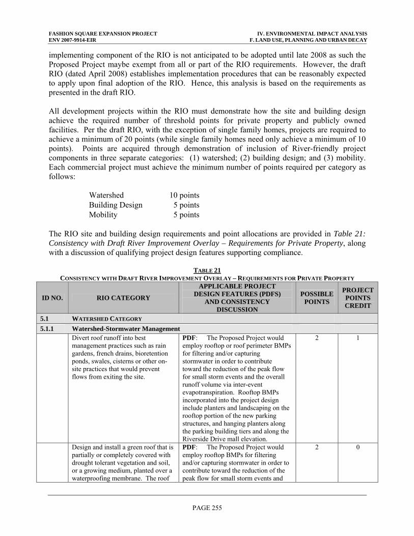
FASHION SQUARE EXPANSION PROJECT IV. ENVIRONMENTAL IMPACT ANALYSIS ENV 2007-9914-EIR F. LAND USE, PLANNING AND URBAN DECAY
PAGE 255
implementing component of the RIO is not anticipated to be adopted until late 2008 as such the Proposed Project maybe exempt from all or part of the RIO requirements. However, the draft RIO (dated April 2008) establishes implementation procedures that can be reasonably expected to apply upon final adoption of the RIO. Hence, this analysis is based on the requirements as presented in the draft RIO. All development projects within the RIO must demonstrate how the site and building design achieve the required number of threshold points for private property and publicly owned facilities. Per the draft RIO, with the exception of single family homes, projects are required to achieve a minimum of 20 points (while single family homes need only achieve a minimum of 10 points). Points are acquired through demonstration of inclusion of River-friendly project components in three separate categories: (1) watershed; (2) building design; and (3) mobility. Each commercial project must achieve the minimum number of points required per category as follows:
Watershed 10 points Building Design 5 points Mobility 5 points
The RIO site and building design requirements and point allocations are provided in Table 21: Consistency with Draft River Improvement Overlay – Requirements for Private Property, along with a discussion of qualifying project design features supporting compliance.
TABLE 21 CONSISTENCY WITH DRAFT RIVER IMPROVEMENT OVERLAY – REQUIREMENTS FOR PRIVATE PROPERTY
ID NO. RIO CATEGORY
APPLICABLE PROJECT DESIGN FEATURES (PDFS)
AND CONSISTENCY DISCUSSION
POSSIBLE POINTS
PROJECT POINTS CREDIT
5.1 WATERSHED CATEGORY 5.1.1 Watershed-Stormwater Management Divert roof runoff into best
management practices such as rain gardens, french drains, bioretention ponds, swales, cisterns or other on-site practices that would prevent flows from exiting the site.
PDF: The Proposed Project would employ rooftop or roof perimeter BMPs for filtering and/or capturing stormwater in order to contribute toward the reduction of the peak flow for small storm events and the overall runoff volume via inter-event evapotranspiration. Rooftop BMPs incorporated into the project design include planters and landscaping on the rooftop portion of the new parking structures, and hanging planters along the parking building tiers and along the Riverside Drive mall elevation.
2 1
Design and install a green roof that is partially or completely covered with drought tolerant vegetation and soil, or a growing medium, planted over a waterproofing membrane. The roof
PDF: The Proposed Project would employ rooftop BMPs for filtering and/or capturing stormwater in order to contribute toward the reduction of the peak flow for small storm events and
2 0
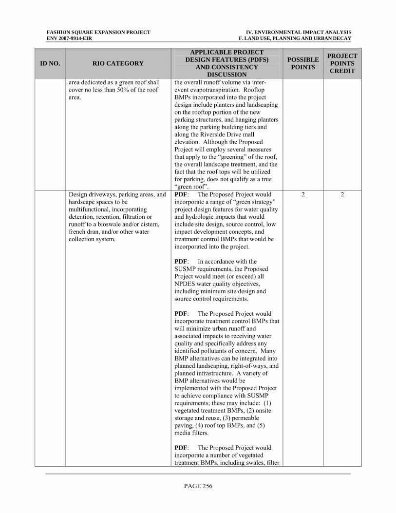
FASHION SQUARE EXPANSION PROJECT IV. ENVIRONMENTAL IMPACT ANALYSIS ENV 2007-9914-EIR F. LAND USE, PLANNING AND URBAN DECAY
PAGE 256
ID NO. RIO CATEGORY
APPLICABLE PROJECT DESIGN FEATURES (PDFS)
AND CONSISTENCY DISCUSSION
POSSIBLE POINTS
PROJECT POINTS CREDIT
area dedicated as a green roof shall cover no less than 50% of the roof area.
the overall runoff volume via inter-event evapotranspiration. Rooftop BMPs incorporated into the project design include planters and landscaping on the rooftop portion of the new parking structures, and hanging planters along the parking building tiers and along the Riverside Drive mall elevation. Although the Proposed Project will employ several measures that apply to the “greening” of the roof, the overall landscape treatment, and the fact that the roof tops will be utilized for parking, does not qualify as a true “green roof”.
Design driveways, parking areas, and hardscape spaces to be multifunctional, incorporating detention, retention, filtration or runoff to a bioswale and/or cistern, french dran, and/or other water collection system.
PDF: The Proposed Project would incorporate a range of “green strategy” project design features for water quality and hydrologic impacts that would include site design, source control, low impact development concepts, and treatment control BMPs that would be incorporated into the project. PDF: In accordance with the SUSMP requirements, the Proposed Project would meet (or exceed) all NPDES water quality objectives, including minimum site design and source control requirements. PDF: The Proposed Project would incorporate treatment control BMPs that will minimize urban runoff and associated impacts to receiving water quality and specifically address any identified pollutants of concern. Many BMP alternatives can be integrated into planned landscaping, right-of-ways, and planned infrastructure. A variety of BMP alternatives would be implemented with the Proposed Project to achieve compliance with SUSMP requirements; these may include: (1) vegetated treatment BMPs, (2) onsite storage and reuse, (3) permeable paving, (4) roof top BMPs, and (5) media filters. PDF: The Proposed Project would incorporate a number of vegetated treatment BMPs, including swales, filter
2 2
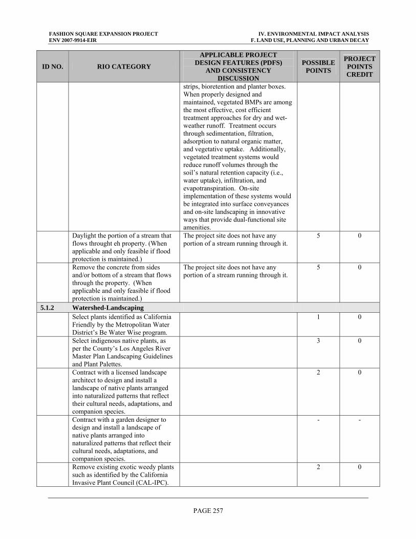
FASHION SQUARE EXPANSION PROJECT IV. ENVIRONMENTAL IMPACT ANALYSIS ENV 2007-9914-EIR F. LAND USE, PLANNING AND URBAN DECAY
PAGE 257
ID NO. RIO CATEGORY
APPLICABLE PROJECT DESIGN FEATURES (PDFS)
AND CONSISTENCY DISCUSSION
POSSIBLE POINTS
PROJECT POINTS CREDIT
strips, bioretention and planter boxes. When properly designed and maintained, vegetated BMPs are among the most effective, cost efficient treatment approaches for dry and wet-weather runoff. Treatment occurs through sedimentation, filtration, adsorption to natural organic matter, and vegetative uptake. Additionally, vegetated treatment systems would reduce runoff volumes through the soil’s natural retention capacity (i.e., water uptake), infiltration, and evapotranspiration. On-site implementation of these systems would be integrated into surface conveyances and on-site landscaping in innovative ways that provide dual-functional site amenities.
Daylight the portion of a stream that flows throught eh property. (When applicable and only feasible if flood protection is maintained.)
The project site does not have any portion of a stream running through it.
5 0
Remove the concrete from sides and/or bottom of a stream that flows through the property. (When applicable and only feasible if flood protection is maintained.)
The project site does not have any portion of a stream running through it.
5 0
5.1.2 Watershed-Landscaping Select plants identified as California
Friendly by the Metropolitan Water District’s Be Water Wise program.
1 0
Select indigenous native plants, as per the County’s Los Angeles River Master Plan Landscaping Guidelines and Plant Palettes.
3 0
Contract with a licensed landscape architect to design and install a landscape of native plants arranged into naturalized patterns that reflect their cultural needs, adaptations, and companion species.
2 0
Contract with a garden designer to design and install a landscape of native plants arranged into naturalized patterns that reflect their cultural needs, adaptations, and companion species.
- -
Remove existing exotic weedy plants such as identified by the California Invasive Plant Council (CAL-IPC).
2 0
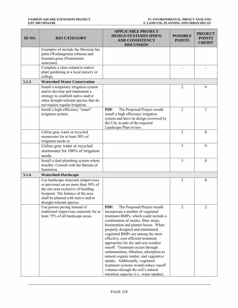
FASHION SQUARE EXPANSION PROJECT IV. ENVIRONMENTAL IMPACT ANALYSIS ENV 2007-9914-EIR F. LAND USE, PLANNING AND URBAN DECAY
PAGE 258
ID NO. RIO CATEGORY
APPLICABLE PROJECT DESIGN FEATURES (PDFS)
AND CONSISTENCY DISCUSSION
POSSIBLE POINTS
PROJECT POINTS CREDIT
Examples of include the Mexican fan palm (Washingtonia robusta) and fountain grass (Pennisetum setaceum).
Complete a class related to native plant gardening at a local nursery or college.
- -
5.1.3 Watershed-Water Conservation Install a temporary irrigation system
and/or develop and implement a strategy to establish native and/or other drought tolerant species that do not require regular irrigation.
2 0
Install a high-efficiency "smart" irrigation system.
PDF: The Proposed Project would install a high efficiency irrigation system and have its design reviewed by the City as part of the required Landscape Plan review.
2 2
Utilize gray water or recycled stormwater for at least 50% of irrigation needs or
2 0
Utilize gray water or recycled stormwater for 100% of irrigation needs.
3 0
Install a dual plumbing system where feasible. Consult with the Bureau of Sanitation.
3 0
5.1.4 Watershed-Hardscape Use hardscape materials (impervious
or pervious) on no more than 50% of the site area exclusive of building footprint. The balance of the area shall be planted with native and/or drought tolerant species.
2 0
Use porous paving instead of traditional impervious materials for at least 75% of all hardscape areas.
PDF: The Proposed Project would incorporate a number of vegetated treatment BMPs, which could include a combination of swales, filter strips, bioretention and planter boxes. When properly designed and maintained, vegetated BMPs are among the most effective, cost-efficient treatment approaches for dry and wet-weather runoff. Treatment occurs through sedimentation, filtration, adsorption to natural organic matter, and vegetative uptake. Additionally, vegetated treatment systems would reduce runoff volumes through the soil’s natural retention capacity (i.e., water uptake),
2 2
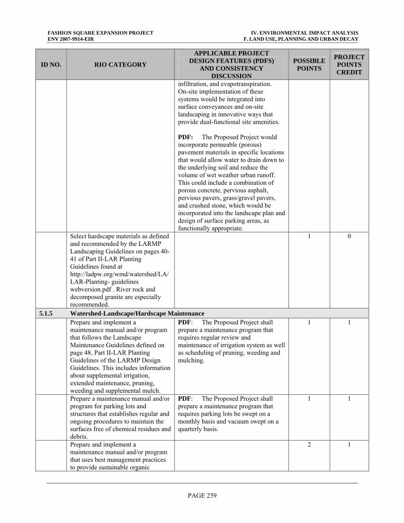
FASHION SQUARE EXPANSION PROJECT IV. ENVIRONMENTAL IMPACT ANALYSIS ENV 2007-9914-EIR F. LAND USE, PLANNING AND URBAN DECAY
PAGE 259
ID NO. RIO CATEGORY
APPLICABLE PROJECT DESIGN FEATURES (PDFS)
AND CONSISTENCY DISCUSSION
POSSIBLE POINTS
PROJECT POINTS CREDIT
infiltration, and evapotranspiration. On-site implementation of these systems would be integrated into surface conveyances and on-site landscaping in innovative ways that provide dual-functional site amenities. PDF: The Proposed Project would incorporate permeable (porous) pavement materials in specific locations that would allow water to drain down to the underlying soil and reduce the volume of wet weather urban runoff. This could include a combination of porous concrete, pervious asphalt, pervious pavers, grass/gravel pavers, and crushed stone, which would be incorporated into the landscape plan and design of surface parking areas, as functionally appropriate.
Select hardscape materials as defined and recommended by the LARMP Landscaping Guidelines on pages 40-41 of Part II-LAR Planting Guidelines found at http://ladpw.org/wmd/watershed/LA/LAR-Planting- guidelines webversion.pdf . River rock and decomposed granite are especially recommended.
1 0
5.1.5 Watershed-Landscape/Hardscape Maintenance Prepare and implement a
maintenance manual and/or program that follows the Landscape Maintenance Guidelines defined on page 48, Part II-LAR Planting Guidelines of the LARMP Design Guidelines. This includes information about supplemental irrigation, extended maintenance, pruning, weeding and supplemental mulch.
PDF: The Proposed Project shall prepare a maintenance program that requires regular review and maintenance of irrigation system as well as scheduling of pruning, weeding and mulching.
1 1
Prepare a maintenance manual and/or program for parking lots and structures that establishes regular and ongoing procedures to maintain the surfaces free of chemical residues and debris.
PDF: The Proposed Project shall prepare a maintenance program that requires parking lots be swept on a monthly basis and vacuum swept on a quarterly basis.
1 1
Prepare and implement a maintenance manual and/or program that uses best management practices to provide sustainable organic
2 1
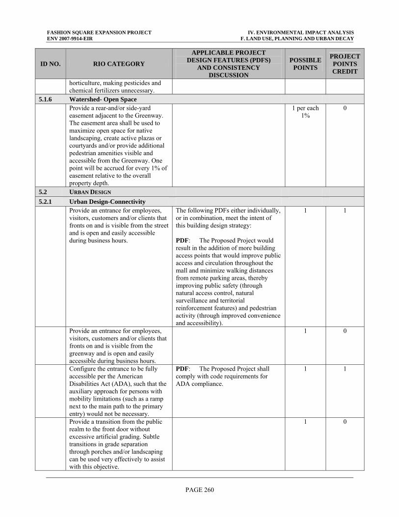
FASHION SQUARE EXPANSION PROJECT IV. ENVIRONMENTAL IMPACT ANALYSIS ENV 2007-9914-EIR F. LAND USE, PLANNING AND URBAN DECAY
PAGE 260
ID NO. RIO CATEGORY
APPLICABLE PROJECT DESIGN FEATURES (PDFS)
AND CONSISTENCY DISCUSSION
POSSIBLE POINTS
PROJECT POINTS CREDIT
horticulture, making pesticides and chemical fertilizers unnecessary.
5.1.6 Watershed- Open Space Provide a rear-and/or side-yard
easement adjacent to the Greenway. The easement area shall be used to maximize open space for native landscaping, create active plazas or courtyards and/or provide additional pedestrian amenities visible and accessible from the Greenway. One point will be accrued for every 1% of easement relative to the overall property depth.
1 per each 1%
0
5.2 URBAN DESIGN 5.2.1 Urban Design-Connectivity Provide an entrance for employees,
visitors, customers and/or clients that fronts on and is visible from the street and is open and easily accessible during business hours.
The following PDFs either individually, or in combination, meet the intent of this building design strategy: PDF: The Proposed Project would result in the addition of more building access points that would improve public access and circulation throughout the mall and minimize walking distances from remote parking areas, thereby improving public safety (through natural access control, natural surveillance and territorial reinforcement features) and pedestrian activity (through improved convenience and accessibility).
1 1
Provide an entrance for employees, visitors, customers and/or clients that fronts on and is visible from the greenway and is open and easily accessible during business hours.
1 0
Configure the entrance to be fully accessible per the American Disabilities Act (ADA), such that the auxiliary approach for persons with mobility limitations (such as a ramp next to the main path to the primary entry) would not be necessary.
PDF: The Proposed Project shall comply with code requirements for ADA compliance.
1 1
Provide a transition from the public realm to the front door without excessive artificial grading. Subtle transitions in grade separation through porches and/or landscaping can be used very effectively to assist with this objective.
1 0
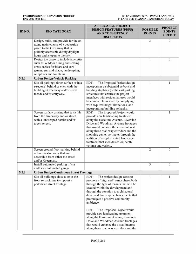
FASHION SQUARE EXPANSION PROJECT IV. ENVIRONMENTAL IMPACT ANALYSIS ENV 2007-9914-EIR F. LAND USE, PLANNING AND URBAN DECAY
PAGE 261
ID NO. RIO CATEGORY
APPLICABLE PROJECT DESIGN FEATURES (PDFS)
AND CONSISTENCY DISCUSSION
POSSIBLE POINTS
PROJECT POINTS CREDIT
Design, build, and provide for the on-going maintenance of a pedestrian paseo to the Greenway that is publicly accessible during daylight hours and is open to the sky.
3 0
Design the paseo to include amenities such as: outdoor dining and seating areas; tables for board and card games; sun and shade; landscaping; sculptures and fountains.
1 0
5.2.2 Urban Design-Vehicle Parking Site all parking (either surface or in a
structure) behind or even with the building's Greenway and/or street façade and/or entryway.
PDF: The Proposed Project design incorporates a substantial setback and building stepback (of the east parking structure) that ensures the project interfaces with residential uses would be compatible in scale by complying with required height limitations, and incorporating building setbacks.
1 1
Screen surface parking that is visible from the Greenway and/or street, with a landscaped barrier and/or green screen.
PDF: The Proposed Project would provide new landscaping treatment along the Hazeltine Avenue, Riverside Drive and Woodman Avenue frontages that would enhance the visual interest along these road way corridors and the shopping center perimeter through the addition of a sophisticated landscape treatment that includes color, depth, volume and variety.
1 1
Screen ground floor parking behind active uses/services that are accessible from either the street and/or Greenway.
2 0
Install automated parking lift(s) and/or an automated garage.
3 0
5.2.3 Urban Design-Continuous Street Frontage Site all buildings close to or at the
front setback line to support a pedestrian street frontage.
PDF: The project design seeks to promote a “high end” atmosphere, both through the type of tenants that will be located within the development and through the attention to architectural detail and landscape enhancements that promulgate a positive community ambience. PDF: The Proposed Project would provide new landscaping treatment along the Hazeltine Avenue, Riverside Drive and Woodman Avenue frontages that would enhance the visual interest along these road way corridors and the
1 1
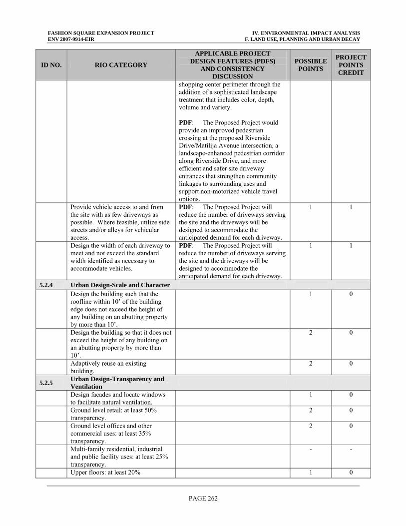
FASHION SQUARE EXPANSION PROJECT IV. ENVIRONMENTAL IMPACT ANALYSIS ENV 2007-9914-EIR F. LAND USE, PLANNING AND URBAN DECAY
PAGE 262
ID NO. RIO CATEGORY
APPLICABLE PROJECT DESIGN FEATURES (PDFS)
AND CONSISTENCY DISCUSSION
POSSIBLE POINTS
PROJECT POINTS CREDIT
shopping center perimeter through the addition of a sophisticated landscape treatment that includes color, depth, volume and variety. PDF: The Proposed Project would provide an improved pedestrian crossing at the proposed Riverside Drive/Matilija Avenue intersection, a landscape-enhanced pedestrian corridor along Riverside Drive, and more efficient and safer site driveway entrances that strengthen community linkages to surrounding uses and support non-motorized vehicle travel options.
Provide vehicle access to and from the site with as few driveways as possible. Where feasible, utilize side streets and/or alleys for vehicular access.
PDF: The Proposed Project will reduce the number of driveways serving the site and the driveways will be designed to accommodate the anticipated demand for each driveway.
1 1
Design the width of each driveway to meet and not exceed the standard width identified as necessary to accommodate vehicles.
PDF: The Proposed Project will reduce the number of driveways serving the site and the driveways will be designed to accommodate the anticipated demand for each driveway.
1 1
5.2.4 Urban Design-Scale and Character Design the building such that the
roofline within 10’ of the building edge does not exceed the height of any building on an abutting property by more than 10’.
1 0
Design the building so that it does not exceed the height of any building on an abutting property by more than 10’.
2 0
Adaptively reuse an existing building.
2 0
5.2.5 Urban Design-Transparency and Ventilation
Design facades and locate windows to facilitate natural ventilation.
1 0
Ground level retail: at least 50% transparency.
2 0
Ground level offices and other commercial uses: at least 35% transparency.
2 0
Multi-family residential, industrial and public facility uses: at least 25% transparency.
- -
Upper floors: at least 20% 1 0
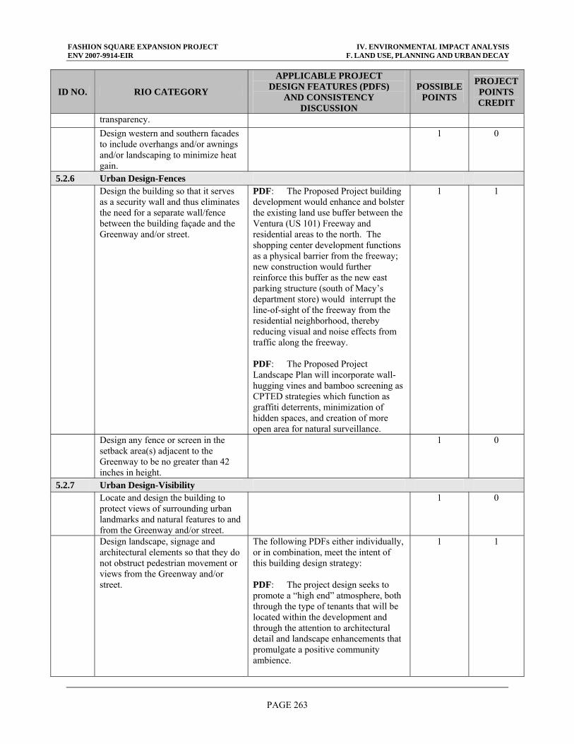
FASHION SQUARE EXPANSION PROJECT IV. ENVIRONMENTAL IMPACT ANALYSIS ENV 2007-9914-EIR F. LAND USE, PLANNING AND URBAN DECAY
PAGE 263
ID NO. RIO CATEGORY
APPLICABLE PROJECT DESIGN FEATURES (PDFS)
AND CONSISTENCY DISCUSSION
POSSIBLE POINTS
PROJECT POINTS CREDIT
transparency. Design western and southern facades
to include overhangs and/or awnings and/or landscaping to minimize heat gain.
1 0
5.2.6 Urban Design-Fences Design the building so that it serves
as a security wall and thus eliminates the need for a separate wall/fence between the building façade and the Greenway and/or street.
PDF: The Proposed Project building development would enhance and bolster the existing land use buffer between the Ventura (US 101) Freeway and residential areas to the north. The shopping center development functions as a physical barrier from the freeway; new construction would further reinforce this buffer as the new east parking structure (south of Macy’s department store) would interrupt the line-of-sight of the freeway from the residential neighborhood, thereby reducing visual and noise effects from traffic along the freeway. PDF: The Proposed Project Landscape Plan will incorporate wall-hugging vines and bamboo screening as CPTED strategies which function as graffiti deterrents, minimization of hidden spaces, and creation of more open area for natural surveillance.
1 1
Design any fence or screen in the setback area(s) adjacent to the Greenway to be no greater than 42 inches in height.
1 0
5.2.7 Urban Design-Visibility Locate and design the building to
protect views of surrounding urban landmarks and natural features to and from the Greenway and/or street.
1 0
Design landscape, signage and architectural elements so that they do not obstruct pedestrian movement or views from the Greenway and/or street.
The following PDFs either individually, or in combination, meet the intent of this building design strategy: PDF: The project design seeks to promote a “high end” atmosphere, both through the type of tenants that will be located within the development and through the attention to architectural detail and landscape enhancements that promulgate a positive community ambience.
1 1
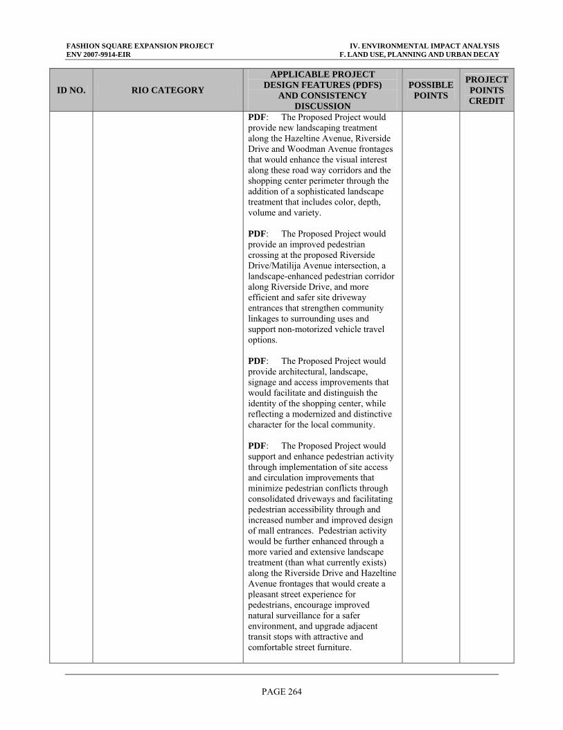
FASHION SQUARE EXPANSION PROJECT IV. ENVIRONMENTAL IMPACT ANALYSIS ENV 2007-9914-EIR F. LAND USE, PLANNING AND URBAN DECAY
PAGE 264
ID NO. RIO CATEGORY
APPLICABLE PROJECT DESIGN FEATURES (PDFS)
AND CONSISTENCY DISCUSSION
POSSIBLE POINTS
PROJECT POINTS CREDIT
PDF: The Proposed Project would provide new landscaping treatment along the Hazeltine Avenue, Riverside Drive and Woodman Avenue frontages that would enhance the visual interest along these road way corridors and the shopping center perimeter through the addition of a sophisticated landscape treatment that includes color, depth, volume and variety. PDF: The Proposed Project would provide an improved pedestrian crossing at the proposed Riverside Drive/Matilija Avenue intersection, a landscape-enhanced pedestrian corridor along Riverside Drive, and more efficient and safer site driveway entrances that strengthen community linkages to surrounding uses and support non-motorized vehicle travel options. PDF: The Proposed Project would provide architectural, landscape, signage and access improvements that would facilitate and distinguish the identity of the shopping center, while reflecting a modernized and distinctive character for the local community. PDF: The Proposed Project would support and enhance pedestrian activity through implementation of site access and circulation improvements that minimize pedestrian conflicts through consolidated driveways and facilitating pedestrian accessibility through and increased number and improved design of mall entrances. Pedestrian activity would be further enhanced through a more varied and extensive landscape treatment (than what currently exists) along the Riverside Drive and Hazeltine Avenue frontages that would create a pleasant street experience for pedestrians, encourage improved natural surveillance for a safer environment, and upgrade adjacent transit stops with attractive and comfortable street furniture.
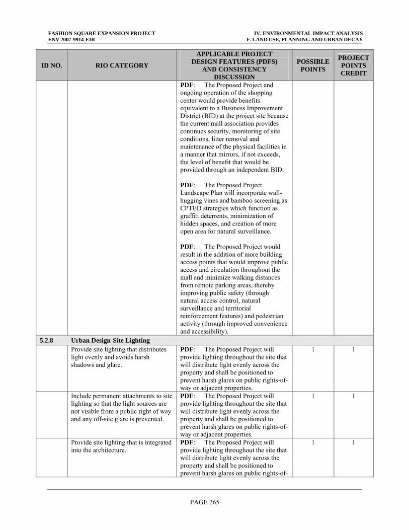
FASHION SQUARE EXPANSION PROJECT IV. ENVIRONMENTAL IMPACT ANALYSIS ENV 2007-9914-EIR F. LAND USE, PLANNING AND URBAN DECAY
PAGE 265
ID NO. RIO CATEGORY
APPLICABLE PROJECT DESIGN FEATURES (PDFS)
AND CONSISTENCY DISCUSSION
POSSIBLE POINTS
PROJECT POINTS CREDIT
PDF: The Proposed Project and ongoing operation of the shopping center would provide benefits equivalent to a Business Improvement District (BID) at the project site because the current mall association provides continues security, monitoring of site conditions, litter removal and maintenance of the physical facilities in a manner that mirrors, if not exceeds, the level of benefit that would be provided through an independent BID. PDF: The Proposed Project Landscape Plan will incorporate wall-hugging vines and bamboo screening as CPTED strategies which function as graffiti deterrents, minimization of hidden spaces, and creation of more open area for natural surveillance. PDF: The Proposed Project would result in the addition of more building access points that would improve public access and circulation throughout the mall and minimize walking distances from remote parking areas, thereby improving public safety (through natural access control, natural surveillance and territorial reinforcement features) and pedestrian activity (through improved convenience and accessibility).
5.2.8 Urban Design-Site Lighting Provide site lighting that distributes
light evenly and avoids harsh shadows and glare.
PDF: The Proposed Project will provide lighting throughout the site that will distribute light evenly across the property and shall be positioned to prevent harsh glares on public rights-of-way or adjacent properties.
1 1
Include permanent attachments to site lighting so that the light sources are not visible from a public right of way and any off-site glare is prevented.
PDF: The Proposed Project will provide lighting throughout the site that will distribute light evenly across the property and shall be positioned to prevent harsh glares on public rights-of-way or adjacent properties.
1 1
Provide site lighting that is integrated into the architecture.
PDF: The Proposed Project will provide lighting throughout the site that will distribute light evenly across the property and shall be positioned to prevent harsh glares on public rights-of-
1 1
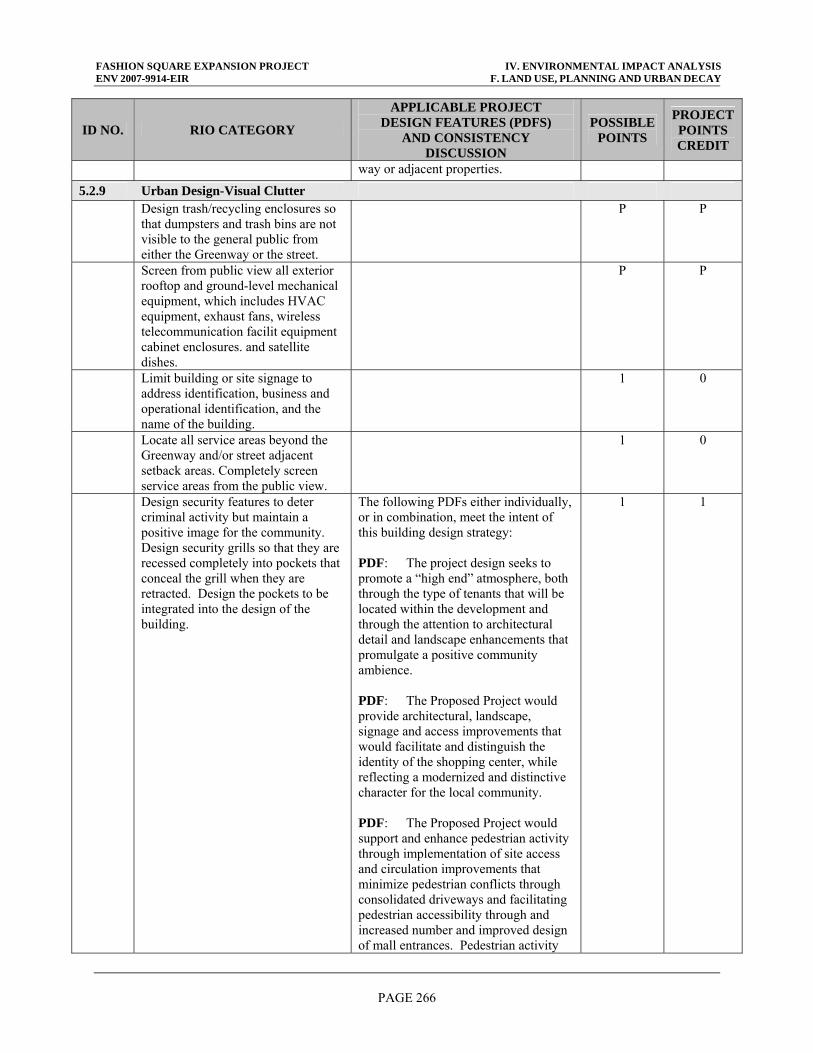
FASHION SQUARE EXPANSION PROJECT IV. ENVIRONMENTAL IMPACT ANALYSIS ENV 2007-9914-EIR F. LAND USE, PLANNING AND URBAN DECAY
PAGE 266
ID NO. RIO CATEGORY
APPLICABLE PROJECT DESIGN FEATURES (PDFS)
AND CONSISTENCY DISCUSSION
POSSIBLE POINTS
PROJECT POINTS CREDIT
way or adjacent properties.
5.2.9 Urban Design-Visual Clutter Design trash/recycling enclosures so
that dumpsters and trash bins are not visible to the general public from either the Greenway or the street.
P P
Screen from public view all exterior rooftop and ground-level mechanical equipment, which includes HVAC equipment, exhaust fans, wireless telecommunication facilit equipment cabinet enclosures. and satellite dishes.
P P
Limit building or site signage to address identification, business and operational identification, and the name of the building.
1 0
Locate all service areas beyond the Greenway and/or street adjacent setback areas. Completely screen service areas from the public view.
1 0
Design security features to deter criminal activity but maintain a positive image for the community. Design security grills so that they are recessed completely into pockets that conceal the grill when they are retracted. Design the pockets to be integrated into the design of the building.
The following PDFs either individually, or in combination, meet the intent of this building design strategy: PDF: The project design seeks to promote a “high end” atmosphere, both through the type of tenants that will be located within the development and through the attention to architectural detail and landscape enhancements that promulgate a positive community ambience. PDF: The Proposed Project would provide architectural, landscape, signage and access improvements that would facilitate and distinguish the identity of the shopping center, while reflecting a modernized and distinctive character for the local community. PDF: The Proposed Project would support and enhance pedestrian activity through implementation of site access and circulation improvements that minimize pedestrian conflicts through consolidated driveways and facilitating pedestrian accessibility through and increased number and improved design of mall entrances. Pedestrian activity
1 1
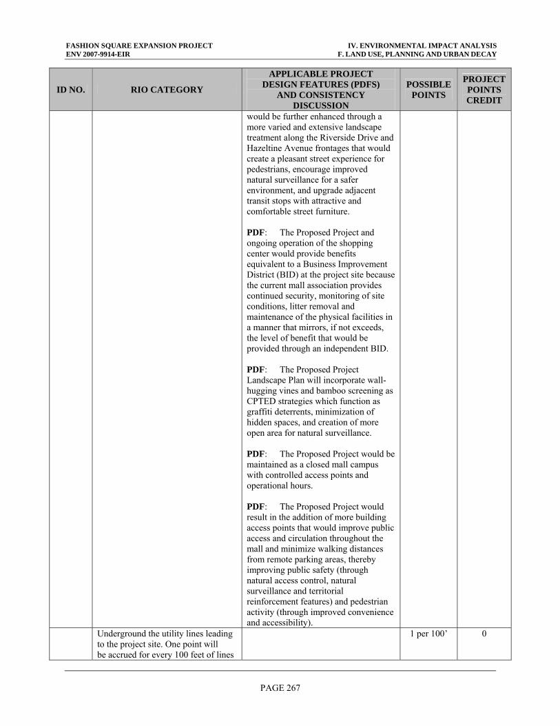
FASHION SQUARE EXPANSION PROJECT IV. ENVIRONMENTAL IMPACT ANALYSIS ENV 2007-9914-EIR F. LAND USE, PLANNING AND URBAN DECAY
PAGE 267
ID NO. RIO CATEGORY
APPLICABLE PROJECT DESIGN FEATURES (PDFS)
AND CONSISTENCY DISCUSSION
POSSIBLE POINTS
PROJECT POINTS CREDIT
would be further enhanced through a more varied and extensive landscape treatment along the Riverside Drive and Hazeltine Avenue frontages that would create a pleasant street experience for pedestrians, encourage improved natural surveillance for a safer environment, and upgrade adjacent transit stops with attractive and comfortable street furniture. PDF: The Proposed Project and ongoing operation of the shopping center would provide benefits equivalent to a Business Improvement District (BID) at the project site because the current mall association provides continued security, monitoring of site conditions, litter removal and maintenance of the physical facilities in a manner that mirrors, if not exceeds, the level of benefit that would be provided through an independent BID. PDF: The Proposed Project Landscape Plan will incorporate wall-hugging vines and bamboo screening as CPTED strategies which function as graffiti deterrents, minimization of hidden spaces, and creation of more open area for natural surveillance. PDF: The Proposed Project would be maintained as a closed mall campus with controlled access points and operational hours. PDF: The Proposed Project would result in the addition of more building access points that would improve public access and circulation throughout the mall and minimize walking distances from remote parking areas, thereby improving public safety (through natural access control, natural surveillance and territorial reinforcement features) and pedestrian activity (through improved convenience and accessibility).
Underground the utility lines leading to the project site. One point will be accrued for every 100 feet of lines
1 per 100’ 0
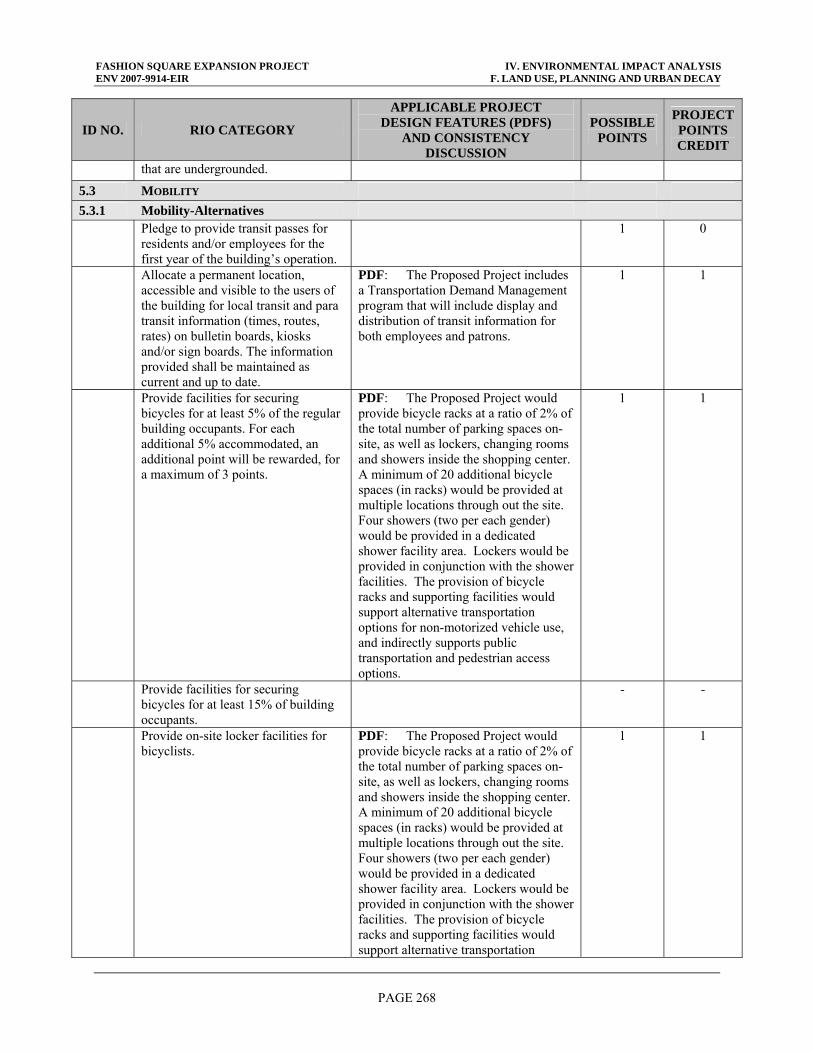
FASHION SQUARE EXPANSION PROJECT IV. ENVIRONMENTAL IMPACT ANALYSIS ENV 2007-9914-EIR F. LAND USE, PLANNING AND URBAN DECAY
PAGE 268
ID NO. RIO CATEGORY
APPLICABLE PROJECT DESIGN FEATURES (PDFS)
AND CONSISTENCY DISCUSSION
POSSIBLE POINTS
PROJECT POINTS CREDIT
that are undergrounded.
5.3 MOBILITY 5.3.1 Mobility-Alternatives Pledge to provide transit passes for
residents and/or employees for the first year of the building’s operation.
1 0
Allocate a permanent location, accessible and visible to the users of the building for local transit and para transit information (times, routes, rates) on bulletin boards, kiosks and/or sign boards. The information provided shall be maintained as current and up to date.
PDF: The Proposed Project includes a Transportation Demand Management program that will include display and distribution of transit information for both employees and patrons.
1 1
Provide facilities for securing bicycles for at least 5% of the regular building occupants. For each additional 5% accommodated, an additional point will be rewarded, for a maximum of 3 points.
PDF: The Proposed Project would provide bicycle racks at a ratio of 2% of the total number of parking spaces on-site, as well as lockers, changing rooms and showers inside the shopping center. A minimum of 20 additional bicycle spaces (in racks) would be provided at multiple locations through out the site. Four showers (two per each gender) would be provided in a dedicated shower facility area. Lockers would be provided in conjunction with the shower facilities. The provision of bicycle racks and supporting facilities would support alternative transportation options for non-motorized vehicle use, and indirectly supports public transportation and pedestrian access options.
1 1
Provide facilities for securing bicycles for at least 15% of building occupants.
- -
Provide on-site locker facilities for bicyclists.
PDF: The Proposed Project would provide bicycle racks at a ratio of 2% of the total number of parking spaces on-site, as well as lockers, changing rooms and showers inside the shopping center. A minimum of 20 additional bicycle spaces (in racks) would be provided at multiple locations through out the site. Four showers (two per each gender) would be provided in a dedicated shower facility area. Lockers would be provided in conjunction with the shower facilities. The provision of bicycle racks and supporting facilities would support alternative transportation
1 1
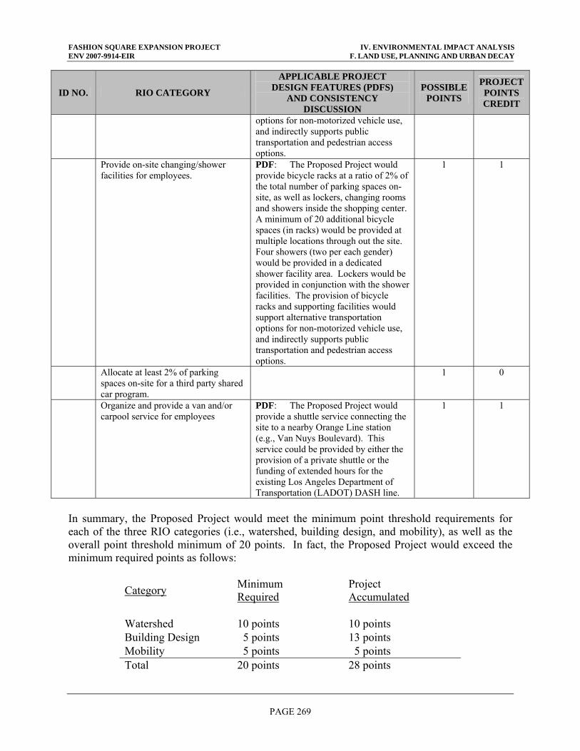
FASHION SQUARE EXPANSION PROJECT IV. ENVIRONMENTAL IMPACT ANALYSIS ENV 2007-9914-EIR F. LAND USE, PLANNING AND URBAN DECAY
PAGE 269
ID NO. RIO CATEGORY
APPLICABLE PROJECT DESIGN FEATURES (PDFS)
AND CONSISTENCY DISCUSSION
POSSIBLE POINTS
PROJECT POINTS CREDIT
options for non-motorized vehicle use, and indirectly supports public transportation and pedestrian access options.
Provide on-site changing/shower facilities for employees.
PDF: The Proposed Project would provide bicycle racks at a ratio of 2% of the total number of parking spaces on-site, as well as lockers, changing rooms and showers inside the shopping center. A minimum of 20 additional bicycle spaces (in racks) would be provided at multiple locations through out the site. Four showers (two per each gender) would be provided in a dedicated shower facility area. Lockers would be provided in conjunction with the shower facilities. The provision of bicycle racks and supporting facilities would support alternative transportation options for non-motorized vehicle use, and indirectly supports public transportation and pedestrian access options.
1 1
Allocate at least 2% of parking spaces on-site for a third party shared car program.
1 0
Organize and provide a van and/or carpool service for employees
PDF: The Proposed Project would provide a shuttle service connecting the site to a nearby Orange Line station (e.g., Van Nuys Boulevard). This service could be provided by either the provision of a private shuttle or the funding of extended hours for the existing Los Angeles Department of Transportation (LADOT) DASH line.
1 1
In summary, the Proposed Project would meet the minimum point threshold requirements for each of the three RIO categories (i.e., watershed, building design, and mobility), as well as the overall point threshold minimum of 20 points. In fact, the Proposed Project would exceed the minimum required points as follows:
Category Minimum Required
Project Accumulated
Watershed 10 points 10 points Building Design 5 points 13 points Mobility 5 points 5 points Total 20 points 28 points
FASHION SQUARE EXPANSION PROJECT IV. ENVIRONMENTAL IMPACT ANALYSIS ENV 2007-9914-EIR F. LAND USE, PLANNING AND URBAN DECAY
PAGE 270
Because the Proposed Project exceeds the minimum required threshold points, the project would be deemed to be in compliance with the pending RIO. Because the Proposed Project would be consistent with the RIO, it would also be consistent with the LARRMP because the project either directly contributes toward the furtherance of LARRMP policies (i.e., as through physical site improvements) or indirectly supports those policies by not creating obstacles for their realization. The Proposed Project will result in a less than significant impact to land use consistency and compatibility in the project area due to conflicts with policies and programs of the LARRMP and RIO. (c) Other Local Programs Although not directly related to the proposed uses under the Proposed Project, the increase in land use intensity could indirectly affect the balance of other local and regional land uses related to parks and recreation. Unlike many other public services, parks and recreational services are dependent not only on funds to support park services, but also the provision of adequate recreational and open space dedicated land uses. The operation and management of public recreational facilities in the project area is provided by the City of Los Angeles Department of Recreation and Parks. The Department of Recreation and Parks currently operates approximately 176 recreation centers, 59 pools, 30 senior citizen centers, 7 museums and historic sites, 13 golf courses, 24 child care centers, and 7 skate parks citywide.1 The project site is currently developed with retail/shopping center facilities. No parkland, open space or recreational facilities are currently located on the project site. The Proposed Project will not result in the creation or removal of parkland or active recreational facilities. The Proposed Project includes the provision of a new community room which would be made available to the surrounding Sherman Oaks community and offset a potential increase demand on recreational facilities for community meeting space needs. An impact to parks and open space is generally based on the number of residents and employees located on a project site that would intend to utilize park facilities. The City of Los Angeles CEQA Significance Thresholds indicate that consideration should be given to the net population increase resulting from the project, the demand for recreation services anticipated at the time of buildout, and whether the project includes features that would reduce demand for recreational services. The project site is currently developed with retail/shopping center facilities. The potential for recreational use by employees at the site during their work shift has been analyzed. Employees at the site on a daily basis could increase to approximately 2,600, an increase of approximately 788 employees per day. However, as a substantial employment base and residential population currently exist in the San Fernando Valley, it is anticipated that the majority of the new employees would be derived from existing residential areas nearby. Hence, the Proposed Project would not necessarily result in an increase in the local population, or an increased use of park and recreational facilities in the project area. An increase of this magnitude would not generate the need for or involve the construction of new or altered park facilities since a substantial
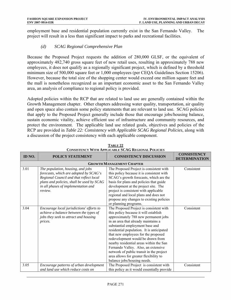
FASHION SQUARE EXPANSION PROJECT IV. ENVIRONMENTAL IMPACT ANALYSIS ENV 2007-9914-EIR F. LAND USE, PLANNING AND URBAN DECAY
PAGE 271
employment base and residential population currently exist in the San Fernando Valley. The project will result in a less than significant impact to parks and recreational facilities. (d) SCAG Regional Comprehensive Plan Because the Proposed Project requests the addition of 280,000 GLSF, or the equivalent of approximately 482,740 gross square feet of new retail uses, resulting in approximately 788 new employees, it does not qualify as a regionally significant project, which is defined by a threshold minimum size of 500,000 square feet or 1,000 employees (per CEQA Guidelines Section 15206). However, because the total size of the shopping center would exceed one million square feet and the mall is nonetheless recognized as an important economic asset to the San Fernando Valley area, an analysis of compliance to regional policy is provided. Adopted policies within the RCP that are related to land use are generally contained within the Growth Management chapter. Other chapters addressing water quality, transportation, air quality and open space also contain some policy statements that are relevant to land use. SCAG policies that apply to the Proposed Project generally include those that encourage jobs/housing balance, sustain economic vitality, achieve efficient use of infrastructure and community resources, and protect the environment. The applicable land use related goals, objectives and policies of the RCP are provided in Table 22: Consistency with Applicable SCAG Regional Policies, along with a discussion of the project consistency with each applicable component.
TABLE 22 CONSISTENCY WITH APPLICABLE SCAG REGIONAL POLICIES
ID NO. POLICY STATEMENT CONSISTENCY DISCUSSION CONSISTENCY DETERMINATION
GROWTH MANAGEMENT CHAPTER 3.01 The population, housing, and jobs
forecasts, which are adopted by SCAG’s Regional Council and that reflect local plans and policies, shall be used by SCAG in all phases of implementation and review.
The Proposed Project is consistent with this policy because it is consistent with SCAG’s growth forecasts, which are the basis for plans and policies that guide development at the project site. The project is consistent with applicable regional and local plans and does not propose any changes to existing policies or planning programs.
Consistent
3.04 Encourage local jurisdictions' efforts to achieve a balance between the types of jobs they seek to attract and housing prices.
The Proposed Project is consistent with this policy because it will establish approximately 788 new permanent jobs in an area that already maintains a substantial employment base and residential population. It is anticipated that new employees for the proposed redevelopment would be drawn from nearby residential areas within the San Fernando Valley. Also, an extensive network of public transit in the project area allows for greater flexibility to balance jobs/housing needs.
Consistent
3.05 Encourage patterns of urban development and land use which reduce costs on
The Proposed Project is consistent with this policy as it would essentially provide
Consistent
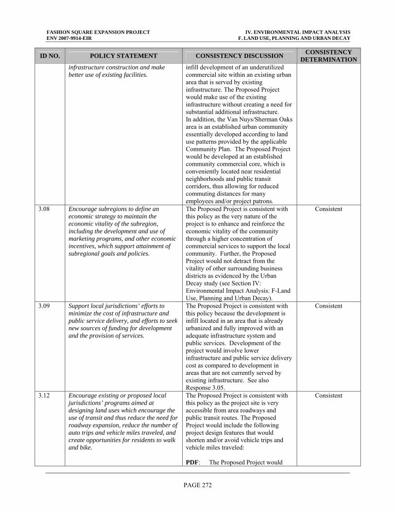
FASHION SQUARE EXPANSION PROJECT IV. ENVIRONMENTAL IMPACT ANALYSIS ENV 2007-9914-EIR F. LAND USE, PLANNING AND URBAN DECAY
PAGE 272
ID NO. POLICY STATEMENT CONSISTENCY DISCUSSION CONSISTENCY DETERMINATION
infrastructure construction and make better use of existing facilities.
infill development of an underutilized commercial site within an existing urban area that is served by existing infrastructure. The Proposed Project would make use of the existing infrastructure without creating a need for substantial additional infrastructure. In addition, the Van Nuys/Sherman Oaks area is an established urban community essentially developed according to land use patterns provided by the applicable Community Plan. The Proposed Project would be developed at an established community commercial core, which is conveniently located near residential neighborhoods and public transit corridors, thus allowing for reduced commuting distances for many employees and/or project patrons.
3.08 Encourage subregions to define an economic strategy to maintain the economic vitality of the subregion, including the development and use of marketing programs, and other economic incentives, which support attainment of subregional goals and policies.
The Proposed Project is consistent with this policy as the very nature of the project is to enhance and reinforce the economic vitality of the community through a higher concentration of commercial services to support the local community. Further, the Proposed Project would not detract from the vitality of other surrounding business districts as evidenced by the Urban Decay study (see Section IV: Environmental Impact Analysis: F-Land Use, Planning and Urban Decay).
Consistent
3.09 Support local jurisdictions’ efforts to minimize the cost of infrastructure and public service delivery, and efforts to seek new sources of funding for development and the provision of services.
The Proposed Project is consistent with this policy because the development is infill located in an area that is already urbanized and fully improved with an adequate infrastructure system and public services. Development of the project would involve lower infrastructure and public service delivery cost as compared to development in areas that are not currently served by existing infrastructure. See also Response 3.05.
Consistent
3.12 Encourage existing or proposed local jurisdictions’ programs aimed at designing land uses which encourage the use of transit and thus reduce the need for roadway expansion, reduce the number of auto trips and vehicle miles traveled, and create opportunities for residents to walk and bike.
The Proposed Project is consistent with this policy as the project site is very accessible from area roadways and public transit routes. The Proposed Project would include the following project design features that would shorten and/or avoid vehicle trips and vehicle miles traveled: PDF: The Proposed Project would
Consistent
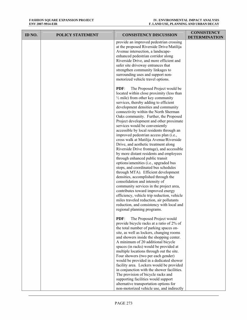
FASHION SQUARE EXPANSION PROJECT IV. ENVIRONMENTAL IMPACT ANALYSIS ENV 2007-9914-EIR F. LAND USE, PLANNING AND URBAN DECAY
PAGE 273
ID NO. POLICY STATEMENT CONSISTENCY DISCUSSION CONSISTENCY DETERMINATION
provide an improved pedestrian crossing at the proposed Riverside Drive/Matilija Avenue intersection, a landscape-enhanced pedestrian corridor along Riverside Drive, and more efficient and safer site driveway entrances that strengthen community linkages to surrounding uses and support non-motorized vehicle travel options. PDF: The Proposed Project would be located within close proximity (less than ½ mile) from other key community services, thereby adding to efficient development densities and community connectivity within the North Sherman Oaks community. Further, the Proposed Project development and other proximate services would be conveniently accessible by local residents through an improved pedestrian access plan (i.e., cross walk at Matilija Avenue/Riverside Drive, and aesthetic treatment along Riverside Drive frontage), and accessible by more distant residents and employees through enhanced public transit options/amenities (i.e., upgraded bus stops, and coordinated bus schedules through MTA). Efficient development densities, accomplished through the consolidation and intensity of community services in the project area, contributes toward improved energy efficiency, vehicle trip reduction, vehicle miles traveled reduction, air pollutants reduction, and consistency with local and regional planning programs. PDF: The Proposed Project would provide bicycle racks at a ratio of 2% of the total number of parking spaces on-site, as well as lockers, changing rooms and showers inside the shopping center. A minimum of 20 additional bicycle spaces (in racks) would be provided at multiple locations through out the site. Four showers (two per each gender) would be provided in a dedicated shower facility area. Lockers would be provided in conjunction with the shower facilities. The provision of bicycle racks and supporting facilities would support alternative transportation options for non-motorized vehicle use, and indirectly
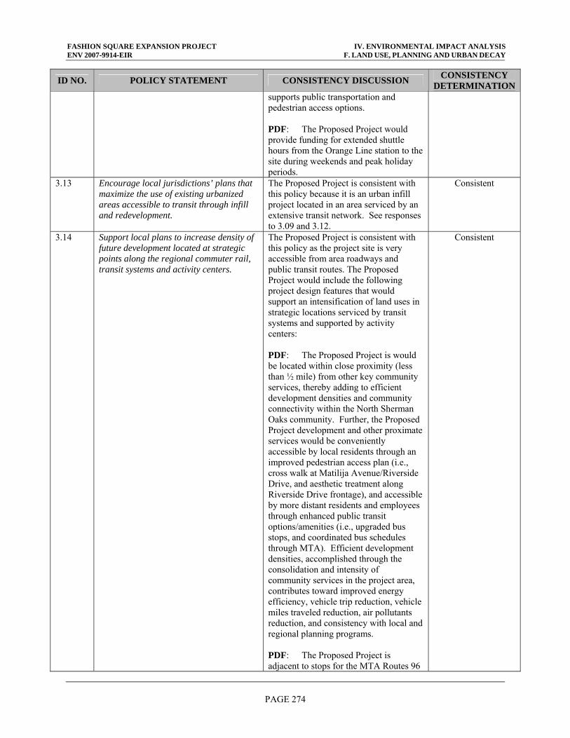
FASHION SQUARE EXPANSION PROJECT IV. ENVIRONMENTAL IMPACT ANALYSIS ENV 2007-9914-EIR F. LAND USE, PLANNING AND URBAN DECAY
PAGE 274
ID NO. POLICY STATEMENT CONSISTENCY DISCUSSION CONSISTENCY DETERMINATION
supports public transportation and pedestrian access options. PDF: The Proposed Project would provide funding for extended shuttle hours from the Orange Line station to the site during weekends and peak holiday periods.
3.13 Encourage local jurisdictions’ plans that maximize the use of existing urbanized areas accessible to transit through infill and redevelopment.
The Proposed Project is consistent with this policy because it is an urban infill project located in an area serviced by an extensive transit network. See responses to 3.09 and 3.12.
Consistent
3.14 Support local plans to increase density of future development located at strategic points along the regional commuter rail, transit systems and activity centers.
The Proposed Project is consistent with this policy as the project site is very accessible from area roadways and public transit routes. The Proposed Project would include the following project design features that would support an intensification of land uses in strategic locations serviced by transit systems and supported by activity centers: PDF: The Proposed Project is would be located within close proximity (less than ½ mile) from other key community services, thereby adding to efficient development densities and community connectivity within the North Sherman Oaks community. Further, the Proposed Project development and other proximate services would be conveniently accessible by local residents through an improved pedestrian access plan (i.e., cross walk at Matilija Avenue/Riverside Drive, and aesthetic treatment along Riverside Drive frontage), and accessible by more distant residents and employees through enhanced public transit options/amenities (i.e., upgraded bus stops, and coordinated bus schedules through MTA). Efficient development densities, accomplished through the consolidation and intensity of community services in the project area, contributes toward improved energy efficiency, vehicle trip reduction, vehicle miles traveled reduction, air pollutants reduction, and consistency with local and regional planning programs. PDF: The Proposed Project is adjacent to stops for the MTA Routes 96
Consistent
FASHION SQUARE EXPANSION PROJECT IV. ENVIRONMENTAL IMPACT ANALYSIS ENV 2007-9914-EIR F. LAND USE, PLANNING AND URBAN DECAY
PAGE 275
ID NO. POLICY STATEMENT CONSISTENCY DISCUSSION CONSISTENCY DETERMINATION
(Downtown LA to Sherman Oaks) and 158 (Chatsworth to Sherman Oaks), and LADOT Dash Route for Van Nuys/Studio City, thereby supporting a range of alternative transportation options for public transportation access. PDF: The Proposed Project would provide funding for extended shuttle hours from the Orange Line station to the site during weekends and peak holiday periods.
3.15 Support local jurisdictions strategies to establish mixed-use clusters and other transit oriented developments around transit stations and along transit corridors
The Proposed Project is consistent with this policy because the development will expand the mix of services available within an established community consisting of office, retail and residential use and the project site is adequately serviced by an extensive transit network. See also responses to 3.05, 3.12 and 3.14.
Consistent
3.16 Encourage developments in and around activity centers, transportation corridors, underutilized infrastructure systems, and areas needing recycling and redevelopment.
The Proposed Project is consistent with this policy because it is an urban infill project located in an area serviced by an extensive transit network and infrastructure system. See responses to 3.05, 3.09, 3.12, 3.13 and 3.14.
Consistent
3.18 Encourage planned development in locations least likely to cause adverse environmental impact.
The Proposed Project is consistent with this policy because the EIR demonstrates that the project is consistent with applicable regional and local plans, and that project-related impacts have been mitigated to minimize conflicts. The project would be developed on an underutilized commercial parcel that is surrounded by urban development of similar use, scale and character to that proposed. This combination of factors minimizes potential for adverse environmental impacts. See also responses to 3.01, 3.05, 3.09, 3.12, 3.13, 3.14 and 3.16.
Consistent
3.20 Support the protection of vital resources such as wetlands, groundwater recharge areas, woodlands, production lands, and land containing unique and endangered plants and animals.
The Proposed Project is consistent with this policy as it would be built in an established urban environment, which does not include any of these resources and would not directly adversely affect these resources. The infill and intensification of commercial uses at the project site could reduce development pressures in non-urban or other more environmentally sensitive areas that more likely result in the potential for effects on these resources. It should be
Consistent
FASHION SQUARE EXPANSION PROJECT IV. ENVIRONMENTAL IMPACT ANALYSIS ENV 2007-9914-EIR F. LAND USE, PLANNING AND URBAN DECAY
PAGE 276
ID NO. POLICY STATEMENT CONSISTENCY DISCUSSION CONSISTENCY DETERMINATION
noted that recent mandates to establish and comply with implementation of the Los Angeles River Improvement Overlay District will further ensure that the Proposed Projects collaborates with the protection/advancement of biological resources and watershed associated with the Los Angeles River greenway corridor.
3.21 Encourage the implementation of measures aimed at the preservation and protection of recorded and unrecorded cultural resources and archaeological sites.
The Proposed Project is consistent with this policy as standard precautions would be undertaken during the construction of the project. There are no known cultural or historical resources identified at the project site. However, in the event that remains or archaeological/ paleontological resources are encountered during excavation, standard regulations and practice by City Code would require work to immediately stop until any such findings can be assessed.
Consistent
3.22 Discourage development, or encourage the use of special design requirements, in areas with steep slopes, high fire, flood, and seismic hazards.
The Proposed Project is consistent with this policy because it not located in an area of extreme hazards and the proposed buildings would be constructed in accordance with applicable seismic standards. See Sections IV: Environmental Impact Analysis: C-Geology and Soils and IV: Environmental Impact Analysis: D-Hazardous Materials and Man-Made Hazards.
Consistent
3.23 Encourage mitigation measures that reduce noise in certain locations, measures aimed at preservation of biological and ecological resources, measures that would reduce exposure to seismic hazards, minimize earthquake damage and to develop emergency response and recovery plans.
The Proposed Project is consistent with this policy because it would not impact biological/ecological resources nor would the development be affected by typical seismic hazards nor would the project interfere with emergency response plans. Appropriate mitigation measures are recommended in the EIR address impacts related to noise. This EIR includes a construction noise assessment which determined that with incorporation of noise reducing mitigation measures, the project related construction noise would be reduced to a less than significant level. See Sections IV: Environmental Analysis: C-Geology and Soils, IV: Environmental Analysis: D-Hazardous Materials and Man-Made Hazards and IV: Environmental Analysis: G-Noise. It should be noted that recent mandates to establish and comply with implementation of the Los
Consistent
FASHION SQUARE EXPANSION PROJECT IV. ENVIRONMENTAL IMPACT ANALYSIS ENV 2007-9914-EIR F. LAND USE, PLANNING AND URBAN DECAY
PAGE 277
ID NO. POLICY STATEMENT CONSISTENCY DISCUSSION CONSISTENCY DETERMINATION
Angeles River Improvement Overlay District will further ensure that the Proposed Projects collaborates with the protection/advancement of biological resources associated with the Los Angeles River greenway corridor. See also responses 3.01, 3.18 and 3.20.
3.27 Support local jurisdictions and other service providers in their efforts to develop sustainable communities and provide, equally to all members of society, accessible and effective services such as public education, housing, health care, social services, recreational facilities, law enforcement, and fire protection.
The Proposed Project is consistent with this policy because it would not pose a significant demand on police, fire and other community services, thereby affording the broader community access to such services. See also Sections IV: Environmental Analysis: Public Services: Fire and Police. PDF: The Proposed Project has committed to achieve LEED certifiable levels to support efforts to develop a sustainable community.
Consistent
AIR QUALITY CHAPTER (CORE) POLICIES/ACTIONS 5.11 Through the environmental document
review process, ensure that plans at all levels of government (regional, air basin, county, subregional and local) consider air quality, land use, transportation and economic relationships to ensure consistency and minimize conflicts.
The Proposed Project is consistent with this policy because the EIR demonstrates that the project is consistent with applicable regional and local plans, and that project-related impacts have been mitigated to minimize conflicts. Air quality, land use, and transportation issues are discussed in Sections IV: Environmental Analysis: B-Air Quality, IV: Environmental Analysis: F-Land Use Planning and Urban Decay, and IV: Environmental Analysis: J-Traffic, Circulation and Access, respectively. See also responses to 3.01 and 3.18.
Consistent
OPEN SPACE AND CONSERVATION CHAPTER GOALS 9.01 Provide adequate land resources to meet
the outdoor recreation needs of the present and future residents in the region and to promote tourism in the region.
The Proposed Project is consistent with this goal because it involves infill development that concentrates commercial uses on lands already designated for, and used as, a commercial use. Also, the Proposed Project will indirectly support community recreational needs by providing a community meeting facility and offering opportunities for casual recreational activity (such as events or indoor walking programs). Further, the Proposed Project would not adversely impact park and recreational facilities located in the project area.
Consistent
FASHION SQUARE EXPANSION PROJECT IV. ENVIRONMENTAL IMPACT ANALYSIS ENV 2007-9914-EIR F. LAND USE, PLANNING AND URBAN DECAY
PAGE 278
ID NO. POLICY STATEMENT CONSISTENCY DISCUSSION CONSISTENCY DETERMINATION
CORE WATER QUALITY CHAPTER POLICIES 11.02 Encourage "watershed management"
programs and strategies encouraged, recognizing the primary role of local governments in such efforts.
The Proposed Project is consistent with this policy because the project design and site planning incorporate a range of project design features that minimize pollutant runoff and manage runoff volumes. A discussion of the specific best management practices (BMPs) to be incorporated into the Proposed Project, and the water quality results, is provided in Section IV: Environmental Impact Analysis: E-Water Resources.
Consistent
11.07 Encourage water reclamation throughout the region where it is cost-effective, feasible, and appropriate to reduce reliance on imported water and wastewater discharges. Current administrative impediments to increased use of wastewater should be addressed.
As discussed in Section IV: Environmental Impact Analysis: E-Water Resources, LADWP, the water supplier for the Proposed Project, is working to increase a portion of its supply that is derived from recycled water. Although a dual water system for the delivery of reclaimed water to the project site is not currently in place, landscape areas incorporated into the Proposed Project would provide an opportunity for the use of reclaimed water in the future if delivery infrastructure is developed. Because the Proposed Project relies on water provided by LADWP, and LADWP derives a portion of its water supply from reclaimed water, the project is indirectly consistent with this policy.
Consistent
REGIONAL TRANSPORTATION PLAN (2004) GOALS G 1.0 Maximize mobility and accessibility for
all people and goods in the Region. The Proposed Project is consistent with this goal because the development includes measures which improve the local flow of traffic (thereby minimizing congestion) and expanding opportunities for pedestrian, bicycle and public transit access between existing residential uses and the expanded commercial uses at the project site. See also responses to 3.05, 3.12 and 3.14.
Consistent
G 4.0 Maximize the productivity of our transportation system.
The Proposed Project is consistent with this goal because the location of infill commercial development proximate to key components of the transit network, and the implementation of mitigation measures to improve traffic flow on local streets, will enhance the productivity of the established transportation system in the project area. See Section IV: Environmental Impact Analysis: J-Traffic, Circulation and Access. See also responses to 3.05, 3.12, 3.13, 3.14, 3.15
Consistent
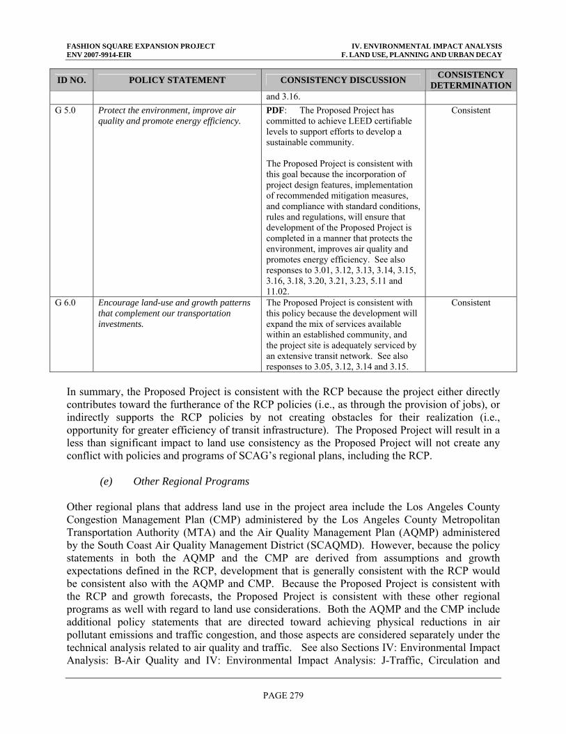
FASHION SQUARE EXPANSION PROJECT IV. ENVIRONMENTAL IMPACT ANALYSIS ENV 2007-9914-EIR F. LAND USE, PLANNING AND URBAN DECAY
PAGE 279
ID NO. POLICY STATEMENT CONSISTENCY DISCUSSION CONSISTENCY DETERMINATION
and 3.16. G 5.0 Protect the environment, improve air
quality and promote energy efficiency. PDF: The Proposed Project has committed to achieve LEED certifiable levels to support efforts to develop a sustainable community. The Proposed Project is consistent with this goal because the incorporation of project design features, implementation of recommended mitigation measures, and compliance with standard conditions, rules and regulations, will ensure that development of the Proposed Project is completed in a manner that protects the environment, improves air quality and promotes energy efficiency. See also responses to 3.01, 3.12, 3.13, 3.14, 3.15, 3.16, 3.18, 3.20, 3.21, 3.23, 5.11 and 11.02.
Consistent
G 6.0 Encourage land-use and growth patterns that complement our transportation investments.
The Proposed Project is consistent with this policy because the development will expand the mix of services available within an established community, and the project site is adequately serviced by an extensive transit network. See also responses to 3.05, 3.12, 3.14 and 3.15.
Consistent
In summary, the Proposed Project is consistent with the RCP because the project either directly contributes toward the furtherance of the RCP policies (i.e., as through the provision of jobs), or indirectly supports the RCP policies by not creating obstacles for their realization (i.e., opportunity for greater efficiency of transit infrastructure). The Proposed Project will result in a less than significant impact to land use consistency as the Proposed Project will not create any conflict with policies and programs of SCAG’s regional plans, including the RCP. (e) Other Regional Programs Other regional plans that address land use in the project area include the Los Angeles County Congestion Management Plan (CMP) administered by the Los Angeles County Metropolitan Transportation Authority (MTA) and the Air Quality Management Plan (AQMP) administered by the South Coast Air Quality Management District (SCAQMD). However, because the policy statements in both the AQMP and the CMP are derived from assumptions and growth expectations defined in the RCP, development that is generally consistent with the RCP would be consistent also with the AQMP and CMP. Because the Proposed Project is consistent with the RCP and growth forecasts, the Proposed Project is consistent with these other regional programs as well with regard to land use considerations. Both the AQMP and the CMP include additional policy statements that are directed toward achieving physical reductions in air pollutant emissions and traffic congestion, and those aspects are considered separately under the technical analysis related to air quality and traffic. See also Sections IV: Environmental Impact Analysis: B-Air Quality and IV: Environmental Impact Analysis: J-Traffic, Circulation and
FASHION SQUARE EXPANSION PROJECT IV. ENVIRONMENTAL IMPACT ANALYSIS ENV 2007-9914-EIR F. LAND USE, PLANNING AND URBAN DECAY
PAGE 280
Access of this DEIR for a more detailed discussion of the AQMP and CMP on aspects other than land use. (5) Cumulative Impacts The Proposed Project will result in a less than significant land use impact. The Proposed Project is consistent with the current Community Commercial designation of the Van Nuys-North Sherman Oaks Community Plan. As such, the project will not require a general plan amendment that could directly or indirectly generate a potential land use impact. The Proposed Project is consistent with other applicable land use plans such as the RCP, LARRMP and Draft RIO. The project is proposed on the existing shopping center site and will not extend past existing site boundaries, reducing potential land use impacts attributable to encroachment onto other properties. The Proposed Project will not divide an established community. Section III: General Description of Environmental Setting of this DEIR provides a list of projects that are planned or are under construction in the project area. Development attributable to past, present and probable future projects would be development planned for as a part of the local land use projections of the City of Los Angeles and part of the existing baseline. These projections are utilized regionally by SCAG and SCAQMD, and thus would not represent new unanticipated growth. Anticipated uses include office space and retail/commercial uses. None of the related projects are requesting General Plan Amendments. As a result the related projects are considered consistent with the General Plan. Since the proposed Project and other developments planned for the area are consistent with the overall existing and planned land use patterns in the area, cumulative impacts in this regard are not expected. As discussed above, the Proposed Project is compatible with existing uses immediately surrounding the site. The identified related projects are not located immediately adjacent to the project site such that they could, in relation to the project site, divide an established community. Additionally, land use impacts due to conflict with applicable plans such as the General Plan are typically site specific and will be identified during environmental analysis for specific related projects. Cumulative land use impacts are less than significant. No cumulatively considerable impact is anticipated as a result of the Project when viewed in connection with the effects of past projects, the effects of other current projects, and the effects of probable future projects. 4. MITIGATION PROGRAM With the incorporation of the assumed PDFs and SCAs, the Proposed Project would not result in any significant land use compatibility or land use plan consistency impacts. To ensure the Proposed Project is consistent with these assumptions, the follow mitigation measures are recommended: MM LU-1: The Proposed Project must obtain the appropriate approvals, including zone
change, variances and conditional use permits, prior to commencing project
FASHION SQUARE EXPANSION PROJECT IV. ENVIRONMENTAL IMPACT ANALYSIS ENV 2007-9914-EIR F. LAND USE, PLANNING AND URBAN DECAY
PAGE 281
development. Attainment of such approvals shall in turn ensure that the Proposed Project is in full compliance with local codes, procedures and regulations.
MM LU-2: The Proposed Project shall comply with the draft RIO and/or adopted RIO in
effect at the time of project approval. MM LU-3: In accordance with the SUSMP requirements, the Proposed Project shall meet (or
exceed) all minimum site design and source control BMPs. MM LU-4: The Proposed Project shall adopt an erosion and sediment control plan for the
project site during the construction phase that would employ strategies such as temporary and permanent seeding, mulching, earth dikes, silt fencing, sediment traps and sediment basins. The erosion and sediment control plan shall comply with U.S. Environmental Protection Agency (EPA) Document No. EPA 832/R-92-005 (September 1992), Storm Water Management for Construction Activities, Chapter 3 (or the local agency equivalent erosion and sedimentation control standards and codes) and shall address soil loss, stormwater runoff, wind erosion, sedimentation, and fugitive dust at a minimum. The erosion and sediment control plan shall contribute to minimizing water quality impacts and may indirectly minimize aesthetic effects during the construction phase.
MM LU-5: Consistent with California laws, the Proposed Project shall prohibit smoking in
the shopping center buildings, public areas, or exterior areas within 25 feet from entries, outdoor air intakes and operable windows, unless such areas are specifically designated and properly ventilated as a dedicated “smoking area”.
MM LU-6: The Proposed Project shall include the provision of a new community room to be
made available to the surrounding Sherman Oaks community and to offset a potential increase demand on recreational facilities for community meeting space needs.
MM LU-7: The Proposed Project shall provide new landscaping treatment along the
Hazeltine Avenue, Riverside Drive and Woodman Avenue frontages that would enhance the visual interest along these road way corridors and the shopping center perimeter through the addition of a sophisticated landscape treatment that includes color, depth, volume and variety.
MM LU-8: The Proposed Project shall provide funds for the implementation of a
Neighborhood Protection Program (NPP) that focuses on the prevention of “cut through” traffic in the residential neighborhoods north of the project site (across Riverside Drive). The NPP would seek to maintain the quality of the residential area through traffic control and traffic calming measures.
MM LU-9: The Proposed Project shall provide an improved pedestrian crossing at the
proposed Riverside Drive/Matilija Avenue intersection, a landscape-enhanced pedestrian corridor along Riverside Drive, and more efficient and safer site
FASHION SQUARE EXPANSION PROJECT IV. ENVIRONMENTAL IMPACT ANALYSIS ENV 2007-9914-EIR F. LAND USE, PLANNING AND URBAN DECAY
PAGE 282
driveway entrances that will serve to strengthen community linkages to surrounding uses and support non-motorized vehicle travel options.
MM LU-10: The Proposed Project Landscape Plan shall incorporate wall-hugging vines and
bamboo screening as CPTED strategies which function as graffiti deterrents, minimization of hidden spaces, and creation of more open area for natural surveillance.
MM LU-11 The Proposed Project shall incorporate building access points that would improve
public access and circulation throughout the mall and minimize walking distances from remote parking areas, thereby improving public safety (through natural access control, natural surveillance and territorial reinforcement features) and pedestrian activity (through improved convenience and accessibility).
MM LU-12: The Proposed Project shall incorporate treatment control BMPs that will minimize
urban runoff and associated impacts to receiving water quality and specifically address the identified pollutants of concern. Many BMP alternatives can be easily integrated into planned landscaping, right-of-ways, and planned infrastructure. BMP alternatives that would be implemented with the Proposed Project include: (1) vegetated treatment BMPs, (2) onsite storage and reuse, (3) permeable paving, (4) roof top BMPs, and (5) media filters.
MM LU-13: The Proposed Project shall incorporate a number of vegetated treatment BMPs,
including swales, filter strips, bioretention and planter boxes. When properly designed and maintained, vegetated BMPs are among the most effective, cost efficient treatment approaches for dry and wet-weather runoff. Treatment occurs through sedimentation, filtration, adsorption to organic matter, and vegetative uptake. Additionally, vegetated treatment systems would reduce runoff volumes through soil soaking, infiltration, and evapotranspiration. On-site implementation of these systems would be integrated into surface conveyances and on-site landscaping in innovative ways that provide dual-functional site amenities.
MM LU-14: The Proposed Project shall incorporate permeable (porous) pavement material in
pavement areas (such as roadways, driveways, parking areas, and walkways). The permeable (porous) pavement materials would allow water to drain down to the underlying soil and reduce the volume of wet weather urban runoff. The Proposed Project would incorporate a mix of porous concrete, pervious asphalt, pervious pavers, grass/gravel pavers, and crushed stone, into the landscape plan and design of surface parking areas as functionally appropriate.
MM LU-15: The Proposed Project shall employ rooftop BMPs for filtering and/or capturing
stormwater in order to contribute toward the reduction of small storm events peaks and the overall runoff volume via inter-event evaporation and transpiration. Rooftop BMPs incorporated into the project design include planters and landscaping on the rooftop portion of the new parking structures, and hanging
FASHION SQUARE EXPANSION PROJECT IV. ENVIRONMENTAL IMPACT ANALYSIS ENV 2007-9914-EIR F. LAND USE, PLANNING AND URBAN DECAY
PAGE 283
planters along the parking building tiers and along the Riverside Drive mall elevation.
MM LU-16: The Proposed Project shall employ media filtration to separate and filter fine
particulates and associated pollutants from captured stormwater. MM LU-17: The Proposed Project shall provide bicycle racks at a ratio of 2% of the total
number of parking spaces on-site, as well as lockers, changing rooms and showers inside the shopping center. A minimum of 20 additional bicycle spaces (in racks) would be provided at multiple locations through out the site. Four showers (two per each gender) would be provided in a dedicated shower facility area. Lockers would be provided in conjunction with the shower facilities.
MM LU-18: The Proposed Project shall designate an area for recyclable collection and storage
that is appropriately sized and located in a convenient area to serve mall tenants. As appropriate, the Fashion Square Mall Association shall implement the use of cardboard balers, aluminum can crushers, recycling chutes and other waste management technologies to further enhance and manage a recycling program at the shopping center.
MM LU-19: The Proposed Project shall install carbon monoxide and airflow measurement
equipment that would transfer the information to the HVAC system and/or Building Automation System to trigger corrective action, if applicable, and/or use the measurement equipment to trigger alarms that inform building operators or occupants of a possible deficiency in outdoor air delivery. Installation of such a system in areas where carbon monoxide concentrations may escalate (such as in the vicinity of loading docks or valet parking drop-offs) would improve both indoor and localized “hotspot” air quality.
5. SIGNIFICANT PROJECT IMPACTS AFTER MITIGATION With implementation of the standard conditions and project design features, the Proposed Project would not result in significant land use compatibility or land use plan consistency impacts on a project-level or cumulative basis; it would not result in significant unavoidable impacts.