item - london, ontariocouncil.london.ca/councilarchives/agendas/planning...zaml i this map is an...
TRANSCRIPT

Agenda Item # Page #
SUBJECT:
Z-6619 C. Parker
APPLICATION BY: Lech Rutkowski 4922 White Oak Road
PUBLIC PARTICIPATION MEETING ON June 21,2004 at 7:OO pm
11 TO: I CHAIR AND MEMBERS - PLANNING COMMIITEE I1
Date Application Accepted: February 4,2004
R. W. PANZER II
Agent: Barry Card
I ACTING GENERAL MANAGER OF PLANNING AND DEVELOPMENT 11 II
RECOMMENDATION
That, on the recommendation of the Acting General Manager of Planning and Development, the following actions be taken with respect to the application of Lech Rutkowski relating to the property located at 4922 White Oak Road, north of Highway 401:
'
(a) a by-law BE INTRODUCED at the Municipal Council meeting on June 28, 2004 to amend Zoning By-law No. 2000 (former Town of Westminster) in accordance with the attached enacting clause to change the zoning FROM Institutional (I) TO Institutional Exception (I-J and Hazard Land Floodway (H.L) Zones to permit transport truck and trailer parking in association with an office use as a temporary use and recognize the existing floodway lands, respectively.
(b) That three readings of the Zoning By-law amendment above BE WITHHELD until the applicant enters into a Commercial Boulevard Parking Agreement with the City.
RATIONALE
I. The requested zoning by-law amendment would recognize an existing use, on a temporary basis.
REQUESTED ACTION: Zoning by-law amendment to add a temporary zone to allow transport truck and trailer parking. The applicant has indicated it is not a transport terminal because no goods are off-loaded from the trucks. The trucks are parked there temporarily.
The amendment was submitted as a result of a zoning by-law enforcement complaint in August 2003. The use has been here since 1995.
II SITE CHARACTERISTICS:
Current Land Use - Tractor trailer depot (L.R. International Trucking) and accessory office Area - I .8 ha (4.45 acres) Shape - Irregular
1

metres 500 I 1000 I
LOCATION MAP Subject Site: 4922 White Oak Road , Planner: cp
Applicant: Lech Rutkowski Created By: cp
Roll Number: 080040104000000 Date: 2/13/2004
File Number: 2-6619
CORPORATION OF THE CITY OF LONDON Prepared By: Planning & Development Department
Scale: 1: I0000
N
A
1500 I 200
LEGEND Subject Site
Water
11.4 Buildings
@ Flood Plain Limit
$ Ecological Zone
Streams 2

Agenda Item # Page #
2-661 9 C. Parker
SURROUNDING LAND USES:
North - Agricultural land, City water pumping station
0 South - Highway 401 (no access), cemetery, agricultural land
EasQ - Agricultural land
West - Agricultural land
~~ -
OFFICIAL PLAN DESIGNATION: (refer to map on page 3)
0 AGRICULTURAL (Schedule A: Land Use) designation is applied to lands outside the Urban Growth boundary and the primary permitted uses are those that involve the cultivation of land and the raising of livestock. OPEN SPACE (Schedule A:Land Use)/FLOOD LINES (Schedule B:Flood Plain and Environmental Features) designations are applied to the stream corridor which is located in the western portion of the property.
EXISTING ZONING: (refer to map on page 4)
INSTITUTIONAL (I) ZONE (Former Town of Westminster) permits a public educational institution, a church, a building or structure of a public utility, a community centre, a club or fraternal organization and related recreational facilities, a public library, a fire hall, a cemetery, a municipal use and a parking lot incidental to the above on a minimum lot area of 2000m2
GENERAL PROVISION SECTION 5.28.1 (Former Town of Westminster) defers delineation and regulation of watercourses, municipal drains and hazardous areas to the Conservation Authority.
PLANNING HISTORY
There have been no previous planning applications on this site. The building was originally used as a school for approximately 50 years. It was then converted to a union hall for the IBEW (International Brotherhood of Electrical Workers) for approximately 20 years. In 1995 the applicant bought the property and has used it as a transport truck depot since that time.
SIGNIFICANT DEPARTMENTIAGENCY COMMENTS
The Environmental and Enaineerinq Services Department comments;
0 “the site is located in the Dingman Creek sub-watershed;
0 no sanitaiy or storm sewers are available to setvice this site;
0 a 450mm watermain transmission line runs through the property;
0 a Union Gas pipeline, with a 20m centreline ofset easement runs through the property;
0 as a result of discussions with Mr. Rufkowski legal representative and the City of London in 2003, the applicant is required to enfer into a commercial boulevard parking agreemenf
3

LEGEND
DOWNWWN AREA
REGIONAL SHOPPING AREA
COMMUNITY SHOPPING AREA
NEIGHBOURHOOD SHOPPING AREA
ASSOCIATED SHOPPING AREA COMMERCIAL
BUSINESS DISTRICT *
ARTERIAL MIXED USE DISTRICT
HIGHWAY SERVICE COMMERCIAL
RESTRl CTED/HlGHWAv SERVICE CO MMERCl AL
n DEFERRED AREAS
9 - 1 AREAS l,, I II UNDER APPEAL OFFICE AREA
0 FFICE/RESI DENTI AL
OFFICE BUSINESS PARK
GENERAL INDUSTRIAL
LIGHT INDUSTRIAL
REGIONAL FACILITY
COMMUNITY FACILITY
OPEN SPACE
URBAN RESERVE - COMMUNITY GROWTH
mj RESTRICTED SERVICE COMMERCIAL URBAN RESERVE - INDUSrRlAL GROWTH
COMMERCIAL POLICY AREA RURAL SETTLEMENT
MULTI - FAMILY, HIGH DENSITY RESIDENTIAL
MULTI - FAMILY, MEDIUM DENSITY RESIDENTIAL T I AGRICULTURE
ENVIRONMENTAL REVIEW
1-1 LOW DENSITY RESlDENTlAL @ URBAN GROWTH BOUNDARY
THIS IS AN EXCERPT FROM THE PhNNlNG DIVlSlON'6 WORKING CONSOLIDATION OF SCHEDULE A 70 THE CITY OF WNDON OFFICIAL PLAN, WITH ADDED NOTATIONS
CITY OF LONDON DEPARTMENT OF PLANNING AND DEVELOPMENT
OFFICIAL PLAN SCHEDULE A - LAND USE
FILE NO.
2-6619 CP I I- MAP PREPARED:
P I June 07,2004 CMH 1
0
PREPARED 6% Graphbe .& lnformatlon Ssrvlcee I SCALE 1:30,000 I AML LOCATION: \\clfilel\QleWor k\plannlng\projecte\p-off lclalplan\wor kooneolOO\exerpte\amIr\echablk8xl4.a,ml

LEGEND NATURAL HERITAGE SYSTEM
ESA'S
POTENTIAL ESA'S ....,. ...... ......
DEFERRED AREAS
NATURAL HAZARDS FIX)ODLlNES *NOTE* Flood lines ehown on this map are approxlmata The precise delineation of flood plain mappin Is avaflable from the conservation authority havlng jurisdfotion.
FLOOD FRINGE *NOTE* Flood Fringe map Ing for certaln areas of the oity le avaiiaMe from the upper J a m e s River Conservation Authority. ~~~~~~
VEQETATION PAEHES OUTSIDE ESA'S AND WETLANDS
RIVER,STREAM AND R&INE CORRIDORS OUTSIDE ,/A\,,/' 100 YEAR EROSION LINE OF FLOOD PLAIN REGULATED CORRIDORS
WETLANDS CLASS 1 - 3 FILL LINES
POTENTIAL SPECIAL POLICY AREAS WETLANDS CLASS 4 - 7
NATURAL RESOURCES - { - GROUND WATER RECHARGE AREAS
WOODLANDS vA EXTRACTIVE INDUSTRIAL
.&. POTENTIAL NATURALlZATiON AREAS AND UPLAND CORRIDORS
SF AQQREQATE RESOURCE AREAS
-I# ABANDONED OIUQAS WELLS
t
THIS tS AN EXCERPT FROM THE PLANNINO DIVISION'S WORKING CONSOLIDATION OF SCHEDULE B 'Io THE CITY OF WNDON OFFICIAL PLAN. WITH ADDED NOTATIONS
CITY OF' LONDON DEPARTMENT OF PLANNING AND DEVELOPMENT
FILE NO. I 2-6618 CP I MAP PREPARED:
June 07,2004 CMH
0 lo00
OFFICIAL PLAN SCHEDULE B - FLOOD PLAIN AND
. ENVIRONMENTAL FEATURES I SCALE 1:30,000 PREPARED By: Graphics & lnformatlon Servlcee
AML LOCATION: \\cfflfsl\QlsWork\piannlng\projscto\p~off iclalplan\wor k~on~o100\excerpts\amls\~chbcol8xl4.amf

vA COUNCIL APPROVl!D ZONING FOR THE SUBJECT SITE: I [ former Westminster Twp ] II
I) LEGEND FOR ZONING BYLLA R i - SINGLE DETACHED R2 - SINGLE AND TWO R3 - SINGLE TO FOUR UNIT DWELLIN!& R4 - STREET TOWNHOUSE R5 - CLUSTER TOWNHOUSE R6 -CLUSTER HOUSING ALL FORMS R7 - SENIORS HOUSING R8 - MEDIUM DENSITY/LOW RISE'APTS. R9 - MEDIUM TO HIGH DENSITY APT$. R10 - HIGH DENSITYAPARTMENTS R11 - LODGING HOUSE
DA - DOWNTOWN AREA RSA - REGIONAL SHOPPING AREA
OR - OFFICE/RESIDENTIAL OC - OFFICE CONVERSION RO - RESTRICTED OFFICE OF -OFFICE
RF - REGIONAL FACILITY CF - COMMUNITY FACILITY NF - NEIGHBOURHOOD FACILITY HER - HERITAGE DC -0AYCARE
OS - OPEN SPACE CR - COMMERCIAL RECREATION
OB - OFFICE BUSINESS PARK LI - LIGHT INDUSTRIAL GI - GENERAL INDUSTRIAL HI - HEAVY INDUSTRIAL EX - RESOURCE EXTRACTIVE UR - URBAN RESERVE
"h" - HOLDING SYMBOL
"H" - ,HEIGHT SYMBOL "B" - BONUS. SYMBOL "T" - TEMPORARY USE SYMBOL
I'D" -,DENSITY SYMBOL
I 2) Fl FOR TOWNSHIP ZOPES PLEASE SEE THE RELEVANT ZONING B Y - L A W / ; F ~ ~ A DESCRIPTION OF REGULATIONS
CIW OF L ~ I ~ ~ O N DEPARTMENT OF PLANNING; DEVELOPMENT
II
!
ZONING
SCHEDULE A
BY-LAW NO. Z a m l I
THIS MAP IS AN UNOFFICIAL EXTRACT FROM THE ZONR& BY-LAW WITH ADDED NOTATIONS
FILE NO: I 2-6619 CP MAP PREPARED: I 2004June7 CMH
1 :7500
6 100 Meters
' It I

Agenda Item # Page #
PUBLIC LIAISON:
Z-6619 C. Parker
with the City of London to allow the parking of trailers on City lands adjacent to the overpass, and restricted to an area where site lines will not be diminished at the Westminster Drive and White Oak Road intersection.”
On February 13,2004 9 letters were sent to landowners within 120m of the property boundaries. Living in the City notice was provided in the Saturday, February 21,2004 London Free Press.
Two
The Upper Thames River Conservation Authoritv (UTRCA1 comments;
“We have reviewed the above noted liaison with regard to the policies and regulations made pursuant to Section 28 of the Conservation Authourities Act. We have also reviewed the liasions with regard to the Provincial Policy Statement made pursuant to Section 3 of the Planning Act. We offer the following comments at fhis time;
Conservation Authorities Act r
The northerly portion of the subject property is affected by the Regulatory Flood Plain associa fed with the Bannister-Johnson Drain which crosses fhis site. The UTRCA regulates development within the Regulafory Flood Plain under Ontario Regulation 7 70/90 made pursuant to Section 28 of the Conservation Authorities Act. This regulation requires the landowner to obtain written approval from the UTRCA prior fo undertaking any filling, grading and/or construcfion within a regulated area.
.
According to Conservation Authority and Provincial flood plain management policies, new development, including the construction of buildings, and site alteration are generally restricted in the flood plain.
Recommendation ,
The UTRCA supports the proposal to restrict development on the lands below the Regulatory flood line through protective zoning. We recommend that all lands below the floodline be zoned “Hazard Land-Floodway (H. L.) Zone” in the Former Township of Westminster By-law 2000, and ultimately through the Annexed Area Zoning By-law Project, these lands be zoned “Open Space (OS4)” I have enclosed an aerial photograph indicating the location of the Regulatory Flood Line in relation to physical features, for your information and use.
We have no objecfion fo the applicafion to zone the balance ofthe lands to add fransport fruck and trailer parking in association with an office use as a temporary use in the existing Institutional Zone. ”
The Advisory Committee, on the Environment comments;
(a) “that the Hazard Land-Floodway (H.L.) Zone be applied with respect to concerns of fuel leaks, cleaning of vehicles etc. in order to protect the ground and surface water and .
existing water stream as this is in the Dingman Creek subwatershed; and,
(b) that the agricultural land adjacent to this terminal property be protected.”
Union Gas Co. Ltdxomments;
“,,,we have an NPS 7OSTEEL HP line running through fhis property. If zoning permits transport truck and trailer parking we would have a concern over depth of cover for our plant Union Gas would like to complete test excavafions in the area that is considered for such parking before zoning approval is granted to ensure adequate cover over this HP line. ”
7

Agenda Item # Page #
Z-6619 C. Parker
Nature of Liaison: Change Zoning By-law No. 2000 (Former Town of Westminster) to amend the zoning on the subject site to add transport truck and trailer parking in association with an office use as a temporary permitted use in the existing Institutional (I) Zone, apply a holding provision to require an archaeological assessment of the property and apply a Hazard Land- Floodway (H.L) Zone to the stream corridor which runs across a portion of the prop e rt y . The applicant requested the first amendment to recognize an existing business on the property. The last two possible amendments have been liaised by the City to address possible archaeological and floodplain issues.
Responses: One phone call and one letter from abutting property owners objecting to the a p pl ica t ion.
The owner of 4837 White Oak Road (northwest) objects because; /I ?-“The applicant now conducts business as a trucking company from the property while parking a number of trucks on City properfy. If he is allowed to continue with the blessing of zoning, I can only imagine fhat he will continue to sfore old cars and boats af the roadside and will park frucks wherever they will fif in the future. 2-The access from the properfy to White Oak Road is on a bend in the road and between two curves and an infersecfion wifh Westminster Drive. I suspect that at times traffic on the roadway is at risk with frucks entering and leaving but possibly the city traffic departmenf would be better judge of fhat situafion. I would suggesf fhaf the fraffic department stafe fhaf they have no concerns abouf this locafion, prior to your decision. 3-Further fo item 2, at the presenf fime there is a truck parked on the property that advertises truck driver training. If thik is a sign of things to come, then the above mentioned traffic concerns would be greater with a student entering and leaving the property.”
By telephone, the owner of 4860 White Oak Road (abutting north) made the following comments objecting to the application;
. “fhe owner changed fhe existing culverf withouf a permif, blocking water and causing flooding, oilin drain . movemenf all through the night from the property , narrow laneway requires wide turning movemenfs. . visibility and access problem . no permit for building, blew over . problem with septic system. ”
I’
-
ANALYSIS
I. Does the requested zoning conform to the Agricultural policies in the Official Plan?
No, the transport trailer depot is not a permitted use in the Agricultural designation. The Agriculture designation typically permits uses which involve the cultivation of land and the raising of livestock. Section 9.2.2 (Secondary Permitted Uses) of the Official Plan permits agriculturally- related commercial and industrial uses under Section 9.2.8 . The transport trailer depot does not appear to have any relationship to the surrounding agricultural community. It is an industrial use which has located here to take advantage of the proximity to Highway 401 for the temporary storage of transport trailers.
2. What are the rationale for, applying temporary zoning to this property?
Section 19.5.3 of the Official Plan allows Council to permit uses which do not conform to the

Agenda Itern # Page #
2-661 9 C. Parker
Official Plan or Zoning By-law. As indicated above, the existing use does not conform to the Official Plan and it is not a legally established use, as evidenced by the existing zoning by-law enforcement complaint. The previous school and union hall uses were permitted by the Zoning By-law. It is intended by the Official Plan that, over the long term, these non-conforming uses cease to exist, or relocate.to an,area where they will conform to the Plan.
However, this is an existing business which has operated here since 1995, and until recently, has not created any problems. The policies allow, in instances of hardship, the recognition of these types of uses. The policies also allow for expansions or enlargements through the Committee of Adj us t me n t .
The application of a temporary zone will recognize the existing use for a three year period with the possibility of extensions if the use does not create any further problems or relocates. Planning staff do not see this as a long term use on this site or see the possibility of an expansion of the existing use. The site has no access to Highway 401, the closest interchanges being Wellington and Wonderland Road which requires truck traffic over the neighbouring two lane roadways. As indicated by the neighbouring property owners there may be a traffic safety issue with these trucks turning onto two lane rural roadways.
3. What type of issues will need to addressed for the long term development?
Through the liaison process a number of issues were raised with regard to the existing use and any future development on the property. The application of the temporary zone to permit the transport trailer depot will resolve the zoning by-law enforcement complaint and the application of the Hazard Zone will address the concerns of the UTRCA. The boulevard parking agreement , raised by Transportation as an issue, will deal with the overpass embankment and blockage of sight lines issues.
The long term development of this property is also constrained. There are no sanitary or storm sewers and these lands are outside the Urban Growth boundary and are not expected to be developed for at least 20 years. Any new development will also require an archaeological assessment. In addition, there are hydro and union gas easements across the property.
ll CONCLUSION II The temporary recognizes an existing business which has been here since 1995 and the conditions identified through this process will resolve the zoning by-law issues.
June 4,2004 CPICP planningreport
9

i I i I
Agenda Item ## Page ##
I
I ! Z-6619
C. Parker R e s p o n s e s to Public Liaison Letter and ublication in “Living in the City”
Telephone Written I I !
George Smallman, 4860 White Oaks Road, Miqe Wells,WBC Holdings Inc. 4837 White Oak Road,London, N6E 3Y7
I
I I
I I I
I
I I I t
I

t Agendakern# Page#
Z-6619 C. Parker
ENACTING CLAUSE
BY-LAW NO. Z.-1 9
CITY OF LONDON ZONING BY-LAW BY-LAW NO. 2000 AMENDMENT
I ) Section 35 of the Institutional (I) Zone of By-law No. 2000 is amended by adding the following exception zone:
35.4.- a) Defined Area: ,
, 1 p
I-- as shown on Schedule 'A', Map 14 to this By-law.
b) Permitted Uses
i) Uses permitted under Section 35.1 .I
c) Temporary Use Permitted
i) , Transport truck trailer parking, with an accessory office use in the existing building, may be permitted for a period not exceeding three years (3) from the date of passing of this By- law. A Boulevard Parking Agreement must be entered into with the City prior to three readings of the Zoning By-law.
ii)
d) Holding Provision
i) No new development shall occur until such time as an archaeological resourse assessment of the subject property has been completed, to the satisfaction of the Ministry of Culture, and the City of London, prior to any new development on the site taking place. No grading or other soil disturbance shall take place on the subject property prior to the issuance of a letter of clearance by the City of London.
'
?
,
/’‘
I Agenda Item # Page #
2-661 9 C. Parker
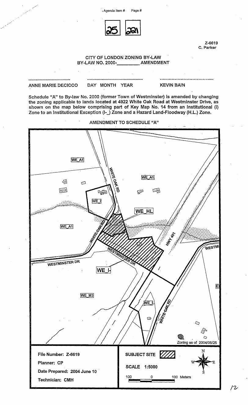
CITY OF LONDON ZONING BY-LAW BY-LAW NO. 2000- AMENDMENT
Schedule “A” to By-law No. 2000 (fbrmer Town of Westminster) is amended by changing the zoning applicable to lands located at 49.22 White Oak Road at Westminster Drive, as s h o w n o n the map below comprising part of Key Map No. 14 from an Institutional (I) Zone to an Institutional Exception (I-J Zone and a Hazard Land-Floodway (H.L.) Zone.
’ AMENDMENT TO SCHEDULE “A”