it is important to note that a change in applicant …
TRANSCRIPT

Standard application form 2016
For Office Use
Ref. No._________________
Application date:__________
Date of receipt. ___________
Date Validated:____________
APPLICATION FOR A LEASE/LICENCE/CONSENT UNDER THE FORESHORE ACT
1933 (AS AMENDED)
Applications for Offshore renewable energy (ORE) projects should use an ORE specific
form. Please complete the form electronically. Type details in the boxes provided, space will
expand as you type. The enclosures checklist should also be completed Tá an leagan Gaeilge den fhoirm seo ar fáil ar iarratas.
BEFORE FILLING OUT THIS FORM PLEASE READ THE DECLARATION AND
CONSENT ON PAGE 9:
IT IS IMPORTANT TO NOTE THAT A CHANGE IN APPLICANT NAME WILL REQUIRE A NEW APPLICATION.
DATA PROTECTION
The Office of the Data Protection Commissioner states that the sending of
marketing material to individuals without consent may result in action by the
Data Protection Commissioner against the sender including prosecution. It is the
responsibility of persons or entities wishing to use any personal data on an
application form for direct marking purposes to be satisfied that that they may do
so legitimately under the requirements of the Data Protection Acts 1998 and 2003
and with regard to General Data Protection Regulation (2016/679) requirements.
Applicant Name and Address:
Full Name of Applicant (not Agent):
Company/Organisation: Dublin Port Company
Address: Port Centre, Alexandra Road, Dublin 1
Eircode: D01 H4C6
Applicant Contact Details:
Phone No: 01 8876000
E-mail address:

2
Agent (if any) Address/Contact Details:
Person/Agent acting on behalf of the Applicant:
Company: RPS
Address: Elmwood House, 74 Boucher Road, Belfast
Eircode: (postcode) BT12 6RZ
Phone No: +44 2890 667914
E-mail address:
Applicant’s Legal Advisor:
Name: Beauchamps Solicitors
Address: Riverside Two, Sir John Rogerson’s Quay, Dublin 2
Eircode: D02 KV60
Phone No: 01 4180600
E-mail address: [email protected]
Part 1: Proposal Details (Attach additional documents as
required)
1.1
Description of proposed works/activity.
Dublin Port Company (DPC) need to carry out regular maintenance dredging of the
navigation channel, basins and berthing pockets in order to maintain their
advertised charted depths and hence provide safe navigation for vessels to and
from the Port. The loading of dredged material will be restricted to those areas of
the navigation channel, basins and berthing pockets which contain sediments which
are suitable for disposal at sea (Class 1 : uncontaminated, no biological effects
likely). Confirmation of the suitability of the dredged sediments for disposal at sea
is made through a programme of sediment chemistry sampling and analysis and
eco-toxicological testing. It is proposed to dispose of the dredged sediments at the
existing licenced offshore disposal site located at the entrance to Dublin Bay to the
west of the Burford Bank, (6.75 km from the lighthouse at the end of the Great
South Wall). The approximate amount of material to be dredged is 300,000 cubic
metres per annum and it consists mostly of silt and sand with elements of clay,
gravel and cobbles. Dredging will be carried out by a trailer suction hopper dredger
and support vessels.

3
1.2
Describe the nature and scale of any structure to be erected on the
foreshore. Is the structure proposed to be temporary or permanent?
There will be no permanent or temporary structures erected on the foreshore as
part of the proposed maintenance dredging campaigns 2022-2029.
1.3
Indicative timing of the works/activity: (i) Start date (ii) Duration (iii)
Any other information relevant to timing.
It is proposed to undertake the maintenance dredging and disposal at sea
operations within the period April to September each year between 2022 and
2029. The dredging campaign within each of these periods is expected to last
approximately 4-6 weeks, depending on weather conditions.
A closed period between 1st April and 14th May will operate for loading areas in the
inner Liffey channel upstream of Berth 49, including the main channel and channel
side berths but not including basins to protect migrating Atlantic salmon and River
Lamprey.
1.4
Primary usage for proposed development (please tick)
Use
Industrial
Commercial √
Within Fishery Harbour Centre
Sea Fisheries
Local Authority
Community/Co Op scheme
Other(specify)
Maintenance Dredging
√
1.5
Do the proposed works provide for public use, commercial use, restricted
use or strictly private use? Provide Details
The proposed works are for commercial use and for the restricted use by ferry and
cruise operators.
1.6
Might the proposed works restrict public use/enjoyment of the foreshore?
Provide details.
There will be no change to the use made of the foreshore by the public as a result
of the proposed works (see responses to Section 6 Navigational Safety
Considerations).
4
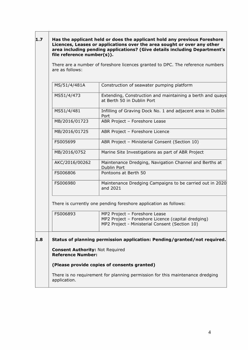
1.7
Has the applicant held or does the applicant hold any previous Foreshore
Licences, Leases or applications over the area sought or over any other
area including pending applications? (Give details including Department’s
file reference number(s)).
There are a number of foreshore licences granted to DPC. The reference numbers
are as follows:
MS/51/4/481A Construction of seawater pumping platform
MS51/4/473 Extending, Construction and maintaining a berth and quays
at Berth 50 in Dublin Port
MS51/4/481 Infilling of Graving Dock No. 1 and adjacent area in Dublin
Port
MB/2016/01723
ABR Project – Foreshore Lease
MB/2016/01725 ABR Project – Foreshore Licence
FS005699 ABR Project – Ministerial Consent (Section 10)
MB/2016/0752 Marine Site Investigations as part of ABR Project
AKC/2016/00262 Maintenance Dredging, Navigation Channel and Berths at
Dublin Port
FS006806 Pontoons at Berth 50
FS006980 Maintenance Dredging Campaigns to be carried out in 2020
and 2021
There is currently one pending foreshore application as follows:
FS006893 MP2 Project – Foreshore Lease
MP2 Project – Foreshore Licence (capital dredging)
MP2 Project - Ministerial Consent (Section 10)
1.8
Status of planning permission application: Pending/granted/not required.
Consent Authority: Not Required
Reference Number:
(Please provide copies of consents granted)
There is no requirement for planning permission for this maintenance dredging
application.

5
1.9
Are any other consents required for this proposal? Please detail.
Consent type Dumping at Sea Permit
Consent Authority: EPA
Reference Number: No reference number available yet
Status of application: Application will be made in Q1 2021
(Please provide copies of consents granted)
1.10
Employment Implications (if any)
Dublin Port Company currently employs more than 140 people directly. A further
4,000 people are employed within the Dublin Port Estate. Dublin Port is a
significant focal point for employment in Dublin both directly through businesses
operating in the Port Estate and regionally through enterprises supported by the
trading activity carried out at the Port. Dublin Port is a key facilitator of
merchandise trade in and out of Ireland and has a critical impact on the national
and regional economies. The Port is also a key component of the national tourism
sector and represents a gateway for visitors to Ireland both in terms of people
arriving/departing on conventional ferries and cruise ships.
The importance of Dublin Port has been recognised at a National Level by its
status as a Tier 1 Port in the National Ports Policy (2013).
1.11
Capital cost of proposed works (€ - Euro)
The total cost for the maintenance dredging campaigns 2022-2029 is in the region
of 10 million Euros.
1.12
Do the proposed works involve the draw down of European Union or State
funding?
If “Yes” give details, including any time restrictions, etc. applying
There will be no draw down of EU or State funding for the proposed maintenance
dredging works. DPC will finance the maintenance dredging campaigns entirely
from their own financial resources.

6
Part 2: Proposed Site. (Attach additional documents as
required)
2.1
County: Dublin
2.2
Location name and nearest townland name:
The location name is Dublin Port. There are two adjoining townlands: North Dock
B and Pembroke East A.
2.3
Geographic co-ordinates of the area under application in degrees minutes
and seconds WGS84 for offshore developments and where the area can
also be identified on the Ordnance Survey map and/or is connected to the
seashore/mainland, specify Ordnance Survey map no and Irish
Transverse Mercator coordinates
Please refer to Drawing Number IBE1618/Main 2022-2029/FS/01 Rev A for location
of the following points.
Loading Area
No. E_ING N_ING Lat Long 1 318166.36 234348.96 53.34640317 -6.226418015 2 318837.16 234289.56 53.34571962 -6.216373174 3 319239.84 234253.00 53.34530072 -6.210343869 4 319671.72 234254.45 53.34521635 -6.203862041 5 320070.28 234241.70 53.34501162 -6.197885765 6 320189.05 234260.51 53.34515365 -6.196096184 7 320403.01 234266.35 53.34515742 -6.192883156 8 320672.69 234303.60 53.34543056 -6.188821957 9 321332.89 234233.45 53.34464972 -6.178941241
10 322218.11 234255.79 53.34464678 -6.165648574 11 323491.11 234383.54 53.34549874 -6.146495674 12 324826.07 234267.56 53.34414417 -6.126508204 13 325743.04 234219.64 53.34349696 -6.112767322 14 327726.23 233630.05 53.33772783 -6.083246313 15 328428.48 233729.36 53.33844979 -6.072670039 16 328122.08 233392.17 53.3354961 -6.077403433 17 328034.99 232901.47 53.33111072 -6.078908047 18 327672.70 232635.28 53.32880777 -6.084450004 19 327276.19 232522.53 53.3278906 -6.090443066 20 325686.45 233724.44 53.33906337 -6.113812835 21 324775.58 233778.05 53.33976021 -6.127458672 22 323419.70 233937.78 53.34151228 -6.147740925 23 322221.22 233979.97 53.3421691 -6.165708233 24 321305.18 233957.39 53.34217692 -6.179462648 25 320988.49 233943.25 53.34212243 -6.184220336 26 320658.17 233927.62 53.34205737 -6.18918301

7
27 320256.16 233928.28 53.3421548 -6.195215185 28 319526.70 234003.33 53.34299394 -6.20613306 29 318934.36 234086.52 53.34387434 -6.214990787 30 318782.12 234024.04 53.34334745 -6.217298696 31 318503.33 234176.99 53.34478342 -6.221425176 32 318149.66 234222.50 53.34527122 -6.226715833
Dump Site
No E_ING N_ING Lat Long Dmp 1 329883.41 233355.62 53.334739 -6.050994248 Dmp 2 331193.12 233391.61 53.33473942 -6.031331255 Dmp 3 331239.22 231722.62 53.31974096 -6.031330253 Dmp 4 330250.95 231695.43 53.31974056 -6.046162212 Dmp 5 329918.29 232076.09 53.32324046 -6.050995099
2.4
Please indicate the size of the Foreshore area (Ha2) or (M2) or (KM2)
Maintenance Dredging Campaign – 2022-2029
Area of Foreshore subject to proposed Maintenance Dredging loading activity:
492.5 Ha
Area of Foreshore subject to proposed Maintenance Dredging dumping activity:
212.5 Ha
2.5
If offshore please indicate distance from shore (Km):
Great South Wall to seaward end of Navigation Channel: Approx 5.3 km
Great South Wall to Dumpsite at Burford Bank: Approx 6.8km
2.6
Is any of the foreshore in the proposed site in private ownership? If yes
please provide documentary evidence of same (e.g. folio)
Yes, some areas of foreshore which will be subject to maintenance dredging are in
the ownership of DPC, refer to Drawing no. IBE618/Main 2022-2029/FS/02 Rev A.
The total area in private ownership by DPC = 49 Ha
The total area in state ownership = 656 Ha
2.7
Any other site details considered relevant:
All other relevant site details are included in the supporting documentations and
drawings.

8
Part 3. Maps and Drawings, Please refer to Guidance on map and drawing requirements.
3.1
Site location map attached? Please include reference no(s).
Yes, please refer to following drawing:
Loading and Dump Site
Drawing No. IBE1618/Main 2020-2029/FS/01/ RevA
3.2
Foreshore Lease/Licence map attached? Please include reference no(s).
Yes, please refer to following drawing:
Loading and Dump Site
Drawing No. IBE1618/Main 2020-2029/FS/01/ RevA
3.3
Drawings of structures to be used and or layout (if required) attached?
Please detail and include reference no(s).
N/A – no structures to be used. Maintenance dredging campaign only.
3.4
Admiralty Chart attached?
Yes please refer to following drawing:
Drawing No. IBE1618/Main 2020-2029/FS/03/RevA
3.5
Other maps/drawings attached ?– please detail and include reference
numbers
Drawing no. IBE1618/Main 2022-2029/FS/02 RevA is included. This drawing
shows the areas in private ownership to be dredged.
Part 4: Pre- application consultations

9
4.1
Describe briefly any consultations undertaken with the following bodies:
National Parks & Wildlife Service (NPWS) of the Department of Arts,
Heritage, Regional, Rural and Gaeltacht Affairs
National Monuments Service (NMS) of the Department of Arts,
Heritage, Regional, Rural and Gaeltacht Affairs
Inland Fisheries Ireland
Sea Fisheries Protection Authority
Marine Institute
Marine Survey Office
Please also provide copies of correspondence.
Consultation letters were issued to the following organisations:
Inland Fisheries Ireland
Sea Fisheries Protection Authority
Marine Survey Office
Development Applications Unit (DAU) of DAHRRGA (The DAU is the co-
ordination unit for consultations with National Parks and Wildlife Services
and National Monuments Service)
Responses were received from the following as a result of the above consultation
process:
Underwater Archaeology Unit and National Parks and Wildlife Services of
DAHRRGA (letter received on 18th August 2020 via DAU)
Marine Survey Office (email received from MSO on 11th May 2020)
A copy of all the above correspondence is provided along with this application in a
standalone document entitled “Stakeholder Consultation”
Consultation with Marine Institute
Dublin Port Company (DPC) consulted with the Marine Institute regarding their
plans to submit both Foreshore Licence and Dumping at Sea Permit applications for
an eight year maintenance dredging programme (2022-2029).
Further to this consultation, the Marine Institute issued a Sampling & Analysis Plan
(SAP) to DPC on 27th March 2020. Additional sediment chemistry sampling and
analysis was also undertaken in accordance to the requirements of the ABR Project
Dumping at Sea Permit, S0024-01. The results of all the sediment chemistry
analysis carried out in April 2020 were forwarded to the Marine Institute for their
interpretation. The Marine Institute expressed concern over PCBs and PAH levels
that are marginally above the lower guideline limit, notably at sample location
DC04, and recommended that further investigative work be undertaken comprising
eco-toxicological testing.
The eco-toxicological test results showed that the marine sediments to be dredged
have no significant biological effect and can therefore be considered as Class 1
material (Uncontaminated: no biological effects likely) and thereby suitable for
disposal at sea.
Details are presented in the standalone document entitled “Volumes and Sediment
Chemistry”. RPS, 2021” which accompanies this application.

10
4.2
Describe briefly any consultations undertaken with other relevant
authorities (e.g. Local Authority, Port/Harbour authority etc) or State
Agencies.
A consultation letter and information pack containing drawings regarding the
proposed maintenance dredging was issued to Dublin City Council. No
observations were submitted by Dublin City Council in response to this
consultation.
4.3
Describe any consultations undertaken to date with other foreshore
users.
Regular communication takes place between DPC Harbour Master’s Office and
the users of the Port. Regular maintenance dredging is essential for the viability
and safety of the users of Dublin Port Company facilities.
4.4
Describe any likely interactions with activities of the public or other
foreshore users during the construction and operational phases of the
works/activities (e.g. fishing, aquaculture, sailing, and surfing
swimming, walking). Describe any measures proposed to minimise
inconvenience to other users.
The proposed maintenance dredging is taking place entirely within the confines
of Dublin Port and the existing navigation channel. Dublin Port is a working port
with restrictions already in place regarding what activities can take place within
its jurisdiction. Fishing or aquaculture does not take place within Dublin Port.
There are existing agreements in place already for the control of small vessels
within Dublin Port, “Dublin Bay Guidance Notes on Leisure Craft”.
Regular communication takes place between Dublin Port Company and the
Winter Swimming Group which participate in swimming close to Bull Island.
4.5
Have adjacent land owners, whose properties may be affected by these
works been consulted? Please provide details/permissions as
appropriate.
The proposed maintenance dredging will take place entirely within the confines of
Dublin Port and the existing navigation channel. The proposed maintenance
dredging will not impact on any adjacent land owners.

11
Part 5: Environmental Considerations
(your consultations with National Parks and Wildlife Service and National Monuments Service may inform your answers.
Attach additional reports as required and mark under the R
column)
www.epa.ie/downloads/advice/ea/guidelines/
www.environ.ie/en/DevelopmentHousing/PlanningDevelopment/EnvironmentalAss
essment/
http://www.npws.ie/protectedsites/appropriateassessment/
http://webgis.npws.ie/npwsviewer/
Environmental legislative requirements
Yes No R
5.1
Is an Environmental Impact Statement required for
this proposal?
Maintenance dredging is an exempted activity
X
5.2
Is a Natura Impact Statement required for this
proposal?
See standalone Natura Impact Statement (NIS)
X
X
5.3
Is the area within or adjacent to a NHA, pNHA, SAC,
SPA, or National Park?
Specify site names and code(s).
See standalone Natura Impact Statement (NIS)
X
X
5.4
Describe any other projects or plans for the area,
anticipated or developed, that in combination with
this proposal, may have a significant effect on a
Natura 2000 site: Please list with planning reference
numbers (where available).
See standalone Natura Impact Statement (NIS)
X
X

12
Environmental Considerations
Yes No R
5.5
Will the proposal have any potential environmental
impacts? If yes, please describe
The potential environmental effects of this project have
been assessed and are presented in the following attached
reports:
Marine Mammal Risk Assessment of Dublin Port
Company Proposed Maintenance Dredging
Programme 2022 to 2029 and Disposal at Sea. IWDG
Consulting, 2020.
Marine Archaeology Impact Assessment Maintenance
Dredging 2022-2029. ADCO Ltd., 2020.
Dublin Port Maintenance Dredging (2022-2029).
Benthic and Fisheries Assessment. Aquatic Services
Unit, 2020.
Water Quality Risk Assessment. RPS, 2021.
Coastal Processes Risk Assessment. RPS, 2021
X
X
X
X
X
X
X
X
X
X
5.6
Are you proposing any measures to mitigate the
potential environmental impacts? If yes, please
describe
In relation to marine mammals, it is proposed to adhere to
the recommendations as set out in the “Marine Mammal
Risk Assessment” report which accompanies this application
X
X
5.7
Are there public health/safety implications arising
from the proposed works? (e.g. effluent disposal,
removal of derelict or dangerous structures etc.) If
yes, please describe
There are no public health or safety implications arising
from the proposed maintenance dredging campaigns.
X
5.8
Will the works involve the storage and/or disposal of
waste? If “Yes” please give details of the type of
waste and the proposed method of storage and/or
disposal (including location)
No
X

13
5.9
Any other Environmental Considerations? If yes,
please specify.
No
X
Built Heritage Considerations
Yes No R
5.10
Does the area contain an archaeological site or
feature? If yes, please specify.
No
X
5.11
Does the area contain or adjoin a listed
archaeological site or monument? If yes, please
specify.
There are no recorded monuments in the RMP (Record of
Monument and Places) or in the Dublin City Record of
Protected Structures within the Study Area.
X
5.12
Will the proposal have any potential impacts on the
archaeological integrity of the site? If yes please
describe
The impact of the proposed maintenance dredging on
archaeology has been assessed, see attached report “Marine
Archaeology Impact Assessment Maintenance Dredging
2022-2029. ADCO Ltd., 2020.
X
X
5.13
Are you proposing any measures to mitigate potential
archaeological impacts? If yes, please describe?
The impact of the proposed maintenance dredging on
archaeology has been assessed, see attached report “Marine
Archaeology Impact Assessment Maintenance Dredging
2022-2029”. ADCO Ltd., 2020. DPC will adhere to the
recommendations made in this report.
X
X

14
Part 6: Navigational Safety Considerations. (Your
consultations with relevant stakeholders may inform your answers. Attach additional documents as required and mark
under the R column)
Navigational Safety Considerations.
Yes
No
R
6.1
Are there public navigational safety implications
arising from the proposed works?
Dublin Bay, the approaches to the Port and the shipping
channel are monitored at all times by Vessel Traffic Services
(VTS). All vessels are advised regarding works,
developments or issues that are ongoing in the Dublin Port
area of jurisdiction. Prior to any dredging a DPC “Notice to
Mariners” is sent out to all shipping informing them about
the planned work and dates. During the dredging operation
the vessel traffic is supervised and controlled.
X
6.2
What marine activity is there in the area?
Dublin Bay is very busy with marine leisure events and small
craft movements especially during the summer months.
Agreement was reached with all the sailing and motor clubs
how best to co-exist. To that end the commercial shipping
channels, access routes and anchorage areas are well defined
and kept clear. The organised leisure industry operates within
the confines of the areas agreed for their events. Individual
craft must operate within the international maritime
legislation governing all vessels big and small.
6.3
How will the marine activity be affected by the
proposed works?
Marine activity will be able to operate with little or no
disruption as the dredging operation will be subservient to
the demands of commercial movements. The leisure craft
are not normally allowed to operate within the confines of
the main approach channel. As the dredging is confined to
the navigation channel, basins and berths channel there
should be no effect. When small craft are entering or leaving
the Port they must do so under the control of VTS.
Therefore they will be well informed and aware of any
dredging operations and of their requirements to stay clear.
Again this is in compliance with International Legislation.

15
6.4
What mitigating measures will be put in place?
As discussed in the response to Question 6.1, the Harbour
Master will issue a Notice to Mariners specifying in detail the
areas to be dredged and the requirements for all craft, not
directly involved with the dredging operation to keep clear.
In relation to commercial traffic they will be coordinated and
controlled by VTS who will be in communication with all
involved.
6.5
How will the proposed works affect Marine Navigation
in the future?
Periodic maintenance dredging ensures that the access into
the Port is maintained and therefore ensures the safe
passage of vessels into and from the Port. The buoyage
defining the navigation routes will remain the same after the
maintenance dredging campaign is completed.
Part 7: Fishing/Aquaculture considerations (your
consultations with IFI, SFPA, DAFM may inform your answers. Attach additional documents as required and mark
under the R column)
Fishing/Aquaculture considerations
Yes
No
R
7.1
Is the proposal located in proximity to any of the
following:
aquaculture operation
designated Shellfish Growing Waters
fish spawning ground
other sensitive fisheries location
Please Illustrate on appropriate chart including
distance in Km.
There are no aquaculture operations or designated shellfish
growing waters in the vicinity of the proposed works.
X

16
7.2
Are there other potential impacts of the proposal on
fishing/aquaculture in the area? If yes, please
describe.
The impact of the proposed maintenance dredging on
fisheries is provided in the attached report, Dublin Port
Maintenance Dredging (2022-2029). Benthic and Fisheries
Assessment. Aquatic Services Unit, 2020.
DPC will adhere to the recommendations made in this
report.
X
X
7.3
Are there any measures proposed to mitigate
potential impacts on fisheries or aquaculture? If yes,
please describe.
Recommended fishery mitigation measures are set out in
the attached report, Dublin Port Maintenance Dredging
(2022-2029). Benthic and Fisheries Assessment. Aquatic
Services Unit, 2020.
DPC will adhere to the recommendations made in this
report.
X
X
Part 8 – Additional information
8.1
Please detail any additional relevant information.
There is no further information provided in this section of the form.

17
Declaration and Consent:
The details provided here are correct to the best of my knowledge.
I understand that no works will be commenced, by me or my agents on the
proposed site, without the prior written consent of the Minister.
By submitting this application form, I agree that the details provided (with
personal contact details redacted) are to be published on the Department of
Housing website and also that the full information provided including contact
details are to be processed and retained by the Department of Housing, Planning
and Local Government and shared with all appropriate Prescribed Bodies (as part
of the Prescribed Bodies Consultation process) in furtherance of consideration for
a foreshore Consent under the Foreshore Act 1933 (and Foreshore Amendment
Act 2011).
I give consent to the Minister and his servants to copy this application and to
make (a redacted) copy available for inspection and copying by the public. This
consent relates to this application, to any further information, or submission
provided by me or on my behalf and to the publication of the licence document.
Signature of Applicant (or his or her Agent):
__________ ____________
Name of above Signatory (block letters):
_______ _________________
Position Held:
________Senior Associate, RPS_________
Date: _____15th February 2021_________
Return completed applications to:
Marine Planning Policy and Development Section
Department of Housing, Planning and Local Government
Newtown Road
Wexford
Y35 AP90
Enquiries to: [email protected] (Other contact details to be included in
Guidance materials)
Email a copy of application documents: [email protected]

18
Enclosures Checklist
One hard copy of every document is required unless otherwise stated.
Electronic versions of documentation must also be provided in searchable
PDF format (no single file to be greater than 30mb) so that the
Department can make them available on its website.
Note: The documents below have been transferred to the Foreshore Unit,
DHLGH via a secure file transfer in line with the Department’s current Covid-19
policy.
Item
No.
Description No. of copies
Required
1 Application Form.
With original signature
File Transfer
X
2 Mapping (see guidelines document)
(i) Site Location map
(ii)Foreshore Lease/licence map
File Transfer
File Transfer
X
X
3 British Admiralty Chart (largest available scale)
File Transfer X
4 Drawings of the structures to be used and/or layout
N/A
5 Pre-application correspondence with stakeholders.
File Transfer X
6 Other statutory permissions:
(i) Planning permission
(ii) Effluent Discharge Licence
(iii) Other consent (Please specify)
Dumping at Sea Permit application will be submitted to
the EPA Q1 2021
N/A
N/A
See
Note
7 Company documentation (1):
Certified copy of the Company’s Memorandum and
Articles of Association
File Transfer X
8 Company documentation (2)
Certificate of Incorporation of a Limited Liability, or
Company/Rule Book/Constitution for a Club or Co-
Operative Society as appropriate
File Transfer X
9 Environmental Impact Statement (EIS).
(i) Hard copy
(ii) CDs
N/A
10 Natura Impact Statement (NIS)
(i) Hard copy
(ii) CDs
File Transfer
X

19
11 Property-related owner permissions/wayleaves
(i) Folio – (or other evidence of private ownership)
(ii) Wayleave/consent from other property owners
(iii) Other (Please specify)
File Transfer
X
N/A
N/A
12 Other – Please specify
1. Stakeholder Consultation Report. RPS, 2021
2. Marine Mammal Risk Assessment of Dublin Port
Company Proposed Maintenance Dredging
Programme 2022 to 2029 and Disposal at Sea.
IWDG Consulting, 2020.
3. Marine Archaeology Impact Assessment
Maintenance Dredging 2022-2029. ADCO Ltd.,
2020.
4. Water Quality Risk Assessment. RPS, 2021.
5. Dublin Port Maintenance Dredging (2022-2029).
Benthic and Fisheries Assessment. Aquatic
Services Unit, 2020
6. Coastal Processes Risk Assessment. RPS, 2021
7. Volumes and Sediment Chemistry. RPS, 2021
File Transfer
File Transfer
File Transfer
File Transfer
File Transfer
File Transfer
File Transfer
X
X
X
X
X
X
X