issued for town planning - shire of mitchell
TRANSCRIPT
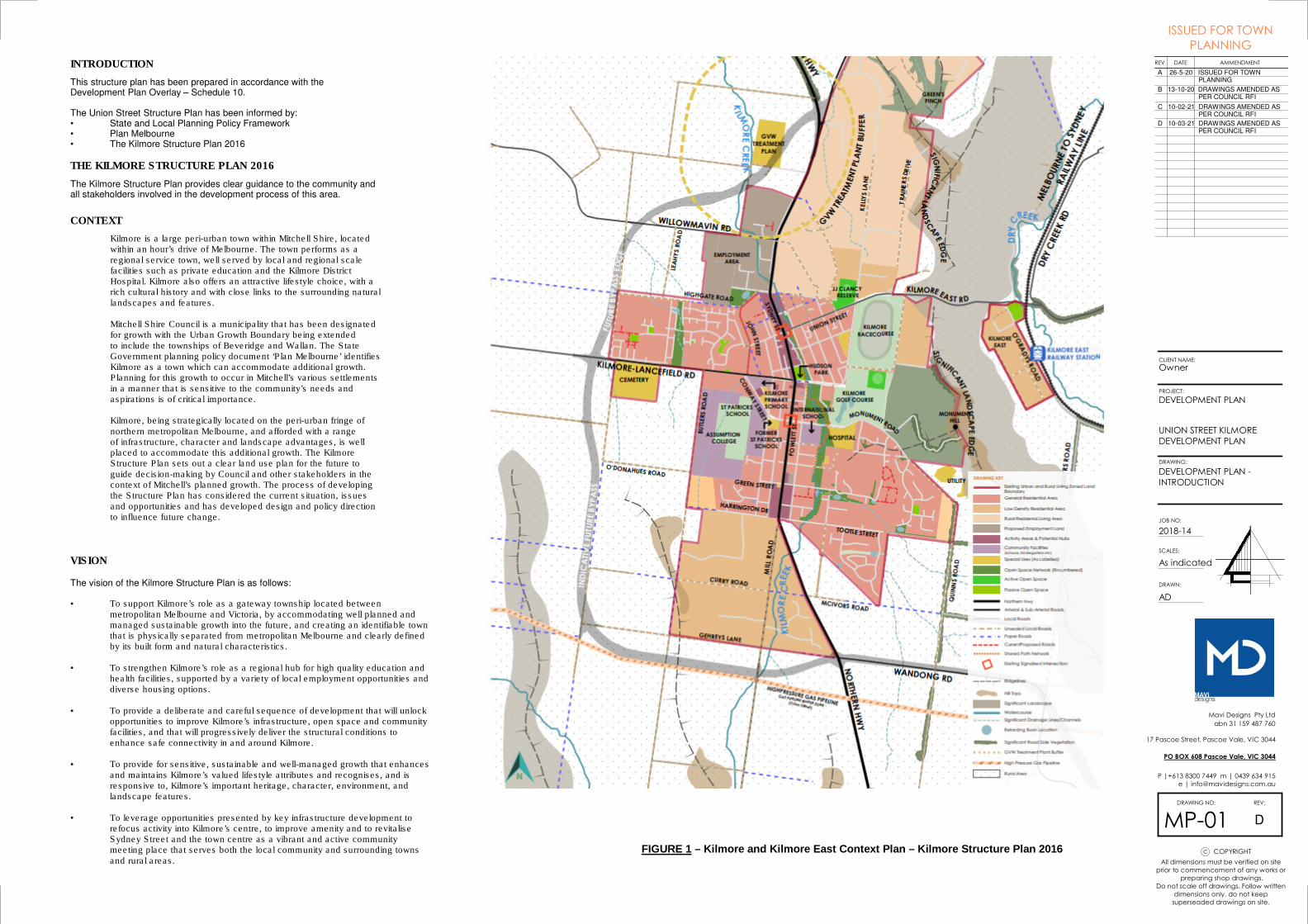
FIGURE 1 – Kilmore and Kilmore East Context Plan – Kilmore Structure Plan 2016
THE KILMORE STRUCTURE PLAN 2016
INTRODUCTION
This structure plan has been prepared in accordance with the Development Plan Overlay – Schedule 10.
The Union Street Structure Plan has been informed by:• State and Local Planning Policy Framework• Plan Melbourne• The Kilmore Structure Plan 2016
Kilmore is a large peri-urban town within Mitchell Shire, locatedwithin an hour’s drive of Melbourne. The town performs as aregional service town, well served by local and regional scalefacilities such as private education and the Kilmore DistrictHospital. Kilmore also offers an attractive lifestyle choice, with arich cultural history and with close links to the surrounding naturallandscapes and features.
Mitchell Shire Council is a municipality that has been designatedfor growth with the Urban Growth Boundary being extendedto include the townships of Beveridge and Wallan. The StateGovernment planning policy document ‘Plan Melbourne’ identifiesKilmore as a town which can accommodate additional growth.Planning for this growth to occur in Mitchell’s various settlementsin a manner that is sensitive to the community’s needs andaspirations is of critical importance.
Kilmore, being strategically located on the peri-urban fringe ofnorthern metropolitan Melbourne, and afforded with a rangeof infrastructure, character and landscape advantages, is wellplaced to accommodate this additional growth. The KilmoreStructure Plan sets out a clear land use plan for the future toguide decision-making by Council and other stakeholders in the context of Mitchell’s planned growth. The process of developingthe Structure Plan has considered the current situation, issuesand opportunities and has developed design and policy directionto influence future change.
The Kilmore Structure Plan provides clear guidance to the community and all stakeholders involved in the development process of this area.
CONTEXT
The vision of the Kilmore Structure Plan is as follows:
• To support Kilmore’s role as a gateway township located between metropolitan Melbourne and Victoria, by accommodating well planned and managed sustainable growth into the future, and creating an identifiable town that is physically separated from metropolitan Melbourne and clearly defined by its built form and natural characteristics.
• To strengthen Kilmore’s role as a regional hub for high quality education and health facilities, supported by a variety of local employment opportunities and diverse housing options.
• To provide a deliberate and careful sequence of development that will unlock opportunities to improve Kilmore’s infrastructure, open space and community facilities, and that will progressively deliver the structural conditions to enhance safe connectivity in and around Kilmore.
• To provide for sensitive, sustainable and well-managed growth that enhances and maintains Kilmore’s valued lifestyle attributes and recognises, and is responsive to, Kilmore’s important heritage, character, environment, and landscape features.
• To leverage opportunities presented by key infrastructure development to refocus activity into Kilmore’s centre, to improve amenity and to revitalise Sydney Street and the town centre as a vibrant and active community meeting place that serves both the local community and surrounding towns and rural areas.
VISION
COPYRIGHTc
abn 31 159 487 760
17 Pascoe Street, Pascoe Vale, VIC 3044
P |+613 8300 7449 m | 0439 634 915
SCALES:
REV:
JOB NO:
DRAWING NO:
DRAWN:
CLIENT NAME:
DRAWING:
REV AMMENDMENTDATE
All dimensions must be verified on site
prior to commencement of any works or
preparing shop drawings.
Do not scale off drawings. Follow written
dimensions only. do not keep
superseaded drawings on site.
Mavi Designs Pty Ltd
PROJECT:
PO BOX 608 Pascoe Vale, VIC 3044
As indicated
DEVELOPMENT PLAN
UNION STREET KILMORE
DEVELOPMENT PLAN
Owner
2018-14
AD
MP-01
DEVELOPMENT PLAN -
INTRODUCTION
ISSUED FOR TOWN
PLANNING
A 26-5-20 ISSUED FOR TOWN PLANNING
B 13-10-20 DRAWINGS AMENDED AS PER COUNCIL RFI
C 10-02-21 DRAWINGS AMENDED AS PER COUNCIL RFI
D
D 10-03-21 DRAWINGS AMENDED AS PER COUNCIL RFI

Figure 3 – Overlay Map of Structure Plan Area
Figure 2 – Zoning Map of Structure Plan Area
The land within this Structure Plan Area is affected by a - Development Plan Overlay 10.
• To implement the Municipal Planning Strategy and the Planning Policy Framework.
• To identify areas which require the form and conditions of future use and development to be shown on a development plan before a permit can be granted to use or develop the land.
• To exempt an application from notice and review if a development plan has been prepared to the satisfaction of the responsible authority.
A permit must not be granted to use or subdivide land, construct a building or construct or carry out works until a development plan has been prepared to the satisfaction of the responsible authority.
OVERLAY
The land within this Structure Plan Area is zoned – General Residential Schedule 1.
The Purposed of the zone is:
• To implement the Municipal Planning Strategy and the Planning Policy Framework.
• To encourage development that respects the neighbourhood character of the area.
• To encourage a diversity of housing types and housing growth particularly in locations offering good access to services and transport.
• To allow educational, recreational, religious, community and a limited range of other non-residential uses to serve local community needs in appropriate locations.
ZONING
COPYRIGHTc
abn 31 159 487 760
17 Pascoe Street, Pascoe Vale, VIC 3044
P |+613 8300 7449 m | 0439 634 915
SCALES:
REV:
JOB NO:
DRAWING NO:
DRAWN:
CLIENT NAME:
DRAWING:
REV AMMENDMENTDATE
All dimensions must be verified on site
prior to commencement of any works or
preparing shop drawings.
Do not scale off drawings. Follow written
dimensions only. do not keep
superseaded drawings on site.
Mavi Designs Pty Ltd
PROJECT:
PO BOX 608 Pascoe Vale, VIC 3044
As indicated
DEVELOPMENT PLAN
UNION STREET KILMORE
DEVELOPMENT PLAN
Owner
2018-14
AD
MP-02
DEVELOPMENT PLAN -
ZONING & OVERLAY
ISSUED FOR TOWN
PLANNING
A 26-5-20 ISSUED FOR TOWN PLANNING
B 13-10-20 DRAWINGS AMENDED AS PER COUNCIL RFI
C 10-02-21 DRAWINGS AMENDED AS PER COUNCIL RFI
D
D 10-03-21 DRAWINGS AMENDED AS PER COUNCIL RFI

UNION STREET
UNION STREET
CH
AP
EL S
TR
EE
T
CH
AP
EL S
TR
EE
T
JO
HN
ST
RE
ET UNION STREET
UNION STREET
CH
UR
CH
ST
RE
ET
No 9 CHAPEL STREET
HERITAGE HOUSE TO BE RETAINED
No 3-5 CHAPEL STREET
HERITAGE HOUSE & TREES TO BE
RETAINED
OA
K
TR
EE
No 6
UN
ION
ST
RE
ET
HE
RIT
AG
E
HO
US
E T
O B
E
RE
TA
INE
D
16A UNION STREET14 UNION
STREET
18 UNION STREET
12 UNION STREET
12A UNION STREET
10 UNION STREET8 UNION
STREET
2-4 UNION STREET
20 UNION STREET
1 CHAPEL STREET
3 CHAPEL STREET
16 UNION STREET
COPYRIGHTc
abn 31 159 487 760
17 Pascoe Street, Pascoe Vale, VIC 3044
P |+613 8300 7449 m | 0439 634 915
SCALES:
REV:
JOB NO:
DRAWING NO:
DRAWN:
CLIENT NAME:
DRAWING:
REV AMMENDMENTDATE
All dimensions must be verified on site
prior to commencement of any works or
preparing shop drawings.
Do not scale off drawings. Follow written
dimensions only. do not keep
superseaded drawings on site.
Mavi Designs Pty Ltd
PROJECT:
PO BOX 608 Pascoe Vale, VIC 3044
1 : 1000
DEVELOPMENT PLAN
UNION STREET KILMORE
DEVELOPMENT PLAN
Owner
2018-14
AD
MP-03
DEVELOPMENT PLAN -
EXISTING CONDITIONS
ISSUED FOR TOWN
PLANNING
A 26-5-20 ISSUED FOR TOWN PLANNING
B 13-10-20 DRAWINGS AMENDED AS PER COUNCIL RFI
C 10-02-21 DRAWINGS AMENDED AS PER COUNCIL RFI
D
D 10-03-21 DRAWINGS AMENDED AS PER COUNCIL RFI
UNION STREET
CH
AP
EL S
TR
EE
T
JOH
N S
TR
EE
T
UNION STREET
UNION STREET KILMORE DEVELOPMENT PLAN
CH
UR
CH
ST
RE
ET
SY
DN
EY
ST
RE
ET
SY
DN
EY
ST
RE
ET
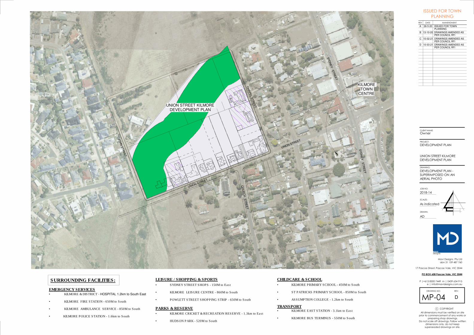
KILMORE TOWN
CENTRE
• KILMORE & DISTRICT - HOSPITAL 1.2km to South East
• KILMORE FIRE STATION - 650M to South
• KILMORE AMBULANCE SERVICE - 850M to South
• KILMORE POLICE STATION - 1.6km to South
SURROUNDING FACILITIES:
EMERGENCY SERVICES
LEISURE / SHOPPING & SPORTS
• SYDNEY STREET SHOPS - 150M to East
• KILMORE LEISURE CENTRE - 860M to South
• POWLETT STREET SHOPPING STRIP - 650M to South
CHILDCARE & SCHOOL
• KILMORE PRIMARY SCHOOL - 450M to South
• ST PATRICKS PRIMARY SCHOOL - 850M to South
• ASSUMPTION COLLEGE - 1.2km to South
PARKS & RESERVE
• KILMORE CRICKET & RECREATION RESERVE - 1.3km to East
• HUDSON PARK - 520M to South
TRANSPORT• KILMORE EAST STATION - 3.1km to East
• KILMORE BUS TERMINUS - 550M to South
COPYRIGHTc
abn 31 159 487 760
17 Pascoe Street, Pascoe Vale, VIC 3044
P |+613 8300 7449 m | 0439 634 915
SCALES:
REV:
JOB NO:
DRAWING NO:
DRAWN:
CLIENT NAME:
DRAWING:
REV AMMENDMENTDATE
All dimensions must be verified on site
prior to commencement of any works or
preparing shop drawings.
Do not scale off drawings. Follow written
dimensions only. do not keep
superseaded drawings on site.
Mavi Designs Pty Ltd
PROJECT:
PO BOX 608 Pascoe Vale, VIC 3044
As indicated
DEVELOPMENT PLAN
UNION STREET KILMORE
DEVELOPMENT PLAN
Owner
2018-14
AD
MP-04
DEVELOPMENT PLAN -
SUPERIMPOSED ON AN
AERIAL PHOTO
ISSUED FOR TOWN
PLANNING
A 26-5-20 ISSUED FOR TOWN PLANNING
B 13-10-20 DRAWINGS AMENDED AS PER COUNCIL RFI
C 10-02-21 DRAWINGS AMENDED AS PER COUNCIL RFI
D
D 10-03-21 DRAWINGS AMENDED AS PER COUNCIL RFI

UNION STREET
CH
AP
EL S
TR
EE
T
JOH
N S
TR
EE
T
60m WIDE WATERWAY
No 9 CHAPEL STREETHERITAGE HOUSE TO BE RETAINED
No 3-5 CHAPEL STREETHERITAGE HOUSE & TREES TO BE RETAINED
OAK TREE
LOT 7
LOT 1
LOT 3
LOT 5
LOT 19
LOT 17
LOT 20
No 6
UN
ION
ST
RE
ET
HE
RIT
AG
E
HO
US
E T
O B
E
RE
TA
INE
D
WATERWAYAREA
30M WATERWAY SETBACK FROM CETRELINE OF WATERWAY IN-ACCORDANCE WITH 'GOULBURN BROKEN CATCHMENT MANAGEMENT AUTHORITY' REQUIREMENTS
LOT LAYOUTSDEVELOP LOT LAYOUTS TO BE CONSISTANT WITH LOT OWNERSHIP SIZE AND LOCATION WITH-IN THE DEVELOPMENT PLAN
HERITAGE OVERLAYRETAIN DWELLINGS AND / OR TREES THAT ARE PROTECTED BY A HERITAGE OVERLAY
DEVELOP LOT LAYOUTSDEVELOP LOT LAYOUTS THAT ENCOURAGES INCREASED RESIDENTIAL DEVELOPMENT IN-ACCORDANCE WITH THE 'KILMORE STRUCTURE PLAN 2016'
OPEN SPACE LINKSCREATE OPEN SPACE LINKS ALONG THE PROPOSED WATERWAY
CARRIAGEWAYSPROVISION OF CARRIAGEWAYS AND FOOTPATHS IN-ACCORDANCE WITH THE RESPONSIBLE AUTHORITY
STRATEGIC ROAD LINKPROVIDE AN INTERNAL ROAD (STRATEGIC ROAD LINK) IN-ACCORDANCE WITH THE 'KILMORE STRUCTURE PLAN 2016'
WATERWAYAREA
WATERWAYAREA30000 W
ATERW
AY
30000 WATER
WAY
APPROX. CENTRE-LINE OF WATERWAY
LOT 9
2-4 UNION STREET
AC
CE
SS
WA
Y 7
.5M
wid
w
com
mon d
rivew
ay
LOT 2
LOT 4
LOT 6
LOT 8
LOT 10
LOT 11
LOT 12
LOT 13
LOT 14
LOT 15
LOT 16
LOT 18
LOT 21LOT 22
LOT 30
LOT 33
AC
CESSW
AY 10
M w
ide
LOT 23LO
T 24LOT 25LO
T 26LOT 27
LOT 28LO
T 2
9
pede
stria
n pat
h
walk
way
walk
way
com
mon d
rivew
ay
pede
stria
n pa
th
pede
strian
pat
h
pedestrian path
LOT 31
LOT 32
TRANSPARENT FENCINGALONG No. 9 CHAPEL STREET
TIMBER PALING FENCES DOTTED IN RED BOUNDING No 3-5 CHAPEL STREET
PROPOSED ROADS / COURTS
PROPOSED AREAS FOR HOUSING
WATERWAYS / PARKLAND / TREES / PARKLAND
PROPOSED LOT BREAK-UPS
LOT
WALKING TRAIL
MASTER PLAN LEGEND
PROPOSED DWELLING OUTLINE
DENOTES - TRANSPARENT FENCING
DENOTES -ACTIVE FRONTAGE TO WATERWAY
- TOTAL SITE AREA: 13500m²
SUMMARY NOTES
- TOTAL LOTS: 33
- SUB-DIVISION LAYOUT FOR EACH ALOTMENT WILL BE SUBJECT TO THE PLANNING PROCESS
- ROADS, OPEN SPACE DIMENSIONS, WATERWAY DIMENSIONS, PEDESTRIAN PATHS ARE SUBJECT TO COUNCIL APPROVAL
- AREA AVERAGE PER LOT: 410m²
COPYRIGHTc
abn 31 159 487 760
17 Pascoe Street, Pascoe Vale, VIC 3044
P |+613 8300 7449 m | 0439 634 915
SCALES:
REV:
JOB NO:
DRAWING NO:
DRAWN:
CLIENT NAME:
DRAWING:
REV AMMENDMENTDATE
All dimensions must be verified on site
prior to commencement of any works or
preparing shop drawings.
Do not scale off drawings. Follow written
dimensions only. do not keep
superseaded drawings on site.
Mavi Designs Pty Ltd
PROJECT:
PO BOX 608 Pascoe Vale, VIC 3044
As indicated
DEVELOPMENT PLAN
UNION STREET KILMORE
DEVELOPMENT PLAN
Owner
2018-14
AD
MP-05
DEVELOPMENT PLAN -
PROPOSED
ISSUED FOR TOWN
PLANNING
A 26-5-20 ISSUED FOR TOWN PLANNING
B 13-10-20 DRAWINGS AMENDED AS PER COUNCIL RFI
C 26-11-20 RESPONSE TO COUNCIL RFI
D
D 10-03-21 DRAWINGS AMENDED AS PER COUNCIL RFI