issue 55 2011 wa sets the standard
TRANSCRIPT

Industry
Issue # 55 March 2011
WA sets the standard Welcome to 2011 and the 55th issue of ASSAY. Yet again, the good folk of Western Australia have set a high benchmark for reporting and communicating their research and management of acid sulfate soils. If there was an award for the most consistently submitted and engaging articles provided to ASSAY, Western Australia would top the tipping! A worthy achievement indeed, but is it one that could be equalled, or perhaps even exceeded by the other States and Territories? Time will tell…
Inside you’ll find articles about new ARC grant‐funded research being carried out by Southern Cross University; some more historic references to acid sulfate soil impacts – this time fish kills in the Tweed River over a century ago; and some intriguing preliminary finds of sulfidic materials at over 200 metres elevation in inland Victoria. The research community have also had a busy start to the year, with no less than seven publications summarised within this edition; and not forgetting, another great article and captivating image from Western Australia…
Happy reading…Simon
Stories and places in this issue…..
Pg 7: Tweed – historic fish kills
Pg 2: Lake Mealup
Pg 4: Boundary Creek – sulfides found at over 200 m elevation
Pg 5: GeoScience - New ARC project

Investigations continue at Lake Mealup, Western Australia
Clare Nixon, Department of Environment and Conservation
Investigations are continuing at Lake Mealup to monitor a recovery program for this significant, groundwater‐dependent wetland.
Lake Mealup lies within the Ramsar‐listed Peel‐Yalgorup system, east of the Harvey Estuary and south of Perth in Western Australia.
The ecological significance of the lake has progressively deteriorated over time. Declining rainfall since the mid 1970s has affected the lake’s capacity to maintain water levels on a permanent basis. Since 1993, Lake Mealup has dried out each summer, resulting in extreme acidification. The lake recorded a pH of 2.9 in November 2010.
DEC environmental officer Jarrod Abrahams ‐ wondering where the water went …
This situation is further exacerbated by an extensive agricultural drainage network that was designed for flood mitigation. However, some of these drains appear to intersect the water table and therefore could impede groundwater flow towards the lake.
The Lake Mealup recovery program is a joint initiative between the Commonwealth, WA’s Department of Environment and Conservation (DEC), Department of Water, the Lake Mealup Preservation Society and the Peel‐Harvey Catchment Council.
The recovery program involves the construction of a weir at the Mealup Main Drain, south of Lake Mealup, in order to restore some natural groundwater flow into the lake.
DEC carried out soil, groundwater and surface water investigations between 2008 and 2010, in an
ASSAY # 54 December 2010
2

effort to characterise the acidity risk associated with acid sulfate soils and declining groundwater levels.
Lake Mealup is located in an area of geological transition. Tamala Limestone (MW3, DoW2901) occurs west of the lake. The lake itself is situated within Bassendean Sands (MW1, MW2, MW4, MW5) and east of Lake Mealup are dense clays of the Guildford Formation (MW6).
DEC environmental officer Steve Clohessy said the unique characteristics of each geological formation played a major role in determining the lake’s susceptibility to acidification.
“Potential ASS was identified throughout each Bassendean Sands profile from the surface to a depth of approx 6 m below ground level,” he said.
Lake Mealup sampling sites
“Soil investigations around Lake Mealup showed that highly‐leached, poorly buffered Bassendean Sands are highly susceptible to acidification.”
“This is largely due to the presence of highly reactive pyritic materials in porous soils with poor buffering capacity, which can trigger large scale pH changes from the oxidation of very small amounts of pyrite.”
Steve said the seasonal drying out of the lake over the past 17 years had exposed the pyritic minerals, including monosulfidic sediments that had accumulated in the system, creating an acid store capable of causing extensive soil and water acidification.
“Additional soil and pore water characterisation has been undertaken to understand the complex biochemical processes of the lake sediment to assist in the recovery program,” he said.
ASSAY # 54 December 2010
3

Further groundwater and surface water monitoring will be undertaken in order to assess changes in water quality following construction of the weir, which is scheduled to be completed by May 2011.
For further information, please contact [email protected]
Inland and upland acidification of the Big Swamp, Victoria
Photos: Mal Gardiner / John Callahan
The Big Swamp along Boundary Creek, a tributary of the Barwon River in Victoria, has been showing signs of acidification ‐ which makes for an interesting case, given its location inland from the coast and elevation over 200 m above mean sea level.
Mal Gardiner, a local resident of the area, contacted ASSAY to draw attention to the potential for acid sulfate soil issues at this site. Visual indicators such as iron flocculation and iron staining were present, as was evidence of concrete corrosion on infrequently submerged bridge pylons.
Groundwater pumping has been taking place in the vicinity since the early 1980s to augment the town water supply for regional urban centres. Whether this or other factors are primarily responsible for the desiccation and acidification of the Big Swamp is uncertain.
The progressive drying out of the wetland has enabled peat fires to ignite and burn, which have further exacerbated the challenges facing this area.
In February 2010, researchers from EAL Consulting Services based at Southern Cross University, Lismore collected soil samples at Big Swamp for further detailed analysis.
Boundary Creek (arrows) and Big Swamp (dashed) after the 2010 peat fires
ASSAY # 54 December 2010
4

Results indicated that the Big Swamp (formerly inundated and now either permanently or periodically exposed) demonstrated extremely high acidic soil conditions, as well as associated instances of acidic surface waters discharging in the immediate vicinity. Extraordinarily high levels of reduced inorganic sulfur (up to 16% SCR) and titratable actual acidity were also found at the site.
In association with highly acidic soil conditions, subsurface layers showed that significant acid generating capability remains within the periodically wetted soil profile.
Big Swamp 2010 – taken just before the most recent peat fire, the
Elevated levels of dissolved metals (iron and aluminium) and sulfates confirm the presence of an active acid sulfate soil environment.
Other locales in the vicinity of Big Swamp that were examined as part of the study have also displayed characteristics of acid sulfatesoils.
Further study is warranted at this site to determine the exact nature and origin of the acid sulfate soils found.
For further information on this topic, please contact Mal Gardiner at [email protected]
Unravelling the mysteries of acid sulfate soils
Source: http://www.farnorthcoaster.com.au/news/10053/unravelling-the-mysteries-of-acid-sulfate-soils/
Flooding, sea level rise and general land use practices all have the potential to impact significantly on the world’s wetland environments and therefore to affect water and soil quality as well as marine environments on a large scale, according to Southern Cross University.
Fish kills are a well‐documented example. An Australian Research Council Discovery Projects scheme grant awarded to a Southern Cross University Special Research Centre, Southern Cross GeoScience project, has funded research that aims to rethink how soil mineralogy and biogeochemistry affect wetland environments and consequently the broader environment.
The project, titled ‘A new paradigm for the accumulation and persistence of metastable iron sulfides in sulfidic soils’, is being led by Southern Cross GeoScience Associate Professor Ed Burton, who said there was still a lot to learn about the behaviour of organic material and minerals in wetland soils.
ASSAY # 54 December 2010
5
“I have been studying the geochemical behaviour of iron and sulfur in acid sulfate soil wetlands since joining Southern Cross University in 2005 and one of my initial discoveries was that the soils that underlay these wetlands often have extremely high concentrations of a group of iron sulfide minerals that have traditionally been considered quite rare,” Dr Burton said.

“My work showed that these iron sulfide minerals exert an amazingly strong influence over the composition of soil pore‐water and shallow groundwater, particularly the abundance of arsenic and heavy metals. This led me to question why normally very rare, and highly reactive, iron sulfide minerals tend to accumulate and persist in acid‐sulfate soil wetlands.
“I am also looking at mineral behaviour because I have observed that the natural accumulation of metastable iron sulfide can be harnessed to remediate wetland soils that are acidic or contaminated with heavy metals and conversely, since metastable iron sulfides are very reactive, that their natural accumulation may, in some cases, represent a ‘time bomb’ that might release associated heavy metals when wetland conditions change.
“By understanding how wetlands respond to environmental conditions and by having better tools to monitor such responses, soil and water managers will be able to forecast how potential management scenarios will ultimately affect water quality and ecosystem health.
“Up to now, there has been a yawning gulf between, firstly, the molecular‐level chemistry of iron sulfide minerals and, secondly, field‐based observations of geochemical phenomena affecting iron sulfide occurrence. My research approach aims to bridge this gulf by connecting observations at the wetland scale with observations of molecular‐scale dynamics.
Associate Professor Dr Ed Burton testing water quality in the Tuckean Swamp Photo: Jane Munro
“My earlier research has demonstrated that a dual approach is needed to truly understand and predict changes in wetland water‐quality, and optimise land management efforts. The project will be the first
in the world to systematically unravel the driving forces behind the accumulation and persistence of highly reactive iron sulfides in wetland soils.
“This is internationally‐significant because iron sulfides are ubiquitous in wetland soils, yet systematic studies into their geochemical behaviour have been largely confined to laboratory‐based ‘model’ systems.”
Dr Burton was awarded a prestigious five‐year Australian Research Fellowship in association with the Australian Research Council grant in recognition that this research project is of international significance and will be facilitated within a world‐class research environment.
The research team includes Associate Professor Ed Burton as the Chief Investigator, along with Professor Richard Bush, co‐director of Southern Cross GeoScience. Professor Mats Astrom from Linnaeus University in Sweden and Professor Stefan Peiffer from the University of Bayreuth in Germany are both Partner Investigators.
The scientific results will be published over the course of the five‐year project in international geochemistry journals. The project aims to enable Australian and international communities to better protect their water resources for the benefit of the environment and dependant rural and regional economies.
ASSAY # 54 December 2010
6
Southern Cross University received the highest classification of a ‘well above world standard’ rating in the field of geochemistry in the Excellence in Research for Australia 2010 National report released this week.
For more information on this project, please contact [email protected]
Early fish kills in the Tweed, NSW
Simon Walsh
As mentioned in ASSAY 54, I have been working on a project to determine the historic occurrence of major fish kills on the Richmond River, NSW. This process involved checking records in old newspapers, government archives, diaries and reports for references to major fish kills, floodplain drainage construction and acid sulfate soils.
Below is an interesting selection of early newspaper clippings referring to fish kills on the Tweed River in NSW. Initially, the operations of the local sugar mill were being blamed for these events, until the analysis of a water sample in 1908 found it to be “impregnated with sulphuretted hydrogen”.
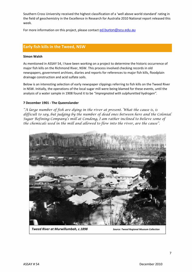
7 December 1901 ‐ The Queenslander
Tweed River at Murwillumbah, c.1898 Source: Tweed Regional Museum Collection
“A large number of fish are dying in the river at present. What the cause is, is difficult to say, but judging by the number of dead ones between here and the Colonial Sugar Refining Company’s mill at Condong, I am rather inclined to believe some of the chemicals used in the mill and allowed to flow into the river, are the cause”.
ASSAY # 54 December 2010
7
ASSAY # 54 December 2010
8
“Reference was recently made in the “Courier” to the heavy mortality of fish in the Tweed River which usually occurs after heavy rain. Various reasons have been ascribed, the most generally accepted idea being that the mortality was caused by water heavily charged with alum. The local Fisheries Inspector (Mr Laman) recently forwarded samples of the water from the various small streams which enter into the
8 February 1907 – Sydney Morning Herald
“During the last cane-crushing season on the Tweed River, a close watch was kept on the water to see if any destruction of fish occurred from the discharge of waste matters into it. None was reported this season”.
27 Nov 1907 ‐ Tweed Times & Brunswick Advocate
“Fish are dying wholesale in the river, and even large jewfish have bitten the mill refuse, with fatal results. Pity!”
“A close season against net fishing has been declared in Cudgegong Creek by the Fisheries Board. The Department will protect the fish against the individual, but it will let the CSR Co. kill wholesale”.
November, 1907 ‐ NSW Fishery Inspector reports
“During the month of November, a considerable number of dead fish were seen floating in the Tweed River, between the Condong sugar mill and Murwillumbah, and endeavours were made to obtain some specimens for examination as to the cause of the excessive mortality.
Samples were forwarded to Sydney but owing to the high temperature at the time, and the length of the journey, their condition on arrival was such that it was impossible to subject them to any satisfactory examination.”
29 February 1908 ‐ Sydney Morning Herald
“A sample of Tweed River water, in which fish had been found dead during the recent heat wave, was reported upon by the Board of Health, and was found to be impregnated with sulphuretted hydrogen”.
10 December 1910 ‐ Sydney Morning Herald
“Thousands of dead fish were seen floating in the river in the vicinity of Murwillumbah yesterday and today. A similar occurrence was noticeable three years ago. The cause of the wholesale destruction cannot be ascertained, but the matter has been brought under the notice of the Inspector of Fisheries”.
4 July 1924 ‐ Sydney Morning Herald
“Following upon the heavy rains of a few weeks ago, which resulted in a small flood, the waters of the Tweed River were heavily charged with alum from the surrounding hills. This had the effect of killing fish in thousands. About the lower reaches of the river that waters had been thick with dead fish, and the odour was most offensive. In former years, when the fish died in large numbers, the view was held that the chemicals discharged from the Condong sugar mill were the cause of the slaughter. As the mill has not yet commenced operations this year, it is clear that it cannot be held responsible”.
10 September 1924 ‐ Brisbane Courier

river to Sydney for analysis and has now received the analyst’s report, which indicates that the small creek which enters the river near Stott’s Channel is the prime cause. This water contains one per cent of (free) sulphuric acid and is largely charged with alum. Sulphuric acid being deadly to fish life, it is considered that the cause of the heavy mortality has been located”.
For further information on this project, please contact [email protected]
Acid sulfate soil short course hits the mark
Chrisy Clay, Southern Cross University
Building upon its success last year, Southern Cross GeoScience’s acid sulfate soil professional short course will be rolled out across the country during 2011. The course, delivered with the assistance of Caring for our Country, will run at least once in every state and territory by June 2011.
And the course seems to have hit the mark with its target audience. Demand for the course has steadily built over the past twelve months, to the point where wait lists now exist for most locations. The course, which covers how to manage acid sulfate soils during development, has been specifically developed for consultants, engineers, contractors, environmental officers and town planners.
Organisers have found that even experienced practitioners, who have been working in the field for some years, are improving their knowledge, skills and confidence by attending the course. In particular, participants are interested in further information on the detailed analysis of acid sulfate soils and how to interpret laboratory results. This aspect, as well as segments on conducting a desktop and preliminary assessment, identifying suitable management options and writing a management plan, are all covered during the course.
During the first half of this year, the short course will be run at:
Sydney 6th & 7th April
Adelaide 17th & 18th May
Gold Coast mid‐June
For further information on the courses, visit www.scu.edu.au/geoscience/index.php/15
ASSAY # 54 December 2010
9

ASSAY # 54 December 2010
10
Recent publications
Johnston SG, Keene AF, Bush RT, Burton ED, Sullivan LA, Isaacson L, McElnea A, Ahern CR, Smith CD and Powell B. (2011)
Iron geochemical zonation in a tidally inundated acid sulfate soil wetland.
Chemical Geology 280 (2011): 257‐270.
Tidal inundation is a new technique for remediating coastal acid sulfate soils (CASS). Here, we examine the effects of this technique on the geochemical zonation and cycling of Fe across a tidally inundated CASS toposequence, by investigating toposequence hydrology, in situ pore water geochemistry, solid‐phase Fe fractions and Fe mineralogy.
Interactions between topography and tides exerted a fundamental hydrological control on the geochemical zonation, redistribution and subsequent mineralogical transformations of Fe within the landscape. Reductive dissolution of Fe3+ minerals, including jarosite (KFe3(SO4)2(OH)6), resulted in
elevated concentrations of pore water Fe2+ (>30 mmol L−1) in former sulfuric horizons in the upper
intertidal zone. Tidal forcing generated oscillating hydraulic gradients, driving upward advection of this Fe2+‐ enriched pore water along the intertidal slope.
Subsequent oxidation of Fe2+ led to substantial accumulation of reactive Fe (III) fractions (up to 8000
μmol g−1) in redox‐interfacial, tidal zone sediments. These Fe3+ ‐ precipitates were poorly crystalline
and displayed a distinct mineralisation sequence related to tidal zonation. Schwertmannite (Fe8O8(OH)6SO4) was the dominant Fe mineral phase in the upper‐intertidal zone at mainly low pH (3–4).
This was followed by increasing lepidocrocite (γ‐FeOOH) and goethite (α‐FeOOH) at circumneutral pH within lower‐intertidal and subtidal zones. Relationships were evident between Fe fractions and topography. There was increasing precipitation of Fe‐sulfide minerals and non‐sulfidic solid‐phase Fe2+ in the lower intertidal and subtidal zones. Precipitation of Fe‐sulfide minerals was spatially coincident with decreases in pore water Fe2+. A conceptual model is presented to explain the observed landscape‐scale patterns of Fe mineralisation and hydro‐geochemical zonation.
This study provides valuable insights into the hydro‐geochemical processes caused by saline tidal inundation of low lying CASS landscapes, regardless of whether inundation is an intentional strategy or due to sea‐level rise.
Jones AM, Collins RN and Waite TD. (2011)
Mineral species control of aluminum solubility in sulfate‐rich acidic waters
Geochimica et Cosmochimica Acta. 75(4):965‐977.
The identification of the mineral species controlling the solubility of Al in acidic waters rich in sulfate has presented researchers with several challenges. One of the particular challenges is that the mineral species may be amorphous by Xray diffraction.
The difficulty in discerning between adsorbed or structural sulfate is a further complication. Numerous studies have employed theoretical calculations to determine the Al mineral species forming in acid sulfate soil environments. The vast majority of these studies indicate the formation of a mineral species matching the stoichiometry of jurbanite, Al(OH)‐O4.5H2O. Much debate, however, exists as to

ASSAY # 54 December 2010
11
the reality of jurbanite forming in natural environments, particularly in view of its apparent rare occurrence.
In this work the use of Al, S and O K‐edge XANES spectroscopy, in combination with elemental composition analyses of groundwater precipitates and a theoretical analysis of soluble Al concentrations ranging from pH 3.5 to 7, were employed to determine the mineral species controlling the solubility of Al draining from acid sulfate soils into Blacks Drain in north‐eastern New South Wales, Australia.
The results indicate that a mixture of amorphous Al hydroxide (Al(OH)3) and basaluminite (Al4(SO4)(OH)10.5H2O) was forming. The use of XANES spectroscopy is particularly useful as it provides insight into the nature of the bond between sulfate and Al, and confirms the presence of basaluminite. This counters the possibility that an Al hydroxide species, with appreciable amounts of adsorbed sulfate, is forming within these groundwaters. Below approximately pH 4.5, prior to precipitation of this amorphous Al(OH)3 /basaluminite mixture, our studies indicate that the Al3+ activity of these acidic sulfate‐rich waters is limited by the availability of dissolved Al from exchangeable and amorphous/poorly crystalline mineral species within adjacent soils.
Further evidence suggests the Al3+ activity below pH 4.5 is then further controlled by dilution with either rainwater or pH 6�8 buffered estuarine water, and not a notional Al(OH)SO4 mineral species.
Keene AF, Johnston SG, Bush RT, Sullivan LA, Burton ED, McElnea AE, Ahern CR and Powell B. (2011)
Effects of hyper‐enriched reactive Fe on sulfidisation in a tidally inundated acid sulfate soil wetland
Biogeochemistry. 103(1‐3):263‐279.
Solid phase Fe and S fractions were examined in an acid sulfate soil (ASS) wetland undergoing remediation via tidal inundation. Considerable diagenetic enrichment of reactive Fe3+ oxides (HCl‐ and dithionite‐extractable) occurred near the soil surface (0�0.05 m depth), where extremely large concentrations, up to 3534 mu mol/g, accounted for 90% of the total Fe pool.
This major source of reactive Fe exerts a substantial influence on S cycling and the formation, speciation and transformation of reduced inorganic S (RIS) in tidally inundated ASS. Under these geochemical conditions, acid volatile sulfide (AVS; up to 57 mu mol/g) and elemental sulfur (S‐0; up to 41 mu mol/g) were the dominant fractions of RIS in near surface soils. AVS‐S to pyrite‐S ratios exceeded 2.9 near the surface, indicating that abundant reactive Fe favoured the accumulation of AVS minerals and S‐0 over pyrite.
This is supported by the significant correlation of poorly crystalline Fe with AVS‐S and S‐0‐S contents (r = 0.83 and r = 0.85, respectively, P < 0.01). XANES spectroscopy provided direct evidence for the presence of a greigite‐like phase in AVS‐S measured by chemical extraction. While the abundant reactive Fe may limit the transformation of AVS minerals and S‐0 to pyrite during early diagenesis (in the order of 5 years), continued sulfidisation over longer time scales is likely to eventually lead to enhanced sequestration of S within pyrite (with a predicted 8% pyrite by mass).
These findings provide an important understanding of sulfidisation processes occurring in reactive Fe‐enriched, tidally inundated ASS landscapes.

ASSAY # 54 December 2010
12
Kinsela AS, Collins RN and Waite TD. (2011)
Speciation and transport of arsenic in an acid sulfate soil‐dominated catchment, eastern Australia
Chemosphere. 82(6):879‐887.
Factors controlling the transport of geogenically‐derived arsenic from a coastal acid sulfate soil into downstream sediments are identified in this study with both solid‐phase associations and aqueous speciation clearly critical to the mobility and toxicity of arsenic.
The data from both sequential extractions and X‐ray adsorption spectroscopy indicate that arsenic in the unoxidised Holocene acid sulfate soils is essentially non‐labile in the absence of prolonged oxidation, existing primarily as arsenopyrite or as an arsenopyrite‐like species, likely arsenian pyrite.
Anthropogenically‐accelerated pedogenic processes, which have oxidised this material over time, have greatly enhanced the potential bioavailability of arsenic, with solid‐phase arsenic almost solely present as As(V) associated with secondary Fe(III) minerals present. Analyses of downstream sediments reveal that a portion of the arsenic is retained as a mixed As(III)/As(V) solid‐phase, though not at levels considered to be environmentally deleterious.
Determination of arsenic speciation in pore waters using high performance liquid chromatography/Inductively Coupled Plasma‐Mass Spectrometry shows a dominance of As(III) in upstream pore waters whilst an unidentified As species reaches comparative levels within the downstream, estuarine locations. Pore water As(V) was detected at trace concentrations only.
The results demonstrate the importance of landscape processes to arsenic transport and availability within acid sulfate soil environments.
Russell DJ, Preston KM and Mayer RJ. Recovery of fish and crustacean communities during remediation of tidal wetlands affected by leachate from acid sulfate soils in north‐eastern Australia
Wetlands Ecology and Management. 19 (1):89‐108.
In the 1970s, acid sulfate soils (ASS) distributed within about 720 ha of predominantly mangrove and salt pan wetlands at East Trinity in north Queensland were developed after the area was isolated from tidal flooding by a surrounding seawall and the installation of tidal gates on major drainage creeks. Following drainage and oxidation of these estuarine acidic sediments, resultant acid leachate caused considerable, ongoing environmental problems including regular fish kills.
A rehabilitation program covering much of these former tidal wetlands commenced in 2000 using a lime‐assisted tidal exchange management regime. Changes in the established populations of estuarine fish and crustaceans were monitored in the two creeks (Firewood and Hills Creeks) where tidal flows were reinstated.
In Firewood Creek between 2001 and 2005, there was a progressive increase in fish species richness, diversity and abundance. The penaeid prawn Fenneropenaeus merguiensis was a major component of the cast net catches in the lower sections of both Firewood and Hills Creeks but its relative abundance decreased upstream of the tidal gates on the seawall. Well established stocks of predominantly juvenile, male Scylla serrata (Mud crab – Editor’s note) resident upstream of the tidal gates indicated suitable habitats with acceptable water and sediment quality and adequate availability of food.
The regular fish kills that occurred prior to the management regime abated and, overall, the

ASSAY # 54 December 2010
13
implementation of the rehabilitation program is yielding positive benefits for the local fisheries.
Santos IR and Eyre BD. (2011)
Radon tracing of groundwater discharge into an Australian estuary surrounded by coastal acid sulphate soils.
Journal of Hydrology 396 (2011) 246‐257.
Widespread sulfidic deposits have accumulated in tropical coastal floodplains throughout the world. Sulfidic soils oxidize when floodplains are drained for urban and agricultural development. As a result, large amounts of sulphuric acid may be released to nearby waterways. Macropores may create excellent conditions for groundwater flow in coastal acid sulphate soils (CASS).
An automated radon (222Rn) measurement system was used to quantify groundwater inputs into a tidally‐dominated estuary that is known to be influenced by acid discharges from CASS (Richmond River Estuary, Australia). A high resolution radon survey along a 120‐km long segment of the tidal river identified two areas of preferential groundwater inputs. Intensive time series measurements in one of those areas (the Tuckean Broadwater) demonstrated that groundwater inputs are highly variable over hourly and seasonal time scales and inversely related to surface water pH. Elevated radon concentrations (up to 12 dpm/L) and low pH (as low as 3.3) were observed in surface waters at low tide a few weeks after a large rain event.
These results demonstrate that acidic waters are entering the estuary via tidally‐modulated groundwater flow pathways. Groundwater discharge rates into drains in the Tuckean Swamp were estimated from a dual‐assumption radon mass balance to be 0.09–0.16 and 0.56–0.89 m3 s_1 during the dry and wet season, respectively (or 6–10 and 37–59 cm/day if the area is taken into account). While surface runoff increased only 2‐fold in the wet season relative to the dry season, groundwater discharge rates increased ~ 6‐fold. Since groundwater can be a major driver of surface water quality, radon can be useful in CASS monitoring and management efforts.
Ward NJ, Bush RT, Burton ED, Appleyard S, Wong S, Sullivan LA and Cheeseman PJ (2010)
Monosulfidic black ooze accumulations in sediments of the Geographe Bay area, Western Australia.
Marine Pollution Bulletin. 60 (11):2130‐2136.
Mobilisation of sedimentary monosulfidic black ooze (MBO) may result in rapid deoxygenation and acidification of surface waters, and release of potentially toxic metals. This study examines the extent and nature of MBO accumulation in the Geographe Bay area, Western Australia.
MBO accumulations were found to be widespread in benthic sediments of the Geographe Bay area with acid volatile sulfide (AVS) contents as high as 320 mu mol g‐1. The MBO materials often had unusually high dissolved sulfide (S‐11) concentrations in their pore‐waters (up to 610 mg L‐1) and elevated elemental sulfur (S‐0) contents (up to 51 mu mol g‐1 ).
Dissolved S‐11 is able to accumulate due to limited iron availability and S‐0 is largely its partial oxidation product. The availability of organic carbon and Fe limited MBO accumulation at many sites. A comparison of AVS and simultaneously extracted metal (SEM) concentrations has shown that metals are likely to be bound in sulfide complexes.

Announcement: 3rd National Acid Sulfate Soil Conference
common ground ‐ shared experience ‐ practical solutions
March 2012
Melbourne, Victoria
Conference organisers:
For more details contact [email protected] or visit www.scu.edu.au/nationalassconference
ASSAY contact details
Previous issues of ASSAY are available from: http://www.dpi.nsw.gov.au/aboutus/resources/periodicals/newsletters/assay/
ASSAY is a free, quarterly newsletter aboutacid sulfate soils around Australia, and is available to all people interested in this issue.
It is produced by Industry & Investment NSW with funding assistance from the Federal, State and Territory governments.
To subscribe, email the editor, Simon Walsh with “Subscribe ASSAY” in the subject line:
ASSAY # 54 December 2010
14