issue. 1, september 2017 petrophysical evaluation and...
TRANSCRIPT
International Journal of Research Publications
Volume 1 – Issue. 1, September 2017
www.ijrp.org
Petrophysical Evaluation and Reservoir
Summation of Bentiu Formation –Diffra west
Area, Muglad Basin, Sudan
Hamid.O.E *, Hafeiez.M.A
* Geophysics department, faculty of science, University of kordofan
Petroleum department Faculty of Petroleum and Minerals
Abstract - This study represents the petrophysical evaluation of Bentiu Formation-Muglad basin,
Diffra west oil field block (4) using well logs, A successful petrophysical interpretation for any
hydrocarbon system still motivates the researchers, to conduct more studies to discover a new
productive zones as well as to sustain their continuity productivity.
In this study petrophysical evaluation had been done for five wells using Interactive Petrophysics
software to detect the petroleum parameters and reservoir characteristics in the study area,
Focusing on Bentiu formation Evaluation which is the main reservoir at this part of Muglad
basin manually compared with interpretation for all logs have been done to confirm the software
results.
Many reservoirs in addition of many determination, water cut had had been determined, which
were considered to be negatively affection on the future production rates. The solution of this
reduction impact was already proposed.
Comprehensive results were achieved after calculating the amount and distribution of shale
throw all the layers of Bentiu Formation using single curve method determination, the average
porosity of Bentiu Formation about 15%, and average water saturation had also been determined
by 62% these values were considered to be very compatible with the characteristics of the
reservoirs but some different cases had been noted, such as high water cut in Diffra1 about
(93%) and in Diffra5 about (94%).
Index Terms - petrophysical cut-off values determination, (Sw Cut-Off),multi-target prospect in
Bentiu, Diffra west oil field.
I. Introduction
Muglad Basin represents parts of Central Africa Rift System, which extends from North of
Cameron and South Nigeria at the Atlantic Coast to western and Central Sudan. Extending
southeast wards from south Darfur to the Sudanese Kenyan border (Fig2), The basin is oriented
International Journal of Research Publications
Volume 1 – Issue. 1, September 2017
www.ijrp.org
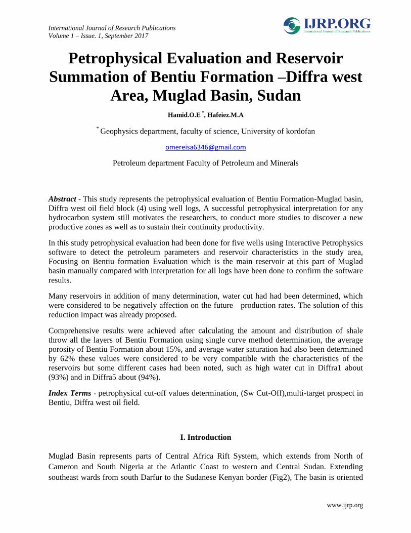
NW-SE and it occupies an area of about 160000km² There is a huge amount of locally deposited
Cretaceous- Neogene sediments of about 13km in thickness (Idris, 2001). In the Late Jurassic
time, a triple junction began to develop along the Kenya coastline, separating the Malagasy
island. The arm of this triple junction extended from the Lamu Embayment through the Anza
Trough in Kenya and into the southern Sudan at the same time (Late Jurassic) and to the west,
the African and South
American cartons
began to separate (Figure1).
Figure1 Separation of Africa and South America Continents
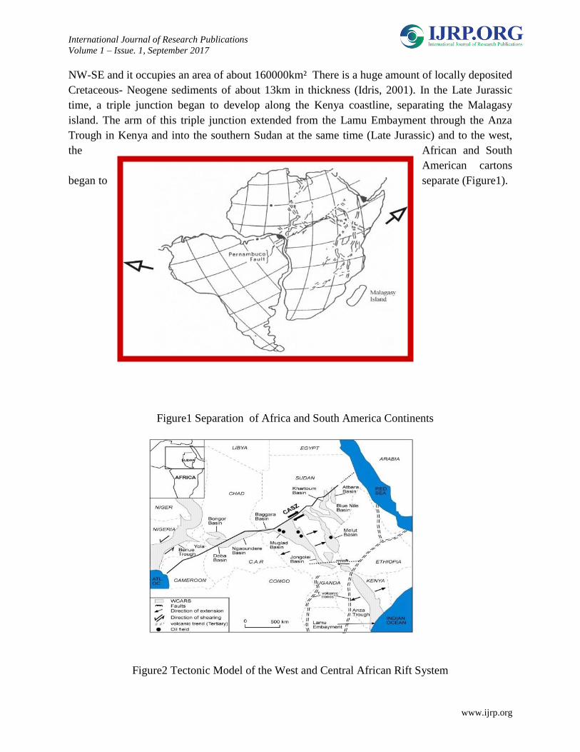
Figure2 Tectonic Model of the West and Central African Rift System
International Journal of Research Publications
Volume 1 – Issue. 1, September 2017
www.ijrp.org
Due to these major events, a shear reactivation along the CASZ developed, which led to the
development of parallel and subparallel half grabens of NW-SE orientation in the central and
southern Sudan cratonic areas (Figure2).
2-Study area
The study area is named Diffra west, it is located in the southwestern part of Muglad basin. It's
approximately. It's approximately bounded by latitudes 10º 4´to 10º 5´N and longitudes 28º 26´
to 28º 27´ E. The study area width is about 1.84km and length is about 1.85km, with the total
area of about 3.5km ² (Figure3).
Figure3 location map of the study area
3-research methodology
The method that was used in this study is the analysis of well logs for five wells manually and
through software and the outcome of both of them was assist.
2.1 Log Quality Control (LQC)
The term log quality control (LQC) is very important part of every logging job because log

International Journal of Research Publications
Volume 1 – Issue. 1, September 2017
www.ijrp.org
data can be affected by the borehole conditions such as wash out (caving) and or tool problems.
as it appear that in the position that marked by circle in Diffra 5 (Well) caliber log showed high
caving while in diffra4 (well) the circled position showed less caving which considered to be
good hole condition (figure4).
The above bad hole condition can highly effect on the tool accuracy so we calculate the
correction factor for the density tool and were strongly applied and bad hole condition was
successfully delineated as its appear in the coming next (figure5).
Diffra
5
Diffra
4
Figure
4 bad
hole
condit
ion
Diffra
5 and
good
hole
condit
ion
Diffra 4
Figure 5 density tool (bad hole reduction)
International Journal of Research Publications
Volume 1 – Issue. 1, September 2017
www.ijrp.org
4-results and conclusion
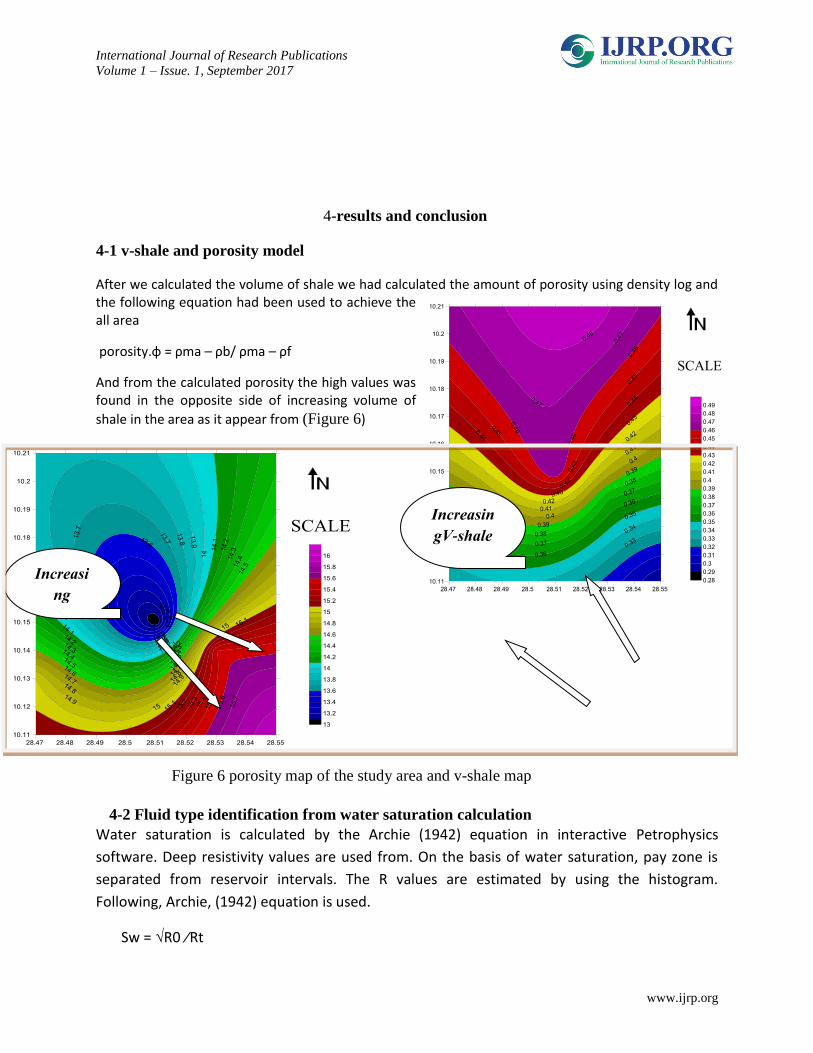
4-1 v-shale and porosity model
After we calculated the volume of shale we had calculated the amount of porosity using density log and the following equation had been used to achieve the all area
porosity.ɸ = ρma – ρb/ ρma – ρf
And from the calculated porosity the high values was found in the opposite side of increasing volume of
shale in the area as it appear from (Figure 6)
Figure 6 porosity map of the study area and v-shale map
4-2 Fluid type identification from water saturation calculation
Water saturation is calculated by the Archie (1942) equation in interactive Petrophysics
software. Deep resistivity values are used from. On the basis of water saturation, pay zone is
separated from reservoir intervals. The R values are estimated by using the histogram.
Following, Archie, (1942) equation is used.
Sw = √R0 ∕Rt
Increasi
ng
porosity
Increasin
gV-shale

International Journal of Research Publications
Volume 1 – Issue. 1, September 2017
www.ijrp.org
Where:
Sw = water saturation
R0 = resistivity of water formation
RT = true resistivity of the formation.
From the previous calculations the amount of water in all wells were obtained and water model
for Bentiu formation had been
predicted.
From the direct quick look of
interpretation from the log we
can easily distinguish between
the oil and water by the
characteristics shape of some
parameters like Gamma-ray,
resistivity and porosity reading
against the zone.
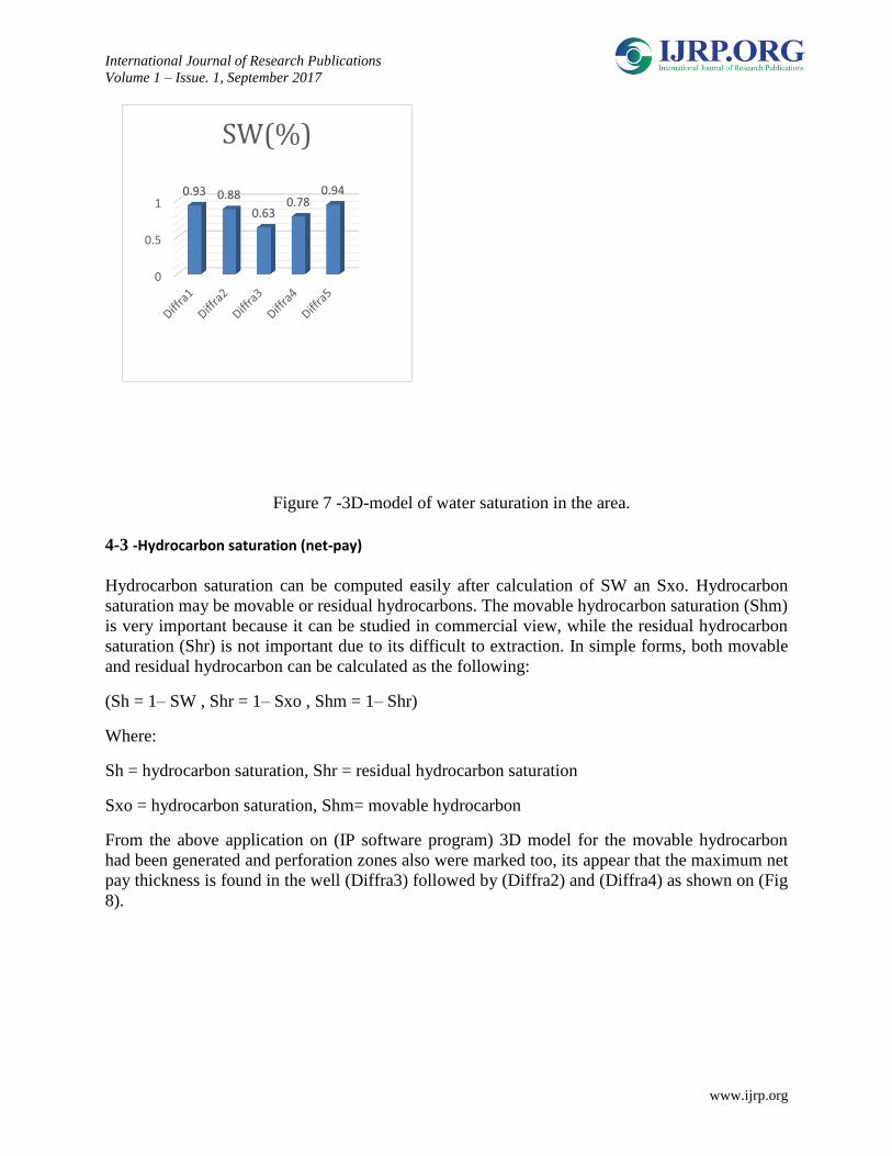
From figure(7) below its clear
that the wells Diffra1 and Diffra5
are mainly shows high values of
water saturation which mean
that by the fact of hydrocarbon
that the porous non filled with water should be filled with oil, and these wells were mentioned
showed high water cut and were considered to be nonproductive wells.
International Journal of Research Publications
Volume 1 – Issue. 1, September 2017
www.ijrp.org
Figure 7 -3D-model of water saturation in the area.
4-3 -Hydrocarbon saturation (net-pay)
Hydrocarbon saturation can be computed easily after calculation of SW an Sxo. Hydrocarbon
saturation may be movable or residual hydrocarbons. The movable hydrocarbon saturation (Shm)
is very important because it can be studied in commercial view, while the residual hydrocarbon
saturation (Shr) is not important due to its difficult to extraction. In simple forms, both movable
and residual hydrocarbon can be calculated as the following:
(Sh = 1– SW , Shr = 1– Sxo , Shm = 1– Shr)
Where:
Sh = hydrocarbon saturation, Shr = residual hydrocarbon saturation
Sxo = hydrocarbon saturation, Shm= movable hydrocarbon
From the above application on (IP software program) 3D model for the movable hydrocarbon
had been generated and perforation zones also were marked too, its appear that the maximum net
pay thickness is found in the well (Diffra3) followed by (Diffra2) and (Diffra4) as shown on (Fig
8).
0
0.5
10.93 0.88
0.63 0.78
0.94
SW(%)

International Journal of Research Publications
Volume 1 – Issue. 1, September 2017
www.ijrp.org
Figure 8 - 3D model presents
the movable
hydrocarbon (Net-pay) distribution in Bentiu formation for the most three productive wells.
4-4 Conclusions
The present study is reflect the petrophysical evaluation of Bentiu Formation, in Diffra west oil
field in Muglad basin, Sudan and that has been carried out.
It's highly ambitioned this theses will help by one way or another in future purposes and hoped to
be guidance for coming studies on petrophysical evaluations. Due to the high water cut problems
in the Diffra west oil field the petrophysical approach was chosen to assess the reservoirs within
the Albian age Formation.
Petrophysical evaluation and brief summary of the chapters and recommendations from this
study can be summarized as following.
The data that have been used to conduct this study include wire line logs for five wells.
Due to bad hole effect on density tool reading, single method shale indicator which depends on
Gamma-ray reading had been used to calculate shale volume in all Bentiu formation. Because its
International Journal of Research Publications
Volume 1 – Issue. 1, September 2017
www.ijrp.org
important step in petrophysical evaluation to know the distribution of shale in order to pick out
non-reservoir rocks. This obtained statistically using the cross plot and compared with
histograms for all wells, had been found that all Bentiu reservoirs contain Vshale <50% and
countoring map was built for better representation.
The most important factor that must be calculated for better determination of potential
reservoirs is porosity which can be obtained using various different
methods(sonic,density,neutron) and density).and here density-neutron had been used to
calculate porosity, the porosity obtained excluding shale effect is called the effective porosity
which reflect the reservoir quality. Optimum porosity in this study had been achieved,>16%. 3D
model had been generated to show the variations between wells.
Water saturation was also determined using Archie Equation in this study, depend on water cut
of <50%, and 3D model had been designed to reflects the water saturation variations along all
wells in the study area.
5-References
1-Abdullatif O.M. (1992): Sedimentological investigation of Cretaceous, north margin of
Muglad baisn. Unpuplished report.
2-Ahmed, S.M.( 2014): Formation Evaluation for Bentiu Formation Muglad Basin, Jake South
Area (Block6) using wells data. M.SC. Thesis Elneelain University, Khartoum, Sudan.
3-Amir, A.O.(2000): Sedimentology of the Creataceous outcropping strata at the NE margin of
the Muglad Rift Basin Western Kordofan State. M.Sc. Thesis University of Khartoum,
Khartoum, Sudan.
4-Abu Zeid, A.A. (2005): depositional environment, geochemistry and digenesis of the Aptian –
Albian lacustrine Abu Gabra formation, Muglad rift basin, Sudan: PH. D. Thesis, University of
Khartoum.
5-Awad, M.Z., Farwa, A.G., Elnadi, A.H.H., Fairhed, J.D., Ali Babikir, I.A., Eisawi, A.A.M., ET
Toam, G.A.A and Zeinelabdein, K.A.E. (2015): Petroleum Geology and Resources of the Sudan,
Sudan, Geozen science media UG petten kofestr. 16-1810247 Berlin Germany.
6-Browne, S. E., Fairhead J. and I. I. Mohamed (1985): Gravity study of the White Nile rift,
Sudan, and its regional tectonic setting: Tectonophysics, V. 113, p. 123-137.
7-Browne, S. E., and J. D. Fairhead. (1983): Gravity study of the Central African rift system: a
model of continental disruption; 1, the Ngaoundere and Abu Gabra rifts, in P. Morgan, ed.,
Processes of continental rifting: Tectonophysics, V. 94, p. 187-203.