issn: 1992-8645 study on the d/h ratio of … · ashihara yoshinobu proposed that when value of d/h...
TRANSCRIPT
Journal of Theoretical and Applied Information Technology 10th March 2013. Vol. 49 No.1
© 2005 - 2013 JATIT & LLS. All rights reserved.
ISSN: 1992-8645 www.jatit.org E-ISSN: 1817-3195
448
STUDY ON THE D/H RATIO OF CITY ROAD’S ENVIRONMENTAL EFFECT BASED ON BIM
1ZHOU TAO, 2SHEN QING
1Assoc. Prof., Faculty of Construction Management and Real Estate, Chongqing University 2Postgraduate, Faculty of Construction Management and Real Estate, Chongqing University
E-mail: [email protected], [email protected]
ABSTRACT
Based on urban planning theory, the paper conducts a study on the D/H ratio of city road and applies a new technology BIM to make a quantitative objective analysis on the space size of road, differing from traditional subjective evaluation from the perspectives like psychology, physiology, social behavior and urban esthetics. Through the simulation and analysis on sunshine, ventilation under different D/H ratio, this paper discusses relationship among D/H, sunshine and ventilation and the change rule of sunshine and ventilation based on different D/H value, thus to get the best value range of D/H at planning level, and to demonstrate the traditional suggested value to sum up optimum value of D/H with more sufficient grounds. A new urban planning method is also involved in this paper.
Keywords: D/H, City Road, Simulation in Ecology 1. INTRODUCTION
With the development of economy, China witnesses a rapid urbanization process, during which period cities keep expanding outward and city space is developed and transformed quickly as well. As an important component of city space, city road is also developed rapidly and plays an increasingly important role in the city, for it functions not only as the channel to link the urban function block and meet the transportation requirements among the blocks, but also to adjust the urban spatial structure, shape the image of city, strengthen the city vitality and provide good ventilation, lighting for urban residents and provide space for residents’ daily life and economic activity.
At present the study on urban planning focuses on the study of block with insufficient consideration of public space between plaques. In addition, the relevant study of public space lays particular stress on qualitative research with ignorance of microenvironment analysis; hence as a public space, road space is also lack of corresponding microenvironment analysis. What’s more, urban road planners and managers are even unconscious of the function of city road as public space, and it is widely believed that road is just the transportation space in urban life, therefore while conducting concrete road planning, people usually lay stress on “vehicles first” idea and the transportation function of road with ignorance of
the basic requirement of people. Even they realize the close association between road and people’s life, they just stress on the road landscape design, overlooking the most basic ‘people first’ design idea, which is to provide sufficient sunshine comfortable ventilation environment for pedestrians and drivers.
With the development of city and the upturn of people’s living standards, people put forward higher request for the quality of life, housing conditions, travel and urban ecological environment, which means higher demand on planning and designing of city road and leads to the great conflict of the current road planning idea: the opposition of “people first” idea and “vehicles first” idea. In the Declaration of Urban Design, Jacobs and D. Appleyard proposed seven “essential elements of good city environment in the future”, include the livability and public environment. [1] Therefore, to better integrating the two elements, it is extremely necessary to introduce the livability idea into the planning and design of road. Generally speaking, living environment can basically be summarized as the comfortable perception, including the luminous environment perception, wind environment perception and temperature perception under natural environment. [2] The factors that have great impact on the sunshine and ventilation is the size of road space, therefore it has significant meaning to discuss the size index of road space, which is the relationship between the

Journal of Theoretical and Applied Information Technology 10th March 2013. Vol. 49 No.1
© 2005 - 2013 JATIT & LLS. All rights reserved.
ISSN: 1992-8645 www.jatit.org E-ISSN: 1817-3195
449
ratio of road width of city road and surrounding building height (D/H).
Road space refers to the three-dimensional space enclosed by road and buildings on both sides, and the sunshine and ventilation of this space is mainly influenced by the limitation of D/H. As the component factors of D/H, nowadays road and buildings change greatly: rapid development of modern means of transportation promotes the development of city road, and widening, hardening of road and three-dimensionalization of transportation have successively been realized. In addition, the improvement of building technology accelerates the development of urban architecture, which leads to the buildings on both sides of road space gradually become high-rise and big-sized buildings. With the buildings on both sides of road become increasingly higher, the value of D/H of road space become smaller, which results in a mass of shadow space and the discomfort of passers-by and drivers.
What makes people more anxious is during the reconstruction of old city, program manager comprises to the developers and adopts construction model featuring high plot ratio and low density to balance the economic profit. As a result, high-rise buildings completed one after another make the narrow city road become narrower and constrained, resulting in the discomfort of pedestrians. While in the construction of new urban district, the problem is excessive pursuit of urban construction speed, which is on condition of meeting the basic function of road, urban construction overlooks the road’s function as people’s public living space, thus the road can’t satisfy people’s real demand.
Based on the perspective of city planning, the paper conducts a study on the D/H value and applies a new technology BIM to make a quantitative objective analysis on the size of road space. The study includes the following three tasks: firstly, through the simulation analysis of sunshine, ventilation under different D/H ratio, this paper discusses relationship among D/H, sunshine and ventilation of road space; Secondly, based on the change rule of different D/H, sunshine and ventilation, the paper determines the reasonable value range of D/H at planning level, and compares with the traditional suggested value of D/H to sum up reasonable value range of D/H with more sufficient arguments; thirdly, this paper sill assist designers make decisions, improve living environment and ecological environment of road
transport, and advance the construction of livable and sustainable development city. [3]
2. LITERATURE REVIEW
In the second half of the 19th century, D/H is firstly proposed by the Austrian architect and urban planner Camillo with the purpose to correct the space method of urban planning based on technology and practical orientation. In his book Shape of Square, he wrote “according to experience, the relation between the size of square and that of buildings can be generally concluded as follows: the minimum size of square should be the same as the height of buildings on the dominate square. If it is impossible from the perspective of the integral shape and detailed constitute of building, the maximum size of square can’t be more than twice the height of buildings.” That is depth of square and height of building ratio should be no less than 1 and no more than 2 (1<D/H<2).
However, modernist master Le Corbusier didn’t agree with D/H theory of. In his ideal plan of modern city with 3 million people, the central district of city is built in the form of skyscrapers to reduce building density. In this way, land area of building only accounts for 5% of the urban land and the rest 95% are for the open land use for the parks and sports ground. But in his ideal plan, D/H is totally out of control, so in the book City of Tomorrow, Corbusier wrote like this, “I think Hitti’s argumentation is ingenious and his theory is correct. They are based on the past. To tell the truth, they are the past---they are the small past and sorrowful past. They are the little unnoticed flower on the road side. That past is not the past at the peak, but compromised past instead.”[4]
But the real condition is not as what Corbusier thinks like. Even though the longing for “sunshine, air and afforest” attract numerous developer to follow the ideal path of Corbusier to develop their city. However, people also begin to realize that opening space everywhere means the greatly weakened sense of privacy and security, the spirit need essential to people’s life. So based on the road aesthetics and psychology, Japanese scholar Ashihara Yoshinobu proposed that when value of D/H is larger than one, the sense of alienation gradually occurs with the increasing of the value of ratio; when the value of D/H equals one, there is a symmetrical sense between height and width, so D/H equaling one is a transition of space’s property.[5] Domestic scholar Chen Dihua also pointed out that different width, thickness and height of buildings have different standard of

Journal of Theoretical and Applied Information Technology 10th March 2013. Vol. 49 No.1
© 2005 - 2013 JATIT & LLS. All rights reserved.
ISSN: 1992-8645 www.jatit.org E-ISSN: 1817-3195
450
control and the basic principle demand that the aspect ratio of road and building should be larger than 1 or 0.8, because if the ratio is smaller than this, people would feel depressed when they walk on the road and if the ratio is larger than this, people would always feel empty and cheerless. This idea is also based on psychology, lacking in the discussion from the perspective of planning. Though Ashihara Yoshinobu also put forward that while planning apartment house, we always adopt 1.5 as the value of D/H in order to achieve certain sunshine time in winter, he didn’t give analytic demonstration for this argument, and as influence factors like sunshine and ventilation differs in different places, it is necessary to conduct more scientific quantitative analysis on the reasonable D/H value range according to the local conditions.
In 19th century, Germany architect H. Martens proved by experiment that 45°angle is the position to enjoy the best sight of any architectural details, while when the visual angle is 27°, we can observe the whole image of object, and its detail effect as well. This view has been elaborated in detail in the Buefd H. mnl’s book Scale of Urban Planning.[6] Later, more experiments all proved that according to people’s visual feature, basic vertical angle of view for clearly seeing the complete picture of building is 18°and range of visibility is three times the height of building. The limit vertical angle for seeing clearly complete height of building is about 45°and clearly seeing the detail of building means the range of visibility equals the height of building. Therefore, the range of visual angle between 18°and 45°is the ideal impression area. In people’s actual activity experience, 27°angle is the vertical space relation observation area with good reaction, so 27°is the best vertical angle of view. If the visual angle 27°is put on the sidewalk on the other side of street, D/H=2 this typical road space size index would be proved, and under this index, people usually can get the best perception effect. In addition, the height of visual angle is also closely linked with range of visibility. The bigger visual angle is, the shorter the range of visibility is, which will have impact on the experience of street architecture’s scale in the road space. So to speak, visual angle and range of visibility is the basic component of lateral dimension of city road space. Based on visual angle and passers-by’s feelings about buildings, it has been proved that while the value of D/H is no less than 1 and no more than 2 (1≤D/H≤2), the sense of road space size is balanced. But the study is lack of consideration for the most basic environment condition of road space, sunshine and ventilation.
Based on the idea of “composite scale” and from the contrast between street architecture and mass of road space, Zhang Zhaoji conducted study on the influence mechanism of space scale of city road and put forward the scale and form of city road space.[7] But his study also didn’t make the range of D/H value clearly, nor did he analyze and explain scientifically the reasons of division. Therefore, it is of great necessity to conduct more concrete and objective argumentation.
Some scholars have discussed the road space from the perspective of humanization concept. For instance, American architect once said it is widely believed that there are three dimensions of design, namely aesthetics, technology and economy. However, what’s more important is the fourth dimension: humanity. Scholar Li Liguan said that the ultimate purpose of urban transportation is not only to meet the demand of vehicles transit, but more important is to guarantee the public transportation users’ requirements on the passage, safety and landscape, and the demand of people living near the road on the public space of street, their living and commercial need about street and their sense of identity about the culture of street. What humanized transportation idea advocates is an urban construction mode led by walking, bicycles and public transportation, and a recognized sustainable green transportation idea as well. [8]
As an important public place closely related to people’s life, city road should not only meet people’s travel demand, but also be designed based on “people-oriented” idea. That means the city road should be designed based on people’s actual need, psychological and behavioral characteristics to satisfy people’s physiological and mental demand, physical and mental demand, and fulfill their activity demand in the road space. All of these are done to make people have a sense of identity and belonging in order to achieve the harmony between spirit ad substance, human beings and environment and to build a street with elevated vitality. Though Li Liguan discussed the value of D/H, his study is based on the previous research from the visual perspective and lack of study from the perspective of planning.
Some scholars have also done research on the road space from the ecological aspect, and road ecology has been specially formed in foreign countries. The study of road ecology involves the following directions: impact of road on biological population and their habitat environment, road’s influence on the physical environment like geology, terrain, landform, hydrology, soil and microclimate,
Journal of Theoretical and Applied Information Technology 10th March 2013. Vol. 49 No.1
© 2005 - 2013 JATIT & LLS. All rights reserved.
ISSN: 1992-8645 www.jatit.org E-ISSN: 1817-3195
451
research on the road pollution zone generated by road and vehicles and study on road network and road influence zone, which has become important leading edge field of ecology. Compared with foreign scholars, domestic scholars’ study is mainly from the perspective of natural ecology to illustrate road’s influence on the surrounding environment, like off gas, noise, dewatering, heat reflection, etc. Lu Mengli and Wu Zhiyong have done research on the influence of road ecological environment’ changes on social environment and individual people. [9]
Study on city road scale lays stress on its historical development, with insufficient study regarding scale design as a whole concept. Some scholars’ study from the angle of scale mainly focuses on the research influence factors for forming road space scale system [10], with a lack of study centering on D/H as the subject of study, which doesn’t play an active guiding role for the modern city road design and whole city planning. For instance, while discussing the road scale control, Shiyan put extra emphasis on qualitative analysis. [11]
To sum up, though many scholars both at home and abroad have conducted research on road space scale index D/H, their study lay emphasis on subjective evaluation from the perspectives like psychology, physiology, behavior, sociology and urban aesthetics. And their study has come to the classical conclusion: while D/H is no less than 1 and no more than 2 (1≤D/H≤2), the sense of road scale is balanced and pedestrians ’ sense of identity and belonging are quite high. But their study overlooked the new perspective---quantitative and objective analysis for road space sizes through ecological and livable planning.
3. RESEARCH METHODS
Based on the condition of Chongqing
Municipality, this research sums up the change rule of sunshine and ventilation under different D/H values by applying Ecotect Analysis software to simulate the sunshine and ventilation in corresponding conditions. In this way, this research is aimed at quantitatively evaluate the mutual relationship between value of D/H at planning level and microenvironment in the open space of road, and comparing with the traditional D/H suggested value to get the more reasonable range of D/H value with more sufficient supporting data[12].
3.1 Area Selection The reasons why to choose Chongqing as the
research place are as follows: Firstly, Chongqing, typical southern city featuring the climate of cold winter and cool summer, is located in the southwest of China; Secondly, with the fast development of economy, urban construction of Chongqing develops rapidly and numerous skyscrapers ate built, which make the city road seem more narrow and constrained, so study on D/H value of road is extremely urgent now; Thirdly, in recent years, Chongqing is carrying out the construction of livable city and lay stress on engineering construction of afforesting vegetation, and this research can offer a proper proposal for the road design on the planning level and can assist the construction of livable city.
3.2 Data collection
In this research, the data of external environment needed for the modeling are mainly external meteorological data obtained by simulation, such as sunshine duration, the daily average temperature of Chongqing and seasonal winds, etc.
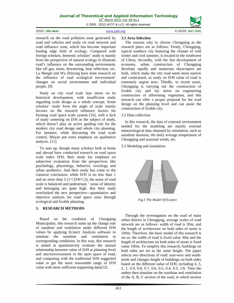
3.3 Modeling and simulation
Through the investigation on the road of main urban district in Chongqing, average scales of road network are as follows: width of road is 30m, and the length of architecture on both sides of street is 100m. Therefore, the basic model of this research is set as: the width of road is fixed value 30m and the length of architecture on both sides of street is fixed value 100m. To simplify this research, buildings on both sides are set as the same height. The paper selects two directions of road: east-west and south-north and changes height of buildings on both sides based on the different value of D/H, including 4, 3, 2, 1, 0.9, 0.8, 0.7, 0.6, 0.5, 0.4, 0.3, 1/6. Then the author then simulate on the sunshine and ventilation of the A, B, C section of the road, in which section
Fig.1 The Model Of Ecotect

Journal of Theoretical and Applied Information Technology 10th March 2013. Vol. 49 No.1
© 2005 - 2013 JATIT & LLS. All rights reserved.
ISSN: 1992-8645 www.jatit.org E-ISSN: 1817-3195
452
A, B and C divide the road equally (A and C represents both ends of the road and B represents the middle section of road). The simulation results are as follows:
Fig. 2 and Fig. 4 indicate the total sunshine duration in the whole day of winter solstice, and the top right of Fig. is the duration of sunshine index color stripes, which use different colors correspond to sunshine duration: from deep blue to yellow reveal the increase of total sunshine duration in that whole day, which is the sunshine duration from 1 hour to 10 hours. In the Figures, different sunshine accumulative time is distinguished by different color zone, which are defined by envelope line. The percentage of different sunshine duration can be obtained by outputting data.
Fig. 3 and Fig.5 are the pictures of wind speed, which mainly reflect air flow condition between buildings on both sides and in above road space. This research chooses 1.5m space plane as the wind speed calculation plane, for this height mainly reflects basic air flow condition within people’s motion space, so as to get people’s sense of comfort. The figures show that while wind speed is between
0.1 to 0.2 m/s, more specific and concrete data can be gained by outputting data for analyzing.
4. DATA ANALYSIS
4.1 Sunshine
Sunshine are closely associated with people’s living, physical and psychological health, good environment and work efficiency, especially in the cold winter, people want to gain more sunshine. However, sunshine is not the more the better, because excessive sunshine might result in superheat temperature and bad influence for people’s life, especially during summer in the hot area of southern part of China. Therefore, how to make use of the favorable side of sunshine, control and avoid the bad influence of sunshine is an important consideration while designing as regards to sunshine.
This paper applies Ecotect Analysis to analyze sunshine for road and select the sunshine duration in the whole day of winter solstice to simulate and analyze. The final results are as follows:
4.1.1 South-north direction of road
It can be seen from Fig. 6 that under different D/H values, B1 section of road has different accumulative sunshine duration, for example, while D/H=1, there are two kinds of accumulative sunshine time in the whole day: 2 hours and 3 hours, in which the former one accounts for 60% of the sector and the latter one 40%. Seeing the trend of sunshine duration’s percentage of the sector under different D/H values, we can easily conclude that while D/H≤0.8, the sunshine duration involves three kinds: 1hour, 2 hours and 3 hours and the proportion of these sunshine durations remain the same. Fig. 7 also indicates that while D/H≤1, the components of sunshine duration and the proportions of every part shall not change any more. Therefore, it can be concluded that while D/H>0.8, the requirement of 2 hours ‘sunshine duration can be met and while D/H≤0.8, sunshine duration in part of the road can’t meet the demand of 2 hours and the proportions of every sunshine duration shall not change any more.
Fig.2 Total Sunshine Duration On Winter
Solstice (South To North)
Fig.3 Wind Speeds At 1.5m
(South To North)
Fig.4 Total Sunshine Duration On Winter
Solstice (West To East)
Fig.5 Wind Speeds At 1.5m (West To East)

Journal of Theoretical and Applied Information Technology 10th March 2013. Vol. 49 No.1
© 2005 - 2013 JATIT & LLS. All rights reserved.
ISSN: 1992-8645 www.jatit.org E-ISSN: 1817-3195
453
4.1.2 East-west direction of road
Fig. 8 shows that wherever the section position of road is, while D/H≤ 1, the proportion of sunshine duration shall not change any more: B2 section of road includes three kinds of sunshine duration, namely 0 hour, 1hour and 2 hours; A2 and C2 sections of road have five kinds of sunshine duration, namely 0 hour, 1 hour, 2 hours, 3 hours, 4 hours. So it is easy to find that the sunshine on the east-west direction is not as sufficient as that on the south-north and while D/H>1, sunshine duration is more sufficient, otherwise much shade would be formed on the road, which will have impact on the comfort of pedestrians and drivers.
4.2 Ventilation
Data analysis shows that under two kinds of directions, if the D/H value is the same, the wind speed on the whole road is the same. It can be seen from the following table that as the average wind speed of Chongqing is not high, about 1.5m/s in the winter, so D/H value is of little influence to wind speed and the aptitude variation of wind speed is small. While D/H is 0.7, mean value of wind speed reaches the maximum; while D/H is more than 0.7, wind speed gradually decreases with the growth of D/H value; while D/H is less than 0.7, wind speed increases with the growth of D/H value. Therefore, in order to keep good ventilation environment, D/H value shouldn’t be too big or too small, and it’s appropriate to be about 0.7.
Fig.6 Sunshine analysis of B1 section of road (south to north)
Fig.7 Sunshine analysis of C1 section of road (south to north)
Fig.8 The Sunshine Analysis Of B2 Section (West To East)
Fig.10 Sunshine analysis of A2 section (west to east)
Fig.9 Sunshine analysis of C2 section (west to east)

Journal of Theoretical and Applied Information Technology 10th March 2013. Vol. 49 No.1
© 2005 - 2013 JATIT & LLS. All rights reserved.
ISSN: 1992-8645 www.jatit.org E-ISSN: 1817-3195
454
5. CONCLUSION
Through analysis of sunshine duration and
ventilation data, the conclusion can be summarized as follows:
Firstly, D/H value has a great impact on the sunshine duration and different direction of road also can influence sunshine duration, and sunshine duration in the south-north direction is more sufficient than that in the east-west direction. In order to meet the requirement of no less than 2 hours’ sunshine duration, it is suggested that the D/H value in the south-north direction is more than 0.8 and that in the east-west direction is no less than 1.
Secondly, neither D/H value nor different direction of road has great influence on ventilation, so compared with sunshine duration. Therefore, the value range of D/H is freer and the value around 0.7 is appropriate.
It can be seen by summarizing conclusions that D/H value from the perspective of sunshine and ventilation can be well integrated with the former studies based on visual sense, psychology and aesthetics. The best value range is as follows: 0.8<
D/H<2 in the south-north direction of road; 1<
D/H<2 in the east-west direction of road.
The study of this paper might have the following functions:
Firstly, supplementing and updating the traditional D/H values.
Most former studies on D/H value are from the angle of psychology and visual sense, lacking in the study from the perspective of planning and design. By applying new technology, this paper simulates on the sunshine and ventilation under different D/H values and gets the best value range of D/H on the planning and design level through more objective and scientific analysis. In addition, the paper also proves the original suggested value of D/H and summarizes the value range of D/H with more sufficient supporting data.
Secondly, proving new design method for the planning of city road space scale.
Due to different climate and terrain in different places, we should adjust measures to local condition while making concrete road design for a place and make the corresponding road space scale. This paper applies BIM software to assist relevant design, which shall make road space scale design more objective and scientific.
Acknowledgment
This work is supported by the Fundamental Research Funds for the Central Universities, Project No. CDJSK 11007.
REFRENCES:
[1] Allan Jacobs, Donald Appleyard, Towards an Urban Design Manifesto, 1987.
[2] He Guanpei, General introduction of BIM, Beijing: China Building Industry Press, 2011, pp. 94-99.
[3] Chen Dihua, “An Exploration of Good City Road Space”, Urban Construction Theory Research (Electronic Edition), vol.3, 2012.
[4] Le Corbusier, transl. Li Hao, Urbanism, Beijing: China Building Industry Press, 2009.
[5] Ashihara Yo shinobu, transl. Yin Peitong, Aesthetic of Street, Beijing: China Building Industry Press, 1998, pp. 35-38.
M 0.05 0.15 0.25 0.35 0.45
4 0.142 26.51 57 14.44 2.05 0
3 0.162 20.91 49.68 26.08 3.34 0
2 0.184 15.41 42.03 36.1 6.47 0
1 0.200 8.41 42.03 41.06 8.51 0
0.9 0.203 10.24 32.65 50.86 6.25 0
0.8 0.224 6.9 23.81 57.76 11.53 0
0.7 0.239 6.9 20.26 50.97 21.12 0.75
0.5 0.231 7.44 25.11 48.17 18.1 1.19
0.3 0.206 8.62 39.87 38.9 12.61 0
1/6 0.192 19.4 34.38 33.19 10.78 2.26
Table.1 Analysis Of Wind Speeds Data
Probability
Wind speed
Fig.11 Analysis Of Wind Speeds
Journal of Theoretical and Applied Information Technology 10th March 2013. Vol. 49 No.1
© 2005 - 2013 JATIT & LLS. All rights reserved.
ISSN: 1992-8645 www.jatit.org E-ISSN: 1817-3195
455
[6] Ashihara Yo shinobu, Transl. Yin Peitong, External Space Design, Beijing: China Building Industry Press, 1985, pp.27-30.
[7] Zhang Zhao, “Composite Scale Research of Urban Road Space”, Zhejiang University, 2004.
[8] Li Liguan, “Function Optimization of City Road Branch and Humanized design”, Unpublished PhD Dissertation, Southeast University, 2009.
[9] Lu Mengli and Wu Zhiyong, “Study on city road node space integration based on Environment-Behavior Studies --Take Guangzhou City for Example”, Planner, Vol. 26, No. 2, 2010, pp. 73-78.
[10] M. Makhlouf, F. Messai, H. Benalla, “Modeling and Simulation of Grid-Connected Photovoltaic Distributed Generation System”, Journal of Theoretical and Applied Information Technology, Vol. 45. No. 2, 2012, pp. 378 – 386.
[11] Shi Yan, “Study on City Street Scale in Mountain Land--Take Chongqing for Example”, Unpublished PhD Dissertation, Chongqing University, 2004.
[12] Chongwen Wang, Mingli Bao, Tong Shen, “3D Model ODEL Reconstruction Algorithm and Implementation Based on the Mobile Device”, Journal of Theoretical and Applied Information Technology, Vol. 46. No. 1, 2012, pp. 255 -262.