isotopic evidence for paleohydrologic evolution of ground-water flow paths, southern great plains,...
TRANSCRIPT

Geology
doi: 10.1130/0091-7613(1989)017<0653:IEFPEO>2.3.CO;2 1989;17;653-656Geology
Alan R. Dutton and William W. Simpkins southern Great Plains, United StatesIsotopic evidence for paleohydrologic evolution of ground-water flow paths,
Email alerting servicescite this article
to receive free e-mail alerts when new articleswww.gsapubs.org/cgi/alertsclick
Subscribe to subscribe to Geologywww.gsapubs.org/subscriptions/click
Permission request to contact GSAhttp://www.geosociety.org/pubs/copyrt.htm#gsaclick
Opinions presented in this publication do not reflect official positions of the Society.positions by scientists worldwide, regardless of their race, citizenship, gender, religion, or political viewpoint.article's full citation. GSA provides this and other forums for the presentation of diverse opinions and articles on their own or their organization's Web site providing the posting includes a reference to thescience. This file may not be posted to any Web site, but authors may post the abstracts only of their unlimited copies of items in GSA's journals for noncommercial use in classrooms to further education anduse a single figure, a single table, and/or a brief paragraph of text in subsequent works and to make
toemployment. Individual scientists are hereby granted permission, without fees or further requests to GSA, Copyright not claimed on content prepared wholly by U.S. government employees within scope of their
Notes
Geological Society of America
on August 14, 2014geology.gsapubs.orgDownloaded from on August 14, 2014geology.gsapubs.orgDownloaded from

Isotopie evidence for paleohydrologic evolution of ground-water f low paths, southern Great Plains,
United States
Alan R. Dutton, William W. Simpkins* Bureau of Economic Geology, University of Texas, Austin, Texas 78713
ABSTRACT A confined aquifer in Triassic Dockum Group sandstone beneath
the southern Great Plains was isolated from hypothesized paleore-charge areas in eastern New Mexico by Pleistocene erosion of the Pecos and Canadian river valleys and formation of hydrologic divides. Truncation of the flow system left meteoric water in the confined aquifer with mean SD and S l s O values that are 17°/oo and 2.0°/oo, respectively, lighter than those in the overlying High Plains aquifer. Thick upper Dockum mudstone retards downward flow from the High Plains aquifer, which has been recharged by isotopically heavy precipitation during the Holocene. Recharge to the confined aquifer occurred at altitudes of 1600 to 2200 m in proximal Dockum sand-stone facies since eroded in eastern New Mexico, at a mean tempera-ture 3 °C cooler than present temperature across the southern High Plains. Effects of Pleistocene climatic change on isotopic composition of Dockum ground water could be superposed over geomorphologic effects.
INTRODUCTION Conceptual hydrogeologic models of regional aquifers seldom con-
sider whether paleohydrologic conditions are responsible for observed hydraulic-head and solute distributions. However, hydraulic-head distribu-tion can gradually change during geologically long durations in response to physiographic evolution (England and Freeze, 1988). If ground water has a long residence time, stable isotopes and dissolved solutes can reflect a preceding flow regime even when hydraulic head is equilibrated with recharge and discharge rates.
The purpose of this paper is to discuss the significance of isotopically light SD and 5 I 8 0 compositions of ground water in the Triassic Dockum Group in the Texas Panhandle and eastern New Mexico (Fig. 1). Physio-graphic and climatic changes are obvious possible explanations of the isotopic depletion. The Pecos and Canadian river valleys were incised during the late Tertiary and Pleistocene (Gustavson and Finley, 1985; Gustavson, 1986). Isotopically light ground waters in other basins have been interpreted as Pleistocene in age and related to climatic variation (Clayton et al., 1966; Perry et al., 1982; Friedman, 1984; Rozanski, 1985). Whether the Pleistocene climate in the southwestern U.S. was generally cooler and wetter than the Holocene climate is uncertain (Barry, 1983; Friedman, 1983), particularly in the study area (Holliday, 1987).
HYDROGEOLOGIC SETTING The Dockum Group is composed of more than 610 m of conglomer-
ate, sandstone, and mudstone deposited in fan, fluvial, deltaic, and lacus-trine environments in a continental basin (McGowen et al., 1979).
75 ml
100 km
*Present address: Department of Geology and Geophysics, University of Wis-consin, Madison, Wisconsin 53706.
EXPLANATION SANDSTONE (percent)
l l t l f j > 60 Sand input axis 5 0 - 6 0 ^ — D o c k u m limit
E 3 4 0 - 5 0
mm 30-40 1 I <30
Figure 1. Percent sandstone in lower Dockum Group (modified from J. H. McGowen et al., unpublished map).
Sandstone and conglomerate beds in the lower Dockum Group are discon-tinuous and occur mainly around the basin perimeter (Fig. 1). In the muddy upper Dockum Group, which acts as a confining unit, thickest sandstone deposits are in southeastern New Mexico and the south-central part of the Texas Panhandle and are not extensive elsewhere (McGowen et al., 1979).
The essentially flat surface of the southern High Plains is inclined to the southeast and bounded by an erosional escarpment (Fig. 2) that has a relief of as much as 265 m. Beneath most of the southern High Plains, the Dockum is overlain by the Miocene Ogallala and Pleistocene Blackwater Draw Formations. Cretaceous Edwards and Trinity Groups subcrop be-neath the younger formations in the southern part of the southern High Plains. Similarity of hydraulic head in the Ogallala Formation and Cre-taceous rocks suggests that hydrostratigraphic units in these formations are interconnected in the so-called High Plains aquifer (Gutentag et al., 1984; Nativ and Smith, 1987). The Dockum Group overlies Permian evaporites
GEOLOGY, v. 17, p. 653-656, July 1989 653
on August 14, 2014geology.gsapubs.orgDownloaded from
and shale that are assumed to act as a lower confining system (Dutton, 1989).
Climate of the Texas Panhandle and eastern New Mexico is semiarid to subhumid. Mean annual precipitation is 50 ±10 cm, mean annual pan evaporation is 250 ±25 cm, and maximum air temperature ranges from 11 +3 °C in winter to 34 ±3 °C in summer (Gutentag et al., 1984). Water available for recharge to the High Plains aquifer is limited, possibly to less than 0.5 cm/yr (Ostercamp and Wood, 1987).
DATA A N D M E T H O D S A potentiometric surface (Fig. 2) was constructed from about 1050
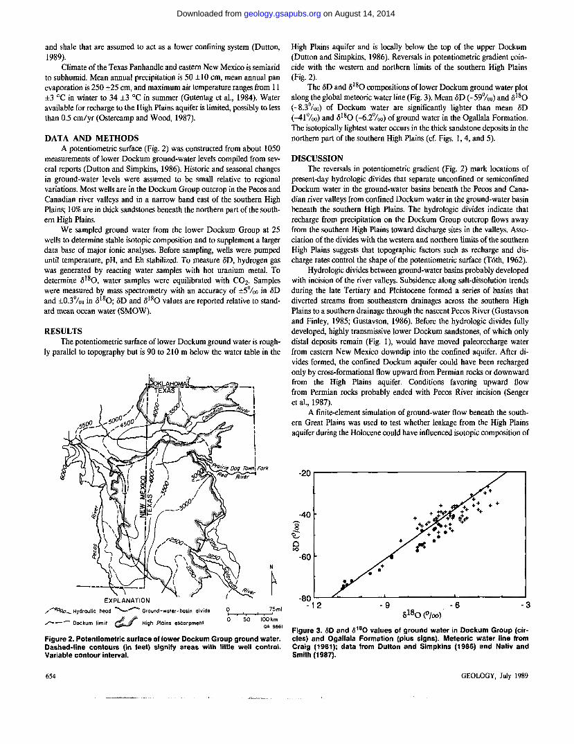
measurements of lower Dockum ground-water levels compiled from sev-eral reports (Dutton and Simpkins, 1986). Historic and seasonal changes in ground-water levels were assumed to be small relative to regional variations. Most wells are in the Dockum Group outcrop in the Pecos and Canadian river valleys and in a narrow band east of the southern High Plains; 10% are in thick sandstones beneath the northern part of the south-ern High Plains.
We sampled ground water from the lower Dockum Group at 25 wells to determine stable isotopic composition and to supplement a larger data base of major ionic analyses. Before sampling, wells were pumped until temperature, pH, and Eh stabilized. To measure <5D, hydrogen gas was generated by reacting water samples with hot uranium metal. To determine fi180, water samples were equilibrated with CO2. Samples were measured by mass spectrometry with an accuracy of ±5°/00 in <5D and ±0.3°/oo in <5180; SD and 5 1 8 0 values are reported relative to stand-ard mean ocean water (SMOW).
RESULTS The potentiometric surface of lower Dockum ground water is rough-
ly parallel to topography but is 90 to 210 m below the water table in the
Figure 2. Potentiometric surface of lower Dockum Group ground water. Dashed-line contours (in feet) signify areas with little well control. Variable contour interval.
High Plains aquifer and is locally below the top of the upper Dockum (Dutton and Simpkins, 1986). Reversals in potentiometric gradient coin-cide with the western and northern limits of the southern High Plains (Fig. 2).
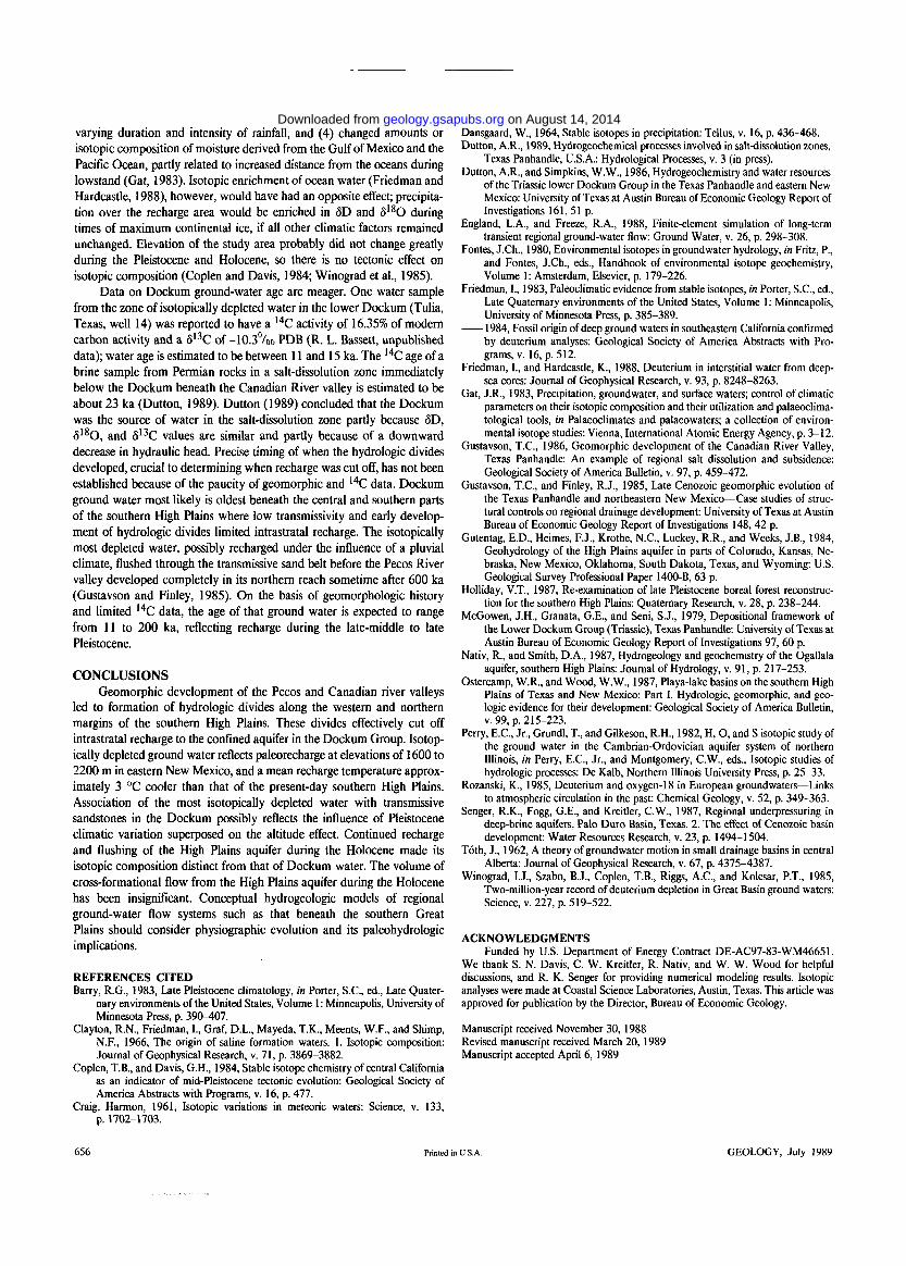
The <5D and 5 1 8 0 compositions of lower Dockum ground water plot along the global meteoric water line (Fig. 3). Mean SD (-59°/00) and S l 8 0 (-8.3°/oo) of Dockum water are significantly lighter than mean 3D (-41°/00) and S 1 8 0 (-6.2°/oo) of ground water in the Ogallala Formation. The isotopically lightest water occurs in the thick sandstone deposits in the northern part of the southern High Plains (cf. Figs. 1, 4, and 5).
DISCUSSION The reversals in potentiometric gradient (Fig. 2) mark locations of
present-day hydrologic divides that separate unconfined or semiconfined Dockum water in the ground-water basins beneath the Pecos and Cana-dian river valleys from confined Dockum water in the ground-water basin beneath the southern High Plains. The hydrologic divides indicate that recharge from precipitation on the Dockum Group outcrop flows away from the southern High Plains toward discharge sites in the valleys. Asso-ciation of the divides with the western and northern limits of the southern High Plains suggests that topographic factors such as recharge and dis-charge rates control the shape of the potentiometric surface (Toth, 1962).
Hydrologic divides between ground-water basins probably developed with incision of the river valleys. Subsidence along salt-dissolution trends during the late Tertiary and Pleistocene formed a series of basins that diverted streams from southeastern drainages across the southern High Plains to a southern drainage through the nascent Pecos River (Gustavson and Finley, 1985; Gustavson, 1986). Before the hydrologic divides fully developed, highly transmissive lower Dockum sandstones, of which only distal deposits remain (Fig. 1), would have moved paleorecharge water from eastern New Mexico downdip into the confined aquifer. After di-vides formed, the confined Dockum aquifer could have been recharged only by cross-formational flow upward from Permian rocks or downward from the High Plains aquifer. Conditions favoring upward flow from Permian rocks probably ended with Pecos River incision (Senger et a l , 1987).
A finite-element simulation of ground-water flow beneath the south-ern Great Plains was used to test whether leakage from the High Plains aquifer during the Holocene could have influenced isotopic composition of
Figure 3. <5D and <51S0 values of ground water in Dockum Group (cir-cles) and Ogallala Formation (plus signs). Meteoric water line from Craig (1961); data from Dutton and Simpkins (1986) and Nativ and Smith (1987).
654 GEOLOGY, July 1989
on August 14, 2014geology.gsapubs.orgDownloaded from

Dockum water. The cross-sectional model included the unconfined High Plains aquifer, upper Dockum confining layer, lower Dockum confined aquifer, and the lower confining system in Permian evaporites and shale. The water table prescribed for the High Plains aquifer had an average lateral hydraulic-head gradient of 0.002. A vertical hydraulic conductivity of 8 x 10~6 m / d was assigned to the upper Dockum and Permian confin-ing layers. Horizontal and vertical hydraulic conductivities of 0.8 and 0.08 m/d , respectively, were assigned to the lower Dockum aquifer. The hydraulic-conductivity distribution resulted in a maximum difference in hydraulic head of 78 m between the High Plains aquifer and the Dockum. Model results show that under present-day hydrologic conditions, more than 90% of the lateral flow within the lower Dockum derives from leakage across the upper Dockum confining layer. Average travel time downward across the 145-m-thick confining layer, however, is computed to be about 310 ka. Average time for movement of water in the Dockum aquifer along a 110-km-long eastward flow path beneath the southern High Plains is calculated to be about 300 ka. Therefore, vertical leakage of isotopically enriched Holocene water almost certainly has not affected ground-water composition in the lower Dockum, even if the vertical flow rate is underestimated by an order of magnitude.
The proportion of Dockum ground water that derived from cross-formational leakage prior to Pecos River incision is unknown. The steep vertical gradient in hydraulic head possibly originated when the river valley developed and cut off the confined aquifer from its recharge area to the west. Before then hydraulic heads in the High Plains aquifer and lower Dockum could have been similar. Even if a vertical gradient were signifi-cant, downward leakage during the middle to late Pleistocene probably was not the source of the isotopically depleted water in view of the estimate of ground-water velocity in the upper Dockum confining layer. It
EXPLANATION
High Plains escarpment ^ —
8 0 (%o)
- — Dockum limit
50
is interesting to note that the greatest depletion occurs where the overlying confining layer is least permeable—i.e., where sandstone makes up less than 20% of the layer. Where sandstone composes more than 30% of the upper Dockum section, in the south-central part of the study area, no wells are available for sampling to determine whether there is chemical evidence for leakage.
Depleted 3D and 5 l s O values relative to Ogallala water are therefore explained by intrastratal recharge to Dockum sandstones at higher eleva-tions to the west before the hydrologic divides formed. The 5D and S 1 8 0 values of precipitation decrease with increasing elevation because of the effect of atmospheric cooling on isotopic fractionation between water vapor and precipitation (Gat, 1983). On the basis of the correlation be-tween condensation temperature and isotopic composition ( d S D / d T = 5 .6% 0 / °C and ddliO/dT= 0 .7% 0 / °C; Dansgaard, 1964), the difference in mean isotopic compositions of Dockum and Ogallala ground waters reflects a mean temperature for Dockum recharge that was approximately 3 °C cooler than present temperatures across the southern High Plains, assuming that surface temperatures in the recharge zone parallel condensa-tion temperatures. If altitude effects for S 1 8 0 are on the order of-2°/oo to -3°/oo/km (Fontes, 1980), average Dockum water possibly was recharged at elevations approximately 700 to 1000 m higher than present recharge to the High Plains aquifer. Since Pecos River incision reached its present extent, the High Plains aquifer has been recharged at the lower elevations of the present-day southern High Plains and possibly under a warmer and more arid climate (Holliday, 1987), making its ground-water isotopic composition distinct from that of confined ground water in the Dockum. The elevation shift is somewhat overestimated, because the difference in mean isotopic compositions between the two aquifers involves both alti-tude and climatic effects.
Dockum ground water in basin-margin sandstones beneath the northern part of the southern High Plains is as much as 30°/oo lighter in 5D and 4°/oo lighter in S l 8 0 compared to ground water in muddy basin-center areas (cf. Figs. 1, 4, and 5). Mean isotopic composition of the most depleted Dockum water implies an equivalent condensation temperature as much as 5.6 °C cooler than the temperature of present recharge to the High Plains aquifer, 2.6 °C cooler than the altitude-related shift previously estimated. Reasonable estimates of altitude effect and paleorecharge eleva-tion cannot account for that much temperature reduction. Complex effects of glaciation that could account for the observed spatial and inferred temporal variation in isotopic composition include (1) modified storm trajectories, (2) changed amounts of winter and summer precipitation, (3)
75 mi
IOO Km OA 9863
Figure 4.3D values in lower Dockum ground water. Band of isotopically depleted water coincides with area where sandstone makes up 30% to 50% of lower Dockum.
Figure 5. Cross section of S1sO values of ground water in High Plains aquifer and Dockum Group. Section made by projecting mapped con-tours onto stratigraphie profile. Data for High Plains aquifer from Nativ and Smith (1987).
654 GEOLOGY, July 1989
on August 14, 2014geology.gsapubs.orgDownloaded from
varying durat ion and intensity of rainfall, and (4) changed amounts or isotopic composi t ion of moisture derived f rom the Gulf of Mexico and the Pacific Ocean , partly related to increased distance f rom the oceans during lowstand (Gat, 1983). Isotopic enr ichment of ocean water (Fr iedman and Hardcastle, 1988), however , would have had an opposite effect; precipita-tion over the recharge area would be enriched in SD and 5 1 8 0 during times of m a x i m u m continental ice, if all other climatic factors remained unchanged. Elevation of the study area probably did not change greatly during the Pleistocene and Holocene, so there is no tectonic effect on isotopic composit ion (Coplen and Davis, 1984; Winograd et al., 1985).
Da ta on D o c k u m ground-water age are meager. O n e water sample f rom the zone of isotopically depleted water in the lower D o c k u m (Tulia, Texas, well 14) was reported to have a l 4 C activity of 16.35% of modern carbon activity and a S 1 3 C of -10.3°/oo P D B (R. L. Bassett, unpublished data); water age is estimated to be between 11 and 15 ka. The 1 4 C age of a brine sample f rom Permian rocks in a salt-dissolution zone immediately be low the D o c k u m beneath the Canadian River valley is estimated to be about 2 3 ka (Dut ton , 1989). Du t ton (1989) concluded that the D o c k u m was the source of water in the salt-dissolution zone partly because 3D, <5 l sO, a n d 5 I 3 C values a re similar and partly because of a d o w n w a r d decrease in hydraulic head. Precise timing of when the hydrologic divides developed, crucial to determining when recharge was cut off, has not been established because of the paucity of geomorphic a n d 1 4 C data. D o c k u m ground water most likely is oldest beneath the central and southern parts of the southern High Plains where low transmissivity and early develop-ment of hydrologic divides limited intrastratal recharge. The isotopically most depleted water, possibly recharged under the influence of a pluvial climate, flushed through the transmissive sand belt before the Pecos River valley developed completely in its nor thern reach somet ime after 600 ka (Gustavson and Finley, 1985). O n the basis of geomorphologic history and limited 1 4 C data , the age of that g round water is expected to range f rom 11 to 2 0 0 ka, reflecting recharge during the late-middle to late Pleistocene.
C O N C L U S I O N S G e o m o r p h i c development of the Pecos and Canad ian river valleys
led to format ion of hydrologic divides a long the western and northern margins of the southern High Plains. These divides effectively cut off intrastratal recharge to the confined aquifer in the D o c k u m Group. Isotop-ically depleted ground water reflects paleorecharge at elevations of 1600 to 2 2 0 0 m in eastern N e w Mexico, and a mean recharge temperature approx-imately 3 ° C cooler than that of the present-day southern High Plains. Association of the most isotopically depleted water with transmissive sandstones in the D o c k u m possibly reflects the influence of Pleistocene climatic variation superposed on the altitude effect. Cont inued recharge and flushing of the High Plains aquifer during the Holocene made its isotopic composi t ion distinct f rom that of D o c k u m water. The volume of cross-formational f low f r o m the High Plains aquifer during the Holocene has been insignificant. Conceptual hydrogeologic models of regional ground-water f low systems such as that beneath the southern Great Plains should consider physiographic evolution and its paleohydrologic implications.
REFERENCES CITED Barry, R.G., 1983, Late Pleistocene climatology, in Porter, S.C., ed., Late Quater-
nary environments of the United States, Volume 1: Minneapolis, University of Minnesota Press, p. 390-407.
Clayton, R.N., Friedman, I., Graf, D.L., Mayeda, T.K., Meents, W.F., and Shimp, N.F., 1966, The origin of saline formation waters. 1. Isotopic composition: Journal of Geophysical Research, v. 71, p. 3869-3882.
Coplen, T.B., and Davis, G.H., 1984, Stable isotope chemistry of central California as an indicator of mid-Pleistocene tectonic evolution: Geological Society of America Abstracts with Programs, v. 16, p. 477.
Craig, Harmon, 1961, Isotopic variations in meteoric waters: Science, v. 133, p. 1702-1703.
Dansgaard, W., 1964, Stable isotopes in precipitation: Tellus, v. 16, p. 436-468. Dutton, A.R., 1989, Hydrogeochemical processes involved in salt-dissolution zones,
Texas Panhandle, U.S.A.: Hydrological Processes, v. 3 (in press). Dutton, A.R., and Simpkins, W.W., 1986, Hydrogeochemistry and water resources
of the Triassic lower Dockum Group in the Texas Panhandle and eastern New Mexico: University of Texas at Austin Bureau of Economic Geology Report of Investigations 161, 51 p.
England, L.A., and Freeze, R.A., 1988, Finite-element simulation of long-term transient regional ground-water flow: Ground Water, v. 26, p. 298-308.
Fontes, J.Ch., 1980, Environmental isotopes in groundwater hydrology, in Fritz, P., and Fontes, J.Ch., eds., Handbook of environmental isotope geochemistry, Volume 1: Amsterdam, Elsevier, p. 179-226.
Friedman, I., 1983, Paleoclimatic evidence from stable isotopes, in Porter, S.C., ed., Late Quaternary environments of the United States, Volume 1: Minneapolis, University of Minnesota Press, p. 385-389. 1984, Fossil origin of deep ground waters in southeastern California confirmed by deuterium analyses: Geological Society of America Abstracts with Pro-grams, v. 16, p. 512.
Friedman, I., and Hardcastle, K., 1988, Deuterium in interstitial water from deep-sea cores: Journal of Geophysical Research, v. 93, p. 8248-8263.
Gat, J.R., 1983, Precipitation, groundwater, and surface waters; control of climatic parameters on their isotopic composition and their utilization and palaeoclima-tological tools, in Palaeoclimates and palaeowaters; a collection of environ-mental isotope studies: Vienna, International Atomic Energy Agency, p. 3-12.
Gustavson, T.C., 1986, Geomorphic development of the Canadian River Valley, Texas Panhandle: An example of regional salt dissolution and subsidence: Geological Society of America Bulletin, v. 97, p. 459-472.
Gustavson, T.C., and Finley, R.J., 1985, Late Cenozoic geomorphic evolution of the Texas Panhandle and northeastern New Mexico—Case studies of struc-tural controls on regional drainage development: University of Texas at Austin Bureau of Economic Geology Report of Investigations 148, 42 p.
Gutentag, E.D., Heimes, F.J., Krothe, N.C., Luckey, R.R., and Weeks, J.B., 1984, Geohydrology of the High Plains aquifer in parts of Colorado, Kansas, Ne-braska, New Mexico, Oklahoma, South Dakota, Texas, and Wyoming: U.S. Geological Survey Professional Paper 1400-B, 63 p.
Holliday, V.T., 1987, Re-examination of late Pleistocene boreal forest reconstruc-tion for the southern High Plains: Quaternary Research, v. 28, p. 238-244.
McGowen, J.H., Granata, G.E., and Seni, S.J., 1979, Depositional framework of the Lower Dockum Group (Triassic), Texas Panhandle: University of Texas at Austin Bureau of Economic Geology Report of Investigations 97, 60 p.
Nativ, R., and Smith, D.A., 1987, Hydrogeology and geochemistry of the Ogallala
aquifer, southern High Plains: Journal of Hydrology, v. 91, p. 217-253. Ostercamp, W.R., and Wood, W.W., 1987, Playa-lake basins on the southern High
Plains of Texas and New Mexico: Part I. Hydrologic, geomorphic, and geo-logic evidence for their development: Geological Society of America Bulletin, v. 99, p. 215-223.
Perry, E.C., Jr., Grundl, T., and Gilkeson, R.H., 1982, H, O, and S isotopic study of the ground water in the Cambrian-Ordovician aquifer system of northern Illinois, in Perry, E.C., Jr., and Montgomery, C.W., eds., Isotopic studies of hydrologic processes: De Kalb, Northern Illinois University Press, p. 25-33.
Rozanski, K., 1985, Deuterium and oxygen-18 in European groundwaters—Links to atmospheric circulation in the past: Chemical Geology, v. 52, p. 349-363.
Senger, R.K., Fogg, G.E., and Kreitler, C.W., 1987, Regional underpressuring in deep-brine aquifers, Palo Duro Basin, Texas. 2. The effect of Cenozoic basin development: Water Resources Research, v. 23, p. 1494-1504.
Toth, J., 1962, A theory of groundwater motion in small drainage basins in central Alberta: Journal of Geophysical Research, v. 67, p. 4375-4387.
Winograd, I.J., Szabo, B.J., Coplen, T.B., Riggs, A.C., and Kolesar, P.T., 1985, Two-million-year record of deuterium depletion in Great Basin ground waters: Science, v. 227, p. 519-522.
A C K N O W L E D G M E N T S Funded by U.S. Department of Energy Contract DE-AC97-83-WM46651.
We thank S. N. Davis, C. W. Kreitler, R. Nativ, and W. W. Wood for helpful discussions, and R. K. Senger for providing numerical modeling results. Isotopic analyses were made at Coastal Science Laboratories, Austin, Texas. This article was approved for publication by the Director, Bureau of Economic Geology.
Manuscript received November 30, 1988 Revised manuscript received March 20, 1989 Manuscript accepted April 6, 1989
656 Printed in U.S.A. GEOLOGY, July 1989
on August 14, 2014geology.gsapubs.orgDownloaded from