is42: a new ims certified infrasound station in the graciosa island ...€¦ · of north-atlantic...
TRANSCRIPT
IS42: A new IMS certified infrasound station in the Graciosa Island, Azores, Portugal
Nicolau Wallenstein (1), João Luís Gaspar (1), Alfred Kramer (2), Juraci Carvalho (2), Paola Campus (3), Georgios Haralabus (2), João Gregório (4), Pierrick Mialle (2) and Flávio Soares (1)
(1) Centro de Vulcanologia e Avaliação de Riscos Geológicos, Rua da Mãe de Deus, 9501-801 Ponta Delgada, Portugal ([email protected], +351-296650142),(2) International Monitoring System, CTBTO Preparatory Commission, Vienna International Centre, P.O. Box 1200, 1400 Vienna, Austria,(3) Dipartimento di Scienze della Terra, Università degli Studi di Firenze, Via G. La Pira, 4, 50121 – Firenze, Italy,(4) Direcção Regional da Ciência Tecnologia e Comunicações, Rua Conselheiro Dr. Luís Bettencourt, 16, 9500-058 Ponta Delgada, Portugal
ABSTRACT
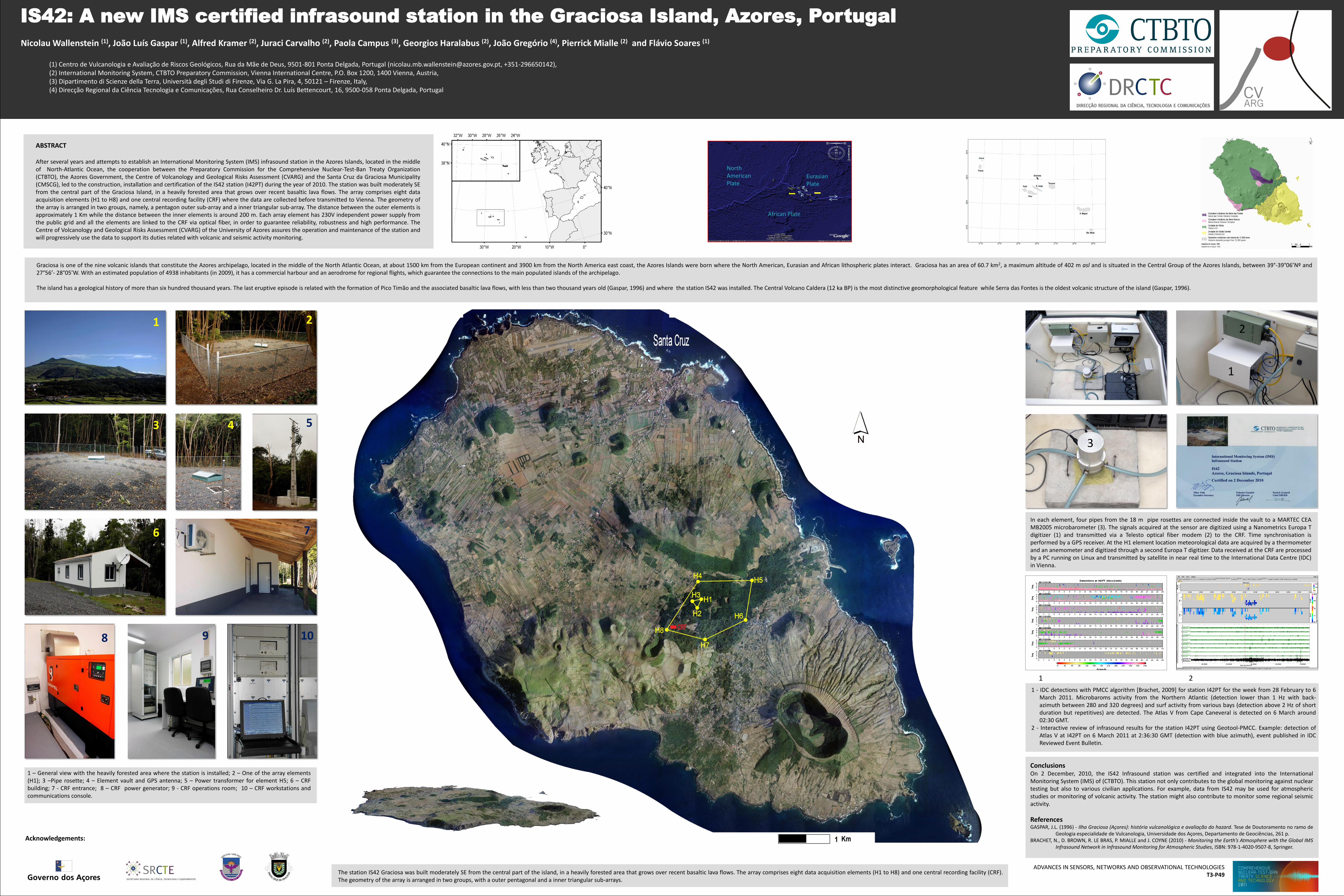
After several years and attempts to establish an International Monitoring System (IMS) infrasound station in the Azores Islands, located in the middleof North-Atlantic Ocean, the cooperation between the Preparatory Commission for the Comprehensive Nuclear-Test-Ban Treaty Organization(CTBTO), the Azores Government, the Centre of Volcanology and Geological Risks Assessment (CVARG) and the Santa Cruz da Graciosa Municipality(CMSCG), led to the construction, installation and certification of the IS42 station (I42PT) during the year of 2010. The station was built moderately SEfrom the central part of the Graciosa Island, in a heavily forested area that grows over recent basaltic lava flows. The array comprises eight dataacquisition elements (H1 to H8) and one central recording facility (CRF) where the data are collected before transmitted to Vienna. The geometry ofthe array is arranged in two groups, namely, a pentagon outer sub-array and a inner triangular sub-array. The distance between the outer elements isapproximately 1 Km while the distance between the inner elements is around 200 m. Each array element has 230V independent power supply fromthe public grid and all the elements are linked to the CRF via optical fiber, in order to guarantee reliability, robustness and high performance. TheCentre of Volcanology and Geological Risks Assessment (CVARG) of the University of Azores assures the operation and maintenance of the station andwill progressively use the data to support its duties related with volcanic and seismic activity monitoring.
North American Plate
Eurasian Plate
African Plate
Acknowledgements:
Graciosa is one of the nine volcanic islands that constitute the Azores archipelago, located in the middle of the North Atlantic Ocean, at about 1500 km from the European continent and 3900 km from the North America east coast, the Azores Islands were born where the North American, Eurasian and African lithospheric plates interact. Graciosa has an area of 60.7 km2, a maximum altitude of 402 m asl and is situated in the Central Group of the Azores Islands, between 39°-39°06’Nº and27°56’- 28°05’W. With an estimated population of 4938 inhabitants (in 2009), it has a commercial harbour and an aerodrome for regional flights, which guarantee the connections to the main populated islands of the archipelago.
The island has a geological history of more than six hundred thousand years. The last eruptive episode is related with the formation of Pico Timão and the associated basaltic lava flows, with less than two thousand years old (Gaspar, 1996) and where the station IS42 was installed. The Central Volcano Caldera (12 ka BP) is the most distinctive geomorphological feature while Serra das Fontes is the oldest volcanic structure of the island (Gaspar, 1996).
ConclusionsOn 2 December, 2010, the IS42 Infrasound station was certified and integrated into the InternationalMonitoring System (IMS) of (CTBTO). This station not only contributes to the global monitoring against nucleartesting but also to various civilian applications. For example, data from IS42 may be used for atmosphericstudies or monitoring of volcanic activity. The station might also contribute to monitor some regional seismicactivity.
ReferencesGASPAR, J.L. (1996) - Ilha Graciosa (Açores): história vulcanológica e avaliação do hazard. Tese de Doutoramento no ramo de
Geologia especialidade de Vulcanologia, Universidade dos Açores, Departamento de Geociências, 261 p.BRACHET, N., D. BROWN, R. LE BRAS, P. MIALLE and J. COYNE (2010) - Monitoring the Earth’s Atmosphere with the Global IMS
Infrasound Network in Infrasound Monitoring for Atmospheric Studies, ISBN: 978-1-4020-9507-8, Springer.
2
1
3
1 2
3 4 5
6 7
8 9 10
1 – General view with the heavily forested area where the station is installed; 2 – One of the array elements(H1); 3 –Pipe rosette; 4 – Element vault and GPS antenna; 5 – Power transformer for element H5; 6 – CRFbuilding; 7 - CRF entrance; 8 – CRF power generator; 9 - CRF operations room; 10 – CRF workstations andcommunications console.
1 2
1 - IDC detections with PMCC algorithm [Brachet, 2009] for station I42PT for the week from 28 February to 6March 2011. Microbaroms activity from the Northern Atlantic (detection lower than 1 Hz with back-azimuth between 280 and 320 degrees) and surf activity from various bays (detection above 2 Hz of shortduration but repetitives) are detected. The Atlas V from Cape Caneveral is detected on 6 March around02:30 GMT.
2 - Interactive review of infrasound results for the station I42PT using Geotool-PMCC. Example: detection ofAtlas V at I42PT on 6 March 2011 at 2:36:30 GMT (detection with blue azimuth), event published in IDCReviewed Event Bulletin.
The station IS42 Graciosa was built moderately SE from the central part of the island, in a heavily forested area that grows over recent basaltic lava flows. The array comprises eight data acquisition elements (H1 to H8) and one central recording facility (CRF).The geometry of the array is arranged in two groups, with a outer pentagonal and a inner triangular sub-arrays.
In each element, four pipes from the 18 m pipe rosettes are connected inside the vault to a MARTEC CEAMB2005 microbarometer (3). The signals acquired at the sensor are digitized using a Nanometrics Europa Tdigitizer (1) and transmitted via a Telesto optical fiber modem (2) to the CRF. Time synchronisation isperformed by a GPS receiver. At the H1 element location meteorological data are acquired by a thermometerand an anemometer and digitized through a second Europa T digitizer. Data received at the CRF are processedby a PC running on Linux and transmitted by satellite in near real time to the International Data Centre (IDC)in Vienna.
ADVANCES IN SENSORS, NETWORKS AND OBSERVATIONAL TECHNOLOGIEST3-P49