investigation of geology and hydro-geophysical features
TRANSCRIPT

1
Journal of Environmental & Earth Sciences | Volume 02 | Issue 01 | April 2020
Distributed under creative commons license 4.0 DOI: https://doi.org/10.30564/jees.v2i1.1279
Journal of Environmental & Earth Sciences
https://ojs.bilpublishing.com/index.php/jees
ARTICLE
Investigation of Geology and Hydro-geophysical Features Using Elec-tromagnetic and Vertical Sounding Methods for Abu Zabad Area, Western Kordofan State, Sudan
Elhag A. B1 Musa M. A.2* 1. Department of Civil Engineering, College of Engineering, King Khalid University, Abha, Saudi Arabia, on leave from Kordofan University, Sudan2. Department of Geology, College of Science and Information Technology, Nyala University, Nyala, Sudan
ARTICLE INFO ABSTRACT
Article historyReceived: 8 October 2019 Accepted: 21 October 2019Published Online: 31 March 2020
The geology and hydro-geophysical features can aid in identifying bore-hole location. The study aims to investigate groundwater aquifers and best location of boreholes in the crystalline basement area of Abu Zabad near El Obeid Southwest, Sudan. The study area is underlain by two aqui-fers formations from Precambrian age. The oldest units of basement com-plex of area under investigation consist of metamorphic rocks including gneiss, schist, and quartzite. The geophysical methods electromagnetic (EM) and vertical electrical sounding (VES) surveys showed that best aquifers yield for construction of boreholes are in weathering and frac-tures formation. The EM results revealed that structural features are sig-nificant for groundwater potential and interpretation of the VES data also revealed four geo-electric layers, but generally two distinct lithologic lay-ers, which include Superficial deposit and bedrock-basement respectively. The curves generated from the data revealed H curve and HK curve, and thickness of these layers varies from 15 m to 50 m in the area. The aqui-fer thickness range from 20 m to 30 m. The study concludes that these techniques are suitable for identifying borehole location in the basement rock in Abu Zabad Area Sudan.
Keywords:Electromagnetic and geoelectric surveyAquifer units and groundwater potential
*Corresponding Author:Musa M. A.,Department of Geology, College of Science and Information Technology, Nyala University, Nyala, Sudan;Email: [email protected]; [email protected]
1. Introduction
Groundwater investigation of different techniques; geological, hydro-geological, geophysical tech-niques. The hydrological cycle as results of cli-
matic changes have a significant associated impact on wa-ter resources (Stoll et al. 2011). Jyrkama and Sykes (2007)
studied the variation of the groundwater recharge. Lineaments provide the pathways for groundwater
movement in hard rock areas [3,4]. Furthermore, in order to locate favorable sites for groundwater exploration a linea-ment density map was prepared as suggested by [17]. The movement and occurrence of groundwater depends main-ly on the secondary porosity and permeability resulting
CORE Metadata, citation and similar papers at core.ac.uk
Provided by Bilingual Publishing Co. (BPC): E-Journals

2
Journal of Environmental & Earth Sciences | Volume 02 | Issue 01 | April 2020
Distributed under creative commons license 4.0
from faulting and fracturing etc. [7]. In October 1966 and 1973, Kordofan State was shaken by strong earthquakes that have great attention to hydrology due to a few of groundwater wells in the aquifer are dry [8]. In study area geological formation is exposed in the eastern part of Tor-da (Precambrian age). They are predominantly massive and compact of schist and gneiss metamorphic rocks (Fig-ure 4).
Surface geophysical survey is a veritable tool in groundwater exploration, owing to its economy in bore-hole construction by identifying borehole location prior to drilling [12]. Hydrogeophysical study is very important in basement rocks areas and considered a priority in many groundwater prospections. Many geophysical methods used in basement areas, but the electrical resistivity (ER) method is essential tools [10].
The electromagnetic (EM) and vertical electrical sounding (VES) survey used in this work for locating the aquifers extension [16]. The two most common arrays used for VES are Wenner array and Schlumberger array [5]. This method is regularly used to solve a wide variety of groundwater problems such as determination of depth, thickness and boundary of aquifer, determination of zones with high yield potential in an aquifer, determination of the boundary between saline and fresh water zones and estimation of aquifer transmissivity and in environmental problems as well [1,2,11,13,15].
Study AreaThis paper focus on the geology and groundwater re-
sources of western Sudan in terms of aquifers properties, investigated area includes Abu Zabad area which lies within Western Kordofan State. The target area is covers an area of about 25 Km2 between Latitudes 12° 20′–12° 38′ N and Longitudes 29° 28′ – 29° 45′ E (Figure 1), and characterized by undulating topographical surfaces most-ly covered by sand dunes and gentle slopes to the east of Torda (watercourse) (Figure 1). The rainfall generally occurs in summer season, with maximum in the month of August. The prevailing winds blow from the south during summer, and blow north during winter. The average of temperatures ranges between 30◦C in January and 48◦C in June.
Western Kordofan area is the most important district area in Kordofan States as it is located within the base-ment complex and Nubian sandstone formation area. An intensive geophysical survey was carried out to locate different types of rocks. The ages of these rocks in most localities are assigned to the Precambrian period.
Figure 1. Distribution of pre-Quaternary geological units in the Kordofan Region
Source: [20]
The objective of the study is to recognize water-bear-ing formations in study area, and to examine suitable and available resources of groundwater. The main rocks characterization and recognition of aquifers, lateral and vertical extensions useful for drilling boreholes, as well as the main objectives of the geophysical survey in the study area are as follows:
(1) Determine anomalous (conductive) zones.(2) Determine fractures, faulting and similar rock de-
formations which play an important role in sub-surface hydrology of the area (water movement and recharge).
2. Materials and Methods
The study employed two direct current (DC) methods: Vertical Electric Sounding (VES) and electromagnetic (EM). In both electric potential produced by (DC) current injected by two electrodes is measured by another pair of electrodes. VES technique employed Schlumberger array, which is particularly efficient when main resistivity gra-dient is in vertical direction. The electromagnetic (EM) array is more suitable to study grounds with lateral resis-tivity variation. The weathering and fracturing of analysis were also carried out to determine the optimized location and groundwater well.
The vertical electrical sounding and electrical profiling
DOI: https://doi.org/10.30564/jees.v2i1.1279

3
Journal of Environmental & Earth Sciences | Volume 02 | Issue 01 | April 2020
Distributed under creative commons license 4.0
methods are based on four-electrode principle as shown in (Figure 2). The electrical current ( I ) is applied to A and B electrodes and the potential (ΔU) is measured between M and N electrodes. The bulk soil electrical resistivity (ER) is calculated with:
ER K=∆
IU (1)
Where:K= is the geometric factor.The conductive and EM anomalies delineated by
across the entire study area, and carried out to determine depth to fresh rock. Figure 8 reveals the geo-electric se-quence along W – E within the study area. Conductive and EM anomalies were delineated at three VES,s and three EM profiling locations within the study area. The Figure 8 was combined the VES and Electromagnetic data and obtained by computing the depths and locations of fractures.
Figure 2. Two current and two potential electrodes on the surface of ground of resistivity
Source: [7]
Geology and Hydrogeological SettingThe study area lies South of Central African Shear
Zone (CASZ). The Torda basin Complex is main basin in study area and in general trending North to South. The Torda basin, located in Eastern extension of Abu Zabad town (Figure 3). The basement complex is divid-ed into three groups which include weathering, fracture and tide crystalline rocks. Hydrogeological and litho-logical log have been studied and evaluated to charac-terize aquifer potentials, and suitable sites for several wells were selected in Torda basin to define aquifers extensions (Figure 3). Geologically, Torda basin Com-plex is composed of two major basins, named weather-ing and fractures basement regolith. The groundwater
occurs in drilled wells in weathering and fractures basement regolith.
The target area is generally an undulating plain of low relief with altitude ranging range from 610 to 616 m above mean sea level, and major drainage system in study area Khor El Ganam, Khor Sheween and Wadis and ground surface slopes gently to east towards Tor-da.
The regional geologic map of the study area is com-posed of igneous and metamorphic rocks surrounded by Paleozoic and Cretaceous sedimentary rocks. The Pre-cambrian rocks are extending southward from the valley of Abu Zabad through subdued topographic basin drained by Torda.
In Eastern Abu Zabad city (Figure 3), groundwater extraction from hand dug wells (shallow boreholes) and deep boreholes around the water pool (Torda) is used for drinking and irrigation. The geological logs from the surface down to 53 m depth revealed that the structural features consist of Superficial deposits, and bedrock-base-ment. The individual thickness of these layers varies from 5 m to 10 m in the area (Figure 4). The main aquifer appears at depths below 20 m, composed of fragment of metamorphic and igneous rocks.
Figure 3. Geomorphological map of the study areaSource: [9]
3. Results and Discussion
The geological setting of the study area consists of su-perficial deposits and Precambrian basement rocks. The sediments exposed in Northern part are mostly Cretaceous in age belong to the Wadi of Ger Elassal formation. They are dominated by fine to coarse grained cross-bedded fluviatile sandstones forming. The Precambrian basement rocks consist of gneisses, schists and quarzites (Figure 4). The weathered and fractured basement rocks constitute major aquifers or aquitards.
The degree of weathering is one of the most significant factors controlling the type and abundance of clay miner-als [6]. In basement rock of study area percentage of clay
DOI: https://doi.org/10.30564/jees.v2i1.1279
4
Journal of Environmental & Earth Sciences | Volume 02 | Issue 01 | April 2020
Distributed under creative commons license 4.0
minerals is proportional with intensity and time interval of weathering (Figure 4). Whereas, weathered and fractured basement rocks constitute the major aquifers or aquitards.
Figure 4. Weathering and fractured profile on gnesis of the study area (Abu Zabad - Torda)
Note: Photograph with the author (May, 2018).
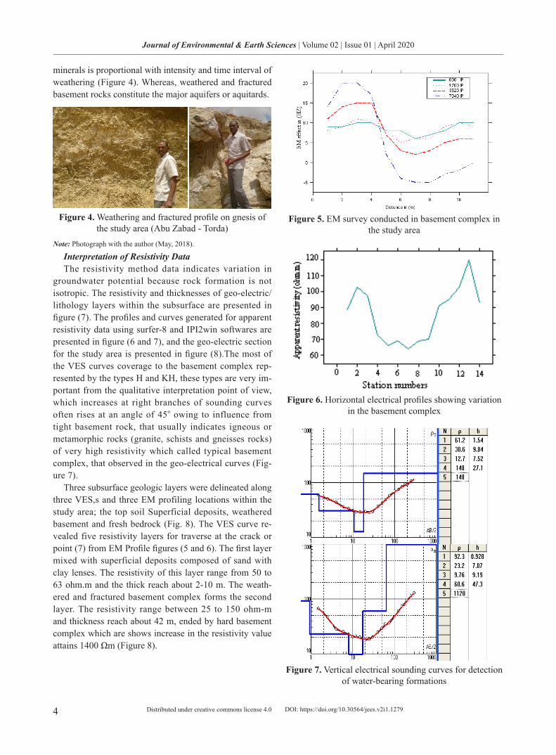
Interpretation of Resistivity DataThe resistivity method data indicates variation in
groundwater potential because rock formation is not isotropic. The resistivity and thicknesses of geo-electric/lithology layers within the subsurface are presented in figure (7). The profiles and curves generated for apparent resistivity data using surfer-8 and IPI2win softwares are presented in figure (6 and 7), and the geo-electric section for the study area is presented in figure (8).The most of the VES curves coverage to the basement complex rep-resented by the types H and KH, these types are very im-portant from the qualitative interpretation point of view, which increases at right branches of sounding curves often rises at an angle of 45o owing to influence from tight basement rock, that usually indicates igneous or metamorphic rocks (granite, schists and gneisses rocks) of very high resistivity which called typical basement complex, that observed in the geo-electrical curves (Fig-ure 7).
Three subsurface geologic layers were delineated along three VES,s and three EM profiling locations within the study area; the top soil Superficial deposits, weathered basement and fresh bedrock (Fig. 8). The VES curve re-vealed five resistivity layers for traverse at the crack or point (7) from EM Profile figures (5 and 6). The first layer mixed with superficial deposits composed of sand with clay lenses. The resistivity of this layer range from 50 to 63 ohm.m and the thick reach about 2-10 m. The weath-ered and fractured basement complex forms the second layer. The resistivity range between 25 to 150 ohm-m and thickness reach about 42 m, ended by hard basement complex which are shows increase in the resistivity value attains 1400 Ωm (Figure 8).
Figure 5. EM survey conducted in basement complex in the study area
Figure 6. Horizontal electrical profiles showing variation in the basement complex
Figure 7. Vertical electrical sounding curves for detection of water-bearing formations
DOI: https://doi.org/10.30564/jees.v2i1.1279

5
Journal of Environmental & Earth Sciences | Volume 02 | Issue 01 | April 2020
Distributed under creative commons license 4.0
Figure 8. Shows that traverse of EM and three points of VES
To recognize the two aquifers at different depths, the lithological analysis of well logs is useful for obtaining variations of weathering and fractured basement rocks (Figure 4). The water table marks of aquifer are underlain by an unsaturated zone which composed of superficial deposits, and thickness of unsaturated zone above aquifer is about 20 m to groundwater table. In Torda towards east, water table is the shallowest (about 15 m) and therefore unsaturated zone is a thin layer. The total thickness of the aquifer varies from 30 m in the eastern part to 10 m in the west with an average thickness of about 20 m.
nnual groundwater level fluctuations related to ground-water recharge and discharge in the aquifer system. Direct reflected in variations of groundwater level when recharge exceeds discharge, water table levels will rise and when discharge exceeds recharge, they will fall. Whereas, two types of fluctuations are recorded, which include either seasonal or diurnal ones. The water level in study area fluctuates in response to variation in recharge periods, rise due to the seasonal rainfalls and decline in the summer and during droughts in response to a decrease in ground-water recharge from precipitation. The influence of the recharge extends to certain distances and then becomes negligible. Groundwater quality is saline in the western-er area where is low recharge, but in eastern area (Torda basin) is good quality occurs; the total dissolved solids (TDS) range between 300 to 600 mg/l, and groundwater is suitable for drinking and irrigation purposes.
Several pumping tests that were conducted at different wells in the study area to determine the hydraulic proper-ties of the aquifer. The base of the aquifer is at the depth of range from 20 m to 30 m, and the yield about borehole about 2500 g/h.
4. Conclusions
The study area composed of two aquifers weathered and fractured basement rocks, both aquifers are found at rela-tively in the Torda Basin in the East direction. Groundwa-ter recharge by the flood of many Khors; Khor El Ganam, Khor Sheween and Wadis respectively. Groundwater sa-linity progressively increases with the low recharge.
This study investigated the groundwater potential and aquifer extension, western Kordafan state, Abu Zabad, Su-dan. Electromagnetic and vertical electrical sounding us-ing the Schlumberger array configuration were carried out. Analysis and interpretation of EM and VES data obtained from the study area showed profile 1 and 2, and VES 3 and VES 5 to be locating the successful for borehole drill-ing due to low resistivity of the weathered and fractured aquifer layers coupled with the relatively high thicknesses of the weathered layers. Itis therefore recommended that for future groundwater exploration in the study area, geo-physical prospection should be taken to locate the best site for groundwater drilling.
Acknowledgement
The authors would like to express their gratitude to King Khalid University, Saudi Arabia for providing ad-ministrative and technical support.
References
[1] Acharya , T. Biswas , A. Bhat tacharyya , A. Chakraborty, A. Chakraborty, M., Sarkar, M.. Vulner-ability mapping of saline water intrusion in coastal aquifers of West-Bengal, India using flow-net ap-proach. Indian Groundwater, 2018, 10: 46-56.
[2] Biswas, A., Sharma, S. P.. Geophysical surveys for identifying source and pathways of subsurface water inflow at the Bangur chromite mine, Odisha, India. Natural Hazards, 2017, 88 (2): 947-964.
[3] Biswas, A. Jana, A., Mandal, A.. Application of Re-mote Sensing, GIS and MIF technique for Elucida-tion of Groundwater Potential Zones from a part of Orissa coastal tract, Eastern India. Research Journal of Recent Sciences, 2013, 2 (11): P. 42-49.
[4] Biswas, A. Jana A., Sharma S. P.. Delineation of groundwater potential zones using satellite remote sensing and geographic information system tech-niques: a case study from Ganjam district, Orissa, India. Research Journal of Recent Sciences, 2012, 1 (9): 59-66, Available online at: www.isca.in.
[5] Cardimona, S.. Electrical Resistivity technique for Subsurface Investigation, 2017.
[6] Duzgoren-Aydin, N.S., Aydin, A., Malpas, J.. Distri-
DOI: https://doi.org/10.30564/jees.v2i1.1279

6
Journal of Environmental & Earth Sciences | Volume 02 | Issue 01 | April 2020
Distributed under creative commons license 4.0
bution of clay minerals along a weathered pyroclastic profile, Hong Kong. Catena, 2002, 50: 17-41.
[7] Elhag A. B.. Application of Remote Sensing and Geo-Electrical Method for Groundwater Exploration in Khor Al Alabyad, North Kordofan State, Sudan. American Journal of Earth Sciences, 2016.
http://www.openscienceonline.com/journal/archive2? journalId=715&paperId=2914
[8] Elhag, A. B., Elzien, S. M.. Structures Controls on Groundwater Occurrence and Flow in Crystalline Bedrocks: a case study of the El Obeid area, Western Sudan. Global Advanced Research Journal of Envi-ronmental Science and Toxicology, 2013, 2(2): 037-046. ISSN: 2315-5140. Available online:
http://garj.org/garjest/index.htm. [9] Eltahir, A. D. M.. Late Quaternary Sedimentary and
Paleoclimatic Evolution of Kordofan, Sudan, Ph.D. Dissertation for the doctorate degree of the Universi-té Grenoble Alpes, France, 2018.
[10] Gautam, P., Biswas, A.. 2D Geo-electrical imag-ing for shallow depth investigation in Doon Valley Sub-Himalaya, Uttarakhand, India. Modeling Earth Systems and Environment, 2016, 2 (4): 175.
[11] Nejad, H. T.. Geoelectrical Investigation of the Aquifer Characteristics and Groundwater Potential in Bahbadan Azad University Farm, Khuzestan prov-ince, Iran. Journal of Applied Sciences, 2009, 9(20): 3691-3698.
ISSN: 1812 – 5654[12] Obiora, D. N., Ownuka, O. S.. Groundwater Explo-
ration in Ikorodu, Lagos-Nigeria: A Surface Geo-physical Survey Contribution, University of Nigeria, Nsukka. The Pacific Journal of Science and Technol-ogy, 2005, 6(1): 86–93.
http://www.akamaiuniversity.us/PJST.htm [13] Parial, K. Biswas, A. Agrahari, S. Sharma, S. P.,
Sengupta, D.. Identification of contaminated zones
using direct current resistivity surveys in and around ash ponds near Kolaghat Thermal power plant, West Bengal, India. International Journal of Geology and Earth Sciences, 2015, 1 (2): 55-64.
[14] Rodis, H.G., Hassan, A., Wahadan, L.. Groundwater Geology of Kordofan Province-Sudan, Contribution to the hydrology of Africa and Mediterranean Re-gion. United State government printing office. Wash-ington, 1968.
[15] Sharma, S. P., Biswas, A.. A practical solution in delineating thin conducting structures and suppres-sion problem in direct current resistivity sounding. Journal of earth system science, 2013, 122 (4): 1065-1080.
[16] Sharma, S. P., Baranwal, V. C.. Delineation of groundwater-bearing fracture zones in a hard rock area integrating very low frequency electromagnetic and resistivity data. Journal of Applied geophysics, 2005, 57 (2): 155-166.
[17] Sree Devi, P. D., Srinivasulu, S., Ragu, K. K.. Hy-dro-geomorphological and groundwater prospects of the Pageru river basin by using remote sensing data. Environmental Geology, 2001, 40: 1088-1094.
[18] U.N.S Special 92 Fund (DOX - SUD - A 39). United Nations Special Fund, F.A.O Land and Water Use Survey in Kordofan Province, Sudan. Reports of the following notations:- DOX - sun – A 39, 1965.
[19] Van Daele, K.. Characterization of geological mate-rials, their weathering products and their relationship with soils in the Gilgel Gibe catchment, SW Ethio-pia. Ghent University, Belgium. (published M.Sc. in geology), 2011, 14.
[20] Warage, A.. Seismotectonice in Central Sudan and Local Site Effect in Western Khartoum, Master The-sis in Geodynamics, Department of Earth Science University of Bergen, Norway, 2007.
DOI: https://doi.org/10.30564/jees.v2i1.1279