inverted transtensional basin setting for gold and copper and base
TRANSCRIPT

BMR Journal of Australian Geology & Geophysics. 12. 13-24 © Commonwealth of Australia 1991
Inverted transtensional basin setting for gold and copper and base metal deposits at Cobar, New South Wales R. A. Glen 1
The Cobar Basin in western New South Wales fonned by sinistral transtension in the latest Silurian to late Early Devonian and evolved through a syn-rift phase of brittle upper crustal faulting and subsidence followed by a post-rift sag phase of passive subsidence which can also be recognised in other Early Devonian stratotectonic elements in western New South Wales. Basin evolution was controlled by regional faults splaying off the Gilmore Suture and the Kiewa Fault. The Cobar Basin was largely inverted - 400 Ma ago with reversal of movement (dextral transpression) on synsedimentary north-northwest-trending strike-slip/oblique-slip faults and on west-northwest-trending dip-slip
Introduction The Cobar region in western New South Wales is one of the most prospective parts of the Lachlan Fold Belt for gold and base metal exploration. Major mining centres in the region are those around Cobar itself (the Cobar Mining Field) as well as those of Canbelego, Nymagee, Shuttleton and Mount Hope (Fig . I) . All deposits in these fields occur in Early Devonian rocks belonging to the Cobar Supergroup. The largest group of deposits is the Cobar Mining Field, which extends some 60 km from Elura Mine in the north to the Queen Bee Mine in the south. Historical and indicated reserves of this field amount to more than 431 000 t copper, I 600 300 t lead , 2500 000 t zinc, 4050 t silver and 56 t gold.
Recent work in the Cobar region by the Geological Survey of New South Wales has resolved to a considerable degree previous uncertainties and contradictions about stratigraphy, ages of units, deformation styles and ages, and the relationships of orebodies to regional structures and stratigraphic units . In the area around Cobar, published and unpublished work has produced a new tectonic model for the opening , filling and closure of the Cobar Basin. Structures developed during the inversion of the basin have in places acted as focusing pathways and traps for mineralising solutions .
Despite the new available surface mapping, the poor outcrop, lack of relief, monotonous lithologies and sparse fossil data create major uncertainties when trying to extrapolate surface data to depth, and act as major constraints on any tectonic and ore genesis models for the field. In order to solve this problem a consortium of government and mining/exploration companies has been formed to carry out deep seismic reflection studies in the area, under the aegis of the Australian Consortium of Refraction Profiling (ACORP). The consortium comprises the Bureau of Mineral Resources, the New South Wales Department of Minerals and Energy through the NSW Geological Survey, and three companies - Pas minco Limited, Geopeko and CRA Exploration Pty Ltd . The aims of the studies are: I. to define major, possibly prospective structures which
developed both within the basin and along its margins; and thereby
2. to test tectonic models which may have a significant impact on the prospectivity of both the Cobar Basin and other similar basins within the Lachlan Fold Belt .
The Cobar ACORP study marks a major attempt to apply the seismic reflection technique to deformed sedimentary basins
I Geological Survey of New South Wales , PO Box 536, St Leonards NSW 2065
faults. These faults controlled the partitioning of defonnation in surface rocks into a high-strain Zone I developed above a half positive flower structure in the eastern part of the basin , and a lower strain Zone 2 developed above a flat detachment in the central part of the basin. Shortcut faults developed during inversion are the most likely structural targets for sulphide and gold accumulation which is structurally controlled and syntectonic metahydrothermal in origin. Some of these faults have experienced strike-slip faulting as well as contractional movement.
within the fold belt. Up to now, the method has been applied mainly to undeformed basins; successful results from this project will establish seismic as a major regional mapping tool in fold belts . Because of company involvement, these results will be proprietary for two years after the end of data acquisition .
Because of the novelty in interpreting seismic data from folded rocks at Cobar , great care has been taken to define the parameters of the study, which must be able to pass judgement on the existing tectonic models of the area. This paper briefly describes the ' pre-seismic' tectonic and ore genesis models, which serve as a framework for seismic work and can later be compared with 'post-seismic ' models. Modifications to these 'pre-seismic ' models will come as no surprise .
Regional setting Regional crustal extension of the Lachlan Fold Belt in western New South Wales in the latest Silurian to Early Devonian led to the widespread development of deepwate~ troughs and basins and shallow-water flanking shelves . In the Cobar region, four deepwater elements are recognised (Glen & others, 1985)the Cobar Basin to the north, the Mount Hope and Rast troughs joining it to the south and the poorly known Melrose Trough further to the southeast (Fig . I) .
The Cobar Basin, Mount Hope and Rast troughs form the eastern part of the Darling Basin (Glen & others, 1985) . Shallow-water elements flanking deepwater structures (Fig. I) include: I . the Kopyje Shelf (Lochkovian in age; Sherwin, 1985)
which lies east and north of the Cobar Basin , east of the Rast Trough and around the northern part of the Melrose Trough. The volcanic-rich eastern part of this shelf is the Canbelego-Mineral Hill Belt;
2. the Winduck shelf (mainly Pragian in age with some Lochkovian elements; Sherwin, 1985) which lies west of the Cobar Basin and Rast Trough, and
3. the Walters Range Shelf (Pragian in age; Sherwin, 1985) which lies between the Mount Hope and Rast troughs .
The regional Devonian extension event in western New South Wales followed: I . deposition of the Girilambone Group. Limited palaeon
tological control indicates a late Darriwilian to earliest Gisbornian (Lower Ordovician) age at least in part (Stewart
2 The tenn 'deepwater' is used for water depths of greater than fairweather wave base.

14 R.A. GLEN
S H
10
SCALE
kilometres
20
COBAR SU PERGROUP
Figure 1. Location map, showing main geological units in the Cobar region.
REFERENCE
~ [3 [!)
~
Cainozoic cover
Mulga Downs Group
Winduck and Walters Range groups
Amphitheatre and Nurri groups (undift)
Biddabirra and Shume Formations
Volcanics of Mount Hope and Rast groups
High-level granitoids
Kopyje Group (volcanics separated) Mouramba Group and Boothumble Fm.
Silurian granitoids
Girilambone Group
Fault
Fold
North
Inset shows Devonian extensional elements. Based on mapping by Geological Survey of New South Wales (work by Glen. MacRae. Pogson. Scheibner and Trigg).

& Glen, 1986). This is consistent with the suggestion that deposition occurred in the northern part of the Wagga Basin (Pogson, 1982).
2. deformation of Girilambone Group rocks to greenschistlow amphibolite grades in the latest Ordovician-earliest Silurian (Pogson , 1982).
COBAR BASIN, NSW 15
-e---e- Synrift Fault (Lochkovian)
-- Synrift Fault (Pragian)
3. emplacement of granitoids during the Silurian, commencing ~ IE with rare foliated granites at around 440 Ma (Pogson & ~
--..... Synrift Fault (Lochkovian & Pragian)
Hilyard, 1981) but consisting mainly of post-tectonic Late f Silurian granitoids at around 420 Ma (e.g. Thule Granite $ 422 ± 6 Ma, Pogson & Hilyard, 1981; Erimeran Granite ~ -419 Ma, S. Shaw, Macquarie University , & D. Pogson, ~ Geological Survey of New South Wales , personal communication, 1985; Wild Wave Granodiorite 418±2 Ma, Glen & others, 1983).
....!.......... Normal Faults
t '--_ __ -'2'Okm
The youngest Palaeozoic events in the Cobar region were the deposition of the - 4 km thick fluviatile Mulga Downs Group from the late Early Devonian to earliest Carboniferous, and its subsequent deformation, presumably in the Carboniferous (Glen, 1982).
There is no widespread angular unconformity between the Mulga Downs Group and rocks of the underlying Winduck Shelf. Relations are generally paraconformable, although they range from disconformable to locally angular unconformable (Glen, 1982).
Elements of fill of the Cobar Basin The Cobar Basin was filled by siliceous clastic sediments which show clear subdivision into syn-rift and post-rift packets (Figs 2, 3a). Although almost all of this fill is turbiditic, the syn-rift packet commenced with deposition of alluvial fan and shallow-water sequences on an unstable shelf (Mouramba Group; MacRae, 1987), which is now restricted to (or only developed in) the southeastern corner of the basin . Turbiditic sedimentation commenced soon after, with deposition of the Nurri Group (shed off land to the east) and lower parts of the Amphitheatre Group shed off varying sources to the northwest, west, southwest and southeast (Glen & others , 1985; Glen, 1987a; MacRae, 1987; Glen, in press) . Variation in source direction, recognition of multiple submarine fan systems (Glen 1987a, MacRae 1987), major cyclic changes in bed thicknesses (sandstone beds up to 1 m) within the sequence (see below), and significant thickness changes across early syndepositional faults (see below) all indicate that the synrift packet continued into the Pragian, at or near the top of the Biddabirra Formation (Glen, 1989, 1990). Volcanics form only an insignificant part of the outcropping syn-rift packet, although they may be more common at depth, possible accounting for the increased gravity anomaly developed over the extended crust overlain by the Cobar Basin (Bureau of Mineral Resources, 1970; cf. Scheibner, 1982).
The post-rift packet comprises the Pragian upper Amphitheatre Group. Deposition in a quieter tectonic environment is reflected by reversion to thinner bedded turbidites (with sandstone beds generally less than 5 cm thick, but up to 10 cm), by a more consistent palaeocurrent direction to the southeast (Glen, 1987a, 1990, in press) and by less dramatic changes in thickness across the basin. This post-rift sag phase of subsidence was more widespread than the syn-rift phase of extension and, as a result, large areas of basement and even old shelf west of the Cobar Basin became submerged below the Pragian Winduck Shelf. As subsidence of the Cobar Basin slowed, sediments of the upwardly shallowing Winduck Shelf prograded eastwards across the old basin edge and before erosion probably interfingered with and overlay the post-rift
~ Mouramba Group
s S N
S S N S S N
S S '" S -. 5 S S S S s
\ $ S S S
- SSSs,\SSSSS .... /~ S S S ss m
0,. S S S s sts S m m : 0AJ.,1" 5 ~s S m m m
~ Lower Amphitheatre Group/eSA Siltstone
"""$+ ssss ·sSs mmmmm m .c-. SSS m m m
"~ s t s rn \m m ~\S mm m m
---+ palaeocurrent direction
Poet-rift rock packet (upper Amphltheatr. Group)
---+ palaeocurrent direction
Present distribution shown for all elements
m m .... ,
Figure 2. Interpretative diagram, using present rock distribution of the deformed Cobar Basin, showing syn-depositional faults and syn-rift and post-rift rock packets. West- northwest-trending faults are inferred to be extensional largely dip slip. Meridional to northwest-trending faults on east (?and west) margins are inferred to be oblique to strike-slip faults. Palaeocurrent directions represent variable sized groups of data presented in MacRae (1988) for the southeast of the basin and Glen (I 987a. in press) for the rest of the basin .
basin sediments of the upper Amphitheatre Group (Glen, 1987a). Whereas the syn-rift phase offormation was synchronous with limited crustal extension to the east (leading to formation of the Kopyje Shelf, see below) , there was no equivalent post-rift sag phase subsidence east of the Cobar Basin (unless of course all evidence of Pragian sediments there was removed by later deformation and erosion) . Sag phase subsidence thus seems to be asymmetrical in character, with syn-rift and post-rift packets outlining a ' half steer-head' structure rather than a symmetrical 'steer-head' .
The syn-rift and post-rift phases of formation of the Cobar Basin can be recognised throughout the Cobar region in the Mount Hope and Rast troughs, in the development of the Winduck and Walters Range shelves and in the CanbelegoMineral Hill Belt (Glen , 1990). In the Mount Hope Trough (Fig. 3b), block-faulted felsic volcanics and interbedded sediments (Mount Hope Group; Scheibner, 1985) form the synrift packet. Deposition was originally fluviatile (Mount Kennan Volcanics; Scheibner, 1987) but became turbiditic thereafter. The siltstone-rich ' distal' Pragian turbidites of the Broken Range Group (Scheibner, 1987) and the surrounding shallowwater Winduck and Walters Range groups (Scheibner, 1987) represent post-rift, sag-phase deposition . In the CanbelegoMineral Hill Belt (Fig. 3c), Lochkovian volcanics and clastics (including the debris flow Talingaboolba Formation (Pogson & Felton, 1978) are all syn-rift, and are unconformably overlain

16 R.A. GLEN
A
LATE PrldoNan ILURIA LLldlo",I4!n
B
..... G. DOWNS GROU'
BARKABA~
WINOUCK GROUP
,i..,ucJ __ Jr~""'=::::1H,.f,
j(Grenit8
MOUNT HOPE GROUP
c GFiLAMBONE GROUP
z ~
~
D
~ Q Q
'" z
i ~ z
" " ~ ~ ;:i
z ~ ~ :J:
" g
--] ....... DOWNS GROU'
WALTERS RANGE SHELF
800THUMBLE FORMA'T'ION
In all flgures,syn-rift rock packet Is delineated by :
Figure 3. Rock relation diagrams showing syn-rift and post-rift elements for Devonian extensional elements in the Cobar Basin. A, Cobar Basin, modified from Glen (I 987a). B, Canbelego-Mineral Hill Belt , simplified from Pogson (in press). C, Mount Hope Trough, simplified from Scheibner (1985). D, Rast Trough, modified from Trigg (1987).
to varying degrees by the post-rift Yarra Yarra Creek Group, consisting of shallow-water clastics and limestones (Pogson & Felton, 1978). In the Rast Trough (Fig. 3d), shallow-water to alluvial fan deposits (Boothumble Formation, Mouramba Group; Trigg, 1987) mark the start of the syn-rift phase. The mixed volcaniclastic and siliclastic, turbiditic Rast Group occupies the remainder of the syn-rift pocket, and probably extends up only into the Early Pragian (L. Sherwin, New South Wales Geological Survey, personal communication, 1988) rather than Zlichovian as thought by Trigg (1987). No outcropping post-rift sequence has yet been recognised from this trough, but sag-phase subsidence next to the Rast Trough led to formation of the shallow-water Winduck and Walters Range groups.
Indications thus are of large scale upper crustal processes acting roughly synchronously over 25 {)()() km2 of western New South Wales . The superposition of syn-rift and post-rift phases of basin formation, the presence of abundant volcanics in the Mount Hope and Rast troughs and in the Canbelego-Mineral Hill Belt of the Kopyje Shelf, and the possible presence of volcanics either at the base of the Cobar Basin or in middle crustal levels beneath it, all suggest that processes leading to upper crustal extension and sag phase subsidence were concentrated in the same area over time. This has implications for the geometry and mechanism of crustal scale extension, which are outside the scope of this paper.
Cobar Basin architecture Assessment of the syndepositional architecture of the Cobar Basin is complicated by poor outcrop, monotonous lithologies and the recognition that present boundaries and internal faults
formed during basin inversion. Syndepositional faults are recognised by major, abrupt changes in facies and/or thickness across these inversion structures. Characteristics of faults identified this way are shown in Table I . Their distribution and age constraints suggest that the Cobar Basin was fault-bounded on all sides (Fig . 2), although there is a lack of data about the Little Tank Fault along the northern edge.
Activity along the faulted eastern margin (Rookery Fault) was greatest at basin initiation. The upward-fining cycle of the Lochkovian Nurri Group indicates that activity on this fault (i.e. relief) diminished about the end of the Lochkovian (Glen, 1987a). This coincided with a switch of basin-margin tectonism to the western side of the Cobar Basin, which in part was the lackermaroo Fault, and which in part lies hidden below post-rift rocks. Uplift and fault activity along this edge sent huge submarine fan lobes across the entire basin, and this is reflected in the upward thickening and coarsening cycle of the lower parts of the Amphitheatre Group (CSA Siltstone and lower Amphitheatre Group and up to the top of the Biddabirra Formation) (Glen, 1987a). Lessening of activity on the Rookery and Little Tank faults around the Lochkovian/Pragian boundary coincided with the development of new faults basinwards of them - the Myrt and Bundella faults respectively -which dammed the Amphitheatre Group to the west and south. As a result of this damming, shallow-water shelf-rocks at the start of syn-rift phase of subsidence were only thinly covered, and are now exposed on the eastern edge of the basin. How long these faults were active for is unknown. If there was no sag-phase subsidence east of the Cobar Basin (see above), fault activity must have persisted into post-rift time.
Synchronous activity on faults with different orientations constrains their movement histories. In the absence of direct

Table I. Nature and age of synsedimentary faulting in the Cobar Basin.
Demonstrated Fault age
Rookery Lochkovian
Little Tank Lochkovian (inferred)
lackermaroo Lochkovian
Myrt Pragian
Bundella Pragian
Crowl Creek Lochkovian to ?Pragian
Buckwaroon Pragian
Activity
Separates shelf from basement , W facing scarp. E edge of Cobar Basin in north, hinge zone overlapped by interfingering facies in SE comer. Intrabasinal conglomerates and slumped blocks of limestone in basin sediments attributed to faulting .
Separates shelf from basin .
Separates basal Lochkovian shelf sediments from basal Lochkovian turbidites . Extension to north underwent local early inversion, putting Lochkovian shelf over Lochkovian turbidites .
W facing scarp. Dramatic thinning of CSA Siltstone and Biddabirra Fault . Inactive before end of Biddabirra deposition .
S-facing scarp, dams Biddabirra Formation to south .
Separates volcanics on south from clastics on north . Used as feeder channel for Shume fan . Dams Shume Fm to north .
Biddabirra Formation thicker to east.
Type offault
strike-slip , oblique-slip
extensional
?strike-slip, oblique-slip
strike-slip, oblique-slip
extensional
extensional
evidence for fault movement, information must come from the pattern of contractional faults . The braided nature of the faulted eastern margin, its length, and cross-sections indicating the presence of fore and back thrusts (see below and Glen 1990) all suggest that this basin edge is now a positive half-flower structure above a strike-slip fault . These inferences suggest that the original north-northwest trending edge of the Cobar Basin was marked by transtensional structures , and this in turn means that the west-northwest trending faults were extensional faults . The mainly hidden western margin of the basin was probably also transtensional, but data are scarce and limited to the southern section where a ramping, largely east-dipping thrust system developed in the Carboniferous (not Devonian as in the east - see below) . Transtensional faults commonly contain areas of local uplift where changes in fault orientations lead to localised shortenings, and further evidence for these features in the basin history supports the transtensional faulted nature of the eastern and western boundaries . Along the eastern margin such syn-sedimentary uplifts led to deposition of intraformational conglomerate (Glen, 1987a) . Along the western margin, uplift led to local inversion with Lochkovian shelf rocks lying above Lochkovian turbidites (Glen, in press). The Cobar Basin thus formed as a transtensional basin, opening under left-lateral shear coupled with extension.
Structures formed during basin inversion Basin inversion was caused by right-lateral transpression . Subdivision of structures into zones of varying intensity and geometry (Glen, 1985) reflects the partitioning of deformation into largely strike-slip plus compressional components (Structural Zone 1) along the eastern edge and into purely compressional components elsewhere (Zone 2) (Fig. 4).
Structural Zone I lies along the eastern edge of the former basin and widens southward. Its structural style is characterised
COBAR BASIN , NSW 17
by a series of steep east and west dipping thrust faults at the surface , which are inferred to shallow with depth as part of a linked thrust system and merge into a floor thrust which itself steepens into a strike-slip fault (Fig. 5; Glen , 1988, 1989, 1990). These thrust faults are best recognised in the northern and middle parts of Zone I, which they divide into three thrust plates. From west to east, these are: • the steeply west-dipping Cobar Plate (imbricated at CSA
Mine) and bounded to the east by the west-dipping Cobar Fault;
• a central strongly imbricated triangle zone (Chesney Plate) between the Cobar Fault and the east-dipping Great Chesney Fault;
• eastern pop-up zones (the Queen Bee Plate in the south between the Queen Bee and Rookery faults) and the northern part of the Rookery Plate in the north between the Great Chesney Fault and the west-dipping Rookery Fault (Figs 4 , 5) .
Geometries of these features are discussed more fully in Glen (1990) . The Myrt and Rookery faults are interpreted to be reactivated syn-sedimentary faults . The other faults have no demonstrable early history and developed as short-cut structures during thrusting , as movement on the steepening reactivated faults became inhibited by increasing friction, causing them to become locked up . Major folds in Zone I are interpreted to be thrust related - as ramp (fault-bend) folds or as fault-propagation folds - which were subsequently overprinted by a regional shortening event which led to development of a subvertical SI cleavage (overprinting a local earlier fabric) . SI commonly transects FI folds (Glen , 1985 , 1990) and contains a subvertical extension lineation (L I).
Structural Zone I also contains evidence of a strike-slip component of deformation which was active throughout the zone both during ductile cleavage formation, and also on individual faults during brittle deformation. Large-scale leftlateral ductile movement is indicated by transected relations between FI folds and SI cleavage (Fig . 4, and Glen, 1985, 1990) and by the variation in angles between S I and bounding faults (Fig . 4) . This left-lateral movement is especially marked north of the latitude of Cobar. Evidence of strike-slip movement on individual faults within Zone I is indicated by the braided pattern of the Rookery Fault, by jogs and quartz vein arrays in and adjacent to the Great Chesney Fault (Glen 1987a), and by shallow plunging striae on steeply east-dipping shears which overprint dip-slip striae both at the CSA Mine and at The Peak in the Blue Shear. At The Peak , the pattern of braided faults (mapping by M. Hinman, James Cook University, personal communication, 1989) and the presence of steep folds in chlorite-talc schist also indicate strike-slip movemenL While most of the strike-slip movement in Zone I was leftlateral , a right-lateral component of vertical movement on the Great Chesney Fault has been documented (Glen , 1987a) . Right-lateral movement on the Myrt Fault is also suggested from the angular relations between that fault and DI structures in Zone 2 to the west (Fig . 4) . Together these apparently contradictory movements are best interpreted in terms of the northern part of Zone I being translated southward, underthrusting the southern part (Glen, 1990).
Structural Zone 2 is of lower DI strain than Zone I. Local relatively high strain parts do occur (e .g. the Bundella Block) but even here strain is less than in Zone I. DI structures in Zone 1, include west-northwest trending FI folds , steep faults (inferred to be thrusts which shallow and merge at depth into a flat detachment; Fig. 6) and a subvertical SI cleavage which is best . developed in the Bundella Block where it contains a down dip extension lineation LI (Schmidt , 1980). At Elura mine, de Roo (1989) showed that this S I overprints an earlier fabric which K.

18 R.A. GLEN
Sect ion line Fig.6b-X
IOonoo 0 i 00
Mulga Downs Group
BASIN FILL Amphitheatre Group
1':':':':' :1 upper Amphitheatre Group
Bid.dabirra Formation
Shume Formation
lower Amphitheatre Group
CSA Siltstone
Nurri Group
~~ Great Cobar Slate
1::::1;111 Chesney Formation
.::::.: Mouramba Group .. -.
~ Winduck GrouD
III Kopyje Group
BASEMENT
I_I Granite
Girilambone Group
~ Thrust - emergent
~ Thrust-blind
Fault-movement uncertain
F1 fold
F2 fold
(Sub) zone boundaries
Geological boundaries
Section line
o I
E-Elura mine
C-CSA mine
P-Peak mine
10km I
Figure 4. Map of deformed Cobar Basin, showing stratigraphic units, subdivision into structural zones, subzones and blocks, regional folds and contractional faults. Block names (Zone 2): B Bundella, M MaryvaJe , 0 Oakden, Bi Biddabirra, N Nullawarra. Other abbreviations refer to faults and selected folds in Structural Zone 2. Faults: AF Amphitheatre Fault, BF Buckwaroon Fault, BIF Biddabirra Fault, BNF Bundella Fault, BUF, Buckambool Fault, CF Cobar Fault, CCF Crowl Creek Fault, CfF Cougar Tank Fault, DF Dusty Tank Fault, EF Elliston Fault, GF Great Chesney Fault, lF lackermaroo Fault, LF Little Tank Fault, LUF Lucknow Fault,
COBAR BASIN, NSW 19
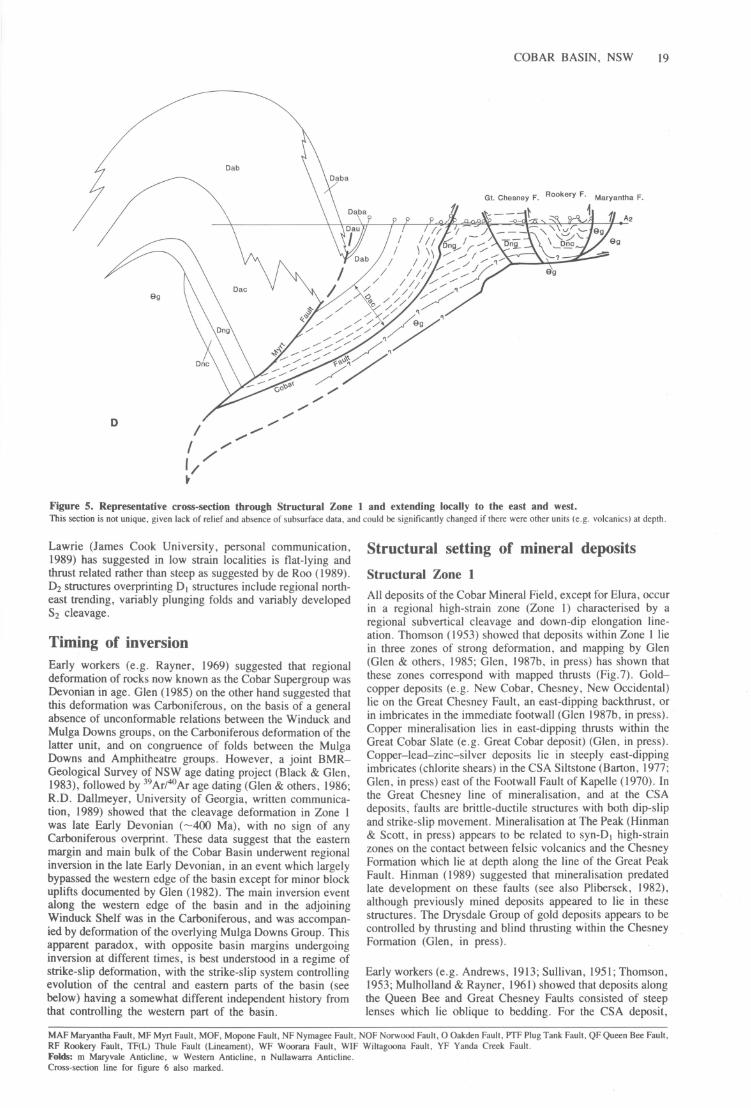
9g
D
Figure 5. Representative cross-section through Structural Zone I and extending locally to the east and west. This section is not unique, given lack of relief and absence of subsurface data, and could be significantly changed if there were other units (e .g. volcanics) at depth.
Lawrie (James Cook University, personal communication, 1989) has suggested in low strain localities is flat-lying and thrust related rather than steep as suggested by de Roo (1989) . D2 structures overprinting D, structures include regional northeast trending, variably plunging folds and variably developed S2 cleavage.
Timing of inversion Early workers (e .g. Rayner, 1969) suggested that regional deformation of rocks now known as the Cobar Supergroup was Devonian in age. Glen (1985) on the other hand suggested that this deformation was Carboniferous, on the basis of a general absence of unconformable relations between the Winduck and Mulga Downs groups, on the Carboniferous deformation of the latter unit, and on congruence of folds between the Mulga Downs and Amphitheatre groups. However, a joint BMRGeological Survey of NSW age dating project (Black & Glen, 1983), followed by 39Ar/4DAr age dating (Glen & others, 1986; R.D. Dallmeyer, University of Georgia, written communication, 1989) showed that the cleavage deformation in Zone I was late Early Devonian (-400 Ma), with no sign of any Carboniferous overprint. These data suggest that the eastern ~argi~ an.d main bulk of the Cobar Basin underwent regional mverslOn m the late Early Devonian, in an event which largely bypassed the western edge of the basin except for minor block uplifts documented by Glen (1982). The main inversion event al~ng the western edge of the basin and in the adjoining Wmduck Shelf was in the Carboniferous, and was accompanied by deformation of the overlying Mulga Downs Group. This ~ppar~nt para.dox, wi~h opposite basin margins undergoing m~ersIo~ at different limes, is best understood in a regime of strike-~hp deformation, with the strike-slip system controlling evolutIOn of the central and eastern parts of the basin (see below) having a somewhat different independent history from that controlling the western part of the basin.
Structural setting of mineral deposits
Structural Zone I All deposits of the Cobar Mineral Field, except for Elura, occur in a regional high-strain zone (Zone I) characterised by a regional subvertical cleavage and down-dip elongation lineation. Thomson (1953) showed that deposits within Zone I lie in three zones of strong deformation, and mapping by Glen (Glen & others, 1985; Glen, 1987b, in press) has shown that these zones correspond with mapped thrusts (Fig .7). Goldcopper deposits (e .g. New Cobar, Chesney, New Occidental) lie on the Great Chesney Fault, an east-dipping backthrust, or in imbricates in the immediate footwall (Glen 1987b, in press) . Copper mineralisation lies in east-dipping thrusts within the Great Cobar Slate (e.g. Great Cobar deposit) (Glen, in press) . Copper-Iead-zinc-silver deposits lie in steeply east-dipping imbricates (chlorite shears) in the CSA Siltstone (Barton, 1977; Glen , in press) east of the Footwall Fault of Kapelle (1970). In the Great Chesney line of mineralisation, and at the CSA deposits, faults are brittle-ductile structures with both dip-slip and strike-slip movement. Mineralisation at The Peak (Hinman & Scott, in press) appears to be related to synoD, high-strain zones on the contact between felsic volcanics and the Chesney Formation which lie at depth along the line of the Great Peak Fault. Hinman (1989) suggested that mineralisation predated late development on these faults (see also Plibersek, 1982), although previously mined deposits appeared to lie in these structures. The Drysdale Group of gold deposits appears to be controlled by thrusting and blind thrusting within the Chesney Formation (Glen, in press).
Early workers (e .g. Andrews, 1913; Sullivan, 1951; Thomson, 1953; Mulholland & Rayner, 1961) showed that deposits along the Queen Bee and Great Chesney Faults consisted of steep lenses which lie oblique to bedding. For the CSA deposit,
MAF Maryantha Fault, MF Myrt Fault, MOF, Mopone Fault, NF Nyrnagee Fault, NOF Norwood Fault, 0 Oakden Fault, PTF Plug Tank Fault, QF Queen Bee Fault, RF Rookery Fault, TF(L) Thule Fault (Lmeament) , WF Woorara Fault, WIF Wiltagoona Fault, YF Yanda Creek Fault. Folds: rn Maryvale Anticline, w Western Anticline, n Nullawarra Anticline. Cross-section line for figure 6 also marked.

BUN DELLA BLOCK MARYVALE BLOCK - I ~
OLiNO BLOCK BIDDABIRRA BLOCK
NORTH SOUTH
km ~ \, {3,~o. ~ ~ \~~~~ 10, ,~ I; /~/ pi-I ~ (~ '\ '. \g\ \q'.\. 1Jit!-.('>!f \ /'/1- " I iF1 \ \', \q \" Y ~;0\V~~ ~ I 0 \ \ ~~ ... \'(~~_ ... ~'<J 7r I J));, }; \" ,\ \10 liA:l } J r \ \ \ \., (.~ / ~ . "-'1, \ \ ,
Q, REPRESENTATIVE DIP
\ /..... \
/~2 ANTICLINE \ /
DEEP STRUCTURE UNCERTAIN
NO VERTICAL EXAGGERATION ? '
Section trends 2580 Section trends 052 0 • i ...
o 3km
Vertical = Horizontal Scale
x Belford Anticline Bindi Syncline
-- BASEMENT Position of floor thrust uncertain
Figure 6. a, Cross-section through northern part of Zone 2. Southernmost boundary (Norwood Fault) shown as vertical for convenience. b, Cross-section through southwestern part of zone showing detachment with ramp and splay related folds. Note the Bindi and Buckambool Synclines and Bulgoo and Bedford Anticlines are Carboniferous structures, The age of the Nullawarra Anticline is inferred to be Devonian, Thrusting thus propagated from east to west,
/
'-------
Iv'f' / ~~~ /
'f-~<? /
,///
//
Dac ~ ? other units at depth
Nullawarra Anticline
/
'- \\ '" " " "\\ ................ . ,, "\" "\ "'-" \
\ "\\
2
4
tv o
;:Q
;I>
Cl
~

S T R U C T U R A L
To Louth
S T R U C T U R A L
Z 0 N E 1
One
COBAR BASIN, NSW 21
To Bourke
•
A
----
-t,t-
/...
S' ~ ~ ~
Mineral deposit
Stratigraphic contact
Thrust fault
Other fault
Anticline, Syncline
Road
Cobar •
SYDNEY
(f TN
~eg_S To ~ Nyngan I
a.. z:;:' «0 -0: zC!) 00: >w wa.. 0:;:' >-C/)
\ \ \ . GI.9I.dstC;'>1) \ ~
\
New \""''''''''''''
\Da
upper Amphitheatre Group Alley Sandstone Member Biddabirra Formation CSA Siltstone
Great Cobar Slate
...J 0: Chesney Formation 0:« ~ ~ Dncd Drysdale Conglomerate Member
() Cobar Basin
I Dkm I Meryula Formation Kopy je Shelf
ORDO-~ G"I b G VIC IAN L':1LJ In am one roup
o 2 468 ~! __ ~I __ ~I __ ~I _----'I km
Bee
Figure 7. Relationship between mineral deposits and major faults in central part of Zone I.

22 R.A. GLEN
Robertson (1974) and O'Connor (1980) showed that mineralisation lay close to east-dipping cleavage in orientation and oblique to west-dipping bedding. All these deposits are associated with areas of silicification (quartz veining and formation of elvan), chloritisation, and formation of carbonate alteration haloes (Mulholland & Rayner, 1961; Robertson, 1974). Thus, in addition to lying in or next to major faults, the lenses making up individual deposits are themselves structurally controlled. For this reason, early workers (e.g . Andrews, 1913; Sullivan, 1951; Thomson, 1953; Mulholland & Rayner, 1961) suggested that the deposits were epigenetic and of replacement origin. More recent workers (Glen, 1987a; Brill, 1988; de Roo, 1989; Hinman, 1989 and, to some extent, Robertson, 1974) suggested a syn-deformational, metahydrothermal origin, with deposits occupying dilatant sites in the country rock.
Structural Zone 2 To date, Elura is the only known deposit in Structural Zone 2. Elura is a concentrically zoned pipe-like deposit localised by a north-northwest trending anticline (D, of this study, D2 of de Roo, 1989) (Schmidt, 1980, 1983; de Roo, 1989). Additional orebodies north of the main pod also occur in domal culminations along this anticline (Lawrie, 1990). De Roo (1989) and Lawrie both suggested that Elura formed as a syntectonic orebody by a combination of replacement and emplacement in dilatant sites.
Towards a model of ore genesis The association of major structures and orebodies suggests an ore genesis model involving the migration of ore-bearing fluids towards major faults, the focusing of those fluids up these structures and the precipitation therein of gangue minerals, sulphides and native metals (cf. Cox & others, 1986) . Glen (1987a) suggested that these fluids were metamorphic in origin and Brill (1988) has demonstrated this for the CSA deposit. This in tum implies that basin sediments had already been dewatered before deformation and ore emplacement. Of critical interest to exploration and to more specific ideas on ore formation is why only particular parts of major structures are mineralised. In this regard, the following points can be made: 1. The absence of any deposit worthy of mention on
reactivated syn-depositional faults may be due either to lack of favourable traps on these major structures and/or a time difference between movement on these faults and on the later short-cut faults, which were synchronous with cleavage formation and fluid circulation.
2. Deposits associated with the Great Chesney Fault are associated with left-stepping jogs in the fault which formed either as tear faults during thrusting or as dilational jogs during left-lateral strike-slip movement. As suggested by Sullivan (1951), Mulholland & Rayner (1961) and Glen
WEST
COBAR BASIN I KOPY JE SHELF
EAST
-- - - - -~ .. . ..
-:-. -.~. --;.~. --;.,........ ".---,-.~/ . . . . . BASEMENT
.. " .. " BASEMENT x""
o • EXTENSIONAL/STRIKE-SLIP PHASE
( 1987b), these areas are marked by intersections between north-northwest and west-northwest-trending major fracture systems, with consequent development of significant fault-induced permeability in the imbricated footwall of the fault itself. The greater presence of carbon in the footwall rocks probably also played a major role in the precipitation of gold (cf. Wall & Ceplecha, 1976).
3. The CSA group of deposits lies within the CSA siltstone in the imbricated hanging wall of the Footwall Fault (Barton, 1977; Glen, in press) and just north of west-northwest trending beds in the short limb of a sinistral south-plunging fold (O'Connor, 1980). Mapping by Glen (in press) suggests that this fold is a ductile manifestation of the Plug Tank Fault (see also Fig. 7)
4. The work of Hinman (Hinman, 1989; Hinman & Scott, in press) suggests that The Peak deposits occur where deformation has been partitioned around the contact between sediments of the Nurri GroUJi and silicified felsic volcanics which have been intersected in deep drill holes.
5. The localisation of orebodies by folding at Elura appears anomalous in the context of the Cobar Mining Field where all other deposits are localised by faults. The simplest way to explain this anomaly is to suggest that the major anticline at Elura is developed above a blind thrust. In such cases, deposition of sulphides would occur in an area of reduced permeability above the tip line of the thrust.
6. Metal zoning of the Cobar field has long been enigmatic . Gold + copper deposits occur on the Queen Bee and Great Chesney faults, gold + copper + base metal deposits occur on faults in the Great Cobar Slate and also at The Peak, and base metal + I-copper deposits occur in the CSA Siltstone at Elura and at CSA. In the model of syn-deformational metahydrothermal ore genesis outlined above, wherein metals are scavenged from small traces in rocks at depth, this zoning may in part be explicable in terms of fault geometry and stratigraphy intersected by faults at depth. The Queen Bee and Great Chesney faults, associated with gold + copper mineralisation, dip east (Figs 5, 7) and penetrate relatively thin basin fill (Nurri Group) in addition to Ordovician basement. Faults in the CSA Siltstone (e.g. at the CSA Mine) lie in the imbricated Cobar Plate, in the hanging wall of the west-dipping Cobar Fault which penetrates large volumes of basin sediments of the Amphitheatre Group (Fig. 5) . Faults in the Great Cobar Slate and at The Peak cut through a moderate amount of thinbedded Nurri Group as well as Ordovician basement (Fig. 5). It would thus appear that gold + copper mineralisation may reflect metal sources in easterly derived basin sediments as well as in the underlying basement, whereas base metal + I-copper deposits may reflect metal sources within the deeper parts of the basin, either within sediments or from a mixture of sediments plus possible volcanics at depth.
INVERSIQN- THRUST/ STRIKE-SLIP PHASE
ZO~I_' _ Z,-,-O_NE_ ' _ _
OEFORMED DEFORMED
CO BAR BASIN KOPYJE SHELF
o Towards OJ) Away
Figure 8. Sketch of extensional and contractional phases on the eastern side of the Cobar Basin, showing asymmetrical negative and positive Dower structures.

Synthesis The Cobar Basin developed as a left-lateral transtensional basin in the latest Silurian-Early Devonian (-410 Ma) and persisted till the late Early Devonian (-400 Ma) before undergoing the first stage of regional inversion in a right-lateral transpressional regime (Fig. 8). During the roughly 10 Ma of its existence , the basin was filled by both syn-rift and post-rift sediments .
Using aeromagnetic data and satellite imagery, D. Pogson (New South Wales Geological Survey, personal communication, 1989) has shown that the faults bounding the eastern margin of the Cobar Basin and margins of the Rast Trough can be traced hundreds of kilometres to the south, where they join the Gilmore Suture (Fig. 9). The eastern boundary fault of the Canbelego-Mineral Hill Belt also coincides for much of its length with the Gilmore Suture (Fig . 9) . The lackermarooThule-Blue Mountain fault system has similarly been traced southward below alluvium (D. Pogson & E. Scheibner, New South Wales Geological Survey, personal communication, 1989) and may extend under the Murray Basin to link into the Kiewa Fault in eastern Victoria.
The Gilmore Suture and less certainly the Kiewa Fault are probably the controlling strike-slip faults in this part of the Lachlan Fold Belt (Glen, 1990), with movement on them and their splays leading to transtensional opening and transpressional closing of the Cobar Basin as discussed above. Regional relations suggest that the Gilmore Suture is in fact one of the master faults controlling end-Ordovician deformation, Silurian granite emplacement and Devonian to Carboniferous basin evolution in western New South Wales . This suture was active as an oblique collisional boundary between the Molong Volcanic Arc and the Wagga Basin at the end of the Ordovician (Scheibner, 1982). It underwent left-lateral strike-slip in the late Silurian (revealed by the en echelon arrangement of granitoids to the west) (Scheibner, 1982), and also controlled evolution of the Tumut Trough - opening in the mid Silurian by right-lateral movement3 (Powell, 1983; P. Stuart-Smith, BMR, personal communication, 1989) and closing by leftlateral movement at the end of the Silurian (P . Stuart-Smith, BMR, personal communication, 1989). Interestingly, this endSilurian left-lateral sense of movement at Tumut is the same as that inferred in the Cobar region, for the Cobar Basin and for the Canbelego-Mineral Hill Belt (Glen, 1990). Structures in the northern part of the Mount Hope Trough lie oblique to bounding Scotts Craig Fault (MacRae, 1989), thereby implying some component of strike-slip deformation. The main part of the Mount Hope Trough (and the Rast Trough to the east), however, shows no obvious structural evidence of transpression with ductile structures mapped parallel to bounding faults , and it is not known whether they evolved in a strike-slip regime or orthogonally . Some strike-slip movement is suggested, however, along the Sugarloaf Fault in the Mount Hope Trough where the cross and parallel faults mapped adjacent to it by Scheibner (1985) may be parts of a braided system with jogs . Movement on the lackermaroo-Thule-Blue Mountain fault "ystem was transpressional in the Carboniferous, with the strike-slip component varying locally from dextral to sinistral depending on fault orientation and local block movement (Glen, 1990).
Acknowledgements Data from the Mount Hope and Rast troughs and the Kopyje Shelf are based on mapping by E. Scheibner, G. MacRae, S.
3 L. Wyborn (1977) suggested that the Tumut Trough opened by leftlateral movement on the Long Plain-Indi Fault.
COBAR BASIN, NSW 23
WINDUCK SHELF
D
Extension direction
Cainozoic cover or rocks of other ages not relevant to middle Silurian to Early Devonian tectonics
Early Devonian and Late Silurian troughs and basins
o I
km
TN
100 I
~ Early Devonian ~ shelves, present
deposition
r+++l Late Silurian ~ granitoids
Major faults
Figure 9. Regional relations in western New South Wales, showing middle Silurian to Early Devonian depositional elements, late Silurian granitoids and major faults. Simplified from Pogson (1972). Note: all faults except Woorara have both syn-rift and post-rift depositional histories. Inset shows (a) model for oblique extension of an irregularly shaped basin, and (b) application to Cobar region. Holes formed at major changes in amount or direction of extension are filled by volcanics or shallow-level granites.
24 R.A. GLEN
Trigg and D. Pogson, all of the New South Wales Geological Survey. Discussion with D. Pogson is gratefully acknowledged. M.G. Duba and M. Aresh of the New South Wales Geological Survey are thanked for typing and cartography, respectively. Published with the permission of the DirectorGeneral, New South Wales Department of Minerals and Energy.
References
Andrews, E.e., 1913 - Report on the Cobar Copper and Gold-field. Part I. Mineral Resources 17. New South Wales Department of Mines. Sydney . .
Barton, e.M., 1977 - A geotechnical analysis of rock structure and fabric in the CSA Mine, Cobar, New South Wales . CSIRO Division of Geomechanics. Technical Paper. 24, 30 pp.
Black, L.P. & Glen, R.A. , 1983 - Cobar geochronology. Bureau of Mineral Resources. Australia. 1982 Annual Report, 107-108.
Brill, B. A., 1988 - Geochemistry and genesis of the CSA Cu-Pb-Zn deposit, Cobar, NSW, Australia. Ph.D. thesis. University of Newcastle. New South Wales .
Bureau of Mineral Resources , 1970 - Bouguer Anomalies. Cobar 1:250000 sheet. H55/B2-14. Bureau of Mineral Resources. Australia.
Cox, S.F., Etheridge, M.A. & Wall, VJ. , 1986-The role of fluids in syntectonic mass transport, and the localization of metamorphic vein-type ore deposits. are Geology Reviews , 2, 65-86.
de Roo, J.A., 1989 - The Elura Ag-Pb-Zn mine in Australia - ore genesis in a slate belt by syndeformational metasomatism along hydrothermal fluid conduits. Economic Geology, 84, 256-278 .
Glen, R.A ., 1982 - Nature of late-Early to Middle Devonian tectonism in the Buckambool area, Cobar, New South Wales. Journal of the Geological Society of Australia, 29, 127-138 .
Glen, R.A., 1985 - Basement control on the deformation of cover basins: an example from the Cobar district in the Lachlan Fold Belt, Australia. Journal of Structural Geology, 7, 301-315.
Glen , R.A., 1987a- Geology of the Wrightville I: 100 000 geological sheet 8034, explanatory notes. Geological Survey of New South Wales. Sydney. 257 pp.
Glen, R.A., 1987b - Copper and gold rich deposits in deformed turbidites at Cobar, Australia: their structural control and hydrothermal origin. Economic Geology, 82 , 124-140.
Glen, R.A., 1988 - Basin inversion, thrusts and ore deposits at Cobar, New South Wales: a preliminary report . Geological Survey of New South Wales. Quarterly Notes, 73, 21-26.
Glen, R.A., 1989 - Basin inversion, thrusts and ore deposits at Cobar, New South Wales. Geological Society of Australia. Abstracts , 24, 54-55.
Glen, R.A., 1990 - Formation and inversion of transtensional basins in the western part of the Lachlan Fold Belt, with emphasis on the Cobar Basin. Journal of Structural Geology, 12, 601-620.
Glen, R.A., in press - Geology of the Cobar 1:100 000 geological sheet 8035 (second edition), explanatory notes. Geological Survey of New South Wales. Sydney.
Glen, R.A. , Dallmeyer, R.D. & Black, L.P., 1986 - Preliminary report on new isotopic evidence for, and implication of, an Early Devonian deformation at Cobar. Geological Survey of New South Wales. Quarterly Notes, 64, 26-29 .
Glen, R.A., Lewington, G.L. & Shaw, S.E., 1983 - BasementJcover relations and a Silurian, I-type intrusive from the Cobar Lucknow area, Cobar, New South Wales. Journal and Proceedings of the Royal Society of New South Wales, 116, 25-32 .
Glen, R.A ., MacRae, G.M., Pogson, DJ ., Scheibner, E., Agostini, A. & Sherwin, L., 1985 - Summary of the geology and controls of mineralization in the Cobar region. Geological Survey of New South Wales. Report GS 19851203 (unpublished), 91 pp.
Hinman, M.e., 1989 - Syntectonic precious and base metal mineralization controlled by deformation partitioning during an Early Devonian Orogeny at Peak, Cobar, NSW. Geological Society of Australia. Abstracts, 24, 71-72 .
Hinman, M.e. & Scott, A.K., in press - Geology of the Peak Gold Deposit, Cobar N.S.W. In The geology of Australian ore deposits . Australasian Institute of Mining & Metallurgy. Melbourne .
Kapelle , K., 1970 - Geology of the CSA Mine, Cobar, New South Wales. Australasian Institute of Mining and Metallurgy. Proceedings, 233, 79-94 .
Lawrie, K., 1990 - Exploration for syntectonic massive sulphide deposits based on structural and microstructural analysis of drill core. Geological Society of Australia. Abstracts, 25, 179.
MacRae, G.P., 1989 - Geology of the Nymagee 1:100 000 sheet 8133. Geological Survey of New South Wales. Sydney, 137 pp.
Mulholland, C.SU. & Rayner, E.O., 1961 - The gold-copper deposits of Co bar, New South Wales: central section (Great Cobarto New Occidental). New South Wales Department of Mines. Technical Report 1958, 6, 28-49.
O'Connor, D.P.H., 1980 - Discussion: Evidence of an exhalative origin for deposits of the Cobar district, New South Wales. BMR Journal of Australian Geology & Geophysics, 5, 70-72.
Plibersek, P.F., 1982 - Structure, stratigraphy, wall; rock alteration and mineralization of 'The Peak' near Cobar, New South Wales. B.Appl.Sci. thesis. New South Wales Institute of Technology. Sydney.
Pogson, DJ., 1972 - Geological map of New South Wales, I : I 000 000. New South Wales Geological Survey. Sydney.
Pogson, DJ. , 1982 - Stratigraphy, structure and tectonics: Nymagee-Melrose. central western New South Wales . M.Appl.Sci. thesis. New South Wales Institute of Technology. Sydney.
Pogson, DJ. & Felton, E.A .• 1978 - Reappraisal of the geology, Cobar-Canbelego-Mineral Hill region, central western New South Wales. Geological Survey of New South Wales. Quarterly Notes. 33, 1-14.
Pogson, DJ. & Hilyard, D .. 1981 - Results of isotopic age dating related to Geological Survey investigations, 1974-1978. Geological Survey of New South Wales. Records, 20, 251-273 .
Powell, e.McA., 1983 - Tectonic relationship between the Late Ordovician and Late Silurian palaeogeographies of southeastern Australia. Journal of the Geological Society of Australia, 30, 353-373.
Rayner, E.O., 1969 - The copper ores of the Cobar Region, New South Wales. Geological Survey of New South Wales, Memoir 10.
Robertson, I.G., 1974 - The environmental features and petrogenesis of the mineral zones of Cobar, New South Wales. Ph.D. thesis. University of New England. Armidale.
Scheibner, E., 1982 - Some aspects of the geotectonic development of the Lachlan Fold Belt. Geological Survey of New South Wales, Report GS 1982/062 (unpublished) .
Scheibner, E., 1985 - The Mount Allen I: 100 000 geological sheet 8032 . Geological Survey of New South Wales. Sydney.
Scheibner, E., 1987 - Geology of the Mount Allen 1:100 000 geological sheet 8032 . Geological Survey of New South Wales. Sydney, 220 pp.
Schmidt, B.L., 1980 - Geology of the Elura Ag-Pb-Zn deposit, Cobar district, NSW. M.Sc. thesis. Australian National University. Canberra .
Sherwin, L. , 1985 - Biostratigraphy. In Glen, R.A., MacRae, G.M., Pogson, DJ ., Scheibner, E. , Agostini, A. & Sherwin, L., 1985-Summary of the geology and controls of minerali'zation in the Cobar region. Geological Survey of New South Wales. Report GS 1985/203 (unpublished), 91 pp.
Stewart, I.R. & Glen, R.A., 1986 - An Ordovician age for part of the Girilambone Group at Yanda Creek, east of Cobar. Geological Survey of New South Wales. Quarterly Notes, 64, 23-26.
Sullivan, CJ., 1951 - Geology of New Occidental, New Cobar and Chesney mines, Cobar, New South Wales. Bureau of Mineral Resources. Australia. Report 6, 45 pp.
Thomson, B.P., 1953 - Geology and ore occurrences in the Cobar district: 5th Empire Mining & Metallurgy Congress. Australia & New Zealand, I, 863-896.
Trigg, SJ., 1987 - Geology of the Kilpamey 1:100 000 sheet 8132. Geological Survey of New South Wales. Sydney, 131 pp.
Wall, V.J. & Ceplecha, J.C., 1976-Deformation and metamorphism in the development of gold-quartz mineralization in slate belts. 25th International Geological Congress. Abstracts, I, 142-143.
Wyborn, L.A.!., 1977 - Aspects of the geology of the Snowy Mountains region and their implications for the tectonic evolution of the Lachlan Fold Belt. Ph.D. thesis. Australian National University. Canberra.