introduction to thermal infrared remote sensing balance … · · 2013-07-24introduction to...
TRANSCRIPT

1
23/07/2013 1
Introduction to thermal infrared remote sensing ‐ Surface Energy Balance System Basics
Z. (Bob) SuITC, University of Twente Enschede, The Netherlands
1. To understand basic concepts of surface radiation budget
2. To understand basic measurements to derive surface radiation components
3. To be able to derive surface radiation components using different information
4. To familiarize with retrieval of surface parameters
Learning Objectives
2
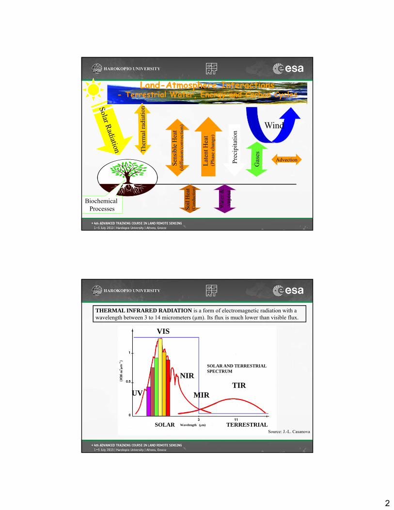
Wind
Land-Atmosphere Interactions - Terrestrial Water, Energy and Carbon Cycles
Lat
ent H
eat
(Pha
se c
hang
e)
Pre
cipi
tati
on
Biochemical Processes
Advection
VIS
UV
NIRTIR
MIR
SOLAR TERRESTRIAL
SOLAR AND TERRESTRIAL SPECTRUM
Wavelength (m)
THERMAL INFRARED RADIATION is a form of electromagnetic radiation with a wavelength between 3 to 14 micrometers (µm). Its flux is much lower than visible flux.
Source: J.-L. Casanova

3
RADIANT POWER: The rate of flow of electromagnetic energy, i.e., radiant energy, (watts, i.e., joules per second.)
RADIANT EMITTANCE: Radiant power emitted into a full sphere, i.e., 4π (steradians), by a unit area of a source, expressed in watts per square meter. Synonym radiant exitance, flux, radiant flux, E (W m-2)
RADIANCE: Radiant power, in a given direction, per unit solid angle per unit of projected area of the source, as viewed from the given direction. Note: Radiance is usually expressed in watts per steradian per square meter, L (W m-2.sr-1) = M/
IRRADIANCE: Radiant power incident per unit area upon a surface. Note: Irradiance is usually expressed in watts per square meter, but may also be expressed in joules per square meter. Synonym: power density, flux, radiant flux, M (watts/m2).
Some definitions
Source: J.-L. Casanova
Graphical representation of emittance, radiance and irridiance
Source: J.-L. Casanova
RADIANCE, L = E/ (Wm-2.sr-1)
IRRADIANCE, M (Wm-2)
EMITTANCE or EXITANCE, E (Wm-2)
4
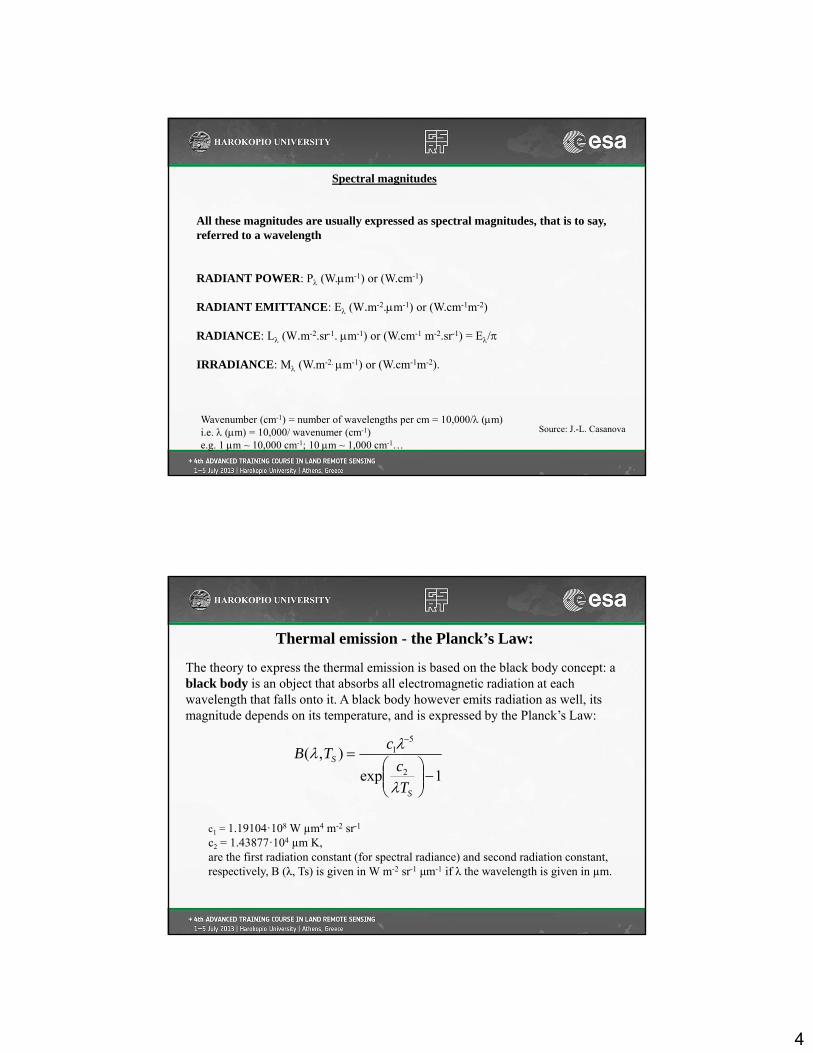
All these magnitudes are usually expressed as spectral magnitudes, that is to say, referred to a wavelength
RADIANT POWER: P (W.m-1) or (W.cm-1)
RADIANT EMITTANCE: E (W.m-2.m-1) or (W.cm-1m-2)
RADIANCE: L (W.m-2.sr-1. m-1) or (W.cm-1 m-2.sr-1) = E/
IRRADIANCE: M (W.m-2. m-1) or (W.cm-1m-2).
Spectral magnitudes
Source: J.-L. CasanovaWavenumber (cm-1) = number of wavelengths per cm = 10,000/ (m) i.e. (m) = 10,000/ wavenumer (cm-1)e.g. 1 m ~ 10,000 cm-1; 10 m ~ 1,000 cm-1…
c1 = 1.19104·108 W µm4 m-2 sr-1
c2 = 1.43877·104 µm K, are the first radiation constant (for spectral radiance) and second radiation constant, respectively, B (λ, Ts) is given in W m-2 sr-1 μm-1 if λ the wavelength is given in µm.
The theory to express the thermal emission is based on the black body concept: a black body is an object that absorbs all electromagnetic radiation at each wavelength that falls onto it. A black body however emits radiation as well, its magnitude depends on its temperature, and is expressed by the Planck’s Law:
1exp
),(2
51
S
S
T
c
cTB
Thermal emission - the Planck’s Law:

5
Thermodynamic (kinetic) temperature
Brightness temperature
Directional radiometric surface temperature & Directional emissivity
Hemispheric broadband radiometric surface temperature & Hemispherical broadband emissivity
Terminology in Thermal Remote Sensing
Source: J. Norman, and F. Becker, 1995
Thermodynamic (kinetic) temperature (T) is a macroscopic measure to quantify the thermal dynamic state of a system in thermodynamic equilibrium with its environment (no heat transfer) and can be measured with a infinitesimal thermometer in good contact with it.By maximizing the total entropy (S) with respect to the energy (E) of the system, T is defined as
Thermodynamic (kinetic) temperature
TdE
dS 1
which is consistent with the definition of the absolute temperature by the ideal gas law
RTPV
where P is pressure, V volume, R the gas constant (R=kN0, k is Boltzmann constant, N0 number of molecules in a mole).

6
5223Nadir
Object
Sensor
The Fundamental
of Earth Observation
(Sensor - Object Radiative Relationship)
Sensor ResponseA. How much radiation is detected?
B. When does it arrive?
Object Properties:Its range, its combined temperature &
Emissivity (or reflectivity)at different times, at different spatial resolution, at different wavelengths, at different direction,
at different polarization
A: A Passive Sensor SystemA+B: An Active Sensor System
atmosphere
Brightness temperature (Tb,i) is a directional temperature obtained by equating the measured radiance (Rb,i) with the integral over wavelength of the Planck’s black body function multiplied by the sensor response fi.
Brightness temperature
2
1
1,
exp
,,
,
25
1,,
d
TC
CfTRR
ib
iibib
12
1
df i is the detector relative response.

7
The spectral radiance (RR) measured by a directional radiometer is the sum of the emitted black body radiance modified by the emissivity and the reflected radiation within an infinitesimal wavelength band.
Directional radiometric surface temperature & Directional emissivity
2/
0 ,
2
0
,,
sin,cos,,,
,,,
ddL
RR
b
BR
Bidirectional reflectance distribution function Sky radiance
If the incident sky radiance is isotropic, we have
2/
0 ,
2
0,sin,cos,,,
LddLb
Therefore for opaque bodies at thermal equilibrium,
,1,
A hemispheric radiometric surface temperature is used to provide an estimate of the emitted radiance (Rl) over a broad wavelength and the full hemisphere of view
Hemispheric broadband radiometric surface temperature & Hemispherical broadband emissivity
42/
0 ,
2
0cossin,,
2
1RBl TdddRR
8
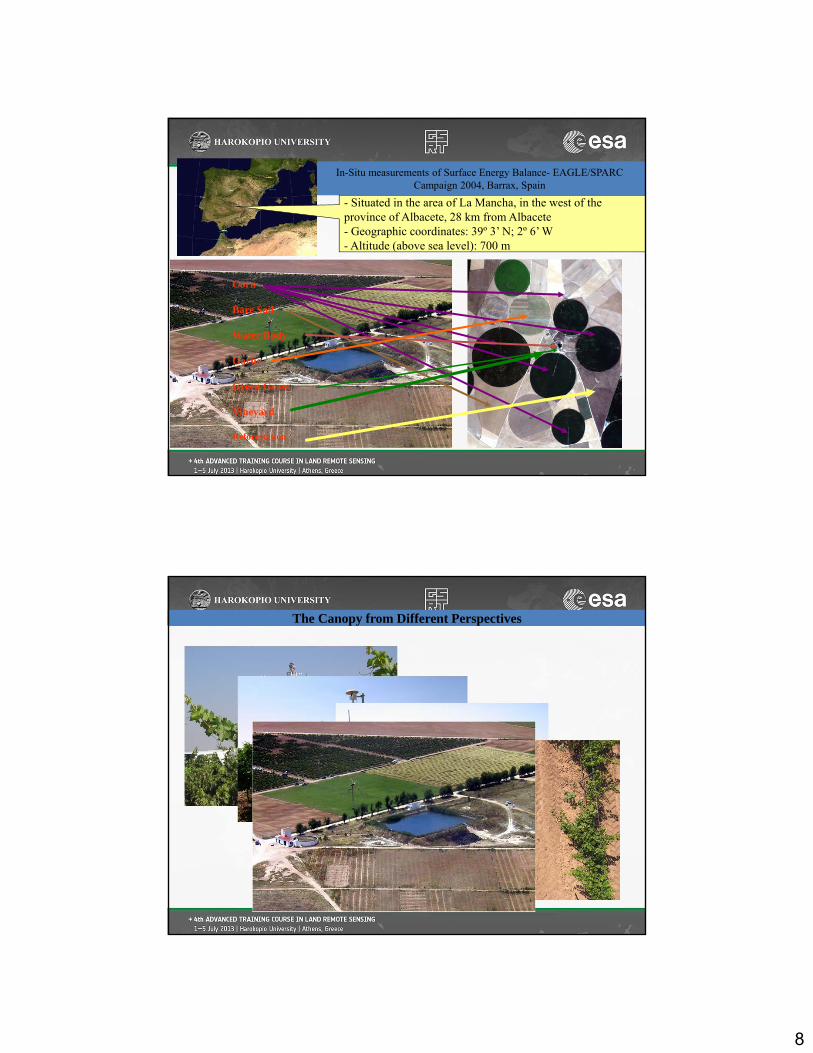
Corn
Bare Soil
Water Body
Garlic
Green Grass
Vineyard
Reforestation
In-Situ measurements of Surface Energy Balance- EAGLE/SPARC Campaign 2004, Barrax, Spain
- Situated in the area of La Mancha, in the west of the province of Albacete, 28 km from Albacete- Geographic coordinates: 39º 3’ N; 2º 6’ W- Altitude (above sea level): 700 m
The Canopy from Different Perspectives

9
Factors Influencing the Emissivity
• The material (minerals, water etc.)• The surface geometry (roughness of the surface) • The wavelength of the radiation • The view angle
(Source: Sobrino et al., 2005)
800 1200 1600 2000 2400 28000.5
0.6
0.7
0.8
0.9
1.0
Water:
Soil:
Spe
ctra
l em
issi
vity
Wave number (cm-1)
Seawatr1Vegetation: 106
108 121 e3101 e4643 eply3c7
Spectral emissivity extracted from MODIS UCSB Emissivity Library
12.5 8.3 6.3 4.2 3.6 3.3
Wavelength (μm)

10
Solar R
adiation
Atm
ospheric therm
al radiation
Reflected solar radiation
Surface therm
al radiation
swuR
Surface Radiation Budget - Measurements
lwulwdswuswdn RRRRR
swdR lwdR lwuR
Net radiation
CNR1 net radiometer:
Spectral response- Pyranometer: 305 to 2800 nm- Pyrgeometer: 5000 to 50000 nm
Radiation components: 1. incoming short-wave radiation2. surface-reflected short-wave radiation3. incoming (long-wave) thermal infrared radiation 4. outgoing (long-wave) TIR radiation
Albedo (whiteness): ratio of scattered to incident electromagnetic radiation
nmm
mm
10001
505
1
2
3
4
Surface Radiation Budget - Measurements

11
EAGLE/SPARC Campaign 2004, Barrax, Spain
Barrax 2004 Radiation @ Vineyard
-200
0
200
400
600
800
1000
1200
196 197 198 199 200 201 202 203
SW_inc
SW_out
LW_inc
LW_out
Radiation Components, Barrax, 15 July 2004
-200
0
200
400
600
800
1000
1200
0 50 140
230
320
410
500
550
640
730
820
910
1000
1050
1140
1230
1320
1410
1500
1550
1640
1730
1820
1910
2000
2050
2140
2230
2320
Time
W/M
^2 SW_in
SW_outLW_inLW_out
EAGLE/SPARC Campaign 2004, Barrax, Spain
12
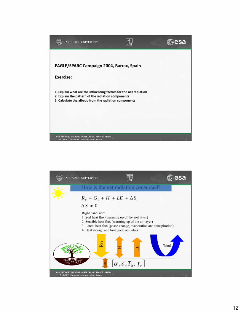
EAGLE/SPARC Campaign 2004, Barrax, Spain
Exercise:
1. Explain what are the influencing factors for the net radiation2. Explain the pattern of the radiation components 3. Calculate the albedo from the radiation components
Wind
How is the net radiation consumed?
LE
00
S
SLEHGRn
cfT ,,, 0
Right hand side:1. Soil heat flux (warming up of the soil layer)2. Sensible heat flux (warming up of the air layer)3. Latent heat flux (phase change, evaporation and transpiration)4. Heat storage and biological activities

13
Forest nurseryDutch site
garlicvineyard
corn
Bare soil
Wheat
~3 km
3
12
4
5
INRA sitesForest nursery
Dutch site
garlicvineyard
corn
Bare soil
Wheat
~3 km
3
12
4
5
Dutch site
garlicvineyard
corn
Bare soil
Wheat
~3 km
3
12
4
5
INRA sites
Locations of measurements
Source: Su et al., (2008)
The soil heat fluxes were measured with 4 soil heat fluxes buried at a depth of 1cm below surface, with two placed in the middle of the row and two under the vine and shaded.
Soil heat flux plates:SH1 and SH4 were in the shadeSH2 and SH3 were in the sunlit areas
Soil heat flux: measurements with soil heat flux plates
SH2SH3
SH1SH4

14
Soil heat flux: measurements with soil heat flux plates
Sensible heat flux: scintillometer measurements
•Scintillometer, 2 Sets• Radiation components• Soil Heat flux plates• Temperature profile (air & soil)
Transmitter
Receiver

15
Scintillometer Data, EAGLE/SPARC Campaign 2004, Barrax, Spain
Barrax 2004 Sensible heat f luxes
-200
-100
0
100
200
300
400
500
600
196 197 198 199 200 201 202 203
Vineyard
Corn-C2
Reforestation-F1
Sunflow er-SF1
Bare-B1
corn-3D
Scintillometer Data, EAGLE/SPARC Campaign 2004, Barrax, Spain
Barrax 2004 Fluxes @ Vineyard
-400
-200
0
200
400
600
800
196 197 198 199 200 201 202 203
Rnet
G_avg
H-LAS
LE_Rest.
16
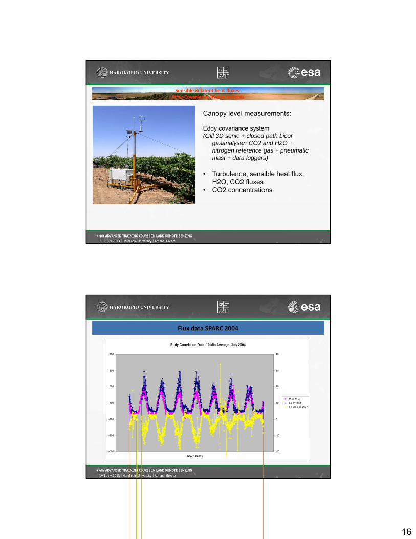
Sensible & latent heat fluxes:Eddy Covariance Measurements
Canopy level measurements:
Eddy covariance system (Gill 3D sonic + closed path Licor
gasanalyser: CO2 and H2O + nitrogen reference gas + pneumatic mast + data loggers)
• Turbulence, sensible heat flux, H2O, CO2 fluxes
• CO2 concentrations
Eddy Correlation Data, 10 Min Average, July 2004
-500
-300
-100
100
300
500
700
DOY 195-203
-20
-10
0
10
20
30
40
H W m-2
LE W m-2
Fc μmol m-2 s-1
Flux data SPARC 2004

17
Energy balance components
-200
-1000
100200
300
400500
600700
800
196 197 198 199 200 201 202 203
H_ed
LE
Rn
G
H_las
Energy balance (60 minute average), Vineyard, Barrax 2004
Energy balance closure ??
(Sum of H and LE exceeds the available energy)
-200
0
200
400
600
800
196 197 198 199 200 201 202 203
H_ed+LE_ed
R_avai10 minutes average, Vineyard, Barrax 2004
-200
0
200
400
600
800
196 197 198 199 200 201 202 203
H_ed+LE_ed
R_avai60 minutes average, Vineyard, Barrax 2004
18
Solar R
adiation
Atm
ospheric therm
al radiation
Reflected solar radiation
Surface therm
al radiation
eTemperaturSurfaceT
emissivity
albedo
:
:
:
0
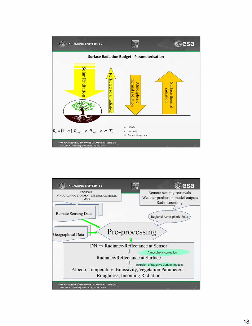
Surface Radiation Budget ‐ Parameterisation
401 TRRR lwdswdn
Pre-processing
Remote Sensing Data
Geographical Data
Regional Atmospheric State
Remote sensing retrievals Weather prediction model outputs
Radio sounding
ENVISAT NOAA/AVHRR, LANDSAT, METEOSAT, MODIS
MSG
DN Radiance/Reflectance at Sensor
Radiance/Reflectance at Surface
Albedo, Temperature, Emissivity, Vegetation Parameters, Roughness, Incoming Radiation
Atmospheric correction
Inversion of radiative transfer models

19
Incoming global radiation
Albedo
Vegetation cover, Leaf Area Index
Surface temperature
Emissivity
Roughness
Derived Surface Parameters/variables
Components of reflected and scattered solar beams received at the satellite

20
Input parameters:
– Group 1: date, time, location (latitude) and DEM (elevation, slope, aspect) to compute solar declination, eccentricity, solar zenith angle for a horizontal surface, solar azimuth angle, solar zenith angle on slopes
– Group2: weather condition ‐ Optical properties of the atmosphere (at the time of calculation)
Incoming global radiation
z
Case: a
z
Case: b
In Ida Idr
Idm
• Case a: use total optical depth
•
• where Isc is the solar constant, e0 the eccentricity factor, z solar zenith angle, m
air mass, the optical depth
)exp(cos0 meII zsc
Incoming global radiation

21
Incoming global radiation (cont.)
Case b: use water-vapor / horizontal visibility
where the direct solar radiation is
etc.References:M. Iqbal (1983) An introduction to solar radiation, Academic Press, Toronto. p.188-191.R. Bird and R.L. Hulstrom (1980) Direct insolation models, Trans. ASME J. Sol. Energy Eng., 103, 182-192. R. Bird and R.L. Hulstrom (1981) A simplified clear sky model for direct and diffuse insolation on horizontal surfaces, SERI/TR-642-761, Solar Energy Research Institute, Golden, Colorado.
ag
dadrndmdadrn
dn
IIIIIII
III
1
1
awgorzscn eII cos9751.0 0
Algorithms
‐ Calculate surface bidirectional reflectance of narrow band
‐ Derive surface broad‐band albedo from narrow surface
reflectance
‐ Derive NDVI from band RED & NIR surface reflectance
‐ (Ref. Lecture optical remote sensing)
Surface Albedo & NDVI

22
Algorithms
Land surface temperature derived by using a theoretical split‐window algorithm
References: Sorino et al.(2004)
Surface temperature
The at-sensor radiance for a given wavelength (λ) s:
where
– ελθ is the surface emissivity,
– Bθ(λ, Ts) is the radiance emitted by a blackbody at temperature Ts of the surface,
is the downwelling radiance,
– λθ is the total transmission of the atmosphere (transmittance) and
is the upwelling atmospheric radiance. All these magnitudes also depend on the observation angle θ.
The radiative transfer equation for LST retrieval
atmatmS
sensorat LLTBL )1(),(
atmL
atmL

23
According to Sobrino et al. (1996), the upwelling and downwelling atmospheric radiance can be substituted, respectively, by:
)()1( aiiatm TBL
)()1( 53 aiiatm TBL
where Ta is the effective mean atmospheric temperature andi53 is the total atmospheric path transmittance at 53 degrees.
Substituting both atmospheric radiances in the radiative transfer equation, an algorithm involving temperatures can be obtained using a first‐order Taylor series expansion of the Planck’s law and writing the equation for i and j (i and j being two different channels observed at the same angle, Split‐Window method):
Split‐window equations to derive land surface temperature
Ts = Ti+A(Ti-Tj)-B0+(1-i)B1- B2
where A and Bi are coefficients that depend on atmospheric transmittances, i is the mean value of the emissivities of channels i and j, is the spectral variation, Ti and Tj are the brightness temperatures for two different channels with the same view angle.
This equation is the so-called split-window equation and gives a separation between the atmospheric and emissivity effects in the retrieval of surface temperature.

24
Split‐window and dual‐angle algorithms for AATSR sensor with values of the coefficients calculated by a minimization process
Notation: n: Nadir view;f: Forward view;SW: Split‐Window Method (two spectral channels at the same observation angle)quad: algorithm that includes a quadratic dependence on (Ti‐Tj);(1): AATSR Channel 1 (12 m);(2): AATSR Channel 2 (11 m);W: algorithm with water vapor content dependence;: algorithm with emissivity dependence;: algorithm including spectral or angular emissivity difference.

25
Algorithms
Estimation of surface emissivity using the theoretical model of Caselles and Sobrino (1989).
References:
V. Caselles and J.A. Sobrino (1989) Determination of frosts in orange groves from NOAA-9 AVHRR data, RSE, 29:135-146.
E. Valor and V. Caselles (1995) Mapping land surface emissivity from NDVI: Application to European, African, and South American Areas, RSE, 57:167-184.
Sobrino and Soria (2006)
Emissivity
A simplified method to emissivity, ᵋ, using atmospherically corrected data in the visible
and near infrared channels (Sobrino and Raissouni, 2000). Three different surface
types: bare soil pixels (NDVI<0.2), mixed pixels (0.2<NDVI<0.5) and fully vegetation
pixels (NDVI>0.5).
The NDVI is calculated with reflectivity values from the Red region (red) and Near
Infrared (nir) region:
AATSR channels centred in 0.67 m and 0.87 m used for red and nir respectively.
Thresholds Method (NDVITHM)
nirred
nirredNDVI

26
The final expressions obtained for this method are for bare soil pixels (NDVI < 0.2), = 0.9825 ‐0.051 redΔ = ‐0.0001 ‐0.041 red
for mixed pixels (0.2<= NDVI <=0.5), = 0.971 + 0.018 fcΔ = 0.006 (1 ‐ fc )
and for vegetation pixels (NDVI > 0.5), = 0.990
with fc being the vegetation proportion, given by
where NDVImin=0.2 and NDVImax=0.5. The main constraint of this method is that it can not be used to extract water emissivity values because it is not possible to apply the NDVI and fc equations for water pixels.
Thresholds Method (NDVITHM)
2
minmax
min
NDVINDVI
NDVINDVI
cf
20
200 vgor ZZZ
Roughness
Total roughness
Vegetation roughness
Orographic roughness vp
Zsize
or 1
0
),(0 cvg fhfZ
(h - vegetation height, fc – fractional coverage)

27
Questions:
1. What is surface radiation budget
2. List some methods to derive surface radiation components
3. What information is needed in order to derive surface
radiation components using the above mentioned methods
4. What are the essential surface parameters in determination of surface
radiation balance
Su, Z., Timmermans, W., Gieske, A., Jia, L., Elbers, J. A., Olioso, A., Timmermans, J., Van Der Velde, R., Jin, X.,Van Der Kwast, H., Nerry, F., Sabol, D., Sobrino, J. A., Moreno, J. and Bianchi, R., 2008, Quantification of land‐atmosphere exchanges of water, energy and carbon dioxide in space and time over the
heterogeneous Barrax site, International Journal of Remote Sensing, 29:17,5215‐5235.
Su, Z., J. Wen, and L. Wan, 2003, A methodology for the retrieval of land physical parameter and actual evaporation using NOAA/AVHRR data, Journal of Jilin University (Earth Science Edition), 33(sup.), 106‐118.
Su, Z., Timmermans,W. J., van der Tol, C., Dost, R. J. J., Bianchi, R., Gómez, J. A., House, A., Hajnsek, I., Menenti,M., Magliulo, V., Esposito,M., Haarbrink, R., Bosveld, F. C., Rothe, R., Baltink, H. K., Vekerdy, Z., Sobrino, J. A., Timmermans, J., van Laake, P., Salama, S., van der Kwast,H., Claassen, E., Stolk, A., Jia, L., Moors, E., Hartogensis, O., and Gillespie, A., 2009, EAGLE 2006 ‐multi‐purpose, multi‐angle and multi‐sensor in‐situ, airborne and space borne campaigns over grassland and forest. Hydrology and Earth System Sciences, 13, 833–845.
Jia, L., Z.‐L. Li, M. Menenti, Z. Su, W. Verhoef, Z. Wan, 2003, A practical algorithm to infer soil and foliage component temperatures from bi‐angular ATSR‐2 data, International Journal of remote Sensing, 24 (23), 4739–4760.
Li, Z.‐L., L. Jia, Z. Su, Z. Wan, R.H. Zhang, 2003, A new approach for retrieving precipitable water from ATSR‐2 split window channel data over land area, International Journal of Remote Sensing, 24(24), 5095–5117.
Sobrino, J., G. Soria, F. Prata, 2004, Surface temperature retrieval from Along Track Scanning Radiometer 2 data: Algorithms and validation, Journal of Geophysical Research, Vol. 109, doi:10.1029/2003JD004212.
Sobrino, J.A. , J.C. Jim´enez‐Mu˜noz,., P.J. Zarco‐Tejada, G. Sepulcre‐Cant´o, E. de Miguel, G. S`oria, M. Romaguera, Y. Julien, J. Cuenca, V. Hidalgo, B. Franch, C. Mattar, L. Morales, A. Gillespie, D. Sabol, L. Balick, Z. Su, L. Jia, A. Gieske, W. Timmermans, A. Olioso, F. Nerry, L. Guanter, J. Moreno, and Q. Shen, 2009, Thermal remote sensing from Airborne Hyperspectral Scanner data in the framework of the SPARC and SEN2FLEX projects: an overview, Hydrol. Earth Syst. Sci., 13, 2031–2037.
Norman, J., F. Becker, 1995, Terminology in thermal remote sensing of natural surfaces, Agricultural and Forest Meteorology, 77, 153‐166.
Wan, Z., Y. Zhang, Q. Zhang, Z.‐L. Li, 2004, Quality assessment and validation of the MODIS global land surface temperature, International Journal of Remote
Sensing, 25(1), 261–274.
References/Further Readings

28
Field experimental data access:
SPARC2004, SEN2FLEX2005, EAGEL2006 data, REFLEX2012 data
ESA’s Principle Investigators portal http://earth.esa.int/