introduction of bridge method between rtk and rtk-ppp for...
TRANSCRIPT

1
Introduction of Bridge Method
Between RTK and RTK-PPP
for their Co-prosperity
Nov. 2016
Izumi MIKAMI, Koki ASARI, and Masayuki SAITO
Satellite Positioning Research & Application Center(SPAC)

Positioning Signal Command & Telemetry
Ground segment
Monitor Stations Control Stations
Control Center
(1) JAXA HP:http://www.satnavi.jaxa.jp/project/qzss/index.html (2) Lockheed Martin HP:http://www.lockheedmartin.com/us/products/gps.html
(3) ESA HP:http://www.esa.int/Our_Activities/Navigation/Galileo/What_is_Galileo (4) CAST (Spaceflight 101 HP:ttp://spaceflight101.com/long-
march-3a-launches-beidou-2-satellite/ ) (5) Reshetnev HP:http://www.iss-reshetnev.com/spacecraft/spacecraft-navigation/glonass-m
(6) ISRO HP:http://www.isro.gov.in/Spacecraft/irnss-1g
GPS(2)
(USA)
QZSS(1)
(JPA)
GALILEO(3)
(EU)
Space segment
IRNSS(6)
(India)
GLONASS(5)
(Russia)
BeiDou(4)
(CHINA)
2
User Segment
Concept of GNSS (Global Navigation Satellite System)
GNSS is infrastructure at both space and ground segments. The user can measure self position on real-time
basis using ranging signals sent from GNSS.
Positioning Signal
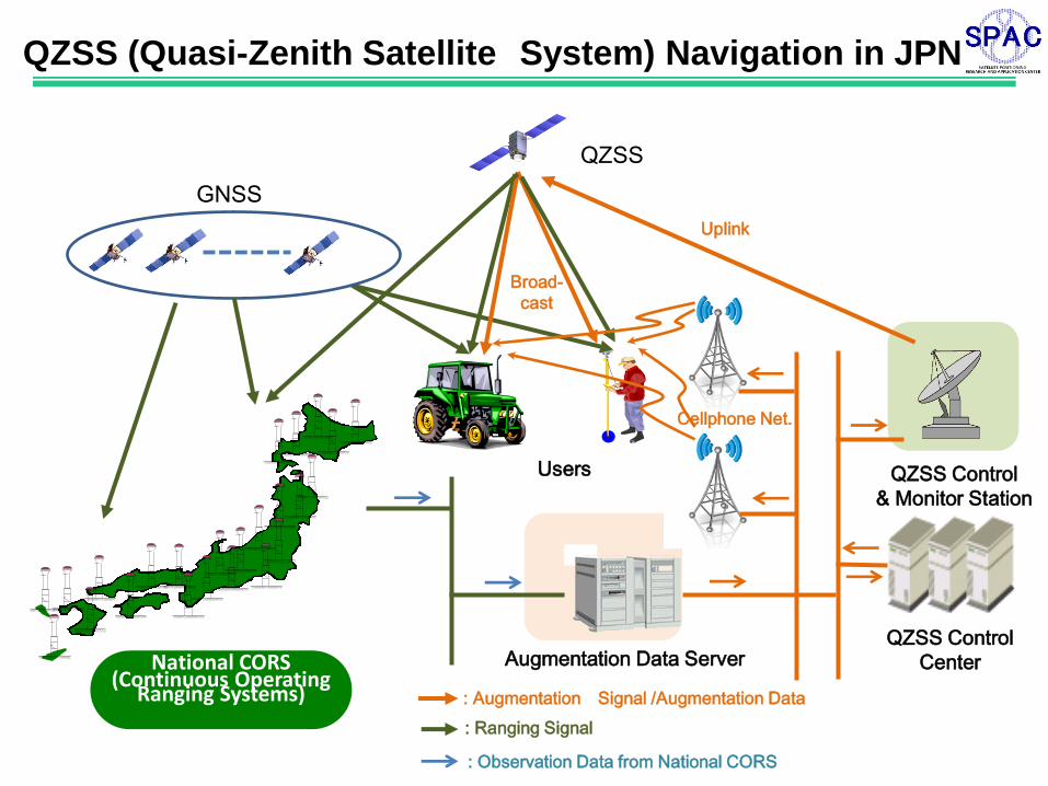
QZSS Control
Center
QZSS
GNSS
National CORS (Continuous Operating
Ranging Systems)
Augmentation Data Server
Uplink
Users QZSS Control
& Monitor Station
Cellphone Net.
QZSS (Quasi-Zenith Satellite System) Navigation in JPN
Broad-
cast
: Augmentation Signal /Augmentation Data
: Ranging Signal
: Observation Data from National CORS
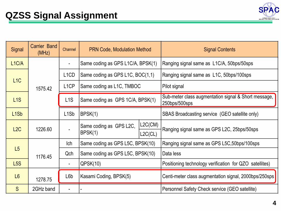
Signal Carrier Band
(MHz) Channel PRN Code, Modulation Method Signal Contents
L1C/A
1575.42
- Same coding as GPS L1C/A, BPSK(1) Ranging signal same as L1C/A, 50bps/50sps
L1C L1CD Same coding as GPS L1C, BOC(1,1) Ranging signal same as L1C, 50bps/100sps
L1CP Same coding as L1C, TMBOC Pilot signal
L1S L1S Same coding as GPS 1C/A, BPSK(1) Sub-meter class augmentation signal & Short message,
250bps/500sps
L1Sb L1Sb BPSK(1) SBAS Broadcasting service (GEO satellite only)
L2C 1226.60 - Same coding as GPS L2C,
BPSK(1)
L2C(CM) Ranging signal same as GPS L2C, 25bps/50sps
L2C(CL)
L5
1176.45
Ich Same coding as GPS L5C, BPSK(10) Ranging signal same as GPS L5C,50bps/100sps
Qch Same coding as GPS L5C, BPSK(10) Data less
L5S - QPSK(10) Positioning technology verification for QZO satellites)
L6
1278.75 L6b Kasami Coding, BPSK(5) Centi-meter class augmentation signal, 2000bps/250sps
S 2GHz band - - Personnel Safety Check service (GEO satellite)
4
QZSS Signal Assignment

5
Principle of RTK (Real Time Kinematic)-GPS
(Position of BS)
(Observation data at BS)
Base Station (BS) RTK User
Wireles transmission
RTK
-mm to cm class accuracy by relative measurement with respect to Base Station position. -BS is needed for each RTK user. -BS position must be pre-determined. -Wireless transmission of observation data of BS and its position is needed. -No other infrastructure is needed.

6
GNSS Satellite
Quasi-Zenith Satellite
National CORS RTK User
National CORS
National CORS
National CORS
VRS Server (Virtual Reference Point Generator)
Ranging Signal
GNSS Satellite GNSS Satellite GNSS Satellite
Principle of Network RTK-VRS (Virtual Reference System)
Cm class Positioning
-No Base-station is needed -VRS server is needed as infra structure. -Bidirectional communication via cell phone network is necessary between user and VRS server. -VRS server send position of Virtual Base Station and its observation data normally via cell phone network.

7
GNSS Satellite
Quasi-Zenith Satellite
National CORS User
National CORS
National CORS
National CORS
Cm class Positioning
SSR Server (Augmentation Data Generator)
Augmentation Signal Ranging Signal
GNSS Satellite GNSS Satellite GNSS Satellite
-No Base-station is needed. -SSR server is needed as infra-structure. -User can receive augmentation data free of charge from QZSS in addition to normal ranging signals from GNSS, and can enjoy cm class point positioning.
Principle of RTK-PPP(Precise Point Positioning)

8
Potential Users of QZSS Service and Coverage
-Normally understood that Augmentation data are irrelevant to RTK users.
-Can’t RTK users enjoy Augmentation data from QZSS free of charge?
If existing RTK equipment can accept augmentation data, a large number of new users would be born! ?
Augmentation signal L6
(Augmentation data for RTK-PPP)No good Good
Signal Broadcasted from QZSS RTK Users New RTK-PPP Users
Ranging signal (L1/L2)
(Compatible with GPS, Galileo)Good Good
-Should RTK users continuously pay for communication and/or Base Station?

9
RTK-VRS, RTK-GPS and RTK-PPP in the Field
From Field test report by Hokkaido Univ. (& SPAC), Oct. 15,2014
LEX Receiver
(RTK-PPP)
Robot Controller
X-Y
Err
or
(m)
X-Y
Err
or
(m)
Drive distance (m) Drive distance (m)
QZSS continuous service is desired to improve situation.
RTK-PPP/RTK-VRS Test Result (Above)
-RTK-PPP (CMAS) showed better
accuracy than RTK-VRS.
Iwamizawa City voice on RTK-GPS
(Seed Planning, Market Research, Jul.27,2016)
-Due to many base stations, radio
signals interferes and tractor’s auto
driving is disabled.
-Windbreak trees disturb radio signal.
-Base station is expensive.

10
Physical Meaning of RTK-GPS and RTK-PPP
-----(1)
A: Satllite unique errors
(clock, orbit, signal bias)
(Clock, circuit delay)
Base station
C: Receiver
unique errors
RTK user RTK-PPP user
B:Propagation pass errors
(ionosphere, troposphere)
RTK
Distance between two points
RTK-PPP
Sum of Augmentationdata from QZSS Distance between
two points
Assumed Point (Cooridinate obtained by point positioning)
Distance error due to A,B,C
Distance error due to A,B,C
Geometric distance (Calculated using Ephemeris
data and assumed point coordinate)
True distance between satellite & receiver
Lp by calculation

11
Physical Meaning of RTK-GPS and RTK-PPP
-----(1)
A: Satllite unique errors
(clock, orbit, signal bias)
(Clock, circuit delay)
Base station
C: Receiver
unique errors
RTK user RTK-PPP user
B:Propagation pass errors
(ionosphere, troposphere)
RTK
Distance between two points
RTK-PPP
Sum of Augmentationdata from QZSS Distance between
two points
Assumed Point (Cooridinate obtained by point positioning)
Distance error due to A,B,C
Distance error due to A,B,C
Geometric distance (Calculated using Ephemeris
data and assumed point coordinate)
True distance between satellite & receiver
If L6 receiver can generate 𝐿𝑝 by right member calculation of Eq. (1), base station can be substituted with L6 receiver, and RTK user can no longer needs base station and VRS data transmission. Named “L6 adopter”
Lp by calculation

Augmentation Signal L1/L2
RTK positioningcoordinate
Self coordinate by point positioning
Generated observation data Self coordinate by point positioning
Ephemeris data
RTKObservation
datagenerator
12
L6 Adapter Concept Case 1 : When RTK side can send Ephemeris data and self coordinate
Case 2 : When RTK side cannot send Ephemeris data and self coordinate
Augmentation Signal L1/L2
L1
Generated observation data Self coordinate by point positioning
RTK positioningcoordinateRTK
Observationdata
generator
wired
wired
Patent application submitted

13
Conclusions
1. Verified RTK users can use QZSS augmentation data.
2. L6 adopter can act as attachment to existing RTK equipment as well as component
of new RTK product.
3. Several technical problems occurring in the field, associated with radio transmission
in RTK-GPS, can be resolved by L6 adopter and QZSS augmentation data.
4. Radio transmission cost, base station cost, and other cost necessary for RTK-VRS
& RTK-GPS system can no longer become necessary after use of L6 adopter.
Therefore, L6 adopter must be attractively lower-costed than these costs.
5. If transmitting cm class augmentation data via ground system, say, cell phone
network, data volume becomes far less than those of RTK-VRS, which reduce
transmission cost significantly.
6. RTK-PPP method is deemed rather difficult to understand and hard to apply to
product. For RTK equipment users and manufacturers, L6 adopter may eliminate
their study effort and minimize development time and cost.
Hope this “bridge method” can lower technical barrier of RTK-PPP for
users and act as co-prosperity driver with conventional RTK method.
THANKS FOR YOUR KIND ATTENTION!