interoffice memorandum - template.net€¦ · · 2016-04-22interoffice memorandum date: january...
TRANSCRIPT

Interoffice Memorandum Date: January 7,2012
To:
From:
Subject:
Planning Board Members'(/
Ryan Chapdelain) Chief Planner, Neighborhood and Development Services
ZonngText Amendment--North Trail Overlay District (NTOD)
The creation of a North Traii Overlay District (NTOD) was directed by the City Commission as
part of their FY 20L3 Strategic Plan. This draft is based on a coÍununity vision that has evolvedthrough close consultation with the people living and working along the corridor. It is theintent of the NTOD to provide for an optional set of zontng standards to voluntarily encouragenew development and re-development projects along the North Trail and allow these projectsto function in a sensitive manner to preserve the integrity and long-term viability of thesurrounding neighborhoods.
Alternative Motions:
o Move to find Zontng Text Amendment 13-ZTA-01" consistent with the Sørøsotø City Pløn(2030) and find that it satisfies the Standards for Review tnZorung Code Section IV-1206and recommend approval to the City Commission.
¡ Move to find Zonrng Text Amendment 13-ZTA-01, inconsistent with the Sørasotø CityPløn (2030) arrd/ or find that it does not satisfy the Standards for Review in Zoning CodeSection IV-1206 and recommend denial to the City Commission.
Section [V-1206: Standards for Review
In reaiaaing øn application for a text ømendment, the Planning Board and City Commission shall consider whetherthe proposed ømendment: (1-) is consistent with and furthers the goals, objectiaes ønd øction strøtegies of the
comprehensioe plan, and (2) furthers the purposes of these regulations ønd other city ordinønces, reguløtions øndactions designed to implement the Sarasota City PIøn; ønd (3) wouldbe in the public interest and seroe aaølidpublic purpose.
AttachmenLs:r Memorandum Regarding Sarasotø City Plan Consistency Analysis. City of Sarasota FY 13 Strategic Plan (Page 1). Background of NTOD Planning Processo þf{{p¡ NTOD-ZTA document (9/7 /12)forPlanningBoardReviewo NTOD Issues Matrix Summarizing Substantive Public Comments, Along with Staff Comments. Development Review Committee Sign-Off Sheeto Minutes of 9/13/12NTOD Community Workshopo Correspondence
1 of 82

Interoffice Memorandum
To:
From:
Subject:
Date: January 7,2013
Planning Board Memb.ers
nyurl Ctlup A"tu¡M¡"f Plarurer, Neighborhood and Development Services
Sørøsotø City Pløn Consistency Analysis re Proposed Zoning TextAmendme nt L3-ZT A-01, North Trail Overlay District.
The purpose of the proposed Zontng Text Amendment is to maintain the Zontng Code 2002 Ed.The following identifies relevant sections of the Sørøsota City PIan addressed by the proposedZorungText Amendment:
Future Land Use Chapter:
Objective 2 - LandDevelopment RegulationsThe City shall make appropriate changes to the City's existing Land DevelopmentRegulations [LDRs], including the Zoning Code, in order to ensure continued consistencybetween those regulations and this Sørasotø City Pløn. In addition, the City may considerother regulatory factors for possible incorporation into the Land Development Regulationsthat are not issues of "consistcrrcf" , but which warrant consideration due, in part, to thedeveloped character of the City.
Action Strategies:
2.1 Components of the Land Development Regulations: The Land DevelopmentRegulations, and any subsequent revisions made thereto, shall continue to address:
. The subdivision of land
. Signage¡ Areas subject to seasonal or periodic
flooding¡ Mixed-usedevelopmento Storm water management. Open space
The above listing of items to be addressed by the Landand not exhaustive.
¡ On-site vehicular movemento Vehicular parking¡ Coastal higþhazard areas
o Areas of special flood hazard. Well-head protection areaso Compatibility [i.e. intensity, density &
scale of development]
Development Regulations is intended to be illustrative
2.6 Overlay Districts: Overlay Districts which modify the development standards of theunderlying zone district may be established by ordinance to protect or enhancespecified aÍeas,land uses and structures whicþ by virtue of their type or locatioryhave characteristics which are distinct from areas, land uses or structures outside theoverlay district. \ÂIhen establishing an overlay district these "distinct" characteristicsshall be identified. 2 of 82

Overlay Districts may be used to modify the development standards of the underþingzone district and delete uses which would otherwise be permitted or permissible inthe underlying zone districL However, overlay districts shall not be utilized to adduses not specifically enumerated in the district regulations for the underlying zonedistrict or future land use classification.
Conclusion:
Based on the Objectives, Action Strategies and text noted above, the proposed Zoning TextAmendment as detailed in application no.13-ZTN0L, may be found consistentwith the Sørøsota
City Pløn [Comprehensive Plan].
3 of 82

Strategic Goal: ECONOMIC DEVELOPMENT AND GROWTH
TEGY: ENCOURAGE SUSTAINá.BLE ENTREPRENURIAL INITIATIVES IN THE N. SARá.SOTA COMMUNITY
OBJECTI\,'E: Develop a Small Business IncubatorDevelop a small business incubator program tlat incorporates business assistance, training and resources to support sustainable entrepreneuriaÌ initiatives in the
Sa¡asota communþ. Developing an incubator will not necessarily resuìt in the establishment of an Incubator Faeility; rather, a sustaìnable incubatorwill support local entrepreneuriai efforts md strengthen the business communþ into which new businesses will develop.
LEADDEPT: and. Development Seroices
IASKS: DATE PRIMARY PROJEC:TED SCHEDT]LElollaborate with the USF research study partnership for NRO and NorthJa¡asota busi¡esses to assess current businesses/programs and provide:ommunit¡r assistance.
sep2012
Alston, L
2
Evaluate the outcome of the cunent Memo of Understanding (MOU) between theCity and the SCF/Small Business Development Center; develop a new MOU forannual seruices.
Oct20L2
Alston, L
3
leview the completed business incubator feasibility study and provide\dministration with a report recommending next-step strategies for incubatingrctivities.
Oct2072
Alston, L
Somplete all activities associâted with the rz-week "Intro to BusinessDevelopment" course, sponsored by the Cþ and other communþ partners.
Dec2Ôt2 Alston, L
5Hol.d a Business Resource Center Open House for the community andstakeholders,
Jan2ô13
Alston, L
6Share a compÌeted draft of a Business Resource Center marketing plan with CityAdminisnation for input and acceptance.
Feb2O13
Alston, L
7Identifu a "Champion" to take the lead in operation ofthe small businessincubation program, i.e. a local universit¡r or other organization.
Mar2O13
Alston, L
I Host community meetings to request input and feedback on the intentions for th¡small business incubation program.
API2O13
Alston, L
9Jomplete draft ofsmall business incubation program plan including written5oals and objectives, and review with City Adminìstration.
Jun20L3
Alston, L
10Present final proposal for the business incubation program to tlte CityCommission for direction and acceptance.
sep2O13
Alston, L
OBJECTIVE: l,lst¿r[¡lish l N()ì.tlì'li':ri[ (Jvcr.lar. Dislr.ictEncourage development and ¡edevelopment aìong the North Trail by incorporating a North Trail Overlay Distúct into the City's Zoning Code.LEAD DEPT: Neighborhood and Development Sewices
STRATEGY: REVITALIZE NORTIIWEST SARASOTA
IASKS: DATI PRIMARÌ PROJECTED SCHEDIJLEAttend the No¡th T¡ail Partnership's Community workshop, being held to gathercitizen comments on the NTOD proposal.
Oct2012
Chapdelain
Present the North Trail Overlay District Zoning Text Amendment to the City'sDevelopment Review Committee at their November zorz meeting; receivefeedback and, ifno revisions needed, receive 'sign-off.
Nov2012
Chapdelain
Jomplete all revisions to the proposed Zoning Text Amendment based on:omments ¡eceived via the Community Workshop and the Design ReviewJommittee meeting.
Dec2012
Chapdelain
4Present the proposed Zoning Text Amendment to the Planning Board for PublicHearing.
Jan2O13
Chapdelain
5Revise the proposed text as needed to address comments receivetl at the Plannin¡Board Public Hearing.
Feb2O13
Chapdelain
6lresent North Trail Overlay District Zoning Text Amendment for Public HearingFirst Reading) at March zor3 Cþ Commission meeting.
Mar2O13
ChapdeÌain
7l¡esent North Trail Overlay District Zoning Text Amendment for adoption onìecond Reading at April zor3 City Commission meeting.
Apr2O13
Chapdelain
City of Sarasota FY 2013 Strategic Plan for Commission Acceplance September 4, 20124 of 82

January 7, 2013
Background of the North Trail Overlay District Planning Process
The genesis of a comprehensive North Trail overlay occurred in 2009 with the formation of what is now known as the North Trail Redevelopment Partnership (NTRP). The NTRP is a non-profit corporation comprised of community leaders, representatives of universities/institutions, business owners, Indian Beach/Sapphire Shores, Tahiti Park, Bayou Oaks and Central Cocoanut neighborhood representatives, Sarasota Chamber of Commerce representatives, local architects, planners, and realtors. The organization seeks to study, understand, and facilitate positive redevelopment of the North Trail. Their mission is to “…foster sustainable, predictable, economic redevelopment along North Tamiami Trail to achieve a revitalized, attractive, safe and inviting environment for business, institutions and neighborhoods.” Shortly after its formation, the NTRP established a ‘Redevelopment Subcommittee’ whose scope was to meet regularly to identify barriers to economic success and redevelopment along the North Trail. Out of this broad purview a specific charge emerged of developing an overlay concept to incentivize and attract sustainable redevelopment, consisting of quality buildings and streetscapes within the context of a shared vision. The diverse, revolving group was made up of neighborhood representatives, developers, architects, planners, real estate brokers, business owners, property owners, etc. who all have a vested interest in the betterment of the North Trail corridor. The group evaluated previous North Trail studies and used common themes found in the studies as well as those voiced by stakeholders over the years as the basis for the overlay concept. One of the group’s key objectives was ensuring the overlay was balanced in its approach. Establishing protections for residential areas related to compatibility as well as providing meaningful incentives and predictability to help spur desired redevelopment were fundamental to the work effort. The NTRP Redevelopment Subcommittee took the time necessary to maximize consensus, both inside and outside the group, by constantly vetting and revising the overlay concept in a thoughtful and deliberative manner based on stakeholder feedback. This holistic, inclusive approach endured for over three years with the end result materializing in an overlay concept that many North Trail stakeholders can support and one that has a genuine opportunity to be utilized by the private sector. It is the previous work of the NTRP and its Redevelopment Subcommittee that serves as the foundation for the proposed North Trail Overlay District (NTOD). The NTRP Redevelopment Subcommittee turned over its overlay concept to City staff in July 2012 when the group determined it had reached an end point with their work effort. Staff then began to formally prepare the NTOD Zoning Text Amendment, which is also a specific directive within the City’s FY 13 Strategic Plan. City staff held numerous public meetings on the NTOD since August 2012, including a Community Workshop on September 13, 2012 where over 80 individuals were in attendance. Staff continues to maintain a list of substantive public comments received based upon the City’s first NTOD draft document (9/7/12) that has been shared with the public. Any changes to this draft document made in advance of the City Commission public hearing will be tracked accordingly. Revitalization of the North Trail will continue to require a sustained, multi-pronged approach that is supported by corridor stakeholders. Transportation, public safety, economic development, redevelopment, and marketing are all critical components of the revitalization equation. The NTOD is not to be viewed as a panacea to address all of the challenges, perceived or otherwise, associated with the North Trail; however, it is considered a tool within the redevelopment tool box to help promote revitalization along the corridor over the long-term. The NTOD is an excellent example of what can happen when citizens from divergent backgrounds come together to work constructively and continuously toward a unified goal for the greater good of a community.
5 of 82

This DRAFT document is subject to further review and editing.
NTOD, September 7, 2012 draft page 1 of 44
The following link contains previous studies and related information on the current NTOD proposal: www.sarasotagov.com/NTStudies
NORTH TRAIL OVERLAY DISTRICT (NTOD) –MAJOR FEATURES
The following list highlights the proposed “optional” NTOD criteria which are intended to encourage new development and re-development projects provided they function in a sensitive manner that preserves the integrity and long-term viability of the surrounding neighborhoods. Major features include:
The NTOD is not mandatory, however, any development project that voluntarily makes use of the
NTOD shall be required to follow the NTOD standards for all future development applications.
Replaces the existing NTOD, which currently provides a 10’ height bonus if certain standards are met. Existing NTOD is very narrow in scope and has never been utilized by the private sector.
Underlying zoning district standards remain in effect except for the standards contained in the NTOD. The NTOD “overlays” ten (10) zone districts. Since the NTOD does not address uses, the underlying base zone districts must be consulted to determine the allowed use(s). However, since the NTOD addresses parking, those overlay standards supersede the base zone district.
Establishes an administrative development review process.
Requires a community workshop prior to filing a development application in the NTOD for any development project over 5,000 sq. ft. (non-residential) or 8 units or greater (residential) to notify the public, explain the proposed project and listen to public comment.
Establishes specific standards for an administrative adjustment process. This allows flexibility for preservation of trees and addresses unforeseen development issues associated with small and irregularly shaped properties within the NTOD area.
Requires a community workshop prior to filing an adjustment application in the NTOD for any development project over 5,000 sq. ft. (non-residential) or 8 units or greater (residential) to notify the public, explain the proposed project and listen to public comment.
Establishes an appeal process for administrative site plans and administrative adjustments in the NTOD by allowing for a de novo hearing before the Planning Board, whose decision could ultimately be appealed to the City Commission.
Establishes height limits up to 45 feet in the NTOD. There are 10 zones districts “overlaid” by the NTOD. The maximum heights in the 10 individual zone districts are; RSF4 – 35’, RMF3 – 35’, *RMF4 – 95’, OPB – 45’, CN – 35’, CG – 45’, CGD – 45’, CI – 45’, *CRD – 65’, NT – 35’. *The maximum heights in RMF-4 and CRD would not be reduced by the NTOD.
Establishes “daylight plane” standards and setback standards in the NTOD to increase distance of buildings from adjacent residential uses.
Establishes “urban frontage” standards in the NTOD to enhance building and hardscape aesthetics along North Tamiami Trail.
Establishes flexible parking standards in the NTOD for new buildings and for re-purposing of existing buildings.
Establishes uniform signage design standards in the NTOD to enhance the aesthetics of individual building sites and the entire corridor.
*NOTE: The text and formatting on this cover page only is slightly different than what is included on the original cover page of the 9/7/12 draft in order to reflect staffing changes and provide more succinctness.
6 of 82

This DRAFT document is subject to further review and editing.
NTOD, September 7, 2012 draft page 2 of 44
SUSCRIBE NOW
If you have not already subscribed the following link, on the
City’s web site, will allow you to receive notice of all future
zoning Text Amendments.
(http://www.egovlink.com/sarasota/subscriptions/subscribe.asp)
You will receive an email confirmation of your subscription(s)
along with instructions on how to unsubscribe or manage your
subscriptions.
7 of 82

This DRAFT document is subject to further review and editing.
NTOD, September 7, 2012 draft page 3 of 44
Add text to make NTOD “OPTIONAL”.
NOTES
1. The existing North Trail Overlay District (NTOD) will be deleted in its entirety. 2. All of the NTOD text on pages 7-38 is new.
3. Revisions to existing text on pages 4-6 and 40-44 is underlined and shaded.
8 of 82
This DRAFT document is subject to further review and editing.
NTOD, September 7, 2012 draft page 4 of 44
Division 9. Special Public Interest Overlay Districts Section VI-901. Intent and Purpose A. The purpose of the special public interest overlay districts established in the following
sections is to protect and enhance certain specific lands, uses and structures which, by virtue of their type or location, have characteristics which are distinct from lands and structures outside such overlay districts. It is the intent of the City Commission to permit, insofar as possible, those uses and structures, which would otherwise be permitted, provided that reasonable and necessary conditions are met which insure the protection and enhancement of said lands, uses and structures. It is the further intent of the City Commission to specifically protect and enhance the following:
1. Fruitville Gateway Corridor Overlay District (FCOD) 2. Coastal Islands Overlay (CIO) 3. Ringling Overlay District (ROD) 4. Housing Authority Overlay District (HAOD) 5. North Trail Overlay District (NTOD)
SectionVI-902. General
A. The provisions of this Division 9 apply to all lands, uses and structures in areas approved by the City Commission as Overlay Districts. Such lands, uses and structures are also subject to the provisions of their underlying zoning designation; provided, however, that where the provisions of this Division 9 are more restrictive than in conflict with the provisions of the underlying zoning designation, the provisions of this Division 9 shall apply.
B. The special public interest overlay districts established in this Article generally operate by
establishing performance standards to effectuate the purposes of the district. Except as otherwise provided, they do not supersede the regulations of the underlying district.
C. Land lying within special public interest overlay districts shall remain part of the
underlying zoning districts established by other provisions of this Article, and may, in addition, lie in one or more overlay districts in accordance with the designation of each.
D. Unless otherwise specified in this Code creating the special public interest overlay
districts, when any zoning lot or use is partially located within a special public interest overlay district, the remainder of the zoning lot or use shall not be subject to the provisions of this Division 9.
Comment: Revised to be consistent with “applicability” provisions in all overlay districts
9 of 82

This DRAFT document is subject to further review and editing.
NTOD, September 7, 2012 draft page 5 of 44
SectionVI-903. Creation of Special Public Interest Overlay Districts
A. Amendments to this Division shall be adopted in accordance with the provisions of Article IV upon the recommendation of the City Commission, Planning Board, City Manager, City Attorney, or the Department of Neighborhood and Development Services.
B. Every recommendation for creation of a special public interest overlay district or addition
of land thereto shall address the following, as applicable: 1. A statement of purpose and intent shall specify the nature of the special and
substantial public interest involved and objectives to be promoted by creation of the special public interest overlay district and imposition of the regulations proposed therefore.
2. Proposed district boundaries shall be depicted on one or more maps that shall also
display all other zoning districts applicable to the property proposed for inclusion in the district.
3. Regulations proposed to promote the special purposes of the district.
C. Regulations proposed with any special public interest overlay district shall be designed to
reasonably promote the purposes of the district, and may require or address any of the following, in addition to or in lieu of other regulations affecting property within the district:
1. Submission of specifically detailed site plans, building plans, elevations and maps
showing the relation of proposed development to surrounding or otherwise affected property in terms of location, scale or intensity, character and continuity;
2. Protection of features designated as being of special concern within the district; 3. Mixtures or limitations of permitted uses; 4. Special performance standards and development regulations; 5. Other matters as appropriate to promote the special public interests of the district.
SectionVI-904. Mapping of Special Interest Overlay Districts
A. Upon approval of a special public interest overlay district, by adoption of an ordinance by
the City Commission a map of the district boundaries shall be incorporated into the zoning maps of the city.
***
Comment: Other overlay districts (FCOD, CIO, ROD, and HAOD) are not included to save paper.
10 of 82
This DRAFT document is subject to further review and editing.
NTOD, September 7, 2012 draft page 6 of 44
SectionVI-905. Fruitville Gateway Corridor Overlay District.
***
F. Development Standards.
1. Applicability. All uses in the FCOD shall be subject to the development standards set forth in the underlying zoning district, unless a more restrictive standard is established below by the FCOD.
When the FCOD applies to a particular property, the underlying zoning district categories are neither abandoned nor repealed. The existing regulations remain in effect. All development shall be subject to the development standards set forth in the underlying zoning district. However, where the provisions of this section are in conflict with the underlying zoning designation, the provisions of this section shall apply.
Existing development shall be subject to this Section when seeking any one of the following:
a) Cumulative expansion after the effective date of these regulations (October 21, 1998) of at least fifty (50) percent of the improved (building and land) square footage existing at the time of the effective date of these regulations (October 21, 1998).
b) Any cumulative substantial remodeling of an existing use after the adoption effective date of these regulations (October 21, 1998).
***
Comment: This is an errata change to make the FCOD consistent with VI-902 A and “applicability” provisions in all overlay districts.
11 of 82

This DRAFT document is subject to further review and editing.
NTOD, September 7, 2012 draft page 7 of 44
SectionVI-910. North Trail Overlay District.
Comment: The NTOD currently “overlays” 10 zone districts including; RSF-4, RMF-3, RMF-4, OPB, CN, CG, CGD, CI, CRD, and NT.
12 of 82

This DRAFT document is subject to further review and editing.
NTOD, September 7, 2012 draft page 8 of 44
A. Vision, Intent and Purpose
The Vision. After the completion of Interstate 75 the US 41 corridor began to change. In 1989, the community identified a need to address the decline. Since then, various studies of the US 41 corridor have provided clear direction on how to transform the corridor into a more vibrant, walkable district that supports local community redevelopment objectives. It is a long-term vision that will need to occur in phases over time. This community based vision has evolved through close consultation with the people living and working along the corridor. With the growth occurring in Sarasota and Manatee County, there is a tremendous opportunity to create a mix of workforce housing, small-scale shops, restaurants and businesses for a distinct and authentic urban environment.
The US 41 corridor is a critical, but underutilized and undervalued gateway to Sarasota and Manatee County’s most culturally and economically significant resources. US 41 provides mobility for automobiles as a major regional transportation corridor but lacks a sense of place and positive cultural identity. Rather than favoring pedestrian and neighborhood movements, US 41 simply functions as a pathway facilitating automobile movement. However, US 41 has the potential to function as a destination attraction. Every day approximately 40,000 cars are carried along US 41. Unfortunately, today US 41 does not do such a good job of providing access for the people who live there, work there, learn there, and visit there. Despite its design for good regional access, the corridor is a peril for pedestrians. The majority of people making trips along US 41 are locally-oriented. Between downtown Palmetto and downtown Sarasota, more than 50 percent of origins and destinations are located within ¼ mile of US 41. The proportion of pass-by trip traffic using US 41 traveling to and from points outside the area is relatively low – about 20 percent. Travel markets located east of US 41 between Bradenton and Sarasota use the Corridor to travel to downtown areas in Bradenton and Sarasota.
Comment: This draft is based, in part, on prior studies that may be found on the following link. http://www.sarasotagov.com/NTStudies The Vision, Intent and Purpose statement will be used, in part, to “paint a picture” for the future for the North Trail, establish development standards, evaluate site plans, evaluate adjustments and evaluate appeals.
13 of 82
This DRAFT document is subject to further review and editing.
NTOD, September 7, 2012 draft page 9 of 44
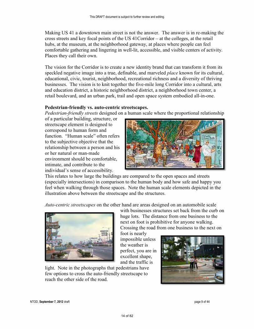
Making US 41 a downtown main street is not the answer. The answer is in re-making the cross streets and key focal points of the US 41Corridor – at the colleges, at the retail hubs, at the museum, at the neighborhood gateway, at places where people can feel comfortable gathering and lingering in well-lit, accessible, and visible centers of activity. Places they call their own.
The vision for the Corridor is to create a new identity brand that can transform it from its speckled negative image into a true, definable, and marveled place known for its cultural, educational, civic, tourist, neighborhood, recreational richness and a diversity of thriving businesses. The vision is to knit together the five-mile long Corridor into a cultural, arts and education district, a historic neighborhood district, a neighborhood town center, a retail boulevard, and an urban park, trail and open space system embodied all-in-one. Pedestrian-friendly vs. auto-centric streetscapes. Pedestrian-friendly streets designed on a human scale where the proportional relationship of a particular building, structure, or streetscape element is designed to correspond to human form and function. “Human scale” often refers to the subjective objective that the relationship between a person and his or her natural or man-made environment should be comfortable, intimate, and contribute to the individual’s sense of accessibility. This relates to how large the buildings are compared to the open spaces and streets (especially intersections) in comparison to the human body and how safe and happy you feel when walking through those spaces. Note the human scale elements depicted in the illustration above between the streetscape and the structures.
Auto-centric streetscapes on the other hand are areas designed on an automobile scale
with businesses structures set back from the curb on huge lots. The distance from one business to the next on foot is prohibitive for anyone walking. Crossing the road from one business to the next on foot is nearly impossible unless the weather is perfect, you are in excellent shape, and the traffic is
light. Note in the photographs that pedestrians have few options to cross the auto-friendly streetscape to reach the other side of the road.
14 of 82

This DRAFT document is subject to further review and editing.
NTOD, September 7, 2012 draft page 10 of 44
The Intent and Purpose. The North Trail Overlay District (NTOD) is intended to provide an optional set of zoning standards to voluntarily encourage new development and re-development projects that are human scale and will support human activity on the street and shift from an auto-centric land use pattern to one that emphasizes a variety of modal choices - including walking, biking and transit. In addition, the standards will encourage new development and re-development projects to function in a sensitive manner that preserves the integrity and long-term viability of the surrounding neighborhoods.
15 of 82
This DRAFT document is subject to further review and editing.
NTOD, September 7, 2012 draft page 11 of 44
B. Establishment of the Boundaries The application of the NTOD shall be restricted to those geographical areas that are designated on the Official Zone District Map of the City of Sarasota.
C. Applicability.
1. Purpose. The North Trail Overlay District (NTOD) provides an optional,
alternative, and voluntary set of development standards which is intended to partially implement the Vision, Intent and Purpose for the NTOD. Compliance is intended to occur, over time, as redevelopment and new development occur. These regulations are intended for new development, expansion and remodeling. Existing structures and uses are allowed to continue and normal repair and maintenance is encouraged. Exceptions from restrictions that would otherwise limit the ability to rebuild after sudden or gradual destruction are allowed for condominiums and valid development approvals. Section VI-910 E (Adjustment Review Process) below also recognizes that some sites may be difficult to develop in compliance with these regulations and provides for adjustments to these regulations.
2. Voluntary. These standards only apply to development projects where the
Applicant voluntarily agrees to meet applicable development standards for the current and future development projects. If the Applicant does not voluntarily agree, the NTOD standards do not apply. Although use of the NTOD is not mandatory, any development project that voluntarily makes use of the NTOD shall be required to proffer a proviso that must be recorded in the official records for Sarasota County, on forms approved by the city attorney, to identify NTOD standards are mandatory for all future development applications. [For example, if a development project voluntarily seeks to utilize the lower parking standards to re-purpose an existing building then the proviso will mandate future development on the site to utilize applicable NTOD standards.]
3. Conflict. When the NTOD applies to a particular property, the underlying zoning
district categories are neither abandoned nor repealed. The existing regulations remain in effect. All development shall be subject to the development standards set forth in the underlying zoning district. However, where the provisions of this section are in conflict with the underlying zoning designation, the provisions of this section shall apply.
Comment: The NTOD is OPTIONAL. However, once utilized, the overlay becomes mandatory.
Adjustments allow for flexibility and compliance over time.
16 of 82

This DRAFT document is subject to further review and editing.
NTOD, September 7, 2012 draft page 12 of 44
D. Development Standards. 1. Height.
a. Maximum Height. The maximum height is forty-five (45) feet, except for properties zoned RMF-4 and CRD. The maximum height in RMF-4 and CRD is regulated by those zone districts. Height adjustments are prohibited.
2. Setbacks .
a. Front setbacks.
i. Properties fronting North Tamiami Trail. a. Minimum front setback for properties fronting on North
Tamiami Trail is ten (10) feet. b. Maximum front setback for buildings fronting on North
Tamiami Trail is twenty (20) feet. This requirement is limited to portions of the building required to meet the minimum façade requirement (see Facades below).
c. Additions to development on zoning lots totaling five hundred (500) square feet or less, once each five (5) calendar years, are exempt from the maximum front setback requirement for buildings fronting on North Tamiami Trail in subsection “b” above.
ii. Properties not fronting North Tamiami Trail. The minimum front setback for properties not fronting North Tamiami Trail is the same as the underlying zoning district.
b. Side setbacks. i. Properties abutting residentially zoned property. Properties with a
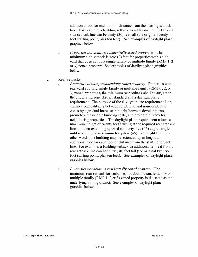
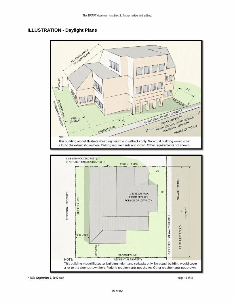
side yard abutting single family or multiple family (RMF-1, 2, or 3) zoned properties, the minimum side setback shall be subject to the underlying zone district standard and a daylight plane requirement. The purpose of the daylight plane requirement is to; enhance compatibility between residential and non-residential zones by a gradual increase in height between developments, promote a reasonable building scale, and promote privacy for neighboring properties. The daylight plane requirement allows a maximum height of twenty feet starting at the required side setback line and then extending upward at a forty-five (45) degree angle until reaching the maximum forty-five (45) foot height limit. In other words, the building may be extended up in height an
Comment: Exemption to maximum setback
standard for small additions.
POLICY DECISION There are 10 zones districts “overlaid” by NTOD. The maximum heights in the 10 zone districts are; RSF4 – 35’, RMF3 – 35’, RMF4 – 95’, OPB – 45’, CN – 35’, CG – 45’, CGD – 45’, CI – 45’, CRD – 65’, NT – 35’. The maximum height in RMF-4 and CRD would not be reduced by the NTOD - unless they are excluded. [NOTE: The highlighted portion of this statement was inadvertently omitted in the original 9/7/12 draft document and was necessary to be added for intended consistency with the above paragraph, D.(1)(.a.)]
17 of 82
This DRAFT document is subject to further review and editing.
NTOD, September 7, 2012 draft page 13 of 44
additional foot for each foot of distance from the starting setback line. For example, a building setback an additional ten feet from a side setback line can be thirty (30) feet tall (the original twenty-foot starting point, plus ten feet). See examples of daylight plane graphics below.
ii. Properties not abutting residentially zoned properties. The
minimum side setback is zero (0) feet for properties with a side yard that does not abut single family or multiple family (RMF 1, 2 or 3) zoned property. See examples of daylight plane graphics below.
c. Rear Setbacks.
i. Properties abutting residentially zoned property. Properties with a rear yard abutting single family or multiple family (RMF-1, 2, or 3) zoned properties, the minimum rear setback shall be subject to the underlying zone district standard and a daylight plane requirement. The purpose of the daylight plane requirement is to; enhance compatibility between residential and non-residential zones by a gradual increase in height between developments, promote a reasonable building scale, and promote privacy for neighboring properties. The daylight plane requirement allows a maximum height of twenty feet starting at the required rear setback line and then extending upward at a forty-five (45) degree angle until reaching the maximum forty-five (45) foot height limit. In other words, the building may be extended up in height an additional foot for each foot of distance from the starting setback line. For example, a building setback an additional ten feet from a rear setback line can be thirty (30) feet tall (the original twenty-foot starting point, plus ten feet). See examples of daylight plane graphics below.
ii. Properties not abutting residentially zoned property. The
minimum rear setback for buildings not abutting single family or multiple family (RMF 1, 2 or 3) zoned property is the same as the underlying zoning district. See examples of daylight plane graphics below.
18 of 82
This DRAFT document is subject to further review and editing.
NTOD, September 7, 2012 draft page 14 of 44
ILLUSTRATION - Daylight Plane
19 of 82
This DRAFT document is subject to further review and editing.
NTOD, September 7, 2012 draft page 15 of 44
ILLUSTRATION - Daylight Plane
Revise reference to residential
20 of 82
This DRAFT document is subject to further review and editing.
NTOD, September 7, 2012 draft page 16 of 44
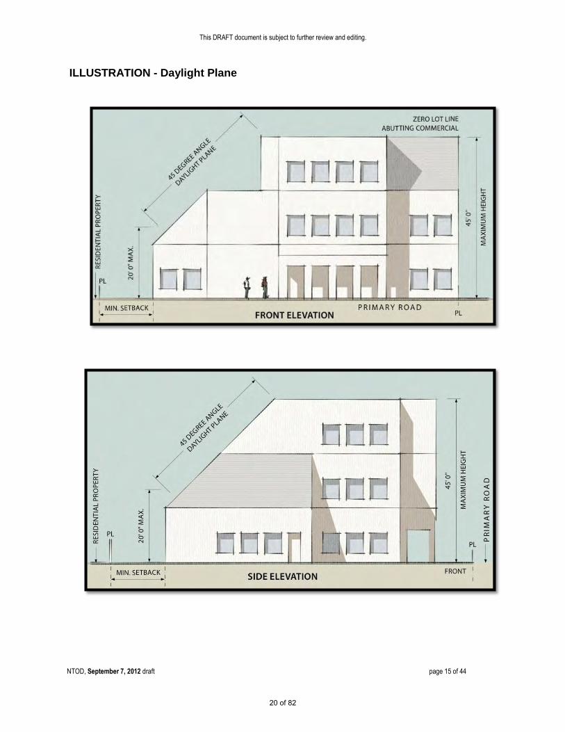
3. Urban Frontage Requirements (North Tamiami Trail). a. Pedestrian Space. The front setback area for portions of buildings fronting
on North Tamiami Trail is required to provide a paved pedestrian space that is continuous from the curb to the building. This should not be construed to prohibit amenities that enhance human activity including; landscaping, courtyards, outdoor dining and seating. However, a minimum eight (8) foot clear pedestrian path shall be maintained along the entire property frontage located on the public right-of-way, private property or a combination of both. Any encroachments into the public right-of-way are subject to City review and approval. Paved areas may utilize various materials, provided the finished surface meets the American with Disabilities Act (ADA) standards. See examples of pedestrian oriented spaces, urban frontages and courtyards below.
21 of 82

This DRAFT document is subject to further review and editing.
NTOD, September 7, 2012 draft page 17 of 44
b. Corner Architecture (North Tamiami Trail). New buildings at the intersection of North Tamiami Trail with another public street shall accentuate the building corner facing the intersection by including architectural treatment that emphasizes the corner, such as the examples shown below.
Note: Insure building does not block site triangles at intersections. See. VII-1203.
22 of 82

This DRAFT document is subject to further review and editing.
NTOD, September 7, 2012 draft page 18 of 44
c. Façades (exterior wall of a building). i. Façade Requirement. At least fifty (50) percent of the street frontage for each
zoning lot on North Tamiami Trial shall be occupied by building(s). In the absence of building(s) along the remainder of the front lot line, a freestanding decorative masonary or decorative metal (wrought iron or aluminum) wall with optional pilasters shall be built coplanar with the façade to screen surface parking - except for access openings to allow vehicles and pedestrians to pass through. The “streetwall” shall be a minimum of three (3) feet high and a maximum of six and one-half (6.5) feet high. The opaque portions of the streetwall shall not exceed three (3) feet in height - except for optional pilasters. Portions of the streetwall above three (3) feet in height shall be less than fifty (50) percent opaque to provide transparency for passive servailence between the sidewalk and the property. Where the access crosses any pedestrian path, the intersection shall be clearly marked and lighted for the safety of the pedestrian.
ii. Reduction in Façade Requirement. In order to form an outdoor pedestrian plaza or courtyard with a clear walkway connecting the sidewalk to the building entry, the fifty (50) percent building street frontage may be reduced by the Director of Neighborhood and Development Services as long as the twenty (20) foot minimum depth of habitable space is maintained along the entire building frontage that runs parallel to North Tamiami Trial (see Habitable Space below). The outdoor plaza or courtyard may not be used for parking.
23 of 82

This DRAFT document is subject to further review and editing.
NTOD, September 7, 2012 draft page 19 of 44
iii. Main Entrance. At least one main entrance of a commercial or mixed-use building shall face onto a sidewalk along North Tamiami Trail or at a corner with North Tamiami Trail. Entrances shall be emphasized with one or more of the following techniques; landscaping, paving, lighting or recessed from the facade surface.
iv. Exemptions to Façade Requirement.
a. Development on zoning lots that have eighty (80) feet or less of street frontage on North Tamiami Trail and no other access other than through the North Tamiami Trail frontage are exempt from the requirements of this subsection “c. Façades” (exterior wall of a building fronting on North Tamiami Trail).
b. Additions to development on zoning lots totaling five hundred (500) square feet or less, once each five (5) calendar years, are exempt from the requirements of this subsection “c. Façades” (exterior wall of a building fronting on North Tamiami Trail).
4. Habitable Space.
Portions of a building or parking garage facing North Tamiami Trail shall provide a twenty (20) foot minimum depth of habitable space for the full length of the first story. Habitable space involves space in a building which is used or designed to be used primarily for non-residential or residential human activities (e.g. working, shopping, living, sleeping, cooking and eating). Habitable space excludes parking garages, bathrooms, utility, storage, laundry rooms, halls and closets. Stairwells, elevators, lobbies or other associated building service space may be allowed to contribute up to twenty (20) percent of the habitable space requirement.
COMMENT: Exemption for small lots and small additions.
24 of 82

This DRAFT document is subject to further review and editing.
NTOD, September 7, 2012 draft page 20 of 44
5. Windows. a. The first story shall be a minimum of
thirty (30) percent glass for portions of a building facing a street. On the first story, the bottom of the rough opening for windows shall begin no higher than forty-eight (48) inches above finished grade of the ground floor. The combined area, of all stories, above the first story shall be a minimum of twenty-five (25) percent glass.
b. The combined area of all stories shall be a minimum of twenty (20) percent glass for portions of a building not facing a street (excluding alleys).
c. Security or decorative grilles, if any, shall be at least fifty (50) percent transparent and shall be located on the inside of the glassed area.
d. Glass, at the first floor, shall be clear or lightly tinted with a visible light transmittance factor of six tenths (0.6) or higher (where R+A+T=1.0). Translucent, opaque, and mirrored glass may not be used for window materials.
e. Reduction in window area requirement. The Director of Neighborhood and Development Services may reduce or eliminate the required amount of window area (without a formal application for an adjustment) provided one or more of the following techniques is used on the exterior wall of the building and/or on a streetwall: i. Installing a vertical trellis in front of the wall with climbing vines or
planting materials. ii. Providing a landscaped planting bed in front of the wall with plant
materials that can obscure at least fifty (50) percent of the wall’s surface. iii. Providing artwork (mosaic, mural, sculpture, relief, etc.) over the blank
wall surface. iv. Vertical or horizontal change in wall plane. v. Decorative lighting and/or decorative masonry patterns. vi. Canopies or awnings. New awnings, canopies and similar features shall
be constructed of high quality materials. Materials that have a glossy or shiny appearance are prohibited. Backlighting of awnings is prohibited.
Applicants requesting a reduction in the window area requirement must submit their request in writing to the Director of Neighborhood and Development Services and explain the basis for the request.
Comment: Verify if 48 inches should be the standard for a
maximum height.
25 of 82

This DRAFT document is subject to further review and editing.
NTOD, September 7, 2012 draft page 21 of 44
6. Screening. a. Garbage Collection Areas. All exterior garbage cans, dumpsters and
garbage collection and compaction areas must be screened from the street and any adjacent properties. These areas shall be located and screened so that the visual impacts of these functions are contained and out of view from adjacent properties and public streets. Trash receptacles for pedestrian use are exempt. See Section VII-1401 for specific requirements.
b. Mechanical Equipment. Mechanical equipment, located on the ground, such as heating or cooling equipment, pumps, or generators must be screened from public streets and any adjacent properties. All rooftop mechanical equipment must be screened from the ground level of public streets and any adjacent properties by integrating it into building and roof design.
c. Other Screening Requirements. The screening and buffering requirements for uses, parking areas, exterior storage and exterior display areas are stated with the regulations for those types of items.
26 of 82

This DRAFT document is subject to further review and editing.
NTOD, September 7, 2012 draft page 22 of 44
7. Pedestrian Standards. a. Standards. An on-site pedestrian circulation system must be provided. The
system must meet all standards of this section. The following example provides clear pedestrian connections from the street, between buildings, through parking lots, and to adjacent uses. i. Connections.
a. Connection to Street. The sidewalk system must connect all abutting streets to the main entrance.
b. Internal Connections. The sidewalk system must connect all buildings on the zoning lot, and provide connections to other areas of the site, such as parking areas, bicycle parking, recreational areas, common outdoor areas and any other amenities.
ii. Materials. a. The circulation system must be hard-surfaced with a
minimum eight (8) foot clear pedestrian path. b. Where the system crosses driveways, parking areas and
loading areas, the system must be clearly identifiable through the use of elevation changes, speed bumps, different paving materials, or other similar method. Stripping does not meet this requirement.
c. Where the system is parallel and adjacent to a motor vehicle travel lane, the system must be a raised path or be separated from the lane by a raised curb, bollards, landscaping or other physical barrier. If a raised path is used the ends of the raised portions must be equipped with ADA (Americans with Disabilities Act) accessible curb ramps.
iii. Lighting. The on-site pedestrian circulation system must be lighted to a level where the employees, residents, visitors and customers can safely use the system at night. All lighting fixtures must be shielded and directed to confine light spread within the site boundaries. See the standards in Section VII-1402 Site Lighting.
27 of 82

This DRAFT document is subject to further review and editing.
NTOD, September 7, 2012 draft page 23 of 44
8. Exterior Display, Storage, and Work Activities. a. Exterior Display and Storage. Exterior display of goods is prohibited except for
the display and storage of plants, produce, motor vehicles and boats subject to the following limitations. i. Such uses must be accessory to
an approved primary use. ii. Display areas for plants and
produce are limited to an area equal to fifteen (15) percent of the principal uses’ gross floor area.
iii. There is no limit for approved motor vehicle or boat sales/rental lots and plant nurseries.
iv. Except for approved plant nurseries, all plant and produce merchandise must be stored inside the building after permitted hours of operation. Motor vehicles and boats may remain outdoors.
i. Hours of operation are limited from 6:00 a.m. to 9:00 p.m.
ii. Display areas are not permitted in required landscape, parking, or pedestrian areas.
b. Exterior work activities. Exterior work activities are prohibited except for the
following uses that comply with all applicable regulations: restaurants; plant nurseries; entertainment and recreation uses that are commonly performed outside; sales or rental of motor vehicles and boats; fuel sales; car washes; commercial surface parking lots; and open air markets.
c. Open Air Market/Bazaar. The purpose of an open air market/bazaar is to allow
for open-air sale of retail products in certain non-residential zone districts, to provide for the creation of a more urban pedestrian environment and to stimulate business. Permitted locations shall be limited to property zoned CN, CP, CSCN, CSCC, CSCR, CG, CI, ILW, I, CND, CSD, CRD, CGD, CSC, NT, DTE, DTC, DTB, ICD, IGD, IHD, G and CBN. Applications for a provisional use permit shall be submitted to the Director of Neighborhood and Development Services and shall meet the standards defined in VII-602 (x).
COMMENT: Open Air Market/Bazaar is an existing zoning code provision found in VII-602 .X. This option allows outdoor vending, by provisional use permit, on private property. This does not address “street/sidewalk” vending which is regulated in chapter 23 of the City Code – commercial vending on public property and public ROW. Additional outdoor options available for; Accessory Outdoor Restaurants, Sidewalk Cafes and Temporary Uses.
28 of 82

This DRAFT document is subject to further review and editing.
NTOD, September 7, 2012 draft page 24 of 44
9. Parking. a. General Standards.
See sections VII-201, 202, 203, 204, 205, 207, 208, 209, 213, 214 and 215 which shall apply where applicable.
The following standards supersede the parking standards of Article VII, Division 2 where in conflict with other parking provisions, including the General Standards of sub-section 9. a. above. b. Minimum Parking Requirement
i. One (1) space for each three hundred and fifty (350) square feet of floor area for non-residential space.
ii. One (1) space for each residential unit. iii. One-half (1/2) space for each transient lodging space, plus applicable
parking for accessory uses, which may draw patrons beyond those receiving accommodations.
c. Changes in Use Exemption
i. Changes to existing uses shall be exempt from having to meet new parking requirements and may continue to provide existing parking. Any new/additional building square footage, however, shall be subject to meeting applicable parking requirements.
d. Alternative Parking Ratio
i. The Director of Neighborhood and Development Services, after consultation with the City Engineer, shall be authorized to approve alternative ratios for providing required off-street parking spaces in accordance with this section.
ii. Where the applicant believes the required parking ratios of this section are too high, data submitted by the applicant may be used to determine a different or lesser ratio for specific proposed use. Such data may include site studies from similar uses, generally accepted engineering or industry specific practices (for example, ITE parking rates or ICSC parking rates), or independent engineering calculations based on the nature of the proposed use. The Director of Neighborhood and Development Services, in coordination with the City Engineer, shall evaluate such submittals to determine an acceptable ratio for the proposed use.
iii. An attested copy of an approved alternative parking ratio must be recorded in the official records for Sarasota County on forms approved by the city attorney. An alternative parking ratio may be amended by following the same procedure required for the original approval. The applicant shall provide proof of recordation prior to approval of the certificate of occupancy.
29 of 82

This DRAFT document is subject to further review and editing.
NTOD, September 7, 2012 draft page 25 of 44
e. Location of Parking. Parking lots or garages shall not be located any closer to the North Tamiami Trail right-of-way than the distance by which the principal building is set back from the street right-of-way. This provision shall not be construed to preclude parking lot access driveways. Parking areas shall not be located on street corners unless one of the following conditions exists; however this shall not be construed to allow parking in front of buildings on North Tamiami Trial. i. If a zoning lot fronts on three (3) streets, then parking may be
located on only one (1) corner. ii. If a zoning lot fronts on four (4) streets, then parking may be
located on only two (2) corners.
iii. Exemptions to Location of Parking Requirement. a. Development on zoning lots that have eighty (80) feet or less of
street frontage on North Tamiami Trail and no other access other than through the North Tamiami Trail frontage are exempt from the requirements of this subsection “e. Location of Parking”.
b. Additions to development totaling five hundred (500) square feet or less, once each five (5) calendar years, are exempt from the requirements of this subsection “e. Location of Parking”.
COMMENT: Exemption for small lots and
small additions.
30 of 82
This DRAFT document is subject to further review and editing.
NTOD, September 7, 2012 draft page 26 of 44
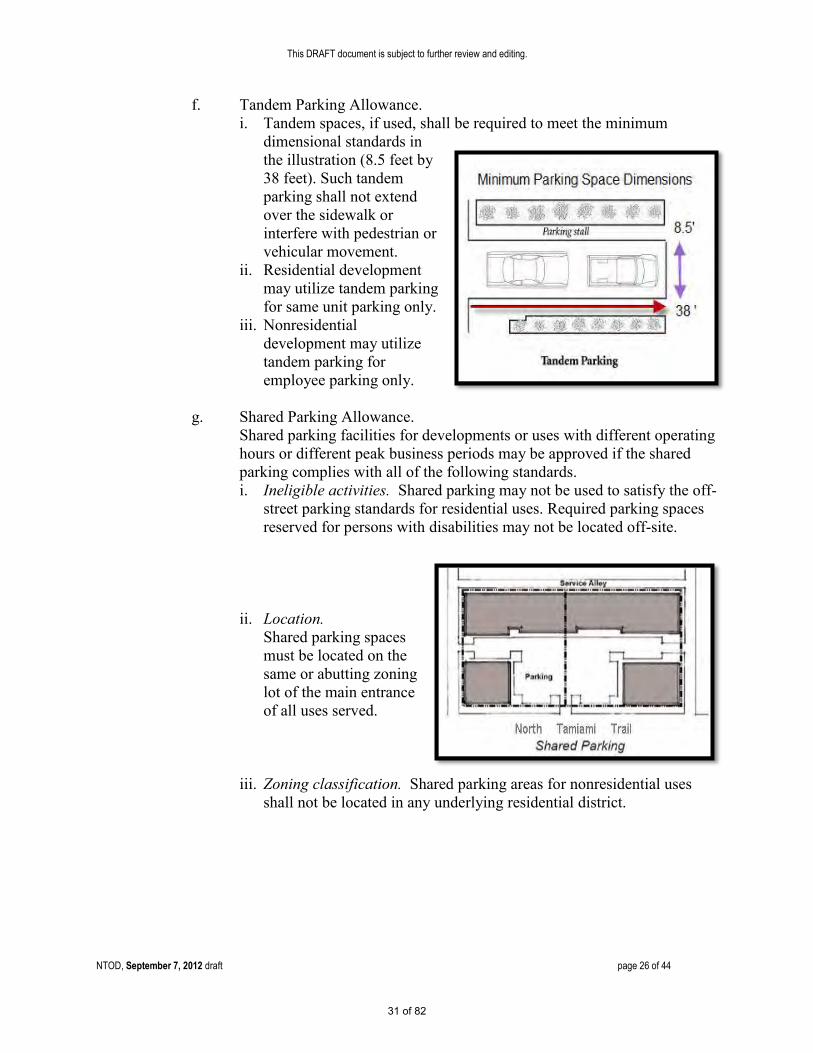
f. Tandem Parking Allowance. i. Tandem spaces, if used, shall be required to meet the minimum
dimensional standards in the illustration (8.5 feet by 38 feet). Such tandem parking shall not extend over the sidewalk or interfere with pedestrian or vehicular movement.
ii. Residential development may utilize tandem parking for same unit parking only.
iii. Nonresidential development may utilize tandem parking for employee parking only.
g. Shared Parking Allowance.
Shared parking facilities for developments or uses with different operating hours or different peak business periods may be approved if the shared parking complies with all of the following standards. i. Ineligible activities. Shared parking may not be used to satisfy the off-
street parking standards for residential uses. Required parking spaces reserved for persons with disabilities may not be located off-site.
ii. Location.
Shared parking spaces must be located on the same or abutting zoning lot of the main entrance of all uses served.
iii. Zoning classification. Shared parking areas for nonresidential uses
shall not be located in any underlying residential district.
31 of 82

This DRAFT document is subject to further review and editing.
NTOD, September 7, 2012 draft page 27 of 44
iv. Shared parking analysis.
Those wishing to use shared parking as a means of satisfying off-street parking requirements must submit a shared parking analysis to the Director of Neighborhood and Development Services that clearly demonstrates the feasibility of shared parking. The analysis must be provided in a form acceptable to the Director of Neighborhood and Development Services. It must address at a minimum; the size and type of the proposed development, the composition of tenants, the anticipated rate of parking turnover, and the anticipated peak parking and traffic loads for all uses that will be sharing off-street parking spaces.
32 of 82

This DRAFT document is subject to further review and editing.
NTOD, September 7, 2012 draft page 28 of 44
v. Agreement for shared parking. A shared parking plan shall be enforced through written agreement among all owners of record. The owner of the shared parking area shall enter into a written agreement with the city, with enforcement running to the city, providing that the land comprising the parking area shall never be disposed of except in conjunction with the sale of the building which the parking area serves so long as the facilities are required; and that the owner agrees to bear the expense of recording the agreement and such agreement shall bind his or her heirs, successors, and assigns. An attested copy of the agreement between the owners of record shall be submitted to the city attorney for recordation in a form established by the city attorney. Recordation of the agreement must take place before issuance of a certificate of occupancy for any use to be served by the shared parking area. A shared parking agreement may be revoked only if all required off-street parking spaces will be provided on-site in accordance with the off-street parking schedules in this section. The written agreement shall be voided by the city if other off-street facilities are provided in accord with these zoning regulations. The Director of Neighborhood and Development Services is hereby authorized to administratively approve and execute on behalf of the city shared parking agreements which are in compliance with this section.
vi. Change in use. Where the uses subject to a shared parking
agreement change, the Director of Neighborhood and Development Services shall have the authority to require a revised shared parking analysis. A new shared parking agreement is required when the revised shared parking analysis indicates additional parking is required.
33 of 82

This DRAFT document is subject to further review and editing.
NTOD, September 7, 2012 draft page 29 of 44
h. Offsite parking. Off-street parking spaces on a separate lot from the lot on which the principal use is located may be approved if the offsite parking complies with the all of following standards. i. Ineligible activities. Offsite parking may not be used to satisfy the
off-street parking standards for convenience stores or other convenience-oriented uses. Required parking spaces reserved for persons with disabilities may not be located off-site.
ii. Location. No offsite parking space may be located more than six-hundred (600) feet from the primary entrance of the use served (measured along the shortest legal pedestrian route). Offsite parking spaces may not be separated from the use served by an arterial street right-of-way (as designated in the comprehensive plan), unless a grade-separated pedestrian walkway is provided, or other traffic control or remote parking shuttle bus service is provided.
iii. Zoning classification. Offsite parking areas shall not be located in any residential district.
iv. Agreement for offsite parking. In the event that an offsite parking area is not under the same ownership as the principal use served, a written agreement between the record owners is required. The owner of the offsite parking area shall enter into a written agreement with the city, with enforcement running to the city, providing that the land comprising the parking area shall never be disposed of except in conjunction with the sale of the building which the parking area serves so long as the facilities are required; and that the owner agrees to bear the expense of recording the agreement and such agreement shall bind his or her heirs, successors, and assigns. An attested copy of the agreement between the owners of record must be submitted to the city attorney for recordation in form established by the city attorney. Recordation of the agreement must take place prior to issuance of a building permit or certificate of occupancy for any use to be served by the offsite parking area. An offsite parking agreement may be revoked only if all required off-street parking spaces will be provided, in accordance with the off-street parking schedules in this section. The Director of Neighborhood and Development Services is hereby authorized to administratively approve and execute on behalf of the city off-site parking agreements which are in compliance with this section.
v. Signage. All offsite parking spaces shall be clearly marked for exclusive use of the use to be served.
34 of 82

This DRAFT document is subject to further review and editing.
NTOD, September 7, 2012 draft page 30 of 44
10. Signage.
a. General Standards See VII-101 thru 109
b. Lighting
Signage may be externally illuminated by reflection of a light source aimed at its surface. All lighting must be shielded to prevent glare or nuisance beyond the property line. The backlighting of awnings and messages attached thereto is prohibited. Backlighting with neon or fluorescent white light is permitted only for signs that use individually cut opaque letters (a.k.a. “halo illuminated letters”). The use of cabinet-type box signs or channel letter signs with translucent backlit panels is prohibited. Signage inside shopfront windows may be neon lit. Signs with flashing or intermittent lights, continuous changes of message, animated and electronic message boards, lights of changing degrees of intensity, and lights or lighting effects that cause glare are prohibited.
c. Wall Sign One single external wall sign band (with individually cut letters) may be applied at the top of either the first or second floor façade of each building, providing that it not exceed two (2) feet in height by any length. This shall not be interpreted to allow for two wall sign bands on any building. Where there is more than one sign on an individual building, all signs should be complementary to each other in the type of construction materials and letter size and style of copy.
d. Directory Sign One (1) wall mounted directory sign may be located at each ground level entrance. The sign may list the name of the establishment(s) and may include a location map. Each directory sign shall not exceed a total aggregate area of sixteen (16) square feet. Any such sign shall not project more than twelve (12) inches from the building to which it is attached.
e. Projecting Sign Projecting signs, not to exceed four (4) square feet in area per face for each separate business entrance may be attached perpendicular to the façade. The bottom of such signs shall be a minimum of eight (8) feet above the walkway.
f Awning Sign Awnings at the first story may have signs. No such sign shall exceed twenty (20) percent of the area of each awning (top plus all sides).
35 of 82

This DRAFT document is subject to further review and editing.
NTOD, September 7, 2012 draft page 31 of 44
f. Temporary Portable A-Frame Sign
A single temporary portable A-frame sign may be allowed for each business, on private property, provided the sign is less than four (4) feet high and less than eighteen (18) by twenty-four (24) inches per face. Placement in the public right-of-way shall be prohibited.
g. Window Sign Such signs shall cover no more than twenty (20) percent of the total window and glass portion of the door area. A permanent address shall be permitted in addition to the twenty (20) percent coverage. Window signs shall not be included in any calculation of total sign area for the building or tenant. Handwritten signs of any type are prohibited.
h. Real Estate Sign One single or double faced non-illuminated “For Sale” or “For Rent” sign for each street frontage not exceeding sixteen (16) square feet per face and not exceeding six (6) feet in height above grade. Upon sale or rent, the sign shall be immediately removed.
i. Monument Sign One free standing monument sign per street frontage not exceeding one hundred twenty (120) square feet in area on all faces and not exceeding ten (10) feet in height above grade.
36 of 82

This DRAFT document is subject to further review and editing.
NTOD, September 7, 2012 draft page 32 of 44
j. Building Banners
Building banners shall be permitted on each face of the building subject to the following regulations. a. Banners shall be located on private property unless a right-of-
way encroachment permit is obtained. b. The bottom of the banner shall be a minimum of 8 feet above
the walkway or ground. c. The maximum size of each banner shall project a maximum of
3 feet from the face of the building and be a maximum of 9 feet tall and shall be of uniform dimensions throughout the zoning lot upon which they are located.
d. One banner may be located for each fifty (50) feet of building length. For example, if the face of the building is ninety-nine (99) feet long, only one banner shall be permitted on that face of the building.
e. The top and bottom of all banners shall be affixed to poles designed solely for that purpose. No banners shall be affixed to other structures, vehicles, utility poles, trees, shrubs or plants.
f. All banners shall be constructed of fire retardant material and shall be replaced by the owner of the banner at a minimum of two (2) times per year.
g. All banners may contain written copy of a general non-advertising nature plus identifying logos or symbols. The term “non-advertising nature” shall mean the copy does not advertise the name of any business, specific merchandise or sale prices.
k. Marquee Sign Theatres may have one marquee sign for each building frontage
that includes an entrance available to the general public. The marquee shall not extend beyond the top or sides of the building.
l. Alley Signs
Alleys may also contain one projecting or wall sign at each customer entrance. Such signs shall not exceed four (4) square feet in area per face. The bottom edge of such signs shall be located a minimum of eight feet above the walkway.
m. Other Signs Prohibited. All other signs not specifically permitted.
n. Design Guidelines See Appendix D. Advisory Community Design Guidelines. These non-mandatory guidelines should be consulted prior to developing signs for any project.
Comment Advertising of businesses &
merchandise is prohibited.
37 of 82

This DRAFT document is subject to further review and editing.
NTOD, September 7, 2012 draft page 33 of 44
E. Adjustment Review Process
1. Purpose and Applicability. Existing structures and uses are allowed to continue and normal repair and maintenance is encouraged. Compliance with the NTOD standards is intended to occur, over time, as new development, expansion and remodeling occur. The regulations of the NTOD apply over a wide area; which makes full compliance with all of the regulations difficult on sites with unusual situations. Adjustment reviews allow alternative ways to meet the vision, intent and purposes of the NTOD (VI-910 A) by providing flexibility for sites that are; small or irregularly shaped or contain significant tree canopy. Adjustments may also be used when strict application of the regulations would preclude reasonable economic use of a site. The adjustment process allows the NTOD regulations to continue providing certainty and rapid processing of site plan applications. Each adjustment shall be considered unique and shall not set precedent for others.
2. Regulations which may and may not be adjusted.
a. Eligible Regulations. Unless specifically prohibited in sub-section “b” below, all regulations in the NTOD may be modified administratively by the Director of Neighborhood and Development Services by using the adjustment review process.
b. Ineligible Regulations. No adjustments shall be granted for the following.
i. Maximum building height. ii. Setbacks and daylight plane for properties abutting residentially
zoned property. iii. Signage. However, to accommodate existing buildings, the
dimensional standards may be adjusted by up to twenty-five (25) percent and the location of signs may be adjusted if the approval criteria are met.
iv. Allowed uses in the underlying zone districts. v. Maximum residential densities in the underlying zone districts. vi. Maximum floor area ratio in the underlying zone districts.
Comment All reviews are administrative and subject to approval criteria. Appeals of administrative decisions go to the Planning Board.
Comment Some adjustments are prohibited.
38 of 82

This DRAFT document is subject to further review and editing.
NTOD, September 7, 2012 draft page 34 of 44
3. Approval Criteria. Prior to filing any application for an adjustment for any non-residential project five thousand (5,000) square feet or larger in area, regardless of the use(s), or any residential project eight (8) units or larger, shall be required to hold a community work shop in accord with the procedures identified in section IV-201 (b). An application for an adjustment shall be accompanied by documentation that establishes how the applicant meets the criteria of sub-section “a.”, “b.”, or “c.” below. a. Civic/Government Uses. Adjustment requests for uses that are uniquely
governmental such as administration centers, public safety/public works facilities, public mass transit terminals, post offices, public libraries, public museums, or public schools/colleges will be approved, approved with changes, or approved with conditions if the Director of Neighborhood and Development Services finds that the applicant has shown that approval criteria “i” through “v” below have been met. i. The design of the development project is exemplary civic
architecture; and ii. The building will be constructed of high quality materials and
finishes; and iii. The project will enhance the appearance and environment of the
City; and iv. The adjustment will not be injurious to the neighborhood or
otherwise detrimental to the public welfare; and v. The Vision, Intent and Purpose of the NTOD have been met.
b. Other Non-government Uses. Adjustment requests for uses that are not
uniquely governmental such as apartments/condominiums, hotels/motels, retail/service shops, or office buildings (regardless of ownership) will be approved, approved with changes, or approved with conditions if the Director of Neighborhood and Development Services finds that the applicant has shown that either approval criteria “i” through “vi” or approval criteria “vii” through “x” below, have been met. i. Granting the adjustment will equally or better meet the purpose of
the regulation to be adjusted; and ii. The proposal will not significantly detract from the livability or
appearance of any adjacent residential zone district; and iii. If more than one adjustment is being requested, the cumulative
effect of the adjustments results in a project which is still consistent with the overall purpose of the NTOD; and
iv. City designated historic resources (if applicable) are preserved; and v. Any impacts resulting from the adjustment are mitigated to the
maximum extent practical; and vi. The Vision, Intent and Purpose of the NTOD have been met.
or vii. Application of the regulation in question would preclude
reasonable economic use of the site; and
Comment Approval criteria for civic/government uses and other non-government uses include a demonstration that the “vision, intent and purpose” of the NTOD have been met.
39 of 82

This DRAFT document is subject to further review and editing.
NTOD, September 7, 2012 draft page 35 of 44
viii. Granting the adjustment is the minimum necessary to allow reasonable use of the site; and
ix. Any impacts resulting from the adjustment are mitigated to the extent practical; and
x. The Vision, Intent and Purpose of the NTOD have been met.
c. Preservation of Trees. It is the intent of this section to permit the applicant to receive an adjustment equal to the decrease in the buildable area caused by the modification required to the structure to preserve trees protected by Article VII, Division 3.1 of this Code. An application for an adjustment shall demonstrate all of the following three (3) requirements are met. i. The adjustment is for the purpose of preserving a tree or trees
protected by Article VII, Division 3.1 of this Code; and, ii. The applicant cannot design and locate the proposed structure or
infrastructure improvements to preserve the trees and also comply with all provisions of the Zoning Code, without causing the applicant undue hardship; and,
iii. Considering the shape and dimensions of the real property, the location of existing structures and infrastructure improvements, and the size, age, health and species of trees sought to be protected, it is not feasible to transplant the trees to another location on the site.
The application for such an adjustment shall otherwise be exempted from the requirements of sub-sections VI-910 E. 4. “a.” and “b.” above.
d. Conditions. In granting any adjustment, the Director of Neighborhood and
Development Services shall prescribe appropriate conditions and safeguards in conformity with these regulations. Violation of such conditions and safeguards, when made a part of the terms under which the adjustment is granted, shall be deemed a violation of these regulations.
e. Amendments. An adjustment may be amended, only by following the
preceding procedures in this section. f. Expiration of Approval. An adjustment shall expire upon the expiration of
the site plan into which the adjustment has been incorporated.
g. Appeals. Any final decision of the Director of Neighborhood and Development Services may be appealed to the Planning Board in accord with sub- section G. (Appeal Process) below.
40 of 82

This DRAFT document is subject to further review and editing.
NTOD, September 7, 2012 draft page 36 of 44
F. Development Review Process
1. Authority. If the applicant voluntarily agrees to utilize the NTOD standards (see VI-910 C), all site plans in the NTOD shall be processed administratively, by the Director of Neighborhood and Development Services, without regard to the administrative site plan thresholds in Sec. IV-501(C). Prior to filing any development application, all non-residential projects five thousand (5,000) square feet or larger in area, regardless of the use(s) or eight (8) residential units or larger, shall be required to hold a community work shop in accord with the procedures identified in section IV-201 (b). An application for site plan approval shall be accompanied by the information and documentation required by the applicable review procedures set out in article IV, division 3. At the option of the applicant, a site plan may be processed in advance of a building permit or in conjunction with a building permit. The Director of Neighborhood and Development Services shall review all site plans, for completeness and compliance with the provisions of this section and the regulations pertaining to base zone district. The Director of Neighborhood and Development Services may solicit and consider comments from the Development Review Committee (DRC). Any final decision of the Director of Neighborhood and Development Services may be appealed to the Planning Board in accord with sub-section G. (Appeal Process) below.
2. Other Approvals. In the event that a site plan requires a rezoning,
conditional use, development agreement or vacation of right-of-way; then the site plan shall be filed and processed in accord with the applicable development review procedures set out in Article IV of this Code. In the event that a site plan requires approval of a major right-of-way encroachment agreement, then the site plan shall be processed in accordance with this section; however approval of the encroachment agreement shall be obtained in accord with the procedures set out in Article VII, Division 12.
3. Expiration of Approval. Site plan approval shall expire two (2) years after the date
of the action granting such approval if a building permit for construction on the site has not yet been issued. When an approved site plan incorporates approved conditional uses or adjustments, such conditional uses or adjustments will also expire upon the expiration of the site plan.
4. Extension of Approval. Upon application submitted to the City Auditor and
Clerk’s Office at least thirty (30) calendar days prior to the expiration of site plan approval; the Director of Neighborhood and Development Services may grant a one-time extension of the site plan up to two (2) additional years. No additional extensions are permitted.
Comment All reviews are administrative and subject to approval criteria. Appeals of administrative decisions go to the Planning Board.
Comment Process requires a community workshop prior to filing an application for any site plan over 5,000 sq. ft. (non-residential) or 8 units (residential) IV-201 (b) states: “The purpose of the Community Workshop shall be to inform the neighboring property owners, residents, and business owners of the nature of any proposed development or land use request, explain the site plan, if any and solicit comments.”
41 of 82

This DRAFT document is subject to further review and editing.
NTOD, September 7, 2012 draft page 37 of 44
The application for the extension of the site plan shall demonstrate compliance with approval criteria “a” or “b” or “c” below. a. The application contains evidence satisfactory to the Director of
Neighborhood and Development Services that the applicant has made reasonable efforts to develop the documents needed to make an application for a building permit and has taken reasonable steps to secure any other development approvals that may be needed from other permitting authorities to allow for the submission of a building permit application
or b. The application contains evidence satisfactory to the Director of
Neighborhood and Development Services establishing that the applicant has, since the date of the site plan approval, made significant and substantial expenditures or incurred significant and substantial obligations in reliance on the approval and in furthering and proceeding with the development.
or c. The delay in proceeding with the commencement of the development
resulted from “force majeure” or “Act of God” and not acts or omissions of the applicant.
The burden of proof is on the applicant to show that the evidence is satisfactory and no guarantee is made for approval of the extension. This paragraph four (4) and paragraph three (3) above shall not apply to a site plan which is subject to or governed by an enforceable Development Agreement pursuant to Article IV, Division 15 of the Zoning Code. The denial by the Director of Neighborhood and Development Services of an application to extend the site plan approval may be appealed to the Planning Board by filing such appeal with the City Auditor and Clerk's Office no later than ten (10) days after the written decision by the Director of Neighborhood and Development Services.
42 of 82

This DRAFT document is subject to further review and editing.
NTOD, September 7, 2012 draft page 38 of 44
G. Appeal Process
1. Decision of the Director. Any aggrieved person may appeal the decision of the Director of Neighborhood and Development Services to approve or deny an adjustment, site plan or site plan extension by filing a notice of appeal with the Office of the City Auditor and Clerk on a form prepared by the Department of Neighborhood and Development Services within ten (10) calendar days after the date the letter containing the decision of the Director of Neighborhood and Development Services is mailed to the applicant or within ten (10) calendar days after issuance of a building permit. The Planning Board shall hold a de novo hearing on the application for adjustment, site plan approval or site plan extension by using the applicable approval criterion to consider the appeal, and may affirm, affirm with conditions or reverse the decision of the Director. The hearing shall be advertised and conducted in accord with Sec. IV-202. Prior to conducting the hearing, the Planning Board shall make a determination as to whether the entity or person who filed the notice of appeal is an “aggrieved person” as defined in this Zoning Code and the Planning Board may receive evidence on this issue. In the event the Planning Board determines that the appealing party is not an “aggrieved person,” the Board shall not conduct the hearing on the application for adjustment, site plan approval or site plan extension.
2. Decision of the Planning Board. An appeal of a decision of the Planning Board
may be made to the City Commission. A notice of appeal in the form of a letter shall be filed with the City Auditor and Clerk’s Office within ten (10) days of the Planning Board’s decision. The City Commission shall hold a de novo public hearing to consider the appeal, and may affirm, affirm with conditions or reverse the decision of the Planning Board by using the applicable approval criterion. The hearing shall be advertised and conducted in accord with Sec. IV-202. An appeal of the decision of the City Commission may be made to the Circuit Court for Sarasota County, Florida, by filing a Petition for Writ of Certiorari as provided under the Florida Rules of Appellate Procedure. A decision of the City Commission to approve or deny an adjustment, site plan or site plan extension as provided in Section G above shall be deemed to have been rendered on the date that the City Commission adopts a resolution setting forth its findings and decision.
H. Enforcement
Should a violation of an approved design occur during construction, the Director of Neighborhood and Development Services has the authority to require the developer to stop, remove, and/or alter the violation or to require the developer to secure an adjustment in accord with sub-section E. above.
***
Comment All appeals are subject to a public hearing and go to the Planning Board.
Appeals of the Planning Board are subject to public hearing and go the City Commission.
Beyond City Commission appeals go to Court.
43 of 82

This DRAFT document is subject to further review and editing.
NTOD, September 7, 2012 draft page 39 of 44
The following underlined and shaded text are additions to existing sections of the Zoning Code
44 of 82
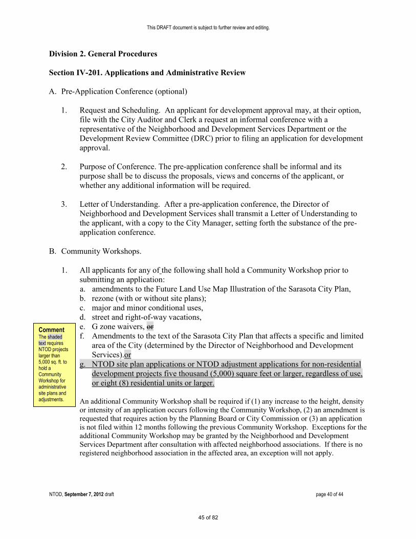
This DRAFT document is subject to further review and editing.
NTOD, September 7, 2012 draft page 40 of 44
Division 2. General Procedures Section IV-201. Applications and Administrative Review
A. Pre-Application Conference (optional)
1. Request and Scheduling. An applicant for development approval may, at their option, file with the City Auditor and Clerk a request an informal conference with a representative of the Neighborhood and Development Services Department or the Development Review Committee (DRC) prior to filing an application for development approval.
2. Purpose of Conference. The pre-application conference shall be informal and its
purpose shall be to discuss the proposals, views and concerns of the applicant, or whether any additional information will be required.
3. Letter of Understanding. After a pre-application conference, the Director of
Neighborhood and Development Services shall transmit a Letter of Understanding to the applicant, with a copy to the City Manager, setting forth the substance of the pre-application conference.
B. Community Workshops.
1. All applicants for any of the following shall hold a Community Workshop prior to submitting an application: a. amendments to the Future Land Use Map Illustration of the Sarasota City Plan, b. rezone (with or without site plans); c. major and minor conditional uses, d. street and right-of-way vacations, e. G zone waivers, or f. Amendments to the text of the Sarasota City Plan that affects a specific and limited
area of the City (determined by the Director of Neighborhood and Development Services).or
g. NTOD site plan applications or NTOD adjustment applications for non-residential development projects five thousand (5,000) square feet or larger, regardless of use, or eight (8) residential units or larger.
An additional Community Workshop shall be required if (1) any increase to the height, density or intensity of an application occurs following the Community Workshop, (2) an amendment is requested that requires action by the Planning Board or City Commission or (3) an application is not filed within 12 months following the previous Community Workshop. Exceptions for the additional Community Workshop may be granted by the Neighborhood and Development Services Department after consultation with affected neighborhood associations. If there is no registered neighborhood association in the affected area, an exception will not apply.
Comment The shaded text requires NTOD projects larger than 5,000 sq. ft. to hold a Community Workshop for administrative site plans and adjustments.
45 of 82

This DRAFT document is subject to further review and editing.
NTOD, September 7, 2012 draft page 41 of 44
2. The purpose of the Community Workshop shall be to inform the neighboring property owners, residents, and business owners of the nature of any proposed development or land use request, explain the site plan, if any and solicit comments.
3. Notice shall be provided by mail at least fourteen (14) days prior to the date of the
Community Workshop to each owner of record of any land within five hundred (500) feet of the property for which the development approvals are sought and to affected neighborhood associations who have registered with the Office of the City Auditor and Clerk to receive notice. The notice of the Community Workshop shall include at a minimum the following: the applicant's name and telephone number, the street address of the site with a small identification map, a clear, factual explanation of what the applicant is proposing and the date, time and location of the workshop. This notice requirement does not mean that all persons receiving the notice must attend the Community Workshop. The City Manager may promulgate administrative regulations setting forth guidelines pertaining to any additional requirements for the conduct of the workshop.
(Ord. No. 06-4663, 3-20-06; Ord. No. 09-4838, 2-17-09)
C. Simultaneous Applications. Applications for development approvals may be filed and
reviewed simultaneously, at the option of the applicant, provided however, that any application for development approval that also requires a variance shall not be processed for final approval until the variance has been granted.
D. Application Submission Requirements [Sec. 4.4]
1. All applications for development approval shall be submitted to the City Auditor and
Clerk's Office in a form specified by the Director of Neighborhood and Development Services. All applications for development approval, except for City-initiated applications, shall be accompanied by the payment of a fee in accordance with the provisions of Section IV-102. All applicants for development approval, other than the City of Sarasota shall be required to submit such information with the application as required by the “Development Approval Application” package promulgated and utilized by the City and may be required to submit such additional information as the City may deem necessary to review the proposed development. A physical and/or digital massing model of a proposed project may be required by the Director of Neighborhood and Development Services to evaluate the effect of a proposed project on the surrounding area and better understand the project’s characteristics.
2. City initiated applications for development approval shall be accompanied by such
information as may be necessary to evaluate and decide the application as determined by the Department of Neighborhood and Development Services staff.
3. The city manager is authorized to promulgate administrative regulations which may require that applications for development approval be accompanied by specific information or materials.
46 of 82

This DRAFT document is subject to further review and editing.
NTOD, September 7, 2012 draft page 42 of 44
E. Determination of Completeness of Application. When a privately initiated application for development approval is submitted, the City Auditor and Clerk's Office shall determine whether the application is complete. If the application is complete, the application shall be forwarded to the DRC, if otherwise required by the terms of these regulations. If the application is not complete, it shall be returned to the applicant. The City shall take no further action on the application until the deficiencies are corrected. Upon determination that the application is complete, a Notice of Filing is required to be mailed for the following types of applications: site plans, administrative site plans that are reviewed by the DRC; site specific quasi-judicial rezonings, site specific quasi-judicial rezone ordinance amendments; final subdivision plats; conditional uses; historic designations; development permits for developments of regional impact; adult use permits; development agreements; G Zone Waivers; amendments to future land use map, Illustration LU-6 of the comprehensive plan; street vacations; off-site parking agreements and amendments to any of the foregoing. A notice of filing is a letter sent to persons that may be affected by a development application.
(Ord. No. 06-4663, 3-20-06)
F. Determination of Sufficient Application. After an application is determined complete, each department that is a member of the DRC shall review the application for sufficiency and shall provide comments to the DRC.
1. Determination of Sufficient Application. The DRC shall determine if the application is
sufficient, and shall notify the applicant of additional information that is required to be submitted.
2. Remedy of Insufficiencies. If the applicant fails to respond to the specified
insufficiencies within 90 days of the date of the letter providing notification of deficiency, the application for development approval shall be deemed withdrawn.
3. Additional Information. If an applicant submits additional data or information at any
time after a determination of completeness has been made, the revised application will be subject to the same stages of review as the initial application.
4. Staff Analysis. After an application is determined sufficient, the DRC shall review the
application for development approval and the comments of all members of the DRC. The Neighborhood and Development Services Department shall collect the comments of the other departments and shall prepare a written analysis of the issues raised by the application.
(Ord. No. 99-4147, Sec. 2, 7-19-99, Ord. No. 03-4429, Sec. 4, 1-21-03, Ord. No. 05-4607, Sec. 1, 2 and 3, 03-24-05, Ord. No. 04-4573, Sec. 20, 6-20-05; Ord. No. 07-4770 12-17-07)
***
47 of 82

This DRAFT document is subject to further review and editing.
NTOD, September 7, 2012 draft page 43 of 44
Division 5. Site Plan Section IV-501. Purpose and Applicability A. Purpose. The purpose of site plan review is to ensure that development is carried out in
compliance with these regulations. In addition, a site plan describing and portraying both existing and proposed conditions of the zoning lot(s) and development is required in order that the approving authority can make an informed decision.
B. Applicability. Site plan approval is required prior to the issuance of a building permit for any
buildings other than single-family and two-family dwellings. C. Administrative Site Plans. Unless the site plan is proffered as part of a rezoning application
or is submitted in connection with a conditional use request , or on property in “G”zone districts, or processed as provided in IV-1901 (Downtown Zone Districts), the Department of Neighborhood and Development Services is authorized to review and approve or deny the following site plan applications: 1. New residential development, except as noted in (b) above, that cumulatively results in
fewer than eight units. 2. Additions to existing residential units, except as noted in (b) above. 3. New commercial developments that cumulatively result in:
a. Less than ten thousand (10,000) square feet of gross floor area if not within one hundred
(100) feet of a residential zoning district b. Less than five thousand (5,000) square feet of gross floor area if within one hundred
(100) feet of a residential zoning district 4. Additions to commercial developments that cumulatively result in:
a. Less than five thousand (5,000) square feet of gross floor area if not within one hundred
(100) feet of a residential zoning district and the addition does not result in the building being larger than ten thousand (10,000) square feet of gross floor area.
b. Less than five thousand (5,000) square feet of gross floor area if within one hundred
(100) feet of a residential zoning district and the addition does not result in the building being larger than five thousand (5,000) square feet of gross floor area.
5. Notwithstanding the provisions of Section IV-501(C)(4)(a & b) above, one addition
to a commercial development totaling five hundred (500) square feet or less may be administratively approved once each five (5) calendar years.
Comment The following non-shaded text is existing language from the zoning code.
48 of 82
This DRAFT document is subject to further review and editing.
NTOD, September 7, 2012 draft page 44 of 44
6. North Trail Overlay District (NTOD) a. If the applicant voluntarily agrees to utilize the NTOD standards (see VI-
910 C), all site plans in the NTOD shall be processed administratively without regard to the thresholds in this sub-section. At the option of the applicant, a site plan may be processed in advance of a building permit or in conjunction with a building permit.
b. In the event that a site plan requires a rezoning, conditional use,
development agreement or vacation of right-of-way; then the site plan shall be filed and processed in accord with the applicable development review procedures set out in Article IV of this Code. In the event that a site plan requires approval of a major right-of-way encroachment agreement, then the site plan shall be processed in accordance with this section; however approval of the encroachment agreement shall be obtained in accord with the procedures set out in Article VII, Division 12.
D. Other site plans not related to proffered rezoning applications or on property in “G” zone
districts. All other applications for site plan approval shall be reviewed and approved or denied by the Planning Board. If the application requires a conditional use approval, the site plan review shall be conducted as part of the conditional use review and a separate site plan review will not be required shall be reviewed and approved or denied in accordance with the procedure set forth in Article IV, Division 9, as part of the conditional use application. The approval or denial shall be based on the criteria set forth in section IV-506. The City Manager may, concurrent with the site plan approval process, approve technical deviations from the regulations contained in the Engineering Design Criteria Manual (EDCM) in the manner provided herein. Rezoning petitions (map amendments) which are submitted with a site plan will be subject to approval by both the Planning Board and the City Commission.
E. Site plans proffered as part of a rezoning application. For all site plans proffered as part
of a rezoning application, the site plan shall be reviewed and approved or denied in accordance with the procedure set forth in Article IV, Division 11, as part of the rezoning application. The approval or denial shall be based on the criteria set forth in Section IV-506.
***
Comment The shaded text exempts the NTOD from the existing site plan review
standard.
49 of 82

NORTH TRAIL OVERLAY DISTRICT (NTOD) ISSUES
January 7, 2013 page 1 of 4 Comments based on 9/7/12 NTOD Draft
Meeting Date
of Comment
#
General Description
Staff Comment
Public Comment at
Planning Board Public Hearing
Planning Board
Recommendation
City
Commission Action
9/13/12 1.
Parking. New development may cause parking overflow into neighborhoods and could result in vehicles parking in the grassy area of the right-of-way abutting the street. New curb and gutter and/or sidewalks on potentially impacted streets should be evaluated.
If on-street parking becomes a problem, City can address at that time. City has the ability to designate ‘No Parking’ areas on residential streets and for specific times, if necessary. Market forces would also be expected to address such an issue. Availability of some parking relief considered a key incentive of NTOD to promote redevelopment.
9/13/12 2.
Parking. Parking in the rear may create safety issue for customers.
New Urbanism principles are a major component of the NTOD. One feature includes a 50% frontage requirement for a new building, which would allow parking on the side of the structure. Parking may be located in the side or rear of a building, just not in the front setback. Redevelopment of properties is expected to lead to more natural surveillance of parking areas.
10/17/12 3.
Parking. Requirement of a “streetwall” to screen surface parking areas may have the unintended consequence of deterring potential customers by minimizing the “openness” of the parcel. Such a wall may give the impression the area is unsafe.
Consider the use of street trees and other landscaping features within the Parking Lot Landscaping standards of the Zoning Code in lieu of a “streetwall.” This would be done in an effort to help screen parking areas while also allowing for adequate visibility from the street. Where necessary, consider replacing the word “streetwall” with “decorative fence” to more accurately describe the intent.
9/24/12 4.
Pedestrian Space. A two (2) foot “frontage zone” for pedestrian building access adjacent to the building façade should be required.
The NTOD already requires an eight (8) foot clear pedestrian path to be maintained along the entire property frontage located on the public right-of-way, private property or a combination of both, to facilitate unimpeded pedestrian circulation.
10/17/12 5.
Stormwater Management. How will potential flooding/water run-off issues be addressed with the increase in impervious surface related to the urban frontage-pedestrian space requirement?
Stormwater management is addressed through City site plan review process and is also vetted with SWFWMD should the new impervious surface area exceed certain thresholds. There are a variety of LID techniques to help mitigate potential stormwater management issues, such as landscape features and pervious pavement applications.
50 of 82

NORTH TRAIL OVERLAY DISTRICT (NTOD) ISSUES
January 7, 2013 page 2 of 4 Comments based on 9/7/12 NTOD Draft
Meeting Date
of Comment
#
General Description
Staff Comment
Public Comment at
Planning Board Public Hearing
Planning Board
Recommendation
City
Commission Action
9/13/12 6.
Administrative Site Plan Review. Development standards may not provide sufficient protection to adjacent residential. Should a standard be established to require certain “large” buildings go through a public hearing rather than administrative review?
Administrative Site Plan Review is one of the major incentives available to commercial property owners within the NTOD. The trade-off for this incentive is that certain development standards, such as building setbacks, daylight plane standards, and urban frontage requirements, have to be met to provide greater neighborhood protection and compatibility. The requirement of a Community Workshop alerts neighbors to the proposed development and encourages formal interaction with the developer at the earliest of stages, before a development application can even be filed. This allows the public to maintain a level of engagement with the developer. Current site plan application process City-wide does not require a Community Workshop.
9/24/12 7.
Community Workshops. Review and discuss existing thresholds. May want to consider adding proposed residential buildings that are greater than 5,000 sq. ft. as part of Community Workshop threshold. After the Community Workshop, a second “non-binding” meeting should be considered for developers to have with neighbors to share a more detailed site plan.
The minimum threshold for a Community Workshop requirement is a proposed non-residential building of at least 5,000 sq. ft., or eight or more residential units within 100 feet of a residentially zoned property; or a non-residential building greater than 10,000 sq. ft., irrespective of the distance from a residentially-zoned property. This is the same threshold in place today for those site plan applications which require a public hearing. These thresholds should remain consistent. If an applicant seeks an adjustment to the NTOD standards, a second Community Workshop would be required (provided the overall project meets the minimum threshold standard for a Community Workshop) to keep the public informed of any requested deviations from the approved NTOD standards.
9/13/12 8.
Applications. How will residents know when an application for a building permit has been filed and approved?
All development applications are considered public record and the status of building permit applications are available to be monitored online. All property owners within a 500-foot radius, including adjacent neighborhood associations, are notified of the development proposal (which meets the threshold standard) through a formal Community Workshop. This same notification process can be considered for both the filing and approval of building permit applications.
51 of 82

NORTH TRAIL OVERLAY DISTRICT (NTOD) ISSUES
January 7, 2013 page 3 of 4 Comments based on 9/7/12 NTOD Draft
Meeting Date
of Comment
#
General Description
Staff Comment
Public Comment at
Planning Board Public Hearing
Planning Board
Recommendation
City
Commission Action
9/24/12 9.
Appeals. Neighborhood associations should be considered an “aggrieved person” under the present Zoning Code definition.
In Section II-201, Zoning Code, the definition of "aggrieved person" includes "any person or entity which will suffer to a greater degree than general public an adverse effect to a legally recognized interest protected or furthered by the land development regulations or the comprehensive plan." A neighborhood association is an entity. Thus, if a neighborhood association can show that it will suffer to a greater degree than the general public an adverse effect which is legally recognized and protected by the Zoning Code or the Sarasota City Plan, then the neighborhood association is an aggrieved person.
9/24/12 10.
Appeals. The $1,097 appeal fee (plus $500 escrow) should be waived for a neighborhood association filing a formal appeal.
Current fee schedules should remain equitable and consistent and not be revised for individual groups.
9/13/12 11.
Adjustments. Administrative approval should be limited to certain thresholds.
Due to the uniqueness of many of the North Trail parcels, it is important to provide for flexibility for unanticipated conditions to encourage desired development. A threshold is included for signage. Many standards are ineligible to be administratively adjusted, including height and setbacks. The established approval criteria for administrative adjustments, currently listed in Section IV-1903 of the Zoning Code, provide reasonable safeguards. The NTOD requires a second Community Workshop be held before an applicant can apply for an administrative adjustment, provided the overall project meets the minimum threshold standard for a Community Workshop. This requirement is intended to keep the public informed of any requested deviations from the approved NTOD standards. Administrative adjustment decisions may be appealed to the Planning Board.
52 of 82

NORTH TRAIL OVERLAY DISTRICT (NTOD) ISSUES
January 7, 2013 page 4 of 4 Comments based on 9/7/12 NTOD Draft
Meeting Date
of Comment
#
General Description
Staff Comment
Public Comment at
Planning Board Public Hearing
Planning Board
Recommendation
City
Commission Action
9/13/12 12.
Sunset Provision. Can a specific date be included in the NTOD language within the Zoning Code or adopting ordinance? Rather than a sunset provision, could a “future review” date be established to mandate a review of the NTOD application to determine its effectiveness?
The City Commission always has the authority to change an ordinance. A sunset provision could have the unintended consequence of creating a non-conformity as any property utilizing the NTOD development standards today must also adhere to these standards for all future development. If the NTOD is repealed, those buildings which developed under NTOD standards could become non-conforming. If the sunset/review language is in the adopting ordinance only, the default position is that the NTOD remains in place until the Commission takes action to remove or modify it. If the sunset/review language is codified directly into the Zoning Code as part of the NTOD, the default position is that the NTOD will expire at the sunset date. In that scenario, the Commission would need to take affirmative future action in order to extend or modify the NTOD.
N/A 13.
Errata. 1. Page 23: Change last two roman numerals from “i.” and “ii.”
to “v.” and “vi.” in paragraph 8.a 2. Page 31: Change section lettering from “f.—i.” to “g—j.” 3. Page 33: Delete semi-colon from line 7 of paragraph 1. 4. Page 33: Replace period with colon on line one of paragraph
2. 5. Page 33: Replace period with colon on line 1 of paragraph
2.b. 6. Page 40: Remove underscore on line 1 of paragraph B.1. 7. Page 43: Change lower case “(b)” to uppercase “B” on line 1
of paragraph C.1.
53 of 82

DEVELOPMENT REVIEW COMMITTEESIGN.OFF SHEET
netitionls¡ \ j-lT\\ - o \, \-)co\\^Îr,*\Uuqr\oo?"1''1ït"""1 been reviewed by the city ofSarasota Development Review Committee (DRC). Signatures by representatives do not imply
endorsement, confer approval, or certify compliance with applicable codes. Refer to accompanyingcorrespondence for further details, concerns, and/or recommended conditions, if any. The purpose of theSign-Off is to allow the petition(s) to be scheduled for puþlic hearinq before the Planning Board/LocalPlanning Agency at its regular meeting of 1\f,^.r'-, c.',.f
-) -1 .,Lü\ L
.
\
AREA OFRESPONSIBILITY REPRESENTATIVE SIGNATURE COMMENTS
BUILDING MURPHV /AGRIESTI /BLI55 ffiuPI.ANNING / ZONING
'cHNETDER /HocLUND rur*orL il^l ul
ENGINEERING SCHERRV /DAVIS.SHAW
TRANSPORTATION SMITH ( -)n,',r)-iç#PUBLICWORKS /WATER/5EWER
1asì ètlft fis /scHERRv './Z:*,
NEIGHBORHOOD HAVES /CHAPDEI.AINl\
çk-.--i ñPOLICE DEPARTMENT 5OLOMON r,uÅ )ffit^,,FIRE (Sorosoto County) HICKS ãM;il' L^,Ð-o-^ lU,r*.,SCHOOL DI5TRICT(Sorqsoto Countv)
RVAN \WI^) W^*, (¡u Å)
COMPLIES WITH TREE PROTECTION ORDINANCE
REQUIRES PUBLIC ART VY/
¡lþ rc-\ r-e-a$
v [Signature]
j
RECEIVED IN THE CITY AUDITOR AND CLERK'S OFFICE ON
54 of 82

ffiSnnnm$Ël\:r-*-"--"7 r
City of Sarasota Application No. 12-CW-21Department of Neighborhood & Development Services1565 First Street, Sarasota, Florida 34236Phone: (941) 954-2612 o Fax: (941) 954-2616
To: Meeting Attendees Date: September27,2012
From: Ryan Chapdelain, City of Sarasota
Subject: Summary of Minutes - Community Workshop - City Commission Chambers - Application No. l2-CW-21 -Thursday, September, 13,2012 - 5:30 p.m.
Ryan Chapdelain began with a brief overview. He recognized Mayor Suzanne Atwell, City Commissioner Paul Caragiuloand County Commissioner Joe Barbetta from Sarasota County. Four Planning Board members were also present. Ryanexplained this is an introduction of the overlay proposal. Ryan stated staff will eventually take the overlay proposal to thePlanning Board and the City Commission, probably early 2013.
Ryan said staff will be available to meet and talk with citizens and comments will be logged from the meeting. He saidthe NTOD is one redevelopment tool in the tool box for North Trail redevelopment. Ryan pointed out this NTOD isoptional, voluntary. It does not change any existing densities or uses on affected properties.
Mike Taylor presented a summary of the NTOD. He said the attempt is to create a balance between the developmentinterests and protecting the adjacent neighborhoods.
Mike Taylor pointed out the process proposed is administrative approval, but projects must meet the enhanced standardsof the NTOD. The administrative approval process is meant to be an incentive to developers, but once a developerutilizes the NTOD they have to build to those enhanced standards into the future. There is also a community workshoprequirement for certain size projects prior to securing a building permit, which basically applies to non-residential projectsover 5,000 square feet, or eight or more residential units. Mike Taylor also described the administrative adjustmentprocess and how it can be used as a means to address development issues on irregular shaped properties.
Mike Taylor discussed the urban frontage requirements of the NTOD. The intent is to make the commercial propertiesmore pedestrian friendly by limiting parking in the front yard area to 50 percent or less. Mike Taylor described theminimum lO-foot front yard setback and maximum 2O-foot front yard setback and the intent of the setback.Mike Taylor discussed that a major part of neighborhood preservation is pushing new buildings towards the North Trailand creating a daylight plane standard adjacent to residentially zoned properties.
Mike Taylor described some of the lighting and screening standards. He also described the appeal process if citizensdisagree with administrative determinations, which goes to the Planning Board and can also go to the City Commission.
Ryan Chapdelain pointed out the map on page 7 of properties that are eligible to participate in the NTOD. Theseproperties are all within the Community Commercial Future Land Use Classification.
COùtäióäfS:.r!,,:'., ., :,',:'''r::' .'¡;-- -..;. :,,¡.,r.jj¡.,,,1$ RèCÈansèù.äA question was asked related to how large are 5,000square feet buildings?
It was stated the Family Dollar is about 9,000 squarefeet. The Coffee Loft is about 5,000 square feet.
A resident stated that all the properties on TamiamiCircle are not included. The resident pointed out thatcould be an important node for future development.
Ryan Chapdelain said the east side of TamiamiCircle is designated with a Community OfficeInstitutional Future Land Use Classification in theComprehensive Plan.
County Comrnissioner Barbetta said the slowing of trafficis a key factor, along with enhanced landscaping.
Mike Taylor said that there would be a mixture ofboth hardscape and landscape improvements and thatother transportation improvements are planned forthe future.
55 of 82

Coqrmêntsr R-eSp,¡q+lati,
County Commissioner Barbetta also discussed howstormwater impacts redevelopment and questioned theproposed parking standards.
Mike Taylor suggested that stormwater is a regionalissue but said that parking standards were altered inthe NTOD. No additional parking is required forchange of uses, which is a big incentive of theNTOD. If they do not have to change parking, thenstormwater improvements are most likely not anissue.
There was a question as to how the NTOD has beenshared with developers.
Mike Taylor said that is the intent of this meetingand the North Trail Redevelopment Parlnership hasmade attempts to share the NTOD concepts. Theuses in the underlying zone districts have notchansed.
A question was asked related to the height for newbuildings close to the street related to flooding. Thesuggestion was that required elevations should be limitedor lowered.
Mike Taylor stated buildings need to be elevated in amanner to prevent flooding. There are a number ofways to floodproof buildings.
A question was asked related to the lessened parkingstandards and that it may create a parking problem.
One possible solution is there can be shared parkingand tandem parking. Market forces would beexpected to address anv þotential parkine oroblems.
There was a question regarding administrative review. Mike Taylor verifìed that all NTOD permits wouldbe administrative, but community workshops arerequired with certain thresholds of development(More than 5,000 sq. ft. or eight or more residentialunits).
It was pointed out that height, some signage, setbacks anddaylight plane standards cannot be adjusted, buteverything else can.
Mike Taylor stated that all adjustments must meetcertain criteria and if a resident disagrees, they haveappeal rights. Mike Taylor also said uses, densitiesand maximum floor area ratios cannot be adiusted.
There was another comment related to the administrativeapproval and that if the developers got as manyincentives as they did, why not delete adrninistrativeapproval?
Mike Taylor said that is part of the process we aregoing through right now to make that detenninationbased upon input. Ryan Chapdelain explained thecommunity workshop process again as anopportunity for public input before the developmentaoplication is filed.
There was a comment that the southem neighborhoodshave curbs and sidewalks, but the northemneighborhoods do not have that infiastructure andtherefore overflow parking may be a more problematicissue there.
The City has the ability to designate 'No Parking'areas (for specific hours, if necessary) on residentialstreets.
There was a question as to why there is no limit on thepercentage of administrative adjustments that can begranted.
It was pointed out that downtown there is a 25Yo
limitation on staff flexibility for administrativeadjustments and Mike Taylor said that could beadded to the NTOD.
There was a question as to the 10 days to flrle an appealand how the neighbors will know a project is approved.
It was mentioned that is one intent of the CommunityWorkshop, to engage the public at the verybeginning and encourage engagement through thedevelopment process. The building permit processcan also be tracked online.
There was a question as to whether SCAT prefers busstops on private property or on the right-of-way?
It was pointed out that staff currently works withSCAT on all projects and will continue to do sounder the NTOD.
This is a good, balanced plan.
Commissioner Caragiulo discussed non-conformingparking.
Tim Litchet stated he felt the intent was to allow thenon-conforming parking without requiring theapplication of new dirnensional parkins standards.
56 of 82

B.eip.onsçsThere was a suggestion that architectural revrew rs
needed City-wide.Mike Taylor stated the intent of the new standards ofthe NTOD is to make the architecture rnorepedestrian friendlv.
There was a question as to whether administrative siteplan approval was really a tool which attracts business.
Mike Taylor said that there is probably more thanone thing that attracts development, but developersorefer oredictabilitv.
There was a question related to new redevelopment alongGoodrich Ave. and Fruitville Rd. and whether that wasplanned years ago.
Mike Taylor said the developer's original plans fellthrough, so they redeveloped existing buildings andwe have had a good result. A similar result couldhappen with the "mom and pop" motels on the NorthTrail.There was discussion that compromise is the key tosuccess
There was a concern related to the tenn "aggrievedoerson."
Mike Taylor said that term is defined in the ZoningCode.
There was a question as to whether there should be a
"sunset" nrovision in the ordinance.Mike Taylor said that is a policy decision to becleterr¡ined in implementins the ordinance.
There was a question as to whether appeals would utilizethe same standards as elsewhere in the City.
Tim Litchet said yes, the Planning Board would lookat the intent and purpose of the NTOD and thenapply NTOD standards by reviewing the standards inthe Zoninp Code under Section lV-202
There was a question as to whether safety issues arebeing created by having more parking in the rear.
Mike Taylor discussed some CPTED principles thatcould help mitigate that concern, but agreed thatcould be an on-soins nroblem
Natural surveillance and enhanced lighting can alsoaddress public safety concerns with parking in the backof a buildins.There was a discussion related to the daylight plane andthe hope that it applies to all buildings that abutresidential orooerties.
Mike Taylor verified it applies to buildings that abutresidentially zoned property on any side.
There was a final comment that the current zoning is notbeing effective in redevelopment so maybe tryingsomethins else is a viable idea.
The meeting adjoumed at 7:15 p.rn.
Contacts regarding this summary:Ryan ChapdelainCity ofSarasota, (941) 954-2612
57 of 82

XPLEASE PRINT CLEARLY*
Meetine Attendance Sisn-In
Application # l2-Cril-2 ICommunity Workshop
ZoningText AmendmentFor the proposed North Trail Overlay District
Thurs, September l3rzLl} @ 5:30 p.m.City l{all - Commi5sion Chambers
NAME STBEET ADDRESS/ZIP EMAIL ADDRESS PIIONE #
fr^an|zllurà,t A'&tn^1t453 P;,nfutsnffit.K3l 4o-s+ Sußt+r, Ft ' 'r udv , obr ia.(\ Sg@hú"-l.eom
ffi;r),"i ñvr¡n çhsrlb,^t Y\ìf : f VAnfr;SarÆrjlt,/</J,{1 ,- r/fl/.{ccc:/ I Y /^ z?r¡r* t'tu-*ü]
Zt?r \ff e;'þ*ih- /vL
'S*lo *,núo*r,,n z
^ 2,Zl Nt \kc =,r rr - * onû{ î{2,ø- . .1 7r^-,l¿ ßnltíørrx
/-fLí{ À c*ç5;1t6g"* ¡u¿ IíLs,
-=Hggçcq Èo..' çq¿*
S*. o^l\o*^¡"*rv -1 1o t-Llsr Ç (.¿rri, ko^olrrnÀao',,nì A ll
t04fo Nn^lU
(ø.f¡yl<fcT o__ fTol^ C^sn
G-Ar- \sl...-o-t\\,..,, -+*-*-. ^,^^ n -[\
.) l-J VK;iþ,|)¿ /r) ?-{} 4 .i,rt*,"í ¿'.a-vzt
-) ränne GonqÌ 3ør: 1?oGrr,îo ,yk-t{r
Ç.¿i o'3ø t1A { *Vrnn . ( r,,'y1 _3 Sk-,S ¡ a¿r
\ì,. i-'{- f I \'5 1e3Z L.r--< {.-rV ,^ u 7'I(( t, { I l. J¡<; < . L. cu,-\1 3tr-?:stI lt-* 5 3c,l S+"*v n""t Ù ¿- J*- ì c\.---ì (Ð ¡"-...---.-$t t' q, ¿<j\^<\¿-.<<: ('c\-¿"r
Page\ of iL
f ?"yt \*) -\ tr' sì1n-,.\'çL,J \-<¡r<- s,*\r,vù58 of 82

* PLEASE PRIIVT CLEARLYC,
Application#12-CW-21Cornmunity Workshop
/sningText AmendmentFor the proposed Nortù Trail Overlay District
Thurs, September 13,20L2 @ 5:30 p.m"City Hall- Co¡nmission Chambers
NA}TE RESSIZIP PIIONE #\-l
J ir'r -To"\Q
Qr,¡ç Xo*rafr i\u" Z4szA ¡f"Je c *-^.-L-rrr", çpo,p.1r )*.,t 4,t &-¿^tlo., pJ'4
U>ou /u, TMtu'&^u' lr^.( ì* n sL - nlA Ð,vr--¿r--n -r^"-i--'; rJ .1
^ $^,. .i i, ci rl y\ ü1 ârt ati å^u Si*.p ( ; r.) , a-rg.g
^Avîtr.Lk'Lnw^3 ) )- 33Õ I
-ì."ç ro'r,r,, ( t.tufif,,tj/
>e/*t ) 44t( I¡lsr¿tfi;rÍ/L Ðt
1 Irifl\nqfÞffi IV 148 frurruür^v) T00AÞgYbV--tll.lr,.(r)nn noL.TuSt\\.^",.Ñ-,\ et(* tìl ^ -*., ,-. .\ S ={. - ?-r;
" <.trr=k.^, * "¡-¿' o^.-L.. ,, -* -\ 9,i9- r,,'./'j\
A.--i .,','-¡ ¿-'c7/7 (7.ñ, ;. 3ti)atJ '* / .t.JV
rase Q of lU59 of 82

*PLEASE PRINT CLEARLY*
Meetins Attendance Sien-In
Application #12-CW-21Community Workshop
ZonrngText AmendmentFor the proposed North Trail Overlay District
Thurs, September l3,2tJI2 @ 5:30 p.nr-City llall - Commission Chambers
NAME STBEEIApDRESS/ZP EMAg.. AD.p.RESS PIIONE #
PAt,t- t/øQtz IOO A 5f L v *f /L'/?-o .<42-? + O^/ LrSl 7/Í- 72* <"')'? z'pÎo^n, Ç, Ail,,o,, V i fl6trà[i+if(t,1
^ - F-oc-h \ <t -t-3 ç i , a {c q- f) ø-r i ?c,vt. v e} 36>Z-7nl
-- ,/\l',<enga,<v (--o,J¿ ¡ 3Çtt TQafuu,, A,lt .-Zr'f?@¡+o<- t¿t-t^. 3çg -8t27¡[,' 4 ÊLL ,'\ 3;'3Å,/'fr*,/ É¿/,5 cun/ro./o- d u,. =:{ 3lt-- 7/ 7_ç-
<ritla )*o{lu*, {o 11 &il.ls*( Å,! 3+ZZr, [/1,,11,Å 4'ø tn^( â+ , H o Í- 3 i3-oztlLU* içL a,¡)c-l< 3lo ( B*y.'1. o,- ßo(, 31J3 cf ga.-re-rolr. ¡ q p
^ o[ - "o,,.f55-tu)
ÅòyrtLi/Lr'ûTuLts W+,4a sp Sue¡+tçd Co l. c¡ ø ?/4- ó ós-soæs
J \'*.\å)"{l"]-¡)r TcP õo 5 S,0\-ø'1 ßv- Y cs /{ ow \T-v Øq o\. aw ?q / 3¿3 lLTl ,'
;v ¿ ,úu (r; ,[ , >uu,l t'Pt3 LbY <1 lC ,rr, >lq O )Õ(. (,vu6l¡T'^' tct@:: /i,/_t.?fl.66?f\. C) () v\ \ a (5-- À".^^\l *t."rC¿çL\¿r,,\ .'- * 3\\ \\ÈJtlr\t\ ll't"-" l^,, r/,.,,.(\(,it tLtl 7 c¡: //,f),, Ð, 'íttlztt,z 2ltIi''u(5¡'11 7o ] vitLLt(,vtA ltL,
\*/ iJg¿rrh\ c,'i a,n (çr+' 19 I il,r, I, (. iÍrn -abfu)ff
Page Ç of (ù
60 of 82

Meetine Attendance Sign-In
Application # I 2-Cril-2 ICommunity Workshop
l,sningText AmendmentFor the proposed North Trail Overlay District
Thurs, September 13,2012 @ 5:30 p.m.City Hall - Commission Chambers
XPLEASE PRINT CLEARLYXNAME STREET ADDRESS/ZIF EMAIL ANDßESS PIIONE #
{orr,lrs D.'f,Ê66) 7 oa 4oØSzn*'/ l'eç;ßtrHÆ fl¿l,-Lo,q 6/ú 7q t F2,/¡)
of lL¡
61 of 82

Meeting Attendance Sisn-In
Applicatio n #12-CW -21Community Workshop
ZoningText AmendmentFor the proposed North Trail Overlay District
Thurs, September 13,2012 @ 5:30 p.m.City llall - Commission Chambers
*PLEASE PRINT CLEARLY*NAME S,TREET ADDRESS/ZP " EMAIT ADDRESS CO PHOIYE #1--) --lr- . -- . t¡{l-o È-rtr ,r¡-;.tR{i¿! æ,,ivllf : ¿rJú,'{o..rr¡z*,0 0lrc.
'.\ q6 ã \ \.^ç.. o-{i*\* \= ¡1clçise.-'\1¡ v\o-r \ ì.,r .< S€@ ytLX îq t- ]ÂL\-1oK\
l*¡t\pel^*)Êsñ %"^"4 ÊùMe Cr¿ 'JoL. e an{'t tr-cl .ou{.*\ â^.( )\ ctut.sst.wßqárr.^/ø¿q ry'.u 2 /f f ,û átá¿,j 4 o4 Çrl- sr??qJ//,l\1 t k" L.o'.1,1 4 t t'l ./1ou .flno* -û.,,.0 qq( -tqcl*t"Fl
t'
Page]_ of lU
62 of 82

Department of Neighborhood & Development Services
Meetins Attendance Sien-In
*PLEASE PRI]VT CLEARLYX
Application #12-C\il-2 ICommunity Workshop
ZonrngText AmendmentFor the proposed North Trail Overlay District
Thurs, September 13,2012 @ 5:30 p.m.City llall - Conrmission Chambers
NAME STREET ADDRESS/ZP EI}.ß& ADDRESS I-: : : : PIIONE #
ÕPmrr U<twa lltÉTÉhìnt pl-uu b foo l.e @ b"++y b snn. c Frrl aøs" 11KOl ,. ?-r,ri * ,hja* . 5Ò? \'¡lcnr<'Þ" Aruf zt/) €b¿fn*r' I (0, \ 5s1 -1'L^b
I..)
lL5í<,i II
J?5 i clt¿ s{ 'S ltu,.l^-';ro' . J t \eT 7e u';'. -Ü ¿l3 5 :-*l /'r'/
'.T r c \..*+ /î\hr,ti\^úi Vtc\crÐca\\ir. n r..ll) r'.,,-ntt,.\ ,( c ift ZAa -{.1 7 *} <-',r
*tuDrl -%*ru'J,?asy ¿c/Õ€/ /lu.
\ - J'. '-"a-
-1t ¡,tÌ>l- /,1¿ rnÆ il - FL Cø Gfl I /L . c-ô ryt ?1/-ful-úfc t''/a k*¿ - il r-) Ie-n c.k t9"rS ,Iu.t{. (LÇ
U f. rttt.'' c \ ¿a <o -asoà.¡^u*)oor, ceu( t- (LA
v^-\- JpÇ LI
-Lf,.:i>J .',, . r ie...!1.'rl.¡,)t,
^ ...-- -
i ." l- i i tu .,,1+, , rjì-fì'l ¡: t" ilç,¡'
âq3t I 1., n, \ ,,-)- ' /L\ t"?- ,¡ )i '¿-J -{S É
iilu ll"r í;o,,lu ]A-M Êtav Shav N.r/,
-i
i{qr) ?,,ÇT-çrç1I
.,, \
Paee ( of ÍC:
63 of 82

Meetins Attendance Sign-In
Application #12-CW-21Community Workshop
/,sningText AmendmentFor the proposed North Trail Overlay District
Thurs, September 13,2012 @ 5:30 p.m.City Halt- Commission Chambers
*PLEASE PRINT CLEARLY*NAME S,TREETADDRESS/AP &I}TAIT AÐD,BESS PHONE #
{re Lr,wdrl Peô Na,1fu,c¡*l<, FL sotLT I uu,*rcrrÐ" ßwn ¿c n - r-\ eÎ-
ño Al ,Jl/n,n ,\ /d.ç SÆpÁ,-,aÒr,-f-
-Jun e-¡')u-&,"a g (LÒ l--, ( rr
7 z? \ Ä-i-,-.i--'i+ 9¿{ z 11 ,,to aaa ral.,o.q é "l er,tl,*,..L' (-*-- '1.t, i tê..ðiç rlcJ r-J
vage ! of [a
64 of 82

Meetine Attendance Sisn-In
Application #12-CW-21Community Workshop
Zoning Text AmendmentFor the proposed North Trail Overlay District
Thurs, September 13,2012 @ 5:30 p.m.City Hall - Commission Chambers
*PLEASE PRINT CLEARLY*NAME STRSET ADDR.ESS/ZIP E-MAII, ADDRDSS PIIONE #
ftr'A&^a*l- þAO f ft4,úrÆ, /fl{3(è ?'¿ f .*t r- - Qfr ß.& rc*rt alæt cszlt A¡ (oò-f7&
,.\lvla- f-/úr¿xr,r"
.ÇtO è W i L;tcHá--ç(-t rL- VrL$na=)Tft 3'f>3f
f"rlte.r-rre- €s-@¡ ^oì
\. C6.¡a #*ri&r
Pagefc¡ of ¡û
65 of 82

Ryan Ghapdelain
From:Sent:To:
Gc:Subject:
David Morriss [[email protected]]Thursday, August 02,2012 10:28 AMRyan Chapdelain; Allen Parsons; Carol Hickler; Chris Gallagher; 'David Greenberg'; 'DAVIDJENNINGS'; 'Eric J. Collin'; George Schiavone Smugglers Cove; 'Gretchen Serrie'; 'JayPatel'; 'Jay Patel'; 'Jim Bridges'; Jim Moynihan; Lyttle, Richard B.; 'Mike Lasche'; patrickmcternan; Richard Clapp; Richard Dorfman; Rlck Ellis; Robinson, Janet; roger barkin; 'valdsvekis'; Veronica MorganMichaelTaylorRE: Meeting
Hello All,
Seebelow: thenextNTRPRedevelopmentmeetinghasbeenrescheduledtoAugust!4Ìh,2}!2atthe3'dfloorconference room.
Please note that, with the NTOD now in the City's hands, all meetings pertaining to it shall be public with notice and
minutes taken.
For any other topics or activities of the NTRP Redevelopment group, it will be business as usual.
D. Morriss
From : Rya n Cha pdela i n fma ilto : Rya n.Chapdelai n @sarasotagov.com ]Sent: Monday, July 30, 2012 5:02 PM
To: David MorrissCc: MichaelTaylorSubject: Meeting
David,
City staff will be holding a meeting, open to the public, to discuss the proposed North Trail Overlay District. The meetingis scheduled forTuesday, August 14, at 3:00 PM in the Third FloorAnnex Conference Room of City Hall. Please feelfreeto share this with others.
Ryan Chapdelain, AICP
City of Sarasota, Neighborhood and Development Services(e4!) 9s4-2612(e4!) 9s4-26L6 (fax)
Please consider the environment before printing this e-mail.
Under Florida law, e-mail addresses are public records. lf you do not want your e-mail address released in response to apublic-records request, do not send electronic mail to this entity. lnstead, contact this office by phone or in writing. E-mailmessages sent or received by City of Sarasota officials and employees in connection with official City business are publicrecords subject to disclosure under the Florida Public Records Act.
66 of 82

Ryan Chapdelain
From: MichaelTaylorSent: Thursday, September 06,2012 4:42PMTo: '[email protected]'; '[email protected]'; '[email protected]';
'[email protected]'; '[email protected]'; 'Mike Lasche'; 'CraigColburn';'[email protected]'; [email protected]';'[email protected]'; 'George@\Aazzarantani.com'; '[email protected]';'[email protected]'; '[email protected]'; '[email protected]';'[email protected]'; '[email protected]'; '[email protected]'; '[email protected]';'[email protected]';'m illardyoder@wilsonm iller.com';'[email protected]'; '[email protected]'; '[email protected]';'[email protected]'; 'Gretchen Serrie'; 'Bharat Patel'; '[email protected]';'[email protected]'; '[email protected]'; [email protected]';'[email protected]'; '[email protected]'; '[email protected]';'POLABRAN@VERIZON. N ET';'[email protected]';'gncrc@verizon. net' ;
[email protected]'; '[email protected]'; '[email protected]';'[email protected]'; 'williamrexl @verizon.net'; '[email protected]'; [email protected]';'[email protected]'; '[email protected]'; '[email protected]'; 'Craig Noren';'[email protected]'; 'Carolyn Fishel'; 'Jim Young'; 'Virginia Hoffman'; 'GemScheb'; '[email protected]'; 'Fay Rice'; '[email protected]'; 'Jono Miller';[email protected]'; [email protected]'; '[email protected]'; 'Lori Niles'; 'HalAckerstein'; 'Joan Breiner'; 'Samantha DiSanti'; 'Lou Dortf'; 'Karen Finnigan'; 'A T Forrest'; 'JCLaurie'; 'Pat Wilkerson'; 'Abbie Forrest'; Tack laurie'; 'Stan'; '[email protected]';'[email protected]'; '[email protected]'; 'William Russell'; '[email protected]'; 'cerichards';'[email protected]'; '[email protected]'; '[email protected]'; '[email protected]'; '[email protected]';'[email protected]';'bfrankl in@srq planning.com';'[email protected]'; '[email protected]';JBHarshman;[email protected];'[email protected]'; '[email protected]'; [email protected];[email protected]; [email protected]; Bob Morris;[email protected]; '[email protected]'; '[email protected]';'[email protected]'; [email protected]; [email protected];[email protected]; eagle64'1 @verizon.net; [email protected]; [email protected];[email protected] ; [email protected] ; [email protected] ;
[email protected]; '[email protected]'; [email protected];[email protected]; pelicandude@m sn.com ; regencyhouse435@verizon. net;[email protected] ; [email protected]; [email protected];[email protected]; [email protected]; [email protected]; 'dss3
@verizon.net'; [email protected]; Ed Weber; Rod Thomson; [email protected]; [email protected]; [email protected]; [email protected];[email protected]; [email protected]; [email protected];[email protected] ; [email protected]; [email protected]; Scott Baker;[email protected]; [email protected];'[email protected]';'[email protected]';'Diana Winer ([email protected])';'a.scottbushey@verizon. net';'rolen@daystar. net' ;'[email protected]';'[email protected]';'Jerry Elden ([email protected])'; Rick Ellis([email protected])
Cc: Timothy Litchet; David Smith; Gretchen Schneider; Robert Fournier; Mike Connolly; ThomasBarwin; Marlon Brown; Pamela Nadalini; Karen McGowan; Lori Rivers; Shane Johnson;Courtney Mendez; James Hoglund; Clifford Smith; Steven Stancel; Ryan Chapdelain; NancyKelly; Ronda Hayes; Gerald Chapin;Alexandrea DavisShaw; Dru Jones; Erica Reed-Agard;Lorna Alston; Linda Strange; Susan Dodd; Diane Taylor; Donald Hadsell; '[email protected]'; '[email protected]'; '[email protected]'; Vald Svekis([email protected]); [email protected]'; PBLS-Chris Gallagher; PBL4-Morton Siegel; PBL3-Susan Chapman; PBL2-Jennifer Ahearn-Koch; PBLl-Vald Svekis; Suzanne Atwell; TerryTurner; Paul Caragiulo; Shannon Snyder;Willie Shaw
Subject: NTOD - Notice of Meeting, 9-13-12 and Distribution, 9-7-12 draft documentAttachments: 12-CW-21 North Trail Overlay (9-13-12).pdf; NTOD September 7 2012 DRAFT.pdf
Ëv*ryone:Please find aliached a nrtire of a meeting to discuss the praposed Ncrth Trail tverlay District {NTûü).
1
67 of 82

This meeting wåll be held Thursday $eptarnbet'!3, 2û1Z at Cãty t'lall, 15ñ5 't$t str**t, $arasota, Florida at 5:3û P.M.
ln addition, please find attached the draft of the North Trail ûverlay Distdcl {NTCID), prapared by the tity cf Sarasota. Thisdocument is 44 pages. This draft is based on a long ter¡"n ccmmunity based vision that has evolved through close
consultalion with the pecpl* living and working along ih* ccridor, To p.ravid* further apporlunity Tor stakeholders To
understand, participale and be heard; a specific time Tsble for decisinn making has not'been established. The iollowing
link, nn the ti{y's web siie, contains previ*u* studies - http://www.sarasotasov.com/NTStudies
Êf you have questlons û!'ËorTìrrlürìts or wish to scheduËe a rneeting with city sÊaff cantact:Þ Mike TayÊor - phone;941-954-4111Þ Ryan Cl':apdelaãn - på':one; S41-954-2612"
SUSGRIBE NOTIT
If you have not already subscribed, the follouring link on tlre Gity's wel¡ site willallor,v you to receive notice of all frrf¡¡re zoning Text llrnend¡nents,
(hlfp.¡ÍwU¿w"er¡o_vlinl¡.com/Sa.rasofa/sr¡bscriptions/s¡rbsçtiþe.A"Sp)
Yorr r¡vill receive an e¡¡rail confir¡nation of yorrr srrbscriptÍon(s) along withinstn¡ctions on hor,n to r¡ns¡¡bscril¡e or rlrrarrage your srrbscriptions,
b4ih.,øTa3tlor, *.lcr€eneral Manager - Neighborhocd, Redevelopment and Special Projeets DivisionDepartment of Neighborhood and Development Services
City of Sarasota, Florida
{s4r.}e54-4111
Flease consider the environment befare printing this e-mail.
lJnt.;l*:r ilorielm fnw, *-m*ìì *cldr**s*s .rr* publìc rcc*rds. lT yr* cl* *<¡t r'v**t y*r-lr *-m*il r:cldr*ss releas*<j ir: r*sp*:ns* t* a
ril*$$årgs$ì s*nt *r r**eiv*d by üity *f $e¡r¿:sclt{i¡ *ffiçi¿¡ìs *nd *rnpl*yses in **nnçcti*n wìth offi*ì¿¡l City b*sirruss *r* p*blicr*c*rris *ui:j**t l* qiis*k¡**r* undsr tl"ru ilf silri¿lx Ilr-¡hlìc Rccürds ,&c{.
68 of 82

From:Sent:To:Gc:Subject:
G eorge Mazzar antani [G eo rge @ m azzara nta n i . co m ]Friday, September 07,2012 12:45 PMMichaelTaylorRyan ChapdelainRE: NTOD - Notice of Meeting, 9-13-12 and Distribution, 9-7-'12 draft document
Thank you Mil<e- Will do.
From: Michael Taylor Imailto:[email protected]]Sent: Friday, September 07, 2012 B:39 AM
Tor George MazzarantaniCc: Ryan Chapdelain; Michael TaylorSubject: RE: NTOD - Notice of Meeting, 9-13-LZ and Distribution,9-7-L2 draft document
Mr. Mazzarantani:Call Ryæn Chapdelain {94:"-954-2612) or myse lf {941"-954-41"L1"} to schedule an appointment. Future noïices will also be
sênt âs circunrstances warrânt.
l'4í)eeTagl,ar, xctGeneral Manager - Neighborhood, Redevelopment and Specìal Projects Division
tepartment of Neighborhocd and Developmettt Services
City of Sarasotâ, Florida
{941}954-4r"11
From : George luturru ru niå n i f r. iri", c""rg;O tur.u tanta n i.com lSent: Thursday, September 06, 20124:49 PM
To: MichaelTaylorSubject: RE: NTOD - Notice of Meeting, 9-13-12 and Distribution,9-7-L2 draft document
Michael:
I will be traveling out of town, and unfortunately miss this meeting.
Haw should I best follow up upoil my return-may I call/see you for an update post-meeting?
Thank you and regards,
GHM
l"$ì't'åf $f r r:tüeçnçg H. ibt¡\ãUÅ*.,\NÏ\Hl, PÅ.
George H. Mazzarantan¡, EsquireNlemher, Florida Bar I l'lorida Registered Architect1800 Second Street, Su¡te 708Sarasota, FL 34236(941) 9s4-6000 (phone)(877) 565-1 126 (fax)
Please visit our website at www.mazzðrantaili.com
69 of 82
From:Sent:To:Gc:
Subject:
MichaelTaylorThursday, September 13,2012 9:56 AMMike LascheTerry Turner; Suzanne Atwell; Shannon Snyder; Paul Caragiulo; Willie Shaw; Gretchen Serrie;Vald Svekis; Jennifer Ahearn-Koch; Timothy Litchet; Ryan Chapdelain;[email protected]; [email protected]; Pola Summers; ValerieBuchand; Virginia Hoffman; Jono Miller; Stan Zimmerman; Deborah Dart; Jack Gurney; OglesJacob; Robert Fournier; David Smith;Thomas Ban¡vin; Marlon Brown; Pamela Nadalini; KarenMcGowan; Clifford Smith; Ryan Chapdelain;Alexandrea DavisShaw; Linda Strange;[email protected]; PBLS-Chris Gallagher; PBL4-Morton Siegel; Don Farr;MichaelTaylorRESPONSE, NTOD Process lssues
h¡'[r. Lachs:I under*Tand and ãppreciate yoLlr coRcerns"
Please uildËr$tänd -thA.Sçptæmbel T, Pû'!? dreft of the pfq"il"pqgdllorth Trall Qye.rlav DisttiËt l_NTÇ*)is the $TARTåNü POINT fcr a communitv -wide discussion" Thç proce$s ffiust ällüw svrryrno toprov¡dÐ input to thc City. Eeginning tonight, at the $epternber 13 intradueti*R, staff will brief all thcsewhu attend, respand to questlons ånd begin logging crmm*nts / issues a$ they are identified. Overthe next sev€râl weeks I months the tity staff will meet with any grüup{$) or individual{s} wha requ*sta m#çt¡n$ wiih City staff" Staff will provide informatian and lag comrnents / i*sues åt eärh rnsstins.At scme pç¡nt, {dat* to be determined - perhap$ Jänuäry 2t13), staff will schedule ãnother publicworksh*p CIr â public hearinE with th* Flanning Ëoard. Ât this publi* meetins / hearång, the City staffwill prese*t the n'Ìätrix with aceumulated rûr'nm€nts / issues with a staff respon$e tr each enmment /issue. At their public h*arinç, the Planning Board ffiäy use the list $f cCIr'nmÐnts / i*sues as än aid toformr-¡late their recommendation to the City Commission. At their public hearång the üity Comn'lissionmäy ¿äl$o u$e the comment 1 issues mãtrix ä$ ã tosl To formulate their eiecisicn{s}. This appraach willallcw everyünê to partieipâtÊ on equäl footing fro¡n the säms starting print, follcw everyone'stÐrnments, sse staff r*Ëpün$es, Planning ßoard rsrornmsndatians and final action{s} by thm CityC*mmission through th* sntire prote$s. lf necessary, a rev¡sed draft may be needed et somç pointin the prot*ss. !-'lcw*ver, all camrnents I issues will be tracked frann beginning ta end. I hope you$Êe the fairn*ss and lcgic of the äpprûåch.
Ëlease cnntact me if you still hav* questions"
laí|øTayl,or, arcY
General Manager - Neighborhood, Redevelopment and Special Projects DivisionDepartment of Neighborhood and Development ServicesCity of Sarasota, Florida(9411 365-2200 ext 4410
-----Original Message-----From: M ike Lasche Imailto:res1-dz6m @verizon. net]Sent: Thursday, September 13,2012 8:32 AMTo: MichaelTaylorCc:TerryTurner; Suzanne Atwell; Shannon Snyder; PaulCaragiulo; Willie Shaw; Gretchen Serrie; Vald Svekis; JenniferAhearn-Koch; Timothy Litchet; Ryan Chapdelain; [email protected]; [email protected]; Pola
70 of 82

Summers; Valerie Buchand; Virginia Hoffman; Jono Miller; Stan Zimmerman; Deborah Dart; Jack Gurney; Ogles Jacob;Robert Fournier; David Smith; Thomas Barwin; Marlon Brown; Pamela Nadalini; Karen McGowan; Clifford Smith; Ryan
Chapdelain; Alexandrea DavisShaw; Linda Strange; [email protected]; PBL5-Chris Gallagher; PBL4-MortonSiegel; Don Farr
Subject: NTOD Process lssues
Dear MichaelTaylor,
I would like to register complaints with the process regarding the recent new draft of the NTOD.
As you know, the lndian Beach/Sapphire Shores Association (IBSSA) Land Use Committee sent you an email on May 23,2012 indicating our strong reservations and concerns with the NTOD draft at that time. Although we indicated we hadother concerns as well, we specified two major concerns in that email:
1) The proposal of the most extreme form of Administrative Site Plan Review in the City, with 11.5 of L3 categories ofdevelopment standards being completely changeable by City staff.2) The adjustment and appeals process being opaque and difficult for neighborhood associations to either participate in
or monitor.
We did not receive a response in June. We did not receive a response in July.
During this time, NTRP members told us that you were working on a new draft of the NTOD. Despite asking about it, wedid not receive a new draft in June or July.
ln August, the first NTOD meeting under the official aegis of the City, was held. During that meeting, we asked about thenew draft and you said that you didn't want us to have or understand a new draft before the upcoming public meeting.And the IBSSA Land Use Committee did not receive a response to our May 23 request in August either.
As the IBSSA Board was meetingongl6,just one week before the 9/13 public meeting, members of the Land Use
Committee began discussing action on the NTOD in early September. Emails, which were also distributed to supportersof the NTOD who are close to you, were sent among the committee discussing a proposal to make a publicstatement..
1) Opposing the NTOD draft based on the extreme form of administrative site plan review proposed for the North Trail.2) Opposing the NTOD draft based on its easing of parking restrictions without concern for the ability of surroundingneighborhoods to accept any overflow.
AI4:42 on the afternoon of the day the IBSSA Board was going to meet at 7 p.m. and discuss action on the NTOD, yousent out a new draft of the NTOD. Thus, the members of the Land Use Committee had no time to review the new draftbefore the Board meeting, thus making it functionally impossible for the IBSSA Board to comment on the new draft at itsregularBoardmeeting. Coincidence?
Further compounding the difficulty, unlike previous versions of NTOD drafts, and unlike previous practice with zoningdrafts, the new NTOD draft did not include underlines for additions and strikeouts for deletions. Those of us who caredabout the new draft had to comb through the 44 page document, word by word, in order to find any changes. lf yourintent was, as you stated in the August meeting, to leave the public in the dark about the new draft, this was certainly a
good tactic. Members of IBSSA who read your recent draft spent many unnecessary hours attempting to figure out whatwas new or omitted. We were delayed by days in understanding the changes.
ln sum, I would like to state three things.
71 of 82

1) I do not consider it fair or good practice for you to ignore IBSSA's request for over three months and then drop a new
draft on us less than three hours before IBSSA is preparing to comment on the NTOD.
2) I do not consider it fair or good practice to omit underlines and strikeouts in your revisions.
3) Having reviewed the new draft word by word, my opinion is that the new draft is substantiatively the same as the old
one. lt does not adequately address the concerns the IBSSA Committee had about administrative site plan review, an
opaque and difficult adjustments/appeals process, and parking.
Mike Lasche
Ple*se consider the environment before printinç this *-mail.
LJnC*r fl*rida law, *-rn*ì] iìridr*ss*s *re publì* rc**rds. åT y** eÌ* n*l r,r¡*nt y*ur e-m*ìl sddt*ss r*l*ns*<j ìn r**p*ns* to xpr:l*li+-r*c*rds r*qu*st, d* n*t s*nd *l*cirr¡nic m¡¡ìl t* this *ntity. !*siead, $*rltacf this *ffi** by ¡:h*n* *r ì* wrìtìng. Ë-maiiirèrìl;ìåSss s*nt *r r***iv*cl by üiiy *f $ar***ln *ffi*ìals and cmpl*yses in c*nnecti*n wìth r:ffi*ì;¡l üity husin*s* *r* p*blicre**rris sçbì*ct i* tji**l*t¡i.lre **cJtr th* fïfcrid;l Fublic Recc¡rcls Å{:t.
72 of 82

Ryan Chapdelain
From:Sent:To:Cc:Subject:
Mike Lasche [[email protected]]Tuesday, September 25,2012 2:16 PMMichaelTaylorMichaelTaylor; Ryan Chapdelain; Gretchen Serrie; Vald SvekisNTOD, Concerns and Questions
Dear Mike and Ryan,
Thank you for meeting with the IBSSA Land Use Committee yesterday. I appreciated your willingness todiscuss the NTOD.
During and after the meeting, you suggested that we send questions in by email, as well as concerns. If Iunderstand you cotrectly, two things will be done with the questions and concerns. Both will be noted in amatrix of citizen input. And, for questions, you will attempt to answer them.
That said, below are my concerns and questions.
Before reading them, please understand two things.
Mike Taylor, from yesterday, I understand that you will be very busy today so please know that I don't expectyou to drop everything today and deal with this.
Second, any statements or questions expressed herein are my opinions and my opinions alone. They do notrepresent the views of anyone else.
Mike Lasche
Concerns:
1) I am concerned that the draft of the NTOD, as per September 7 , 2012 which appears to be 99o/o based on aprior draft from March 23,2012, does not contain underlines/strikeouts to signify additions/deletions. Thismakes it diffrcult for people monitoring the process to understand what has been changed.
2) The 9l7lI2 clraft does not include additions to the Urban Frontage requirements which were voted in by the
NTRP Redevelopment Committee in li4ay 2012. The additions are shown in underlines below:
3. Urban Frontage Requirements (North Tamiami Trail)
a. Pedestrian Space. The front setback area for portions of buildings fronting on North Tamiami Trail is requiredto provide a paved pedestrian space that is continuous from the curb to the building. This shouldnot be construed to prohibit amenities that enhance human activity including: landscaping, courtyards, outdoordining and seating. However, a minimum eight (8) foot clear pedestrian path-gnd_Alwal2)_foa!frontaee zone adjacent to the building-façade, shall be maintained along the entire property frontage located onthe public rieht- of-way, private property, or combination of both. The frontaqe zone may be left
73 of 82

clear but shall be reserved for space for ingress/egress. or other allowed uses of thedevelopment
3) There is a typographical effor on pp. 30 and 31 . P. 30 ends with a section f. P. 31 begins with another
section f.
4) I feel that the public has been stonewalled during this process. On 5123112, the IBSSA Land Use Committeesent an email to Mike Taylor, asking for clarification on points of administrative site plan review and theadjustment process. This email was never answered.
5) During the City sponsored meeting in August, 2012 aboutthe NTOD, Michael Taylor told me that he didn'twant citizens having a copy of the pending new draft of the NTOD before the9ll3l12 public meeting. Thisintent makes it difficult for citizens to understand documents with which they are presented, to analyze thedocuments, and to ask pertinent questions.
6) At the meeting of the IBSSA Land Use Committee and City staff on 9124112, Michael Taylor said that there
would be no official redrafts of the NTOD until the time it would be presented to the Planning Board inJanuary, 2013. He said that citizen comments and questions would be placed in some type of record but that he
did not believe the City would provide new drafts to reflect any input. This leaves citizens with no knowledgeof the evolution of the draft of the NTOD and makes them feel that their input may be useless.
1) P. 33, E. (2) (a). ..........allows Administrative Site Plan Review (ASPR) for all NTOD projects........a11
regulations in the NTOD may be modified administrativelyby the DNDS by using the adjustment reviewprocess. With the language of section (b), the only exceptions to ASPR are Maximum Building Height,setbacks and daylight plane for properties abutting residentially zoned property, and signage dimensions whichmaybe adjusted onlyby 25Yo. Allowed uses, maximum residential densities, and maximum floor area in the
underlying zone districts are mentioned as not being modifiable but those exceptions were already well stated
elsewhere.
As Zoning Code IV-501 already grants ASPR for smaller projects, the effect of this language is to grant ASPRfor the large projects too. But, it is the large projects, which can have large impact on neighborhoods, whichshould not be left to Administrative Site Plan Review. It is particularly the large projects where the publicshould have input in the process through the Planning Board.
8) The language of P. 33 E.(2) (a) also leaves the following development standards infinitely adjustable byCity staff. In my opinion, if we are to have administrative site plan review (ASPR), many of these standards
should not be adjustable by ASPR.
Front, rear, and side setbacks if property abuts commercial property
Urban frontage requirements
Pedestrian Space
Corner Architecture
Facades
Main Entrance
74 of 82

Habitable Space
V/indows
Screening of Unsightly uses (Garbage Collection, Mechanical Eqpt, Other)
Pedestrian Standards (Connections, Materials, Lighting)
Exterior Display, Storage, and'Work, Open Air Market
Parking, Amount and Location
9) The 9l7ll2 draft differs from the3l23l12 draft in its trigger of the size thresholds for a CommunityWorkshop. Before, it was a development more than 5,000 square feet. Now, it is a commercial developmentmore than 5,000 square feet or a residential unit with 8 residential units or larger. I am concemed because wemight have residential developments of significant size, say 10,000 square feet, that only have 7 units. And, bythe NTOD draft language, these would not require a community workshop, even though they might have greaterimpact on a neighborhood than a 5,000 square foot commercial development.
10) Community'Workshops offer no binding requirements for developers. They are for informationalpurposes only. The neighborhoods can attend them but there is no process through them to secure anything theneighborhood might want. Why should people attend the workshops if they can have no effective input? Inthe past, they had input through the Planning Board process but the Community Workshop/Administrative SitePlan process takes community input out of the equation.
11) P. 40, 8.....first sentence should end with a 'ofor".
12) The loosening of parking requirements, from 1 space/250 square feet to 1 space/350 square feet will lead tooverflow parking on neighborhood streets.
13) Citizens won't know what the decision of the Director of Neighborhood and Development Services is whenhe/she decides on an adjustment. P. 38 (G) (1) does not specify any public notice of the DNDS decision.
14) Only an "aggrieved person" may appeal a decision on an adjustment, p. 38 G. 1.. But, the definition of an
aggrieved person, as shown in II-201, page CD2:7, does not appear to include a neighborhood association.Thus, NHA's would have no right to appeal an adjustment decision.
15) There are costs/fees, for appeals of adjustments, that are too high for neighborhood associations to pay.
16) The overall premise of the NTOD is that citizens will get good development standards in exchange forallowing higher maximum heights, loosened parking standards, and administrative site plan review. But, thereis a catch here that makes it a false trade. Part of administrative site plan review is that most of thedevelopment standards can be modified awayby City Staff.
17) When the NTOD was presented to the public, North Trail Redevelopment Partnership staff said that itwould be sunsetted. But, there is no sunset clause in the NTOD draft. Moreover, city staff have said that therecan't be sunset clauses, as per advice of legal counsel. For several reasons, the NTOD should have a sunsetclause but it doesn't.
75 of 82

Questions:
1) Can we get a version of the 9l7ll2 draft with underline/strikeouts from3123 draft?
2) The 917/I2 draft does not contain language on urban frontage which was voted in, unanimously, by NTRPRedev Committee in May, 2012. The new language imposes no new burden on the developer and indeed,gives the developer more control over the2'space in front of the development facade. The added language isshown in underlines below. Why wasn't this language included in the 917112 draft? Who made this decision?Was this decision made after discussion with NTRP personnel?
3. Urban Frontage Requirements (North Tamiami Trail)
a. Pedestrian Space. The front setback area for portions of buildings fronting on North Tamiami Trail is requiredto provide a paved pedestrian space that is continuous from the curb to the building. This should not beconstrued to prohibit amenities that enhance human activity including: landscaping, courtyards, outdoor diningand seating. However, a minimum eight (8) foot clear pedestrian path. and a two (2) foot frontaadjacent to the buildins façade, shall be maintained along the entire property frontage located on the publicright-of-way, private property, or combination of both. The frontage zone may be left clear but shall bereserved for space for ingÍess/esress. or other allowed uses of the development
3) Whose decision was it that the City should take up and sponsor the NTOD? Was it the City Commission?Was it the Planning Department?
4) The history of the NTOD begins with the decision to make it optional, then there was a decision to make itmandatory, then a decision to make it optional. Why did staff, in the 9l7ll2 draft keep it optional?
5) Why was there no response to the IBSSA request of 512312, asking for clarification on various points? Upto the date of this writing, 9125112, the IBSSA Land Use Committee never received a response to its questions
of 5123112.
6) Why are the following development guidelines not excepted from Administrative Site Plan Review? Whomade this decision?
76 of 82

Front, rear, and side setbacks if property abuts commercial property
Urban frontage requirements
Pedestrian Space
Corner Architecture
Facades
Main Entrance
Habitable Space
Windows
Screening of Unsightly uses (Garbage Collection, Mechanical Eqpt, Other)
P edestri an S tandards (Connections, Materi als, Li ghting)
Exterior Display, Storage, and'Work, Open Air Market
Parking, Amount and Location
7) P. 33, E. (2) (a). ...allows Administrative Site Plan Review (ASPR) for all NTOD projects. . ... ...a11
regulations in the NTOD may be modified administratively by the DNDS by using the adjustment reviewprocess. (b) excepts Maximum Building Height, setbacks and daylight plane for properties abuttingresidentially zoned property, and caps ASPR adjustment at25Yo of signage dimensions.
But, only maximum height has the prohibition of adjustment in the actual language of development guidelinesof the NTOD, on p. 12. Setbacks and daylight plane have no such language in their section on pp. 12-15.Signage has no such exception in its section on pp. 31-31.
Thus, if one reads the NTOD in the development standards section, and then reads p.33, one gets two differentinterpretations. This leaves the meaning ambiguous. Why isn't the excepting language also included in theactual regulatory text?
8) What is meaning of E.2.b,ii? No adjustment for setbacks and daylight plane just where the propertyabuts residential........or on all sides if one side of the property abuts residential?
9) A Community Workshop is required for:
77 of 82

an adjustment, p.34 E(3)
Prior to filing a development application....F(1), p. 36
amendments to the Future Land Use Mapp Illustration ...p 40
Rezone....p.40
Major and minor conditional uses....p. 40
Street and ROW vacations....p. 40
G-Zone waivers....p. 40
Amendments to the text of the Sarasota City Plan that affects a specific and limited area, as per Director ofNeighborhood and Design Services judgment....p. 40
NTOD site plan application or NTOD adjustment applications for non-residential projects more than 5,000 sfor residential projects of 8 units or larger.
An additional Community Workshop is required for
Any increase to height, density, or intensity after first Workshop
An amendment that requires action by PB or City Comm
If application is not filed within 12 months of first workshop
But exceptions to 2nd workshop may be granted by DNDS
Are all these triggers for a Community Workshop the actual intent of the draft?
10) The loosening of parking requirements, from one space/250 sf to one space/350 sf is not modified by thesite-specific ability of neighborhood streets to handle any overflow. Why doesn't the draft include language thatwould prohibit this loosening when the adjacent neighborhood streets lack curbs and sidewalks?
11) Will citizens know of adjustment applications only through Community Workshops? As per p. 34 (E(3)?
78 of 82
12) How will citizens know of the DNDS decision on an adjustment? P. 38 (G) (1) does not specify the publicnotice of the DNDS decision.
13) Only an "aggrieved person" may appeal a decision on an adjustment. But, the definition of an aggrievedperson, as shown in II-201, page CD2:7, does not appear to include a neighborhood association. How willNHA prove that it has suffered worse than the general public on an adverse effect to a legally recognizedinterest protected or furthered by the LDR or comp plan?
14) What is (b) referenced on p.43, in 1) and 2)?
15) What is meaning of p. D? D 1 a? Maximum height ofRMF-4 and CRD is regulatedbythose zonedistricts. ... .then max height of RMF-4 and CRD would be reduced by NTOD, unless they areexcluded. ... .......?!?
16) Can you provide any examples of where Administrative Site Plan Review has led to development thatwould have occurred without it?
17) Can you provide examples of development not happening because of the current non-administrative siteplan review process?
18) Why would a neighborhood give up their right to be involved in the development review process andinstead, let it all be handled by administrative site plan review?
19) Are there any city ordinances that have sunset clauses?
79 of 82

Ryan Ghapdelain
From:Sent:To:Cc:Subject:
Mike Lasche [m [email protected]]Thursday, September 27,2012 B:11 AMRyan Chapdelain; Michael TaylorGretchen Serrie; Vald Svekis; Don FarrAnother comment for the NTOD matrix
Dear Mike and Ryan,
I have another comment for the NTOD comment log. Here it is:
18) lt is very possible that staff and developers may decide that certain things should not beconsidered an adjustment when citizens might think that they should. Thus, from the citizen'sperspective, certain adjustments may be granted without going through the official adjustmentprocess. This issue is less of a problem when all these issues are publicly addressed by the PlanningBoard. But, when it is done in private, between the DNDS and the developer, the potential forshenanigans and controversy is much greater.
Re these comments, can we get a copy of the citizen comments and questions. lf for no otherreason, I want to be sure that my comments are actually being officially registered.
Mike Lasche
80 of 82

Fwd: Aggrieved person Page 1 of2
Fwd: Aggrieved personSuzanne Atwell
Sent: Friday, November 16, 2012 8:25 AM
To: Robert Fournier
Attachments: Aggrieved Person definition.pdf (1 MB) ; ATT00001.htm (232 B)
Bob:
Any comments to this?
Thanks...
Suzanne
Sent from my iPhone
Begin forwarded message :
From: "Mike Lasche" <mike@floridawalksaTo: "Suzanne Atwell" <Suzanne.Atwell@sarasot >Subject: Aggrieved person
Dear Suzanne,
It just struck me that you, as Mayor, could clear up this issue for us better than anyone else.
In my earlier email, I attached the definition of an "aggrieved person" and it is hereinattached.
In the NTOD draft, only an "aggrieved person" is allowed to appeal a decision by theDirector of Neighborhood and Development Services (DNDS) on an adjustment.
Would you please ask the City Attorney to clariS if an NHA would be allowed to appeal anadjustment decision by the DNDS, merely if it felt that the decision was unjustifred?
The language, "Any person or entity which will suffer to a greater degree than the generalpublic an adverse effect to a legally recognized interest protected or furthered by the landdevelopment regulations or the comprehensive plan." appears to severely restrict the peopleand cases that are allowed in an appeal.
Particularly, if a NHA felt that an adjustment was not compatible for the neighborhood,would their appeal be allowed? Perhaps one way of answering this would be to provideexamples of when a NHA would be allowed to be an "aggrieved person" and when not.
Mike Lasche
https://mail.sarasotagov.com/owa/?ae:Item&t:IPM.Note&id:RgAAAAAgnlCNl5xXS. .. lll1612012
81 of 82

I.wd: Aggrieved person Yage'¿ oI'¿
Please consider the environment before printíng this e-mail.
Under Florida law, e-mail addresses are public records. lf you do not want your e-mail address released inresponse to a public-records request, do not send electronic mail to this entity. lnstead, contact this office byphone or in writing, E-mail messages sent or received by tity of Sarasota officials and employees ín connectionwith official City business are public reeords subject to disclosure under the Florìda Public Records Act.
https://mail.sarasotagov.com/owa/?ae:Item&t:IPM.Note&id:RgAAAAAgnlCNl5xXS... l1l1612012
82 of 82