international journal of geographical information sciencegood/papers/433.pdf · international...
TRANSCRIPT

This article was downloaded by:[Goodchild, Michael F.][Goodchild, Michael F.]
On: 30 March 2007Access Details: [subscription number 773287858]Publisher: Taylor & FrancisInforma Ltd Registered in England and Wales Registered Number: 1072954Registered office: Mortimer House, 37-41 Mortimer Street, London W1T 3JH, UK
International Journal of GeographicalInformation SciencePublication details, including instructions for authors and subscription information:http://www.informaworld.com/smpp/title~content=t713599799
Towards a general theory of geographic representationin GIS
To cite this Article: , 'Towards a general theory of geographic representation in GIS',International Journal of Geographical Information Science, 21:3, 239 - 260xxxx:journal To link to this article: DOI: 10.1080/13658810600965271URL: http://dx.doi.org/10.1080/13658810600965271
Full terms and conditions of use: http://www.informaworld.com/terms-and-conditions-of-access.pdf
This article maybe used for research, teaching and private study purposes. Any substantial or systematic reproduction,re-distribution, re-selling, loan or sub-licensing, systematic supply or distribution in any form to anyone is expresslyforbidden.
The publisher does not give any warranty express or implied or make any representation that the contents will becomplete or accurate or up to date. The accuracy of any instructions, formulae and drug doses should beindependently verified with primary sources. The publisher shall not be liable for any loss, actions, claims, proceedings,demand or costs or damages whatsoever or howsoever caused arising directly or indirectly in connection with orarising out of the use of this material.
© Taylor and Francis 2007

Dow
nloa
ded
By: [
Goo
dchi
ld, M
icha
el F
.] At
: 22:
01 3
0 M
arch
200
7
Research Article
Towards a general theory of geographic representation in GIS
MICHAEL F. GOODCHILD*{, MAY YUAN{ and THOMAS J. COVA§
{National Center for Geographic Information and Analysis, and Department of
Geography, University of California, Santa Barbara, CA 93106-4060, USA
{Department of Geography, University of Oklahoma, 100 East Boyd St, Norman, OK
73019-1008, USA
§Department of Geography, University of Utah, 260 S. Central Campus Dr. Rm. 270,
Salt Lake City, UT 84112-9155, USA
(Received 9 November 2005; in final form 15 August 2006 )
Geographic representation has become more complex through time as
researchers have added new concepts, leading to apparently endless proliferation
and creating a need for simplification. We show that many of these concepts can
be derived from a single foundation that we term the atomic form of geographic
information. The familiar concepts of continuous fields and discrete objects can
be derived under suitable rules applied to the properties and values of the atomic
form. Fields and objects are further integrated through the concept of phase
space, and in the form of field objects. A second atomic concept is introduced,
termed the geo-dipole, and shown to provide a foundation for object fields,
metamaps, and the association classes of object-oriented data modelling.
Geographic dynamics are synthesized in a three-dimensional space defined by
static or dynamic object shape, the possibility of movement, and the possibility of
dynamic internal structure. The atomic form also provides a tentative argument
that discrete objects and continuous fields are the only possible bases for
geographic representation.
Keywords: Representation; Data model; Dynamic; Interaction
1. Introduction
The past four decades have witnessed a massive proliferation of geographical
information system (GIS) data models, data structures, and discussions of
geographic representation and ontology. Berry’s geographic matrix (Berry 1964)
and Sinton’s three-dimensional schema (Sinton 1978) provided early models of the
geographic world, as did vector and raster representations. In the 1970s, topological
data structures (see, for example, Laboratory for Computer Graphics and Spatial
Analysis 1978) were the subject of much discussion; in the 1980s, the relational
model was found to offer a straightforward way of implementing topological
structures in commercial GIS (Worboys 1995); and in the 1990s, the object-oriented
model was widely adopted (Egenhofer and Frank 1992, Worboys 1995, Arctur and
Zeiler 2004), although frequently by utilizing more conventional relational database
technology. Recently, much effort has gone into extending these models to include
time (Langran 1992, Peuquet 2002) and the third spatial dimension (Raper 1989,
*Corresponding author. Email: [email protected]
International Journal of Geographical Information Science
Vol. 21, No. 3, March 2007, 239–260
International Journal of Geographical Information ScienceISSN 1365-8816 print/ISSN 1362-3087 online # 2007 Taylor & Francis
http://www.tandf.co.uk/journalsDOI: 10.1080/13658810600965271

Dow
nloa
ded
By: [
Goo
dchi
ld, M
icha
el F
.] At
: 22:
01 3
0 M
arch
200
7
Breunig 1996). The distinction between discrete-object and continuous-field
conceptualizations has received attention (Goodchild 1991, Couclelis 1992), and
metamaps (Takeyama and Couclelis 1997) and object fields (Cova and Goodchild
2002) have been described.
Faced with such complexity, anyone approaching GIS in the early years of the
21st century might well ask whether geographic representation needs to be so
complex; whether a general theory might bring all of these ideas under a single
umbrella that includes all three spatial dimensions and time; and whether such a
theory might eventually simplify the design and construction of GIS. We know that
the geographic world is complex, but it does not follow that the rules that are built
into our systems and used to represent the geographic world also need to be
complex. A general theory that provided a simpler set of building blocks for
geographic representation would give better support for the scientific investigation
and management of the surface and near-surface of the Earth, including its
description, representation, analysis, visualization, and simulation.
In this paper, we outline the elements of such a theory, responding to many of the
desiderata of a spatio-temporal ontology identified by Galton (2003):
N ‘To provide suitable forms of representation and manipulation to do justice to
the rich network of interconnections between field-based and object-based
views of the world;
N To extend the field-based and object-based views, and the forms of
representation developed to handle them, into the temporal domain;
N To provide a means to develop different views of spatio-temporal extents and
the phenomena that inhabit them, especially with reference to those
phenomena which seem to present dual aspects as both object-like and field-
like.’
The focus is on geographic information, and the representation of such
information in a digital system. In practice, geographic data are acquired and
compiled into information in many ways, through combinations of sampling, direct
measurement, interpretation, interpolation, generalization, and inference—and in
practice, many of these steps may be subjective, non-replicable, or poorly
documented. Geographic data can range from records of single geo-referenced
transactions or point observations to the complex content of maps, and to elaborate
database structures. In general, the theory outlined in this paper is independent of
the methods used to acquire geographic information, though comments are made on
the acquisition process where appropriate. Thus, our central concept—the geo-
atom—is an abstraction and not necessarily linked to any system of measurements
in the real world, any model of human cognition, or any internal representation in a
digital computer. We show how the geo-atom provides a central concept from which
other concepts of continuous fields, discrete objects, and field objects (Yuan 1999,
2001) can be derived and show how relational tables and object-oriented classes
implement this core concept. We introduce the concept of a geo-dipole, and show
how it can be used as a theoretical underpinning for object fields (Cova and
Goodchild 2002), metamaps (Takeyama and Couclelis 1997), and the association
classes of the object-oriented approach to data modelling.
The purpose of the paper is to offer a conceptual and theoretical framework to
clarify and integrate thinking on geographic representation in GIS. While we discuss
practical implications at several points, the focus is more on theory than practice.
240 M. F. Goodchild et al.

Dow
nloa
ded
By: [
Goo
dchi
ld, M
icha
el F
.] At
: 22:
01 3
0 M
arch
200
7
After a review of the literature on integration and simplification of data-model
concepts, section 2 outlines the fundamental elements of the proposed theory.
Section 3 describes the extension of the theory to include concepts of interaction.
Section 4 presents a discussion of time-dependent concepts, and section 5 presents
our conclusions.
1.1 Relevant literature
There have been several prior calls for simplification and integration of geographic
data modelling concepts, and some successes (e.g. the effort by Winter and Frank
2000, to unify vector and raster perspectives on topology); most relevant to this
discussion are those that have focused on the fundamental conceptual duality
between discrete objects and continuous fields. That duality was described in a very
early form in Peuquet’s (1988) distinction between location-based and object-based
representations. Moreover, ‘The high degree of parallelism shown between location-
based and object-based views and the limited number of types of relationships seem
to indicate that a unified framework for representing geographic phenomena need
not be as complex as had been previously anticipated.’ She went on to add, however,
that such a unified framework ‘remains a multifaceted research issue.’
Terminology converged on (continuous) field and (discrete) object in the early
1990s. Goodchild (1989) saw the distinction between them as essential to an
understanding of uncertainty and error in GIS, arguing for example that uncertainty
in an area-class map was better understood as uncertainty in class c as a function of
location x than as uncertainty in the positions and attributes of the discrete nodes,
edges, and faces of the map. While the field approach leads to the possibility of
simple models of how uncertainty distorts the value of c(x), the object approach
must create separate but necessarily interdependent models of uncertainty in nodes,
edges, and faces, and must somehow deal with the fact that the topology of the
boundary network is itself uncertain.
Couclelis (1992) argued that the field/object distinction was fundamental to our
understanding of the world around us, and strongly related to human perception
(see also Couclelis 1996). Humans clearly perceive the world around them as
populated by discrete objects, to which they give names and ascribe behaviours.
Other properties of the environment are perceived as continuously varying fields,
however, including atmospheric pollution, noise, and crowding. Many physical laws
concern continuous fields and are specified as partial differential equations,
including the laws of hydrodynamics, while the motion of planets must be
understood through laws governing the interactions of discrete objects.
It is helpful to examine the field/object distinction first in the context of form and
then of process. If we consider first how the world looks, it is possible for any scene,
whether in two, three, or four dimensions, to be conceived either as an empty space
littered with discrete, countable objects, or as a collection of one or more variables
that are functions of location (Longley et al. 2005). The discrete-object and
continuous-field views are essentially interchangeable, in the sense that any scene
can be represented in either way. For example, a map of land ownership can be seen
either as a collection of non-overlapping, space-exhausting, discrete areas or as a
function that maps location to a nominal variable owner.
The field/object distinction is perceived very differently, however, if the scene is
manipulated or subjected to the operation of dynamic, form-modifying processes; in
other words, if one examines how the scene works. While it might be possible to
Towards a general theory of geographic representation 241

Dow
nloa
ded
By: [
Goo
dchi
ld, M
icha
el F
.] At
: 22:
01 3
0 M
arch
200
7
count the discrete clouds in a single snapshot of the sky, the frequent merging,
splitting, and shape changes that occur in clouds render the discrete-object view
impractical. On the other hand, vehicles and biological organisms by and large
maintain their identity through time, making a discrete-object view the dominant
conceptualization for modelling transportation or for certain aspects of biogeo-
graphy.
These arguments and examples draw attention to the multiple perspectives that
exist on the field/object distinction, and to the various arguments in favour of using
one perspective or the other in approaching a given problem. In some instances, the
choice is clear, but in other cases, such as the single snapshot of a cloudy sky, there
are advantages and disadvantages to both conceptualizations. Clearly, it would be
advantageous if both could be brought within a single framework, and several
authors have commented on this possibility.
To Worboys (1995), while ‘field-based and object-based models are in a sense
inverse to each other’ (p. 151), ‘There is some level at which fields and objects can
co-exist.’ ‘(An) object-oriented approach may be taken to the specification of field
models. Conversely, some of the types in an object-based approach may be fields.
The field and object-based approaches to spatial data modelling are therefore not
mutually exclusive’ (p. 177). Galton (2001) provided the basis for a formal
mathematical theory of objects and fields. On the other hand, Egenhofer et al.
(1999) saw integration as an issue of interoperability, calling for systems that would
allow ‘users to perform analyses beyond the limitations of a single spatial
conceptualisation’, while Cova and Goodchild (2002) proposed a hybrid concept
of object fields in which every point in geographic space mapped not to a value but
to an entire discrete object. The 1998 report on the Specialist Meeting on the
Ontology of Fields (Peuquet et al. 1999), conducted by the US National Center for
Geographic Information and Analysis under its Varenius Project, contains one of
the more extensive discussions of these and related issues.
Camara et al. (2000) described a unified framework in which both fields and
objects are special cases of a central concept of a geographical object, defined as a
triple (S,A,f) where S is a subset of the Euclidean plane, A is a set of attribute
domains, and the function f associates each location within the subset S with a value
on the set of attribute domains. In this framework, a discrete object as traditionally
defined is a simple, or homogeneous geographical object, while a continuous field is a
simple, non-homogeneous geographical object.
The most substantial contribution to the literature on integrating field-based and
object-based conceptualizations may be that of Kjenstad (in press). Using Unified
Modelling Language (UML) as a framework, he develops schemata for both
conceptualizations and then shows how they can be mapped to each other after
some augmentation. Any object is defined by a set of n parameters that includes
both attributes and geometry. Since an object can be a point, line, area, or volume,
the number of parameters defining its geometry varies, and it can be as small as two
in the case of point objects. The Parameterized Geographic Object Model
(PGOModel) thus allows an integrated perspective. Among other concepts,
Kjenstad introduces the PGOAtom, whose instances are defined by one specific
combination of the n parameters of a PGOObject. When the object is a point, this
concept, which plays a comparatively minor role in their model, is somewhat similar
to what Goodchild et al. (1999) describe as the atomic form of geographic
information. This atomic form is the foundation of our approach in this paper.
242 M. F. Goodchild et al.
Dow
nloa
ded
By: [
Goo
dchi
ld, M
icha
el F
.] At
: 22:
01 3
0 M
arch
200
7
2. Primitives of geographic representation
Although numerous definitions of geographic information and GIS can be found in
the literature, all focus on the concept of geo-referencing—the association of
locations in the geographic domain with the properties of those locations. The
geographic domain clearly includes the surface of the Earth, and will also likely
include the near-surface, so as to include the domains of groundwater hydrology,
geology, oceanography, and atmospheric science—perhaps as far as 10 km below
the surface and 30 km above it. In the temporal dimension, the interests of geologists
and palaeontologists might extend to several billions of years before present, and
GIS-based models might be called on to forecast decades or more into the future,
and millennia into the future in the case of models of physical process. Spatial and
temporal resolution are defining characteristics of the geographic domain and
essential to our theory, and each application will impose its own requirements.
Spatial dimensions will likely not be resolved to finer than 1 cm, and the temporal
dimension will likely not be resolved to finer than 1 s, in most applications.
Within these crude limits, a vast and potentially infinite number of properties
might conceivably be found at a geographic location at any point in time (though
agencies such as the US Federal Geographic Data Committee, www.fgdc.gov, and
the European Commission’s INSPIRE project, www.ec-gis.org/inspire, have some-
times limited the set for purposes of standardization and prioritization). For
example, an agricultural scientist might be concerned with soil and crop types; a
geotechnical engineer might also be concerned with soil but with an entirely different
set of properties or types; a botanist might record trees; and an ecologist might
record types of land cover. In all such cases, the semantic meaning of the properties
must be understood by both creator and user of the geographic information if it is to
be successfully shared. ‘Geographic location’ might refer to a point, a line, an area, a
volume, or some indeterminate region with fuzzy boundaries (Burrough and Frank
1996); and in the temporal dimension, the property might be associated with an
instant, an extended interval, or an indeterminate interval. A statistician might refer
to this geometric basis for a statement about a property as its support. To simplify
this complexity, we first reduce all geographic information to a very primitive form,
which we term the geo-atom.
2.1 Geo-atoms
A geo-atom is defined as an association between a point location in space–time and
a property. We write a geo-atom as a tuple <x,Z,z(x)> where x defines a point in
space–time, Z identifies a property, and z(x) defines the particular value of the
property at that point. For example, a geo-atom might indicate that at 120uW,
34uN, at 0 m above mean sea level, and at local noon on 11 July 2005 (a four-
dimensional definition of x), the Celsius temperature (the property Z) was 20u (the
value z(x)). The number of dimensions of space–time depends on the application,
since many applications of geographic information ignore the temporal dimension,
and many also ignore the third (vertical) spatial dimension, and in practice GIS
technologies often impose dimensional limitations as well.
Many applications of GIS, particularly in transportation, address phenomena
distributed over one-dimensional structures embedded in two or three spatial
dimensions. Such networks are particularly common in transportation and
hydrology. Field-based perspectives can be adopted when variables such as
Towards a general theory of geographic representation 243

Dow
nloa
ded
By: [
Goo
dchi
ld, M
icha
el F
.] At
: 22:
01 3
0 M
arch
200
7
elevation, slope, or traffic density are distributed continuously over the network;
and object-like perspectives may be present when discrete zero- or one-dimensional
landmarks, bridges, or tunnels are associated with the network. Rather than treat
networks as a third case, therefore, we regard them as special cases of field-based
and object-based conceptualizations in which the set of possible locations x is
limited to the one-dimensional network structure. In the field case, variables are
continuous functions of locations on the network, while in the object case, the
network is conceptualized as empty except where occupied by discrete, countable,
and potentially overlapping objects.
Goodchild et al. (1999) describe the geo-atom as the atomic form of geographic
information, arguing that all geographic information can be reduced to it. For
example, a polygon defining the outline of California can be regarded as a set of
atomic statements about the points constituting (or filling) the state, and a polyline
defining the centreline of a street can be regarded as a set of atomic statements about
points along the centreline. In both cases, the sets are in principle infinite, though we
return to this issue later when we consider spatial resolution, uncertainty, and
spatial autocorrelation (note that the spatial, temporal, and value resolutions of the
example tuple above are all limited).
As we noted earlier, the concept of a geo-atom is an abstraction. Point-like
observations are often made in such disciplines as meteorology, but many other
forms of geographic observations concern larger geographic aggregates, and while
reducing them to atomic form as statements about points is in principle possible, in
general it is much easier to store them in aggregate form. Even point-like
observations must in practice have some level of granularity, since physical
principles inevitably place lower limits on the spatial footprint of observations.
Earlier discussions of this atomic form (e.g. Goodchild et al. 1999) have omitted
Z, the identification of the property. We include it here in the interests of generality,
since it allows the tuple to exist in isolation from other tuples relating to the same
property. In that sense, the atomic form is independent of any subsequent
organization of geo-atoms into larger aggregates.
In our framework, statements about higher-dimensional objects—pixels, lines,
areas, and volumes—are aggregations of statements about geo-atoms, based on
exact or approximate uniformity or some other simple rule. For example, property
lots are aggregates of points that have the same ownership, contours are aggregates
of points based on identical elevation, and the State of Hawaii is an aggregation of
points under the administrative authority of the State of Hawaii. Moreover,
statements about such objects are often aggregated further and implemented in the
tables of the relational model or the classes of the object-oriented model. Both
strategies make sense, but only when there are many objects of the same type sharing
the same properties.
While there can be many properties ascribed to the same location x, we assume
that any single property Z can take only one value at any instant and location in
four-dimensional space–time. The issue of single values becomes more complex, of
course, when dimensionality is reduced. Thus, there are clearly examples, in the
form of overhanging cliffs, where ground elevation is not a single-valued function of
the two horizontal dimensions; nevertheless, the binary property ‘in air/in ground’
can still be treated as a single-valued function of the three spatial dimensions. The
issue of single values is also complicated by the possibility of measurement
uncertainty.
244 M. F. Goodchild et al.
Dow
nloa
ded
By: [
Goo
dchi
ld, M
icha
el F
.] At
: 22:
01 3
0 M
arch
200
7
In principle, geographic features of more than zero dimensions contain an infinite
number of points and therefore an infinite number of geo-atoms whose positions
can be resolved to infinite precision. In practice, however, the number of statistically
independent observations that can be made in space–time is limited. Tobler’s First
Law of Geography (TFL) states that ‘all things are related, but nearby things are
more related than distant things’ (Tobler 1970), although certain phenomena clearly
constitute exceptions (Longley et al. 2005). We noted earlier that applications of
geographic information always impose a limit on spatial and temporal resolution.
Moreover, we are unable to measure location on the Earth’s surface exactly, and
similar constraints apply to time, implying that it is impossible to determine whether
two points are exactly coincident, or whether a point lies exactly on a boundary or
surface.
2.2 Geo-fields
A geo-field defines the variation of one or more properties over a domain of space–
time D. As such, it constitutes an aggregation of geo-atoms, where each geo-atom
defines the same set of properties and aggregation is over a defined domain. Thus, a
geo-field aggregates geo-atoms over space by property Z, irrespective of value. A geo-
field for a single property such as elevation is termed a scalar geo-field, while a vector
geo-field might describe the spatial (and temporal) variation of direction of a
phenomenon such as wind or aspect over a domain, and would have one value for
each of the components of the directional vector (two for directions in the horizontal
plane, three for directions in three dimensions). A variety of terms have been used for
this concept in GIS practice: coverage and surface often convey the sense of geo-field.
It is convenient to think of geo-fields as functions of geographic location, since
they map locations in space–time within the domain D to values of one or more
properties, though not to more than one value. Thus, elevation might be
conceptualized as a geo-field z5z(x) where z denotes the value of elevation at the
point x in two-dimensional space.
Many properties can be conceptualized as geo-fields (Longley et al. 2005).
Elevation and Celsius temperature are examples of properties measured on interval
scales, while county, owner, and soil type are examples of properties measured on
nominal scales that are nevertheless conceptualized as mappings from location to
value, and therefore as geo-fields. Note, however, that whereas by definition a point
can lie in only one county, it is possible under the legal system of property ownership
that exists in the United States for a point to lie in more than one parcel, or in none,
until such disagreements are resolved by legal action. In such cases, the ownership
property is no longer field-like and would not be conceptualized as a geo-field,
unless it is transformed into a single-valued property such as ‘number of owners’.
In principle, any geo-field over a finite domain D aggregates, an infinite number
of geo-atoms. So, unless it can be represented accurately by a mathematical
function, in practice it is necessary to sample, select, or approximate to represent a
geo-field in a store of finite size, using methods that essentially rely on TFL. For
properties measured on interval or ratio scales, the law implies that variance will
increase with distance, a requirement that is reflected in the observed structure of
geostatistical semi-variograms (Goovaerts 1997), as well as in the properties of the
functions commonly used to model them. For properties measured on nominal or
ordinal scales, this implies the existence of connected areas of equal class and
measurable size.
Towards a general theory of geographic representation 245

Dow
nloa
ded
By: [
Goo
dchi
ld, M
icha
el F
.] At
: 22:
01 3
0 M
arch
200
7
In current GIS practice, which is dominated by the two-dimensional case, there
appear to be six commonly used ways of representing geo-fields (Goodchild 1993),
which we term discretizations:
N F1: piecewise constant, such that the variable is constant within each of a set of
non-overlapping, space-exhausting polygons (the choropleth map, and the
area-class map in the nominal case);
N F2: piecewise linear with continuity of value over triangular elements (the
triangulated irregular network or TIN), and where there is continuity of value
across triangle edges);
N F3: piecewise constant in a regular grid of cells (normally rectangular), a special
case of F1;
N F4: sampled at a set of irregularly spaced points;
N F5: sampled at a set of points in a regular array (normally rectangular), a
special case of F4;
N F6: sampled along a set of isolines of the property Z.
Thus, a discretization F g {F1, F2, …, F6} is a required and inherent property of
the digital representation of any two-dimensional field, along with a domain and a
property. The two point-based discretizations, F4 and F5, constitute samples of geo-
atoms. F3 and F5, the two ‘raster’ options, are duals of each other, and the
distinction between them is sometimes ignored in practice.
In the first three types of discretization, the user is able to query the value of the
field at any point—for F1 and F3, the value returned will be the value associated
with the enclosing polygon or rectangle, while for F2, it will be a value obtained by
linear interpolation within the enclosing triangle. In the remaining three cases,
however, some (unspecified) form of interpolation procedure that is not inherent in
the discretization is needed to obtain an estimate unless the query point coincides
with a sample point or isoline. For this reason, Goodchild (1993) has termed cases
F1 through F3 complete and cases F4 through F6 incomplete representations of fields
on two dimensions, respectively.
In effect, these discretizations create representations of fields as properties of
discrete objects—polygons, triangular polygons, rectangular polygons, points,
points, and polylines, respectively. However, there is an important distinction, in
that the discrete objects utilized to represent a field normally have no meaning in
reality but exist solely for the purposes of the representation. Moreover, the precise
selection of points, lines, areas, volumes, or hyper-volumes that are created in a
discretization process ultimately impacts the accuracy of the representation of any
geo-field with respect to the real world. For example, in representing an interval-
scaled field on two dimensions, such as elevation, it is desirable that the vertices of
the TIN (F2) be located on peaks, pits, channels, and ridges. Similarly, in
representing a nominal-scaled field on two dimensions using F1, it is desirable that
the boundaries between areas be located along lines of rapid change in class. It is
virtually impossible for a representation, based on a discretization, to agree perfectly
with the real world, so the choice of a comparatively accurate discretization is clearly
important.
In practice, the current generation of two-dimensional GIS products makes no
distinction between points, polylines, or polygons representing a field on the one
hand, and points, polylines, or polygons representing discrete objects on the other.
Thus, all methods are available for processing, and the user is not in any way
246 M. F. Goodchild et al.

Dow
nloa
ded
By: [
Goo
dchi
ld, M
icha
el F
.] At
: 22:
01 3
0 M
arch
200
7
protected from absurd choices. For example, nothing would prevent a user taking a
set of points representing cities with associated populations, and interpolating a field
of ‘population’ between them. Similarly, editing rules are not constrained by whether
the objects represent discrete objects or a continuous field, so users are free for
example to allow isolines to cross, or to overlap polygons representing a nominal field.
The six approaches are clearly not the only possible discretizations of a geo-field.
Finite-element meshes (Topping et al. 2000) cover a two-dimensional domain with a
mixture of triangles and quadrilaterals, modelling the variation of a geo-field within
each element as a polynomial function of location, and imposing continuity
constraints across element boundaries. An extension to the TIN model has been
described that models variation within each triangle as a quintic polynomial rather
than a linear function (Akima 1978), and finite-element meshes that are restricted to
triangles are essentially identical to this extension. Splines provide a range of
possibilities for discretizing fields, as do Fourier transforms and wavelets. However,
options such as Fourier transforms or polynomials that assume homogeneity over
the field’s spatial domain run contrary to the observation that geographic
phenomena are almost always spatially heterogeneous; wavelets and other spatially
piecewise approaches thus tend to be more useful in practice.
Although, in principle, fields are constructed from the properties of points, in
other words from geo-atoms, in practice the definitions of many properties require
convolution over a neighbourhood around the point. Fields representing density
properties, such as population density, must be defined in this way. In other cases,
convolution may be inherent in the process of measurement, as it is with remote-
sensing instruments, for example. Suppose that a domain D contains n individuals,
the ith individual being located at xi. Then, population density P(x) can be defined
as the convolution:
P xð Þ~Xn
i~1
K xi{xk kð Þ
where K denotes a kernel function (Silverman 1998). The rate of decrease in K with
distance will be defined by a parameter with units of length, which thus reflects the
scale of the density field. In general, the coarser the scale the smoother the density
field. Note that an appropriate strategy must be adopted for dealing with the edge
effects consequent on the use of a limited domain D.
2.3 Geo-objects
A geo-object is defined as an aggregation of points in space–time whose geo-atoms
meet certain requirements, such as having specified values for certain properties. For
example, the geo-object Jefferson County is composed of all geo-atoms having the
value Jefferson County for the property County. Thus, geo-objects represent geo-
atoms aggregated by the values of properties using specified rules, rather than by
property alone as in the case of geo-fields. Again, several terms in common use in
GIS practice convey similar meaning, including entity and feature. The dimension-
ality of geo-objects is constrained by the space in which they are embedded; for
example, a geo-object embedded in a space of two horizontal dimensions and time
may be a point, line, area, or volume. We include points as geo-objects, although a
point with a single property is formed from a single geo-atom, rather than from
many by a process of aggregation.
Towards a general theory of geographic representation 247

Dow
nloa
ded
By: [
Goo
dchi
ld, M
icha
el F
.] At
: 22:
01 3
0 M
arch
200
7
TFL ensures the existence and representational efficiency of geo-objects. With
TFL, rules applied to the values of geo-atoms, such as ‘mean annual temperature
10–15 C and mean annual precipitation 500–700 mm’ can be expected to identify
connected areas of measurable size. But while the point sets formed by such
aggregations are normally connected, they may sometimes contain holes or enclaves.
The Open Geospatial Consortium (OGC) Simple Feature Specification (documents
relating to the Simple Feature Specification are available at www.opengeospatia-
l.org), which deals with static geo-objects, allows in the two-dimensional planar case
for multipart polygons (collections of disconnected islands that share the identity
property), multipart polylines (collections of disconnected polylines with shared
identity), and multipoints (collections of points with shared identity). In addition, the
geometry of geo-objects may be defined by curves, such as arcs of circles, arcs of
ellipses, or Bezier curves, rather than by straight lines.
Most current GIS data models take a space-centred approach to geo-object
identity that recognizes geo-objects primarily by their locations and associated
geometries, and only secondarily by their attributes. In doing so, new geo-object
identities are needed when changes occur to location or geometry, in other words to
the point set defining the geo-object. Alternatively, the identity of a geo-object may
derive from its attributes, such as its name, that may survive changes of location and
even geometry. ‘Portage’, for example, was used as the county name for two
spatially disjoint areas in Wisconsin at different times, and thus one might
reasonably model both as versions of the same geo-object. When state and county
names are used as county identifiers, the identity of a county is not necessarily tied
to a particular geographic location.
In addition to properties that are assumed uniform over the geo-object (spatially
intensive properties), properties at the set level are likely to emerge and may
include both direct measures of the point set (e.g. length, area, volume, shape) and
integrals of spatially intensive properties at the points (e.g. total population
integrated from population density). Such set measures and integrals are termed
spatially extensive (Longley et al. 2005), and it would make little sense to attach
them to constituent geo-atoms. For example, the geo-atom <x,population density
per km2,300> based on a spatially intensive property is clearly more meaningful
than the geo-atom <x,total population of containing census tract,3000>, since
the latter confuses a property of the point with a property of its containing
area. We note, however, that this approach is commonly used in Tomlin’s map
algebra (Tomlin 1990) in zonal operations, when it is necessary to store spatially
extensive properties such as measures of area in raster-only systems. The distinction
between spatially intensive and spatially extensive properties is reflected in the split
and merge rules (Zeiler 1999), that is, the methods that apply whenever geo-objects
are split or merged. For example, when a county is subdivided into two smaller
units, a spatially extensive property must be partitioned between them such that the
sum of the spatially extensive properties of the parts is equal to the property of the
whole, while a spatially intensive property of the whole may also apply to both
parts.
While homogeneity is clearly the basis for the definition of many geo-objects,
others may arise through the aggregation of geo-atoms using more complex rules.
For example, the functional region (Johnston et al. 2000) is defined by regional
geographers based on interaction between its component parts. Thus, a
metropolitan area is composed of an urban core and its inner and outer suburbs,
248 M. F. Goodchild et al.

Dow
nloa
ded
By: [
Goo
dchi
ld, M
icha
el F
.] At
: 22:
01 3
0 M
arch
200
7
held together by interaction and complementarity rather than by the uniformity of
any one property.
The spatial extent of a geo-object may be established by fiat, as for example when
counties are defined by administrative decision, or may be bona fide if the spatial
extent reflects some form of internal cohesion or homogeneity, as for example when
geo-objects represent individual organisms, houses, geographic regions, or severe
storms (Smith and Varzi 2000). In the bona fide case, the rules defining membership
in the constituent point set can be complex and vague, as for example in the rules
defining membership in topographic features (e.g. mountain, valley) or meteor-
ological features (e.g. severe storm, atmospheric high).
Geo-objects with indeterminate boundaries (Burrough and Frank 1996) can be
modelled through partial membership, as collections of points with associated
membership functions. Consider a geo-object and its constituent point set. Then, for
each location x, define a membership function m(x) that gives the degree of
membership of the point in the geo-object. Since m(x) is a function of location, onecan conceive of it as a geo-field. More generally, any geo-object can be
conceptualized as a membership field that is continuous-scaled in the case of
indeterminate boundaries, and binary in the case of determinate boundaries. In this
view, the isolines of the membership field are related to the boundary of the geo-
object, and the gradient of the field at any location is related to the boundary’s local
degree of indeterminacy.
2.4 A theory of bona fide geo-objects
This line of argument can be extended to reach other useful conclusions, and in this
section we present a simple but general theory that integrates concepts of geo-fields
and geo-objects by allowing the latter to be derived from the former. At the
functional level, operations that create geo-fields from geo-objects and vice versa are
well known (Galton 2003, and for a comprehensive review see Camara et al. 1996);
they include:
N density estimation, which creates a continuous field of density from a collection
of discrete objects;
N object extraction algorithms in image processing and pattern recognition thatextract discrete objects from a field of reflectance or radiation; and
N algorithms for identification of surface-specific points and lines (peaks, pits,
passes, ridges, etc.).
While each of these provides functional ways of linking geo-objects and geo-fields,
the two conceptualizations clearly interact in other ways as well. Bian (2000)
discusses the modelling of dynamics, and the processes that determine the movement
of objects, in ways that draw on both conceptualizations. In another context,
ecologists might ask how discrete, homogeneous patches of a biogeographical
landscape arise in a world that is defined by the field-like variation of physical
properties such as temperature and precipitation. In this section, we review a simplebut general model that provides one more link between geo-objects and geo-fields.
Consider a set of properties {Z1, Z2, …, Zm} measured on interval or ratio scales.
For example, the properties might be those relevant to the success of various plant
species, such as mean annual temperature, mean annual precipitation, elevation,
slope, and soil pH. Suppose these properties have been evaluated over a spatio-
temporal domain D, forming a set of geo-fields. Under TFL, each property can be
Towards a general theory of geographic representation 249

Dow
nloa
ded
By: [
Goo
dchi
ld, M
icha
el F
.] At
: 22:
01 3
0 M
arch
200
7
expected to vary spatially in a manner that exhibits strong positive autocorrelation,
characterized by a semi-variogram.
Now, consider an m-dimensional space defined by these properties, and assume that
the space is partitioned into C irregularly shaped zones, each zone corresponding to
one habitat type, and defined by the range of conditions characteristic of that type.
We might term this a phase space (Goodchild and Wang 1989) by analogy to the space
defined by temperature and pressure that characterises the gaseous, liquid, and solid
phases of a chemical compound. Any point in this space will map to one of the C
types, depending on the zone in which the point falls. Thus, any point in geographic
space, characterized by a set of values on the m properties, maps to a point in the m-
dimensional space, which in turn maps to one of the C types in geographic space. In
short, the model provides a function f linking the values at a point to the type at that
point: c(x)5f(z1(x), z2(x), …, zm(x)), where z1(x) through zm(x) are the values of the
respective properties at point x and c(x) is the type at point x.
In this model, c(x) can be regarded as a nominal-scaled field or area-class map
(Mark and Csillag 1989); or alternatively connected areas of the same value of c can
be regarded as bona fide geo-objects. TFL ensures that these connected areas are of
measurable size, which they would not be if the input geo-fields lacked positive
spatial autocorrelation. Moreover, because of TFL, only certain adjacencies can
occur between types: only types that are adjacent in phase space can be adjacent in
geographic space. When m51, the boundaries of the types will be isolines of the
input variable, and hence the map of c(x) will have a characteristic appearance with
no nodes in the boundary network.
The model just described can be identified in numerous sources in biogeography
(e.g. Holdridge 1971) and is also the model used in remote sensing to classify
multispectral data (Lillesand et al. 2004). This provides a convenient and general
way of understanding how homogeneous patches and area-class maps arise in
reality, and of linking concepts of geo-objects to concepts of geo-fields.
2.5 Field objects (f-objects)
As defined above, geo-objects are formed from points whose geo-atoms meet certain
requirements. In the previous section, we argued that those requirements can be
quite complex, based on substantial variability among the values of given properties,
but nevertheless the outcome was a geo-object of homogeneous class. Yuan (1999)
has argued that this approach is too restrictive for certain phenomena, and has
defined the field object (f-object) as a geo-object with internal heterogeneity
conceptualized as a field. For example, a severe storm may have a boundary defined
by the limits of cloud cover, and an internal structure defined by the variation of
such field-like properties as rainfall or atmospheric pressure. F-objects can be seen
as generalizations of geo-fields in which the domain D is bona fide rather than fiat,
or as generalizations of geo-objects to allow for internal variation. Both the internal
structure and boundary of a f-object may be indicative of the physical dynamics that
drive its development in space and time. For example, the winds, precipitation,
temperature, and pressure fields of a convective storm characterize the dynamics
and stability of the storm and how it may evolve under certain atmospheric
conditions (Yuan 2001, McIntosh and Yuan 2005). As the f-object moves, it carries
the embedded geo-fields with it, raising the possibility that its dynamics may be
better understood within the moving (Lagrangian) coordinate frame of the
bounding geo-object than in a fixed (Eulerian) frame.
250 M. F. Goodchild et al.

Dow
nloa
ded
By: [
Goo
dchi
ld, M
icha
el F
.] At
: 22:
01 3
0 M
arch
200
7
2.6 Tables and classes
Thus far, we have discussed individual geo-objects. In practical applications, it is
common to deal with many geo-objects, and to arrange them into classes based on
shared sets of properties. In the relational model, these populate tables that are
linked with keys (Codd 1970); in the object-oriented model, they form classes that
are linked by inheritance, composition, aggregation (but not in the primary sense in
which the word is used in this paper), and association relationships (Zeiler 1999).
Such structures represent a comparatively advanced state of geographic knowledge,
however, since they presume a set of rules for aggregating geo-atoms into geo-
objects, a classification scheme for grouping geo-objects into tables and classes; and
an expectation that the same set of attributes is known for each geo-object. In his
classic book on databases, Date (2000) uses the term atomic to describe individual
entries in such tables. In the geographic context, these entries record the attributes of
geo-objects, or the attributes of objects formed by discretizing geo-fields. In our
view, however, when such elements record geographic knowledge, they can almost
always be decomposed further (with the obvious exception of knowledge about
points), ultimately into geo-atoms—implying that Date’s use of the term atomic
would be inappropriate in this context.
The six discretizations of a geo-field discussed in section 2.2 all yield objects with
common sets of properties that can be assembled into tables and classes. For
example, in the case of the two horizontal dimensions, F1 yields either a set of
polygons (e.g. ESRI’s shapefile model) or sets of points (nodes), polylines (arcs), and
polygons (e.g. ESRI’s coverage model). F4, on the other hand, yields simply a set of
points. Thus, the relational and object-oriented models are well suited to the
representation of geo-fields; their use in the representation of geo-objects, on the
other hand, may or may not make sense, depending on the number of such geo-
objects present, the existence of a classification scheme, and complete sets of
attributes for each geo-object.
3. Concepts of interaction: geo-dipoles
The previous section described the representation of distributions on the Earth’s
surface in terms of continuous geo-fields and discrete geo-objects. The processes that
modify such distributions, however, must often be understood in terms of
interactions. For example, demographic distributions are modified by flows of
migrants between locations; the physical landscape is modified by flows of air,
water, and sediment; and communities are created by social interaction. While
interactions can be difficult to show cartographically, various methods have been
devised for representing them in GIS in order to support analysis and modelling,
and thus to improve our understanding of dynamic processes and their effects.
These include object fields (Cova and Goodchild 2002), metamaps (Takeyama and
Couclelis 1997), object pairs (Goodchild 1991), and association classes (Zeiler 1999).
In this section, we introduce a new, fundamental concept that plays a similar role in
relation to these approaches as the geo-atom plays in relation to geo-objects and
geo-fields.
We define a geo-dipole as a tuple connecting a property and value not to one
location in space–time as in the case of the geo-atom but to two: <x1,x2,Z,z(x1,x2)>.
Geo-dipoles capture the properties of pairs of points, or properties that are
associated with two points rather than one. For example, Z might represent such
Towards a general theory of geographic representation 251

Dow
nloa
ded
By: [
Goo
dchi
ld, M
icha
el F
.] At
: 22:
01 3
0 M
arch
200
7
properties as distance or direction in space, interaction intensity, time interval, flow
intensity, or flow direction, and z(x1,x2) might represent their values for pairs
(x1,x2).
Like geo-atoms, geo-dipoles are a conceptual abstraction and not observed except
under limited circumstances. For example, while distance and direction can be
evaluated between points, the magnitude of a flow of migrants can only be observed
between aggregate areas. Despite this abstract quality, however, geo-dipoles play an
important role in unifying the various approaches that have been proposed to the
representation of interaction, as we show in the following sections.
3.1 Object fields (o-fields)
Cova and Goodchild (2002) describe object fields (o-fields), in which each point
maps not to a value but to a geo-object. For example, at every point on a
topographic surface it is possible to define a visible area, or the area that can be seen
from that point. Let x1 denote the point location of the observer, let Z be the binary
property ‘is visible from’, and let z(x1,x2) be the value of this property for the pair
(x1,x2)—in other words, whether x2 is visible from x1. This defines a number of geo-
dipoles of the form <x1,x2,Z,z(x1,x2)>. Now, form a geo-object from the set of
points x2 for which the value with respect to x1 is ‘visible’, and call this geo-object
O(x1). We now have the central concept of object fields, a mapping from location x1
to a geo-object O(x1). Cova and Goodchild (2002) identify a number of other
instances of this concept, including watersheds (defined as the areas upstream of
each point), and trade areas (the areas served by a hypothetical store located at each
point). Fisher (1991) has investigated the indeterminate case, in which membership
in the geo-object O(x1) is affected by uncertainty regarding the exact values of the
elevation field.
3.2 Metamaps
Takeyama and Couclelis (1997) describe the metamap, which they define as the
Cartesian product of a raster. Consider an aggregation of geo-atoms into a raster of
cells {Oi, i51,n} (compare F3 above). Now, consider a pair of such cells {O1,O2},
and the various properties that might characterize the pair, including interaction,
connectivity, distance, direction, etc. Denote one such property as z12, representing
the flow of migrants from cell 1 to cell 2, for example (for a review of spatial
interaction modelling based on pairs of geo-objects, see Fotheringham and O’Kelly
1989).
Just as in section 2.3, it is helpful to distinguish between spatially intensive and
spatially extensive properties. Flow of migrants is a spatially extensive property,
responding to the sizes of both O1 and O2, and must first be normalized for its
decomposition to make sense, for example by dividing by the product of the
populations of O1 and O2. Tobler (1988) describes one of several efforts to place
interaction modelling on a spatially continuous basis using density functions defined
on geo-atoms rather than aggregate measures defined on geo-objects. Other
properties such as distance are spatially intensive and will not require normalization,
though we note that the distance between representative points in O1 and O2 may be
a poor estimate of the distances between pairs of points.
With this qualification, the tuple <O1,O2,z12> can be decomposed into atomic
statements, or geo-dipoles, of the form <xi,xj,I,z12(xi,xj)>, where I denotes a
252 M. F. Goodchild et al.
Dow
nloa
ded
By: [
Goo
dchi
ld, M
icha
el F
.] At
: 22:
01 3
0 M
arch
200
7
spatially intensive property and where xi is contained in O1, and xj is contained in
O2.
3.3 Association classes and object pairs
Goodchild (1991) defines an object pair as a pair of geo-objects having properties
that exist only for the pair, and not for the individual members of the pair. Distance,
direction, interaction, and flow are all examples of properties that exist only for
pairs of geo-objects, that is, for geo-objects taken two at a time. Other types of
relationships between geo-objects have been studied extensively. For example,
numerous papers have appeared that enumerate the various binary topological
relationships that can exist between geo-objects, beginning with the work of
Egenhofer and Franzosa (1991).
When both geo-objects are of the same class, then such properties can be
visualized as entries in a square table, or as properties of the Cartesian product of
the members of the class. Such data types often arise in GIS in dealing with
interactions over space but are not typically recognized as generic types in
commercial GIS. For example, they arise whenever a distance matrix is calculated or
when a W matrix is defined for many types of spatial analysis (Haining 2003; W is
defined as a square matrix whose elements measure the relative proximity of pairs of
features), and are found in the turntable construct in ESRI products, which is a table
used to store whether it is possible to turn from one link into another link at a
network junction, along with other relevant attributes of the turn.
In object-oriented modelling, such properties could be stored in an association
class, which is defined as a class whose instances record properties of an association
between two existing classes (Zeiler 1999). For example, an association class could
be defined between the classes ‘neighbourhood’ and ‘school’; and its instances could
record distance, travel time, travel mode, and number of students travelling between
a given neighbourhood and a given school.
As with object fields and metamaps, object pairs and instances of association
classes can be conceptualized as aggregations of geo-dipoles. They generalize the
concept of a metamap to include interactions between arbitrarily shaped geo-
objects, and between pairs formed from geo-objects of different classes.
4. Time dependence and dynamics
In this section, we consider the implications of the temporal dimension for each of
these concepts. The geo-atom has already been defined as linking a location in four-
dimensional space–time to properties and values, and we have noted the common
lack of support for time and the third geographic dimension in GIS practice,
implying that in many cases, x will be no more than two-dimensional. We now
consider each of the other concepts introduced in the previous sections.
A geo-field is defined on as many as four dimensions, including time. More often,
however, a GIS user is faced with treating time as a series of snapshots or occurrents
(the SNAP ontology of Grenon and Smith 2004), in other words as an ordered
sequence of separate fields defined over the spatial dimensions only. Assume first
that the discretizations of the snapshots are identical. For example, weather stations
that are fixed at irregularly spaced sample points (F4) might generate time series of
measurements; irregular reporting zones such as counties (F1) might be used to
create longitudinal statistics on population; a sequence of Earth images might use
Towards a general theory of geographic representation 253
Dow
nloa
ded
By: [
Goo
dchi
ld, M
icha
el F
.] At
: 22:
01 3
0 M
arch
200
7
congruent rectangular pixels (F3) in each time series; and changes in elevation
through time might be reported for a constant grid of points (F5). In two cases,
however (F2 and F6, the TIN and digitized isoline representations, respectively), the
discretization will likely change between snapshots. TIN triangles may be
repositioned to capture the new peaks, pits, ridges, and channels of each new
surface; and isolines will by definition be repositioned as the surface changes
through time. Thus, F2 and F6 make little sense as discretizations of sequences of
snapshot geo-fields, though they are in principle valid discretizations of a single geo-
field over a space for which one dimension is time. In the remaining four cases, a
common strategy is to resample each snapshot to a shared discretization, either to a
single set of polygons (F1; see, for example, the National Historic GIS project,
www.nhgis.org) using some method of areal interpolation (Goodchild et al. 1993),
to a shared set of sample points (F4), or to a shared raster (commonly by bilinear
interpolation, reducing the rectangles in F3 to central points as in F5).
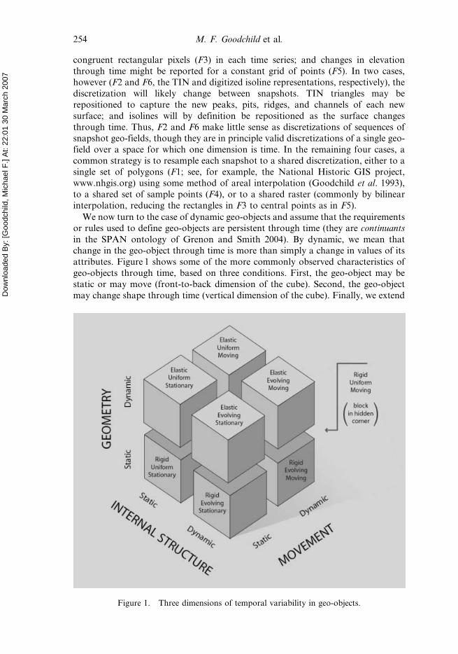
We now turn to the case of dynamic geo-objects and assume that the requirements
or rules used to define geo-objects are persistent through time (they are continuants
in the SPAN ontology of Grenon and Smith 2004). By dynamic, we mean that
change in the geo-object through time is more than simply a change in values of its
attributes. Figure 1 shows some of the more commonly observed characteristics of
geo-objects through time, based on three conditions. First, the geo-object may be
static or may move (front-to-back dimension of the cube). Second, the geo-object
may change shape through time (vertical dimension of the cube). Finally, we extend
Figure 1. Three dimensions of temporal variability in geo-objects.
254 M. F. Goodchild et al.

Dow
nloa
ded
By: [
Goo
dchi
ld, M
icha
el F
.] At
: 22:
01 3
0 M
arch
200
7
the concept of geo-objects to include internal structure, as discussed in section 2.5,
where we introduced the term field object, and in the left-to-right dimension record
whether the object is internally and constantly uniform, or whether it has
heterogeneous and evolving internal structure. A geo-object with attributes that
change through time, but without movement, change in shape, or a changing
internal structure would be assigned to the first category in this taxonomy.
These three sets of conditions produce eight combinations, for which we provideexamples as follows:
N Uniform Stationary Rigid: buildings and streets in a city.
N Uniform Stationary Elastic: the seasonal expansion or contraction of a lake
when only the extent of the lake is considered.
N Uniform Moving Rigid: moving vehicles, and the lifelines through space
created by human life histories.
N Uniform Moving Elastic: a spreading wildfire when only the burn scar is
considered.
N Evolving Stationary Rigid: soils in a watershed and digital elevation models.
N Evolving Stationary Elastic: heat-island effects in an urban area, and
vegetation cover during desertification.
N Evolving Moving Rigid: changing landscapes on moving, rigid tectonic plates.
N Evolving Moving Elastic: oil spills and hurricanes.
Stefanidis et al. (2003) have described the representation of moving, elastic geo-objects as helixes by adapting the image-processing concept of snakes. Assume that
the geo-object is captured in a sequence of snapshots. The movement of the geo-
object’s centre of mass provides a polyline in three dimensions (two horizontal
dimensions plus time), while its rotation and changing shape can be described by
tracking its principal axes.
5. Conclusions
The concepts of discrete objects and continuous fields were introduced into the
GIScience literature in the late 1980s and early 1990s, and have since come to
dominate thinking about human conceptualizations of geographic space. Humans
appear more comfortable describing the world in terms of discrete objects, while
many physical processes are modelled in terms of continuous fields through the
solution of partial differential equations. While some success has been achieved at
integrating the two concepts, and several methods result in transformations betweenthem, many questions remain: are there only two ways of thinking about the world;
and why are they so distinct?
In this paper, we introduced the concept of the geo-atom and showed that it could
provide the foundation for both discrete-object and continuous-field conceptualiza-
tions. Both aggregate the locations that are the first element of the geo-atom tuple.
Geo-fields are formed by aggregating the geo-atoms for a single property, that is, the
second element of the geo-atom tuple; and geo-objects are formed by aggregating
geo-atoms according to rules defined on the third element, the geo-atom’s value.
Since these are the only available elements within the proposed theory, we can infer
that discrete objects and continuous fields are indeed the only possible bases forconceptualization of the geographic world, if such conceptualizations are limited to
aggregations of point sets. We also examined the concept of a field object and
showed that it could be defined as a geo-field whose domain is a geo-object. We
Towards a general theory of geographic representation 255

Dow
nloa
ded
By: [
Goo
dchi
ld, M
icha
el F
.] At
: 22:
01 3
0 M
arch
200
7
introduced the concept of phase space to provide one general theory of how geo-
objects can be derived from geo-fields using rules that can be expressed as partitions
of an m-dimensional space.
Figure 2 summarizes the proposed theory, showing the aggregation of geo-atoms
into geo-fields and geo-objects, and the different implications of dynamics for both.
The three binary dimensions identified in figure 1 lead to the eight cases of dynamic
geo-objects at the lowest level of figure 2.
The theory outlined in this paper is limited by its focus on conceptualizations
based on point sets, and thus on the aggregation of geo-atoms into geo-fields and
geo-objects. The question of whether conceptualizations might be possible based on
Figure 2. Basic elements of the theory, including the possibility of static geo-fields and theeight types of dynamic geo-objects.
256 M. F. Goodchild et al.

Dow
nloa
ded
By: [
Goo
dchi
ld, M
icha
el F
.] At
: 22:
01 3
0 M
arch
200
7
operations other than aggregation remains open but is beyond the scope of this
paper.
The concept of a geo-dipole was introduced, and shown to provide a foundationfor a set of concepts dealing with such properties as distance, direction, interaction,
and flow, including object fields and metamaps. While such concepts clearly play an
important role in our understanding of the processes that dominate the evolution of
social and physical landscapes, to date they have found little support in a GIS
technology that has tended to emphasize aspects of the static form of the Earth’s
surface (Goodchild 2004). One might ask whether properties of locations taken three
at a time (or more generally n.2 at a time) also have practical application.
We argued that relational tables and object-oriented classes implement the results
of two stages of aggregation of geo-atoms. In the case of geo-objects, they are useful
only when such objects can be grouped into classes, and are sufficient in number topopulate them. In the case of geo-fields, they result from a process of discretization
that converts a geo-field into a collection of geo-objects and is unsatisfactory in
several respects. First, it assumes an ability to define a set of geo-objects that
provides an accurate representation of the geo-field. Second, it fails to capture the
behaviours that such geo-objects must exhibit as representations of a geo-field, such
as non-crossing of isolines. Third, it raises problems when dealing with dynamic geo-
fields, as shown in section 4. Finally, by transforming a geo-field into what appears
to be a collection of geo-objects, it fails to prevent the user from performinginappropriate operations. This process of discretization of phenomena that are
essentially continuous on the Earth’s surface remains perhaps the most problematic
area of geographic data modelling in current GIS practice, and one that might
eventually motivate a new approach that is neither relational nor object-oriented.
Acknowledgements
This research is supported by the US National Science Foundation through
Collaborative Awards BCS-0416208 to Yuan, BCS-0416300 to Cova, and BCS-
0417131 to Goodchild. Helpful comments on earlier drafts were provided by three
anonymous referees, and by Kjell Kjenstad, Sven Schade, Jordan Hastings, and
many others.
ReferencesAKIMA, H., 1978, A method of bivariate interpolation and smooth surface fitting for
irregularly distributed data points. ACM Transactions on Mathematical Software, 4,
pp. 148–159.
ARCTUR, D. and ZEILER, M., 2004, Designing Geodatabases: Case Studies in GIS Data
Modeling (Redlands, CA: ESRI Press).
BERRY, B.J.L., 1964, Approaches to regional analysis: a synthesis. Annals of the Association of
American Geographers, 54, pp. 2–11.
BIAN, L., 2000, Object-oriented representation for modelling mobile objects in an aquatic
environment. International Journal of Geographical Information Science, 14, pp.
603–624.
BREUNIG, M., 1996, Integration of Spatial Information for Geo-Information Systems (Berlin:
Springer).
BURROUGH, P.A., and FRANK, A.U. (Eds), 1996, Geographic Objects with Indeterminate
Boundaries (Bristol, PA: Taylor & Francis).
CAMARA, G., MONTERO, A.M.V., PAIVA, J.A., GOMES, J. and VELHO, L., 2000, Towards a
unified framework for geographical data models. Geoinfo 2000: Workshop Brasileiro
de Geoinformatica, Sao Paulo.
Towards a general theory of geographic representation 257

Dow
nloa
ded
By: [
Goo
dchi
ld, M
icha
el F
.] At
: 22:
01 3
0 M
arch
200
7
CAMARA, G., SOUZA, R.C., FREITAS, U.M. and GARRIDO, J.C.P., 1996, SPRING: integrating
remote sensing and GIS with object-oriented data modelling. Computers and Graphics,
15, pp. 13–22.
CODD, E.F., 1970, A relational model of data for large shared data banks. Communications of
the ACM, 13, pp. 377–387.
COUCLELIS, H., 1992, People manipulate objects (but cultivate fields): beyond the raster-
vector debate in GIS. In Theory and Methods of Spatio-Temporal Reasoning in
Geographic Space, A.U. Frank, I. Campari and U. Formentini (Eds), pp. 65–77
(Berlin: Springer).
COUCLELIS, H., 1996, Towards an operational typology of geographical entities with ill-
defined boundaries. In Geographic Objects with Indeterminate Boundaries, P.A.
Burrough and A.U. Frank (Eds), pp. 45–56 (Bristol, PA: Taylor & Francis).
COVA, T.J. and GOODCHILD, M.F., 2002, Extending geographical representation to include
fields of spatial objects. International Journal of Geographical Information Science, 16,
pp. 509–532.
DATE, C.J., 2000, An Introduction to Database Systems, 7th ed (Reading, MA: Addison-
Wesley).
EGENHOFER, M.J. and FRANK, A.U., 1992, Object-oriented modeling for GIS. Journal of the
Urban and Regional Information Systems Association, 4, pp. 3–19.
EGENHOFER, M. and FRANZOSA, R., 1991, Point-set topological spatial relations.
International Journal of Geographical Information Systems, 5, pp. 161–174.
EGENHOFER, M.J., GLASGOW, J., GUNTHER, O., HERRING, J.R. and PEUQUET, D.J., 1999,
Progress in computational methods for representing geographical objects.
International Journal of Geographical Information Science, 13, pp. 775–796.
FISHER, P.F., 1991, First experiments in viewshed uncertainty: the accuracy of the viewshed
area. Photogrammetric Engineering and Remote Sensing, 57, pp. 1321–1327.
FOTHERINGHAM, A.S. and O’KELLY, M.E., 1989, Spatial Interaction Models: Formulations
and Applications (Boston, MA: Kluwer).
GALTON, A.P., 2001, A formal theory of objects and fields. In Spatial Information Theory:
Foundations of Geographic Information Science, D.R. Montello (Ed.), pp. 458–473,
Lecture Notes in Computer Science Vol. 2205 (Berlin: Springer).
GALTON, A.P., 2003, Desiderata for a spatio-temporal geo-ontology. In Spatial Information
Theory: Foundations of Geographic Information Science, W. Kuhn, M.F. Worboys
and S. Timpf (Eds), pp. 1–12, Lecture Notes in Computer Science Vol. 2825 (Berlin:
Springer).
GOODCHILD, M.F., 1989, Modeling error in objects and fields. In Accuracy of Spatial
Databases, M.F. Goodchild and S. Gopal (Eds), pp. 107–14 (Basingstoke: Taylor and
Francis).
GOODCHILD, M.F., 1991, Geographical data modeling. Computers and Geosciences, 18, pp.
400–408.
GOODCHILD, M.F., 1993, The state of GIS for environmental problem solving. In
Environmental Modeling with GIS, M.F. Goodchild, B.O. Parks and L.T. Steyaert
(Eds), pp. 8–15 (New York: Oxford University Press).
GOODCHILD, M.F., 2004, GIScience: geography, form, and process. Annals of the Association
of American Geographers, 94, pp. 709–714.
GOODCHILD, M.F., ANSELIN, L. and DEICHMANN, U., 1993, A framework for the areal
interpolation of socioeconomic data. Environment and Planning A, 25, pp. 383–397.
GOODCHILD, M.F., EGENHOFER, M.J., KEMP, K.K., MARK, D.M. and SHEPPARD, E., 1999,
Introduction to the Varenius project. International Journal of Geographical
Information Science, 13, pp. 731–745.
GOODCHILD, M.F. and WANG, M.-H., 1989, Modeling error for remotely sensed data input to
GIS. Proceedings, AutoCarto 9, pp. 530–537 (Falls Church, VA: ASPRS/ACSM).
GOOVAERTS, P., 1997, Geostatistics for Natural Resources Evaluation (New York: Oxford
University Press).
258 M. F. Goodchild et al.

Dow
nloa
ded
By: [
Goo
dchi
ld, M
icha
el F
.] At
: 22:
01 3
0 M
arch
200
7
GRENON, P. and SMITH, B., 2004, SNAP and SPAN: towards dynamic spatial ontology.
Spatial Cognition and Computation, 4, pp. 69–103.
HAINING, R.P., 2003, Spatial Data Analysis: Theory and Practice (Cambridge: Cambridge
University Press).
HOLDRIDGE, L.R., 1971, Forest Environments in Tropical Life Zones: A Pilot Study (New
York: Pergamon Press).
JOHNSTON, R.J., GREGORY, D., PRATT, G. and WATTS, M., 2000, The Dictionary of Human
Geography, 4th ed (Oxford: Blackwell).
KJENSTAD, K., 2006, On the integration of object-based models and field-based models in
GIS. International Journal of Geographical Information Science, 20, pp. 491–509.
LABORATORY FOR COMPUTER GRAPHICS AND SPATIAL ANALYSIS, 1978, Proceedings of the
First International Advanced Study Symposium on Topological Data Structures for
Geographic Information Systems, Harvard Papers on Geographic Information
Systems Volume 5 (Cambridge, MA: Laboratory for Computer Graphics and
Spatial Analysis).
LANGRAN, G., 1992, Time in Geographic Information Systems (London: Taylor & Francis).
LILLESAND, T.M., KIEFER, R.W. and CHIPMAN, J.W., 2004, Remote Sensing and Image
Interpretation (New York: Wiley).
LONGLEY, P.A., GOODCHILD, M.F., MAGUIRE, D.J. and RHIND, D.W., 2005, Geographic
Information Systems and Science, Second Edition (New York: Wiley).
MARK, D.M. and CSILLAG, F., 1989, The nature of boundaries in ‘area-class’ maps.
Cartographica, 26, pp. 65–78.
MCINTOSH, J. and YUAN, M., 2005, A framework to enhance semantic flexibility for analysis
of distributed phenomena. International Journal of Geographical Information Science,
19, pp. 999–1018.
PEUQUET, D.J., 1988, Representations of geographic space: toward a conceptual synthesis.
Annals of the Association of American Geographers, 78, pp. 375–394.
PEUQUET, D.J., 2002, Representations of Space and Time (New York: Guilford Press).
PEUQUET, D.J., SMITH, B. and BROGAARD, B., 1999, The Ontology of Fields. Report of a
Specialist Meeting Held under the Auspices of the Varenius Project (Santa Barbara,
CA: National Center for Geographic Information and Analysis).
RAPER, J. (Ed.), 1989, Three Dimensional Applications in Geographical Information Systems
(London: Taylor & Francis).
SILVERMAN, B.W., 1998, Density Estimation for Statistics and Data Analysis (Boca Raton, FL:
Chapman & Hall/CRC).
SINTON, D., 1978, The inherent structure of information as a constraint to analysis: mapped
thematic data as a case study. In Harvard Papers on Geographic Information
Systems, G. Dutton (Ed.). Volume 6 (Reading, MA: Addison-Wesley).
SMITH, B. and VARZI, A.C., 2000, Fiat and bona fide boundaries. Philosophy and
Phenomenological Research, 60, pp. 401–420.
STEFANIDIS, A., EICKHORST, K., AGOURIS, P. and PARTSINEVELOS, P., 2003, Modeling and
comparing change using spatiotemporal helixes. In Proceedings, ACM-GIS ’03, E.
Hoel and P. Rigaux (Eds), pp. 86–93 (New Orleans, LA: ACM Press).
TAKEYAMA, M. and COUCLELIS, H., 1997, Map dynamics: integrating cellular automata and
GIS through Geo-Algebra. International Journal of Geographical Information Science,
11, pp. 73–91.
TOBLER, W.R., 1970, A computer movie simulating urban growth in the Detroit Region.
Economic Geography, 46, pp. 234–240.
TOBLER, W.R., 1988, The quadratic transportation problem as a model of spatial interaction
patterns. In Geographical Systems and Systems of Geography: Essays in Honor of
William Warntz, W.J. Coffey (Ed.), pp. 75–88 (London, Ontario: University of
Western Ontario, Department of Geography).
TOMLIN, C.D., 1990, Geographic Information Systems and Cartographic Modeling (Englewood
Cliffs, NJ: Prentice-Hall).
Towards a general theory of geographic representation 259
Dow
nloa
ded
By: [
Goo
dchi
ld, M
icha
el F
.] At
: 22:
01 3
0 M
arch
200
7
TOPPING, B.H.V., MUYLLE, J., PUTANOWICZ, R. and CHENG, B., 2000, Finite Element Mesh
Generation (Edinburgh: Saxe-Coburg).
WINTER, S. and FRANK, A.U., 2000, Topology in raster and vector representation.
GeoInformatica, 4, pp. 35–65.
WORBOYS, M.F., 1995, GIS: A Computing Perspective (Bristol, PA: Taylor & Francis).
YUAN, M., 1999, Representing geographic information to enhance GIS support for complex
spatiotemporal queries. Transactions in GIS, 3, pp. 137–160.
YUAN, M., 2001, Representing complex geographic phenomena with both object- and field-
like properties. Cartography and Geographic Information Science, 28, pp. 83–96.
ZEILER, M., 1999, Modeling Our World: The ESRI Guide to Geodatabase Design (Redlands,
CA: ESRI Press).
260 Towards a general theory of geographic representation