intergraph geospatial portfolio geospatial® geospatial portfolio more than ever before, we can...
TRANSCRIPT

Intergraph®
geospatIalportfolIoG
EO
SP
AT
IAL
intergraph®
geospatialportfolio
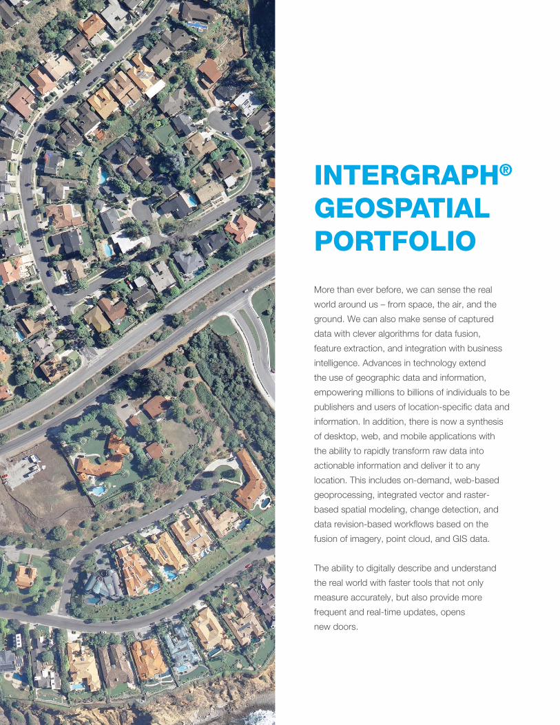
More than ever before, we can sense the real
world around us – from space, the air, and the
ground. We can also make sense of captured
data with clever algorithms for data fusion,
feature extraction, and integration with business
intelligence. Advances in technology extend
the use of geographic data and information,
empowering millions to billions of individuals to be
publishers and users of location-specific data and
information. In addition, there is now a synthesis
of desktop, web, and mobile applications with
the ability to rapidly transform raw data into
actionable information and deliver it to any
location. This includes on-demand, web-based
geoprocessing, integrated vector and raster-
based spatial modeling, change detection, and
data revision-based workflows based on the
fusion of imagery, point cloud, and GIS data.
The ability to digitally describe and understand
the real world with faster tools that not only
measure accurately, but also provide more
frequent and real-time updates, opens
new doors.

3
The exploitation and usage of such data for
personal benefit brings a new era in socializing
geography beyond the traditional geospatial
genres. Intergraph®’s geospatial products exploit
the wealth of content collected from a variety
of sources. The portfolio includes the industry’s
leading desktop GIS, remote sensing, and
photogrammetry software, as well as the synthesis
of these technologies in server-based products
specializing in data management, automated
geoprocessing, spatial data infrastructure,
workflow optimization and web editing, and
web mapping.
GEOMEDIA
ERDASIMAGINE
GEOMEDIASMART CLIENT
GEOMEDIAWEBMAP
ERDASAPOLLO
LPS & IMAGESTATION
GEOSPATIALPORTAL
GEOSPATIALSDI
No product on the market today provides more classification solutions than ERDAS IMAGINE.
Geospatial portfolio overview
4
photoGrammetry Intergraph’s photogrammetry products enable
you to take the first steps to connect imagery
to locations on the earth’s surface and create
accurate representations of the earth from
remotely sensed data.
Production photogrammetry products rapidly
georeference or orthorectify massive volumes
of incoming spatial data so you can create or
update large spatial databases. They are ideal
for commercial photogrammetry or production
mapping customers who need to quickly
deliver large quantities of data.
Project photogrammetry products are ideal
for users who work with smaller quantities of
raw imagery and varied types of data (such
as raster, vector, GIS, and LiDAR), and who
will likely perform further processing, such as
change detection or image classification.
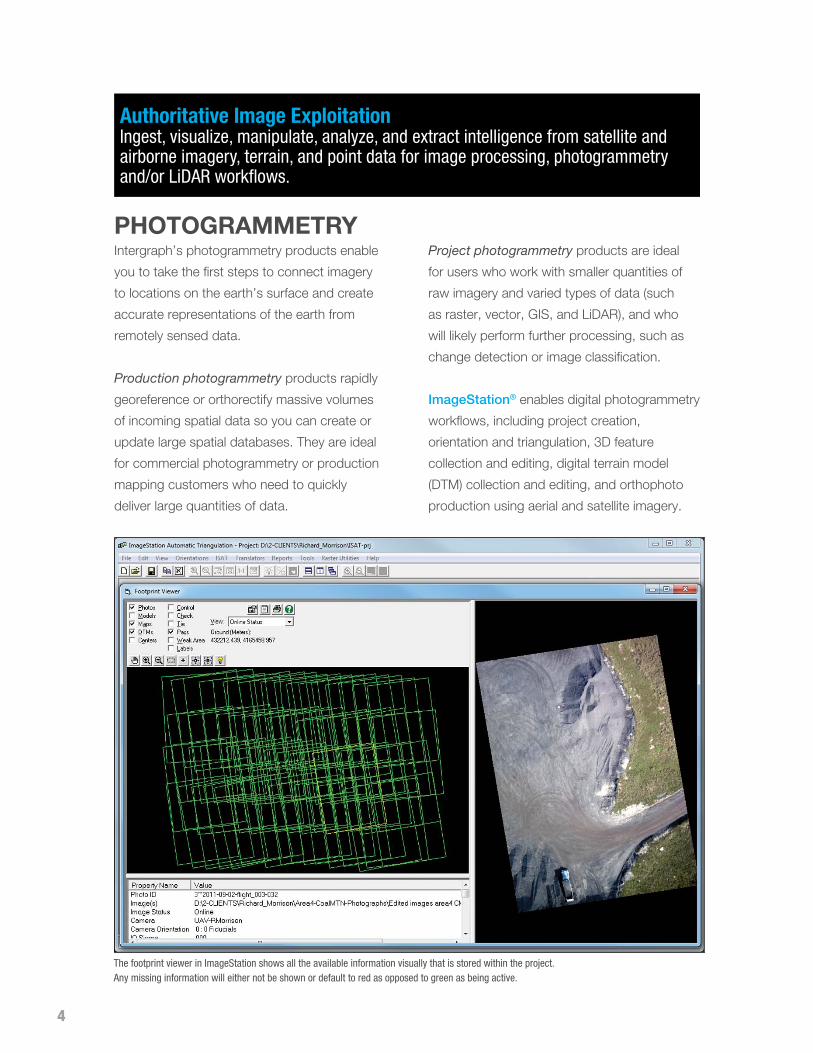
ImageStation® enables digital photogrammetry
workflows, including project creation,
orientation and triangulation, 3D feature
collection and editing, digital terrain model
(DTM) collection and editing, and orthophoto
production using aerial and satellite imagery.
Authoritative Image Exploitation Ingest, visualize, manipulate, analyze, and extract intelligence from satellite and airborne imagery, terrain, and point data for image processing, photogrammetry and/or LiDAR workflows.
The footprint viewer in ImageStation shows all the available information visually that is stored within the project. Any missing information will either not be shown or default to red as opposed to green as being active.
5
It is designed for high-volume commercial
photogrammetry and production mapping
customers who need to move large quantities
of raw spatial information to an actionable or
exploitable format.
ImageStation within the GeoMedia®
context helps mapping professionals create
continuous, topologically accurate, and
attributed map layers stored in a variety of
open formats. This integration enables you
to streamline the process of creating and/
or updating your GIS using photogrammetric
techniques and directly store your data as an
asset within a corporate database.
LPS is a complete suite of photogrammetric
production tools for triangulation, generating
terrain models, producing orthomosaics, and
extracting 3D features. Automating precision
measurement and including flexible operations
such as terrain editing and feature extraction,
LPS increases productivity while ensuring high
accuracy. Integrated with the ERDAS IMAGINE
product suite, it offers a variety of functional
add-on modules. LPS adapts to your specific
business needs, enabling a seamless,
process-driven workflow.
ERDAS Extensions for ArcGIS® are geared
toward stereo viewing and feature collection.
With Stereo Analyst® for ArcGIS, you can
create and revise a comprehensive database
of feature data. Stereo visualization improves
the interpretation of images and allows for
more precise collection leading to greater
accuracy in your resulting layers. Tightly
integrated with ArcGIS, Stereo Analyst,
Feature Assist (for simplified rooftop collection)
and Terrain Editor enable stereo collection
inside a familiar environment.
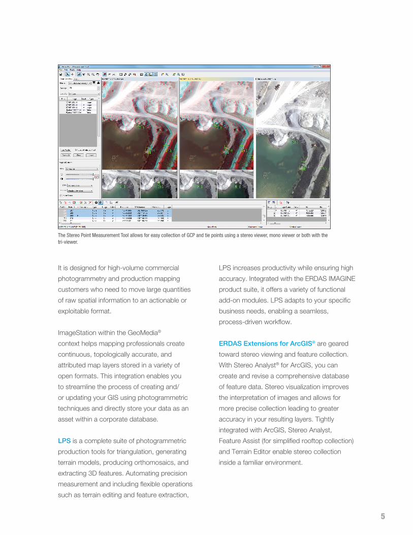
The Stereo Point Measurement Tool allows for easy collection of GCP and tie points using a stereo viewer, mono viewer or both with the tri-viewer.

6
Easily blend a landcover classification into a Color Infrared (CIR image). The vector line represents a planned new corridor.
remote sensinG Intergraph’s remote sensing products enable
you to process data to enhance visibility of
certain image elements and analyze it to extract
information that cannot be detected from visual
inspection alone. These products are useful when
you need to:
•Orthorectify raster imagery
•Detect changes between two or more
raster images
•Analyze imagery using spectral signatures
•Process and analyze radar data
•Classify imagery
•Create presentation products (Microsoft®
Word and PowerPoint® documents) with
your imagery
•Convert files
ERDAS IMAGINE® performs advanced remote
sensing analysis and spatial modeling to create
new information. In addition, with ERDAS
IMAGINE, you can visualize your results in
2D, 3D, movies, and on cartographic-quality
map compositions. The core of the ERDAS
IMAGINE product suite is engineered to scale
with your geospatial data production needs –

7
from IMAGINE Essentials, through IMAGINE
Advantage, and on to IMAGINE Professional.
Optional modules providing specialized
functionalities are also available to enhance your
productivity and capabilities.
• IMAGINE Essentials is the entry-level image
processing product for map creation and
simple feature collection tools.
• IMAGINE Advantage enables advanced
image registration, mosaicking and image
analysis, and change detection capabilities.
• IMAGINE Professional includes a production
toolset for spectral and radar processing, and
spatial modeling.
ERDAS ER Mapper provides advanced image
processing and compression capabilities widely
used in a variety of industries, including oil, gas,
and mineral exploration. ERDAS ER Mapper
allows you to visualize, enhance, and combine
images for a broad array of applications.
Extracting the quantitative information you need,
ERDAS ER Mapper makes your data more
meaningful to solve business problems.
A planned road intersection is linked to a 3D view where the image is draped over LiDAR data.
8
GeoMedia is a powerful GIS management
package that enables you to realize the
maximum value from your geospatial resources,
integrating them to present clear, actionable
information. It provides simultaneous access
to geospatial data in almost any form, uniting
them in a single map view for efficient processing,
analysis, presentation, and sharing. GeoMedia’s
intuitive, dynamic analysis functionality supports
powerful modeling and “what-if” analysis by
concatenating analysis processes. Results of
one operation feed directly into the next process,
and results are updated automatically in response
to data changes.
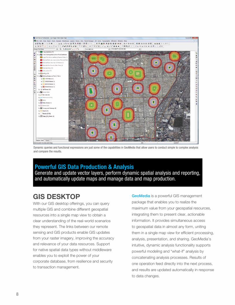
Dynamic queries and functional expressions are just some of the capabilities in GeoMedia that allow users to conduct simple to complex analysis and compare the results.
Gis DesKtopWith our GIS desktop offerings, you can query
multiple GIS and combine different geospatial
resources into a single map view to obtain a
clear understanding of the real-world scenarios
they represent. The links between our remote
sensing and GIS products enable GIS updates
from your raster imagery, improving the accuracy
and relevance of your data resources. Support
for native spatial data types without middleware
enables you to exploit the power of your
corporate database, from resilience and security
to transaction management.
Powerful GIS Data Production & Analysis Generate and update vector layers, perform dynamic spatial analysis and reporting, and automatically update maps and manage data and map production.

9
systems to easily introduce location-based
information into your workflows.
•GeoMedia Essentials provides tools for
querying and analyzing geospatial data. In
addition, IMAGINE Essentials is included for
simple image preparation.
•GeoMedia Advantage provides a full
GIS analytical package with the Essentials
product as well as Geomedia Grid.
•GeoMedia Professional contains
the Advantage product, plus all
feature collection, editing and quality
control functionality.
GeoMedia 3D will ingest a variety of open source and commercial 3D models. Here we have Lucas Oil Stadium, home of Super Bowl XLVI, and the Indianapolis skyline. Models courtesy of Pictometry
GeoMedia’s stable, robust technology is
actively used by organizations throughout
the world. Whether your organization has a
single user or hundreds distributed across the
enterprise, GeoMedia’s flexible architecture
maintains a high degree of performance and
reliably meets your demands. Capitalize on
the coordination between GeoMedia and
ERDAS IMAGINE to create vector layers
based on accurately processed raster
imagery. Based on open standards from the
Open Geospatial Consortium (OGC®) and
International Standards Organization (ISO),
GeoMedia integrates well with other business

10
serverAs the Earth changes and our ability to capture
change expands, organizations have to be agile
and innovative to accommodate the growing
volumes of data. Once data is organized and
managed, you need to get your geographic
information to customers. New business
opportunities exist for delivering the data, along
with information products derived from the
original source. Today, many organizations
need to implement an online strategy and
business model based on the update frequency
of their content, the quality of the data, and the
derivative and increased value extracted by
merging multiple sources of data.
Intergraph’s geospatial server portfolio provides
modern, SOA-based enterprise solutions
satisfying a wide range of customers who
need to manage and deliver geospatial data,
services, and workflows to a variety of desktop,
web, and mobile applications. These solutions
provide the industry’s most advanced and
comprehensive geospatial functionality, with
innovative products to meet mapping users’
needs across all geospatial markets. From
comprehensive data management in ERDAS
APOLLO, to high-performance web-enabled
maps and geoservices in GeoMedia WebMap,
to the optimized geospatial business workflows
of GeoMedia Smart Client, to a standards-
compliant spatial data infrastructure (SDI) in
Geospatial Portal, these scalable offerings are
integrated and support the Dynamic GIS by
offering a complete solution for geo-enabling
your entire enterprise.
ERDAS APOLLO is an enterprise-class data
management, analysis, and delivery solution that
provides remarkable business value. ERDAS
APOLLO is scalable through clustering to meet
your organization’s growing needs. From a
remarkably fast image server to a comprehensive
data management system, ERDAS APOLLO is
the most advanced geospatial enterprise solution,
ensuring unprecedented performance even when
handling the largest data archives.
•ERDAS APOLLO Essentials is a low-cost
image delivery system providing the fastest
image delivery over the web, including
high-performance imagery streaming
protocol ECWP.
•ERDAS APOLLO Advantage enables you
to manage and distribute massive amounts
of data. This includes efficiently cataloging
and quickly sharing data throughout the
enterprise and into any client or application.
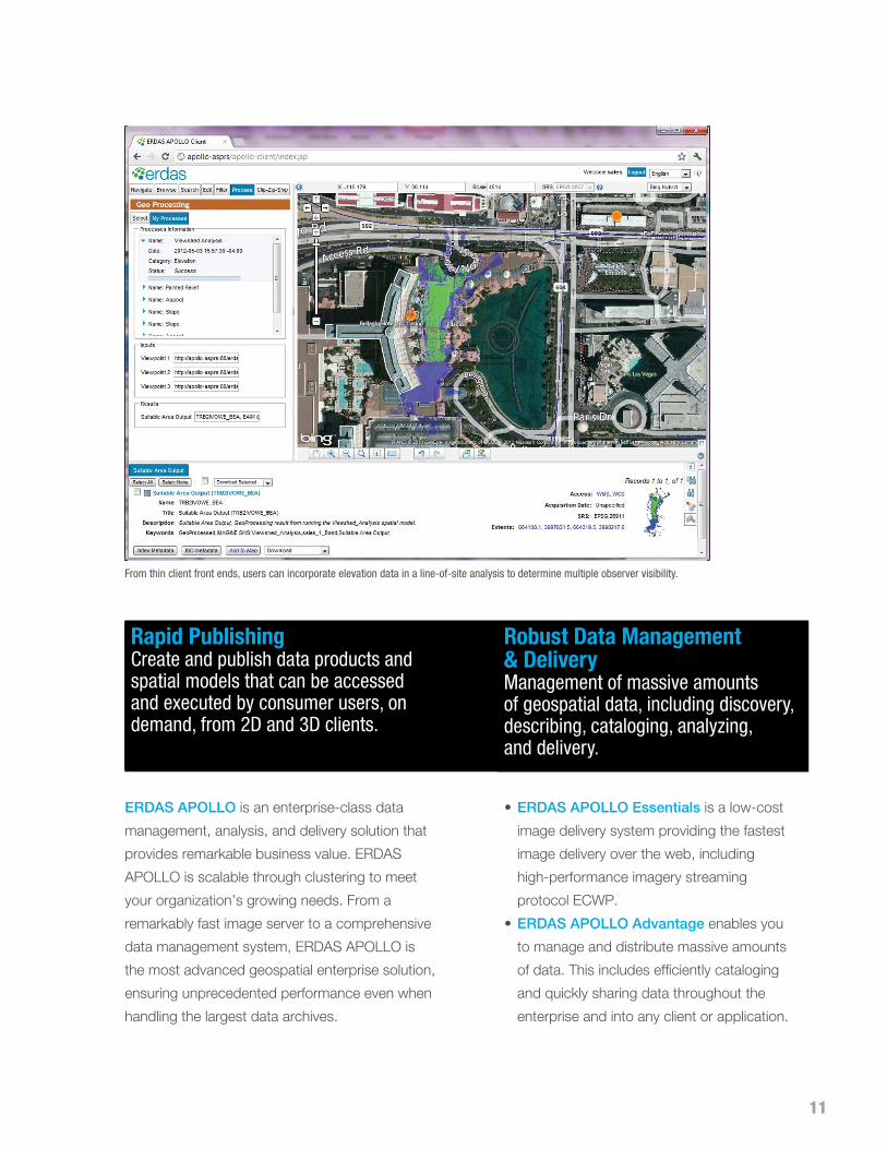
From thin client front ends, users can incorporate elevation data in a line-of-site analysis to determine multiple observer visibility.
Rapid Publishing Create and publish data products and spatial models that can be accessed and executed by consumer users, on demand, from 2D and 3D clients.
Robust Data Management & Delivery Management of massive amounts of geospatial data, including discovery, describing, cataloging, analyzing, and delivery.
11

12
• ERDAS APOLLO Professional provides
interoperable, on-demand geoprocessing
of gridded geospatial data. You can perform
analytics to create, visualize, and extract
geospatial information products from 2D
and 3D clients.
GeoMedia Smart Client makes your
organization progressive, enabling you to
seamlessly integrate geospatial processes into
configurable workflows. Your end users can
leverage advanced geospatial functionality via
simple-to-use, map-based tools, streamlining
their processes and honing their expertise.
These vibrant geospatial business workflows
provide a level of sophistication not supported by
legacy, out-of-the-box software products. With
GeoMedia Smart Client, workflow optimization
and intuitive web editing will be a reality
embraced across your organization.
Geoprocessing outputs are cataloged for discovery by others or immediate download using the Clip, Zip, and Ship workflow.
GeoMedia Smart Client supports the ability to dynamically change the user interface to match user roles or specific workflow steps, across departments and functions.
Dynamic Geoprocessing Execute robust and complex on-the-fly geoprocessing (such as change detection, site analysis, or elevation change) through the OGC Web Processing Service (WPS) implementation.
Web-based Workflow OptimizationUtilize highly configurable workflows leveraging advanced geospatial functionality via intuitive, map-based tools.

13
GeoMedia Smart Client meets the needs of
multi-disciplinary operations, affordably enabling
users in the organization to access and use rich
geospatial data in their business processes.
Instead of using different vendors and tools
to build configurable workflows for each
workgroup within an organization, GeoMedia
Smart Client provides for technology needs
across the enterprise. With GeoMedia Smart
Client, you create a single deployment that
can be configured for an unlimited number of
applications – making it the perfect GIS for a
smarter organization.
•GeoMedia Smart Client Essentials provides
high-end vector redlining functionality and
support for an unlimited number of users to
display raster and vector maps, analyze and
query data, print, and utilize measurement and
dimensioning functions. Advanced client and
server geo-caching is provided for both raster
and vector data, ensuring high performance.
•GeoMedia Smart Client Advantage
contains all of the features and functionality
of the Essentials product, plus the ability to
utilize predefined business process workflows
and edit data. The additional Workflow
Manager - Runtime module enables
customers to run pre-built workflows, edit
attributes or capture and change spatial data
on the web client and push the changes
back to the server database.
•GeoMedia Smart Client Professional
contains all of the features and functionality
of the Advantage product, plus the Workflow
Manager – Editor for developing workflows or
revising the structure, process, and forms of
current ones.
Government and state transportation departments use GeoMedia Smart Client for land planning and management, railway and roadway asset management, and map production.
14
GeoMedia WebMap is a fully scalable server
solution for building and deploying web services
and websites. Using GeoMedia desktop as a
publishing platform, you can easily create high-
performance web applications enabling real-time
enterprise data access and sophisticated
analysis. Available in three tiers, GeoMedia
WebMap can include powerful linear referencing
and analysis capabilities, including routing and
dynamic segmentation web services.
•GeoMedia WebMap Essentials enables
users to publish and manage volumes of
structured geospatial data.
•GeoMedia WebMap Advantage contains all
the features and functionality of the Essentials
product, plus the Geospatial Portal.
•GeoMedia WebMap Professional contains
all the features and functionality of the
Cohesive Geoportal & Geoservices Visualize, share, and exploit accurate geospatial data to collaborate internally with government agencies, commercial businesses, and the public – all while adhering to government mandates to ensure users have access to authoritative data.
Advantage product, as well as the ability to
read and write to data servers and utilize
advanced geoprocessing capabilities such as
linear referencing and routing.
Geospatial Portal is a browser-based web portal
that can be used as a mechanism for finding,
viewing, querying, and analyzing geospatial data
published by Intergraph products and/or other
standard web services. It acts as a client for
web mapping applications, such as city portals,
tourist information or spatial data infrastructure
(SDI) services. Geospatial Portal integrates
multiple data sources into a single map view,
providing easy navigation and interaction. It
provides ISO/OGC compliance and works
with INSPIRE discovery, view, download and
transformation services.
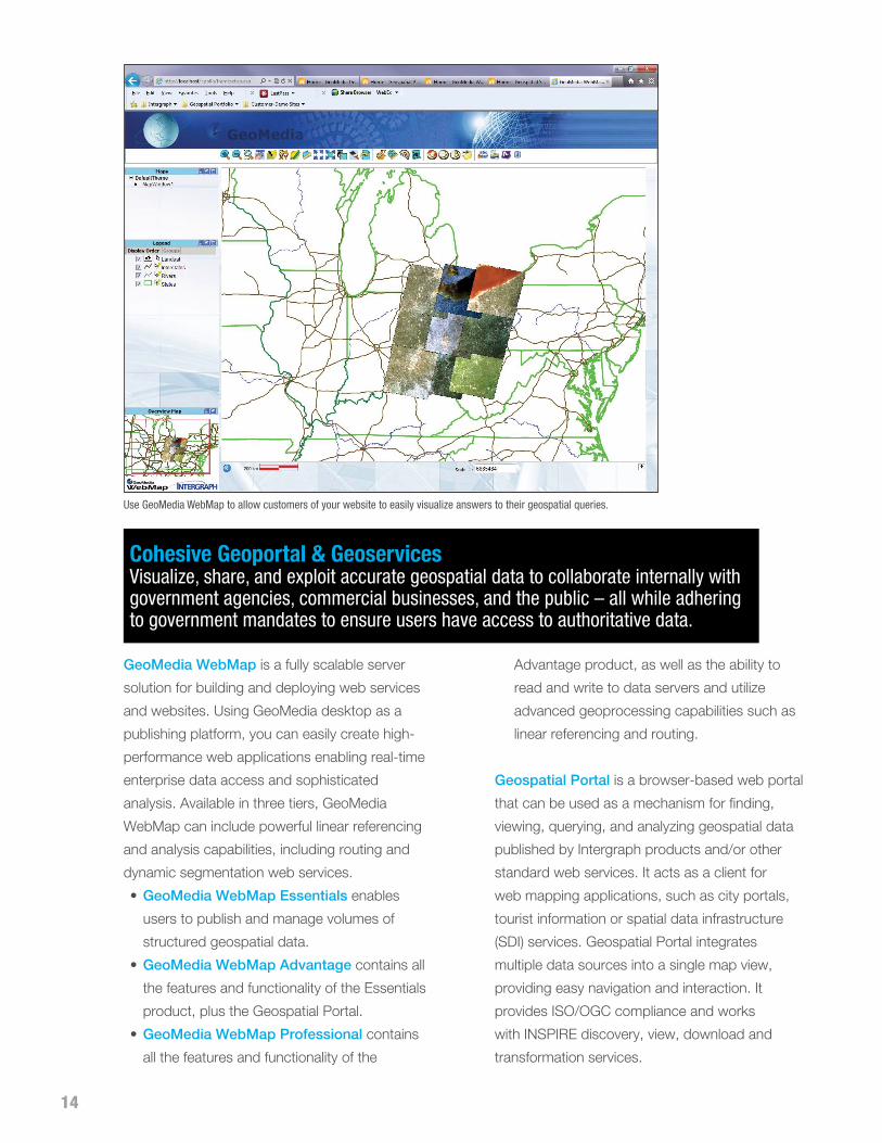
Use GeoMedia WebMap to allow customers of your website to easily visualize answers to their geospatial queries.

15
Geospatial SDI is an interoperable and scalable
spatial data infrastructure for cataloging and
delivering enterprise geospatial data over the
web. Demand for SDI has grown rapidly, driven
by both legislation obliging public bodies to
publish data and by private sector organizations
seeking to increase the use of their existing
data holdings. Ultimately, SDI implementations
provide a mechanism for increased collaboration
with partners and customers, broadening a
potential user base. Geospatial SDI is for data
providers that need to manage and serve secure
or licensed information using standards-based
web services (such as ISO/OGC or INSPIRE).
The product offers a rich set of web services,
extending those offered in GeoMedia WebMap
and ERDAS APOLLO to the full set of services
required of SDI implementations.
why interGraph?As you can see, our portfolio provides
integrated geospatial systems, harnessing the
traditional domains of GIS, remote sensing,
photogrammetry, and mapping with applications
across the enterprise. Sparked by change and
fueled by data and information captured from a
variety of sensing devices, raw source content is
fed through the geospatial information life cycle,
processed with geospatial software, shared
rapidly (and securely), and ultimately delivered
on-demand as reliable and actionable information
to users in the office, field, and across the globe
in real time.
Intergraph’s software addresses needs across
government and transportation, defense and
intelligence, utilities and communications,
and public safety and security organizations.
As change happens, users in these critical
industries can derive real-time information to
protect lives, property, and infrastructure. With
leading technologies, Intergraph has the market
ingredients, coupled with a revolutionary strategy
to fulfill the increasing demands for information
portraying our changing earth.

geospa t ia l . in tergraph.com
Intergraph, the Intergraph logo, Stereo Analyst, ImageStation, GeoMedia, and ERDAS IMAGINE are registered trademarks of Intergraph Corporation or its subsidiaries in the United States and in other countries. Other brands and product names are trademarks of their respective owners. Intergraph believes the information in this publication is accurate as of its publication date. Such information is subject to change without notice.
©2012 Intergraph Corporation 8/12 GEO-US-0024A-ENG