intelligent transport systems (its); cooperative its (c-its); release 1 users and applications...
DESCRIPTION
Intelligent Transport Systems (ITS);Cooperative ITS (C-ITS);Release 1Users and Applications Requirements - Part 2 Applications and Facilities Layer Common Data DictionaryTRANSCRIPT

ETSI TS 102 894-2 V1.1.1 (2013-08)
Intelligent Transport Systems (ITS); Users and applications requirements; Part 2: Applications and facilities layer
common data dictionary
Technical Specification

ETSI
ETSI TS 102 894-2 V1.1.1 (2013-08)2
Reference DTS/ITS-0010022
Keywords application, data, ITS
ETSI
650 Route des Lucioles F-06921 Sophia Antipolis Cedex - FRANCE
Tel.: +33 4 92 94 42 00 Fax: +33 4 93 65 47 16
Siret N° 348 623 562 00017 - NAF 742 C
Association à but non lucratif enregistrée à la Sous-Préfecture de Grasse (06) N° 7803/88
Important notice
Individual copies of the present document can be downloaded from: http://www.etsi.org
The present document may be made available in more than one electronic version or in print. In any case of existing or perceived difference in contents between such versions, the reference version is the Portable Document Format (PDF).
In case of dispute, the reference shall be the printing on ETSI printers of the PDF version kept on a specific network drive within ETSI Secretariat.
Users of the present document should be aware that the document may be subject to revision or change of status. Information on the current status of this and other ETSI documents is available at
http://portal.etsi.org/tb/status/status.asp
If you find errors in the present document, please send your comment to one of the following services: http://portal.etsi.org/chaircor/ETSI_support.asp
Copyright Notification
No part may be reproduced except as authorized by written permission. The copyright and the foregoing restriction extend to reproduction in all media.
© European Telecommunications Standards Institute 2013.
All rights reserved.
DECTTM, PLUGTESTSTM, UMTSTM and the ETSI logo are Trade Marks of ETSI registered for the benefit of its Members. 3GPPTM and LTE™ are Trade Marks of ETSI registered for the benefit of its Members and
of the 3GPP Organizational Partners. GSM® and the GSM logo are Trade Marks registered and owned by the GSM Association.

ETSI
ETSI TS 102 894-2 V1.1.1 (2013-08)3
Contents
Intellectual Property Rights ................................................................................................................................ 7
Foreword ............................................................................................................................................................. 7
Introduction ........................................................................................................................................................ 7
1 Scope ........................................................................................................................................................ 8
2 References ................................................................................................................................................ 8
2.1 Normative references ......................................................................................................................................... 8
2.2 Informative references ........................................................................................................................................ 8
3 Definitions and abbreviations ................................................................................................................... 9
3.1 Definitions .......................................................................................................................................................... 9
3.2 Abbreviations ..................................................................................................................................................... 9
4 ITS data dictionary structure .................................................................................................................. 10
4.1 Attributes for DE/DF identification .................................................................................................................. 10
4.1.1 Descriptive name ........................................................................................................................................ 10
4.1.2 Identifier ..................................................................................................................................................... 10
4.1.3 ASN.1 representation .................................................................................................................................. 10
4.2 Attributes for DE/DF definition ....................................................................................................................... 10
4.2.1 Definition .................................................................................................................................................... 10
4.2.2 Category ...................................................................................................................................................... 11
4.2.3 Unit ............................................................................................................................................................. 11
4.2.4 Last modification date ................................................................................................................................ 11
Annex A (normative): Data type specifications ................................................................................. 12
A.1 AccelerationConfidence ......................................................................................................................... 12
A.2 AccelerationControl ............................................................................................................................... 13
A.3 AccidentSubCauseCode ......................................................................................................................... 14
A.4 AdverseWeatherCondition-AdhesionSubCauseCode ............................................................................ 15
A.5 AdverseWeatherCondition-ExtremeWeatherConditionSubCauseCode ................................................ 16
A.6 AdverseWeatherCondition-PrecipitationSubCauseCode ....................................................................... 16
A.7 AdverseWeatherCondition-VisibilitySubCauseCode ............................................................................ 17
A.8 CauseCode .............................................................................................................................................. 17
A.9 ClosedLanes ........................................................................................................................................... 18
A.10 CauseCodeType ..................................................................................................................................... 18
A.11 CollisionRiskSubCauseCode.................................................................................................................. 20
A.12 Curvature ................................................................................................................................................ 20
A.13 CurvatureConfidence.............................................................................................................................. 21
A.14 CurvatureCalculationMode .................................................................................................................... 21
A.15 CurvatureValue ...................................................................................................................................... 22
A.16 DangerousEndOfQueueSubCauseCode ................................................................................................. 22
A.17 DangerousGoodsBasic ........................................................................................................................... 23
A.18 DangerousGoodsExtended ..................................................................................................................... 24
A.19 DangerousSituationSubCauseCode ........................................................................................................ 25

ETSI
ETSI TS 102 894-2 V1.1.1 (2013-08)4
A.20 DeltaAltitude .......................................................................................................................................... 25
A.21 DeltaLatitude .......................................................................................................................................... 26
A.22 DeltaLongitude ....................................................................................................................................... 26
A.23 DeltaReferencePosition .......................................................................................................................... 27
A.24 Heading .................................................................................................................................................. 27
A.25 HeadingConfidence ................................................................................................................................ 28
A.26 HeadingValue ......................................................................................................................................... 28
A.27 DriveDirection ........................................................................................................................................ 28
A.28 DrivingLaneStatus .................................................................................................................................. 29
A.29 Altitude ................................................................................................................................................... 29
A.30 AltitudeConfidence ................................................................................................................................ 30
A.31 AltitudeValue ......................................................................................................................................... 31
A.32 EmbarkationStatus ................................................................................................................................. 31
A.33 EmergencyPriority ................................................................................................................................. 31
A.34 EmergencyVehicleApproachingSubCauseCode .................................................................................... 32
A.35 EnergyStorageType ................................................................................................................................ 32
A.36 ExteriorLights ......................................................................................................................................... 33
A.37 HardShoulderStatus ................................................................................................................................ 33
A.38 HazardousLocation-AnimalOnTheRoadSubCauseCode........................................................................ 34
A.39 HazardousLocation-DangerousCurveSubCauseCode ............................................................................ 35
A.40 HazardousLocation-ObstacleOnTheRoadSubCauseCode ..................................................................... 36
A.41 HazardousLocation-SurfaceConditionSubCauseCode ........................................................................... 37
A.42 HeightLonCarr ....................................................................................................................................... 37
A.43 HumanPresenceOnTheRoadSubCauseCode .......................................................................................... 38
A.44 HumanProblemSubCauseCode .............................................................................................................. 38
A.45 InformationQuality ................................................................................................................................. 39
A.46 ItsPduHeader .......................................................................................................................................... 39
A.47 LaneNumber ........................................................................................................................................... 40
A.48 Latitude ................................................................................................................................................... 40
A.49 LateralAcceleration ................................................................................................................................ 40
A.50 LateralAccelerationValue ....................................................................................................................... 41
A.51 LightBarSireneInUse .............................................................................................................................. 41
A.52 Longitude ............................................................................................................................................... 42
A.53 LongitudinalAcceleration ....................................................................................................................... 42
A.54 LongitudinalAccelerationValue ............................................................................................................. 42
A.55 TrafficRule ............................................................................................................................................. 43
A.56 PathDeltaTime ........................................................................................................................................ 43
A.57 PathHistory ............................................................................................................................................. 43

ETSI
ETSI TS 102 894-2 V1.1.1 (2013-08)5
A.58 PathPoint ................................................................................................................................................ 44
A.59 PerformanceClass ................................................................................................................................... 44
A.60 PosCentMass .......................................................................................................................................... 45
A.61 PosConfidenceEllipse ............................................................................................................................. 45
A.62 PositioningSolutionType ........................................................................................................................ 46
A.63 PositionOfOccupants .............................................................................................................................. 47
A.64 PosFrontAx ............................................................................................................................................. 48
A.65 PosLonCarr ............................................................................................................................................. 48
A.66 PosPillar ................................................................................................................................................. 48
A.67 PostCrashSubCauseCode ....................................................................................................................... 49
A.68 PtActivation ............................................................................................................................................ 50
A.69 PtActivationData .................................................................................................................................... 50
A.70 PtActivationType ................................................................................................................................... 51
A.71 ReferencePosition ................................................................................................................................... 51
A.72 RequestResponseIndication .................................................................................................................... 52
A.73 RescueAndRecoveryWorkInProgressSubCauseCode ............................................................................ 52
A.74 RoadType ............................................................................................................................................... 53
A.75 RoadworksSubCauseCode ..................................................................................................................... 53
A.76 SemiAxisLength ..................................................................................................................................... 54
A.77 SignalViolationSubCauseCode .............................................................................................................. 54
A.78 SlowVehicleSubCauseCode ................................................................................................................... 55
A.79 SpecialTransportType ............................................................................................................................ 55
A.80 Speed ...................................................................................................................................................... 56
A.81 SpeedConfidence .................................................................................................................................... 56
A.82 SpeedLimit ............................................................................................................................................. 56
A.83 SpeedValue ............................................................................................................................................. 57
A.84 StationarySince ....................................................................................................................................... 57
A.85 StationaryVehicleSubCauseCode ........................................................................................................... 58
A.86 StationID ................................................................................................................................................ 58
A.87 StationType ............................................................................................................................................ 59
A.88 SteeringWheelAngle .............................................................................................................................. 59
A.89 SteeringWheelAngleConfidence ............................................................................................................ 59
A.90 SteeringWheelAngleValue ..................................................................................................................... 60
A.91 SubCauseCodeType ............................................................................................................................... 60
A.92 TimestampIts .......................................................................................................................................... 61
A.93 Temperature ........................................................................................................................................... 61
A.94 TrafficConditionSubCauseCode ............................................................................................................ 62
A.95 TurningRadius ........................................................................................................................................ 62

ETSI
ETSI TS 102 894-2 V1.1.1 (2013-08)6
A.96 VDS ........................................................................................................................................................ 63
A.97 VehicleBreakdownSubCauseCode ......................................................................................................... 63
A.98 VehicleIdentification .............................................................................................................................. 64
A.99 VehicleLength ........................................................................................................................................ 64
A.100 VehicleLengthConfidenceIndication ...................................................................................................... 64
A.101 VehicleLengthValue ............................................................................................................................... 65
A.102 VehicleMass ........................................................................................................................................... 65
A.103 VehicleRole ............................................................................................................................................ 65
A.104 VehicleWidth ......................................................................................................................................... 66
A.105 VerticalAcceleration ............................................................................................................................... 66
A.106 VerticalAccelerationValue ..................................................................................................................... 66
A.107 WheelBaseVehicle ................................................................................................................................. 67
A.108 WMInumber ........................................................................................................................................... 67
A.109 WrongWayDrivingSubCauseCode ........................................................................................................ 67
A.110 YawRate ................................................................................................................................................. 68
A.111 YawRateConfidence ............................................................................................................................... 68
A.112 YawRateValue ....................................................................................................................................... 69
Annex B (normative): ASN.1 module of the common data dictionary ........................................... 70
Annex C (informative): Bibliography ................................................................................................... 77
History .............................................................................................................................................................. 78

ETSI
ETSI TS 102 894-2 V1.1.1 (2013-08)7
Intellectual Property Rights IPRs essential or potentially essential to the present document may have been declared to ETSI. The information pertaining to these essential IPRs, if any, is publicly available for ETSI members and non-members, and can be found in ETSI SR 000 314: "Intellectual Property Rights (IPRs); Essential, or potentially Essential, IPRs notified to ETSI in respect of ETSI standards", which is available from the ETSI Secretariat. Latest updates are available on the ETSI Web server (http://ipr.etsi.org).
Pursuant to the ETSI IPR Policy, no investigation, including IPR searches, has been carried out by ETSI. No guarantee can be given as to the existence of other IPRs not referenced in ETSI SR 000 314 (or the updates on the ETSI Web server) which are, or may be, or may become, essential to the present document.
Foreword This Technical Specification (TS) has been produced by ETSI Technical Committee Intelligent Transport Systems (ITS).
The present document is part 2 of a multi-part deliverable covering the Intelligent Transport Systems (ITS); Users and applications requirements, as identified below:
Part 1: "Facility layer structure, functional requirements and specifications";
Part 2: "Applications and facilities layer common data dictionary".
The specifications of data elements of the facilities layer messages have been tested within various European Projects such as DRIVE C2X, CVIS, SCORE@F, simTD and ETSI Interoperability Test events. Feedbacks from these testing activities have been considered in the present document. The specifications in the present document have also been checked and harmonized with common data dictionary specifications as specified by SAE International.
Introduction ITS applications are enabled by the data exchanges among ITS stations (ITS-S) via wireless or wired communications. A basic set of application [i.1] has been defined by ETSI TC ITS. Accordingly, a set of higher layer messages and communication protocols have been specified in support of this application set.
Even though each message has specific requirements on the data being included and transmitted to other ITS-Ss, ETSI TC ITS has identified a set of data types which are commonly used in multiple ITS applications and facilities layer messages. A common data dictionary is therefore defined for this common set.
For each data type, this common dictionary includes a textual description of the semantic of the data type in question. It also includes the ASN.1 definition of the data type. Therefore, this common data dictionary can be imported by any message when necessary during the encoding and decoding procedure.

ETSI
ETSI TS 102 894-2 V1.1.1 (2013-08)8
1 Scope The present document defines a repository of a set of data elements and data element sets that are commonly used in the ITS applications and facilities layer messages. Each data element is defined with a set of attributes, enabling the identification of the data element in question in a number of perspectives, e.g. descriptive name, ASN.1 definition, data definition, minimum data granularity requirement, etc.
The present document focuses on the data elements being used by the Cooperative Awareness basic service [i.2] and Decentralized Environmental Notification basic service [i.3]. Further data elements are expected to be added in the future to support other application and facilities layer messages or functions.
The present document does not specify the syntax and requirements of data elements in the specific context of any message. Such syntax and requirements are specified in the corresponding message standards such as [i.2] and [i.3].
2 References References are either specific (identified by date of publication and/or edition number or version number) or non-specific. For specific references, only the cited version applies. For non-specific references, the latest version of the referenced document (including any amendments) applies.
Referenced documents which are not found to be publicly available in the expected location might be found at http://docbox.etsi.org/Reference
NOTE: While any hyperlinks included in this clause were valid at the time of publication, ETSI cannot guarantee their long term validity.
2.1 Normative references The following referenced documents are necessary for the application of the present document.
[1] Recommendation ITU-T X.680: "Information technology - Abstract Syntax Notation One (ASN.1): Specification of basic notation".
[2] SAE J670: "Vehicle Dynamics Terminology", January 2008.
2.2 Informative references The following referenced documents are not necessary for the application of the present document but they assist the user with regard to a particular subject area.
[i.1] ETSI TR 102 638 (V1.1.1): "Intelligent Transport Systems (ITS); Vehicular Communications; Basic Set of Applications; Definitions".
[i.2] ETSI EN 302 637-2: "Intelligent Transport Systems (ITS); Vehicular Communications; Basic Set of Applications; Part 2: Specification of Cooperative Awareness Basic Service".
[i.3] ETSI EN 302 637-3: "Intelligent Transport Systems (ITS); Vehicular Communications; Basic Set of Applications; Part 3: Specifications of Decentralized Environmental Notification Basic Service".
[i.4] European Agreement (Applicable as from 1 January 2011): "Concerning the International Carriage of Dangerous Goods by Road".
NOTE: Available at: http://www.unece.org/trans/danger/publi/adr/adr2011/11ContentsE.html.
[i.5] United Nations: "Recommendations on the Transport of Dangerous Goods - Model Regulations", Twelfth revised edition.
NOTE: Available at: http://www.unece.org/trans/danger/publi/unrec/12_e.html.

ETSI
ETSI TS 102 894-2 V1.1.1 (2013-08)9
[i.6] ETSI TS 101 539-1 (V1.1.1): "Intelligent Transport Systems (ITS); V2X Applications; Part 1: Road Hazard Signalling (RHS) application requirements specification".
[i.7] ISO 3779 (2011-07): "Road vehicles ― Vehicle identification number (VIN) Content and structure".
[i.8] VDV recommendation 420 (1992): "Technical Requirements for Automatic Vehicle Location / Control Systems - Radio Data Transmission (BON Version) with Supplement 1 and Supplement 2".
3 Definitions and abbreviations
3.1 Definitions For the purposes of the present document, the following terms and definitions apply:
data element: data type that contains one single data
data frame: data type that contains more than one data element in a predefined order
ITS data dictionary: repository of data elements and data frames used in the ITS applications and ITS facilities layer
ITS messages: messages exchanged at ITS facilities layer among ITS stations or messages exchanged at ITS applications layer among ITS stations
3.2 Abbreviations For the purposes of the present document, the following abbreviations apply:
ABS Anti-lock Braking System ACC Adaptive Cruise Control AEB Autonomous Emergency Braking ASN.1 Abstract Syntax Notation One CAM Cooperative Awareness Message DE Data Element DENM Decentralized Environmental Notification Message DF Data Frame DR Dead Reckoning ESP Electronic Stability Program GNSS Global Navigation Satellite System ITS-S ITS Station LDM Local Dynamic Map OEM Original Equipment Manufacturer SAE Society of Automotive Engineers TC Technical Committee VDS Vehicle Descriptor Section WGS84 World Geodetic System 84 WMI World Manufacturer Identifier

ETSI
ETSI TS 102 894-2 V1.1.1 (2013-08)10
4 ITS data dictionary structure The ITS data dictionary is a repository that includes a list of data elements (DE) and data frames (DF) that represent data/information necessary for the realization of ITS applications and ITS facilities.
A DE/DF may be used to construct ITS facilities layer or ITS applications layer messages, if needs are identified by the message in question. Examples of ITS facilities layer message are Cooperative Awareness Message (CAM) as specified in [i.2] and Decentralized Environmental Notification Message (DENM) as specified in [i.3]. These messages are named as ITS messages in the scope of the present document.
According to the usage purpose, a DE or a DF can be classified into the following categories:
• Message management: the DE/DF is used to support the management of an ITS facilities layer or ITS application layer message and communication protocol, e.g. protocol version.
• Application usage: the DE/DF includes information and data that are useful for the realization of one or multiple ITS applications.
The present document includes DE and DF definitions for the Cooperative Awareness Message (CAM) as given in [i.2] and Decentralized Environmental Notification Message (DENM) as given in [i.3].
The complete list of DE and DF is provided in the normative annex A of the present document.
Each DE and DF is defined by a set of attributes, enabling the identification of the data in question. These attributes are defined in clauses 4.1 and 4.2.
4.1 Attributes for DE/DF identification
4.1.1 Descriptive name
This attribute provides a descriptive name of the DE or DF. The descriptive name shall be identical as being used in the messages specifications such as [i.2] and [i.3]. It shall also be unique within the common data dictionary. Furthermore, the descriptive name may be used in other ITS applications and facilities layer components, e.g. LDM.
4.1.2 Identifier
This attribute provides a unique identifier of the defined DE or DF. It always starts with the term "DataType" followed by a sequence number as unique identifier. In the present document a three digits sequence number is used. Its length may be extended in the future.
NOTE: The identifier of a DataType is applicable within the present document, it may also be referenced in other standards.
4.1.3 ASN.1 representation
This attribute provide the ASN.1 representation of the defined DE or DF. The ASN.1 definition shall follow the specifications as defined in [1]. The ASN.1 type name shall be identical to the descriptive name.
4.2 Attributes for DE/DF definition
4.2.1 Definition
This attribute provides a textual explication of the defined DE or DF.

ETSI
ETSI TS 102 894-2 V1.1.1 (2013-08)11
4.2.2 Category
This attribute indicates the category that DE or DF in question belongs to. Currently, the following categories are defined:
• Vehicle information: the DE or DF describes one or a set of in vehicle data.
• GeoReference information: the DE or DF provides geographical description of the data.
• Road topology information: the DE or DF describes one or a set of road topology information.
• Traffic information: the DE or DF describes one or a set of road traffic information.
• Infrastructure information: the DE or DF describes one or a set of ITS infrastructure information.
• Personal information: the DE or DF describes one or a set of ITS personal information.
• Communication information: the DE or DF describes one or a set of data that are relevant to the ITS application layer or ITS facilities layer communication protocol.
• Other information: the DE or DF that does not belong to any of the above categories.
A DE or DF shall belong to at least one of the above categories. One DE or DF may belong to more than one category. It is expected that more categories will be added in the future.
4.2.3 Unit
The applied unit for the data, if necessary.
4.2.4 Last modification date
The date at which the latest modification is done for the DE and DF in the format of yy-mm-dd.

ETSI
ETSI TS 102 894-2 V1.1.1 (2013-08)12
Annex A (normative): Data type specifications
A.1 AccelerationConfidence Descriptive Name AccelerationConfidence
Identifier DataType_001
ASN.1 representation AccelerationConfidence ::= INTEGER { pointOneMeterPerSecSquared(1),
outOfRange(101), unavailable(102)} (0 .. 102)
Definition The absolute accuracy of a reported vehicle acceleration value with a predefined confidence level (e.g. 95 %). It may apply to LongitudinalAccelerationValue as defined in clause A.54, LateralAccelerationValue as defined in clause A.50 or VerticalAccelerationValue as defined in clause A.106. For accuracy equal or worse than 10,1 m/s2, the value shall be set to 101. The data shall be set to 102 if the data is unavailable.
Unit 0,1 m/s2
Category Vehicle information
Modification date 2012-10-15

ETSI
ETSI TS 102 894-2 V1.1.1 (2013-08)13
A.2 AccelerationControl Descriptive Name AccelerationControl
Identifier DataType_002
ASN.1 representation
AccelerationControl ::= BIT STRING { brakePedalEngaged (0), gasPedalEngaged (1), emergencyBrakeEngaged (2), collisionWarningEngaged (3), accEngaged (4), cruiseControlEngaged (5), speedLimiterEngaged (6) } (SIZE(7))
Definition Current controlling mechanism for longitudinal movement of the vehicle. The data may be provided via the in vehicle network. It indicates whether a specific in vehicle acceleration control system is engaged or not. Currently, this DE includes the information of the vehicle brake pedal, gas pedal, emergency brake system, collision warning system, autonomous cruise control system, cruise control system and speed limiter system. The corresponding bit shall be set to 1 under the following conditions:
• brakePedalEngaged(0): Driver is stepping on the brake pedal • gasPedalEngaged(1): Driver is stepping on the gas pedal • emergencyBrakeEngagegd(2): emergency brake system is engaged
NOTE: the system engagement condition is OEM specific • collisionWarningEngaged(3): collision warning system is engaged
NOTE: the system engagement condition is OEM specific • accEngagged(4): ACC is engaged • cruiseControlEngaged(5): cruiseControl is engaged • speedLimiterEngaged(6): speed limiter is engaged
Otherwise (for example when the corresponding system is not available due to non- equipped system or information is unavailable), the corresponding bit shall be set to 0.
Unit N/A
Category Vehicle information
Modification date 2013-06-27

ETSI
ETSI TS 102 894-2 V1.1.1 (2013-08)14
A.3 AccidentSubCauseCode Descriptive Name AccidentSubCauseCode
Identifier DataType_003
ASN.1 representation AccidentSubCauseCode ::= INTEGER {unavailable(0),
multiVehicleAccident(1), heavyAccident(2), accidentInvolvingLorry(3), accidentInvolvingBus(4), accidentInvolvingHazardousMaterials(5), accidentOnOppositeLane(6), unsecuredAccident(7), assistanceRequested(8) } (0..255)
Definition Encoded value of the sub cause codes of the event type "accident" as defined in clause A.10. Sub event cause and value setting rule is defined according to clause 7.1.3 of EN 302 637-3 [i.3]. The sub causes are described as following:
• unavailable(0): in case the information on the sub cause of the accident is unavailable,
• multiVehicleAccident(1): in case more than two vehicles are involved in accident,
• heavyAccident(2): in case the airbag of the vehicle involving is accident is triggered, and accident requires important rescue and recovery work,
• accidentInvolvingLorry(3): in case the accident involves a lorry, • accidentInvolvingBus(4): in case the accident involves a bus, • accidentInvolvingHazardousMaterials(5): in case the accident involves
hazardous material, • accidentOnOppositeLane(6): in case the accident happens on opposite lanes
of the transmitting vehicle, • unsecuredAccident(7): in case the accident is not secured, • assistanceRequested(8): in case the rescue and assistance request is
already sent. Additional sub cause codes may be added in the future.
Unit N/A
Category Traffic information
Modification date 2013-03-25

ETSI
ETSI TS 102 894-2 V1.1.1 (2013-08)15
A.4 AdverseWeatherCondition-AdhesionSubCauseCode Descriptive Name AdverseWeatherCondition-AdhesionSubCauseCode
Identifier DataType_004
ASN.1 representation AdverseWeatherCondition-AdhesionSubCauseCode ::= INTEGER
{unavailable(0), heavyFrostOnRoad(1), fuelOnRoad(2), mudOnRoad(3), snowOnRoad(4), iceOnRoad(5), blackIceOnRoad(6), oilOnRoad(7), looseChippings(8), instantBlackIce(9), roadsSalted(10) } (0..255)
Definition Encoded value of the sub cause codes of the event type "adverseWeatherCondition-Adhesion" as specified in clause A.10. Definition of the sub event cause is defined and the value is assigned according to clause 7.1.3 of EN 302 637-3 [i.3]. The sub causes are described as following:
• unavailable(0): in case information on the cause of the low road adhesion is unavailable,
• heavyFrostOnRoad(1): in case the low road adhesion is due to heavy frost on the road,
• fuelOnRoad(2): in case the low road adhesion is due to fuel on the road, • mudOnRoad(3): in case the low road adhesion is due to mud on the road, • snowOnRoad(4): in case the low road adhesion is due to snow on the road, • iceOnRoad(5): in case the low road adhesion is due to ice on the road, • blackIceOnRoad(6): in case the low road adhesion is due to black ice on the
road, • oilOnRoad(7): in case the low road adhesion is due to oil on the road, • looseChippings(8): in case the low road adhesion is due to loose gravel or
stone fragments which have become detached from a road surface or form a hazard,
• instantBlackIce(9): in case the low road adhesion is due to instant black ice on the road surface,
• roadsSalted(10): when the low road adhesion is due to salted road. Additional sub cause codes may be added in the future.
Unit N/A
Category Traffic information
Modification date 2013-03-12

ETSI
ETSI TS 102 894-2 V1.1.1 (2013-08)16
A.5 AdverseWeatherCondition-ExtremeWeatherConditionSubCauseCode
Descriptive Name AdverseWeatherCondition-ExtremeWeatherConditionSubCauseCode
Identifier DataType_005
ASN.1 representation AdverseWeatherCondition-ExtremeWeatherConditionSubCauseCode ::= INTEGER {unavailable(0), strongWinds(1), damagingHail(2), hurricane(3), thunderstorm(4), tornado(5), blizzard(6) } (0..255)
Definition Encoded value of the sub cause codes of the event type "adverseWeatherCondition-ExtremeWeatherCondition" as specified in clause A.10. Definition of the sub event cause is defined and the value is assigned according to clause 7.1.3 of EN 302 637-3 [i.3]. The sub causes are described as following:
• unavailable(0): in case information on the type of extreme weather condition is unavailable,
• strongWinds(1): in case the type of extreme weather condition is strong wind, • damagingHail(2): in case the type of extreme weather condition is damaging
hail, • hurricane(3): in case the type of extreme weather condition is hurricane, • thunderstorm(4): in case the type of extreme weather condition is
thunderstorm, • tornado(5): in case the type of extreme weather condition is tornado, • blizzard(6): in case the type of extreme weather condition is blizzard.
Additional sub cause codes may be added in the future.
Unit N/A
Category Traffic information
Modification date 2013-03-25
A.6 AdverseWeatherCondition-PrecipitationSubCauseCode
Descriptive Name AdverseWeatherCondition-PrecipitationSubCauseCode
Identifier DataType_006
ASN.1 representation AdverseWeatherCondition-PrecipitationSubCauseCode ::= INTEGER {unavailable(0), heavyRain(1), heavySnowfall(2), softHail(3) } (0..255)
Definition Encoded value of the sub cause codes of the event type "adverseWeatherCondition-Precipitation" as specified in clause A.10. Definition of the sub event cause is defined and the value is assigned according to clause 7.1.3 of EN 302 637-3 [i.3]. The sub causes are described as following:
• unavailable(0): in case information on the type of precipitation is unavailable, • heavyRain(1): in case the type of precipitation is heavy rain, • heavySnowfall(2): in case the type of precipitation is heavy snow fall, • softHail(3): in case the type of precipitation is soft hail.
Additional sub cause codes may be added in the future.
Unit N/A
Category Traffic information
Modification date 2013-03-26

ETSI
ETSI TS 102 894-2 V1.1.1 (2013-08)17
A.7 AdverseWeatherCondition-VisibilitySubCauseCode Descriptive Name AdverseWeatherCondition-VisibilitySubCauseCode
Identifier DataType_007
ASN.1 representation AdverseWeatherCondition-VisibilitySubCauseCode ::= INTEGER
{unavailable(0), fog(1), smoke(2), heavySnowfall(3), heavyRain(4), heavyHail(5), lowSunGlare(6), sandstorms(7), swarmsOfInsects(8) } (0..255)
Definition Encoded value of the sub cause codes of the event type "adverseWeatherCondition-Visibility" as specified in clause A.10. Definition of the sub event cause is defined and the value is assigned according to clause 7.1.3 of EN 302 637-3 [i.3]. The sub causes are described as following:
• unavailable(0): in case information on the cause of low visibility is unavailable, • fog(1): in case the cause of low visibility is fog, • smoke(2): in case the cause of low visibility is smoke, • heavySnowfall(3): in case the cause of low visibility is heavy snow fall, • heavyRain(4): in case the cause of low visibility is heavy rain, • heavyHail(5): in case the cause of low visibility is heavy hail, • lowSunGlare(6): in case the cause of low visibility is sun glare, • sandstorms(7): in case the cause of low visibility is sand storm, • swarmsOfInsects(8): in case the cause of low visibility is swarm of insects.
Additional sub cause codes may be added in the future.
Unit N/A
Category Traffic information
Modification date 2013-03-26
A.8 CauseCode Descriptive Name CauseCode
Identifier DataType_008
ASN.1 representation CauseCode ::= SEQUENCE {
causeCode CauseCodeType, subCauseCode SubCauseCodeType }
Definition Encoded value of a travel event type. It shall provide the type of a direct cause (causeCodeType as defined in clause A.10) and sub type of the direct cause code (subCauseCodeType as defined in clause A.91). The value setting is defined in clause 7.1.3 of EN 302 637-3 [i.3].
Unit N/A
Category Traffic information
Modification date 2012-09-06

ETSI
ETSI TS 102 894-2 V1.1.1 (2013-08)18
A.9 ClosedLanes Descriptive Name ClosedLanes
Identifier DataType_009
ASN.1 representation ClosedLanes ::= SEQUENCE {
hardShoulderStatus HardShoulderStatus OPTIONAL, drivingLaneStatus DrivingLaneStatus, ... }
Definition This DF indicates the opening/closure status of a lane or a set of lanes. It shall include the following information:
• drivingLaneStatus: open/closing status of driving lane, • hardShoulderStatus: open/closing status of hard shoulder lane.
Unit N/A
Category Road topology information
Modification date 2013-06-03
A.10 CauseCodeType Descriptive Name CauseCodeType
Identifier DataType_010
ASN.1 representation CauseCodeType ::= INTEGER {
reserved (0), trafficCondition (1), accident (2), roadworks (3), adverseWeatherCondition-Adhesion (6), hazardousLocation-SurfaceCondition (9), hazardousLocation-ObstacleOnTheRoad (10), hazardousLocation-AnimalOnTheRoad (11), humanPresenceOnTheRoad (12), wrongWayDriving (14), rescueAndRecoveryWorkInProgress (15), adverseWeatherCondition-ExtremeWeatherCondition (17), adverseWeatherCondition-Visibility (18), adverseWeatherCondition-Precipitation (19), slowVehicle (26), dangerousEndOfQueue (27), vehicleBreakdown (91), postCrash (92), humanProblem (93), stationaryVehicle (94), emergencyVehicleApproaching (95), hazardousLocation-DangerousCurve (96), collisionRisk (97), signalViolation (98), dangerousSituation (99) } (0..255)

ETSI
ETSI TS 102 894-2 V1.1.1 (2013-08)19
Definition Value of the direct cause code of a detected event as defined in [i.3]. The value is assigned according to the clause 7.1.3 EN 302 637-3 [i.3]. The cause codes are described as following:
• reserved (0): the value is reserved for future use, • trafficCondition (1): the type of detected event is an abnormal traffic condition, • accident (2): the type of detected event is a road accident, • roadworks (3): the type of event is roadwork, • adverseWeatherCondition-Adhesion (6): the type of detected event is low
adhesion, • hazardousLocation-SurfaceCondition (9): the type of detected event is
abnormal road surface condition, • hazardousLocation-ObstacleOnTheRoad (10): the type of detected event is
obstacle on the road, • hazardousLocation-AnimalOnTheRoad (11): the type of detected event is
animal on the road, • humanPresenceOnTheRoad (12): the type of detected event is human
presence on the road, • wrongWayDriving (14): the type of the detected event is vehicle driving in
wrong way, • rescueAndRecoveryWorkInProgress (15): the type of event is rescue and
recovery work for accident or for a road hazard is in progress, • adverseWeatherCondition-ExtremeWeatherCondition (17): the type of
detected event is extreme weather condition, • adverseWeatherCondition-Visibility (18): the type of detected event is low
visibility, • adverseWeatherCondition-Precipitation (19): the type of detected event is
precipitation, • slowVehicle (26): the type of event is slow vehicle driving on the road, • dangerousEndOfQueue (27): the type of detected event is dangerous end of
vehicle queue, • vehicleBreakdown (91): the type of detected event is break down vehicle on
the road, • postCrash (92): the type of detected event is post crash, • humanProblem (93): the type of detected event is human health problem in
vehicles involved in traffic, • stationaryVehicle (94): the type of detected event is stationary vehicle, • emergencyVehicleApproaching (95): the type of event is vehicle operating
emergency mission is approaching, • hazardousLocation-DangerousCurve (96): the type of event is dangerous
curve, • collisionRisk (97): collision risk is detected, • signalViolation (98): the type of detected event is signal violation, • dangerousSituation (99): the type of detected event is dangerous situation
and autonomous safety system is vehicle is activated. Additional cause codes may be added in the future.
Unit N/A
Category Traffic information
Modification date 2013-03-26

ETSI
ETSI TS 102 894-2 V1.1.1 (2013-08)20
A.11 CollisionRiskSubCauseCode Descriptive Name CollisionRiskSubCauseCode
Identifier DataType_011
ASN.1 representation CollisionRiskSubCauseCode ::= INTEGER {unavailable(0),
longitudinalCollisionRisk(1), crossingCollisionRisk(2), lateralCollisionRisk(3), vulnerableRoadUser(4) } (0..255)
Definition Encoded value of the sub cause codes of the event type "collisionRisk" as specified in clause A.10. Definition of the sub event cause is defined and the value is assigned according to clause 7.1.3 of EN 302 637-3 [i.3]. The sub causes are described as following:
• unavailable(0): in case information on the type of collision risk is unavailable, • longitudinalCollisionRisk(1): in case the type of detected collision risk is
longitudinal collision risk, e.g. forward collision or face to face collision, • crossingCollisionRisk(2): in case the type of detected collision risk is crossing
collision risk, • lateralCollisionRisk(3): in case the type of detected collision risk is lateral
collision risk, • vulnerableRoadUser(4): in case the type of detected collision risk involves
vulnerable road users e.g. pedestrians or bicycles. Additional sub cause codes may be added in the future.
Unit N/A
Category Traffic information
Modification date 2013-03-26
A.12 Curvature Descriptive Name Curvature
Identifier DataType_012
ASN.1 representation Curvature ::= SEQUENCE {
curvatureValue CurvatureValue, curvatureConfidence CurvatureConfidence }
Definition It describes the curvature of the vehicle trajectory and the accuracy of the provided curvature. The curvature detected by a vehicle represents the curvature of actual vehicle trajectory.
Unit N/A
Category Vehicle Information
Modification date 2013-04-05

ETSI
ETSI TS 102 894-2 V1.1.1 (2013-08)21
A.13 CurvatureConfidence Descriptive Name CurvatureConfidence
Identifier DataType_013
ASN.1 representation CurvatureConfidence ::= ENUMERATED {
onePerMeter-0-00002 (0), onePerMeter-0-0001 (1), onePerMeter-0-0005 (2), onePerMeter-0-002 (3), onePerMeter-0-01 (4), onePerMeter-0-1 (5), outOfRange (6), unavailable (7) }
Definition It describes the absolute accuracy range of a CurvatureValue as defined in clause A.15 for a predefined confidence level. The value shall be set to:
• 0 when the accuracy is less than or equal to 0,00002 m-1 • 1 when the accuracy is less than or equal to 0,0001 m-1 • 2 when the accuracy is less than or equal to 0,0005 m-1 • 3 when the accuracy is less than or equal to 0,002 m-1 • 4 when the accuracy is less than or equal to 0,01 m-1 • 5 when the accuracy is less than or equal to 0,1 m-1 • 6 when the accuracy is worse than 0,1 m-1 • 7 when the information is not available
Unit N/A
Category Vehicle Information
Modification date 2013-03-26
A.14 CurvatureCalculationMode Descriptive Name CurvatureCalculationMode
Identifier DataType_014
ASN.1 representation CurvatureCalculationMode ::= ENUMERATED { yawRateNotUsed(0),
yawRateUsed(1), ... }
Unit N/A
Definition It describes whether the yaw rate is used by vehicle to calculate the curvature as provided by the Curvature data type.
Category Vehicle Information
Modification date 2012-09-06

ETSI
ETSI TS 102 894-2 V1.1.1 (2013-08)22
A.15 CurvatureValue Descriptive Name CurvatureValue
Identifier DataType_015
ASN.1 representation CurvatureValue ::= INTEGER{ straight(0),
reciprocalOf1MeterRadiusToLeft(30000), reciprocalOf1MeterRadiusToRight(-30000), unavailable(30001) } (-30000..30001)
Definition It describes the inverse of the vehicle turning curve radius scaled with 30 000. The curvature detected by a vehicle represents the curvature of the actual vehicle trajectory. Positive values indicate a turning curve to the left. It corresponds to the vehicle coordinate system A as defined in [2]. The value shall be set to 0 for straight driving. When the information is not available, the DE shall be set to 30 001.
Unit 1 over 30 000 metres
Category Vehicle Information
Modification date 2013-06-03
A.16 DangerousEndOfQueueSubCauseCode Descriptive Name DangerousEndOfQueueSubCauseCode
Identifier DataType_016
ASN.1 representation DangerousEndOfQueueSubCauseCode ::= INTEGER {unavailable(0),
suddenEndOfQueue(1), queueOverHill(2), queueAroundBend(3), queueInTunnel(4) } (0..255)
Definition Encoded value of the sub cause codes of the event type "dangerousEndOfQueue" as specified in clause A.10. Definition of the sub event cause is defined and the value is assigned according to clause 7.1.3 EN 302 637-3 [i.3]. The sub causes are described as following:
• unavailable(0): in case information on the type of dangerous queue is unavailable,
• suddenEndOfQueue(1): in case a sudden end of queue is detected, e.g. due to accident or obstacle,
• queueOverHill(2): in case the dangerous end of queue is detected on the road hill,
• queueAroundBend(3): in case the dangerous end of queue is detected around the road bend,
• queueInTunnel(4): in case queue is detected in tunnel. Additional sub cause codes may be added in the future.
Unit N/A
Category Traffic information
Modification date 2013-03-26

ETSI
ETSI TS 102 894-2 V1.1.1 (2013-08)23
A.17 DangerousGoodsBasic Descriptive Name DangerousGoodsBasic
Identifier DataType_017
ASN.1 representation DangerousGoodsBasic::= ENUMERATED {
explosives1(0), explosives2(1), explosives3(2), explosives4(3), explosives5(4), explosives6(5), flammableGases(6), nonFlammableGases(7), toxicGases(8), flammableLiquids(9), flammableSolids(10), substancesLiableToSpontaneousCombustion(11), substancesEmittingFlammableGasesUponContactWithWater(12), oxidizingSubstances(13), organicPeroxides(14), toxicSubstances(15), infectiousSubstances(16), radioactiveMaterial(17), corrosiveSubstances(18), miscellaneousDangerousSubstances(19) }
Definition This DE indicates the type of the dangerous goods being carried by a Heavy Vehicle. The value is assigned according to "class" and "division" definitions of dangerous goods as specified in part II, chapter 2.1.1.1 of [i.4].
Unit N/A
Category Vehicle information
Modification date 2013-04-05

ETSI
ETSI TS 102 894-2 V1.1.1 (2013-08)24
A.18 DangerousGoodsExtended Descriptive Name DangerousGoodsExtended
Identifier DataType_018
ASN.1 representation DangerousGoodsExtended ::= SEQUENCE {
dangerousGoodsType DangerousGoodsBasic, unNumber INTEGER (0..9999), elevatedTemperature BOOLEAN, tunnelsRestricted BOOLEAN, limitedQuantity BOOLEAN, emergencyActionCode IA5String OPTIONAL, phoneNumber IA5String OPTIONAL, companyName UTF8String OPTIONAL }
Definition This DF provides a description of dangerous goods being carried by a Heavy Vehicle. It shall include the following information:
• dangerousGoodsType as defined in clause A.17, • unNumber: a 4-digit number that identifies the substance of the dangerous
goods as specified in [i.5], • elevatedTemperature: whether the carried dangerous goods are transported
at high temperature. If yes, the value shall be set to TRUE, • tunnelsRestricted: whether the Heavy Vehicle carrying dangerous goods is
restricted to enter tunnels. If yes, the value shall be set to TRUE, • limitedQuantity: whether the carried dangerous goods are packed with limited
quantity. If yes, the value shall be set to TRUE, • emergencyActionCode: Physical signage placard at the vehicle that carries
information on how an emergency service should deal with an incident. This DE is optional; it shall be present if the information is available,
• phoneNumber: contact phone number of assistance service in case of incident or accident. This DE is optional; it shall be present if the information is available,
• companyName: name of company that manages the transportation of the dangerous goods. This DE is optional; it shall be present if the information is available.
Unit N/A
Category Vehicle information
Modification date 2012-09-07

ETSI
ETSI TS 102 894-2 V1.1.1 (2013-08)25
A.19 DangerousSituationSubCauseCode Descriptive Name DangerousSituationSubCauseCode
Identifier DataType_019
ASN.1 representation
DangerousSituationSubCauseCode ::= INTEGER {unavailable(0), emergencyElectronicBrakeEngaged(1), preCrashSystemEngaged(2), espEngaged(3), absEngaged(4), aebEngaged(5), brakeWarningEngaged(6), collisionRiskWarningEngaged(7) } (0..255)
Definition Encoded value of the sub cause codes of the event type "dangerousSituation" as specified in clause A.10. Definition of the sub event cause is defined and the value is assigned according to clause 7.1.3 EN 302 637-3 [i.3]. The sub causes are described as following:
• unavailable(0): in case information on the type of dangerous situation is unavailable,
• emergencyElectronicBrakeEngaged(1): in case emergency electronic brake is engaged,
• preCrashSystemEngaged(2): in case pre crash system is engaged, • espEngaged (3): in case Electronic Stability Program (ESP) system is
engaged. • absEngaged (4): in case Anti-lock braking system (ABS) is engaged, • aebEngaged (5): in case Autonomous Emergency Braking (AEB) system is
engaged, • brakeWarningEngaged (6): in case brake warning is engaged, • collisionRiskWarningEngaged (7): in case collision risk warning is engaged.
Additional sub cause codes may be added in the future.
Unit N/A
Category Traffic information
Modification date 2013-06-27
A.20 DeltaAltitude Descriptive Name DelatAltitude
Identifier DataType_020
ASN.1 representation
DeltaAltitude ::= INTEGER { oneCentimeterUp (1), oneCentimeterDown (-1), unavailable(12800) } (-12700..12800)
Definition It defines an offset altitude with regards to a specific elevation value. It may be used to describe a geographical point with regards to a specific reference geographical position. Positive values are used for providing altitude offset upon the reference position, negative values are used for providing altitude offset below the reference position.
Unit 0,01 metre
Category GeoReference information
Modification date 2013-06-27

ETSI
ETSI TS 102 894-2 V1.1.1 (2013-08)26
A.21 DeltaLatitude Descriptive Name DeltaLatitude
Identifier DataType_021
ASN.1 representation DeltaLatitude ::= INTEGER { oneMicrodegreeNorth (10),
oneMicrodegreeSouth (-10) } (-131072..131071)
Definition It defines offset latitude with regards to a specific latitude value. It may be used to describe a geographical point with regards to a specific reference geographical position. Position values are used for providing offset toward the north from the reference position. Negative values are used for providing offset towards the south from the reference position.
Unit 0,1 microdegree
Category GeoReference information
Modification date 2013-03-26
A.22 DeltaLongitude Descriptive Name DeltaLongitude
Identifier DataType_022
ASN.1 representation DeltaLongitude ::= INTEGER { oneMicrodegreeEast (10), oneMicrodegreeWest
(-10) } (-131072..131071)
Definition It defines an offset longitude with regards to a specific longitude value. It may be used to describe a geographical point with regards to a specific reference geographical position. Position values are used for providing offset toward the east from the reference position. Negative values are used for providing offset towards the west from the reference position.
Unit 0,1 microdegree
Category GeoReference information
Modification date 2013-03-26

ETSI
ETSI TS 102 894-2 V1.1.1 (2013-08)27
A.23 DeltaReferencePosition Descriptive Name DeltaReferencePosition
Identifier DataType_023
ASN.1 representation
DeltaReferencePosition ::= SEQUENCE { deltaLatitude DeltaLatitude, deltaLongitude DeltaLongitude, deltaAltitude DeltaAltitude }
Definition It defines a geographical point position as offset position to a reference geographical point, as defined with the DF ReferencePosition specified in clause A.71. It shall include the following information:
• deltaLatitude: a delta latitude offset with regards to the Latitude value of the reference position as specified in clause A.48,
• deltaLongitude: a delta longitude offset with regards to the Longitude value of the reference position as specified in clause A.52,
• deltaAltitude: a delta altitude offset with regards to the AltitudeValue of the reference position as specified in clause A.31.
Unit N/A
Category GeoReference information
Modification date 2013-06-27
A.24 Heading Descriptive Name Heading
Identifier DataType_024
ASN.1 representation Heading ::= SEQUENCE {
headingValue HeadingValue, headingConfidence HeadingConfidence }
Definition Heading direction with regards to the WGS84 north and the accuracy of the heading value.
Unit N/A
Category GeoReference information, vehicle information, road topology information
Modification date 2013-06-03

ETSI
ETSI TS 102 894-2 V1.1.1 (2013-08)28
A.25 HeadingConfidence Descriptive Name HeadingConfidence
Identifier DataObject_025
ASN.1 representation HeadingConfidence ::= INTEGER { withinZeroPointOneDegree(1),
withinOneDegree(10), outOfRange(126), unavailable(127) } (1..127)
Definition The absolute accuracy of the headingValue information as specified in clause A.26 for a predefined confidence level (e.g. 95 %). The required confidence level is defined by the corresponding standards applying the DE. When the heading accuracy information is not available, the DE shall be set to 127. For values equal or worse than 126, the DE shall be set to 126.
Unit 0,1 degree
Category GeoReference information, vehicle information, road topology information
Modification date 2013-03-26
A.26 HeadingValue Descriptive Name HeadingValue
Identifier DataType_026
ASN.1 representation HeadingValue ::= INTEGER { wgs84North(0), wgs84East(900,
wgs84Ssouth(1800, wgs84West(2700), unavailable(3600) } (0..3600)
Definition Orientation of a heading with regards to the WGS84 north. When the information is not available, the DE shall be set to 3 600.
Unit 0,1 degree
Category GeoReference information, vehicle information, road topology information
Modification date 2013-03-26
A.27 DriveDirection Descriptive Name DriveDirection
Identifier DataType_027
ASN.1 representation DriveDirection ::= ENUMERATED { forward (0), backward (1),
unavailable(2) }
Definition It denotes whether a vehicle is driving forward or backward. When the information is not available, the value shall be set to 2.
Unit N/A
Category Vehicle information
Modification date 2013-04-05

ETSI
ETSI TS 102 894-2 V1.1.1 (2013-08)29
A.28 DrivingLaneStatus Descriptive Name DrivingLaneStatus
Identifier DataType_028
ASN.1 representation DrivingLaneStatus ::= BIT STRING { outermostLaneClosed(1),
secondLaneFromOutsideClosed(2) } (SIZE (1..14))
Definition DE that indicates whether a driving lane is open to traffic. A lane is counted from the outside boarder of the road. If a lane is closed to traffic, the corresponding bit shall be set to 1.
Unit N/A
Category GeoReference information, road topology information
Modification date 2013-04-05
A.29 Altitude Descriptive Name Altitude
Identifier DataType_029
ASN.1 representation
Altitude ::= SEQUENCE { altitudeValue AltitudeValue, altitudeConfidence AltitudeConfidence }
Definition Altitude and accuracy of an altitude in a WGS84 co-ordinate system. It shall include the following information:
• altitudeValue: altitude of a geographical point. It shall be presented as specified in clause A.31
• altitudeConfidence: accuracy of the altitudeValue within a specific confidence level. It shall be presented as specified in clause A.30
Unit N/A
Category GeoReference information
Modification date 2013-06-27

ETSI
ETSI TS 102 894-2 V1.1.1 (2013-08)30
A.30 AltitudeConfidence Descriptive Name AltitudeConfidence
Identifier DataType_030
ASN.1 representation )
AltitudeConfidence ::= ENUMERATED { alt-000-01 (0), alt-000-02 (1), alt-000-05 (2), alt-000-10 (3), alt-000-20 (4), alt-000-50 (5), alt-001-00 (6), alt-002-00 (7), alt-005-00 (8), alt-010-00 (9), alt-020-00 (10), alt-050-00 (11), alt-100-00 (12), alt-200-00 (13), outOfRange (14), unavailable (15) }
Definition Absolute accuracy of the altitudeValue of a geographical point for a predefined confidence level (e.g. 95 %). The required confidence level is defined by the corresponding standards applying the usage of this DE. The DE shall be set to:
• 0 if the altitude accuracy is within 0,01 meter • 1 if the altitude accuracy is within 0,02 meter • 2 if the altitude accuracy is within 0,05 meter • 3 if the altitude accuracy is within 0,1 meter • 4 if the altitude accuracy is within 0,2 meter • 5 if the altitude accuracy is within 0,5 meter • 6 if the altitude accuracy is within 1 meter • 7 if the altitude accuracy is within 2 meter • 8 if the altitude accuracy is within 5 meters • 9 if the altitude accuracy is within 10 meters • 10 if the altitude accuracy is within 20 meters • 11 if the altitude accuracy is within 50 meters • 12 if the altitude accuracy is within 100 meters • 13 if the altitude accuracy is within 200 meters • 14 if the altitude accuracy is worse than 201 meters • 15 if the altitude accuracy information is unavailable
Unit N/A
Category GeoReference information
Modification date 2013-06-27

ETSI
ETSI TS 102 894-2 V1.1.1 (2013-08)31
A.31 AltitudeValue Descriptive Name AltitudeValue
Identifier DataType_031
ASN.1 representation
AltitudeValue ::= INTEGER { seaLevel(0), oneCentimeter(1), unavailable(800001) } (-100000..800001)
Definition Altitude in a WGS84 co-ordinate system. When the information is not available, the DE shall be set to 800 001. For altitude equal or higher than 8 000 m, the DE shall be set to 800 000. For altitude equal or lower than -1 000 m, the DE shall be set to -100 000.
Unit 0,01 metre
Category GeoReference information
Modification date 2013-06-27
A.32 EmbarkationStatus Descriptive Name EmbarkationStatus
Identifier DataType_032
ASN.1 representation EmbarkationStatus ::= BOOLEAN
Definition It indicates whether a vehicle (e.g. public transport vehicle, truck) is under the
embarkation process. If it is the case, the data shall be set to TRUE.
Unit N/A
Category Vehicle information
Modification date 2012-09-07
A.33 EmergencyPriority Descriptive Name EmergencyPriority
Identifier DataType_033
ASN.1 representation
EmergencyPriority ::= BIT STRING { requestForRightOfWay(0), requestForFreeCrossingAtATrafficLight(1) } (SIZE(2))
Definition It indicates the priority right requested by an operating emergency vehicle. The corresponding bit shall be set to 1 if the priority is requested.
Unit N/A
Category Traffic information
Modification date 2013-06-27

ETSI
ETSI TS 102 894-2 V1.1.1 (2013-08)32
A.34 EmergencyVehicleApproachingSubCauseCode Descriptive Name EmergencyVehicleApproachingSubCauseCode
Identifier DataType_034
ASN.1 representation EmergencyVehicleApproachingSubCauseCode ::= INTEGER {unavailable(0),
emergencyVehicleApproaching(1), prioritizedVehicleApproaching(2) } (0..255)
Definition Encoded value of the sub cause codes of the event type "emergencyVehicleApproaching" as specified in clause A.10. Definition of the sub event cause is defined and the value is assigned according to clause 7.1.3 of EN 302 637-3 [i.3]. The sub causes are described as following:
• unavailable(0): in case further detailed information on the emergency vehicle approaching event is unavailable,
• emergencyVehicleApproaching(1): in case an operating emergency vehicle is approaching,
• prioritizedVehicleApproaching(2): in case a prioritized vehicle (e.g. bus) is approaching.
Additional sub cause codes may be added in the future.
Unit N/A
Category Traffic information
Modification date 2013-03-26
A.35 EnergyStorageType Descriptive Name EnergyStorageType
Identifier DataType_035
ASN.1 representation EnergyStorageType::= BIT STRING { hydrogenStorage(0),
electricEnergyStorage(1), liquidPropaneGas(2), compressedNaturalGas(3), diesel(4), gasoline(5), ammonia(6) } (SIZE(7))
Definition Type of energy being used and stored in vehicle. If the corresponding storage type is used by a vehicle, the corresponding bit shall be set to 1. Otherwise, the corresponding bit shall be set to 0.
Unit N/A
Category Vehicle information
Modification date 2013-03-26

ETSI
ETSI TS 102 894-2 V1.1.1 (2013-08)33
A.36 ExteriorLights Descriptive Name ExteriorLights
Identifier DataType_036
ASN.1 representation ExteriorLights ::= BIT STRING {
lowBeamHeadlightsOn (0), highBeamHeadlightsOn (1), leftTurnSignalOn (2), rightTurnSignalOn (3), daytimeRunningLightsOn (4), reverseLightOn (5), fogLightOn (6), parkingLightsOn (7) } (SIZE(8))
Definition This DE describes the status of the exterior light switches of a vehicle. The value of each bit indicates the state of the switch, which commands the corresponding light. The bit corresponding to a specific light is set to 1, when the corresponding switch is turned on, either manually by the driver or automatically by a vehicle system. The bit value does not indicate if the corresponding lamps are alight or not. If a vehicle is not equipped with a certain light, the corresponding bit shall be set to 0. The fogLightOn only indicates the status of the tail fog lamp switch. As the bit value indicates only the state of the switch, the turn signal and hazard signal bit values shall not alternate with the blinking interval. For hazard indicator, the leftTurnSignalOn (2) and rightTurnSignalOn (3) shall be set to 1.
Unit N/A
Category Vehicle information
Modification date 2013-03-26
A.37 HardShoulderStatus Descriptive Name HardShoulderStatus
Identifier DataType_037
ASN.1 representation HardShoulderStatus ::= ENUMERATED { availableForStopping(0), closed(1),
availableForDriving(2) }
Definition DE that indicates whether a hard should lane is open to traffic.
Unit N/A
Category Road topology information
Modification date 2013-04-05
ETSI
ETSI TS 102 894-2 V1.1.1 (2013-08)34
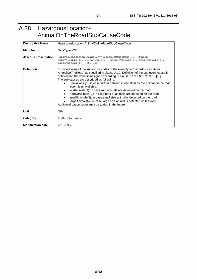
A.38 HazardousLocation-AnimalOnTheRoadSubCauseCode
Descriptive Name HazardousLocation-AnimalOnTheRoadSubCauseCode
Identifier DataType_038
ASN.1 representation HazardousLocation-AnimalOnTheRoadSubCauseCode ::= INTEGER {unavailable(0), wildAnimals(1), herdOfAnimals(2), smallAnimals(3), largeAnimals(4) } (0..255)
Definition Encoded value of the sub cause codes of the event type "hazardousLocation-AnimalOnTheRoad" as specified in clause A.10. Definition of the sub event cause is defined and the value is assigned according to clause 7.1.3 EN 302 637-3 [i.3]. The sub causes are described as following:
• unavailable(0): in case further detailed information on the animal on the road event is unavailable,
• wildAnimals(1): in case wild animals are detected on the road, • herdOfAnimals(2): in case herd of animals are detected on the road, • smallAnimals(3): in case small size animal is detected on the road, • largeAnimals(4): in case large size animal is detected on the road.
Additional cause codes may be added in the future.
Unit N/A
Category Traffic information
Modification date 2013-03-26

ETSI
ETSI TS 102 894-2 V1.1.1 (2013-08)35
A.39 HazardousLocation-DangerousCurveSubCauseCode Descriptive Name HazardousLocation-DangerousCurveSubCauseCode
Identifier DataType_039
ASN.1 representation HazardousLocation-DangerousCurveSubCauseCode ::= INTEGER
{unavailable(0), dangerousLeftTurnCurve(1), dangerousRightTurnCurve(2), multipleCurvesStartingWithUnknownTurningDirection(3), multipleCurvesStartingWithLeftTurn(4), multipleCurvesStartingWithRightTurn(5) } (0..255)
Definition Encoded value of the sub cause codes of the event type "hazardousLocation-DangerousCurve" as specified in clause A.10. Definition of the sub event cause is defined and the value is assigned according to clause 7.1.3 of EN 302 637-3 [i.3]. The sub causes are described as following:
• unavailable(0): in case further detailed information on the dangerous curve is unavailable,
• dangerousLeftTurnCurve(1): in case the dangerous curve is left turn, • dangerousRightTurnCurve(2): in case the dangerous curve is right turn, • multipleCurvesStartingWithUnknownTurningDirection(3): in case of multiple
curves for which the starting curve turning direction is not known, • multipleCurvesStartingWithLeftTurn(4): in case of multiple curves for which
the first curve is left turn. • multipleCurvesStartingWithRightTurn(5): in case of multiple curves for which
the first curve is right turn. Additional sub cause codes may be added in the future. The definition of whether a curve is dangerous may vary according to region and according to vehicle types/mass and vehicle speed driving on the curve. This definition is out of scope of the present document.
Unit N/A
Category Traffic information
Modification date 2013-03-26

ETSI
ETSI TS 102 894-2 V1.1.1 (2013-08)36
A.40 HazardousLocation-ObstacleOnTheRoadSubCauseCode
Descriptive Name HazardousLocation-SurfaceConditionSubCauseCode
Identifier DataType_040
ASN.1 representation HazardousLocation-ObstacleOnTheRoadSubCauseCode ::= INTEGER {unavailable(0), shedLoad(1), partsOfVehicles(2), partsOfTyres(3), bigObjects(4), fallenTrees(5), hubCaps(6), waitingVehicles(7) } (0..255)
Definition Encoded value of the sub cause codes of the event type "hazardousLocation-ObstacleOnTheRoad" as specified in clause A.10. Definition of the sub event cause is defined and the value is assigned according to clause 7.1.3 of EN 302 637-3 [i.3]. The sub causes are described as following:
• unavailable(0): in case further detailed information on the detected obstacle is unavailable,
• shedLoad(1): in case detected obstacle is large amount of obstacles (shedload),
• partsOfVehicles(2): in case detected obstacles are parts of vehicles, • partsOfTyres(3): in case the detected obstacles are parts of tyres, • bigObjects(4): in case the detected obstacles are big objects, • fallenTrees(5): in case the detected obstacles are fallen trees, • hubCaps(6): in case the detected obstacles are hub caps, • waitingVehicles(7): in case the detected obstacles are waiting vehicles.
Additional sub cause codes may be added in the future.
Unit N/A
Category Traffic information
Modification date 2013-03-26

ETSI
ETSI TS 102 894-2 V1.1.1 (2013-08)37
A.41 HazardousLocation-SurfaceConditionSubCauseCode
Descriptive Name HazardousLocation-SurfaceConditionSubCauseCode
Identifier DataType_041
ASN.1 representation HazardousLocation-SurfaceConditionSubCauseCode ::= INTEGER {unavailable(0), rockfalls(1), earthquakeDamage(2), sewerCollapse(3), subsidence(4), snowDrifts(5), stormDamage(6), burstPipe(7), volcanoEruption(8), fallingIce(9) } (0..255)
Definition Encoded value of the sub cause codes of the event type "hazardousLocation-SurfaceCondition" as specified in clause A.10. Definition of the sub event cause is defined and the value is assigned according to clause 7.1.3 of EN 302 637-3 [i.3]. The sub causes are described as following:
• unavailable(0): in case further detailed information on the road surface condition is unavailable,
• rockfalls(1): in case rock falls are detected on the road surface, • earthquakeDamage(2): in case the road surface is damaged by earthquake, • sewerCollapse(3): in case of sewer collapse on the road surface, • subsidence(4): in case road surface is damaged by subsidence, • snowDrifts(5): in case road surface is damaged due to snow drift, • stormDamage(6): in case road surface is damaged by strong storm, • burstPipe(7): in case road surface is damaged due to pipe burst, • volcanoEruption(8): in case road surface is damaged due to volcano eruption, • fallingIce(9): in case road surface damage is due to falling ice.
Additional sub cause codes may be added in the future.
Unit N/A
Category Traffic information
Modification date 2013-03-26
A.42 HeightLonCarr Descriptive Name HeightLonCarr
Identifier DataType_042
ASN.1 representation HeightLonCarr ::= INTEGER { oneCentimeter(1), unknown(100) } (0..100)
Definition Height of left or right longitude carrier of vehicle from base to top (left or right carrier
seen from vehicle rear to front). For values equal or higher than 99, the DE shall be set to 99. If the value is unavailable, the DE shall be set to 100.
Unit 1 centimetre
Category Vehicle information
Modification date 2012-10-15

ETSI
ETSI TS 102 894-2 V1.1.1 (2013-08)38
A.43 HumanPresenceOnTheRoadSubCauseCode Descriptive Name HumanPresenceOnTheRoadSubCauseCode
Identifier DataType_043
ASN.1 representation HumanPresenceOnTheRoadSubCauseCode ::= INTEGER {unavailable(0),
childrenOnRoadway(1), cyclistOnRoadway(2), motorcyclistOnRoadway(3) } (0..255)
Definition Encoded value of the sub cause codes of the event type "humanPresenceOnTheRoad" as defined in clause A.10. Definition of the sub event cause is defined and the value is assigned according to clause 7.1.3 of EN 302 637-3 [i.3]. The sub causes are described as following:
• unavailable(0): in case further detailed information on human presence on the road is unavailable,
• childrenOnRoadway(1): in case children on the road event is detected, • cyclistOnRoadway(2): in case cyclist presence is detected on the road, • motorcyclistOnRoadway(3): in case motorcyclist presence is detected.
Additional sub cause codes may be added in the future.
Unit N/A
Category Traffic information
Modification date 2013-03-26
A.44 HumanProblemSubCauseCode Descriptive Name HumanProblemSubCauseCode
Identifier DataType_044
ASN.1 representation HumanProblemSubCauseCode ::= INTEGER { unavailable(0),
glycemiaProblem(1), heartProblem(2) } (0..255)
Definition Encoded value of the sub cause codes of the event type "humanProblem" as specified in clause A.10. Definition of the sub event cause is defined and the value is assigned according to clause 7.1.3 of EN 302 637-3 [i.3]. The sub causes are described as following:
• unavailable(0): in case further detailed information on human health problem is unavailable,
• glycemiaProblem(1): in case human problem is due to glycaemia problem, • heartProblem(2): in case human problem is due to heart problem.
Additional sub cause codes may be added in the future.
Unit N/A
Category Traffic information
Modification date 2012-10-15

ETSI
ETSI TS 102 894-2 V1.1.1 (2013-08)39
A.45 InformationQuality Descriptive Name InformationQuality
Identifier DataType_045
ASN.1 representation InformationQuality ::= INTEGER { unknown(0), lowest(1), highest(7) }
(0..7)
Definition Indicate the quality level of provided information.
Unit N/A
Category Communication information
Modification date 2013-01-15
A.46 ItsPduHeader Descriptive Name ItsPduHeader
Identifier DataType_046
ASN.1 representation ItsPduHeader ::= SEQUENCE {
protocolVersion INTEGER{ currentVersion(1) } (0..255), messageID INTEGER{ denm(1),cam(2), poi(3), spat(4), map(5), ivi(6), ivs(7), ev-rsr(8) } (0..255),, stationID StationID }
Definition Common message header for application and facilities layer message. It is included at the beginning of an ITS message as the message header. It shall include the following information:
• protocolVersion: version of the ITS message and/or communication protocol, • messageID: Message type of the ITS message. Currently, three message
type values are assigned, including CAM, DENM, Point of Interest ITS, Signal Phase And Timing (SPAT), MAP, In Vehicle Information (IVI),In Vehicle Signage messages (IVS), and electric vehicle recharging spot reservation message.
• stationID: the identifier of the ITS-S that generates the ITS message in question. It shall be represented as specified in clause A.86.
Unit N/A
Category Communication information
Modification date 2013-06-27

ETSI
ETSI TS 102 894-2 V1.1.1 (2013-08)40
A.47 LaneNumber Descriptive Name LaneNumber
Identifier DataType_047
ASN.1 representation
LaneNumber ::= INTEGER { offTheRoad(-1), hardShoulder(0), outermostDrivingLane(1), secondLaneFromOutside(2) } (-1..14)
Definition This DE indicates lane position information counted from the outside border of the road; -1 denotes that the referenced geographic position is outside the road.
Unit N/A
Category GeoReference information
Modification date 2012-10-15
A.48 Latitude Descriptive Name Latitude
Identifier DataType_048
ASN.1 representation Latitude ::= INTEGER { oneMicrodegreeNorth (10), oneMicrodegreeSouth
(-10), unavailable(900000001) } (-900000000..900000001) -- multiples of 0.1 microdegree
Definition Absolute geographical latitude in a WGS84 coordinate system, providing a range of 90 degrees in north or in south hemisphere. Positive values are used for latitude value in north, negative values are used for latitude in south.
Unit 0,1 microdegree
Category GeoReference information
Modification date 2013-04-05
A.49 LateralAcceleration Descriptive Name LateralAcceleration
Identifier DataType_049
ASN.1 representation LateralAcceleration ::= SEQUENCE {
lateralAccelerationValue LateralAccelerationValue, lateralAccelerationConfidence AccelerationConfidence }
Definition It indicates the vehicle acceleration at lateral direction and the accuracy of the lateral acceleration.
Unit N/A
Category Vehicle information
Modification date 2013-04-05

ETSI
ETSI TS 102 894-2 V1.1.1 (2013-08)41
A.50 LateralAccelerationValue Descriptive Name LateralAccelerationValue
Identifier DataType_050
ASN.1 representation LateralAccelerationValue ::= INTEGER
{ pointOneMeterPerSecSquaredToLeft(1), pointOneMeterPerSecSquaredToRight(-1), unavailable(161) } (-160 .. 161)
Definition Vehicle acceleration at lateral direction. It corresponds to the vehicle coordinate system A as specified in [2]. Negative value indicates that the vehicle is accelerating towards the right side with regards to the vehicle orientation. Positive values indicate the acceleration to the left hand side with regards to the vehicle orientation. When the information is not available, the value shall be set to 161.
Unit 0,1 m/s2
Category Vehicle information
Modification date 2013-04-05
A.51 LightBarSireneInUse Descriptive Name LightBarSireneInUse
Identifier DataType_051
ASN.1 representation LightBarSirenInUse ::= BIT STRING {
lightBarActivated (0), sirenActivated (1) } (SIZE(2))
Definition It describes the status of light bar and any sort of audible alarm system beside the horn. This includes various common sirens as well as backup up beepers and other slow speed manœuvring alerts. When the lightbar or audible alarm is active, the corresponding bits shall be set to 1. Otherwise, it shall be set to 0.
Unit N/A
Category Vehicle information
Modification date 2012-09-07

ETSI
ETSI TS 102 894-2 V1.1.1 (2013-08)42
A.52 Longitude Descriptive Name DE_ Longitude
Identifier DataType_052
ASN.1 representation Longitude ::= INTEGER { oneMicrodegreeEast (10), oneMicrodegreeWest
(-10), unavailable(1800000001) } (-1800000000..1800000001) -- multiples of 0.1 microdegree
Definition Absolute geographical longitude in a WGS84 co-ordinate system, providing a range of 180 degrees to the east or to the west of the prime meridian. Negative values are used for longitudes to the west, position values are used for longitudes to the east.
Unit 0,1 microdegree
Category GeoReference information
Modification date 2013-04-05
A.53 LongitudinalAcceleration Descriptive Name LongitudinalAcceleration
Identifier DataType_053
ASN.1 representation LongitudinalAcceleration ::= SEQUENCE {
longitudinalAccelerationValue LongitudinalAccelerationValue, longitudinalAccelerationConfidence AccelerationConfidence }
Definition It indicates the vehicle acceleration at longitudinal direction and the accuracy of the longitudinal acceleration.
Unit N/A
Category Vehicle information
Modification date 2013-04-05
A.54 LongitudinalAccelerationValue Descriptive Name LongitudinalAccelerationValue
Identifier DataType_054
ASN.1 representation LongitudinalAccelerationValue ::= INTEGER {
pointOneMeterPerSecSquaredForward(1), pointOneMeterPerSecSquaredBackward(-1), unavailable(161) } (-160 .. 161)
Definition Vehicle acceleration at longitudinal direction. It corresponds to the vehicle coordinate system A as specified in [2]. Negative values indicate that the vehicle is braking.
Unit 0,1 m/s2
Category Vehicle information
Modification date 2013-04-17

ETSI
ETSI TS 102 894-2 V1.1.1 (2013-08)43
A.55 TrafficRule Descriptive Name TrafficRule
Identifier DataType_055
ASN.1 representation TrafficRule ::= ENUMERATED { noPassing(0),
noPassingForTrucks(1) …}
Definition It indicates whether overtaking is allowed at a certain position. If the overtaking limitation is apply to trucks only, the DE shall be set to 1.
Unit N/A
Category Infrastructure information
Modification date 2013-04-05
A.56 PathDeltaTime Descriptive Name PathDeltaTime
Identifier DataType_056
ASN.1 representation PathDeltaTime ::= INTEGER { tenMilliSecondsInPast(1) } (0..65535, ...)
Definition This DE defines the recorded or estimated travel time separated between a pathPosition as defined in clause A.58 to a predefined reference position. It may be used to describe the historical path travelled by an ITS-S in mobility (e.g. vehicle ITS-S) as specified in [i.2].
Unit 0,01 second
Category GeoReference information
Modification date 2012-09-06
A.57 PathHistory Descriptive Name PathHistory Identifier DataType_057
ASN.1 representation PathHistory ::= SEQUENCE SIZE(0..23) OF PathPoint
Definition DF that defines a path with a set of path points. It may contain up to 23 PathPoints as
defined in clause A.58. It may be used to describe the historical path of a vehicle or any path.
Unit N/A
Category GeoReference information
Modification date 2013-06-03

ETSI
ETSI TS 102 894-2 V1.1.1 (2013-08)44
A.58 PathPoint Descriptive Name PathPoint
Identifier DataType_058
ASN.1 representation PathPoint ::= SEQUENCE {
pathPosition DeltaReferencePosition, pathDeltaTime PathDeltaTime OPTIONAL }
Definition DF that defines a waypoint position within a path. It shall include the following information:
• pathPosition: The waypoint is defined as a DeltaReferencePosition with regards to a pre-defined reference position. It shall be as specified in clause A.23,
• pathDeltaTime: The travel time separated from a waypoint to the predefined reference position. It shall be presented as specified in clause A.56. This field is OPTIONAL. It shall be present if the travel delta time is available.
Unit N/A
Category GeoReference information
Modification date 2013-03-27
A.59 PerformanceClass Descriptive Name PerformanceClass
Identifier DataType_059
ASN.1 representation PerformanceClass ::= INTEGER { unknown(0), performanceClassA(1),
performanceClassB(2) } (0..7)
Definition This DE denotes the ability of an ITS-S to provide up-to-date information to other ITS-Ss. As defined in [i.6], performance class A shall be set to 1, performance class B shall be set to 2. When the performance class is unknown, it shall be set to 0. The specification of the performance class may be extended in the future. Values in the range 3 to 7 are reserved for future use.
Unit N/A
Category Vehicle information
Modification date 2013-04-05

ETSI
ETSI TS 102 894-2 V1.1.1 (2013-08)45
A.60 PosCentMass Descriptive Name PosCentMass
Identifier DataType_060
ASN.1 representation PosCentMass ::= INTEGER { tenCentimeters(1), unknown(63) } (0..63)
Definition It indicates the perpendicular distance from the centre of mass of an empty load vehicle
to the front of the vehicle bounding box. For values equal or higher than 62, the data shall be set to 62. 63 shall be used if the information is unavailable.
Unit 0,1 metre
Category Vehicle information
Modification date 2013-04-05
A.61 PosConfidenceEllipse Descriptive Name PosConfidenceEllipse
Identifier DataType_061
ASN.1 representation PosConfidenceEllipse ::= SEQUENCE {
semiMajorConfidence SemiAxisLength, -- confidence of the ellipse's major semi-axes semiMinorConfidence SemiAxisLength, -- confidence of the ellipse's minor semi-axes semiMajorOrientation Heading }
Definition DF that provides the horizontal position accuracy in a shape of ellipse with a predefined confidence level (e.g. 95 %). The centre of the ellipse shape corresponds to the reference position point for which the position confidence is evaluated. It shall include the following information:
• semiMajorConfidence: half of length of the major axis between the center point and major axis point of the position accuracy ellipse. It shall be presented as specified in clause A.76,
• semiMinorConfidence: Half of length of the minor axis between the center point and minor axis point of the position accuracy ellipse. It shall be presented as specified in clause A.76,
• semiMajorOrientation: Orientation direction of the ellipse major axis of the position accuracy ellipse with regards to the north. It shall be presented as specified in clause A.26.
The required confidence level of the position accuracy is defined by ITS message or ITS application applying this DF.
Unit N/A
Category GeoReference information
Modification date 2013-03-27

ETSI
ETSI TS 102 894-2 V1.1.1 (2013-08)46
A.62 PositioningSolutionType Descriptive Name PositioningSolutionType
Identifier DataType_062
ASN.1 representation PositioningSolutionType ::= ENUMERATED { noPositioningSolution(0),
sGNSS(1), dGNSS(2), sGNSSplusDR(3), dGNSSplusDR(4), dR(5), ... }
Definition It indicates the positioning technology being used to estimate a geographical position. It covers the following positioning solutions:
• sGNSS(1): Global Navigation Satellite System, • dGNSS(2): Differential GNSS, • sGNSSplusDR(3): GNSS and dead reckoning, • dGNSSplusDR(4): Differential GNSS and dead reckoning, • dR(5): dead reckoning.
Other positioning solutions may be added in the future.
Unit N/A
Category GeoReference information
Modification date 2013-03-27

ETSI
ETSI TS 102 894-2 V1.1.1 (2013-08)47
A.63 PositionOfOccupants Descriptive Name PositionOfOccupants
Identifier DataType_063
ASN.1 representation PositionOfOccupants ::= BIT STRING {
row1LeftOccupied (0), row1RightOccupied (1), row1MidOccupied (2), row1NotDetectable (3), row1NotPresent (4), row2LeftOccupied (5), row2RightOccupied (6), row2MidOccupied (7), row2NotDetectable (8), row2NotPresent (9), row3LeftOccupied (10), row3RightOccupied (11), row3MidOccupied (12), row3NotDetectable (13), row3NotPresent (14), row4LeftOccupied (15), row4RightOccupied (16), row4MidOccupied (17), row4NotDetectable (18), row4NotPresent (19), } (SIZE(20))
Definition Indicates whether a passenger seat is occupied or whether the occupation status is detectable or not. The number of row in vehicle seats layout is counted in rows from the driver row backwards from front to the rear of the vehicle. The left side seat of a row refers to the left hand side seen from vehicle rear to front side. Additionally, a bit is reserved for each seat row, to indicate if the seat occupation of a row is detectable or not, i.e. row1NotDetectable (3), row2NotDetectable(8), row3NotDetectable(13) and row4NotDetectable(18). Finally, a bit is reserved for each row seat to indicate if the seat row is present or not in the vehicle, i.e. row1NotPresent (4), row2NotPresent (9), row3NotPresent(14), row4NotPresent(19). When a seat is detected to be occupied, the corresponding seat occupation bit shall be set to 1. For example, when the row 1 left seat is occupied, row1LeftOccupied(0) bit shall be set to 1. When a seat is detected to be not occupied, the corresponding seat occupation bit shall be set to 0. Otherwise, the value of seat occupation bit shall be set according to the following conditions:
• If the seat occupation of a seat row is not detectable, the corresponding bit shall be set to 1. When any seat row not detectable bit is set to 1, all corresponding seat occupation bits of the same row shall be set to 1.
• If the seat row is not present, the corresponding not present bit of the same row shall be set to 1. When any of the seat row not present bit is set to 1, the corresponding not detectable bit for that row shall be set to 1, and all the corresponding seat occupation bits in that row shall be set to 0.
Unit N/A
Category Vehicle information
Modification date 2013-03-25

ETSI
ETSI TS 102 894-2 V1.1.1 (2013-08)48
A.64 PosFrontAx Descriptive Name PosFrontAx
Identifier DataType_064
ASN.1 representation PosFrontAx ::= INTEGER { tenCentimeters(1), unknown(20) } (0..20)
Definition Perpendicular distance between the vehicle front of the bounding box and the front
wheel axle in 10 centimetres. Values equal or higher than 19 shall be set to 19. Value 20 shall be set if the data is unavailable.
Unit 0,1 metre
Category Vehicle information
Modification date 2013-03-27
A.65 PosLonCarr Descriptive Name PosLonCarr
Identifier DataType_065
ASN.1 representation PosLonCarr ::= INTEGER { oneCentimeter(1), unknown(127) } (0..127)
Definition Distance from the center of vehicle front bumper to the right or left longitudinal carrier
of vehicle. The left/right carrier refers to the left/right as seen from a passenger sitting in the vehicle For values equal or higher than 126, the DE shall be set to 126. If the information is unavailable, this DE shall be set to 127.
Unit 0,01 metre
Category Vehicle information
Modification date 2013-06-03
A.66 PosPillar Descriptive Name PosPillar
Identifier DataType_066
ASN.1 representation PosPillar ::= INTEGER { tenCentimeters(1), unknown(30) } (0..30)
Definition It indicates the perpendicular inter-distance of neighbouring pillar axis of vehicle
starting from the middle point of the front of the vehicle bounding box. For values equal or higher than 29, the data shall be set to 29. 30 shall be used if the information is unavailable.
Unit 0,1 metre
Category Vehicle information
Modification date 2012-10-15

ETSI
ETSI TS 102 894-2 V1.1.1 (2013-08)49
A.67 PostCrashSubCauseCode Descriptive Name PostCrashSubCauseCode
Identifier DataType_067
ASN.1 representation PostCrashSubCauseCode ::= INTEGER {unavailable(0),
accidentWithoutECallTriggered (1), accidentWithECallManuallyTriggered (2), accidentWithECallAutomaticallyTriggered (3), accidentWithECallTriggeredWithoutAccessToCellularNetwork(4)} (0..255)
Definition Encoded value of the sub cause codes of the event type "postCrash" as specified in clause A.10. Definition of the sub event cause is defined and the value is assigned according to clause 7.1.3 of [i.3]. The sub causes are described as following:
• unavailable(0): in case further detailed information on post crash event is unavailable,
• accidentWithoutECallTriggered(1): in case no eCall has been triggered, • accidentWithECallManuallyTriggered (2): in case eCall has been manually
triggered and transmitted to eCall back end, • accidentWithECallAutomaticallyTriggered (3): in case eCall has been
automatically triggered and transmitted to eCall back end, • accidentWithECallTriggeredWithoutAccessToCellularNetwork(4): in case
eCall has been triggered but cellular network is not accessible from triggering vehicle.
Additional sub cause codes may be added in the future.
Unit N/A
Category Traffic information
Modification date 2013-03-27

ETSI
ETSI TS 102 894-2 V1.1.1 (2013-08)50
A.68 PtActivation Descriptive Name PtActivation
Identifier DataType_068
ASN.1 representation PtActivation ::= SEQUENCE {
ptActivationType PtActivationType ::= INTEGER (0..255) ptActivationData PtActivationData ::= OCTET STRING (SIZE(1..20)) }
Definition Real-time systems designed for operations control, traffic light priorities, track switches, barriers, etc. using a range of activation devices equipped in public transport vehicle. The activation of the corresponding equipment is triggered by the approach or passage of a public transport vehicle at a certain point (e.g. a beacon). This DE shall include the ptActivationType as defined in clause A.70 and ptActicationData as defined in clause A.69. Today there are different payload variants defined for public transport activation-data. The R09.x is one of the industry standard used by public transport vehicles (e.g. buses, trams) in Europe (e.g. Germany Austria) for controlling traffic lights, barriers, bollards etc. This DE includes information like route, course, destination, priority etc. The R09.x content is defined in [i.8]. It includes information as follows:
• Priority Request Information (pre-request, request, ready to start) • End of Prioritization procedure • Priority request direction • Public Transport line number • Priority of public transport • Route line identifier of the public transport • Route number identification • Destination of public transport vehicle
Other countries may use different message sets defined by the local administration.
Unit N/A
Category Vehicle information
Modification date 2013-06-03
A.69 PtActivationData Descriptive Name PtActivationData
Identifier DataType_069
ASN.1 representation PtActivationData ::= OCTET STRING (SIZE(1..20))
Definition DF used for various tasks in the public transportation environment, especially for
controlling traffic signal systems to prioritize and speed up public transportation in urban area (e.g. intersection "bottlenecks"). The traffic lights may be controlled by an approaching bus or tram automatically. This permits "In Time" activation of the green phase, will enable the individual traffic to clear a potential traffic jam in advance. Thereby the approaching bus/tram may pass an intersection with activated green light without slowing down the speed due to traffic congestion. Other usage of the DF is the provision of information like the public transport line number or the schedule delay of a public transport vehicle.
Unit N/A
Category Vehicle information
Modification date 2013-01-23

ETSI
ETSI TS 102 894-2 V1.1.1 (2013-08)51
A.70 PtActivationType Descriptive Name PtActivationType
Identifier DataType_070
ASN.1 representation PtActivationType ::= INTEGER (0..255)
Definition This DE indicates a certain coding of the data frame ptActivationData.
− 0 undefined − 1 coding of ptActivationData conform to [i.8]. This represents the state of art
coding for public transportation communication in Germany. Switzerland and Austria
− 2 coding of ptActivationData based on [i.8]. This represents an alternative way for coding for public transport communication payload defined by VDV (Association of German public transport association)
The values 3 to 15 are reserved for alternative and future use.
Unit N/A
Category Vehicle information
Modification date 2013-06-03
A.71 ReferencePosition Descriptive Name ReferencePosition
Identifier DataType_071
ASN.1 representation ReferencePosition ::= SEQUENCE {
latitude Latitude, longitude Longitude, positionConfidenceEllipse PosConfidenceEllipse , altitude Altitude }
Definition The geographical position of a location or of an ITS station. It represents a geographical point position. It shall include the following information:
• latitude: Latitude of the geographical point; it shall be presented as specified in clause A.48
• longitude: Longitude of the geographical point; it shall be presented as specified in clause A.52
• positionConfidenceEllipse: Confidence of the geographical position; it shall be presented as specified in clause A.61
• altitude: Altitude and altitude confidence of the geographical point; it shall be presented as specified in clause A.29
Unit N/A
Category GeoReference information
Modification date 2013-06-27

ETSI
ETSI TS 102 894-2 V1.1.1 (2013-08)52
A.72 RequestResponseIndication Descriptive Name RequestResponseIndication
Identifier DataType_072
ASN.1 representation RequestResponseIndication ::= ENUMERATED { request(0), response(1) }
Definition This DE includes whether an ITS message is transmitted as request from ITS-S or a
response transmitted from ITS-S after receiving request from other ITS-Ss.
Unit N/A
Category Communication information
Modification date 2012-10-15
A.73 RescueAndRecoveryWorkInProgressSubCauseCode Descriptive Name RescueAndRecoveryWorkInProgressSubCauseCode
Identifier DataType_073
ASN.1 representation RescueAndRecoveryWorkInProgressSubCauseCode ::= INTEGER {unavailable(0),
emergencyVehicles(1), rescueHelicopterLanding(2), policeActivityOngoing(3), medicalEmergencyOngoing(4), childAbductionInProgress(5) } (0..255)
Definition Encoded value of the sub cause codes of the event type "rescueAndRecoveryWorkInProgress" as specified in clause A.10. Definition of the sub event cause is defined and the value is assigned according to clause 7.1.3 of EN 302 637-3 [i.3]. The sub causes are described as following:
• unavailable(0): in case further detailed information on rescue and recovery work is unavailable,
• emergencyVehicles(1): in case rescue work is ongoing by emergency vehicles,
• rescueHelicopterLanding(2): in case rescue helicopter is landing, • policeActivityOngoing(3): in case police activity is ongoing, • medicalEmergencyOngoing(4): in case medial emergency recovery is
ongoing, • childAbductionInProgress (5): in case a child kidnapping alarm is activated.
Additional sub cause codes may be added in the future.
Unit N/A
Category Traffic information
Modification date 2013-03-27

ETSI
ETSI TS 102 894-2 V1.1.1 (2013-08)53
A.74 RoadType Descriptive Name RoadType
Identifier DataType_074
ASN.1 representation RoadType ::= ENUMERATED {
urban-NoStructuralSeparationToOppositeLanes(0), urban-WithStructuralSeparationToOppositeLanes(1), nonUrban-NoStructuralSeparationToOppositeLanes(2), nonUrban-WithStructuralSeparationToOppositeLanes(3) }
Definition Type of a road segment.
Unit N/A
Category Road Topology Information
Modification date 2013-06-27
A.75 RoadworksSubCauseCode Descriptive Name RoadworkSubCauseCode
Identifier DataType_075
ASN.1 representation RoadworksSubCauseCode ::= INTEGER {unavailable(0), majorRoadworks(1),
roadMarkingWork(2), slowMovingRoadMaintenance(3), winterService(4), streetCleaning(5) } (0..255)
Definition Encoded value of the sub cause codes of the event type "roadworks" as defined in clause A.10. Definition of the sub event cause is defined and the value is assigned according to clause 7.1.3 of EN 302 637-3 [i.3]. The sub causes are described as following:
• unavailable(0): in case further detailed information on roadworks is unavailable,
• majorRoadworks(1): in case a major roadworks is ongoing, • roadMarkingWork(2): in case a road marking work is ongoing, • slowMovingRoadMaintenance(3): in case slow moving road maintenance
work is ongoing, • winterService(4): in case winter service work is ongoing, • streetCleaning(5): in case a vehicle street cleaning work is ongoing.
Additional sub cause codes may be added in the future.
Unit N/A
Category Traffic information
Modification date 2013-03-27

ETSI
ETSI TS 102 894-2 V1.1.1 (2013-08)54
A.76 SemiAxisLength Descriptive Name SemiAxisLength
Identifier DataType_076
ASN.1 representation SemiAxisLength ::= INTEGER{ oneCentimeter(1), outOfRange (4094),
unavailable(4095) } (0..4095)
Definition Absolute position accuracy in one of the axis direction as defined in a shape of ellipse with a predefined confidence level (e.g. 95 %). For accuracy equal or worse than 4 094, the value shall be set to 4 094. The value shall be set to 4 095 when the data is unavailable.
Unit 1 centimetre
Category GeoReference information
Modification date 2012-10-15
A.77 SignalViolationSubCauseCode Descriptive Name SignalViolationSubCauseCode
Identifier DataType_077
ASN.1 representation SignalViolationSubCauseCode ::= INTEGER {unavailable(0),
stopSignViolation(1), trafficLightViolation(2), turningRegulationViolation(3) } (0..255)
Definition Encoded value of the sub cause codes of the event type "signalViolation" as specified in clause A.10. Definition of the sub event cause is defined and the value is assigned according to clause 7.1.3 of EN 302 637-3 [i.3]. The sub causes are described as following:
• unavailable(0): in case further detailed information on signal violation event is unavailable,
• stopSignViolation(1): in case a stop sign violation is detected, • trafficLightViolation(2): in case a traffic light violation is detected, • turningRegulationViolation(3): in case a turning regulation violation is
detected. Additional sub cause codes may be added in the future.
Unit N/A
Category Traffic information
Modification date 2013-03-27

ETSI
ETSI TS 102 894-2 V1.1.1 (2013-08)55
A.78 SlowVehicleSubCauseCode Descriptive Name SlowVehicleSubCauseCode
Identifier DataType_078
ASN.1 representation SlowVehicleSubCauseCode ::= INTEGER {unavailable(0),
maintenanceVehicle(1), vehiclesSlowingToLookAtAccident(2), abnormalLoad(3), abnormalWideLoad(4), convoy(5), snowplough(6), deicing(7), saltingVehicles(8) } (0..255)
Definition Encoded value of the sub cause codes of the event type "slowVehicle" as specified in clause A.10. Definition of the sub event cause is defined and the value is assigned according to clause 7.1.3 of EN 302 637-3 [i.3]. The sub causes are described as following:
• unavailable(0): in case further detailed information on slow vehicle driving event is unavailable,
• maintenanceVehicle(1): in case of a slow driving maintenance vehicle on the road,
• vehiclesSlowingToLookAtAccident(2): in case vehicle is temporally slowing down to look at accident, spot, etc.,
• abnormalLoad(3): in case an abnormal loaded vehicle is driving slowly on the road,
• abnormalWideLoad(4): in case an abnormal wide load vehicle is driving slowly on the road,
• convoy(5): in case of slow driving convoy on the road, • snowplough(6): in case of slow driving snow plough on the road, • deicing(7): in case of slow driving de-icing vehicle on the road, • saltingVehicles(8): in case of slow driving salting vehicle on the road.
Additional sub cause codes may be added in the future.
Unit N/A
Category Traffic information
Modification date 2013-03-27
A.79 SpecialTransportType Descriptive Name SpecialTransportType
Identifier DataType_079
ASN.1 representation SpecialTransportType ::= BIT STRING { heavyLoad(0), excessWidth(1),
excessLength(2), excessHeight(3) } (SIZE(4))
Definition To indicate if a vehicle ITS-S is carrying goods with heavy load, excess width, excess length or excess height. The corresponding bit shall be set to 1 when the special transport applies to the corresponding case. Otherwise, the corresponding bit shall be set to 0.
Unit N/A
Category Vehicle information
Modification date 2013-04-05

ETSI
ETSI TS 102 894-2 V1.1.1 (2013-08)56
A.80 Speed Descriptive Name Speed
Identifier DataType_080
ASN.1 representation Speed ::= SEQUENCE {
SpeedValue SpeedValue, SpeedConfidence SpeedConfidence }
Definition It describes the speed and corresponding accuracy of the speed information for a moving object (e.g. vehicle).
Unit N/A
Category Vehicle information
Modification date 2012-06-15
A.81 SpeedConfidence Descriptive Name SpeedConfidence
Identifier DataType_081
ASN.1 representation SpeedConfidence ::= INTEGER { withinOneCentimeterPerSec(1),
withinOneMeterPerSec(100), outOfRange(126), unavailable(127) } (1..127)
Definition The absolute accuracy of the speedValue information for a predefined confidence level. The required confidence level is defined by the station applying this DE. For values equal or higher than 126, the DE shall be set to 126. When the accuracy information is not available, the DE shall be set to 127.
Unit 0,01 m/s
Category Vehicle information
Modification date 2012-10-15
A.82 SpeedLimit Descriptive Name SpeedLimit
Identifier DataType_082
ASN.1 representation SpeedLimit ::= INTEGER { oneKmPerHour(1) } (0..255)
Definition Speed limitation applied to a geographical position, a road section or a geographical
region.
Unit km/h
Category Infrastructure information
Modification date 2013-06-27

ETSI
ETSI TS 102 894-2 V1.1.1 (2013-08)57
A.83 SpeedValue Descriptive Name SpeedValue
Identifier DataType_083
ASN.1 representation SpeedValue ::= INTEGER { standstill(0), oneCentimeterPerSec(1),
unavailable (16383) } (0..16383)
Definition Speed of a moving object (e.g. vehicle). When the information is not available, the DE shall be set to 16 383.
Unit 0,01 m/s
Category Vehicle information
Modification date 2013-04-05
A.84 StationarySince Descriptive Name StationarySince
Identifier DataType_084
ASN.1 representation StationarySince ::= ENUMERATED { lessThan1Minute(0),
lessThan2Minutes(1), lessThan15Minutes(2), over15Minutes(3) }
Definition Indicates the duration in minutes of a vehicle being stationary. For vehicle being stationary since more than 15 minutes, the DE shall be set to 3.
Unit N/A
Category Infrastructure information
Modification date 2012-10-15

ETSI
ETSI TS 102 894-2 V1.1.1 (2013-08)58
A.85 StationaryVehicleSubCauseCode Descriptive Name StationaryVehicleSubCauseCode
Identifier DataType_085
ASN.1 representation StationaryVehicleSubCauseCode ::= INTEGER {unavailable(0),
humanProblem(1), vehicleBreakdown(2), postCrash(3), publicTransportStop(4), carryingDangerousGoods(5) } (0..255)
Definition Encoded value of the sub cause codes of the event type "stationaryVehicle" as specified in clause A.10. Definition of the sub event cause is defined and the value is assigned according to clause 7.1.3 of EN 302 637-3 [i.3]. The sub causes are described as following:
• unavailable(0): in case further detailed information on stationary vehicle is unavailable,
• humanProblem(1): in case stationary vehicle is due to health problem of driver or passenger,
• vehicleBreakdown(2): in case stationary vehicle is due to vehicle break down, • postCrash(3): in case stationary vehicle is caused by collision, • publicTransportStop(4): in case public transport vehicle is stationary at bus
stop, • carryingDangerousGoods(5): in case the stationary vehicle is carrying
dangerous goods. Additional sub cause codes may be added in the future.
Unit N/A
Category Traffic information
Modification date 2013-03-27
A.86 StationID Descriptive Name StationID
Identifier DataType_086
ASN.1 representation StationID ::= INTEGER(0..4294967295)
Definition Identifier for the ITS station as used in application and facilities layer message.
The station ID may be a pseudonym. It may vary over space and/or over time.
Unit N/A
Category Communication information
Modification date 2012-06-14

ETSI
ETSI TS 102 894-2 V1.1.1 (2013-08)59
A.87 StationType Descriptive Name StationType
Identifier DataType_087
ASN.1 representation StationType ::= INTEGER { unknown(0), pedestrian(1), cyclist(2),
moped(3), motorcycle(4), passengerCar(5), bus(6), lightTruck(7), heavyTruck(8), trailer(9), specialVehicles(10), tram(11), roadSideUnit(15) } (0..255)
Definition The type of an ITS-S.
Unit N/A
Category Other information
Modification date 2012-06-15
A.88 SteeringWheelAngle Descriptive Name SteeringWheelAngle
Identifier DataType_088
ASN.1 representation SteeringWheelAngle::= SEQUENCE {
steeringWheelAngleValue SteeringWheelAngleValue, steeringWheelAngleConfidence SteeringWheelAngleConfidence }
Definition Steering wheel angle of the vehicle at certain point in time. In includes a steering wheel angle value and the estimated accuracy of the value.
Unit 1,5 degree
Category Vehicle information
Modification date 2013-06-03
A.89 SteeringWheelAngleConfidence Descriptive Name SteeringWheelAngleConfidence
Identifier DataType_089
ASN.1 representation SteeringWheelAngleConfidence ::= INTEGER { withinOnePointFiveDegree(1),
outOfRange(126), unavailable(127) } (1..127)
Definition Absolute accuracy for a SteeringWheelAngleValue as defined in clause A.90 for a predefined confidence level (e.g. 95 %). 126 shall be set if the accuracy is equal or worse than 189 degrees. When the accuracy information is not available, the value shall be set to 127.
Unit 1,5 degree
Category Vehicle information
Modification date 2013-06-03

ETSI
ETSI TS 102 894-2 V1.1.1 (2013-08)60
A.90 SteeringWheelAngleValue Descriptive Name SteeringWheelAngleValue
Identifier DataType_090
ASN.1 representation SteeringWheelAngleValue ::= INTEGER { straight(0),
onePointFiveDegreesToLeft(1), onePointFiveDegreesToRight(-1), unavailable(511) } (-511..511)
Definition Steering wheel angle of the vehicle at certain point in time. Negative values shall be used when the steering wheel angle is turning clock wise (i.e. to the right). 510 shall be set if the data is equal or higher than 510. It corresponds to the vehicle coordinate system A as specified in [2]. -511 shall be used when the value is equal or less than -511. When the information is not available, the value shall be set to 511.
Unit 1,5 degree
Category Vehicle information
Modification date 2013-06-03
A.91 SubCauseCodeType Descriptive Name SubCauseCodeType
Identifier DataType_091
ASN.1 representation SubCauseCodeType ::= INTEGER (0..255)
Definition Type of sub cause of a detected event as defined in [i.3].
For DENM usage, the value as given in clause 7.1.3 of EN 302 637-3 [i.3] apply. NOTE 1: The sub cause code value assignment varies based on value of
causeCode as defined in clause A.10. NOTE 2: Complete list of all possible sub cause code values as given in [i.3]
is provided in the present document for information and for potential future usage. For example, see clause A.3 for sub cause code of accident event.
Unit N/A
Category Traffic information
Modification date 2013-06-18

ETSI
ETSI TS 102 894-2 V1.1.1 (2013-08)61
A.92 TimestampIts Descriptive Name TimestampIts
Identifier DataType_092
ASN.1 representation TimestampIts ::= INTEGER { utcStartOf2004(0),
oneMillisecAfterUTCStartOf2004(1) } (0..3153600000000)
Definition TAI time value in milliseconds since 00:00:00.000 hours of 01 January 2004 UTC.
Unit milliseconds
Category Other Information
Modification date 2012-09-07
A.93 Temperature Descriptive Name Temperature
Identifier DataType_093
ASN.1 representation Temperature ::= INTEGER { oneDegreeCelsius(1) } (-60..67)
Definition Temperature. For temperature equal or lower than -60 °C, the value shall be set to -60.
For temperature equal or higher than 67 °C, the value shall be set to 67.
Unit °C
Category Other information
Modification date 2013-04-05

ETSI
ETSI TS 102 894-2 V1.1.1 (2013-08)62
A.94 TrafficConditionSubCauseCode Descriptive Name TrafficConditionSubCauseCode
Identifier DataType_094
ASN.1 representation TrafficConditionSubCauseCode ::= INTEGER {unavailable(0),
increasedVolumeOfTraffic(1), trafficJamSlowlyIncreasing(2), trafficJamIncreasing(3), trafficJamStronglyIncreasing(4), trafficStationary(5), trafficJamSlightlyDecreasing(6), trafficJamDecreasing(7), trafficJamStronglyDecreasing(8) } (0..255)
Definition Encoded value of the sub cause codes of the event type "trafficCondition" as defined in clause A.10. Definition of the sub event cause is defined and the value is assigned according to clause 7.1.3 of EN 302 637-3 [i.3]. The sub causes are described as following:
• unavailable(0): in case further detailed information on traffic jam is unavailable,
• increasedVolumeOfTraffic(1): in case detected jam volume is increased, • trafficJamSlowlyIncreasing(2): in case detected traffic jam volume is
increasing slowly, • trafficJamIncreasing(3): in case traffic jam volume is increasing, • trafficJamStronglyIncreasing(4): in case traffic jam volume is strongly
increasing, • trafficStationary(5): in case traffic is stationary, • trafficJamSlightlyDecreasing(6): in case traffic jam volume is decreasing
slowly, • trafficJamDecreasing(7): in case traffic jam volume is decreasing, • trafficJamStronglyDecreasing(8): in case traffic jam volume is decreasing
rapidly. Additional sub cause codes may be added in the future.
Unit N/A
Category Traffic information
Modification date 2013-03-27
A.95 TurningRadius Descriptive Name TurningRadius
Identifier DataType_095
ASN.1 representation TurningRadius ::= INTEGER { point4Meters(1), unavailable(255) } (0..255)
Definition The smallest circular turn (i.e. U-turn) that the vehicle is capable of making. Values
equal or higher than 254 shall be set to 254. Value 255 shall be set if the data is unavailable. For vehicle with tracker, the turning radius applies to the vehicle only.
Unit 0,4 metre
Category Vehicle information
Modification date 2012-10-15

ETSI
ETSI TS 102 894-2 V1.1.1 (2013-08)63
A.96 VDS Descriptive Name VDS
Identifier DataType_096
ASN.1 representation VDS ::= IA5String (SIZE(6))
Definition Vehicle Descriptor Section (VDS). The values are assigned according to [i.7].
Unit N/A
Category Vehicle information
Modification date 2012-09-06
A.97 VehicleBreakdownSubCauseCode Descriptive Name VehicleBreakdownSubCauseCode
Identifier DataType_097
ASN.1 representation VehicleBreakdownSubCauseCode ::= INTEGER {unavailable(0), lackOfFuel
(1), lackOfBatteryPower (2), engineProblem(3), transmissionProblem(4), engineCoolingProblem(5), brakingSystemProblem(6), steeringProblem(7), tyrePuncture(8)} (0..255)
Definition Encoded value of the sub cause codes of the event type "vehicleBreakdown" as specified in clause A.10. Definition of the sub event cause is defined and the value is assigned according to clause 7.1.3 of EN 302 637-3 [i.3]. The sub causes are described as following:
• unavailable(0): in case further detailed information on cause of vehicle break down is unavailable,
• lackOfFuel (1): in case vehicle break down is due to lack of fuel, • lackOfBatteryPower (2): in case vehicle break down is caused by lack of
battery power, • engineProblem(3): in case vehicle break down is caused by an engine
problem, • transmissionProblem(4): in case vehicle break down is caused by
transmission problem, • engineCoolingProblem(5): in case vehicle break down is caused by an engine
cooling problem, • brakingSystemProblem(6): in case vehicle break down is caused by a braking
system problem, • steeringProblem(7): in case vehicle break down is caused by a steering
problem, • tyrePuncture(8): in case vehicle break down is caused by tire puncture.
Additional sub cause codes may be added in the future.
Unit N/A
Category Traffic information
Modification date 2013-03-27

ETSI
ETSI TS 102 894-2 V1.1.1 (2013-08)64
A.98 VehicleIdentification Descriptive Name VehicleIdentification
Identifier DataType_098
ASN.1 representation VehicleIdentification ::= SEQUENCE {
wMInumber WMInumber, vDS VDS }
Definition This DF provides the vehicle identification of a vehicle. It shall include the World Manufacturer Identifier (WMI) code and the Vehicle Descriptor Section (VDS). The values are assigned according to [i.7].
Unit N/A
Category Vehicle information
Modification date 2012-09-06
A.99 VehicleLength Descriptive Name VehicleLength
Identifier DataType_099
ASN.1 representation VehicleLength ::= SEQUENCE {
vehicleLengthValue VehicleLengthValue, vehicleLengthConfidenceIndication VehicleLengthConfidenceIndication }
Definition Estimated length of vehicle and the whether the estimated length is confident.
Unit N/A
Category Vehicle information
Modification date 2012-09-07
A.100 VehicleLengthConfidenceIndication Descriptive Name VehicleLengthConfidenceIndication
Identifier DataType_100
ASN.1 representation VehicleLengthConfidenceIndication ::= ENUMERATED { noTrailerPresent(0),
trailerPresentWithKnownLength(1), trailerPresentWithUnknownLength(2), trailerPresenceIsUnknown(3) }
Definition To indicate whether the presence of a trailer is detectable or whether its length is included in the vehicleLengthValue.
Unit N/A
Category Vehicle information
Modification date 2012-10-15

ETSI
ETSI TS 102 894-2 V1.1.1 (2013-08)65
A.101 VehicleLengthValue Descriptive Name VehicleLengthValue
Identifier DataType_0101
ASN.1 representation VehicleLengthValue ::= INTEGER { tenCentimeters(1), outOfRange(1022),
unavailable(1023) } (1..1023)
Definition Estimated length of vehicle. The DE shall be set to 1 022 if the vehicle length is equal or higher than 1 022. The DE shall be set to 1 023 if the information in unavailable.
Unit 0,1 metre
Category Vehicle information
Modification date 2012-10-15
A.102 VehicleMass Descriptive Name VehicleMass
Identifier DataType_102
ASN.1 representation VehicleMass ::= INTEGER { hundredKg(1), unavailable(1024) } (1..1024)
Definition Estimated empty load mass of the vehicle in multiple of 100 kg. For values equal or
higher than 1 023, the value shall be set to 1 023. The value shall be set to 1 024 when the data is unavailable.
Unit 100 kg
Category Vehicle information
Modification date 2012-10-15
A.103 VehicleRole Descriptive Name VehicleRole
Identifier DataType_103
ASN.1 representation VehicleRole ::= ENUMERATED { default(0), publicTransport(1),
specialTransport(2), dangerousGoods(3), roadWork(4), rescue(5), emergency(6), safetyCar(7) }
Definition Role played by a vehicle at a point in time.
Unit N/A
Category Vehicle information
Modification date 2012-10-15

ETSI
ETSI TS 102 894-2 V1.1.1 (2013-08)66
A.104 VehicleWidth Descriptive Name VehicleWidth
Identifier DataType_104
ASN.1 representation VehicleWidth ::= INTEGER { tenCentimeters(1), outOfRange(61),
unavailable(62) } (1..62)
Definition Estimated width of vehicle, including side mirrors. For values equal or higher than 61, the DE shall be set to 61. The DE shall be set to 62 if the information is unavailable.
Unit 0,1 metre
Category Vehicle information
Modification date 2012-10-15
A.105 VerticalAcceleration Descriptive Name VerticalAcceleration
Identifier DataType_105
ASN.1 representation VerticalAcceleration ::= SEQUENCE {
verticalAccelerationValue VerticalAccelerationValue, verticalAccelerationConfidence AccelerationConfidence }
Definition It indicates the vehicle acceleration at vertical direction and the accuracy of the vertical acceleration.
Unit N/A
Category Vehicle information
Modification date 2013-06-03
A.106 VerticalAccelerationValue Descriptive Name VerticalAccelerationValue
Identifier DataType_106
ASN.1 representation VerticalAccelerationValue ::= INTEGER { pointOneMeterPerSecSquaredUp(1),
pointOneMeterPerSecSquaredDown(-1), unavailable(161) } (-160 .. 161)
Definition Vehicle acceleration at vertical direction. It corresponds to the vehicle coordinate system A as specified in [2]. Negative values indicate the vehicle is accelerating downwards. When the information is not available, the value shall be set to 161.
Unit 0,1 m/s2
Category Vehicle information
Modification date 2013-04-05

ETSI
ETSI TS 102 894-2 V1.1.1 (2013-08)67
A.107 WheelBaseVehicle Descriptive Name WheelBaseVehicle
Identifier DataType_107
ASN.1 representation WheelBaseVehicle ::= INTEGER { tenCentimeters(1), unavailable(127) }
(0..127)
Definition Perpendicular distance between front and rear axle of the wheel base of vehicle. Values equal or higher than 126 shall be set to 126. Value 127 shall be set if the data is unavailable.
Unit 0,1 metre
Category Vehicle information
Modification date 2012-09-07
A.108 WMInumber Descriptive Name WMInumber
Identifier DataType_108
ASN.1 representation WMInumber ::= IA5String (SIZE(1..3))
Definition World Manufacturer Identifier (WMI). The values are assigned according to [i.7].
Unit N/A
Category Vehicle information
Modification date 2012-09-06
A.109 WrongWayDrivingSubCauseCode Descriptive Name WrongWayDrivingSubCauseCode
Identifier DataType_109
ASN.1 representation WrongWayDrivingSubCauseCode ::= INTEGER {unavailable(0), wrongLane(1),
wrongDirection(2) } (0..255)
Definition Encoded value of the sub cause codes of the event type "wrongWayDriving" as defined in clause A.10. Definition of the sub event cause is defined and the value is assigned according to clause 7.1.3 of EN 302 637-3 [i.3]. The sub causes are described as following:
• unavailable(0): in case further detailed information on wrong way driving event is unavailable,
• wrongLane(1): in case vehicle is driving on a lane for which it has no authorization to use,
• wrongDirection(2): in case vehicle is driving in a direction that it is not allowed. Additional sub cause codes may be added in the future.
Unit N/A
Category Traffic information
Modification date 2013-03-27

ETSI
ETSI TS 102 894-2 V1.1.1 (2013-08)68
A.110 YawRate Descriptive Name YawRate
Identifier DataType_110
ASN.1 representation YawRate::= SEQUENCE {
yawRateValue YawRateValue, yawRateConfidence yawRateConfidence }
Definition Yaw rate of vehicle at a point in time. It shall include a measured yaw rate of vehicle and accuracy information of the provided measured value.
Unit N/A
Category Vehicle information
Modification date 2013-03-27
A.111 YawRateConfidence Descriptive Name YawRateConfidence
Identifier DataType_111
ASN.1 representation YawRateConfidence ::= ENUMERATED {
degSec-000-01 (0) degSec-000-05 (1), degSec-000-10 (2), degSec-001-00 (3), degSec-005-00 (4), degSec-010-00 (5), degSec-100-00 (6), outOfRange (7), unavailable (8), }
Definition DE that denotes the absolute accuracy range for the measured yawRateValue for a predefined confidence level (e.g. 95 %). The DE shall be set to:
• 0 if the accuracy is within 0,01 degrees/second • 1 if the accuracy is within 0,05 degrees/second • 2 if the accuracy is within 0,1 degrees/second • 3 if the accuracy is within 1 degrees/second • 4 if the accuracy is within 5 degrees/second • 5 if the accuracy is within 10 degrees/second • 6 if the accuracy is within 100 degrees/second • 7 if the accuracy is worse than 100 degrees/second • 8 if the accuracy information is unavailable
Unit N/A
Category Traffic information
Modification date 2013-06-27

ETSI
ETSI TS 102 894-2 V1.1.1 (2013-08)69
A.112 YawRateValue Descriptive Name YawRateValue
Identifier DataType_112
ASN.1 representation YawRateValue ::= INTEGER { straight(0), degSec-000-01ToRight(-1),
degSec-000-01ToLeft(1), unavailable(32767) } (-32767..32767)
Definition YawRateValue denotes the vehicle rotation around z-axis of Coordinate System A centered on the center of mass of the empty-loaded vehicle. The leading sign denotes the direction of rotation. The value is negative if the rotation is clockwise (i.e. turning right). It corresponds to the vehicle Coordinate System A as specified in [2]. The yaw rate value shall be a raw data value, i.e. not filtered, smoothed or otherwise modified. The reading instant should be the same as for the vehicle acceleration. When the information is not available, the DE shall be set to 32 767.
Unit 0,01 degree per second
Category Vehicle information
Modification date 2013-03-27

ETSI
ETSI TS 102 894-2 V1.1.1 (2013-08)70
Annex B (normative): ASN.1 module of the common data dictionary ITS-Container { itu-t (0) identified-organization (4) etsi (0) itsDomain (5) wg1 (1) ts (102894) cdd (2) version (1) } DEFINITIONS AUTOMATIC TAGS ::= BEGIN ItsPduHeader ::= SEQUENCE { protocolVersion INTEGER{ currentVersion(1) } (0..255), messageID INTEGER{ denm(1),cam(2), poi(3), spat(4), map(5), ivi(6), ivs(7), ev-rsr(8) } (0..255), stationID StationID } StationID ::= INTEGER(0..4294967295) ReferencePosition ::= SEQUENCE { latitude Latitude, longitude Longitude, positionConfidenceEllipse PosConfidenceEllipse , altitude Altitude } DeltaReferencePosition ::= SEQUENCE { deltaLatitude DeltaLatitude, deltaLongitude DeltaLongitude, deltaAltitude DeltaAltitude } Longitude ::= INTEGER { oneMicrodegreeEast (10), oneMicrodegreeWest (-10), unavailable(1800000001) } (-1799999999..1800000001) -- multiples of 0.1 microdegree Latitude ::= INTEGER { oneMicrodegreeNorth (10), oneMicrodegreeSouth (-10), unavailable(900000001) } (-900000000..900000001) -- multiples of 0.1 microdegree Altitude ::= SEQUENCE { altitudeValue AltitudeValue, altitudeConfidence AltitudeConfidence } AltitudeValue ::= INTEGER { seaLevel(0), oneCentimeter(1), unavailable(800001) } (-100000..800001) AltitudeConfidence ::= ENUMERATED { alt-000-01 (0), alt-000-02 (1), alt-000-05 (2), alt-000-10 (3), alt-000-20 (4), alt-000-50 (5), alt-001-00 (6), alt-002-00 (7), alt-005-00 (8), alt-010-00 (9), alt-020-00 (10), alt-050-00 (11), alt-100-00 (12), alt-200-00 (13), outOfRange (14), unavailable (15) } DeltaLongitude ::= INTEGER { oneMicrodegreeEast (10), oneMicrodegreeWest (-10) } (-131072..131071) -- multiples of 0.1 microdegree DeltaLatitude ::= INTEGER { oneMicrodegreeNorth (10), oneMicrodegreeSouth (-10) } (-131072..131071) -- multiples of 0.1 microdegree DeltaAltitude ::= INTEGER { oneCentimeterUp (1), oneCentimeterDown (-1), unavailable(12800) } (-12700..12800)

ETSI
ETSI TS 102 894-2 V1.1.1 (2013-08)71
PosConfidenceEllipse ::= SEQUENCE { semiMajorConfidence SemiAxisLength, -- confidence of the ellipse's major semi-axes semiMinorConfidence SemiAxisLength, -- confidence of the ellipse's minor semi-axes semiMajorOrientation Heading } PathPoint ::= SEQUENCE { pathPosition DeltaReferencePosition, pathDeltaTime PathDeltaTime OPTIONAL } PathDeltaTime ::= INTEGER { tenMilliSecondsInPast(1) } (0..65535, ...) PtActivation ::= SEQUENCE { ptActivationType PtActivationType, ptActivationData PtActivationData } PtActivationType ::= INTEGER { undefinedCodingType(0), r09-16CodingType(1), vdv-50149CodingType(2) } (0..255) PtActivationData ::= OCTET STRING (SIZE(1..20)) AccelerationControl ::= BIT STRING { brakePedalEngaged (0), gasPedalEngaged (1), emergencyBrakeEngaged (2), collisionWarningEngaged (3), accEngaged (4), cruiseControlEngaged (5), speedLimiterEngaged (6) } (SIZE(7)) SemiAxisLength ::= INTEGER{ oneCentimeter(1), outOfRange(4094), unavailable(4095) } (0..4095) CauseCode ::= SEQUENCE { causeCode CauseCodeType, subCauseCode SubCauseCodeType } CauseCodeType ::= INTEGER { reserved (0), trafficCondition (1), accident (2), roadworks (3), adverseWeatherCondition-Adhesion (6), hazardousLocation-SurfaceCondition (9), hazardousLocation-ObstacleOnTheRoad (10), hazardousLocation-AnimalOnTheRoad (11), humanPresenceOnTheRoad (12), wrongWayDriving (14), rescueAndRecoveryWorkInProgress (15), adverseWeatherCondition-ExtremeWeatherCondition (17), adverseWeatherCondition-Visibility (18), adverseWeatherCondition-Precipitation (19), slowVehicle (26), dangerousEndOfQueue (27), vehicleBreakdown (91), postCrash (92), humanProblem (93), stationaryVehicle (94), emergencyVehicleApproaching (95), hazardousLocation-DangerousCurve (96), collisionRisk (97), signalViolation (98), dangerousSituation (99) } (0..255) SubCauseCodeType ::= INTEGER (0..255) TrafficConditionSubCauseCode ::= INTEGER {unavailable(0), increasedVolumeOfTraffic(1), trafficJamSlowlyIncreasing(2), trafficJamIncreasing(3), trafficJamStronglyIncreasing(4), trafficStationary(5), trafficJamSlightlyDecreasing(6), trafficJamDecreasing(7), trafficJamStronglyDecreasing(8) } (0..255)

ETSI
ETSI TS 102 894-2 V1.1.1 (2013-08)72
AccidentSubCauseCode ::= INTEGER {unavailable(0), multiVehicleAccident(1), heavyAccident(2), accidentInvolvingLorry(3), accidentInvolvingBus(4), accidentInvolvingHazardousMaterials(5), accidentOnOppositeLane(6), unsecuredAccident(7), assistanceRequested(8) } (0..255) RoadworksSubCauseCode ::= INTEGER {unavailable(0), majorRoadworks(1), roadMarkingWork(2), slowMovingRoadMaintenance(3), winterService(4), streetCleaning(5) } (0..255) HumanPresenceOnTheRoadSubCauseCode ::= INTEGER {unavailable(0), childrenOnRoadway(1), cyclistOnRoadway(2), motorcyclistOnRoadway(3) } (0..255) WrongWayDrivingSubCauseCode ::= INTEGER {unavailable(0), wrongLane(1), wrongDirection(2) } (0..255) AdverseWeatherCondition-ExtremeWeatherConditionSubCauseCode ::= INTEGER {unavailable(0), strongWinds(1), damagingHail(2), hurricane(3), thunderstorm(4), tornado(5), blizzard(6) } (0..255) AdverseWeatherCondition-AdhesionSubCauseCode ::= INTEGER {unavailable(0), heavyFrostOnRoad(1), fuelOnRoad(2), mudOnRoad(3), snowOnRoad(4), iceOnRoad(5), blackIceOnRoad(6), oilOnRoad(7), looseChippings(8), instantBlackIce(9), roadsSalted(10) } (0..255) AdverseWeatherCondition-VisibilitySubCauseCode ::= INTEGER {unavailable(0), fog(1), smoke(2), heavySnowfall(3), heavyRain(4), heavyHail(5), lowSunGlare(6), sandstorms(7), swarmsOfInsects(8) } (0..255) AdverseWeatherCondition-PrecipitationSubCauseCode ::= INTEGER {unavailable(0), heavyRain(1), heavySnowfall(2), softHail(3) } (0..255) SlowVehicleSubCauseCode ::= INTEGER {unavailable(0), maintenanceVehicle(1), vehiclesSlowingToLookAtAccident(2), abnormalLoad(3), abnormalWideLoad(4), convoy(5), snowplough(6), deicing(7), saltingVehicles(8) } (0..255) StationaryVehicleSubCauseCode ::= INTEGER {unavailable(0), humanProblem(1), vehicleBreakdown(2), postCrash(3), publicTransportStop(4), carryingDangerousGoods(5) } (0..255) HumanProblemSubCauseCode ::= INTEGER { unavailable(0), glycemiaProblem(1), heartProblem(2) } (0..255) EmergencyVehicleApproachingSubCauseCode ::= INTEGER {unavailable(0), emergencyVehicleApproaching(1), prioritizedVehicleApproaching(2) } (0..255) HazardousLocation-DangerousCurveSubCauseCode ::= INTEGER {unavailable(0), dangerousLeftTurnCurve(1), dangerousRightTurnCurve(2), multipleCurvesStartingWithUnknownTurningDirection(3), multipleCurvesStartingWithLeftTurn(4), multipleCurvesStartingWithRightTurn(5) } (0..255) HazardousLocation-SurfaceConditionSubCauseCode ::= INTEGER {unavailable(0), rockfalls(1), earthquakeDamage(2), sewerCollapse(3), subsidence(4), snowDrifts(5), stormDamage(6), burstPipe(7), volcanoEruption(8), fallingIce(9) } (0..255) HazardousLocation-ObstacleOnTheRoadSubCauseCode ::= INTEGER {unavailable(0), shedLoad(1), partsOfVehicles(2), partsOfTyres(3), bigObjects(4), fallenTrees(5), hubCaps(6), waitingVehicles(7) } (0..255) HazardousLocation-AnimalOnTheRoadSubCauseCode ::= INTEGER {unavailable(0), wildAnimals(1), herdOfAnimals(2), smallAnimals(3), largeAnimals(4) } (0..255) CollisionRiskSubCauseCode ::= INTEGER {unavailable(0), longitudinalCollisionRisk(1), crossingCollisionRisk(2), lateralCollisionRisk(3), vulnerableRoadUser(4) } (0..255) SignalViolationSubCauseCode ::= INTEGER {unavailable(0), stopSignViolation(1), trafficLightViolation(2), turningRegulationViolation(3) } (0..255) RescueAndRecoveryWorkInProgressSubCauseCode ::= INTEGER {unavailable(0), emergencyVehicles(1), rescueHelicopterLanding(2), policeActivityOngoing(3), medicalEmergencyOngoing(4), childAbductionInProgress(5) } (0..255) DangerousEndOfQueueSubCauseCode ::= INTEGER {unavailable(0), suddenEndOfQueue(1), queueOverHill(2), queueAroundBend(3), queueInTunnel(4) } (0..255) DangerousSituationSubCauseCode ::= INTEGER {unavailable(0), emergencyElectronicBrakeEngaged(1), preCrashSystemEngaged(2), espEngaged(3), absEngaged(4), aebEngaged(5), brakeWarningEngaged(6), collisionRiskWarningEngaged(7) } (0..255) VehicleBreakdownSubCauseCode ::= INTEGER {unavailable(0), lackOfFuel (1), lackOfBatteryPower (2), engineProblem(3), transmissionProblem(4), engineCoolingProblem(5), brakingSystemProblem(6), steeringProblem(7), tyrePuncture(8)} (0..255)

ETSI
ETSI TS 102 894-2 V1.1.1 (2013-08)73
PostCrashSubCauseCode ::= INTEGER {unavailable(0), accidentWithoutECallTriggered (1), accidentWithECallManuallyTriggered (2), accidentWithECallAutomaticallyTriggered (3), accidentWithECallTriggeredWithoutAccessToCellularNetwork(4)} (0..255) Curvature ::= SEQUENCE { curvatureValue CurvatureValue, curvatureConfidence CurvatureConfidence } CurvatureValue ::= INTEGER { straight(0), reciprocalOf1MeterRadiusToRight(-30000), reciprocalOf1MeterRadiusToLeft(30000), unavailable(30001) } (-30000..30001) CurvatureConfidence ::= ENUMERATED { onePerMeter-0-00002 (0), -- within 0.00002 m^-1 onePerMeter-0-0001 (1), -- within 0.0001 m^-1 onePerMeter-0-0005 (2), -- within 0.0005 m^-1 onePerMeter-0-002 (3), -- within 0.002 m^-1 onePerMeter-0-01 (4), -- within 0.01 m^-1 onePerMeter-0-1 (5), -- within 0.1 m^-1 outOfRange (6), unavailable (7) } CurvatureCalculationMode ::= ENUMERATED { yawRateUsed(0), yawRateNotUsed(1), transitionMode(2), ... } Heading ::= SEQUENCE { headingValue HeadingValue, headingConfidence HeadingConfidence } HeadingValue ::= INTEGER { wgs84North(0), wgs84East(900), wgs84South(1800), wgs84West(2700), unavailable(3600) } (0..3600) HeadingConfidence ::= INTEGER { withinZeroPointOneDegree(1), withinOneDegree(10), outOfRange(126), unavailable(127) } (1..127) LaneNumber ::= INTEGER { offTheRoad(-1), hardShoulder(0), outermostDrivingLane(1), secondLaneFromOutside(2) } (-1..14) ClosedLanes ::= SEQUENCE { hardShoulderStatus HardShoulderStatus OPTIONAL, drivingLaneStatus DrivingLaneStatus, ... } HardShoulderStatus ::= ENUMERATED { availableForStopping(0), closed(1), availableForDriving(2) } DrivingLaneStatus ::= BIT STRING { outermostLaneClosed(1), secondLaneFromOutsideClosed(2) } (SIZE (1..14)) -- numbering matches LaneNumber numbering PerformanceClass ::= INTEGER { unavailable(0), performanceClassA(1), performanceClassB(2) } (0..7) -- values in range 3-7 are reserved for later definition SpeedValue ::= INTEGER { standstill(0), oneCentimeterPerSec(1), unavailable(16383) } (0..16383) SpeedConfidence ::= INTEGER { withinOneCentimeterPerSec(1), withinOneMeterPerSec(100), outOfRange(126), unavailable(127) } (1..127) VehicleMass ::= INTEGER { hundredKg(1), unavailable(1024) } (1..1024) Speed ::= SEQUENCE { speedValue SpeedValue, speedConfidence SpeedConfidence } DriveDirection ::= ENUMERATED { forward (0), backward (1), unavailable (2) } EmbarkationStatus ::= BOOLEAN LongitudinalAcceleration ::= SEQUENCE { longitudinalAccelerationValue LongitudinalAccelerationValue, longitudinalAccelerationConfidence AccelerationConfidence }

ETSI
ETSI TS 102 894-2 V1.1.1 (2013-08)74
LongitudinalAccelerationValue ::= INTEGER { pointOneMeterPerSecSquaredForward(1), pointOneMeterPerSecSquaredBackward(-1), unavailable(161)} (-160 .. 161) AccelerationConfidence ::= INTEGER { pointOneMeterPerSecSquared(1), outOfRange(101), unavailable(102)} (0 .. 102) LateralAcceleration ::= SEQUENCE { lateralAccelerationValue LateralAccelerationValue, lateralAccelerationConfidence AccelerationConfidence } LateralAccelerationValue ::= INTEGER { pointOneMeterPerSecSquaredToRight(-1), pointOneMeterPerSecSquaredToLeft(1), unavailable(161) } (-160 .. 161) VerticalAcceleration ::= SEQUENCE { verticalAccelerationValue VerticalAccelerationValue, verticalAccelerationConfidence AccelerationConfidence } VerticalAccelerationValue ::= INTEGER { pointOneMeterPerSecSquaredUp(1), pointOneMeterPerSecSquaredDown(-1), unavailable(161) } (-160 .. 161) StationType ::= INTEGER { unknown(0), pedestrian(1), cyclist(2), moped(3), motorcycle(4), passengerCar(5), bus(6), lightTruck(7), heavyTruck(8), trailer(9), specialVehicles(10), tram(11), roadSideUnit(15) } (0..255) ExteriorLights ::= BIT STRING { lowBeamHeadlightsOn (0), highBeamHeadlightsOn (1), leftTurnSignalOn (2), rightTurnSignalOn (3), daytimeRunningLightsOn (4), reverseLightOn (5), fogLightOn (6), parkingLightsOn (7) } (SIZE(8)) DangerousGoodsBasic::= ENUMERATED { explosives1(0), explosives2(1), explosives3(2), explosives4(3), explosives5(4), explosives6(5), flammableGases(6), nonFlammableGases(7), toxicGases(8), flammableLiquids(9), flammableSolids(10), substancesLiableToSpontaneousCombustion(11), substancesEmittingFlammableGasesUponContactWithWater(12), oxidizingSubstances(13), organicPeroxides(14), toxicSubstances(15), infectiousSubstances(16), radioactiveMaterial(17), corrosiveSubstances(18), miscellaneousDangerousSubstances(19) } DangerousGoodsExtended ::= SEQUENCE { dangerousGoodsType DangerousGoodsBasic, unNumber INTEGER (0..9999), elevatedTemperature BOOLEAN, tunnelsRestricted BOOLEAN, limitedQuantity BOOLEAN, emergencyActionCode IA5String OPTIONAL, phoneNumber IA5String OPTIONAL, companyName UTF8String OPTIONAL } SpecialTransportType ::= BIT STRING { heavyLoad(0), excessWidth(1), excessLength(2), excessHeight(3) } (SIZE(4)) LightBarSirenInUse ::= BIT STRING { lightBarActivated (0),
ETSI
ETSI TS 102 894-2 V1.1.1 (2013-08)75
sirenActivated (1) } (SIZE(2)) HeightLonCarr ::= INTEGER { oneCentimeter(1), unavailable(100) } (0..100) PosLonCarr ::= INTEGER { oneCentimeter(1), unavailable(127) } (0..127) PosPillar ::= INTEGER { tenCentimeters(1), unavailable(30) } (0..30) PosCentMass ::= INTEGER { tenCentimeters(1), unavailable(63) } (0..63) RequestResponseIndication ::= ENUMERATED { request(0), response(1) } SpeedLimit ::= INTEGER { oneKmPerHour(1) } (0..255) StationarySince ::= ENUMERATED { lessThan1Minute(0), lessThan2Minutes(1), lessThan15Minutes(2), over15Minutes(3) } Temperature ::= INTEGER { oneDegreeCelsius(1) } (-60..67) TrafficRule ::= ENUMERATED { noPassing(0), noPassingForTrucks(1), ... } WheelBaseVehicle ::= INTEGER { tenCentimeters(1), unavailable(127) } (0..127) TurningRadius ::= INTEGER { point4Meters(1), unavailable(255) } (0..255) PosFrontAx ::= INTEGER { tenCentimeters(1), unavailable(20) } (0..20) PositionOfOccupants ::= BIT STRING { row1LeftOccupied (0), row1RightOccupied (1), row1MidOccupied (2), row1NotDetectable (3), row1NotPresent (4), row2LeftOccupied (5), row2RightOccupied (6), row2MidOccupied (7), row2NotDetectable (8), row2NotPresent (9), row3LeftOccupied (10), row3RightOccupied (11), row3MidOccupied (12), row3NotDetectable (13), row3NotPresent (14), row4LeftOccupied (15), row4RightOccupied (16), row4MidOccupied (17), row4NotDetectable (18), row4NotPresent (19) } (SIZE(20)) PositioningSolutionType ::= ENUMERATED { noPositioningSolution(0), sGNSS(1), dGNSS(2), sGNSSplusDR(3), dGNSSplusDR(4), dR(5), ... } VehicleIdentification ::= SEQUENCE { wMInumber WMInumber, vDS VDS } WMInumber ::= IA5String (SIZE(1..3)) VDS ::= IA5String (SIZE(6)) EnergyStorageType::= BIT STRING { hydrogenStorage(0), electricEnergyStorage(1), liquidPropaneGas(2), compressedNaturalGas(3), diesel(4), gasoline(5), ammonia(6) } (SIZE(7)) VehicleLength ::= SEQUENCE { vehicleLengthValue VehicleLengthValue, vehicleLengthConfidenceIndication VehicleLengthConfidenceIndication } VehicleLengthValue ::= INTEGER { tenCentimeters(1), outOfRange(1022), unavailable(1023) } (1..1023) VehicleLengthConfidenceIndication ::= ENUMERATED { noTrailerPresent(0), trailerPresentWithKnownLength(1), trailerPresentWithUnknownLength(2), trailerPresenceIsUnknown(3) }

ETSI
ETSI TS 102 894-2 V1.1.1 (2013-08)76
VehicleWidth ::= INTEGER { tenCentimeters(1), outOfRange(61), unavailable(62) } (1..62) PathHistory::= SEQUENCE (SIZE(0..23)) OF PathPoint EmergencyPriority ::= BIT STRING { requestForRightOfWay(0), requestForFreeCrossingAtATrafficLight(1) } (SIZE(2)) InformationQuality ::= INTEGER { unavailable(0), lowest(1), highest(7) } (0..7) RoadType ::= ENUMERATED { urban-NoStructuralSeparationToOppositeLanes(0), urban-WithStructuralSeparationToOppositeLanes(1), nonUrban-NoStructuralSeparationToOppositeLanes(2), nonUrban-WithStructuralSeparationToOppositeLanes(3) } SteeringWheelAngle::= SEQUENCE { steeringWheelAngleValue SteeringWheelAngleValue, steeringWheelConfidence SteeringWheelConfidence } SteeringWheelAngleValue ::= INTEGER { straight(0), onePointFiveDegreesToRight(-1), onePointFiveDegreesToLeft(1), unavailable(511) } (-511..511) SteeringWheelConfidence ::= INTEGER { withinOnePointFiveDegrees(1), outOfRange(126), unavailable(127) } (1..127) TimestampIts ::= INTEGER { utcStartOf2004(0), oneMillisecAfterUTCStartOf2004(1) } (0..3153600000000) VehicleRole ::= ENUMERATED { default(0), publicTransport(1), specialTransport(2), dangerousGoods(3), roadWork(4), rescue(5), emergency(6), safetyCar(7) } YawRate::= SEQUENCE { yawRateValue YawRateValue, yawRateConfidence YawRateConfidence } YawRateValue ::= INTEGER { straight(0), degSec-000-01ToRight(-1), degSec-000-01ToLeft(1), unavailable(32767) } (-32767..32767) -- LSB units of 0.01 degrees per second YawRateConfidence ::= ENUMERATED { degSec-000-01 (0), degSec-000-05 (1), degSec-000-10 (2), degSec-001-00 (3), degSec-005-00 (4), degSec-010-00 (5), degSec-100-00 (6), outOfRange (7), unavailable (8) } END

ETSI
ETSI TS 102 894-2 V1.1.1 (2013-08)77
Annex C (informative): Bibliography SAE J2735: "Dedicated Short Range Communications (DSRC) Message Set Dictionary".
ISO/DTS 18234-9: "Intelligent transport systems -- Traffic and travel information via transport protocol expert group (TPEG) data-streams -- Part 9: Traffic Event Compact (TPEG-TEC)".
DATEX II v2.0 Data Dictionary.

ETSI
ETSI TS 102 894-2 V1.1.1 (2013-08)78
History
Document history
V1.1.1 August 2013 Publication