integration tide gauge and satellite altimetry for storm surge and sea level change prediction. ole...
TRANSCRIPT

Integration Tide Gauge and Satellite Altimetry for Storm Surge
and Sea Level change prediction.
Ole B. Andersen and Y. Cheng (DTU, Denmark)Xiaoli Deng, M. Steward, N Idris,
and Zahra Gharineiat (Uni NewCastle, Australia)

IAHS-IAPSO-IASPEI Assembly, Gothenburg, Sweden, July, 2013
2 DTU Space, Technical University of Denmark
Overview
Why use satellite altimetry
Crital issues: Spatio-temporal sampling vs surge/cyclone Availability and accuracy
Accuracy degradation (Coastal and rain). Reliability of surge capturing Importance of residual range corr errors:
Ocean tide correctionMerging with tide gauges (spatial temporal correlation) Hindcast / forecast modelling
Test region: North European ShelfGreat Barrier Reef (Cyclone Helen and Larry)
Conclusions.
Queenland surge

IAHS-IAPSO-IASPEI Assembly, Gothenburg, Sweden, July, 2013
3 DTU Space, Technical University of Denmark
Satellite altimetry is well
Esablished for linear
sea level change

IAHS-IAPSO-IASPEI Assembly, Gothenburg, Sweden, July, 2013
4 DTU Space, Technical University of Denmark
Sea Level and Storm Surges
Critial issues:
Spatio-temporal sampling vs surge/cyclone
Availability and accuracy
Accuracy degradation (Coastal and rain).
Reliability of surge capturing
Importance of residual range corr errors:
Ocean tide correction
Merging with tide gauges (spatial temporal correlation)
Hindcast / forecast modelling

IAHS-IAPSO-IASPEI Assembly, Gothenburg, Sweden, July, 2013
5 DTU Space, Technical University of Denmark
Typical Surges / Cyclones
North sea has mainly external surges generated by wind forcing.
GBR has numerous cyclones (near seasonal)
= Water level recorders

IAHS-IAPSO-IASPEI Assembly, Gothenburg, Sweden, July, 2013
6 DTU Space, Technical University of Denmark
Correlations, Water level recorders
Timescales, ~10-60 h
Counterclockwise propagation of sea level anomalies
Autocorrelation Crosscorrelation
Curtesy of J. Hoyer
IAHS-IAPSO-IASPEI Assembly, Gothenburg, Sweden, July, 2013
7 DTU Space, Technical University of Denmark
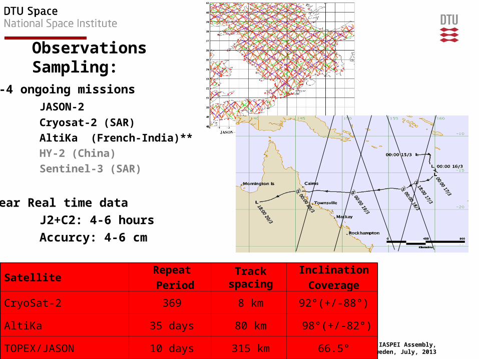
ObservationsSampling:
SatelliteRepeat Period
Track spacing
InclinationCoverage
CryoSat-2 369 8 km 92°(+/-88°)
AltiKa 35 days 80 km 98°(+/-82°)
TOPEX/JASON 10 days 315 km 66.5°
3-4 ongoing missionsJASON-2
Cryosat-2 (SAR)AltiKa (French-India)**HY-2 (China)Sentinel-3 (SAR)
Near Real time data J2+C2: 4-6 hoursAccurcy: 4-6 cm

IAHS-IAPSO-IASPEI Assembly, Gothenburg, Sweden, July, 2013
8 DTU Space, Technical University of Denmark
Sea Level and Storm Surges
Critial issues:
√ Spatio-temporal sampling vs surge/cyclone
√ Availability and accuracy
Accuracy degradation (Coastal and rain).
Reliability of surge capturing
Importance of residual range corr errors:
Ocean tide correction
Merging with tide gauges (spatial temporal correlation)
Hindcast / forecast modelling

IAHS-IAPSO-IASPEI Assembly, Gothenburg, Sweden, July, 2013
9 DTU Space, Technical University of Denmark
Heavy Rain can be problematic

IAHS-IAPSO-IASPEI Assembly, Gothenburg, Sweden, July, 2013
10 DTU Space, Technical University of Denmark
Sea Level and Storm Surges
Critial issues:
√ Spatio-temporal sampling vs surge/cyclone
√ Availability and accuracy
√ Accuracy degradation (Coastal and rain).
Reliability of surge capturing
Importance of residual range corr errors:
Ocean tide correction
Merging with tide gauges (spatial temporal correlation)
Hindcast / forecast modelling

IAHS-IAPSO-IASPEI Assembly, Gothenburg, Sweden, July, 2013
11 DTU Space, Technical University of Denmark
Last devastating storm
surge in Britain – 1953
”Data for validation?”

IAHS-IAPSO-IASPEI Assembly, Gothenburg, Sweden, July, 2013
12 DTU Space, Technical University of Denmark
High Water in Hvide Sande
Simple 2 and 3 std. deviation test on ”high water”

IAHS-IAPSO-IASPEI Assembly, Gothenburg, Sweden, July, 2013
13 DTU Space, Technical University of Denmark
Satellite Obs
One versus two satellite (TOPEX/ENVISAT)
Degradation not an issue

IAHS-IAPSO-IASPEI Assembly, Gothenburg, Sweden, July, 2013
14 DTU Space, Technical University of Denmark
Great Barrier Reef – Summer Cyclones
• Helen (January, 04, 2008) Larry (March 19th, 2006)

IAHS-IAPSO-IASPEI Assembly, Gothenburg, Sweden, July, 2013
15 DTU Space, Technical University of Denmark
Sea Level and Storm Surges
Critial issues:
√ Spatio-temporal sampling vs surge/cyclone
√ Availability and accuracy
Accuracy degradation (Coastal and rain).
Reliability of surge capturing
Importance of residual range corr errors:
Ocean tide correction
Merging with tide gauges (spatial temporal correlation)
Hindcast / forecast modelling

IAHS-IAPSO-IASPEI Assembly, Gothenburg, Sweden, July, 2013
16 DTU Space, Technical University of Denmark
Tide Correction Models
Remove residual tidal signal using the ”pointwise tide model. This enhances
The spatial correlation between tide gauge and

IAHS-IAPSO-IASPEI Assembly, Gothenburg, Sweden, July, 2013
17 DTU Space, Technical University of Denmark
Spatio-temporal Correlation
• TOPEX / JASON (17 years) ERS / ENVISAT (12 years)

IAHS-IAPSO-IASPEI Assembly, Gothenburg, Sweden, July, 2013
18 DTU Space, Technical University of Denmark
Temporal Correlation at Newlyn
After Detiding – temporal correlation = 0.93 (0.89 FES 2004 / GOT4.7)

IAHS-IAPSO-IASPEI Assembly, Gothenburg, Sweden, July, 2013
19 DTU Space, Technical University of Denmark
Sea Level prediction
CAN WE PREDICT/WARN ABOUT INCREASED SEA LEVEL
”STORM SURGES” FROM SATELLITE ALTIMETRY?????
Main issues:
Sampling (fixed tracks, sampling 9 / 17 or 35 days
Availability of ACCURATE real time data (1-6 hours)
Capture the Surge by the altimeter
Merging Tide gauge and Altimetry (observe the same signal)
Establish warning – ”hindcast” high water.

IAHS-IAPSO-IASPEI Assembly, Gothenburg, Sweden, July, 2013
20 DTU Space, Technical University of Denmark
Combing Tide gauges and Altimetry
Small time scale, Large spatial scales, high correlation T/P + Gauges
)()()()( 33221 tsshtsshtsshtTP
Least squares fit in every T/P observation
Regression Model

IAHS-IAPSO-IASPEI Assembly, Gothenburg, Sweden, July, 2013
21 DTU Space, Technical University of Denmark
Integrating using Neural Network
Test on using 4 gauges along coast of Norway.
Training using one T/P time series
Predicting other satellite points.
Higher temporal correlation using
Neural Network than regression method.

IAHS-IAPSO-IASPEI Assembly, Gothenburg, Sweden, July, 2013
22 DTU Space, Technical University of Denmark
• Satellite altimetry delivers: – Sea surface height– Wave height– Wind Speed
• predefined tracks+sampling
• Satellite altimetry has high temporal/spatial correlation with tide gauges
• Huge potential for ”high water forecasting”
• with tide gauges offers huge potential for improved warning in the future
Comming satellites (Cryosat + Sentinel-3) might offer even better prediction in the future (higher resolution + across track coverage)
Having vacation in Venice this summer…….
Conclusions