integration of geographic information systems (gis) to enhance academic ... · integration of...
TRANSCRIPT

1
Integration of Geographic Information Systems (GIS) to Enhance Academic Capability
of Philippine Higher Education Institutions
ALEJANDRO F. TONGCO [email protected]
Oklahoma State University
GENARO V. JAPOS [email protected]
Liceo de Cagayan University, Philippines
Date Submitted: Sept. 11, 2010 Plagiarism Detection: PassedFinal Revision Complied: Oct. 7, 2010 Flesch Reading Ease: 32.71 Gunning Fog Index: 13.85
Abstract - This paper presents a framework for improving campus management and enhancing academic capability through the integration of geographic information systems (GIS) in the functions of Philippine higher education institutions (HEIs). Institutional units applied with a GIS are described. Methods are briefly discussed to implement the plan as well as to sustain and institutionalize GIS.
Vol. 1 No. 1 January 2011 ISSN: 2094-9251 pp. 1-18International Peer Reviewed Journal
Asian Journal of Business and GovernanceBusiness Administration Section

Asian Journal of Business and Governance
2
INTRODUCTION
Philippine HEIs have been surviving on relatively meager resources. They have struggled to comply with performance standards and tuition controls set by government agencies such as the Commission of Higher Education (CHED) and accreditation bodies. Nevertheless, HEIs have strived to establish themselves as research universities to be on par with international universities worldwide. Faced with daunting challenges and stagnant budgets, new approaches and techniques have to be found and applied to help improve existing campus management efficiency and enhance academic capability.
A modern, versatile tool that has been widely accepted to improve management decision-making and enhance research in business and industry in a wide variety of disciplines and applications is GIS. It is used to manage entire organizations and as a tool in solving day-to-day spatial problems across different departmental levels. GIS is an information system that manages spatial, or geographically referenced, and non-spatial data. Spatial data takes advantage of the unique location of people, places, things, and events on Earth, as well as their interrelationships, to produce information to help in making informed decisions.
GIS is especially useful in a university setting, because it cuts across the major facets that comprise a university such as instruction, research, extension, and campus and human resource administration. GIS is seen as a novel approach that can help simplify the overall management process and enhance the scholastic standing of the university.
Demand for GIS Skills
GIS is applied in many disciplines and industries (1). Among them are the following: Agriculture, Architecture, Business, Defense and Intelligence, Education, Engineering, Government, Law, Libraries and Museums, Mapping and Charting, Natural Resource Management, Natural Sciences, Physical Sciences, Public Health and Medicine, Public Safety, Social Sciences, Transportation, and Utilities and Communications. (A more extensive list is listed in Appendix). With these varied and extensive applications, it is highly likely that industries will continue to seek for GIS-skilled personnel.
Business Administration Section

3
GIS in Schools Worldwide
Colleges and universities, particularly in the U.S., have been using or offering GIS courses for the past 20-25 years. It is now increasingly used in campus administration and academic capability building. Although GIS was borne from Geography course in schools, GIS’ fast development was mostly nurtured and popularized by private industries, most notably by the Environmental Science Research Institute (ESRI) (2). The development, utilization, and complexity of GIS is moving at a fast pace challenging educational institutions to keep up with the growth demands. Business and industry are employing not just all-around GIS-skilled graduates but they are beginning to look for people with highly specialized GIS skills such as GIS application developers and modelers as well as GIS theoreticians and scientists.
Based on the recent published account, there are more than 6,500 colleges and universities worldwide offering varying GIS-related courses and degree programs (3). The list of GIS programs is as follows: Certificate in GIS: 327; Bachelor’s Degree: 242; Graduate Degree: 190; and Distance Learning: 87. More than 2,000 of these HEIs are in the U.S., where 70 or more disciplines incorporate GIS in teaching, research, administration. The Urban and Regional Information Systems Association (URISA) stated more than 400 United States community colleges and technical-vocational schools offer GIS, remote sensing, and other related technologies. These include formal trainings, certification, associate, and diplomas (4).
Universities offer bachelors, masters, and post-baccalaureate certificates, as well as PhD degrees. For example, the University of Texas at Dallas, offers a PhD in geospatial information sciences (5), SUNY (State University of New York) University at Buffalo offers a PhD in geography with specialization in geographic information systems (6), and the George Mason University offers a doctorate in Earth Systems and Geoinformation Sciences (7).
GIS is increasingly used in many K-12 and vocational schools. United States Congressmen have urged President Obama’s Administration for the inclusion of geography and geospatial education in the Science, Technology, Engineering, and Mathematics (STEM) Curriculum (8) and in the Elementary and Secondary Education Act (ESEA) Blueprint for Reform (9).
HEIs such as the University of Oregon (10) and the University of Missouri (11) have extensively used GIS in campus planning and facilities management.
Integration of Geographic Information Systems (GIS) to Enhance Academic Capability of Philippine Higher Education Institutions
A. Tongco and G.V. Japos

Asian Journal of Business and Governance
4
Likewise, GIS applications in research have penetrated many disciplines, as shown for example in annual conference proceedings sponsored by the Environmental Science Research Institute (ESRI) for more than 20 years (12). ESRI is manufacturer of the most widely used GIS software, the ArcGIS suite of software.
What is GIS?
A GIS consists physically of computer hardware, people, software, data, and methods. Hardware may consist of computers and servers, large-format printers and scanners, and GPS equipment. People may consist of users, programmers, and designers. Examples of GIS software are MapWindow, ArcGIS, Manifold GIS, and Quantum GIS.
Data, whether as input or output, are either spatial or non-spatial, or both. Institutional processes may include guidelines, specifications, standards, and policies.
Figure 1. A schematic showing the components of a GIS and how spatial and non-spatial input data are processed into information.
Business Administration Section

5
To function, a GIS needs data that are spatial in nature, that is, geographically referenced, which has latitude and longitude and in some cases elevation, as well as data that is non-spatial, which may consist of ordinary tables, text, and hard-copy paper maps. Spatial data may consist of digital vector maps, represented either as lines, points, or polygons; or raster maps such as satellite and aerial imagery. Examples of vector data are GPS (global positioning system) points and survey data from total station or mobile GIS.
GIS manipulates, analyzes, interprets, manages, and stores these data. GIS may retrieve, display, and present these data into usable digital information such as digital maps and image maps, tables, statistical results, graphs and charts. The output may be processed further into other desired forms of spatial and non-spatial data.
The GIS software is the valuable tool that makes it happen. But it is always the human person that decides what, why, and when to process; what criteria to follow; how to process the data; and who makes the final decisions.
How is GIS Done?
GIS leverages the unique location of people, things, places on Earth – what they are and what are in them, where they are, and how they relate with their neighbors – within a defined geographical entity. These factors require building a database with similarly referenced data layers. Overlaying of data layers enables users to visualize relationships, interactions, connections, patterns, and trends. The datasets are the foundation to scientific spatial analysis that gives informed interpretation of research or project results and thus minimizing guesses in decision making.
Figure 2. An illustration of different GIS data layers used to simulate the real world (15).
Integration of Geographic Information Systems (GIS) to Enhance Academic Capability of Philippine Higher Education Institutions
A. Tongco and G.V. Japos

Asian Journal of Business and Governance
6
The choice of data layers depends on the problem being tackled. For example, in campus planning, the following data layers may be needed: layout and types of existing and planned buildings; water, electricity, and sewage lines; roads, bridges, and other infrastructures; permanent historical and cultural landmarks; natural resources; and raster data such as elevation and natural-color photo-imagery.
A Model for GIS Integration in Philippine HEIs
A framework-model diagram is presented (Figure 3) as a comprehensive roadmap for Philippine HEI administrators how to integrate GIS in HEIs. GIS integration focuses on two main HEI divisions: campus management and academic capability. The expected results of GIS integration are as follows:
1. Improved decision making across all campus management levels by leveraging campus spatial and non-spatial data to produce valuable information.
2. Enhanced scholastic strength through GIS application in teaching, research, extension, and revenue generation by GIS-engaged faculty, staff, and students.
Figure 3. A Schematic Model of GIS Integration for Philippine HEIs. (Zoom to 400% to see details.)
Business Administration Section

7
The Components
In a university-wide GIS-engaged management, GIS capitalizes on the unique location of the following to aid in in-depth analysis: human resource, physical and natural resource, and assets. The spatial interaction and information derived from the various features can help in analyzing spatial patterns and trends that are valuable in achieving a more effective campus management.
A. CAMPUS ADMINISTRATION
1. GIS in Campus Assets and Facilities Management
A university-wide GIS can provide broad spatial information and enable a visual view about the campus. This information can significantly aid in campus planning and management of its resources (10, 11).
Similarly, GIS technology can be applied to Philippine HEI campuses. The campus boundary is one big area with sub-areas (e.g., footprints of buildings, classrooms, laboratories, offices, and other structures), has people in them (e.g., faculty, staff, and students) and things in them (e.g., equipment, furniture, fixtures, and other assets), and has unique locations of those things relative to each other (e.g., geographic coordinates, relative distances, and elevation).
With a GIS, information can be quickly accessed saving much time in many tasks. These may include preparation of annual reports, short and long-term plans, growth forecasts, future manpower and equipment allocations, land and infrastructure project development, research development and implementation, building and facility site selection, equipment inventory and status, as well as on-the-spot information requests. Easier data accessibility can significantly help HEI officials and stakeholders in making prompt and sensible decisions and in formulating project and research plans.
2. GIS in Faculty, Staff, and Student Administration
GIS can also be quite useful in managing faculty, staff, and students. For example, by using GIS and faculty teaching schedules, faculty locations at certain time of day can easily be shown visually on a computer. GIS could
Integration of Geographic Information Systems (GIS) to Enhance Academic Capability of Philippine Higher Education Institutions
A. Tongco and G.V. Japos

Asian Journal of Business and Governance
8
further determine what class s/he is handling and the quantity and names of students in that class. Furthermore, faculty and student database can be queried to determine the previous and next subjects and location of the faculty or students. Knowledge of this sort of information helps top officials in tracking and supervising their faculty members.
The use of GIS in student recruitment and enrollment is another area that is worth looking into. GIS can help make intelligent recruitment strategies such as deciding to prioritize recruitment target areas and choosing new enrollees based on scholastic standing, thus guaranteeing the university with a top-performing student population. GIS can also include other criteria for new-enrollee selection, such as household income and ethnicity, if desired. Nevertheless, quality students can translate into quality graduates and higher percentage of board passers, resulting further into higher accreditation levels for the school’s programs, attracting more topnotch entrants, higher job prospects for graduates, and enhanced reputation in the community and region and among the country’s HEIs.
3. GIS in Alumni Administration
One extremely valuable but often overlooked and undervalued resource especially among Philippine HEIs is the alumni. The alumni are a potentially vast financial resource for the university. GIS can be used to create and manage an alumni spatial database which can be used to intelligently plan for fund-raising campaigns that target potential high givers. Thus, HEIs need to maintain the alumnus-alma mater bond. Such relationship can lead to many positive results for the university’s capability building efforts and for its new job-seeking graduates. The database may also include foundations, corporations, organizations, and private individuals. A highly notable example of alumni philanthropy is that of Stanford University in California, U.S.A. It raised more than $900 million in 2006 alone (16).
B. ACADEMIC CAPABILITY BUILDING
1. GIS Skills Development for Faculty, Staff, and Students
A prerequisite to the development and sustained utilization of GIS in campus management and in academic capability building is the presence of a
Business Administration Section

9
GIS-skilled human resource. Empowering the most important resource of a university, i.e. its faculty, staff, and students in GIS science and technology can lead to the active use of GIS in the many components that comprise a university and thus sustain the GIS capability buildup of the university system.
GIS skills can be acquired through GIS graduate and undergraduate education from GIS-strong schools through in-campus or virtual classrooms, continuing education, professional trainings, conferences and meetings, exchanges, internships, and other similar educational schemes.
A GIS-skilled faculty and staff can produce many opportunities for the university. To mention a few, these are in research, extension, and project tie-ups, as well as in developing new GIS-related curriculum and developing GIS-skilled graduates.
Training a select group of people in GIS is needed to initially establish a core of GIS trainers on campus. Better yet, it may be advisable to hire experienced GIS specialists in order to fast-track project execution.
2. GIS-Engaged Teaching and GIS Curriculum Development
GIS is an invaluable teaching and research tool. GIS challenges students and teachers, as well as researchers to think more analytically and critically. Students will have the distinct advantage if they are introduced to GIS early in their education, establishing a solid foundation of analytical thinking.
Elementary and high schools in developed countries, such as the U.S. and Canada, are now using GIS as part of their curriculum (17, 18). GIS integration in schools has resulted in the improvement of students’ scores in achievement tests.
The presence of a dynamic university-wide GIS stimulates the development and enhances the growth, not only of computer science or information technology, but of other disciplines on campus as well, including agriculture, social sciences, natural and life sciences, physical sciences, environmental management, educational management and administration, public health, business administration, and science education.
GIS can be taught as a topic within many subjects such as biology and social studies. A separate subject in GIS can also be developed; this is already done as part of many degree programs. Likewise, a GIS major or minor is already offered in many science and technology degrees. Recently, a bachelor’s or graduate degree in GIS is now offered in many universities worldwide (3).
Integration of Geographic Information Systems (GIS) to Enhance Academic Capability of Philippine Higher Education Institutions
A. Tongco and G.V. Japos

Asian Journal of Business and Governance
10
Philippine HEIs can take advantage of this opportunity.
3. GIS in Research and Extension
The application of GIS in research has made GIS quite popular. It is not just another analytical tool such as statistics; although GIS goes far beyond traditional statistics, taking into account the location of subjects and the interrelationships among them. GIS uses a multidisciplinary approach involving computer science, geodesy, mathematics, and geography. Its uniqueness is its ability to present a more understandable, visual interpretation of research results, enhancing the quality of research thereby adding value to it.
GIS can make research more enjoyable for researchers and graduate students discovering additional information out of traditional survey data through the application of spatial statistical and geostatistical analysis. GIS can present a way to better understand statistics through data geo-visualization and measurement of data distributions, as well as introducing a more motivating and educational tool for all users.
Furthermore, GIS is a useful tool in extension projects. Planning and selection of project sites can be better decided if aided by GIS. Guesswork in targeting of sampling sites can be avoided. Likewise, project results can be clearly presented and disseminated through maps and geographic data visualization.
Internationally funded development projects almost always use GIS in the project’s full cycle. A GIS-skilled HEI, therefore, would have a better chance as local project partner.
4. GIS in Revenue Generation
As GIS human resource in HEIs build up, so does the university’s confidence and capabilities in pursuing GIS-related revenue-generating projects. With a GIS infrastructure in place, HEIs can have substantial influence in capturing GIS-related project tie-ups with national and international agencies. An HEI’s GIS can also serve as a model, and thus as GIS resource, for other HEIs and campuses that plan to create a better campus management system and GIS capability building projects of their own. All these can attract revenue for the HEI in terms of computer equipment, software, or additional manpower, and at the same time continuously build its own GIS knowledge base.
Business Administration Section

11
Philippine HEIs Can be Enhanced by GIS
It is not a question whether Philippine HEIs are ready for GIS or not. It is a question how quickly administrators can envision the advantages of a GIS-empowered university and how fast they can move to adopt GIS. Transitioning to include GIS technology skills development should not be difficult considering the high IT literacy among the HEIs’ current human resource.
GIS academic programs worldwide have multiplied because of the demand for GIS-skilled graduates in business and industry. While GIS has been around for about 30 years, Philippine businesses, industries, local government units, government agencies, and academia have started using GIS only these past few years. Graduates of other disciplines who were trained on-the-job in GIS or who have acquired the skills through trainings elsewhere are doing GIS tasks that come along. This is what happened during the early years of GIS. People got their elementary GIS skills not through formal education. But this may not be advisable now when GIS-engaged workplaces have multiplied and are increasingly using GIS in greater depth.
This is an opportunity for HEIs to look into. HEIs that can first offer GIS academic programs definitely have the advantage. The earlier an HEI can establish itself as a GIS-engaged institution, the greater its opportunities – through research and off-campus collaborations, and projects - and the faster it can develop into a center of excellence in GIS.
Philippine HEIs need to do a lot of catching up and do it fast. The University of the Philippines-Diliman (UPD) is the only HEI in the country offering a degree in Geography, which is the main foundation of GIS (13). No Philippine HEI is known to offer a formal degree or certificate program in GIS, or a major or minor in GIS under a degree offering.
One important motivating factor for HEIs is the demand for GIS-capable graduates. Undoubtedly, graduates who are skilled in GIS or GIS-related degrees will have the advantage in the current and future job market locally and worldwide. With more and more companies using GIS, possession of a GIS degree is definitely a big plus in job search.
Knowing how to use GIS software, however, goes hand in hand with acquiring GIS skills. ArcGIS is becoming the ‘standard’ in many departments in U.S. universities, as what has been accorded to Microsoft’s Word or Excel many years ago. The ArcGIS suite of software is considered the de-facto
Integration of Geographic Information Systems (GIS) to Enhance Academic Capability of Philippine Higher Education Institutions
A. Tongco and G.V. Japos
Asian Journal of Business and Governance
12
standard worldwide. Unfortunately, this software is relatively prohibitive for most developing-country users. Philippine HEIs do not have much choice. If they wish to prepare their GIS graduates to be highly competitive in the international GIS job market, they have to make the investment in ArcGIS skills development.
Fortunately, starting to learn GIS does not require large initial investments in hardware and software. Most existing computer hardware in place can do the job. Many highly capable GIS software are free (14). Complex and process-intensive tasks, however, may require sophisticated GIS software. But free and open source software (FOSS) in GIS, such as SAGA GIS and MapWindow, are increasingly equipped with powerful functions found in commercial ones.
The Business Case of Implementing a GIS in Philippine HEIs
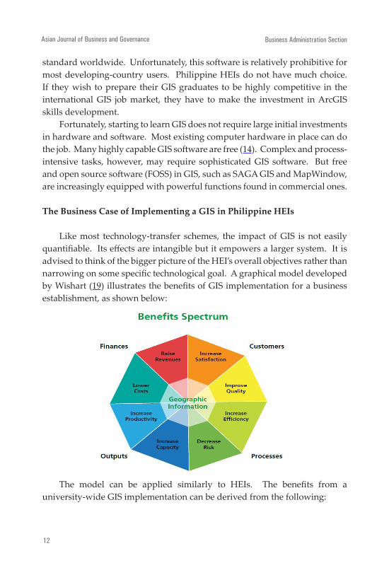
Like most technology-transfer schemes, the impact of GIS is not easily quantifiable. Its effects are intangible but it empowers a larger system. It is advised to think of the bigger picture of the HEI’s overall objectives rather than narrowing on some specific technological goal. A graphical model developed by Wishart (19) illustrates the benefits of GIS implementation for a business establishment, as shown below:
The model can be applied similarly to HEIs. The benefits from a university-wide GIS implementation can be derived from the following:
Business Administration Section

13
Improved Campus Management Efficiency
1. Faster and simplified tasks in campus administration improve efficiency and reduce costs.
2. Minimized guesswork through GIS-based decision-making avoids costly mistakes.
3. GIS-based student recruitment and retention strategies translate into an academically superior student population, further attracting excellent students.
4. Avoidance of unnecessary promotional and advertising costs is possible with GIS.
5. GIS-assisted alumni management and donor fund-raising schemes can financially sustain HEIs.
Enhanced Academic and Intellectual Capacity
1. GIS-engaged students improve their spatial and analytical thinking abilities turning them into excellent students and graduates.
2. Enrolment can increase due to popularity of GIS as an emergent field.3. GIS-engaged faculty and staff attract GIS project partnerships and
increases GIS capability buildup, including monetary benefits.4. GIS adds value and improves the quality of research thus stimulating
further scholarly activities in campus and giving the HEI strong leverage in attracting funding sources for its researches.
5. GIS-enhanced extension and outreach projects produce value-added results.
6. High employability of GIS-skilled graduates attracts more students to the HEI’s GIS curricular offerings and GIS-engaged disciplines.
Sustaining a GIS-Engaged HEI
GIS implementation, however, can face difficult barriers because of the lack or absence of awareness among HEI administrators about the utility of a GIS. Thus a GIS leader at the top of the management ladder is valuable to bring the project to fruition.
Integration of Geographic Information Systems (GIS) to Enhance Academic Capability of Philippine Higher Education Institutions
A. Tongco and G.V. Japos

Asian Journal of Business and Governance
14
GIS Executive Champion
The GIS executive champion is needed to push for GIS integration especially during dire circumstances. He/she is indispensable in making the project a success from beginning to end and beyond. The GIS executive champion works closely with top HEI officials (ideally, he/she should be one of them) for a smooth and coherent program implementation and consequently institutionalization of GIS. Moreover, he/she shall lead in sustaining GIS university-wide and to immerse GIS in the consciousness of officials, faculty, staff, and students.
GIS Advisory and Technical Working Groups
At the very start of a plan for a GIS university-wide, even before a project is conceptualized, it is advised to form a GIS advisory group. It shall be composed of top school officials who are the main stakeholders. The advisory group shall formulate policies for the overall conduct of the project and shall guide the project leader toward implementing these policies in harmony with the university’s mission and vision.
The technical working group shall give advice on the technology aspect and shall spearhead the initial skills building program, help to synthesize and implement new GIS projects, and to act as the main GIS knowledge resource on campus.
GIS Advocacy
Advocacy and popularization of GIS can be done through the announcement of GIS activities, progress, and accomplishments in the school’s website as well as in local and regional newspapers. Holding of GIS lectures and mini-conferences on campus as well as participation in the annual International GIS Day events can add to GIS’ popularity.
Institutionalizing GIS Integration: The Role of the HEI GIS Center
The HEI GIS Center acts as the central body that provides overall leadership in the planning, implementation, and assessment of the university’s GIS program. It is a must that this body be formally established institutionally as
Business Administration Section

15
a distinct component within the university with the purpose of implementing and sustaining the project’s objectives and mission beyond its entire project phase. On the other hand, GIS integration should be embedded in the university’s vision, mission, and goals across all departmental levels to insure continuity and growth of GIS.
Having a GIS in the university should not be just learning about GIS or a GIS software. Since the HEI aspires to be in the forefront of one or several emergent technologies, such as GIS, the HEI can do more than being a plain user. Institutionalization of GIS is one large step. Excellence in GIS university-wide is better. Producing high-caliber scholastic research aided by GIS is much better. With a nurtured GIS knowledge base in its arsenal and knowing GIS’ wide-ranging and almost unlimited applications, the HEI can build up its research capability with greater depth at the same time manage the campus more efficiently.
CONCLUSION
An emergent and financially healthier university can ultimately be realized through the following GIS-engaged activities: efficient management of campus facilities and assets, intelligent student recruitment, development of highly-competitive GIS-skilled graduates, enhanced research, aggressive alumni and donor fund raising, added revenue generation through GIS-based schemes, improved quality of reports, and greater leverage in capturing GIS projects. A GIS-empowered HEI can meet the challenges of an increasingly GIS-engaged teaching, research, extension, and workplace environment, most especially, the competition ahead.
Note: Pursuant to the international character of this publication, the journal is indexed
by the following agencies: (1)Public Knowledge Project, a consortium of Simon Fraser University Library, the School of Education of Stanford University, and the British Columbia University, Canada:(2) E - International Scientific Research Journal Consortium; (3) Journal Seek - Genamics, Hamilton, New Zealand; (4) Google Scholar; (5) Philippine Electronic Journals (PEJ);and,(6) PhilJol by INASP.
Integration of Geographic Information Systems (GIS) to Enhance Academic Capability of Philippine Higher Education Institutions
A. Tongco and G.V. Japos
Asian Journal of Business and Governance
16
Acronyms
BSCS Bachelor of Science in Computer ScienceBSIT Bachelor of Science in Information TechnologyCHED Commission on Higher EducationDBM Department of Budget and ManagementDMgmt Doctor of ManagementESEA Elementary and Secondary Education ActFOSS Free and Open Source SoftwareGIS Geographic Information SystemGPS Global Positioning SystemHEI Higher Educational InstitutionIT Information TechnologyMAEd Master of Arts in EducationMEng Master in EngineeringMMgmt Master in ManagementMNurs Master in NursingPHEI Philippine Higher Educational InstitutionSTEM Science, Technology, Engineering, Mathematics
CurriculumSUNY State University of New YorkUPD University of the Philippines-DilimanUPLB University of the Philippines at Los BanosURISA Urban and Regional Information Systems
Association
LITERATURE CITED
(1) Industries. 2011, March 29. Retrieved from http://www.esri.com/industries.html
(2) ESRI. 2011, March 29. Retrieved from http://www.esri.com
(3) Find a GIS Program. 2011, March 29. Retrieved from http://gis.esri.com/university/
onlinedb.cfm
Business Administration Section

17
(4) Colleges & Universities. 2011, March 29. Retrieved from http://www.urisa.org/career/
colleges
(5) Doctor of Philosophy. ( 2011, March 29). Retrieved from https://www.utdallas.edu/epps/
gis/phd.html
(6) PhD Degree in Geography with Specialization in: Geographic Information Systems. (2011, March 29). Retrieved from http://www.geog.buffalo.edu/programs/phd/gis.shtml
(7) Ph.D. in Earth Systems and Geoinformation Sciences. (2011, March 29). Retrieved from http://www.scs.gmu.edu/Academics/PHD_ESGS_main.html
(8) STEM Fields. (2011, March 29). Retrieved from http://en.wikipedia.org/wiki/STEM_fields
(9) Richardson, D. (2011, March 29). Needed: A National Blueprint for GIS and Geography Education in Our Schools. Retrieved from http://www.esri.com/industries/education/index.html
(10) Campus GIS. (2011, March 29). Retrieved from http://geography.uoregon.edu/infographics/projects/campus_GIS.htm
(11) Campus Facilities. (2011, March 29). Retrieved from http://www.cf.missouri.edu/spm/gis/about.html
(12) Recent Proceedings. (2011, March 29). Retrieved from http://proceedings.esri.com/library/userconf/index.html
(13) Student Information. (2011, March 29). Retrieved from http://upd.edu.ph/grad_programs.html
(14) The FreeGIS Project provides. (2011, March 29). Retrieved from http://www.freegis.org
Integration of Geographic Information Systems (GIS) to Enhance Academic Capability of Philippine Higher Education Institutions
A. Tongco and G.V. Japos

Asian Journal of Business and Governance
18
(15) Why Use GIS? (2011, March 29). Retrieved from (http://gis.com/content/why-use-gis
(16) Contributions to Colleges and Universities Up by 9.4 Percent to $28 Billion. (2011, March 29). Retrieved from http://www.charitynavigator.org/index.cfm/bay/content.view/cpid/565
(17) GIS in the Classroom. (2011, March 29). Retrieved from http://www.edu.gov.mb.ca/k12/cur/gis/index.html
(18) ArcNews. Winter 2010/2011, Vol. 32 No. 4. (2011, March 29). Retrieved from http://www.esri.com/arcnews/index.html
(19) Wishart, K. (2011, March 29). Speak the Same Language: Making a compelling case for GIS to business executives. Retrieved from http://www.esri.com/news/arcuser/0309/roi_kw.html
Business Administration Section