integrated map tool overview, current status, and things to come…
TRANSCRIPT
Integrated Map Tool
Overview,
Current Status,
and Things to Come…

Integrated Mapping and Analysis Tool (IMAT)
“map widget” Integrated Mapping Tool IMAT
• Reusable components for portrayal, query, analysis, and exchange
• Analytical capabilities provided through application “proxy” services
• Scalable and extensible, but not a full-featured web-based GIS
• Fast
• Lightweight (small footprint on server) with browser-based clients
• Modular, reusable components, designed for service-oriented architecture (SOA)
• Built on interoperability standards
• Leverages development funding from DHS, FGDC, and IR&D.
• ~$50k in WRAP-centric development funds from CAP grant alone

Integrated Mapping and Analysis Tool (IMAT)
Service interfaces based on Open Geospatial Consortium (OGC) specifications:
WMS = Web Mapping Service
WFS = Web Feature Service
WCS = Web Coverage Service
WPS = Web Processing Service
CSW = Catalog Service for the Web
“Features” are simple like points, lines, and polygons.
“Coverages” are rasters, lattices, or TIN surfaces
Projection & analysis will be WPS’s
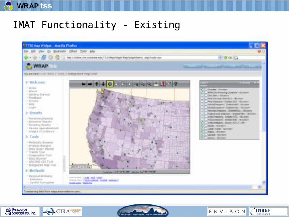
IMAT Functionality - Existing

IMAT – Current Work aka “Cycle 1”
• “Interactive Scaling” and other client-side controls (operated by users)
collaborative task by ENVIRON and Image Matters
provides capability to shade features (e.g., county polygons or model output grid cells) for local-scale area based on values of a continuous variable
allows changing colors and other symbology for layer features
• Metadata Catalog
Implement Catalog Service for the Web (CSW)
Storage location for metadata from WRAP layers
Provides connectivity to National Spatial Distribute Infrastructure (NSDI) distributed Clearinghouse network – allows discovery of WRAP geodata from any of the 6 Clearinghouse Gateways
Metadata management through CatMan tool
• Direct Access (“one-click-away”) to metadata from IMAT viewer
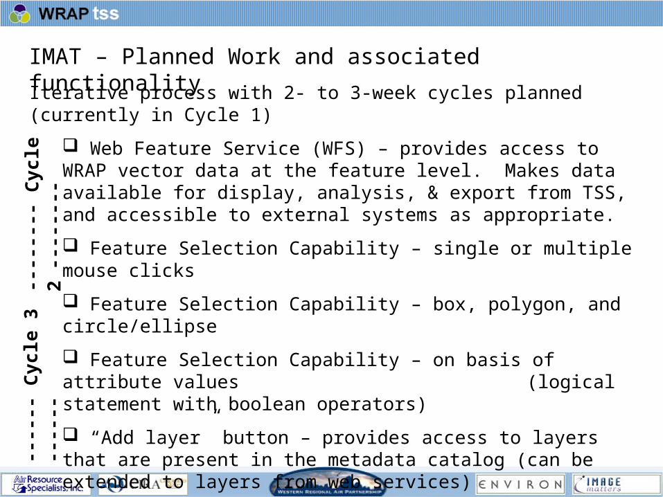
IMAT – Planned Work and associated functionality
Iterative process with 2- to 3-week cycles planned (currently in Cycle 1)
Web Feature Service (WFS) – provides access to WRAP vector data at the feature level. Makes data available for display, analysis, & export from TSS, and accessible to external systems as appropriate.
Feature Selection Capability – single or multiple mouse clicks
Feature Selection Capability – box, polygon, and circle/ellipse
Feature Selection Capability – on basis of attribute values (logical statement with boolean operators)
“Add layer” button – provides access to layers that are present in the metadata catalog (can be extended to layers from web services)
Web Mapping Service (WMS) – provides service to be ingested for display through IMAT, or through an external web mapping system.
“Create AOI layer” button – makes a temporary (cached) layer that serves as the user’s Area-of-Interest for analysis and/or data export.
----
----
Cyc
le 2
---
----
---
----
Cy
cle
3 -
----
-
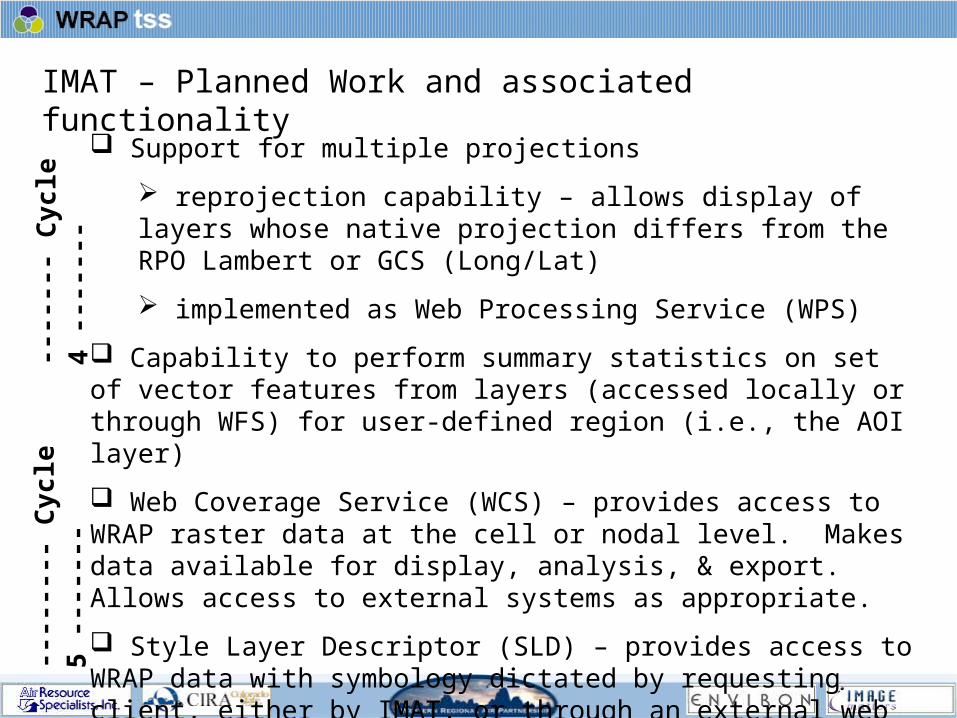
IMAT – Planned Work and associated functionality
Support for multiple projections
reprojection capability – allows display of layers whose native projection differs from the RPO Lambert or GCS (Long/Lat)
implemented as Web Processing Service (WPS)
Capability to perform summary statistics on set of vector features from layers (accessed locally or through WFS) for user-defined region (i.e., the AOI layer)
Web Coverage Service (WCS) – provides access to WRAP raster data at the cell or nodal level. Makes data available for display, analysis, & export. Allows access to external systems as appropriate.
Style Layer Descriptor (SLD) – provides access to WRAP data with symbology dictated by requesting client, either by IMAT, or through an external web mapping system. Extends current work.
Summary statistics capability for raster layers for user-defined AOI.
----
---
Cy
cle
4 -
----
----
----
-- C
ycle
5 -
----
--

IMAT – Future Work & associated functionality
Potential Post-October 2006 development:
Provision of CatMan and MetaMan tools as appropriate. Metaman provides metadata editing and validation capabilities.
Design and Implement Registry (Catalog) for contextual geospatial data and other key WRAP layers available through web services.
Identify key web services of interest (WMS, WFS, WCS) and populate the web service Registry with service info and capabilities.
Data download capability – site with “ftp from HTTP” transfer capability – develop tools and web pages that utilize the AOI functionality and the indexed data. Potential output formats include shapefiles, SDTS format, GML, and ASCII.
Metadata upload tools
Data upload tool – allow States and Tribes to upload data to TSS----
----
----
----
---
Cy
cle
6 -
----
----
----
----
---

Architecture Overview
Third-Party Libraries (Mochikit, DWR)
userSmarts® Javascript Framework(aka TANDOM™)
IMAT(Integrated Map Tool)
Widget
Canvas
Tool Bar
Layer Bar
View Context
Scale Legend
Location Bar
MapTag
Geom. Rend.
OGC Proxy Services(userSmarts® owsremote)
WMS-P
JSON using DWR over HTTP
JavascriptJava
OGC Web ServicesHTTP
WMS
WFS-P CSW-P
WFS CSW
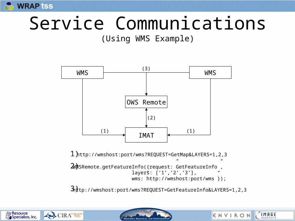
Service Communications(Using WMS Example)
WMS
OWS Remote
IMAT
WMS
(1)(1)
(3)
(2)
http://wmshost:port/wms?REQUEST=GetMap&LAYERS=1,2,3
WMSRemote.getFeatureInfo({request:”GetFeatureInfo”,layers: [‘1’,’2’,’3’], wms:”http://wmshost:port/wms”});
http://wmshost:port/wms?REQUEST=GetFeatureInfo&LAYERS=1,2,3
1)
2)
3)

Current Capabilities• Display a set of layers defined by an OGC ViewContext document
– where each layer can be hosted by a separate WMS than the rest• Extendable Tool-based interaction
– Panning– Zooming (in, out, to box)– Geometric area selection (box, polygon, circle) with support for callbacks returning geometry– Distance Measuring (with configurable UOM)– Bookmarking (context save/restore)– Feature description query support (using WMS GetFeatureInfo)
• Layer management controls using LayerBar– Show/hide– Activate/deactivate (for query)– Shift up/down
• Multiple supported projections– Cassini (standard latitude/longitude)– Lambert Conformal Conic
• Real-time user location status in given projection using LocationBar• Scale legend (with configurable UOM)• Geometry Renderer API with default implementations for Firefox and Internet
Explorer

Near-term Capabilities• Layer property editor
– Allowing on-the-fly adjustments to certain layer properties• Opacity• Color scale min and max• And many more (TBD)
– Inline with the layer information provided by the Layer Bar• Shown/Hidden by clicking an ‘Edit’ button
• Layer legend information– Requires either ‘turning on’ legend support in Arc or creating default icons (non-
scaling layers)– Scaling service will provide legend information for dynamically shaded layers
• Metadata Viewer– Component integrated with the IMAT– Allow for querying a CSW and displaying the resulting metadata
‘hits’– Adding layers identified by CSW results to current map
• Supporting WFS endpoints for describe feature functionality– Select by point or bounding region (box, polygon)– External component for querying based on attribute values
• Area of Interest Layer• Something else
Near-term Capabilities, cont’d