instructor’s notes for mt. st. helens topographic profiles ... · • nuee ardente: ash mixes...
TRANSCRIPT

Instructor’s Notes for Mt. St. Helens Topographic Profiles
A Laboratory Activity by Eileen Herrstrom
University of Illinois at Urbana-Champaign [email protected]
Overview On May 18, 1980, Mt. St. Helens in the state of Washington exploded in a cloud of ash, plus lava and mud flows. What had been a beautiful symmetrical snow-covered mountain with heavily forested slopes became a startling landscape of ash, mud, and downed trees surrounding a broken, irregular peak. The power of the initial blast was directed upward and laterally, snapping off trees for miles in the blast zone. In the years since 1980, many people – geologists, biologists, environmentalists – have been observing and studying how the landscape recovers after a major volcanic eruption.
Screen shot from the Mt. St. Helens VolcanoCam
<http://www.mountsthelens.com/volcanocam.html> on March 22, 2011, showing a small plume of steam emerging from a lava dome inside the crater.
Learning objectives
• Describe the shape of Mt. St. Helens before and after the eruption. • Draw two topographic profiles across the volcano and determine their vertical
exaggeration. • Use your profile to estimate the dimensions of the material removed by the eruption
and calculate the volume. • Compare your result with published values and identify sources of error in your work.

Teaching Notes and Tips • Note that students need access to a printer to complete this exercise, as they must print
some of the accompanying teaching materials. Alternatively, the maps and profile graph may be provided by the instructor.
• Some students have difficulty visualizing the material removed by the eruption as a perfect cone and relating this three-dimensional concept to the two-dimensional cross-section in the topographic profiles. Given the before and after profiles, students must choose a base for the cone. Explanations and illustrations were added to the instructions to address this issue.
• Other students have problems carrying out the calculations. One common error is expressing the height and radius of the cone in different units.
• If students have access to Google Earth and know the basics of how to use it, they can be instructed to fly to Mt. St. Helens and rotate the image to see the mountain from all directions. Alternatively, this could be done as part of the introduction to the exercise.
Outline of Lecture that precedes Mt. St. Helens Topographic Profiles Lab Activity I. “Quiet” (non-explosive) eruptions
A. Lava eruptions
• Typical of volcanoes that erupt basalt • Characteristics include
o Lava flows o Lava fountains
• Form shield volcanoes o Gently sloping o Dome-like volcanoes o Composed of multiple lava flows o May have a crater or caldera (large crater) at the top
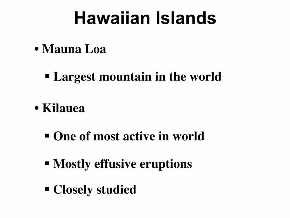
B. Hawaii
• Chain of islands all built by lava flows o Mauna Loa
§ Highest mountain in the world (from the sea floor) § Currently active
o Kilauea § One of the most active volcanoes in the world § Intensely studied
• Loihi Seamount o Newest Hawaiian volcano o Top is ~1 km below sea level o Thousands of years still, until it becomes an island

C. Mid-ocean ridges
• Most lava eruptions occur under the oceans • Along divergent boundaries
o Typically produce pillow basalt: rounded mounds of lava o Or obsidian
II. “Loud” (explosive) eruptions
A. Ash fall eruptions
• Produce a large plume of volcanic ash o Fine-grained or glassy o Rhyolite (or andesite)
• Ash settles from the air in a layer similar to snow. • Forms a stratovolcano
o Steep-sided mountain o Alternating ash-falls and lava flows
• May produce a volcanic mudflow
B. Examples of ashfall eruptions
• Vesuvius - active volcano next to Naples, Italy o Erupted in 79 A.D.
§ Ashfall lasted ~2 days § This was followed by an eruption of mixed pyroclastic debris that lasted
~6 hours § Killed ~20,000
o Buried several Roman cities and preserved them § Pompeii and Herculaneum were rediscovered in 1700s § Excavation uncovered mosaics and paintings § Casts were made of human and animal victims
<http://commons.wikimedia.org/wiki/Pompeii#Victims> o Today, Vesuvius is surrounded by Naples metropolitan area
§ Densely populated § Another eruption like 79 CE would be deadly, so geologists are
monitoring the volcano • Mt. Saint Helens
o In the Cascade Range in NW US o Erupted May 18, 1980 o Sequence of events:
§ March 1980 - Signs of activity prompted geologists to warn there was a high likelihood of an explosive eruption.
• Side of mountain bulged outward and upward § 5/18/80 - Two strong earthquakes => a large landslide => the sudden
release of pressure on the magma => explosion of volcanic ash => knocked down trees
• Ash extended 16 km (10 miles) up into atmosphere and east to the Atlantic Ocean
§ 5/18/80 - Hot ash melted snow => enormous mudflows =>flooding downstream
§ 63 people were killed, including one geologist. Many more deaths would probably have resulted without warnings from geologists.
C. Ash-flow eruptions
• Spectacular (and includes the largest) eruptions • Occur when extremely viscous magma with lots of gas pressure erupts as hot ash • Nuee ardente: ash mixes with air, creating a hot, dense cloud
o Nuee ardente flows down the side of the volcano. o Speeds of up to 60 mi/hr o Results in instantaneous destruction
D. Examples of ash-flow eruptions
• Mt. Pelee o On the island of Martinique in the Caribbean o Eruption in 1902 produced a nuee ardente o Obliterated the city of St. Pierre
§ In ~30 sec § All but 2 of 28,000 inhabitants died.
• Yellowstone o First national park, located in NW Wyoming state o Enormous nuees ardentes occured at 2.0, 1.3, and 0.6 Ma
§ ~1000 times larger than Mt. St. Helens 1980 eruption o Geysers and hot springs indicate magma is still present below the surface. o Other activity
§ Earthquake swarms § Caldera rise and subsidence
Slides The following pages present slides from the lecture that covers Mt. St. Helens. Please note that the Mt. St. Helens portion of the lecture is complete. Other slides are included to outline the framework of the lecture on particular styles of volcanic eruptions, but detailed examples are not provided.

Erupting Volcanoes
https://commons.wikimedia.org/wiki/File:Pyroclastic_flows_at_Mayon_Volcano.jpg

Lava Eruptions • Basalt lava§ Eruptions include:
o Lava fountainso Lava flows
Krafla, Iceland
Kilauea, Hawaii
https://commons.wikimedia.org/wiki/File:Lava_flow_at_Krafla,_1984.jpg
https://volcanoes.usgs.gov/vsc/glossary/lava_fountain.html

Mountains from Lava Eruptions
• Form shield volcanoes
§ Gently sloping
§ Dome-shaped
§ At the top:
o Crater
o Caldera: large crater from collapse

A Typical Shield Volcano
Sketch & photo by Eileen Herrstrom
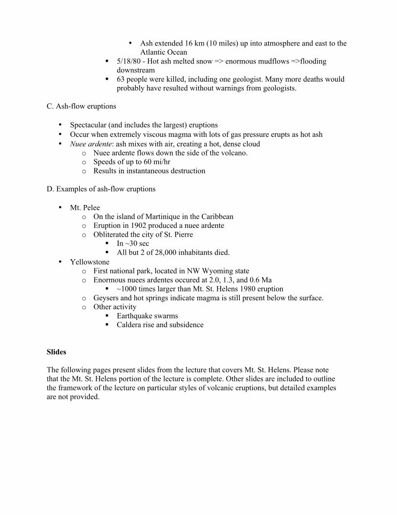
Hawaiian Islands • Mauna Loa
§ Largest mountain in the world
§ Closely studied
• Kilauea
§ One of most active in world
§ Mostly effusive eruptions

More Lava Eruptions
• Most occur at MORs
§ Hot lava + cold seawater = very fast cooling
o Obsidian
o Pillow basalt
https://commons.wikimedia.org/wiki/File:Nur05018-Pillow_lavas_off_Hawaii.jpg

Explosive Eruptions: Ash-Falls
• Large cloud of ash
o Fine-grained rhyolite or glassy
• Form composite volcanoes
§ Alternating layers of ash and lava
§ Steeper, smaller than shield volcanoes
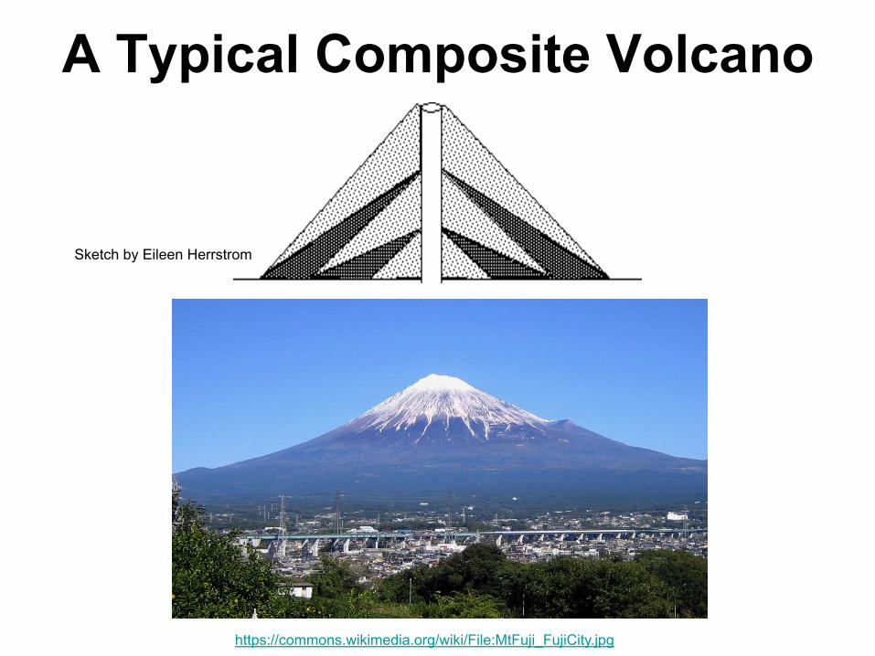
A Typical Composite Volcano
https://commons.wikimedia.org/wiki/File:MtFuji_FujiCity.jpg
Sketch by Eileen Herrstrom

Composite Volcanoes
Masaya, Nicaragua: light = ash, dark = lavaPhoto by Eileen Herrstrom

Ash-Fall Example: Mt. St. Helens • Cascade Mtns, state of Washington
§ Erupted May 18, 1980 § Details in lab
https://commons.wikimedia.org/wiki/File:St_Helens_before_1980_eruption_horizon_fixed.jpg
https://commons.wikimedia.org/wiki/File:MSH82_st_helens_plume_from_harrys_ridge_05-19-82.jpg

Mt. St. Helens Sequence #1 § March 1980
§ Mountainside began to bulge, small EQs
o Older rocks felsico Geologists
watched closely
MSH images from - https://volcanoes.usgs.gov/volcanoes/st_helens/st_helens_gallery_23.html

MSH Sequence #2
May 18, 1980 at ~ 8:30 AM
a. Two larger EQs
o --> Pressure released
o --> Eruption!
b. Landslide
http://www.youtube.com/watch?v=bgRnVhbfIKQ

MSH Sequence #3 #3. May 18, 1980 at ~ 8:32 AM
§ Ash
o 16 km up
o East to Atlantic
§ Trees knocked down by blast
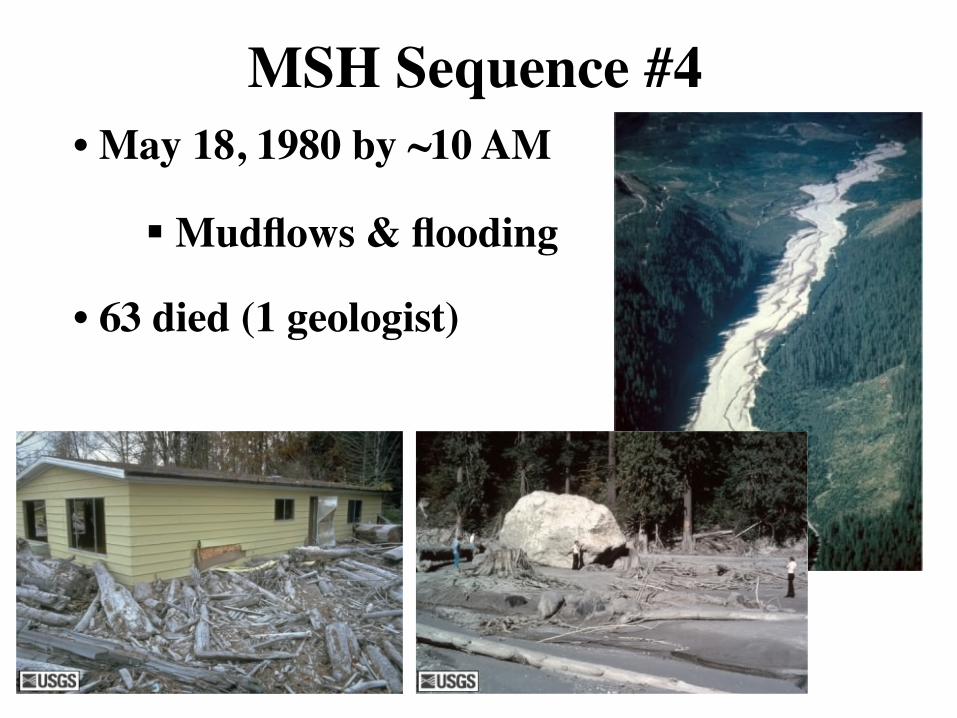
MSH Sequence #4 • May 18, 1980 by ~10 AM
§ Mudflows & flooding
• 63 died (1 geologist)

MSH Effects

Ash-Flow Eruptions
• Very viscous, gaseous magma
§ Largest eruptions
o Pressure builds
o Ash explodes
§ Nuee ardente (glowing cloud): hot ash + gas rushes downslope

Examples of Ash-Flows
Lamington, Papua New Guinea
Mt. Pelee, Martiniquehttps://commons.wikimedia.org/wiki/File:Pelee_1902_2.jpg
https://www.ngdc.noaa.gov/hazardimages/picture/show/1514 NOAA/NGDC – University of Colorado