inner core dynamics: eyewall replacement and hot tower
TRANSCRIPT

9/28/2011
1
Inner core dynamics: Eyewall Replacement and Hot tower
FIU Undergraduate Hurricane Internship
1
Lecture 5
8/15/2011
Outlines
• Three main features of hurricanes
• Maximum potential intensity (MPI)
• Eyewall replacement cycle (ERC)
• Rapid intensification (RI)
2
• Convective bursts
• Hot towers

9/28/2011
2
Structure of Hurricane
3
• Typically about 300 miles in diameter. • A hurricane is an extremely complicated structure comprised of three main features: outer rainbands an eyewall and the
Three main features of Hurricane
of three main features: outer rainbands, an eyewall and the eye.
4

9/28/2011
3
Hurricane: Rainbands
• Rainbands are rings of thunderstorms that spiral in towards the eye.
• Rainbands are responsible for most of the rain and tornadoes
5
associated with a hurricane.
Convective VS. Stratiform
• Distinguishing between convective and stratiform precipitation is important.
- different precipitation growth mechanisms
- different vertical distribution of diabatic heating processes
6
9/28/2011
4
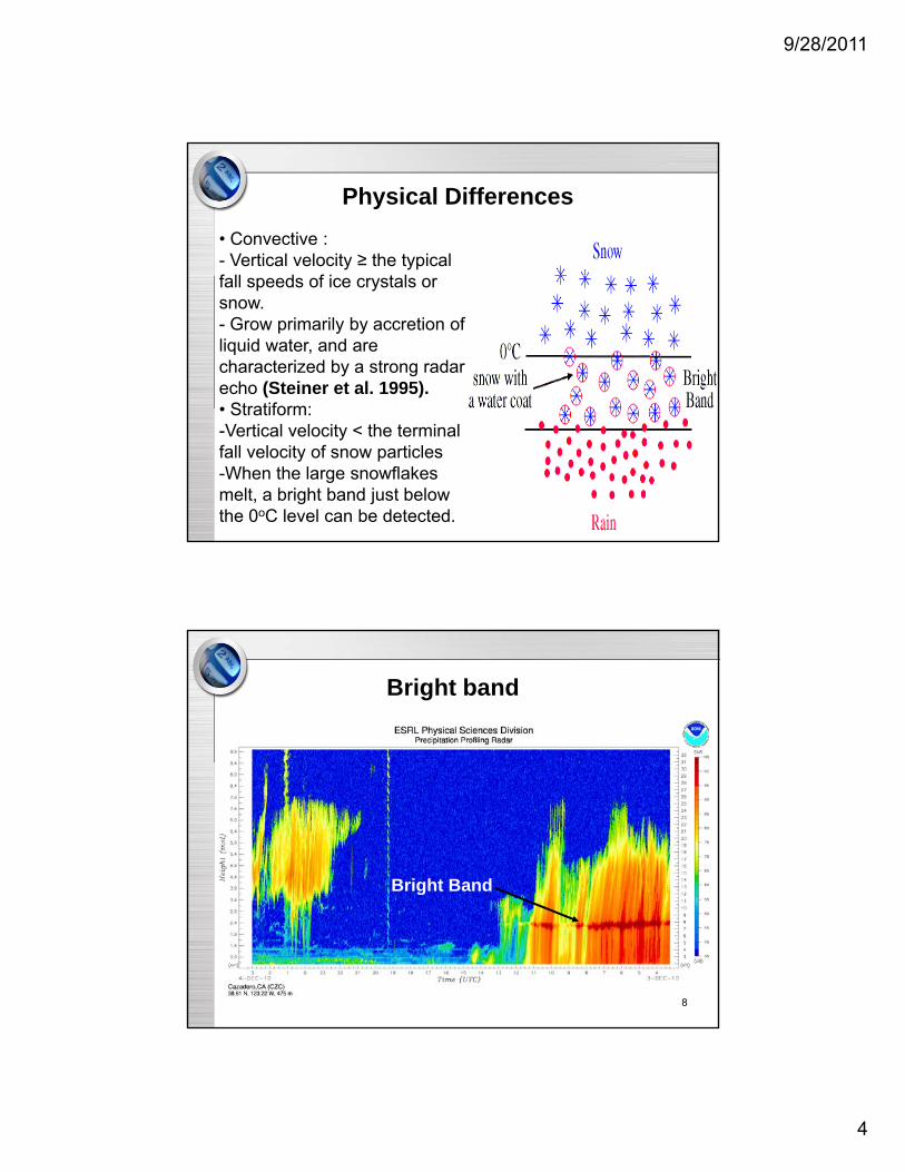
Physical Differences
• Convective :- Vertical velocity ≥ the typical f ll d f i t lfall speeds of ice crystals or snow. - Grow primarily by accretion of liquid water, and are characterized by a strong radar echo (Steiner et al. 1995). • Stratiform:
7
• Stratiform: -Vertical velocity < the terminal fall velocity of snow particles-When the large snowflakes melt, a bright band just below the 0oC level can be detected.
Bright band
Bright Band
8

9/28/2011
5
Precipitation in TC
• Jorgensen found that over 90% of thethat over 90% of the rain areas in tropical cyclones were stratiform in type
• However, the convective rainfall
9
convective rainfall contributes about 40% of the total storm precipitation
Hurricane: Eyewall
• A ring of intense convectionconvection surrounding the center
• Strongest wind speeds
10
• Heaviest precipitation occur

9/28/2011
6
Hurricane: Eye
• 30-60 km in diameterdiameter
• relatively warm
• light winds
• clear/broken clouds
11
• low surface pressure
Factors controlling intensity change
• Inner core (eye and eyewall) dynamics
• Environmental conditions, including vertical wind , gshear, moisture distribution, and sea surface temperature (upper ocean heat content), etc.
12

9/28/2011
7
Maximum potential intensity (MPI)
• The maximum potential intensity (MPI) is the theoretical upper limit of intensity that a TC can achieve.
• MPI=f {(Ck/CD), ε, SST, RH }
- ε = (TB-To)/TB
(thermodynamic
efficiency)
C d C
13
- Ck and CD are
exchange coefficients
of enthalpy and
momentum fluxes
Researches on MPI
• Banner Miller (1958) first proposed the concept of MPI, lower the SST and the amount of energy available to the t dstorm drops.
• Emanuel (1986, 1988) envisioned the intensity of TC is due to the difference in the surface temperature and the temperature at the "outflow" level of the atmosphere.
• Miller's MPI also relies on the existence of Convective Available Potential Energy (CAPE) in the tropical
14
atmosphere.
• On average, storms reach about 55% of their MPI. Storms that are farther west and farther north tend to reach a larger fraction of their MPI. (Mark Demaria and John Kaplan, 1994)

9/28/2011
8
• A video of concentric eyewall cycles
Eyewall Replacement Cycles (ERCs)
eyewall cycles
http://www.youtube.com/watch?v=LIRLn2CZQwA
15
Definition of ERCs
• A full cycle of eyewall replacement i l d th iincludes the genesis of a secondary eyewall, the dissipation of the inner eyewall, and the organization of the new eyewall
16
the new eyewall. (Willoughby et al.1982)
• Very common in intense tropical cyclones.

9/28/2011
9
Observation of ERCs
• Two concentric rings of enhanced convection
17
Formation of ERCs
• When the eye diameter gets too small then the eyewall convection is not able to stay organized. New convection and a new eyewall develop outside the old oneand a new eyewall develop outside the old one.
• Once the winds become too strong, turbulent breakdown occurs. This turbulence breaks apart portions of the eyewall which lead to its weakening. A new eyewall develops where the wind field remains less turbulent and
i d t id th ld ll
18
more organized outside the old eyewall.
• The band of convection outside the inner eyewall begins to rob the inner eyewall of moisture and energy. The inner eyewall weakens and the outer eyewall replaces it.

9/28/2011
10
ERCs with TC intensity
• The storm often weakens as a result of the gradual erosion of the inner eyewall, but it may reintensify when the outer eyewall contracts and gains organizationthe outer eyewall contracts and gains organization. (Willoughby et al. 1982)
• TC intensity changes associated with concentric eyewall cycles vary considerably from case to case. About 28% of TCs actually intensify after the secondary eyewall formation. (Kuo et al. 2009)
19
• Willoughby (1995) found that the time required for a cycle of weakening and reintensifying can range from a few hours to more than a day.
Rapid Intensification (RI)
• Rapid intensification (RI) is the explosive deepening of a tropical cyclone.
• Kaplan and DeMaria (2003) define RI as a maximum sustained surface wind speed increase of 15.4 m/s (30 kt) over a 24-hour period.
• All category 4 and 5 hurricanes, 83% of all major
20
g y , jhurricanes (category 3, 4, 5), 60% of all hurricanes, and 31% of all tropical cyclones experienced at least one RI period during their lifetime.

9/28/2011
11
Forecast of RI is very important, but ...
• RapidRapid deepening causes most major hurricanes
• Time-scale
21
is so short that adequate warnings are difficult
Kaplan et al. (2003) reseach on RI
22

9/28/2011
12
Forecast of RI
• RI probability can be estimated through the analysis of five predictors:analysis of five predictors:
- previous 12-hour intensity change (already deepening storms more likely),
- SST (higher more likely),
- low-level relative humidity (higher more likely),
23
- vertical shear (lower is better),
- difference between current intensity and MPI (larger is better).
Definition of convective bursts
“A mesoscale cloud system consisting of asystem consisting of a cluster of high cumulonimbus towers within the inner core region that approaches or reaches the tropopause with
24
p pnearly undiluted cores.” (Rodgers et al. 2000)

9/28/2011
13
Observation of convective bursts• They appear as large, circular, continuous areas of extremely cold (-80°C to -100°C) cloud tops.
25
Vertical structure of convective bursts
• Rapidly transfers latent
d ibl h tand sensible heat into the upper troposphere.
• Enhances the warm-core anomaly aloft
26
anomaly aloft, accelerating upper-level divergence and spawning surface pressure falls.

9/28/2011
14
Convective bursts and TC intensity
• When a burst does occur, the TC will subsequently intensify 70% of the time.
27
(Hennon, 2006)
Hot towers/ Deep convective bursts
• Video http://www youtube com/watch?v=OQsKusqMdhttp://www.youtube.com/watch?v=OQsKusqMdUU
• Consider the following while watching video:
- What is the hot tower
28
- Where you can find hot towers in hurricanes
- What is the role of hot towers in hurricanes
- What causes the hot tower

9/28/2011
15
Definition of hot towers• A hot tower is a tropical cumulonimbus cloud that penetrates the tropopause, i.e. it reaches out of the lowest layer of the atmosphere, the troposphere, into the stratosphere.
29
Observation of hot towers
• Up to now, TRMM's Precipitation Radar (PR) is one of the best instruments to observe hot towers.
30

9/28/2011
16
Global distribution of Hot tower
• Five different referencereference heights are used to identify hot towers
• Overshooting convection is
31
more frequent over land than over water (Liu et al. 2005)
Hot towers in Tropical Cyclone
32

9/28/2011
17
Hot towers on TC intensity change
• Hot towers (Simpson et al. 1998) and convecitve bursts (Steranka et al 1986) near the storm center were found(Steranka et al. 1986) near the storm center were found to be related to TC intensitification.
• Kelley et al. (2004, 2005) found that the chance of TC intensification increases when one or more hot towers exist in the eyewall.
• Rogers (2010) and Guimond et al. (2010) also emphasize the importance of hot towers and convective bursts near
33
the importance of hot towers and convective bursts near the eye in TC rapid intensification.
• The chance of RI/IN increases when a hot tower exists, but not substantially. A hot tower is neither a necessary nor a sufficient condition for RI. (Jiang et al. 2009)
Reference• DeMaria, M., and J. Kaplan, 1994: Sea surface temperature and the
maximum intensity of Atlantic tropical cyclones. J. Climate, 7, 1324-1334.
• Emanuel K A 1986: An air sea interaction theory for tropical• Emanuel, K.A., 1986: An air-sea interaction theory for tropical cyclones. Part I: Steady state maintenance. Journal of Atmospheric Sciences, 43, 585-604.
• Emanuel, K.A., 1991: The theory of hurricanes. Annual Review of Fluid Mechanics, 23, 179-196.
• Emanuel, K.A., 1988: The maximum potential intensity of hurricanes. Journal of Atmospheric Sciences, 45, 1143-1155.
• Hennon, P.A., 2006: The role of the ocean in convective burst initiation: Implications for tropical cyclone intensification. Dissertation, Th Ohi St t U i it 162
34
The Ohio State University, 162 pp. • Kaplan, J., and M. DeMaria, 2003: Large-scale characteristics of
rapidly intensifying tropical cyclones in the North Atlantic basin. Weather and Forecasting, 18, 1093-1108.
• Miller, B.I., 1958: On the maximum intensity of hurricanes. Journal of Meteorology, 15, 184-195.

9/28/2011
18
• Jorgensen, D.P., 1984a: Mesoscale and convective-scale characteristics of mature hurricanes. Part I: General observations by research aircraft. Journal of the Atmospheric Sciences, 41, 1268 1285
Reference
1268-1285.
• Jorgensen, D.P., 1984b: Mesoscale and convective-scale characteristics of mature hurricanes. Part II: Inner core structure of Hurricane Allen (1980). Journal of the Atmospheric Sciences, 41,
1287-1311.
35