infrastructure delivery plan - nottingham city council
TRANSCRIPT

Greater Nottingham
Broxtowe Borough Council Erewash Borough Council Gedling Borough Council Nottingham City Council
Rushcliffe Borough Council
Infrastructure Delivery Plan May 2013
(Version 3)

This page is intentionally blank

Broxtowe, Erewash, Gedling, Nottingham City and Rushcliffe Infrastructure Delivery Plan
1
Contents Page
Executive Summary 2
Part One - Context 1. Purpose of the Plan 4
2. Joint Working Arrangements and Governance 5
3. Scope and Status 6 4. Policy Context 7 5. Engagement and Consultation 11 6. Infrastructure Topic Areas 11
Part 2 - Infrastructure Assessment and Viability 7. Infrastructure Assessment by category
a) Strategic Transport 13 b) Utilities - Water 33 c) Utilities - Energy 39 d) Utilities - Digital Infrastructure 49 e) Flooding and Flood Risk 51 f) Health and Local Services 61 g) Education 68 h) Emergency Services (police, fire and ambulance) 78 i) Waste Management (Collection and Disposal) 84 j) Green Infrastructure and Biodiversity 89 k) Heritage Assets 95
8. Strategic Site Schedules 100
9. Viability 208 Part 3 – Infrastructure Schedule, Funding, Monitori ng and Review 10. Erewash, Broxtowe, Gedling, Nottingham and Rushcliffe Strategic
Infrastructure Schedule 218 11. Funding and Complementary Programmes 235
12. Monitoring and Review 238 Appendix A - Consultees 239 Appendix B - NRL Viability Assessment 240 Appendix C - Summary of main changes from Versions 1 and 2 268 Contacts and Further Information 270

Broxtowe, Erewash, Gedling, Nottingham City and Rushcliffe Infrastructure Delivery Plan
2
Executive Summary This Infrastructure Delivery Plan accompanies the Core Strategies of Broxtowe, Erewash, Gedling, Nottingham and Rushcliffe Councils. It considers a range of infrastructure categories and the extent to which each is a constraint to the delivery of the Core Strategies. Where possible it identifies the cost and delivery route for new infrastructure and whether the infrastructure is critical to the delivery of the strategies. The IDP has been developed following consultation with service providers and with reference to wider evidence base documents. The primary issues identified in the plan which have the potential to affect the delivery or require more review are set out below:
• Key dependency identified for the Clifton South site - dependant on delivery of the A453 improvement scheme, detailed proposals for site access and integration with the A453 required;
• Proactive approach required to flooding and flood risk at the Boots/Severn Trent,
Field Farm and Waterside sites, proactive intervention required at Boots regarding site remediation;
• Early dialogue essential with Severn Trent Water to enable satisfactory lead in
periods for water and waste water infrastructure;
• Early dialogue essential with Western Power to enable satisfactory lead in periods for electricity supply;
• There are pressures on education provision across the IDP area and contributions to
additional school places are likely to be required on most sites;
• Detailed mitigation measures required to ensure there are no adverse affects on the prospective Sherwood Forest Special Protection Area;
• Transport modelling indicates no showstoppers at a strategic level. Ongoing
investment and promotion of sustainable transport measures is required and site specific transport assessments and review of the Highways Agency’s Route Strategy to guide investment and improvements to the strategic road network;
• Should Government progress with the current preferred route for HS2 (High Speed
Rail 2), there is an opportunity for the development of a strategic site at Toton (Broxtowe) adjacent to a proposed HS2 station. Further transport modelling and dialogue with the Highways Agency, highway authorities and HS2 would be required;
• Further information relating to existing and future capacity of health services is
required – dialogue with Clinical Commissioning Groups underway;
• Strategic level assessments indicate the broad viability of sites but underline the need for open book appraisals with developers to objectively assess developer contributions and essential infrastructure;
• Further dialogue with emergency services on detailed proposals (e.g. unit types and
tenancy).
The IDP sets out infrastructure requirements and capacity constraints as advised by local authorities and stakeholders. It does not imply that all of these requirements need to be met

Broxtowe, Erewash, Gedling, Nottingham City and Rushcliffe Infrastructure Delivery Plan
3
for development to proceed. The IDP will assist with the prioritisation of essential infrastructure along side viability assessments. Broad brush viability assessment undertaken as part of the IDP, indicate that the strategic allocations identified in the Core Strategies are broadly viable but councils and developers will need to have a collaborative ‘open book’ approach to agreeing S106 contributions. The availability of land and apparent viability of some of the Core Strategies undeveloped green field sites points to wider issues in the market related to finance and investor confidence (see also GL Hearn Report prepared as part of the Core Strategies supporting evidence). The IDP is a living document and will require ongoing review as development proposals and infrastructure requirements are confirmed in more detail.

Broxtowe, Erewash, Gedling, Nottingham City and Rushcliffe Infrastructure Delivery Plan
4
Part 1
1. Purpose of the Plan This IDP sets out infrastructure capacity, constraints and requirements associated with the Core Strategies of the following councils: Broxtowe Borough Council Erewash Borough Council Gedling Borough Council Nottingham City Council Rushcliffe Borough Council It seeks to identify when infrastructure will be required, how it will be delivered and funded and responds to guidance within the National Planning Policy Framework which requires local councils to ensure that Core Strategy proposals are supported by satisfactory infrastructure. The Planning Inspectorate has provided advice on approaches to infrastructure planning within ‘Examining Development Plan Documents: Learning from Experience’ (September 2009) with further guidance set out within ‘Viability Testing for Local Plans’ (October 2012), Guidance specifically for Greater Nottingham was provided as part of the Planning Inspectorates Advisory visit in March 2010 and soundness advice visit in 2012. Greater Nottingham’s Infrastructure Delivery Plan responds to the above and builds on the Greater Nottingham and Ashfield Infrastructure Capacity Study completed in June 2009. The IDP will assist the partner authorities in considering and planning for infrastructure investment across the conurbation and will inform both public and private sector funding decisions. The document both responds to and informs other policy, investment programmes and strategies including:
• S106 and proposed Community Infrastructure Levies • Local Transport Plans • The Nottingham Core HMA Local Investment Plan • Greater Nottingham Growth Point Programme • Local Authority Service Plans • Waste Plans • Health and Education Investment Plans • Sustainable Communities Plans
Importantly the IDP may assist in identifying opportunities to maximise efficiencies in the use and effectiveness of existing assets and possibilities for cross boundary collaboration. Longer term, the IDP may inform the infrastructure priorities of the Derbyshire and Nottinghamshire Local Enterprise Partnership (D2N2 LEP).

Broxtowe, Erewash, Gedling, Nottingham City and Rushcliffe Infrastructure Delivery Plan
5
2. Joint Working Arrangements and Governance The following Councils are members of the Greater Nottingham Joint Planning Advisory Board: Ashfield District Council (with regard to the Hucknall wards of Ashfield District Council) Broxtowe Borough Council Derbyshire County Council Erewash Borough Council Gedling Borough Council Nottingham City Council Nottinghamshire County Council Rushcliffe Borough Council The Councils collaborate on strategic policy and planning issues and work together on joint commissions and evidence base documents and where possible have sought to maximise synergy across their emerging Core Strategies. Many of the infrastructure issues identified in this report have cross boundary impacts and/or solutions and interdependencies which necessitate collaboration between the authorities. A single IDP has therefore been developed to support the Core Strategies of Broxtowe, Erewash, Gedling, Nottingham and Rushcliffe Borough Councils. Ashfield District Council is not included in the IDP as Ashfield is at an earlier stage of plan preparation but the council remains closely involved in the Joint Planning Advisory Board and supporting joint officer group. As the Hucknall wards of Ashfield have a close functional relationship with the area covered by the IDP, broad assumptions regarding the future levels of growth and potential strategic sites within Hucknall have been made (in consultation with Ashfield District Council). This has enabled more realistic assessments of cumulative impacts (e.g. on transport networks and water resources) to made. The Derby Housing Market Area lies immediately to the west of Erewash Borough Council and regular meetings have taken place to share experience and methodologies for the Core Strategy evidence base. The IDP covers a large and complex spatial area. Other authorities have established single Infrastructure Working Groups with representatives from, for example, the Emergency Services, Utilities Companies and Council Departments. The area covered by the IDP includes a greater number of stakeholders (for example three highway authorities and five separate bodies representing the Emergency Services). Liaison via a number of focused themed meetings with service providers (where appropriate) has proved a meaningful vehicle for developing the IDP and for partners to discuss related cross boundary service delivery issues. Overall governance is provided by the Joint Planning Advisory Board. Successful delivery and future reviews of the Infrastructure Plan will depend on the participation of various public and private sector agencies with clear governance and ‘ownership’ of each element of the plan. Lead partners for specific infrastructure projects are outlined in the Infrastructure Schedule in Section 10.

Broxtowe, Erewash, Gedling, Nottingham City and Rushcliffe Infrastructure Delivery Plan
6
3. Scope and Status
The following categories of infrastructure are considered within this report:
a) Strategic Transport b) Utilities - Water c) Utilities - Energy, d) Utilities - IT e) Flooding and Flood Risk f) Health and Local Services g) Education h) Emergency Services (police, fire and ambulance) i) Waste Management (Collection and Disposal) j) Green Infrastructure and biodiversity k) Heritage Assets
Additional factors which may affect site delivery and viability (such as ground conditions and contamination) are also considered where relevant. The report is set out in three parts. Part One sets out the context for the IDP and Part Two provides a topic by topic overview of each category of infrastructure considered with an assessment of the level of constraint and conclusions regarding cumulative impacts. This section then considers each strategic site in more detail including timescales for delivery, masterplanning undertaken to date. Part Three sets out an overall infrastructure schedule and deals with the overall resources required to deliver the strategies, funding sources, complementary programmes, monitoring and review. More detailed information and consideration has been given to infrastructure requirements for sites for which delivery is expected to commence within the first 5 years of the plans. As advised by the Planning Inspectorate, the plan focuses on the impact that each site or group of sites will have on the plan area, whilst matters which impact within the site itself are less detailed unless it is clear that these are critical issues for the development of the site.
The conclusions drawn in the report have been based on consultation with service providers, stakeholders, Local Authorities and information contained within the Core Strategies evidence base. This information is clearly subject to change and the report should be regarded as a snapshot at a particular point in time and will be subject to continual review. Reference is made to a number of evidence based documents - this IDP does not duplicate the contents of these documents but identifies the key conclusions from these sources which are relevant for future infrastructure planning. Inevitably there will be gaps in the information available. In such cases this is highlighted in the document alongside the need for further research and/or any reasonable assumptions that have been made in arriving at conclusions. The report considers infrastructure requirements at a strategic level and the IDP should not be regarded as a substitute for detailed site assessments which would normally be undertaken by developers/landowners. The IDP accompanies the councils’ Core Strategies and further refinement will be required as site specific Development Plan Documents emerge. Inevitably the infrastructure requirements and constraints highlighted in this report will make reference to existing/historic capacity issues or constraints. However, in assessing the need for and contributions towards infrastructure Local Authorities will need to have regard to the constraints/ additional infrastructure requirements generated as a direct consequence of development.

Broxtowe, Erewash, Gedling, Nottingham City and Rushcliffe Infrastructure Delivery Plan
7
4. Policy Context This IDP supports the Core Strategies of Broxtowe, Erewash, Gedling, Nottingham and Rushcliffe Councils. The councils of Broxtowe, Gedling and Nottingham City have prepared Aligned Core Strategies on a common timetable. Erewash Borough Council has prepared a separate Core Strategy with strong synergies with the aligned documents. At the time of writing Erewash Borough Council’s Core Strategy was subject to Examination in Public. All of these plans cover the period up to 2028. Rushcliffe Borough Council has prepared a separate Core Strategy but with clear synergies and links to the aligned strategies, with a plan period up to 2026. Rushcliffe’s Core Strategy has been submitted to the Secretary of State and following pre hearing meetings held in spring 2013, the council is currently considering a range of issues raised by the Inspector. The IDP will be updated to reflect any changing circumstances. Ashfield District Council is in the process of preparing a Local Plan. This Infrastructure Delivery Plan takes account of all types of development within the Core Strategies but the primary focus is housing and employment land as this is likely to have the greatest impact on future infrastructure requirements. Housing Proposals The IDP considers the levels of housing growth proposed in the councils’ emerging Core Strategies. Housing figures for each council are set out in Table 4.1. Table 4.1 Core Strategies Proposed Dwelling Number s
Local Authority Number of Dwellings
Delivery Period
Broxtowe Borough Council 6,150 2011-2028 Erewash Borough Council 6,250 2011-2028 Gedling Borough Council 7,250 2011-2028 Nottingham City Council 17,150 2011-2028 Rushcliffe Borough Council 9,400 2011-2026 Total 46,200
Ashfield District Council is not specifically included in this IDP but the Hucknall wards of Ashfield District Council have a close functional relationship with the councils covered by this document. A housing growth figure for Hucknall of 3,000 has therefore been assumed (with regard to the previous housing targets within the East Midlands Regional Spatial Strategy and following discussion with officers from Ashfield District Council) to ensure that cross boundary and cumulative impacts are considered where appropriate. The Core Strategies anticipate that most of the housing provision will be met within the existing built up area and on relatively small sites which will be identified within Development Plan Documents. However there will be a need for development on larger sites - within Sustainable Urban Extensions, on existing urban brownfield sites and in and around existing smaller free standing settlements where appropriate.

Broxtowe, Erewash, Gedling, Nottingham City and Rushcliffe Infrastructure Delivery Plan
8
Strategic Sites The Core Strategies identify large strategic sites which include strategic allocations (sites which have a defined boundary and where delivery is expected to commence within 5 years) and strategic locations (sites/settlements where growth is likely to commence later in the plan period – 5 years and onwards, where precise boundaries are yet to be determined or where areas are the focus of large regeneration zones). Strategic locations include both single sites or comprise of several smaller sites which will be included in later Development Plan Documents. Some of these sites will be mixed use with elements of housing, employment, retail and community facilities. The IDP reviews the infrastructure and services required to create attractive and sustainable developments including access to appropriate retail, employment health and education facilities. More detail is provided for those sites which are expected to commence earlier in the plan period. Table 4.3 sets out the types of use, dwelling numbers and anticipated delivery timescales for the strategic sites. Nottingham City and Erewash councils have strategic sites named Stanton Tip and Stanton Regeneration Site respectively. To avoid confusion, where each site is mentioned without reference the council area in which it is located, the initials of the relevant Local Authority is provided after the site name (EBC for Erewash Borough Council and NCC for Nottingham City Council). This approach is also adopted for the Boots and Severn Trent Site (within Broxtowe) and Boots (within Nottingham). Smaller Housing Sites Development on a significant number of smaller housing sites will form an important part of overall supply. These sites are not identified within the high level Core Strategies and will be the subject of subsequent Development Plan Documents. Whist these sites are yet to be allocated, the cumulative impact of all potential sites is an important consideration for the IDP - particularly in terms the capacity of the transport network, water and waste water services and education. The number of dwellings expected to come forward on strategic sites and smaller sites is set out in Table 4.2 below. The IDP sets out the approach to smaller sites/cumulative impact within each infrastructure category. Table 4.2 Dwellings on Strategic and Non Strategic Sites
Local Authority Dwellings on Strategic Sites 1
Dwellings on Smaller Sites
Total
Broxtowe 3,5502 2,600 6,150 Erewash 2,000 4,250 6,250 Gedling 4,143 3,107 7,250 Nottingham 4,100 13,050 17,150 Rushcliffe 7,220 2,180 9,400 Total 20,863 25,001 46,200
1 This includes clusters of smaller sites which form part of proposed strategic locations
2 Should development at Toton (Broxtowe) come forward in the plan period, this figure will increase and
dwellings on smaller sites will decrease.

Broxtowe, Erewash, Gedling, Nottingham City and Rushcliffe Infrastructure Delivery Plan
9
Table 4.3 Strategic Sites
Use Timescale for Delivery Local
Authority Strategic Sites Dwelling Nos.
Res Emp Reg Status
0-5 6-10 11+ Broxtowe Field Farm 450 ���� Allocation Severn Trent and Boots Site 550 ���� ���� ���� Location Awsworth 350 ���� Location Brinsley 200 ���� Location Eastwood 1,400 ���� Location
Kimberley (including Nuthall and Watnall) 600
���� Location
Toton ���� ���� Location Erewash Stanton Regeneration Site 2,000 ���� ���� ���� Location Gedling Land North of Papplewick Lane 600 ���� Allocation Top Wighay Farm 1,000 ���� ���� Allocation Bestwood Village 579 ���� Location Calverton 1,518 ���� Location Ravenshead 446 ���� Location Nottingham Boots Site 600 ���� ���� ���� Location Stanton Tip 500 ���� ���� ���� Location Waterside Regeneration Zone 3,000 ���� ���� ���� Location Southside Regeneration Zone Via DPD ���� ���� ���� Location Eastside Regeneration Zone Via DPD ���� ���� ���� Location Rushcliffe South of Clifton 2,500 ���� ���� Allocation Melton Road, Edwalton 1,200 ���� ���� Allocation North of Bingham 1,000 ���� ���� Allocation RAF Newton 550 ���� ���� ���� Allocation Cotgrave 470 ���� ���� ���� Allocation East Leake 400 ���� Location Keyworth 450 ���� Location Radcliffe on Trent 400 ���� Location Ruddington 250 ���� Location
Notes: Res=Residential, Emp=Employment, Reg=Regeneration (direct on site regeneration)

Broxtowe, Erewash, Gedling, Nottingham City and Rushcliffe Infrastructure Delivery Plan
10
Employment Land and Regeneration The policies within the Core Strategies seek to strengthen and diversify Greater Nottingham’s economy with a particular emphasis on the science and knowledge based economy and office development. A minimum of 409,700 square metres of office space (B1) and 70 hectares of industrial and warehouse space will be provided as set out in Table 4.4. This will be kept under review to ensure a 5 year supply. Table 4.4 Employment Land
Local Authority B1(a and b) B2 and B8 Timescale Broxtowe 34,000 sq m 15 ha 2011-2028 Erewash 42,900 sq m 13 ha 2011-2028 Gedling 22,800 sq m 10 ha 2011-2028 Nottingham 253,000 sq m 12 ha 2011-2028 Rushcliffe 57,000 sq m 20 ha 2011-2026 Total 409,700 sq m 70 ha
Nottingham City Centre and the Regeneration Zones will be the focus for a significant element of employment land but opportunities exist within large strategic sites as part of mixed use schemes and within town centres. Smaller employment sites will be identified via Development Plan Documents. Table 4.3 sets out which of the strategic sites are expected to contribute to employment land provision. Regeneration Areas The Core Strategies identify areas and sites in need of focussed regeneration efforts by the public and private sector. This could include transformation of estate based housing areas, redevelopment of derelict or underused sites and revitalisation of water front locations to address problems from our industrial past and help support and sustain villages. These sites provide opportunities to address our housing and employment needs but are often the locations which have the most challenging delivery issues such as contamination and flood risk which can result in high infrastructure costs and marginal viability. Strategic sites with opportunities for regeneration are set out within Table 4.3.

Broxtowe, Erewash, Gedling, Nottingham City and Rushcliffe Infrastructure Delivery Plan
11
5. Engagement and Consultation All conclusions drawn in this IDP are based on information provided directly by partner organisations and service providers and information contained with the Core Strategies evidence base. A list of those service providers and stakeholders consulted is provided within Appendix A. As a general guide, stakeholders and service providers were requested to respond to the following questions:
• Do the proposals within the Core Strategies complement or conflict with forward plans/asset management plans?
• Are there any perceived constraints/capacity limitations to servicing future developments?
• If so, can these be overcome? • Are there expectations of additional costs being met by developers over and above
normal site development costs? • If there are costs, how have they been calculated and can they be demonstrated to
be reasonable? • Are there any lead in/forward planning periods required to build capacity for new
services? Engagement on the Core Strategies has largely been welcomed by both public and private sector stakeholders and has enabled comprehensive and strategic responses taking account of cross boundary challenges and opportunities. An ongoing dialogue will be maintained and information updated and refined as development proposals take shape. 6. Infrastructure Topic Areas Part Two of the IDP considers each of the infrastructure categories. For each category, sources of information are identified along with an overview of the situation or status, known future plans, capacity constraints and, where relevant, trigger thresholds for new/upgraded infrastructure. Where available, cost and phasing information has been provided. Strategic policies from the Core Strategies which directly link to the topic area or mitigation measures are identified. Each infrastructure section is subdivided into:
• Key Issues for the Core Strategies • Background • Assessment • Phasing and Dependencies • Costs • Policy Synergies • Further Work Required • Summary Assessment

Broxtowe, Erewash, Gedling, Nottingham City and Rushcliffe Infrastructure Delivery Plan
12
An assessment for each site and category is provided. The assessment is defined as follows:
A
Constraints identified which may affect delivery (including costs and phasing) and require mitigation particularly relating to critical infrastructure.
B
Potential constraint for which mitigation may be required, or minor cost/phasing impact.
C
No major constraints based on the evidence available. No further assessment required at present
D
Information insufficient to assess or not yet available
The above assessment is applied to strategic allocations and strategic locations for growth The level of constraint will be also be considered in terms of the scale of development and cost of mitigation. Critical and Non-Critical (Desirable) Infrastructur e Following PINS advice, the report also distinguishes between ‘critical’ and ‘non-critical’ infrastructure. Critical infrastructure for the purpose of this report is defined as infrastructure without which the development could not physically be delivered or accessed. This includes:
• Flooding and flood risk mitigation • Transport Infrastructure (on which the delivery of the site is clearly dependant) • Utilities (Water/Energy/IT)
Desirable infrastructure is defined as infrastructure without which the development could still physically proceed. However, desirable infrastructure may be important in terms of the quality and sustainability of the development. The scale, scope, phasing and overall balance of desirable infrastructure may determine whether the development is acceptable in policy terms and ultimately whether planning permission will be granted. Desirable infrastructure for the purpose of this report includes:
• Transport Infrastructure – highways/public transport/rail • Utilities (Green Energy) • Education Provision • Health and Local Services • Emergency Services • Green Infrastructure and biodiversity • Waste Management • Heritage Assets

Broxtowe, Erewash, Gedling, Nottingham City and Rushcliffe Infrastructure Delivery Plan
13
Part 2 - Infrastructure Assessment and Viability
7. Infrastructure Assessment by Category
a) Strategic Transport 1. Key Issues for the Core Strategies:
• Accessing communities and services by sustainable modes of transport; • Minimising congestion and pollution; • Making best use of existing transport infrastructure and assets; • Supporting healthy lifestyles; • Minimising and reducing carbon emissions.
2. Background This section considers the potential for new developments to be supported by appropriate transport infrastructure including:
i. Strategic Transport Networks (highways, bus, light rail) ii. Rail iii. Walking and Cycling Routes iv. Air
Information regarding strategic transport issues within the IDP has been informed by consultation with the three local highway authorities within the Core Strategies area: Derbyshire County Council Nottingham City Council Nottinghamshire County Council Consultation has also taken place with public transport operators (NET, bus and rail companies and Network Rail) and the Highways Agency as strategic highway authority for the trunk road network. The three local highway authorities published Local Transport Plans (LTP’s) in March 2011 which outline long-term transport strategies up to 2026. Each LTP is accompanied by a 4 year implementation plan including a programme of transport schemes and initiatives to be delivered subject to funding availability. The primary objectives of the strategies align with the Core Strategies and can be summarised as follows:
• Encouraging sustainable alternatives, tackling climate change, reducing carbon emissions and pollution;
• Supporting economic growth and reducing congestion; • Improving quality of life, safety and promoting greater equality of opportunity.
Strategic Transport Context Greater Nottingham is well connected to strategic highway networks and is served by four junctions of the M1 motorway. However parts of the network experience capacity and congestion problems including:
• Ring Road (A6514 between A52(T) Derby Road and A60 Mansfield Road • A52(T) between the A46(T) and Junction 25 of the M1

Broxtowe, Erewash, Gedling, Nottingham City and Rushcliffe Infrastructure Delivery Plan
14
• A46(T) to Newark • A453(T) linking to Junction 24 of the M1 • A611 • A6007/A609/A6096 • A610 • M1 Junction 25 • Derby Road (B5010) junctions with Rushy Land and Town Street (Sandiacre) linking
to A6007 and B6003 though Stapleford, joining the A52(T) at Bramcote and Bardills junctions.
The Department for Transport’s (DfT) UK road delay analysis places the A453(T) as the most congested inter-urban road in the country in terms of delays, experiencing an average delay per 10 vehicle miles of 11.4 minutes. The road also has a poor safety record with an average occurrence of one death per year and one serious injury per week. Major works by the DfT to upgrade the A453(T) were approved in March 2012 and are due for completion by 2015. At the time of writing, works to upgrade the A46(T) improving access into the east of Nottingham were nearing completion. Traffic congestion is a particular problem impacting on the efficiency and movement of traffic along the main routes into and out of the city, around the Ring Road and A52(T), particularly during morning and evening peak times and Government has recently confirmed approval for a major scheme improvement to the Nottingham Ring Road. Congestion has been contained since 2005 as a result of major transport improvements in Nottingham such as the NET (tram) and high quality bus network. More recently, the recession has contributed to reduced demand for travel by car and the movement of goods. Buses are a major component of the public transport network in Greater Nottingham and provision in the conurbation is good in comparison with many other areas of the UK. There has been considerable investment by the City and County Councils in bus infrastructure and services over recent years, which has created a positive climate for commercial bus operators. The majority of bus services in Greater Nottingham are operated on a commercial basis with revenue supporting more rural services. The Greater Nottingham area is fortunate in that two of the major operators Trent Barton and Nottingham City Transport, have themselves invested heavily in service improvements. Network coverage for the existing urban area is good with around 93% of households within 30 minutes travel time of a town centre by bus, train or tram with no more than a 400m walk to the bus stop. However there are constraints. Whilst Greater Nottingham has a comprehensive bus network, many high frequency bus services are now operating at or near capacity in the peak periods of demand. The lack of available kerb space in the city centre is a particular constraint given the very large number of services that terminate there. The Core Strategies area has been successful in securing significant levels of investment for its transport infrastructure to support improvements to highways, heavy and light rail, interchanges and bus based public transport. Improvements to Nottingham Midland Station are well underway and will provide new passenger facilities, integration of heavy and light rail and a new multi-storey car park (which opened on 14th May 2012). Line One of Nottingham Express Transit (NET) currently runs from/to Nottingham City Centre and Hucknall, serving town and local centres, employment sites and Park & Ride facilities. Construction recently commenced on two new NET lines which will serve Clifton via the Meadows, and Beeston/Chilwell via Lenton. Nottingham City Council in partnership with Nottinghamshire County Council and Derbyshire County Council have been successful in securing £15m via the Government’s Local Sustainable Transport Fund for the Nottingham urban area to support a range of ‘Smarter Choices’ initiatives.

Broxtowe, Erewash, Gedling, Nottingham City and Rushcliffe Infrastructure Delivery Plan
15
In terms of heavy rail services Greater Nottingham benefits from direct rail connections to London, Manchester, Birmingham, Sheffield, Leeds and Liverpool via Nottingham Station and local connections to Derby, Leicester, Lincoln and Newark. Funding approval has recently been confirmed for the Trent Resignalling scheme which will upgrade signalling equipment serving the East Midlands rail network and which makes provision for additional future capacity at Nottingham Station. In principle the scheme will also create capacity for trains to stop at a new Ilkeston Station should this come forward in the future. Despite the success of local services such as the Robin Hood Line, Nottingham has a much less developed local rail network compared to other Core Cities. Smaller settlements currently served by local rail links are set out in Table 7.1 In February 2013, the Government announced its preferred route for Phase Two of HS2, from Birmingham to Manchester and Leeds. The eastern leg would serve stations in the East Midlands, South Yorkshire and Leeds. The line would connect with the London to West Midlands leg to the east of Birmingham, near Junction 4 of the M6, and then follow the M42 corridor north-east towards Derby and Nottingham. The East Midlands Hub station would be at Toton in Broxtowe. The line would then head north, following the M1 corridor towards South Yorkshire. Although delivery of HS2 is outside of the plan period, the implications of the proposals have been considered as part of councils emerging core strategies and the IDP. The proposed new station at Toton provides an opportunity for a new strategic site with excellent local and national rail connections. Table 7.1 Existing Local Rail Stations
District Station Stop Ashfield Hucknall
Broxtowe Attenborough Beeston Erewash Long Eaton Gedling Burton Joyce Carlton Netherfield Newstead
Nottingham Bulwell Rushcliffe Aslockton Bingham Elton and Orston
East Midlands Parkway Radcliffe on Trent
In terms of air travel, the IDP area is located close to East Midlands Airport. Alongside passenger travel, the airport is particularly important for freight and cargo handling. Current congestion on the A453(T) is a particular problem for journeys between the IDP area and the airport although the opening of the East Midlands Parkway Station has improved rail links. Improving walking and cycling links and increasing non motorised modal share is an important element of the councils’ Local Transport Plans and closely linked with improving

Broxtowe, Erewash, Gedling, Nottingham City and Rushcliffe Infrastructure Delivery Plan
16
public transport modal share. The Local Transport Plans set out proposals for safe, direct and attractive pedestrian cycle links. A number of cross boundary strategic routes are located along Green Infrastructure corridors such as the River Trent, Leen and Erewash and Nottingham and Grantham Canals. 3. Assessment i. Strategic Transport Network (highways, bus, light rail) The cumulative impact of the Core Strategies proposals on the strategic highway network has been tested using the Greater Nottingham multi-modal Transport Model (GNTM). This was developed jointly by the transport authorities within the HMA and endorsed by the Highways Agency. The model includes a simulation network consisting of three main elements to forecast road trips by various classes of user and trip purpose, Nottingham Express Transit and heavy rail, and trip distributions between modes of transport. The model has been used to provide information on forecast pressures on the highway network which would result from the Core Strategies and aims to:
1. Model the transport impacts of growth in the Housing Market Area 2. Assist in the identification of potential mitigation strategies and measures and 3. Inform the Infrastructure Delivery Plan.
The transport model includes the levels of housing and employment growth set out within the councils’ emerging Core Strategies over a 15 year period and incorporates an allowance for the Hucknall area of Ashfield to ensure the cumulative area-wide impacts of development can be understood. More detail on the assumed housing and employment growth is contained within the main report and its appendices. Larger sites (over 300 dwellings) are specifically identified in the model – this includes strategic sites identified in the Core Strategies and sites above 300 dwellings which may be allocated in site specific Development Plan Documents. As the details of delivery on smaller sites will be the subject of future Development Plan Documents, wider growth has been distributed by electoral ward on the basis of each council’s Strategic Housing Land Availability Assessment (SHLAA). The study employs the latest version of the GNTM originally validated to a 2008 base year which has been continually updated and improved. The model comprises three main elements, as follows:
• Highway assignment model (SATURN) which represents the highway network roads and junctions,
• Public Transport model (CUBE Voyager) which includes buses, trams and rail and, • A Demand Model which forecasts the levels and usage of each mode of transport.
The model is provided with changes in highways and public transport networks and development proposals and forecasts future travel patterns taking into account assumptions on car ownership levels, fuel prices etc.

Broxtowe, Erewash, Gedling, Nottingham City and Rushcliffe Infrastructure Delivery Plan
17
The three following scenarios have been developed to enable comparative assessments: 2008 Base – The base case represents the position in 2008 when the model was developed. This provides a useful bench-mark for other scenarios to be tested against. 2028 Reference Case – This includes assumptions relating to development and transport networks and represents what is likely to happen without the proposed Core Strategies. The assumptions include:
• Residential development within the HMA constructed since 2008, sites with planning permission and sites allocated in Local Plans,
• Non-residential development within the HMA constructed since 2008 is included, however, the overall growth levels to reflect employment growth are derived from TEMPRO3 between 2008 and 2028,
• Outside the HMA area both residential and non-residential growth is in line with TEMPRO forecasts,
• Transport infrastructure with committed public sector funding eg NET lines 2 and 3, dualling of the A453 etc, and highway infrastructure associated with development with planning permission, e.g. Sharphill Woods Edwalton, are included.
2028 Core Strategies – This represents the impacts of full growth proposals. The assumptions include:
• Specific residential and employment strategic sites and • Wider growth distributed by ward on the basis of each council’s SHLAAs
The first stage of the study presented details of the forecast impacts assuming no mitigation, except that committed through planning obligations associated with developments with extant planning permission. The next stage assesses the mitigating impacts of a Smarter Choices Package4 and a Public Transport Package. As part of the Smarter Choices Mitigation Package, the main bid Local Sustainable Transport Fund (LSTF) has been modelled. This includes rolling out the Key Component scheme to all areas of the model currently within the LSTF Key Component area, including the establishment of a Community Smarter Travel Hub in Ilkeston. In addition to the LSTF main bid measures, targeted smarter choice packages have also been provided to each core strategy site, with the intention of providing site specific Smarter Choices measures such as Worksmart and personalised school and home travel planning to all Core Strategy sites. The aim of the public transport mitigation strategy is to ensure that each Core Strategy development has the benefit of high frequency, attractive bus services. Developing the strategy to serve the strategic sites involved a review of existing public transport service levels from each development to identify gaps in service. Public transport improvements to be delivered as part of the Reference Case developments were assumed to be in place. Conservative improvements to services were then identified which were considered necessary to make the sites acceptably accessible by public transport.
3 TEMPRO is a data set of trip rates provided by the Department for Transport based on population and employment growth
assumptions 4 Smarter Choices is about making greener healthier travel choices a realistic and attractive option for journeys to work, school
and leisure by encouraging workplace, school and personalised travel planning; improving public transport information and marketing; promoting car sharing and car clubs; encouraging low carbon transport; and encouraging working from home and teleconferencing to reduce the need to travel

Broxtowe, Erewash, Gedling, Nottingham City and Rushcliffe Infrastructure Delivery Plan
18
These included:
• Upgrading of existing bus routes to a minimum of 15 min frequency • Extension and upgrading of existing bus routes • Extension of existing routes with 15 min frequency (or better) • New 15 min frequency services
The improved bus services by site are summarised in Table 7.2 . Table 7.2 Public Transport Services Strategic Site District
Public Transport Improvements Modelled
Rolls Royce Ashfield Amberline extended/diverted to site and frequency improved to 15 min
Severn Trent/Boots
Broxtowe Citylink 1 extended to Beeston and increased frequency
Field Farm Broxtowe The Two (Rainbow 2) extended into the site Stanton Ironworks and West of Quarry Hill
Erewash Service 14 extended to site, increased frequency and linked to i4 (Rainbow 4), Ilkeston Station, shuttle bus to Ilkeston Station and Toton NET Park and Ride
Waterside Nottingham Citylink 2 increased in frequency Remainder of Boots
Nottingham Citylink 1 extended to Beeston and increased frequency
North of Papplewick Lane
Gedling Increased frequency of Service 141 and 228
Top Wighay Farm Gedling New shuttle bus service to Hucknall NET/Rail stations
Westhouse Farm Gedling Increased frequency of Service 141 and 228 Park Road/Hollinwood
Gedling
Howbeck Road Gedling
No improvements proposed (already receives 15 min frequency service)
Broad Valley Farm Gedling Increased frequency of Service 141 and 228 North of Bingham Rushcliffe RAF Newton Rushcliffe
Service 90 and 54, Bingham Express and Red1 diverted into the site
Clifton South Rushcliffe New shuttle bus service from the development to Clifton NET Park and Ride and diversion of other local services to the development.
Each stage of the study has produced a series of outputs and indicators to enable comparisons to be drawn between scenarios, providing an understanding of the likely cumulative impact of growth. These network wide indicators include: • Total highway trip numbers • Public transport modal share • Average speeds • Congestion expressed as Journey Time to/from Work in minutes • CO2 The results from the modelling and analysis are summarised in the table 7.3 which illustrates the forecast changes of each indicator between scenarios as they develop.

Broxtowe, Erewash, Gedling, Nottingham City and Rushcliffe Infrastructure Delivery Plan
19
Table 7.3 Global Indicator Comparisons
Scenario 2008 Base 2028 Reference
Case (Base + 22,099 houses)
2028 Core Strategies (Ref Case + 26,964
houses)
Smarter Choices Mitigation
Public Transport Mitigation
Indicator AM PM AM PM AM PM AM PM AM PM Highway Trips (Passenger Car Units)
198,000 212,600 233,600 252,750 241,450 261,850 237,925
258,189
237,512
257,763
Public Transport Mode Share 14.7% 14.6% 14.7% 15.3% 15.9%
Average Speeds (MPH - Network Wide)
28.8 28.1 26.9 25.6 25.6 24.4 26.3 25.0 26.3 25.0
Congestion (Average Journey to/from Work Times - Minutes)
13.7 14.6 14.7 15.9 15.4 16.3 15.2 16.3 15.1 16.2
Carbon (Mega-tonnes per annum)
1.634 2.355 2.455 2.429 2.425

Broxtowe, Erewash, Gedling, Nottingham City and Rushcliffe Infrastructure Delivery Plan
20
In addition to the global indicators above, detailed modelled outputs are presented in the appendices of the main report showing changes in traffic flow (highway network), average journey times (route specific) and junction performance expressed as the ratio of volume of traffic to theoretical capacity (location specific). To help understand the local impacts of the Core Strategy sites, including traffic distribution patterns and congested junctions, some further analysis has been undertaken at a district level. Whilst the local impacts are represented in the plans included in the main report, the impacts are based on the full Core Strategy housing and employment growth. The indicators have been chosen and presented in a way to help understand the scale and severity of the impacts forecast from the assumed housing and employment growth across the Housing Market Area, and provide a residual value for these indicators assuming fairly conservative levels of Smarter Choices and Public Transport Mitigation. The model demonstrates that the Core Strategy with Smarter Choices and public transport mitigation packages does not represent a significant worsening of traffic conditions across the area when comparing the 2028 Reference Case to the 2028 Core Strategies Scenario. The highway network is forecast to be more congested in 2028 than in the 2008 situation as a result of the cumulative residual impacts of traffic. However, it can be seen that the comparison between the 2028 Reference Case and the 2028 Core Strategies Scenario, which identifies the impacts of the Core Strategies growth, over and above development which has already been developed/allocated or approved demonstrates a relatively modest worsening of impacts between these scenarios. For example, the average AM peak journey time increases from 14.7 minutes in the 2028 Reference Case to 15.1 minutes in the 2028 Core Strategies scenario. Historic evidence would tend to suggest that it would be reasonable to expect that travellers would change their travel behaviour to respond to congested traffic conditions in an incremental way as travel demand grows and traffic conditions worsen. Accordingly it could be argued therefore that the 2028 Core Strategies modelling results represent a worst case scenario which would be unlikely to materialise. It is hoped that the continued success of sustainable transport policies promoted by the local highway authorities will continue to influence travel patterns and a shift towards more sustainable modes of travel such that the forecast residual traffic impacts are minimised. Based on the evidence provided through the transport modelling exercise, plus the knowledge of past experience, an examination of the global indicators leads to the conclusion that, whilst there will be an impact, the Core Strategy housing and employment growth can be delivered without significant detriment to the operation of the transport networks, assuming the delivery of currently committed schemes and delivery of the Smarter Choices, Public Transport and local highway mitigation and access improvements through the development management process and public sector funding streams. The modelling indicates that, subject to the implementation of Smarter Choices and Public Transport measures, major strategic highway interventions are not required and there are no ‘showstoppers’ to prevent the scale of growth anticipated in the core Strategies coming forward. However, there will be a need for localised highway improvements on key routes informed by the outcome of route strategies and site specific transport assessments.
Broxtowe, Erewash, Gedling, Nottingham City and Rushcliffe Infrastructure Delivery Plan
21
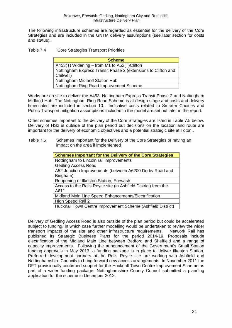
The following infrastructure schemes are regarded as essential for the delivery of the Core Strategies and are included in the GNTM delivery assumptions (see later section for costs and status): Table 7.4 Core Strategies Transport Priorities
Scheme A453(T) Widening – from M1 to A52(T)Clifton Nottingham Express Transit Phase 2 (extensions to Clifton and Chilwell) Nottingham Midland Station Hub Nottingham Ring Road Improvement Scheme
Works are on site to deliver the A453, Nottingham Express Transit Phase 2 and Nottingham Midland Hub. The Nottingham Ring Road Scheme is at design stage and costs and delivery timescales are included in section 10. Indicative costs related to Smarter Choices and Public Transport mitigation assumptions included in the model are set out later in the report. Other schemes important to the delivery of the Core Strategies are listed in Table 7.5 below. Delivery of HS2 is outside of the plan period but decisions on the location and route are important for the delivery of economic objectives and a potential strategic site at Toton.. Table 7.5 Schemes Important for the Delivery of the Core Strategies or having an
impact on the area if implemented
Schemes Important for the Delivery of the Core Stra tegies Nottingham to Lincoln rail improvements Gedling Access Road A52 Junction Improvements (between A6200 Derby Road and Bingham) Reopening of Ilkeston Station, Erewash Access to the Rolls Royce site (in Ashfield District) from the A611 Midland Main Line Speed Enhancements/Electrification High Speed Rail 2 Hucknall Town Centre Improvement Scheme (Ashfield District)
Delivery of Gedling Access Road is also outside of the plan period but could be accelerated subject to funding, in which case further modelling would be undertaken to review the wider transport impacts of the site and other infrastructure requirements. Network Rail has published its Strategic Business Plans for the period 2014-19. Proposals include electrification of the Midland Main Line between Bedford and Sheffield and a range of capacity improvements. Following the announcement of the Government’s Small Station funding approvals in May 2013, a funding package is in place to deliver Ilkeston Station. Preferred development partners at the Rolls Royce site are working with Ashfield and Nottinghamshire Councils to bring forward new access arrangements. In November 2011 the DFT provisionally confirmed support for the Hucknall Town Centre Improvement Scheme as part of a wider funding package. Nottinghamshire County Council submitted a planning application for the scheme in December 2012.

Broxtowe, Erewash, Gedling, Nottingham City and Rushcliffe Infrastructure Delivery Plan
22
ii Rail Although consideration of potential new rail services is included in the Greater Nottingham Transport model, further details of rail services within Greater Nottingham are set out below. The East Midlands Route Utilisation Strategy details existing and potential future capacity constraints on the rail network. It details the underlying growth in to and out of Nottingham, showing routes likely to be subject to overcrowding in the future. It also details other capacity gaps. However, it does not take into account induced demand from external events, such as increased housing, parking levy or other changes in local policy. Network Rail has confirmed that there are some constrained rail routes around Nottingham, the principal corridor being Nottingham Station to Trent Junction (Long Eaton). Demand for rail travel during the peak time at Nottingham is anticipated to grow by 2.9% per annum over the next 10 years. The Trent Resignalling work will assist by providing additional capacity at Nottingham Station. Other capacity pinch points are Bulwell to Kirkby on the Robin Hood Line and the crossing of the East Coast Mainline at Newark. The approach to Long Eaton station is becoming constrained as east-west freight services grow. Some crowding is expected on most corridors, with the exception of the Nottingham – Lincoln corridor Network Rail note that the proposed Ilkeston Station is located on a core freight artery and any proposals to provide additional stations or passenger services on this corridor would need to take into consideration the capacity required to accommodate future freight growth. Should future rail services be considered for the Bingham and Ilkeston corridors, Network Rail suggest that there may be merit in exploring Hybrid Tramtrain technology. No other extensions/improvements to other local settlements within the conurbation are under consideration. Should further growth occur around Bingham, Nottinghamshire County Council comment that depending on the scale of growth, enhanced rail services in this area may be justifiable. This could potentially take the form of an extension of service from the Robin Hood Line with a new station near Newton and also have the potential to serve the Queens Medical Centre and Nottingham University Campus with a new station stop at Lenton in Nottingham. Previous studies have not supported a new station at Lenton but this was based on its function as an origin station in its own right and further review may be needed. Derbyshire County Council is developing proposals for a new station at Ilkeston and is progressing a GRIP 4 assessment (Guide to Rail Investment Projects). Development of a station at Ilkeston has a strong business case and would provide accessible rail services to Ilkeston, Stanton Regeneration Site (EBC) and settlements on the western edge of Broxtowe District. East Midlands Trains (EMT) comment that there is currently limited station car parking at Beeston Station close to the Boots and Severn Trent Water strategic sites (BBC and NCC) which could limit future local rail use. Two possible solutions are put forward including a short term solution of using the car park at Beeston Business Park or longer term providing a new car park on land to the north of the railway currently owned by Network Rail. Increased demand for services at East Midlands Parkway Station could arise from development at Clifton South. EMT has commented that this station has poor highways signage and should development take place at Clifton South developer contributions to improving the signage on the A453(T) should be considered. EMT comment that Nottingham City’s Regeneration Zones are close to Nottingham station and should benefit from improvements to the Station to be delivered over the next 4 years.

Broxtowe, Erewash, Gedling, Nottingham City and Rushcliffe Infrastructure Delivery Plan
23
EMT would support investment in first-rate pedestrian footpaths and cycle ways between the developments and the station and additional cycle storage provision at Nottingham station. Overall rail capacity/service constraints will not be a barrier to the physical delivery of any site or area proposed within the Core Strategies. However, the capacity limitations of the rail network are likely to impact on the successful delivery of wider policy objectives relating to congestion, carbon reduction, pollution and sustainable travel modes. The modal split for rail journeys is also relativity low for the IDP area, which suggests that further modal shift may be possible with enhanced services or travel demand management approaches. The key synergies between specific Core Strategies sites and rail services are set out below: Table 7.6 Rail Infrastructure and Strategic Sites
District Site/Settlement where relevant Rail Station/Route Erewash Ilkeston Sub Regional
Centre/Stanton Regeneration Site Potential Station at Ilkeston
Rushcliffe Bingham Potential Enhancements on the Nottingham to Grantham line
Nottingham City Centre Employment Area, Southside, Eastside and Waterside Regeneration Zones. Wider importance to Greater Nottingham
Nottingham Station Enhancements
Broxtowe/Nottingham Boots/Severn Trent Beeston Station Car Park Enhancements
Broxtowe Directly linked to potential strategic site at Toton but wider importance to Greater Nottingham
HS2 route and station at Toton
With the exception of Stanton Regeneration Site (EBC) all sites in the Core Strategies have been assessed as category ‘C’ as rail constraints will not prevent development of strategic sites coming forward but rather investment in rail will provide additional transport choice for residents/businesses. In the case of Stanton (EBC), highway capacity is likely to be severely constrained and the availability of sustainable travel alternatives may have a direct positive impact on modal split at this site. The preferred route for Phase Two of HS2 may adversely affect the deliverability of several smaller sites within the councils SHLAA’s. However HS2 provides the opportunity for the development of a strategic site at Toton and reliable and convenient rail services will also have a positive impact on Greater Nottingham’s offer as a well connected business location and encourage inward investment. Work commissioned by emda (former East Midlands Development Agency) identified that high speed rail could generate very substantial economic benefits for Nottingham but this would be dependent on where a station is located.

Broxtowe, Erewash, Gedling, Nottingham City and Rushcliffe Infrastructure Delivery Plan
24
High Speed Rail and Potential Strategic Site at Tot on In January 2013, the Government announced its initial preferred route for Phase Two of HS2 (high speed rail), from Birmingham to Manchester and Leeds. The eastern leg would serve stations in the East Midlands, South Yorkshire and Leeds. The line would connect with the London to West Midlands leg to the east of Birmingham, near Junction 4 of the M6, and then follow the M42 corridor north-east towards Derby and Nottingham. An East Midlands Hub station is proposed at Toton in Broxtowe. The line would then head north, following the M1 corridor towards South Yorkshire. The current status of the proposals is that of ‘preferred route’. Formal public consultation is expected to commence from July 2013 to April 2014. It is anticipated that a final decision on the route and details of land take for associated facilities such as parking and access will not be known before the end of 2014. Construction of the East Midlands element of HS2 is estimated to commence in the early 2020s with completion by 2033. Although delivery of HS2 is outside of the plan period the councils have considered the impacts and potential opportunities of the proposals within their current strategies. As a result Broxtowe Borough Council has consulted on the potential for a new strategic site at Toton – adjacent to the proposed HS2 station. The current proposals for HS2 provide opportunities for a sustainable and accessible strategic site to be delivered at Toton. The Highways Agency and the three highway authorities have agreed a joint approach to the potential development at Toton and this is set out in full within the Transport Background Paper Addendum (May 2013). There are a number of uncertainties which limit the effectiveness of including development at Toton within the HMA wide cumulative transport model at this time, as set out below: � The current HS2 alignment is the Government’s initial preferred route on which
consultation will be based. However, confirmation of the final route is not expected until the end of 2014 and delivery will be outside the plan period.
� Design / development work for HS2 is at a preliminary stage with only indicative
access arrangements available. Access to the Toton site, and particularly the A52(T), will require detailed consideration in terms of physical constraints, land take and impact on A52(T) flows/congestion.
� Expectations of land take for servicing the new HS2 station and in particular land that
may be required for Park & Ride facilities and the number of spaces to be provided, are not yet available.
� A route strategy for the trunk roads within the Aligned Core Strategies area is
currently under development by the Highways Agency However, site specific transport modelling has been undertaken for this site for development of up to 1,000 homes (current planning application). As the HS2 proposals, access arrangements and associated facilities are likely to reduce the scale of land available for development at Toton, the Highways Agency and highway authorities consider that the current site specific transport modelling provides a benchmark for considering the impacts of an upper scale of development. As such the Highways Agency and local highway authorities consider the current transport modelling to be robust in assessing the site’s indicative acceptability in transport terms for the purposes of the Core Strategy.

Broxtowe, Erewash, Gedling, Nottingham City and Rushcliffe Infrastructure Delivery Plan
25
A range of indicative mitigation works for the site has been identified and these are included within the infrastructure schedule at Section 10. The highway authorities and Highways Agency have also agreed milestones for further review of this site (see table 7.11). iii Cycling and Walking The Local Authorities within the IDP area have invested in improved strategic and local cycling and walking links alongside public transport and highway schemes. Provision of high quality walking and cycling links has the potential to increase modal shift away form vehicle transport and bring health benefits to local communities. Provision of enhanced and new links is addressed in more detail in the green infrastructure and strategic site chapters. Improved and new walking and cycling links from strategic sites to public transport services will be considered as part of the detailed site specific masterplanning and transport modelling work and is not considered to be a constraint to delivery of the councils strategies. iv. Air The opening of East Midlands Parkway rail station and planned improvements to the A453 will improve links between East Midlands Airport and the IDP area. Air transport is not regarded as a constraint to the delivery of the Core Strategies. 4. Phasing and Dependencies The following table sets out phasing and dependencies at a strategic level. The IDP will be updated as further transport assessments and modelling work is completed for strategic sites. Table 7.7 Transport – Phasing and Dependencies Site/Scheme Dependency Clifton South Dependant on implementation of A453(T) improvement scheme
(delivery by 2015) and NET phase 2 (under construction). Ilkeston Station
Operation of a station at Ilkeston is dependant on capacity improvements delivered as part of the Trent Resignalling works. These are due for completion by December 2013. A funding package for Ilkeston Station was confirmed in May 2013.
Trent Resignalling
Resignalling works are expected to be delivered mid 2013 with completion no later than December 2013.
Nottingham Station
The new multi-storey car park was completed on 14th May 2012 and main station works are due for completion by May 2014. Works to the track layout are dependent on the Trent Resignalling scheme.
HS2 Although delivery of HS2 is outside of the plan period, the final decision on the East Midlands leg of HS2 and station location directly impacts on the potential for a strategic site at Toton (Broxtowe).

Broxtowe, Erewash, Gedling, Nottingham City and Rushcliffe Infrastructure Delivery Plan
26
5. Costs Table 7.8 sets out the costs of strategic schemes which are regarded as essential to the delivery of the Core Strategies: Table 7.8 Strategic Transport Schemes
Scheme Status Funding and Cost £m A453(T) Widening – from M1 to A52(T)Clifton
Approved. Underway. £164m - DfT
Nottingham Express Transit Phase 2 (extensions to Clifton and Chilwell)
Approved. Under construction. £570m – DfT, NCC/Workplace Parking Levy PFI
Nottingham Midland Station Hub
Approved. Under construction Completion 2014
£67m – Network Rail/East Midlands Trains NCC, NsCC NDE Railways Heritage Trust
Nottingham Ring Road Improvement Scheme
Approved. Design Stage Estimated Cost £16m £13m DfT £3m LTP
In addition to the above, the mitigation strategy for the GNTM assumes that Local Authorities will continue to pursue a strategy which supports the promotion of walking and cycling, the application of Smarter Choices travel planning and maximises the use of public transport and where necessary implements improvements to the highway network. Cost estimates are provided in Table 7.9. Whilst the model is at a strategic level and detailed costs for transport mitigation measures are difficult to estimate, it is essential that the councils have a broad understanding of the likely costs of integrated transport measures and that these are realistic and affordable over the plan period. This will also inform preparation for the Community Infrastructure Levy, more detailed Development Plan Documents and wider funding and investment programmes. Whist the cost of Smarter Choices packages will vary from location to location and will need to be assessed as part of the overall viability of a development, it is possible to estimate a cost range for Smarter Choices Packages based on previous experience. Significant funding has already been secured for the implementation of Smarter Choices packages via the Local Sustainable Transport Fund. This is accounted for in the model as part of the Reference Case. Approximately 27,000 dwellings are included in the model beyond the Reference Case and for these dwellings it is estimated that the cost of additional Smarter Choices packages would range between £500 to £1,000 per dwelling. The model assumes that new strategic sites will be provided with a public transport service of at least a 15 minute frequency. Some sites are already well served or have the potential to be well connected with minor adjustments to existing services. Others may require an initial developer funded subsidy to support operation of a new or extended service.

Broxtowe, Erewash, Gedling, Nottingham City and Rushcliffe Infrastructure Delivery Plan
27
Currently approximately 89% of public transport services in Nottingham City are run commercially. In Nottinghamshire County the figure is approximately 90% and Derbyshire 85% of services are commercial. This reflects the current distribution of population in and on the edge of urban areas. The Core Strategy seeks to continue this pattern of growth in locations readily accessible by existing and new commercial services. Nottingham City Transport and TrentBarton are the primary public transport operators in the Greater Nottingham area and have commented on the councils’ Infrastructure Delivery Plan. They have indicated (without prejudice to decisions on future services) that for the most part, new development proposed in the Core Strategies is likely to be served by existing commercial services or alterations to existing services. Those sites where an initial developer funded subsidy might be required to support new or extended services are listed below:
• Waterside (Nottingham City) • Edwalton (public transport package already included in S106) • RAF Newton (public transport package under negotiation) • Bestwood Village • East Leake • Stanton Regeneration Site, Erewash (costs of public transport package included in
Derbyshire County Council Infrastructure Delivery Plan and Greater Nottingham Infrastructure Schedule)
• Cotgrave (public transport package already included in S106) This does not infer that these are the only sites where contributions to appropriate transport packages will be sought as site specific integrated transport packages and contributions will be informed by transport assessments and site viability. However, it does allow broad assumptions about the general costs of provision of new services to be made. Nottingham City Council and Nottinghamshire County Council estimate the average cost of a new bus service (operating Monday to Saturday 7am to 7pm on at least an hourly basis) as approximately £125,000 to £150,000 per year per service. These costs have been taken as a minimum requirement for the above sites and are included in the Infrastructure Delivery Plan cost estimates. As site specific Development Plan Documents emerge, significant clusters of smaller sites will reviewed. It should also be noted that the existing LSTF programme includes at least £10m to directly support public transport. The transport model includes modest assumptions regarding the introduction of bus priority measures on a limited number of selected routes. The highway authorities consider that it is reasonable to assume GPS bus priority systems could be introduced on at least 10 main routes during the plan period. Costs based on current GPS systems have been estimated at an average of approximately £100,000 per corridor (based on installation at 10 junctions per route) ie an overall cost of £1m for 10 routes. In addition to intelligent transport systems, it is reasonable to assume that some physical PT infrastructure measures (bus lanes, bus gates etc) would be desirable to realise the bus journey time improvements modelled on selected corridors. For Nottinghamshire County Council, it is estimated that the cost of this over the plan period may be approximately £10m and would be implemented subject to funding opportunities arising to support delivery. Nottingham City’s current Local Transport Plan Implementation Plan includes £500k per annum to support Bus Infrastructure Schemes, and assuming the same level of spending across the plan period, a total of £8m to £10m may be available to support such schemes.

Broxtowe, Erewash, Gedling, Nottingham City and Rushcliffe Infrastructure Delivery Plan
28
In Nottingham City, Bus Transit Corridor schemes (such as Daleside Road at an estimated cost of £5m) will be promoted to the Local Transport Body for prioritisation but currently have no committed funding. Three major public transport schemes are included in the transport model - Nottingham Express Transit (NET) Phase Two, Nottingham Station Hub and Ilkeston Station. NET Phase 2 and the Station Hub are both currently under construction with confirmed funding. The funding package for Ilkeston Station was confirmed in May 2013, with contributions from Derbyshire County Council, Growth Point and the DfT’s Small Station Fund. It is not anticipated that major highway interventions will be required over the plan period. However there will be a need for localised improvements and measures to protect the operation of the principal road network. These are likely to mainly include junction improvement schemes. The cost of local highway interventions will be determined by route strategies and transport assessments at a site specific level as part of detailed master-planning at planning application stage. Transport modelling indicates that it may be necessary to consider a number of junction improvement schemes to maintain the effective operation of the SRN. These will be developed through the Highway Agency’s Route Strategies but from work already undertaken it is evident that a number of junctions on the A52 between QMC and Bingham will need to be improved in order to support development in the corridor and to safeguard the operation of this strategic route. The indicative cost of these measures is in the order of £15m - £18m. In addition, M1 junctions 25, 26 and 27 will come under increased pressure as a result of proposed development in the Core Strategies and in neighbouring districts. These impacts may require localised measures to be brought forward at these junctions and this will be subject to review by the HA in consultation with local highway authorities and through the development management process. Funding from the Highways Agency is uncertain and developer contributions may not support all the necessary works. Derbyshire, Nottingham and Nottinghamshire Councils have an excellent track record of securing funding for and delivering sustainable transport schemes via national programmes and local negotiation. The councils will work to identify appropriate funding via their own Local Transport Programmes, CIL and emerging devolved local funding regimes. Councils are currently considering the introduction of the Community Infrastructure Levy and this funding route is more suited to delivering area wide improvements such as bus priority corridors. The councils will continue to support sustainable transport measures through Local Transport Plan investment programmes and bidding opportunities such the Local Sustainable Transport Fund as they arise.

Broxtowe, Erewash, Gedling, Nottingham City and Rushcliffe Infrastructure Delivery Plan
29
Table 7.9 Strategic Transport Mitigation Costs (over plan period)
Scheme Status/Comments Funding and Cost £m
Local Sustainable Transport Fund
Approved/Secured – Includes £10m to support public transport
£15m (DfT)
Future Smarter Choices/Bus Services Improvements
To be negotiated on site by site basis. Cost is based on a range of £500-£1000 per dwelling based on recent experience (including min of £150k each for improved services to Waterside, Bestwood Village and East Leake)
£13.5m – £27.5m (S106, CIL)
GPS bus Priority and Physical Bus Priority Measures
GPS based on 10 corridors over the plan period at £100,000 per corridor Physical measures (e.g. bus lanes) based on introduction of past PT measure by the three highway authorities
£19m- £21m (S106, CIL, LTP)
Strategic Road Network Indicative costs provided by the Highways Agency
£15m -18m (S106, CIL, LTP)
Ilkeston Station reopening Design Stage. Funding Package secured May 2013
£6.5m secured
Site specific works already negotiated as part of S106 agreements have been included in the model, costs associated with these sites are included in the viability assessments and infrastructure schedule later in this report. There will be further costs, as yet undetermined, associated with both local highway network improvements and the Strategic Route Network (M1 junctions). Detailed costs associated with the delivery of each strategic site will be the subject of further transport modelling and assessment. Network Rail have commented that investment in new rail services is relatively expensive for local journeys and although a socio economic business case maybe possible, other public sector investment for operating subsidies is usually required. However marginal improvements such as at the proposed Ilkeston Station may be achieved at relatively low cost, but at the expense of journey time penalties to Sheffield and Leeds. Nottinghamshire County Council comment that new services to serve Bingham/Lenton would be likely to require an operating subsidy. Whilst investment in major rail infrastructure with regional and national benefits is largely funded by central government, local improvements are likely to require additional support via S106, CIL and Local Authority Funding. In general extensions/additions to suburban rail networks are expensive with relatively few opportunities to serve new settlements/areas due to fixed assets/routes. 6. Policy Synergies
• Climate Change Policies • Developer Contributions (S106 and CIL) to support strategic infrastructure
investment

Broxtowe, Erewash, Gedling, Nottingham City and Rushcliffe Infrastructure Delivery Plan
30
7. Further work required and Future Engagement The work completed to date takes a strategic approach to transport modelling and confirms that there is no requirement for any single large infrastructure scheme. Further transport assessment will be required at planning application stage as detailed proposals emerge for each strategic site. Table 7.10 sets out the status of transport modelling work for strategic site allocations, where delivery is expected to commence in the first five years of the plan period. Table 7.10 – Strategic Allocations – Transport Assessment Status
Site Location Status Field Farm Broxtowe Transport Assessment
submitted as part of planning application. Developer led.
North of Papplewick Lane Gedling Transport Assessment to be progressed as part of planning application. Developer led
Top Wighay Gedling Preliminary access details developed. Transport Assessment to be progressed as part of planning application. Developer led
Clifton South Rushcliffe Transport Assessment to be progressed in preparing a planning application for the site. Developer led.
Melton Road Rushcliffe Transport requirements agreed as part of planning application
North of Bingham Rushcliffe Transport Assessment progressing as part of planning application. Developer led.
Former RAF Newton Rushcliffe Transport requirements agreed as part of planning approval. Developer led.
Cotgrave Colliery Rushcliffe Transport requirements agreed as part of planning application
As the Highways Agency’s Route Strategy work develops, further consideration will be given to modelling the impact of works to preferred junctions using the GNTM and working with HS2 as further details emerge. Smaller sites will be identified through site specific Development Plan Documents. The councils will need to review potential clusters of sites and their impacts on the highway network and potential mitigation measures. Table 7.11 sets out the milestones agreed by the Highways Agency and highway authorities should development come forward at Toton.

Broxtowe, Erewash, Gedling, Nottingham City and Rushcliffe Infrastructure Delivery Plan
31
Table 7.11 Further Transport Modelling Requirements - Toton
Action Lead Timescale Route Strategy Finalisation
Highways Agency TBC – depends on progress on consultation process with key partners
Consultation on HS2 preferred route
HS2 July 2013 to April 2014
Confirmation of access arrangements and land take at Toton for HS2 Station and line
HS2 Late 2014
Confirmation of Housing and Employment Assumptions for remaining land at Toton Confirmed
Broxtowe Borough Council Early 2015 in Site Allocations DPD
Transport Modelling TBC – depends on final timing (i.e. may be progressed by developers/Local Authorities or HS2 as part of scheme development)
As proposals emerge, developers will be encouraged to make use of the Greater Nottingham Transport Model to promote consistency of approach and the ability to consider the cumulative impacts of development. Other further work includes:
• Ongoing collaboration between the councils and the Highways Agency including review of trunk road strategy when confirmed by the Highways Agency;
• Site specific transport modelling to confirm local requirements; • Following confirmation of DfT funding (May 2013), review programme for
implementation of Ilkeston Station; • Review Rushcliffe sites in line with progression of the council’s Core Strategy.
8. Summary Assessment Overall no showstoppers have been identified in terms of strategic transport requirements. All sites have been assessed as B for highways and public transport due to the need to support Smarter Choices and integrated transport solutions.

Broxtowe, Erewash, Gedling, Nottingham City and Rushcliffe Infrastructure Delivery Plan
32
Table 7.12 Summary Assessment
Critical Non-Critical
Site Strategic Highways
Public Transport Rail
Walking and
Cycling Air
Field Farm B B C C C Severn Trent and Boots Site (BBC) B B C C C Toton B B A C C Awsworth B B C C C Brinsley B B C C C Eastwood B B C C C Kimberley (including Nuthall and Watnall)
B B C C C
Stanton Regeneration Site (EBC) B B B C C Land North of Papplewick Lane B B C C C Top Wighay Farm B B C C C Bestwood Village B B C C C Calverton B B C C C Ravenshead B B C C C Boots Site (NCC) B B C C C Stanton Tip (NCC) B B C C C Waterside Regeneration Zone B B C C C Southside Regeneration Zone B B C C C Eastside Regeneration Zone B B C C C South of Clifton B B C C C Melton Road, Edwalton B B C C C North of Bingham B B C C C RAF Newton B B C C C Cotgrave B B C C C East Leake B B C C C Keyworth B B C C C Radcliffe on Trent B B C C C Ruddington B B C C C

Broxtowe, Erewash, Gedling, Nottingham City and Rushcliffe Infrastructure Delivery Plan
33
b) Utilities - Water 1. Key Issues for the Core Strategies:
• Sufficient clean water supply for both existing and new developments; • Satisfactory waste water and sewerage disposal; • Minimal impact on water resources and water quality.
2. Background A Water Cycle Scoping Study and an Outline Water Cycle Study have been completed for Greater Nottingham and Ashfield District (May 2009 and February 2010). The Outline Water Cycle Study (OWCS) considered the impact of the Core Strategies on the following:
i. Water Resources/Supply ii. Waste Water Treatment and Sewerage iii. Sewer Flooding and Surface Water Drainage (see also flooding section) iv. Water Quality v. Fluvial Flooding (this is covered within a separate later section)
The area covered by the IDP falls entirely within the remit of one Water Company - Severn Trent Water (STW) which has responsibility for providing clean water and sewerage services. Both STW and the Environment Agency (EA) were represented on the Steering Group responsible for overseeing the Water Cycle Studies. Following completion of the Outline Water Cycle Study ongoing dialogue with Severn Trent Water and the Environment Agency has taken place to discuss specific constraints identified within the Study. The cumulative impacts of growth are particularly important in assessing water supply and services and therefore assumptions regarding growth in Hucknall (including the Rolls Royce site) have been considered in this section. STW’s Water Resources Management Plan (June 2010) sets out how the company will provide supplies of water to customers over the next 25 years and beyond. The plan explains the challenges and uncertainties and sets out a range of options to ensure that future demand for water can be met. The strategy includes demand management and leakage reduction, as well as new water resource development in the longer term. The plan focuses on providing reliable water supplies at least cost, and in a way that will minimise the impact on the natural environment. The plan includes assumptions on the level of future growth based on figures within the East Midlands Regional Spatial Strategy.

Broxtowe, Erewash, Gedling, Nottingham City and Rushcliffe Infrastructure Delivery Plan
34
3. Assessment i. Water Resources/Supply The OWCS states that the water resource situation in the East Midlands is significantly constrained. There is little opportunity to develop new water resource schemes. Current licensed abstractions may be curtailed in order to protect the environment and climate change is expected to reduce resource availability further. This situation reinforces the importance of managing the demand for water in this area. STW forecast a shortfall of supply against demand if no interventions are made. However the company plans a programme of measures that will maintain a surplus of supply over demand. Severn Trent plans to resolve potential deficits in supply through increasing capacity of existing sources, demand management and metering. Growth should not be constrained at the strategic level, provided that strategic water resources infrastructure is implemented in a timely manner in relation to growth. As a result of the constraint in the region on water resources, the OWCS recommends that as a minimum all new homes are built to the water consumption standards of the Code for Sustainable Homes Level 3/4 (or equivalent) in order to reduce demand from new households. It recommends that the Councils also include policies to support the water company’s water efficiency activities to help reduce demand from existing development. Follow up meetings with STW have confirmed that new water supply is provided directly on behalf of developers with costs generally covered over a 12 year period by additional fees per dwelling for housing development. Generally water supply is not considered a constraint to development. The Company expect to meet additional water demands largely from leakage reduction and water efficiency measures/metering but the implementation of at least Sustainable Homes Level 3/4 for new homes will be important in meeting future demand. The constraint attached to water supply within the IDP is assessed at ‘B’ for all sites to reflect the need for the inclusion of water efficiency measures in new development. As part of an integrated approach to water resources planning Severn Trent Water have a long term plan to increase the number of households that have a water meter. Currently all new properties are required to have a meter and also existing customers can opt to have one fitted for free but STW are now trialling a third element to this strategy by the compulsory fitting of meters to properties where there is a change of occupier. The trial started in June 2011 and covers 4 postcode areas in Leicestershire, and is aimed at fitting 10,000 meters over the next 4 years. ii. Waste Water Treatment and Sewerage The OWCS sets out that waste water treatment and sewerage infrastructure could constrain the phasing of growth and early dialogue with ST and the EA is key. Potential constraints were identified Huthwaite Waste Water Treatment Works and at Lilac Grove, Beeston. Following the OWCS, STW undertook a further review of the position at Huthwaite and have identified a potential solution in consultation with Ashfield District Council. The OWCS also concluded that growth around Lilac Grove Treatment Works is likely to be contained within its existing capacity. The Environment Agency has highlighted capacity at Cotgrave Wastewater Treatment Works as a potential constraint to growth at Cotgrave Colliery. Severn Trent have subsequently confirmed that sufficient capacity exists to accommodate this development.

Broxtowe, Erewash, Gedling, Nottingham City and Rushcliffe Infrastructure Delivery Plan
35
Ongoing dialogue is underway between Severn Trent and prospective developers of the Field Farm site as this is a complex drainage area. For most sites further hydraulic modelling is likely to be required to confirm requirements. Severn Trent Water comment that the impact of new development on waste water systems can be managed by ensuring that additional flows from new development are minimised, thereby reducing the additional capacity needs. Should new development adopt water consumption in line with Code for Sustainable Homes Level 3 or better (i.e. maximum of 105 litres per person per day) additional flow volumes would be reduced, therefore minimising the need for infrastructure capacity improvements. iii Sewer Flooding and Surface Water Drainage The OWCS confirmed that sewer flooding incidents are recorded by STW and detailed hydraulic modelling (outside the scope of the OWCS) would be needed to determine the level of constraint. The OWCS also identifies a particular risk of surface water flooding within the built up area of Nottingham and recommends that further detailed assessment is undertaken. In recognition of the level of flood risk in Nottingham, DEFRA awarded funding for Nottingham City Council to prepare a Surface Water Management Plan. A draft framework plan (March 2011) has been prepared which provides an overview of the nature of flooding and priorities for early work including hydraulic modelling. The work has informed the preparation of a statutory Preliminary Flood Risk Assessment. Outputs of the work SWMP will be incorporated into the IDP as they emerge. Flood Maps for Surface Water were issued by the Environment Agency in December 2010 these are based on national data and present a severe worst case scenario based on a 1:200 year event. They indicate potential for surface water flooding in many existing urban areas. STW will normally expect all surface water to be dealt with on site via Sustainable Drainage Systems except in specific circumstances (e.g. existing built up areas with limited opportunities such as the City Centre). The OWCS provides an overview of where different types of SDS may be appropriate. The Environment Agency has also provided comments on strategic sites. All sites are assessed as ‘B’ for surface water to reflect the need for incorporation of Sustainable Drainage Systems as part of new developments. iv. Water Quality The OWCS found that much of the area, like large parts of Central England are failing the Water Framework Directive standards. However this is not necessarily a constraint to development provided there is no deterioration in water quality. The Environment Agency have commented that where Waste Water Treatment Works have capacity (or headroom) for additional waste water from new development, there must be no deterioration in consented water quality standards. The Environment Agency are eager to explore options for waste water treatment with Severn Trent to identify optimum outcomes for water quality. All locations have been assessed as ‘B’ with regard to the need to ensure site specific proposals lead to no deterioration in water quality. Whilst further feasibility and assessment work may be required on some sites no ‘showstoppers’ are identified for the Core Strategies in terms of water resources, treatment, surface water flooding and quality.

Broxtowe, Erewash, Gedling, Nottingham City and Rushcliffe Infrastructure Delivery Plan
36
4. Phasing and Dependencies STW comment that further detailed feasibility will be required to quantify the impact of proposed development and the extent of any required capacity improvements. If capacity improvements are required, this can usually be completed by Severn Trent Water in 18-24 months. To ensure that customers and the environment are protected until improvements are complete, Severn Trent Water may request the local planning authority to place a drainage condition on any planning application to delay occupation until capacity improvements are complete. STW have commented that they will commence detailed investigations into capacity improvement requirements for the sites identified in this IDP. Capacity improvement construction works would not normally commence until there is more certainty that a development will take place, which is usually when outline planning permission is granted. This approach minimises abortive expenditure associated with speculative development enquiries. STW comment that large developments are constructed in phases and in some cases, the STW sewer network may not have sufficient capacity to accommodate the entire development, but may be able to accommodate some earlier smaller phases. STW welcomes the opportunity to discuss the proposed development timescales and construction phasing with stakeholders to determine how many units can connect into the existing system before the need to improve capacity arises and the time at which capacity improvements will be required. The timeframe for design and eventual construction of capacity improvement work will be dependant on the certainty of planning permission being granted, development size / phasing and the extent of the anticipated capacity improvements. Subject to the above, detailed feasibility and construction works will be programmed accordingly by STW to ensure capacity is made available as soon as reasonably possible. STW welcomes the opportunity to work with developers from an early stage to identify suitable connection points or suggest alternative connection points which could negate or minimise the need for capacity improvement work. 5. Costs Severn Trent Water comment that costs associated with investigating, designing and constructing infrastructure improvements that are required to accommodate new development are difficult to identify at a strategic level. Severn Trent Water will undertake more detailed internal investigations to determine whether the proposed sites require infrastructure capacity improvements and identify the associated costs. The water industry operates on five-yearly cycles called Asset Management Plan (AMP) periods. Every five years Ofwat carries out a review of the prices that Severn Trent Water and the other appointed monopoly water and sewerage and water only companies can charge their customers. This includes taking decisions on the services that customers receive and the investment that Companies can carry out. The aim of the Ofwat price review process is to ensure that the charges represent the best value for customers and allow efficient companies to finance their functions. When setting price limits, Ofwat has a duty to ensure that each company has sufficient money to finance its functions and the price limits that are set are no higher than they need

Broxtowe, Erewash, Gedling, Nottingham City and Rushcliffe Infrastructure Delivery Plan
37
to be to allow efficient companies to run their business. The five year cycle and price review process drives planning and capital investment in water supply and waste water infrastructure for new developments. Therefore, Water Companies need to consider time horizons for strategic development in line with the five year capital investment programme. For example, if a Local Authority plans for a development to take place in 10 years time, any required capital investment should be planned and accounted for in the next AMP period. As a result of recent case law, water companies are now obliged to allow third party connections to sewage network regardless of capacity issues. Off site costs of new infrastructure are borne by the Water Companies – meaning early dialogue, phasing and planning is increasingly important in investment planning to secure site delivery. STW support measures to reduce water consumption/waste water from new homes and the adoption of Code for Sustainable Homes Level 3 (or equivalent) as a minimum is strongly supported by STW. 6. Policy Synergies
• Climate Change Policies relating to water resources/use and sustainable drainage including Code for Sustainable Homes Level 3/4
7. Further Work Required and Future Engagement
• Some sites will require further hydraulic modelling to inform development proposals
(see strategic site chapter) and the extent of any required capacity improvements; • Review the outputs of Nottingham City Council’s Surface Water Management Plan
(ongoing); • Via the IDP process joint meetings with Severn Trent Water, the Environment
Agency and Local Authority representatives have been convened and well received. Further joint collaboration will continue with formal structures established in relation to Flooding issues via the Lead Local Flood Authorities (Nottingham City, Nottinghamshire County Council and Derbyshire County Council);
• Review outcome and potential application of the water meter pilot project with STW; • Work with STW and EA to maximise opportunities to improve water quality.
8. Summary Assessment Sufficient lead in time for Severn Trent is regarded as the most critical element in delivering water and waste water services. Early dialogue on development proposals will enable Severn Trent to plan for off site works and ensure sufficient resources within their AMP. Inclusion of water efficiency measures compatible with the Code for Sustainable Homes Level 3/4 will be an important element in managing future supply. Incorporation of Sustainable Drainage Systems in all new developments will assist in managing surface water and sewer flooding.

Broxtowe, Erewash, Gedling, Nottingham City and Rushcliffe Infrastructure Delivery Plan
38
Table 7.13 Summary Assessment
Critical
Strategic Site Water
Resources Waste Water/
Sewerage
Sewer Flooding/ Surface Water
Water Quality
Rolls Royce* B C B B Field Farm B B B B Severn Trent and Boots Site (BBC)
B B B B
Toton B B B B Awsworth B C B B Brinsley B C B B Eastwood B C B B Kimberley (including Nuthall and Watnall)
B C B B
Stanton Regeneration Site B B B B Land North of Papplewick Lane
B C B B
Top Wighay Farm B B B B Bestwood Village B C B B Calverton B C B B Ravenshead B C B B Boots Site (NCC) B C B B Stanton Tip (NCC) B C B B Waterside Regeneration Zone
B C B B
Southside Regeneration Zone
B C B B
Eastside Regeneration Zone
B C B B
South of Clifton B B B B Melton Road, Edwalton B B B B North of Bingham B B B B RAF Newton B B B B Cotgrave B C B B East Leake B C B B Keyworth B C B B Radcliffe on Trent B C B B Ruddington B C B B
*The Rolls Royce site is located in Ashfield District but is located close to Gedling/Nottingham and therefore the site is considered above.

Broxtowe, Erewash, Gedling, Nottingham City and Rushcliffe Infrastructure Delivery Plan
39
c) Utilities - Energy 1. Key Issues for the Core Strategies:
• Ability for new developments to access gas and electricity services without adverse impacts on existing provision;
• Maximise potential for generation and use of green energy from water, wind, sun, ground and waste sources.
2. Background This section considers the potential for new developments to be supported by appropriate energy infrastructure including:
v. Electricity vi. Gas vii. Green Energy
Consultation has taken place with National Grid, National Grid Gas Distribution, Western Power, British Gas, Nottingham Energy Partnership and Enviroenergy. As this is a strategic review of infrastructure, research has focussed on establishing the high level constraints regarding energy generation, transmission, distribution and supply. Consultation has therefore been limited to establishing whether supply and services can be provided in principle by the primary operators and suppliers (and not the multiple range of companies which can offer end user supplies to residents and businesses). i. Electricity Electricity Transmission National Grid operates, owns and maintains the national electricity transmission network in England providing electricity supplies from generating stations to local distribution companies. The company has a statutory duty to develop and maintain an efficient, co-ordinated and economical transmission system of electricity and to facilitate competition in the supply and generation of electricity. National Grid do not distribute electricity to individual premises but their role is to ensure a reliable and quality supply to all via a high voltage electricity system, which operates at 400,000 and 275,000 volts and is transmitted by a network of pylons, overhead lines, underground cables and substations. To facilitate competition in the supply and generation of electricity, National Grid must offer a connection to any proposed generator, major industry or distribution network operator who wishes to generate electricity or requires a high voltage electricity supply. Often proposals for new electricity projects involve transmission reinforcements remote from the generating site, such as new overhead lines or new development at substations. If there are significant demand increases across a local distribution electricity network area then the local network distribution operator may seek reinforcements at an existing substation or a new grid supply point. In addition National Grid may undertake development works at its existing substations to meet changing patterns of generation and supply.

Broxtowe, Erewash, Gedling, Nottingham City and Rushcliffe Infrastructure Delivery Plan
40
Electricity Distribution and Supply Separate regional companies own and operate the electricity distribution networks that comprise overhead lines and cables at 132,000 volts and below. It is the role of these local distribution companies to distribute electricity to homes and businesses. Western Power operate the local distribution network for the Greater Nottingham area. ii Gas Gas Transmission National Grid owns and operates the high pressure gas transmission system in England (including pipelines, compressor stations and distribution networks). National Grid has a duty to develop and maintain an efficient co-ordinated and economical transmission system for the conveyance of gas and respond to requests for new gas supplies in certain circumstances. New gas transmission infrastructure developments (pipelines and associated installations) are periodically required to meet increases in demand and changes in patterns of supply. Developments to the network are as a result of specific connection requests e.g. power stations, and requests for additional capacity on the network from gas shippers. Generally network developments to provide supplies to the local gas distribution network are as a result of overall demand growth in a region rather than site specific developments. Gas Distribution National Grid also owns and operates the lower-pressure distribution gas mains in the East Midlands delivering gas to homes and employment sites. Reinforcements and developments of local distribution network generally are as a result of overall demand growth in a region rather than site specific developments. A competitive market operates for the connection of new developments. Gas Supply A range of companies are able to supply gas to homes and businesses and for the purpose of this study consultation has taken place with British Gas. British Gas are only able to comment on specific sites where estimated housing numbers are provided. They are unable to comment on employment sites until further information on the specific type and extent of employment use is confirmed. However British Gas has provided comments on each of the named strategic housing sites. iii. Green Energy The Core Strategies support the application of an ‘energy hierarchy’ for new development encouraging design solutions which reduce energy use, use energy efficiently and maximise the used of low carbon and renewable energy sources. The IDP has sought to establish at a strategic level whether there are constraints which might have a serious impact on the incorporation of Green Energy within new developments. The assessment has primarily been informed by work commissioned by the East Midlands Councils – ‘Low Carbon Energy Opportunities and Heat Mapping for Local Planning Areas Across the East Midlands’ (March 2011). Consultation has also taken place with the Nottingham Energy Partnership and Enviroenergy.
Broxtowe, Erewash, Gedling, Nottingham City and Rushcliffe Infrastructure Delivery Plan
41
The following energy sources have been considered:
• Solar • Wind • Ground/Air • Water • Waste
3. Assessment i. Electricity Transmission National Grid has confirmed that specific development proposals within the Greater Nottingham area will not have a significant effect upon National Grid’s electricity transmission infrastructure. National Grid state that it is unlikely that any extra growth will create capacity issues for National Grid given the scale of their transmission networks. Local Electricity Distribution Western Power have confirmed that reasonable estimates of demand for electricity can be made for the proposed housing sites but are unable to comment on proposed employment uses until further information on type, class and floor area of development is available. The company confirms that local electricity distribution reinforcement of networks will be necessary - this is the norm for all proposed development. In addition to standard works, Western Power have identified where there will be a need to reinforce primary networks (33,000Volts and above) and where this will be required in the next five years. The company has three projects in their 2010 – 2015 programme of works which are fully funded. Further upgrading of primary networks and bulk supply points is required in some locations. Western Power will not build infrastructure in advance of firm connection requests and therefore early dialogue with developers is required on development and electricity infrastructure phasing. Table 7.14 shows where primary network reinforcement is required and where plans to are already in place. The sites in the table have been grouped together where there are interdependencies or cumulative impacts.

Broxtowe, Erewash, Gedling, Nottingham City and Rushcliffe Infrastructure Delivery Plan
42
Table 7.14 Electricity Distribution - Planned and Required Reinforcement Strategic Sites
or Location Reinforcement
Required? Planned
works with funding for
completion by 2015
Other reinforcement needed
Notes
Field Farm No
Severn Trent and Boots Site (BBC)
Boots Site (NCC)
Yes
Install a new transformer at Boots Primary and a new circuit from there to Nottingham (applies also to Nottingham City Boots site)
Toton
Overhead power lines to be rerouted below ground, new terminal pylon to be provided on site.
Awsworth Yes New 33/11kV primary at Watnall
Brinsley
Eastwood
Remaining Growth within urban area of Broxtowe
Yes
New 33/11kV primary and circuits in the Eastwood area
Depending on phasing the overall strategy for the area may need review including reinforcements further up the network by upgrading an existing Bulk Supply Point (BSP) or potentially building a new one.
Kimberley (inc Nuthall/Watnall) Yes
New 33/11kV primary at Watnall
Stanton Regeneration Site (EBC)
Yes New 33/11kV primary and circuits in the Stanton area.
Remaining Growth within Erewash to be accommodated in Ilkeston and
Yes
Use new Stanton Primary, uprate Ilkeston Primary, potentially reinforce Long Eaton Primary.
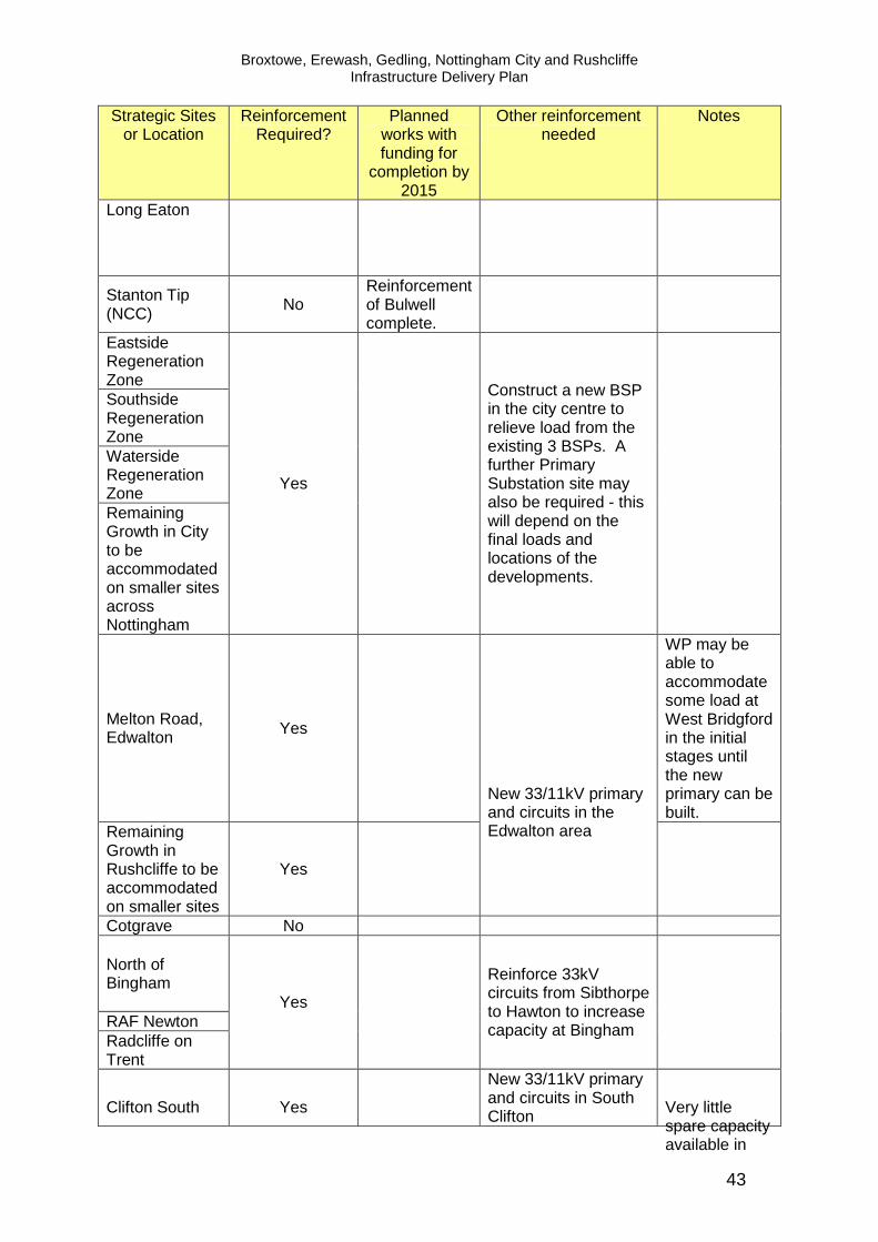
Broxtowe, Erewash, Gedling, Nottingham City and Rushcliffe Infrastructure Delivery Plan
43
Strategic Sites or Location
Reinforcement Required?
Planned works with funding for
completion by 2015
Other reinforcement needed
Notes
Long Eaton
Stanton Tip (NCC) No
Reinforcement of Bulwell complete.
Eastside Regeneration Zone Southside Regeneration Zone Waterside Regeneration Zone Remaining Growth in City to be accommodated on smaller sites across Nottingham
Yes
Construct a new BSP in the city centre to relieve load from the existing 3 BSPs. A further Primary Substation site may also be required - this will depend on the final loads and locations of the developments.
Melton Road, Edwalton Yes
WP may be able to accommodate some load at West Bridgford in the initial stages until the new primary can be built.
Remaining Growth in Rushcliffe to be accommodated on smaller sites
Yes
New 33/11kV primary and circuits in the Edwalton area
Cotgrave No
North of Bingham
RAF Newton Radcliffe on Trent
Yes
Reinforce 33kV circuits from Sibthorpe to Hawton to increase capacity at Bingham
Clifton South Yes
New 33/11kV primary and circuits in South Clifton Very little
spare capacity available in

Broxtowe, Erewash, Gedling, Nottingham City and Rushcliffe Infrastructure Delivery Plan
44
Strategic Sites or Location
Reinforcement Required?
Planned works with funding for
completion by 2015
Other reinforcement needed
Notes
the area.
Ruddington Yes
East Leake Possibly
Likely to need to transfer load from East Leake to the new primary at Clifton South to release capacity at East Leake.
Keyworth No
Top Wighay Yes Uprating Hucknall to 40MVA.
Land North of Papplewick Lane
Yes
Bestwood Village Yes
Calverton Yes Ravenshead Yes Remaining Growth in Gedling to be accommodated on smaller sites
Yes
Update an existing 33/11kV primary at Calverton - may also need to build a new 33/11kV primary in the area.
The local Bulk Supply Point will not support all of these projects -WP will need to look at building a new BSP, probably to the north of the area itself on an existing site, and then reconfiguring the network.
Source: Western Power May 2012 Notes: Bulk Supply Point: a substation which transforms electricity from 132,000 volts down to 33,000 volts and then feeds this out to a selection of local primary substations, acting as a ’primary hub’. Primary Substation: a substation which transforms electricity from 33,000 volts down to 11,000 volts to then distribute the electricity out to homes and businesses.
ii Gas Transmission National Grid have confirmed that specific development proposals within the Greater Nottingham area will not have a significant effect upon National Grid’s gas transmission infrastructure. National Grid state that it is unlikely that any extra growth will create capacity issues given the scale of their transmission networks. Local Gas Supply From the information provided by British Gas no abnormal constraints have been identified.

Broxtowe, Erewash, Gedling, Nottingham City and Rushcliffe Infrastructure Delivery Plan
45
iii. Green Energy The Low Carbon Opportunities5 (LCO) report commissioned by the East Midlands Councils assesses the technical potential for renewable and low carbon energy technologies across the East Midlands. The report does not provide guidance on specific sites but looks at the theoretical potential for renewable energy. The key conclusions of the report are included in the assessment below.
• Solar Energy The LCO report concludes that all areas within the HMA have considerable potential for solar thermal and solar photovoltaic renewable energy.
• Wind Due to its more easterly position and landscape character Rushcliffe is identified as having potential for commercial wind energy. Potential for wind generation in Gedling and Ashfield Districts is limited by constraints relating to existing infrastructure and bird sensitivity issues. Other areas not specifically mentioned in the study may be suitable depending on local characteristics.
• Ground/Air There is considerable potential for air source heating and heat pumps across the HMA (subject to site specific ground conditions).
• Water The report sets out that there is limited potential for hydro generation across the area. However the report makes little comment on the potential for water source heat pumps and this may have some potential for Core Strategies sites close to water courses (such as the recent development at River Crescent in Nottingham for example).
• Waste/Biomass Rushcliffe has potential for energy from biomass from energy crops, managed woodland and agricultural arisings. Nottingham is identified has having particular potential for the generation of energy from municipal and commercial/industrial waste and waste wood. A District Heating System operated by Enviroenergy serves part of Nottingham City Centre and provides heat and electricity from steam generated from the Eastcroft Energy from Waste Plant (EEFWP). Heat/energy capacity is closely linked to operation of the EEFWP, whilst physical extensions to the district heating network are largely reliant on external funding. Recent and committed extensions to the network have the potential to serve developments within the Waterside and Southside Regeneration Areas. Enviroenergy comment that large developments may have the critical mass to support local combined heat and power (CHP) generation. Nottingham City Council is exploring the feasibility of creating an Energy Park in Bulwell to serve the Blenheim Lane employment area with locally generated CHP. There may be potential to serve the Rolls Royce site to the North West. Nottingham City Council has secured funding from the Department for Energy and Climate Change to develop an Energy Mapping tool for the City. The tool which is currently underdevelopment will help to assess site suitability for green energy and heating sources.
5 Low Carbon Energy Opportunities and Heat Mapping for Local Planning Authorities Across the East Midlands:
Final Report, March 2011

Broxtowe, Erewash, Gedling, Nottingham City and Rushcliffe Infrastructure Delivery Plan
46
4. Phasing and Dependencies No specific phasing constraints have been identified in relation to:
• gas transmission • electricity transmission • gas supply • green energy
Western Power state that reinforcement of the primary network may be require the acquisition of new overhead line, cable routes and new substation sites with long lead in and construction times with a 2-3 year lead in for a new Primary with possible longer lead in times for Bulk Supply Points. They advise that sign on and commitment from developments is required as early as possible to facilitate timely completion of the necessary work. Table 7.13 indicates where strategic sites have a combined/cumulative impact. 5. Costs No abnormal costs have been identified relating to:
• electricity and gas transmission • gas distribution • gas supply
There may be additional costs related to local electricity distribution. Although Western Power has an extensive capital programme for reinforcement which is not attributable to individual developments they may recover costs of reinforcement works required to meet the needs of specific developments. Developers may be required to pay for two main elements – the full costs of local infrastructure for the sole purpose of serving a development site and a proportion of any higher voltage reinforcement required to make the local connection (based on the proportion to be used by the development). Where adequate capacity exists ‘upstream’ reinforcement works may not be necessary. Smaller developments will probably be accommodated without additional cost. Developers will not normally be asked to contribute towards the cost of a Bulk Supply Point. Western Power may be granted funding via OFGEM in their next price control period (2015-2023) but this will not be confirmed for at least two years. Any extension to the District Heating System in Nottingham City Centre would require developer/external funding. No cost information is available and estimates would be based on specific requirements. Costs relating to the inclusion of green energy measures can be difficult to calculate and may depend on the investment model used and return period and site specific circumstances. However cost assumptions are included within the viability section relating to strategic allocations at Section 9.

Broxtowe, Erewash, Gedling, Nottingham City and Rushcliffe Infrastructure Delivery Plan
47
6. Policy Synergies
• Climate Change policies with regard to the Energy Hierarchy which promote energy efficient buildings, energy efficient systems, and the use of low carbon and renewable energy.
7. Further Work Required
• Assess capacity/constraints for gas and electricity for employment uses as more detail becomes available (employment sites currently assessed as ‘D’ in the table below );
• Assess local electricity distribution constraints as site information becomes available and encourage early dialogue with developers and utilities companies;
• Review application of Nottingham Energy Mapping tool when available. 8. Summary Assessment Lead in times for electricity distribution is the main potential constraint. However providers have indicated that for large developments there is usually sufficient supply for early phases to proceed whilst main works comments. Early dialogue between developers and utility providers is key. Table 7.15 Summary Assessment
Critical Non-critical
Strategic Site Gas
Transmission
Gas Distribution/
Supply
Electricity Transmission
Electricity Distribution/
Supply
Green Energy
Field Farm C C C C C Severn Trent and Boots Site (NCC)
C C/D C B C
Toton C C B C C Awsworth C C C B C Brinsley C C C B C Eastwood C C C B C Kimberley (including Nuthall and Watnall)
C C C B C
Stanton Regeneration Site
C C/D C B C
Land North of Papplewick Lane
C C C B C
Top Wighay Farm C C/D C B C Bestwood Village C C C B C Calverton C C C B C Ravenshead C C C B C Boots Site (NCC) C C/D C B C Stanton Tip (NCC) C C/D C C C Waterside C C/D C B C

Broxtowe, Erewash, Gedling, Nottingham City and Rushcliffe Infrastructure Delivery Plan
48
Critical Non-critical
Strategic Site Gas
Transmission
Gas Distribution/
Supply
Electricity Transmission
Electricity Distribution/
Supply
Green Energy
Regeneration Zone Southside Regeneration Zone
C C/D C B C
Eastside Regeneration Zone
C C/D C B C
South of Clifton C C/D C B C Melton Road, Edwalton
C C C B C
North of Bingham C C C B C RAF Newton C C C B C Cotgrave C C C C C East Leake C C C C/B C Keyworth C C C C C Radcliffe on Trent C C C B C Ruddington C C C B C

Broxtowe, Erewash, Gedling, Nottingham City and Rushcliffe Infrastructure Delivery Plan
49
d) Utilities – Digital Infrastructure 1. Key Issues for the Core Strategies:
• Satisfactory access to IT (Broadband and Telecommunications) to support
businesses and connected communities. 2. Background Provision of high speed broadband services is particularly important to support the growth of knowledge based economies and has an increasing role in enabling sustainable home working patterns and supporting residents to be part of digital community with easy access to online information and services. IT and telecommunication services can be provided by a range of suppliers but as with energy supply, this study focuses on establishing whether, in principle, reasonable access can be provided to development sites and locations. Two main suppliers for Greater Nottingham were invited to comment on the IDP – Open Reach (BT) and Virgin Media. BT Openreach owns and manages a local access network that connects homes and businesses to telephone exchanges. It also provides installation and maintenance services on behalf of Communications Providers. The Company’s approach to serving new sites is set out within ‘Builder’s guide to telecommunications infrastructure and installation’. No response has been received from Virgin Media. Consultation has also taken place with Local Authorities regarding future strategic digital infrastructure provision. For knowledge based industries and media businesses, the provision of high speed dependable broad band services via fibre is becoming increasingly important. Local authorities are developing digital strategies to meet their particular needs, though co-ordinating approaches across the LEP area. Strategies include consideration of future business needs and how best to plan for and deliver high speed networks to employment sites and regeneration areas making the bet use of existing assets. Planning permission (subject to S106) was granted on 6th May 2011 for the development of a 90,000 sq ft fibre-optic data centre called The Portal within Nottingham’s Southside Regeneration Zone. The Portal has the potential to become one of UK's largest centres for the storage, pooling and transmission of national and international high-speed data. The development of data centres elsewhere in the UK have been a stimulus to new high tech global employment opportunities as blue chip companies seek to be located as close as possible to the data centre for reasons of connectivity. In addition the Government announced a £60m ‘City Deal’ for Nottingham in July 2012 to support the City’s Growth Plan. Improvement to digital infrastructure is identified as a priority for investment. 3. Assessment BT Openreach have confirmed that there are unlikely to be any limitations to broad band and telephone services for new developments and that the company is currently obliged to service new developments.
Broxtowe, Erewash, Gedling, Nottingham City and Rushcliffe Infrastructure Delivery Plan
50
Potential development of the Portal may provide significant locational advantages to existing and new knowledge based companies within Greater Nottingham, supporting the employment policies within the Core Strategies. 4. Phasing and Dependencies There are no anticipated phasing constraints. The standard lead in time for BT Openreach is 3 to 6 months for larger developments (e.g. over 100 plots). 4. Costs No abnormal costs associated with digital infrastructure are anticipated. BT Openreach has confirmed that under its present policy a set of standard site costs apply to developers. 5. Policy Synergies
• Supporting development of knowledge based businesses; • Supporting connected communities and home working.
6. Further Work Required
• Review the findings of the Digital Infrastructure Strategy when available; • Assess information provided from Virgin Media when available.
7. Summary Assessment No abnormal constraints are identified for the delivery of the Core Strategies. As all sites are assessed as ‘C’ no summary table is provided.

Greater Nottingham Broxtowe, Erewash, Gedling, Nottingham City and Rushcliffe Infrastructure Delivery Plan
51
e) Flooding and Flood Risk 1. Key Issues for the Core Strategies:
• Minimising development in areas of flood risk; • Reducing and mitigating against flood risk; • Planning for future climate change via the location and design of
development.
2. Background Flooding and flood risk are potentially the most significant physical constraints on use and development of land within Greater Nottingham. Flooding can occur from a number of sources including:
i. River flooding ii. Groundwater iii. Reservoir flooding iv. Surface Water/Sewer Flooding v. Coastal Flooding
The IDP considers all of the above with the exception of coastal flooding which is not relevant for Greater Nottingham. Sewer and surface water flooding are considered within the Utilities Section. A comprehensive and collaborative approach has been taken to flooding and flood risk across Greater Nottingham. A number of technical studies have been prepared by or with close consultation with the Environment Agency and Severn Trent Water. The source material for this chapter can be summarised as follows:
• Scoping Water Cycle Study (Scott Wilson, 2009) • Outline Water Cycle Study (Entec,2010) • Trent Catchment Flood Management Plan (Environment Agency, 2008b); • Lower Derwent Strategy (Environment Agency, 2008); • Fluvial Trent Strategy (Environment Agency, 2005); • River Leen and Day Brook Strategic Flood Risk Assessment (Black and
Veatch, 2008) • Greater Nottingham Strategic Flood Risk Assessment (Black and Veatch,
2008 with update 2010) • Ashfield District Council Strategic Flood Risk Assessment Level 1 (Ashfield
District Council, 2009) • Environment Agency Flood Zone Maps • Nottingham Left Bank Flood Alleviation Scheme • Nottingham Right Bank Flood Alleviation Scheme • Environment Agency Reservoir Flood Maps
i. River Flooding The main source of flooding in the study area is from the River Trent and its tributaries, mainly the River Derwent and the River Soar. Other sources include the River Erewash, River Leen, River Smite and other smaller brooks and dykes.

Greater Nottingham Broxtowe, Erewash, Gedling, Nottingham City and Rushcliffe Infrastructure Delivery Plan
52
Flood Zones 2 and 3 of the River Trent affect Nottingham City and the settlements of Long Eaton, Toton, Attenborough, Rylands, Beeston, Clifton, Wilford, West Bridgford, Lenton, Adbolton, Colwick, Netherfield, Radcliffe on Trent, Stoke Bardolph and Burton Joyce. The River Soar poses a risk of flooding to agricultural land and settlements including Sutton Bonington, Normanton on Soar and Stanford on Soar. Kingston Brook, a tributary of the River Soar flows westwards through Rushcliffe posing a particular flood risk to areas of East Leake and Kingston on Soar. In Ashfield, the main risk of flooding from watercourses is the Baker Lane Brook and the River Leen in Hucknall. Significant flooding events related to the Trent occurred in 1998 and 2000 which highlighted the limitations of Nottingham’s flood defences and led to a review of flood risk and the publication of the Fluvial Trent Strategy. This strategy and the River Trent Strategic Flood Risk Assessment have informed the development of the Nottingham Left Bank Flood Alleviation Scheme (FAS). The FAS aims to reduce the risk of flooding to 16,000 homes and businesses along a 27 kilometre stretch of the River Trent, from Sawley to Colwick. The works aim to reduce the probability of flooding across Nottingham from two per cent (1 in 50 chance) in any given year to one per cent (1 in 100 chance). The FAS has a positive impact on a number strategic sites and locations within the Core Strategies. Work on the FAS was completed in Autumn 2012 and covered the following phases:
• Sawley and Trent Meadows • Beeston and Rylands • Attenborough • Meadows • Colwick
Leen and Day Brook A Strategic Flood Risk Assessment for the River Leen and Day Brook was prepared in 2008. Whilst the conclusions of the assessment do not relate to the Core Strategies strategic sites, there are a number of smaller locations along the Leen and Day Brook which are at risk from flooding. Flood risk from the Leen and Day Brook largely affects existing properties but the following potential smaller development sites within Nottingham City are affected:
• Bulwell Town Centre • Vernon Road • P Z Cussons • Bobbers Mill South
The study also considered possible mitigation measures. The above sites will be considered in more detail within DPD’s. Hucknall A level 1 Strategic Flood Risk Assessment covering Ashfield District Council, was undertaken in 2009. Whilst the SFRA considers the whole of Ashfield, this study considers the conclusions of the study which relate the four wards within Hucknall as these may have cross boundary impact for the IDP area.

Greater Nottingham Broxtowe, Erewash, Gedling, Nottingham City and Rushcliffe Infrastructure Delivery Plan
53
The River Leen and the Baker Lane Brook are identified as the main rivers within Hucknall. The overall conclusion from the Ashfield SFRA is that flood risk is relatively low and that flood risk will not have a substantial effect upon the potential location of development in the District. The potential strategic site at Rolls Royce is considered to be at low risk of flooding. The River Leen and Day Brook SFRA indicates that some existing properties in parts of Hucknall are at risk of flooding. In addition, additional water from development into the River Leen and its tributary streams may have significant implications for flooding downstream in the City of Nottingham. Although rural catchments outside Nottingham City Council’s boundary currently do not contribute significant volumes of floodwater to the River Leen and Day Brook, even small increases may exacerbate the existing flooding situation to the detriment of people and property in Nottingham. The SFRA advises that where possible, major development proposals within the catchment area of the River Leen and Day Brook should seek to reduce volumes and peak flow rates of surface water generated by a development to pre-developed greenfield rates. Urban expansion and major development proposals within the District of Ashfield or the Borough of Gedling should assess the impact of additional surface water run-off on receiving watercourses. In addition the Environment Agency have advised that further assessment of the capacity of the Greythorne Dyke pumping station (west Bridgford, Rushcliffe) is required and that the cumulative impacts of smaller development sites in the Wilford Lane area may necessitate upgrading works. Table 7.16 below provides an overview of the flooding status and recent flood related progress on strategic sties. Table 7.16 Flood Risk and Strategic Sites
Strategic Site
Flood Risk
Rolls Royce* Flood Risk Assessment prepared in 2007. Low risk of flooding.
Field Farm
A small part of the site is within the functional floodplain of the Boundary Brook and part is within the 1:100 year flood plain. A Sequential Test was completed in Feb 2012. The site covers a complex drainage area due to the interaction of local sewers and overland flows.
Severn Trent and Boots Site (BBC)
Within Flood Zone 3. Parts of the site remain at flood risk in a 1 in 1000 year flood post completion of the Nottingham Left Bank Flood Alleviation Scheme.
Toton
Site within Flood Zone 1. No significant flood risk and no significant fluvial sources. Potential increase in surface water runoff requiring mitigation from attenuation storage and on site SDS provision.
Awsworth
The Gilt Brook flows through land to the North of Awsworth, some of which falls in Flood Zone 3, land to the East and South of the settlement lie largely outside of the floodplain, an ordinary watercourse flows between Awsworth and Babbington.
Brinsley Much of area surrounding settlement is within Flood Zone 1

Greater Nottingham Broxtowe, Erewash, Gedling, Nottingham City and Rushcliffe Infrastructure Delivery Plan
54
Strategic Site
Flood Risk
and therefore low risk. Some ordinary water courses present.
Eastwood
Much of Eastwood and surrounding area lie in Flood Zone 1 and are at low risk. However the Beauvale Brook , River Erewash and Gilt Brook are located to the north, west and east of the settlement respectively.
Kimberley (including Nuthall and Watnall)
The Gilt Brook runs to the west of Kimberley. Much of Kimberley and Watnall and land to the immediate west of Nuthall fall within Flood Zone 1 and are therefore low risk. EA maps identify some surface water flooding. A lake and ordinary watercourse are located to the south of the settlement, north of the A610.
Stanton Regeneration Site (EBC)
The proposed new access road is located within the functional floodplain of the River Erewash and discussions are on-going with Environment Agency. Other parts of the site low risk.
Land North of Papplewick Lane
A small part of this site is in Flood Zone 2 of the River Leen and a small part of the track along the eastern boundary of the site edges into Flood Zone 3 with the remainder of the site being in Flood Zone 1 and there are some smaller watercourses that run through the site. Overall low risk but sequential test required if development falls within flood zone.
Top Wighay Farm Within Flood Zone 1, although there are a number of smaller watercourses that run through the site. Overall low risk.
Bestwood Village Watercourse located to the west of the settlement - low flood risk.
Calverton
The strategic location falls outside of the flood zone but a watercourse runs along the northern edge of the village which has an associated flood zone. The flood zone may be misaligned away from the watercourse.
Ravenshead Low risk.
Boots Site (NCC) This site falls within Flood Zone 3 and, parts of site remain at flood risk in a 1 in 1000 year flood post completion of the Nottingham Left Bank Flood Alleviation Scheme.
Stanton Tip Parts of the site fall within Flood Zones 3 and 2, former colliery culvert runs through the site.
Waterside Regeneration Zone
Part of the area around Meadow Lane are within Flood Zone 3 from the River Trent and Tinkers Leen. These parts of the regeneration area remain at flood risk during a climate change and 1 in 1000 year flood post completion of the Nottingham Left Bank Flood Alleviation Scheme.
Southside Regeneration Zone
Part of the regeneration area around the Extended Island site lies within Flood Zone 3 from the River Trent and Nottingham Canal. This part of the regeneration zone remains at flood risk in a 1in 1000 year flood post completion of Nottingham Left Bank Flood Alleviation Scheme. However, flood risk principles for the Extended Island site were agreed as part of the outline planning application.
Eastside Part of the regeneration area around the Nottingham

Greater Nottingham Broxtowe, Erewash, Gedling, Nottingham City and Rushcliffe Infrastructure Delivery Plan
55
Strategic Site
Flood Risk
Regeneration Zone Station/Queens Road area is in Flood Zone 3 from the River Trent, Tinkers Leen and Nottingham Canal. These parts of the regeneration area remain at flood risk during a climate change and 1 in 1000 year flood event post completion of the Nottingham Flood Alleviation Scheme.
South of Clifton
A small part of the site associated with Fairham Brook falls within Flood Zone 3 and provides opportunities for GI and biodiversity enhancements. Surface water requires attenuation to ensure no downstream flooding.
Melton Road, Edwalton
EA have identified the need to control run off from the site. The approved scheme incorporates a range of SUDS including porous paving and above ground balancing areas.
North of Bingham
Parts of site lie in Flood Zone 3. FRA indicates implementation of Car Dyke Management Scheme (CDMS) required (realignment and excavation of Car Dyke and creation of lake). CDMS needs to be in place before residential elements of the scheme can commence. Swales required. Improvements to watercourse proposed as part of planning application to resolve flooding issues. SUDS required in the form of an above ground amenity lake.
RAF Newton
The site falls within Flood Zone 1 (low risk) but with a culverted watercourse crossing the site which is to be reopened as part of the development. There are known flood risk issues downstream of the site and redevelopment provides an opportunity to reduce downstream flows via Sustainable Drainage Systems.
Cotgrave A small part of this site is in Flood Zone 3 from Grantham Canal. EA have negotiated SDS as part of planning application for Cotgrave Colliery. Overall low risk.
East Leake
There are two sources of flooding in East Leake - Kingston Brook (runs from east to west through the centre of the village) and Sheepwash Brook (runs from south to the confluence with Kingston Brook in the playing fields at the centre of the village). A number of properties fall within the flood zones in particular along Brookside.
Keyworth Low risk - no flood zones within the settlement. Proposals to manage surface water required.
Radcliffe on Trent
The River Trent is the major source of flood risk in the lower areas of Radcliffe in the west. Some parts of the village including the area around Sydney Grove, Lamcote Gardens, The Green and Yew Tree Close are within a flood zone.
Ruddington
No flood zones within the settlement. Fairham Brook flows to the west of Ruddington and is fed by two tributaries one to the north and one to the south of the settlement, both have associated flood zones. If development is restricted to key settlement then flooding to new development should not be an issue but disposal of surface water could exacerbate problems.

Greater Nottingham Broxtowe, Erewash, Gedling, Nottingham City and Rushcliffe Infrastructure Delivery Plan
56
*The Rolls Royce site is located in Ashfield District but lies close to Nottingham and Gedling and is included above to ensure cumulative/cross boundary impacts are considered. ii. Ground Water Flooding The River Leen and Day Brook catchment area is located on rocks which are capable of storing large amounts of water. With the decline of abstraction from traditional industries and increases in rainfall there has been a rise in ground water levels resulting in flooding of basements and cellars in the Basford area. This may have an impact on the appropriateness of surface water drainage systems in some locations. Sewer and surface water flooding are considered in Section 7b. iii. Reservoir Flooding
The Environment Agency’s reservoir flood maps indicates those areas which could be at risk of inundation should a reservoir fail. Table 7.17 sets out those strategic sites which could potentially be affected by reservoir flooding based on these maps. For broad locations potential reservoir flooding has been assessed as that within approximately 1 mile of the main settlement. It should be noted that the EA’s reservoir information relates only to large raised reservoirs of a capacity of 25,000 cubic metres of water or more and is given for guidance only. Where there are multiple sources of reservoir flooding it is not possible to distinguish the level/extent of flooding attributable to each source. Table 7.17 Reservoir Flood Risk
Strategic Site
Reservoir Flood Risk
Rolls Royce None Identified
Field Farm Very small area to south at risk from Strelley SR, Moorgreen, Mapperley and Osbourne’s Pond
Severn Trent and Boots Site (BBC)
None Identified
Toton None Identified Awsworth None Identified Brinsley None Identified
Eastwood Flooding risks to the north and west of main settlement from Moorgreen, Codnor Park and Loscoe
Kimberley (including Nuthall and Watnall)
Risk of flooding at the south eastern edge from Temple Lake
Stanton Regeneration Site (EBC)
Possible flooding from Shipley Lake, Mapperley, Manners Balancing Pond, Osbourne’s Pond and Moorgreen
Ilkeston SRC
Flood risk at the western edge from Shipley Lake, Mapperley, Manners Balancing Pond and Osborne’s Pond. To the eastern edge Moorgreen, Loscoe, Strelley SR and Codnor Park
Land North of Papplewick Lane
Western edge may be affected by Newstead Abbey Upper Lake
Top Wighay Farm None Identified Bestwood Village Flood risk to the western edge of the settlement from Mill

Greater Nottingham Broxtowe, Erewash, Gedling, Nottingham City and Rushcliffe Infrastructure Delivery Plan
57
Strategic Site
Reservoir Flood Risk
Lakes, Newstead Abbey Upper Lake and Barracks Farm Calverton None Identified Ravenshead None Identified
Boots Site (NCC) The southern boundary is close to areas possibly at risk from Howden, Carsington and Blithfield
Stanton Tip (NCC) None Identified Waterside Regeneration Zone
Large areas of the site at risk from Howden, Carsington, Breaston FSR, Cropston and Blithfield
Southside Regeneration Zone
None Identified
Eastside Regeneration Zone
None Identified
South of Clifton Small area to south west close to Barton in Fabis from Carsington and Howden
Melton Road, Edwalton
None identified
North of Bingham None identified RAF Newton None identified Cotgrave None Identified East Leake None Identified Keyworth None Identified
Radcliffe on Trent Flood risk to the northern edge of the settlement from Carrsington, Blithfield, Ogston and Cropston
Ruddington None Identified *The Rolls Royce site is located in Ashfield District but lies close to Nottingham and Gedling and is included above to ensure cumulative/cross boundary impacts are considered. Employment/Retail Locations (where not included abo ve)
Hucknall Flood risk to the east from Newstead Abbey Upper Lake and Barracks Farm Reservoir
Beeston
Flood risk to the north east of settlement from Wollaton Park Lake and Strelley SR. To the south from Carsington, Moorgreen, Staunton Harold, Howden, Blithfield, Church Wilne, Ogston, Foremark and Cropston.
Long Eaton
Flood risk from Moorgreen, Strelley SR, Mapperley, Osbourne’s Pond, Howden, Blithfield, Cropston, Foremark, Carsington, Breaston FSR, Church Wilne, West Park and Harrington Drain FSR Ogston and Staunton Harold
Arnold None Identified City Centre None Identified
Bulwell Flood risk to the east from Newstead Abbey Upper Lake, Barracks Farm, and Mill Lakes. To the south from Temple Lake.

Greater Nottingham Broxtowe, Erewash, Gedling, Nottingham City and Rushcliffe Infrastructure Delivery Plan
58
3. Assessment i. River Flooding Greater Nottingham has large areas potentially at risk from river flooding. Flooding constraints affecting locations for growth identified in the Core Strategies have been discussed with the Environment Agency. For the most part, flooding affects relatively small areas of the Core Strategies sites and the Agency have provided both informal and formal advice on flood risk issues and how best to avoid, mitigate and provide betterment to address flooding. In additional the Nottingham Left Bank Flood Alleviation Scheme has a positive impact on many sites. Whilst no absolute ‘showstoppers’ have been identified there are several sites where very careful consideration of flood risk will be required. Parts of the Boots Campus (BBC and NCC), land at Severn Trent and the Waterside Area fall within Flood Zone 3 but are important housing, employment and regeneration sites. Capacity issues have been identified related to the Greythorne Dyke pumping station in West Bridgford. Whilst this does not impact on strategic sites, further dialogue will be required regarding the cumulative impact of smaller sites in the Wilford Lane area. The partners will work closely with the Environment Agency and developers to achieve the optimum outcome balancing growth and regeneration with appropriate flood risk solutions. It is recognised that climate change and development may have further adverse impacts on flooding and flood risk and that information relating to flood risk is dynamic and will need ongoing review. The assessment of Core Strategies sites regarding flood risk (Table 7.16) has been agreed in close consultation with the Environment Agency. ii. Ground Water Flooding Flooding from ground water is a particular issue for Nottingham City’s urban areas which were formerly the focus for traditional industries. Whilst ground water flooding is of real concern to existing residents, strategic sites within the Core Strategies are largely unaffected. iii. Reservoir Flooding The Environment Agency on their website state that reservoir flooding is extremely unlikely and there has been no loss of life from reservoir flooding since 1925. Since then reservoir legislation has been introduced to ensure that reservoirs are well maintained and monitored. The identification of possible risks from reservoirs is not necessarily a constraint to development. The reservoir flood risk information provides a basis for councils to determine the need for further consultation with the Environment Agency and reservoir owners and therefore reservoir flooding has been assessed as ‘c’ for all sites. 4. Phasing and Dependencies The Nottingham Left Bank Flood Alleviation Scheme was completed late 2012. This has positive impacts on strategic sites at Boots, Severn Trent, Waterside, Eastside, Southside and around the towns of Beeston and Long Eaton.

Greater Nottingham Broxtowe, Erewash, Gedling, Nottingham City and Rushcliffe Infrastructure Delivery Plan
59
Incorporation of appropriately designed (site specific) flood mitigation measures may have adverse impacts on delivery (time and cost) and will need to be considered as part of site specific flood risk assessments. 5. Costs The Left Bank Flood Alleviation Scheme is costed at £45m and is fully funded. Works to upgrade the Greythorne Dyke pumping station are estimated at £290,000. Wider costs associated with assessing and mitigating against flood risk are difficult to determine at a strategic level and site specific flood risk assessment may be required to inform infrastructure costs. 6. Policy Synergies
• Climate Change policies relating to flooding, Sustainable Drainage and opportunities for multi-use areas (e.g. open space, habitats, making space for water).
7. Further Work Required and Future Engagement
• Site specific flood risk assessments for proposals in Flood Zones 2/3 and developments over 1ha in Flood Zone 1.
• Ongoing dialogue with Environment Agency (including engagement with Local Authorities in their capacity of Local Lead Flood Authorities).
• Further assessment of Greythorne Dyke pumping station by the Environment Agency.
8. Summary Assessment Risk of flooding has the potential to impact on the delivery of several Core Strategy sites including Boots (BBC and NCC) and Field Farm. Close dialogue with the Environment Agency is essential to agree flood management and mitigation measures. Table 7.18 Summary Assessment
Critical
Strategic Site Flood Risk Ground Water
Flooding
Reservoir Flooding
Rolls Royce* C C C Field Farm B C C Severn Trent and Boots Site (BBC) A/B C C Toton C C C Awsworth C C C Brinsley C C C Eastwood C C C Kimberley (including Nuthall and Watnall)
C C C
Stanton Regeneration Site (EBC) B/C C C Ilkeston SRC B C C Land North of Papplewick Lane C C C

Greater Nottingham Broxtowe, Erewash, Gedling, Nottingham City and Rushcliffe Infrastructure Delivery Plan
60
Top Wighay Farm C C C Bestwood Village C C C Calverton C C C Ravenshead C C C Boots Site (NCC) A/B C C Stanton Tip (NCC) B C C Waterside Regeneration Zone B C C Southside Regeneration Zone B C C Eastside Regeneration Zone C C C South of Clifton C C C Melton Road, Edwalton C C C North of Bingham B C C RAF Newton C C C Cotgrave C C C East Leake B C C Keyworth C C C Radcliffe on Trent B C C Ruddington B C C
*The Rolls Royce site is located in Ashfield District but lies close to Nottingham and Gedling and is included above to ensure cumulative/cross boundary impacts are considered.
Critical
Strategic Site Flood Risk Ground Water
Flooding
Reservoir Flooding
Employment/Retail Locations (where not included above) Hucknall B C C Beeston B C C Long Eaton B C C Arnold C C C City Centre B C C Bulwell B C C

Greater Nottingham Broxtowe, Erewash, Gedling, Nottingham City and Rushcliffe Infrastructure Delivery Plan
61
f) Health and Local Services 1. Key Issues for the Core Strategies:
• Local health services in accessible locations • Provision of new/extended facilities appropriate to the scale of new
development • Clustering/sharing of facilities and services to provide integrated services for
local communities.
2. Background This section considers the provision of local services, including health services, to support growth. This section considers:
i. Hospitals ii. General Practitioners and Dentists iii. Local and town centres
Consultation has taken place with Local Authorities regarding the accessibility of a range services such as retail, food retail and community facilities and this section is also informed by the Tribal Sustainable Locations for Growth report and Retail Health Checks undertaken by the local authorities. Consultation has also taken place with the three Primary Care Trusts that covered the IDP area up to April 2013; NHS Derbyshire, NHS Nottingham and NHS Nottinghamshire regarding the provision of health services. Until April 2013 Primary Care Trusts (PCTs) were responsible for directing resources and regulating the primary care activities of General Practitioners (GPs) dentists, optometrists and pharmacists and directing funds to secondary care providers such as hospital trusts and ambulance trusts. PCTs have previously sought funding for new GP surgeries from new development where there is there is insufficient capacity within existing facilities. At the time of writing, PCTs had just transferred many of their responsibilities to new Clinical Commissioning Groups (CCGs), in response to the Government’s reorganisation of commissioning in the NHS. The information set out in this document will therefore be reviewed when new structures and funding mechanisms are fully established. 3. Assessment i. Hospitals
NHS Nottingham City commented that Nottingham University Hospitals Trust (NUH) is the primary provider of hospital based care and treatment services for Nottingham and Nottinghamshire. For Erewash the majority of care is provided by the Derby Hospital Foundation Trust. NHS Nottingham City had not undertaken a detailed assessment of the impact of the proposed demand for services at NUH as it is envisaged that overtime NUH should be able to absorb changing patterns in demand of services. However, the impact on

Greater Nottingham Broxtowe, Erewash, Gedling, Nottingham City and Rushcliffe Infrastructure Delivery Plan
62
specific services will depend on the demographics and particularly the age profile of the residents of new developments. NHS Nottinghamshire commented that funding for NUH is directed to hospitals by PCTs (now CCGs) and that funding is made available on the basis of population levels and sensitised to reflect the characteristics of the population in terms of age and deprivation. NHS Derbyshire commented that the PCT has a duty to plan for care, including hospital care, which meets the needs of the local population including demand for services arising from population growth. ii. General Practitioners and Dentists Consultation with the PCTs sought to establish whether existing services have the capacity to accommodate growth and, if new services are required, the level of provision needed, potential costs and phasing. NHS Nottingham City (Public Health) commented that the health impact of the projected increase in the city population over the next decade is considered within the Joint Strategic Needs Assessment – therefore housing growth within this period has been considered at a strategic level. Further health impact assessment in collaboration with the public health team is welcomed at a point when more detailed proposals are available (e.g. tenancy) is known. NHS Nottingham City provided specific comments on the strategic locations proposed in Nottingham. Stanton (NCC) is estimated to generate approximately 300-400 additional patients. The six nearest practices (five within Bulwell and one at Cinderhill) are estimated to have capacity, however the new Bulwell Health Centre is likely to be particularly popular for new registrations and therefore a further future review is recommended as development proposals come forward. The Waterside Regeneration Zone may generate 900 -1,200 new patients and is close to seven existing GP practices. Whilst there may be some capacity in existing surgeries, for this level of growth the PCT expected to consider provision of additional facilities. In the shorter term, capacity exists within the new Platform One Practice on Station Street with a list size of approximately 2,250 of its planned capacity of 6,000. For the strategic location at Boots, it is estimated that approximately 2,500 patients may be generated on the Nottingham City part of the site. The closest City facilities are located at the University of Nottingham but these are focussed on the needs of students. Additional provision to serve this site and existing residents in Dunkirk and Beeston Rylands may be necessary. There are four existing practices in Beeston and Chilwell which may have capacity to serve dwellings on the Broxtowe part of the site but further consultation with NHS Nottinghamshire is required to ensure cross boundary issues are addressed. The strategic allocation at Clifton South in Rushcliffe is located close to existing practices in Clifton within Nottingham City. NHS Nottingham City comments that capacity at these practices is limited and that contributions towards their expansion would be needed or new provision made within the development. NHS Nottinghamshire has facilitated meetings with the emerging Clinical Commissioning Groups which cover the IDP area within Nottinghamshire County.

Greater Nottingham Broxtowe, Erewash, Gedling, Nottingham City and Rushcliffe Infrastructure Delivery Plan
63
Capacity information and future requirements relating to Field Farm in Broxtowe and sites in Rushcliffe have been provided (see table 7.19). For other areas, although information relating to the location of existing surgeries is available, current information on capacity and the potential for expansion has not yet been made available and it is therefore difficult to assess the impact of the Core Strategies. However, a positive and collaborative dialogue has been established with NHS Nottinghamshire and this area of the IDP will be reviewed when further information is available. In planning for new GP services NHS Derbyshire applied a standard multiplier to calculate the potential need for GP services. An average of 2.3 persons per household is assumed, with a patient list size of one GP per 1,800 people. From this calculation it is assumed that 13,800 patients will result from growth in Erewash. The three nearest practices to serve Ilkeston and Stanton Regeneration Site (EBC) are: Adam House Medical Centre The Old Station Eden Surgery NHS Derbyshire commented that if development were to proceed they would consider expansion of facilities with the possibility of additional new buildings. However, further details of smaller sites in Ilkeston is required to confirm requirements and longer term growth at Stanton Regeneration Site would need to be reviewed in the context of up to date GP list sizes. NHS Nottinghamshire commented that although NHS dental services receive funding from the PCT, the location of services and their capacity is a business-led decision made by practitioners and is largely driven by market forces. This is the position nationally. Although local authorities or PCTs (now CCGs) have no direct control over the location and accessibility of new dental practices, the Core Strategies seek promote sites with good access to local services. Table 7.20 GP Practice Requirements
Site GP/Dentist Est Cost
Field Farm Contribution to existing facilities required.
£427K
Severn Trent and Boots Site (BBC)
Some possible capacity within existing surgeries, further new provision likely
tbc
Toton Capacity and requirements tbc by CCG, land set aside for health use if required
tbc
Awsworth Capacity and requirements tbc by CCG
tbc
Brinsley Capacity and requirements tbc by CCG
tbc
Eastwood Capacity and requirements tbc by CCG
tbc
Kimberley (including Nuthall and Watnall)
Capacity and requirements tbc by CCG
tbc
Stanton Regeneration Site (EBC)
Possible expansion of existing facilities and new provision
tbc

Greater Nottingham Broxtowe, Erewash, Gedling, Nottingham City and Rushcliffe Infrastructure Delivery Plan
64
Site GP/Dentist Est Cost Land North of Papplewick Lane
Capacity and requirements tbc by CCG
tbc
Top Wighay Farm Capacity and requirements tbc by CCG but likely that existing services will require expansion
tbc
Bestwood Village Capacity and requirements tbc by CCG
tbc
Calverton Capacity and requirements tbc by CCG
tbc
Ravenshead Capacity and requirements tbc by CCG
tbc
Boots Site (NCC) Some possible capacity within existing surgeries, further new provision likely
tbc
Stanton Tip (NCC) Potential capacity within existing practices
tbc
Waterside Regeneration Zone
Possible expansion of existing facilities and new provision. Short term capacity within existing practices.
tbc
Southside Regeneration Zone
N/A
Eastside Regeneration Zone
N/A
South of Clifton New on site facility required with cost estimate based on Principia multiplier.
Est approx. £2.9m
Melton Road, Edwalton
Reserved site to be provided of 0.7ha. Healthcare contribution required to support existing facilities.
£1.1m
North of Bingham Off site contribution required. tbc RAF Newton Off site contribution required. Est £506k
Cotgrave Contribution to health care included as part of overall S106.
East Leake Further expansion of existing facilities required. Costs based on multiplier.
Est. £306k
Keyworth New LIFT facility with potential capacity.
Radcliffe on Trent Existing facilities difficult to expand but contributions to be based on multiplier.
Est £238k
Ruddington
Recent extension to local facilities. Further ext may be required but further review needed.
tbc

Greater Nottingham Broxtowe, Erewash, Gedling, Nottingham City and Rushcliffe Infrastructure Delivery Plan
65
iii. Local Centres and Town Centres The councils have sought to development close to existing local and town centres to maximise the use of existing facilities, reduce the need for car journeys and support the vitality and regeneration of local centres. The table below sets out the local and town centres which are expected to serve the Core Strategies strategic sites and where additional community services are likely to be required.
Table 7.20 Local Centres and Town Centres
Site
Local Centre/Town Centre
Field Farm Good range of existing facilities within Stapleford.
Severn Trent and Boots Site (BBC)
Good range of facilities within Beeston, on site facilities tbc.
Toton Good range of facilities within Stapleford Town Centre. Land set aside for community building if required.
Awsworth Good range of town centre facilities at Kimberley and Ilkeston.
Brinsley Good range of facilities at Eastwood. Eastwood Good range of facilities within Eastwood. Kimberley (including Nuthall and Watnall)
Good range of facilities within existing settlement.
Stanton Regeneration Site (EBC)
Close to Ilkeston Town Centre, neighbourhood facilities to be provided on site. Likely that growth in Ilkeston and to a lesser extent Long Eaton, may create need for enhanced or replacement community halls with an estimated contribution of £1m.
Land North of Papplewick Lane
Close to existing limited local facilities in Papplewick but close to Hucknall Town Centre. Further links required.
Top Wighay Farm Close to town centre facilities within Hucknall. Local scale facilities to be provided on site. Further public transport links required.
Bestwood Village Existing local centre. Further provision tbc. Improved public transport links required.
Calverton Existing local centre. Further provision tbc. Ravenshead Existing local centre. Further provision tbc.
Boots Site (NCC) Good range of facilities within Beeston, on site facilities tbc.
Stanton Tip (NCC) Good range of facilities within Bulwell Town Centre. New local scale retail uses to be provided on site.
Waterside Regeneration Zone
Full range of facilities within Nottingham City but requires provision of new neighbourhood facilities.
Southside Regeneration Zone
Full range of facilities within Nottingham City.
Eastside Regeneration Full range of facilities within Nottingham City.

Greater Nottingham Broxtowe, Erewash, Gedling, Nottingham City and Rushcliffe Infrastructure Delivery Plan
66
Site
Local Centre/Town Centre
Zone
South of Clifton Close to Clifton District Centre. New neighbourhood centre required on site.
Melton Road, Edwalton
Good range of existing services within West Bridgford Town Centre. New on site community hall required, local convenience store, sports and play areas. Contribution to existing leisure facilities of £0.64m.
North of Bingham
Good range of existing services in Bingham town centre. New on site community centre required, leisure facilities and allotments. Cost tbc.
RAF Newton New community hall, sports pitch and play area required and contribution to library services. Cost tbc.
Cotgrave Close to Cotgrave town centre. New walking links required. Contribution of £933k to support town centre facilities.
East Leake Existing local centre. Further provision tbc Keyworth Existing local centre. Further provision tbc Radcliffe on Trent Good range of existing facilities within village. Ruddington Good range of existing facilities within village.
4. Phasing and Dependencies The phasing and delivery of healthcare contributions and facilities is agreed on a case by case basis. However new and expanded facilities are generally expected to be in place prior to first occupation of dwellings. Improvements to local services should also be in place on first occupation of dwelling but there may be some circumstances, such as the scale of the overall development which necessitate phased provision 5. Costs Where expansion of GP surgeries is required (on sites above 10 dwellings), NHS Derbyshire request S106 contributions based on an average cost per dwelling. This is calculated from the average cost of a new GP surgery and assumes 2.3 persons per household and an average of 1,800 patients per GP which gives a cost per dwelling of £513. The formula excludes legal costs and land acquisition costs. Principia, the Clinical Commissioning Group for Rushcliffe have developed a similar cost model building with a cost per dwelling of £950. This is based on an average occupancy of 2.3 persons per dwelling and a ratio of 1,800 patients per GP with a cost per square metre of £2,123. No cost information is provided by NHS Nottingham City. Where provided, estimated costs are set out in Table 7.19 and 7.20 Costs for additional local services are largely based on actual costs of e.g. new play areas.

Greater Nottingham Broxtowe, Erewash, Gedling, Nottingham City and Rushcliffe Infrastructure Delivery Plan
67
6. Policy Synergies
• Local Services and Healthy Lifestyles 7. Further Work Required and Future Engagement
• Confirmation of GP capacity and required future provision by CCG’s: • Ongoing engagement with all CCGSs regarding longer term requirements for
health services; • Ongoing town centre health checks.
8. Summary Assessment Whilst local services are not considered a critical issue for the delivery of the Core Strategies, they are important to securing the sustainability and attractiveness of communities and wider objectives to reduce car journeys. Further engagement is required with CCGs to refine future requirements which will be informed by more detailed site information as part of councils emerging Development Plan documents. Table 7.21 Summary Assessment
Non-Critical Site Hospital GP/Dentist Local
Services Field Farm C B B Severn Trent and Boots Site BBC) C D D Toton C D C Awsworth C D D Brinsley C D D Eastwood C D D Kimberley (including Nuthall and Watnall)
C D D
Stanton Regeneration Site (EBC) C D D Land North of Papplewick Lane C D B Top Wighay Farm C D B Bestwood Village C D D Calverton C D D Ravenshead C D D Boots Site (NCC) C D D Stanton Tip (NCC) C C D Waterside Regeneration Zone C B D Southside Regeneration Zone N/A Eastside Regeneration Zone N/A South of Clifton C B B Melton Road, Edwalton C B B North of Bingham C B B RAF Newton C B B Cotgrave C B B East Leake C B B Keyworth C D B Radcliffe on Trent C B C Ruddington C B C

Greater Nottingham Broxtowe, Erewash, Gedling, Nottingham City and Rushcliffe Infrastructure Delivery Plan
68
g) Education 1. Key Issues for the Core Strategies:
• Ensuring development is supported by accessible and appropriate educational facilities.
2. Background The IDP defines education as a non-critical infrastructure category, as physical delivery of a site is not directly dependant on school places. However, adequate provision of accessible education facilities is recognised as a very important element in delivering attractive and sustainable communities. The information within this chapter has been informed by consultation and information from the Education Departments of the three Local Authorities which cover the IDP area: Derbyshire County Council Nottingham City Council Nottinghamshire County Council The three Local Authorities are responsible for co-ordination of school admissions and distribution of funding to state schools. The authorities undertake a rolling programme of pupil projection based on census data, GP registrations and school catchment information to try to match demand for school places with physical supply. Pupil projection is a complex area and only relevant for forecasting up to 5 years. This is important for the IDP as long term growth proposals will require further and regular review. In determining future education requirements generated by the Core Strategies proposals, an understanding of current provision and planned supply is necessary. Information for Local Authority schools can be provided with a relatively high degree of accuracy. However Academies are not currently obliged to share roll numbers or expansion/contraction plans with LAs. As all future new primary and secondary schools are required to have Academy status there may be greater uncertainty around pupil planning in the future (and IDP requirements). The Government is currently considering future engagement arrangements for Local Authorities, Academies and Free Schools. The IDP considers provision of schools places for two groups - primary (5-11) and secondary (11-15) education. Assessment has focussed on sites which are likely to come forward in the first 5 years of the plan period due to the difficulties of projecting longer term pupil numbers. However, broad assumptions have been made for longer term sites. In assessing the need for additional school places and school buildings each Local Authority has advised on the current capacity of existing schools, planned capacity, the potential for school expansion and the need for new school provision with regard to the most recent pupil projection data. Information on the school capacity and existing pupil rolls is not replicated in the IDP. This information can be misleading as it does not take into account pupil projections or planned changes to school provision. The information presented in this IDP is based on consultation with

Greater Nottingham Broxtowe, Erewash, Gedling, Nottingham City and Rushcliffe Infrastructure Delivery Plan
69
education colleagues, their assessment of existing capacity, pupil projections and projected demand from new development. The IDP sets out the additional school places likely to be required and which developments give rise to the need for new school places and new schools. In determining the number of school places likely to be generated by a new development, the Local Authorities apply the following methodology: Table 7.22 School Place Calculation
Local Authority Type of Provision Places per 100
Dwellings Derbyshire Primary School Places 20 Nottingham Primary School Places 18 Nottinghamshire Primary School Places 21
Derbyshire Secondary School Places 15
Nottingham Secondary School Places 8
Nottinghamshire Secondary School Places 16
Source: Derbyshire County Council, Nottingham City Council, Nottinghamshire County Council. Note: Nottingham City Council exclude one bed or specialist housing from the calculations above. 3. Assessment Within the Nottingham City area, the council has been undertaking a rolling programme of school reorganisation since 2002. In terms of primary phase proposals the city is responding to significant growth in the number of school age children living in the City and requiring places within City schools. Between 2009 and 2011 an additional 460 primary phase places have been added to the City’s primary estate and there are currently proposals to add a further 840 places in 2012/13. Despite these additions further capacity is required to meet projected growth expected in 2013 onwards. Proposals for new schools under the Building Schools for the Future Programme will not proceed due to Government budget cuts. Although Nottingham City currently has an overall surplus of primary spaces, constraints on capacity are anticipated from 2013 with requirements for school expansion or new schools as appropriate. It is likely Nottingham City will require contributions for school expansion or new schools on all new housing post 2013. As much of Nottingham City’s growth will come forward on smaller sites (via DPD’s) ongoing dialogue on capacity and provision will be key. A submission to the government’s Priority School’s Building Programme was made in Autumn 2011, to support the demands identified. All areas of the city are now showing increased demand for first entry into the primary school phase by 2014/15 – including Clifton, Bulwell, Broxtowe/Strelley, Bestwood/Top Valley and Sneinton. At secondary level the impact of rising school numbers is projected to create significant pressure from 2015 onwards. This corresponds with the larger current primary cohorts entering secondary phase.

Greater Nottingham Broxtowe, Erewash, Gedling, Nottingham City and Rushcliffe Infrastructure Delivery Plan
70
Within Nottinghamshire County, there is also pressure on primary school places although there is potential in many locations for expansion to meet needs. However, larger development proposals will require new on site provision. Generally there is capacity within existing secondary schools to accommodate growth subject to contributions to expand facilities. As with Nottinghamshire, Derbyshire County Council are experiencing pressure on primary capacity and development proposals will require increased capacity or new schools in some locations. Secondary provision is expected to be met by capacity within existing schools. The following table sets the additional primary school places required for each strategic site and likely future provision. For some strategic locations (delivery to commence later in the plan period) it is not yet possible to confirm provision and a further review of future pupil projections is required. The table also sets out an estimate of places required (by Local Authority) on smaller sites throughout IDP area. Whilst smaller sites are to be identified through later Development Plan Documents, an understanding of the potential cumulative impact is important to assess the overall impact on schools and future resources and to enable education colleagues to plan effectively. Table 7.23 Primary School Places
Strategic Site Primary Places
Required
Likely Future
Provision
Comments
Field Farm 95 Capacity within existing schools
Contributions required to accommodate additional pupils within existing buildings.
Severn Trent and Boots Site (BBC) 115 Tbc
Toton Tbc Tbc Awsworth 84 Tbc Brinsley 53 Tbc Eastwood 294 Tbc Kimberley (including Nuthall and Watnall) 126 Tbc
Provision depends on phasing and accurate longer term pupil projections
Stanton Regeneration Site (EBC) 400 New 2 form entry
school on site
Class provision to be phased with development phase completion. Close liaison with neighbouring schools re impacts/catchments.
Land North of Papplewick Lane 126 New 1 form entry
school on site

Greater Nottingham Broxtowe, Erewash, Gedling, Nottingham City and Rushcliffe Infrastructure Delivery Plan
71
Strategic Site Primary Places
Required
Likely Future
Provision
Comments
Top Wighay Farm 210 New 1 form entry school on site
Bestwood Village 120
New primary may be required to accommodate existing growth and proposed growth.
Provision depends on phasing and accurate longer term pupil projections.
Calverton 319
Capacity to expand existing schools to be reviewed. Other wise new primary may be required.
Provision depends on phasing and accurate longer term pupil projections.
Ravenshead 95 Existing capacity.
Boots Site (NCC) 108 Tbc
Provision depends on phasing and accurate longer term pupil projections
Stanton Tip (NCC) 90 Tbc
Provision depends on phasing and accurate longer term pupil projections
Waterside Regeneration Zone 540 Tbc
Provision depends on phasing and accurate longer term pupil projections (and mix of units) but likely that expansion and or new schools required.
Southside Regeneration Zone N/A
Eastside Regeneration Zone N/A
South of Clifton 525 New school on site
Melton Road, Edwalton 252 New 1.5 form school. S106 agreement
North of Bingham 210 New 1 form entry primary school on site.
RAF Newton 116
New school with 4 classrooms but infrastructure for 210 place school
Cotgrave 99 Capacity of existing schools S106 agreement

Greater Nottingham Broxtowe, Erewash, Gedling, Nottingham City and Rushcliffe Infrastructure Delivery Plan
72
Strategic Site Primary Places
Required
Likely Future
Provision
Comments
to be expanded.
East Leake 84
Likely to require expansion of capacity at existing schools.
Review of longer term pupil projections needed when available.
Keyworth 95 Capacity within existing schools at present.
Review of longer term pupil projections needed when available.
Radcliffe on Trent 84
Likely to require expansion of capacity at existing schools.
Review of longer term pupil projections needed when available
Ruddington 53
Likely to require expansion of capacity at existing schools.
Review of longer term pupil projections needed when available
Estimate of Primary School Places on Non-Strategic Sites
Broxtowe 546 Tbc
Smaller sites and capacity of schools to be reviewed as part of DPD.
Erewash 850 Tbc
Ongoing dialogue with Derbyshire CC as proposals for smaller sites emerges.
Gedling 652 Tbc
Smaller sites and capacity of schools to be reviewed as part of DPD.
Nottingham 2,349
All new sites likely to require additional school capacity.
Smaller sites and capacity of schools to be reviewed as part of DPD.
Rushcliffe 457 Tbc
Smaller sites and capacity of schools to be reviewed as part of DPD.
Table 7.24 Secondary School Places
Strategic Site Secondary
Places Required
Future Provision Comments
Field Farm 72 Capacity within existing schools.
Severn Trent and (BBC) Site 88 Likely to be
accommodated

Greater Nottingham Broxtowe, Erewash, Gedling, Nottingham City and Rushcliffe Infrastructure Delivery Plan
73
Strategic Site Secondary
Places Required
Future Provision Comments
Toton tbc Awsworth 64 Brinsley 40 Eastwood 224 Kimberley (including Nuthall and Watnall) 96
within existing schools but may require contributions to expansion
Stanton Regeneration Site (EBC) 300
Expected capacity within existing schools.
Land North of Papplewick Lane 96
Top Wighay Farm 160
To be accommodated within existing schools with contribution to new places
Bestwood Village 95 Calverton 243
Ravenshead 72
Likely to be accommodated within existing schools but may require contributions for new places
Provision depends on phasing and accurate longer term pupil projections
Boots Site (NCC) 48 Tbc
Provision depends on phasing and accurate longer term pupil projections
Stanton Tip (NCC) 40 Tbc
Provision depends on phasing and accurate longer term pupil projections
Waterside Regeneration Zone 240 Tbc
Provision depends on phasing and accurate longer term pupil projections (and mix of units).
Southside Regeneration Zone N/A
Eastside Regeneration Zone N/A South of Clifton 400 Melton Road, Edwalton 192 S106 agreement.
North of Bingham 160
To be accommodated within existing local secondarys with contributions to support new places.
RAF Newton 0 Capacity at Radcliffe on Trent
Source: planning application

Greater Nottingham Broxtowe, Erewash, Gedling, Nottingham City and Rushcliffe Infrastructure Delivery Plan
74
Strategic Site Secondary
Places Required
Future Provision Comments
negotiations.
Cotgrave 75 Capacity within existing schools.
East Leake 64
To be accommodated within existing local secondarys with contributions to support new places.
Keyworth 72 Expected capacity within existing schools.
Radcliffe on Trent 64
Ruddington 40
To be accommodated within existing local secondarys with contributions to support new places.
Review of longer term pupil projections needed when available.
Estimate of Secondary School Places for Non-Strategic Sites
Broxtowe 416 Tbc
Smaller sites and capacity of schools to be reviewed as part of DPD.
Erewash 587 Tbc
Ongoing dialogue with Derbyshire CC as proposals for smaller sites emerges.
Gedling 497 Tbc
Smaller sites and capacity of schools to be reviewed as part of DPD.
Nottingham 1,044
Notts CC confirm all new sites will require additional school capacity.
Smaller sites to be reviewed as part of DPD.
Rushcliffe 348 Tbc
Smaller sites and capacity of schools to be reviewed as part of DPD.

Greater Nottingham Broxtowe, Erewash, Gedling, Nottingham City and Rushcliffe Infrastructure Delivery Plan
75
4. Phasing and Dependencies Phasing of housing delivery has a direct impact on when school places are required and the threshold or trigger for investment in new school buildings. Generally Local Authorities require provision of school places at first occupation of dwellings. For large sites, which require new primary schools, a phased approach to the provision of class rooms may be appropriate i.e. the provision of infrastructure for a complete school but with phased delivery of class rooms to match growth and occupancy of new development (this approach is suggested by Derbyshire County Council for Stanton Regeneration Site within Erewash). Early dialogue with Local Authorities is key. Some sites have cross boundary impacts. For example secondary school provision at Top Wighay within Gedling Borough Council could be accommodated by schools located in Ashfield District Council. In this case Nottinghamshire County Council provide education services for both councils and have considered cross boundary impacts within their comments. Clifton South within Rushcliffe Borough Council is located close to an existing community in Nottingham City Council. A new primary will be required on site on site to serve the new development whilst secondary school provision will be via existing local schools within Rushcliffe. Due to the close proximity of to the existing community further dialogue on cross boundary issues will be required as development proposals emerge Pupil projection is a complex area and although schools have defined catchments, parental choice and school capacity are important factors in determining future needs. With the increase of new Academies, planning for school places longer term is increasingly difficult and regular review of this element of the IDP will be required. 5. Costs The three Local Authorities will seek developer contributions to support the cost of additional school places where existing schools have no capacity. Where new places are required and expansion of existing school buildings is possible, the authorities use a standard cost multiplier (based on government guidance) per school space required as set out below (as at Spring 2012): Table 7.25 Cost per School Place
Local Authority Type of Provision
Cost per
place Derbyshire Primary £11,399 Nottingham Primary £11,455 Nottinghamshire Primary £11,455 Derbyshire Secondary £17,176 Nottingham Secondary £17,260 Nottinghamshire Secondary £17,260
Source: Derbyshire, Nottingham and Nottinghamshire Councils.

Greater Nottingham Broxtowe, Erewash, Gedling, Nottingham City and Rushcliffe Infrastructure Delivery Plan
76
Nottingham City Council are currently considering a further model to calculate the costs of education infrastructure which looks at average occupancy per dwelling to better reflect the likely pressures on education from different dwelling types. This then uses benchmark build costs for new schools from the government per place required. For many sites the precise dwelling mix has not yet been established. Therefore the methodology In Table 7.22 has been used in this document to provide a broad estimate of education contributions which may be required over the plan period. The following cost estimates have been provided by the authorities as a guide to the cost of new primary schools – based on actual build costs of recent schemes. New School One form entry £5-6m New School Two form entry £7m Cost estimates for the provision of new school places/schools is set out below: Table 7.26 Estimated Costs per Strategic Site
Strategic Site/Area
Primary
Secondary
Field Farm £525k - Severn Trent and Boots Site (BBC) tbc tbc Toton tbc tbc Awsworth £842k £967K Brinsley £481k £552k Eastwood £3.36m £3.86m Kimberley (including Nuthall and Watnall) £1.4m £1.6m
Stanton Regeneration Site (EBC) £5-7m tbc Land North of Papplewick Lane £5-5.5m £1.65m Top Wighay Farm £5-5.5m £2.76m Bestwood Village £5-5.5m £1.6m Calverton £3.6m - 5.5m £3.6m Ravenshead - £1.21m Boots Site (NCC) tbc tbc Stanton Tip (NCC) £1.03m £690k Waterside Regeneration Zone £6.1m £4.1m Southside Regeneration Zone N/A Eastside Regeneration Zone N/A South of Clifton £10-12m £6.9m Melton Road, Edwalton £3.6m £3.3m North of Bingham £3m £2.8m RAF Newton £2.35m - Cotgrave £763k - East Leake £962k £1.1m Keyworth £1m £1.24m Radcliffe on Trent £962k £1.1m Ruddington £907k £691k

Greater Nottingham Broxtowe, Erewash, Gedling, Nottingham City and Rushcliffe Infrastructure Delivery Plan
77
Non Strategic Sites
Broxtowe £6.2m £7.1m Erewash £9.68 tbc Gedling £7.5m £8.6m Nottingham £26.9m £18m Rushcliffe £5.2m £6m
The costs above include broad estimates relating to longer term development sites (strategic locations) and smaller sites which will defined in DPD’s to enable a borad understanding of the overall scale of contributions which may be required to support education provision over the plan period. However, the costs assume that existing schools have no capacity and therefore costs are towards the higher end of what might be expected. Clearly as DPD’s emerge and proposals for strategic locations are confirmed further review of capacity and pupil projections will be required in consultation with education colleagues. Costs for new schools are based on recent examples provided by the Local Authorities. Different procurement models and developer partnerships may have the potential to reduce build costs. 6. Policy Synergies
• Provision of local services to support sustainable communities 7. Further Work Required and Future Engagement
• Ongoing dialogue with education colleagues including joint meetings where schools have potential cross boundary impacts (Clifton South, Top Wighay).
• Confirmation of requirements at Toton, depending on the scale of development.
8. Summary Assessment Whilst school place provision is not necessarily a physical ‘show stopper’ for development, provision of appropriate facilities is an extremely important factor in securing attractive and sustainable development. All strategic sites are likely to be required to contribute to the provision of school places or new schools on larger sites. The likely cost of school places has been considered in the overview of viability for strategic allocations within Chapter 10. Indicative costs for smaller sites will be an important consideration in the councils’ preparations for Community Infrastructure Levies. A summary table is not included for education infrastructure as all sites are assessed as ‘B’ and all will be required to contribute to education provision (this is with the exception of secondary provision at the former Cotgrave Colliery and Field Farm and primary provision at Ravenshead).

Greater Nottingham Broxtowe, Erewash, Gedling, Nottingham City and Rushcliffe Infrastructure Delivery Plan
78
h) Emergency Services 1. Key Issues for the Core Strategies:
• Provision of satisfactory levels of emergency services for existing and new development;
2. Background This section considers the potential for new developments to be supported by appropriate emergency services including:
i. Police ii. Fire iii. Ambulance
Consultation has been undertaken with representatives from Nottinghamshire and Derbyshire Police, Nottinghamshire and Derbyshire Fire and Rescue Services and the East Midlands Ambulance Service (EMAS).
i. Police
Policing within the Core Strategies area is provided by Nottinghamshire and Derbyshire Police. There are two divisions in Nottinghamshire - Nottingham City and Nottinghamshire County.
Each division is sub-divided into a number of Neighbourhood Policing Areas (NPAs), each of which is headed by a Neighbourhood Policing Inspector (NPI). Local policing in Nottinghamshire is delivered from police stations in these NPAs.
In Derbyshire, Erewash is part of D Division, which covers Erewash, Derby City and South Derbyshire. Local policing in Erewash is delivered from Inspector led Section Stations at Ilkeston and Long Eaton.
Funding for local policing is agreed centrally and is part of a complex formula related to population and policing needs. Police budgets have recently been subject to severe budget cuts. In both Derbyshire and Nottinghamshire a review of policing and estates strategy is underway. Potential for community policing is being explored alongside consideration of fewer prime police stations. More innovative approaches to police accommodation may be explored such as co-location of services and community based policing within existing public and private sector buildings. New approaches to IT may enable responses from the nearest available resource rather than traditional patches. Nottinghamshire Police are currently reviewing opportunities to reduce revenue costs (staffing and energy) associated with existing and new buildings. Both services commented that the physical attributes of a development - design, layout, form and housing mix can influence the potential for crime and fear of crime and subsequently the levels/type of policing delivered. Police colleagues would encourage that these issues are considered as early as possible in the development process.

Greater Nottingham Broxtowe, Erewash, Gedling, Nottingham City and Rushcliffe Infrastructure Delivery Plan
79
ii. Ambulance Services East Midlands Ambulance Service (EMAS) NHS Trust provides emergency and urgent care transport services for Derbyshire and Nottinghamshire. EMAS take a formulaic approach to forward planning to ambulance services linked to population, resident numbers, housing type and socio-economic factors. Currently services are funded by Primary Care Trusts. At the time of writing the EMAS Estates Strategy was under review. iii. Fire Fire Services for the Core Strategies area are provided by Derbyshire and Nottinghamshire Fire and Rescue Services. At the time of writing the way in which fire services are deployed was subject to change and a review of the capacity and location of appliances and stations was underway. Service provision by the Fire Service is changing from an approach based on target response times to one of risk assessment. Risk levels are determined by a range of factors including the type of homes, their design and occupier profiles with interventions such as sprinkler systems having a significant impact on assessment of risk levels. This new approach has implications for the way in which the need for new fire stations is assessed and subsequently the way staff and appliances are deployed including consideration of ‘standby’ locations on areas of hard standing. Consultation confirmed that there is generally a downward trend in fire related incidents but traffic and road safety incidents are on the increase. Ease of access to new developments is becoming an increasingly important consideration for the service. 3. Assessment Police Previous consultation regarding 5,500 homes at Clifton South led to a requirement for the provision of a new police station. Consultation has confirmed that this requires further review in the context of new approaches to Estate Strategies. No other specific constraints to the delivery of the Core Strategies have been identified. However as new approaches to accommodating police services within local communities are considered, early discussion with LA’s and developers is increasingly important to explore partnership opportunities for shared space and services. Ambulance Services Consultations confirmed that generally there were few problems in servicing the conurbation although meeting response times for the existing Clifton area was challenging due to the number of speed humps. No ‘showstoppers’ were identified in serving future development proposals. It was noted however that the new Derby City Hospital has led to Ambulance Services within Erewash being pulled further south with additional travel times. Should further development come forward around the A52 corridor around Long Eaton and Borrowash then early dialogue would be welcomed to ensure proposals are adequately supported. In terms of the Core Strategies Proposals, no specific constraints were identified but EMAS are increasingly making use of ‘stand-by’ locations which are dynamic and change

Greater Nottingham Broxtowe, Erewash, Gedling, Nottingham City and Rushcliffe Infrastructure Delivery Plan
80
regularly depending on the needs of the settlement and time of day. At the time of writing, EMAS was considering consultation responses to proposals to introduce 131 ‘tactical deployment points’ and standby locations across the East Midlands. This new service model would be supported by 13 new ambulance ‘hubs’ providing staff and vehicle facilities and would replace the majority of existing ambulance stations, Fire Generally Nottingham City is regarded as a high risk area for fire services (compared to other locations across Nottinghamshire). However current arrangements for fire services are considered adequate although this may be affected by future budget cuts. As part of previous consultations regarding development proposals at Clifton South, the Fire Service sought S106 contributions for a new station. This was based on the need to provide a 10 minute response time. However the new risk based approach may mean that this is no longer appropriate but this will be informed by more detailed information on the type and tenure of housing proposed and transport accessibility. Although optimal locations for stations are under review within the Nottingham City area, no specific infrastructure requirements related to the Core Strategies have been identified. Derbyshire Fire and Rescue Service particularly welcomed early discussions at the masterplanning stage for large sites. Design (houses and roads) and mix of housing has a significant impact on the level of risk and how services need to be deployed. No specific requirements resulting from the Core Strategies were identified for Broxtowe Borough although dialogue is on going between Nottinghamshire and Derbyshire Fire and Rescue Services regarding cross boundary opportunities and efficiencies. 4. Phasing and Dependencies Police Consultation confirmed that no barriers were perceived in terms of gearing up police services for new development and that beat arrangements could be reorganised to accommodate changes associated with new development. Fire and Ambulance No specific phasing requirements were identified to serve new developments but early dialogue welcomed on major proposals. 5. Costs Emergency services across the IDP area are responding to severe reductions in budgets and are seeking to reduce revenue costs associated with the staffing and servicing of traditional forms of accommodation. Police The key issue for policing relates to revenue funding for staffing rather than capital to support physical assets. Derbyshire Police commented that the budget for the next 4 years is already fixed and existing resources will need to deployed differently to respond to increases in population and housing. Derbyshire Police believed that in

Greater Nottingham Broxtowe, Erewash, Gedling, Nottingham City and Rushcliffe Infrastructure Delivery Plan
81
most instances contributions from development would not be sought but early consultation was welcomed. Early discussions between Nottinghamshire Police, Rushcliffe Borough Council and developers identified the need for a new police station to serve the development at Clifton South. However, with police revenue budgets now under pressure consultation confirmed that this may require review in the context of a new approach to police estates strategy and divisional operation. Nottinghamshire Police confirmed that contributions to support policing are likely to be required but this can only be assessed on a case by case basis considering the nature of development and type of units to be delivered. Nottinghamshire Police welcome further dialogue on innovative ways to support new styles of policing as part of further CIL discussions. Fire In order to achieve a 10 minute fire response time at Clifton south, a new fire station was deemed to be required by Nottinghamshire Fire and Rescue Service – based on previous proposals for 5,500 homes. However recent changes to the way in which fire serves are deployed may negate this requirement. Nottinghamshire Fire service colleagues will review the need for physical assets on a risk based approach when further details of type and tenure of housing are known. Derbyshire Fire and Rescue commented that the precise impact/cost on services of new development is difficult to estimate however the costs of mobilisation for an incident are around £900. The key issue however is one of capacity of staff/vehicles for multiple incidents related to the quality and comprehensiveness of the service provided. Derbyshire Fire and Rescue Service would welcome further dialogue on approaches to quantifying costs, particularly with regard to the development of CIL and to explore opportunities for co-location of services. Ambulance It is unlikely that EMAS would seek direct contributions from development to support services but early discussion on development proposals is welcomed and possibly provision of simple hard standing or ‘standby’ locations as part of major developments. Estimated costs are provided for new infrastructure at Clifton South however further consultation will take place with police and fire colleagues to review this following the conclusion of their estates and operational strategies. Table 7.27 Emergency Service Costs
Location Requirement and Cost Clifton South Police Station.
Capital cost estimated to be £680,000 based a building footprint of 203m2 and site area of 0.04 ha.
Clifton South
Fire Station Capital cost estimated to be £2.5-3 million based on site area of 0.3ha, plus a pumping station of £0.25millon. Revenue costs estimated at £0.7 million for staffing
Source: Nottinghamshire Police, Nottinghamshire Fire and Rescue

Greater Nottingham Broxtowe, Erewash, Gedling, Nottingham City and Rushcliffe Infrastructure Delivery Plan
82
6. Policy Synergies
• Strong, safe and cohesive communities; • Housing size, mix and choice; • Transport accessibility.
7. Further Work Required and Future Engagement
• Review Nottinghamshire Police Estates Strategy when available; • Review Nottinghamshire Fire and Rescue Estates Strategy when available; • Review EMAS Estates Strategy when available; • Further dialogue with all service providers and review of potential approach to
costing services as suggested by Derbyshire Fire and Rescue. 8. Summary Assessment Developer contributions to support emergency services to date have been limited. Currently specific requirements relate only to the Clifton South site (for fire and police station provision) although this is subject to review. Emergency service provision is unlikely to directly impact on the deliverability of the Core Strategies and as such most sites have been assessed as ‘C’. However, such services are important to the overall sustainability and safety of communities, and as service reviews are still ongoing, an early review of this element of the IDP will be required and further investigation of methodologies to calculate costs associated with the services. Table 7.28 Summary Assessment
Non-critical Strategic Site
Police Fire Ambulance Field Farm C C C Severn Trent and Boots Site (BBC) C C C Toton C C C Awsworth C C C Brinsley C C C Eastwood C C C Kimberley (including Nuthall and Watnall)
C C C
Stanton Regeneration Site (EBC) C C C Land North of Papplewick Lane C C C Top Wighay Farm C C C Bestwood Village C C C Calverton C C C Ravenshead C C C Boots Site (NCC) C C C Stanton Tip (NCC) C C C Waterside Regeneration Zone C C C Southside Regeneration Zone C C C Eastside Regeneration Zone C C C South of Clifton B B C Melton Road, Edwalton C C C

Greater Nottingham Broxtowe, Erewash, Gedling, Nottingham City and Rushcliffe Infrastructure Delivery Plan
83
Non-critical Strategic Site
Police Fire Ambulance North of Bingham C C C RAF Newton C C C Cotgrave C C C East Leake C C C Keyworth C C C Radcliffe on Trent C C C Ruddington C C C

Greater Nottingham Broxtowe, Erewash, Gedling, Nottingham City and Rushcliffe Infrastructure Delivery Plan
84
i) Waste Management 1. Key Issues for the Core Strategies:
• Reduce household, business and construction waste; • Reduce landfill and increase recycling; • Reduce energy consumption and increase sustainable energy generation.
2. Background Waste is generated from many sources including industrial/commercial activities, construction, demolition, municipal and household waste. Municipal waste is collected and disposed of by Local Authorities whilst other forms of waste are dealt with by the private sector. The preparation of strategic policies for the long term management and disposal of waste are prepared by county and unitary councils. For the IDP area, strategic policies for waste management are set out within the following documents: Nottinghamshire and Nottingham Waste Local Plan 2002 Derbyshire and Derby Waste Local Plan 2005 Both these plans are currently under review. Nottinghamshire County and Nottingham City Councils submitted a revised plan to the Secretary of State in January 2013. Derbyshire County Council and Derby City Council are also preparing a new plan. More information will be available during 2013. The emerging documents set out estimates for the amount of waste which is currently generated, collected, recycled and disposed of along with estimates for the future and proposals to manage future waste. The scale of growth proposed within the Core Strategies will be considered as part of the Councils’ emerging waste plans and the plans will set out potential locations to accommodate future waste disposal. Nottingham City Council has responsibility for both waste collection and disposal. Nottinghamshire and Derbyshire County Councils have responsibility for waste disposal whilst the District and Borough councils have responsibility for municipal/domestic waste collection. Direct consultation has taken place with Nottingham City Council, Nottinghamshire County Council and Derbyshire Council on waste related issues. The main issues arising from the Core Strategies growth proposals relate to the sustainable management of waste in terms of:
• reducing the generation of waste; • increasing recycling; • minimising waste destined for landfill; • securing sustainable energy where from waste where appropriate; • ensuring sufficient capacity and sites for future waste management needs; • balancing the impacts of waste management on the environment including
residential amenity.

Greater Nottingham Broxtowe, Erewash, Gedling, Nottingham City and Rushcliffe Infrastructure Delivery Plan
85
3. Assessment Nottingham City Nottingham City Council indicates that no immediate constraints are identified. Nottingham City households each produce approximately 1 tonne of waste per annum of which 40-50% is currently recycled. If these estimates are applied to new households proposed within the Nottingham element of the Core Strategies then there is sufficient disposal infrastructure in place to manage additional waste arisings within the plan period. More detailed information on the precise nature and timing of commercial/health/education provision is required to enable a further assessment of waste infrastructure however Nottingham City Council anticipates that the current disposal facilities are able to support these additional waste streams. Derbyshire County Council
Waste management budgets in Derbyshire are currently under pressure in the context of reduced council budgets. New Household Waste Recycling facilities within Derbyshire are being prioritised more towards the north of the County as this is where there is identified shortfall in provision. The Derbyshire County Council Infrastructure Delivery Plan sets out a requirement for a Household waste and Recycling in Ilkeston and seeks contributions to support its delivery.
Nottinghamshire County Council Nottinghamshire County Council comment that the Core Strategies proposals do not raise any significant concerns in terms of waste disposal capacity due to recent fall in waste tonnages, although there will be a direct impact on the waste collection functions carried out by district councils. A direct and potentially significant impact is anticipated on Household Waste Recycling Centres (HWRC). Due to budget pressure several 3 HWRCs were closed during Summer/Autumn 2011. Specific comments are provided below: Broxtowe. There are two HWRC within Broxtowe at Giltbrook and Beeston. Stapleford HWRC was closed in August 2011 and as a result additional congestion and capacity issues are expected at Beeston HWRC. Capacity exists at the Giltbrook HWRC. Gedling. Only one HWRC now operates within Gedling located at Calverton. Whilst capacity exists at Calverton, housing proposed at Top Wighay and Papplewick Lane is likely to impact on the Hucknall HWRC. Rushcliffe – There are two HWRCs in Rushcliffe at West Bridgford and Langar. The Edwalton and Clifton South developments are likely to impact on the busy West Bridgford site but there is currently no capacity for expansion. Development at Cotgrave and Tollerton may have an impact on West Brigford although residents may also travel to Langar.

Greater Nottingham Broxtowe, Erewash, Gedling, Nottingham City and Rushcliffe Infrastructure Delivery Plan
86
Districts No specific constraints are identified by waste collection departments. However, Gedling Borough Council has commented that a further residual waste collection point in the north of the borough is desirable Cross Boundary Impacts Nottinghamshire County Council comments that the Stanton Tip development at Bulwell is likely to have an impact on the Hucknall HWRC within the County. Depending on the final access arrangements for the Boots sites this may impact on Lenton HWRC (City) or Beeston (County). Development at Toton may increase congestion at Beeston but would not necessitate the need for new HWRC facilities. It is considered that Waterside Regeneration zone may impact on West Bridgford HWRC, which is already at capacity and has no scope for expansion. Similarly growth in Long Eaton could impact on the HWRC at Beeston. 4. Phasing and Dependencies Nottingham City Council comments that there are no requirements for lead in planning arrangements to build capacity into current service provision. Nottinghamshire County Council comment that lead in times for additional HWRC’s if required (including planning, licensing and development of the site) are around 18 – 24 months. Within regard to waste collection, no specific constraints have been identified provided waste collection Departments are notified of development proposals at the earliest stage to enable existing rounds to be adjusted and new rounds established. 5. Costs Nottingham City Council has estimated that the Core Strategies proposals would require additional waste collection infrastructure costing in the region of approximately £0.5 million capital and £0.5 m revenue per annum. Disposal costs would be in the region of £0.9 million per annum. A standard refuse collection round is estimated to service around 5,000-8,000 properties per week (depending on density/ type of housing etc.) at a cost of £150,000 per round per annum. It is estimated that 3 additional rounds may be required to service additional homes within Nottingham City at a cost of £0.5 million plus capital costs of infrastructure. Average waste disposal costs equate to approximately £50 per tonne of waste equating to £0.9 million pa for Nottingham City. As a Waste Collection Authority and Waste Disposal Authority Nottingham City Council would meet revenue costs but may require developers to meet some of the capital costs in terms of site provision for recycling centres and containers for collection where required. No additional facilities are required at present (as a result of the Core Strategies proposals) but this will be kept under review. Nottingham City Council estimate the costs of a new Household Waste Recycling Centre to be in the region of £500,000 – 700,000 excluding land costs.

Greater Nottingham Broxtowe, Erewash, Gedling, Nottingham City and Rushcliffe Infrastructure Delivery Plan
87
Nottinghamshire County Council Nottinghamshire County Council’s additional disposal costs associated with the Core Strategies growth are estimated to be in the region of at least £1.5m per annum. No direct contributions from developers are sought for this aspect. However Developer contributions would be expected for the provision of additional HWRC where required by new development. Nottinghamshire County Council estimates the cost of a new split level HWRC on a 1 ha site to be in the region of £1.5m (based on £1m development costs and £500,000 of land costs). This is based on the current development of the Newark HWRC on Brunel Drive, Newark Business Park. It should be noted that that per annum costs are based on full housing provision up to the plan period rather than a gradual increase in homes. Derbyshire County Council is seeking £575k towards the Phase 1 costs of a Household Waste Recycling Centre for Ilkeston. District waste collection Departments expect costs to be met directly by each council as part of normal charging arrangements. In some cases householders may be charged for provision of bins or special collection services. Examples of waste disposal and HWRC costs are provided below.. Table 7.29 Waste Disposal Costs
Location Waste Disposal Costs Nottingham City Waste Disposal (revenue) £0.9m p.a. Costs met by Nottingham
City Council Waste Collection (revenue) £0.5m p.a. Costs met by Nottingham City Council Waste Collection (capital) £0.5m per p.a. Costs met by Nottingham City Council Future HWRC if required. Capital costs £500 – 700,000 capital, £300,000 revenue pa.
Nottinghamshire County Council
Waste Disposal. Additional £1.5m revenue p.a. Met by Nottinghamshire County Council
Gedling Colliery/Chase Farm/ HWRC
New HWRC. Total cost est £1.5m. Funding to be confirmed part developer contributions should the site come forward.
Ilkeston Phase 1 Household Waste and Recycling Centre (2013-18) £575k. Funding via S106/CIL.
6. Policy Synergies
• Climate Change and carbon reduction. • Environmental protection.

Greater Nottingham Broxtowe, Erewash, Gedling, Nottingham City and Rushcliffe Infrastructure Delivery Plan
88
7. Further Work Required and Future Engagement
• Review the outcome of Waste Local Plans when available; • Review the impact of business growth as proposals emerge; • Lead agencies are Local Authorities – ongoing engagement/joint working.
8. Summary Assessment No critical issues relating to waste disposal and waste collection are identified which would prevent growth proposals from coming forward. However congestion at existing facilities is likely. All sites assessed a ‘C’ (and therefore no summary table is provided).

Greater Nottingham Broxtowe, Erewash, Gedling, Nottingham City and Rushcliffe Infrastructure Delivery Plan
89
j) Green Infrastructure and Biodiversity 1. Key Issues for the Core Strategies:
• Protection of green infrastructure corridors and assets; • Promoting appropriate access to new and enhanced green infrastructure and
open spaces.
2. Background This section considers the impact of the core strategies on green infrastructure6 and assets. Information in this chapter has been informed by the Tribal Sustainable Locations for Growth Study, the 6C’s Green Infrastructure Strategy, Habitats Regulation Assessments and consultation with Local Authorities, Natural England and the Environment Agency. This section considers potential constraints to the delivery of the Core Strategies from a GI perspective - in terms of avoiding adverse impacts on GI corridors and assets but also identifies opportunities for growth to provide new and enhanced facilities. 3. Assessment The 6C’s Strategic Green Infrastructure Strategy was published in July 2010 (study can be downloaded at www.emgin.co.uk following the link to the 6C’s and National Archives) and was created by a partnership of local authorities and environmental organisations to develop a cross boundary green infrastructure strategy for the East Midlands. The strategy identifies indicative opportunities for sub-regional, city-scale and urban fringe green infrastructure networks. The strategy assesses the location and distribution of existing GI assets including natural green space, countryside access routes, open space and green wedges, watercourses, historic environmental assets, and floodplain. The strategy identifies opportunities to improve the connectivity of habitats and wildlife and also improvements for people via multi-user paths. The strategy suggests new and enhanced green infrastructure in broadly defined corridors and zones – many focused on watercourses including: Derwent River, River Trent, River Leen, Grantham Canal, Trent and Mersey Canal, Beeston Canal, River Erewash, Erewash Canal. The Greenwood Community Forest is also identified as an important GI asset for biodiversity and heritage. These strategic GI corridors and locations run through or past several of the strategic sites and offer opportunities for enhancement and improvement as set out in Table 7.30. The requirement for flood mitigation on several sites also provides opportunities for enhanced green infrastructure. Development Plan Documents will identify opportunities for enhancements and delivery of the 6C’s strategy at a local scale. 6 A full definition of the term ‘Green Infrastructure’ is provided within the Aligned Core Strategies
June 2012.

Greater Nottingham Broxtowe, Erewash, Gedling, Nottingham City and Rushcliffe Infrastructure Delivery Plan
90
The 6C’s Strategy and local Strategies such as the Trent River Park Strategy have already guided investment towards strategic multi-user routes and habitat improvements along the Trent, Leen and Erewash and Nottingham canals and masterplan proposal for strategic sites will be required to make provision for strategic multiuse routes. A Habitats Regulation Assessment (HRA) Screening Record has been undertaken for the Core Strategies. This found that there could be potentially significant effects on parts of the prospective Sherwood Forest Special Protection Area. It concluded that a precautionary approach should be followed and that policies should not encourage further visitors to this part of the Greenwood Community Forest. Supplementary Screening Records in reference to Calverton and Top Wighay Farm in Gedling were subsequently undertaken. The Screening Record for Top Wighay concluded that the scale of development would not be likely to have significant impact on any European site. Potential affects on the Sherwood Forest prospective Special Protection Area could not be ruled out. Following consultation with Natural England, a number of appropriate mitigation measures are identified and required to be in place to avoid significant effects from development at Calverton. The following measures are required:
• Management of car parking provision in the vicinity of the prospective SPA habitat;
• Avoiding the provision of a footway along Main Street west of Hollinwood Lane down to the B6386;
• Maintaining further use of arable fields on the perimeter of Watchwood Plantation;
• Maintaining the integrity of the fence along the B6386; • Provision of Suitable Alternative Natural Green Space (SANGS); • Providing high levels of open spaces and attractive green infrastructure within
the development to facilitate dog walking and to promote routes to other less sensitive sites;
• Reviewing the alignment of footpaths in the plantations relating to the location of breeding territories;
• Provision of good quality information for walkers and dog walkers; • Review of mitigation measures should the prospective SPA be confirmed; • Establishing a forum to explore co-ordination of activities to maximise
recreational potential without significant adverse impact on breeding populations;
• Ongoing dialogue with neighbouring Local Authorities regarding ‘in-combination’ effects.
As Development Plan Documents emerge further opportunities for new and improved green infrastructure is likely to emerge. The IDP will be updated as appropriate. 4. Phasing and Dependencies With the exception of the strategic location at Calverton, no critical phasing or dependencies have been identified. Further consultation with Natural England will inform the detailed delivery arrangements and timing of mitigation measures associated with development at Calverton.

Greater Nottingham Broxtowe, Erewash, Gedling, Nottingham City and Rushcliffe Infrastructure Delivery Plan
91
5. Costs Enhancements and costs associated with green infrastructure will be need to be developed on a case by case basis as developer proposals emerge and many schemes are likely to be provided on site as part of the overall offer of the development. The Local Services chapter includes costs for the provision of parks and play spaces on schemes for which planning applications have been submitted within Rushcliffe. 6. Policy Synergies
• Green Infrastructure, parks and open spaces • Biodiversity • Climate Change • Local Services and Healthy Lifestyles
7. Further Work Required and Future Engagement
• Ongoing engagement with Natural England to develop detailed mitigation proposals for the strategic location at Calverton;
• Detailed proposals for site specific GI to be developed as part of masterplanning for strategic sites including full assessment of biodiversity and protected species where appropriate;
• Further review as smaller sites emerge. 9. Summary Assessment With the exception of Calverton, the presence of and provision of green infrastructure is not regarded as a critical constraint to the delivery of the Core Strategies. Opportunities for enhanced GI should be maximised as part of development proposals including areas of flood mitigation as parks and opens spaces. Table 7.30 Summary Assessment
Site Constraints and Opportunities Further Work Assessment
Field Farm
Within the Greenwood Community Forest. Opportunities for on site GI and open space including 2 full sized football pitches and pavilion and playgrounds.
Progressed via planning application details.
B
Severn Trent and Boots Site (BBC)
Protected species may be present on site. Opportunities for enhancement of river and canal corridors.
Strategy to protect / enhance and or relocate required as part of master-plan. Opportunities to extend GI network
B
Toton
Within Greenwood Community Forest. Potential loss of hedgerows, damage to retained trees during construction and loss
Opportunities for creation of new GI and swales which could offset
B

Greater Nottingham Broxtowe, Erewash, Gedling, Nottingham City and Rushcliffe Infrastructure Delivery Plan
92
Site Constraints and Opportunities Further Work Assessment
of roosting opportunities and bird migration patterns, degradation of local nature reserve through increased public activity from development.
negative impacts. Increased long term opportunities for wildlife, biodiversity and habitat creation.
Awsworth
Within the Greenwood Community Forest. Opportunities for enhanced GI along water courses (including SINCs).
Opportunities to enhance GI to be explored as proposals emerge.
B
Brinsley
Within the Greenwood Community Forest and proximity to Erewash valley. Areas of POS to the east and south of Brinsley, SINC located to west and smaller SINCs to west and east.
Opportunities to enhance GI to be explored as proposals emerge.
B
Eastwood
Within the to Greenwood Community Forest and proximity to Erewash Valley. Large SINC located to the southwest, smaller SINCs to south and east.
Opportunities to enhance GI to be explored as proposals emerge.
B
Kimberley (including Nuthall and Watnall)
Within the Greenwood Community Forest, local SSSIs and SINCs. Several water courses present.
Opportunities to enhance GI to be explored as proposals emerge.
B
Stanton Regeneration Site (EBC)
Opportunities for enhanced routes and habitats along watercourses
Opportunities to enhance GI to be explored as proposals emerge.
B
Land North of Papplewick Lane
Significant GI assets on site. Opportunities to protect and enhance GI on eastern part of site close to River Leen. Public open space of approx. 1.6ha to be provided on site with commuted sum for maintenance.
GI proposals to be developed as part of detailed masterplanning. Maintenance contributions to be agreed via S106 negotiations.
B
Top Wighay Farm
HRA screening record concluded scale of development would not be likely to have significant impact on any European site. Significant GI assets on site (2 x SINCs) provide opportunities for protection and enhancement of GI. Additional public open space to be provided on site.
Opportunities to enhance GI to be explored as proposals emerge.
B
Bestwood Village HRA screening record concluded the scale of development proposed at Bestwood would not
Opportunities to enhance GI to be explored as
B

Greater Nottingham Broxtowe, Erewash, Gedling, Nottingham City and Rushcliffe Infrastructure Delivery Plan
93
Site Constraints and Opportunities Further Work Assessment
be likely to have significant impact on any European site.
proposals emerge.
Calverton
A Habitats Regulation Assessment Screening Report has been undertaken relating to a prospective Special Protection Area near to Calverton. The Screening Report concludes that potential significant effect cannot be ruled out without the implementation of a mitigation strategy.
Mitigation measures required. See assessment for details.
A
Ravenshead
HRA Screening Report confirmed the scale of development proposed for Ravenshead would have no significant impact on any European site but there should be no development west of the A60.
Opportunities to enhance GI to be
explored as proposals emerge.
B
Boots Site (NCC)
Protected species may be present on site. Opportunities for enhancement of river and canal corridors.
Strategy to protect / enhance and or relocate required as part of master-plan. Opportunities to extend GI network
B
Stanton Tip (NCC)
SINC located on site – opportunities for enhanced GI provision.
Opportunities to enhance GI to be explored as proposals emerge.
B
Waterside Regeneration Zone
Opportunities to enhance river and canal corridors, Sneinton Greenway and habitats as part of flood mitigation scheme.
Contributions to be agreed as part of site specific S106 discussions.
B
Southside Regeneration Zone
Opportunities for enhancement along canal routes and culverted watercourses.
To be negotiated as detailed proposals emerge.
B
Eastside Regeneration Zone
Opportunities to enhance Sneinton Greenway.
To be negotiated as detailed proposals emerge.
B
South of Clifton
GI enhancements required within the site and along new boundaries in accordance with the landscape actions in the GNLCA and LBAP. Opportunities to retain and enhance two existing copses on the site and opportunities for GI enhancement
Details to be developed as part of master-plan.
B

Greater Nottingham Broxtowe, Erewash, Gedling, Nottingham City and Rushcliffe Infrastructure Delivery Plan
94
Site Constraints and Opportunities Further Work Assessment
along water course/flood areas. Proximity to East Midlands Airport requires consideration with regard to birdstrike due to the presence of water bodies.
Melton Road, Edwalton
Requirement for management plan for local GI/Woodland at Sharphill woods. Provision of on site amenity open space and maintenance contribution required if a management company put in place by developers.
Details included in planning permission/S106 agreement.
B
North of Bingham
Provision of 4.9ha community park required on Parson’s Hill, a new lake, 5.8ha amenity open space including a green spine along the Car Dyke corridor.
Details to be agreed as part of planning application.
B
RAF Newton
Group and individual TPOs adjacent to existing village of Newton which will require protection and enhancement. An open space scheme is required, alongside including allotments, community orchards and a ‘foraging’ path.
Details and contributions to be agreed as part of planning application.
B
Cotgrave
Opportunities for GI enhancement on site and within the adjacent Country Park including a scheme for habitat replacement/ and contributions for ecology.
Requirements and contributions agreed as part planning application and of S106.
B
East Leake
Close to Rushcliffe Golf Course SSSI. Opportunities for enhancement of green infrastructure along water courses.
Opportunities for GI and POS to be explored as detailed proposals emerge.
B
Keyworth
Close to Keyworth Meadow LNR, Nature reserve located to the east of the settlement, and smaller areas to the south.
Opportunities to enhance GI to be developed as detailed proposals emerge.
B
Radcliffe on Trent
Close to Greenwood Community Forest, Netherfield Lagoons and SINC located to the west of the settlement. Opportunities to enhance GI Holme Pierrepont.
Opportunities to enhance GI to be explored as proposals emerge.
B
Ruddington
Close to Willwell Cutting LNR and SSSI, and SINC to the east and Rushcliffe Country Park.
Opportunities for enhanced GI associated with water courses.
B

Greater Nottingham Broxtowe, Erewash, Gedling, Nottingham City and Rushcliffe Infrastructure Delivery Plan
95
k) Heritage Assets 1. Key Issues for the Core Strategies:
• Preservation and enhancement of heritage assets.
2. Background This section considers the impact of the core strategies on heritage assets such as buildings, sites or landscapes of historic, archaeological, architectural or artistic interest. 3. Assessment The area covered by the Core Strategies includes many heritage sites and buildings. Policies within the Core Strategy seek to preserve and enhance heritage assets and their settings in line with their interest and significance but also to realise opportunities for enhancement linked with investment in tourism, regeneration and economic development. Table 7.31 below identifies those heritage assets which are located within or close to strategic sites and where further careful assessment of the impact on these heritage assets will be required as part of development proposals. This includes ongoing dialogue with agencies with specialist expertise such as English Heritage. As Development Plan Documents emerge further assessment will be required and the IDP will be updated as appropriate. 4. Phasing and Dependencies No critical phasing or dependencies have been identified at a strategic level. Further consultation with English Heritage will inform the detailed delivery arrangements. 5. Costs Costs associated with the enhancement and protection of heritage assets will be developed as detailed proposals emerge. With the exception of Listed Buildings on the Boots site (BBC and NCC), costs associated with heritage assets at a strategic level are unlikely to act as a constraint. At Boots, the landowner is working closely with the local authorities, D2N2 Local Enterprise Partnership (LEP), Department for Communities and Local Government and the Homes and Communities Agency to target investment to deliver regeneration of the site and appropriate reuse of historic buildings including a funding package to bring forward development of the site. 6. Policy Synergies
• Parks and open spaces • Economic Development • Regeneration • Design and Enhancing Local Identity • Culture and Tourism

Greater Nottingham Broxtowe, Erewash, Gedling, Nottingham City and Rushcliffe Infrastructure Delivery Plan
96
7. Further Work Required and Future Engagement
• Ongoing engagement with English Heritage; • Assessment of impacts and opportunities for enhancement as part of detailed
proposals/masterplanning where relevant. • Further review as smaller sites emerge via Development Plan Documents.
8. Summary Assessment With the exception of the Boots site (BBC and NCC), the presence of heritage assets is not regarded as a critical constraint to the delivery of the Core Strategies. Where further assessment of other sites is required, sites have been categorised at ‘B’. Table 7.31 Summary Assessment
Site Constraints and Opportunities Further Work Assessment
Field Farm
Site is not within a designated Conservation Area and has no impact upon a designated Conservation Area or heritage assets.
C
Severn Trent and Boots Site (BBC)
Several high quality Listed Buildings on site.
Further dialogue with English Heritage as proposals emerge to preserve and enhance heritage assets. Strategy for reuse and conversion/adaptation costs required as part of detailed master-plan.
A
Toton No significant heritage issues. C
Awsworth
3 Listed buildings are present in Awsworth
Further dialogue with English Heritage as proposals emerge to preserve and enhance heritage assets.
B
Brinsley
There is one Conservation Area within Brinsley and 2 Listed Buildings in the area, in addition to Brinsley Headstocks.
Further dialogue with English Heritage as proposals emerge to preserve and enhance heritage assets.
B
Eastwood
Scheduled Ancient Monument present at Greasley. Conservation Area and 20 Listed Buildings in Eastwood.
Further dialogue with English Heritage as proposals emerge to preserve and enhance heritage assets.
B
Kimberley (including Nuthall
There are two Conservation Areas within Kimberely and 13
Further dialogue with English Heritage as B

Greater Nottingham Broxtowe, Erewash, Gedling, Nottingham City and Rushcliffe Infrastructure Delivery Plan
97
Site Constraints and Opportunities Further Work Assessment
and Watnall) Listed Buildings in the area. proposals emerge to preserve and enhance heritage assets.
Stanton Regeneration Site (EBC)
Potential for archaeology on site. Proximity to two Scheduled Ancient Monuments (Dale Abbey and Lock Up and Pinfold). Five Conservation Areas close by and proximity to several Listed Buildings.
Further dialogue with English Heritage as proposals emerge to preserve and enhance heritage assets.
B
Land North of Papplewick Lane
Proximity to Site of Special Scientific Interest ("Quarry Banks"), Conservation Areas at Linby and Papplewick, Scheduled Ancient Monuments, Historic Parks and Gardens at Newstead Abbey and Papplewick Hall, Listed Buildings present in and around Linby and Papplewick.
Further dialogue with English Heritage as proposals emerge to preserve and enhance heritage assets. B
Top Wighay Farm
Proximity to Site of Special Scientific Interest ("Quarry Banks"), Conservation Area at Linby, Scheduled Ancient Monuments, Historic Parks and Gardens at Newstead Abbey and Papplewick Hall, Listed Buildings present in and around Linby.
Further dialogue with English Heritage as proposals emerge to preserve and enhance heritage assets.
B
Bestwood Village
Conservation Area, Scheduled Ancient Monument and Listed Buildings present in and around Bestwood Village.
Further dialogue with English Heritage as proposals emerge to preserve and enhance heritage assets.
B
Calverton
Proximity to Scheduled Ancient Monuments. Conservation Area and Listed Buildings present in and around Calverton.
Further dialogue with English Heritage as proposals emerge to preserve and enhance heritage assets.
B
Ravenshead
Proximity to Historic Park and Garden at Newstead Abbey. Special Character Area between Sheepwalk Lane and Mansfield Road (A60). Listed Buildings present around Ravenshead.
Further dialogue with English Heritage as proposals emerge to preserve and enhance heritage assets.
B
Boots Site (NCC)
Several high quality Listed Buildings on site.
Further dialogue with English Heritage as proposals emerge to preserve and
B

Greater Nottingham Broxtowe, Erewash, Gedling, Nottingham City and Rushcliffe Infrastructure Delivery Plan
98
Site Constraints and Opportunities Further Work Assessment
enhance heritage assets. Strategy for reuse and conversion/adaptation costs required as part of detailed master-plan.
Stanton Tip (NCC)
Site is not within a designated Conservation Area and has no impact upon a designated Conservation Area or heritage assets.
C
Waterside Regeneration Zone
Proximity to Station Conservation Area and Colwick Hall and remains of Church and grave yard of John the Baptist, several Listed Buildings and structures present in the area
Further dialogue with English Heritage as proposals emerge to preserve and enhance heritage assets.
B
Southside Regeneration Zone
Incorporates part of the Station Conservation Area and adjoins the Canal Conservation Area, several Listed Buildings present.
Further dialogue with English Heritage as proposals emerge to preserve and enhance heritage assets.
B
Eastside Regeneration Zone
Proximity to 4 Conservation Areas and several Listed Buildings.
Further dialogue with English Heritage as proposals emerge to preserve and enhance heritage assets.
B
South of Clifton
The Conservation Areas of Thrumpton and Clifton Village are located within relatively close proximity to the site. The development may have an impact on heritage assets, from the setting of designated heritage assets to the survival of archaeological and historic landscape features. The site incorporates an area of historic landscape significance, including Clifton Pasture.
Further dialogue with English Heritage as proposals emerge to preserve and enhance heritage assets.
B
Melton Road, Edwalton
Site is not within a designated Conservation Area and has no impact upon a designated Conservation Area or heritage assets.
C
North of Bingham
Site is outlined by the SHLAA as not being within a designated Conservation Area, with no impact upon a designated
Due to the proximity of heritage assets such as the Bingham Henge Monument on
B

Greater Nottingham Broxtowe, Erewash, Gedling, Nottingham City and Rushcliffe Infrastructure Delivery Plan
99
Site Constraints and Opportunities Further Work Assessment
Conservation Area. However there is the presence of Scheduled Ancient Monuments, a Conservation Area and 26 Listed Buildings within Bingham. Close to areas of archaeological value including Roman Settlement of Margidunum and Fosse Way.
Moorbridge Road, Bingham, further dialogue with English Heritage may be required to preserve and enhance heritage assets.
RAF Newton
Site is not within a designated Conservation Area and has no impact upon a designated Conservation Area or heritage assets.
C
Cotgrave
Site is not within a designated Conservation Area and has no impact upon a designated Conservation Area or heritage assets.
C
East Leake
Conservation Area and cluster of Listed Buildings in the centre of East Leake
Further dialogue with English Heritage as proposals emerge to preserve and enhance heritage assets.
B
Keyworth
Conservation Area and 13 Listed Buildings in Keyworth
Further dialogue with English Heritage as proposals emerge to preserve and enhance heritage assets.
B
Radcliffe on Trent
Close to historic park and gardens and Listed Buildings at Holme Pierrepont and six Listed Buildings within the village.
Further dialogue with English Heritage as proposals emerge to preserve and enhance heritage assets.
B
Ruddington
Conservation Area and Listed Buildings present in Ruddington.
Further dialogue with English Heritage as proposals emerge to preserve and enhance heritage assets.
B

Greater Nottingham Broxtowe, Erewash, Gedling, Nottingham City and Rushcliffe Infrastructure Delivery Plan
100
Section 8 Strategic Site Schedules This chapter draws together information for each strategic site proposed in the Core Strategies and includes, where relevant, information on contamination and ground conditions. In line with guidance from the Planning Inspectorate, more detail is provided for those sites which are expected to come forward early in the plan period on ‘strategic allocations’. For ‘strategic locations’, where delivery is expected later in the plan period, infrastructure requirements will require further refinement and discussion with providers. Where appropriate, a summary of further work required is provided. All strategic allocations are accompanied by an indicative concept plan illustrating the broad disposition of land uses, access points, green infrastructure and so on. Where information is available, concept plans are also provided for some strategic locations.

Greater Nottingham Broxtowe, Erewash, Gedling, Nottingham City and Rushcliffe Infrastructure Delivery Plan
101
Boots (Nottingham) and Boots and Severn Trent Land (Broxtowe) Site Summary ACS Designation Strategic Location Timescale 6 + years Site Area 126ha (80.9ha Nottingham City, 44.8ha Broxtowe) Housing Units 1,150 (550 in Broxtowe, up to 600 in Nottingham City) Employment Uses Approx 200,000 sqm business and commercial space – high tech, high quality focus. Other Uses Open space and Green Infrastructure. Other uses tbc. Ownership/Developer Willing owners positively engaged. IDP Constraints/Requirements Summary
Infrastructure Summary Assessment Further Work Transport Existing high frequency bus services. Access
improvements to the strategic road network and modification and adoption of internal road layout required. Pedestrian route to NET stop. Provision of Integrated Sustainable Transport package.
Access strategy required as part of detailed master-plan and TA as part of planning application.
Utilities
Electricity - Install a new transformer at Boots Primary and a new circuit from there to Nottingham. Gas – no abnormal requirements. Waste water – no major constraints anticipated subject to phasing. Further work required to confirm most appropriate WWTW. Water supply – no abnormal requirements subject to phasing. IT – No abnormal requirements.
Further dialogue with Western Power. Opportunities for extension to existing CHP facilities. Further dialogue with Severn Trent as detailed proposals emerge.
Flooding and Flood Risk
Part of the site is within Flood Zone 3 although 1 in100 hundred year protection is provided by the Left Bank Flood Alleviation Scheme. Sequential Test completed.
Site specific flood risk assessment to inform flood mitigation strategy and disposition of uses/layout/design.
Health Facilities Tbc could be provided in local scale retail centre. To be reviewed as part of detailed master-plan. Education Provision
Contributions to primary and secondary education may be required depending on final scheme details. Will require cross boundary LA collaboration.
Costs tbc in parallel with detailed master-planning and future pupil projection data (projections only valid 5 years in advance of development - accurate assessment of local school
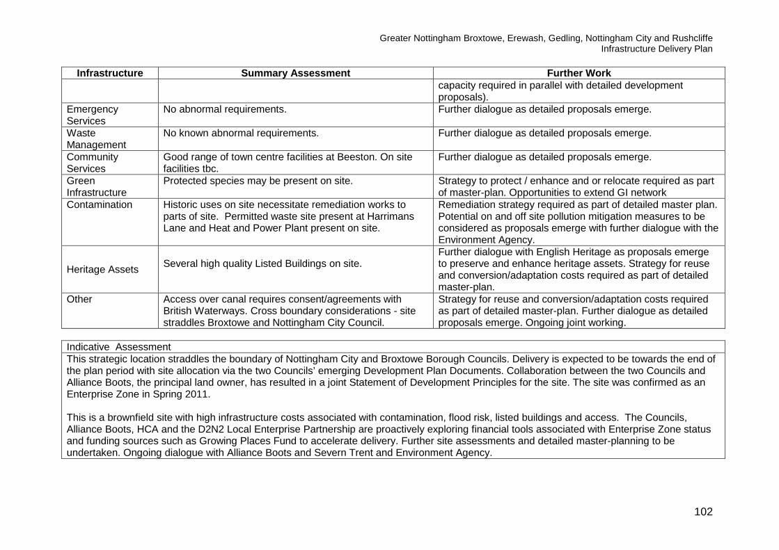
Greater Nottingham Broxtowe, Erewash, Gedling, Nottingham City and Rushcliffe Infrastructure Delivery Plan
102
Infrastructure Summary Assessment Further Work capacity required in parallel with detailed development
proposals). Emergency Services
No abnormal requirements. Further dialogue as detailed proposals emerge.
Waste Management
No known abnormal requirements. Further dialogue as detailed proposals emerge.
Community Services
Good range of town centre facilities at Beeston. On site facilities tbc.
Further dialogue as detailed proposals emerge.
Green Infrastructure
Protected species may be present on site. Strategy to protect / enhance and or relocate required as part of master-plan. Opportunities to extend GI network
Contamination
Historic uses on site necessitate remediation works to parts of site. Permitted waste site present at Harrimans Lane and Heat and Power Plant present on site.
Remediation strategy required as part of detailed master plan. Potential on and off site pollution mitigation measures to be considered as proposals emerge with further dialogue with the Environment Agency.
Heritage Assets Several high quality Listed Buildings on site.
Further dialogue with English Heritage as proposals emerge to preserve and enhance heritage assets. Strategy for reuse and conversion/adaptation costs required as part of detailed master-plan.
Other Access over canal requires consent/agreements with British Waterways. Cross boundary considerations - site straddles Broxtowe and Nottingham City Council.
Strategy for reuse and conversion/adaptation costs required as part of detailed master-plan. Further dialogue as detailed proposals emerge. Ongoing joint working.
Indicative Assessment This strategic location straddles the boundary of Nottingham City and Broxtowe Borough Councils. Delivery is expected to be towards the end of the plan period with site allocation via the two Councils’ emerging Development Plan Documents. Collaboration between the two Councils and Alliance Boots, the principal land owner, has resulted in a joint Statement of Development Principles for the site. The site was confirmed as an Enterprise Zone in Spring 2011. This is a brownfield site with high infrastructure costs associated with contamination, flood risk, listed buildings and access. The Councils, Alliance Boots, HCA and the D2N2 Local Enterprise Partnership are proactively exploring financial tools associated with Enterprise Zone status and funding sources such as Growing Places Fund to accelerate delivery. Further site assessments and detailed master-planning to be undertaken. Ongoing dialogue with Alliance Boots and Severn Trent and Environment Agency.

Greater Nottingham Broxtowe, Erewash, Gedling, Nottingham City and Rushcliffe Infrastructure Delivery Plan
103

Greater Nottingham Broxtowe, Erewash, Gedling, Nottingham City and Rushcliffe Infrastructure Delivery Plan
104

Greater Nottingham Broxtowe, Erewash, Gedling, Nottingham City and Rushcliffe Infrastructure Delivery Plan
105

Greater Nottingham Broxtowe, Erewash, Gedling, Nottingham City and Rushcliffe Infrastructure Delivery Plan
106
Field Farm, North of Stapleford (Broxtowe) Site Summary ACS Designation Allocation Timescale To commence within first 5 years of plan period Site Area 28 ha Housing Units 450 Employment Uses None Other Uses Education, Health, Green Infrastructure. Ownership/Developer Willing developer. Resolution to grant planning permission, referred to Secretary of State. IDP Constraints/Requirements Summary
Infrastructure Summary Assessment Further Work Transport Integrated transport package required estimated at
£30,000 per net developable hectare of site, est cost of £750,000 - £900,000. No further highway improvements will be funded by the Highways Agency.
TA submitted as part of planning application. Contributions to be agreed as part of S106 discussions. Further dialogue with Highways Agency required regarding access to A52 and A453.
Utilities Electricity – no abnormal requirements. Gas – no abnormal requirements Waste water – existing service at/near capacity – see flooding info below. Water supply – no abnormal requirements IT – no abnormal requirements
Included in Western Power programme to be implemented 2015. See flooding below.
Flooding and Flood Risk
Part of the site is within the functional floodplain (Zone 3b) of Boundary Brook and part is within the 1 in 100 year floodplain (Zone 3a). A Sequential Test was completed in Feb 2012. The site covers a complex drainage area with previous flooding occurrences due to interaction of local sewers and overland flows.
Site specific flood risk assessment and development of strategy to reduce, manage and mitigate flood risk and increase resilience (including appropriate location of dwellings and use of flood areas for GI). Ongoing dialogue with Severn Trent and Environment Agency.
Health Enhancements to local health infrastructure required at an estimated cost of £427,500.
Contributions to be agreed as part of S106 discussions.
Education Provision
Contribution to provide capacity at infant and junior schools required - estimated cost £525,000. Capacity
Contributions to be agreed as part of S106 discussions.

Greater Nottingham Broxtowe, Erewash, Gedling, Nottingham City and Rushcliffe Infrastructure Delivery Plan
107
Infrastructure Summary Assessment Further Work within existing secondary schools.
Police Services No abnormal requirements. Further dialogue on opportunities to use local facilities for neighbourhood policing as detailed proposals emerge.
Ambulance Services
No abnormal requirements. Further dialogue required on inclusion of standby locations as detailed proposals emerge.
Fire and Rescue No abnormal requirements. Further dialogue required on layout and mix of units. Waste Management
No abnormal requirements. Further dialogue on detailed proposals.
Community Services
Good range of town centre facilities at Stapleford. Further dialogue on detailed proposals.
Green Infrastructure
Within the Greenwood Community Forest. Opportunities for on site GI and open space including 2 full sized football pitches and pavilion and playgrounds. Maintenance contribution sought of £828,666.
To be progressed via planning application details.
Contamination No abnormal requirements.
Heritage Assets Site is not within a designated Conservation Area and has no impact upon a designated Conservation Area or heritage assets.
Other
Potential surface coal reserves and coal mining legacy issues.
Further review and dialogue with Coal Authority.
Indicative Assessment This is a green field site close to the existing urban area, Stapleford Town Centre and transport networks and is expected to commence within the first 5 years of the plan. A Planning application for 450 dwellings was considered by Broxtowe’s Development Control Committee on 10th April 2013 who resolved that the Council is minded to Grant Planning Permission. The application has now been referred to the Secretary of State. No irresolvable constraints to development have been identified. Joint meetings with the Environment Agency and Severn Trent have identified a need for an holistic approach to fluvial, surface water and waste water drainage including recommendations from the Pitt Review which are being addressed through the progression of the planning application. As part of the processing of the planning application it has been identified that 6% of the site comprises Grade 2 Agricultural Land and 33% Grade 3a which amounts to 10.8 hectares. There are two individual and woodland Tree Preservation Orders which were confirmed in 2012 and extensive open areas of the site are to be retained to allow recreational use and to allow some habitat to encourage barn owl feeding.

Greater Nottingham Broxtowe, Erewash, Gedling, Nottingham City and Rushcliffe Infrastructure Delivery Plan
108

Greater Nottingham Broxtowe, Erewash, Gedling, Nottingham City and Rushcliffe Infrastructure Delivery Plan
109

Greater Nottingham Broxtowe, Erewash, Gedling, Nottingham City and Rushcliffe Infrastructure Delivery Plan
110
Land in the vicinity of the proposed HS2 station at Toton (Broxtowe) Site Summary ACS Designation Strategic Location
Timescale 6 -15 years
Site Area Approx 73 ha
Housing Units To be determined through the Broxtowe Allocations Development Plan Document.
Employment Uses To be determined through the Broxtowe Allocations Development Plan Document.
Other Uses Open space and additional land for community facilities including education and limited local retail provision.
Ownership/Developer Planning Application submitted on part of the land. Willing owners positively engaged to meet the needs of HS2.
IDP Constraints/Requirements Summary Infrastructure Summary Assessment Further Work
Transport
Integrated transport package required. Requirement for a subsidised bus service incorporating Banks Road estate, Stapleford, Beeston and the City Centre. Access improvements to the strategic road network to include new access points off Toton/ Stapleford Lane. Transport modelling undertaken for a location west of Toton/Stapleford Lane for up to 1000 homes has been carried out. This indicates that the following mitigation works may be required including: A52 (T)/B6003 junction (Bardills Roundabout):
• Third traffic lane on the A52 (T) east approach • A 3 lane circulatory carriageway connecting
the A52 (T) east approach to the A52(T) west exit
• A 3 lane exit of the A52 (T) west exit
Internal roads layout to be prepared. Further discussions with NET to ensure no conflict with the park and ride facility. Commence dialogue with HS2 to ensure no conflict with access arrangements including alternative access to the station and safeguarded extended tram to HS2 station. Ongoing dialogue with highway authorities and Highways Agency to confirm detailed requirements as set out in the Transport Background Paper Addendum May 2013.

Greater Nottingham Broxtowe, Erewash, Gedling, Nottingham City and Rushcliffe Infrastructure Delivery Plan
111
Infrastructure Summary Assessment Further Work • Extension to the A52(T) west approach • M1 Junction 25 • Additional 60m lane on the A52(T) east off-slip
to provide dedicated left turn along with extended 3 lane provision
Mitigation impacts to the following County Road junctions:
• Stapleford Lane / Darley Avenue • Stapleford Lane / Woodstock Road and • Stapleford Lane / Swiney Way.
Travel Planning with the following objectives: • Achieve the minimum number of car
movements to and from the development, • Reduce the need to travel to and from the site, • Address the access needs of site users, by
supporting walking cycling and public transport,
• Provide adequately for those with mobility difficulties.
Public Transport Support: • Contribution to fund extension of existing bus
services Safeguarding NET extension:
• NET route safeguarded through the site Road Safety Audit.

Greater Nottingham Broxtowe, Erewash, Gedling, Nottingham City and Rushcliffe Infrastructure Delivery Plan
112
Infrastructure Summary Assessment Further Work
Utilities
Electricity – overhead power lines to be rerouted underground beneath the roads on site and a new terminal pylon located in the SW corner of the site. Western Power have been consulted and have no objection in principle to doing this. Further work required to confirm most appropriate WWTW. Water supply – no abnormal requirements subject to phasing. There is no objection in principle form Severn Trent to the planning application for 775 homes on the west of Toton Lane IT – No abnormal requirements.
Opportunities for extension to existing CHP facilities. Further dialogue with Western Power and Severn Trent as detailed proposals emerge
Flooding and Flood Risk
Site within Flood Zone 1. No significant flood risk. No significant risk for fluvial sources and therefore no specific mitigation required. Potential increase in surface water run off requiring mitigation from attenuation storage and on site SuDS provision.
Ongoing dialogue with the Environment Agency to ensure suitable mitigation methods are adopted.
Health Land set aside for health facilities if required Planning application contains a site for a medical centre. Further dialogue with CCG. Contributions to be agreed as part of S106 discussions.
Education Provision
Detailed assessment of education requirement suggests development would generate a need for a new primary school and extended secondary school provision would be required. Land has been set aside for a nursery school if required.
Proceed with development of a Master plan for the education provision. Continued dialogue with the council, education authority, developers and the planning department regarding S106 contributions.
Emergency Services No abnormal requirements Further dialogue as plans are finalised.
Waste Management No known abnormal requirements. Further dialogue as plans are finalised.

Greater Nottingham Broxtowe, Erewash, Gedling, Nottingham City and Rushcliffe Infrastructure Delivery Plan
113
Infrastructure Summary Assessment Further Work
Community Services
Good range of town centre facilities available at Stapleford Town Centre. Excellent potential (NET) access to range of facilities at Beeston and Nottingham City Centre. Land set aside for a community building if required.
Further details to be developed as part of ongoing discussions. Local centre to be created incorporating offices, pub, restaurant/pub, education space, medical plot, limited local retail provision and day nursery.
Green Infrastructure
Extensive Green Infrastructure to be provided. Potential loss of hedgerows, damage to retained trees during construction, loss of roosting opportunities and bird migration patterns, degradation of local nature reserve through increased public activity from development. Opportunities for creation of new green infrastructure and swales which could offset negative impacts. Increased long term opportunities for wildlife and biodiversity and habitat creation.
Strategy to protect/enhance and or relocate as part of ongoing studies. Opportunities to extend GI network.
Contamination
Potential contaminants from former agricultural uses on the site. Potential impact on the human receptors on the site from contaminants from Toton Sidings, the sewage works and the electricity substation.
Gas monitoring over a 3 month period and topsoil chemical tests should be carried out to further inform remediation strategy.
Heritage Assets No significant heritage issues.
Other
Following HS2 announcement strong potential for positive social-economic benefits for the wider area. No significant demolition issues associated with the development.
Strategy and detailed assessment of HS2 requirements required to be incorporated into Masterplan. Commencement of discussions as detailed proposals of HS2 emerge. Joint-working with HS2 and NET.

Greater Nottingham Broxtowe, Erewash, Gedling, Nottingham City and Rushcliffe Infrastructure Delivery Plan
114
Indicative Assessment
This strategic location is a green field site close to the existing urban area with existing links to Stapleford Town Centre and potential excellent future transport links to Nottingham City Centre and the rest of the UK/Europe. The site can be developed to reflect garden city principles and maintain the separate identities of Stapleford and Toton. Delivery is expected to be within 6-10 years of the plan period. A planning application has been submitted for land on the west side of Toton Lane and is under consideration and negotiations have reached an advanced stage. No irresolvable constraints have been identified. If built development takes place on the east of Toton Lane then this should be to the South of the proposed NET route, with this route and park and ride used as a long term defensible Green Belt boundary. The announcement from HS2 to locate their preferred station at Toton strongly contributes to the strategic importance of the site. Continued joint working with NET, the Highways Agency and the commencement of dialogue with HS2 will be essential.

Greater Nottingham Broxtowe, Erewash, Gedling, Nottingham City and Rushcliffe Infrastructure Delivery Plan
115

Greater Nottingham Broxtowe, Erewash, Gedling, Nottingham City and Rushcliffe Infrastructure Delivery Plan
116
Awsworth (Broxtowe) Site Summary ACS Designation Strategic Location Timescale for Delivery 6 + years Housing Units 350 Other Uses tbc IDP Constraints/Requirements Summary
Infrastructure Summary Assessment Further Work Transport Existing frequent bus service to Ilkeston and Kimberley.
Transport modelling underway. Integrated transport/walking and cycling package required.
Transport assessment and further highway requirements to be developed as part of master-planning work.
Utilities
Electricity - Additional 33/11KV primary required at Watnall. Depending on phasing of this and other sites reinforcement further up the network may be required by upgrading an existing Bulk Supply Point. New primary at Watnall included in Western Power programme to be implemented by 2015 Gas – no abnormal requirements. IT – no abnormal requirements. Water supply/Waste water – no constraints identified subject to phasing.
Further dialogue with Western Power as proposals emerge. Further ongoing dialogue with Severn Trent.
Flooding and Flood Risk
The Gilt Brook flows through land to the North of Awsworth, some of which falls in Flood Zone 3, land to the East and South of the settlement lie largely outside of the floodplain, an ordinary watercourse flows between Awsworth and Babbington. Settlement is located on a Secondary Aquifer. Alluvial deposits close to Erewash canal provide possible pathway for any contaminants.
Avoid areas of flood risk. Further flood risk assessment maybe required if land to north of settlement or land near to water course between Awsworth and Babbington be considered. Development proposals to ensure adequate protection to aquifer from foul and surface water flows.
Health Facilities
No existing GP practice. Existing residents register with both Nottinghamshire and Derbyshire Practices.
Dialogue underway with Nottinghamshire CCG re appropriate future facilities.

Greater Nottingham Broxtowe, Erewash, Gedling, Nottingham City and Rushcliffe Infrastructure Delivery Plan
117
Infrastructure Summary Assessment Further Work Education Provision
Limited capacity at existing primary schools which requires further review in consultation with education colleagues. Potential for reconfiguration of secondary school. On the basis of Nottinghamshire County Council’s education multiplier the following education contributions may be sought - £842k for primary school places and £967k for secondary school places.
Potential extension of existing schools under review by Education Colleagues. Contributions to be reviewed in light of pupil projection data (only valid 5 years in advance of development) to provide accurate assessment of existing local school capacity and confirm if contributions to expand existing schools are appropriate or if new school provision is required.
Police Services No abnormal requirements. Further dialogue on opportunities to use local facilities for neighbourhood policing as detailed proposals emerge.
Ambulance Services
No abnormal requirements. Further dialogue required on inclusion of standby locations as detailed proposals emerge.
Fire and Rescue No abnormal requirements. Further dialogue required on layout and mix of units.
Waste Management
No known abnormal requirements. Further dialogue as detailed proposals emerge.
Community Services
Main town centre facilities located at Kimberley and Ilkeston.
Further dialogue as detailed proposals emerge.
Green Infrastructure
Within the Greenwood Community Forest. Opportunities for enhanced GI along water courses (including SINCs).
Opportunities to enhance GI to be explored as proposals emerge.
Contamination
Areas of previously used land,landfill and waste transfer station present.
Appropriate desk top studies and investigation if required.
Heritage Assets 3 Listed buildings are present in Awsworth Further dialogue with English Heritage as proposals emerge to preserve and enhance heritage assets.
Other
Potential cross boundary considerations. Underlying coal strata and coal mining legacy issues.
Dialogue with CCGs required re health facilities and Erewash Borough Council re Town Centre facilities. Appropriate desk top studies and investigation if required. Further dialogue with the Coal Authority.

Greater Nottingham Broxtowe, Erewash, Gedling, Nottingham City and Rushcliffe Infrastructure Delivery Plan
118
Indicative Assessment No major constraints to development. An area of former landfill to the south west of the settlement will not impede delivery of the amount of new development proposed for Awsworth with several options available to deliver Awsworth Core Strategy Housing numbers. Development expected to come forward in the middle of the plan period but opportunities for earlier delivery on several sites with planning permission or allocated for housing in the adopted Broxtowe Local Plan. Education requirements of several settlements are closely linked. Further review of how best to accommodate cumulative school places within all of the settlements of Awsworth, Brinsley, Eastwood and Kimberley will be required with close consultation with education colleagues at Nottinghamshire County Council. Further dialogue with Environment Agency required as development proposals emerge. Proposals to have regard to presence of water courses outside of the main settlement.

Greater Nottingham Broxtowe, Erewash, Gedling, Nottingham City and Rushcliffe Infrastructure Delivery Plan
119

Greater Nottingham Broxtowe, Erewash, Gedling, Nottingham City and Rushcliffe Infrastructure Delivery Plan
120
Brinsley (Broxtowe) Site Summary ACS Designation Strategic Location Timescale for Delivery 6 + years Housing Units 200 Other Uses tbc IDP Constraints/Requirements Summary
Infrastructure Summary Assessment Further Work Transport Existing bus services. Transport modelling underway.
Integrated transport/walking and cycling package required. Transport assessment and further highway requirements to be developed as part of master-planning work.
Utilities
Electricity - Additional 33/11kV primary and circuits in the Eastwood area. Depending on phasing of this and other sites reinforcement further up the network may be required by upgrading an existing Bulk Supply Point Gas – no abnormal requirements IT – no abnormal requirements Water supply/Waste water – no constraints identified subject to phasing.
Further dialogue with Western Power as proposals emerge. Further ongoing dialogue with Severn Trent.
Flooding and Flood Risk
Much of area surrounding settlement is within Flood Zone 1 and therefore low risk. Some ordinary water courses present. Land to west of Brinsley is a Secondary Aquifer. Reservoirs along the railway line to the west of the settlement are sensitive groundwater receptors and surrounded by alluvial deposits.
Should development proposals include areas covered by ordinary water courses, further flood risk assessment may be required. Development proposals to include adequate protection to aquifer from foul and surface flows. Further dialogue with EA as detailed proposals emerge.
Health Facilities
No existing GP practices. Existing residents register at Eastwood, Jacksdale and Underwood.
Dialogue underway with CCG re appropriate future facilities.
Education Provision
Close relationship with schools in Selston. Limited capacity for expansion of primary schools. Further review required with education colleagues. Re-configuration of secondary school possible. On the basis of
Education contributions to be reviewed in light of pupil projection data (only valid 5 years in advance of development) to provide accurate assessment of existing local school capacity and confirm if contributions to expand existing schools are

Greater Nottingham Broxtowe, Erewash, Gedling, Nottingham City and Rushcliffe Infrastructure Delivery Plan
121
Infrastructure Summary Assessment Further Work Nottinghamshire County Council’s education multiplier the following education contributions may be sought - £481k for primary school places and £552k for secondary school.
appropriate or if new school provision is required.
Police Services No abnormal requirements Further dialogue on opportunities to use local facilities for neighbourhood policing as detailed proposals emerge.
Ambulance Services
No abnormal requirements Further dialogue required on inclusion of standby locations as detailed proposals emerge.
Fire and Rescue No abnormal requirements Further dialogue required on layout and mix of units. Waste Management
No known abnormal requirements. Further dialogue as detailed proposals emerge.
Community Services
To be confirmed. Further dialogue as detailed proposals emerge.
Green Infrastructure
Within the Greenwood Community Forest and proximity to Erewash valley. Areas of POS to the east and south of Brinsley, SINC located to west and smaller SINCs to west and east.
Opportunities to enhance GI to be explored as proposals emerge.
Contamination Areas of previously used land and landfill present. Appropriate desk top studies and investigation if required.
Heritage Assets There is one Conservation Area within Brinsley and 2 Listed Buildings in the area, in addition to Brinsley Headstocks.
Further dialogue with English Heritage as proposals emerge to preserve and enhance heritage assets.
Other Alluvium deposits and coal strata and coal mining legacy issues.
Appropriate desk top studies and investigation if required. Further dialogue with the Coal Authority.
Indicative Assessment No major constraints to development. Development expected to come forward in the middle of the plan period but opportunities for earlier delivery on several sites with planning permission or allocated for housing in the adopted Broxtowe Local Plan. Areas to the west of Brinsley are visually prominent, including a Mature Landscape Area and several Sites of Importance for Nature Conservation. The amount of development proposed in the Core Strategy can be accommodated without adversely impacting on these areas Education requirements of several settlements are closely linked. Further review of how best to accommodate cumulative school places within all of the settlements of Awsworth, Brinsley, Eastwood and Kimberley will be required with close consultation with education colleagues at Nottinghamshire County Council. Further dialogue with Environment Agency required as development proposals emerge.

Greater Nottingham Broxtowe, Erewash, Gedling, Nottingham City and Rushcliffe Infrastructure Delivery Plan
122

Greater Nottingham Broxtowe, Erewash, Gedling, Nottingham City and Rushcliffe Infrastructure Delivery Plan
123
Eastwood (Broxtowe) Site Summary ACS Designation Strategic Location Timescale for Delivery 6 + years Housing Units 1,400 Other Uses tbc
IDP Constraints/Requirements Summary
Infrastructure Summary Assessment Further Work Transport Existing high frequency bus service. Transport modelling
underway. Integrated transport/walking and cycling package required.
Transport assessment and further highway requirements to be developed as part of master-planning work.
Utilities
Electricity - Additional 33/11kV primary and circuits in the Eastwood area. Depending on phasing of this and other sites reinforcement further up the network may be required by upgrading an existing Bulk Supply Point Gas – no abnormal requirements IT – no abnormal requirements Water supply/Waste water – no constraints identified subject to phasing.
Further dialogue with Western Power as proposals emerge. Further ongoing dialogue with Severn Trent.
Flooding and Flood Risk
Much of Eastwood and surrounding area lie in Flood Zone 1 and are at low risk. However the Beauvale Brook, River Erewash and Giltbrook are located to the north, west and east of the settlement respectively. Other surface water courses to north and west of settlement on alluvial deposits are sensitive to development due to potential for transmission of pollutants.
Generally low risk. Should proposals near Beavale Brook or River Erewash emerge further flood risk assessment is required. Development proposals located to avoid sensitive areas. Further dialogue with EA as proposals emerge.
Health Facilities
4 existing GP practices. Dialogue underway with CCG re appropriate future facilities.
Education Provision
Limited capacity at existing primary school, further review by education colleagues. Reconfiguration of secondary school possible.
Education contributions to be reviewed in light of pupil projection data (only valid 5 years in advance of development) to provide accurate assessment of existing local school capacity and confirm if contributions to expand existing schools are appropriate or if

Greater Nottingham Broxtowe, Erewash, Gedling, Nottingham City and Rushcliffe Infrastructure Delivery Plan
124
Infrastructure Summary Assessment Further Work On the basis of Nottinghamshire County Council’s education multiplier the following education contributions may be sought - £3.36m for primary school places and £3.86m for secondary school places.
new school provision is required.
Police Services No abnormal requirements Further dialogue on opportunities to use local facilities for neighbourhood policing as detailed proposals emerge.
Ambulance Services
No abnormal requirements Further dialogue required on inclusion of standby locations as detailed proposals emerge.
Fire and Rescue No abnormal requirements Further dialogue required on layout and mix of units. Waste Management
No abnormal requirements Further review when details proposals emerge.
Community Services
Opportunities to support existing town centre.
Green Infrastructure
Within the Greenwood Community Forest and proximity to Erewash Valley. Large SINC located to the southwest, smaller SINCs to south and east.
Opportunities to enhance GI to be explored as proposals emerge.
Contamination
Small area of land between A610 and New Eastwood is historic landfill, piled foundations unlikely to be acceptable due to nature of waste. Areas of previously used land.
Development proposals to avoid this area. Appropriate desk top studies and investigation if required.
Heritage Assets Scheduled Ancient Monument present at Greasley. Conservation Area and 20 Listed Buildings in Eastwood.
Further dialogue with English Heritage as proposals emerge to preserve and enhance heritage assets.
Other Underlying coal strata and mining legacy issues. Appropriate desk top studies and investigation if required. Further dialogue with the Coal Authority.
Indicative Assessment No major constraints to development. Development expected to come forward in the middle of the plan period but opportunities for earlier delivery on several sites with planning permission or allocated for housing in the adopted Broxtowe Local Plan. Education requirements of several settlements are closely linked. Further review of how best to accommodate cumulative school places within all of the settlements of Awsworth, Brinsley, Eastwood and Kimberley will be required with close consultation with education colleagues at Nottinghamshire County Council. Further dialogue with Environment Agency required as development proposals emerge.

Greater Nottingham Broxtowe, Erewash, Gedling, Nottingham City and Rushcliffe Infrastructure Delivery Plan
125

Greater Nottingham Broxtowe, Erewash, Gedling, Nottingham City and Rushcliffe Infrastructure Delivery Plan
126
Kimberley (including Nuthall and Watnall - Broxtowe ) Site Summary ACS Designation Strategic Location Timescale for Delivery 6 + years Housing Units 600 Other Uses tbc IDP Constraints/Requirements Summary
Infrastructure Summary Assessment Further Work Transport Existing high frequency bus services to Nottingham.
Transport modelling underway. Integrated transport/ walking and cycling package required.
Transport assessment and further highway requirements to be developed as part of master-planning work.
Utilities
Electricity - New 33/11kV primary at Watnall required. Included in Western Power programme to be implemented by 2015. Gas – no abnormal requirements IT – no abnormal requirements Water supply/Waste water – no constraints identified subject to phasing.
Further dialogue with Western Power as proposals emerge. Further ongoing dialogue with Severn Trent.
Flooding and Flood Risk
The Gilt Brook runs to the west of Kimberley. Much of Kimberley and Watnall and land to the immediate west of Nuthall fall within Flood Zone 1 and are therefore low risk. EA maps identify some surface water flooding. A lake and ordinary watercourse are located to the south of the settlement, north of the A610. Area underlain by a Principal Aquifer. Underlying bedrock at Nuthall susceptible to rapid migration of pollutants. A total Source Protection Zone is present over High Wood Cemetery (west of A6002).
Generally low flood risk but depending on the location of development further flood risk assessment (including surface water) may be required. Development proposals to include full protection from contamination for the aquifer/ground water and controlled waters. Further dialogue with EA as proposals emerge.
Health Facilities
One existing GP practice. Dialogue underway with CCG re appropriate future facilities.
Education Most primary schools nearing capacity but some potential to Education contributions to be reviewed in light of pupil

Greater Nottingham Broxtowe, Erewash, Gedling, Nottingham City and Rushcliffe Infrastructure Delivery Plan
127
Infrastructure Summary Assessment Further Work Provision
expand. Further review with education colleagues. Potential capacity within existing secondary schools. On the basis of Nottinghamshire County Council’s education multiplier the following education contributions may be sought - £1.4m for primary school places and £1.6m for secondary school places.
projection data (only valid 5 years in advance of development) to provide accurate assessment of existing local school capacity and confirm if contributions to expand existing schools are appropriate or if new school provision is required.
Police Services No abnormal requirements Further dialogue on opportunities to use local facilities for neighbourhood policing as detailed proposals emerge.
Ambulance Services
No abnormal requirements Further dialogue required on inclusion of standby locations as detailed proposals emerge.
Fire and Rescue No abnormal requirements. Further dialogue required on layout and mix of units. Green Infrastructure
Within the Greenwood Community Forest, local SSSIs and SINCs. Several water courses present.
Opportunities to enhance GI to be explored as proposals emerge.
Waste Management
No abnormal requirements.
Community Services
Good range of facilities within existing settlement. Opportunities to support existing town centre as details of proposals emerge.
Contamination Areas of previous used land and landfill. Appropriate desk top studies/investigation if required.
Heritage Assets There are two Conservation Areas within Kimberley and 13 Listed Buildings in the area.
Further dialogue with English Heritage as proposals emerge to preserve and enhance heritage assets.
Other Underlying coal strata and coal mining legacy issues. Appropriate desk top studies/investigation if required. Further dialogue with the Coal Authority.
Indicative Assessment No major constraints to development. Development expected to come forward in the middle of the plan period but opportunities for earlier delivery on several sites with planning permission or allocated for housing in the adopted Broxtowe Local Plan. Education requirements of several settlements are closely linked. Further review of how best to accommodate cumulative school places within all of the settlements of Awsworth, Brinsley, Eastwood and Kimberley will be required with close consultation with education colleagues at Nottinghamshire County Council. Further dialogue with Environment Agency required.
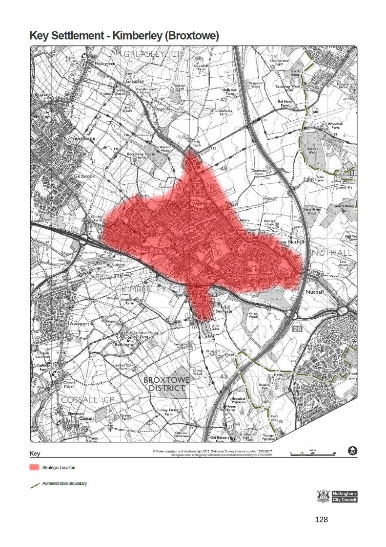
Greater Nottingham Broxtowe, Erewash, Gedling, Nottingham City and Rushcliffe Infrastructure Delivery Plan
128
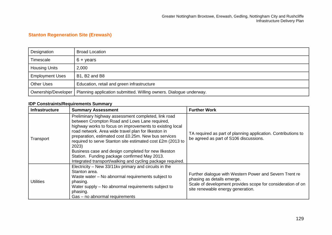
Greater Nottingham Broxtowe, Erewash, Gedling, Nottingham City and Rushcliffe Infrastructure Delivery Plan
129
Stanton Regeneration Site (Erewash)
Designation Broad Location
Timescale 6 + years
Housing Units 2,000
Employment Uses B1, B2 and B8
Other Uses Education, retail and green infrastructure
Ownership/Developer Planning application submitted. Willing owners. Dialogue underway. IDP Constraints/Requirements Summary Infrastructure Summary Assessment Further Work
Transport
Preliminary highway assessment completed, link road between Crompton Road and Lows Lane required, highway works to focus on improvements to existing local road network. Area wide travel plan for Ilkeston in preparation, estimated cost £0.25m. New bus services required to serve Stanton site estimated cost £2m (2013 to 2023) Business case and design completed for new Ilkeston Station. Funding package confirmed May 2013. Integrated transport/walking and cycling package required.
TA required as part of planning application. Contributions to be agreed as part of S106 discussions.
Utilities
Electricity – New 33/11kv primary and circuits in the Stanton area. Waste water – No abnormal requirements subject to phasing. Water supply – No abnormal requirements subject to phasing. Gas – no abnormal requirements
Further dialogue with Western Power and Severn Trent re phasing as details emerge. Scale of development provides scope for consideration of on site renewable energy generation.

Greater Nottingham Broxtowe, Erewash, Gedling, Nottingham City and Rushcliffe Infrastructure Delivery Plan
130
Infrastructure Summary Assessment Further Work IT – no abnormal requirements
Flooding and Flood Risk
The proposed link road between Crompton Road and Lows Lane will pass through the functional floodplain of the River Erewash and discussions are on-going with the Environment Agency. Other parts of the site are low risk.
Site specific flood risk assessment. Further dialogue with the Environment Agency.
Health Contributions may be sought for expansion of existing facilities or provision on site.
Contributions to be agreed as part of S106 discussions. Dialogue with CCG underway.
Education Provision
A new 2 form entry primary school is required on site. Class provision to be phased with close liaison with neighbouring schools. Est cost £5.5 to 6m. Current capacity for secondary school places.
Contributions and phasing to be agreed as part of S106 discussions. Further dialogue with Derbyshire County Council, contributions to be reviewed in the light of future pupil projection data (only valid 5 years in advance of development) to provide accurate assessment of existing local school capacity.
Police Services No abnormal requirements Further dialogue on use of local facilities for neighbourhood policing as detailed proposals emerge.
Ambulance Services No abnormal requirements Further dialogue re inclusion of standby locations required as
detailed proposals emerge.
Fire and Rescue Services No abnormal requirements Further dialogue on layout and mix of units required as
detailed proposals emerge.
Waste Management
Possible requirement for development sites in Ilkeston to contribute to Ilkeston Household Waste Recycling Centre (DCC IDP) at a total cost of £0.575m.
Further dialogue with Derbyshire County Council on requirements and scale of contributions as part of S106 discussions.
Community Services
Close to good range of facilities at Ilkeston Town Centre. Local facilities to be provided on site. Growth in Ilkeston and Long Eaton likely to require enhancement or replacement of community halls (est contribution £1m).
Further master-planning to consider appropriate local facilities.

Greater Nottingham Broxtowe, Erewash, Gedling, Nottingham City and Rushcliffe Infrastructure Delivery Plan
131
Infrastructure Summary Assessment Further Work
Green Infrastructure
Preliminary ecological surveys completed by landowner Potential for improvement of habitats and green corridors associated with watercourses within the sites including the Nut brook canal, Erewash canal, Quarry Hill Road Pond and Quarry Hill lagoon. Proximity to five local nature reserves.
Opportunities to be identified via masterplanning.
Contamination Extensive contamination from former industrial use and historic land filling.
Preliminary survey completed by landowner. Remediation strategy to be agreed as part of detailed masterplanning.
Heritage Assets
Potential for archaeology on site. Proximity to two scheduled ancient monuments (Dale Abbey and Lock Up and Pinfold). Five conservations close by and proximity to several Listed Buildings.
Further dialogue with English Heritage as proposals emerge to preserve and enhance heritage assets.
Indicative Assessment
Major brownfield site with significant potential for regeneration. Scale of development has been reduced to address highway issues. Planning application submitted February 2013. Proactive landowner in place, initial surveys complete. Due to historic uses and need for remediation, development expected to come forward later in the plan period.

Greater Nottingham Broxtowe, Erewash, Gedling, Nottingham City and Rushcliffe Infrastructure Delivery Plan
132

Greater Nottingham Broxtowe, Erewash, Gedling, Nottingham City and Rushcliffe Infrastructure Delivery Plan
133

Greater Nottingham Broxtowe, Erewash, Gedling, Nottingham City and Rushcliffe Infrastructure Delivery Plan
134
North of Papplewick Lane (Gedling) ACS Designation Allocation Timescale To commence within first 5 years of plan period Site Area 15.95 ha Housing Units 600 Indicative Housing Mix 30% affordable housing Employment Uses None Other Uses Education, green infrastructure Ownership/Developer Willing owners positively engaged for majority of the site. Dialogue underway IDP Constraints/Requirements Summary
Infrastructure Summary Assessment Further Work Transport
Early Transport Assessment completed but requires updating. Site to be accessed via 2 of either Delia, Dorothy, Alison and Marion Avenues or via Papplewick Lane, depending on whether the site is developed as one or two phases. Integrated transport/walking and cycling package required including links to Hucknall Station (NET/Train stops within 800m of parts of site).
Updated TA required. Confirmation of phasing required. Should the site be developed as two phases, third party land may be required. Contributions to be agreed as part of S106 discussions.
Utilities Electricity – Update required to existing 33/11vK primary at Calverton, may also require new 33/11kV primary in the area. Depending on phasing new Bulk Supply Point may be required. Waste water – no abnormal constraints or requirements. Water supply – no abnormal constraints or requirements. Gas – no abnormal requirements IT – no abnormal requirements.
Early dialogue with Western Power required re phasing.
Flooding and Flood Risk
A small part of the site is in Flood Zone 2 of the River Leen and a small part of the track along the eastern boundary of the site edges into Flood Zone 3 with the remainder of the
Ongoing dialogue with EA re layout/ masterplanning and to maximise GI opportunities from flood areas.

Greater Nottingham Broxtowe, Erewash, Gedling, Nottingham City and Rushcliffe Infrastructure Delivery Plan
135
Infrastructure Summary Assessment Further Work site being in Flood Zone 1 with other smaller watercourses that run through the site. EA comment that site has an overall low flood risk. Should development fall within flood areas, a sequential test will be required.
Health
Likely that a financial contribution towards the expansion of existing primary health care surgeries will be required.
Contributions to be agreed as part of S106 discussions. Dialogue with CCG underway.
Education
New Primary school to be provided on 1.1 ha site cost est £5 - 5.5m, subject to an assessment demonstrating that the anticipated pupil yield cannot be accommodated in the existing school system through the extension or improvement of existing schools. Capacity to expand existing secondary school with contributions based on Notts County Education multiplier est cost is £1.65m.
Contributions and phasing to be agreed as part of S106 discussions.
Police Services No abnormal requirements. Further dialogue on use of local facilities for neighbourhood policing as detailed proposals emerge.
Ambulance Services
No abnormal requirements. Further dialogue re inclusion of standby locations required as detailed proposals emerge.
Fire and Rescue Services
No abnormal requirements. Further dialogue on layout and mix of units required as detailed proposals emerge.
Waste Management
No abnormal requirements. Further dialogue as detailed proposals emerge.
Community Services
Close to existing local centre and Hucknall Town Centre. Potential to support town centre regeneration.
Further dialogue with Ashfield District Council as detailed proposals emerge.
Green Infrastructure/ Open Space
Significant GI assets on site. Opportunities to protect and enhance GI on eastern part of site close to River Leen. Public open space of approx. 1.6ha to be provided on site with commuted sum for maintenance.
GI proposals to be developed as part of detailed masterplanning. Maintenance contributions to be agreed via S106 negotiations.
Contamination No abnormal requirements.
Heritage Assets
Proximity to Site of Special Scientific Interest ("Quarry Banks"), Conservation Areas at Linby and Papplewick, Scheduled Ancient Monuments, Historic Parks and Gardens at Newstead Abbey and Papplewick Hall, Listed
Further dialogue with English Heritage as proposals emerge to preserve and enhance heritage assets.

Greater Nottingham Broxtowe, Erewash, Gedling, Nottingham City and Rushcliffe Infrastructure Delivery Plan
136
Infrastructure Summary Assessment Further Work Buildings present in and around Linby and Papplewick.
Other If progressed as two phases land acquisition required for access. Cross boundary considerations - close to Ashfield District Council and Nottingham City Council. Nearest town centre facilities are located in Hucknall.
Further review following confirmation of development phases. Further dialogue with adjacent Local Authorities (particularly re highway, public transport and communities facilities).
Indicative Assessment No major constraints to physical site delivery are identified. The site is close to the administrative boundary of Ashfield District Council and Nottingham City Council and further dialogue regarding cross boundary impacts is required as detailed proposals emerge. Information on capacity of local health facilities is awaited from CCG.

Greater Nottingham Broxtowe, Erewash, Gedling, Nottingham City and Rushcliffe Infrastructure Delivery Plan
137

Greater Nottingham Broxtowe, Erewash, Gedling, Nottingham City and Rushcliffe Infrastructure Delivery Plan
138

Greater Nottingham Broxtowe, Erewash, Gedling, Nottingham City and Rushcliffe Infrastructure Delivery Plan
139
Top Wighay Farm (Gedling) ACS Designation Allocation Timescale To commence within first 5 years of plan period Site Area 35.6ha Housing Units 1000 Housing Mix 30% Affordable Housing. Employment Uses 8.5 ha (B1,B8) Other Uses Education, health and green infrastructure Ownership/Developer Willing owner. Dialogue underway. IDP Constraints/Requirements Summary
Infrastructure Summary Assessment Further Work Transport
Access details developed. Planning permission granted for two junctions from A611/Wighay Road. Integrated transport/ walking and cycling package required including potential link buses to Hucknall NET/train station.
TA required as part of planning application. Contributions to be agreed as part of S106 discussions
Utilities Electricity –Uprating Hucknall to 40MVA required. Depending on phasing a new Bulk Supply Point may be required. Uprating works programmed by Western Power for completion by 2015. Waste water - local upsizing likely to be required, subject to hydraulic modelling. Water supply - extensive off-site mains may be required - approx 1.5km to Wood Lane and booster pumps Gas – no abnormal requirements IT – no abnormal requirements
Further dialogue with Western Power and Severn Trent re phasing as details emerge.
Flooding and Flood Risk
No abnormal requirements
Health
Contributions to be sought to support health care – likely to be in the form of a contribution to existing Hucknall surgeries (info from CCG awaited).
Contributions to be agreed as part of S106 discussions. Dialogue with CCG underway.
Education New Primary School to be provided on 1.5 ha site est cost Contributions and phasing to be agreed as part of S106
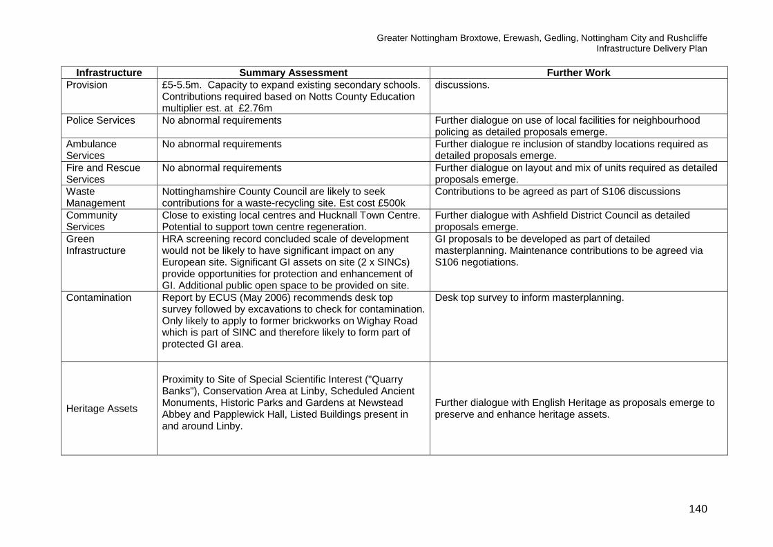
Greater Nottingham Broxtowe, Erewash, Gedling, Nottingham City and Rushcliffe Infrastructure Delivery Plan
140
Infrastructure Summary Assessment Further Work Provision
£5-5.5m. Capacity to expand existing secondary schools. Contributions required based on Notts County Education multiplier est. at £2.76m
discussions.
Police Services No abnormal requirements Further dialogue on use of local facilities for neighbourhood policing as detailed proposals emerge.
Ambulance Services
No abnormal requirements Further dialogue re inclusion of standby locations required as detailed proposals emerge.
Fire and Rescue Services
No abnormal requirements Further dialogue on layout and mix of units required as detailed proposals emerge.
Waste Management
Nottinghamshire County Council are likely to seek contributions for a waste-recycling site. Est cost £500k
Contributions to be agreed as part of S106 discussions
Community Services
Close to existing local centres and Hucknall Town Centre. Potential to support town centre regeneration.
Further dialogue with Ashfield District Council as detailed proposals emerge.
Green Infrastructure
HRA screening record concluded scale of development would not be likely to have significant impact on any European site. Significant GI assets on site (2 x SINCs) provide opportunities for protection and enhancement of GI. Additional public open space to be provided on site.
GI proposals to be developed as part of detailed masterplanning. Maintenance contributions to be agreed via S106 negotiations.
Contamination Report by ECUS (May 2006) recommends desk top survey followed by excavations to check for contamination. Only likely to apply to former brickworks on Wighay Road which is part of SINC and therefore likely to form part of protected GI area.
Desk top survey to inform masterplanning.
Heritage Assets
Proximity to Site of Special Scientific Interest ("Quarry Banks"), Conservation Area at Linby, Scheduled Ancient Monuments, Historic Parks and Gardens at Newstead Abbey and Papplewick Hall, Listed Buildings present in and around Linby.
Further dialogue with English Heritage as proposals emerge to preserve and enhance heritage assets.

Greater Nottingham Broxtowe, Erewash, Gedling, Nottingham City and Rushcliffe Infrastructure Delivery Plan
141
Infrastructure Summary Assessment Further Work Other Potential archaeological sites within the allocated land.
Cross boundary considerations - close to Ashfield District Council and Nottingham City Council. Nearest town centre facilities are located in Hucknall.
A programme of investigation will need to be agreed and the protection / enhancement of any remains. Further dialogue with adjacent Local Authorities (particularly highway, public transport and communities facilities).
Indicative Assessment No major constraints to physical site delivery are identified. Site is located close to Ashfield District Council and Nottingham City Council and further dialogue regarding cross boundary impacts is required as detailed proposals emerge. Information on capacity of local health facilities awaited from CCG..

Greater Nottingham Broxtowe, Erewash, Gedling, Nottingham City and Rushcliffe Infrastructure Delivery Plan
142

Greater Nottingham Broxtowe, Erewash, Gedling, Nottingham City and Rushcliffe Infrastructure Delivery Plan
143

Greater Nottingham Broxtowe, Erewash, Gedling, Nottingham City and Rushcliffe Infrastructure Delivery Plan
144
Bestwood Village (Gedling) ACS Designation Strategic Location Timescale 6 + years Housing Units 500 new dwellings plus 79 existing commitments Other Uses N/A IDP Constraints/Requirements Summary
Infrastructure Summary Assessment Further Work Transport Transport modelling underway. Integrated transport/walking
and cycling package required. Transport assessment and further highway requirements to be developed as part of master-planning work.
Utilities Electricity – Updating of existing 33/11kV primary at Calverton required may also need a new 33/11kV primary in the area. Depending on phasing a new Bulk Supply Point may be required Waste water - upsizing of sewers is likely to be required, subject to hydraulic modelling. Water supply – no abnormal requirements. Gas – no abnormal requirements. . IT – no abnormal requirements.
Further dialogue with Western Power and Severn Trent when phasing details emerge.
Flooding and Flood Risk
Watercourse located to the west of the settlement - low flood risk.
Further dialogue with EA as detailed location and layout emerges.
Health TBC Dialogue with CCG underway. Capacity issues to be reviewed as detailed proposals emerge.
Education Provision
A new primary school may be required to accommodate school places for both the existing population and new growth. Contributions to the school from new development would be proportionate to school places generated by the new development – the estimated cost for a new primary school on a 1.1ha site is £5-5.5m. Capacity to expand existing secondary schools. Contributions required based on Notts County Education multiplier of £1.6m.
Education contributions to be reviewed in light of pupil projection data (only valid 5 years in advance of development) to provide accurate assessment of school capacity when development proposals emerge and to confirm if contributions to expand existing schools are appropriate or if new school provision is required.
Police Services No abnormal requirements Further dialogue on use of local facilities for neighbourhood

Greater Nottingham Broxtowe, Erewash, Gedling, Nottingham City and Rushcliffe Infrastructure Delivery Plan
145
Infrastructure Summary Assessment Further Work policing as detailed proposals emerge.
Ambulance Services
No abnormal requirements Further dialogue re inclusion of standby locations required as detailed proposals emerge.
Fire and Rescue Services
No abnormal requirements Further dialogue on layout and mix of units required as detailed proposals emerge.
Waste Management
No abnormal requirements Further dialogue on detailed proposals
Community Services
No abnormal requirements Further dialogue on detailed proposals
Green Infrastructure
HRA screening record concluded the scale of development proposed at Bestwood would not be likely to have significant impact on any European site.
Masterplanning to identify opportunities for enhanced GI and public open space.
Contamination No abnormal requirements. Bestwood landfill and various waste licences present. Appropriate desk top studies/further investigation as required.
Heritage Assets Conservation Area, Scheduled Ancient Monument and Listed Buildings present in and around Bestwood Village.
Further dialogue with English Heritage as proposals emerge to preserve and enhance heritage assets.
Other Potenial coal mining legacy issues. Further review as detailed proposals emerge and further dialogue with the Coal Authority.
Indicative Assessment No major infrastructure constraints to development are identified. Further development of transport impacts and mitigation required. Phasing of development and contributions relating to school provision will be particularly important. Further dialogue with all infrastructure/service providers and the Environment Agency is required as more detailed proposals emerge.

Greater Nottingham Broxtowe, Erewash, Gedling, Nottingham City and Rushcliffe Infrastructure Delivery Plan
146

Greater Nottingham Broxtowe, Erewash, Gedling, Nottingham City and Rushcliffe Infrastructure Delivery Plan
147
Calverton (Gedling) ACS Designation Strategic Location Timescale for Delivery 6 + years Housing Units 1,300 new dwellings plus 218 existing commitments Other Uses N/A IDP Constraints/Requirements Summary
Infrastructure Summary Assessment Further Work Transport Transport modelling underway. Integrated transport/walking
and cycling package required. Transport assessment and further highway requirements to be developed as part of master-planning work.
Utilities
Electricity – Updating of existing 33/11kV primary at Calverton required may also need a new 33/11kV primary in the area. Depending on phasing a new Bulk Supply Point may be required. Waste Water - upsizing of sewers is likely to be required, subject to hydraulic modelling. Water Supply - Capacity available within the network system, but some reconfiguration of the local distribution network will be necessary depending on programme of development Gas – no abnormal requirements IT – no abnormal requirements
Further dialogue with Western Power and Severn Trent following confirmation of location and phasing of development.
Flooding and Flood Risk
The strategic location falls outside of the flood zone but a watercourse runs along the northern boundary of the site which has an associated flood zone. The flood zone may be misaligned away from the watercourse.
EA advise that a hydrological assessment of the watercourse is recommended to inform a site-specific Flood Risk Assessment. No built development should then take place within that part of the site shown to be at flood risk by the site-specific Flood Risk Assessment. Layout to include an appropriate easement from the watercourse and SUDS to be incorporated into the scheme. Further dialogue with EA required as detailed location and layout of development emerges.
Health Facilities To be confirmed Dialogue with CCG underway

Greater Nottingham Broxtowe, Erewash, Gedling, Nottingham City and Rushcliffe Infrastructure Delivery Plan
148
Infrastructure Summary Assessment Further Work Education Provision
Potential capacity for expansion of existing primary school within Calverton but requires further analysis of constraints. If not possible a new primary school may be required. Potential costs range from £3.6m based on standard multiplier to approximately £5.5m for new school. Potential capacity to expand existing secondary schools but requires further analysis. Some reconfiguration may be required which may require contributions over the standard multiplier costs. Costs based on Notts County Education multiplier est at £3.6m
Further review of potential for expansion underway by education colleagues. Requirements to be reviewed in light of future pupil projection data (only valid 5 years in advance of development) to provide accurate assessment of school capacity when development proposals emerge and to confirm if contributions to expand existing schools are appropriate or if new school provision is required.
Police Services No abnormal requirements. Further dialogue on use of local facilities for neighbourhood policing as detailed proposals emerge.
Ambulance Services
No abnormal requirements. Further dialogue re inclusion of standby locations required as detailed proposals emerge.
Fire and Rescue Services
No known abnormal requirements. Further dialogue on layout and mix of units required as detailed proposals emerge.
Waste Management
No known abnormal requirements. Further dialogue as detailed proposals emerge.
Community Services
To be confirmed. Further dialogue as detailed proposals emerge.
Green Infrastructure
A Habitats Regulation Assessment Screening Report has been undertaken relating to a prospective Special Protection Area near to Calverton. The Screening Report concludes that potential significant effect cannot be ruled out without the implementation of a mitigation strategy.
Masterplanning and planning applications to include appropriate mitigation measures (full details set out in the David Tyldesley and Associates Screening Record Feb 2012) including: • Management of car parking provision in the vicinity of the
prospective SPA habitat; • Avoiding the provision of a footway along Main Street west
of Hollinwood Lane down to the B6386; • Maintaining further use of arable fields on the perimeter of
Watchwood Plantation; • Maintaining the integrity of the fence along the B6386; • Provision of Suitable Alternative Natural Green Space

Greater Nottingham Broxtowe, Erewash, Gedling, Nottingham City and Rushcliffe Infrastructure Delivery Plan
149
Infrastructure Summary Assessment Further Work
(SANGS); • Providing high levels of open spaces and attractive green
infrastructure within the development to facilitate dog walking and to promote routes to other less sensitive sites;
• Reviewing the alignment of footpaths in the plantations relating to the location of breeding territories;
• Provision of good quality information for walkers and dog walkers.
• Review of mitigation measures should the prospective SPA be confirmed
• Establishing a forum to explore co-ordination of activities to maximise recreational potential without significant adverse impact on breeding populations.
• Ongoing dialogue with neighbouring Local Authorities regarding ‘in-combination’ effects.
Contamination Proximity to landfill sites, Calverton Colliery and several sites with waste management licences.
Appropriate desk top studies/further investigation as required.
Heritage Assets Proximity to Scheduled Ancient Monuments. Conservation Area and Listed Buildings present in and around Calverton.
Further dialogue with English Heritage as proposals emerge to preserve and enhance heritage assets.
Other Potential mining legacy issues. Further review as detailed proposals emerge. Further dialogue with the Coal Authority.
Indicative Assessment No major infrastructure constraints to development are identified. However, the location of a prospective Special Protection Area near to Calverton will require careful management, including mitigation measures as set out in the Habitats Regulation Assessment Screening Report (February 2012). Phasing of development and contributions relating to school provision will be particularly important to ensure capacity meets development need. Further development of transport impacts and mitigation measures is required including dialogue with all infrastructure/service providers as more detailed proposals emerge.

Greater Nottingham Broxtowe, Erewash, Gedling, Nottingham City and Rushcliffe Infrastructure Delivery Plan
150

Greater Nottingham Broxtowe, Erewash, Gedling, Nottingham City and Rushcliffe Infrastructure Delivery Plan
151
Ravenshead (Gedling) ACS Designation Strategic Location Timescale for Delivery 6 + years Housing Units 330 new dwellings plus 116 existing commitments Other Uses N/A IDP Constraints/Requirements Summary
Infrastructure Summary Assessment Further Work Transport Transport modelling underway. Integrated transport/walking
and cycling package required. Transport assessment and further highway requirements to be developed as part of master-planning work.
Utilities
Electricity –Updating of existing 33/11kV primary at Calverton required, may also need a new 33/11kV primary in the area. Depending on phasing a new Bulk Supply Point may be required Waste Water - Low/ Medium – impact, upsizing of sewers likely to be required for large sites to the south. Sites to the north and smaller sites unlikely to cause too many issues, subject to hydraulic modelling. Water Supply. The Kighill site may require extensive off site mains otherwise capacity can be provided from the outlet of local booster pumps. Gas – no abnormal requirements. IT – no abnormal requirements.
Further dialogue with Western Power and Severn Trent following confirmation of location and phasing of development..
Flooding and Flood Risk
No abnormal requirements.
Health Facilities To be confirmed. Dialogue with CCG underway Education Provision
Current information suggests sufficient capacity within primary schools to accommodate growth. Capacity to expand existing secondary schools. Contributions required based on Notts County Education multiplier of £1.21m
Education contributions to be reviewed in light of pupil projection data (only valid 5 years in advance of development) to provide accurate assessment of local school capacity when proposals emerge and to confirm if contributions to expand existing schools are required.

Greater Nottingham Broxtowe, Erewash, Gedling, Nottingham City and Rushcliffe Infrastructure Delivery Plan
152
Infrastructure Summary Assessment Further Work Police Services No known abnormal requirements. Further dialogue on use of local facilities for neighbourhood
policing as detailed proposals emerge. Ambulance Services
No known abnormal requirements. Further dialogue re inclusion of standby locations required as detailed proposals emerge.
Fire and Rescue Services
No known abnormal requirements. Further dialogue on layout and mix of units required as detailed proposals emerge.
Waste Management
No known abnormal requirements. Further dialogue as detailed proposals emerge.
Community Services
To be confirmed. Further dialogue as detailed proposals emerge.
Green Infrastructure
HRA Screening Report confirmed the scale of development proposed for Ravenshead would have no significant impact on any European site.
Contamination No abnormal requirements.
Heritage Assets
Proximity to Historic Park and Garden at Newstead Abbey. Special Character Area between Sheepwalk Lane and Mansfield Road (A60). Listed Buildings present around Ravenshead.
Further dialogue with English Heritage as proposals emerge to preserve and enhance heritage assets.
Indicative Assessment No major infrastructure constraints to development are identified. Further development of transport impacts and mitigation measures is required. Further dialogue with all infrastructure/service providers, particularly Severn Trent is required as more detailed proposals emerge.

Greater Nottingham Broxtowe, Erewash, Gedling, Nottingham City and Rushcliffe Infrastructure Delivery Plan
153

154
Stanton Tip (Nottingham City) Site Summary ACS Designation Strategic Location Timescale for Delivery 6 + years Site Area 42ha Housing Units 500 Employment Uses 4 – 6 ha employment land Other Uses Local scale retail, community uses and Green Infrastructure.
Ownership/Developer Willing owner positively engaged. Nottingham City Council part owner. IDP Constraints/Requirements Summary
Infrastructure Summary Assessment Further Work Transport No abnormal issues anticipated. Integrated transport
package required. New vehicle/ped/cycle connections with adjacent housing area required. Improved connection to NET stop required.
Transport assessment and further highway requirements to be developed as part of master-planning work.
Utilities Electricity – No abnormal requirements. Waste Water – Hydraulic modelling required to confirm connection locations. Water Supply – no abnormal requirements Gas – no abnormal requirements. IT – no abnormal requirements.
Further dialogue with Western Power as proposals emerge. Further dialogue with Severn Trent.
Flooding and Flood Risk
Culvert runs below part of the site and may restrict developable area/provide opportunities for GI provision. Topography of site to be considered re surface/sewer flooding.
Further study of water course and potential flood risk and opportunities to enhance Green Infrastructure areas.
Health Facilities To be confirmed Dialogue with Nottingham CCG.
Education Provision
On the basis of Nottingham City’s education multiplier the following education contributions may be sought: 1. Contribution to primary school places of £1,030,950 2. Contribution to secondary school places of £690,400.
Education contributions to be reviewed in light of pupil projection data (only valid 5 years in advance of development) to provide accurate assessment of existing local school capacity and confirm if contributions to expand existing schools are appropriate or if new school provision is required.

155
Emergency Services
No known abnormal requirements. Further dialogue as detailed proposals emerge.
Waste Management
No known abnormal requirements. Further dialogue as detailed proposals emerge.
Community Services
To be confirmed. Further dialogue as detailed proposals emerge.
Green Infrastructure
SINC located on site – opportunities for enhanced GI provision.
To be reviewed as part of master-plan.
Contamination
Historic uses on site necessitate remediation works with likely duration of 2-3 years.
Remediation strategy required as part of master plan and detailed proposals.
Heritage Assets Site is not within a designated Conservation Area and has no impact upon a designated Conservation Area or heritage assets.
Other Site has a steep profile. To be considered as part of master-plan. Innovative remediation and access strategy required.
Indicative Assessment Positive engagement with landowner. Development is expected to come forward mid/end of plan period. Existing allocation within the Nottingham Local Plan. Concept statement agreed and further public engagement planned by developers. Site boundaries and allocation to be confirmed via Nottingham City Council’s emerging DPD. This is a brownfield site with likely abnormal costs associated with contamination and flood risk. Gas monitoring currently underway. Nottingham City Council’s interest in the site to be used proactively to assist in site delivery. Further site assessments and detailed master-planning to be undertaken.

156

157

158
Waterside Regeneration Zone (Nottingham City) Site Summary ACS Designation Strategic Location Timescale for Delivery Mid to late plan period Site Area 100ha Housing Units 3,000 Employment Uses B1, B2, B8 Other Uses Health, education, community, retail, sport, markets, public open space and Green Infrastructure Ownership/Developer Ongoing dialogue established with key owners and stakeholders via Nottingham Regeneration Limited. Significant land
holdings by Nottingham City Council, HCA and ISIS. IDP Constraints/Requirements Summary
Infrastructure Summary Assessment Further Work Transport Improved highway and more direct highway access through
the Regeneration Zone required. Package of potential schemes may include: 1. Cattle Market Road realignment estimated cost £3.5m. 2. Cattle Market Road/London Road Junction pedestrian
improvements estimated cost £750k. 3. Pedestrian improvements at level crossings est cost
£1.5m. 4. Environmental Improvements to Trent Lane cost tbc. 5. Lady Bay Bridge/Meadow Lane junction pedestrian
crossing est cost £750k 6. A612 cycle commuter route between
Waterside/Eastside/City Centre est cost £250k. 7. Lady Bay Bridge pedestrian improvements est cost
£2.5m. 8. North South cycle routes Seinton/A612 to river costs tbc. 9. Eastern Bus Rapid Transit Link inc expansion of
Racecourse Road P&R est cost £4.5m. 10. Safeguarded tram route along A612 to connect eastern
Requirements to be defined as site specific proposals emerge (early contributions agreed as part of Eastpoint development). Contributions to be agreed as part of S106 discussions/CIL and future LTP packages. Scheme under development by Network Rail.

159
Infrastructure Summary Assessment Further Work site of City.
11. Shop link bus services connecting to Sneinton. 12. Continuous cycle and walking route adjacent to River
Trent (already in place at River Crescent). 13. Integrated transport package required for each
development site. Utilities
Electricity – A new Bulk Supply Point is required in the city centre to relieve load from 3 existing points. A further primary substation may be required depending on phasing and final loads. Waste Water –- no abnormal requirements Water Supply – no abnormal requirements Gas – no abnormal requirements. IT – no abnormal requirements.
Early dialogue with Western Power required re phasing, depending on planned works investment costs may be met by Western Power.
Flooding and Flood Risk
Part of the area around Meadow Lane falls within Flood Zone 3 of the River Trent and Tinkers Leen. These parts of the regeneration zone remain at flood risk during a climate change and 1 in 1000 year flood, post completion of the Nottingham Left Bank Flood Alleviation Scheme. Culverted watercourse located to the west of the Regeneration Area.
Site specific flood risk and mitigation strategies required.
Health Facilities To be confirmed. Dialogue with Nottingham CCG. Education Provision
On the basis of Nottingham City’s education multiplier the following education contributions may be sought - contribution to primary school places of £6,185,700 and contribution to secondary school places of £4,142,400.
Education contributions to be reviewed on a site by site basis and in light of pupil projection data (only valid 5 years in advance of development) to provide accurate assessment of existing local school capacity and confirm if contributions to expand existing schools are appropriate or if new school provision is required.
Emergency Services
No known abnormal requirements. Further dialogue as detailed proposals emerge.
Waste Management
No known abnormal requirements. Further dialogue as detailed proposals emerge.

160
Infrastructure Summary Assessment Further Work Community Services
To be confirmed. Further dialogue as detailed proposals emerge.
Green Infrastructure
Sneinton Greenway improvements est cost £250k. Site specific open space and Green Infrastructure. Provision to be made on site for continuous walking and cycle route along the River Trent.
Contributions to be agreed as part of site specific S106 discussions.
Contamination
Contamination in various forms likely due to historic uses. Proximity to Enviroenergy, Eastcroft Energy from Waste Plan and Clinical Waste Plant
Remediation strategies required as part of detailed site proposals. Appropriate desk top studies/further investigation as required to address contamination and pollution control issues.
Heritage Assets Proximity to Station Conservation Area and Colwick Hall and remains of Church and grave yard of John the Baptist, several Listed Buildings and structures present in the area.
Further dialogue with English Heritage as proposals emerge to preserve and enhance heritage assets.
Indicative Assessment Development is expected to come forward on a phased basis on a number of sites within the Regeneration Zone mid to end of plan period. Specific sites are to be allocated within the City Council’s emerging DPD. There are likely to be abnormal costs associated with contamination and flood risk requiring proactive and innovative delivery mechanisms by the public and private sector. Nottingham Regeneration Limited is leading on development of regeneration proposals with a collaborative approach established for Trent Basin (13ha) involving HCA, NRL, Nottingham City, Metropolitan Housing Trust, ISIS and a potential developer. Ongoing proactive dialogue established with the Environment Agency on flood risk matters. Further assessments required as site specific proposals emerge.

161

162

163
Southside Regeneration Zone (Nottingham City)
Site Summary ACS Designation Strategic Location Timescale for Delivery Throughout plan period Site Area 38ha Housing Units TBC via DPD Employment Uses B1, B2 Other Uses Transport hub, health, retail, community, public open space and Green Infrastructure (and appropriate city centre uses) Ownership/Developer Ongoing dialogue established with key owners and stakeholders.
IDP Constraints/Requirements Summary
Infrastructure Summary Assessment Further Work Transport Improved transport connections required to secure high
quality integrated transport hub at the heart of Southside Regeneration Zone. Package of potential schemes may include: 1. The Hub Transport Interchange – under construction. 2. NET Phase Two (lines 2 and 3 of the tram) –
approved. 3. Turning Point South – downgrading of inner ringroad
cost tbc. 4. New Broad Marsh Bus Station cost tbc. 5. Improvements to pedestrian and cycle links at
Arkwright Walk est cost £750k. 6. Cattle Market Road/ Long Road pedestrian crossing
improvements (see also Waterside Regeneration Zone) est cost £750k.
7. Route extension for centre link services. Cost tbc. 8. Integrated transport package for each site.
Requirements to be defined as site specific proposals emerge. Contributions to be agreed as part of S106 discussions/CIL. Planning permission granted for Phase I redevelopment of Broad Marsh Shopping Centre. Dialogue ongoing.
Utilities
Electricity – A new Bulk Supply Point is required in the city centre to relieve load from 3 existing points. A further primary substation may be required depending on phasing
Early dialogue with Western Power required re phasing, depending on planned works investment costs may be met by Western Power.

164
Infrastructure Summary Assessment Further Work and final loads. Opportunities for connection to District Heating network. Waste Water –- no abnormal requirements depending on phasing Water Supply – no abnormal requirements depending on phasing. Gas – no abnormal requirements. IT – no abnormal requirements.
Flooding and Flood Risk
Part of the regeneration zone around the Station Hub and Queens Road fall within Flood Zone 3 of the River Trent, Tinkers Leen and Nottingham Canal. These parts of the regeneration zone remain at flood risk during a climate change and 1 in 1000 year flood event post completion of the Nottingham Flood Alleviation Scheme.
Ongoing dialogue with EA. Site specific flood risk and mitigation strategies required.
Health Facilities To be confirmed. Dialogue with Nottingham CCG re future capacity. Education Provision
Housing and education requirements to be confirmed via DPD.
Further dialogue as detailed proposals emerge.
Emergency Services
No known abnormal requirements. Further dialogue as detailed proposals emerge.
Waste Management
No known abnormal requirements. Further dialogue as detailed proposals emerge.
Community Services
To be confirmed Further dialogue as detailed proposals emerge.
Green Infrastructure
Opportunities for enhancement along canal routes and culverted watercourses.
To be negotiated as detailed proposals emerge.
Contamination Possible contamination hot spots due to historic uses. Proximity to Enviroenergy, Eastcroft Energy from Waste Plant and Clinical Waste Plant.
Site specific investigations as detailed proposals emerge to address contamination and pollution control issues.
Heritage Assets Incorporates part of the Station Conservation Area and adjoins the Canal Conservation Area, several Listed Buildings present.
Further dialogue with English Heritage as proposals emerge to preserve and enhance heritage assets.

165
Indicative Assessment The Southside Regeneration Zone is one of the most sustainable commercial locations in the City and the focus of the City’s integrated transport plans and growing office quarter. Further development within the zone is expected to come forward on a phased basis on a number of sites throughout the plan period with site opportunities to be identified within the City Council’s emerging DPD. Although part of the zone is within the Flood Zone 3, satisfactory approaches to flood risk have been successfully developed with close dialogue with the Environment Agency.

166

167

Greater Nottingham Broxtowe, Erewash, Gedling, Nottingham City and Rushcliffe Infrastructure Delivery Plan
168
Eastside Regeneration Zone (Nottingham City) Site Summary ACS Designation Strategic Location Timescale for Delivery Throughout plan period Site Area 56ha Housing Units TBC via DPD Employment Uses B1, B2 Other Uses Retail, health, education, community, public open space and Green Infrastructure (and appropriate city centre uses). Ownership/Developer Ongoing dialogue established with key owners and stakeholders IDP Constraints/Requirements Summary
Infrastructure Summary Assessment Further Work Transport Improved transport connections required to integrate
Eastside successfully with City Centre and surrounding communities. Package of potential future schemes may include: 1. Connecting Eastside Phase II (completion of two way
route on A60 and downgrading of inner ringroad, pedestrian and cycle improvements). Estimated cost £4-5m.
2. A612 Cycle Commuter Route (see also Waterside) estimated cost £250k.
3. Cross city centre cycle route estimated cost £100k. 4. Eastern Bus Rapid Transit Link inc expansion of Race
Course P&R (see also Waterside) estimated cost £4.5m. 5. Integrated transport package for each site.
Requirements to be defined as site specific proposals emerge. Contributions to be agreed as part of S106 discussions/CIL.
Utilities Electricity – A new Bulk Supply Point is required in the city centre to relieve load from 3 existing points. A further primary substation may be required depending on phasing and final loads Waste Water – Hydraulic modelling may be required depending on scale and phasing. Water Supply – no abnormal requirements
Early dialogue with Western Power required re phasing, depending on planned works investment costs may be met by Western Power. Further dialogue with Severn Trent.

Greater Nottingham Broxtowe, Erewash, Gedling, Nottingham City and Rushcliffe Infrastructure Delivery Plan
169
Infrastructure Summary Assessment Further Work Gas – no abnormal requirements. IT – no abnormal requirements.
Flooding and Flood Risk
Part of the regeneration zone around the Extended Island site lies within Flood Zone 3 from the River Trent and Nottingham Canal. This part of the regen zone remains at flood risk in a 1in 1000 year flood post completion of Nottingham Left Bank Flood Alleviation Scheme.
Flood risk principles for the Extended Island site agreed as part of the outline planning application. Ongoing dialogue with EA.
Health Facilities To be confirmed depending on DPD. Dialogue with CCG. Education Provision
Housing and subsequent education requirements to be confirmed via DPD.
Further dialogue as detailed proposals emerge.
Emergency Services
No known abnormal requirements. Further dialogue as detailed proposals emerge.
Waste Management
No known abnormal requirements. Further dialogue as detailed proposals emerge.
Community Services
To be confirmed. Further dialogue as detailed proposals emerge
Green Infrastructure
Improvements to Sneinton Greenway (see also Waterside) estimated cost £250k.
To be negotiated as detailed proposals emerge.
Contamination
Some sites likely to have contamination constraints due to historic uses. Proximity to Enviroenergy, Eastcroft Energy from Waste Plan and Clinical Waste Plant.
Further assessment as site specific proposals emerge
Heritage Assets Proximity to 4 Conservation Areas and several Listed Buildings.
Further dialogue with English Heritage as proposals emerge to preserve and enhance heritage assets.
Other Victoria Leisure Centre Improvements. Est cost £9m. Sneinton Market improvements. Estimated Cost £6.8m.
Schemes are on site.
Indicative Assessment Development within the regeneration zone is expected to come forward on a phased basis on a number of sites throughout the plan period with site allocations identified within the City Council’s emerging DPD. Public sector investment has/will be targeted to support transport and public realm improvements to support site specific private sector investment (for example Connecting Eastside/Sneinton Market). Proactive engagement is underway with key stakeholders/landowners via Nottingham Regeneration Limited. Although part of the zone is within Flood Zone 3, satisfactory approaches to flood risk have been successfully developed with close dialogue with the Environment Agency.

Greater Nottingham Broxtowe, Erewash, Gedling, Nottingham City and Rushcliffe Infrastructure Delivery Plan
170

Greater Nottingham Broxtowe, Erewash, Gedling, Nottingham City and Rushcliffe Infrastructure Delivery Plan
171

Greater Nottingham Broxtowe, Erewash, Gedling, Nottingham City and Rushcliffe Infrastructure Delivery Plan
172
South of Clifton (Rushcliffe) Site Summary Designation Strategic Allocation Timescale To commence within first 5 years of the plan Site Area 175ha Housing Units 2,500 Indicative Housing Mix 30% Affordable Housing Employment Uses B1/B2/B8 on approx 20ha Other Uses Local Centre, Education, Open space and Green Infrastructure. Other uses tbc. Ownership/Developer Willing owners/agents, positively engaged. IDP Constraints/Requirements Summary
Infrastructure Summary Assessment Further Work Transport Transport modelling underway.
Scheme dependant on the A453 improvement scheme. The Government confirmed its commitment to the scheme in March 2012. Scheme completion anticipated prior to 2015. Implementation of NET Phase Two is now underway which will extend to the urban edge of the existing settlement - directly to the north of the proposed development providing opportunities for good PT access to Nottingham. Contributions to public transport, walking and cycling measures, and links with existing community required in line with the County Councils Interim Transport Planning Statement.
Development of transport and access strategy in consultation with Highways Agency, Nottinghamshire County and Nottingham City Highway Authorities and NET Consortium and agents for site (dialogue underway). TA required as part of planning application including details of site access and impact/ mitigation on minor roads (through Gotham, Clifton and Ruddington). Further dialogue required re phasing of A453, NET and site access to maximise efficiencies and minimise disruption. Contributions to be agreed as part of S106 discussions.
Utilities
Electricity – New 33/11kV primary and circuits required. Likely to require transfer of load from East Leake. Gas – no abnormal requirements Waste water - Possible upgrade to sewerage system. May require new sewerage outlet along Fairham Brook wildlife
Early dialogue with Western Power as development details emerge.

Greater Nottingham Broxtowe, Erewash, Gedling, Nottingham City and Rushcliffe Infrastructure Delivery Plan
173
Infrastructure Summary Assessment Further Work corridor. Capacity issues at Clifton pumping station which may need to be resolved but largely a phasing constraint. Water supply – no abnormal requirements IT – no abnormal requirements.
Revised comments awaited from Severn Trent and ongoing dialogue required.
Flooding and Flood Risk
A small part of the site associated with Fairham Brook falls within Flood Zone 3 and provides opportunities for GI and biodiversity enhancements. Surface water requires attenuation to ensure no downstream flooding.
Site specific flood risk assessment and development of strategy to reduce, manage and mitigate flood risk and increase resilience (including SUDS, appropriate location of dwellings and use of flood areas for GI). Ongoing dialogue with Severn Trent and Environment Agency.
Health
Facilities at Clifton Cornerstone in Clifton nearing capacity. Likely that a new small scale facilities will be required on site. Cost estimate for new facility based on Principa Consortia cost calculator is £2.9m.
Further dialogue with CCG required.
Education Provision
Planning permission granted to expand Farnborough Technology College in Clifton to meet existing growth needs in Clifton. Works anticipated to be complete Autumn 2013. Scale of development would require a new on site primary school on at least a 2.5ha site. Estimated cost of approximately £10m -12m. Contributions to the provision of secondary places to schools within nearby settlements are required based on the education multiplier and contributions to transport costs. Cost of secondary school places estimated at £6.9m.
Should housing numbers increase a full review of secondary requirements for this site and nearby settlements would be required. Further dialogue with Nottingham City Council re cross boundary issues and secondary school within existing settlement of Clifton.
Police Services
No abnormal requirements. Further dialogue on opportunities to use local facilities for neighbourhood. policing as detailed proposals emerge.
Ambulance Services
Consideration to provision of vehicle standby locations required.
Further dialogue required as detailed proposals emerge.

Greater Nottingham Broxtowe, Erewash, Gedling, Nottingham City and Rushcliffe Infrastructure Delivery Plan
174
Infrastructure Summary Assessment Further Work Fire Services
No abnormal requirements. Further dialogue required on layout and mix of units.
Waste Management
No abnormal requirements.
Community Services
Close to existing District Centre at Clifton. Local centre to be provided on site. Provision of leisure/ multipurpose community building to be considered.
To be developed as part of master-planning proposals.
Green Infrastructure
GI enhancements required within the site and along new boundaries in accordance with the landscape actions in the GNLCA and LBAP. Opportunities to retain and enhance two existing copses on the site and opportunities for GI enhancement along water course/flood areas. Proximity to East Midlands Airport considered requires consideration with regard to birdstrike due to the presence of water bodies.
Details to be developed as part of master-plan.
Contamination No abnormal requirements. Heritage Assets The Conservation Areas of Thrumpton and Clifton Village
are located within relatively close proximity to the site. The development may have an impact on heritage assets, from the setting of designated heritage assets to the survival of archaeological and historic landscape features. The site incorporates an area of historic landscape significance, including Clifton Pasture.
Further dialogue with English Heritage as proposals emerge to preserve and enhance heritage assets.
Other Cross boundary considerations – close to boundary with Nottingham City Council and existing community at Clifton.
Ongoing dialogue with Nottingham City Council re impacts and opportunities for existing services at Clifton (retail, leisure, community, education health and transport).
Indicative Assessment No major constraints to development identified. Proactive agents/owners. Ongoing dialogue required re phasing and A453 and site highway access and impact on local roads. Large SUE which generates the need for on site education, health and small scale local services.

Greater Nottingham Broxtowe, Erewash, Gedling, Nottingham City and Rushcliffe Infrastructure Delivery Plan
175

Greater Nottingham Broxtowe, Erewash, Gedling, Nottingham City and Rushcliffe Infrastructure Delivery Plan
176

Greater Nottingham Broxtowe, Erewash, Gedling, Nottingham City and Rushcliffe Infrastructure Delivery Plan
177
Melton Road, Edwalton (Rushcliffe) Site Summary Designation Strategic Allocation Timescale To commence within first 5 years of the plan
Planning Permission Granted Site Area 108ha Housing Units 1,200 Indicative Housing Mix 30% Employment Uses B1 (up to 4,500sqm) Other Uses Play and recreational facilities, community hall, retail, education and green infrastructure. Ownership/Developer Willing owners positively engaged. IDP Constraints/Requirements Summary
Infrastructure Summary Assessment Further Work Transport
Highway improvements required including - A52/Melton Road roundabout and Boundary
Road/Musters Road junction - Major access to be from Melton Road, possible
secondary access to be considered at point further north of Melton Road or at Musters Road (public transport and cyclists/ pedestrians only).
- Various localised highways improvements required. - Travel plan, new bus service and supporting
infrastructure required (including bond of £5m to support bus service).
- Off site pedestrian and cycle links and improvements required.
Details included in planning permission/S106 agreement. Works to be completed under section 278 of the Highways Act.
Utilities
Electricity – New 33/11kV primary and circuits required in the Edwalton area. Western Power may be able to accommodate some load in West Bridgford until the new primary is constructed. Waste water - Further sewage/off site drainage
Further dialogue with Western Power and Severn Trent.

Greater Nottingham Broxtowe, Erewash, Gedling, Nottingham City and Rushcliffe Infrastructure Delivery Plan
178
Infrastructure Summary Assessment Further Work improvements may be required off site. Water supply – no abnormal requirements. Gas – No abnormal requirements IT – No abnormal requirements
Flooding and Flood Risk
EA have identified the need to control run off from the site. The approved scheme incorporates a range of SUDS including porous paving and above ground balancing areas.
Details included in planning permission.
Health
An area of 0.7ha within the development site to be reserved for healthcare provision in or adjacent to the local centre. A minimum healthcare contribution of £1.1m to be made prior to the occupation of any dwellings, to be expended within the administrative wards of West Bridgford within Rushcliffe Borough.
Details included in planning permission/S106 agreement.
Education Provision
A new 1.5 form primary school is required on a 1.9ha site. Estimated cost £3.6m. Contributions required to support secondary places within existing schools estimated at £3.3m.
Details included in planning permission/S106 agreement.
Emergency Services
No requirements.
Waste Management
No requirements.
Community Services
Good range of town centre facilities at West Bridgford. Provision to be made on site for a community hall and associated facilities, convenience food store(s) and other retail units at a community centre location. A financial contribution of £0.64m towards the upgrading of the existing leisure facilities at Rushcliffe School or toward other leisure facilities West Bridgford/Edwalton required. Provision to be made for appropriate sports and play areas and a Maintenance Contribution required if a management company is not set up by the developers.
Details included in planning permission/S106 agreement.

Greater Nottingham Broxtowe, Erewash, Gedling, Nottingham City and Rushcliffe Infrastructure Delivery Plan
179
Infrastructure Summary Assessment Further Work Green Infrastructure
Requirement for management plan for local GI/Woodland at Sharphill woods via financial contribution of £60K. Provision of on site amenity open space and maintenance contribution required if a management company put in place by developers.
Details included in planning permission/S106 agreement.
Contamination
Ground conditions survey required for allocated school sites. Details included in planning permission/S106 agreement.
Heritage Assets The site is not within a designated Conservation Area and has not impact on a designated Conservation Area or heritage assets.
Indicative Assessment No major physical constraints to development identified and planning permission has been granted. Preliminary on site work has commenced. Proactive agents/owners.

Greater Nottingham Broxtowe, Erewash, Gedling, Nottingham City and Rushcliffe Infrastructure Delivery Plan
180

Greater Nottingham Broxtowe, Erewash, Gedling, Nottingham City and Rushcliffe Infrastructure Delivery Plan
181

Greater Nottingham Broxtowe, Erewash, Gedling, Nottingham City and Rushcliffe Infrastructure Delivery Plan
182
North of Bingham (Rushcliffe) Site Summary Designation Strategic Allocation Timescale To commence within first 5 years of the plan
Planning Application Submitted Site Area 92ha Housing Units 1,000 Indicative Housing Mix 30% Employment Uses 15.6 ha B1 and B2 Other Uses Neighbourhood centre including retail, education, community centre. Ownership/Developer Willing owners positively engaged. Infrastructure Summary Assessment Further Work
Transport
TA submitted as part of the planning application indicates no major strategic requirements but subject to further review including impact of development on Bingham centre and surrounding roads. A46. Existing high frequency bus service Nottingham/Bingham has potential to directly serve new settlement. Travel Plan required and contributions for: - to public transport, walking and cycling measures in line
with the County Councils Interim, Transport Planning Statement
- footpath/cycle along A46 and Chapel Lane, - railway station improvements (station car park), - improved pedestrian/ cycle links from the site to the
station, provision of foot/cycle bridge over old and new A46
Consideration of TA and S106 contributions as part of planning application.
Utilities
Electricity – Reinforcement of 33kV circuits from Sibthorpe to Hawton required. Waste Water. Potential cumulative impact (with RAF Newton) on Aslockton Sewage Works.
Further dialogue with Western Power. Severn Trent to carry out modelling work with regard to sewerage systems to ascertain effects of development and possible works required.
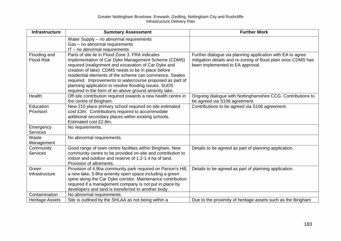
Greater Nottingham Broxtowe, Erewash, Gedling, Nottingham City and Rushcliffe Infrastructure Delivery Plan
183
Infrastructure Summary Assessment Further Work
Water Supply – no abnormal requirements Gas – no abnormal requirements IT – no abnormal requirements
Flooding and Flood Risk
Parts of site lie in Flood Zone 3. FRA indicates implementation of Car Dyke Management Scheme (CDMS) required (realignment and excavation of Car Dyke and creation of lake). CDMS needs to be in place before residential elements of the scheme can commence. Swales required. Improvements to watercourse proposed as part of planning application to resolve flooding issues. SUDS required in the form of an above ground amenity lake.
Further dialogue via planning application with EA to agree mitigation details and re-zoning of flood plain once CDMS has been implemented to EA approval.
Health
Off-site contribution required towards a new health centre in the centre of Bingham.
Ongoing dialogue with Nottinghamshire CCG. Contributions to be agreed via S106 agreement.
Education Provision
New 210 place primary school required on site estimated cost £3m. Contributions required to accommodate additional secondary places within existing schools. Estimated cost £2.8m.
Contributions to be agreed via S106 agreement.
Emergency Services
No requirements.
Waste Management
No abnormal requirements.
Community Services
Good range of town centre facilities within Bingham. New community centre to be provided on-site and contribution to indoor and outdoor and reserve of 1.2-1.4 ha of land. Provision of allotments.
Details to be agreed as part of planning application.
Green Infrastructure
Provision of 4.9ha community park required on Parson’s Hill, a new lake, 5.8ha amenity open space including a green spine along the Car Dyke corridor. Maintenance contribution required if a management company is not put in place by developers and land is transferred to another body.
Details to be agreed as part of planning application.
Contamination No abnormal requirements. Heritage Assets Site is outlined by the SHLAA as not being within a Due to the proximity of heritage assets such as the Bingham

Greater Nottingham Broxtowe, Erewash, Gedling, Nottingham City and Rushcliffe Infrastructure Delivery Plan
184
Infrastructure Summary Assessment Further Work
designated Conservation Area, with no impact upon a designated Conservation Area. However there is the presence of Scheduled Ancient Monuments, a Conservation Area and 26 Listed Buildings within Bingham. Close to areas of archaeological value including Roman Settlement of Margidunum and Fosse Way.
Henge Monument on Moorbridge Road, Bingham, further dialogue with English Heritage may be required to preserve and enhance heritage assets.
Indicative Assessment Greenfield site with no major physical constraints to development identified, flood risk to addressed by Carr Dyke Management Scheme. Planning permission granted subject to S106 agreement. Proactive owners/developers.

Greater Nottingham Broxtowe, Erewash, Gedling, Nottingham City and Rushcliffe Infrastructure Delivery Plan
185

Greater Nottingham Broxtowe, Erewash, Gedling, Nottingham City and Rushcliffe Infrastructure Delivery Plan
186

Greater Nottingham Broxtowe, Erewash, Gedling, Nottingham City and Rushcliffe Infrastructure Delivery Plan
187
Former RAF Newton (Rushcliffe) Site Summary Designation Strategic Allocation Site Area 74ha Timescale To commence within first 5 years of the plan
Resolution to grant planning permission subject to S106 agreement. Housing Units 500 dwellings 50 live-work units. Indicative Housing Mix 27% affordable housing Employment Uses 9 ha existing B8, 1.95ha B1, 4.4ha B2 and B8, 50 live work units. Other Uses Education, community facilities, green infrastructure.
Ownership/Developer Willing owner/developer IDP Constraints/Requirements Summary
Infrastructure Summary Assessment Further Work Transport Planning application submitted. Transport modelling
underway. No Highways Agency objections, subject to details of S106. A travel plan will be a requirement and contributions to highway and public transport including: • improvements to A52 Radcliffe Road/Bingham Road
junction (estimated cost £60K), • work to ensure all traffic uses new link road to the A46,
on-site bus gate maintenance contribution (estimated at £140K total)
• widening of link road to 7.3 metres prior to use of new employment area
• localised improvements to roads and traffic management, traffic calming to discourage the use of Main Street by through traffic (estimated at £50K)
• Foot and cycleway bridge required over old and new A46 to link with Bingham and alterations to bridleways and footpaths
Consideration of planning application and agreement of S106 contributions.

Greater Nottingham Broxtowe, Erewash, Gedling, Nottingham City and Rushcliffe Infrastructure Delivery Plan
188
Infrastructure Summary Assessment Further Work • walking, cycling and public transport improvements (a
new hourly bus service will commence May 2012 with potential for further modification) in line with the County Councils Interim Transport Planning Statement.
Utilities
Electricity – Reinforcement of 33kV circuits from Sibthorpe to Hawton required. Waste Water –Potential cumulative impact (with North of Bingham) Newton) on Aslockton Sewage Works, largely a phasing issue. Water supply – no abnormal requirements. Gas – no abnormal requirements IT – no abnormal requirements
Further dialogue with Western Power re cumulative impacts. Further dialogue with Severn Trent particularly re phasing of development.
Flooding and Flood Risk
The site falls within Flood Zone 1 (low risk) but with a culverted watercourse crossing the site which is to be reopened as part of the development. There are known flood risk issues downstream of the site and redevelopment provides an opportunity to reduce downstream flows via Sustainable Drainage Systems.
Details of SUDS to be agreed as part of planning conditions.
Health
Off site contribution to existing facilities at East Bridgford and Radcliffe health centres required. Estimated cost £506K.
Contributions to be agreed as part of S106 agreement.
Education Provision
Scale of development requires a new on site primary school of 4 classrooms but with full infrastructure for a 210 place school, estimated cost £2.3m. Capacity at Radcliffe on Trent to accommodate secondary school intake.
Contributions to be agreed as part of S106 agreement.
Emergency Services
No abnormal requirements.
Waste Management
On site waste management scheme required. Details to be agreed as part of planning application.

Greater Nottingham Broxtowe, Erewash, Gedling, Nottingham City and Rushcliffe Infrastructure Delivery Plan
189
Infrastructure Summary Assessment Further Work Community Services
New community hall required to accommodate consented and proposed dwellings. Provision of sports pitch with associated changing facilities required and children’s play space including equipped areas along with a contribution to support indoor and outdoor leisure. Potential library contribution to support existing library service (est £0.1m).
Details and contributions to be agreed as part of planning application.
Green Infrastructure
Group and individual TPOs adjacent to existing village of Newton which will require protection and enhancement. An open space scheme is required, alongside including allotments, community orchards and a ‘foraging’ path. Maintenance contribution required if a management company is not put in place by developers and land is transferred to another body.
Details and contributions to be agreed as part of planning application.
Contamination
Localised hotspots of contamination identified. Further desk/site investigation required as appropriate.
Heritage Assets Site is not within a designated Conservation Area and has no impact upon a designated Conservation Area or heritage assets.
Other High potential for archaeological remains.
Detailed scheme of archaeological mitigation and building recording required.
Indicative Assessment Brownfield site with no major physical constraints to development identified although some local hot spots of contamination present. Resolution to grant planning permission subject to S106 agreement. Proactive owners/developers.

Greater Nottingham Broxtowe, Erewash, Gedling, Nottingham City and Rushcliffe Infrastructure Delivery Plan
190

Greater Nottingham Broxtowe, Erewash, Gedling, Nottingham City and Rushcliffe Infrastructure Delivery Plan
191
Cotgrave Colliery (Rushcliffe)
Site Summary Designation Strategic Allocation Timescale To commence in first 5 years of the plan
Outline Planning Permission Granted Site Area 34.5 Housing Units 470 Housing Mix 30% affordable housing Employment Uses 4.7ha - BI, B2, B8 Other Uses Open space, green infrastructure and allotments Ownership/Developer Willing owner/developer IDP Constraints/Requirements Summary
Infrastructure Summary Assessment Further Work Transport Assessment undertaken as part of planning application.
Travel Plan and Coordinator required and works and contributions including: • Improvements for A606 /Old Melton Road Junction
including bus hurry call system, • Improvements for A606/Tollerton Lane junction
including a hurry call system for buses, • Alterations to A52 Stragglethorpe Lane junction,
lengthening of the left turn lane on Stragglethorpe Lane,
• Various localised highway improvements, • Existing bus networks service main centre of Cotgrave
only. A financial contribution for a bus to serve the former Colliery site is required of £600K to be provided between 7am to 7.30pm Monday-Sat and 10-4 Sunday,
• £40K towards sustainable transport connections from the site to Cotgrave,
Contributions and works agreed via planning permission and subsequent S106. Works to be completed under s278 of the Highways Act.

Greater Nottingham Broxtowe, Erewash, Gedling, Nottingham City and Rushcliffe Infrastructure Delivery Plan
192
Infrastructure Summary Assessment Further Work • Towpath contribution of £94K and replacement car
park, • Pedestrian/cycle canal bridge Country park cycle path
contribution of £57K.
Utilities
Electricity – No abnormal requirements. Waste Water – No abnormal requirements. Water supply – no abnormal requirements. Gas – no abnormal requirements IT – no abnormal requirements
Flooding and Flood Risk
A small part of this site lies within Flood Zone 3 from the Grantham Canal. SUDS incorporated as part of planning application for Cotgrave
Health
Contribution to local health services included as part of overall contribution to town centre facilities (see community services)
Details to be agreed as part of masterplan.
Education Provision
Contribution of £763k agreed to provide additional primary school places within existing schools. Capacity within secondary schools.
Contribution and phasing of payment agreed as part of S106.
Police Services
Contribution to policing included as part of overall contribution to town centre facilities (see community services).
Details to be agreed as part of masterplan.
Ambulance Services
No requirement
Fire Services No requirement Waste Management
Waste Recycling Point on the employment area to serve the residential development.
Details agreed as part of planning application.
Community Services
Close to Cotgrave Town Centre - improved links to be provided and Town Centre Masterplan underway. A community contribution of £933K agreed to support measures identified in the Town Centre master plan including the provision or improvement to health provision, police provision, community safety and other related
Details to be finalised when final masterplan is agreed.

Greater Nottingham Broxtowe, Erewash, Gedling, Nottingham City and Rushcliffe Infrastructure Delivery Plan
193
Infrastructure Summary Assessment Further Work purposes. Contributions to Youth Leisure of £30K required and provision of a neighbourhood Equipped area of play, a Locally Equipped Area of Play and a Sports Playing Capacity Scheme.
Green Infrastructure
Opportunities for GI enhancement on site and within the adjacent Country Park. A scheme for habitat replacement/enhancement to be submitted in addition to a contribution of £20K to support ecology improvements within the country park. An open space scheme and park contribution of £105K is required. A maintenance contribution required if a management company is not put in place by developers and land is transferred to another body.
Requirements and contributions agreed as part planning application and of S106.
Contamination
Site remediation works complete. Minor localised pockets to remediate Further testing may be required.
Testing and remediation works as required.
Heritage Assets Site is not within a designated Conservation Area and has no impact upon a designated Conservation Area or heritage assets.
Indicative Assessment Regeneration of this former colliery site is being led by the Homes and Communities Agency (HCA). Public sector funding has been used to remediate the site, develop the approved scheme and remove barriers to delivery. Outline planning permission has been granted.

Greater Nottingham Broxtowe, Erewash, Gedling, Nottingham City and Rushcliffe Infrastructure Delivery Plan
194

Greater Nottingham Broxtowe, Erewash, Gedling, Nottingham City and Rushcliffe Infrastructure Delivery Plan
195

Greater Nottingham Broxtowe, Erewash, Gedling, Nottingham City and Rushcliffe Infrastructure Delivery Plan
196
East Leake (Rushcliffe) Site Summary Designation Strategic Location Timescale for Delivery 6 + years Housing Units 400 Other Uses tbc IDP Constraints/Requirements Summary
Infrastructure Summary Assessment Further Work Transport Transport modelling underway. Integrated
transport/walking and cycling package required and further review of cumulative impact on local road networks from settlement growth and SUE at land South of Clifton. Existing high frequency bus service.
Transport (highway/public transport and walking and cycling) requirements to be developed.
Utilities
Electricity – possibly requires reinforcement including new 33/11kV primary and circuits at South Clifton. Waste water – no abnormal requirements subject to phasing. Water supply - no abnormal requirements subject to phasing. Gas – no abnormal requirements IT – no abnormal requirements.
Further dialogue with Western Power re cumulative impacts. Further ongoing dialogue with Severn Trent.
Flooding and Flood Risk
There are two sources of flooding in East Leake - Kingston Brook (runs from east to west through the centre of the village) and Sheepwash Brook (runs from south to the confluence with Kingston Brook in the playing fields at the centre of the village). A number of properties fall within the flood zones in particular along Brookside.
Should development proposals come forward within the flood zones a comprehensive flood risk assessment will be required and surface water controlled at source using sustainable urban drainage techniques. New development must not cause or exacerbate flooding problems up or downstream.
Health Facilities
Existing services recently expanded but further growth likely to require additional services.
Dialogue with CCG underway. Capacity to be reviewed as detailed proposals emerge.

Greater Nottingham Broxtowe, Erewash, Gedling, Nottingham City and Rushcliffe Infrastructure Delivery Plan
197
Infrastructure Summary Assessment Further Work Contributions based on Health body cost calculator estimated to be £380k.
Education Provision
Contributions likely to be required to support additional primary and secondary places at existing local schools. Costs based on the Nottinghamshire County Council education multiplier are estimated to be £962k for primary places and £1.1m for secondary places. Capacity of school places closely linked with Land to South of Clifton – further increases in housing numbers would require full review of education provision.
Education contributions to be reviewed in light of pupil projection data (only valid 5 years in advance of development) to provide accurate assessment of existing local school capacity and confirm if contributions to expand existing schools are appropriate or if new school provision is required.
Police Services No abnormal requirements Further dialogue on opportunities to use local facilities for neighbourhood policing as detailed proposals emerge.
Ambulance Services No abnormal requirements. Further dialogue required on inclusion of standby locations as detailed proposals emerge.
Fire and Rescue No abnormal requirements. Further dialogue required on layout and mix of units. Waste Management No abnormal requirements. Further dialogue as detailed proposals emerge. Community Services
Existing community services within settlement including leisure centre, library and open space.
No abnormal requirements but there may be opportunities to support local facilities as detailed proposals emerge.
Green Infrastructure
Close to Rushcliffe Golf Course SSSI. Opportunities for enhancement of green infrastructure along water courses.
Opportunities for GI and POS to be explored as detailed proposals emerge.
Contamination No abnormal requirements. Heritage Assets Conservation Area and cluster of Listed Buildings in
the centre of East Leake Further dialogue with English Heritage as proposals emerge to preserve and enhance heritage assets.
Other Underlain by deposits of gypsum, Till and Made Ground, and underground workings present relating to gypsum.
Desk/site investigations required as appropriate.
Indicative Assessment No major constraints to development. Education requirements of settlement are linked with other sites and will require further review. Development proposals should avoid areas of flood risk - further dialogue with Environment Agency required as development proposals emerge. Highway and public transport proposals to be developed.

Greater Nottingham Broxtowe, Erewash, Gedling, Nottingham City and Rushcliffe Infrastructure Delivery Plan
198

Greater Nottingham Broxtowe, Erewash, Gedling, Nottingham City and Rushcliffe Infrastructure Delivery Plan
199
Keyworth (Rushcliffe) Site Summary Designation Strategic Location Timescale for Delivery 6 + years Housing Units 450 Other Uses tbc IDP Constraints/Requirements Summary
Infrastructure Summary Assessment Further Work Transport Existing frequent bus services with capacity for
expansion if required. Transport modelling underway. Integrated transport/walking and cycling package required.
Transport (highway/public transport and walking and cycling) requirements to be developed as part of master-planning work.
Utilities
Electricity – no abnormal requirements. Waste water – no abnormal requirements subject to phasing. Water supply - no abnormal requirements subject to phasing. Gas – no abnormal requirements IT – no abnormal requirements.
Further ongoing dialogue with Severn Trent.
Flooding and Flood Risk
Low risk - no flood zones within the settlement. Proposals to manage surface water required.
Proposals to include means to control surface water at source using SUDS.
Health Facilities
Settlement has a new LIFT scheme with existing capacity. May need small scale contribution depending on growth levels.
Dialogue underway with CCG re appropriate future facilities.
Education Provision
Current capacity within existing schools and capacity for expansion. but longer term pupil projections not available/reliable. Future review required, interim requirements should be based on Nottinghamshire
Education contributions to be reviewed in light of pupil projection data (only valid 5 years in advance of development) to provide accurate assessment of existing local school capacity and confirm if contributions to expand existing schools

Greater Nottingham Broxtowe, Erewash, Gedling, Nottingham City and Rushcliffe Infrastructure Delivery Plan
200
Infrastructure Summary Assessment Further Work County Council multiplier with support for primary places estimated at £1m and secondary places £1.24m.
are appropriate or if new school provision is required.
Police Services No abnormal requirements Further dialogue on opportunities to use local facilities for neighbourhood policing as detailed proposals emerge.
Ambulance Services No abnormal requirements Further dialogue required on inclusion of standby locations as detailed proposals emerge.
Fire and Rescue No abnormal requirements Further dialogue required on layout and mix of units. Waste Management
No known requirements. Further dialogue as detailed proposals emerge.
Community Services
Local facilities available in existing settlement. Opportunities to support local facilities to be explored as detailed proposals emerge.
Green Infrastructure
Close to Keyworth Meadow LNR, Nature reserve located to the east of the settlement, and smaller areas to the south.
Opportunities to enhance GI to be developed as detailed proposals emerge.
Contamination
No abnormal requirements.
Heritage Assets Conservation Area and 13 Listed Buildings in Keyworth Further dialogue with English Heritage as proposals emerge to preserve and enhance heritage assets.
Other Underlain by deposits of Till. Desk/site investigations required as appropriate. Indicative Assessment No major constraints to development. Further dialogue with CCG and Nottinghamshire County Council education colleagues as proposals emerge. Highway and public transport proposals to be developed.

Greater Nottingham Broxtowe, Erewash, Gedling, Nottingham City and Rushcliffe Infrastructure Delivery Plan
201

Greater Nottingham Broxtowe, Erewash, Gedling, Nottingham City and Rushcliffe Infrastructure Delivery Plan
202
Radcliffe on Trent (Rushcliffe) Site Summary Designation Strategic Location Timescale for Delivery 6 + years Housing Units 400 Other Uses tbc IDP Constraints/Requirements Summary
Infrastructure Summary Assessment Further Work Transport Existing rail station and high frequency bus services with
capacity for expansion if required. Transport modelling underway. Integrated transport/walking and cycling package required and consideration of congestion on A52.
Transport (highway/public transport and walking and cycling) requirements to be developed as part of master-planning work.
Utilities
Electricity – Reinforcement of 33kV circuits from Sibthorpe to Hawton required. Waste water – no abnormal requirements subject to phasing. Water supply - no abnormal requirements subject to phasing. Gas – no abnormal requirements IT – no abnormal requirements.
Further dialogue with Western Power re cumulative impacts. Further ongoing dialogue with Severn Trent.
Flooding and Flood Risk
The River Trent is the major source of flood risk in the lower areas of Radcliffe in the west. Some parts of the village including the area around Sydney Grove, Lamcote Gardens, The Green and Yew Tree Close are within a flood zone.
Should development proposals come forward within the flood zones, a comprehensive flood risk assessment will be required and surface water controlled at source using SUDS. New development must not cause or exacerbate flooding problems up or downstream.
Health Facilities
Existing facilities may be difficult to expand and these are near to capacity. New services based on existing cot calculator is £238k.
Dialogue underway with CCG re appropriate future facilities.
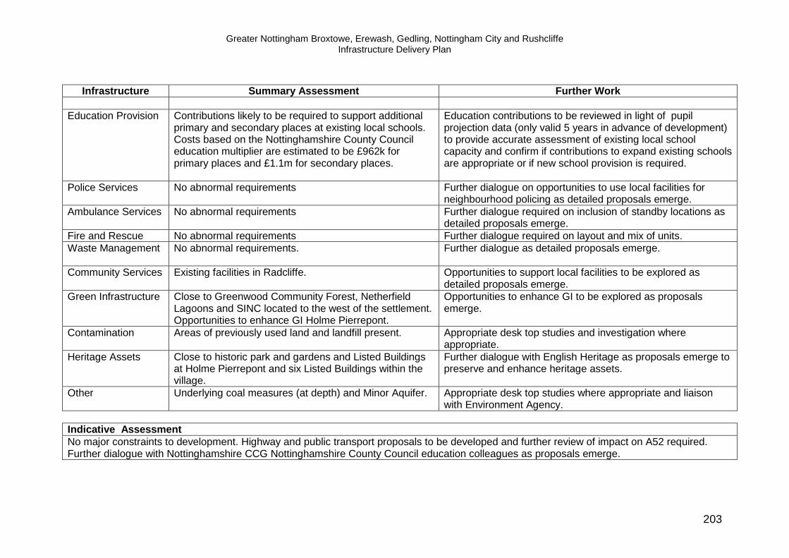
Greater Nottingham Broxtowe, Erewash, Gedling, Nottingham City and Rushcliffe Infrastructure Delivery Plan
203
Infrastructure Summary Assessment Further Work
Education Provision
Contributions likely to be required to support additional primary and secondary places at existing local schools. Costs based on the Nottinghamshire County Council education multiplier are estimated to be £962k for primary places and £1.1m for secondary places.
Education contributions to be reviewed in light of pupil projection data (only valid 5 years in advance of development) to provide accurate assessment of existing local school capacity and confirm if contributions to expand existing schools are appropriate or if new school provision is required.
Police Services No abnormal requirements Further dialogue on opportunities to use local facilities for neighbourhood policing as detailed proposals emerge.
Ambulance Services No abnormal requirements Further dialogue required on inclusion of standby locations as detailed proposals emerge.
Fire and Rescue No abnormal requirements Further dialogue required on layout and mix of units. Waste Management
No abnormal requirements. Further dialogue as detailed proposals emerge.
Community Services
Existing facilities in Radcliffe. Opportunities to support local facilities to be explored as detailed proposals emerge.
Green Infrastructure
Close to Greenwood Community Forest, Netherfield Lagoons and SINC located to the west of the settlement. Opportunities to enhance GI Holme Pierrepont.
Opportunities to enhance GI to be explored as proposals emerge.
Contamination
Areas of previously used land and landfill present. Appropriate desk top studies and investigation where appropriate.
Heritage Assets Close to historic park and gardens and Listed Buildings at Holme Pierrepont and six Listed Buildings within the village.
Further dialogue with English Heritage as proposals emerge to preserve and enhance heritage assets.
Other Underlying coal measures (at depth) and Minor Aquifer.
Appropriate desk top studies where appropriate and liaison with Environment Agency.
Indicative Assessment No major constraints to development. Highway and public transport proposals to be developed and further review of impact on A52 required. Further dialogue with Nottinghamshire CCG Nottinghamshire County Council education colleagues as proposals emerge.

Greater Nottingham Broxtowe, Erewash, Gedling, Nottingham City and Rushcliffe Infrastructure Delivery Plan
204

Greater Nottingham Broxtowe, Erewash, Gedling, Nottingham City and Rushcliffe Infrastructure Delivery Plan
205
Ruddington (Rushcliffe) Site Summary Designation Strategic Location Timescale for Delivery 6 + years Housing Units 250 Other Uses tbc IDP Constraints/Requirements Summary
Infrastructure Summary Assessment Further Work Transport Existing frequent bus services with existing capacity.
Transport modelling underway. Integrated transport/walking and cycling package required.
Transport (highway/public transport and walking and cycling) requirements to be developed as part of master-planning work.
Utilities
Electricity – New 33/11kV primary and circuits in South Clifton required. Waste water – no abnormal requirements subject to phasing. Water supply - no abnormal requirements subject to phasing. Gas – no abnormal requirements IT – no abnormal requirements.
Further dialogue with Western Power re cumulative impacts. Further ongoing dialogue with Severn Trent.
Flooding and Flood Risk
No flood zones within the settlement. Fairham Brook flows to the west of Ruddington and is fed by two tributaries one to the north and one to the south of the settlement, both have associated flood zones. If development is restricted to key settlement then flooding to new development should not be an issue but disposal of surface water could exacerbate problems.
Surface water to be controlled at source using SUDS. New development must not cause or exacerbate flooding problems up or downstream.
Health Facilities
Recent extension to existing surgery. Further extension may be possible to create capacity but further review required.
Dialogue underway with CCG re appropriate future facilities.
Education Provision Contributions likely to be required to support additional Education contributions to be reviewed in light of pupil

Greater Nottingham Broxtowe, Erewash, Gedling, Nottingham City and Rushcliffe Infrastructure Delivery Plan
206
Infrastructure Summary Assessment Further Work primary and secondary places at existing local schools.
Costs based on the Nottinghamshire County Council education multiplier are estimated to be £607k for primary places and £691k for secondary places.
projection data (only valid 5 years in advance of development) to provide accurate assessment of existing local school capacity and confirm if contributions to expand existing schools are appropriate or if new school provision is required.
Police Services No abnormal requirements Further dialogue on opportunities to use local facilities for neighbourhood policing as detailed proposals emerge.
Ambulance Services No abnormal requirements Further dialogue required on inclusion of standby locations as detailed proposals emerge.
Fire and Rescue No abnormal requirements Further dialogue required on layout and mix of units. Waste Management
No known abnormal requirements. Further dialogue as detailed proposals emerge.
Community Services
Good range of facilities within Ruddington. Potential for growth to support services.
Opportunities to support local facilities to be explored as detailed proposals emerge.
Green Infrastructure
Close to Willwell Cutting LNR and SSSI, and SINC to the east and Rushcliffe Country Park.
Opportunities for enhanced GI associated with water courses.
Contamination
Areas of previously landfill. Appropriate desk top studies and investigation if required.
Heritage Assets Conservation Area and Listed Buildings present in Ruddington.
Further dialogue with English Heritage as proposals emerge to preserve and enhance heritage assets.
Other Underlain by deposits of Till and Made Ground. Appropriate desk top studies and investigation if required. Indicative Assessment No major constraints to development. Further dialogue with CCG and Nottinghamshire County Council education colleagues as proposals emerge. Highway and public transport proposals to be developed.

Greater Nottingham Broxtowe, Erewash, Gedling, Nottingham City and Rushcliffe Infrastructure Delivery Plan
207

Greater Nottingham Broxtowe, Erewash, Gedling, Nottingham City and Rushcliffe Infrastructure Delivery Plan
208
9. Viability The National Planning Policy Framework expects local authorities to plan for high quality sustainable development and sets out the range of infrastructure requirements to be considered in planning for new development. In particular the NPPF expects that local authorities will ‘give great weight to the need to create, expand or alter schools’. The NPPF also sets out that ‘…the sites and scale of sites identified in the plan should not be subject to such a scale of obligations and policy burdens that their ability to be developed viably is threatened’. Councils are expected to use appropriate proportionate available evidence to demonstrate deliverability of their proposals. Current economic conditions are extremely challenging for the development sector as evidenced by recent dwelling completion rates. Whilst improved conditions may be expected with longer term recovery, the NPPF expects councils to plan for delivery across economic cycles. In reviewing viability consideration has been given to guidance within ‘Viability Testing for Local Plans’ (October 2012), discussion at pre-submission meetings with PINs and advice within the NPPF which sets out that assessment should be proportionate ‘using only appropriate available evidence’. In the context of the above, the councils believe their approach to viability is appropriate for a Core Strategy. The general approach and methodology is set out below. The Core Strategies include eight strategic allocations where development is expected to commence in the first five years of the plan period – and arguably in the most challenging economic conditions. The local authorities have therefore sought to test, at a broad scale, the deliverability of these strategic sites and apply sensitivity testing related to house prices and levels of affordable housing. All of the appraisals include estimated costs for education provision. Nottingham Regeneration Limited was commissioned to undertake the appraisals on behalf of the Local Authorities. The assessments provide the councils with a broad understanding of the viability of a scheme and are based on a number of assumptions and do not replace detailed appraisals informed by, for example, intrusive investigations and detailed transport assessments which would normally be undertaken by a developer. The methodology and appraisal results are included in Appendix B. A summary of the approach is set out below:
• Appraisals have been undertaken using the Three Dragons Viability Tool which is a recognised viability model used by local authorities and accepted by the development industry;
• The model uses default values for each local authority area for house price, affordable rental values and build costs;
• The models base date is December 2008 and values have been updated to reflect current conditions (house prices and build costs);
• The mix of uses, dwelling numbers and affordability have been set by each local authority;

Greater Nottingham Broxtowe, Erewash, Gedling, Nottingham City and Rushcliffe Infrastructure Delivery Plan
209
• A standard range of development costs are applied including fees and developers profit;
• An allowance is included for a range of external costs; • A further allowance is included to reflect the councils’ aspirations for
sustainable, low carbon homes and water efficiency measures; • Unless specified, model default values are used for housing mix; • The model includes potential infrastructure costs and S106 contributions
where known. The model uses two variables, the level of affordable housing and house prices, to demonstrate the sensitivity of the model to variable factors over time. Clearly there are other variable factors which could have been modelled such as the cost of land and build costs. However, the assessment seeks to test the broad viability of schemes and the two variables have been selected as having the greatest relevance in this instance. It should not be assumed that if a scheme is shown to be marginal then it is just the level of affordable housing and or house prices which are the key factors. These are just two of many factors which would need to be considered in a detailed open book assessment of any scheme using more detailed information from developers. Appraisal results As set out above, the appraisals provide a broad indication of viability. The sensitivity analysis demonstrates that relatively minor changes to house prices and the level of affordable homes may dramatically affect viability. Including detailed cashflow modelling may also result in different appraisal values. Further variables such as the mix of units, cost of land, build costs and wider S106 requirements also affect viability. The appraisals for Field Farm, Top Wighay, North of Papplewick Lane, Melton road, South of Clifton and Cotgrave indicate that developments are broadly viable with some head room for additional infrastructure requirements. For Cotgrave it should be noted that significant public sector funding has previously been targeted at preparing the site for development and this is not included in the appraisal – hence the very positive appraisal assessment. The former RAF Newton site is assessed has having a positive valuation but is marginally viable. The appraisal indicates that very small changes in the model inputs could result in a viable scheme (e.g. the precise mix of units, for example). However, since the appraisal was completed and following discussion with the council and education colleagues regarding existing school capacity, the proposed financial contribution to support education has been reduced by approximately £4.6m along with a reduction in the proportion of affordable housing units from 30 to 27% (and other more minor reductions in cost on other supporting elements of the scheme). These changes clearly have a positive impact on the viability assessment. A planning application has been submitted for this site and the Borough Council’s Development Control committee have resolved to grant planning permission subject to Secretary of State Approval. The site to the North of Bingham indicates a negative residual valuation of around £17,000. As with RAF Newton the sensitivity testing indicates dramatic changes in viability with small changes to the model with a need for detailed viability testing as part of the planning application process. However, since the appraisal was

Greater Nottingham Broxtowe, Erewash, Gedling, Nottingham City and Rushcliffe Infrastructure Delivery Plan
210
undertaken, S106 contributions to primary school provision have reduced from £5m to £3m which clearly has a positive impact on viability. The appraisal results suggest that the strategic allocations are broadly viable but for RAF Newton and North of Bingham detailed open book assessments are key. The sites at Top Wighay and North of Papplewick Lane are greenfield sites with assessment indicating viability and few constraints to development yet developers have been slow to progress these sites indicating wider issues in the development sector other than land availability and site viability. Other forces such as the availability of finance and investor/developer confidence are constraining the delivery of new housing. This is supported by the conclusions of the GL Hearn Report commissioned by the partners as part of the Core Strategies evidence base. Summary Viability Assessments 9.1 Field Farm Indicative Viability Assessment Conclusions Existing use value (agricultural) – £295,000 With 20% uplift – £354,000
The overall assessment shows a positive residual site value of £701,000. The sensitivity analysis illustrates that a fall in values of just 5% would result in a negative viability at 25% affordable housing provision. At these levels of value a reduction in affordable provision of 5% would be required to produce a residual value in excess of the estimated existing use value. NB Since the viability assessment was undertaken the education contribution has been renegotiated and is reduced significantly to circa £525k. If the figures are recalculated this would have positive impact on the viability results.
Market Values
90% 95% 100% 105% 110%
15 92,000 2,468,000 4,664,000 7,043,000 9,292,000
20 -1,627,000 613,000 2,683,000 4,925,000 7,044,000
Affo
rdab
le
Hou
sing
%
25 -3,346,000 -1,242,000 701,000 2,806,000 4,796,000

Greater Nottingham Broxtowe, Erewash, Gedling, Nottingham City and Rushcliffe Infrastructure Delivery Plan
211
9.2 Top Wighay Farm Indicative Viability Assessment Conclusions Existing use value (agricultural) – £672,500 With 20% uplift – £807,000
Market Values 90% 95% 100% 105% 110%
20 1,755,441 6,445,441 11,005,441 15,826,441 20,549,441
25 -236,559 4,160,441 8,435,441 12,954,441 17,382,441
Affo
rdab
le
Hou
sing
%
30 -2,227,559 1,876,441 5,865,441 10,084,441 14,217,441
The overall assessment shows a positive residual site value of £5,865,441 at 30% affordability levels. At this level of affordable provision, the sensitivity analysis illustrates that a fall in market values of 5% still produces a viable figure when compared to existing use value. Decreasing the affordable provision by 25% however dramatically improves the viability position. NB. The viability does not include any allowance for transport or health S106 payments as these have not been defined at present. Any payments negotiated will affect these viability figures. 9.3 North of Papplewick Lane Indicative Viability Assessment Conclusions Existing use value (agricultural) – £400,000 With 20% uplift – £480,000
Market Values 90% 95% 100% 105% 110%
20 8,775,000 £12,561,000 £16,489,000 £20,416,000 £24,344,000
25 £5,982,000 £9,559,000 £13,270,000 £16,979,000 £20,690,000
Affo
rdab
le H
ousi
ng %
30 £3,191,000 £6,558,000 £10,050,000 £13,543,000 £17,035,000
The overall assessment shows a residual site value of £10,050,000 at 30% affordability levels. Market values assume an uplift in the market compared with majority of comparables within the postcode due to the favourable location of the site. It should be noted that should this uplift not be achieved, reductions in market value can have a significant negative impact on the figures.

Greater Nottingham Broxtowe, Erewash, Gedling, Nottingham City and Rushcliffe Infrastructure Delivery Plan
212
NB. The viability does not include any allowance for transport, health or green infrastructure S106 payments as these have not been defined at present. Also no allowance is made for the potential need to purchase properties on Papplewick Lane. Any payments negotiated will affect these viability figures. 9.4 Clifton South Indicative Viability Assessment Conclusions Existing use value (agricultural) – £2,625,000 With 20% uplift – £3,150,000
NB. The figures produced above should be treated with caution due to the large numbers of units, (2,500), entered in the appraisal and the fact that the appraisal is not carried out on a discounted cashflow basis. This results in very large differences between different levels of market value. The overall assessment shows a residual site value of £19,711,399 at 30% affordability levels and 100% market value. However, the large number of houses modelled in the viability assessment creates large variances between different levels of value and affordability. In reality, a developer would undertake a phased development of much smaller volumes. A site of this size would take several years to complete and would usually be undertaken by more than one developer. The figures should therefore be viewed with caution.
Market Values 90% 95% 100% 105% 110%
20 9,746,399 24,342,399 39,102,399 54,190,399 69,278,399
25 1,885,399 15,570,399 29,407,399 45,552,399 57,697,399
Affo
rdab
le
Hou
sing
%
30 -5,974,601 6,796,399 19,711,399 32,913,399 46,115,399

Greater Nottingham Broxtowe, Erewash, Gedling, Nottingham City and Rushcliffe Infrastructure Delivery Plan
213
9.5 RAF Newton Indicative Viability Assessment Conclusions Existing use value (agricultural) – N/A Alternative Use Value (resi hope value)– £1,825,000
The overall assessment shows a positive residual site value of £1,885,251 at 30% affordability levels. This is marginally viable when compared with existing use value. Furthermore at this level of affordable provision, the sensitivity analysis illustrates that a fall in market values of 10% would result in a negative viability figure in excess of £3.8m. Decreasing the affordable provision by 25% however dramatically improves the viability position. Notes on land values. For this site, given the former use of the site as an RAF land Station, an alternative use value (based on residential) is considered the most appropriate approach here. Alternative Use Value - whilst the housing site is adjacent to former station housing, this land will still require a degree of servicing. The alternative land value is therefore considered to be somewhat below that which would be obtainable for previously developed residential land but in excess of agricultural land value. A figure of circa £100,000 per ha is considered reasonable. This reflects a degree of hope value as well as an allowance for servicing ,decontamination etc. Taking the residential area of the land 18.25 ha this equates to £ 1.825m. NB – since the appraisal was completed Rushcliffe Borough Council have confirmed that the amount included in the appraisal to support education has been reduced by approximately £4.6m following confirmation of school capacity. The level of affordable housing has been reduced from 30% to 27%. Both elements would have a positive impact on the above appraisal.
Market Values 90% 95% 100% 105% 110%
20 -612,749 2,667,251 5,947,251 9,227,251 12,605,251
25 -2,232,749 842,251 3,917,251 6,992,251 10,159,251
Affo
rdab
le
Hou
sing
%
30 -3,854,749 -984,749 1,885,251 4,755,251 7,711,251

Greater Nottingham Broxtowe, Erewash, Gedling, Nottingham City and Rushcliffe Infrastructure Delivery Plan
214
9.6 North of Bingham Indicative Viability Assessment Conclusions Existing use value (agricultural) – £2,300,000 With 20% uplift – £2,760,000
Market Values
90% 95% 100% 105% 110%
20 -2,837,947 3,194,053 9,226,053 15,259,053 21,426,053
25 -6,822,947 -1,106,947 4, 609,053 10,324,053 16,169,053
Affo
rdab
le
Hou
sing
%
30 10,803,947 -5,409,947 -16,947 5,377,053 10,891,053 The overall assessment shows a negative residual site value of £16,947 at 30% affordability levels. Furthermore at this level of affordable provision, the sensitivity analysis illustrates that a fall in market values of only 5% would result in the development illustrating a negative viability. Decreasing the affordable provision by 25% however dramatically improves the viability position. NB. A planning application is currently under consideration. Information provided above relates to how the application stands at present, however as negotiations with developers are on-going this is subject to change. No major strategic infrastructure requirements currently identified. However, TA still to be agreed by HA and negotiations regarding flooding issues on-going with EA. 9.7 Melton Road, Edwalton Indicative Viability Assessment Conclusions Existing use value (agricultural) – £2,700,000 With 20% uplift – £3,240,000
Market Values
90% 95% 100% 105% 110%
20 4,306,176 11,313,176 18,319,176 25,325,176 32,488,176
25 286,176 6,854,176 13,422,176 19,990,176 26,706.18
Affo
rdab
le
Hou
sing
%
30 -3,735,824 2,394,176 8,525,176 14,655,176 20,923,176 The overall assessment shows a positive residual site value of £8,525,176 at 30% affordability levels. Furthermore at this level of affordable provision, the sensitivity analysis illustrates that a fall in market values of 5% would be required before the development becomes unviable when compared to existing use value. NB the Business Innovation Centre has been valued on the basis of B1 occupation. The introduction of B2 or B8 accommodation could result in a less viable position

Greater Nottingham Broxtowe, Erewash, Gedling, Nottingham City and Rushcliffe Infrastructure Delivery Plan
215
9.8 Cotgrave Indicative Viability Assessment Conclusions Existing use value (agricultural) – £ 862,500 With 20% uplift – £1,035,000
Market Values 90% 95% 100% 105% 110%
20 3,697,421 6,269,421
8,840,421 11,412,421
14,049,421
25 2,417,421 4,828,421 7,239,421 9,650,421 12,122,241
Affo
rdab
le H
ousi
ng
%
30 1,274,421 3,524,421 5,774,421 8,024,421 10,332,421
The overall assessment shows a positive residual site value at all levels of value and proportion of affordable housing with a base figure of £5,774,421 at 30% affordability levels. Given the positive outcome of this analysis there may be other unknown costs associated with the development which could reduce the viability.

Greater Nottingham Broxtowe, Erewash, Gedling, Nottingham City and Rushcliffe Infrastructure Delivery Plan
216
Core Strategies Viability – Smaller Sites The assessment above focuses on strategic allocations likely to come forward in the first five years of the plan. A significant element of growth is expected to come forward on smaller sites, many of which will be identified in subsequent Development Plan Documents and strategic locations later in the plan period. Strategic constraints to the delivery of this wider growth have been assessed in this document and the IDP will be continually updated as DPD’s emerge. As with large strategic sites, the viability of smaller sites varies greatly between Local Authorities and within local authority areas. Undertaking specific viability assessments on all sites is neither practical nor possible in terms of local authority resources and the approach taken in this IDP has been discussed with pre-submission meetings with PINS. However it is helpful to consider recent examples of challenging schemes to demonstrate current approaches to deliverability. Nottingham City Council has perhaps the most challenging sites to deliver, reflecting the urban nature of the area, a legacy of past industrial uses and large areas at risk of flooding. Applying standard development appraisals to many of the City’s sites is likely to indicate that sites are unviable. However this is not the case in practice and the City has a good track record of bringing forward difficult schemes and using funding streams innovatively. The local authorities are also working with Government agencies and public private sector partnerships (such as Nottingham Regeneration Limited, Blueprint and the Homes and Communities Agency) to target investment towards difficult sites. Some examples are provided below. i. At the PZ Cussons site in Basford, Nottingham planning permission has been granted and site work is underway for residential development on a 7ha site. This brownfield site is contaminated and at risk of flooding and would, in normal circumstances, be regarded as unviable. The council has worked with the developers on an open book basis to find acceptable solutions to site delivery balancing S106 expectations with the wider benefits of the delivery of the scheme. Approval has been granted for proposals which include local training and employment, play areas, integrated public transport measures and homes which will meet Level 4 of the Code for Sustainable Homes and 13% affordable housing. The council has applied affordable housing standards with flexibility to secure a viable scheme. ii. The Severn Trent/Boots sites straddling the boundaries of Broxtowe and Nottingham City is likely to have high abnormal costs associated with development due to flood risk, contamination and the need for access improvements. The site has been confirmed as an Enterprise Zone and a priority for delivery. A partnership approach between the councils, Boots, the Homes and Communities Agency, the Department for Communities and Local Government and the D2N2 Enterprise partnership has secured significant funding (including Growing Places Fund loan), to support site delivery. iii. Within Rushcliffe Borough Council, a flexible approach has been taken to delivery on brownfield sites such at Camelot Street in Ruddington. A total of 72 dwellings were completed on this site in 2011 with 15% affordable dwellings provided in view of the difficulties of delivery a viable scheme.

Greater Nottingham Broxtowe, Erewash, Gedling, Nottingham City and Rushcliffe Infrastructure Delivery Plan
217
Whilst the councils have a duty to set out the infrastructure requirements which would they would normally expect as part of any development, as highlighted, in the NPPF the councils take a realistic and pragmatic approach to development, balancing S106 requirements against the wider benefits of the scheme. Gedling Borough Council has commissioned a study which will review the barriers and constraints to site delivery and how these can be overcome. The conclusions will be included in the IDP when available.

Greater Nottingham Broxtowe, Erewash, Gedling, Nottingham City and Rushcliffe Infrastructure Delivery Plan
218
Part 3 – Infrastructure Schedule, Funding, Monitor ing and Review 10. Erewash, Broxtowe, Gedling, Nottingham and Rus hcliffe Strategic Infrastructure Schedule. The schedule below sets out the strategic infrastru cture required to support the Core Strategies of Er ewash, Broxtowe, Gedling, Nottingham City and Rushc liffe councils.
Timescale for delivery - Years Nature Infrastructure LA Site (where
relevant) Description Progress Est. Cost
£k
Funding Secured
£k
Funding Source Lead Partners
0-5 6-10 10-15
Comments
Critical Strategic and Site Specific
Flood Risk BBC GBC NCC
Boots and Severn Trent Land Eastside Waterside
River Trent Left Bank Flood Alleviation Scheme Complete 51,000 51,000 DEFR EA � Complete.
Critical Strategic and Site Specific
Transport Relevant to all
Land South of Clifton Southside Eastside Waterside Stanton Tip Top Wighay North of Papplewick Lane
NET Phase Two (Lines 2 and 3 serving the Meadows, Clifton, Beeston and Chilwell) Likely to deliver capacity improvements at Hucknall NET stop relevant sites within GBC.
Underway 570,000 570,000 DFT NCC PFI
Tramlink Nottingham NCC �
Construction commenced Jan 2012. First service to commence 2014.
Critical Strategic and Site Specific
Transport NCC Relevant to all
Southside
Nottingham Hub. Integrated transport hub including new station car park, station facilities and NET interchange
Underway 67,000 67,000
NR EMT NCC NsCC NDE RHT
NR
EMT NCC NsCC NDE NRL RHT
� Station car park opened Feb 2012. Main station works complete May 2014
Critical Strategic
Transport NCC Ring Road Major. Improvements to Nottingham Ring Road
Approved 16,200 16,200 DFT LTP S106
NCC �
Construction to commence Sep 2013, completion anticipated Sep 2015
Critical Strategic and Site Specific
Transport NCC and RBC
Implementation of A453 improvement scheme. Relevant to all councils. Critical to the delivery of Land to the south of Clifton
Underway 164,000 164,000 DFT NsCC
HA DFT NsCC
�
Discussion with Highways Agency underway re access arrangements for land to the south of Clifton (critical scheme for RBC Core Strategy)
Critical Site Specific
Contamination BBC NCC
Boots and Severn Trent
Site Remediation Master planning underway
Possibly GPF S106 HCA
Developer
Alliance Boots NCC BBC LEP
� �
Site infrastructure requirements and funding mechanisms for the Enterprise Zone being explored by Boots in collaboration with LEP. Cost estimates under development.

Greater Nottingham Broxtowe, Erewash, Gedling, Nottingham City and Rushcliffe Infrastructure Delivery Plan
219
Timescale for delivery - Years Nature Infrastructure LA Site (where
relevant) Description Progress Est. Cost
£k
Funding Secured
£k
Funding Source Lead Partners
0-5 6-10 10-15
Comments
Critical Site Specific
Flood Risk BBC Field Farm Site specific flood risk assessment and mitigation
Resolution to grant Planning Permission
tbc tbc Developer Developer �
Critical Site Specific
Contamination NCC Stanton Tip Site remediation Master planning underway
tbc Direct provision
Developer � Remediation likely to require innovative solutions and potential public sector support.
Critical Site Specific
Flood Risk BBC BCC
Boots Flood risk protection/mitigation
Master planning underway
tbc
Possibly GPF HCA S106
Developer
Alliance Boots NCC BBC LEP
� �
Site infrastructure requirements and funding mechanisms for the Enterprise Zone being explored by Boots in collaboration with LEP. Estimated costs relate to all infrastructure requirements
Critical Site Specific
Flood Risk RBC North of Bingham
Car Dyke Flood Management System
Planning Permission
tbc S106 Developer RBC EA
�
Critical Site Specific
Flood Risk EBC Stanton Regeneration Site
Flood risk management Master planning underway
tbc Direct provision
Developer Developer �
Flood areas to be incorporated into open space/green infrastructure areas
Critical Site Specific
Green Infrastructure GBC Calverton
Mitigation measures associated with prospective Sherwood Forest Special Protection Area
To be developed as part of masterplanning work
tbc tbc S106 Developer GBC Natural England
� �
Mitigation measures follow guidance within HRA Screening Record and guidance from Natural England.
Critical Site Specific
Utilities RBC Land South of Clifton
Waste water infrastructure and capacity improvements to pumping station
Master planning underway
tbc ST ST Developer �
Delivery of site dependant on A453 scheme. ST require lead in period for capacity improvements but confirm sufficient existing capacity for works to start on site in parallel with lead in period.
Important Strategic
Transport Relevant to all
Midland Mainline Speed Improvements and Electrification
Listed as a priority scheme by the Govt. awaiting funding approval
Circa £500m
Central Gov’t Network Rail
NR �
Important Strategic
Transport Relevant to all
High Speed Rail 2 (outside of plan periods but route/station decisions relevant to IDP)
Design Stage 32bn DFT DFT Delivery outside plan period but decision on location of new station could affect plan area.
Important Strategic
Transport Relevant to all
Nottingham to Lincoln Rail Improvements
No commitment
tb tbc tbc tbc Scheme delivery subject to prioritisation by DFT/NR and funding availability
Important Strategic
Transport Relevant to all
Trent Resignalling. Improvements to rail signals within the Nottingham area
Underway 105,000 105,000 NR NR �
Scheme provides capacity for Ilkeston Station stops. Works are expected to be delivered mid 2013 with completion by at least December 2013.

Greater Nottingham Broxtowe, Erewash, Gedling, Nottingham City and Rushcliffe Infrastructure Delivery Plan
220
Timescale for delivery - Years Nature Infrastructure LA Site (where
relevant) Description Progress Est. Cost
£k
Funding Secured
£k
Funding Source Lead Partners
0-5 6-10 10-15
Comments
Important Strategic
Transport Relevant to all
Track and line speed improvements on lines from Nottingham (to Birmingham, Leeds, Lincoln, Manchester, Norwich, Skegness and Worksop)
No commitment
tbc tbc tbc NR NsCC DCC
tbc Incremental improvements as funding becomes available.
Important Strategic
Transport
RBC NCC Relevant to all
A52 Junction Improvements (A6200 Derby Road to Bingham)
No commitment
15,000-18,000
Developer CIL HA
HA tbc Scheme delivery subject to prioritisation by DFT/HA and funding availability
Important Strategic Transport
Relevant to all
Junction modifications/traffic management M1 junctions 25,26 and 27
No commitment tbc
Developer CIL HA
HA tbc
Important Strategic
Transport EBC Ilkeston area Ilkeston Travel Plan Brief drafted 250 S106 CIL LTP
DCC �
Important Strategic and Site Specific
Transport Relevant to all
Smarter Choices Packages and Improved Public Transport Across the Plan Area
LSTF underway
2,8500 – 42,500
15,000
DfT (LSTF) CIL S106 LTP
LA’s Developers Transport Operators
� � �
Estimated cumulative cost. £15m secured via LSTF. Costs for strategic sites to be determined on site by site basis at planning application stage.
Important Strategic and Site Specific
Transport Relevant to all
GPS Bus Priority and Physical Bus Priority Measures
No commitment
19,000 – 21,000
S106 CIL LTP
DCC NsCC NCC
Districts � � �
Important Strategic and Site Specific
Transport EBC Stanton Regeneration Site
Ilkeston Station - provision of new passenger rail station
Design Stage 6,500 6,500
Growth Point DCC DfT
DCC NR BBC NsCC
�
Scheme dependant on delivery of Trent Resignalling works.Funding package confirmed May 2013.
Important Site Specific
Transport BBC
Land in the vicinity of proposed HS2 Station at Toton
Integrated transport package – details to be confirmed but likely to include Travel Planning, Smarter Choices, public transport support, mitigation and improvement to local roads and A52 junctions, M1 Junction 25 and safeguarding of NET route.
Planning Application
tbc S106 Developers BBC NsCC HA
� �
Progression of site (including scale) dependant on future decisions on HS2. Indicative scope of further transport modelling requirements agreed with HA,NsCC, NCC and DsCC (see Transport Background Paper Addendum May2013)
Important Site Specific
Transport GBC Gedling Colliery/Chase Farm
Gedling Access Road to facilitate development of Gedling Colliery/Chase Farm. Outside of plan period but to be accelerated if possible.
Stalled 30,000 HCA S106
GBC HCA Developers
�
GBC and HCA reviewing long term delivery options for the scheme. Potential part funding from HCA
Important Site Specific
Transport ABC Rolls Royce
Access to the Rolls Royce site from the A61. Outside plan area but important for the efficient operation of transport network.
Design Stage tbc 500 Growth Point S106
Developers ADC NsCC
�
Scheme outside of ACS area but close to boundary and important to efficient highway network. Developer partner in place and pre application work

Greater Nottingham Broxtowe, Erewash, Gedling, Nottingham City and Rushcliffe Infrastructure Delivery Plan
221
Timescale for delivery - Years Nature Infrastructure LA Site (where
relevant) Description Progress Est. Cost
£k
Funding Secured
£k
Funding Source Lead Partners
0-5 6-10 10-15
Comments
underway. Delivery timescale tbc.
Important Site Specific
Utilities BBC
Land in the vicinity of proposed HS2 Station at Toton
Overhead power lines to be rerouted underground beneath the roads on site and a new terminal pylon located in the SW corner of the site
Planning Application
tbc S106 Developers Western Power
� �
Progression of site (including scale) dependant on future decisions on HS2. No objections from Western Power.
Site Specific
Flood Risk RBC Smaller Sites in Wilford Lane Area
Upgrade to Greythorne Dyke Pumping Station
Not committed
290 S106 Developers EA �
Potential constraint arising from cumulative impact of smaller sites. Further assessment by EA.
Site Specific
Utilities RBC Former RAF Newton/North of Bingham
Additional water pumps. Modelling work on sewerage system and subsequent improvements
Planning Permission
tbc S106 tbc � �
Site Specific
Utilities BBC Brinsley Eastwood BBC
New primary circuits 33/11k primary circuits in the Eastwood area.Possible upgrade to Bulk Supply Point
Not Committed
tbc tbc Developer Western Power
Western Power
� �
Site Specific
Utilities NCC
Eastside Waterside Southside NCC
New Bulk Supply Point and possible primary substation
Not Committed
Not known
Western Power
Western Power
� �
Site Specific
Utilities BBC Kimberley New 33/11kV primary at Watnall
Planned works
Not known
Fully funded
Western Power
Western Power
�
Site Specific Utilities RBC
Land to the south of Clifton Ruddington East Leake
New 33/11K V primary and circuits in South Clifton.
Not Committed
Not known
Developer Western Power
Western Power � �
Site Specific
Utilities RBC Melton Road/ cumulative non strategic sites
New 33/11V and circuits in the Gamston/Edwalton area
Not Committed
Not known
Developer Western Power
Western Power
� � �
Early phases of development to be accommodated from existing supply.
Site Specific
Utilities RBC
North of Bingham RAF Newton Radcliffe
Reinforce 33kV circuits from Sibthorpe to Hawton
Not Committed
Not known
Developer Western Power
Western Power
� �

Greater Nottingham Broxtowe, Erewash, Gedling, Nottingham City and Rushcliffe Infrastructure Delivery Plan
222
Timescale for delivery - Years Nature Infrastructure LA Site (where
relevant) Description Progress Est. Cost
£k
Funding Secured
£k
Funding Source Lead Partners
0-5 6-10 10-15
Comments
Site Specific
Utilities GBC
Papplewick Lane Bestwood Village Calverton Ravenshead GBC
Update existing 33/11kV primary at Calverton and possible new primary. New local Bulk Supply Point
Not Committed
Not known
Developer Western Power
Western Power
� �
Site Specific
Utilities BBC NCC
Severn Trent Boots Asworth
New transformer at Boots primary and new circuit to Nottingham. Possible upgrade to Bulk Supply Point
Not Committed
tbc tbc Developer Western Power
Western Power
� �
Site Specific
Utilities EBC
Stanton Regeneration Site Ilkeston Long Eaton
New 33/11V and circuits in the Stanton area
Not Committed
tbc tbc Developer Western Power
Western Power
� �
Site Specific
Utilities GBC Top Wighay Farm
Updating Hucknall to 40MVA Planned works
Not known
Fully funded
Western Power
Western Power
�
Site Specific
Transport BBC NCC
Boots Improved site access Master planning underway
25,000
Possibly GPF HCA Developer
Developer NCC BBC LEP
� �
Site infrastructure requirements and funding mechanisms for the Enterprise Zone being explored by Boots in collaboration with LEP. Estimated costs relate to all infrastructure requirements
Site Specific
Transport BBC NCC
Boots and Severn Trent Land
Integrated transport package Master planning underway
tbc S106 NCC BBC NsCC � �
Strategic integrated transport measures to be confirmed via transport modelling
Site Specific
Transport NCC Eastside Integrated transport package Master planning underway
tbc S106 NCC � � �
Strategic integrated transport measures to be confirmed via transport modelling
Site Specific
Transport NCC Eastside A612 Commuter Cycle Route Not Committed
250 S106 LTP
NCC �
Site Specific Transport NCC Eastside
Connecting Eastside Phase II
Funding secured 5,000 5,000 TIF 2 NCC �
Site Specific
Transport NCC Eastside Southside Waterside
Route extension for centre link service
Not Committed
120 S106 LTP
NCC �
Site Specific Transport NCC
Eastside Waterside Bus Rapid Transport Link
Not Committed 4,000
S106 LTP NCC �
Site Specific
Transport BBC Field Farm Integrated transport package
Resolution to grant Planning Permission
900 S106 BBC NsCC � Contributions based on formula costs per ha

Greater Nottingham Broxtowe, Erewash, Gedling, Nottingham City and Rushcliffe Infrastructure Delivery Plan
223
Timescale for delivery - Years Nature Infrastructure LA Site (where
relevant) Description Progress Est. Cost
£k
Funding Secured
£k
Funding Source Lead Partners
0-5 6-10 10-15
Comments
Site Specific
Transport RBC Former Cotgrave Colliery
Highway improvements A606 /Old Melton Road Junction, A606/Tollerton Lane inc hurry call bus system. Alterations to A52 Stragglethorpe Lane junction inc lengthening of the left turn lane on Stragglethorpe Lane.
Outline planning permission
tbc S106 HCA
HCA RBC NsCC
�
Regeneration of site led by HCA. HCA contribution to scheme to be negotiated with development partner as part of land receipt.
Site Specific Transport RBC
Former Cotgrave Colliery
Local highway and walking and cycling improvements to Hollygate Lane / Stragglethorpe Road Junction,Stragglethorpe Road/Colliers Way Junction and Hollygate Lane to Colston Gate.
Outline planning permission
tbc S106 HCA HCA
RBC NsCC
�
Regeneration of site led by HCA. HCA contribution to scheme to be negotiated with development partner as part of land receipt.
Site Specific
Transport RBC Former Cotgrave Colliery
Integrated transport package/smarter choices
Outline planning permission
763 S106 HCA
RBC NsCC �
Regeneration of site led by HCA. HCA contribution to scheme to be negotiated with development partner as part of land receipt.
Site Specific Transport RBC
Former RAF Newton
Link road widening, bus gates, integrated transport package
Planning Permission 970 Developer Developer �
Site Specific
Transport RBC Former RAF Newton/North of Bingham
Foot/cycleway bridge over old and new A46 to link with Bingham, with the provision of land within the North of Bingham site in order to provide landing room for the bridge.
Planning Permission
tbc Developer tbc �
Bridge part of S106 for RAF Newton. Area of land required within North of Bingham site to provide a landing area for one of the approach ramps.
Site Specific
Transport GBC Gedling Colliery Integrated transport package Master planning underway
tbc S106 GBC NsCC �
Strategic integrated transport measures to be confirmed via transport modelling
Site Specific
Transport RBC Land South of Clifton
Highway access to A453, Clifton and integrated transport package
Master planning underway
tbc Developer RBC NsCC � � �
Delivery dependant on A453 and could be accelerated subject to implementation timescale for this scheme
Site Specific
Transport RBC Melton Road Edwalton
Highway improvements inc A52/Melton Road roundabout and Boundary Road/Musters Road junction. Major and secondary access required from Melton Road. Traffic calming measures to along Tollerton Lane to its junction with the A606 Melton Road. Extension to 30/40mph zone along Melton Rd to A52
Planning Permission
tbc Developer Developer RBC NsCC
� �
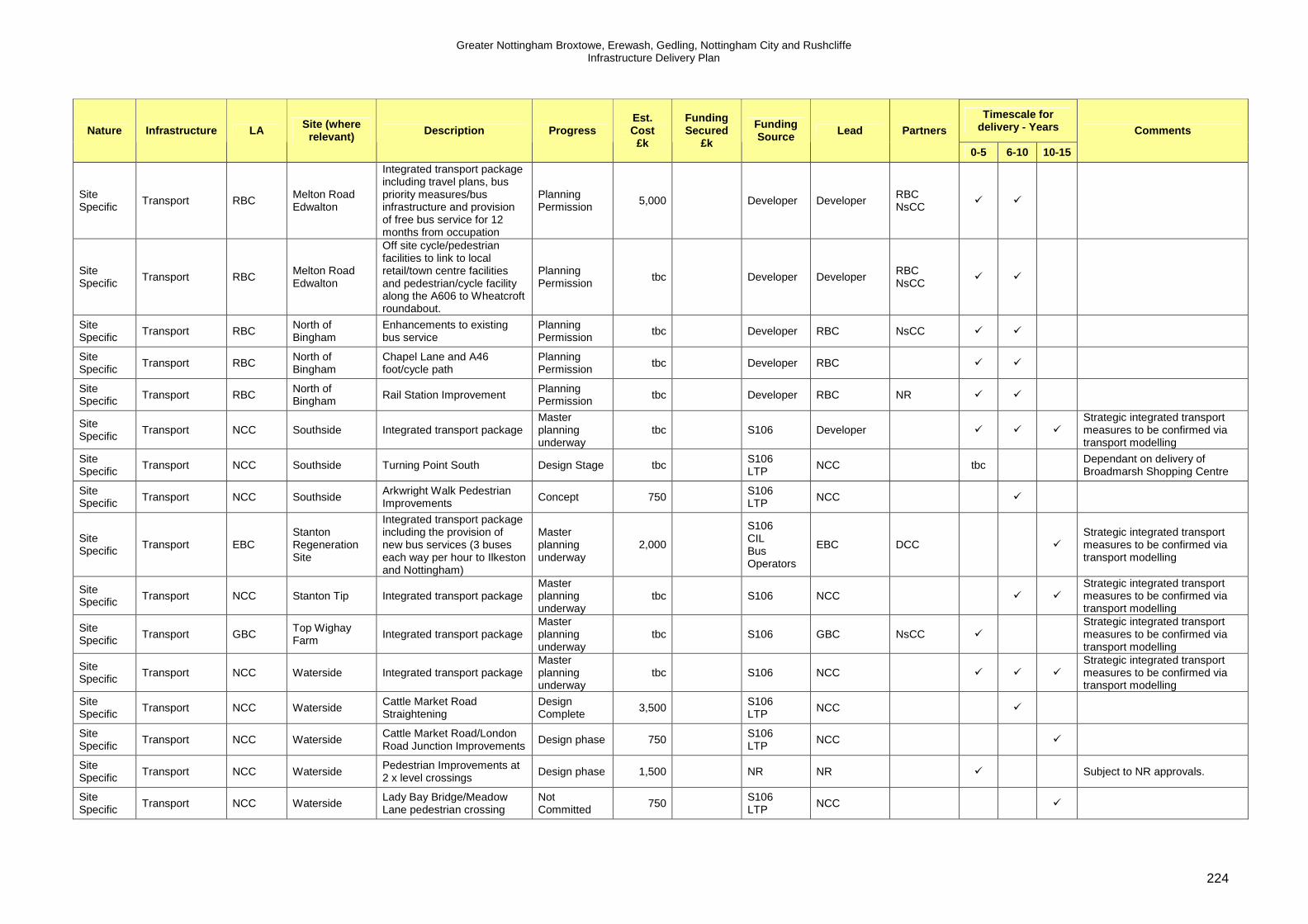
Greater Nottingham Broxtowe, Erewash, Gedling, Nottingham City and Rushcliffe Infrastructure Delivery Plan
224
Timescale for delivery - Years Nature Infrastructure LA Site (where
relevant) Description Progress Est. Cost
£k
Funding Secured
£k
Funding Source Lead Partners
0-5 6-10 10-15
Comments
Site Specific
Transport RBC Melton Road Edwalton
Integrated transport package including travel plans, bus priority measures/bus infrastructure and provision of free bus service for 12 months from occupation
Planning Permission
5,000 Developer Developer RBC NsCC
� �
Site Specific
Transport RBC Melton Road Edwalton
Off site cycle/pedestrian facilities to link to local retail/town centre facilities and pedestrian/cycle facility along the A606 to Wheatcroft roundabout.
Planning Permission
tbc Developer Developer RBC NsCC
� �
Site Specific
Transport RBC North of Bingham
Enhancements to existing bus service
Planning Permission
tbc Developer RBC NsCC � �
Site Specific
Transport RBC North of Bingham
Chapel Lane and A46 foot/cycle path
Planning Permission
tbc Developer RBC � �
Site Specific Transport RBC
North of Bingham Rail Station Improvement
Planning Permission tbc Developer RBC NR � �
Site Specific
Transport NCC Southside Integrated transport package Master planning underway
tbc S106 Developer � � �
Strategic integrated transport measures to be confirmed via transport modelling
Site Specific
Transport NCC Southside Turning Point South Design Stage tbc S106 LTP
NCC tbc Dependant on delivery of Broadmarsh Shopping Centre
Site Specific Transport NCC Southside
Arkwright Walk Pedestrian Improvements Concept 750
S106 LTP NCC �
Site Specific
Transport EBC Stanton Regeneration Site
Integrated transport package including the provision of new bus services (3 buses each way per hour to Ilkeston and Nottingham)
Master planning underway
2,000
S106 CIL Bus Operators
EBC DCC �
Strategic integrated transport measures to be confirmed via transport modelling
Site Specific Transport NCC Stanton Tip Integrated transport package
Master planning underway
tbc S106 NCC � �
Strategic integrated transport measures to be confirmed via transport modelling
Site Specific
Transport GBC Top Wighay Farm
Integrated transport package Master planning underway
tbc S106 GBC NsCC � Strategic integrated transport measures to be confirmed via transport modelling
Site Specific
Transport NCC Waterside Integrated transport package Master planning underway
tbc S106 NCC � � �
Strategic integrated transport measures to be confirmed via transport modelling
Site Specific
Transport NCC Waterside Cattle Market Road Straightening
Design Complete
3,500 S106 LTP
NCC �
Site Specific
Transport NCC Waterside Cattle Market Road/London Road Junction Improvements
Design phase 750 S106 LTP
NCC �
Site Specific
Transport NCC Waterside Pedestrian Improvements at 2 x level crossings
Design phase 1,500 NR NR � Subject to NR approvals.
Site Specific
Transport NCC Waterside Lady Bay Bridge/Meadow Lane pedestrian crossing
Not Committed
750 S106 LTP
NCC �

Greater Nottingham Broxtowe, Erewash, Gedling, Nottingham City and Rushcliffe Infrastructure Delivery Plan
225
Timescale for delivery - Years Nature Infrastructure LA Site (where
relevant) Description Progress Est. Cost
£k
Funding Secured
£k
Funding Source Lead Partners
0-5 6-10 10-15
Comments
facilities
Site Specific Transport NCC Waterside
North-south cycle route from Sneinton/A612 to river
Not Committed tbc
S106 LTP NCC tbc
Site Specific
Transport NCC Waterside East-west cycle route adjacent to Trent
Master plan complete
tbc Direct provision
Developer � � �
Cycle/pedestrian route to be provided as part of development proposals.
Site Specific
Transport NCC Waterside Neighbourhood centre facilities
Masterplanning underway
tbc Developer Developer � �
Site Specific Transport NCC Waterside
Lady Bay Bridge Walking and Cycling Improvements
Outline Design No Commitment
2,500 S106 LTP NCC NsCC �
Feasibility Completed. Desirable but not essential
Strategic Transport RBC Former RAF Newton
A52 Radcliffe Road/Bingham Road Junction
Planning Permission
60 S106 HA Developer �
Site Specific
Local Services RBC Former Cotgrave Colliery
Contribution to support youth leisure activities and Sports Capacity Scheme
Outline planning permission
30 S106 RBC NsCC �
Site Specific
Local Services RBC Former Cotgrave Colliery
Community facilities and town centre enhancements
Outline planning permission
932 S106 RBC �
Site Specific Local Services RBC
Former Cotgrave Colliery
Cotgrave Town Centre Redevelopment to improve facilities and linkages to Cotgrave and Cotgrave Colliery
Master planning complete
Est 2,500 -
3,000 2,500
HCA Growth Point RBC
RBC
HCA Cotgrave Town Council RSL NRL
�
Site Specific
Local Services RBC Former RAF Newton
Library improvements Planning Permission
111 Developer Developer � �
Site Specific
Local Services RBC Former RAF Newton
Sports Pitch, changing facilities and play areas
Planning Permission
Direct provision
Developer � �
Site Specific Local Services RBC
Former RAF Newton
In/out door leisure facilities and swimming pool improvements
Planning Permission 134 Developer RBC � �
Site Specific
Local Services RBC Melton Road Edwalton
Provision of a community hall within the site (500m2 on a suitable site of 0.32ha with car parking)
Planning Permission
tbc Direct provision
Developer RBC � �
Site Specific
Local Services RBC Melton Road Edwalton
Provision for convenience food stores and other retail units at a community centre location.
Planning Permission
tbc Direct provision
Developer RBC � �

Greater Nottingham Broxtowe, Erewash, Gedling, Nottingham City and Rushcliffe Infrastructure Delivery Plan
226
Timescale for delivery - Years Nature Infrastructure LA Site (where
relevant) Description Progress Est. Cost
£k
Funding Secured
£k
Funding Source Lead Partners
0-5 6-10 10-15
Comments
Site Specific
Local Services RBC Melton Road Edwalton
Financial contribution toward the upgrading of the existing leisure facilities at Rushcliffe School or alternative leisure facilities to serve local residents
Planning Permission
tbc S106 RBC � �
Site Specific
Local Services RBC East Leake Expansion of GP facilities. Not yet begun 306 S106 Developer CCG � �
Site Specific
Local Services BBC Field Farm Contribution to local health centre
Resolution to grant Planning Permission
427 S106 BBC CCG �
Site Specific
Local Services BBC
Land in vicinity of proposed of HS2 Station. Toton
Land within site for health facilities
Planning Application
tbc Developer BBC CCG
� � Progression of site (including scale) dependant on future decisions on HS2.
Site Specific
Local Services RBC Former RAF Newton
Contribution to East Bridgford and Radcliffe Health Centres
Planning Permission
506 S106 Developer CCG � �
Site Specific
Local Services GBC Gedling Colliery Health Centre Master planning underway
tbc tbc GBC CCG �
Detailed requirements to be confirmed following further consultation CCG
Site Specific
Local Services RBC Melton Road Edwalton
Site of 0.7ha within the development site to be reserved for healthcare provision. Healthcare contribution for West Brigford ward to be made prior to the occupation of any dwellings.
Planning Permission
1,104 S106 RBC CCG � �
Site Specific
Local Services RBC North of Bingham
Contribution to health centre Planning Permission
tbc S106 RBC CCG � �
Site Specific Local Services GBC
North of Papplewick Lane
Contribution to local health centre
Master planning underway
tbc S106 GBC CCG � Detailed requirements to be confirmed following further consultation CCG
Site Specific
Local Services RBC Radcliffe Expansion of GP facilities. Not yet begun 238 S106 Developer CCG � �
Site Specific
Local Services GBC Top Wighay Farm
GP Surgery Master planning underway
tbc S106 GBC CCG � Detailed requirements to be confirmed by CCG
Site Specific
Local Services RBC Land South of Clifton
Provision of health services on site
Master planning underway
2,900 S106 Developer CCG � �
Site Specific
Local Services EBC Stanton Regeneration Site
Possible expansion of existing GP facilities
Master planning underway
tbc S106 Developer CCG � �
Site Specific
Local Services EBC
Ilkeston/Long EastonStanton Regeneration Site
Enhanced or replacement community hall(s)
No Commitment
1,000 S106 CIL
EBC � � �

Greater Nottingham Broxtowe, Erewash, Gedling, Nottingham City and Rushcliffe Infrastructure Delivery Plan
227
Timescale for delivery - Years Nature Infrastructure LA Site (where
relevant) Description Progress Est. Cost
£k
Funding Secured
£k
Funding Source Lead Partners
0-5 6-10 10-15
Comments
Site Specific
Local Services NCC Stanton Tip Provision of local scale retail uses on site
Master planning underway
tbc S106 Developer NCC � �
Site Specific Local Services NCC Waterside Expansion of GP facilities.
Master planning underway
tbc S106 Developer CCG � � Short term capacity within existing facilities.
Site Specific
Green Infrastructure
NCC Eastside Waterside
Sneinton Greenway Not Committed
250 S106 LTP
NCC �
Site Specific
Green Infrastructure
BBC Field Farm Provision of 2 full football pitches and pavilion plus maintenance contribution
Resolution to grant Planning Permission
1,411 S106 and direct provision
Developer BBC
�
Site Specific
Green Infrastructure
BBC
Land in vicinity of proposed HS2 Station, Toton
New on site green infrastructure and swales
Planning Application
tbc Direct provision
Developer � � Progression of site (including scale) dependant on future decisions on HS2
Site Specific
Green Infrastructure
RBC Former Cotgrave Colliery
Cotgrave County Park Cycle path and canal towpath improvements
Outline planning permission
153 S106 HCA RBC NsCC
� �
Regeneration of site led by HCA. HCA contribution to scheme to be negotiated with development partner as part of land receipt.
Site Specific
Green Infrastructure
RBC Former Cotgrave Colliery
Direct provision of habitat replacement/enhancement including plus ecology contribution for Cotgrave Country park
Outline planning permission
20 Direct provision S106
HCA RBC NsCC
� �
Regeneration of site led by HCA. HCA contribution to scheme to be negotiated with development partner as part of land receipt.
Site Specific
Green Infrastructure
RBC Former Cotgrave Colliery
Country Park connectivity and safety improvements.
Outline planning permission
105 S106 HCA RBC NsCC
� �
Regeneration of site led by HCA. HCA contribution to scheme to be negotiated with development partner as part of land receipt.
Site Specific
Green Infrastructure
RBC Former Cotgrave Colliery
Cotgrave Country Park Habitat and Access Enhancements
Underway 385 385 NsCC Growth Point
NsCC � �
Site Specific
Green Infrastructure
RBC Former Cotgrave Colliery
Direct provision of open space including 0.35ha orchard land, 0.2 ha play area and equipment, 0.36ha allotment provision and maintenance contribution,SUDs and car park
Master planning complete
Direct provision S106
Developer RBC NsCC
� �
Regeneration of site led by HCA. HCA contribution to scheme to be negotiated with development partner as part of land receipt.
Site Specific
Green Infrastructure
RBC Melton Road Edwalton
Sharphill woods enhancement, habitat creation and management plan, direct provision of landscape buffers, country park and open space and play areas and contributions to future maintenance (only
Planning Permission
60 S106 Direct Provision
RBC Developer
� �
Regeneration of site led by HCA. HCA contribution to scheme to be negotiated with development partner as part of land receipt.

Greater Nottingham Broxtowe, Erewash, Gedling, Nottingham City and Rushcliffe Infrastructure Delivery Plan
228
Timescale for delivery - Years Nature Infrastructure LA Site (where
relevant) Description Progress Est. Cost
£k
Funding Secured
£k
Funding Source Lead Partners
0-5 6-10 10-15
Comments
maintenance cost included in schedule)
Site Specific
Green Infrastructure
RBC North of Bingham
Provision of 4.9a community park at Parson's Hill , 6.8ha amenity space, GI corridor along Car Dyke and maintenance contribution
Planning Permission
tbc S106 RBC � �
Site Specific
Green Infrastructure
GBC North of Papplewick Lane
1.6ha Public Open Space and maintenance contribution
Master planning underway
tbc Direct Provision and S106
GBC �
Site Specific
Emergency Services RBC
Land South of Clifton
Possible new police station but subject to review
Master planning underway
680 S106 Developer � � Requirements to be confirmed as Estates Strategy confirmed.
Site Specific
Emergency Services
RBC Land South of Clifton
Possible new fire station but subject to review
Master planning underway
2,500 S106 Developer � � Requirements to be confirmed as Estates Strategy confirmed.
Site Specific
Education BBC Awsworth Expansion of existing primary schools
Not yet begun 842 S106 NsCC � �
Site Specific
Education BBC Awsworth Expansion of existing secondary schools
Not yet begun 967 S106 NsCC � �
Site Specific
Education GBC Bestwood Village
Possible new primary school Not yet begun 5,000 S106 GBC NsCC � �
Site Specific
Education GBC Bestwood Village
Expansion of secondary places
Not yet begun 1,600 S106 GBC NsCC � �
Site Specific
Education BBC NCC
Boots Expansion of GP facilities. Master planning underway
tbc tbc S106 Developer
Alliance Boots, NCC, BBC, LEP
�
Site Specific Education NCC Boots 2 form entry primary school
Master planning underway
3,650 tbc Developer
Alliance Boots, NCC, BBC, LEP
�
Indicative costs for education provided on basis of current multiplier and split between LA's on basis of housing numbers. Detailed assessment not yet possible as delivery timescale outside of reliable timescale for pupil projection forecasts
Site Specific
Education BBC Boots 2 form entry primary school Master planning underway
3,340 tbc Developer
Alliance Boots, NCC, BBC, LEP
�
Indicative costs for education provided on basis of current multiplier and split between LA's on basis of housing numbers. Detailed assessment not yet possible as delivery timescale outside of reliable timescale for pupil projection forecasts

Greater Nottingham Broxtowe, Erewash, Gedling, Nottingham City and Rushcliffe Infrastructure Delivery Plan
229
Timescale for delivery - Years Nature Infrastructure LA Site (where
relevant) Description Progress Est. Cost
£k
Funding Secured
£k
Funding Source Lead Partners
0-5 6-10 10-15
Comments
Site Specific
Education BBC Boots Secondary school places contribution
Master planning underway
1,500 tbc Developer
Alliance Boots, NCC, BBC, LEP
�
Indicative costs for education provided on basis of current multiplier and split between LA's on basis of housing numbers. Detailed assessment not yet possible as delivery timescale outside of reliable timescale for pupil projection forecasts
Site Specific
Education NCC Boots Secondary school places contribution
Master planning underway
1,800 tbc Developer
Alliance Boots, NCC, BBC, LEP
�
Indicative costs for education provided on basis of current multiplier and split between LA's on basis of housing numbers. Detailed assessment not yet possible as delivery timescale outside of reliable timescale for pupil projection forecasts
Site Specific Education BBC
Land in vicinity of proposed HS2 Station, Toton
New primary school and extended secondary school
Planning Application tbc Developer NsCC � �
Progression of site (including scale) dependant on future decisions on HS2. Further assessment of education required as details confirmed
Site Specific
Education BBC Brinsley Expansion of existing primary schools
Not yet begun 481 S106 NsCC � �
Site Specific
Education BBC Brinsley Expansion of existing secondary schools
Not yet begun 552 S106 NsCC � �
Site Specific
Education GBC Calverton Possible expansion of existing schools or new primary may be required
Not yet begun 3,600-5,500
S106 GBC NsCC � �
Site Specific
Education GBC Calverton Expansion of secondary places
Not yet begun 3,600 S106 GBC NsCC � �
Site Specific
Education NCC Cumulative non strategic sites
Primary School Places Contribution
To be determined via DPD
2,690 Developers NCC � � �
Indicative costs are provided for school places generated from non strategic housing sites over the plan period on the basis of current multiplier. Detailed requirements to be confirmed in parallel with DPDs and detailed site proposals.
Site Specific
Education BBC Cumulative non strategic sites
Primary School Places Contribution
To be determined via DPD
6,200 S106 BBC NsCC � � �
Indicative costs are provided for school places generated from non strategic housing sites over the plan period on the basis of current multiplier. Detailed requirements to be confirmed in parallel with DPDs and detailed site proposals.

Greater Nottingham Broxtowe, Erewash, Gedling, Nottingham City and Rushcliffe Infrastructure Delivery Plan
230
Timescale for delivery - Years Nature Infrastructure LA Site (where
relevant) Description Progress Est. Cost
£k
Funding Secured
£k
Funding Source Lead Partners
0-5 6-10 10-15
Comments
Site Specific
Education BBC Cumulative non strategic sites
Secondary school places contribution
To be determined via DPD
7,100 S106 BBC NsCC � � �
Indicative costs are provided for school places generated from non strategic housing sites over the plan period on the basis of current multiplier. Detailed requirements to be confirmed in parallel with DPDs and detailed site proposals.
Site Specific
Education EBC Cumulative non strategic sites
Primary School Places Contribution
To be determined via DPD
8,500 S106 EBC DCC � � �
Indicative costs are provided for school places generated from non strategic housing sites over the plan period on the basis of current multiplier. Detailed requirements to be confirmed in parallel with DPDs and detailed site proposals.
Site Specific Education GBC
Cumulative non strategic sites
Primary School Places Contribution
To be determined via DPD
7,500 S106 GBC NsCC � � �
Indicative costs are provided for school places generated from non strategic housing sites over the plan period on the basis of current multiplier. Detailed requirements to be confirmed in parallel with DPDs and detailed site proposals.
Site Specific
Education GBC Cumulative non strategic sites
Secondary school places contribution
To be determined via DPD
8,600 S106 GBC NsCC � � �
Indicative costs are provided for school places generated from non strategic housing sites over the plan period on the basis of current multiplier. Detailed requirements to be confirmed in parallel with DPDs and detailed site proposals.
Site Specific
Education RBC Cumulative non strategic sites
Primary School Places Contribution
To be determined via DPD
5,200 S106 RBC NsCC � � �
Indicative costs are provided for school places generated from non strategic housing sites over the plan period on the basis of current multiplier. Detailed requirements to be confirmed in parallel with DPDs and detailed site proposals.
Site Specific
Education RBC Cumulative non strategic sites
Secondary school places contribution
To be determined via DPD
6,000 S106 RBC NsCC � � �
Indicative costs are provided for school places generated from non strategic housing sites over the plan period on the basis of current multiplier. Detailed requirements to be confirmed in parallel with DPDs and detailed site proposals.
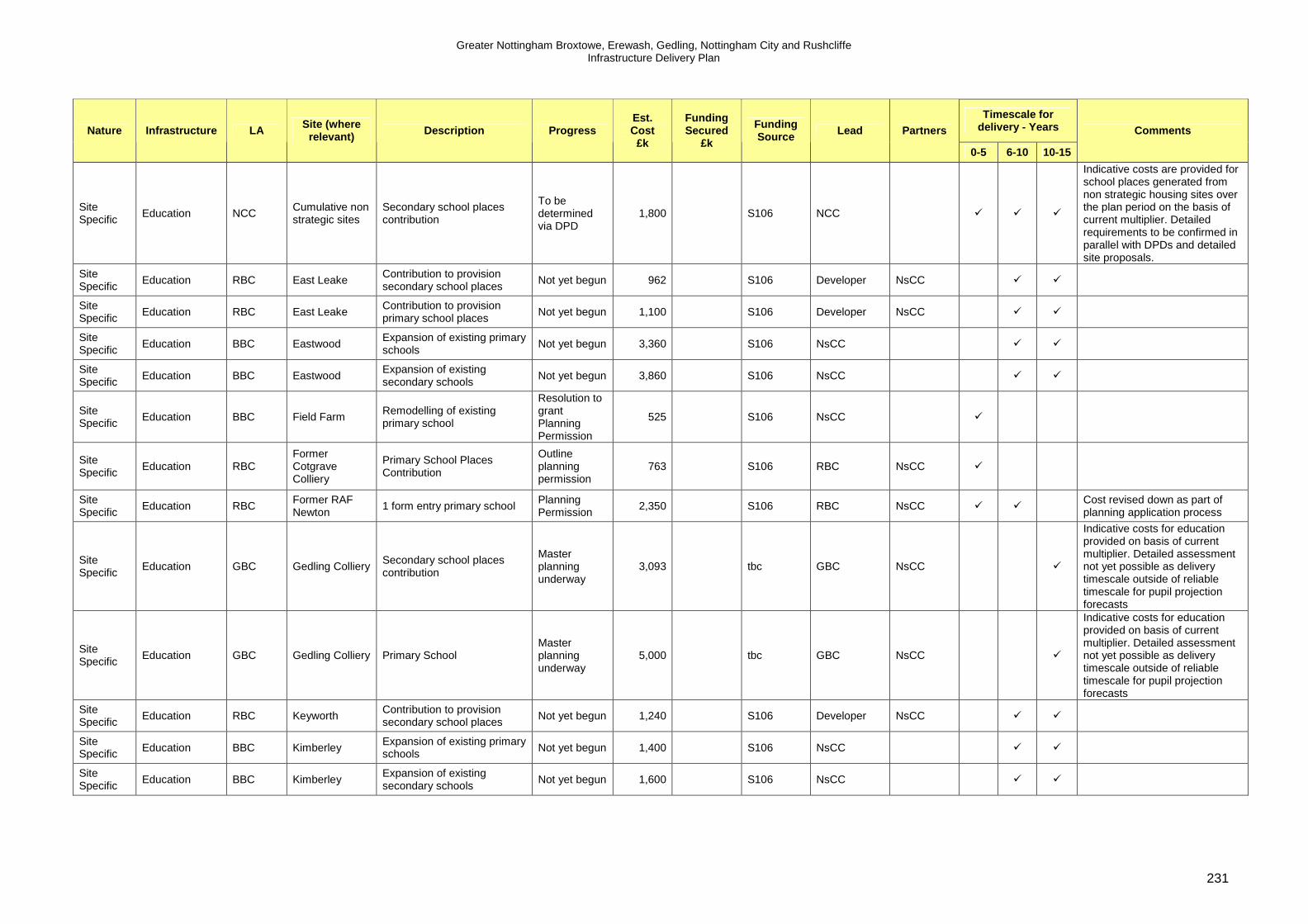
Greater Nottingham Broxtowe, Erewash, Gedling, Nottingham City and Rushcliffe Infrastructure Delivery Plan
231
Timescale for delivery - Years Nature Infrastructure LA Site (where
relevant) Description Progress Est. Cost
£k
Funding Secured
£k
Funding Source Lead Partners
0-5 6-10 10-15
Comments
Site Specific
Education NCC Cumulative non strategic sites
Secondary school places contribution
To be determined via DPD
1,800 S106 NCC � � �
Indicative costs are provided for school places generated from non strategic housing sites over the plan period on the basis of current multiplier. Detailed requirements to be confirmed in parallel with DPDs and detailed site proposals.
Site Specific
Education RBC East Leake Contribution to provision secondary school places
Not yet begun 962 S106 Developer NsCC � �
Site Specific
Education RBC East Leake Contribution to provision primary school places
Not yet begun 1,100 S106 Developer NsCC � �
Site Specific
Education BBC Eastwood Expansion of existing primary schools
Not yet begun 3,360 S106 NsCC � �
Site Specific
Education BBC Eastwood Expansion of existing secondary schools
Not yet begun 3,860 S106 NsCC � �
Site Specific
Education BBC Field Farm Remodelling of existing primary school
Resolution to grant Planning Permission
525 S106 NsCC �
Site Specific
Education RBC Former Cotgrave Colliery
Primary School Places Contribution
Outline planning permission
763 S106 RBC NsCC �
Site Specific
Education RBC Former RAF Newton
1 form entry primary school Planning Permission
2,350 S106 RBC NsCC � � Cost revised down as part of planning application process
Site Specific
Education GBC Gedling Colliery Secondary school places contribution
Master planning underway
3,093 tbc GBC NsCC �
Indicative costs for education provided on basis of current multiplier. Detailed assessment not yet possible as delivery timescale outside of reliable timescale for pupil projection forecasts
Site Specific
Education GBC Gedling Colliery Primary School Master planning underway
5,000 tbc GBC NsCC �
Indicative costs for education provided on basis of current multiplier. Detailed assessment not yet possible as delivery timescale outside of reliable timescale for pupil projection forecasts
Site Specific
Education RBC Keyworth Contribution to provision secondary school places
Not yet begun 1,240 S106 Developer NsCC � �
Site Specific Education BBC Kimberley
Expansion of existing primary schools Not yet begun 1,400 S106 NsCC � �
Site Specific
Education BBC Kimberley Expansion of existing secondary schools
Not yet begun 1,600 S106 NsCC � �

Greater Nottingham Broxtowe, Erewash, Gedling, Nottingham City and Rushcliffe Infrastructure Delivery Plan
232
Timescale for delivery - Years Nature Infrastructure LA Site (where
relevant) Description Progress Est. Cost
£k
Funding Secured
£k
Funding Source Lead Partners
0-5 6-10 10-15
Comments
Site Specific
Education RBC Land South of Clifton
Secondary school places contribution
Master planning underway
6,900 S106 RBC NsCC � � �
Delivery of site dependant on A453 scheme. Indicative costs for education provided on basis of current multiplier. Detailed assessment not yet possible as delivery timescale outside of reliable timescale for pupil projection forecasts
Site Specific
Education RBC Land South of Clifton
2 x 2 form entry primary schools
Master planning underway
12,000 S106 RBC NsCC � � �
Delivery of site dependant on A453 scheme. Indicative costs for education provided on basis of current multiplier. Detailed assessment not yet possible as delivery timescale outside of reliable timescale for pupil projection forecasts
Site Specific Education RBC
Melton Road Edwalton
Primary School Places Contribution and provision of a fully serviced 1.9ha site for a 1.5 form entry primary school
Planning Permission 3,600 S106 RBC NsCC �
Site Specific
Education RBC Melton Road Edwalton
Secondary school places contribution
Planning Permission
3,300 S106 RBC NsCC �
Site Specific
Education RBC North of Bingham
1 form entry primary school Planning Permission
3,000 S106 RBC NsCC �
Site Specific
Education RBC North of Bingham
Secondary school places contribution
Planning Permission
2,800 S106 RBC NsCC �
Site Specific
Education GBC North of Papplewick Lane
Primary School Master planning underway
5,000 S106 GBC NsCC �
Site Specific
Education GBC North of Papplewick Lane
Secondary school places contribution
Master planning underway
1,657 S106 GBC NsCC �
Site Specific Education RBC Radcliffe
Contribution to provision primary school places Not yet begun 962 S106 Developer NsCC � �
Site Specific
Education RBC Radcliffe Contribution to provision secondary school places
Not yet begun 1,100 S106 Developer NsCC � �
Site Specific
Education GBC Ravenshead Expansion of secondary places
Not yet begun 1,210 S106 GBC NsCC � �
Site Specific Education RBC Ruddington
Contribution to provision primary school places Not yet begun 907 S106 Developer NsCC � �
Site Specific
Education RBC Ruddington Contribution to provision secondary school places
Not yet begun 691 S106 Developer NsCC � �

Greater Nottingham Broxtowe, Erewash, Gedling, Nottingham City and Rushcliffe Infrastructure Delivery Plan
233
Timescale for delivery - Years Nature Infrastructure LA Site (where
relevant) Description Progress Est. Cost
£k
Funding Secured
£k
Funding Source Lead Partners
0-5 6-10 10-15
Comments
Site Specific
Education EBC Stanton Regeneration Site
2 form entry primary school Master planning underway
7,000 S106 Developer �
Phased delivery of school required - 1 form into 2 form primary school in parallel with site development
Site Specific
Education NCC Stanton Tip Primary school places contribution
Master planning underway
1,031 S106 NCC �
Indicative costs for education provided on basis of current multiplier. Detailed assessment not yet possible as delivery timescale outside of reliable timescale for pupil projection forecasts
Site Specific
Education NCC Stanton Tip Secondary school places contribution
Master planning underway
690 S106 NCC � �
Indicative costs for education provided on basis of current multiplier. Detailed assessment not yet possible as delivery timescale outside of reliable timescale for pupil projection forecasts
Site Specific
Education GBC Top Wighay Farm
Secondary school places contribution
Master planning underway
2,760 S105 GBC NsCC �
Site Specific
Education GBC Top Wighay Farm
Primary School Master planning underway
5,000 S106 GBC NsCC �
Site Specific Education NCC Waterside
Primary School Places Contribution
Master plan complete 6,186 S106 NCC � � �
Indicative costs for education provided on basis of current multiplier. Detailed assessment not yet possible as delivery timescale outside of reliable timescale for pupil projection forecasts
Site Specific Education NCC Waterside
Secondary school places contribution
Master plan complete 4,142 S106 NCC � � �
Indicative costs for education provided on basis of current multiplier. Detailed assessment not yet possible as delivery timescale outside of reliable timescale for pupil projection forecasts
Site Specific Waste EBC
Ilkeston/ Stanton Regeneration Site
Contribution to Ilkeston Household Waste Recycling Centre Phase 1
No Commitment 575
S106 CIL DCC EBC tbc

Greater Nottingham Broxtowe, Erewash, Gedling, Nottingham City and Rushcliffe Infrastructure Delivery Plan
234
Abbreviations ADC Ashfield District Council BBC Broxtowe Borough Council CIL Community Infrastructure Levy CCG Clinical Commissioning Group DCC Derbyshire County Council DEFR Department for Environment Food and Rural Affairs DFT Department for Transport EA Environment Agency EBC Erewash Borough Council EMT East Midlands Trains GBC Gedling Borough Council GP Growth Point GPF Growing Places Fund HA Highways Agency HCA Homes and Communities Agency HS2 High Speed Rail 2 LEP Local Enterprise Partnership LA Local Authority LTP Local Transport Plan NR Network Rail NCC Nottingham City Council NRL Nottingham Regeneration Limited NsCC Nottinghamshire County Council PCT Primary Care Trust PFI Private Finance Initiative RBC Rushcliffe Borough Council RHT Railways Heritage Trust RSL Registered Social Landlord S106 Section 106 ST Severn Trent TIF Transport Innovation Fund WPL Work Place Parking Levy

Greater Nottingham Broxtowe, Erewash, Gedling, Nottingham City and Rushcliffe Infrastructure Delivery Plan
235
11. Funding and Complementary Programmes Successful delivery of the Core Strategies and associated infrastructure will rely on funding from a range of sources. The Infrastructure Schedule in Chapter 10 sets out the likely funding sources, lead agencies and estimated timescale for delivery for each element of infrastructure. Inevitably the list of infrastructure requirements will exceed available funding. The schedule identifies critical infrastructure which the councils consider essential to deliver their strategies. Economic conditions are challenging with limits on both public and private resources. The funding sources and investment programmes most relevant to the Core Strategies are set out below. However, there is a need to focus not simply on funding availability, but also on more innovative mechanisms to secure growth and infrastructure - such as the appropriate phasing and timing of infrastructure, delayed land receipts, the use of new finance initiatives such as Growing Places Fund loans, strong partnerships and open book development appraisals at planning application stage to ensure viability and constraints are fully explored. S106 Contributions and Community Infrastructure Lev y Developer contributions are expected to make a significant contribution to delivery of the Core Strategies and it is recognised that Government are encouraging councils to adopt a flexible approach to secure delivery of growth (some local examples of how the councils have achieved this are set out in Section 9). The establishment of a Community Infrastructure Levy has the potential to reflect local differences in viability and provide a greater level of certainty to developers. Gedling Borough Council is one of the Government’s ‘front runners’ in the development of CIL and will be sharing expertise and lessons learned with the local authorities in Greater Nottingham. The councils of Broxtowe, Erewash, Gedling, Nottingham and Rushcliffe intend to take an aligned approach to the consideration of CIL, building on Gedling’s experience and where possible taking a common approach to viability methodology. Viability work associated with CIL preparation will inform and update the IDP. Local Transport Plan, Local Sustainable Transport F und and Work Place Parking Levy. Several major transport schemes are identified as essential to the delivery of the Core Strategies. These are outside the scope of S106 contributions and central Government funding, Local Transport Plan and Work Place Parking Levy contributions have been secured to deliver these schemes. Nottingham City Council introduced a Work Place Parking Levy in April 2012. The Levy places a charge on parking spaces within the City for organisations employing more than 10 people. The levy collected directly supports the provision of public transport in Nottingham, including Lines Two and Three of the Nottingham Express Transit and the Nottingham Midland Station improvements. The Local Transport Plan priorities of the three Highway Authorities are closely aligned to the Core Strategies. Nottingham City Council in collaboration with Derbyshire and Nottinghamshire County Councils has secured £15m from the Local Sustainable Transport Fund (LSTF) aimed at encouraging modal shift away from the car. LSTF directly supports the aims of the Core Strategies and takes a cross boundary integrated approach to promoting sustainable travel. The transport

Greater Nottingham Broxtowe, Erewash, Gedling, Nottingham City and Rushcliffe Infrastructure Delivery Plan
236
modelling study which supports the Core Strategies includes assumptions regarding the impacts of the approved LSTF programme, further Smarter Choices packages and improved public transport services. A conservative approach has been taken to the assumed level of future funding available to support these initiatives which is considered reasonable and achievable over the plan period. However the three transport authorities have an excellent track record of securing and delivering transport schemes and working with developers to implement travel demand initiatives. The Department for Transport (DfT) has consulted local authorities regarding proposals to devolve funding for local major transport schemes (for delivery post 2015) for local determination and has published indicative funding levels for new Local Transport Bodies. It is proposed that both membership of the Board and priorities for spending will be determined locally. The transport authorities are currently working with the D2N2 LEP and partner councils to develop Governance arrangements. For 2015/16 – 2018/19 funding levels of £46.8m for the D2N2 LEP areas have been indicated. Local Authority Main Stream Funding and Assets Although council budgets are under severe pressure, councils do have flexibility in the use of receipts from New Homes Bonus and in the way that council assets are used to secure delivery. Where council holdings form part of development sites, councils may consider delayed or reduced receipts where appropriate. Further flexibility may be provided by new mechanisms associated with business rate income. The IDP provides a platform for co-ordinated investment on a range of services within and across council boundaries. Early dialogue on growth proposals, will enable investment in, for example school places, to be made in timely way and at least cost – blending private sector contributions with existing expansion/improvements plans. Growing Places Funding The Nottinghamshire and Derbyshire Local Enterprise Partnership (D2N2) was allocated approximately £26m by Government to support its strategic priorities. The Partnership has confirmed that a significant proportion of the funding (alongside other funding) will be directed to part of the Nottinghamshire Enterprise Zone at the Boots site which straddles the boundary of Broxtowe District and Nottingham City Councils. Funding will directly support remediation works, site preparation and infrastructure provision on this strategic site. Growth Point The Greater Nottingham area has received approximately £12m from the Growth Point programme. The programme is supporting improvements to town centres, green infrastructure and transport in the IDP area, including a £1m allocation to secure a new station at Ilkeston and support to bring forward smaller non strategic sites.

Greater Nottingham Broxtowe, Erewash, Gedling, Nottingham City and Rushcliffe Infrastructure Delivery Plan
237
City Deal In July 2012, the Government confirmed a £60m ‘City Deal’ to help delver Nottingham’s Growth Plan - a series of proposals to unlock economic growth within Nottingham. The plan supports the City’s Core Strategy objectives via 3 themes:
• Fostering enterprise – focusing on business finances and entrepreneurs, • Developing a skilled workforce – focussing on skills and training, • 21st Century Infrastructure – focussing on digital infrastructure, land and
property and a new ‘Creative Quarter’. Detailed delivery programmes are currently under development Other Funds The councils have a strong track record in bidding for and securing one off ‘challenge’ funds and blending funding streams to maximise outputs (eg European Regional Development Funds). This has been particularly important in progressing economic development schemes - such as Southglade Food park which has recently been awarded European Regional Development Funding with contributions from Nottingham City Council via prudential borrowing. Councils are working closely with partner organisations such as Registered Social Landlords to maximise delivery using public land and with support from the Affordable Homes Programme.

Greater Nottingham Broxtowe, Erewash, Gedling, Nottingham City and Rushcliffe Infrastructure Delivery Plan
238
12. Monitoring and Review The Greater Nottingham Joint Planning Advisory Board steers the development of the Core Strategies and associated activities. Regular progress updates are provided to the Board on the delivery of the Core Strategies and infrastructure schemes. In particular, future reviews will focus on the delivery of critical infrastructure - should this be stalled or delayed with a review of the impact on the Core Strategy and potential mitigation and alternatives. The IDP is a living document and will require further review as more detailed information becomes available from both service providers and developers. In particular, site specific transport modelling information will help refine the IDP along with ongoing dialogue with utilities providers and public sector stakeholders. The plan will also be updated in parallel with preparations for the Community Infrastructure Levy.

Greater Nottingham Broxtowe, Erewash, Gedling, Nottingham City and Rushcliffe Infrastructure Delivery Plan
239
Appendix A - Infrastructure Delivery Plan Consulte es
Infrastructure Category Organisation Lead Contact
All (Derbyshire IDP) Derbyshire County Council Harriet Fisher Utilities Digital Infrastructure BT Open Reach Neil Chamberlain Utilities Digital Infrastructure Nottingham City Council John Connelly Utilities Digital Infrastructure Virgin Media Education Derbyshire County Council Dee Hill Education Nottingham City Council Nick Lees Education Nottinghamshire County Council Lynn Gillhooley Emergency Services Derbyshire Fire and Rescue Service Richard Brunt Emergency Services Derbyshire Police Karl Smethern Emergency Services East Midlands Ambulance Service Dave Winter Emergency Services Nottinghamshire Fire and Rescue Service Craig Parkin Emergency Services Nottinghamshire Police Tim Wendels Flooding and Flood Risk Environment Agency Naomi Doughty Green Infrastructure Natural England Elizabeth Newman Health and Local Services NHS Derbyshire David Beardow Health and Local Services NHS Nottingham City John Wilcox Health and Local Services NHS Nottinghamshire James Bray Transport Derbyshire County Council Geoff Blissett Transport East Midlands Trains David Horne Transport Highways Agency Kamaljit Khokhar Transport Network Rail Spencer Gibbens Transport Nottingham City Transport David Astill Transport Nottingham Express Transit Chris Deas Transport Nottinghamshire County Council Jim Bamford Transport Trent and Barton Keith Shayshutt Transport Nottingham City Council David Jones Transport Nottinghamshire County Council David Pick Utilities and Flooding Severn Trent Water Peter Davies Utilities Energy British Gas Nigel Morgan Utilities Energy National Grid Damien Holdstock Utilities Energy Western Power Gurpal Singh Waste Broxtowe Borough Council Paul Syson Waste Gedling Borough Council Caroline McKenzie Waste Nottingham City Council Antony Greener Waste Nottinghamshire County Council Helen Lester Waste Rushcliffe Borough Council Darryl Burch
Notes: The IDP has also been informed by ongoing dialogue on the councils Core Strategies and formal consultation responses

Greater Nottingham Broxtowe, Erewash, Gedling, Nottingham City and Rushcliffe Infrastructure Delivery Plan
240
Appendix B
Greater Nottingham Core Strategies
Viability Testing of Development Sites
June 2012

Greater Nottingham Broxtowe, Erewash, Gedling, Nottingham City and Rushcliffe Infrastructure Delivery Plan
241
Greater Nottingham Core Strategies
Viability Testing of Development Sites June 2012
1.0 Introduction The Councils of Broxtowe, Erewash, Gedling, Rushcliffe and Nottingham are collaborating on the preparation of Core Strategies which set out long term spatial policies for Greater Nottingham up to 2028, (2025 for Rushcliffe). To support the Core Strategies an Infrastructure Delivery Plan (IDP) is under preparation which sets out infrastructure constraints and requirements. Nottingham Regeneration Limited has been commissioned by the Growth Point Team on behalf of the Councils to:
1. Undertake broad brush viability assessments for sites which are expected to come forward within the first 5 years of the plan,
2. Apply appropriate sensitivity analysis to the assessments in order to take account of the potential long term nature of the proposals and the need to deal with the potential/likely variations in market conditions.
The study is a strategic level assessment of the various proposals to inform the Councils as to whether the emerging proposals are either viable in the current market conditions, or have a reasonable prospect of becoming viable in the longer term under different but not unrealistic assumptions about future market conditions. This study is not intended, nor should it be used, as a basis for any individual case being considered in relation to a planning application. The assessments are indicative only and do not replace detailed appraisals informed by for example transport impact assessments and intrusive works which would normally be undertaken by developers. Assessments have been undertaken for the following sites included in the Councils’ Core Strategies as likely to commence in the first 5 years of the plan: Broxtowe - Field Farm Gedling - North of Papplewick Lane - Top Wighay Rushcliffe- South of Clifton - North of Bingham - RAF Newton - Edwalton - Cotgrave Colliery 2.0 Approach to Appraisals As discussed above the purpose of this piece of work is to provide high level indicative development appraisals to inform planning policy; in particular where it can reasonably assumed that the site is deliverable. The sites are large and could accommodate significant numbers of residential units; which in some cases may take in excess of 10 years to be built out. At this strategic stage comprehensive site information and costings are not available for each site and a number of assumptions

Greater Nottingham Broxtowe, Erewash, Gedling, Nottingham City and Rushcliffe Infrastructure Delivery Plan
242
have been made in order to undertake the appraisals. Some assumptions are site specific whereas as others apply across the board. The viability assessment adopted for each site was on the basis of a residual land appraisal calculated using a bespoke development appraisal toolkit with sensitivity capabilities. Development appraisals are in essence relatively straightforward and can be illustrated by the following equation:
Development costs include known section 106 costs and contributions. Development appraisals can take many different forms and there is no set professional code of conduct for development appraisal and the assessment of development viability. Most developers will prepare development appraisals using computer software packages, e.g. Circle Developer and Pro-Dev. Public agencies have access to bespoke systems such as the HCA Housing Model or the Three Dragons Model. For the purpose of this piece of the work the Three Dragons appraisal model has been selected. The model has built in default values for each local authority area for example for house prices, affordable rental values and build costs. These figures were set at the model’s base date in 2008 and have therefore been reviewed against current market conditions and over ridden as necessary. The lengthy development periods expected adds complications. For the purposes of this exercise a discounted cashflow approach has not been adopted due to the difficulties of setting assumptions for the appraisals with respect to decisions in respect of future house price performance and inflation levels. Appraisals have therefore been carried out at a specific point in time. The following assumptions indicate how figures have been applied to the appraisals. 3.0 Residential Assumptions The unit numbers and mix for each site have been agreed with planning officers from the relevant authorities so as to meet all aspects of present planning policy whilst providing a commercial mix appropriate for the local market. Where house type mix is not yet available the assessment uses a mix of dwelling types deemed appropriate for that particular site.
Completed Development Value
Less
Development Costs
(Construction + Fees + Finance+ Developers Profit)
Equals
Residual Land Value

Greater Nottingham Broxtowe, Erewash, Gedling, Nottingham City and Rushcliffe Infrastructure Delivery Plan
243
The property sizes tested have been derived from Three Dragons model and are as follows including the average bed spaces per property type as set out overleaf:
Size – Sq m Type
Market Affordable
Bed Spaces
2 Bed flat 60 67 3 2 Bed bungalow 65 76 4 2 Bed terrace 65 76 4 2 Bed semi 70 80 4 3 Bed terrace 80 86 4 3 Bed semi 90 86 5 3 Bed detached 120 86 5 4 Bed detached 150 101 7 5 Bed detached 160 110 9
It is recognised that the eventual developers of each site will form their own views on what the appropriate unit type, mix and size are but, for the purposes of consistency, the unit types detailed above have been assessed across both the affordable and private tenure homes. Affordable Housing The appraisals assume that there will be a requirement to provide affordable housing on each site. The basis of assessment is in accordance with each Council’s affordable housing policy or practice i.e. Gedling 30% Broxtowe 30% Rushcliffe 30%
The split between discount buy/intermediate rent and social rent is as advised by the relevant authority and therefore varies between sites as detailed on the attached site proformas. Where no indication was given the assumptions adopted have been recorded. The mix of affordable unit types is assumed to be proportional to the market housing mix.
The shared equity tenure homes have been assessed reflecting an initial purchase of 50% equity with rental on the balance, whilst the social rented were assessed having regard to the model’s default rents and an initial capitalisation yield of 6.75% adjusted to reflect normal RSL’s costs to include management, repairs, voids/bad debts, risk etc. It is assumed that the affordable housing will be sold by a developer to an RSL. Taking into account the above we have assumed that an RSL could reasonably be expected to pay a Developer an average of 21% of market value for social rented and 25% discount market housing in the current market. It should be noted that the affordable rent housing is not included in the Three Dragons Model and has therefore not been appraised. There is currently limited evidence available for this housing type, however rents are higher and therefore values would be higher. This would have a positive effect on the viability of the appraisals. Each of the assessed sites assumes that no Social Housing Grant would be offered in support of the development of the affordable housing.

Greater Nottingham Broxtowe, Erewash, Gedling, Nottingham City and Rushcliffe Infrastructure Delivery Plan
244
4.0 Commercial Assumptions The assumptions in respect of floor area for commercial development differ for each site and are as detailed on the attached proformas. Where no indication of floorspace has been provided, estimates have been made on the following basis: It should be noted that the commercial elements are valued as if 100% of the available area is developed. No assessments have been undertaken in respect of market supply and demand. 5.0 Developer Contributions Planning officers have advised in respect of the likely Section 106 contributions with regard to each site and these are detailed in the individual site pro forma at the end of this report. They are based on the individual council’s developer contributions guidance, policy and information from the Infrastructure Delivery Plan where relevant. The assessments are indicative and actual contributions will be negotiated with Local Authorities depending on the details of actual schemes submitted and issues such as the capacity of services such as public transport and schools when an application for planning consent is submitted. 6.0 Development Costs 6.1 Construction Costs – Base date 3rd Quarter 2011 Based on research a current price per square metre for construction costs on residential and commercial development in greater Nottingham area has been established. For the residential costs it is assumed that the costs of affordable housing are unlikely to differ significantly from those used for the market housing. For the purposes of the residential appraisals, it was decided to adopt the default figures in the Model. Whilst it is recognised that these figures were set some three years ago, tender prices have remained competitive and it is therefore considered that these remain valid i.e. ≤ 75 sq m £875/sq m > 75 sq m £760/sq m For the commercial costs research results costs have been cross checked against those adopted by Gleeds Cost Consultants in the Newark and Sherwood CIL Viability Study. The figures are set out below and indicate the mid point figure adopted in the appraisals.
Type of Employment Use % site coverage
No of floors
B1a Office 35% 2 B2/B8 General Industrial/Warehouse
35% 1

Greater Nottingham Broxtowe, Erewash, Gedling, Nottingham City and Rushcliffe Infrastructure Delivery Plan
245
£/sq m Type Research7 Gleeds Adopted figs
B1a offices 1000 1270 1100 B2/B8 industrial 483 400 450
All costs figures adopted include an allowance for a range of external costs – roads, drainage and services within the site and parking, footpaths, landscaping and other external costs. The Core Strategies include policies which encourage carbon reduction, increased water efficiency and reduced flooding/surface water flooding. An additional £6,000 per unit has been added to the residential build costs for both Private and Affordable housing to reflect the additional cost of these measures. This £6,000 per dwelling is intended to reflect the extra over costs of achieving a level 4 credit rating as adopted in the Code for Sustainable Homes. An updated report for DCLG 8; the Cost of Building to the Code for Sustainable Homes (Aug 2011), indicates that the average additional cost of building to Code 4 is £7,418 and £4,154 to Code 3. £6,000 has therefore been adopted as a midway point to reflect the fact average base building costs quoted above will include some if not all elements of Code 3. 6.2 Abnormal development costs Detailed information in respect of these elements is not available. Therefore where the information provided indicates that exceptional or abnormal costs could arise on some sites, a broad estimate of the likely scale of abnormal costs for each site has been provided. Typically, abnormal costs would constitute items such as unusual site levelling, additional foundation costs where ground conditions are poor, cost of remediation for contaminated sites, etc. Cost assumptions have been informed by information collated as part of the Infrastructure Delivery Plan. We have not undertaken investigations regarding the availability and capacity of existing utility services, which was considered to be beyond the scope of this study. We have, therefore, assumed that such services are available and adequate for each of the sites. It may be that when discussions take place on actual sites, in the future, that provision of services will be an ‘abnormal’ cost (if such services are not readily available or require significant infrastructure contributions) and will need to be reflected in the viability of the particular site under consideration. 6.3 Infrastructure Costs An assessment has been made, following advice from the Council, as to the infrastructure required for each site and the necessary costs. A detailed assessment for each site has been made and included in the relevant section of this report.
7 www.davislangdon.com/upload/StaticFiles/EME%20Publications/CostModels/SmallProjects_CM_Mar10.pdf www.ayh.com/Content/ArcadisUK/docs/Buildings_cost_guide_A4_vfinalFeb2011.pdf 8 http://www.communities.gov.uk/documents/planningandbuilding/pdf/1972728.pdf

Greater Nottingham Broxtowe, Erewash, Gedling, Nottingham City and Rushcliffe Infrastructure Delivery Plan
246
7.0 Development Values 7.1 Residential A decade of positive house price growth came to a dramatic end in late 2007 when growth turned negative for almost twenty four consecutive months. The driver of this decline was the meltdown in credit markets and the subsequent banking crisis which caused a peak to trough fall of approximately 17% (£183,862 [Nov 07] to £152,736 [Apr 09]) on average house prices across England and Wales. Since that time the recovery in the housing market has been fragile with values still well below their peak. With the threat of the UK economy re-entering recession there is likely to be further downward pressure on house prices. Local sales information for the Greater Nottingham area has been sourced from Land Registry data using sold prices collated for the last two years for the postcodes in which the selected sites are situated.9 The graphs below summarise the information gathered. The source data is included at Appendix 1.
9 The housing has been valued using values established from the comparable evidence available for the locality.
No allowance has been made for any potential future uplift in values which may occur due to the new
development itself. The sensitivity tables, however, indicate the result of an uplift in values of 5 and 10 percent
and can therefore be used to gauge the potential effect that the creation of a micromarket might have.

Greater Nottingham Broxtowe, Erewash, Gedling, Nottingham City and Rushcliffe Infrastructure Delivery Plan
247

Greater Nottingham Broxtowe, Erewash, Gedling, Nottingham City and Rushcliffe Infrastructure Delivery Plan
248
7.2 Commercial Where applicable, commercial rental values have been established by reference to asking rents for properties currently on offer on the open market in the vicinity of the sites. Appendix 2 provides a summary of the information used. The capitalisation rates adopted are as follows: B1 office 8.5% B2/B8 industrial 9.5- 10% 8.0 Land Values In order to assess development viability, the appropriate starting point is an analysis of current and alternative use values. Current use values reflect the value of the land in its current state, for example as agricultural land. Alternative use value refers to any potential use for the site. For example a brownfield site may have an alternative use as industrial land. All sites have therefore, been assessed on the basis of the residual land value that the assumed scheme can support compared to the existing use value for the site. It is recognised that for some greenfield sites and occasionally other sites may develop an element of ‘hope value’ particularly in the eyes of the owner. This is a matter that should be taken into account in due course when a ‘real’ acquisition and disposal is taking place. In order to assess viability the value of the land for the assumed residential scheme has been compared to the existing use value, to determine if there is another use which would derive more revenue for the landowner. If the assessed value does not exceed the alternative use value, then the development will not proceed. There is little evidence, due to the current state of the market, as to current land values but it is well established that site values for residential have fallen by 50% from the peak. Although evidence is limited anecdotal evidence of asking prices suggests that landowners’ price aspirations remain firm. Whilst there is some greater flexibility market research suggests that distressed landowning vendors are rare and most of the major land-holders are content to “land bank” their sites and await an improvement in the property and wider economic climate. Average suburban land values in Nottingham are reported in the Valuation Office Property Market Report 201110 as being in the region of £1.2m/ha (for small sites of less than 5 hectares with planning consent). Land values for the larger sites will be lower and will be dependent on the services required but could be approximately 1,000,000 to 1,100,000/ha. This will vary according to location and can be adjusted in the light of any new evidence coming forward.
10
http://www.voa.gov.uk/dvs/propertyMarketReport/pmrJan2011.html

Greater Nottingham Broxtowe, Erewash, Gedling, Nottingham City and Rushcliffe Infrastructure Delivery Plan
249
The land values adopted reflect an opinion of the level required for the land to be released onto the market for development. The appraisals are based on current market conditions, with the affordable housing requirements, assuming the land is acquired at the date of valuation. Establishing the level at which a landowner would ‘release’ development land is subjective. Factors that could be taken into account include individual circumstances (including tax liability), expectations about changes in Government policy with regard to CIL, s106 and affordable housing delivery; opinion on the present and future trend in land values. The general view is that landowners accept the need to reflect affordable housing and section 106/ infrastructure expenses in the land value they receive whilst there is a general level of value for development land. In reality this varies depending on the circumstances of each site including the differing costs of developing the sites and providing the necessary infrastructure. Estimates for site value for other uses are as follows. Employment Sites (cleared) £400,000 to £500,000 per ha Garden land (previously developed status) £250,000 to £300,000 per ha As noted above these can only be general guidelines because of the need to take account of the circumstances of each site. In relation to sites with no previous history of development, it should be noted that the existing use value (i.e. effectively agricultural value) is significantly lower than the levels quoted above and the key issue in relation to viability of these sites is to ensure that there is a reasonable uplift from existing use values to make it attractive for landowners to sell the land. (Pure agricultural values are estimated to be in the region of £25,000 per hectare). An uplift figure of 20% has been used for comparison purposes In addition, the nature of the greenfield sites being considered is that they are large sites (relative to most other sites coming to market) with their own particular infrastructure requirements and costs, which may vary due to site specific circumstances. As such their residual land values will vary. This needs to be taken into account when benchmarking against the indicative land value range set out above. 9.0 Other Assumptions 9.1 Fees Professional fees (Architects, Quantity Surveyors, Planning Consultants, Engineers, etc) have been set at8% of build costs to reflect more competitive environment depending on the type of scheme. (The model default level is 12%) 9.2 Interest Rate Our appraisals assume a finance debit rate of 7% and credit rate of 7%.

Greater Nottingham Broxtowe, Erewash, Gedling, Nottingham City and Rushcliffe Infrastructure Delivery Plan
250
9.3 Developers’ Profit It is assumed that a residential developer requires a return of 15 -17.5% return on revenue (Gross Development Value) for ‘market or private housing’. For the purposes of this study we have adopted 15% on private residential to test the viability of each development. For the commercial development we have assumed a profit of 15% of the commercial development cost. Although the The appraisal model assumes that the Developer will construct the affordable housing for the RSL and charge a 6% profit. This reflects the fact that this element of the development carries little risk as the units are effectively presold to the RSL’s. 9.4 Site Acquisition Costs Acquisition Costs include stamp duty at a rate of 4% and an allowance of 1.75% for acquisition agents’ and legal fees. 9.5 Marketing Fees Marketing fees of 3% has been included for all marketing costs including incentives, show homes, brochures etc. 9.6 Disposal costs Agents’ fees are assumed at 1.5% of GDV and legal fees are assumed to be £500 per unit. These assumptions are the market norm. 9.7 Sensitivity To establish the sensitivity to changes in the affordable housing requirement and in house prices, the viability of each site has been tested by applying a universal increase/ decrease in prices across all housing types at differing affordability levels. (Build costs have been left unchanged). A table illustrating the resulting residual land values per hectare is included in the site pro formas. The set of summary proforma showing the results for each site follows overleaf, whilst Appendix 3 provides all the results tables in one place for ease of reference. 10.0 General Caveats As a cautionary note readers should note the following: The property market has undergone a period of significant upheaval since the peak of 2007 and there is still much debate as to the future direction of the economy. This piece of work has been produced within the context of this climate. This report and the information contained herein was collated in early 2012 and reflects the sentiment of that period. Each appraisal has been conducted in isolation and does not take account of the effect of any or all of the other sites coming to the market around the same time. In reality the market will dictate when sites are released and the prevailing conditions at the time could alter the results of the appraisals.
Greater Nottingham Broxtowe, Erewash, Gedling, Nottingham City and Rushcliffe Infrastructure Delivery Plan
251
The larger the proposed development the less accurate the results are likely to be as the development will take place over a prolonged period of time and future income is thus harder to predict. This report does not constitute policy. The results of the appraisals should therefore be taken as an indication only of whether or not a site may prove to be financially viable and thus capable of supporting increased planning obligations. 11.0 Disclosure Neither the whole nor any part of this report nor any reference thereto may be included in any published document, circular or statement nor published in any way without our prior written approval of the form or context in which it may appear. This is not or intended to be a formal valuation and does not adhere to the RICS Valuations Standards. Debbie Lloyd MRICS For and on behalf of Nottingham Regeneration Limited

Greater Nottingham Broxtowe, Erewash, Gedling, Nottingham City and Rushcliffe Infrastructure Delivery Plan
252
Appendix 1
NRL Viability Appraisal Appendix 1 House Sales
Core Strategy Sites - House Sales
Date Address Price Beds Type Age (approx)
Sth of Clifton
NG11 0
29/09/2011 1 Chapel Close Gotham 212,000 4 Detached 9
18/10/2011 1 Chapel Close Gotham 199,950 4 Detached 9
16/12/2010 46 Kegworth Road Gotham 150,000 3 Terrace 1
07/12/2010 14 Kegworth Road Kingston on Soar 240,000 4 Detached 12
06/08/2010 18 Kegworth Road Kingston on Soar 315,000 5 Detached 10
03/08/2010 2 Manor Farm Court Kingston on Soar 555,000 5 Detached 2
Sth of Clifton
NG11 8
20/01/2011 5 Alwood Grove 315,000 5 Detached 12+
01/03/2011 19 Clifton Hall drive 248,000 4 Semi det 1
27/07/2010 56 Fabis Drive 206,500 4 Detached 12+
19/02/2010 31 Fabis Drive 198,000 4 Detached 12+
13/08/2010 8 Falconwood Gardens 175,000 4 Detached 12+
01/10/2010 4 Fleam Road 140,500 3 Detached 12+
17/12/2010 31 Haweskley Gardens 105,000 2 Semi det 12+
09/06/2010 16 Hawkesley Gardens 105,000 2 Semi det 12+
26/08/2011 35 Pieris Drive 86,000 2 Terrace 12+
20/10/2011 27 Tame Close 140,000 3 Detached 12+
26/09/2011 9 Tame Close 170,000 3 Detached 12+
01/10/2010 29 Tame Close 155,000 3 Detached 12+
22/10/2010 3 Tame Close 185,000 3 Detached 12+
02/02/2010 6 Tame Close 167,500 3 Detached 12+
06/09/2011 2 The Leys 135,000 3 Detached 12+
24/05/2011 22 The Leys 155,000 3 Detached 12+
18/07/2011 6 Twyford Gdns 230,000 3 Detached 12+
06/09/2011 6 Veronica Walk 92,000 2 Terrace 12+
Bingham/RAF
Newton
NG13 8
26/08/2010 2 Angelica Court 190,000 3 Detached 12
22/09/2011 3 Arden Grove 174,950 3 Detached 12
26/03/2010 3 Aspen Close 185,000 4 Detached 12+
16/04/2010 8 Avocet Close 229,950 4 Detached 12+
31/10/2011 1 Battle Close Newton 299,950 5 Detached 0
22/09/2011 14 Battle Close 214,950 4 Detached 0
11/05/2011 28 Belvoir Vale Grove 190,000 4 Semi det 5
10/03/2011 5 Belvoir Vale Grove 200,000 4
End
terrace 5
02/12/2010 Belvoir Vale Grove 363,000 5 Detached 5
18/02/2011 8 Betony Close 250,000 4 Detached 10

Greater Nottingham Broxtowe, Erewash, Gedling, Nottingham City and Rushcliffe Infrastructure Delivery Plan
253
24/08/2010 22 Bluebell Bank 232,500 4 Detached 10
26/02/2010 7 Bluebell Bank 235,000 4 Detached 10
10/11/2010 1 Calder Gdns 207,000 4 Detached 2
11/08/2011 37 Charlock Gdns 128,500 2 Semi det 10
10/05/2011 4 Charlock Gdns 134,500 2 Semi det 10
04/04/2011 18 Charlock Gdns 167,000 3 Semi det 10
22/10/2010 43 Charlock Gdns 134,000 2 Semi det 10
27/08/2010 41 Charlock Gdns 142,950 2 Semi det 10
27/10/2011 12 Chipmunk Way Bingham 119,950 2 Terrace 0
05/08/2011 10 Chipmunk Way 119,950 2 Terrace 0
04/08/2011 14 Chipmunk Way 119,950 2 Terrace 0
04/08/2011 15 Chipmunk Way 119,950 2 Terrace 0
14/10/2010 28 Copeland Grove 268,000 4 Detached 10
16/08/2011 1 Cowslip Close 244,000 4 Detached 10
30/09/2010 Cowslip Close 235,000 4 Detached 10
15/11/2010 7 Cropton Grove 125,000 2 Terrace 12+
30/03/2010 5 Cropton Grove 134,500 2 Terrace 12+
23/08/2011 9 Glendoe Grove 167,000 3 Detached 10
08/07/2011 8 Honeysuckle Grove 159,000 3
End
terrace 12
08/04/2011 28 Honeysuckle Grove 134,000 2
End
terrace 12
02/12/2010 31 Honeysuckle Grove 120,000 2 Terrace 12
19/02/2010 48 Honeysuckle Grove 159,000 3 Semi det 12
15/07/2011 21 Kestrel Drive 242,000 4 Detached 12
13/08/2011 24 Kestrel Drive 132,950 2 Terrace 12
30/03/2010 4 Kestrel Drive 234,000 4 Detached 12
12/02/2010 24 Kestrel Drive 204,000 3 Detached 12
11/03/2011 8 Lune Way 159,250 3
End
terrace 0
07/10/2011 12 Mallow Way 282,500 4 Detached 12
02/06/2011 46 Mallow Way 290,000 4 Detached 12
06/08/2010 49 Mallow Way 155,500 3 Semi det 12
19/02/2010 10 Mallow Way 307,000 4 Detached 12
06/05/2011 19 Meadowsweet Hill 324,950 4 Detached 12
23/09/2011 Medway Drive 173,000 3 Detached 1
13/06/2011 Medway Drive 180,452 3 Detached 1
26/02/2010 Medway Drive 205,950 3 Semi det 1
26/02/2010 Medway Drive 130,000 2 Terrace 1
19/02/2010 15 Medway Drive 195,000 3 Semi det 1
29/01/2010 30 Medway Drive 154,950 2 Semi det 1
06/05/2011 2 Mill Hill Road 164,000 3 Semi det 12+
31/03/2011 22 Mill Hill Road 125,000 2 Semi det 12+
30/01/2011 10 Mill Hill Road 130,000 2 Terrace 12+
26/08/2011 52 Nightingale Way 131,000 2 Semi det 12+
10/03/2011 53 Nightingale Way 170,000 3 Detached 12+
04/02/2011 28 Nightingale Way 125,000 2 Terrace 12+

Greater Nottingham Broxtowe, Erewash, Gedling, Nottingham City and Rushcliffe Infrastructure Delivery Plan
254
30/09/2010 32 Nightingale Way 159,950 3 Semi det 12+
03/06/2010 58 Nightingale Way 124,500 2 Terrace 12+
26/02/2010 61 Nightingale way 155,000 3 Semi det 12+
26/02/2010 35 Nightingale Way 159,000 3 Semi det 12+
11/10/2010 7 Osprey Close 219,000 4 Detached 12
18/11/2010 5 Partridge Close 222,000 4 Detached 12
11/06/2010 3 Partridge Close 250,000 4 Detached 12
03/06/2010 9 Partridge Close 242,500 4 Detached 12
04/07/2011 32 Ringwood Close 145,000 3 Semi det 12+
23/07/2010 23 Ringwood Close 157,000 3 Detached 12+
29/09/2011 13 Rockingham Grove 124,645 2
End
terrace 12+
18/08/2011 11 Rockingham Grove 129,950 2 Terrace 12+
Date Address Price Beds Type Age (approx)
31/03/2011 34 Rockingham Grove 123,000 2 Terrace 12+
18/03/2010 18 Rockingham Grove 115,000 2 Terrace 12+
01/07/2011 6 Sandpiper Close 213,000 4 Detached 12+
22/10/2010 3 Sandpiper Close 232,500 4 Detached 12+
15/04/2011 3 Skylark Close 145,000 3 Semi det 12+
09/08/2011 35 Skylark Close 235,000 4 Detached 12+
07/10/2011 47 Swallow Drive 250,000 4 Detached 12+
26/06/2011 30 Swallow Drive 249,950 4 Detached 12+
13/09/2010 8 The Foxgloves 179,000 3 Detached 11
16/11/2011 23 The Teasels 246,000 4 Detached 12+
27/08/2010 4 The Teasels 246,000 4 Detached 12+
23/06/2010 5 The Teasels 245,000 4 Detached 12+
26/02/2010 5 Valerian Way 289,950 4 Detached 12+
29/10/2010 19 Woodpecker Close 225,000 4 Detached 12+
14/05/2010 14 Woodpecker Close 130,000 2 Terrace 12+
Edwalton
NG12 4
21/09/2011 3 Ashridge Close 265,000 4 Detached 12+
17/05/2011 11 Ashridge Close 216,000 3 Detached 12+
21/05/2010 9 Ashridge Close 177,500 3 Detached 12+
12/02/2010 17 Ashridge Close 200,000 3 Detached 12+
19/08/2011 23 Belfry Way 324,000 4 Detached 12+
18/08/2011 28 Belfry Way 410,000 4 Detached 12+
19/11/2010 7 Birkdale Close 400,000 4 Detached 12+
11/05/2010 3 Birkdale Close 552,500 5 Detached 12+
06/05/2011 8a Edwald Road 325,000 3 Detached 12+
21/01/2011 4 Manor Close 340,000 4 Detached 12+
01/07/2011 10 Manor Close 445,000 4 Detached 12+
12/02/2010 27 Manor Close 432,500 4 Detached 12+
01/07/2011 66 Melton Gardens 249,450 4 Detached 12+
07/06/2011 76 Melton Gardens 325,000 4 Detached 12+
22/02/2010 19 Melton Gardens 400,000 5 Detached 12+

Greater Nottingham Broxtowe, Erewash, Gedling, Nottingham City and Rushcliffe Infrastructure Delivery Plan
255
26/11/2010 2 Oakmere Close 285,000 4 Detached 12+
17/12/2010 6 Woburn Close 410,000 6 Detached 10
Cotgrave NG12 3
28/10/2011 1 Ash Lea Close 135,000 3 Detached 10
25/03/2011 2 Bakers Close 217,950 4 Detached 1
01/04/2010 23 Bakers Close 218,950 4 Terraced 2
27/08/2010 24 Bakers Close 185,000 3 Terraced 2
23/07/2010 25 Bakers Close 185,950 3 Detached 2
22/10/2010 27 Bakers Close 169,950 3 Semi det 2
17/10/2010 28 Bakers Close 165,950 3 Semi det 2
15/10/2010 3 Bakers Close 175,000 3 Detached 2
12/08/2011 5 Cavendish Mews 140,000 3 Terraced 0
29/07/2011 4 Cavendish Mews 140,000 3 Terraced 0
03/06/2011 3 Cavendish Mews 140,000 3 Terraced 0
06/05/2011 6 Cavendish Mews 140,000 3 Terraced 0
12/08/2011 8 Gripps Common 126,000 2 Semi det 10
21/04/2011 45 Gripps Common 148,000 3 Semi det 10
20/05/2011 I Diamond Cottages Owthorpe Rd 145,000 2
Bungalo
w S/D 0
07/01/2011 30 Runcie Close 135,000 3 Semi det 10
22/10/2010 21 Runcie Close 93,000 2
Bungalo
w S/D 12+
02/07/2010 20 Runcie Close 120,000 3 Semi det 12+
12/08/2011 20 Thorntons Close 93,000 2 Semi det 12+
12/05/2011 2 Thorntons Close 101,000 2 Terraced 12+
17/12/2010 7 Thorntons Close 78,000 2 Terraced 12+
16/08/2010 11 Thorntons Close 100,500 2
End
terrace 12+
22/09/2010 2 Woulds Field 188,000 4 Detached 12+
Field Farm
NG9 7
Date Address Price Beds Type Age (approx)
04/02/2011 82 Broadoak Drive 90,000 2
Mid
terrace
07/04/2011 17 Clarehaven 105,000 2
Mid
terrace
29/10/2011 12 Clarehaven 122,000
End
terrace
20/06/2011 29 Pritchard Drive 250,000 4 Detached
23/07/2010 27 Sunlea Crescent 122,000 2 Terrac ed
25/03/2010 22 Sunlea Crescent 110,000 2 Terraced
28/04/2011 7 Tilford Gardens 310,000 4 Detached
29/07/2011 1 Walker Grove 242,000 4 Detached 8 yrs
29/07/2011 52 Wellington Street 90,000 2 Semi-det 11 yrs
26/02/2010 50 Wellington Street 120,000 3 Semi-det 11 yrs
North of Papplewick Lane & Top Wighay Farm NG15 8
30/11/2010 Monks Path, Blidworth 995,000 5 Detached 5 yrs

Greater Nottingham Broxtowe, Erewash, Gedling, Nottingham City and Rushcliffe Infrastructure Delivery Plan
256
08/04/2010 200 Church Lane 215,000 4 Detached
26/02/2010 16 Church View, Church Lane 78,995 Flat New
26/02/2010 10 Church View, Church Lane 89,995 Flat New
13/11/2009 15 Church View, Church Lane 95,500 Flat New
03/12/2010 8 Hazel Way 205,000 4 Detached
01/10/2010 15 Hazel Way 174,000 3 Detached
07/12/2009 24 Minerva Grove 119,950 2
End
terrace New
26/02/2010 28 Minerva Grove 119,950 2 Terraced New
29/04/2010 30 Minerva Grove 119,950 2 Terraced New
09/08/2010 12 Minster Close 117,000 2 Semi-det 10 yrs
14/01/2011 28 Minster Close 140,000 3 Detached
28/04/2011 25 Piper Close 96,000 2 Semi-det 11 yrs
14/12/2010 12 Piper Close 145,000 3 Detached
10/12/2010 1 Piper Close 148,000 3 Detached
19/04/2010 7 Piper Close 113,000 2 Semi-det
02/08/2010 1 Sherwood Walk 198,000 4 Detached
08/08/2011 59 The Drift 139,000 3 Semi-det 12 yrs
21/04/2011 36 The Drift 210,000 4 Detached 11 yrs
09/12/2010 67 The Drift 160,000 3 Detached 12 yrs
28/05/2010 8 The Drift 170,000 4 Detached
24/06/2011 6 Union Close 200,000 4 Detached 11 yrs
Source: rightmove.co.uk/houseprices

Greater Nottingham Broxtowe, Erewash, Gedling, Nottingham City and Rushcliffe Infrastructure Delivery Plan
257
Appendix 2 NRL Viability Appraisal Assumptions
South of Clifton (Rushcliffe) Site Area 175ha Housing Units 2500 on approx. 85 Ha of land.
Housing Mix
30% affordable housing under present policy (Assumed 70% Social Rented and 30% Intermediate)
Employment Uses B1/B2/B8 on approx 20 Ha Costs included in Assessment
£14,000,000 primary school contribution £6,904,000 secondary school contribution
Additional Assumptions Residential Mix 250 2 bed terrace 500 3 bed terrace 500 3 bed semi 500 3 bed detached 500 4 bed detached 250 5 bed detached 2500 RSL units Commercial Mix Office 7,000 sq m Industrial 3,500 sq m
Base Values 100% (Market Housing) £120,000 £140,000 £155,000 £190,000 £225,000 £275,000 NB. House values for this site have been skewed more towards postcode NG11 0 rather than NG11 8 due to the location of the site within Rushcliffe and the buyer profile expected. Model default values adopted Rental Values Yield £150/sq m 8.5% £50/sq m 9.5%
North of Bingham (Rushcliffe)
Site Area 92 Housing Units Up to 1000 Housing Mix 30% affordable of which 66% SR, 34% SO. Employment Uses 15.6 Ha B1c/B2(18,580m2) B8 (37,160m2) Cost included in assessment
New primary school £5m Financial contribution required Secondary school to serve the development of £2,761,600
Other Uses Neighbourhood Centre with primary school, community centre, retail
Additional Assumptions Residential Mix 100 2 bed terrace 200 3 bed terrace 200 3 bed semi 200 3 bed detached 200 4 bed detached
Base Values 100% (Market Housing) £120,000 £140,000 £160,000 £185,000 £220,000

Greater Nottingham Broxtowe, Erewash, Gedling, Nottingham City and Rushcliffe Infrastructure Delivery Plan
258
RAF Newton (Rushcliffe)
Site Area 74ha (includes hangars and phase 1 dev and green buffer) 18.5
ha residential Housing Units 500 dwellings plus 50 live-work units. Housing Mix 30% affordable housing ( assumed 70% Social Rent 30%
Intermediate) Employment Uses
9 ha existing B8 (26,780m2). 1.95 Ha B1 (8,900m2) 4.4 Ha B2 and B8 (19,800m2). 50 live work units.
Other Uses Primary school 1.13 Ha. 1000m2 community facilities (including community hall, associated retail). Green Infrastructure.
Costs included in assessment
A52 Radcliffe Road/Bingham Road junction. £60,000. On-site bus gate £60K per camera x 2 £120,000 link road. Contribution to walking, cycling and public transport of £576,000 for residential, £292,000 for the B1 and B2 and B8 £100,000. Total around £970,000 (Approximate). C Contribution of £506,000 to East Bridgford and Radcliffe health centres. On site primary school £5m Contribution to secondary school provision £1,517,000 Sports pitch (2.2ha) with associated changing £259,000. Library contribution of £111,111. Contribution to indoor and outdoor leisure of £133,000 Leisure centre sports hall. £214,000
Additional Assumptions Residential Mix 50 2 bed terrace 100 3 bed terrace 100 3 bed semi 100 3 bed detached 100 4 bed detached 50 5 bed detached 50 Live work units 550 RSL units Commercial Mix Office 8,900 sq m Industrial 19,800 sq m Existing B8 26,780 sq m
Base Values 100% (Market Housing) £120,000 £140,000 £160,000 £185,000 £220,000 £260,000 £225,000 Model default values adopted Rental Values Yield £150/sqm 8.5% £50/sq m 9.5% £45/sq m 9.5%
100 5 bed detached 1000 RSL units Commercial Mix B1c/B2 18,580sq m B8 37,160sq m
£260,000 Model default values adopted Rental Values Yield £50/sq m 9.5% £45/sq m 9.5%

Greater Nottingham Broxtowe, Erewash, Gedling, Nottingham City and Rushcliffe Infrastructure Delivery Plan
259
Melton Road, Edwalton (Rushcliffe)
Site Area 108ha Housing Units Up to 1200 Housing Mix
30% affordable of which 80% shall be rented social and 20% shall be intermediate
Employment Uses
Restricted to the south of the site, adjacent to existing employment uses. B1, up to 4,500m2 – business innovation centre
Other Uses GI, play and recreational facilities, community hall, retail and education facilities.
Costs included in appraisal Health
Healthcare contribution of £1,104,000 Secondary education financial contribution of £3,262,272 Primary education financial contribution of £3,607,745 Sharphill Wood financial contribution of £60,000
Cotgrave Colliery (Rushcliffe)
Site Area 34.5 Housing Units 470 Housing Mix
30% affordable housing, of which 55% will be for rent and 45% will be intermediate housing.
Employment Uses
4.7Ha. one third B1, B2 and B8. Approx. 5,100m2 of each.
Other Uses Open space, GI and allotments
Costs included in appraisal
Travel Plan Co-ordinator appointed from occupation of 1st dwelling for 5 years Travel Pack to be provided to occupiers of each house with details of travel plan initiatives and a travel card of up to £250 towards bus pass for travel between Cotgrave and Nottingham = £117,500; £6,000 pa monitoring of Travel Plan for 5 years prior to commencement of development. £40K towards sustainable transport connections from the site to Cotgrave. Towpath contribution of £93,600
Additional Assumptions Residential Mix 120 2 bed terrace 240 3 bed terrace 240 3 bed semi 240 3 bed detached 240 4 bed detached 120 5 bed detached 1200 RSL units Commercial Mix B1 4,500 sq m (Business Innovation Centre)
Base Values 100% (Market Housing) £120,000 £140,000 £160,000 £185,000 £220,000 £260,000 £225,000 Model default values adopted Rental Values Yield £150/sq m 8.5%

Greater Nottingham Broxtowe, Erewash, Gedling, Nottingham City and Rushcliffe Infrastructure Delivery Plan
260
Country park cycle path contribution of £57,000 Education contribution of £763,200 Youth Leisure Contribution of £30,000. .£20,000 ecology contribution Park contribution of £105,500 Community contribution £932,540
Additional Assumptions Residential Mix 70 2 bed terrace 100 3 bed terrace 100 3 bed semi 100 3 bed detached 100 4 bed detached 470 RSL units Commercial Mix Office 5,100 sq m Industrial 10,200 sq m
Base Values 100% (Market Housing) £120,000 £140,000 £160,000 £185,000 £220,000 Model default values adopted Rental Values Yield £150/sqm 8.5% £50/sq m 9.5%
Field Farm (Broxtowe)
Site Area 11.8ha Housing Units 450 Housing Mix
2 and 3 bed housing (potential 50/50 split). Small number of bungalows proposed/adapted dwellings likely (10 x 2 bed bungalows assumed for appraisal) 25% affordable housing 80/20 social rent/shared equity
Employment Uses None Other Uses Education, health care see costs below Costs included in appraisal
£30,000 per net developable area for integrated transport. Estimated to be £750,000 to £900,000. For appraisal assume £825,000 Health infrastructure requirement of £427,500 Contribution of £2,316,220 for primary and secondary schools Maintenance contribution of £828,666
Additional Assumptions Residential Mix 10 2 bed bungalow 110 2 bed terrace 110 2 bed semi 75 3 bed terrace 75 3 bed semi 70 3bed detached 450 RSL units
Base values (Market housing) £160,000 £120,000 £130,000 £145,000 £150,000 £190,000 Model default values adopted

Greater Nottingham Broxtowe, Erewash, Gedling, Nottingham City and Rushcliffe Infrastructure Delivery Plan
261
North of Papplewick Lane (Gedling)
Housing Units 600 Site Area 15.95 ha Indicative Housing Mix
60 x 2 bed house (terrace/town house) 90 x 3 bed house (terrace/town house) 150 x 3 bed house (semi detached) 150 x 3 bed house (detached) 90 x 4 bed house (detached) 60 x 5 bed house (detached) 30% affordable housing 76% affordable housing for rent and 24% low cost home ownership
Employment Uses None Other Uses 1 x primary school on 1.1 ha
Costs included in appraisal
Primary school £5m. Contributions to secondary places £1,656,960
Additional Assumptions Residential Mix (as given) 60 x 2 bed house (terrace/town house) 90 x 3 bed house (terrace/town house) 150 x 3 bed house (semi detached) 150 x 3 bed house (detached) 90 x 4 bed house (detached) 60 x 5 bed house (detached) 600 RSL units
Base Values 100% (Market Housing) £115,000 £140,000 £160,000 £215,000 £260,000 £280,000 Model default values adopted
Top Wighay Farm (Gedling)
Housing Units 1000 Site Area 35.6ha Housing Mix
50 x 2 bed flats 200 x 2 bed houses (terrace/town house) 200 x 3 bed houses (terrace/town house) 200 x 3 bed houses (semi detached) 200 x 3 bed houses (detached) 205 x 4 bed houses (detached) 30% Affordable Housing 60% social rent and 40% intermediate housing
Employment Uses
8.5 ha (B1,B8 – approx density of 4000 sq m per hectare providing 34,000 sq m of business space)
Other Uses Education and Health
Costs included in appraisal Primary School on 1.7ha £5m.

Greater Nottingham Broxtowe, Erewash, Gedling, Nottingham City and Rushcliffe Infrastructure Delivery Plan
262
Contributions to secondary places required £2,761,600 Waste recycling site £500,000
Additional Assumptions Residential Mix (as given) 50 x 2 bed flats 200 x 2 bed houses (terrace/town house) 200 x 3 bed houses (terrace/town house) 200 x 3 bed houses (semi detached) 200 x 3 bed houses (detached) 200 x 4 bed houses (detached) RSL units Commercial Mix Office 22,530 sq m Industrial 11,265 sq m
Base Values 100% (Market Housing) £105,000 £110,000 £125,000 £130,000 £175,000 £200,000 Model default values adopted Rental Values Yield £135/sq m 8.5% £50/sq m 10%

Greater Nottingham Broxtowe, Erewash, Gedling, Nottingham City and Rushcliffe Infrastructure Delivery Plan
263
Appendix 3 NRL Site Appraisal
Sensitivity – Core Strategy Viabilities
Broxtowe Sites
Field Farm
Gedling Sites
Top Wighay
Market Values 90% 95% 100% 105% 110%
20 1,755,441 6,445,441 11,005,441 15,826,441 20,549,441
25 -236,559 4,160,441 8,435,441 12,954,441 17,382,441
Affo
rdab
le H
ousi
ng %
30 -2,227,559 1,876,441 5,865,441 10,084,441 14,217,441
North of Papplewick Lane
Market Values 90% 95% 100% 105% 110%
20 8,775,000 £12,561,000 £16,489,000 £20,416,000 £24,344,000
25 £5,982,000 £9,559,000 £13,270,000 £16,979,000 £20,690,000
Affo
rdab
le H
ousi
ng %
30 £3,191,000 £6,558,000 £10,050,000 £13,543,000 £17,035,000
Market Values
90% 95% 100% 105% 110%
15 92,000 2,468,000 4,664,000 7,043,000 9,292,000
20 -1,627,000 613,000 2,683,000 4,925,000 7,044,000
Affo
rdab
le H
ousi
ng %
25 -3,346,000 -1,242,000 701,000 2,806,000 4,796,000

Greater Nottingham Broxtowe, Erewash, Gedling, Nottingham City and Rushcliffe Infrastructure Delivery Plan
264
Rushcliffe Sites South of Clifton
Market Values 90% 95% 100% 105% 110%
20 9,746,399 24,342,399 39,102,399 54,190,399 69,278,399
25 1,885,399 15,570,399 29,407,399 45,552,399 57,697,399
Affo
rdab
le H
ousi
ng %
30 -5,974,601 6,796,399 19,711,399 32,913,399 46,115,399
Nth of Bingham
Market Values 90% 95% 100% 105% 110%
20 -2,837,947 3,194,053 9,226,053 15,259,053 21,426,053
25 -6,822,947 -1,106,947 4, 609,053 10,324,053 16,169,053
Affo
rdab
le H
ousi
ng %
30 10,803,947 -5,409,947 -16,947 5,377,053 10,891,053
RAF Newton
Market Values 90% 95% 100% 105% 110%
20 -612,749 2,667,251 5,947,251 9,227,251 12,605,251
25 -2,232,749 842,251 3,917,251 6,992,251 10,159,251
Affo
rdab
le H
ousi
ng %
30 -3,854,749 -984,749 1,885,251 4,755,251 7,711,251

Greater Nottingham Broxtowe, Erewash, Gedling, Nottingham City and Rushcliffe Infrastructure Delivery Plan
265
Edwalton
Market Values 90% 95% 100% 105% 110%
20 4,306,176 11,313,176 18,319,176 25,325,176 32,488,176
25 286,176 6,854,176 13,422,176 19,990,176 26,706.176
Affo
rdab
le H
ousi
ng %
30 -3,735,824 2,394,176 8,525,176 14,655,176 20,923,176
Cotgrave
Market Values 90% 95% 100% 105% 110%
20 3,697,421 6,269,421
8,840,421 11,412,421
14,049,421
25 2,417,421 4,828,421 7,239,421 9,650,421 12,122,241
Affo
rdab
le H
ousi
ng %
30 1,274,421 3,524,421 5,774,421 8,024,421 10,332,421

Greater Nottingham Broxtowe, Erewash, Gedling, Nottingham City and Rushcliffe Infrastructure Delivery Plan
266
Appendix 4 Affordable housing – Costs and Capitalisation Factors The Toolkit uses the following deductions from gross rent and capitalisation rate to calculate the sales values of the affordable units
Gedling Toolkit default values
Social Rent Toolkit Values
Management & Maintenance £1,000 p.a. Bad debts
3% of gross rent
Costs per annum
Repairs reserve £500 p.a. Capitalisation 6.75%
Intermediate Rent Toolkit Values
Management 6%
of gross rent
Maintenance £500
Per dwelling
Bad debts 5%
of gross rent
Costs per annum
Repairs reserve 1%
of gross rent
Capitalisation 6.75%
Broxtowe Toolkit default values
Discount Market Toolkit does not set default values for this housing category. However based on a 50% share purchase by occupier scheme revenue is calculated at 50% market value by the model
Social Rent Toolkit Values
Management & Maintenance £1,000 p.a. Bad debts
3% of gross rent
Costs per annum
Repairs reserve £500 p.a. Capitalisation 6.75%
Advisory Note AN 3
The net rent is the gross rent minus management and maintenance costs, voids and bad debts. The net rent produces an annual sum which will service a loan on the basis of which an RSL can make a capital payment to a developer. The default factor used

Greater Nottingham Broxtowe, Erewash, Gedling, Nottingham City and Rushcliffe Infrastructure Delivery Plan
267
to ‘capitalise’ the net rental payment is set out in the Toolkit. Users can insert an alternative value if required. There is no published guidance which defines the appropriate costs for use in the Toolkit. For both social rent and intermediate rent, the default values have been derived from the housing associations participating in the development of the NOTTS CORE Toolkit. For different housing associations and for individual schemes, these values may vary and Toolkit users are advised to consult with their local housing association on the most appropriate values to use in the Toolkit. Applying the discounts and capitalisation rates shown above to a selection of the Top Wighay and Field Farm affordable housing types produces the following results. Site Type Mkt value Wkly
gross rent
Social rent %age market value
Wkly gross rent
Intermediate Rent %age market value
2 bed flat 105,000 63 23.6% 125 73.7% 3 bed semi 130,000 72 24.3% 160 77.7%
Top Wighay
4 bed det 200,000 87 21.4% 200 64% 2 bed terr 120,000 66 22.3% 3 bed terr 145,000 71 21.3%
Field Farm
3 bed det 190,000 78 19% N/A
Costs No differentiation has been made in the model between the market and affordable building construction costs but a cost per dwelling is added to all units to reflect sustainable elements of construction. In theory this sum could be applied unevenly across the scheme to increase affordable specification c/f market housing.

Greater Nottingham Broxtowe, Erewash, Gedling, Nottingham City and Rushcliffe Infrastructure Delivery Plan
268
Appendix C Summary of Main Changes from Versions 1 and 2 Strategic Transport Updated information added following the completion of transport modelling. No strategic showstoppers identified. Ongoing investment in and promotion of sustainable transport measures is required and site specific transport assessments and review of the Highways Agency’s Route Strategy to guide investment and improvements to the strategic road network. Mitigation costs added to the Infrastructure Schedule. Information related to HS2 added, particularly relating to a possible new strategic site at Toton. Flooding and Flood Risk Section updated in context of completion of the Nottingham Left Bank Flood Alleviation Scheme. EA comments on capacity at Greythorne Dyke pumpin station included included Health Document updated following transfer of Primary Care Trust (PCT) responsibilities to new Clinical Commissioning Groups (CCGs) Education Requirements for RAF Newton and North of Bingham revised following update on existing capacity and costs revised downwards. Local Centres Updated information added on possible contributions to be sought for community uses in Ilkeston/Long Eaton. Emergency Services East Midlands Ambulance Service information updated to reflect current consultation on closure of majority of ambulance stations and replacement with hubs/tactical deployment points. Waste Section updated to include Derbyshire County Council requirement for contribution to Household Waste and Recycling Centre to serve Ilkeston, costs now included in Infrastructure Schedule. Heritage Assets New section added to assess the presence of and potential impacts on heritage assets across the plan area. With the exception of the Boots site, (BBC and NCC) no significant constraints identified. Site Schedules Updated information on contamination and coal resources/coal mining legacy added following Environment Agency and Coal Authority responses on the Aligned Core Strategies; Heritage asset information added; Field Farm – status of scheme updated, concept plan revised to update pedestrian links and open space areas; Stanton Regeneration Site (Erewash) - site schedule and plans added;

Greater Nottingham Broxtowe, Erewash, Gedling, Nottingham City and Rushcliffe Infrastructure Delivery Plan
269
Top Wighay – site area corrected and revised concept plan added showing correct boundary and disposition of uses; RAF Newton – schedule amended with revised (lower) education contributions, revised affordable housing % and revised planning status; North of Bingham – status of site updated and revised education costs included. New schedule added for Land in the Vicinity of the Proposed HS2 Station at Toton – all chapters updated to include Toton. Viability Updated to refer to recent guidance on viability; Further clarification on basis of land value assessment added for RAF Newton and note added regarding lower costs of education and revised affordable housing requirements since appraisal undertaken on RAF Newton and North of Bingham. Infrastructure Schedule Information for Ring Road major updated following funding approval; Information for Midland Mainline Speed Improvements and Enhancements updated following prioritisation of scheme by Government; Estimated costs added for A52 Junction Improvements following information from Highways Agency; Modifications to M1 Junctions added following information received from Highways Agency; Indicative requirements added should strategic site at Toton come forward. Ilkeston Travel Plan added; Smarter Choices, Public Transport and Bus Priority Measures added following completion of transport modelling work; RAF Newton costs revised down ward following negotiation on planning application; Connecting Eastside updated following funding approval; Requirement for contribution to community hall in Ilkeston added; Ilkeston Station updated to reflect updated funding package; Requirement for contribution to Household Waste and Recycling Centre in Ilkeston added; Status of Field Farm updated. Funding and Complementary Programmes Updated to include reference to recent transport funding and devolved transport funding for Local Enterprise Partnerships and City Deal. Appendix B Development costs – typo corrected (£700 amended to £760 for developments above 75 sqm); New appendix added to viability report to clarify cost basis for affordable housing within viability appraisals.

Greater Nottingham Broxtowe, Erewash, Gedling, Nottingham City and Rushcliffe Infrastructure Delivery Plan
270
Contacts and Further Information For more information about the Infrastructure Delivery Plan please contact: Dawn Alvey Greater Nottingham Growth Point Email: [email protected] Telephone: 0115 876 3982 Links to the councils’ Core Strategies and Evidence Base Documents can be found at: www.gngrowthpoint.com Information on the Aligned Core Strategies (Broxtowe, Gedling and Nottingham Councils) submission documents and Public Examination can be found at: www.gngrowthpoint.com/examination