influence of climatic conditions, topography and soil attributes on the spatial distribution of site...
TRANSCRIPT

Journal of Forestry Research (2014) 25(1): 87–95 DOI 10.1007/s11676-014-0434-5
Influence of climatic conditions, topography and soil attributes on the spatial distribution of site productivity index of the species rich forests of Jalisco, Mexico Adel Mohamed • Robin M. Reich • Raj Khosla C. Aguirre-Bravo • Martin Mendoza Briseño Received: 2012-10-28; Accepted: 2013-02-26
© Northeast Forestry University and Springer-Verlag Berlin Heidelberg 2014
Abstract: This paper presents an approach based on field data to model
the spatial distribution of the site productivity index (SPI) of the diverse
forest types in Jalisco, Mexico and the response in SPI to site and cli-
matic conditions. A linear regression model was constructed to test the
hypothesis that site and climate variables can be used to predict the SPI
of the major forest types in Jalisco. SPI varied significantly with topog-
raphy (elevation, aspect and slope), soil attributes (pH, sand and silt),
climate (temperature and precipitation zones) and forest type. The most
important variable in the model was forest type, which accounted for
35% of the variability in SPI. Temperature and precipitation accounted
for 8 to 9% of the variability in SPI while the soil attributes accounted for
less than 4% of the variability observed in SPI. No significant differences
were detected between the observed and predicted SPI for the individual
forest types. The linear regression model was used to develop maps of
The online version is available at http://www.springerlink.com
Adel Mohamed
Department of Ecology and Rangeland Stewardship, Desert Research
Center, 1 Matahaf Al Mattarya, Matarya, Cairo 11753, Egypt
Robin M. Reich ( )
Department of Forest and Rangeland Stewardship, Colorado State Uni-
versity, Fort Collins, CO 80523-1472, U.S.A. Tel: 970-491-6980;
Fax: 970-491-6754; Email: [email protected]
Raj Khosla
Department of Soil and Crop Sciences, Colorado State University
Fort Collins, Colorado 80523-1170, USA.
C. Aguirre-Bravo
USDA Forest Service, Arlington, Virginia 22209-2131, USA
Martin Mendoza Briseño
Colegio de Postgraduados, Campo Veracruz, M.F. Altamirano, Ve-
racruz, Mexico
Corresponding editor: Chai Ruihai
the spatial variability in predicted SPI for the individual forest types in
the state. The spatial site productivity models developed in this study
provides a basis for understanding the complex relationship that exists
between forest productivity and site and climatic conditions in the state.
Findings of this study will assist resource managers in making
cost-effective decisions about the management of individual forest types
in the state of Jalisco, Mexico.
Keywords: Best management practices, climate change, spatial predic-
tions, tropical dry forests, weighted least squares
Introduction The state of Jalisco, located in the western-pacific region of Mexico (20°34′0″ N, 103 40′35″ W), is known for its diverse and unique communities of endemic and specialized species of plants, animals, reptiles, and amphibians. One reason for this diversity is that the state occurs within a transition zone between the temper-ate north and tropical south which provides a wide variety of ecological conditions from tropical forests in the western part of the state to semi-arid shrublands in the east. The tropical dry forests in the region are among the richest tropical dry forests in the world, and have more endemic tree species than elsewhere in the Neotropics (Challenger 1998), while forests found in the temperate climate region are recognized as a center of diversity for the Quercus genus (Nixon 1993). Climatic conditions play an important role in the diversity and distribution of forest types in the state of Jalisco (Reich et al. 2010).
The trees in these forests are an important resource to the local inhabitants by providing a wide range of products for survival and prosperity. With growing populations, the increased demand for food and firewood has accelerated the exploitation of these forests through grazing, fuel wood activities, selective logging and other economic activities (Pande 2005). These disturbances impact both the diversity and productivity of the forests. Soil characteristics, climatic factors and management may also affect
ORIGINAL PAPER

Journal of Forestry Research (2014) 25(1): 87–95
88
site quality and thus the inherent site potential (Reich et al. 2010). Understanding the patterns in forest productivity in relation to the type and severity of disturbances as well as other important ecological drivers is critical for land resource management pur-poses (Ma et al. 2006).
Site productivity can be defined in many ways, depending on the objectives of resource managers. For example, from a con-servation perspective, productivity could be defined as the ability of a site to maintain its diversity while providing goods and ser-vices to the local inhabitants. From a forest management per-spective, productivity is generally defined as the ability of a site to produce wood volume (Avery and Burkhart 2002). Since volume growth is difficult to obtain in the field, site index has become the most widely used method to evaluate the potential of a site to produce wood volume (Gustafson et al. 2003, Pokharel and Dech 2011). Site index is estimated by first measuring the age and height of dominant trees on a site. These measurements are then substituted into an equation or looked up on a chart to obtain an estimate of site index (Avery and Burkhart 2002). This method has proved useful for stand level management of even-aged stands consisting of a single or group of commercially important tree species, but is of limited use in the diverse, un-even-aged forests found in Jalisco.
In Jalisco, Mohamed et al. (2012) developed a simple and quick approach to quantifying the productivity of the major for-est types in the state based on the height-diameter relationship of dominant trees (Huang and Titus 1992; Vanclay and Henry 1988). Known as the site productivity index (SPI), this approach uses the expected height of a dominant tree at a defined reference diameter as a measure of site productivity. The advantage of this approach is that it does not rely on tree age, which is difficult if not impossible to obtain for the majority of tree species found in the state. In Mohamed’s study the biggest challenge was select-ing a tree species to represent the productivity of a site (Mo-hamed et al. 2012). Haung and Titus (1993), for example, de-veloped SPI curves for each of the dominant trees species (white spruce (Picea glauca (Moench) Voss), lodgepole pine (Pinus contorta Dougl.), trembling aspen (Populus tremuloides Michx.), and black spruce (Picea mariana (Mill.) B.S.P.)) found growing in boreal mixed-species stands of Alberta, Canada. In Jalisco, however, 538 species are known to occur and no one species, or group of species, occurs with high enough frequency to represent the conditions found in all forest types (Reich et al. 2008a). Also, most of the tree species that occur in the tropical and semi-arid regions of the state have limited commercial value. So the SPI curves developed by Mohamed et al. (2012) ignored tree species and used the tallest trees on the sample plots to represent the productivity of a site. These models have made it possible to characterize the productivity of forests in Jalisco which is fun-damental for the management and sustainability of the spe-cies-rich forests in the state.
While the spatial patterns in the productivity of the forests have changed considerably in recent times, further changes are likely. These changes may result from influences of regional policies, socio-economics and climate change. Therefore, under-standing how forest productivity might respond to global envi-
ronmental change drivers is a research question of considerable importance. The first step, however, in projecting potential future changes in forest productivity is to understand and represent in models both the socio-economic and bio-physical processes that control current patterns in forest productivity. The objective of this study was to identify the ecological factors influencing the large-scale spatial variability site productivity index (SPI) among the diverse forest types of Jalisco. The study uses spatial models based on field data to predict SPI of the major forest types in Jalisco (Mohamed et al. 2012) and the response in SPI to site and climatic conditions. Cross-validation procedures are used to evaluate the predictive performance of the models. Regional scale applications of the models are undertaken through the use of spatially-variable, geographic data sets (soils, climate and topography). Materials and methods Study area The state of Jalisco, which covers 7.9 million hectares, is char-acterized by three major ecological regions: 1) tropical zone is located in the west part of the state along the Pacific coast and is characterized by high temperature, rain during the summer month (730−1,200 mm), and an annual dry period that lasts for 5 to 9 months. Tropical dry forests dominate this zone with eleva-tion ranging from sea level to 2,000 m; 2) Temperate zone occurs at the higher elevations 1,000−2,500 m and covers a large part of the state with average annual rainfall of 900−1,500 mm. Pine, oak and mixed deciduous hardwood forests dominate this region. This zone gradually changes to 3) Semi-arid region located in the eastern part of the state which is characterized by low annual precipitation with a dry period lasting 6−8 month. The vegetation in this region is dominated by mesquite-acacia and zerophitic shrubs (Reich et al. 2008a).
Sandy loam and sandy clay loam are the dominant soil textural classes in the state (Sergio 1997; Pongpattananurak et al. 2012). These two soil classes occur primarily in the central portion of the state dominated by grasslands and agricultural lands. Sandy clay loam soils also occur in the coastal region dominated by tropical dry forests and in the semi-arid region in the eastern part of the state. Soils are acidic to neutral with pH ranging from 5.8 to 7.0. Soils are derived primarily from volcanic rock and are slightly acidic at the lower elevations and in the central and western part of the state. As the elevation increases the soil pH becomes more acidic. Soils are characterized by very loose sur-face layer with abundant organic matter. Soil depth ranges from 10 cm to more than 1 m in depth. Site productivity index In 2004, 1,442 permanent sample plots (Fig. 1A) were located throughout the state, of these 815 plots were classified as for-ested plots. The site productivity index (SPI) was estimated for each of the forested sample plots using models developed by

Journal of Forestry Research (2014) 25(1): 87–95
89
Mohamed et al. (2012) for the eight major forest types in the state: pine (PN), pine-oak (PO), oak (OK), oak-pine (OP), tropi-cal semi-evergreen forests (SM), tropical dry forests (SB), sub-tropical scrub (MS) and mezquital- huizachal (MH). Estimates of SPI were based on the assumption that the productivity of a site
was proportional to the total tree height of a dominant tree with a 30 cm or 50 cm reference diameter, depending on the forest type. The height of the dominant tree was defined as the average of the five tallest trees on a 30 m × 30 m sample plot, irrespective of tree species.
Fig. 1. Temperature zones (A) and precipitation zones (B) of Jalisco, Mexico. The locations of the 1,442 permanent sample plots used in the study are
overlaid on the temperature zones (A).
GIS data GIS raster layers included a digital elevation model (elevation, slope and aspect), climatic data (Reich et al. 2008b) and soils information (sand, silt, clay and pH) (Pongpattananurak et al. 2012). GIS raster layers representing 30 year average monthly temperatures (°C) and precipitation (mm) were used to identify three temperature zones and four precipitation zones in combina-tions that defined 12 unique climatic zones (Fig. 1; Reich et al. 2008b). The climatic zones were based on a histogram equaliza-tion approach that produced a uniform distribution of tempera-tures and precipitations across the state (Acharya and Ray 2005). Zonal statistics were used to summarize the variability in tem-peratures and precipitation in each of the 12 climatic zones. The digital elevation model was obtained from the National Elevation Dataset as a seamless raster surface at a 90 m resolution (U.S. Geological Survey (USGS), Gesch et al. 2002) and resampled to a 30 m resolution using a bilinear interpolation technique (Eden-ius et al. 2003). This produced a more continuous surface re-flecting gradual changes in elevation at a 30 m spatial resolution. The values of elevation, slope, aspect, soils information and cli-matic zones were extracted from the grid layers and assigned to the individual sample plots.
Binary surfaces representing the presence and absence of indi-vidual forests types across climatic zones were developed. If a climatic zone contained at least one sample plot of a particular
forest type it was assigned a value of one, while climate zones which did not contain a particular forest type were assigned a value of zero. The binary surfaces were used as a mask when developing predictive surfaces of SPI for individual forest types and to understand how dependent forest types are to climatic conditions in the state.
Modeling site productivity index A linear regression model was constructed to test the hypothesis that site and climate variables can be used to predict the site productivity index (SPI) of the major forest types in Jalisco. Independent variables used in the model included soil texture (sand, silt and clay), soil pH, elevation, aspect, slope, tempera-ture zone, precipitation zone and forest type. Forest type and the temperature and precipitation zones were treated as categorical variables in the analysis. Interactions between the categorical variables (forest types, temperature and precipitation zones) and continuous variables (pH, aspect, elevation, slope and soil tex-ture) were included in the model. A stepwise AIC (Venables and Ripley 2002) was used to identify the set of predictors that minimized the AIC.
Residual analysis was performed to evaluate the underlying assumptions of the regression model in describing the variability in SPI. Preliminary analysis indicated that the variability in the error associated with estimating SPI increased with increasing SPI. To account for this variability, weighted least squares was

Journal of Forestry Research (2014) 25(1): 87–95
90
used to estimate the coefficients of the regression model. Pre-liminary analysis also indicated that the variance or residuals from the regression model were not proportional to any of the explanatory variables in the model. As an alternative, a variance function, which is a form of regression analysis, was developed to describe how the variance changed as a function of predictors (Efron and Tibshirani 1993). To estimate the error variance, the absolute values of the residuals were taken as estimates of the standard deviation and regressed on the predicted estimates of SPI, using polynomial regression. Polynomial regression mod-els were fitted successively starting with a linear term then a quadratic term and so on until no further improvement was ob-served in the AIC (Akaike 1969). The weights used in the re-
gression analysis were defined as, 21 ii sw = , where 2is is the
estimated variance associated with the ith estimate of SPI. An iterative procedure was used to estimate the coefficients of the regression model and variance function:
Step 1: Start with a preliminary estimate of the regression co-
efficients, β .
Step 2: Estimate the variance function and compute the esti-mated weights, iw .
Step 3: Let Gβ be the weighted least-squares estimate of the
regression coefficients using the estimated weights from step 2. Step 4: Update the preliminary estimates of the regression co-
efficients by setting β = Gβ and updating the variance function
and weights. Step 5: Repeat steps 3 and 4, M-1 more times until the models
converge based on some user defined criteria.
Cross-validation
A 10-fold cross validation was used to evaluate the predictive performance of the model (Reich et al. 2004). The data was split into 10 parts consisting of approximately 84~85 sample plots. Each subset of data consisted of observations from each forest type roughly proportional to the frequency of occurrence in the complete data set; with at least one sample plot from each forest type. The first subset of data was removed from the data, and the model fitted to the remaining 9 parts of the data and then the fitted model was used to predict the part of the data removed from the modeling process. This procedure was repeated 10 times. The prediction errors were then inferred from the pre-dicted minus the actual values. This information was used to generate a set of statistics to evaluate the predictive performance of the model. Bias was examined using a t-test that tested whether the prediction errors from the cross-validation for the individual forest types differed significantly from zero.
GIS maps of SPI
Raster layers representing the spatial variability in SPI for each forest type were developed by applying the regression coeffi-cients to the appropriate raster layers using the raster calculator in ArcGIS 9.3 (ESRI 2008). A surface representing the expected site productivity was developed by multiplying the individual
layers of SPI for the various forest types by the probability of observing a forest type in a given climate zone:
( )[ ] ( ) ( )=
=F
ff sSPIsfpsSPIE
1
| (1)
where, ( )[ ]sSPIE is the expected SPI at spatial location
s, ( )sfp | is the conditional probability of observing forest type
f (f = 1, 2, …, F) given the spatial location s, and ( )sSPI f is the
predicted SPI for forest type f at spatial location s. The condi-tional probabilities were taken as the proportion of sample plots of a particular forest type that occurred in a given climatic zones. This surface represents the most likely SPI for a particular loca-tion given the influence of site and climatic factors on the pro-ductivity and distribution of the forest types in the state. Results Data Summary statistics of the explanatory variables evaluated in the model are summarized in Table 1. The most productive forest types, expressed in terms of the expected height of the dominant tree at a given reference diameter (SPI), were the pine (PN) and pine-oak (PO) forest types with an average SPI of 21 m (Table 3). The lowest SPI was recorded by the subtropical scrub (MS) (SPI = 7 m) and mezquital-huizachal (SPI = 8 m) forest types. The other four forest types had an average SPI ranging from 13 m to 17 m. Table 1. Summary statistics of the variables used to describe stand pro-
ductivity index (SPI) of the forest types in the state of Jalisco, Mexico
Variable Minimum Mean Maximum Std. Dev.
Elevation (m) 16.0 1322.1 3173.0 717.7
Sand (%) 12.1 61.0 97.2 9.6
Clay (%) 1.4 15.8 46.1 6.2
Silt (%) 7.3 23.2 41.9 4.7
pH 3.2 6.2 8.7 0.5
Aspect (degree) 0 180.4 359.4 100.4
Slope (%) 0.0 14.0 40.5 8.0
Site productivity index model Weighted least squares was used to estimate the coefficients of the regression model describing the influence of site and climatic variables on SPI. A third-degree polynomial was used to estimate
the standard deviation ( is ) to define the weights associated with
individual estimates of SPI:
( ) ( ) ( ) ( )411.2,815
0007.00324.04467.09136.1
ˆ0004.0ˆ0213.0ˆ0855.08803.0ˆ 32
==
−+−=
RMSEn
PPPs iii
(2)

Journal of Forestry Research (2014) 25(1): 87–95
91
where, iP is the estimated SPI on the ith sample plot, and the
numbers in parentheses are the standard errors associated with the estimated coefficients in the variance function. The site productivity index varied significantly with topography (elevation and slope), soil attributes (pH and sand), climate (temperature and precipitation zones) and forest type (Table 2). Table 2. Estimated regression coefficient and associated statistics for the
regression model used to describe the variability in site productivity
index (SPI) for the major forest types in the state of Jalisco, Mexico
Variable Estimated
Coefficient
Standard
Error P-value
Intercept 21.113 3.515 <0.001
Pine-Oak (PO) -3.008 2.470 0.224
Oak (OK) -9.164 2.856 0.001
Oak-Pine (OP) -6.193 2.552 0.015
Tropical Semi Evergreen (SM) -10.460 2.926 <0.001
Tropical Dry (SB) -12.189 2.575 <0.001
Subtropical Scrub (MS) -15.869 2.466 <0.001
Mezquital – Huizachal (MH) -13.932 2.526 <0.001
Sand (%) 0.036 0.013 0.008
Elevation (m) -0.001 0.0004 0.029
Slope (%) 0.037 0.017 0.025
Moist Zone -9.086 3.450 0.009
Damp Zone -7.859 3.415 0.022
Wet Zone 1.866 0.772 0.016
Warm Zone 4.568 2.538 0.053
Hot Zone -5.731 4.383 0.191
PO:Moist -3.441 3.841 0.371
OK:Moist 9.607 3.777 0.011
OP:Moist 5.914 3.684 0.109
SM:Moist 11.360 3.978 0.004
SB:Moist 9.380 3.518 0.008
MS:Moist 9.290 3.440 0.007
PO:Damp 10.388 3.723 0.005
OK:Damp 8.800 3.724 0.018
OP:Damp 7.092 3.568 0.047
SM:Damp 10.757 3.830 0.005
SB:Damp 9.457 3.482 0.007
MS:Damp 8.266 3.411 0.016
MH:Damp 7.512 3.659 0.040
OK:Wet 0.105 1.626 0.949
SM:Wet 2.196 1.821 0.228
SB:Wet 0.351 1.051 0.738
pH:Cool -0.043 0.293 0.884
pH:Warm -0.607 0.274 0.027
pH:Hot 1.120 0.623 0.072
The final model explained 52% of the observed variability in
the SPI. The most important variable in the model was forest type, which accounted for 42% of the variability in SPI. Precipi-tation accounted for 22% of the variability, while temperature and the soil attributes accounted for less than 4% of the variabil-ity observed in SPI. Predicted SPI were in good agreement with measured values (Table 3). No significant differences were ob-
served between the observed and predicted SPI for the individual forest types. The mean absolute error between the predicted and observed values ranged from 0.02 m to a high of 0.8 m for the pine forest (PN) type. The large error associated with the pine forest type may be due to the small sample size (n = 13). Spatial extent of the major forest types Binary maps (Fig. 2) showing the presence – absence of the ma-jor forest types across clime zones were developed to provide key information about the environmental niches of the forest types being modeled and allow for comparisons between forest types (Elith and Leathwick 2009). Some forest types such as oak, tropical semi-evergreen forests, tropical dry forests and the sub-tropical scrub forest type are generalists and able to adapt to a variety of climatic conditions that occurred throughout the state. Other forest types were more restricted in their distribution. The pine forest type occurred primarily in the central region of the state, while the pine-oak forest type was limited to the coastal mountains in western part of the state. The region occupied by oak-pine forest type was equal to the combined areas of the pine and pine-oak forest types. The mezquital-huizachal forest type occurred in the central and eastern part of the state. Since these maps were developed to define the spatial extent of the forest types for use in the developing the spatial models of site produc-tivity they are of limited use for other purposes since they are based only on climate and do not take into consideration other environmental factors that might be important in explaining the distribution of forest types in the state.
Fig. 2. Presence (black) and absence (white) of the major forest types in
Jalisco, Mexico.The maps represent the potential extent of the various
forest types based on climatic conditions not the actual or realized extent
of the forest types.
Maps of forest site productivity The regression model developed to describe SPI in Jalisco may be difficult to interpret because of large number of variables and
Journal of Forestry Research (2014) 25(1): 87–95
92
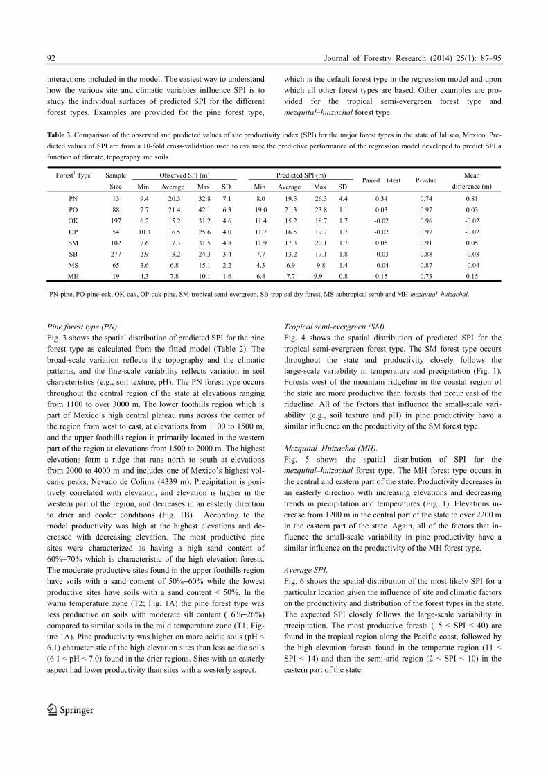
interactions included in the model. The easiest way to understand how the various site and climatic variables influence SPI is to study the individual surfaces of predicted SPI for the different forest types. Examples are provided for the pine forest type,
which is the default forest type in the regression model and upon which all other forest types are based. Other examples are pro-vided for the tropical semi-evergreen forest type and mezquital–huizachal forest type.
Table 3. Comparison of the observed and predicted values of site productivity index (SPI) for the major forest types in the state of Jalisco, Mexico. Pre-
dicted values of SPI are from a 10-fold cross-validation used to evaluate the predictive performance of the regression model developed to predict SPI a
function of climate, topography and soils
Observed SPI (m) Predicted SPI (m) Forest1 Type Sample
Size Min Average Max SD Min Average Max SDPaired t-test P-value
Mean
difference (m)
PN 13 9.4 20.3 32.8 7.1 8.0 19.5 26.3 4.4 0.34 0.74 0.81
PO 88 7.7 21.4 42.1 6.3 19.0 21.3 23.8 1.1 0.03 0.97 0.03
OK 197 6.2 15.2 31.2 4.6 11.4 15.2 18.7 1.7 -0.02 0.96 -0.02
OP 54 10.3 16.5 25.6 4.0 11.7 16.5 19.7 1.7 -0.02 0.97 -0.02
SM 102 7.6 17.3 31.5 4.8 11.9 17.3 20.1 1.7 0.05 0.91 0.05
SB 277 2.9 13.2 24.3 3.4 7.7 13.2 17.1 1.8 -0.03 0.88 -0.03
MS 65 3.6 6.8 15.1 2.2 4.3 6.9 9.8 1.4 -0.04 0.87 -0.04
MH 19 4.3 7.8 10.1 1.6 6.4 7.7 9.9 0.8 0.15 0.73 0.15
1PN-pine, PO-pine-oak, OK-oak, OP-oak-pine, SM-tropical semi-evergreen, SB-tropical dry forest, MS-subtropical scrub and MH-mezquital–huizachal. Pine forest type (PN). Fig. 3 shows the spatial distribution of predicted SPI for the pine forest type as calculated from the fitted model (Table 2). The broad-scale variation reflects the topography and the climatic patterns, and the fine-scale variability reflects variation in soil characteristics (e.g., soil texture, pH). The PN forest type occurs throughout the central region of the state at elevations ranging from 1100 to over 3000 m. The lower foothills region which is part of Mexico’s high central plateau runs across the center of the region from west to east, at elevations from 1100 to 1500 m, and the upper foothills region is primarily located in the western part of the region at elevations from 1500 to 2000 m. The highest elevations form a ridge that runs north to south at elevations from 2000 to 4000 m and includes one of Mexico’s highest vol-canic peaks, Nevado de Colima (4339 m). Precipitation is posi-tively correlated with elevation, and elevation is higher in the western part of the region, and decreases in an easterly direction to drier and cooler conditions (Fig. 1B). According to the model productivity was high at the highest elevations and de-creased with decreasing elevation. The most productive pine sites were characterized as having a high sand content of 60%−70% which is characteristic of the high elevation forests. The moderate productive sites found in the upper foothills region have soils with a sand content of 50%−60% while the lowest productive sites have soils with a sand content < 50%. In the warm temperature zone (T2; Fig. 1A) the pine forest type was less productive on soils with moderate silt content (16%−26%) compared to similar soils in the mild temperature zone (T1; Fig-ure 1A). Pine productivity was higher on more acidic soils (pH < 6.1) characteristic of the high elevation sites than less acidic soils (6.1 < pH < 7.0) found in the drier regions. Sites with an easterly aspect had lower productivity than sites with a westerly aspect.
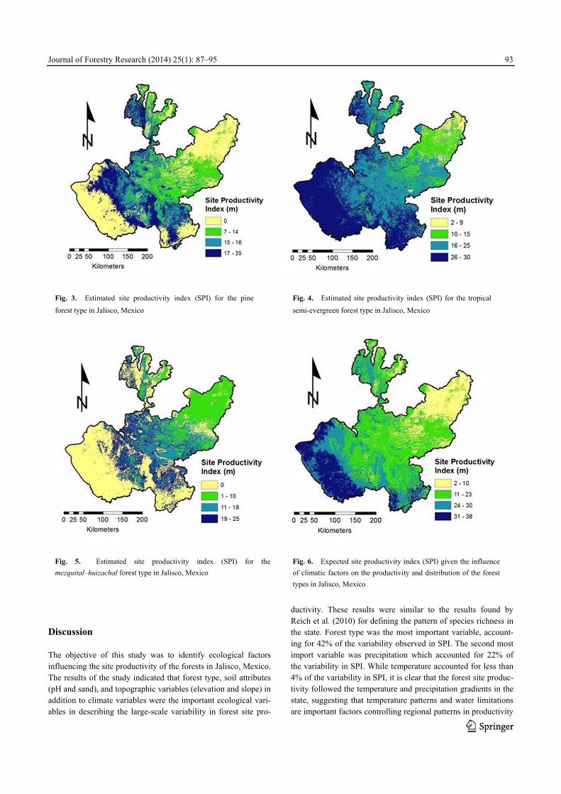
Tropical semi-evergreen (SM) Fig. 4 shows the spatial distribution of predicted SPI for the tropical semi-evergreen forest type. The SM forest type occurs throughout the state and productivity closely follows the large-scale variability in temperature and precipitation (Fig. 1). Forests west of the mountain ridgeline in the coastal region of the state are more productive than forests that occur east of the ridgeline. All of the factors that influence the small-scale vari-ability (e.g., soil texture and pH) in pine productivity have a similar influence on the productivity of the SM forest type. Mezquital–Huizachal (MH). Fig. 5 shows the spatial distribution of SPI for the mezquital–huizachal forest type. The MH forest type occurs in the central and eastern part of the state. Productivity decreases in an easterly direction with increasing elevations and decreasing trends in precipitation and temperatures (Fig. 1). Elevations in-crease from 1200 m in the central part of the state to over 2200 m in the eastern part of the state. Again, all of the factors that in-fluence the small-scale variability in pine productivity have a similar influence on the productivity of the MH forest type. Average SPI. Fig. 6 shows the spatial distribution of the most likely SPI for a particular location given the influence of site and climatic factors on the productivity and distribution of the forest types in the state. The expected SPI closely follows the large-scale variability in precipitation. The most productive forests (15 < SPI < 40) are found in the tropical region along the Pacific coast, followed by the high elevation forests found in the temperate region (11 < SPI < 14) and then the semi-arid region (2 < SPI < 10) in the eastern part of the state.
Journal of Forestry Research (2014) 25(1): 87–95
93
Discussion The objective of this study was to identify ecological factors influencing the site productivity of the forests in Jalisco, Mexico. The results of the study indicated that forest type, soil attributes (pH and sand), and topographic variables (elevation and slope) in addition to climate variables were the important ecological vari-ables in describing the large-scale variability in forest site pro-
ductivity. These results were similar to the results found by Reich et al. (2010) for defining the pattern of species richness in the state. Forest type was the most important variable, account-ing for 42% of the variability observed in SPI. The second most import variable was precipitation which accounted for 22% of the variability in SPI. While temperature accounted for less than 4% of the variability in SPI, it is clear that the forest site produc-tivity followed the temperature and precipitation gradients in the state, suggesting that temperature patterns and water limitations are important factors controlling regional patterns in productivity
Fig. 3. Estimated site productivity index (SPI) for the pine
forest type in Jalisco, Mexico Fig. 4. Estimated site productivity index (SPI) for the tropical
semi-evergreen forest type in Jalisco, Mexico
Fig. 5. Estimated site productivity index (SPI) for the
mezquital–huizachal forest type in Jalisco, Mexico Fig. 6. Expected site productivity index (SPI) given the influence
of climatic factors on the productivity and distribution of the forest
types in Jalisco, Mexico

Journal of Forestry Research (2014) 25(1): 87–95
94
(Reich et al. 2010). Temperature and precipitation directly influ-ence the metabolic processes of photosynthesis and plant respira-tion (Bradford 2011; Peters et al 2013).
The spatial patterns in site productivity are very complex and no one model would be expected to capture all of this variability. To model such complex spatial patterns, it is generally assumed that the data can be decomposed into two components: a mean structure representing the large-scale variation and a stochas-tic-dependent structure representing the small-scale variation (Cressie 1994). The model developed in this study may be thought of describing the large-scale patterns in regional produc-tivity potentials and representing the upper limit on site produc-tivity (Grier et al. 1989). The unexplained variability in the model may be thought of as representing the small-scale or local variability in site productivity. At the local scale, intrinsic fac-tors such as soil moisture-holding capacity, soil nutrient status, and soil porosity influence plant growth and the productivity potential of a site. Natural disturbances such as fire, insects, dis-ease, and erosion can also alter the intrinsic factors that influence the soil forming processes, vegetation development, and site productivity at the local scale (Grier et al. 1989). Socio-economic factors also contribute to altering or depleting forest cover and affect forest structure and species composition of the forests through grazing, fuel wood activities, selective logging and other economic activities (Agramont et al. 2012; Gilba et al. 2011; Moreno-Sanchez et al. 2012). All of these fac-tors have a long-term impact on ecosystem services and the maximum productive potential of a site (Foster et al. 2003; Gough et al. 2008). Many of these important small-scale proc-esses cannot be represented explicitly in model, and so must be included in approximate form as they interact with larger-scale features. This is partly due to limitations in scientific under-standing of the process involved or in the availability of detailed observations of some physical processes. Significant uncertain-ties, in particular, are associated with the representation of site productivity, and in the resulting responses in site productivity to climate change. Some of the factors influencing this uncertainty include: (1) estimates of SPI used in this study may not reflect the true productivity of a site, (2) site variables are not respon-sive to small changes in site productivity; and (3) estimates of site productivity were based on multiple tree species. Despite such uncertainties, the model provided unbiased estimates of SPI for the major forest types in the state.
Climate models are predicting that the tropical dry forests will experience relatively large changes in temperature and rainfall towards the end of this century (Brienen et al. 2010). The tropi-cal dry forests in Mexico are likely to be more affected by changes in soil water availability caused by the combined effects of changes in temperature and rainfall than by changes in tem-perature alone. Lower rainfall and higher temperatures increase water stress and may accelerate forest loss in many areas where water availability is already marginal (Condit et al. 2004). Infer-ences on the likely impact of climatic changes on the tropical dry forest type as well as the other forest types in the state are im-possible to make without a thorough understanding of the influ-ence of site and climatic conditions on the diversity and produc-
tivity of the forests in the state. The model developed in this study is the first step in understanding the impact of climate change on the spatial distribution and productivity of the forest types in the state. Distribution models like those developed here greatly add to assessments of the relative importance of site and climatic factors on the productivity of various forest types and in doing so, offer arguments for which forest types should or should not be harvested, what forest types deserve priority in their management, and which forest types might be significantly im-pacted by climate change. The maps of site productivity can help decision makers identify the locations of especially sensitive forest types to climate change; estimate and predict the impact of these changes on ecosystem services; and prioritize and decide on the best kinds of management options and where to imple-ment them. Conclusions The spatial site productivity index identified using the ecological variables showed to be a useful indicator of site productivity in the diverse forest types of Jalisco, Mexico. An important find-ing of this analysis is that forest type is the most significant variable for determining the productivity of a site. The spatial site productivity models developed in this study provide a basis for understanding the complex relationship that exists between forest productivity and site and climatic conditions in the state. It is clear that the spatial site productivity models are reliable and accurate within the ecological ranges of the data. This study documents an important approach for understanding the relation between forest productivity and site variables and how site pro-ductivity can be estimated using these relations. These models could be linked to climate models to predict the impact of cli-mate change on the distribution and productivity of the forest types in the state. For example, if it is hypothesized that precipi-tation will decrease the information characterizing distribution of forest types within the various climatic zones could be used to provide information on how forest productivity would change under different scenarios of changing temperature and/or pre-cipitation. From these models it would be possible to illustrate the impacts of climate change on potential loss in the diversity of the flora and fauna, change in water quality, impact on ecosys-tem services, and so forth. We expect results of this study to be used directly to establish best management practices for the for-est resources in the state. References Acharya T, Ray AK. 2005. Image processing: principles and applications.
New York: Wiley, p.452.
Agramont ARE, Maass SF, Bernal GN, Hernández JIV, Fredericksen TS. 2012.
Effect of human disturbance on the structure and regeneration of forests in
the Nevado de Toluca National Park, Mexico. Journal of Forestry Research.
23: 39−44
Akaike H. 1969.Fitting autoregressive models for regression. Annals of the

Journal of Forestry Research (2014) 25(1): 87–95
95
Institute of Statistical Mathematics, 21: 243−247.
Avery, T.E. and Burkhart, H.E. 2002. Forest Measurements (5th Ed).
Madison: McGraw Hill, 456 pp.
Bradford JB. 2011. Divergence in forest-type response to climate and weather:
evidence for regional links between forest-type evenness and net primary
productivity. Ecosystems, 14: 975–86.
Brienen RJW, Lebrija-Trejos E, Zuidema PA, Martinez-Ramos M. 2010.
Climate-growth analysis for a Mexican dry forest tree shows strong impact
of sea surface temperatures and predicts future growth declines. Global
Change Biology, 16: 2001–2012.
Challenger A. 1998. Utilización y conservación de los ecosistemas terrestres
de México. Pasado, presente y futuro. Conabio, IBUNAM y Agrupacion
Sierra Madre, México. pp. 375–442.
Cressie N. 1991. Statistics for spatial data. New York: John Wiley and Sons,
p.928.
Condit R, Aguilar S, Hernandez A, Perez R, Lao S, Angehr G, Hubbell SP.
Foster RB. 2004. Tropical forest dynamics across a rainfall gradient and the
impact of an El Nino dry season. Journal Tropical Ecology, 20:51–72.
Elith J, Leathwick JR. 2009. Species distribution models: ecological explana-
tion and prediction across space and time. Annual Review of Ecology, Evo-
lution, and Systematics 40: 677–697.
Ercanli I, Gunlu A, Altun L, Baskent E. 2008. Relationship between site index
of oriental spruce [Picea orientalis (L.) Link] and ecological variables in
Mac¸ka, Turkey. Scandinavian Journal Forestry Research, 23:319–329.
Edenius L, Vencatasawmy CP, Sandstrom P, Dahlberg U. 2003. Combining
satellite imagery and ancillary data to map snowbed vegetation important to
Reindeer Rangifer tarandus. Arctic, Antarctic and Alpine Research, 35:
150–157.
Efron, B. and Tibshirani, R.J. 1993. An introduction to the bootstrap. New
York: Chapman and Hall, p.456.
ESRI. 2008. Environmental Systems Research Institute, Inc., 380 New York
St., Readlands, CA 97393. USA.
Foster D, Swanson F, Aber J, Burke I, Brokaw N, Tilman D, Knapp A. 2003.
The importance of land-use legacies to ecology and conservation. Biosci-
ence 53: 77–88.
Gesch D, Oimoen M, Greenlee S, Nelson C, Steuck M, Tyler D. 2002. The
national elevation dataset. Photogrammetric Engineering & Remote Sens-
ing, 68:5–32.
Gilba EK, Kayombo CJ, Chirenje LI, Musamba EB. 2011. The influence of
socio- economic factors on deforestation: a case study of the Bereku Forest
Reserve in Tanzania. Biodiversity, 2: 31−39
Gough CM, Vogel CS, Schmid HP, Curtis PS. 2008. Controls on annual forest
carbon storage: lessons from the past and predictions for the future. Biosci-
ence, 58: 609–22
Gustafson EJ, Lietz SM, Wright JL. 2003. Predicting the spatial distribution
of aspen growth potential in the upper great Lakes regions. Forest Science,
49: 499–508.
Huang S, Titus SJ. 1992. Comparison of nonlinear height–diameter functions
for major Alberta tree species. Canadian Journal Forest Research, 22:
1297–1304.
Huang S, Titus SJ. 1993. An index of site productivity for uneven-aged or
mixed-species stands. Canadian Journal Forest Research, 23: 558–562.
Louw JH, Scholes MC. 2006. Site index functions using site descriptors for
Pinus patula plantations in South Africa. Forest Ecology and Management,
225: 94–103.
Ma MD, Jiang H, Liu SR, Zu CQ, Liu Yj, Wang JX. 2006. Estimation of
forest- ecosystem site index using remote sensed data. Acta Ecologica
Sinica, 26: 2810–2816.
Mohamed A, Reich RM, Khosla R, Aguirre-Bravo C, Mendoza Briseño M.
2012. Site productivity curves for the diverse forest types of Jalisco, Mex-
ico. Madera y Bosques (in press)
Moreno-Sanchez R, Juan Manuel Torres-Rojo JM, Moreno-Sanchez F, Haw-
kins S, Little J, McPartland S. 2012. National assessment of the fragmenta-
tion, accessibility and anthropogenic pressure on the forests in Mexico.
Journal of Forestry Research, 23: 529–541
Nixon KC. 1993. El género Quercus en México. In: Ramamoorthy, T.P., R.
Bye, A. Lot, y J. Fa (eds), Diversidad Biológica de México. Orígenes y
Distribución. Instituto de Biología, UNAM. pp. 435–448.
Pande PK. 2005. Biomass and productivity in some disturbed tropical dry
deciduous teak forests of Satpura plateau, Madhya Pradesh. Tropical Ecol-
ogy, 46: 229–239.
Peters EB, Wythers KR, Bradford JB, Reich PB. 2013. Influence of distur-
bance on temperate forest productivity. Ecosystems, 16: 95–110.
Pokharel B, Dech JH. 2011. An ecological land classification approach to
modeling the production of forest biomass. The Forestry Chronicle, 87:
23−32.
Pongpattananurak N, Reich RM, Khosla R, Aguirre-Bravo C. 2012. Modeling
the spatial distribution of soil attributes at a regional level: A case study in
the State of Jalisco, Mexico. Soil Science Society of America Journal, 76:
199−209.
Reich RM, Lundquist JE, Bravo VA. 2004. Spatial models for estimating fuel
loads in the Black Hills, South Dakota, USA. International Journal of
Wildland Fire, 13: 119–129.
Reich RM, Aguirrie-Bravo C, Mendoza Briseno, M. 2008a. An innovative
approach to inventory and monitoring of natural resources in the Mexican
State of Jalisco. Environmental Monitoring and Assessments, 146:
383−396.
Reich RM, Aguirrie-Bravo C, Bravo VA. 2008b. New approach for modeling
climatic data with applications in modeling tree species distributions in the
states of Jalisco and Colima, Mexico. Journal Arid Environments, 72:
1343−1357.
Reich RM, Bonham DC, Aguirrie-Bravo C, Chazaro-Basañeza M. 2010.
Patterns of tree species richness in Jalisco, Mexico: relation to topography,
climate and forest structure. Plant Ecology, 210: 67−84.
Vanclay JK. 1992. Assessing site productivity in tropical moist forests: a
review. Forest Ecology and Management, 54: 257–287.
Vanclay JK, Henry NB, 1988. Assessing site productivity of indigenous cy-
press pine forest in southern Queensland. Commonwealth Forestry Review,
67: 53−64.
Venables WN, Ripley, BD. 2002. Modern Applied Statistics with S. (4th Ed.).
New York: Springer, p.495.
Wang Y, Frederic R, Chhun H. 2005. Evaluation of spatial predictions of site
index obtained by parametric and nonparametric methods-A case study of
Lodgepole pine productivity. Forest Ecology and Management, 214:
201−211.
Watt M, David P, Heidi D, Mark K. 2009. Predicting the spatial distribution of
Cupressus lusitanica productivity in New Zealand. Forest Ecology and
Management, 258: 27−223.