industrialisation and an early modern town: broseley in...
TRANSCRIPT

INDUSTRIALISATION AND AN EARLY MODERN TOWN: BROSELEY IN SHROPSHIRE 1600-1820 by STEPHEN CHARLES HUDSON A thesis submitted to the University of Birmingham for the degree of MASTER OF PHILOSOPHY
School of History and Culture College of Arts and Law
University of Birmingham
June 2017

University of Birmingham Research Archive
e-theses repository This unpublished thesis/dissertation is copyright of the author and/or third parties. The intellectual property rights of the author or third parties in respect of this work are as defined by The Copyright Designs and Patents Act 1988 or as modified by any successor legislation. Any use made of information contained in this thesis/dissertation must be in accordance with that legislation and must be properly acknowledged. Further distribution or reproduction in any format is prohibited without the permission of the copyright holder.
ABSTRACT
This work is the first attempt to analyse, assess and evaluate the broad process of
industrialisation in Broseley, Shropshire between 1600 and c.1820. The thesis is a study of
historical processes of growth, development and, ultimately the beginning of decline of a small
industrial urban settlement above the Severn Gorge on the southern margins of the east
Shropshire coalfield. These historical processes, socio-economic in character, are shown to
interact and produce an early industrial town, possessing certain characteristics, features and
traditions, unusual if not unique in a settlement of this nature. A variety of source material –
primary documentary, archaeological/field and secondary – is used to examine the origins and
growth of three groups of industries - mining, iron and ceramics - and the social fabric and
stratification that were both the cause and consequence of their development. Collateral aspects
of industrialisation - the land market, proto-industry and the transport and communications
infrastructure - are also assessed for their significance in Broseley’s industrial past. Broseley has
not received as much focus from historians as other industrial townships on the east Shropshire
coalfield. This thesis establishes the township’s distinctive contribution to the economic
development of the district derived from its diverse industrial experience.
i
DEDICATION
This work is dedicated to the beloved memory of the writer’s son, Richard, who passed away at
the time when the thesis was entering its initial stages of preparation. Also, to the people of
Broseley, whose ancestors dug the coal, smelted and forged the iron and moulded and fired the
pipes, pots, bricks and tiles and without whose back-breaking toil and incredible fortitude this
work would have had little meaning or purpose.
ii

ACKNOWLEDGEMENTS
Jennifer Hudson for unstinting support in all the practical aspects of thesis preparation; Dr
Malcolm Dick for his advice and counselling, particularly concerning the structure, sourcing and
referencing of the work; the late Dr Leonard Schwarz, University of Birmingham, for consistent
support and advice on the academic aspects of the work; Professor Peter Jones, co-supervisor, for
a second opinion concerning particular chapters of the thesis; The late Lord Brooke Weld-
Forester and the Dowager Lady Forester for allowing access to their collection of seventeenth
and eighteenth century documents held at the Shropshire Archives; the staff at Shropshire
Archives, Castlegates, Shrewsbury for providing support and seeking out obscure but relevant
source material; the staff of Ironbridge Gorge Museum Trust Library and Birmingham Archives;
Derek Farlow and Martyn Johnson for proof reading and critical appraisal of the work.
iii

TABLE OF CONTENTS Page Chapter 1 Introduction 1
(i) Industrialisation in Broseley (ii) Broseley’s industrial development – existing
historiography (iii) Methodology and sources (iv) Conclusion
Chapter 2 Broseley – an industrial town? 40
(i) Introduction (ii) Broseley and the process of industrial urbanisation (iii) Population patterns and trends (iv) Transport infrastructure and communications (v) Conclusion
Chapter 3 The nature of the land market in Broseley and district 87
(i) Introduction – the land market in Broseley after the Dissolution
(ii) The nature of seventeenth- and eighteenth-century land holdings in Broseley and their importance for the developing economy of the town
(iii) Multi-faceted estates in the early-nineteenth century (iv) Conclusion
Chapter 4 Proto-industry in seventeenth- and eighteenth-century Broseley 108
(i) Introduction (ii) Broseley as a proto-industrial settlement (iii) The concept of proto-industry and its relevance to Broseley
in the seventeenth and eighteenth centuries (iv) Local proto-industrial elites (v) Other industrial elites (vi) Conclusion
Chapter 5 Industrialisation in Broseley from the early-seventeenth century 165
to the early nineteenth century – coal mining (i) Introduction – mining in Broseley and district in the
seventeenth and eighteenth centuries (ii) The significance of coal in the developing micro-economy
of Broseley (iii) The management of coal resources: the labour
structure and the Chartermaster system
iv

(iv) The sixteenth, seventeenth and early-eighteenth centuries – coal mining in the south bank parishes
(v) The importance of coal in the developing industrial base of Broseley and district from the mid-eighteenth century
(vi) Conclusion
Chapter 6 Industrialisation in Broseley from the early-seventeenth century 224 to the early-nineteenth century – ferrous metal industries (i) Introduction – the iron industry in Broseley and district
before 1760 (ii) Limestone quarrying and iron ore mining – their
significance for the iron industry in Broseley (iii) The Old and New Willey Ironworks and John
Wilkinson’s significance for the late-eighteenth century iron industry on the East Shropshire coalfield
(iv) The Calcutts Ironworks (v) The Benthall Ironworks (vi) The lesser ironworks of Broseley and district (vii) Conclusion
Chapter 7 Industrialisation in Broseley from the early-seventeenth century 293
to the early-nineteenth century – the ceramics industries (i) Introduction – an overview of ceramic manufacture from
the early seventeenth century to the early nineteenth century (ii) The clay tobacco pipe industry (iii) Earthenware (iv) The brick and roof tile industries of Broseley and Jackfield (v) The Caughley China Works – the origins of the East
Shropshire porcelain industry (vi) Conclusion
Chapter 8 Conclusion 340 Appendices Bibliography
v

LIST OF FIGURES Figure 1 Broseley in 1620 (between pages 40 and 41)
Figure 2 The Plott of Broseley – Samuel Parsons’ Map of c.1621 (between pages 87 and
88)
vi

LIST OF APPENDICES
Appendix I Broseley and District Ordnance Survey Pathfinder 890
(SJ60/70)(original2.5” to 1 mile, 1:25,000)
Appendix II Glossary of Mine Workings
Appendix III The ironworks of Broseley and district, their locations and sites
Appendix IV The Ceramic Manufactories of Broseley and District and their locations
Appendix V Late eighteenth century and early nineteenth century road and turnpike
system
Appendix VI Rail and Plateways in Broseley and District between 1600 and 1820
Appendix VII Broseley Estates, Landholdings and significant Landowners 1600-1820
Appendix VIII Landform in Broseley – Geology and Topography
vii

ABBREVIATIONS BA Birmingham Archives BL British Library CUP Cambridge University Press
GA Gloucestershire Archives
HDR Hereford Diocese Records
HRO Hereford Records Office
IGMT Ironbridge Gorge Museum Trust
IGMTAA Ironbridge Gorge Museum Trust Archaeological Archives
IGSGS of GB Institute of Geological Sciences Geological Survey of Great Britain
MUP Manchester University Press
MW Much Wenlock
NA National Archives
NCB National Coal Board
NRS National Records of Scotland
OS Ordnance Survey
OUP Oxford University Press
PRO Public Records Office
SA Shropshire Archives
SCRO Staffordshire County Records Office
SHA Shackerley Collection
viii

SM Science Museum
SRO Scottish Records Office
SRRC Shropshire Records and Research Centre
STAC Court of Star Chamber
SWSHAS South West Shropshire Historical and Archaeological Society
TSAS Transactions of the Shropshire Archaeological Society
VCH Victoria County History
WA Warrington Archives
ix

x

Chapter 1
Introduction
1(i) Industrialisation in Broseley
The thesis examines the historical processes shaping industrialisation in Broseley,
Shropshire. Broseley is a small town situated at a height of approximately 400 feet1 above the
River Severn that has cut a gorge forming a broad north-west to south-east bend from Ludcroft
Wharf in the west to The Roving in the east over a distance of approximately three and a half
miles. It originated as a wood-pasture village2 which developed over 200 years between 1600
and 1800 into a diverse industrial town with a varied social structure. It is this diversity with
three groups of inter-related industries normally associated with coalfields – mining, ferrous
metal and ceramics – that ensures that any historical study of the town will be multi-dimensional
in terms of the growth and development of the industries, their locations and the scale and type of
undertakings and also the social structures, particularly an entrepreneurial cottage-based stratum
that provided the most significant social dynamic for rapid industrial growth. What makes
Broseley worthy of special focus, within this broad-based and far-reaching process of industrial
urbanisation, is that the processes began and ended relatively early – industrialisation from the
early-seventeenth century and de-industrialisation and a decline in output and population from
around 1820. Its micro-economy may be analysed in terms of causation and consequence.
1 The thesis uses imperial measurement of height, distance and weight throughout. 2 M Gelling, HDG Foxall, The Place-Names of Shropshire Part One (English Place-Name Society, 1990), pp. 63-64 – originally the name of the settlement was Burhweard which meant ‘woodland clearing of the forest guardian’. By 1548 it had become Borsley and then further mutated to Broseley.
1
The development of a mining and manufacturing micro-economy transformed the town
from a small rural wood-clearing village into an important primary, secondary manufacturing and
tertiary industrial settlement between 1600 and 1800. The main focus of the study is upon how
and why industries developed, concentrating on coal, iron ore and clay mining, manufacturing
industries such as iron and brick and tile manufactures, and finally consumer manufacturing of
products such as clay tobacco pipes, earthenware and, later, quality porcelain. These light
manufacturing industries, with the exception of porcelain, established themselves initially as
cottage-based undertakings and later as full factory-based concerns. The work also attempts to
establish whether or not Broseley developed a social stratification that was both a cause and
consequence of the process of industrialisation. Primary documentary sources, archaeological
reports and field evidence are used to address a number of questions concerning the development
of industries in the town and the resulting socio-economic framework. Existing work on
industrialisation in Broseley adopts a micro-approach to particular aspects of the town’s
industrialisation, focusing on particular individuals and industrial undertakings. This thesis
attempts to present an overview and explanation of the town’s development in terms of its diverse
economy and complex social structures.
The history of industrialisation and industrial towns is well-established. In settlements
such as the wool- and cotton-mill towns of the West Riding and the Pennine slopes of Lancashire
2

and the pit towns of Northumberland and Durham3 the process of industrial development was
often planned, phased and homogenous and was restricted to one particular industry. The period
of fastest growth and organisational change of industry is known as the Industrial Revolution.
However, there has been considerable debate as to whether it was a revolution or a mere
discontinuity in the rate of change of processes of growth and development.4 The early phase of
industrial development has been termed proto-industrialisation.5 Local capital derived from
agriculture would fund extraction of local mineral resources and/or the processing of imported
raw materials which would then be passed to small-scale individual workers for refinement
and/or manufacture of finished goods. The individual workers in a phase of secondary
industrialisation supported by increased capitalisation would then, as proletarianised wage
earners, form into a collective unit or factory undertaking. Increased growth and refinement of
production was the result of specialisation known as division of labour, probably the single most
important and far reaching socio-economic consequence of the process of industrialisation.6 The
process would finally be completed when service industries developed to facilitate the
manufacturing base.
3 D Levine, K Wrightson, The Making of an Industrial Society – Whickham 1560-1765 (London, Oxford University Press, 1991); B Trinder, Britain’s Industrial Revolution – The Making of a Manufacturing People, 1700-1870 (Lancaster, Carnegie Publishing, 2013), pp. 219-289; JE Williams, The Derbyshire Miners: A Study in Industrial and Social History (London, Allen and Unwin, 1962); C Owen, The Leicestershire and South Derbyshire Coalfield 1200-1900 (Ashbourne, Moorland/Leicestershire Museums, 1984); Trinder, Britain’s Industrial Revolution, pp. 407-420; D Beattie, A History of Blackburn (Lancaster, Carnegie Publishing, 2007); The Cotton Mills of Oldham (Oldham, Oldham Cultural Information Services, 1983); I Haynes, Cotton in Ashton (Tameside Libraries and Arts Committee, 1987) 4 P O’Brien, R Quinault (ed), The Industrial Revolution and British Society (Cambridge, Cambridge University Press, 1993), pp, 1-31, 54-79: MW Flinn, Origins of the Industrial Revolution (London, 1966); MJ Daunton, Progress and Poverty – A Economic and Social History of Britain 1700-1850 (Oxford, OUP, 1995), pp. 125-127 5 DC Coleman, ‘Proto-Industrialisation: A Concept Too Many’, Economic History Review, Series 2 Vol 36 (London, 1983), pp. 435-438; LA Clarkson, Proto-Industrialisation: The First Phase of Industrialisation (London, Macmillan, 1978); see below Chapter 4. 6 O’Brien, Quinault, The Industrial Revolution and British Society, pp. 32-33, 39-40, 46-47, 50, 257, 260, 264-65, 267-269; MJ Daunton, Progress and Poverty: An Economic and Social History of Britain 1770-1850 (Oxford, OUP, 1995), pp.1-2, 8, 13-14, 134, 140, 190.
3

At first sight Broseley’s experience seems nothing like this. The town over 200 years
experienced the growth of diverse industry – extractive, heavy and light manufacturing with an
absence of tertiary services – serving the needs of industry and domestic markets. This growth
was remarkable in a town which at the height of its prosperity in the late-eighteenth century had a
population of no more than 5,000.7 Quantifying output from contemporary data is difficult but it
is likely that the annual-per-capita output of the workforce and the population as a whole was
exceptionally high.8 Division of labour within the micro-economy as a whole rather than within
specific industries was the exception rather than the rule. The scale of operations was also
extremely varied although following a broad chronological pattern of small undertakings
developing towards large units. The variations in landscape produced different rationales when
selecting appropriate locations for undertakings – low opportunity-cost marginal land producing
the maximum proportion of economic rent, advantageous sites considering ease of transport and
proximity to raw materials which reduced unit costs and enhanced profitability.
The primary aim of the thesis is to establish the nature of Broseley’s diverse development
as an industrial town between 1600 and 1800. The work also attempts to show that particular
aspects of the town’s industrial development were shaped by fixed elements, such as geology and
topography, while others were framed by the influence and activity of individual entrepreneurs,
managers and collective groups, such as trade elites and ordinary working people. Both the cause
and consequence of the diversity of industry and the social stratification of the town is examined
7 P Clark, K Gaskin, A Wilson, Population Estimates of English Small Towns, 1550-1851 (Centre for Urban History, University of Leicester, 1989), pp. 137-140 8 The author estimates that seven furnaces averaging 20 tons of pig iron per week, produced approximately 140 tons per week, 7,280 tons per annum, 1 ton 9cwt per capita per annum inclusive of the total population of the town.
4
for pluralist or homogenous characteristics. Does the socio-economic profile of Broseley in the
seventeenth and eighteenth centuries form a dichotomy within an industrial town where the
population is neatly divisible into employers and proletariat?
Industrialisation involves numerous interrelated processes that synthesise into a micro-
economy based on a combination of extractive, manufacturing and service industries.
Consequently, aspects of entrepreneurial activity such as comparative costs and advantage,
opportunity cost, rational expectations, economies and dis-economies of scale, profit
maximisation and locational analysis are examined, referred or alluded to in the thesis. Existing
works that make reference to Broseley ignore these fundamental principles that are the basis of
rational decision making in terms of location, scale and scope of industrial undertakings.
Chapters 2 to 7 examine individual processes concerning Broseley’s economic development
between the early seventeenth and early nineteenth centuries. The primary purpose is to establish
from primary documentary and field evidence that Broseley developed three basic forms of
industry - extractive, ferrous metal, and ceramic manufacture - over this period. A secondary aim
is to create an overview of the broader process of industrialisation in the town, something that
does not exist in available historiography. The town, outside the period of this work, suffered
decline and de-industrialisation over the nineteenth century. Chapter 8 comes to a decision as to
the town’s status as an urban form and introduces the idea of stagnation and decline.
5

1(ii) Broseley’s industrial development - existing historiography
Although a significant amount of work has been undertaken on various aspects of
Broseley’s development there are no substantial, comprehensive works on the town’s history.
Rather, particular historical processes have been examined as part of broader studies. By way of
allusion, other elements of the town’s history have been referred to in general works concerning
particular aspects of Britain’s extended Industrial Revolution. For example, its contribution to
developments in brick-firing technology,9 the refinement of the bi-products of the carbonisation
process,10 advances in the methods of production of pig iron,11 and revolutionary changes in the
drilling of steam engine cylinders and cannon.12 Broseley’s process of industrialisation is
examined as part of the Severn Gorge micro-economy. It also became in the late-eighteenth
century the most important township on the East Shropshire coalfield. In publications that
analyse the urban system that developed in Shropshire over the last 1,000 years, the town has
been classified as one of a central band of industrial centres with Ironbridge, Madeley, Dawley
and Oakengates which developed later than the market/strategic/planned towns of medieval
origin in the north and south of the county, such as Whitchurch, Market Drayton, Clun and
9 C Clark, Ironbridge Gorge (London, Batsford/English Heritage, 1993), pp. 67-68 10 British Museum, Add. MSS.21018, J Plymley, A General View of the Agriculture of Shropshire, 1803 – visit to Lord Dundonald’s tar ovens at the Benthall iron works; A Campbell, Cochrane, Archibald, 9th Earl of Dundonald, (1748-1831) Chemical Manufacturer, The Oxford Dictionary of National Biography (London, OUP, 2004-2010), www.oxforddnb.com (date of access 12th February 2014); C Hatchett, The Hatchett Diary (ed) A Raistrick (Truro: Bradford Barton, 1967), pp. 57-60; B Trinder, The Industrial Revolution in Shropshire (Chichester, Phillimore, 3rd Edition, 2000), p. 16 11 Ironbridge Gorge Museum Trust Library, 1992 1001825, Wilkinson’s method of making iron from ore and recycled iron; Public Records Office, C 210/47 PFF 4614 12 N Scarfe (ed), Innocent Espionage: The La Rochefoucauld Brothers tour of England in 1785 (London, Woodbridge: Boydell, 1995), pp. 90-104; Hatchett, The Hatchett Diary, pp. 57-60.
6

Ludlow.13 General works on urbanisation make little or no reference to Broseley, even in
sections relating to industrial towns.14 When considering its industrial development, Broseley
tends to be regarded primarily as a mining settlement in common with coal-producing centres on
other coalfields. The ways in which Broseley reveals the complexities and diversity of
industrialisation provide the justification for this study.
Sections in the Victoria County History Vol X,15 The Historical and Geographical Study
of Small Towns in Shropshire by S A Lewis16 and frequent references, as in The Landscape of
Industry – Patterns of change in the Ironbridge Gorge by J Alfrey and C Clark,17 provide
insights into particular aspects of Broseley’s history but no evaluation of its importance as an
early industrial town. The VCH is a work of reference, encouraging the reader to pursue more
penetrating and analytical studies. Lewis is concerned mainly with the changing significance of
and balance between the four occupational/industrial sectors of Broseley’s developing economy
and in a broader context provides a comparison with other Shropshire towns. Alfrey and Clark
adopt an approach to the development of the Ironbridge Gorge as a whole that takes the form of
an analysis of land use and its effect on settlement patterns and the location of industry. This
13 B Trinder, A History of Shropshire (Chichester, Phillimore, 1983), pp. 35-40, 76-81; SA Lewis, ‘The Historical and Geographical Study of Small Towns in Shropshire, 1600-1800’ (unpublished PhD Thesis, Leicester University 1991) 14 J Stobart, N Raven, (ed), Towns, Regions and Industries: Urban and Industrial Change in the Midlands c.1700-1840 (Manchester, Manchester University Press, 2005), B Trinder, ‘Towns and Industries: The Changing Character of Manufacturing Towns’, Stobart, Raven (ed) Towns, Regions and Industries: Urban and Industrial Change in the Midlands c. 1700-1840, pp. 102-120 15 Victoria County History of Shropshire Volume X, ed. Stamper, published for the University of London Institute of Historical Research by OUP, 1985 16 Lewis, ‘The Historical and Geographical Study of Small Towns in Shropshire, 1600-1800’ 17 J Alfrey, C Clark, The Landscape of Industry – Patterns of Change in the Ironbridge Gorge (London, Routledge, 1993)
7

study is itself derived from the Nuffield Surveys of Benthall, Broseley Wood, Broseley and
Jackfield, where the linking of development to mapped plot locations is emphasised.18
A definitive work on industrial development in Shropshire during the Industrial
Revolution, by Barrie Trinder, has references to Broseley, particularly with regards to mining,
iron and ceramics industries, transport infrastructure and social development, but the references
are in separate chapters with no integrated overview.19 A similar work, although lacking the
breadth and depth of Trinder’s book, is by Catherine Clark focusing on the socio-economic
history and evolution of the Ironbridge Gorge through the eighteenth and nineteenth centuries.20
The author makes specific reference to the seven ‘missing’ furnaces of the south bank, alluding to
the fact that Broseley’s important contribution to the broader picture of south-east Shropshire as a
leader in ferrous metal and machine-tool technology and development has been frequently
ignored. Early industry, in and around the gorge, has been examined by Malcolm Wanklyn who
recognises Broseley’s importance as a centre for mining and manufacture. Wanklyn emphasises
the volume of exports from the town, particularly coal, and its contribution to the burgeoning
carrying trade down to the lower Severn Valley.21 However, the work does not proceed beyond
Abraham Darby I’s arrival in the district in 1708.
18 J Alfrey, C Clark (ed.) Nuffield Survey, 3rd Interim Report, Benthall and Broseley Wood, Research Paper No. 15 (Ironbridge Institute, 1987); J Alfrey, C Clark (ed.) Nuffield Survey, 4th Interim Report, Broseley and Jackfield, Research Paper No. 16 (Ironbridge Institute, 1988) 19 Trinder, The Industrial Revolution in Shropshire 20 Clark, Ironbridge Gorge 21 MDG Wanklyn, ‘Industrial Development in the Ironbridge Gorge before Abraham Darby’, West Midlands Studies Vol. 15, 1982, p.3
8

The proto-industrial phase of the town’s development during the seventeenth and early-
eighteenth centuries has been surveyed by Trinder and Nancy Cox in their work on inventories
originating from parishes on both sides of the river: Broseley, Benthall, Madeley and Little
Wenlock. Trinder has also examined cottage-workshop industries in the Severn Gorge in the
seventeenth and eighteenth centuries.22 The inventories reveal a structure of small property
owners with substantial personal property and a stake in their landed holdings rather more than
that expected of common labourers. The sample covers the period from the mid-seventeenth to
the mid- eighteenth centuries, prior to the proletarianisation of the town during the industrial
revolution.23 The analysis of the inventories reaches conclusions about developing industrial
elites, particularly in mining and ceramic manufacture. The sample of inventories examined
however is limited in that it does not extend past the mid-eighteenth century. No conclusions can
be reached about wealth-owning patterns of tradesmen and the proletarianisation of previously
propertied individuals in the latter part of the eighteenth century.24 General works exist as to the
meaning and interpretation of probate records as an historical source.25 This thesis attempts,
through particular focus on proto-industrial tradesmen, particularly colliers, to come to
conclusions about wealth ownership in the hands of manual workers and their expanding
consumption patterns. It also examines the resultant elites that developed within particular
industries and how these elites provided the basis for the entrepreneurial skills required for full
22 B Trinder, ‘Workshops and Cottages in the Ironbridge Gorge’, PS Barnwell, M Palmer, M Airs (ed) The Vernacular Workshop: From Craft to Industry 1400-1900 (York, Council for British Archaeology, 2004), pp. 173-178 23 B Trinder & N Cox, Miners and Mariners of the Severn Gorge – Probate Inventories for Benthall, Broseley, Little Wenlock and Madeley 1660-1764 (Chichester, Phillimore, 2000) 24 A Bevan, A Duncan, Tracing your Ancestors in the Public Record Office – PRO Handbook No 19 (London, HMSO, 1990), p. 68 25 B Trinder, ‘The Wooden Horse in the Cellar: Words and Contexts in Shropshire Probate Inventories’, T Arkell, N Evans, N Goose, When Death Do Us Part: Understanding and Interpreting the Probate Records of Early Modern England (Oxford, The Leopard Head Press, 2000)
9

industrialisation as well as the residual labourers that slipped back into poverty and
proletarianisation.
Despite the lack of a comprehensive survey of all the aspects of Broseley’s development
over 200 years, there is considerable published work on individual aspects of Broseley’s history.
Land and resource management within the context of a developing and fragmenting land market
after the Dissolution is examined by Wanklyn in his study of John Weld, a significant freeholder
in Broseley in the first half of the seventeenth century.26 His memorandum, issued in 1633 as a
guide to management of a landed estate with potential for development of industry, utilising
available mineral resources is given particular emphasis. Nothing has been done on the specific
nature of rights retained by freeholders and rights granted through leasing to the tenants who
combined the farming of the land on small plots with small-scale industrial entrepreneurship.
Other large freeholders such as James Clifford, Lawrence Benthall, the Lacons and the Langleys,
although not as significant as Weld and his successors the Weld-Foresters in the development of
an economic base secured by industry, have been neglected by writers concerned with the post-
dissolution land market in the south-bank parishes. These landlords were also responsible for
creating a framework for the take-off for industrial growth, encouraging settlement on the
commons and granting medium-term leases for the development of small individual plots.27
26 MDG Wanklyn, ‘John Weld of Willey 1585-1665 – An Enterprising Landowner of the Early Seventeenth Century’, West Midlands Studies, Vol 3, 1969, pp. 88-89; MDG Wanklyn, ‘John Weld of Willey: Estate Management 1631-1660’, Journal of the Wilkinson Society, Vol 4, 1970-71, pp. 63-71 27 Each individual landholding is called a plot. The totality of these plots in Broseley is referred to as the Plott of Broseley.
10

There are no definitive published works on mining, iron and ceramics in Broseley,
examining their development and importance to Britain’s emergence as the world’s first
industrial economy. General works on the coal industry by J Nef, MW Flinn and J Hatcher make
reference to the importance of mining on the south bank of the Severn particularly in the late-
seventeenth and eighteenth centuries as part of more general surveys of the industry located on all
the coalfields of Britain.28 Work on the iron industry tends to focus on individual ironmasters
and technologists and the two largest works at New Willey and the Calcutts where achievements
were very significant, inevitably there is a focus on John Wilkinson,29 as there is significantly
more material on him in the form of contemporary correspondence than any other personality
prominent in the history of Broseley. Letters written by Wilkinson’s managing clerk, Gilbert
Gilpin, and correspondence from prominent industrialists, such as Boulton, Watt, Botfield,
Onions and Smeaton, to Wilkinson and his clerk, together with papers and transcripts in the Janet
Butler Collection at Ironbridge Gorge Museum Trust Library reveal much about the Ironmaster’s
character, his mode of business operation and ethics and his developments in machine-tool
technology.30 The north bank-iron works of the Severn Gorge and the works in the northern part
of the coalfield, such as Horsehay, Newdale, Ketley and Snedshill, have understandably,
considering the seminal work of the Darby/Reynolds partnership, received more attention than
the seven furnaces and foundries of the south bank.31 General works on the iron industry in the
28 JU Nef, The Rise of the British Coal Industry Vol 1(London, Routledge, 1932); MW Flinn, The History of the British Coal Industry Vol II 1700-1830 (London, OUP, 1984); J Hatcher, The History of the British Coal Industry Vol 1 Before 1700 (London, OUP, 1993) 29 F Dawson, John Wilkinson King of the Ironmasters (Stroud, The History Press, 2012) 30 Ironbridge Gorge Museum Trust Library 1992/Janet Butler Collection and unfinished thesis; Shropshire Archives, The Shackerley Collection, SRR1781, Letters of Gilbert Gilpin 31 Trinder, The Industrial Revolution in Shropshire, pp. 20-85
11

eighteenth century rarely refer to the importance of the Broseley iron works.32 R Terry, in his
work on the industrialisation of Linley Brook, makes reference to old Willey Furnace as
charcoal-based when taken over by Boycott and Walker in 1674. P W King’s thesis on the
charcoal-based iron industry confirms Terry’s findings and both these works are relevant to
Broseley’s experience at the centre of the iron producing area responsible for the change from
timber to coal as the primary fuel for the smelting of iron.33 However, neither work concerns
itself with the post-1757 history of the iron industry in Broseley when the seven furnaces and
foundries were open and in production through to the second quarter of the nineteenth century.
Some important industrialists have received little recognition for their achievements, as have, in
some cases, the works they operated, including the Brodies and Lord Dundonald of the Calcutts
complex, FB Harries and his iron works in the Benthall Valley, and the two John Onions, father
and son, and their works at the Coneybury, Rough Lane, and Foundry Lane.34 There is limited
archival and secondary material available on these three works, particularly Rough Lane and
Foundry Lane. What there is on the Coneybury works is largely concerned with the use of steam
power in iron production and the works as a source of pollution of local landholdings and the
social cost of industrialisation. Particular ceramics industries, notably clay-tobacco pipes in both
32 A Raistrick, Dynasty of Ironfounders – The Darbys and Coalbrookdale, Revised 2nd Edition (York, Sessions Book Trust, 1989), WKV Gale, The British Iron and Steel Industry – A Technical History (Newton Abbot, David & Charles, 1967, JR Harris, The British Iron Industry 1700-1850 – Studies in Economic and Social History (London, Macmillan Education, 1988), E Thomas Coalbrookdale and the Darby Family – The Story of the World’s First Industrial Dynasty (York, Sessions Book Trust, 1999), B Trinder, The Darbys of Coalbrookdale, (Chichester, Phillimore, 1991); R Hayman, ‘The Shropshire Wrought Iron Industry c.1600-1900: A Study of Technological Change’, (unpublished PhD thesis, University of Birmingham, 2003) 33 R Terry, ‘The Industrial History and Archaeology of the Linley Brook’ (Coalbrookdale, Ironbridge Institute, 1989); PW King, ‘The Iron Trade in England and Wales 1550-1815: The Charcoal Iron Industry and its transition to Coke’ (unpublished PhD Thesis, University of Wolverhampton, 2003), p. 85 34 Trinder, Industrial Revolution in Shropshire, C Clark, Ironbridge Gorge
12

the cottage- and factory-based phases of production,35 and porcelain manufacture at Caughley,36
have received attention in terms of organisational development, product specification, and
restraints placed upon the mobility of intellectual property, but there is little concerning the
industries’ significance in the broad process of industrialisation in Broseley.37
As Broseley developed its industrial base through the seventeenth and eighteenth
centuries a transport infrastructure was established to facilitate movement of raw materials and
goods between industrial locations, town and river and down-river to the ports of the lower
Severn.38 An early rail and plateway system developed down batches to the river,39 and this
network was complemented towards the end of the eighteenth century by a turnpike system based
on Much Wenlock that linked the nuclear settlement with its suburbs and, via two new bridges
over the Severn, with the northern part of the coalfield. Apart from Cosson’s and Trinder’s book
on the Iron Bridge40 and Trinder’s work on the Coalport bridge, no specific works on this
network of roads, turnpikes and bridges have been published, although there are substantial
35 D Higgins, ‘The Interpretation and Regional Study of Clay Tobacco Pipes: A Case Study of the Broseley District’ (unpublished University of Liverpool PhD Thesis, 1987) 36 AWJ Houghton, ‘Caughley Porcelain Works, near Broseley, Salop’, Industrial Archaeology 5 1968 37 J Randall, Broseley and Its Surroundings (The Salopian and West Midland Journal Office, Madeley, 1879), pp. 155-156; DR Atkinson, Tobacco Pipes of Broseley, Shropshire (Saffron Waldon, Hart-Talbot, 1975), pp. 46-87; DA Higgins, Pipe Making in the Broseley Area: A Brief Introduction (1997); P Taylor, ‘The Early River Severn Trade in ‘Broseley’ Tobacco Pipes’, Journal of The Broseley Local History Society, No. 36 (Broseley, 2014), pp. 2-16; AWJ Houghton, ‘Caughley Porcelain Works, near Broseley, Salop’, Industrial Archaeology V (1968); GA Godden, Caughley and Worcester Porcelains (Antique Collectors Club Edition, 1981) – both these works concern themselves with the products of Caughley and give no attention to the process of industrialisation. 38 AP Wakelin, ‘Pre-Industrial Trade on the River Severn – A Computer-Aided Study of the Gloucester Port Books, c.1640-c.1770’ (unpublished PhD Thesis, Wolverhampton University 1991); TG Hill, , ‘From Packhorse to Railway: Changing Transport Systems from the Seventeenth to the Nineteenth Century and their Impact upon Trade and Industry in the Shropshire Area’ (unpublished PhD thesis, Leicester University 1998) 39 MJT Lewis, Early Wooden Railways (London, Routledge and Kegan Paul ,1970); RS Smith, ‘England’s First Rails’, Renaissance and Modern Studies IV, pp. 125-128; ML Brown, Broseley Wagonway Routes (Transcript held at Ironbridge Gorge Museum Trust Library) 40 N Cossons, B Trinder, The Ironbridge: Symbol of the Industrial Revolution, 2nd Edition (Chichester, Phillimore, 2002)
13
references in other publications.41 There are five notable publications which refer to early
plateways and railways in Broseley and district by MJT Lewis, ML Brown, RS Smith, PW King
and N Clarke.42 In the latter two works there are extensive references to the rail system leading
down the Calcutts Valley to Jackfield, while there is mention of the importance of the Jackfield
and Benthall systems in the development of early transportation in the district in Lewis’s
comprehensive work. The issue of suburban and conurban development in the town, industry
driven, has likewise not attracted any specific attention although the social and spatial character
of Coal Pit Hill, Broseley Wood, the Benthall Valley and Jackfield is frequently alluded to in
more general works.43 This thesis uses seventeenth-century indentures to show how important it
was to the freeholders, such as the two John Welds, that rights to lay rails over other people’s
land and obtain access to the River Severn were retained as the plott system in Broseley
developed. The plott of Broseley was a division of core and marginal land within the parish into
particular units of variable size and legal status. Those units used specifically for husbandry
would be usually referred to as fields and those supporting dwellings, workshops and
smallholdings as tenements or messuages. The laying of rails led to competitive conflict
occurring even with regard to this particular issue. The scale and location of the rail/plateway
networks is evidenced by contemporary maps as is the system of roads that developed to link
disparate parts of the district and delineate landholdings. The work also makes reference to deeds
41 Alfrey, Clark, The Landscape of Industry – Patterns of Change in the Ironbridge Gorge; Trinder, The Industrial Revolution in Shropshire 42 Lewis, Early Wooden Railways; Smith, ‘England’s First Rails’; Brown, Broseley Wagonway Routes; PW King, ‘The First Shropshire Railways’, G Boyes (ed) Early Railways 4: Papers from the 4th International Early Railways Conference (Sudbury, Six Marttels c.2010); N Clarke, ‘John Wilkinson’s Railway at Willey’, Early Railways 4: Papers from the 4th International Early Railways Conference (Sudbury, 2010), pp. 85-90 43 Alfrey, Clark, The Landscape of Industry – Patterns of Change in the Ironbridge Gorge
14

and indentures that evidenced the making of bridges, turnpikes and road improvements in the
south-bank parishes.
Social frameworks and stratification derived from industrialisation have similarly been
neglected. The extent to which the town was transformed from a proto-industrial settlement to a
fully industrialised urban unit with unusually late proletarianisation has not been explored.
General works examining the theory and practice of proto-industrialisation refer directly or allude
to other towns and other areas with different industrial and agricultural syntheses to Broseley.44
Behavioural aspects, such as social cohesion and diversity, the importance and tradition of
kinship, crime and civil disorder, radical religious movements and industrial urban disease, which
were important in the industrialisation of towns, have also received little attention other than in
broader publications and then frequently only by way of allusion.45 References to changing
social structures and behavioural patterns derived from and supportive of industrialisation,
though limited in their direct relevance to Broseley, do carry some significance again by way of
allusion. The role of open villages in creating an environment of free labour and land markets
44 LA Clarkson, Proto-industrialisation: The First Phase of Industrialisation (London, Macmillan, 1985); P Hudson, Regions and Industries: A Perspective on the Industrial Revolution in Britain (London, CUP, 1989); P Hudson, ‘Proto-Industrialisation’, Digby, Feinstein and Jenkins (ed.) New Directions in Economic and Social History Vol II (London, Macmillan, 1992), pp. 11-22 45 J Stobart, N Raven (ed) Towns, Regions and Industries: Urban and Industrial Change in the Midlands c.1700-1840 (Manchester, MUP, 2005); B Trinder. ‘Towns and Industries: The Changing Character of Manufacturing Towns’, pp. 102-118; B Trinder, ‘Industrialising Towns’, pp. 807-829, P Clark, ‘Small Towns’, pp. 733-774, A Dyer, ‘Midlands’, pp. 93-110, in P Clark (ed), The Cambridge Urban History of Britain Vol. 2 1540-1840 (Cambridge, CUP, 2000); PJ Corfield, ‘Small Towns, Large Implications; Social and Cultural Roles of Small Towns in Eighteenth Century England and Wales’, Eighteenth Century Studies – 10
15

presumed necessary for urban industrialisation are critically examined by BA Holderness and
Barrie Trinder.46
Proto-industry, the initial take-off for full secondary industrialisation, has prompted many
analytical works, particularly of forms and syntheses in continental Europe.47 FF Mendels’
seminal article ‘Proto-industrialisation: the first phase of the industrialising process’ has
relevance to Broseley’s experience.48 Pre-dating this work was recognition by TS Ashton and L
Rostow49 of the importance of the ‘domestic system’ as a phase in nascent industrial
development; the cost of living and improvements in real levels of income and personal wealth,
an important indicator of developing prosperity in Broseley in its industrialising phase, are
surveyed by J Burnett and B Inglis, in works that examine movements in standards of living in
pre-industrial and proletarianised, fully industrialised settlements throughout Britain. 50
Likewise, the early development of tertiary consumption patterns, so significant for Broseley’s
developing cottage-entrepreneur elites, are covered in works by L Weatherhill, C Shammas, J De
46 BA Holderness, ‘Open and Closed Parishes in England’, Agricultural History Review Vol 20, 1972; B Trinder, ‘The Open Village in Industrial Britain’ M Nisser (ed), The Industrial Heritage: Transactions of the 3rd International Conference on the Conservation of Industrial Monuments (1978) Vol 3 1981(Stockholm: Nordiska Museum) 47 R Burt, ‘Proto-industrialisation and Stages of Growth in the Metal Mining Industries’. Journal of European Economic History XXVII; ‘Proto-industrialisation and the British Non-Ferrous Mining Industries’, Steiner Von Bergbau-Zum Industrierevier, Stuttgart; 1995; SC Ogilvie,’ Proto-Industrialisation in Europe’, Continuity and Change VIII (Cambridge, CUP); Hudson, Regions and Industries: A Perspective on the Industrial Revolution in Britain; P Kriedte, H Medick, J Schlumbohm ‘Proto-industrialisation Revisited: Demography, Structure and Modern Domestic Industry’, Continuity and Change VIII; S Rose, ‘Proto-industry, Women’s Work and the Household Economy in the Transition to Industrial Capitalism’. Journal of Family History XIII, pp. 181-193 48 FF Mendels, ‘Proto-industrialisation: The First Phase of the Industrialising Process’, Journal of Economic History XXXII, 1972, pp. 241-261 49 TS Ashton, The Industrial Revolution 1760-1830 (London, OUP, 1948), pp. 40-46; WW Rostow, The Stages of Economic Growth (Cambridge, CUP, 1960) 50 J Burnett, A History of the Cost of Living (London, Pelican, 1969); B Inglis, Poverty and the Industrial Revolution (London, Hodder and Stoughton, 1971)
16

Vries and N McKendrick, J Brewer and JH Plumb.51
The formalisation of work and shift patterns, important for the organisation and regulation
of labour, output and growth have been debated in extensive texts on industrialisation by EP
Thompson and E Hopkins.52 The uncertainty that surrounds this issue is relevant to Broseley,
particularly if Thompson’s view that work discipline originated in the eighteenth century, small-
workshop economy of proto-industry prevails over that of Hopkins who felt that regulated work
patterns only developed in the large-scale manufacturing operations of the second half of the
Industrial Revolution. There is little evidence for work discipline and regulation of the labour
market in Broseley other than the lack of a significant claim to poor relief from the working
population of the town and some limited movement of workers to the town, particularly from
51 L Weatherhill, Comsumer Behaviour and Material Culture in Britain 1660-1760 (London, Routledge, 1988); C Shammas, The Pre-Industrial Consumer in England and America (London, OUP, 1990); J De Vries, The Industrious Revolution: Consumer Behaviour and the Household Economy, 1650 to the present; N McKendrick, J Brewer, JH Plumb, The Birth of a Consumer Society: The Commercialisation of Eighteenth Century England (London, Europa, 1982) 52 EP Thompson, Customs in Common (London, Merlin Press, 1991); EP Thompson, ‘Time, Work Discipline and Industrial Capitalism’, Past and Present 38, 1967; J Rule, ‘Labour in a Changing Economy 1750-1850’,Digby, Feinstein, Jenkins (eds), New Directions in Economic and Social History; MJ Daunton, Progress and Poverty – An Economic and Social History of Britain 1770-1850 (London, OUP, 1995); E Hopkins, ‘Working Hours and Conditions during the Industrial Revolution: A Reappraisal’, Economic History Review Series 2 Vol. 35 1982; E Hopkins, The Rise of the Manufacturing Town: Birmingham and the Industrial Revolution (London, Weidenfeld and Nicholson, 1985)
17

north Staffordshire.53 These migrating workers moved, one presumes, to take advantage of
guaranteed and continuing employment opportunities. The fact that inventories carry references
to tools for a particular trade or calling suggest a permanence and continuity of employment in
particular trades.
The history of the landscape, topography and stratigraphy has also received limited
attention, although of profound importance in Broseley in determining patterns of economic
growth and development.54 Publications with sections on mining contain maps which show the
location of mineral deposits. Together with OS Geological Survey Maps55 of surface
outcropping and stratigraphical cross sections they form what can be the basis of a full survey of
the complex bedding and faulting that is a feature of the stratification in the south-bank parishes.
The field evidence for Broseley’s anticlinal topography and gentle synclinal stratification is
observable, if frequently obscured by development.
53 M Hawes, ‘The Migration of Pottery Workers between Stoke-on-Trent and the Broseley Area in the Eighteenth Century’, The Journal of The Wilkinson Society, No 2 (1974), pp. 7-9; L Rimmell, ‘An Archaeological and Historical Study of the Eighteenth Century Pottery Industry at Jackfield, Shropshire’ (a thesis submitted for the Diploma in Industrial Archaeology at the Institute of Industrial Archaeology, 1988), pp. 12-15; J Randall, The Clay Industries on the Banks of the Severn (Madeley, 1877); SA White, ‘The Ceramic Industries of Jackfield, Shropshire, c.1500-1950’(unpublished MPhil. thesis, University of Birmingham, 2005), p. 62, reference to Thomas Toft, a potter at Jackfield who was related to the Toft family of Stoke-on-Trent, a notable dynasty of potters in north Staffordshire, confirmed by Much Wenlock Borough Archives Poor Law examinations for 1736 where Thomas’s father was indicated as James Toft, a certificated person from Stoke upon Trent in the County of Stafford; SA, XP44/A/1, Broseley Parish Registers, 1570-1800 – reference to Joseph Gardner, Staffordshire potter, being married to Mary Beech in 1735, 1722 to 1724, references to William Bird, Staffordshire potter, when the births of his first children were recorded in the parish registers, reference to John Simpson, potter, born 16th April 1676, son of Richard Simpson, Staffordshire potter. 54 Clark , Alfrey, The Landscape of Industry – Patterns of Change in the Ironbridge Gorge; Clark, Ironbridge Gorge; P Toghill, Geology of Shropshire (Marlborough, Crowood Press, 2006); Alfrey, Clark (eds), Nuffield Survey, 3rd Interim Report, Benthall and Broseley Wood, Research Paper No. 15; Alfey, Clark, Nuffield Survey, 4th Interim Report, Broseley and Jackfield, Research Paper No. 16, B Trinder, The Making of the Industrial Landscape (London, Dent, 1982) 55 Institute of Geological Sciences, Sheet SJ60 and parts of SJ61, 70 and 71 1:25,000 Telford
18

Omissions in available secondary sources are frequently addressed in works concerning
themselves with the broad-based character of a developing industrial urban tradition in Britain.
Publications such as these contain sections on such matters as population trends, industrialising
communities, colliery management, proletarianisation, urban elites, squatter settlements and
developing consumerism.56 All of these matters are relevant to Broseley as an industrialising
settlement in the seventeenth and eighteenth centuries without providing any distinct reference to
the town.
1(iii) Methodology and sources
The thesis in its core chapters takes the form of a micro-history of particular industries in
Broseley. A micro-history of industrialisation is a study of the fine details of a historical process
that takes place in a specific industry and/or in a particular place and/or over a relatively short
time interval. Industry in Broseley is classified into three main groups, coal mining, iron
production and ceramic manufacture. In chapters 5, 6 and 7 each group of industries, using
primary documentary and field evidence, is examined in terms of its developmental processes
regarding product specification and quality and location and scale of undertakings. This
chronological process moves from proto-industy through to full factory-based industrialisation
and vertical and horizontal integrated-industrial complexes. Each industry reflects in its
56 P Clark, ed. The Cambridge Urban History of Britain, Volume II (London, CUP 1982); Hatcher, The History of the British Coal Industry, Volume I before 1700; Nef, The Rise of the British Coal Industry, Volume I; EP Thompson, The Making of the English Working Class (London, Pelican, 1968); JD Chambers, Population, Economy and Society in Pre-Industrial England (London, OUP, 1972); PJ Corfield, ‘Small Towns, Large Implications; Social and Cultural Roles of Small Towns in Eighteenth Century England and Wales’ Eighteenth Century Studies – 10; K Jones, M Hunt, J Mallam, B Trinder, ‘Holywell Lane: A Squatter Community in the Shropshire Coalfield’, Industrial Archaeology Review VI, 3 Autumn 1982; N McKendrick, J Brewer, J H Plumb, The Birth of a Consumer Society: The Commercialisation of Eighteenth Century England (London, Europa Publications, 1982)
19

development the overall emergence of Broseley as an industrial town. The support framework
for the development of industry: accessible resources, population growth, transport and
communications infrastructure, land market and proto-industry, are examined through primary
documentary and field evidence in chapters, 2, 3, and 4.
A study of Broseley’s industrialisation over the 215 years between 1600 and 1815 is made
by examination of documentary evidence available from archival sources and an assessment and
analysis of the archaeology and field evidence within the town and its environs. Archival
evidence exists in the form of indentures containing leases and sale of property located at
Shropshire Archives, Castlegates, Shrewsbury, inventories showing the quality of personalty and
living standards held by Hereford Records Office, correspondence between entrepreneurs and
managers expressing disquiet at or approval of product quality and business practices and parish
records revealing population patterns, all held by Shropshire Archives. This is supported by
locational and spatial evidence of development of industry and infrastructure.
The identification of the location of specific industrial undertakings – mining, iron and
ceramics – broader patterns of spatial development and the transport infrastructure that developed
in and around the town is facilitated by grid co-ordination in the form of map references to the
Ordnance Survey map for the district that has been reproduced in Appendix I.57 Simplified hand-
drawn maps of the district approximating to the Ordnance Survey map are also provided to
facilitate easy recognition of the locations of mining undertakings, iron works, ceramic
57 Ordnance Survey Pathfinder 890 (SJ60/70) (2.5” to one mile, 1:25000)
20

manufactories, roads and turnpikes, rail and plateways and significant estates in and around the
township through Appendices II to VII.
The analysis of the spatial distribution of industry related to its chronological
development facilitates an understanding of the succeeding growth patterns of the three main
industries in the town. For example, mining can be seen from OS map references in Chapter 5 to
move from the shallow outcropping seams of the lower measures on the western margins of the
town out to deep locations on the upper measures well outside the eastern limits of the settlement.
This shift in emphasis of the locations of mines took place over the 200 years between 1600 and
1800, speeding up as the town moved towards full secondary industrialisation in the latter half of
the eighteenth century. Equally, maps reveal the locations of the seven iron works as taking
advantage of shelter, water power, immediate access to raw materials and transport infrastructure.
The primary archival and field evidence is piecemeal and frequently cannot be accurately dated.
There are significant omissions and a considerable part of what is available for scrutiny has
deteriorated.58
58 Hereford Record Office, Inventories virtually disappear from the mid-eighteenth century; SA, 1224/, leases and indentures are incomplete in that they provide little in the way of detail of mining rights in terms of quantities of coal, scale and longevity of mine workings, accounts and specific locations of individual workings; National Archives, Kew, E190/1261/13 Christmas 1727 – Christmas 1728 - original records of Severn trade and coastal transportation of goods in the Bristol Channel contained in the Gloucester Port Books. A database disk produced and held by the University of Wolverhampton contains a summary of the names of vessels, masters, mercantile factors and cargoes, origins of cargoes and destinations. A copy of the disk is held at Gloucestershire Archives. www.gloucestershire.gov.uk/archives-catalogue – Disk at Gloucestershire Archives accessed 20th August 2015 - reference down and up river traffic between the Upper Severn and the Lower Severn ports of Worcester, Gloucester and Bristol. There is little certain and referable to the Severn Gorge in terms of origin and nature of cargoes, ownership of vessels and ownership of goods shipped; SA, XP44/A/1, XP27/A/1, XP21/A/1, XP307/A/1, XP161/A/1 - parish records of baptisms, marriages and burials for the south-bank parishes have little before the early seventeenth century and there are substantial gaps in the late-seventeenth and early-eighteenth centuries.
21

Likewise, much of the archaeology and locational evidence has disappeared and become
obscured by construction and reclamation by vegetation. Interpretation of a chronological
sequence, particularly of mining, is difficult, although formulae have been designed by secondary
authors.59 However, there is enough to provide support for a comprehensive analysis of the
industrialising process in Broseley over the 200 years of this study.
Primary source material held by research centres, libraries and local authority archives
provides significant evidence of industrialisation, particularly the roles played by land use, the
organisation of the land market and the management of mineral resources. These sources form a
limited summation of a number of perceptions, accounts, comments, chronological sequences,
and quantitative and qualitative appreciations of specific aspects of the town’s history. The thesis
also uses the same primary sources to examine the phases of development of the land market
through alienation of smallholdings leading to the development of proto-industry, back to re-
consolidation of large estates as the town moved towards full secondary industrialisation.
Inventories reveal60 both the relative affluence and prosperity of early-cottage
industrialists in the proto-industrial phase and the decline in relative wealth and status of these
industrialists and the rise of professional managerial elites in the late-eighteenth century.
Inventories only exist in any significant number prior to the mid-eighteenth century. In the late-
eighteenth century only those involving litigation in the form of challenge when sent to probate
are recorded and published. These were likely to be the inventories of the more affluent people
59 Alfrey & Clark, The Landscape of Industry 60 HRO, Ronald Street, Hereford; Ironbridge Gorge Museum Trust Library, extracts from and summaries of late-eighteenth century wills and inventories transcribed by Barrie Trinder from originals at Hereford Record Office.
22

in the community, considerable wealth owners, where disputes with regard to devising property
were much more likely. They reveal little about the wealth and prosperity of the ordinary people
in the town. In the century between 1650 and 1750 the recorded inventories form only a sample
of assessment of the wealth of the people of the town. Most people would possess little or no
personalty and consequently no inventory would be made. 61
Large collections of seventeenth- and eighteenth-century contemporary documents such
as indentures, leases, correspondence, maps and common record books,62 provide evidence of
matters such as mining rights, competitive and restrictive trading practices, multi-faceted large
freehold estates, the rise of non-conformism, particularly Baptists, south of the river, crime and
disorder among the proletariat, disease and public health and the relationships between
industrialists and between them and their employees. These issues are indicative of the broad
nature of the industralising process, even if they lack focus on the specific matters of the
development of industry. However, these collections are incomplete as indentures, leases and
accounts lack detail in terms of quantities of coal to be mined and the scale of the resources
available. There are no accounts for the seventeenth century and the eighteenth-century records
only exist for a few years in the middle of the century. Only certain multi-faceted estates, such as
Easthope and Broseley Hall have complete inventories showing the scale and diversity of
operations. Others equally, if not more significant, such as the Calcutts and Caughley Estates,
have incomplete records that exist only in the form of material on individual operations and
61 A Bevan, A Duncan, Tracing Your Ancestors in the Public Record Office, (London, HMSO, 1990) 62 SA, Forester Collection 1224/3/various, Boxes 33,35,36,39,52,77,128-134,163,173,174; Broseley Hall Estate Book; Cooper Collection, Pitt and Cooksey; Shackerley Collection; SA, 1649/1, Common Record Book of Jackfield and its inhabitants (relates to 1828-1836 out of period); Birmingham Archives, The Library of Birmingham, Boulton and Watt Collection; HRO, Probate Inventories for Hereford Diocese.
23

undertakings. Non-conformity, a significant consequence of industrialisation, developed as an
important presence in the new industrialised suburbs of the northern part of Broseley. However,
except for considerable evidence of the management of congregations by the Baptists from the
mid-eighteenth century, there is limited evidence of the importance of Wesleyan Independent and
Primitive Methodists in the devotional history of the town. Crime and disorder, disease and
public health also have little in the way of evidence to suggest they were significant collateral
phenomena in the industrialising process in Broseley. Records relating to trade down-river to the
ports of the lower Severn Valley are contained in the Gloucester Port Books and these records
form a significant primary source held at The National Archives at Kew and regulated and
studied in recent years by DP Hussey and Hugh Conway-Jones.63 A summary/list of the records
is held at Gloucestershire Archives and on-line at Wolverhampton Archives. The archive’s
importance for the East Shropshire coalfield lies in its record of the scale of down- and up-river
transport from and to the Severn Gorge. Vessels that are directly referable to the district in terms
of ownership, nature of cargo and the mercantile factor chartering the boat are recorded in the
archive.64 Secondary works have examined social structures and role of the various workers
employed in the wide variety of occupations relating to river transport.65
63 NA, Kew, E 190/ - original records of Severn trade and coastal transportation of goods in the Bristol Channel contained in the Gloucester Port Books. A database disk produced and held by the University of Wolverhampton contains a summary of the names of vessels, masters, charterers and cargoes, origins of cargoes and destinations. A copy of the disk is held at Gloucestershire Archives. www.gloucestershire.gov.uk/archives-catalogue – disk accessed at Gloucestershire Archives 20th August 2015 - reference down and up river traffic between the Upper Severn and the Lower Severn ports of Worcester, Gloucester and Bristol. There is little certain and referable to the Severn Gorge in terms of origin and nature of cargoes, ownership of vessels and ownership of goods shipped; B Trinder, Barges and Bargemen: A Social History of the Upper Severn Navigation 1660-1900 (Phillimore, Chichester, 2008) 64 NA, 1261/10/21/09, ‘George’ dated 14/5/1728, Merchant James Edwards, Master Edward Jones, Bridgnorth boat carrying 7 chaldrons of coal from Bristol to Gloucester; 1261/10/19/05, ‘Three Brothers’, 15/4/1728, Merchant Wm. Prew, Master John Grainger, Bridgnorth boat carrying 8 chaldrons of coal and deal boards from Bristol to Gloucester – two isolated examples of boats that may well (but not certain) be carrying coal that originated in Broseley. 65 Trinder, Barges and Bargemen: A Social History of the Upper Severn Navigation 1600-1900
24

There are also records of the observations and experience of local antiquarians and
historians such as John Randall. Although these records are largely anecdotal, highly
personalised and frequently contradictory they fill in significant gaps in the regular archival
material available to the historian. 66 Although incomplete, there are bodies of research, such as
the Janet Butler Papers that provide valuable insights into various aspects of the industrial history
of the town.67 This is a collection of newspaper references, correspondence, records of sale and
purchase of land and industrial undertaking and is particularly focused on John Wilkinson’s
activities at New Willey, Bersham, Bradley and Brymbo, revealing much about his character and
business methods.
The Forester Collection at Shropshire Archives is valuable in terms of revealing the
system of landholding and mineral exploitation in Broseley which was based on a legal
framework providing both incentives to produce but also constraints protecting the retained
interests of the large freeholders. Key words and phrases can on occasion be extracted from the
documents that reveal the diversity and individual nature of small leaseholdings in seventeenth-
and eighteenth-century Broseley. These reveal the nature of the interest, usually leasehold, to
whose lives it is linked if a life estate, or if it is determinable after a term of years, the length of
the period, who holds the reversion or remainder if linked to lives in being that have terminated,
the rent payable and the date upon which it is due. It is usually clear what the interest granted is
66 J Randall, Broseley and Its Surroundings (Madeley, 1879); J Randall, The Wilkinsons (Madeley,1876); J Marryat, The History of Pottery and Porcelain, 1st Edition (1850), 2nd Edition (1857); L Jewitt, Ceramic Art in Great Britain (1883 67 Ironbridge Gorge Museum Trust Library, Janet Butler Collection, 1992/, incomplete thesis and record of newspaper articles and publicity, particularly relating to the iron industry in Broseley and most particularly to John Wilkinson and the New Willey iron works.
25

– in tenements, gardens, orchards, fields, coal works, coal reserves and rail and plateways.68 The
details of the interest and the conditions of the tenancy in terms of service to the landlord are
frequently obscure and, as a consequence, the archive has only limited use in revealing the
general character of the specific interests involved. Understandably, as a consequence of their
great age, many of the documents, particularly those relating to the seventeenth century, are
indecipherable.
Other collections of documents from the seventeenth and eighteenth centuries relevant to
aspects of Broseley’s history include the Cooper Collection in the name of Pitt and Cooksey69
which has inventories of large complex freeholdings with combined industry and husbandry
dating to around the turn of the nineteenth century, as does the Shackerley Collection.70 The
Boulton and Watt Collection at The Library of Birmingham has an extensive collection of letters
between Wilkinson and Boulton and Watt and occasionally others which bear witness to his early
deserved reputation for honesty, reliability and quality of product and his later moral decline and
the deterioration in his business relations with the Soho partners.71 Much Wenlock Archive has
material on the extensive turnpike system covering the whole of the old borough, including
Broseley, created in the late-eighteenth, early-nineteenth centuries. It also has settlement and
removal orders relating to the whole of the Borough revealing movement of industrial workers,
68 SA, Forester Collection 1224/BR24 through to 1224/BR64 and 1224/3/464 through to 1224/3/938 69 SA, 6001/ Cooper Collection, Pitt and Cooksey; SRR/, The Shackerley Collection 70 Ibid. 71 BA, The Library of Birmingham, MS/5, MS3147/1-11/3, Box 20/21/1-76, Box 20/16, Boulton and Watt Collection; Boulton and Watt Collection, Assay Papers 1-66; Boulton and Watt Collection, Red Letter Book; Boulton and Watt Collection, List of Iron Furnaces in Great Britain and Ireland, compiled in Birmingham in 1825
26

including potters, to the Broseley district.72 Skilled potters tended to move from one place of
employment to another as demand for their skills fluctuated in the various locations of
manufactories. Evidence from the Borough Poor Law records in the archive dating to the early-
and late-eighteenth century show some potters claiming poor relief with their origins recorded as
being in the upper Trent Valley of north Staffordshire. These settlement and removal orders
show patterns of immigration bringing skills and expertise as well as common labourers to
Broseley to supplement the natural population increase of the town.73
All of these collections of primary documents, maps, indentures, inventories and
commercial and personal correspondence are capable of providing ways of evidencing the
industrialising process in Broseley and its surrounding district. Primary source material is also
used to provide evidence for particular extended and collateral facets of industrialisation.
Demographic patterns of natural indigenous population growth are examined with reference to
parish records in Broseley between the seventeenth and late-eighteenth century using five-year
samples of baptisms and burials over a 150-year period. The importance of migration of workers
and skills into the town is revealed by settlement and removal orders from the early- and late-
eighteenth century which show particular working people moving to the town and their place of
origin. The distribution of wealth ownership and the continuity and perpetuation of this in
particular families and trades is shown by inventories held by Hereford Record Office. The
identification of socio-economic elites within a developing proto-industrial framework is also
derived from inventories. Spatial development, the location of developing industrial suburbs and
72 Much Wenlock Borough Collection, Q1/ held at Much Wenlock Archives, Corn Exchange, High Street, Much Wenlock and SA, Castle Gates, Shrewsbury, 73 Ibid.
27

the emergence of conurban form from an original linear village is evidenced by contemporary
maps from the early-seventeenth century through to 1700 and indentures and leases provide a
clear picture as to the settlement of the commons and development of shallow mining in the
newly-established suburbs of the town. Developing consumerism and the enhanced wealth of
individuals and proto-industrial elites is also assessed by an examination of registered and
published inventories.
Maps tend to be crude, illegible and not to scale. Their specific context in the wider plot
of landholding in the town is frequently difficult to assess. They tend to be concerned with plans
of particular plots in support of an indenture or inventory and as a consequence are witness to the
scale and location of the landholding.74
In support of the archival and primary documentary sources of evidence of Broseley’s
industrialisation is a significant, if depleted, framework of archaeological and field evidence both
in the town and particularly at the periphery of the settlement. A substantial amount of this
evidence exists in the memory of the writer – in the immediate vicinity of his home in Foundry
Lane there were iron window frames in eighteenth and early-nineteenth century cottages, iron
74 SA, 1224/1/32 – Samuel Parsons’ map of the plott of Broseley, 1620, see Figure 2; 1224/1/34 – map of the Commons of Broseley and ‘some lands in the Lordshipp of Broseley’; 6001/ Cooper Collection, Broseley Estate Book, eighteenth century maps (1725-1768) of the Calcutts industrial complex
28

rafters in houses adjacent to local foundries, and puddlers boshes used to collect rain water.75
This identifiable evidence of industrialisation has been obliterated by modern housing. The
casting yards and pattern-makers cottages in Foundry Lane have also disappeared. The former
engine-house and pattern-makers cottages attached to the New Willey iron works remain
although there is no evidence, even in the form of footings, of the furnace or the casting shops.
Mining has left the greatest wealth of visible field evidence of any of the three main groups of
industries. This exists in the form of spoil mounds largely colonised by vegetation, shallow
delves into outcropping seams, impressions of horse gins, bell pits and mouths of adits. The
transport infrastructure has left behind toll houses and rail/plateway embankments and
causeways.
Archaeology provides supportive evidence for archival material of the process of
industralisation, at least back into the eighteenth century. Over the last forty years there have
been numerous archaeological surveys and projects undertaken on specific industrial
75 WKV Gale, The British Iron and Steel Industry: A Technical History (Newton Abbot, David & Charles, 1967), pp. 45-47 - Puddlers boshes were three to four feet wide, two to three feet deep cast iron vessels with two or three lugs on the sides for movement round the foundry by crane and block and tackle. They were used when filled with water to cool the puddling rods used in the puddling furnace to stir the molten iron and separate slag and impurities. This was an integral part of the puddling and rolling process developed by Henry Cort as an alternative to the traditional forging and re-heating of iron in order to reduce the pig to wrought iron.
29
undertakings and aspects of the transport infrastructure. 76 The objectives of these surveys are to
establish certainty of location and scale of undertaking witnessed by building remains and
examining evidence for certain products manufactured at particular sites. The specifications of
ceramic products are established from catalogues, surviving examples and shards and wasters
discovered on archaeological and spoil sites. The margins of the town have not extended
outwards to any significant degree in 200 years and consequently there has been little
encroaching urbanisation responsible for the obliteration of archaeological evidence. Rather, it
has been natural processes of colonization by mature and immature vegetation and neglect
resulting from human indifference that has led to a deterioration in the extra-urban evidence of
industrialisation. The greater part of the field evidence for industrialisation relates to coal,
ironstone and clay mining. The strength of field evidence is in its usefulness in determining
location of undertakings and transport networks and this can be linked to analysis of spatial
changes in location reflecting phases of development of manufactories and mineral extraction.
Its weakness, at least in the context of Broseley, is that it cannot establish with any certainty the
76 R Terry, ‘Industrial History and Archaeology of the Linley Brook’ (unpublished dissertation, Ironbridge Institute, 1989) – a survey of the system of forges on the middle and lower Linley Brook and at Wren’s Nest on the Dean/Cod Brook; R Pringle Scott, The Trial Enigma (October 1983) - a lecture based on Pringle Scott’s attempt to determine the route taken by Wilkinson’s first iron boat between New Willey and the River Severn (Journal of The Wilkinson Society, No 15 (1987) ; R Pee, The New Willey Iron Works: A Reappraisal of the Site – an examination of buildings and the remains of buildings at New Willey to establish the exact furnace site and the extent to which steam power was used to power the bellows and pump water back to the header pool immediately behind the coach road embankment (Journal of The Wilkinson Society No 9 (1981); L Rimmell, ‘An Archaeological Study of the Eighteenth Century Pottery Industry at Jackfield, Shropshire’ – unpublished dissertation that uses evidence provided by particular items of pottery that certain types of earthenware and salt glazed ware and other generic types of pottery were manufactured at various potteries between Coalford and the Salthouse; J Malam, - excavations of Jackfield river bank in 1981 finding wasters, fragments and shards of pottery and kiln furniture; An excavation of the Ashtree pottery site by DA Higgins in 1985; HJ and D Sandon, ‘The Old Vicarage, Benthall, Broseley, Salop, Report of an Archaeological Investigation of the site, January 1978’, Journal of the Wilkinson Society, No 6 – an inconclusive survey of a possible former pottery site; A Jones, DA Higgins, M Trueman, ‘Eleven Benthall Lane’, Ironbridge Archaeological Series 15, 4-5 – an examination of a kiln site linked to a road side cottage; Alfrey, Clark, (ed.), Nuffield Survey, 3rd Interim Report, Benthall and Broseley Wood, Research Paper No. 15; Alfrey, Clark (ed.), Nuffield Survey, 4th Interim Report, Broseley and Jackfield, Research Paper No 16 – these are two detailed surveys of the industry of the south bank parishes in the seventeenth, eighteenth and nineteenth centuries. Both surveys are unreferenced.
30

period when the industrial concerns were established, nor their period of operation. Its great
strength is spatial. In analysing the location of industrial undertakings, rational patterns of
development can be established and from this a sequencing of foundation and growth of
industrial concerns can be made. Together with other evidence – archival and primary
documentary - it can provide an integrated, if incomplete, picture of the developing diverse
extraction and manufacturing micro-economy and transportation infrastructure of the south-bank
parishes.
The thesis places some emphasis on economic viability, absolute/comparative advantage
and the importance of comparative costs to the process of rational decision making. This is
particularly significant for locational determinism and cost minimisation, important in ensuring
competitive pricing and profit maximisation against potentially more cost-effective neighbouring
producers. The concept of opportunity cost and its importance as an indicator of the rational
process of resource allocation is also referred and alluded to on various occasions. It explains
why extractive and manufacturing industry, little regarded initially, were originally located on
marginal land but were moved later to core sites and prime agricultural land as industry gained
comparative advantage over agriculture as the main focus of the town’s economy. It also
explains why resources are allocated to producing one entity rather than another, rationally and
purposively pursuing enhanced profitability.
31

1(iv) Conclusion
Broseley developed from a village to a significant township as a result of industrialisation
– proto and, later, full secondary extractive and manufacturing. Early development was the
consequence of immediate to-hand resources requiring little capital investment and decline was
the consequence of exhaustion and increasingly difficult and costly extraction. This removed the
competitive advantage enjoyed by the south-bank parishes. Some of the historical processes are
unusual, if not unique, in the experience of small industrial towns: the development of the land
market and alienation and later reconsolidation of estates; the social structure that developed
round cottage industry; the sheer diversity of the micro-economy; the informality, lack of
planning and random spatial growth of core and suburban industrial settlement.
From existing secondary material, piecemeal and incomplete, it is possible to justify the
signs on the sides of the roads approaching the town which announce Broseley as ‘an early
industrial town’. However, primary documentary sources supported by limited archaeological
and field evidence can, if added to the secondary source material available, produce a more
complete and integrated picture of the historical processes that occurred and which give Broseley
its status as an early industrial town. Whatever the period of Broseley’s development and
decline, its history in the form of a series of processes was industry driven and this can be firmly
established from primary, field and published sources. Population began to grow from the early-
seventeenth century as its first industry – mining, clay tobacco pipes, earthenware, brick making
– established itself along side agriculture as a major source of income and burgeoning prosperity.
32

The town’s population followed exponential patterns of growth77 in common with other later
industrial towns, and in direct contrast with the older Shropshire towns in the north and south
bands of market/strategic settlements. Spatially, the town grew from a simple linear village to
full integrated urban status with suburban and conurban characteristics, again derived from
developing industry – mining – on the commons, on Coal Pit Hill, Broseley Wood and the
Benthall Valley. Buildings frequently carried a dual function - accommodation and workshop –
with their character determined by the need for industry to develop with close access to the
cottager industrialists. Dwellings – twin-bay, one-and-a-half storey78 - were much more
substantial than common labourers’ hovels, indicating the wealth derived from industry by
cottage-based entrepreneurs. Very early, substantial commercialism rather than personal and
local subsistence became a dominant feature as a considerable proportion of the town’s product
was exported79 to other parts of the region and further afield. Industry attracted immigrants to
the town bringing capital80 and their labour.81 This immigration supplemented the natural
increase of population and provided the investment, expanding market and labour force
associated with developing industrial towns. The social structure of the town during its proto-
industrial phase developed around a class of small-scale entrepreneurs established between an
undersized proletariat and the landowning elite. The domestic accommodation and transport
infrastructure that developed, now largely gone, obscured or misinterpreted, was industry driven.
77 See Chapter 2 78 Map references 673023 Cottages at The Maypole and Cobwell Road, Woodlands Green, 673017 Cottages, Woodhouse Road, 673017 Cottages on Smithy Bank and Carvers Row, 673017 Cottage at bottom of Mill Lane 79 R Cornes, ‘A Short Topographical Account of Bridgnorth in the County of Salop’, Transactions of the Shropshire Archaeological Society, IX , pp. 197, Trinder The Industrial Revolution in Shropshire, pp.54-55 80 SA 1224/3/260 and 1224 Box 163 John Weld’s memorandum and lands and leases in Broseley, VCH Vol. X, p. 274 81 See Chapter 2, removal orders and settlement rights in the Borough of Wenlock, early eighteenth century and late eighteenth century
33
Housing was for proto-industrial colliers and other workers, while roads, bridges, rail and
plateways for moving raw materials to production points and finished goods and minerals
towards export market nodes, spoil mounds and factory buildings fulfilled the basic needs of
developing mining, ceramics and, later, ferrous metal industries. They had consequences for the
post-industrial phase of Broseley’s development that were negative, both in physical and
aesthetic terms.
Broseley was the result of a process of growth and development of diverse aspects of
industrialisation. This thesis will show that these aspects are interrelated in a complex synnergy
of socio-economic phenomena which are both cause and consequence of the overall process of
industrial development. The industries are examined separately but their dependence on each
other is frequently emphasised. The social structure and fragmentation and reconsolidation of the
land market are given sharp focus, particularly the importance of elites and the developing urban
proletariat. The significance of particular individuals and their activities in the history of the
town is also examined closely. There is constant reference to economic principles, such as cost
advantage, opportunity cost and marginal resources, all important in the process of rational
decision making. Diversity of the industry and the cost advantage provided by accessible raw
materials was particularly conducive to the success of the town over the 200 years to 1800. The
thesis also examines the importance of decline in advantage largely brought about by reduced
accessibility to raw materials.
The thesis explores industrialisation in Broseley in the following ways. Chapter 2 is
concerned with establishing in broad terms whether or not Broseley possesses the basic
34

characteristics of an industrial town in terms of industry-driven random or core suburban and
conurban spatial development. Demographic patterns and features such as rates of population
growth and migration are placed in sharp focus. Broseley is compared and contrasted with other
local industrial and non-industrial towns and others further afield within the West Midlands
region, particularly with regard to planned or organic growth. The development of an integrated
transport network of water-borne carriage of goods, plate and railways and turnpike roads is also
examined, particularly from the perspectives of determinism and possibilism and the move from
aggressive competition to moderate co-operation.
Chapter 3 looks at the land and resource market in and around Broseley and attempts to
establish whether or not succeeding phases of alienation/sub-division and subsequent
acquisition/re-consolidation of the post-dissolution Broseley lands of Much Wenlock Priory were
effective in maximising the growth potential of Broseley’s micro-economy. The importance,
business ethics and methodology of individual landlords, particularly the Weld-Foresters, are
given prominence as is the documentary evidence of the land-management processes they
initiated and promoted.82 There is particular attention given to large, late-eighteenth-century
multi-faceted estates with leased agricultural plots and varied industrial undertakings. This
documentary evidence mainly takes the form of indentures, leases, deeds of purchase and
memoranda that reveal a great deal about the fluidity and openness of the land and mineral
markets in the town and the surrounding district.
82 Wanklyn, ‘John Weld of Willey 1585-1685:- An Enterprising Landowner of the early Seventeenth Century’, West Midlands Studies, Vol. 3 1969, pp. 88-99; Wanklyn, ‘John Weld of Willey: Estate Management 1631-1660’, Journal of the Wilkinson Society, Vol. 4 1970-71, pp. 63-71
35

The ‘take-off’ phase for full industrialisation – proto-industry – provides the substance of
Chapter 4.83 Its particular form in Broseley – cottage-based mining and ceramic undertakings –
is examined through a sample of inventories registered and/or published between the mid-
seventeenth and mid-eighteenth centuries and held at Hereford Record Office. Broseley’s early
industrial and social structure, that saw proletarianisation develop later rather than earlier, is
examined both as a causal factor and consequence of the town’s industrialisation. Enhanced
prosperity, consumption ratios and the beginnings of consumerism, derived from industrial
growth, together with the establishment of work discipline are also assessed through the
inventories as consequences of this early phase of Broseley’s industrial development. The
chapter also examines certain socio-economic phenomena normally associated with
industrialisation – crime and disorder, radical non-conformism and public health issues – to
establish whether or not they existed in the town’s industrialising experience.
Coal mining developed from the late-sixteenth century as the industry that underpinned
Broseley’s full secondary industrialisation. It was also the town’s most important export and
consequently the most significant contributor to its domestic product.84 Chapter 5 examines the
scale and phases of development of the industry, moving west to east over 200 years from 1600,
and how these phases reflected the increasing scope, depth and developing integration of
83 Clarkson, Proto-industrialisation: The first phase of industrialisation; MJ Daunton, Progress and Poverty – An economic and social history of Britain 1700-1850, pp. 10-11; Mendels, ‘Proto-industrialisation: The first phase of the industrialising process’; DC Coleman, ‘Proto-industrialisation, a concept too many’, The Economic History Review, Series 2, Vol. 36 1983, pp. 435-438 84 Hatcher, The History of the British Coal Industry, Vol 1 before 1700, pp. 26, 67-70, 141-142; Nef, The Rise of the British Coal Industry, pp. 97, 123, 308-309, 384
36
undertakings with high investment in iron and ceramic manufactories.85 The location and scale
of mining undertakings is evidenced by obscured, largely undatable field archaeology, maps and
aerial photographs and the mining rights granted and retained by indentures, leases and deeds.
The structure of the mining workforce, focused on the Chartermaster system and its incentivised
production, are also given some attention together with comparisons with labour structures on
other coalfields.
Chapter 6 looks at the ferrous metal industries that developed through an examination and
evaluation of the seven furnaces/foundries of varying scope, scale and significance that were in
production from 1757 through to the third decade of the nineteenth century.86 These
undertakings have been described as the ‘seven forgotten works of the south bank’. Site surveys,
leases and indentures and sale promotional publicity are used to examine the relative importance
of each works in terms of location and scale, particularly focusing on New Willey, Calcutts and
Benthall. The chapter also assesses, through published catalogues, patents and correspondence
between entrepreneurs and managers, their range of products and their importance particularly in
the field of developing machine tool technology. There is a brief survey of the achievements at
other iron works on the broader coalfield, particularly at Coalbrookdale, which focused on the
search for a successful method of smelting iron with fossil fuel. Individual ironmasters and other
collateral entrepreneurs and managers are assessed, largely through contemporary
correspondence, for their significance in the technological development of the industry, business
85 Map references 683016 (Guest’s deep pit), 681019 (Broseley Bottom Coal Colliery) – these two collieries beyond the eastern margins of the town serviced iron works (Broseley Furnace and Coneybury) with coal for use in the blast furnace. 86 IGMT Library, 1992.10018.6 and 7, pp. 379, 391, List of furnaces and forges in England and Wales c1736, includes Old Willey, the first evidence of which is 1678; 1992.10018.8, List of iron works in England, Scotland, Wales and Ireland in 1794; BA, The Library of Birmingham, Boulton and Watt Collection MS/5/10
37

methodology and various integrated production processes. Particular attention is given to John
Wilkinson and his activities at New Willey.87
Chapter 7 examines the four ceramic industries that established themselves in the town
from the early-seventeenth century through to the late-eighteenth century. The location and scale
of undertakings is evidenced by maps, leases and indentures. A range of products of varying
quality, satisfying diverse markets and needs, describes the ceramic goods that, like coalmining,
have a continuing history in Broseley from 1600 through to the end of the period studied. There
is a developmental process over the full period of the work. Initially, cottage-based clay tobacco
pipe and earthenware production88 developed in Benthall and Jackfield, giving way ultimately to
factory-based production of both, together with porcelain89 and brick and roof tiles. Each of the
four individual industries and their development is examined separately as is the scale and
significance of individual undertakings. The nature of tertiary goods and markets indicating
increasing levels of prosperity and social penetration of marginal products is also examined. This
reveals significant changes in wealth ownership and social stratification and ascribed and
prescribed status in the district and developing industrial society as a whole. The importance of
migration to and from the upper Trent Valley90 is assessed as is the specification of clays and the
87 Dawson, John Wilkinson King of the Ironmasters 88 A Oswald, RE James, ‘Tobacco Pipes of Broseley, Shropshire, Part 1’ Archaeological Newsletter 5:10, pp. 187-190; Oswald, James, ‘Tobacco Pipes of Broseley, Shropshire, Part 2’ Archaeological Newsletter 5:11, pp. 222-225; D Higgins, ‘The Interpretation and Regional Study of Clay Tobacco Pipes: A Case Study of the Broseley District’ (unpublished University of Liverpool PhD Thesis, 1987); Clark, Alfrey, Nuffield Survey, 3rd Interim Report, Benthall and Broseley Wood, Research Paper No. 15, pp. 59-77; Clark, Alfrey, Nuffield Survey, 4th Interim Report, Broseley and Jackfield, Research Paper No. 16, pp. 44-57; RS Edmundson, ‘Benthall Pottery, Shropshire and its Salopian Art Pottery’, The Journal of the Northern Ceramic Society, Vol 19, 2002, pp. 29-31 89 AWJ Houghton, ‘Caughley Porcelain Works, Near Broseley, Salop’, Industrial Archaeology 1967, pp. 184-192 90 M Hawes, ‘The Migration of Pottery Workers between Stoke-on-Trent and the Broseley Area in the Eighteenth Century’, The Journal of the Wilkinson Society, No. 2, 1974, p. 8
38

importance of their proximity in terms of the location of the manufacturing concerns and the
securing of cost advantage for their products.
Each chapter examines various processes of industrialisation and themes and questions
posed with regard to resources, location, scale and type of undertakings, markets, population and
social structure and communications infrastructure that all integrate to form a significant
industrial settlement. The evidence of these processes is provided by primary documentary and
field evidence which, although limited and piecemeal, synthesises into a perspective of an
industrial town that existing historiography, largely based on allusion rather than direct reference,
fails to satisfy.
39

Chapter 2
Broseley – an industrial town?
2(i) Introduction
Just outside the limits of Broseley alongside the roads from Ironbridge, Bridgnorth, Much
Wenlock and Coalport, are cast metal signs that pronounce Broseley to be ‘an early industrial
town’.1 The poet, John Betjeman and the artist, John Piper, described Broseley, in the 1950s, as a
‘decayed manufacturing town of great beauty’.2 These perceptions of the town suggest that it
was a settlement that grew and developed around industry. In the early-seventeenth century
Broseley was little more than a substantial wood-clearing village3 with three open fields, some
early developing industry and the beginnings of a road network linking developing parts of the
settlement to the north-west to the old village which had developed near to the church.4
Visitors to Broseley in the eighteenth and early-nineteenth centuries made observations
concerning the town and its developing industry. The Reverend Richard Cornes of St Mary’s in
Bridgnorth commented on Broseley’s prominence as a mining centre in an account dated 1739
1 Map references 682018 (B4373), 673011 (B4373), 669021 (B4375), 684015 (Coalport Road) – all are B roads indicating Broseley not standing on any major arterial road having its origins as an early trade route. 2 J Betjeman, J Piper, The Shell Guide to Shropshire (London, Shell Publications, 1955) 3 M Gelling, HDG Foxall, The Place-Names of Shropshire Part One (English Place-Name Society, 1990), pp. 63-64 – originally the name of the settlement was Burhweard which meant ‘woodland clearing of the forest guardian’. By 1548 it had become Borsley and then further mutated to Broseley. 4 See Figure 1, Broseley in 1620
40

when he wrote ‘. . . most common freight upon it (the River Severn) is pit coal from Broseley,
very famous for its collieries where the earth is so perforated by the pits that several houses that
stood over them are fallen and many others are much cracked but the Parish Church ‘tho said to
be undermined, yet stands, and ‘tis hoped may still stand firm and secure’.5 Samuel Butler wrote
in 1782 ‘. . . the best manufactory of tobacco pipes in the kingdom . . . a pottery and chinaworks
said to belong to the Worcester Co. . . . they also make there a kind of bricks which when once
sufficiently hardened by the fire will endure the most intense heat’.6 Viscount Torrington,
visiting the district in July 1784, observed ‘closely adjoining to these works is the town of
Broseley, which bears all the marks of content, increase, and riches, not owing only to the iron
business but to a most flourishing pottery and porcelain manufactory . . . . people do not go ten
yards for their coals ‘.7 The Swedish visitor, Erich Svedenstierna, described the town as follows:
‘Broseley is a small town in Shropshire . . . surrounded by coalmines and iron stone workings . .
. there are several iron works and foundries, lime and brick kilns, tar ovens, and various other
works and manufactories which form an uninterrupted chain of houses and buildings from
Broseley right up to the renowned iron bridge . . .’.8 Likewise, the graphic arts have contributed
images of urgent positive action and success (also, later the impression of decline, stagnation and
5 R Cornes, ‘A Short Topographical Account of Bridgnorth in the County of Salop’, Transactions of Shropshire Archaeological Society, Series 1, Vol. IX (1886), p.197 6 Shropshire Archives, 2495 Sprott, Stokes and Turnbull Collection, The Diary of Sam. Butler. Friday 14th March 1782 7 The Torrington Diaries, ed. CB Andrews, London: Eyre and Spottiswood, 1934 – Viscount Torrington’s visit to the Severn Gorge, Tues. July 20th 1784, Vol 1, pp. 293-284 8 WA Smith, ‘A Swedish View of the West Midlands in 1802-1803’, Journal of West Midlands Studies, Vol. 3 (1970). pp. 45-54 – Visit of Eric T Svedenstierna to Broseley
41

ruin). Non-political, rather romantic, idealised and ultimately ruinous, they form an illuminating
record of success and failure.9
This chapter debates whether or not Broseley possessed the basic characteristics of an
industrial town in the 200 years of its development between 1600 and 1820. It is also a survey
and interpretation of three of these particular characteristics. First, did Broseley possess the
character of a township with its origins and development within the process of industrialisation
that occurred in Britain from the seventeenth to the eighteenth and nineteenth centuries? Second,
did it experience the population and demographic patterns, particularly exponential natural
increase and immigration, normally associated with industrial towns? Third, how did Broseley
adapt and overcome the local topographical features in order to create an integrated transport
network for its raw materials and finished goods?
Broseley’s development as an industrial town can be explored in relation to spatial,
topographical, stratigraphical and human characteristics. Some were determinist, forcing the
town’s industries to locate in particular parts of the parish for cost-efficiency reasons, some were
opportunist where human intervention was able to modify the landscape and topography to create
an effective transport infrastructure. Others were localised while some existed on a broader
regional or even national scale. All shaped Broseley so that it developed as a township that had a
distinctive micro-economy, social structure and spatial development, but also numerous features
9 Works by Wilson Lowry, after George Robertson (The Calcutts Ironworks 1788, held by Ironbridge Gorge Museum Trust Library) (The inside of a smelting house at Broseley, Shropshire 1788, held by IGMT), works by Francis Chesham (a view of the mouth of a coal pit near Broseley, 1788, held by IGMT, AE 185.1770), works by J Homes Smith (old furnaces, Broseley 1821), held in the Homes Smith Collection, SA
42

in common with other developing industrial-urban settlements. An important phase of this
process of industrialisation in Broseley was the development between the late-sixteenth/early-
seventeenth century and the mid-eighteenth century of a diverse proto-industrial base that was the
foundation for full industrialisation from 1750 on. Proto-industry, also referred to as the
domestic system, was a form of micro-economy, cottage or small workshop based, operated by
small-scale entrepreneurs as an additional self-supporting activity to animal husbandry.10 During
the seventeenth and the first part of the eighteenth century this form of economic organisation
was found in mining and ceramic manufacture, both of which together with iron were developed
as large-scale enterprises during the Industrial Revolution. What linked these emergent
characteristics in Broseley was a growing viability and diversity of industry – primary,
secondary, and tertiary - and a form of industrial society, unusual if not unique in its origins and
structure.
The stratification and topography of the town had a strong influence on Broseley’s
development.11 The presence of accessible mineral beds enabled the town to grow as an
industrial community where industrialisation was the main driving force for its population and
spatial growth and development.12 The socio-economic growth of the town led to it developing
largely self-contained communities with their own character. In addition, the town revealed an
10 TS Ashton, The Industrial Revolution (London, OUP,1948), pp. 40-46; WW Rostow, The Stages of Economic Growth, (Cambridge, Cambridge University Press,1960); MJ Daunton, Progress and Poverty – An Economic and Social History of Britain 1700-1850 (London, Oxford University Press, 1995), pp. 10-11; P Hudson, ‘Proto-industrialisation’, A Digby, C Feinstein, D Jenkins (ed.) New Directions in Economic and Social History (London, 1992), pp.11-13; FF Mendels, ‘Proto-Industrialisation: The First Phase of the Industrialising Process’, pp. 241-261; LA Clarkson, Proto-industrialisation: The First Phase of Industrialisation (London, Macmillan, 1978) 11 See Appendix VIII – an analysis of the landform and stratification in the districts of the south bank of the Severn Gorge and their significance for industrial development in Broseley. 12 P Toghill, Geology of Shropshire (The Crowood Press, Marlborough 2006) pp. 240 – 243; Institute of Geological Sciences, Geological Survey of Great Britain (England and Wales) Sheet SJ60 and parts of SJ61, 70 and 71
43

exponential pattern of population growth in common with other industrial settlements.13 The
initial purpose of Broseley’s development from a village to an industrial township was the
exploitation of large mineral resources, particularly coal, in a situation where the land form
facilitated easy extraction and transportation. Its growth into a town was as a result of the
random settlement of land where minerals were easily accessible. Its urbanisation process was
initially derived from the development of primary industry. Increased wages and improved living
standards led to an increase in the birth rate, fall in the death rate and increased migration into the
town as part of a process of rural depopulation as the labour market became focused on industry
rather than agriculture.14 The consequence was a population increase through the seventeenth
and eighteenth centuries that took the form, as it did in other industrial towns, of a geometric
series leading to an exponential pattern of increasingly faster growth towards the end of the
period.15
These processes, demographic, spatial and socio-economic, were shared with other
Midland towns, particularly those on coalfields, but not with all. Other towns local to Broseley in
the vicinity of the Severn Gorge and further afield in Shropshire, such as Much Wenlock to the
south and Shifnal and Newport to the north, did not experience the population and spatial growth
13 See Tables 2:1, 2:2 and 2:3 below 14 SA, Much Wenlock Borough Collection Removal Orders, Q1/5/265 Early Eighteenth century down to 1842 and the 1770s; SA, Settlement Rights and Orders – Examinations, Q1/3/1 1729/30 – 1740. 15 P O’Brien, R Quinault, (ed.) The Industrial Revolution and British Society (Cambridge, Cambridge University Press, 1993), pp 65-66, 232-234; EA Wrigley, RS Schofield, The Population History of England 1541-1871: A Reconstruction (London, Arnold, 1981), Table 7.8, pp 208-209; MJ Daunton, Progress and Poverty – An Economic and Social History of Britain 1700-1850 (Oxford, Oxford University Press, 1995), pp 391-392
44

of the south-bank parishes.16 The same was true of other towns within the West Midlands region
– some developed as industrial centres, such as Gornal, Cradley, West Bromwich and
Wolverhampton,17 whilst others, such as Much Wenlock,18 Bridgnorth, Bewdley, Lichfield and
Stafford, retained their medieval urban forms and experienced less rapid growth in population. A
comparison of Broseley with this diverse urban network in Shropshire and other parts of the West
Midlands reveals Broseley’s identification with some urban forms but not others. Those towns
and urban settlements which can be compared and contrasted with Broseley show that those with
well-defined evidence of planning rather than random organic growth were more successful in
terms of sustained growth of their micro-economy and the enhanced prosperity of the populace.
Examples of flourishing planned towns from those listed above include Much Wenlock,
and Wolverhampton.19 Towns such as Gornal and Cradley on the other hand were unplanned,
developing as random squatter settlements which, with a lack of co-ordinated planning, had
limited potential for further growth.20 Broseley had much in common with this latter type of
16 P Clark, K Gaskin, A Wilson, Population Estimates of English Small Towns 1550-1851 pp. 137 - 140 17 J Stobart, J, B Trinder, ‘New Towns of the Industrial Coalfield: Burslem and West Bromwich’, J Stobart, N Raven (ed.) Towns, Regions and Industries – Urban and Industrial Change in the Midlands c.1700-1840 (Manchester, 2003), pp. 121-132; J Smith, ‘Wolverhampton Transformed 1700-1840’, The Midlands: An Industrial Region – Industrialisation and Social Change, pp. 135-138 18 WF Mumford, Wenlock in the Middle Ages (Much Wenlock, E Mumford, 1977), pp. 3-11; JN Croom, ‘The Topographical Analysis of Medieval Town Plans: Examples of Much Wenlock and Bridgnorth’, Midland History Vol 17 (1992), pp. 16-39 – Even though Much Wenlock failed to expand significantly from the establishment of its planted burgage plots in the thirteenth and fourteenth centuries it still retained its status as the civic, magisterial, electoral and cultural centre of the district through the Industrial Revolution. Broseley failed to assume Wenlock’s role as the district leader at the same time that it was overtaken by Ironbridge as a local service centre. 19E Chitham, West Bromwich – A History (Phillimore, Chichester, 2009), p. 73; C Upton, A History of Wolverhampton (Phillimore, Chichester, 1998), p. 12; J Smith, ‘Wolverhampton Transformed 1700-1840’, The Midlands: An Industrial Region – Industrialisation and Social Change, pp. 135-138; Stobart, Trinder, ‘New Towns of the Industrial Coalfield: Burslem and West Bromwich’, pp. 121-132 20 TJ Raybould, The Economic Emergence of the Black Country – A Study of the Dudley Estate (Newton Abbot, David & Charles, , 1973), pp. 107-108; J Czierpka, ‘The Black Country as an Economic Region in the Industrial Revolution’ (unpublished dissertation University of Birmingham DSS ML2008)
45

settlement.21 Locally, Ironbridge was an example of a new town developing as a service centre
for the southern part of the coalfield from the late-eighteenth century featuring a high population
density settled on low opportunity cost land.22 The waterfront from the gothic warehouse to
approximately half way along the Wharfage, Waterloo Street and Madeley Bank, possessed small
cottage-based shops while the eastern section of the Wharfage, together with Tontine Hill, the
Square and High Street, featured quality brick two and three-storey buildings that contained
prestigious retail and professional services. Immediately behind these prominent buildings was a
high density settlement of craft shops and miners’ cottages with relatively little land attached.
Ironbridge’s character as a planned settlement as a tertiary service centre led to it assuming the
role as the leading township of the Severn Gorge rather than Broseley, although the latter was the
larger, more established town.23 Holywell Lane, an unplanned squatter settlement located on
narrow slangs on the Earl of Craven’s land in Dawley Parva, had little potential for spatial and
economic development and retained its original form until the late-twentieth century.24 The
character of this settlement had more in common with Broseley than Ironbridge.
In the seventeenth and eighteenth centuries, Broseley possessed various facets of
industrial urban growth. These were geological and topographical25 (bedding and land form),
urban type (linear, nuclear, suburban, conurban), popular (social stratification and population
21 B Trinder, The Industrial Archaeology of Shropshire (Chichester, Phillimore, 1996), pp. 99-102 – settlements and housing on the Coalbrookdale Coalfield. 22 B Trinder, ‘Industrialising Towns 1700-1840’, P Clark (ed.) The Cambridge Urban History of Britain Vol II (London, Cambridge University Press, 1982), pp. 805-830; C Clark, J Alfrey, The Landscape of Industry – Patterns of Change in the Ironbridge Gorge (London, Routledge, 1993), pp. 134-135 23 B Trinder, The Industrial Archaeology of Shropshire (Chichester, Phillimore, 1996), p. 102 24 K Jones, M Hunt, J Malam, B Trinder, ‘Holywell Lane: A Squatter Community in the Shropshire Coalfield’, Industrial Archaeology Review VI 3 Autumn 1982, pp. 163-184 25 Toghill, Geology of Shropshire, pp.240 – 243; Institute of Geological Sciences, Geological Survey of Great Britain (England and Wales) Sheet SJ60 and parts of SJ61, 70 and 71
46

growth) and comparative (within hierarchies and systems, local, regional and national).26 During
the town’s fast growth from the late-seventeenth century to the turn of the nineteenth century, it
exhibited diversity and pluralism. Industry was broad-based, extractive, secondary
manufacturing and tertiary manufacturing. The town’s population also exhibited characteristics
of pluralism with a wide range of prosperity ranging from estates going to probate worth no more
than ten pounds and others extending to upwards of £400.27 A degree of homogeneity and
commonality only developed as the town was marginalised and went into decline in the early-
nineteenth century.28 From 1815 Broseley regressed to craft industries and increasing
specialisation in producing bricks and roofing tiles.29 The geological strata and topography
dictated and governed the pattern of industrialisation – early low-capitalised mining was located
on surface or near surface seams or those outcropping on the sides of slopes and valleys;30
consistent water supply to iron works was guaranteed by the creation of systems of dammed
pools31 on uneven water courses, and gradient and ease of transport to the Severn frequently
determined the location of industry. Equally, where mineral resources determined where an iron
26 See below Table 2:1 Population estimates for a sample of Shropshire towns, 1563-1841, transcribed from Clark, Gaskin and Wilson ‘Population estimates of English small towns 1550-1851’ pp. 137-140 and the population table 1804-1961; Victoria County History of Shropshire Vol II (London, Oxford University Press,1973), pp. 219-229, census summaries 27 Hereford Record Office, Inventory of George Bradley, Trowman of Benthall, dated 7/1/1719, valued at £123 3s; inventory of Richard Benthall, Esq., of Benthall Hall, dated 26/5/1720, valued at £502 5s 3d; inventory of Francis Adams, collier of Broseley, dated 10/5/1728, valued at £4 5s 6d; inventory of John Adams, ground collier of Broseley, date of exhibition 22/9/1756, valued at £2 7s. 3d. 28 P O’Brien and R Quinault, The Industrial Revolution and British Society (London, Cambridge University Press, 1993). pp. 205-210; SA Lewis, ‘The Historical and Geographical Study of Small Towns in Salop 1600-1800’, (unpublished PhD Thesis, Leicester University, 1991), pp. 217-233 29 Lewis, ‘The Historical and Geographical Study of Small Towns in Salop 1600-1800’, pp. 217-233 30 C Clark, Ironbridge Gorge (London, Batsford/English Heritage, 1993) pp. 25, 26 31 Map references 673006 and 679016 – the upper reaches of the various batches, particularly Dean Brook, Calcutts Brook, Linley Brook (off the map) have gradual landfall so it was important to hold back water to provide sufficient power to operate water wheels which operated bellows providing the blast in the furnace.
47
foundry was situated, a transport network was created to overcome a negative gradient and
reduce transport costs significantly.32
New suburbs to the north-west and north-east of the old village, and Jackfield at river
side, gave the town a character of agglomeration. Broseley Wood and Jackfield particularly,
developed services and a quasi-autonomous micro-economy of their own. All the suburbs – Coal
Pit Hill, Broseley Wood, Benthall Valley and Jackfield were the creation of developing cottage
industry, and later large-scale primary and secondary industry and/or the export of the product of
the town; Coalpit Hill – shallow mining; Broseley Wood and Benthall Valley – mining, clay pipe
manufacture, iron founding; Jackfield – earthenware and through its extensive system of
wharves, export of coal and ceramic and iron products.33 The original linear character of the old
village along Church Street to what is now the Square was modified to its later agglomerated
form purely by the development of industry and a transport infrastructure to link the disparate
parts of the town.34
32 B Trinder The Industrial Revolution in Shropshire (Chichester, Phillimore, 3rd Edition, 2000), pp. 11–13, 33, 125; Clark, Ironbridge Gorge, pp. 95-100; MJT Lewis, Early Wooden Railways (London, Routledge, 1970), pp. 93-108; RF Savage, and LD Smith, The Waggonways and Plateways of East Shropshire (The Birmingham School of Architecture Thesis, 1965) 33 Map references 674017 (Coal Pit Hill), 671026 (Broseley Wood), 671028 (Benthall Valley), 687029 (Jackfield) – the four suburbs of Broseley all had their own micro-economy and an early social structure that, apart from Jackfield, was not proletarian in origin despite their foundation around mining and the ceramics industries; SP Duckworth, ‘The Severn Navigation and River Wharf Sites in the Ironbridge Gorge with particular reference to the site of Calcutts’, (unpublished dissertation, Institute of Industrial Archaeology, University of Birmingham, 1988), p. 34 34 Map reference 679015– old Broseley village located at the bottom end of Church Street near the five-ways road junction. The oldest and most prestigious houses in the town are located here indicating the wealth from landholding and industrial ventures accruing to the people who resided here – Ironmasters and Chartermasters.
48

Population growth patterns through the seventeenth and eighteenth centuries show faster
growth over the latter half of the period than the earlier.35 Sample surveys within the overall
period show a similar tendency to geometric growth.36 This population trend is associated with
industrial rather than market/strategic towns and rural settlements. Industrial towns possessed a
higher demand for labour, greater affluence, a lower death rate, higher rate of nuptiality and a
higher birth rate.37 Broseley’s industry was also capable of attracting labour from the
surrounding district with its higher than mean/market clearing wage an important factor in
determining immigration.38 The lack of regulation of wages, variation in shift lengths, and
uncertainty of employment suggest wage drift was prevalent over the whole coalfield. The cost
of living and real incomes over the period are difficult to assess,39 and are frequently based on the
informal and cursory observations of visitors to the district.40 Potters from the upper Trent
Valley and miners from other surrounding counties were among various groups of labourers and
cottage industrialists attracted to the fast growing town.41 The cottage industrialist class, the key
element in the social stratification of the town which led to its fast growth over 150 years, was
also the creation of industry or at least its demands.
35 See below, Table 2:2 Population increase in Broseley 1661-1806 36 Ibid. 37 B Trinder, ‘Industrialising Towns’, pp. 805-830; B Trinder, ‘Towns and Industries: The Changing Character of Manufacturing Towns’, Towns, Regions and Industries: Urban and Industrial Change in the Midlands c. 1700-1840 (Manchester, 2005), pp. 102-120 38 M Hawes, ‘The Migration of Pottery Workers between Stoke-on-Trent and the Broseley Area in the Eighteenth Century’, The Journal of the Wilkinson Society, No 2, 1974, pp. 7-9 39 J Burnett, A History of the Cost of Living (London, Pelican, 1969), pp. 22, 164-165, 182-184; AJ Taylor (ed) The Standard of Living in Britain in the Industrial Revolution (London, Methuen, 1975), pp. 1-20 40 J Plymley, A General View of the Agriculture of Shropshire (1803) – record of Plymley’s visit to the Severn Gorge in the early 1790s; British Library, Add.MSS. 21018 41 Hawes, ‘Migration of Pottery Workers’, pp. 7-9; M Furbank, J Lee, MDG Wanklyn, ‘The Much Wenlock Poor Law Records’, West Midlands Studies 6 1973, pp. 32-38
49
The range of contexts – size, age, purpose, landform, population growth, spatial character,
transport network, comparative typology – is underpinned by diversity. Variance rather than
homogeneity makes classification into groups of towns of common character, scale and purpose,
extremely difficult. Whatever the limitations of a comparative study the most prominent feature
of Broseley’s historical identity was industry, industry that defined its spatial growth and
population and social stratification patterns throughout the seventeenth and eighteenth centuries.
2(ii) Broseley and the process of industrial urbanisation
This section draws various aspects of the town’s history together as an overview of
Broseley’s status as an industrial town. Brief references are made to all the broad collateral
aspects of the town’s industrialisation: spatial, demographic, social stratification, proto-industrial
and place in broader urban systems.
Between 1600 and 1850 the establishment and growth of British towns as both proto and
fully industrialised settlements,42 prompted by the development of primary, secondary and
tertiary industry, was a significant socio-economic phenomenon. Broseley became a developed
centre of cottage industry. During the seventeenth century the collieries at Broseley and Benthall
together with those on the north bank at Madeley were second only to Tyneside as a producer of
coal for export.43 In a broader context over the same period and through the first half of the
42 J Stevenson, ‘Social Aspects of the Industrial Revolution’, P O’Brien, R Quinault (ed.), The Industrial Revolution and British Society (London, CUP, 1991), p. 235 43 J Hatcher, The History of the British Coal Industry Vol. 1 before 1700 (London, OUP, 1948), pp. 26, 66-70, 142; JU Nef, The Rise of the British Coal Industry Vol. 1 (London, Routledge, 1932), pp. 97, 123, 308-309, 384
50

eighteenth century the town grew as a significant proto-industrial centre. Both Rostow and
Ashton have identified a stage of economic development where industry developed to such a
degree that it became a platform or ‘take-off’ base for full industrialisation.44 Whether or not this
‘take-off’ was a necessary precursor to full secondary industrialisation is not certain but it can be
explained by what was formerly known as the domestic system and today is frequently referred to
as proto-industry; cottage-based, carried on by small-scale entrepreneurs combining their work
with agriculture. Proto-industry, as Daunton notes, provided a ‘take-off’ platform for full
secondary industrialisation both in Britain and in Western Europe as a whole.45 At various times
in particular locations, both within towns and in rural settings, cottage-based industry provided a
secondary supplementary income to that gained from subsistence and commercial agriculture.46
A process of reduction in the demand for labour for agriculture combined with a labour market
that was both flexible and unconstrained by one sole employer,47 led to a relative fall in wages
for agricultural labourers and the need and opportunity for cottage-based manufacture – textiles,
ceramics, mining – to develop. Many of these cottage-based industrialists gained the skills,
foresight and ambition to develop into significant entrepreneurs or managers, operating highly
capitalised industrial undertakings in the second phase of industrialisation, the development of
full-scale secondary manufacturing. Alternatively, many slipped back socio-economically and
became the core of an urban proletariat.48 Broseley experienced, from the early-seventeenth to
44 TS Ashton, The Industrial Revolution 1600-1830 (London, OUP, 1948), pp. 46-47; WW Rostow, The Stages of Economic Growth, (Cambridge, Cambridge University Press, 1960) 45 Ibid.; LA Clarkson, Proto-industrialisation: The First Phase of Industrialisation (London, Macmillan, 1978); FF Mendels, ‘Proto-Industrialisation: The First Phase of the Industrialising Process’, Journal of Economic History XXXII (London, 1972), pp. 241-261 46 MJ Daunton, Progress and Poverty: An Economic and Social History of Britain 1700-1850 (London, OUP, 1995), pp. 148-170 47Ibid. 48 See below, Chapter 4
51

the latter part of the eighteenth century, a type of cottage-based micro-economy and social
stratification that underpinned the town’s industrialisation between about 1760 and the early part
of the nineteenth century.
By the time of the Dissolution, Shropshire possessed a hierarchy of small market and
strategic towns, broadly speaking located in two bands aligned east/west49 across the north –
Market Drayton, Whitchurch, Wem, Ellesmere and Oswestry – and south – Bridgnorth, Much
Wenlock, Cleobury Mortimer, Ludlow, Bishop’s Castle and Clun – of the county. The mid-
section of the county, including the East Shropshire coalfield was largely devoid of urban
settlement in the form of small towns,50 although it did possess the largest single town,
Shrewsbury, and two significant market centres to the east, Wellington and Newport. The
coalfield itself, however, stretching ten miles north-south between Wellington and Much
Wenlock, had nothing more than a number of scattered villages and hamlets.51 Broseley was no
more than one of these villages with little to suggest a potential for growth.
49 B Trinder, A History of Shropshire (Chichester, Phillimore, 1983), pp. 35-39 50 Ibid. 51 Trinder, The Industrial Revolution in Shropshire, pp. 1-6
52

From 1600 Broseley developed quickly as an industrial urban settlement.52 The town
grew up around its industry where there was little distinction between land use for industry and
land use for accommodation.53 This was the essential character of the towns of the
Coalbrookdale coalfield - they were industry driven, not founded or promoted by church, state or
large landowner. In the process they frequently avoided the worst social consequences of
industrial development – substandard housing, squalor and social deprivation. These new
industrial towns of the east Shropshire coalfield rarely developed sophisticated services and their
outlets, new socio-economic elites or a governmental framework. They lived and prospered,
declined and died, as industrial towns.
An insight into why Broseley developed into a significant industrial township from 1600
is contained in SA Lewis’ study of urbanisation in Shropshire.54 The phase of Broseley’s fastest
and most expansive growth spatially and demographically, 1600 to 1800, coincides with the
establishment and development of its industries, initially coal mining and subsequently its
ceramic and ferrous metal industries. The development of industry in the burgeoning town was
both the cause and consequence of its growth as a substantial settlement. Lewis contrasts the
52 J Stobart, N Raven, (ed.), Towns, Regions and Industries: Urban and Industrial Change in the Midlands c. 1700-1840 (Manchester, 2005); P Clark, ‘Small Towns 1700-1840’, The Cambridge Urban History of Britain, Vol. 2 1540-1840 (Cambridge, 2000), pp. 733-774;PJ Corfield, Small Towns, Large Implications: Social and Cultural Roles of Small Towns in Eighteenth Century England and Wales’, Journal of Eighteenth Century Studies – 10 (London, 1987), pp. 125-138; BA Holderness, ‘Open and Closed Parishes in England’, Agricultural History Review, Vol. 20 (London, 1972), pp. 126-127; B Trinder, ‘Industrialising Towns’, The Cambridge Urban History of Britain, Vol. 2 1540-1840 (Cambridge, 2000), pp. 805-830; B Trinder, ‘The Open Village in Industrial Britain’, The Industrial Heritage: Transactions of the 3rd International Conference on the Conservation of Industrial Monuments (1978), Vol. 3 (Stockholm, 1981), pp. 375-376; B Trinder, ‘Towns and Industries: The Changing Character of Manufacturing Towns’, Towns, Regions and Industries: Urban and Industrial Change in the Midlands c. 1700-1840 (Manchester, 2005), pp. 102-120; SA Lewis, ‘The Historical and Geographical Study of Small Towns in Shropshire 1600-1800’ (unpublished PhD thesis, University of Leicester, 1991) 53 J Alfrey, C Clark, The Landscape of Industry – Patterns of Change in the Ironbridge Gorge (London, Routledge, 1993) 54 Lewis, ‘The Historical and Geographical Study of Small Towns in Salop 1600-1800’, pp. 217-233
53

town with quasi-autonomous local hamlets such as Jackfield, Coalford and Ladywood and
explains why they were nothing more than localised primary settlements while Broseley became
a fully developed township. It was the fuel crisis of the late-sixteenth century that made coal
such a valuable resource,55 and as the marginal land and commons in and around the town were
not highly valued or fit for productive agriculture, squatting was encouraged by rentiers looking
to exploit their holdings. This process fragmented the labour market. Broseley became an ‘open’
settlement and achieved growth patterns that were urban rather than rural in character. On the
other hand the hamlets remained ‘closed’, in the form of consolidated large farms. Within this
framework, labourers lacked autonomy and freedom to market themselves within the growing
diversity of trades and occupations in the district. Also, Broseley developed ‘inter-regional’
trading while the hamlets produced only for the agricultural hinterland, and only goods of a craft
character.56 The hamlets accommodated only wage earners rather than cottage entrepreneurs
with proprietary interests in both agriculture and industry. Finally, Lewis recognises, almost a
contradiction when considering the text immediately above, that Broseley had ‘residentiary’
functions in a sense of producing goods and services for the immediate community, as well as a
product for export. The hamlets, on the other hand, had only ‘export’ functions to external
markets and did not supply their local community.57
55 SA, 1224/ 163, John Weld’s memorandum – ‘£2,000 may be made of the wood and timber that may be spared in Willey Park, Willey held, Rudgwood, and the Birth Leasow and besides leave wood and timber worth £1500’ – ‘Fell no timber or wood in Rudgwood, Willey Park, Birch Leasow, Horsley Moor or Willey held for there will be need of it if I prove to have good coal works’ – Weld’s comments show the value he placed on depleting timber supplies on his estates; Hatcher, History of the British Coal Industry, p. 142; EA Wrigley, Continuity, Chance and Change – The Character of the Industrial Revolution in England (London, CUP, 1988), pp. 28-30 56 Lewis. ‘The Historical and Geographical Study of Small Towns in Salop 1600-1800’, pp. 225-226 57 Ibid.
54

Lewis’ analysis of Broseley township, its suburbs and river-side hamlets is restricted to
examining them in terms of their economic functions - what they produced and what markets
they supplied. An interpretation of her work together with drawing in other aspects of the
district’s development in the seventeenth and eighteenth centuries can lead to a more complete
appreciation of the disparate parts of the township as an industrial urban settlement.
By the late-eighteenth century the settlement can be defined as a township in contrast to
the river-side hamlets. Its product satisfied various markets, local and further afield, with all
manner of goods, domestic, agricultural, industrial and commercial, secondary manufactures and
tertiary goods. Its hinterland was multi-faced, not defined by the district’s most important
transport facility, the River Severn. Equally its labour market was mobile, free and
unconstrained, both vertically and horizontally. The town developed some limited professional
services and a small, weekly market.58
By contrast, the river hamlets developed as one-dimensional settlements, dominated by
mining, coarse ceramic production and exporting goods down the Severn from an extensive
system of wharfs stretching from Ladywood down to the Werps.59 Markets were largely fixed
and labour had little, if any, tradition of mobility from generation to generation and from
58 RR James, ‘Two Celebrated Salopian Surgeons (Sir Caesar Hawkins Bart and his brother, Pennell Hawkins)’,Transactions of the Shropshire Archaeological Society 4th Series VI, pp. 108-110 – Sir Caesar Hawkins established a dynasty of prominent surgeons in the town from 1688; The Wyke family of Jewish origin were surgeons in the town in the eighteenth and early nineteenth centuries; HRO Isaac Wyke 1/7/1755, date of exhibitions, no inventory, Jacob Wyke inventory, 10/11/1780; JD Nichol, ‘Wynnstay, Willey and Wenlock 1780-1832 – A Study in Local Political History’, TSAS LVIII (1965-1968), p. 224 – reference to Vickers and Pritchards bank established at the turn of the nineteenth century; HM Auden (ed.) ‘The Blakeway Family’, TSAS LII (1947-1948), p. 59-78, 191-193 – Edward Blakeway, Master Potter, established himself in banking by 1800. 59 SP Duckworth, ‘The Severn Navigation and River Wharf Sites in the Ironbridge Gorge with particular reference to the site of Calcutts’
55
occupation to occupation. This was a unique socio-economic framework in the district
designated as the ‘riverside economy’.60 The river hamlets were among the parts of the town that
experienced proletarianisation towards the end of the eighteenth century. They were largely
populated by wage-earning labourers experiencing a relative contraction in personal wealth after
proto-industrialisation gave way to full factory-based industrialisation during the first half of
Britain’s Industrial Revolution. The riverside hamlets and the northern suburbs of the town, Coal
Pit Hill, the Benthall Valley and Broseley Wood partly developed their own character as the
process of urbanisation based on land use and industry took hold in the south-bank parishes.
2(iii) Population patterns and trends
Evidence of Broseley’s demographic history between 1600 and the early-nineteenth
century is provided by parish records. However, these statistics and secondary estimates of
demographic patterns do not attempt to explain how population growth was both a stimulus to
industrialisation and a reflection of it. This section uses primary data from parish records and
estimates from secondary authors to establish both exponential population growth in the town
over the relevant period and significant immigration patterns, suggesting the town was
experiencing a process of industrialisation.
60 B Trinder, The Industrial Revolution in Shropshire (Chichester, Phillimore, 2nd Edition, 1981), pp. 3-13
56

Table 2:1 Population estimates for a sample of Shropshire towns 1563 – 184161
1563 1672 1801 1811 Broseley (inc. Benthall) 125 608 5,468 5,413 Much Wenlock - 837 1,981 2,079 Madeley - 398 4,758 5,076 Whitchurch 797 - 4,515 4,900 Ellesmere 1,886 418 5,553 5,639 Wem 994 719 3,087 3,121 Market Drayton 4,237 1,079 3,162 3,370 Ludlow - 2,035 3,897 4,150 Bishop’s Castle - 431 1,313 1,608 Clun CP - - 1,390 1,725
Evidence that Broseley was, around 1600-1620, a nascent urban settlement was provided
by the fact that the town began to exhibit geometric population growth. In 1570 its population
was estimated to be 125, and 140 in 1600. Stamper in VCH estimated in 1620 that Broseley
town had 27 houses, 33 on Coal Pit hill, 30 in Broseley Wood which means that times factorial
4.5, a total of 418 people – a threefold increase in 50 years. This pattern of fast growth continued
through the seventeenth century. By 1650, Broseley’s population exceeded Cleobury Mortimer,
Ellesmere and Church Stretton. In 1672 it went above Madeley’s and Broseley became the tenth
largest town in Shropshire. This dynamic growth pattern was due almost entirely to the town’s
development as a proto-industrial centre and emergent mining community.62
The exponential pattern of population growth is clearly identifiable through the
seventeenth and eighteenth centuries and can be contrasted with the more consistent and
arithmetic patterns of the older towns of south and north Shropshire. This is what might be
61 Table 2:1 taken from Clark, Gaskin, Wilson, Population estimates of English small towns 1550-1851, pp. 137-140; see also the population table 1804-1961 VCH of Shropshire Vol. II, pp. 219-229 62 Ibid.
57
expected from a settlement experiencing fast economic growth and industrialisation where
natural increase in population compounds and is boosted further by immigration.63 Broseley’s
demographic patterns between the late-sixteenth and the early-nineteenth centuries were largely
based on estimates of natural increase plus immigration but it is difficult to say with any certainty
what proportion of the growth was provided by increasing birth rates, declining death rates as
against migration from the surrounding rural area or further afield. In 1570 125 people were
estimated to be living in the four south-bank parishes and by 1620 this had reached 418 – a three-
fold increase. In 1672 around 600 people (608) were settled in Broseley and district and by 1801
this had reached about 5,500 (5,468).64 In 130 years this represented a nine-fold increase
(900%). For Broseley to show patterns of increase appropriate to expanding industrial towns it
was necessary that the greater part of the town’s population growth took place in the second half
of the period.
63 Wrigley & Schofield, The Population History of England 1541-1871: A Reconstruction 64 Ibid.
58

Table 2:2 Population Increase in Broseley 1661 – 180665
(The figures represent births and deaths over a sample of years at five year intervals between 1661 and 1806. Each year used as a sample is used with four other years over a 20 year period to produce an average number of births and deaths and the calculation using this data gives a percentage change chronologically from one group of five figures to the next.) Baptisms Average (% change) Burials Average (% change) Differential
(baptisms/burials) 1661 54 32 1666 69 54 1671 47 57 - 72 50 - 14% more baptisms 1676 50 51 1681 66 42 1686 56 35 1691 75 26 1696 63 72 (26%) 43 38 (-24%) 89% more baptisms 1701 85 36 1706 80 52 1711 61 62 1716 79 58 1721 67 83 (+15%) 39 73 (+92%) 14% more baptisms 1726 91 137 1731 117 69 1736 107 87 1741 85 111 1746 117 108 (+ 30%) 72 85 (+16%) 27% more baptisms 1751 113 95 1756 119 61 1761 142 83 1766 117 70 1771 130 132 (+22%) 79 95 (+12%) 39% more baptisms 1776 129 82 1781 143 159 1786 147 88 1791 165 97 1796 183 148 (12%) 84 104 (+10%) 42% more baptisms 1801 114 163 1806 130 90
65 Table 2:2 is constructed from Parish Records of Broseley, transcribed records of baptisms and burials in the parishes of Broseley, Benthall, Barrow, Willey and Linley from the sixteenth to the nineteenth century held at SA, XP44/A/1, XP27/A/1, XP21/A/1, XP307/A/1, XP161/A/1
59

The figures above reveal geometric series rather than arithmetic ones. An arithmetic
mean for baptisms, over the whole period, calculates to 100 persons and for burials 74. The
geometric mean for baptisms is 89 and for burials 72. In both cases the geometric mean
calculates less than the arithmetic mean which shows that baptisms and burials follow a
geometric/exponential pattern of increase indicating that the greater part of the increase both in
baptisms and burials takes place in the second half of the 145 year period. This is a characteristic
traditionally associated with industrial towns rather than older urban settlements and rural
communities and supports the hypothesis that Broseley was a town whose growth was driven by
the process of industrial development.66
The percentage change does not reveal a smooth pattern of exponential growth of
baptisms or burials. Geometric change is an underlying trend – increasing at an increasing rate –
rather than a consistent year on year same rate progression. The average burials of 73, 85, 95 and
104 are enhanced by single year figures that are exceptionally high (137, 111, 159, 163) which
cannot be explained other than by attribution to bad harvests, food shortages, resultant high prices
or extended cold winters. 67 The smooth increase in the number of burials over the period
examined can be attributed to the significant population growth taking place in the town. We can
assume that it was localised causal factors with no political dimension that were responsible for
the spikes of 1726, 1741, 1781 and 1801. The latter two spikes can be explained by downturns in
the economy, poor harvests, high food prices and a post-war depression in the iron trade
66 EA Wrigley & RS Schofield, The Population History of England 1541-1871: A Reconstruction (London, Arnold, 1981) 67 SA, Parish Records of Broseley, XP44/A/1, Benthall, XP27/A/1, Barrow, XP21/A/1, Willey, XP307/A/1, transcribed records of baptisms and burials.
60

witnessed by some threat of and actual civil disorder, particularly among colliers. Although this
threatened and actual disorder occurred in the northern part of the coalfield it was symptomatic of
causal factors that applied throughout the wider district. These factors would lead to declining
incomes, deterioration in diet and the temperature of dwelling houses which, in turn, would
threaten the infirm and the elderly – the death rate rose.68 The wellbeing of the local populace
was so dependent on the availability and affordability of staple food products, particularly bread,
that if production was reduced significantly due to adverse weather conditions prices would rise
as a consequence of inelastic supply and food consumption would be measurably reduced.
Downturns in the trade cycle possibly resulting from changes in demand patterns for the town’s
product during wartime may also be partially responsible for the reduction in household incomes
leading to temporary impoverishment and a rise in the death rate. The relationship between
baptisms and burials shows a steadily widening gap, assuming roughly constant birth and death
rates, which explains a considerable rate of natural increase of population. The figures for 1686
to 1706 can be explained by the very low number of deaths. Although the number of burials
increases for each five-year sample, as the population is increasing this suggests a death rate per
1,000 people that is in fact declining. Certain assumptions can be made about living standards
and the lack of absolute poverty in the town derived from the comparative affluence of cottager
miners and small industrialists in this first period of industrialisation.69 The figures for baptisms
increased in every five-year sample and as the population was increasing this suggests that the
birth rate per 1,000 was not rising as fast as the death rate was falling. It seems reasonable to
68 B Trinder, The Industrial Revolution in Shropshire, 2nd Edition (Chichester, Phillimore, 1981), pp. 228-229 – food prices rose steeply resulting in proletarian impoverishment; Shrewsbury Chronicle, 14th October 1782 has reference to colliers threatening to’ go to regulate the market’ at Wellington; J Benson, The Life of the Rev. John William de La Flechère, (1835), p. 299; John Randall records that in 1800 there was further trouble as a consequence of the downturn in the iron trade during the fragile peace between Britain and the first French republic. 69 See Chapter 4, Proto-industry, and the references to substantial inventories of working people.
61

assume that these two demographic patterns are linked and that the birth rate did not increase
dramatically as mortality rates were falling.
A further examination of five sample years (July 1757 – July 1762), is tabulated in Table
2:3. Baptisms and burials show that, in the short term, as the town moved into its period of
fastest population growth, the differential between baptisms and burials actually reversed in
favour of births over the five-year period moving from an excess of burials over baptisms of 16 in
1757/58 to an excess of baptisms over burials of 69 in 1761/62, a positive range of 85 between
the beginning and the end of the period. The figures for baptisms calculate to an arithmetic mean
of 138, a geometric mean of 131, geometric growth but not significantly. Burials have an
arithmetic mean of 82, a geometric mean of 80, negative exponential decreasing at a decreasing
rate but only very marginally. The differential between the figures for baptisms and burials – 16,
78, 78, 74, 69 – shows no discernible pattern. Overall, this is indicative of natural population
growth at that time, geometric growth, but not highly exponential, still suggesting that the
industrialising process in the town, now picking up towards full secondary industrialisation (the
New Willey ironworks opened in 1757, the Calcutts ironworks in 1767) was a significant factor
in determining the town’s population growth.
62

Table 2:3 Broseley Baptisms and Burials, 1757 – 176270
Baptisms (July 1757 – July 1762) 95 baptisms between July 24th 1757 and July 24th 1758 162 baptisms between July 24th 1758 and July 24th 1759 136 baptisms between July 24th 1759 and July 24th 1760 146 baptisms between July 24th 1760 and July 24th 1761 Total - 692 153 baptisms between July 24th 1761 and July 24th 1762 Burials (July 1757 – July 1762) 111 burials between July 24th 1757 and July 24th 1758 84 burials between July 24th 1758 and July 24th 1759 59 burials between July 24th 1759 and July 24th 1760 72 burials between July 14th 1760 and July 24th 1761 Total - 410 84 burials between July 24th 1761 and July 24th 1762
The Seven Years War between Great Britain and France provided increased demand for
iron which in turn led to increased demand for coal from the foundries. Wages would have
increased and attracted more immigration – more people, more births – leading to a rise in
nuptiality (25 marriages, 1757/58, 31 marriages, 1761/62). Greater affluence and enhanced
welfare would have resulted in a fall in the number of deaths and an increase in the number of
births as families could afford more children. Whether the increased demand for the town’s
product, itself increasing the demand for labour, drove up the number of births is open to doubt as
there would have been a considerable time lapse between birth and employment. Nevertheless,
the main weakness in the analysis of population patterns from short-term figures is that
anomalous years (with reference to Broseley’s figures between 1757 and 1762, 1758/59 baptisms
and marriages, 1759/60 burials) provide problems for any attempt to identify trends. What is
clear is that over the sample five-year period Broseley’s population was rising exponentially, an
indication that the town was industrialising and that industrialisation and its demands and
70 Ibid., SA, Parish Records of Broseley, XP44/A/1, Benthall, XP27/A/1, Barrow, XP21/A/1, Willey, XP307/A/1, transcribed records of baptisms and burials.
63

consequences were the dominant causal factors in the population trends of the south-bank
parishes. However, the figures also show the volatility and unpredictability of short- to medium-
term trends which should not prevent an overall assessment of population patterns over an
extended time period.
Interesting comparisons can be made with the parishes of Dawley and Madeley, north of
the river,71 the former located two to three miles from the Severn, the latter, at least Madeley
Wood, part of the riverside economy. What the population estimates for 1676 and the figures for
the 1801 census reveal is the strength and pre-eminence of the riverside economy, against
Dawley, towards the end of the seventeenth century and at the turn of the nineteenth century.
The figures reflect the importance of the coal mines in the riverside parishes north and south of
the Severn and the significance of the close proximity to the river for export. Dawley has the
biggest proportionate increase over the period, however, with later strong development – Dawley
1800%, Madeley 700%, Broseley and Benthall 352%. Madeley has twice the proportionate
increase of Broseley and Benthall but is still smaller in absolute terms in 1801. However, by
1801 it had achieved 87% of Broseley and Benthall’s population compared to only 44% in 1676.
We can conclude that during the proto-industrial phase and the first part of the Industrial
Revolution the riverside parishes were the focus of the most significant growth in population and
71 1676 1801 Dawley 216 3,869 Madeley 677 4,758 Broseley and Benthall 1,552 5,468 From BTrinder, J Cox, Yeomen and Colliers in Telford (Phillimore, Chichester, 1980), p. 8, B Trinder, N Cox, Miners and Mariners of the Severn Gorge (Phillimore, Chichester, 2000), p. 3 (The figure of 677 for Madeley in 1676 contrasts sharply with the Clark, Wilson and Gaskin estimate of 398 for Madeley in 1672)
64
output of the East Shropshire coalfield. Over the period Madeley is revealed as a late-developer
with an even faster rate of exponential growth than Broseley and Benthall.
The figures for Broseley do not, however, reflect the overall pattern of population
increase because they take no account of net immigration into the town over the period in
question. There is evidence, admittedly limited, from a variety of sources that the town
benefitted considerably from people moving to Broseley from immediate localities and further
afield at all levels of society, bringing skills and capital to underpin the burgeoning industrial
development of the town. James Clifford encouraged miners – ‘. . . daillie drunkards, horrible
swearers, the scum and dregs of many counties . . . ‘ - from various localities to move to
Broseley and settle on the common land.72 The immigrant miners were frequently divisive and
prompted conflict in 1605-08 that resulted in vandalism and significant damage to railways and
mining equipment owned by Richard Wilcox. Later removal and settlement orders from the
early- and late-eighteenth century show people moving to the Borough of Much Wenlock from
near rather than far.73 The Much Wenlock Borough Collection shows removal orders relating to
persons in the early-eighteenth century who had moved to the district before 1742 from St
Nicholas, Worcestershire, Welshpool, Baschurch, Llandisilio (Denbighshire), Preen, Buildwas,
Clungunford, Linley and Sambourne in Warwickshire.74 The latter half of the eighteenth century
reveals immigration from further afield, such as Llanfair Dyffryn (Denbighshire), Walsall, Castle
72 NA, STAC8/310/16; Trinder, The Industrial Revolution in Shropshire, p.13, 138; JU Nef, The Rise of the British Coal Industry Vol 1 (London, Routledge, 1993), pp. 150-151, MJT Lewis, Early Wooden Railways (London, Routledge, 1970), pp. 95-100; J Alfrey, C Clark, The Landscape of Industry: Patterns of Change in the Ironbridge Gorge (London, Routledge, 1993), pp. 115, 149-150; Victoria County History of Shropshire Vol X, p. 260 73 Much Wenlock Borough Collection, Removal Orders Q1/5/265 1700-1742, 1750, 1770-1780 and Settlement Rights and Orders – Examinations Q1/3/1 1729/30 - 1740 74 Ibid.
65

Donnington (Leicestershire), as well as more local settlements, such as Monkhopton, Leighton,
Shrewsbury, Shipton, Kenley and Cound. The later of these tended to be from immediate
localities. Where it is unclear exactly where in the borough they were moving to we can assume
that as the individual immigrants were described as being possessed of skills and trades that were
clearly industrial that likely as not they moved into Broseley and the other industrial settlements
of the Borough of Wenlock, north of the river. Settlement rights and orders from the early-
eighteenth century show men moving from reasonably local towns and villages and bringing
particular skills to the district.75 A collier, Thomas Ravenscroft, arrived in Broseley from Stone
in Staffordshire in 1730. John Clowton, a rope maker from Pattingham, applied for right of
settlement in 1740. Other applicants, more local, included a collier, Samuel Phillips from
Madeley in 1730 and a shoe maker, Francis Jarvis from Acton Round, also in 1730. By the end
of the century most applicants for settlement tended to be unskilled workers from immediate
localities and further afield together with a few semi-skilled, manual workers.76 This influx of
largely unskilled labour suggests the economy in the town was now fully industrialised with a
labouring proletariat. Additional labour now being attracted to the town was a true industrial
working class. In 1796 Richard Hotchkiss, furnaceman, applied for settlement, his place of
origin being Stafford. A rope maker, Charles Brickley, came from Bridgnorth in 1797. John
Adams, a lime man, from Oswestry in 1799.77 The most significant period for immigration was
the early-eighteenth century when Poor Law records and settlement orders show a considerable
movement of master potters/pottery workers from the Upper Trent Valley bringing important
75 Ibid. 76 Ibid., Q1/3/3 1796-1801 77 Ibid.
66

ceramic manufacturing skills to the town.78 Parish records and inventories show a substantial
amount of stability through several generations of particular families resident in the town and
fixed within a particular trade or calling – the Beards and Balls of the river carrying trade, the
Hartshornes and Rodens of clay pipe manufacture.79 Particular family histories show ancestry
from a variety of locations moving into a variety of trades. The Hudson family originated as
yeoman farmers in the hamlets and villages on and below Wenlock Edge, stopping for one
generation in Much Wenlock before arriving in Broseley at the turn of the nineteenth century.80
The Smallmans came as cordwainers from Bridgnorth district and Ditton Priors81 while the
Cleoburys were almost certainly mid- to late-eighteenth century migrating miners and pottery
workers from the Clee Hills district of south Shropshire. The Rowleys came from Worfield via
Shirlett. All these families moving to the town were evidence of fairly localised migratory
patterns. There was, vertically, considerable stability and continuity from generation to
generation among people who moved to the town as its economy grew. People moved into the
town and stayed through numerous generations within the same trade. This was particularly
prevalent among elite property owners, such as the Weld Foresters and Langleys and
managerial/entrepreneurial families, such as the Huxleys, Onions’ and Guests even where they
had originally established their employment in alternative base trades.
78 Hawes, ‘The Migration of Pottery Workers’, pp. 7-9; Furbank, Lee, Wanklyn, ‘ The Much Wenlock Poor Law Records’, pp. 32-38 79 HRO, Inventory of Thomas Beard, Trowman of Benthall, 9/9/1706, valued at £115 6s. 8d; inventory of Eustace Beard Snr., Waterman/Trowman, 30/5/1726, valued at £19 13s 10d; inventory of Sylvanus Ball, Trowman of Broseley, 31/5/1743, valued at £84 11s 6d; William Ball, Trowman of Broseley, no inventory but estate to probate on 1/8/1758 (The inventories are transcripted in N Cox, B Trinder, Miners and Mariners of the Severn Gorge (Chichester, Phillimore, 2000). The original documents are held at Hereford Record Office, Ronald Street, Hereford) 80 SA, Parish Records of Eaton under Heywood (XP101/A/1), Rushbury (XP233/A/1), Easthope (XP99/A/1), Much Wenlock (XP192/A/1 and Broseley (XP44/A/1), 1690 - 1820 81 SA, Parish Records of Bridgnorth, St Leonards, (XP40/A/1/2), Bridgnorth St Marys, (XP41/A/1), Ditton Priors (XP92/A/1), Ludlow (XP/176/A/1), 1750-1820
67

2(iv) Transport Infrastructure and Communications
Over the 200 years that Broseley industrialised between 1600 and the early-nineteenth
century a transport network developed alongside the micro-economy of the town.82 This network
both stimulated and serviced the developing process of industrialisation and in various ways
reflected the diverse facets of the emergent industrial economy, possessing aspects of historical
narrative of its own. Various aspects of the history of the transport infrastructure reveal a
developing system possessing identifiable elements of the industrialising process present in the
three basic industries of the south-bank parishes – coal mining, iron production and ceramics.
These aspects of the industrialising process included free competition between freeholders
and tenants when establishing tilting rails and plateways, later replaced by co-operation between
entrepreneurs when establishing more permanent rail networks, turnpiking of roads and
constructing bridges at two points across the River Severn. Many of the leases granted by
freeholders in the seventeenth and eighteenth centuries contained references to the right to lay
tilting and main rails.83 The network overcame many natural disadvantages in the landscape,
while at the same time the topography frequently determined the scale and the location of
82 See Appendix V - Late eighteenth century and early nineteenth century road and turnpike system and Appendix VI - Rail and Plateways in Broseley and District between 1600 and 1820 83 SA, 1224/Box 143, leases of land, minerals and mineral rights to John Wilkinson and Old and new Willey iron companies, 30th June 1757 –‘That it shall and may be lawful to . . . lay rails and make a wagonway through and over the lands of the said George Forester . . . and with wagons and horses to carry upon and along the said rails all such clod coal and ironstone as they shall use . . . (right to) lay side branches of rails from any of the coal works or ironstone works to the main rails’; 1224/3/602 through to 613, the purchase of a house and fiery field by George Forester from George Rowley on 3rd October 1757 including the right to ‘lay one or more rail or wagonway from the pits in fiery field over the field the nearest way into the ground of George Forester . . .’; 1224/3/537 10th May 1759, the partners of the new Willey iron furnace granted rights to lay over Swinney and the Upper Ridding farms ‘a railway, wagonway, rail road and passage to and from the new furnaces and works of the said partners near Willey to and from the River Severn . . .’; 1224/Box 163 – Memorandum of John Weld, 1631 – Weld was concerned about the importance of securing rights of way for rails or roads under leases and indentures that he granted to tenants.
68

transport facilities. The system of rail and plateways that developed reflected the individualism
and frequent non-co-operation between the leading entrepreneurs. An integrated network did not
develop with a uniform gauge at any time during the network’s peak usage in the late-eighteenth
and early-nineteenth centuries. Co-operation that developed through common utilisation of
facilities took place within a system that was disparate and non-integrated.
Technical improvements were made in terms of design of trucks and iron rails and the
construction and function of specific networks, such as bridging and railways.84
The system had other functions than purely the servicing of industry. These included the
delineating of landholdings and the linking of the disparate suburbs of the town. It is clear that
the developing transport network in Broseley reflected rational decision making in terms of the
routes chosen, investment undertaken and the motives of cost minimisation and profit
maximisation. However, certain iconic aspects of the infrastructure made little or no contribution
to industrialisation other than as an early imaging and marketing ploy.
The River Severn was the main communications and transport highway serving the East
Shropshire coal field, carrying the product of the district to markets in south Staffordshire and
84 Journal of Samuel More, 15th July 1776; N Scarfe (ed.), Innocent Espionage: The La Rochefoucauld Brothers’ Tour of England in 1785 (Woodbridge, 1995), pp. 102-103; MJT Lewis, Early Wooden Railways (London, Routledge & Paul, 1970), pp. 93-108, 259-265 – the changing specification of rails on the wider Shropshire coalfield.; Trinder, The Industrial Archaeology of Shropshire , pp 103-104 – changes in specification of rail and plateways:- iron wheels for railways cast at Coalbrookdale from 1729, iron rails came into use from 1767 and from the 1780s flanged iron plate rails, Jenny rails, were introduced replacing flanged wheels with flat wheels on railway vehicles; (See Appendix VI)
69

north Worcestershire and the ports and towns of the lower Severn Valley.85 The hamlets of the
riverside economy that developed around the wharves, workshops, insetts and rail and plateway
nodes on the south bank of the river were labouring communities distinct in character from the
rest of Broseley township.86 They were broadly described as ‘watermen’, a term covering a wide
range of unskilled occupations enduring squalor and impoverishment as a genuine urban
proletariat.87 However, it carried serious limitations in the form of an uneven river bed with
alternating deeps and shallows and bays and promontories on the south bank that affected
stability and made the construction of wharves difficult. The Severn was not a reliable and
85 NA, Kew, E190/- original records of Severn trade and coastal transportation of goods in the Bristol Channel contained in the Gloucester Port Books. A database disk produced and held by the University of Wolverhampton contains a summary of the names of vessels, masters, mercantile factors and cargoes, origins of cargoes and destinations. A copy of the disk is held at Gloucestershire Archives. The Gloucester Port Books provide evidence of early down river trade from Shropshire to the ports of the Lower Severn Valley. However, few vessels are directly referable to Broseley and few of the cargoes directly referable to the East Shropshire Coalfield. Examples include 1245/10/02/12 – ‘Walter’, Bridgnorth Merchant William Preene, Master William Capper, dated 21/1/1601, Bridgnorth to Bristol – hides; 1245/10/02/13 – ‘Jesus’, Shrewsbury Merchant Richard Yeoman, Master Lewis Jones, dated 21/1/1601, Shrewsbury to Bristol – linen and hides. There are also examples from the first half of the eighteenth century including 1261/10/07/05 – ‘George’, Merchant Francis Asbury, Master Richard Asbury, dated 12/4/1728, Bridgnorth boat carrying cheese, paper, wood, clothes, tobacco; 1261/10/19/05 – ‘Three Brothers’, Merchant William Prew, Master John Grainger, dated 15/4/1728, Bridgnorth boat carrying 8 chaldrons of coal and deal boards from Bristol to Gloucester; 1261/10/09/01 – ‘Thomas and Mary’, Merchant Thos. Williams, Master Francis Eaves, dated 9/5/1728, carrying cheese, brass, cottons, ham and clothing from Gloucester to Bristol; 1261/10/21/09 – ‘George’ Merchant James Edwards, Master Edward Jones, dated 14/5/1728, Bridgnorth boat carrying 7 chaldrons of coal from Bristol to Gloucester; www.gloucestershire.gov.uk/archives-catalogue accessed 20th August, 2105; AP Wakelin, ‘Pre-Industrial Trade on the River Severn – a computer aided study of the Gloucester Port Books c. 1640-c.1770’, (unpublished PhD Thesis, Wolverhampton University, 1991); MDG Wanklyn, ‘The Severn Navigation in the Seventeenth Century: Long Distance Trade of Shrewsbury Boats’, Midland History Vol. XIII (1988), pp. 34-38; MDG Wanklyn, ‘The Impact of Water Transport Facilities on the Economies of English River Ports c.1600-c.1760’, Economic History Review, XLIX (1996), pp. 1-19; MDG Wanklyn, ‘Industrial Development in the Ironbridge Gorge before Abraham Darby’, West Midlands Studies, Vol 15 (1982), pp. 1-2 – evidence of masters of vessels from the Severn Gorge selling coal in Bristol, some on credit, in the early seventeenth century; B Trinder, Barges and Bargemen: A Social History of the Upper Severn Navigation 1660-1900 (Chichester, Phillimore, 2005), pp. 3-5 – discussion of facility of Port Books. The information on river traffic provided periods covered, completeness, quality of recording and database established at the University of Wolverhampton. 86 SB Smith, A View from the Iron Bridge (Ironbridge Gorge Museum Trust, 1979) 87 Trinder, Barges and Bargemen: A Social History of the Upper Severn Navigation 1600-1900, p. 55 – the people of Jackfield included owners and watermen with eclectic occupations.
70

consistent means of transport.88 Despite its capricious nature in terms of alternating shallows and
deeps, seasonal variations in depth and man-made obstructions,89 the river was navigable without
canalisation beyond Shrewsbury to Newtown and south to the lower Severn ports of Worcester,
Gloucester and Bristol. In the late-eighteenth century, complex structures of wharves, some
permanent and substantial, others less so, were reached by railways that ran down the south-bank
batches.90 During the eighteenth century the average river level fell due to draining of water
meadows and controls on water flow in the upper reaches of the Severn and plans were made to
improve the navigation around the Severn Gorge.91 Jessop noted that waste in the river impaired
navigation and wharf development was restricted by steep valley sides at particular sections of
the river bank. The disposal of rubbish was difficult because of the steep banks so refuse and
spoil was frequently thrown into the river.92 The river banks and channel deeps and shallows
reflect different degrees of hardness of strata and erosion resistance.93 Bedding and its resistance
to water erosion was further complicated by fault lines, such as the one in the Lloyds Coppice,
88 SP Duckworth, ‘The Severn Navigation and River Wharf Sites in the Ironbridge Gorge with particular reference to the Site of Calcutts’ (Institute of Industrial Archaeology Thesis, University of Birmingham, 1988), pp. 59-60, 33-35 – Thos. Telford felt the Severn to be completely unreliable due to enclosure and drainage of north Shropshjire water meadows and proposed regulatory reservoirs in Montgomeryshire; J Plymley, A General View of the Agriculture of Shropshire (1803), pp. 286-288; JP Dodd, ‘The State of Agriculture in Shropshire 1775-1825’, TSAS, Vol LV (1954-1956). pp. 1-13. 89 ‘Historical Manuscript Commission’, (transcribed by HC Maxwell Lyte), TSAS, Series 1, Vol. XI (1888), pp. 425-426 – Records early seventeenth century orders made to survey and amend sewers, weirs, stakings, and the berthing of barges described as an obstruction of the course of the Severn and ‘noisome and dangerous to all passengers’. Owners of the weirs and stakings between Ludcroft and Apley included Richard Benthall and James Clifford, both prominent local landowners. 90 Duckworth, ‘The Severn Navigation and River Wharf Sites in the Ironbridge Gorge with particular reference to the site of Calcutts’, pp. 59-101; C Clark, J Alfrey, The Landscape of Industry – Patterns of Change in the Ironbridge Gorge (London, Routledge, 1993), pp. 76-79 91 W Jessop, Report of W Jessop, Engineer, on a scheme for the improvement of the navigation of the River Severn from Bewdley to Coalbrookdale, Survey taken in the month of November 1785, p. 4 92 Duckworth, ‘The Severn Navigation and River Wharf Sites in the Ironbridge Gorge with particular reference to the site of Calcutts’, pp. 59-61 93 Ibid., p. 60
71

and instability around the Lloyds colliery created a beach effect opposite the Calcutts.94 The
river cut into the bank on the site of Calcutts wharf providing a natural bay for vessels to access
the river bank. The south bank was stable at this particular location and with the bay it provided
a perfect location for a wharf which became the most significant between Bower Yard and the
Werps in terms of its permanence and volume of goods exported down river.95 Sandstone
outcrops on the side of the valley at river level and as it is resistant to sideways erosion
promontories would tend to result, further emphasising the tendency for sheltered bays suitable
for wharves to develop. The softer clay beds resulted in bank collapses and the river widened
and slowed and became shallow near to its banks. Wharves were constructed in these wider and
slower sections of the river.96 The bank collapses led to a build-up of alluvial deposits and shoals
developed. Debris was also carried down to the river by the batches.97 Between Ludcroft and
Coalport the river falls fifteen feet in gentle steps, such as the Calcutts rapids (three feet over 150
yards). In 1785 the biggest step was at Bedlam rapids.98
94 Ibid., pp. 59-101 95 Map references 685031– site of Calcutts wharf on steep section of river bank at bottom of Calcutts Valley. 96 Trinder, Barges and Bargemen: A Social History of the Upper Severn Navigation, pp. 52-28 97 Map references 694025 – small delta of silt and debris at the Werps, Jackfield where Cornbatch Brook reaches the river; 686032 – debris at confluence of Calcutts Brook with river just below the Lloyds rapids. 98 Map references 678033 – the Bedlam rapids, over seventy five yards, have a depth in places in Summer of little more than three feet. A prominent fish weir also provided a significant obstruction.
72
The problems provided by the rejuvenated River Severn for the carriage of goods down to
the south-west could only be overcome by considerable investment and human ingenuity.99 The
location of wharves had to be carefully selected to integrate with rail transport links, at the same
time ensuring they were sited at stable points on the river bank adjacent to deeps. The alternating
shallows and deeps and the systems of rapids were problems that could not be overcome and
throughout its time as the major facility for the transport of goods, the river could only be used
seasonally providing serious limitations on east Shropshire’s ability to export its product down to
the south-west and beyond.100 Nevertheless, its caprice did not deter extensive use of the river
for export purposes. An early entrepreneurial elite grew up around the carrier trade with
trowmen/owners of trows and river boats being regarded as a high status socio-economic group.
Owning substantial personal property the carriers were a self-perpetuating elite with the trade
carried on continuously in certain families over numerous generations and from the mid-
eighteenth century owning and controlling one hundred out of a total of 376 listed Severn
99 A rejuvenated river is one whose course has been altered, frequently by glacial obstruction. The obstruction is avoided by the river cutting itself a new course and profile beginning with a juvenile stage, progressing through a mature phase to old age near to its estuary. The Severn has its original profile from juvenile stage from Plynlimon to west Shropshire and mature and old age phases to the beginning of the Severn Gorge. The Severn Gorge with its steep valley sides and rapids is its secondary juvenile phase together with the valley down to north Worcestershire. Its mature and old age phases stretch from Worcester down to the estuary. 100 Jessop, Report of W Jessop, Engineer, on a scheme for the improvement of the navigation of the River Severn from Bewdley to Coalbrookdale, Survey taken in the month of November 1785, p. 4; Duckworth, ‘The Severn Navigation and River Wharf Sites in the Ironbridge Gorge with particular reference to the site of Calcutts’, pp. 59-101
73

vessels.101 Evidence of coal, castings and ceramic products, including Caughley porcelain, being
sold on the wharves and in the retail outlets of Bristol is available from bills of sale, delivery
notes and invoices issued in the late-seventeenth and throughout the eighteenth century.102 There
is also a suggestion that coal was supplied to trowmen on credit, payment to the coalowners being
required after the coal was sold in the lower Severn ports.103
The developing network – rail and plateways, river carriage and roads and bridges – both
overcame and were constrained by the disadvantages of landscape and topography. The River
Severn with its uneven depth and instability of banks dictated seasonally when it could be used
for transportation of Broseley’s produce down towards the Severn estuary.104 It also determined
where wharves could be located in order to integrate with rail, plateways, transport nodes and
roadways down the various batches to riverside.105 Conversely, the systems of tilting rails,
101 G Perry, Gentleman’s Magazine, Vol 28, 1758, p. 277; Ironbridge Gorge Museum Trust Library, Coalbrookdale Company correspondence, Letters of Richard Ford; Coalbrookdale Company Accounts, 1720-1740; Hereford Record Office, Inventory of Thomas Beard, trowman, 9/9/1706, valued at £115 6s 8d, with a trow and small barge valued at £60; Inventory of Eustace Beard, 30/5/1726, valued at £19 13s 10d, no vessel included in his inventory; Inventory of Francis Jones, trowman, Broseley, 15/9/1728, valued at £9 10s 11d, including £2 15s 6d for a small old vessel; Inventory of John Rowley, Broseley, 27/7/1736, valued at £18 15s, including one little barge on the Severn valued at £14 10s; Inventory of Sylvanus Ball, trowman, 31/5/1743, valued at £84 11s 6d, including two vessels valued at £60; Inventory of William Lloyd, trowman, Broseley, 13/11/1756, valued at £34 3s, including one old barge valued at £10; Trinder, Barges and Bargemen: A Social History of the Upper Severn Navigation 1660-1900, pp. 5, 26, 32, 65, 102-103 – Eustace Beard prominent member of family who, over several generations from the seventeenth through to the nineteenth century, were involved in activities relating to river transport – owners, carriers, boat builders. 102 SA, 1224/3/226; B Trinder, The Industrial Revolution in Shropshire, 3rd Edition (Chichester, Phillimore, 2000), pp. 7-10; DP Hussey, The Gloucester Coastal Port Books 1575-1765 (1995), pp. 16-26; Wanklyn, ‘The Severn Navigation in the Seventeenth Century; The Long Distance Trade of Shrewsbury Boats’, pp. 34-38; Wanklyn, ‘Industrial Development in the Ironbridge Gorge before Abraham Darby’, pp. 3-7; Trinder, The Industrial Revolution in Shropshire, 2nd Edition, pp. 61-71; AWJ Houghton, ‘Caughley Porcelain Works, near Broseley, Salop’, Industrial Archaeology, 1967 p. 185. 103 Wanklyn, ‘The Severn Navigation in the Seventeenth Century; The Long Distance Trade of Shrewsbury Boats’, pp. 34-38; Wanklyn, ‘Industrial Development in the Ironbridge Gorge before Abraham Darby’, pp. 3-7 104 Duckworth, ‘The Severn Navigation and River Wharf Sites in the Ironbridge Gorge with particular reference to the Site of Calcutts’, Institute, pp. 59-60, 33-35; J Plymley, A General View of the Agriculture of Shropshire, (1803), pp. 286-288; Dodd, ‘The State of Agriculture in Shropshire 1776-1825’, pp. 1-13 105 Duckworth, ‘The Severn Navigation and River Wharf Sites in the Ironbridge Gorge with particular reference to the Site of Calcutts’
74

branch and main railways down to the Severn and between transport nodes, industrial
undertakings and land holdings, utilised the gradient when carrying the town’s goods towards the
river, in the process limiting labour costs.106 It also managed to create ease of egress when heavy
goods had to be transported from manufactories and extraction points up gradients to the top of
the Broseley ridge.107
As with the developing industry, particularly coalmining, transport facilities reflected the
competitive and individualistic profit-driven motives of the early entrepreneurs.108 This
competition was initially localised but later became more expansive as markets developed further
afield. Transport facilities then lost this competitive nature and became rather more integrated
into a corporate network for all to use with a degree of co-operation.
Early competition in the first two decades of the seventeenth century tended to reflect the
acquisitive attitudes and frequent personal antipathy that existed between individual freeholders
and industrialists. The competition between Weld and Benthall, Weld and Corbett, Clifford and
Wilcox tended to concentrate on their ability to access coal reserves and supply coal at a
106 SA, 6001/2365 and 2366, Cooper Collection, Broseley Estate Book, Map of Lower Calcutts Valley c. 1720 added to subsequently between 1728 and 1765; SA, 1224/3/602 through to 613 – purchase of house and fiery field by George Forester from Mr Rowley on 3rd October 1757 including the right to . . . .’lay one or more rail or waggonway from the pits in fiery field over the field the nearest way into the ground of George Forester’. 107 N Clarke, ‘John Wilkinson’s Railway at Willey’, (ed.) G Boyes, Early Railways 4: Papers from the 4th International Early Railways Conference (Sudbury, Six Martlets, c.2010), pp. 85-90 108 SA, 1224/163 – Memorandum of John Weld, 1631 transcript made by W Phillips, July 1st 1900 - Comments in Weld’s memorandum re the laying of rails to access coal and obstructing Corbett from accessing his coal; 1224/Box 174 – accounts and correspondence in 1729 -1731 regarding the purchase of land in Holly Groves for laying rails to take coals to the river;1224/3/602 – 3rd October 1757 the purchase of Fiery Field and adjoining land – ‘they (the purchaser George Forester) can lay one or more rail or waggonways from the pits in the Fiery Fields over the field, the nearest way into the ground of George Forester called Lady Pitt ground’; National Archive STAC8/310/16 – depositions by various persons concerning damage by James Clifford’s overseer, Robert Prescott, to Richard Wilcox’s rails and mining equipment; ML Brown, Broseley Waggonway Routes (Ironbridge Gorge Museum Trust Library, 1989) 4220
75

competitive price but also focused on their intentional obstruction and hindrance of their fellow
coal owners.109 This extended even to vandalism and intentional damage to rail and plateways.110
There is a record in the late-eighteenth century of the proprietors of the Iron Bridge initiating
litigation against Francis Blyth Harris, proprietor of the Benthall Ironworks, for allowing castings
and furnace spoil to encroach on the access road down the Benthall Valley to the new bridge –
social capital and industrial land use coming into direct conflict with each claimant seeking to be
given priority for their own purpose, transport or industry.111 John Wilkinson, a single-minded
and ruthless entrepreneur, constructed a complex but entirely self-serving rail system purely to
service his own iron-founding concern at New Willey furnace.112 The railway had little or no
other purpose than to carry castings and pig away from his works to the Severn and bring in coal,
ore and limestone for use in his coal-fired furnace. There were three distinct routes from New
Willey linking into three well established plate and rail networks, all ultimately making their way
to the Severn at different access points. First, there was a railway across to the Benthall Valley
linked to the Benthall Rails which ran down to a wharf in Bower Yard.113 Second, a ninety-
degree branch left this railway at the bottom of the Great Knowle field and proceeded across the
Fiery Fields into Broseley township where it linked up with the Jackfield Rails down to wharves
109 Ibid. 110 NA, STAC8/310/16 111 SA, Benthall Estate Collection; N Cossons, B Trinder, The Iron Bridge – Symbol of the Industrial Revolution, 2nd Edition (Chichester, Phillimore, 2002), p. 32 112 RF Savage, LD Smith, ‘The Waggonways and Plateways of East Shropshire’ (Birmingham School of Architecture Thesis, 1985), pp. 91-92; Clarke, ‘John Wilkinson’s Railway at Willey’, pp. 85-90; B Trinder, The Industrial Revolution in Shropshire 2nd Edition (Chichester, Phillimore, 1981), p. 26; Map references 671028, 672012, 676015, 678006, 705013; SA, 1224/2/537 – ‘to lay new rails and make a double railway adjoining the said railway so that the whole double railway does not exceed in breadth ten yards and . . . a piece of meadow adjoining the River Severn to build one dwelling house and warehouses’; 1224/143 – William Bromley owned some of the land that this railway ran over. The greater part of the network lay on the Browne’s Caughley Estate; N Clarke, ‘John Wilkinson’s Transport Interests’, Journal of Broseley Local History Society, No. 30, 2008 (Broseley, 2008), pp. 3-14 – on page 11 there is a map of Wilkinson’s iron interests on the coalfield, both north and south of the river, and the transport network that served them. 113 See Appendix VI - Rail and Plateways
76
at the Calcutts. Finally, a railway from New Willey crossed the present day Broseley/Bridgnorth
road and linked in with the Riddings Farm network which had a route down Tarbatch Dingle to
the Severn at Willey Wharf.
As the Industrial Revolution began to gather pace a certain degree of co-operation and
integration developed replacing the ruthless individualism of earlier days. This is best evidenced
by the turnpiking of roads and the bridging of the Severn – true social capital - to access the
northern part of the coalfield.114 Multi-faceted industrial complexes, such as the Calcutts
Ironworks and the Caughley porcelain and mining undertakings, possessed their own river
wharves that were linked by railways to a large number of undertakings in the ownership and
operation of other entrepreneurs.115 The sharing of social capital became a focus for a new policy
of co-operation that reflected a realisation that competition meant inefficient utilisation of
resources and extra cost to the micro-economy, leading to higher prices.
During the Industrial Revolution in Britain significant developments in integrated
transport systems and technology took place. A system of turnpikes and, later, canals extended
114 Journal of the House of Commons, 5th February 1776 – Bill presented to Parliament to obtain consent to build a bridge between Bower Yard and Madeley Wood; Cossons, Trinder, The Iron Bridge, pp. 9-13, 24-27; B Trinder, ‘The First Iron Bridges’, The Industrial Archaeology Review, Vol 3 (1979), pp. 112-118; B Trinder, ‘Coalport Bridge: A Study in Historical Interpretation’, The Industrial Archaeology Review, Vol 3 (1979), pp. 153-155; SA, Much Wenlock Borough Collection, Q2/1/4, ‘1827: Articles of agreement between FB Harries, Barnard Dickinson, Richard Darby, Abraham Darby, John Pritchard, Benjamin Ball, Sylvanus Ball of Broseley, iron founders, and Robert Price, Yeoman, of Broseley for making a new road from the Iron bridge to communicate with the turnpike road between Broseley and Bridgnorth’; Map references 673034 and 679014 – both access roads to the two iron bridges began at the five-way junction near All Saints Church and ran, each with a toll house approximately a quarter of a mile along the route, down to the Iron Bridge and Coalport Bridge. Each bridge had its own toll house at the end of the turnpike; SA, Much Wenlock Borough Collection, Q2/1/1; Q2/1/6; SA, 1224/1/26; See Appendix V – Roads and Turnpikes 115 SA, SBL MSS, Broseley Hall Estate Map, c. 1728/65; SA, 1681 Box 188; SA, SBL MSS, Broseley Hall Estate Map, c 1728/65
77

and improved the existing pre-1750 transport network and later, towards the mid-nineteenth
century, a fixed-rail system based on steam traction linked industrial areas to each other and to
transport nodes and ports for the import and export of raw materials and finished goods.
Broseley’s contribution to this process was not radical and far-reaching but had some
significance. However, there has been some disagreement concerning the installation changes
and improvements in the specifications of wagons, wheels and rails and the degree of integration
of individual systems.116 This aside, in the mid-eighteenth century, there was a move from
wooden plate and railways to fixed iron railways at least on the main rail routes in and around the
Calcutts and Benthall Valleys and the Caughley rail network.117 The Iron Bridge pioneered
radical design and construction methods but was soon superseded by designs more appropriate to
simple construction and industrial usage.118 However, in terms of prestige and aesthetic merit its
appeal is eternal.
The late-eighteenth century system of roads in Broseley and district, some of which were
turnpiked, extended from the river virtually to Much Wenlock and out of the immediate area
towards Bridgnorth.119 Beyond the confines of the town the improvement of roads was
116 B Trinder, ‘Recent Research on Early Shropshire Railways’, MJT Lewis (ed.) Early Railways 2: Papers from the 2nd International Early Railways Conference (London, Newcomen Society, 2003) 117 MJT Lewis, Early Wooden Railways (London, Routledge & Paul, 1970), pp. 259-265 – the changing specification of rails on the wider Shropshire coalfield; Trinder, The Industrial Archaeology of Shropshire , pp 103-104 – changes in specification of rail and plateways:- iron wheels for railways cast at Coalbrookdale from 1729, iron rails came into use from 1767 and from the 1780s flanged iron plate rails, Jenny rails, were introduced replacing flanged wheels with flat wheels on railway vehicles. 118 Trinder, ‘The First Iron Bridges’, pp. 112-118; J Ionides, ‘Thomas Farnolls Pritchard of Shrewsbury, Architect and ‘Inventor of Cast Iron Bridges’’, Journal of Broseley Local History Society, No 29, 2007 (Broseley, 2007), pp. 2-10; Smith, A View from the Iron Bridge 119 SA, 1224/1/26; Much Wenlock Borough Collection, Q2/1/1; Q2/1/4; Q2/1/6; 6001/ Manuscripts 2477 and 2479 – Morville and Wenlock Turnpike Road Book and Linley and Smithy Turnpike Road Book, both dating 1796; See Appendix V - Late eighteenth century and early nineteenth century road and turnpike system
78

concerned with facilitating the easier and less labour-intensive passage of raw materials and
finished goods.
Much Wenlock was the fulcrum of a system radiating from the market place.120 This
system linked into the main Shrewsbury/Bridgnorth turnpike at the south-west edge of the
town.121 Much of the system was relevant to Broseley and particularly the bridges at
Benthall/Madeley Wood and Preens Eddy. A Trust was established managed by legally
empowered trustees. The most significant developments involving Broseley were as follows. An
early road along Barrow Street led to the Marsh and then split into two routes to Broseley
township via Posenhall and Barrow respectively. The Posenhall route was turnpiked in 1756.
From the Marsh the road to Barrow was turnpike continuing through Hangstree Gate, Old Willey
village, the Roundthorn, and Caughley to Swinney Ferry.122 Again, from the Marsh a turnpike
led through Shirlett, Beggarhill, Aldenham and Morville to Bridgnorth.123 The turnpike from
Marsh split at Hangstree Gate with a southern branch leading to Nordley on the
Broseley/Bridgnorth road. By 1808 the section to Willey had been altered to go through
Barrow.124 In the early nineteenth century the Barrow/Nordley section was disturnpiked and was
replaced by a direct turnpike from Barrow to Broseley via Willey Furnace. The sub-network
linking old Broseley village and the New Willey furnace with Much Wenlock and Bridgnorth
was improved by replacing the tracks that went through Old Willey village and Hangstree Gate
with a more direct route that today is the Broseley/Much Wenlock road via Barrow. This was
120 SA, Wenlock Borough Records, 6001/2477 – Treasurer’s Account Book contains the names of Treasurers, Chairmen and Trustees of the system from 1797. 121 SA, 261/89, 93 Shrewsbury/Bridgnorth turnpike established by private Act of Parliament, 1765 122 SA, 1224/1/10, 14 123 SA, 1224/1/14 124 R Baugh, Map of Salop 1808 – original held at Powys Castle, Welshpool; 29 Geo. II, c.60)
79
accomplished by purchasing sections of landholdings between the Round House/tollhouse at New
Willey furnace and Barrow.125 This new route was much more direct than the former trackways
and byways, evidence of which can still be seen in the form of sunken green lanes near to Barrow
village. There were also developments in turnpiking on the north side of Broseley. In 1797 a
turnpike was established between Broseley and Brockton via Coalport Bridge.126 The road from
the Marsh/Broseley turnpike via Posenhall and Benthall served the Iron Bridge as well as
Broseley township. The road down the Benthall Valley to the south abutments of the bridge was
precipitous and was obstructed immediately above the lower steep section by the Benthall
ironworks.127 It was decided by the proprietors of the bridge to replace this route to Bower Yard
with a new road from Old Broseley village to the south abutments. The road ran from the end of
Church Street down past the Coneybury, Jackfield Rock, across Large Ash Bank, along
Ladywood to the bridge.128
Within the town the new roadways were largely based on existing thoroughfares. Unlike
the network beyond the limits of the town they acquired a function other than the carriage of
goods and linking the disparate suburbs of the town, Coal Pit Hill, Broseley Wood and old
125 SA, 1224/1/26, ‘Some land about Willey Furnace’ – A document and map recording an early nineteenth century plan for a new road across the holding of W Holmes. This was the 200 yard straight stretch across marshy ground from the Round House/tollhouse at Willey Furnace to the first bend just prior to the entrance to the Sandhole. The document further reveals plans to extend and turnpike this road over Willey Drive and up to Barrow with the turnpike terminating at the present day tollhouse at Five Mile Turn; C & J Greenwood, Map of Salop (1827) 126 CR Ellrington (ed.), Victoria County History of Shropshire, Vol. XI Telford, (London, OUP, 1985), p. 25 127 SA, 6001/3689, 5th February 1779, 12th April and 7th December 1781, 1st November 1782, 17th June 1783, 3rd June 1791, litigation concerning the obstruction of Bridge Road down the Benthall Valley by waste and pools, the responsibility of Banks, Onions and Harries; Cossons, Trinder, The Iron Bridge – Symbol of the Industrial Revolution – 2nd Edition, p. 32 128 SA, 6001/3697, 20th February 1827, 6th June 1828, 7th December 1832; SA, 1649/, Common Place Book of Thomas Beard; Cossons, Trinder, The Iron Bridge – Symbol of the Industrial – 2nd Edition, p. 31-33; J Randall, Broseley and Its Surroundings, (Madeley, 1879), p. 328; PRO, IR 29/29/55; IR 30/29/55; Trinder, Industrial Revolution in Shropshire, pp. 90, 143; J Randall, Broseley, pp. 238, 315-316, Wenlock Borough Records, Q2/1/4; British Library, Add. MS. 36378, ff.229-30
80

Broseley village. The roadways were boundaries between landholdings and provided limits for
domestic and commercial development. This development frequently fronted onto the roadways
emphasising the function of delineation by there being little development to the rear.129 They
guaranteed that the suburbs would only be linked, not integrated, retain their own character and
micro-economy and would tend to be inward looking and parochial in their social support
systems. As such, they militated against social and spatial cohesion in the town. Even so, the
almost divisive role that the roads and streets of the town possessed did not reflect an early social
dichotomy in terms of wealth ownership and quality of housing.
It is also important to determine to what extent specific developments in the transport
network in the town were the result of rational or irrational decision-making. Were decisions to
construct railways, roads and bridges motivated by other considerations than reduced labour
intensity, lower transport costs and final price and enhanced profitability? The question arises as
to whether Wilkinson’s railways were motivated by a desire to ease the workload of a large
retained labour force or to reduce costs and enhance profit by limiting the number of workers
using a greatly eased facility. What role did altruism play in decision making? Several of the
specific developments in the infrastructure could realistically be described as follies, ill-
conceived and doing little or nothing for industrialisation in the town even though perhaps having
great significance in the broader process of industrialisation in Britain through the nineteenth
century. The Coalport (or Preens Eddy) Bridge and the turnpike linking it to old Broseley village
appeared to be marginal and peripheral undertakings with little apparent utility in transporting
129 SA, 1224/1/34 – ‘A Survey of several lands in the Lordshipp of Broseley belonging to the Right Worshipfull George Weld Esquire, anno domini 1686.
81

raw materials and finished goods from one side of the river to the other.130 They were located
outside what was the core industrial heartland of the East Shropshire coalfield.131 However, they
were intended to carry long distance traffic from the Welsh Marches and Broseley township
towards the Stour Valley of south Staffordshire rather than servicing more local trade with the
northern part of the coalfield. Even the Iron Bridge itself, the contemporary symbol of the
Industrial Revolution, was, in many ways, a late-eighteenth-century white elephant effectively
bankrupting its prime motivator and major investor, Abraham Darby III.132 Despite the high
initial cost of casting and installation and the problems of under-utilisation it became profitable
within a few years of its completion. We can assume there was full-cost recovery when by 1793
there was a profitable letting of tolls and an eight per cent dividend (four guineas on each £55
share) was being paid from net profit to shareholders.133 Although it carried both local, regional
and even national stage coaches it failed to attract the volume of traffic that investors had
envisaged. Yet if it was motivated by a somewhat misconceived need to replace a ferry at the
central crossing point of the river between Bower Yard and Madeley Wood, the construction
technology and aesthetic worth drew admiration from visitors as disparate as John Wesley and
Viscount Torrington.134 Although the decision to build it had no foundation in basic utility or
130 B Trinder, ‘Coalport Bridge: A Study in Historical Interpretation’, The Industrial Archaeology Review, pp. 153-155; SA, Q2/1/1 131 Ibid. 132 Innocent Espionage: The La Rochefoucauld Brothers’ Tour of England in 1785, (ed.) N Scarfe (Woodbridge: Boydell, 1995), pp. 90-104; ‘The promoter, Mr Darby, . . . undertook the work for 3,000 pounds sterling . . . thinking they (the shareholders) would make fortunes . . and finding they had lost a lot of money . . . so that Mr Darby has been on the point of bankruptcy’. 133 N Cossons, B Trinder, The Iron Bridge – Symbol of the Industrial Revolution (Chichester, Phillimore, 2nd Edition, 2002), p. 30 134 The Journal of the Reverend John Wesley, ed. N Curnock (Epworth Press, 1938) Vol VI, pp. 225-226; SA, Sprott, Stokes and Turnball Collection, 2495, The Diary of Samuel Butler, March 1782; The Torrington Diaries, ed. CB Andrews (Eyre and Spottiswoode, 1934) Vol 1 pp. 283-284; Innocent Espionage: The La Rochefoucauld brothers’ tour of England in 1785, pp. 90-104.
82

profitability it has proved to be the most potent symbol of industrialisation on the East Shropshire
coalfield and in the wider world.
Men from Broseley were involved as planners and investors in the Iron Bridge and Preens
Eddy Bridge projects. Initially the Iron Bridge was conceived in the minds of local industrialists,
particularly John Wilkinson, and the first meeting of interested parties took place on 15th
September 1775 at Abraham Cannadine’s home in Broseley.135 The initial proposal was almost
certainly made by the architect to John Wilkinson.136 Thomas Telford thought he was the
proposer,137 but the major shareholder was John Wilkinson.138 All subscribers apart from
Abraham Darby III and the architect, Thomas Farnolls Pritchard, lived in Broseley. They
provided a broad cross-section of co-operating elite landowners, industrialists and local trades
and professional men.139 Although the subscribers must have been motivated by envisaged
benefits accruing to their businesses they must have also been aware of the prestige accruing
indirectly to the district and its tourist industry. Many of the luminaries who visited the gorge to
135 Cossons, Trinder, The Iron Bridge, pp. 12-13; Innocent Espionage: The La Rochefoucauld brothers’ tour of England in 1785; SA, Much Wenlock Borough Collection, 6001/Manuscripts 3689-3702 – Minute Book of Trustees of intended bridge and arrangements for anhy transfer of shares and increased capitalisation. 136 Cossons, Trinder, The Iron Bridge, p. 9; Trinder, The First Iron Bridges, pp. 112-120; T Tredgold, A Practical Essay on the Strength of Cast Iron Bridges (1824), pp. 9-10 137 Ibid. 138 Ibid. 139 Cossons, Trinder, The Iron Bridge, pp. 12-13. All subscribers lived in Broseley and they included Charles Guest (soap manufacturer), Leonard Jennings (miller), John Thursfield (surgeon), John Nicholson (landlord, Swan Inn, Wharfage); Trinder, The First Iron Bridges, p. 114
83

view the bridge were fulsome in their praise of its technical and aesthetic merit.140
2(vi) Conclusion
Broseley’s industrial history over the 200 years between 1600 and 1815 had some diverse
and unusual features – informal settlement of the land was key to its initial industralising phase; a
social structure that experienced late proletarianisation relative to the process of industrialisation;
a heavy initial reliance on export of its product rather than local demand to stimulate growth; the
development of a class of small entrepreneurs that lay between employing freeholders and
common labourers; a varied and diverse micro-economy, unspecialised with prominent examples
of primary, secondary manufacturing and tertiary industry; spatial development that possessed
conurban in addition to suburban characteristics; a transport infrastructure that both utilised the
advantages the district enjoyed with regard to topography and water-borne carriage of goods and
also overcame any problems provided by the same.
The town’s history in the seventeenth and eighteenth centuries was a synthesis, a pattern
of growth fostered by the interaction of physical and human factors, some determinist, some
possibilist, resulting in an organic settlement driven by industry. Within this 200 year process of
140 The Journal of the Reverend John Wesley, ed. N Curnock (Epworth Press, 1938) Vol. VI, pp. 225-226 – Wesley impressed with the sheer scale of the project and its weight, felt it weighted more than the Colossus at Rhodes; SA, Sprott, Stokes and Turnball Collection, 2495, The Diary of Samuel Butler, March 1782, Butler commented ‘the bridge itself makes a light and elegant appearance though apparently no ways deficient in strength. In viewing it either up or down water it resembles an elegant arch in some ancient cathedral . . . .’; The Torrington Diaries, ed. CB Andrews (Eyre and Spottiswoode, 1934) Vol. 1, pp. 283-284 – Tuesday July 20th 1784 Viscount Torrington visited the bridge ‘of the Iron bridge over the Severn . . . what shall I say? That it must the admiration as it is one of the wonders of the World’; Innocent Espionage: The La Rochefoucauld brothers’ tour of England in 1785, pp. 90-104 – 14th, 15th March 1785 full description of the structure with comments on its overall impression. ‘Nothing has been done by way of embellishment, and it is noble and handsome . . . we were admiring the bridge, its likeness and the nobility of its construction’.
84

growth Broseley had some commonality but also significant contrasts with other industrial towns
locally, regionally and nationally. It experienced fast exponential population growth, and also
dynamic spatial development where land use determined suburban and, more significantly,
conurban growth of a broadly nucleated character. This was not ordered and systematic and
lacked any true element of planning. Initially it was the large freeholders, succeeded by the
cottage lessees, who were in turn replaced by the large partnerships of iron founders that were the
prime movers in determining land use for industry as the most important and far reaching
synthesis in the town’s history.141 A transport network developed, initially reflecting the division
and competition that existed in the fast developing early micro-economy. The system later
featured accommodation and co-operation with the more mature developed economy of the late-
eighteenth century bringing about a sharing of road, rail and river carriage facilities. Cost
reduction benefits accrued and a competitive price for the town’s goods was retained
substantially longer than would otherwise have been the case.
When placing the town in context it naturally belongs with Holywell Lane, and Cradley
Heath and Gornal as unplanned, random settlements although there were contrasts. It sharply
contrasted, on the other hand, with its close neighbour, Much Wenlock, an ancient religious cult
and market centre having aspects of a medieval planned town. It also contrasted with the larger
north Black Country towns that had medieval market foundations and retained their basic
nucleated and linear forms through to the present day – Dudley and Wolverhampton being the
most significant examples. By way of contrast West Bromwich shared certain development
features with Broseley. The town developed from the eighteenth century as a nascent industrial
141 See Chapter 3, Land Market, and Chapter 4, Proto-Industry
85

settlement, establishing itself some distance removed from the original village near Stone Cross.
It took the form of a linked series of hamlets – Swan Village, Guns Village, Carters Green -
strung out along the main thoroughfare leading from Birmingham to Wolverhampton. Each
hamlet was autonomous with its own trades in the form of workshops and service provision.
What Broseley shared with all industrial towns, randomly determinist or planned possibilist, large
or small, economically diverse or homogenous, simple or complex social stratification was
dynamic exponential population growth. This commonality in terms of the nature of population
growth is the only facet of industrialisation that it shared with all urban industrialising settlements
in the ‘take off’ and first phases of the industrial revolution.
Whatever Broseley shared with other industrial towns it was the significant accessible
mineral resources and their extraction, together with the management of the land they lay under,
that provided the initial impetus for industrial development. Coal mining developed as the
town’s first and most significant industry. All other industrial growth was directly or indirectly
derived from the organisation and structure of the land market and associated mineral extraction
from the early part of the seventeenth century.
86

87
Chapter 3
The nature of the land market in Broseley and district
3(i) Introduction – the land market in Broseley after the Dissolution
This chapter examines Broseley’s developing land market, its structure of land holdings
and their importance in determining the development of the town’s micro-economy. The
resource base for Broseley’s economic development, both agricultural and industrial, was the
land and minerals lying within the urban limits of the town, at the periphery of the settlement and
in the immediate district of the wider south-bank parishes. How this land was divided, alienated,
assigned and devised1 produced a network of plots2 in the hands of driven, energetic persons that
realised the productive potential of the coal, clay and ironstone that lay beneath the surface.
Figure 2 shows the full extent of the plott of Broseley produced by Samuel Parsons c. 1621,
subdivided into small individual holdings, copyhold and tenancies-at-will, the majority of which
eventually becoming leaseholdings. Patterns of development between 1600 and 1815 not only
reflected the pace and scale of change but also the relative wealth and status of the individuals
who were prime movers during each of the three key development phases of the town’s land
1 Victoria County History of England Vol. X Much Wenlock and Corvedale (London, Oxford University Press 1998), pp. 266-271 2 Shropshire Archives 1224/1/32 Samuel Parsons’ map of the Plott of Broseley 1620, see Figure 2; 1224/1/9 – Samuel Parsons’ map of the Plott of Willey, 1618 – land similarly to Broseley divided into small units.
87

market.3 These were, chronologically, the secularisation and fragmentation of Priory lands
between the late-sixteenth and early-seventeenth centuries, subdivision of these large
freeholdings into small leased plots4 between the early-seventeenth and mid- to late- eighteenth
centuries and, finally, re-consolidation of these small leaseholdings into large freeholdings leased
to industrialists and farmers. Each phase in this process provided opportunities for individuals to
participate in the operation of the land market, or at least part of it, and in the course of their
entrepreneurial activity enhance their wealth and status. These land owning and managerial
processes were chronological, functional and rational and their consequences were the spatial
expansion of the town into suburban and even conurban form,5 the establishment and growth of
its product6 and enhanced population growth.7
Manorial and Priory records provide early evidence of industry in the district immediately
to the south of the Severn Gorge: quarrying in the vicinity of Broseley Wood and corn mills
located on certain batches.8 Before the Dissolution there was little evidence of significant
industrial activity, Broseley was a wood-clearing village originally established for forest law
enforcement. Any attempt to clear the forest for agriculture and further development of
3 VCH Vol X, pp. 266-271 References to Langley’s, Lacon’s, Clifford, Weld and Benthall as freeholders; SA 1224/3/160- 184 and 1224/3/303 and 840 Box 43 4 SA, Much Wenlock Borough Collection, M/4/10-M/4/13 – details of a number of leases granted in Broseley with accompanying mining rights. 5 J Alfrey, C Clark The Landscape of Industry: Patterns of Change in the Ironbridge Gorge (London, Routledge 1993) pp. 115-123, 132-133, 149-151, 155 6 J Hatcher, The History of the British Coal Industry Vol 1 Before 1700 (London, OUP 1984) p. 65 7 See Chapter 2 Tables 2:1, 2:2, 2:3 – Population growth in Broseley and district; MDG Wanklyn, ‘Industrial Development in the Ironbridge Gorge before Abraham Darby’, West Midlands Studies XV, p.4; A Charlesworth (ed.) Rural Social Change and Conflicts since 1500 – Rural Riots in Seventeenth Century Salop (London, 1983), pp. 11-12 8 SA, 1224/3/190 Manorial records in the Forester Collection. Map references 681003, Mills on the Dean (Cod) brook. Map references 672026 Quarrying of sandstone in Broseley Wood for monks’ usage at Buildwas Abbey; British Library, ADD.MSS.21018, J Plymley A General View of the Agriculture of Shropshire (1803), p.71; J Randall, Broseley (Madeley, 1877), p.94
88

agricultural support industries, such as the milling of wheat, was immediately quashed – the
Priory was fined by the Crown for assarting on several occasions. However, by the time of the
Dissolution Broseley had three open fields and the land was held by the great Cluniac Priory at
Much Wenlock.9 The Manor was also held by the Priory, and jurisdiction lay in the courts of the
Manor of Marsh. The Dissolution of the Monasteries of the 1540s was a consequence of Henry
VIII’s break with Rome and the establishment of the Church of England. It brought profound
changes to the system of land ownership and management throughout the kingdom. The king
seized the assets of the Church of Rome and turned them to his own purposes by selling them off
to secular landlords who proceeded to radically transform their utilisation. Church lands had
previously been under-utilised by monastic foundations who had no particular desire to exploit
the potential of the huge estates upon which the abbeys, priories and monasteries were founded.
The Dissolution ensured the subdivision and free alienation of land into the hands of aspiring
gentry who as rentiers fragmented and leased their newly acquired lands to men with the
ambition and abilities to exploit their full potential.
The first phase of this process of land development saw a number of local families
acquiring large secular freeholdings such as the Manor, the Priory and Caughley estates together
with rights of common appurtenant. The estates were established in and around Broseley in the
names of Langley10, Lacon, James Clifford, Lawrence Benthall and John Weld. These landlords,
particularly John Weld Snr., Jnr. and their descendents, the Weld-Foresters in their management
9 SA 1224/3/135, 292, 294 Manorial records in the Forester Collection; RW Eyton, ‘Wenlock Priory’, (reprinted from Archaeology Cambrensis 1853), Transactions of Shropshire Archaeological Society, Vol. V, (1882), pp. 167-182 10 AFCC Langley, ‘The Family of Langley of Shropshire’, TSAS, 2nd Series, Vol I (1889), pp. 113-150
89

of their property, used their large landholdings to develop a fluid land market both in terms of
alienation which lead to improvements in agricultural methods and yields and by utilising land to
realise its potential for industrial growth, particularly the mining of coal.11 The market for coal
was expanding rapidly at a time of a growing timber shortage. 12
The second phase – the subdivision of the large freeholdings into small tenanted plots -
was largely achieved by a process of prescriptive settlement on common land by squatters and
tenants-at-will13 and the formal leasing of small plots of land to the local populace and incoming
miners and pottery workers from the local district and further afield. The individual
settlers/squatters mined coal and other minerals and manufactured ceramic products on
smallholdings known as plots. The full plott of Broseley was a complex network of small estates
– possibly a quarter of an acre up to two acres - where individual tenants lived as comparatively
affluent cottager husbandmen/industrialists. The complexity and sheer volume of individual
plotts, some consolidated, some non-consolidated and dispersed, is shown by Samuel Parsons’
11 See Appendix VII - Broseley Estates, Landholdings and significant Landowners 1600-1820 – for a detailed analysis of the developing land market over the period with particular emphasis on the importance of the Weld family and their successors, the Weld-Foresters; SA, 1224/163 John Weld’s memorandum 1631 (a transcript of the memorandum by AW Phillips, dating from the early 20th century is available for examination at Shropshire Archives) – when his health was failing John Weld Snr. compiled a memorandum of advice to his descendents on how his estate should be managed to realise their full potential. The memorandum included comments on the potential of his lands for mining coal, the value of conserving timber resources for pit props and various frequently iniquitous competitive practices such as restricting his competitors’ access to their own lands and obstructing the passage of their goods to the Severn. 12 SA, 1224/163 John Weld’s memorandum 1631 – ‘£2,000 may be made of the wood and timber that may be spared in Willey Park, Willey held, Rudgwood, and the Birch Leasow and besides leave wood and timber worth £1500’ – ‘fell no timber or wood in Rudgwood, Willey Park, Birch Leasow, Horsley Moor or Willey held for there will be need of it if I prove to have good coal works’. 13 SA 1224/1/32 Samuel Parsons’ map of the plott of Broseley 1620, see Figure 3; Wanklyn, ’Industrial Development in the Ironbridge Gorge before Abraham Darby’ pp. 3-7; Alfrey, Clark, Landscape of Industry pp. 115, 129; SA 1224/163 Memorandum of John Weld; MDG Wanklyn, ‘John Weld of Willey 1585-1665:- An Enterprising Landowner of the Seventeenth Century’, West Midland Studies Vol III, (1969), pp. 88-99; B Trinder, Industrial Revolution in Shropshire (Chichester, Phillimore, 2000), pp. 14-15; J U Nef, The Rise of the British Coal Industry Vol 1 (London, Routledge 1993) pp. 150-151; Alfrey, Clark Landscape of Industry pp. 115, 149-150
90

map of 1620.14 The original informal prescriptive tenancies of these cottage industrialists was
slowly regulated into leasehold and other determinable estates, frequently twenty-five years, with
rents paid twice annually and some antiquated manorial incidences remaining.
The third phase of the development of the land market in Broseley began in the last
quarter of the seventeenth century as the Weld and later Weld-Forester families acquired much of
the freehold land in the south-bank parishes, the process of acquisition of substantial agricultural
holdings speeding up in the last two decades of the eighteenth century and the first decade of the
nineteenth century. Simultaneously they recovered leases and acquired reversions and
remainders, seeking to increase the size of holdings to realise economies of scale and develop
multi-faceted industrial and agricultural estates. 15
A structure of localised hamlets and communities developed round these large estates.
This structure gave rise to the units of landholding and various granted and retained interests that
both co-ordinated resources and, at the same time, created the diversity of purpose that was
appropriate to dynamic economic growth. From the early-seventeenth century, to the decline of
Broseley and district as a significant industrial settlement, the Weld-Forester family of Willey
formed the pivotal entrepreneurial force establishing the character and efficiency of the
management of resources.
14 SA 1224/1/32 Samuel Parsons’ map of the plott of Broseley 1620, see Figure 2. 15 Public Records Office CP25/2/343/14; SA 1224/3/162-163; SA, 515/5 pp. 234-241; 515/5 pp. 61-64; SA, 1224 Box 75, 1224/3/3/1 Deeds of the 1st May 1677, 28th May 1683; 32HVIII-1683 – details of the Manor of Caughley with a map of Caughley; 1224 Box 76 Ralph Browne’s will of 2nd January 1704/05; 1224/3/3/1 Deeds of the Manor of Caughley in the name of the Browne family; 1224 Box 77 Jane Browne’s will 25th December 1773; 1224/1/47 – survey of the Caughley Estate, 1780; 1224/1/48 – ‘a plan of the township of Caughley in the County of Salop the property of Ralph Wylde Browne Esquire 1795; SA, 1224/2/511; 1037/21/52; 1037/21/53-56
91

The concept of opportunity cost, the real income forfeited from putting a resource to one
use rather than another, was a significant cause underpinning Broseley’s growth as an industrial
centre. Throughout the town’s expansion and development the exploitation of the marginal land
– steeps, commons and clay soil localities – with near-zero opportunity cost, inappropriate for
any other purpose than the extraction of minerals - provided the basis for industrial development.
It is possible to identify a movement of the secondary manufacturing industry in the town from
this marginal land to more productive core holdings as industry became more profitable with the
development of domestic and derived industrial demand during the Industrial Revolution. This
suggests that although the opportunity cost of the new locations of ceramic and ferrous metal
industries was, on better land, considerably higher than on marginal land, the potential of industry
to generate extra profit was that much greater now that it could offset considerable economic rent
potential from other alternative traditional economic activity.
The development of the land market from large secularised freeholdings through
subdivision into small lettings and then reconsolidation of large freeholdings and substantial
lettings owed much to the drive and foresight of individual landowners. In the early seventeenth
century the land market was controlled by six significant freeholders – the Langley and Lacon
families, James Clifford, Lawrence Benthall and, most particularly, John Weld Snr. and Jnr. All
these rentiers played some part in the subdivision of the Plott of Broseley into small workable
units which were developed by the tenancy as smallholdings and more significantly micro-
industrial undertakings with coal and clay mining and ceramic manufacturing being carried on
alongside. In the second half of the seventeenth century and the greater part of the eighteenth
century this process was continued by the Weld family and their successors, the Weld-Foresters.
92

Finally, during the late-eighteenth century and early-nineteenth century the process of
reconsolidation of freeholdings was initiated and completed by the Foresters of Willey through
the reversion and acquistion of leases and remainders and the re-granting of large portions of the
consolidating freeholding as substantial tenant farms and industrial undertakings.16
3(ii) The nature of seventeenth- and eighteenth-century land holdings in Broseley
and their importance for the developing economy of the town
The alienation and descent of landholdings reveal, how, from the early-seventeenth
century through to the early-nineteenth century, the main freehold and leasehold estates in and
around the town tended to move from family to family, generation to generation, generally
gravitating into the ownership of the Weld-Forester family.17 Although this by no means
guarantees that those best suited to land and resource management regularly replaced those
without the inclination and ability to facilitate the same, there is some cause to believe that this
mobility enhanced the processes of growth and development, so necessary for the town to
advance as a productive economic unit. There is little evidence to suggest that entail, life and
‘per autre vie’ estates and estates in reversion feature prominently in the history of the descent of
realty, rather it is the freehold in fee simple that prevails.18 The fee simple absolute in
possession, a legal rather than equitable estate, meant that the freeholder entered into immediate
possession, his interest was non-determinable and, in theory, of infinite duration and was capable
16 See Appendix VII – Broseley Estates, Landholdings and significant Landowners 1600-1820 – with particular reference to the Weld and Weld Forester families 17 VCH Vol X pp. 266 - 271 18 SA, 1224/3/306 (Rowton); 1224/3/741 (Swinbatch); 840 Box 43 (Calcutts); 1224/3/655 (Amies)
93

of being alienated to anyone interested in acquiring it.19 It was not constrained by an entail
which meant it could be devised to whoever the freeholder desired. This ensured that the
freehold land market in Broseley was very fluid over the 200 years of this study contributing to
the growth of the town’s overall productivity during the period of its greatest expansion.20 Grants
of constrained holdings were leasehold rather than freehold and tended to be limited to a
relatively short term of years or by either lives in being21 or a simple life term.22
By 1825 the land market had stabilised and was almost exclusively a freehold estate held
by the Forester family, subdivided into a complex network of leased tenements or plots held by
cottagers who had no interest in their land other than the protection afforded by a lease frequently
based on a significant number of lives in being.23 These wage-earning labourers’ predecessors
had, as entrepreneurs, through the seventeenth and eighteenth centuries, combined small-scale
agriculture with a cottage industry such as surface mining by delves, or brick making.24 These
lower orders experienced a decline in their rank and their position in the social hierarchy due to
the exhaustion of minerals previously located on their plotts and the expansion of industry into
larger and, where appropriate, factory-based undertakings. Broseley’s immediate hinterland had,
by 1825, become a fully enclosed, mixed agricultural community of tenanted farms and
smallholdings of varying sizes (between five and ten acres), with little evidence of the coal and
ironstone mining that had once preoccupied the local populace. These farms were on lands that
19 R Megarry, W Wade, The Law of Real Property, 7th Edition (London, Thomson, Sweet & Maxwell, 2008), 3-008; 6-013 – 6-016; 6-017 20 VCH Vol X pp. 266 - 271 21 SA, 1224/BR38e 3rd August 1692; 1224/BR50 1st May 1719; 1224/BR44 10th October 1728 22 SA, 1224/3/526 25th August 1737 23 SA, 1224/BR.42a (Box 129); 1224/BR.426/2 (Box 129); 1224/BR.64; 1224/BR.44; 1224/BR.50; 1224/BR.53, All Forester Collection 24 SA, 1224/BR42a – lease granted of three coal pits to William Williams and Noel Edwards
94

the Weld-Foresters had acquired through far-sighted business acumen through the seventeenth
and eighteenth centuries and then let to people far more suited by experience and inclination than
themselves to exploiting their mineral wealth and agricultural potential.
Between 1620 and the early-nineteenth century, as the land market and framework of land
holding was being re-designed, the Weld-Foresters operated according to several clearly defined
maxims, all of which made some contribution to the industrialising process and the family’s pre-
eminence within that process. Firstly, lands were acquired in all the local parishes, stretching
from the Severn Gorge to the Marsh on the edge of Much Wenlock parish (north/south) and from
Benthall through Broseley and Barrow to Linley (west/east).25 This was a spreading of risk,
diversification that would enhance the potential of agriculture to avoid the uncertainty of trade
cycles and alternating booms and slumps between arable and pastoral farming. There was
diversification in industrial resources too. The mineral resources of Broseley and district were
widely rather than locally distributed and the Weld-Foresters could see that as timber ran out,
coal would be required26 and as coal and ironstone were exhausted, clay for brick, tile and
earthenware manufacture might well become significant in the growing total product in the town.
John Weld Snr’s seat was Willey Old Hall, the first recorded brick dwelling in the south-bank
parishes.27 The Welds recognised the need to access water courses and build systems of pools as
25 SA, 1224/3/463; 1224/3/464; 1224/3/465; 1224/3/466; 1224/3/467; 1224/3/480; 1224/3/481; 1224/3/482; 1224/3/485; 1224/3/486,487,488; 1224/3/511,512; 1224/3/519,520; 1224/3/602-613 26 SA, 1224/163, John Weld’s memorandum 1631 – ‘It may fall out iron may hereafter be made with pit coal; then my coal will stand me instead for my furnace, and coals may be brought to my furnace by wagons, either from a place where the coal breaks out over the furnace on the side of the hill, or either from a place in the new park . . . where a very firm coal breaks out’ 27 SA, 1224/1/9 – 11; C Clark, Ironbridge Gorge (London, Batsford/English Heritage 1993) pp. 64, 66
95

a source of power for forging and milling of iron products.28 Both Willey Old29 (seventeenth
century) and Willey New (1757 on) furnaces were located on Severn brooks in sheltered
locations required for controlling the blast. Overall the Weld-Forester lands were acquired and
consolidated to the satisfaction of rational ends – security and enhanced prosperity for future
generations.
In common with the other major landlords the Weld-Foresters saw how important it was
to link detached landholdings by acquiring access and rights of way by agreement and purchase
rather than prescription.30 Monopoly, the ultimate goal of any successful entrepreneurial activity,
is essentially a concept that concerns price and output control in what was previously a free
market. However, it can have a spatial aspect too. Ownership of a continuous land area between
roads and tracks or between two pieces of a competitor’s land can put the owner in a very strong
position with regard to controlling means of entry, passage and egress.31 John Weld Snr. and his
successors, evidenced by the memorandum and land exchanges and purchases and lettings, tried
wherever possible to consolidate and rationalise holdings, acknowledging how local competitors
were virtually beholden to them for the passage of their goods and survival of their agricultural
and later industrial undertakings.
28 SA, 1224/3/464, 1st November 1707 George Weld purchased lease of land with dam and pool; Map references 3344 and 2384, 2742 and 1782 – Large pool behind the dam blocking Dean Brook and carrying the old coach road towards old Willey Village and large pond behind dam on the upper reaches of Dean Brook in the field immediately below Lodge Farm. 29 R Terry, ‘The Industrial History and Archaeology of the Linley Brook’, (unpublished dissertation, Ironbridge Institute, Coalbrookdale, 1989) 30 SA, 1224/3/465 5th December 1717 land bought from Henry Crompton located in George Weld’s own weavers meadow; 1224/3/540 13th February 1790 purchase of Swinney and Upper Ridding; 1224/3/567 4th September 1790 purchase of Lower Ridding 31 SA, 1224/3/465 and 1224/3/480, 481 21st May 1729 George Weld bought land near Syners brook and the park pool, both already owned by him
96
Seventeenth- and eighteenth-century maps show that when land was leased to colliers it
tended to be in small units called plots and as these plots tended to be located alongside natural
and legal boundaries, a street pattern developed in the town that is still clearly discernible
today.32 This guaranteed competition between small-scale operators and ease of movement
through the town down to the river. Consequently, small-scale cottage industry would flourish
within a framework of thoroughfares already established along the axis of the town by the late-
seventeenth century. The market form, perfect with active price competition, would guarantee
the efficient utilisation of resources. No land holding would be too large or too isolated to
subvert natural market forces by stifling competition. For example, Samuel Parsons’ map of
1620 focuses on the old village growing along Church Street towards what is today the Square.33
Lettings were substantial, many by the Crompton, Langley34 and Lacon families, and fragmented
and unconsolidated as leasows, tended towards the character of traditional burgage-type plots
with approximately sixteen feet frontages and long rear extensions up to about 150 feet. Twenty-
five Church Street, a house demolished in 1971, was originally a timber-framed one-bay hall with
an early-nineteenth century brick front elevation, and linear and lateral nineteenth-century
extensions added. The building is shown on Parsons’ map as being sited on Richard Langley’s
letting adjacent to the lane leading to the Broseley gate of Willey Park and being approximately
half an acre in area.35 At the time the map was laid down the town had not extended up Coal Pit
Hill and along the summit of the crescent ridge known as Syners Hill towards present-day
Broseley Wood. However, a later map produced by William Cooke in 1686 shows clearly how
32 SA, 1224/1/32 – Samuel Parsons’ map of the plott of Broseley, see Figure 2; 1224/1/34 – Map ‘ Survey of several lands in the Lordshipp of Broseley belonging to the Right Worshipfull George Weld Esquire anno domini 1686’ 33 SA,1224/1/32, see Figure 2 34 Langley, ‘The Family of Langley of Shropshire’, pp. 113-150 35 SA,1224/1/32, see Figure 2.
97
the plot sizes had contracted in the new part of the town north of Church Street and how they are
situated along field boundaries and access thoroughfares that are the basis of modern-day upper
High Street, Cape Street, Duke Street, King Street and Queen Street.36 The housing can be seen
even today to be of a totally different character to that lower down towards the church in the old
village. This reflected the plot sizes - small-scale - as were the mining operations taking place.
The road system and railways, such as those down Birch Leasow and Calcutts Valley, facilitated
easy access to the river. What the Welds did by becoming immersed in the local land market was
promote a scaling down of landholding and economic units that would not agriculturally or
industrially provide any real price competition to their larger scale operations.
Weld, Clifford and Benthall all pursued policies of encroaching onto the commons37 to
the north of the old village when encouraging squatters to settle and exploit the mineral resources
that lay in this part of the district. This involved the enforcing of their own rights of common
while extinguishing the rights of others. 38 This phase of settlement lacked co-ordinated planning
until George Weld took over the family landholding and interests in the late-seventeenth century.
Even then random development continued within substantial areas of land bounded by a
developing system of thoroughfares.39 These new thoroughfares had two functions. They linked
the disparate parts of the developing township giving a conurban form while at the same time
36 SA, 1224/1/34 37 SA, 1224/1/21, ‘the plott for the bownde of the comon in Broseley’. This map of 1658 marks Langley’s Common, the Priory Common, Rotherhurst Common, Coalpit Hill, Broomie Leasow and Birch Leasow 38 SA, 163/47; 1224/2/64 – Weld’s dispute with Willey and Shirlett copyholders over commons; JM Neeson, Commoners: Common Right, Enclosure and Social Change in England, 1700-1820 (London, Cambridge University Press, 1993), pp. 55-81, 110-134 39 SA, 1224/1/32, Samuel Parsons’ map of the plott of Broseley 1620, see Figure 2; 1224/1/21
98

delineating the limits of landholdings with buildings along the side of the roadways while the
interiors of the holdings remained largely free of development.
The initial process of settlement on the commons was one of fragmentation. Individual
plotts were small, to the rear of cottages and larger dwellings, and it was the colliers and other
labourers who settled these small plots that were largely responsible for the rapid increase in the
coal output in the town. Later both George Weld, in the late-seventeenth and early-eighteenth
centuries and a successor, George Forester in the late-eighteenth and early-nineteenth centuries,
reversed this fragmentation policy and began to reconsolidate their own and acquired
freeholdings into large integrated estates through purchase and the capture of reversions.40 From
the late-seventeenth through the early-nineteenth centuries Weld and Forester were the two most
important figures in the developing land market in the town. They created the impetus for the
development of larger mining and associated secondary manufacturing undertakings with their
large-scale holdings.41 Both Weld and Forester pursued policies of acquiring and consolidating
40 SA, 1224/1/34 – the purchase by George Weld of the Slang and Butt in Weavers Meadow, once part of the Woodhouse Farm; SA, 1224/3/527, 1224/3/552, 1224/3/567 – various purchases by George Forester between late September 1790 and early October 1791; 1224/1/37, 1224/3/572-597 Box 38 – plan and the purchase of Gitchfield Estate for £1,925 from Samuel Manning 1791; 1224/1/38 – map of Swinney, Ridding and Gitchfield Estates purchased by George Forester, 1794;1224/3/641 – the purchase of the Cockshutt Estate; 1224/3/655 – purchase of the Amies Estate (the old Broseley Manor); 1224/Box 77 – purchase of Caughley Manor in 1823; 1224/3/937-951 Box 52 – purchase of freehold and leasehold in Hockley with a reference to two windmills on the property. 41 SA, 1224/Box 143 – 30th June 1757 articles of agreement between George and Brooke Forester and nine partners where the partnership was collectively granted by the Foresters ‘great quantities of clod coals’ and ironstone ‘for the use of Willey furnaces and other furnaces and ironworks soon to be erected by them at Dean Corner, Cod Brook and the Knowle’; 1224/3/552 – lease granted to the partners of the New Willey ironworks over Swinney and the Upper Ridding Farm for ‘ railways, waggonways, railroad and passage to be laid to the Severn and for the building of wharves and warehouses there’.
99

landholdings42 to achieve spatial economies of scale and they were not afraid to dispose of
holdings they had acquired if they proved to be too isolated and/or not possessing potential for
profit.43 However, Forester continued to grant leases to parts of his estates when it was
considered that lessees in possession would competently access any mineral resources attached to
the land.44
Towards the end of the eighteenth century, as the Weld-Forester family consolidated their
position as the dominant landowner in the district they also gained control of the local borough
franchise.45 The Borough of Wenlock, a pocket borough, had a limited number of freeholder
electors.46 The ubiquitous Hartshorne family effectively held their individual freeholdings as a
result of the patronage of the Weld-Foresters.47 Both before and after the 1832 Reform Act the
number of plural votes held by the Hartshornes, although considerably increased as a
consequence of the legislation, were under the control and patronage of the Weld-Foresters as
42 SA, 1224/3/466 and 467; 1224/3/567; 1224/3/465; 1224/3/540; 1224/3/486-488; SA, 1224/3/602 – 613; 1224/3/523, 524; 1224/3/2/1; 1224/Box 77, 32HVIII-1793 – indentures evidence a number of purchases and lettings of various estates, cottages, gardens, tenements and minerals between 1697 and 1823. 43 SA, 1224/3/476 – part of the holding on Syner’s Hill bought from Thomas Nash was sold to Abraham Darby II; 1224/3/525 – 28th September 1784, a collier George Bryan bought land including two houses from a widow, Sarah Rushton, near the market house (new town hall) in Broseley. These were lands sold to Mrs Rushton by George Forester immediately after he had purchased them and possibly found them to be of little value; W Hutton, ‘The Burial Place of Abraham Darby I’, TSAS, Vol. LIX. (1969-1974), pp. 124-126 44 SA, 1224/3/444, 445, 446 – 20th July 1785 a lease by George Forester to Thomas Stephens and Mary Hartshorne of The Tyning and ‘all coals called top coals, bottom coals, best coal, flint coal, clod coal and any other coal and ironstone on The Tyning on top of the fault’. Also, a lease granted to Thomas Stephens and James Wyke, surgeon, all coals and ironstone on the ‘great fault for 99 years’ (Syner’s Hill, Hall’s Yard, Barrett’s Yard, Legg’s Hill). 45 www.historyofparliament.org/volume/1790-1820/constituencies/wenlock (accessed 5th December 2013), 176-1790 George Forester MP for Borough of Wenlock, 1790-1820 Cecil Forester, cousin and heir at law of George, MP for Borough of Wenlock –; JD Nichol, ‘Wynnstay, Willey and Wenlock 1780-1832 – A Study in Local Political History’, TSAS, Vol. LVIII, (1965-1968), pp. 220-234 46 P O’Brien, R Quinault, The Industrial Revolution and British Society, (Cambridge, CUP, 1993), pp. 186-190 47 Hereford Record Office, Inventories of Thomas Hartshorne, Master Collier, 12/12/1682; Thomas Hartshorne, Tobacco Pipe Maker, 10/9/1743
100

were those of the newly enfranchised middle-order electors.48
3(iii) Multifaceted estates in the early nineteenth century
The process of reclaiming leases, enforcing reversions and acquiring and consolidating
freeholds into the hands of a diminishing oligarchy of owners speeded up over the last twenty
years of the eighteenth and the first decade of the nineteenth centuries. The consequence of this
process was the creation of a number of large, disparate freehold estates fragmented spatially
across Broseley and Benthall parishes. They were frequently founded on imported capital and,
potentially, if spatially consolidated, would come to enjoy considerable benefits of economies of
scale. Their diversity was advantageous to the township initially, as was ultimately their
homogeneity as the town experienced serious economic difficulty through the second and third
decades of the nineteenth century. The Calcutts, Caughley and Willey estates are examined in
other contexts elsewhere in this work, but two others – the residual Broseley estate of William
Yalverton Davenport49 and the Easthope estate of William Taylor50 – are worthy of close
examination.
48 SA, Q1/2-5;Q2/1,Much Wenlock Borough Collection – Poll Books for the Borough of Wenlock for 1822 and 1832/33. These show the local electorate before and after the 1832 Reform Act revealing an increase in the number of voters in the Broseley and district parishes from 61 to 167, a number still capable of being managed to the advantage of the Weld-Forester family. 49 SA, 515/5 pp. 234-241 survey and valuation of Broseley Estate situate in the County of Salop, the property of William Yalverton Davenport Esquire (dated 20th March 1800) 50 SA, 515/5 pp. 61-64 Particulars and valuation of an Estate and Mines situate in the Parish of Broseley and County of Salop the Property of William Taylor esq. (dated 19th June 1803)
101

Around the turn of the nineteenth century the Broseley Estate, the origin of which was the
Wilcox Farm holding immediately adjacent to the church, was in the hands of William Yalverton
Davenport.51 The detailed inventory is contained, like Taylor’s Easthope estate, in the Cooper
Collection at Shropshire Archives. The inventory reveals an estate of diverse economic activity
based on Broseley Hall, partially consolidated round the Upper Calcutts Valley, immediately to
the east/north-east of the church, but also including holdings all over the town. Much of the
estate was let in small units to men such as Edward Blakeway, William Adams, John Holmes,
Thomas Bryan, John Onions and Alexander Brodie with further subletting to people such as John
Hancox and John Bell. Much land is described as ‘meadow’52 – prime agricultural land – there
was some woodland – Monewood – and various tenements were let as substantial dwellings with
gardens. However, there is considerable evidence that industry played an increasingly important
role in the overall value of the freeholding. Malthouses, brewhouses, timber yards, warehouses,
workshops and a boring mill are all listed, as are brick kilns and holdings with mines and mine
spoil on land pertaining to Coneybury farm, Bottom Coal Colliery and the Haycop.53 Shops and
tenements were listed built by Banks and Onions for the use of the Coneybury ironworks. A
substantial proportion of the agricultural land was recorded as ‘encombered’ with spoil, ‘rough’
grass and shrubbery and dereliction – affecting its value – but was said to be improvable.54 Some
parts of the holding were clearly a liability. The Delph, at the time a pool of stagnant water in a
former delve with dwellings facing, was described as ‘wretched’ where there was unlikely to be
51 SA, 515/5 pp. 234-241 52 SA, 515/5 p. 234 53 SA, 515/5 p. 239 54 SA, 515/5/p. 236 Wm. Y Davenport’s Estate inventory, Broomy Leasow
102

‘any improvement taking place’.55 It was recommended that this nuisance derived from
unplanned industrialisation be removed and the buildings demolished.56 In one sense while
recording the valuable investment in industry the inventory seems to bemoan the despoliation of
agricultural land by neglectful occupiers using the land without ‘making good’ the dereliction.57
Although it may be argued that this observation is purely from the perspective of valuation and
profitability there may be a show of conscience for the environmental consequences of
industrialisation.
The inventory of the Easthope estate registered with the legal practice of George Potts
was dated 19th June 1803 as the particulars and valuation of an estate and mines situated in the
parish of Broseley and County of Salop, the property of William Taylor Esquire.58 The preamble
focused particularly on the mines located on the estate: –
‘. . . these mines are calculated from the best information I could collect but should it
appear, upon further investigation, that any part of the coals are not gettable, the
proprietor will, I make no doubt, admit of its being reasonable a deduction should be
made accordingly; and if prompt payment is made for these mines a proper calculation
must be made on account.59 (executed and witnessed Val. Vickers Jun.)’.
The detailed inventory shows a vast range of interests – fixed dwellings, substantial
acreage, mineral deposits, industrial, agricultural and horticultural product – attached to this large
55 SA, 515/5 p. 237 56 Ibid. 57 SA, 515/5/p. 235 Wm. Y Davenport’s Estate inventory, Coneybury Farm 58 SA, 515/5 pp. 61-64 59 Ibid.
103

Broseley estate. The interests were expansive and diverse and although the exploitation of the
resources tended to be carried on by cottage tenantry the ownership of the freehold by such large-
scale landholders such as William Taylor, even as late as 1803, underpinned the whole socio-
economic structure of the town just as the Welds, Benthalls, and Clifford had nearly 200 years
before.
The inventory, held by Shropshire Archives, is the most complete of any historical estate
in the south-bank parishes.60 The Easthope Estate was never one of the district’s most
prestigious or prosperous unlike the Calcutts or Willey holdings. This was possibly because
unlike these two major diverse undertakings it did not possess any individual significant mines or
iron and ceramic manufactories. This resultant rather distorted perception of the Easthope Estate
was further compounded by its apparent location – just above the Gorge immediately
downstream of the Iron Bridge.61 The land was marginal, quite possibly former common and
located between F B Harries’ Benthall Valley holdings and the Woodlands estate, bounded by
Cobwell Road, Woodlands Green, Balls Lane and the steep landfall down to riverside, it seemed
to lack the size and the potential to be a significantly productive holding. However, close
examination of the inventory reveals a large number of tenants (fifteen), dwelling houses (around
twenty), individual plotts and gardens (between twenty and twenty-five), various small/moderate
mining undertakings into all nine seams,62 a coking and tar distillation plant,63 brewhouses
60 SA, 515/5 Wm. Taylor’s Easthope Estate, 14 individual plots/holdings/messuages listed 61 Map references 674029 - The main holding of the Easthope Estate was located at the top of the Gorge above Ladywood. Today it is a number of fields to the north-east of Cobwell Road and Woodlands Green. Some evidence of mining with low grass covered spoil heaps and hawthorn marked shallow surface workings. 62 SA, 515/5 pp. 4, 5 of transcript 63 Ibid., p, 3 of transcript
104

(five)64 and a variety of outbuildings65 and styes for animal husbandry. This suggests that even
as late as 1803 the process of reclaiming and re-consolidating small leaseholdings back into the
large freehold estates of the town and begun by the Weld-Foresters, was far from complete. The
town at the beginning of the nineteenth century was still, to a large extent, a community of small
property owners in the form of leased holdings. Also it is difficult to see that all the individual
plotts and leaseholds on the estate could be located on the relatively small acreage of the estate
above the Gorge. It is likely that the estate was not concentrated in the core holding above
Ladywood but was rather, to some degree at least, dispersed round the town. The spatial
consolidation of small land holdings into unitary estates was still incomplete.
3(iv) Conclusion
What Broseley and district enjoyed in the seventeenth and eighteenth centuries was a
comparative and absolute cost advantage that underpinned its economic development. This
advantage was provided by easily accessible mineral resources, a navigable waterway and a
positive gradient to allow laden access to the Severn. The close proximity of the various mineral
deposits led to significant economies of scale and full-cost recovery in the short to medium rather
than long term. However, the key to successful economic development is not how abundantly
these resources and advantages occur but rather how humanity utilises them. It was the dynamics
of the developing seventeenth and eighteenth-century social structure in the area that made the
most of the mineral wealth and the landform – a number of adventurous landholders both
64 Ibid., pp. 1-3 of transcript 65 Ibid.
105

fragmented and then re-consolidated the secular lands descended from the Priory.66 Seeking
personal aggrandisement and gentrification and with relatively low capital input, they realised the
industrial potential of landholdings by making every effort to reserve mineral rights when
granting leases.67 They also took the first steps in creating a transport infrastructure68 that
facilitated the movement of raw materials round undertakings and guaranteed that, as markets
became regional and national, increasing demand for Broseley’s goods could be easily satisfied; a
class of quasi entrepreneurs, cottagers, with prescriptive or lessee rights, developed co-
terminously with the main landholders to exploit mineral resources.69 They had proprietary
interests in their tools and in the product of their labours, and lived in later extended dwellings
rather more substantial than those of common landless labourers.70 On small plots, they
combined agriculture with pipe, earthenware, brick and pottery manufacture but particularly with
coal, clay and ironstone mining.71 Incentives in leases and indentures led to maximisation of
output and prices remained buoyant both locally and regionally. In the late-eighteenth century a
decline in social cohesion led to this manager/labourer grouping disappearing, some upwards into
the entrepreneurial elite and some downwards into the burgeoning landless labouring class with
no other stake in the local economy than the wages gained by their largely unskilled labour.
66 VCH Vol X pp.273-275 67 SA, 1224/BR64 10th October 1728, George Weld lease to Thomas Hughes and John Hartshorne retaining mineral rights 68 Trinder, Industrial Revolution in Shropshire, p.33; Lewis, Early Wooden Railways, pp. 95-100 69 SA, 1224/BR31c 1st January 1690, lease granted by George Weld to Wm. Williams with mining rights 70 Map references 673028 – 23-26 Cobwell Road, a row of two-bay, one-and-a-half storey cottages, probable mid-eighteenth century origin with low temperature fired bricks; 1 The Maypole, three-bay extended cottage, two bays extended by one bay 90 degrees to the main building line, two storey; 5 The Maypole, three-bay cottage, two bays of two storeys longitudinal and one bay 90 degrees to main building line; 7 The Maypole, a continuous dwelling with three different roof pitches, three bays, two full storeys, no continuous building line; 25/26 Woodlands Road, five bays, two storey. 71 HRO, William Oakes, collier, inventory 2/12/1669 includes pigs, cattle and horses
106

The human interaction with the land and mineral wealth was a form of entrepreneurship
that operated over the whole period from a perspective of rational needs and expectations. At
each stage the size of landholdings reflected the nature and scale of undertakings, both
agricultural and industrial. Clearly there was growth in the scale of landholdings to reflect the
expanding output of husbandry and developing mining, iron and ceramic production. Economies
of scale and access feasibility gained from consolidation were at a premium and clearly those best
suited to management – freeholder, tenant, professional manager, and master collier – were
encouraged to occupy holdings to maximise output and profitability. The phase of Broseley’s
economic development between the early-seventeenth and the late-eighteenth century was proto-
industrial in its basic form. The micro-economy that developed as proto-industry, together with
the class of cottager entrepreneurs that managed and worked it, provided the ‘take-off’ platform
for Broseley’s full industrialisation through the last decades of the eighteenth century.
107
Chapter 4
Proto-industry in seventeenth and eighteenth century Broseley
4(i) Introduction
This chapter introduces Broseley as a proto-industrial settlement, before moving on to
look at the theory of this form of socio-economic organisation and its existing historiography.
An analysis of proto-industry in the town follows with a consideration of particular consequences
of this form of micro-economic structure. The work then proceeds to examine the development
of entrepreneurial and managerial elites, work ethic and discipline and the establishment and
growth of consumerism. Primary evidence for this form of micro-economy and its social
structure exists in the form of leases and indentures1 that show rights granted and the framework
of small cottage-based plots that resulted. Inventories2 reveal the relative material prosperity and
consumption patterns of the cottage-based industrialists and developing elites, while
contemporary maps3 show the spatial location and scale of the enclaves of cottage industry. The
perception of the town as a proto-industrial settlement is clear but incomplete. Many of the
settlements were informal and established by prescriptive rights derived from occupation. A
significant proportion of cottagers did not have sufficient personalty to go to probate.
1 Shropshire Archives, Forester Collection 1224/ 2 Hereford Diocese Probate Inventories at Hereford Record Office (The inventories are transcripted in N Cox, B Trinder, Miners and Mariners of the Severn Gorge (Chichester, Phillimore, 2000) 3 SA, 1224/ Mainly seventeenth century; 1224/1/32, Samuel Parsons’ map of the Plott of Broseley, 1620, see Figure 2.
108

4(ii) Broseley as a proto-industrial settlement
By 1815 Broseley was experiencing primary and secondary industrialisation. Its
collieries were large-scale and integrated with other dependent undertakings.4 The town
possessed seven significant iron furnaces and foundries of international repute,5 and its ceramic
industries – earthenware, clay pipes, porcelain and brick and tile manufacture – were operating in
factory-type undertakings. A dichotomy between employers and a proletarianised workforce was
also emerging. As well as socio-economically, this dichotomy was reflected spatially in terms of
an ‘uptown’ and a ‘downtown’. Between 1600 and the mid- to late-eighteenth century Broseley
experienced a phase of proto-industrial development,6 a preparatory stage for full
industrialisation. This stage of economic development was characterised by small-scale
entrepreneurs combining, in their own homes and landholdings, agriculture with other primary
industrial and secondary manufacturing activity.7 This is a simplistic view of what in reality was
complex, diverse and multi-faceted. Coalmining, the underpinning activity of Broseley’s
4 Map references 676027 (Barnetts Leasow); 675026 (Stocking); 675025 (Fishouse); 674023 (Cockshutt); 677022 (Yew Tree); 682023 (Holywell); 679018 (Haycop); 682018 (Bottom Coal); 683021 (Stablehill); 684022 (Corbetts Dingle); 683015 (Deep Pit). 5 Map references Benthall – 672029; Barnetts Leasow – 679033; Coneybury – 682018; Broseley Furnace – 682014; Calcutts – 685030; Broseley Foundry – 676014; New Willey – 674006; www.englishheritagearchives.org.uk/ (accessed 3rd March 2015) English Heritage, Ref: V.540/RAF/1461 (Films: 82/769 Frame 94 (v) 23.4.53, 82/769 Frame 101 (v) 23.4.53, 82/769 Frame 118 (v) 23.4.53, 540/1461 Frame 24 (v) 28.10.54, 540/1461 Frame 26 (v) 28.10.54, 540/1461 Frame 28 (v) 28.10.54) – six aerial photographs, three north-south, two east-west that show low spoil rings surrounding horse gins to the west of the town and large tree covered spoil mounds north-south to the east of the town. 6 A Digby, C Feinstein, D Jenkins, New Directions in Economic and Social History Vol II (London, Macmillan 1992) pp. 11-13; FF Mendels, ‘Proto-Industrialisation: The First Phase of the Industrialising Process’, Journal of Economic History XXXII (1972), pp. 241-261 7 B Trinder, ‘Workshops and Cottages in the Ironbridge Gorge’, PS Barnwell, M Palmer, M Airs (ed.), The Vernacular Workshop: From Craft to Industry 1400-1900 (York, CBA, 2004)
109
industrialisation, was combined with husbandry on a cottage basis for much of the period
between 1600 and 1780.8 This was the most important of the town’s agricultural and industrial
syntheses. Clay tobacco-pipe production, earthenware manufacture and brick and tile
undertakings were likewise cottage-based. Only iron founding of the town’s main industries
began, for obvious reasons, as a large-scale, substantially capitalised industry in factory
buildings. What this 150 – 200 years of experience of cottage-based industry gave to the town
was a framework of traditions – skills, work practices and discipline, a dynamic entrepreneurial
class and industrial and transport infrastructure – that provided the impetus for the push to full
industrialisation over the last and first decades of the eighteenth and nineteenth centuries
respectively.
4(iii) The concept of proto-industry and its relevance to Broseley in the
seventeenth and eighteenth centuries
Prior to full industrialisation to a capital/factory based framework, a preparatory stage of
cottage-based industry, frequently referred to as proto-industry or domestic industry, has been
identified as a ‘take-off’9 or platform for future growth and development. This is a transitory
phase between a primary and secondary economy where industry of varied character is combined
with common husbandry to provide material support for cottagers and their families. As an
8 C Ward, Cotters and Squatters: Housing’s Hidden History (Nottingham, Five Leaves, 2002) 9 TS Ashton, The Industrial Revolution (London, OUP,1948), pp. 40-46; WW Rostow, The Stages of Economic Growth, (Cambridge, Cambridge University Press,1960); MJ Daunton, Progress and Poverty – An Economic and Social History of Britain 1700-1850 (London, Oxford University Press, 1995), pp. 10-11
110

economic system it has been identified as present in Britain and continental Europe from at least
the high Middle Ages.
Considerable work by a number of academics has focused on the broader aspects of this
form of economic organisation. Previously referred to as the domestic system,10 proto-industry
was first defined conceptually by Franklin Mendels in 1969 as an integration of peasant cottage-
based small-scale industry with larger-scale agriculture and extra-regional supply.11 Broseley
had this in its plot structure and had distant markets for its products in the Marches and the
middle and lower Severn valley. However, Mendels’ model was applied to the whole of western
Europe and it may be that it fails when applied specifically to England.12
A substantial survey and analysis of cottage-based industry by L A Clarkson outlines the
particular economic and labour conditions for the development of proto-industry and the social,
political and economic consequences resulting.13 Paradoxically, in its specifics it generalises as
regards the combination of particular industries and agriculture nationally. However, for the
purposes of this work there was no mention of the West Midlands or specific reference to mining,
pottery, clay tobacco pipe manufacture, or the river-carrying trade – all of which were combined
on a small scale with agriculture in Broseley and district. The concept is still appropriate to
Broseley albeit by allusion. Clarkson refers to specific model settlements that featured some
form of conjoined economic activity (Shepshed, for example, an open village in Leicestershire
10 Ashton, The Industrial Revolution, pp. 40-46, Rostow, The Stages of Economic Growth 11 P Hudson, ‘Proto-industrialisation’, Digby, Feinstein, Jenkins (ed.) New Directions in Economic and Social History (London, 1992), pp.11-13 12 Mendels, ‘Proto-Industrialisation: The First Phase of the Industrialising Process’, pp. 241-261 13 LA Clarkson, Proto-industrialisation: The First Phase of Industrialisation (London, Macmillan, 1978)
111

where agricultural labourers doubled up as stockingers with their own cottage-installed stocking
frames). However, there is no mention of Broseley with its diverse micro-economic profile.
Research into a variety of primary sources relating to the town reveals a complex example of a
settlement with a proto-industrial socio-economic framework.14 Very little, if any, recognition
has been granted to Broseley as a significant if largely overlooked example of this micro-
economic system.
The regional pattern and distribution of proto-industrialised settlements has been
examined by Pat Hudson in ‘Regions and industries: a perspective on the industrial revolution in
Britain’.15 Particularly interesting, from an East Shropshire perspective, is Roger Burt’s ‘Proto-
industrialisation and stages of growth in the metal mining industries’.16 This study examines
small-scale ironstone mining in the three centuries from 1500, over much of Western Europe
including England. A more general survey is S C Ogilvie’s ‘Proto-industrialisation in Europe’,17
which looks at broader aspects of the process over the period 1600 to 1800. ‘Proto-
industrialisation and the British non-ferrous mining industries’18 also by Roger Burt focuses on
coal mining, cottage-based in England and Wales. An alternative approach is through the
analysis of demographic patterns and institutions evolving within the proto-industrial social
14 HRO – Inventories of Broseley tradesmen and labourers seventeenth and eighteenth centuries; SA Forester Collection, 1224/leases, indentures, sales and purchases of plots of land in the plott of Broseley, Samuel Parson’s map of 1620 of the whole plot of the town, other seventeenth century maps of the Commons of Broseley and street patterns as boundaries; inventories of diverse, multifaceted estates of the late eighteenth, early nineteenth centuries. 15 P Hudson, Regions and industries: a perspective on the industrial revolution in Britain, (London, CUP, 1989), pp. 5-40 16 R Burt ‘Proto-industrialisation and stages of growth in the metal mining industries’ Journal of European Economic History XXVII pp. 85-104 17 SC Oglivie ‘Proto-industrialisation in Europe’, Continuity and Change VIII (London, Cambridge University Press, 1993), pp. 159-179 18 R Burt ‘Proto-industrialisation and the British non-ferrous mining industries’, Von Bergbau-Zum Industrierevier (Stuttgart: 1995), pp. 317-333
112

framework and several authorities – P Kriedte, H Medick, J Schbumbohm - have contributed to a
work covering broader aspects of the proto-industrialising process in ‘Proto-industrialisation
revisited: demography, structure and modern domestic industry’.19 Sonya Rose in ‘Proto-
industry, women’s work and the household economy in the transition to industrial capitalism’20
examines stratification and female self-perceptions that developed during the proto-industrial
phase – an important aspect of Broseley’s experience of cottage-based industry.
The process of Broseley’s industrialisation in its early phase was associated with a
protracted breakdown of the manor, manorial authority and the ‘open’ or ‘closed’ nature of the
local economy and labour structures.21 The district then moved through a fragmentation of
landed holdings in the ownership of an oligarchy of large freeholders. A considerable proportion
of their holdings were let and they encouraged settlement on commons and marginal land by a
large number of small lessees/squatters/prescriptive tenants at will.22 From the late-eighteenth
century the freeholds re-consolidated almost exclusively in the hands of one family – the Weld-
Foresters of Willey.23 Chapter 3 above reveals that Broseley experienced this protracted socio-
economic process between the late-sixteenth and the mid/late-eighteenth centuries and it is the
second element of this three-part process – fragmentation into small economic units or plots –
that largely represents the town’s proto-industrial phase.
19 P Kriedte, H Medick, J Schonbohm ‘Proto-industrialisation revisited: demography, structure and modern domestic industry’ Continuity and Change VIII (London, CUP) pp. 217-252 20 S Rose, ‘Proto-industry, women’s work and the household economy in the transition to industrial capitalism’, Journal of Family History XIII, pp. 181-193 21 GC Baugh (ed.), Victoria County History Vol X, Much Wenlock and Covrvedale (London, OUP, 1998), pp. 266-268 22 Ibid. pp. 260-261, 271-272, 273-275 23 SA, 1224/3/540 Purchase of Swinney and Upper Riding; 1224/3/567 Purchase of Lower Ridding; 1224/3/595 Purchase of Gitchfield; 1224/3/788-791 Purchase of Rowton; 1224/3/202, 214 Purchase of Swinbatch; 1224, Box 77 Purchase of Caughley Manor
113

. As the Much Wenlock Priory lands were fragmented and fell into the possession of
substantial freeholders they were subleased as small plots24 (frequently less than one acre) that
were, in many cases, not self-supporting agriculturally. The marginal land and commons were
settled, prescriptive rights claimed, and, encouraged by the rentier freeholders, the settlers, who
held the rights in common, exploited the mineral wealth.25 A hybrid social structure developed
with an intermediate band of small holders, not subsisting completely on the farming produce of
their holdings but also involving themselves with small-scale industry in their homes. This
brought considerable consistency to social stratification over the generations, capital holdings and
expertise being maintained and reinforced in the hands of continuing generations of the same
family. As the seventeenth century progressed into the eighteenth century these small
entrepreneurs became a property owning, capitalist class or acquired professional recognition as
managers within the developing structure of large-scale industrial undertakings.26 Alternatively,
however, they could descend into the developing proletariat, urban now rather than rural. People
would either suffer immiseration and proletarianisation or become elite property owners or
managers. This self-identity and ascribed status through proprietary interest in land and industry
is a theme that runs consistently through Broseley’s history in the 200 years following the
Dissolution.
Output generated by cottage-based industry did not respond merely to demand generated
locally. Rather, demand was on a regional, national or even international basis. During the
24 SA, 1224/1/32 Samuel Parsons’ map of the plott of Broseley 1620, see Figure 2. 25 SA, 1224/1/21, Map of the Commons of Broseley 1658 26 L Hayward, ‘Famous Ironmaster was of Broseley descent’, Shrewsbury Chronicle, 29th October 1954; M Elsas, ‘Iron in the Making: Dowlais Iron Company Letters, 1782-1860’ (Cardiff, Glamorgan, 1960); SA – John Guest from a Broseley collier family became owner and manager of ironworks; SRR1781/6/18, Letters of Gilbert Gilpin – John Wilkinson’s managing clerk at New Willey ironworks
114

seventeenth century, Broseley satisfied demand for its goods from other parts of Britain than east
Shropshire and satisfied it with production from nothing more than cottage-based undertakings.27
From the early-seventeenth century Broseley was a major coal producing centre, the majority of
its production being for export rather than local consumption.28 The town’s various grades of
domestic and industrial fuel consistently undercut and outsold those of the South Staffordshire
coalfield in the lower Severn basin and even in its competitors’ own hinterland, the Stour
Valley.29 There is evidence that Broseley was a major source of clay tobacco pipes for the whole
of the West Midlands and a supply network had even penetrated into Wales as far as the coast of
Cardigan Bay.30 This was a tertiary recreational product, a manufacture unlike other ceramic
and ferrous metal goods that served the needs of households and industry. The industry operated
cottage-based on a small scale until the early- to mid-nineteenth century when three large
manufactories developed in Broseley Wood. During the first half of the Industrial Revolution
fifty-one cottagers were listed as pipe makers. Later, from the early part of the nineteenth
century, three factory-based manufactories in Broseley Wood and the Benthall Valley employed
significant numbers of people. Bricks and roofing tiles and other ceramic products such as
Broseley, Benthall and Jackfield earthenware dating from the seventeenth and early-eighteenth
27 JU Nef, The Rise of the British Coal Industry Vol 1 (London, 1932), pp. 96-98; MDG Wanklyn, ‘Industrial development in the Ironbridge gorge before Abraham Darby’, West Midlands Studies Vol 15, (1982), pp. 3-4; National Archives, E190/ Gloucester Port Books www.gloucestershire.gov.uk/archives-catalogue – date of access 11th May 2015 28 J Hatcher, The History of the British Coal Industry Vol 1 before 1700, (London, OUP, 1948) p. 142 29Ibid., pp. 143-144; Wanklyn, ‘Industrial development in the Ironbridge Gorge before Abraham Darby’, pp. 3-4; NA, E190/ Gloucester Port Books www.gloucestershire.gov.uk/archives-catalogue 30 C Clark, Ironbridge Gorge (London, Batsford-English Heritage, 1993), p. 53; NA, E190/ Gloucester Port Books www.gloucestershire.gov.uk/archives-catalogue
115

century have been located by later researchers and archaeologists as far afield as the Birmingham
plateau and parts of the North Wales coalfield in Denbighshire and Flint.31
The anticipated, and realised, consequences of this economic growth for the population of
this centre of proto-industry were twofold – a general rise in real living standards however prices
of staple goods behaved, and a faster rate of increase in the local population.32 During the
seventeenth and early-eighteenth century Broseley’s population can be interpolated and estimated
as increasing from around 200 in 1600 to 2,000-2,500 people by the end of the second quarter of
the eighteenth century and probably in 1750 stood at close to 3,000.33 This followed and
ultimately (early to mid-nineteenth century) preceded periods of very slow growth, stagnation
and even decline. The rise in living standards is evidenced by inventories which, even allowing
for an overall inflation of thirty per cent between 1650 and 1750,34 show a substantial increase in
the average real value of townspeoples’ estates going to probate.35 It appears that new industrial
output together with increasing regional, national and developing colonial demand, increased
average income. This in turn stimulated agriculture with demand for basic foodstuffs highly
elastic at a low standard of living. Consequently, a slight rise in income led to a disproportionate
increase in the quantity demanded and supplied to the populace.36 This made agriculture much
more profitable and the effects of this, admittedly on fewer individuals as pastoral farming
31 Sir Edward Benthall, ‘Some 18th Century Shropshire Potteries’, Transactions of Shropshire Archaeological Society Vol 55, p. 160; J Randall The Severn Valley, (Madeley, 1978), p. 309 32 See Chapter 2 Tables 2:1, 2:2, 2:3, Population growth in Broseley seventeenth and eighteenth centuries; P Clark, K Gaskin, A Wilson, Population Estimates of English Small Towns 1550-1851 (Leicester, 1989), pp. 137-140 33 Ibid. 34 J Burnett, A History of the Cost of Living (Pelican 1969) pp. 60-72 35 HRO, Wm. Benbow, Trowman, 4/4/1673 £67 15s 4d; Thos. Brook, Trowman, 6/10/1683 £18 10s; George Bradley, Trowman, 7/1/1719 £123 3s; Benjamin Buckley, Trowman, 28/5/1740 £127. 6s 36 LH Officer, What were the UK earnings and prices then? (Measuring Worth 200) http://www.measuringworth.org/ukearncpi/ - accessed 10th December 2013
116

became less labour intensive, were profound. Families enjoyed two profitable means to a
satisfactory living standard – animal husbandry and cottage industry.
Table 4:1 The ongoing rates of inflation/deflation and movements in average real income as a percentage at 20 year intervals from 1640 through to 176037
Inflation (%) Average real income (%) 1660 13.18 -1.73 1680 -9.67 6.95 1700 -1.60 -2.73 1720 -0.94 2.64 1740 8.21 -3.01 1760 -11.27 11.46
Centres of developing cottage-based industry slowly gained the character of service
centres, a structure of basic retail outlets and craft workshops that supplied a community, no
longer individually self-sufficient in everyday essentials. There was also need for support for
growth industries in terms of simple low cost production equipment. These suppliers would be
outside any remaining control imposed by guilds and were evidence of growing competitive
commercialism in industry. In the Welsh Marches examples include Oswestry in north
Shropshire, Newtown and Welshpool in modern day Powys. These towns were manufacturing
centres outside of the control of the regional market and administrative centre at Shrewsbury
gaining markets themselves around 1800 (Welshpool market 1797, Newtown market 1832).
Shepshed in Leicestershire was a manufacturing centre for stockings on a similar scale and with a
37 The figures show that over twenty year intervals periods of enhanced prosperity alternated with falling living standards. However, the underlying trend was towards increased affluence. Adding the three periods of improvement together and subtracting the total of three periods of decline gives a net positive growth of average real income of 13.58% over the century 1660-1760. To form an impression of how this enhanced personal wealth relates to increased output the income figures need to be looked at in relation to the movement of prices in column 1.
117
similar role to the Welsh towns. All were textile manufacturing centres and later markets, their
products supplying a region, rather than a locality, and consequently of higher status than the
rather older market towns of Medieval origin which tended to supply only their immediate
hinterland.38 Naturally, these processes of economic growth and market expansion were
accompanied causally by a sharp rise in population. During the seventeenth century, Broseley
possessed these facets of urban growth. Inventories held by Hereford diocese indicate the pre-
eminence of Broseley as a centre of developing services in and around the gorge.39
Over the 150 years or so of Broseley’s proto-industrial phase a large number of
inventories were issued and registered with the Hereford diocese. Before the mid-eighteenth
century, probate inventories rather than wills predominate in the recording of property in the
ownership of deceased persons. This suggests that the majority of small cottage industrialists
were dying intestate. People did not tend to make wills as literacy rates were low and
professional services of lawyers were limited and costly. It also implies that there was little in
the way of valuable personalty to devise, although actual inventories examined (which vary from
less than £10 to around £500) deny this.40 Descent to heirs male, eldest over youngest, occurred
rather than an actual devise to a nominated person of the testator’s choice. This at least ensured
38 B Trinder, ‘Industrialising Towns’, P Clark (ed.) The Cambridge Urban History of Britain Vol II (London, CUP 1982), pp. 102-117 39 HRO, Inventories of Thos. Crew (Pedlar) (1668), Rob Hill (Mercer) (1679), Thos. Oliver (Mercer) (1692), Fra. Gears (Tailor) (1692), Thos. Crowther (Glazier) (1711). (The inventories are transcripted in N Cox B Trinder, Miners and Mariners of the Severn Gorge (Chichester, Phillimore, 2000) 40 HRO, John Clibbury, Corvisor, 17/7/1688 £7 9s 4d; John Clibbury, Corvisor, 27/5/1740 £107 6s; Thos. Davies, collier, 25/10/1716 £13 12s. 2d; Richard Smith, collier, 22/6/1713, £38. 1s. 5d; Wm. Rutter, collier, 26/8/1679, £87 16s and Wm. Oakes, collier, 2/12/1669, £167 7s compare advantageously with Davies and Smith above suggesting declining status and relative prosperity of cottager miners as seventeenth century turns into eighteenth century. (The inventories are transcripted in N Cox B Trinder, Miners and Mariners of the Severn Gorge (Chichester, Phillimore, 2000). The original documents are held at Hereford Record Office, Ronald Street, Hereford).
118

that realty and personalty would settle on one person, following the traditional canons of descent.
This policy was in direct contrast to an actual devise between a plurality of beneficiaries.
Holdings would remain consolidated without partible inheritance and enjoy the resultant
economies of scale. The further consequence of this continuity in single beneficiary/legatee
inheritance of largely landed holdings was that labour, otherwise engaged in agriculture, was
freed to look for employment and opportunity elsewhere – in developing industry.
From the mid-eighteenth century Hereford Diocese records show a significant substitution
of wills for detailed intestate inventories. The wills show a considerable increase in real estate
being devised, a significant indicator of rising incomes and living standards. Unlike the
inventories of deceased intestates they carry no estimate of the value of the property devised. No
real value of estates is recorded for posterity. However, it is fair to assume that with land,
dwellings and other buildings taking over from furniture, utensils and tools of the trade as valued
possessions the town was experiencing a considerable rise in its per capita product and income
during the second half of the eighteenth century. The references to property become broader and
although some are settlements of both realty and personalty on one sole beneficiary there is a
developing tradition of dividing property, even real estate, between numerous offspring. 41 From
about 1750 wills reveal ordinary working people such as colliers, potters, blacksmiths, basket
makers and victuallers, as well as trow and barge owners, acquiring and devising substantial
41 VCH Vol X p. 269, descent of Calcutts Estate in Paul family, descent of Woodlands in Lacon family, descent of Rowton in Old family, descent of Amies in Langley family.
119

wealth.42
Frequently property was devised to the spouse with a provision (no longer permissible in
law from the early twentieth century) that the property be subdivided between surviving children
upon the death of the beneficiary. Women appeared to be treated more favourably by devise even
though any property they were left passed in law to their husband upon marriage. This meant
that as well as the continuation of devised interests to one beneficiary, property was increasingly
left to a plurality of offspring much like the traditional partible inheritance found in Ireland.
There is much evidence of the devising of parts of tenements and dwellings to numerous
offspring, ensuring families at least maintained continuity, permanence and stability. Estates in
the form of leasehold and freehold land and dwellings were spatially divided between children,
the consequence of this being a subdivision of the estate and its weakening as a viable economic
unit. There are transcribed summaries of a large number of late-eighteenth century wills
available and they establish clearly the developing overall pattern of devise.43
42 Ironbridge Gorge Museum Trust Library, extracts from and summaries of late-eighteenth century wills and inventories transcribed by Barrie Trinder from originals at Hereford Record Office. George Armstrong, Broseley, collier, will dated 1/2/1768, date of probate 9/5/1768. Total estate – cottage, leased tenement, and two cottages occupied by tenants – to wife and then to seven daughters. Shows substantial wealth in real estate in the ownership of a labourer and continuity with property being retained in family although the inheritance of females meant that the property would pass into the ownership of sons-in-law. John Bell, Snr., potter, Broseley, will dated 17/12/1790, probate 14/9/1793. All property to wife – houses, church pew, gold pieces, land, invested money, all rents and income received from investments and invested money and use of household goods. On wife’s death property to be split between two sons and three daughters. John Brown, blacksmith, Broseley, will dated 17/2/1782, probate 10/6/1783. All property to wife – dwelling house, personal property, land and workshop. After wife’s death property to be shared between four sons. Particular emphasis on plots of land for three of the sons to build houses on. The three devisors above are no more than labourers and tradesmen/craftsmen. They stand close comparison in wealth to Sylvanus Ball, Broseley, trow owner, will dated 14/3/1777, probate 2/9/1785 (proceedings in chancery notoriously slow). Full estate to wife Eleanor for life then after her death three cottages to pass on to three sons. Sylvanus Snr., a wealthy man providing for continuity of property, ownership and occupation but no more substantial than Armstrong, Bell and Brown. 43 Ironbridge Gorge Museum Trust Library, extracts from and summaries of late-eighteenth century wills and inventories transcribed by Barrie Trinder from originals at Hereford Record Office
120

Several conclusions may be reached about proto-industry in Broseley in the late-
eighteenth and early-nineteenth centuries from the admittedly limited records available. Firstly,
the family names of benefactor/settlors in wills show a significant degree of consistency with
regard to the names on inventories in the late-seventeenth and first half of the eighteenth
centuries. This continuity with property and trades being in the same family for three or four
generations ensured stability both in the property and skills market conducive to consistently high
levels of growth.44 However, the lack of movement and new ideas into agriculture and trades
may have stymied progress. Whatever, there are wills in the names of Cleobury (7/6/1809),
Roden (9/10/1764), Ball (17/3/1803), Hartshorne (15/7/1785 and 25/11/1809),45 all familiar as
families involved in mining, clay pipe manufacture and river transportation in the first half of the
eighteenth century. This suggests that capital to some degree was still subject to sole rather than
plural inheritance within the same family. This at least would ensure that the inheritance was
used within the same trade while maintaining the size of undertaking and guarantee the continuity
of skills and expertise. Secondly, the movement from intestacy to devise suggests a greater
accumulation of wealth and comparative affluence per capita – enhanced affluence demands
regulation and formalisation. It also indicates improving standards of literacy and availability of
44 HRO, John Whitmore, 19/8/1679, £17 13s. 10d., Rob. Whitmore, 20/1/1717, £1,220 18s 2d., Wm. Whitmore, 25/4/1728, £70 2s, all tallow chandlers; Thos. Beard, trowman 9/9/1706 £115.6s.8d., Eustace Beard, waterman, 30/5/1726, £19.13s.10d., Eustace Beard, trowman, 11/10/1762, (no inventory); John Ball, collier, 15/8/1699, £18.0s.2d., Sam Ball, collier, 22/8/1728, £17 10s; Sam. Evans, collier, 30/5/1687, £36 17s 8d., Sam Evans, master collier, 18/9/1733, £172. 16s. (The inventories are transcripted in N Cox B Trinder, Miners and Mariners of the Severn Gorge (Chichester, Phillimore, 2000). The original documents are held at Hereford Record Office, Ronald Street, Hereford). 45 HRO, Jonas Cleobury 7/6/1809, Thomas Roden 9/10/1764. Samuel Ball 17/3/1803, William Hartshorne 15/7/1785, Edward Hartshorne 25/11/1809. (The inventories are transcripted in N Cox B Trinder, Miners and Mariners of the Severn Gorge (Chichester, Phillimore, 2000). The original documents are held at Hereford Record Office, Ronald Street, Hereford).
121

professional services, both indicative of growing prosperity resulting from industrialisation in the
local community.
With Broseley’s emergence from the aftermath of the Dissolution, the basic nature of its
developing industries and their production processes lent themselves to the creation of a social
structure and competitive growth that was unconstrained by traditional restrictive practices and
restraints of trade. The industry of the East Shropshire coalfield with certain exceptions cannot at
any time in its history be described as anything more than semi-skilled. Apart from the
production of quality porcelain and later art pottery at earthenware/salt-glazed ware
manufactories, industries such as bricks and roof tiles, iron castings and the primary extraction of
coal, ironstone and limestone were not based on refined skills acquired from extended training,
apprenticeship or indenture.46 There is some evidence from the correspondence of Gilbert
Gilpin, John Wilkinson’s managing clerk at New Willey, that Wilkinson had a high regard for the
workers at his Broseley ironworks. However, his approbation was more likely to refer to their
qualities of commitment and loyalty than to any skills they may have possessed.47 Regulation to
protect standards of entry, and the quality of product of its manufacturing industries was entirely
inappropriate – coal mining, brick and tile manufacture, clay tobacco pipe production, salt-glazed
earthenware and river transport were not occupations that required refined skills. This meant that
unrestricted competition and the benefits in terms of enhanced cost efficiency and resource
allocation were well established in Broseley by the early part of the seventeenth century. Each
46 Salopian Journal, 30th October 1799; Shrewsbury Chronicle, 13th and 20th September, 1787 and 12th January and 16th February, 1788 – young indentured worker absconded with trade secrets leading to grave concern that they could be used with advantage by competitors; Trinder, The Industrial Revolution in Shropshire, p. 87 47 SA, SRR1781/, Letters of Gilbert Gilpin, Shackerley Estate Book
122
plot with its smallholding for animal husbandry,48 its small pottery for clay pipe or kitchen
utensil manufacture49 and/or its access to near-surface coal deposits that could be mined by a sole
operator50 was a self-contained economic unit, protected by its lease or prescriptive easements,
that would either succeed or fail on its own merits. The local economy reaped the benefits of
unhindered competition and the resultant enhanced prosperity. The rigid social hierarchy of
controlled municipalities not experienced by Broseley provided a foundation for a social structure
that can be identified as capitalist entrepreneur, unpropertied craftsman/journeyman and unskilled
labourer. This rigid stratification, built around and clinging to restrictive trade practices inhibited
economic growth. An expansion of output would have been the normal consequence of the
loosening of socio-economic constraint that followed the end of the manorial system in the high
Middle Ages and early post-Medieval England. However, in Broseley a totally different
stratification developed.
As indicated above, cottage industry led to the development of a class of quasi
entrepreneurs, people with some proprietary interest in the means to their earning a living but
without the capital base sourced internally or from external funding that we would normally
48 SA, 1224/BR 64, October 1728, George Weld granted lease of farm and pig styes to Thos. Hughes and John Hartshorne, pipe makers; HRO William Benbow, trowman, 4/4/1673, inventory includes six pigs, one heffer, three calves, eleven sheep, one small horse, one piglet; William Rutter, collier, 26/8/1679, inventory includes four pigs, one cart, one tumbrill and other implements of husbandry; Ben. Buckley, trowman, 28/5/1740, inventory includes pigs and cows; Thos. Hartshorne, tobacco pipe maker, 10/9/1743, inventory includes two milking cows 49 SA, 1224/ BR64, October 1728, George Weld leased chambers and shops to Thos. Hughes and John Hartshorne for tobacco pipe manufacture; HRO Thos. Roden, tobacco pipe maker, 12/12/1723, inventory includes implements and tools for pipe manufacture, moulds and screws, working clay, working boards, wooden stacking grates for pipes; Thos. Taylor, pipe maker of Broseley, 21/1/1739, inventory includes three screws, seven pairs of moulds, 20 grades, 20 boards, three slob benches; Thos. Hartshorne, tobacco pipe maker, 10/9/1743, inventory includes a parcel of old tobacco pipe tools. (The inventories are transcripted in N Cox B Trinder, Miners and Mariners of the Severn Gorge (Chichester, Phillimore, 2000). The original documents are held at Hereford Record Office, Ronald Street, Hereford). 50 SA, 1224/3/412, 413, 22/5/1752, lease of Hockley in the Hole to Thos. Blakemore with mining rights to Thos. Stephens; HRO Timothy Crampton, collier, 5/11/1672, inventory included wood, tools and wagons for mining coal.
123
associate with the prominent industrialists of the late-eighteenth and early-nineteenth centuries.
Initially inventories revealed manufacturing and extracting equipment such as clay pipe presses,
kilns, mining tools51 - together with leases all classified as personalty – but little realty.
Eventually, from the mid-eighteenth century onwards, substantial real estate was acquired even
by ordinary working people and tradesmen.52 These cottage entrepreneurs, small-scale but in the
main dynamic and industrious, became the source of initiative and innovation that was to
underpin the development of large factory-based undertakings in the town from 1750 onwards –
Wilkinson, Guest, Onions, Gilpin.53 Alternatively they descended into the individually
indiscernible urban and rural proletariat. Broseley’s industrial revolution in the late-eighteenth
and early-nineteenth centuries owes much to the experience, habitual behaviour and regular
production practice already developed in the town.
51 HRO, Thomas Roden exhibited 19/1/1723, and Edward Jones 6/8/1742; B Trinder, ‘The Wooden Horse in the Cellar – Words and Contexts in Shropshire Probate Inventories’, When Death Do Us Part (Oxford, 2000), pp. 268-284 52 IGMT Library, extracts from and summaries of late-eighteenth century wills and inventories transcribed by Barrie Trinder from originals at Hereford Record Office. George Armstrong, Broseley, collier, will dated 1/2/1768, date of probate 9/5/1768. Total estate – cottage, leased tenement, and two cottages occupied by tenants – to wife and then to seven daughters. Shows substantial wealth in real estate in the ownership of a labourer and continuity with property being retained in family although the inheritance of females meant that the property would pass into the ownership of sons-in-law. John Bell, Snr., potter, Broseley, will dated 17/12/1790, probate 14/9/1793. All property to wife – houses, church pew, gold pieces, land, invested money, all rents and income received from investments and invested money and use of household goods. On wife’s death property to be split between two sons and three daughters. John Brown, blacksmith, Broseley, will dated 17/2/1782, probate 10/6/1783. All property to wife – dwelling house, personal property, land and workshop. After wife’s death property to be shared between four sons. Particular emphasis on plots of land for three of the sons to build houses on. The three devisors above are no more than labourers and tradesmen/craftsmen. They stand close comparison in wealth to Sylvanus Ball, Broseley, trow owner, will dated 14/3/1777, probate 2/9/1785 (proceedings in chancery notoriously slow). Full estate to wife Eleanor for life then after her death three cottages to pass on to three sons. Sylvanus Snr., a wealthy man providing for continuity of property, ownership and occupation but no more substantial than Armstrong, Bell and Brown. 53 F Dawson, John Wilkinson – King of the Ironmasters (Stroud, The History Press, 2012); HRO, George Guest, collier, 24/8/1674, £33 2s 10d; Hayward, ‘Famous Ironmaster was of Broseley Descent’, Shrewsbury Chronicle, 29th October 1954, reference to John Guest; Elsas ‘Iron in the Making: Dowlais Iron Company Letters 1782-1860’, p. 238; HRO, John Onions, collier, date of probate 22.7/1735; J Randall, Broseley, (Madeley, 1877), p. 125; SA, 1190/4/251-256; 515/8; Salopian Journal 12/2/1806, p.2; SA, Letters of Gilbert Gilpin, Shackerley Collection, 1781/6/18, 3; B Trinder, ‘Workshops and Cottages in the Ironbridge Gorge’, The Vernacular Workshop: From Craft to Industry 1400-1900 (York, 2004), pp. 173-178
124

A fundamental condition for the development of cottage-based industry is that the village
or township be ‘open’ rather than ‘closed’. A closed village was one where manorial structures
of employment persisted, creating a labour force with a considerable degree of immobility.54
There was, frequently, only one employer, the Lord of the Manor or his successor as the major
landholder in the district. Restrictive practices operated in the labour market and they had the
consequences of reducing upward movement in incomes and preventing the elimination of wage
drift. An open village, conversely, had a fluid labour structure where workers moved between a
number of potential employers, and employment possibilities existed in a variety of occupations
in agriculture and its servicing trades. Wage levels were set competitively and the labour market,
or at least specific parts of it, cleared at constantly changing equilibriums dependant on what
employers wanted in terms of hours worked and the hours that labourers were prepared to work.
The labour market in an open village could more readily respond to both changes in demand
patterns and to any new opportunities provided by emergent industry.
Broseley, as an open village, possessed all of these pre-conditions for cottage industry.
Manorial traditions disappeared quickly after the Dissolution and Broseley soon acquired all the
basic character of an open village. Firstly, no one landlord dominated the land and labour
markets during the seventeenth century.55 The Welds (father, son and descendants), James
Clifford, Lawrence Benthall, the Lacons and the Langleys were all important substantial and
progressive landholders and there is evidence to suggest that Benthall and Clifford in particular
54 BA Holderness, ‘Open and Close Parishes in England’, Agricultural History Review Vol. 20 (1972) pp. 126-127; B Trinder ‘The Open Village in Industrial Britain’, M Nisser (ed.) Industrial Heritage: Transactions of the 3rd International Conference on the Conservation of Industrial Monuments (Stockholm 1981), pp. 375-376 55 J Alfrey, C Clark The Landscape of Industry – Patterns of Change in the Ironbridge Gorge, (London, Routledge: 1993) pp. 14-16
125

encouraged a fluid system of land settlement and employment practices.56 Both encouraged
settlement on and farming of the waste at the margins of the village, together with open and
unconstrained working practices. There is evidence that Benthall encouraged his villagers to
remove from the old village of Benthall behind the Elizabethan hall and re-settle in the Benthall
Valley, a mile to the east where coal, clay and good limestone deposits were more abundant.57
The Welds were somewhat more fastidious, preferring fixed-term leases and strict demarcation
with regard to their rights as landlords and the opportunity for the tenants to exploit the rich
mineral reserves beneath the surface of their plots.58 However, what is noticeable from the many
leases held by the Shropshire Archives in the Forester Collection is that very few old manorial
incidences are retained. Most commonly, in addition to the payment of rent on Lady Day and at
Michaelmas, the Welds insisted on maintenance of hounds on behalf of the landlord by the
tenantry, and the requirement that they attend the Court Leet of the Manor of Marsh and ‘do the
family good service’ in local law enforcement.59 Copyhold tenancies and tenancies at will slowly
disappeared after the first two decades of the seventeenth century.60 On the other hand, rather
than a village experiencing full enclosure of the open fields at an early date, Broseley’s enclosure
appears to have been piecemeal and rather slower than one would expect in a settlement where
the landlords were so determined to realise the full economic potential of the land where they
56 Ibid. 57 VCH of Shropshire, Vol X p. 249; SA, 1224 Box 66, John Weld’s evidence and Lawrence Benthall’s answer dated 16th November 1635 58 SA, 1224/BR24 through to BR64 and 1224/3/464 through to 1224/3/655, range of leases granted and acquired and freeholds purchased 59 SA, 1224/BR50, 1st May 1719 - a lease to William and Anna Whitmore and Robert Whitemore, Jnr. for the life of the longest liver. Jury service and service at Courts Baron and Leet and maintenance of hounds, beagles and fighting cocks for George Weld was required; 1224/BR53. 20th March 1722 – a cottage leased by George Weld to Richard Edwards, Martha Edwards and Robert Edwards who were required to keep one hound or beagle or fighting cocks for the leasor. 60 Alfrey, Clark, Landscape of Industry pp. 151-152; Wanklyn, ‘Industrial Development in the Ironbridge Gorge before Abraham Darby’, pp. 3-7
126

were in possession of the freehold. There is evidence from maps that the three open fields, south,
east and west, still existed in the seventeenth century, though much contracted and surrounded by
well-established consolidated holdings. There is nothing to suggest that Broseley was ever
subject to Parliamentary enclosure through private or general enclosure acts. The later rather
than earlier completion of enclosure in the town does rather conflict with the established
hypothesis that it was a necessary precursor to the establishment of a free labour market. The
retention of what was essentially a medieval method of farming, at least on part of the land, does
not appear to have held the village back in the process of freeing up labour and working practices
for the emergent cottage industries to utilise. The essential character of the local agriculture was
pastoral rather than arable. The topography and landform, in places precipitous, was everywhere
undulating and thus lacked the continuity of line and moderate slope for the successful planting
of cereal crops. Although today the agriculture is considerably more varied, Broseley and district
is still essentially an agricultural community of livestock and root crops. Inventories from the
late-seventeenth and early-eighteenth centuries reveal the importance of keeping cattle, sheep and
pigs through the significant presence of equipment associated with animal husbandry amongst the
personalty of the devisor.61 Rather less importance is granted to stocks of grain and foodstuffs,
other than animal feed.62 We can conclude from this that the demands placed on labour by
agriculture were rather less than in a typical arable village in the east of the country. Depressed
61 HRO Inventories of Edward Hartshorne, blacksmith, 24/4/1694, William Rutter, collier, 26/8/1679; Wm. Benbow, trowman, 4/4/1673. (The inventories are transcripted in N Cox B Trinder, Miners and Mariners of the Severn Gorge (Chichester, Phillimore, 2000). The original documents are held at Hereford Record Office, Ronald Street, Hereford). 62 HRO Timothy Crompton, collier, 5/11/1672; Edward Edwards, 15/5/1723. (The inventories are transcripted in N Cox B Trinder, Miners and Mariners of the Severn Gorge (Chichester, Phillimore, 2000). The original documents are held at Hereford Record Office, Ronald Street, Hereford).
127

wages would be the logical result and the resultant pressures on family income would provide
just the incentive for cottage-based industry to develop.
It is difficult, if not impossible, to fix a date for proto-industry’s origins – there was
cottage industry of some form many centuries before the generally accepted age when proto-
industry began. Broseley had corn mills and sandstone quarrying dating from the early Middle
Ages.63 It is also difficult to spatially define the limits and parameters of Broseley’s proto-
industry. Although it is normally assumed that proto-industry led to enhanced population growth
this did not happen everywhere. Broseley’s population growth, however, was accelerated
through the seventeenth and eighteenth centuries.64 DC Coleman concludes that theoretical
models break down in their application to variant economic systems, at odds with any form of
homogenous framework.65
Established authority on proto-industry suggests that many cottage workers become
proletarianised and impoverished. Although Broseley experienced a substantial proportion of
these cottager industrialists falling back into the labouring classes, a close examination of a
selection of Broseley inventories between 1650 and 1750 shows a significant high mean value of
63 VCH Vol X p. 273; Alfrey, Clark, Landscape of Industry, pp. 11-14 64 See Chapter 2, Tables 2:1, 2:2, 2:3, Population growth in Broseley, Seventeenth and Eighteenth centuries; Clark, Gaskin and Wilson Population Estimates of English Small Towns 1550-1851, pp. 137-140 65 DC Coleman,’ Proto-industrialisation: a concept too many’, Economic History Review Series 2 Vol. 36, 1983 pp. 435 - 438
128

property devised, even among those who may be regarded as living a hand-to-mouth existence.66
The standard of squatter/miner housing and the dwellings of substantial trades/craftsmen was
relatively higher than that part of the coalfield to the north of the Severn Gorge, evidenced by
hearth tax assessments.67 Later poor relief records, although sketchy, show little significant
reliance on the local levy, except during the early-nineteenth century periods of hardship, bad
harvests, economic down-turns in the trade cycle and war.68 Rather than institutionalised poverty
there was a degree of social mobility, allowing wage earners to elevate themselves as small
proprietors and vice versa. Inventories over two or three generations of the same family show a
clear re-definition of the level of household prosperity to a significant degree of variance.69 Each
succeeding generation was capable of enhanced prosperity or impoverishment, dependant solely
on their own efforts, abilities, and opportunities. It is difficult to decide whether the most
prominent and prestigious of cottage industrialists, arguably the master colliers, emerged from
the common populace or made a sideways move from some other self-supporting activity where
past generations of their family had enjoyed a consistent level of success. Lateral mobility from
one occupation to another also occurred in Broseley as the Guest family originated from a collier
66 HRO, Inventories on Joseph Martin, waterman, 2/5/1726 £16 17s; Samuel Ball, collier, 22/8/1728. £17 10s; Maurice Adams, coalminer, 24/7/1754, £13 8s. 6d; Samuel Burrows, carpenter and joiner, 22/2/1745, £38 6s 2d. (The inventories are transcripted in N Cox B Trinder, Miners and Mariners of the Severn Gorge (Chichester, Phillimore, 2000). The original documents are held at Hereford Record Office, Ronald Street, Hereford). 67 Hearth Tax 1672 (Shropshire Archaeological Society, 1949) pp. 31-32, 92 households taxed in Broseley and district, 10 had 5 hearths or more; GC Baugh (ed.) Victoria County History of Shropshire Vol XI Telford, (Oxford, OUP, 1985), p. 27 – Hearth Tax returns 1672, Salopian Archaeological Society, pp. 35-36, 41 – tax paid on 174 hearths in 61 houses in the parishes north of the river compared to the 92 in the south-bank parishes of Broseley and district. 68 SA 2993/P/1 on microfiche and P26/L on microfiche, 31-35, Benthall overseers accounts during second decade of nineteenth century, for Benthall parish 1818-1819 69 HRO Inventories of Thomas Beard 27/8/1681; Thomas Beard Jnr. 9/9/1707; Eustace Beard 14/6/1726; Eustace Beard Jrn. 11/10/1762, no inventory, will implying substantial property; Sylvanus Ball 31/5/1743; William Ball 1/8/1758. (The inventories are transcripted in N Cox B Trinder, Miners and Mariners of the Severn Gorge (Chichester, Phillimore, 2000). The original documents are held at Hereford Record Office, Ronald Street, Hereford).
129

background before achieving prominence in the iron industry in Broseley and subsequently South
Wales.70 Examination of the leases granted by the Weld-Forester family that provided the
opportunity for exploiting the lessors’ coal reserves show that the recipients of these grants were
ordinary colliers who were given authority to mine and then left to make of it what they could.71
Cottage industry was the first stage of the process of full industrialisation in Broseley but
whether or not it was a necessary condition is open to debate. A district given over to combining
industry with agriculture as a means of self-support is likely to lead to full secondary
industrialisation for several reasons. Developing industry, in becoming the focus of a local
micro-economy, would tend to attract labour away from agriculture and in the process boost the
average level of incomes gained by those still involved exclusively in the tilling of the soil or
some form of animal husbandry. As total income rose there would be an increased demand for
factory produced goods, marginal purchases with high demand elasticity. Agriculture was forced
to bid for workers in an increasingly fluid labour market in order to sustain what was still a
labour-intensive industry. As there was little alternative but to employ labourers in a labour-
intensive industry, agricultural workers possessed a high opportunity cost and a demand for their
services that was highly inelastic. It was also clear that cottage industrialists had access to capital
and a variety of skills that could only be to the advantage of what ultimately would be a
developing factory-based industrial economy. It was less the fact of depressed wages in
agriculture and rather more the fact of a strong preparatory manufacturing and maintenance skills
70 Hayward, ‘Famous Ironmaster was of Broseley descent’, Shrewsbury Chronicle, 29th October 1954; Elsas ‘Iron in the Making: Dowlais Iron Company Letters 1782-1860’ 71 SA 1224/BR42, Box 129 Covenants for Coalworks in Broseley; 1224/BR44 Thomas Smyth’s lease 24/6/1703 for extraction of minerals; 1224/3/526 sub lease to Francis Edwards for mining and carriage, 25/8/1737
130

base that directed the populace in Broseley towards industry when income levels became less
than fully sustainable by agriculture. Inventories suggest that in Broseley industrial equipment
and primitive machinery formed a significant part of many cottagers’ devised property.72 People
preferred, or were constrained by necessity, to hold accumulated wealth in their own homes and
several wills reveal retained cash balances.73 Claims to outstanding debts carried forward in wills
show that although there was no financial infrastructure to fund transactions, a substantial part of
commerce was carried by formal and informal credit agreements.74 A relatively sophisticated
system of obligation and counter obligation was in place by 1750.
Empirical study suggests that factory investors had a background in their particular
industry and as a result carried over relevant skills to the larger scale enterprise.75 In Broseley,
the later long-wall, deep-mined coal pits such as the Deep Pit, adjacent to Guest and Onions’
furnace, were supported by investment borne by two families whose origins were as common
jobbing colliers on the marginal land off Coal Pit Hill and iron factors in the northern part of the
coalfield. They also possessed the skills for marketing and management,76 although sadly these
skills, at least as far as the Guest family were concerned, were ultimately lost to the South Wales
72 HRO, Thomas Roden exhibited 19/1/1723; Edward Jones 6/8/1742. (The inventories are transcripted in N Cox B Trinder, Miners and Mariners of the Severn Gorge (Chichester, Phillimore, 2000). The original documents are held at Hereford Record Office, Ronald Street, Hereford). 73Ibid., Hereford Diocese inventory of Samuel Burrows, Carpenter and Joiner, 22/11/1744. (The inventories are transcripted in N Cox B Trinder, Miners and Mariners of the Severn Gorge (Chichester, Phillimore, 2000). The original documents are held at Hereford Record Office, Ronald Street, Hereford). 74 Ibid., Noel Edwards 17/4/1730; Samuel Evans 18/9/1735. (The inventories are transcripted in N Cox B Trinder, Miners and Mariners of the Severn Gorge (Chichester, Phillimore, 2000). The original documents are held at Hereford Record Office, Ronald Street, Hereford). 75 Ibid., inventories of Thos. Roden, tobacco pipe maker, 12/12/1723; Thos. Hartshorne, tobacco pipe maker, 10/9/1743. (The inventories are transcripted in N Cox B Trinder, Miners and Mariners of the Severn Gorge (Chichester, Phillimore, 2000). The original documents are held at Hereford Record Office, Ronald Street, Hereford). 76 Hayward, ‘Famous Ironmaster was of Broseley descent’, Shrewsbury Chronicle, 29th October 1954; Elsas ‘Iron in the Making: Dowlais Iron CompanyLetters 1782-1860’
131

iron industry.77 There is evidence to suggest that some casual labour was engaged by the colliers,
potters and brickmakers, as it was by the trow and barge owners.78 The labour force was
frequently organised and managed by people who had experience as gangers.79 Likewise, there
needed to be an appreciation of burgeoning markets, changes in required specifications, in
developing consumer markets, even of taste. These abilities would have positive consequences
when the district experienced full factory-based industrialisation. Finally, many of these early
entrepreneurs possessed a sound knowledge of the principles of mechanics and the expertise
enabling them to make and maintain machinery. The Hornblowers,80 important figures in
eighteenth-century steam technology, were of a cottage industry background as was John Jones
(John of Lincoln), the carpenter/blacksmith responsible for the design and construction of ‘The
Trial’, the World’s first iron boat from John Wilkinson’s new Willey ironworks.81
Of equal importance to the cottagers’ visible skills of business and industry is a common
work ethic, essential for the regime of factory-based production. Agriculture was well known for
its largely informal regulation – the day would start with sun up and end with sun down,
following the movement of seasons from solstice to solstice through the two equinoxes and
77 Ibid. 78 Clark Ironbridge Gorge, p. 27; M Rowlands, ‘Society and Industry in the West Midlands at the end of the Seventeenth Century’, Midland History Vol 4 (1977), pp. 48-60; J Rule ‘Labour in a Changing Economy, 1700-1850’, Digby, Feinstein and Jenkins (ed.) New Directions in Social and Economic History (Macmillan, 1992) pp. 83-92 79 B Trinder, Industrial Revolution in Shropshire (Chichester, Phillimore, 2000) pp. 161-164 80 R L Hills, ‘Hornblower, Jonathan (1717-1780) Engineer and Hornblower, Jonathan (1753-1815) Steam Engineer’, Oxford Dictionary of National Biography (London, OUP, 2004-2010) www.oxforddnb.com (accessed 23rd July, 2015); SA, 686/1 Letter from Charles King, Steam Technologist and Historian, to George Potts, Solicitor, Broseley, dated March 4th 1939 81 Trinder, Industrial Revolution in Shropshire, p. 105
132

having little regard for the discipline of the clock.82 Absenteeism and procrastination were
endemic, particularly in arable localities.83 However, it appears that industry, particularly
mining, may well have brought to Broseley and district a regular discipline not found where the
sole employer was agriculture. Colliers’ accounts for the mid-eighteenth century in the Willey
Estate Accounts Book84 show that even the casual labour utilised by the cottage-based lessee and
organised by butty or Chartermaster was engaged to a fixed shift length and pattern or regulated
to a certain number of corvers per shift.85 Only the allowance for seasonal patterns of demand
(output peaked in times of low demand, April – September, due to significant stockpiling to meet
the exceptional demand of the winter months) disturbed the regular work systems of the coalfield.
Clearly, iron foundries and brickells needed reliable attendance and timekeeping from their
workforce as furnaces and kilns needed constant attention and maintained temperatures to avoid
the high cost of relining that going out of blast and kiln closure incurred. When these large-scale
undertakings developed from the mid-eighteenth century the local labour force already had the
best of working habits as a behavioural framework for regulating their working day, week and,
ultimately, lives.
Substantial research has been undertaken on when and where this new work discipline
emerged from the previously largely unregulated and customary work systems prevalent in
agriculture. Opinion seems to focus on the second half of the eighteenth century in all forms of
82 EP Thompson Customs in Common (Merlin Press, 1991); EP Thompson, ‘Time, Work Discipline and Industrial Capitalism’, Past and Present 38, 1967; J Rule ‘Labour in a Changing Economy 1750-1850’, Digby, Feinstein, Jenkins, New Directions in Economic and Social History, (London, Macmillan, 1992),pp, 83-97; Daunton, Progress and Poverty – An Economic and Social History of Britain 1700-1850 83 Ibid. 84 SA, 1224/Box 173, Willey Estate Accounts Book, colliers accounts, 21st June 1752 – 30th June 1763 85 Hatcher History of the British Coal Industry Before 1700, pp. 281-301; AJ Taylor ‘The Subcontract System in the British Coal Industry’ T Boyns (ed.) The Mining Industry (London, Tauris Industrial Histories, 1997), pp. 161-175
133
organisation, large or small, or alternatively on the two middle quarters of the nineteenth century
and then only in large undertakings. E P Thompson stressed the growing availability of clocks
and apprehension of time, the incidence of human celebration and recreation rather than natural
seasons, and a growing respect for one’s fellow workers as important in establishing a new work
ethic/discipline and ordered framework in the early part of the Industrial Revolution.86
Conceding that this overview must be modified by various forms of revolt in the form of a
counter culture, Thompson was preceeded in his view by American sociologist, Wilbert Moore,
who drew attention to the need for changes in attitudes and beliefs leading to a new positive
psyche of work practice which placed significant emphasis on impersonality, merit and
performance as basis of judgement and reward, not background, rationality and problem solving,
punctuality, interdependence, deference to legitimate authority and respect for private property.
Moore felt, like Thompson later, that this psyche was already emerging at the beginning of the
eighteenth century: ‘we are entering here already in 1700, the familiar landscape of disciplined
industrial capitalism, with the time sheet, the time keeper, the informers and the fines’.87
Eric Hopkins, criticising Moore’s and Thompson’s perceptions of an earlier rather than
later emergent work culture, gives credence to a nineteenth-century delayed ethic of attendance
and work discipline, and then only in large organisations.88 He uses the examples of Birmingham
86 Thompson, Customs in Common, pp. 352-403; Thompson, ‘Time, Work Discipline and Industrial Capitalism, pp. 71-72; Rule, ‘Labour in a Changing Economy 1750-1850’, pp. 88-90; Daunton, Progress and Poverty – An Economic and Social History of Britain 1700-1850, pp. 177-186 87 Thompson, Customs in Common, pp. 352-403; EP and D Thompson, The Essential EP Thompson, (London, The New Press, 2001), p. 486 – Moore was an American sociologist concerned with labour culture in changing industrial systems. 88 E Hopkins, ‘Working Hours and Conditions during the Industrial Revolution: A Reappraisal’, Economic History Review, Series 2, Vol 35 (1982), pp. 52-56; E Hopkins The Rise of the Manufacturing Town: Birmingham and the Industrial Revolution (London, Weidenfeld and Nicholson, 1985) pp. 113-114
134

and the Black Country to support his views that it was only the development of large-scale
undertakings that led to the new industrial discipline of order and constraint.89 Birmingham
retained its characteristic small-workshop framework right down to the mid/late-nineteenth
century and as a result retained many of the old traditional working practices.90 The Black
Country’s metal industries tended to focus on the production of large quantities of pig and
wrought iron in charcoal and later coal-fired blast furnaces, foundries and forges rather than
refinement and manufacture of small, varied metal products. In south Staffordshire and north
Worcestershire undertakings tended to be larger than the workshops of Birmingham. By the end
of the first twenty five years of the nineteenth century the Black Country had a set of popular
attitudes and work mores suited to the expansion and resurgent growth that took place after the
post-1815 cyclical downturn was replaced by upward movement in the five- to seven-year trade
cycle.91
Although possibly creating and stimulating a regulated work ethic, proto-industry in
Broseley did not lead to the creation of a social structure equipped with attitudes and culture in
common with the industrial society that evolved on the coalfields of Britain during and
subsequent to the Industrial Revolution. The difficulty with Broseley, in direct contrast with
many other industrial towns, is the performing of a straightforward analysis of social
stratification that can be explained simply as those who have and employ, and those who have not
and are employed. In the seventeenth and eighteenth centuries, Broseley’s social structure could
not be explained by reference to the ownership and/or possession of land, mineral wealth, the
89 Ibid. 90 Ibid. 91 Ibid.
135

franchise and civic authority. These determinants of status did not apply in the south-bank
parishes. The complexity of social groupings in the town was further complicated by both
ascending and descending social mobility, frequently occurring in immediately succeeding
generations.92 What this meant was that the community was in a constant state of flux, socio-
economically, and it was very difficult to fix many with a particular place in the social hierarchy.
As a consequence of the lack of a simple socio-economic dichotomy, Broseley’s late-eighteenth,
early-nineteenth century industrial society, originally derived from cottage-based traditions, was
a hybrid. It possessed some, but certainly not all, of the facets of the developing class structure
and attitudes of the populace of the developing industrial towns of the Midland and northern
coalfields.93
This hybrid structure owed much to the economic system that developed in the town in
the seventeenth and early-eighteenth centuries.94 In the nineteenth century little real class
consciousness was to develop among Broseley’s working people and there was little self-
identification among the labouring classes as being part of a nationwide movement seeking social
and political emancipation.95 However, the attitudes of the ordinary working people of the town
towards the landed and professional elites are difficult to assess because the labouring classes
were excluded from the traditional means of recognising and accepting the authority of elites –
the franchise and the magistracy. The writer can only rely on his personal experience of the
92 HRO, George Guest, collier, 24/8/1674, £33 2s 10d; John Onions, collier, date of probate, 22/7/1735. (The inventories are transcripted in N Cox B Trinder, Miners and Mariners of the Severn Gorge (Chichester, Phillimore, 2000). The original documents are held at Hereford Record Office, Ronald Street, Hereford); Hayward, ‘Famous Ironmaster was of Broseley descent’, Shrewsbury Chronicle, 29th October 1954; SA 515/4, p. 101, 1190/4/251-6; J Randall, The Wilkinsons (Madeley, 1876), p. 38 93 F Bedarida, A Social History of England 1851-1990 (London, Routledge 1991) pp. 56-66 94 See Chapter 3 95 Bedarida, A Social History of England 1851-1990 pp. 56-66
136

political affiliations in the town in the late-1950s and 1960s when Conservative councillors
drawn from the professions were consistently elected in a majority over Labour councillors in
what was still culturally and occupationally an industrial working class town. Their ultimate
destiny, however, was still within their control, even though they were not part of the profound
socio-economic and political movements for enlightenment and elevation of working people,
seeking and achieving change over the full span of the nineteenth century. The clearly defined
traditional three-class or revisionist five-class models with discrete parameters in terms of
occupation, education, affluence and self-identity were not recognisable in Broseley’s socio-
economic profile.96 No radical political activity was to occur during the early to middle decades
of the nineteenth century, the great age of reform. No great evangelical97 religious movement
established itself as it did in the north-bank parish of Madeley. Non-conformism – Baptists
particularly,98 Independent and Primitive Methodists,99 Wesleyans and, earliest of all Quakers,
established a presence in the upper part of the town and in Broseley Wood100 but they achieved
nothing like a social revolution or a covert stimulus to political radicalism. No distinct socio-
economic dichotomy developed in the town. This was possibly because the combined cottage-
based entrepreneurs and smallholders who lived in the northern part of the town and Broseley
96 Ibid. 97 Trinder, Industrial Revolution in Shropshire, pp. 174-182; SA, Broseley Baptists 1749-1877 NO6144/3 – congregation records; Broseley Wesleyans, Wesley preached 1774 (Journal Vol. 6 p. 33, July 1774); Broseley Primitive Methodists, NM2533/130 98 SA, Broseley Baptists 1749-1877 NO6144/3 – congregation records; Broseley Wesleyans, Wesley preached 1774 (Journal Vol. 6 p. 33 July 1774); Broseley Primitive Methodists, NM2533/130 99 SA, 5709, Wenlock Borough Quarter Sessions, Order Book, p. 4; WE Hutton, ‘The Burial Place of Abraham Darby I’, TSAS, LIX, (1969-1974) pp. 124- 126; B Trinder, Industrial Revolution in Shropshire 2nd Edition (Chichester, Phillimore, 1981), p. 118; John Wesley works iii 502, iv 24-25, 146, 201 100 VCH Vol X, p. 47; Map references 673027 – Broseley Wood was an unplanned random settlement of squatters’ cottages above the middle Benthall Valley. Primitive Methodists believed the miners in this part of Broseley would benefit from a radical evangelical presence in the form of a chapel which became known as ‘The Mission’; SA, Broseley Baptists 1749-1877 NO6144/3; Broseley Wesleyans, Wesley preached 1774 (Journal Vol. 6 p. 33 July 1774); Broseley Primitive Methodists, NM2533/130
137

Wood could socially and materially identify and interact with non-propertied wage earners and
also with the coalmasters and ironfounders that had established mansions in the southern part of
the town around the church and the old village. The people of Coal Pit Hill, and the commons
and the woodlands overlooking the gorge were a type of middle order, not really labourers who
worked for a regular wage, with no other interest in their toil, and not really employers with a
large fixed investment factory venture and a permanent, regular workforce. The ultimate
consequence of this politically was a failure to develop the awareness, attitudes and commitment
required for participation in the class conflict that was to be the backdrop to Britain’s domestic
politics for the first half of the nineteenth century.
4(iv) Local proto-industrial elites
During Broseley’s development as an industrial town socio-economic elites developed
which, apart from the substantial freeholders in the town, were exclusively based directly or
indirectly on industry, the commercial infrastructure, management and the professions. The
changes that came over these elites between 1760 and 1820
The freeholders that acquired substantial landholdings after the Dissolution formed
Broseley’s first and most enduring socio-economic elite.101 Their pre-eminence existed through
their ownership of land and, later, industrial undertakings, their control of magisterial and civil
101 SA,1224/2/3, 1224/3/195, 1224/2/528, 1224/3/263-264, 1224/3/323-327, 1224/3/241-243. 260; Public Records Office C142/505 No 103; Auden, ‘The War Services of Some Shropshire Officers in the King’s Army’, pp.232-233
138

jurisdictions,102 patronage and maintenance of Parliamentary103 and local representation, and, in
their gift, Church livings. However, the families that comprised this elite were not at all
numerous, little more than a restricted oligarchy – Weld-Forester, Benthall, Clifford, Lacon,
Langley, Browne. Later successors as owners of diverse industrial and agricultural freeholdings
such as Taylor104 and Davenport105 lacked their predecessors’ standing in the community and
lacked their desire for any community role other than the management of their estates. There
were, however, other elite groupings established during the proto-industrial phase of Broseley’s
development. These were identifiable by their commonality, their sense of belonging to a
particular industry, trade or calling. Unlike the elite freeholders referred to above they had little
interest and involvement in politics, jurisprudence or church administration. Neither was their
elitism expressed through exceptional property holding. Rather they were elite groups formed
round ascribed and prescribed status, held in high esteem both by their inferiors and betters for
their vocational abilities and entrepreneurial skills. Each trade or calling possessed a group and
as the eighteenth century progressed, professional and managerial elites developed round the
services required by a developing industrial community – miners, potters, trowmen, managing
clerks, works managers, bankers, technologists, lawyers and surgeons. The status of these
groups is evidenced, in the case of miners and other manual workers, by inventories revealing
their frequently unrecognised affluence, and in the case of the other professional/managerial
elites, through correspondence, praise by contemporaries and the reputation enjoyed by them for
their contribution to the material welfare and moral progress of the community at large.
102 SA, 1224/BR64 and 1224/BR50 103 www.historyofparliamentonline.org/volume/1790-1820/constituencies/wenlock (accessed 15th March 2015) 104 SA, 515/5 pp. 61-64, particulars and valuation of the Easthope estate of William Taylor, 1803 105 SA, 515/5 pp. 234-241, particulars and valuation of the Broseley Hall/Wilcox Farm estate of William Yalverton Davenport, 1800
139

Probate inventories of the cottage industrialists of Broseley’s proto-industrial phase
reveal, in terms of substance, prosperity and personal property, the proto-industrial groups of
small-scale entrepreneurs to be elites within the developing social structure of Broseley and
district over 200 years from 1600. Miners, surprisingly, are prominent as wealth owners with
substantial possessions in the form of tools,106 primitive extractive appliances and domestic
fixtures and fittings.107 This, in addition to the lease which frequently gave them a substantial
term of interest in the property they occupied.
From the early-seventeenth to the mid-eighteenth century, the limited number of
inventories available for examination show many individual colliers to be of unexpected wealth
and substance often combining mining with animal husbandry (kyne for self support and horses
for carriage and tilling).108 While the amount of data available is limited the absolute value of
colliers’ estates in the inventories examined show that someone with a total devise of around
twenty pounds at the beginning of the eighteenth century would be a person of substance in the
community with a well-provided household, not normally associated with those who mined coal
for a living. As a bench mark, someone with an estate of £500 would be a very substantial
landowner of upwards of 100 acres of freehold land, a number of leased tenements and plots,
large main dwelling, fully furnished and with a diversity of interests ranging between substantial
106 HRO, William Oakes, Collier, 12/11/1669; Edward Jones, Collier, 30/3/1742. (The inventories are transcripted in N Cox B Trinder, Miners and Mariners of the Severn Gorge (Chichester, Phillimore, 2000). The original documents are held at Hereford Record Office, Ronald Street, Hereford). 107 HRO, Robert Love, Ground Collier, 27/2/1754 – ancestor of the writer. (The inventories are transcripted in N Cox B Trinder, Miners and Mariners of the Severn Gorge (Chichester, Phillimore, 2000). The original documents are held at Hereford Record Office, Ronald Street, Hereford). 108 HRO William Pearce, Master Collier, 8/12/1742. (The inventories are transcripted in N Cox B Trinder, Miners and Mariners of the Severn Gorge (Chichester, Phillimore, 2000). The original documents are held at Hereford Record Office, Ronald Street, Hereford).
140

agriculture and emergent industry.109 The inventories relate solely to personalty excluding realty
and thus may well understate the absolute wealth and eminence of particular individuals. Leases
were regarded by law as personal property and if an inventory does not contain reference to a
lease it suggests a copyhold tenancy or tenancy-at-will (both of which were subject at the time to
an extended process of conversion to leases) or possibly, a small-scale freehold interest. This
shows the importance of coal extraction and those involved as major contributors to Broseley’s
development as a nascent industrial community in the latter half of the seventeenth and the first
part of the eighteenth century.
Throughout Broseley’s proto-industrial phase the majority of deceased males in Broseley
and Benthall would not have had sufficient property to justify making a will or if dying intestate,
going to probate on the basis of an inventory. However, during the second half of the
seventeenth and the first half of the eighteenth centuries numerous colliers showed themselves to
be people of sufficient property for the registration, exhibition and administration of inventories
by chancery courts.
A selection of six colliers’ inventories over the period between 1669 and 1762 reveals
them to be people of considerable substance. The sample of six miners is admittedly small and
consideration must be given to the fact that any conclusions drawn about changes in comparative
affluence between one period with another must be treated with caution. Three of the miners,
William Smith, Richard Aston and Moses Watkiss, with inventories dated 22/IV/1752,
109 HRO, Richard Benthall, Esquire 26/5/1720 (estate valuation £502 05 03). (The inventories are transcripted in N Cox B Trinder, Miners and Mariners of the Severn Gorge (Chichester, Phillimore, 2000). The original documents are held at Hereford Record Office, Ronald Street, Hereford).
141
21/IX/1756, and 22/VI/1762 respectively,110 suggest that having property for legal record and
administration indicated some sort of status in the community, even though the value was very
small. The fact that the two lowest in value, Smith (£13 05 06) and Aston (£9 02 06), were both
Benthall colliers reflects the considerably earlier decline of Benthall, relative to Broseley, in
terms of coal output and community affluence. The outcropping seams of the lower measures in
the west of the district were largely worked out by the mid-eighteenth century. However, much
more interesting is the range of value over the six inventories dating from the early part of the
period in question through to the last decades. At face value the inventories show a considerable
devaluation over the period even though inflation, albeit at a very low rate, was taking place. The
earliest, that of William Oakes Senior, inventory dated 02/XII/1669, was valued at £167 07 00.
The second, that of James Harrison, inventory dated 07/IX/1677, was much lower at £59 01 04.
The third, that of Edward Jones, inventory dated 06/VIII/1742, showed a further contraction
down to £10 02 06.111 This figure is roughly around that of Smith, Aston and Watkiss. This
significant fall in the wealth of jobbing colliers was at a time when incomes rose in real terms,112
not just through inflation, this rise further exacerbating the decline in overall prosperity and
economic security that was visible in other sectors of the economy.
The above analysis suggests that over a period of around one hundred years cottager
miners experienced a significant decline in their relative and absolute affluence and social status.
110 HRO William Smith, 22/4/1752, £13 5s 6d; Richard Aston, 21/9/1756, £9 2s 6d; Moses Watkiss, 22/6/1762, £14 1s. (The inventories are transcripted in N Cox B Trinder, Miners and Mariners of the Severn Gorge (Chichester, Phillimore, 2000). The original documents are held at Hereford Record Office, Ronald Street, Hereford). 111 HRO William Oakes Snr., collier, 2/12/1669, £167.7s; James Harrison, coal miner, 7/9/1677, £59 1s 1d; Edward Jones, collier, 6/8/1742, £10 2s 6d. (The inventories are transcripted in N Cox B Trinder, Miners and Mariners of the Severn Gorge (Chichester, Phillimore, 2000). The original documents are held at Hereford Record Office, Ronald Street, Hereford). 112 See Table 4:1
142

Here is an example of extreme negative social mobility that can be related to the profound
changes in the socio-economic framework of Broseley, taking place over the period in question.
This impoverishment indicates that the town was moving towards proletarianisation with many of
the cottage miners experiencing a fall in their status and position in the social hierarchy. Smith,
Aston and Watkiss are little more than unskilled labourers and a detailed examination of the
inventories of all six miners in the sample shows a significant reduction in the volume of personal
possessions, such as domestic utensils and household furniture. This was an early example pre-
industrialisation, of proletarianisation, as an economic rather than social phenomenon. It is
impossible to assess their self-perception and ascribed status. In the mid- to late-seventeenth
century miners were small-scale proto-industrial entrepreneurs, wealth creators rather than
unskilled wage earners so much the popular image of most industrial labourers. By the mid-
eighteenth century coal interests had rationalised and consolidated in the hands of substantial
freeholders and the great iron partnerships and miners regressed to the proletariat and the landless
becoming a footloose, largely casual workforce. Miners on the north bank in Madeley and
Madeley Wood, seemed to experience similar reductions in real wealth and status over the same
period.113 Later post-1750 inventories and wills suggest changes in wealth owning patterns in the
parishes of Benthall and Broseley on the south bank and Madeley and Little Wenlock, north of
the river. The frequency of inventories declined suggesting increased wealth and resulting
testacy. There is also a change in the distribution of records moving from Broseley and Benthall
to a greater incidence of inventories and wills in Madeley and Little Wenlock. This suggests a
113 HRO, Inventories of Richard Beech, Collier, Madeley 20/12/1686, £12 7s 5d; Ed. Boden, Collier, The Lloyds, 25/7/1691, £44 2s 2d; John Bayley, Ground Collier, Madeley Wood, 8/2/1711, £2 5s; John Boden, Collier, Madeley Wood, 15/11/1746, £4 7s 4d. (The inventories are transcripted in N Cox B Trinder, Miners and Mariners of the Severn Gorge (Chichester, Phillimore, 2000). The original documents are held at Hereford Record Office, Ronald Street, Hereford).
143

change in the balance of wealth ownership as industry begins to develop in the northern parishes
later than in Broseley and Benthall. Higher rates of exponential population, production and
wealth ownership are found north of the river as the northern riverside parishes play catch-up.
However, there are still numerous estates recorded after 1750 belonging to tradesmen and
labourers, particularly trowmen, colliers and carpenters.114 There is also a change in the
character of inheritance after 1750 with realty becoming increasingly found in the ownership of
ordinary working people and to ensure the continuity of property in the same family a prescribed
succession of property from spouse to offspring becomes the rule. All this change occurs at the
same time as a very substantial rise in the average real value of inheritance during the period of
Broseley’s pre-eminence as an industrial settlement.115
Elite socio-economic groups in eighteenth century Broseley – miners, potters, trowmen,
service providers and managers – provided an insight into the developing affluence of
114 HRO, Inventory of John Yates of Broseley, trowman, 25th November 1757, valued at £43 5s; inventory of Benjamin Madelin of Broseley, trowman, 26th May 1763, valued at £35 1s.; inventory of John Oakes of Broseley, trowman, 26th June 1764, valued at £29 13s 2d; inventory of John Cranage of Benthall, collier, 29th June 1753, valued at £31 16s – including kitchen furniture and utensils of brass and iron at a value of 5s, buttery equipment, including barrels, shelving, dresser and spinning wheel at a value of 7s 6d, above stairs beds, chests, linen, table and chairs at value of £7 8s 6d and bond debts due to the value of £20. 115 IGMT Library, extracts from and summaries of late-eighteenth century wills and inventories transcribed by Barrie Trinder from originals at Hereford Record Office. George Armstrong, Broseley, collier, will dated 1/2/1768, date of probate 9/5/1768. Total estate – cottage, leased tenement, and two cottages occupied by tenants – to wife and then to seven daughters. Shows substantial wealth in real estate in the ownership of a labourer and continuity with property being retained in family although the inheritance of females meant that the property would pass into the ownership of sons-in-law. John Bell, Snr., potter, Broseley, will dated 17/12/1790, probate 14/9/1793. All property to wife – houses, church pew, gold pieces, land, invested money, all rents and income received from investments and invested money and use of household goods. On wife’s death property to be split between two sons and three daughters. John Brown, blacksmith, Broseley, will dated 17/2/1782, probate 10/6/1783. All property to wife – dwelling house, personal property, land and workshop. After wife’s death property to be shared between four sons. Particular emphasis on plots of land for three of the sons to build houses on. The three devisors above are no more than labourers and tradesmen/craftsmen. They stand close comparison in wealth to Sylvanus Ball, Broseley, trow owner, will dated 14/3/1777, probate 2/9/1785 (proceedings in chancery notoriously slow). Full estate to wife Eleanor for life then after her death three cottages to pass on to three sons. Sylvanus Snr., a wealthy man providing for continuity of property, ownership and occupation but no more substantial than Armstrong, Bell and Brown.
144

tradespeople with evidence of the establishment and growth of tertiary/consumer expenditure.
There is considerable debate as to the origins of consumerism in Britain. Evidence from sample
inventories tends to suggest that the end of the first quarter of the eighteenth century was a
watershed in consumption patterns. Before 1725, household, table items and consumer durables
had no further social penetration than the affluent middle orders but towards mid-century the
samples reveal enhanced availability to ordinary folk,116 particularly with regard to bedding and
bed chamber furniture and ftttings.117 However, good quality parlour and kitchen furniture and
utensils appear in the possession of common people only in the last quarter of the eighteenth
century.118 Broseley’s experience somewhat distorts the picture.
There is evidence to suggest that these products were available to the labouring classes at
an earlier date – early-eighteenth century or, in some cases, late-seventeenth century – in the
Shropshire town. This may be rather more indicative of the enhanced status and affluence of
cottage-based colliers than the availability of consumer goods to a genuine urban proletariat.119
An alternative perception of an emergent consumer society is that it is indicative of a broadening
116 C Shammas, The Pre-Industrial Consumer in England and America (London, OUP 1990) p. 6 117 HRO, Inventories of Samuel Evans, Collier, 30/5/1687, £36 17s 8d (basic utensils and soft furnishings only); Samuel Burrows, Carpenter and Joiner 22/2/1744 £38 6s 2d (chairs, tables, dressers, pewter, bedsteads, feather mattresses, clocks, fireside accoutrements). (The inventories are transcripted in N Cox B Trinder, Miners and Mariners of the Severn Gorge (Chichester, Phillimore, 2000). The original documents are held at Hereford Record Office, Ronald Street, Hereford). 118 L Weatherill, Consumer Behaviour and Material Culture in Britain 1660-1760 (London, Routledge 1988) pp. 191-200 119 HRO, John Aston, collier, 15/10/1690, £17 18s, the inventory includes brass, pewter, coffers, cupboards, chairs, stools, iron pots alongside tools (shovels, spades, mandrells, wedges) for mining and 2 pigs for self-consumption; John Ball, collier, 15/8/1699. £18 2d, the inventory includes pewter utensils, chamber pots, candle sticks, cutlery, kettles, warming pan, brass and iron pots, linen soft furnishings, alongside an axe and necessary mining tools and 2 pigs for self-consumption; Edward Jones, collier, 6/8/1742, £10 2s 6d, the inventory includes pewter dishes and plates, dripping pans, warming pan, chest, a dresser, table, feather bed, flock bed, along side shovels, mandrells, wagons and baskets for coal mining. (The inventories are transcripted in N Cox B Trinder, Miners and Mariners of the Severn Gorge (Chichester, Phillimore, 2000). The original documents are held at Hereford Record Office, Ronald Street, Hereford).
145

choice of goods to a relatively elitist society, rather than greater social penetration and descent of
a limited range of products to the lower orders.120 Recognition also has to be given to the
importance of the growth in the number of outlets for purchase and consumption, and the
resultant consequences for the expansion of choice of goods. Most consumer goods had close
substitutes resulting in high demand elasticity, a further indication of enhanced consumer
provision.121
A sociological perspective of historical consumerism is provided by Lorna Weatherill and
Neil McKendrick, John Brewer and J H Plumb, looking beyond identification of period of origin
and manifestation to causation and culture.122 This analysis concerns the significance of, among
other things, social boundaries – people in agrarian communities being less likely to own goods
than those in urban society, whatever their position in society; social emulation – an early form of
acquisitive materialism, perhaps over-stated by theorists but of some importance at least; taste
and fashion – subjective assessment of these two issues tends to merge with objectivity. We
assume, inappropriately, that as we disagree with personal choice of form and specification, there
was none. However, the origins of personal discrimination with regard to the acquisition of non-
essential goods are obscure and complex and beyond the scope of this work.123 Whatever the
case, the production of household goods fulfils social, cultural, and political as well as practical
120 J De Vries, ‘The Industrious Revolution: Consumer Behaviour and the Household Economy, 1650 to the present’, The Industrious Revolution: Consumer Demand, pp. 122-123 121 Ibid. 122 Weatherill, Consumer Behaviour and Material Culture in Britain pp. 191-200; N McKendrick, J Brewer, J H Plumb, The Birth of a Consumer Society: The Commercialisation of Eighteenth Century England (London, Europa 1982), pp. 1-6 123 Ibid.
146

functions.124 Broseley was at the leading edge of this eighteenth-century consumer revolution
whenever it occurred. The town produced goods for both local and removed markets and
examination of sample inventories shows that from the late-seventeenth century its own people at
all levels acquired them too.125
The incidence of domestic furniture and fabrics, utensils and fittings in probate
inventories of jobbing miners and coal masters, shows a significant lower order penetration of
highly elastic, marginal goods.126 Rather than revealing the demand patterns of an impoverished
urban proletariat, the inventories show both the value of high utility domestic durables and
consumables in the late-seventeenth and early-eighteenth centuries, and also significant emphasis
on recreational goods and products in a community already enjoying something more than a
hand-to-mouth existence. These goods, largely produced and used in the locality, would be
disposed of by us today without a second thought, but were extremely valuable and status laden
in the early growth phase of Broseley, defining ordinary working people as a social group already
acquiring the trappings of upwardly mobile folk. Their value as personalty, indicated clearly by
their presence in inventories, shows just how much early industrial workers were firmly in the
grip of acquisitive consumer materialism. Certainly they held more in the way of possessions
than the unskilled, non-artisan workers in other, perhaps more familiar early industrial
communities.
124 Ibid. 125 N Cox, B Trinder, Miners and Mariners of the Severn Gorge (Chichester, Phillimore, 2000) pp. 123-124, 151, 166-167, 177. 126 HRO, Inventory of Edward Jones, Collier, 6/8/1742, £10 2s 6d, the inventory includes pewter dishes and plates, dripping pans, warming pan, chest, a dresser, table, feather bed, flock bed, alongside shovels, mandrells, wagons and baskets for coal mining. (The inventories are transcripted in N Cox B Trinder, Miners and Mariners of the Severn Gorge (Chichester, Phillimore, 2000). The original documents are held at Hereford Record Office, Ronald Street, Hereford).
147

As well as the relative and absolute decline in disposable wealth of the proto-industrialists
it is worth considering the potential effects on the level of investment and rate of growth of
product in Broseley of the particular average local rates of MPS/MPC (marginal propensity to
save/marginal propensity to consume).127 Inventories such as those above suggest that average
real incomes and the value of realty and personalty held by working males were relatively high
and reveal much about capital accumulation and levels of demand in the town. A relatively high
MPS would mean not all income was devoted to current expenditure on day-to-day essentials.
Money retained could be the basis of an informal credit structure that sustained short-term loan
capital, addressing the issue of cash-flow problems for developing industrial concerns and private
individuals. Broseley did not acquire formal banking facilities until Vickers and Pritchard’s bank
was established at the turn of the nineteenth century.128 John Pritchard, a lawyer from Sutton
Maddock, moved to Broseley in 1791. He was initially employed as the agent for the Forester
estate but by 1799 he had entered, as subscriber, into a banking partnership, Vickers and Son,
with offices in Broseley and Bridgnorth.129 His interest in finance was carried on into the mid
and late-nineteenth century by his sons, George and John, in the premises established as the Bank
House on High Street at the top of Fox Lane.130 By 1800 Edward Blakeway, the Master
Potter,131 was using the capital generated from interests in the Calcutts Pottery in Jackfield and
the precursor of Caughley Porcelain Manufactory to involve himself in banking.132 An informal
127 D Begg, S Fischer, R Dormbusch, Economics, 2nd Edition (London, McGraw-Hill, 1987), pp. 444-445; J Beardshaw, Economics – A Student’s Guide (London, Pitman Publishing, 1992), pp. 406-408 128 JD Nichol, ‘Wynnstay, Willey and Wenlock 1780-1832 – A Study in Local Political History’, TSAS LVIII (1965-1968), pp. 220-234 129 Ibid,; SA, Deeds 18054 130 Map references 673019 131 HM Auden, (ed.) ‘The Blakeway Family’, TSAS LII (1947-1948), p. 72 132 Ibid.
148

credit framework,133 based on master colliers and other cottage industrialists’ retained cash
balances would have been an important source of short-term capital prior to the establishment of
Pritchards as the town’s first and only country bank (it was absorbed into Lloyds Joint Stock
bank at a later date). Although a relatively high MPS would have meant a lower average MPC
than elsewhere, this would have been only relatively lower - considering the higher average real
incomes in Broseley134 there would have been a similar or even higher absolute level of current
expenditure and consumption compared with other industrial communities.
In 1793 Joseph Plymley, Archdeacon of Ludlow, carried out a survey of Shropshire’s
agriculture, industry and religious life.135 In visiting Broseley, Benthall and Barrow he made
observations about the wages that were earned by common labourers and iron workers. A
labourer at the Caughley coal and clay workings was paid 10d to 1s per day. Workers at the
Caughley China Works received considerably more. In Benthall parish an ordinary labourer
would earn 16d per day and furnace men 1s 6d a day. In Broseley itself a common labourer
would earn 10s a week in husbandry but 20s to 30s a week in the iron works. If we compare this
to the estimates of wages of unskilled labourers in England in general in the last quarter of the
eighteenth century it appears that Broseley labour was considerably better paid than elsewhere.
133 Noel Edwards, yeoman, 17/4/1730. £153 4s, £80 of which is money at use and debts; Samuel Evans, master collier, 18/9/1733, £172 16s 6d with £160 as money owed 134 British Museum, Add. MSS. 21018, Nineteenth century copy (1803) of Joseph Plymley’s 1793 survey of the social, economic and religious life of parts of Shropshire within the Diocese of Hereford which includes an observation of what common labourers and iron workers could earn in Broseley and district in a working week. 135 J Plymley, A General View of the Agriculture of Shropshire (1803); British Library Add. MSS.21018
149

Table 4:2 Rough Price Guide for 1780-1835136
Bread 1d – 4d per lb Butter 9d – 1s “ “ Sugar 6d “ “ Meat 5d – 8d “ “ Tea 10s – 20s “ “ Oatmeal 2d “ “ Potatoes ½d “ “ Soap 6d “ “
The wages of unskilled labourers in England living at subsistence level over the period were
between 1d and 2d an hour providing a weekly wage of around 7s 6d to 10s. Fifteen shillings a
week was an excellent wage.137 Using the figures in the table above taking the lower estimate as
representative of 1780 at the end of Broseley’s proto-industrial phase and eliminating tea – a
luxury commodity – from the calculation a basic staple food and cleaning bill for a family of five
per week, based on two pounds consumption of each commodity, would be 5s. This would,
compared to a labourer’s wage of 7s 6d, show a propensity to consume basic foodstuffs and
cleaning materials at .66 of the weekly wage. Money, roughly .34 of income, would be available
for other disposable purposes – rent, clothing, fuel, beer – and some higher status tertiary goods,
such as quality utensils, pewter, soft furnishings, furniture and fireplace accroutrements. Any
miner possessing property exhibited in his inventory valued at £10, which was not uncommon in
Broseley, would be equivalent to two and a half months’ food bills. The miner would be
regarded as someone having a substantial margin of income available for acquiring consumer
tertiary high status goods. Plymley’s 20-30s per week, earned by iron workers, would provide
them with substantially more to spend on these collateral, highly elastic goods. They would
136 B Inglis, Poverty and the Industrial Revolution (London, Hodder and Stoughton, 1971) p. 11 137 Ibid.
150
compare very favourably with the standard of living of unskilled proletarianised mining
labourers, who long considered themselves to be part of a high-wage earning elite amongst
unskilled workers. These figures reveal Broseley’s pre-proletarianised labouring classes – miners
and iron workers – and small cottage industrialists to be relatively affluent amongst working
people. A Broseley collier, Joshua Clibbury, inventory dated 5th September 1732, had an estate
of personalty valued at £8 17s 6d. If his wage for the greater part and the end of his working life
was average for a labourer at around 8s 6d per week he had accumulated an estate of personal
property roughly twenty times his weekly wage. If we take this accumulated personalty as not
being part of his current subsistence consumption but rather derived from money retained over
and above his consumption expenditure it suggests a significant MPS co-efficient, particularly for
the first half of the eighteenth century.
A large part of Broseley’s produce – iron goods, coal and ceramic products for example –
was sold in distant markets, regional and even national, rather than consumed locally. Even if a
relatively lower MPC had dampened down demand at the marginal unit of income this would
have had little real negative effect on the demand for the town’s core product which would have
been sustained by consumption patterns further afield. Although the essentials of life for the
working people of Broseley – food, clothing, domestic fuel – were not part of the core product of
the town (that, from which through export, the town derived its income) this would be where the
greater part of the populace’s expenditure would lie. The MPC would have great relevance,
either in dictating prices where the goods demand functions were highly elastic or following
prices where demand functions were highly inelastic. A high MPS suggests a high relative
standard of living among the core populace with basic consumption being satisfied with a
151

relatively small proportion of total and marginal income. It also leads to accumulated wealth as
savings, which may have social value as the basis of lending if held as deposits by banks or
loaned short term to fund business transactions, or anti-social if not deposited in banks or
personally loaned. As numerous inventories carry claims against debtors as valuable personalty,
Broseley’s accumulated wealth was used productively in enhancing growth.138 When standards
of living are rising, as they were in the eighteenth century, demand for essential goods becomes
less elastic and tends towards the vertical. Working people become less price discriminating and
become price followers paying whatever price producers ask for their goods, which have few, if
any substitutes. Rising prices can absorb disposable income in the localised market so increasing
wages in a national scenario where prices are stable does not necessarily at local level mean
rising incomes lead to increased consumption and ordinary peoples’ standard of living. This rise
in real incomes and the standard of living would appear to be the experience of Broseley’s
working people during the greater part of the eighteenth century.
Inventories contain evidence of the role and status of women in Broseley’s proto-
industrial phase which can itself reveal the relative affluence of the proto-industrial cottagers in
138 HRO, Inventory of Noel Edwards, yeoman, 17/4/1730, valued at £153 4s 0d, £80 of which was money at use and debts; Inventory of Samuel Evans, master collier, 18/9/1733, valued at £172 16s 6d with £160 as money owed. (The inventories are transcripted in N Cox B Trinder, Miners and Mariners of the Severn Gorge (Chichester, Phillimore, 2000). The original documents are held at Hereford Record Office, Ronald Street, Hereford).
152

the town. Numerous inventories of women are recorded139 but they rarely carry a designated
occupation. Most are listed as widows. Elizabeth Corbett, a spinster, is listed with an inventory
17th September 1759, valued at £323 16s 2½d.140 This suggests that women’s personalty was in
fact inherited as their husband’s estate or from their father, having no male siblings, not the result
of them being gainfully employed with a substantial MPS co-efficient. Legislation protecting the
interests of married women in their own property was not passed until the second half of the
nineteenth century so any property contained in widow’s inventories must necessarily have been
their husband’s initially, even if the wealth had been generated by the woman before her
marriage. Few women appear to have been employed in occupations that produced substantial
wealth, their waged employment being menial, such as picking nodules of iron ore from pit
waste. The inventories of male tradesmen and labourers reveal a substantial pre-occupation with
kitchen and other domestic equipment suggesting that women were largely occupied with
domestic chores rather than waged employment. The relatively high MPS co-efficient of
inventories suggest that the male head of the household would not have been merely the chief but
the sole breadwinner, earning sufficient money himself to provide a standard of living some way
above subsistence.
139 HRO, Inventory of Mary Beddow, widow, 22nd June 1762, valued at £5 7s; Inventory of Anne Davies, widow, 19th May 1742, valued at £10 1s 10d; Inventory of Joyce Edwards, widow, 1st April 1765, valued at £34 10s. (The inventories are transcripted in N Cox B Trinder, Miners and Mariners of the Severn Gorge (Chichester, Phillimore, 2000). The original documents are held at Hereford Record Office, Ronald Street, Hereford); Ironbridge Gorge Museum Trust Library, MS 100 18 13 – pipe making at Benthall by Margaret Bradley, widow of Henry Bradley who operated a kiln at 11 Benthall Lane. Evidenced by Aris’s Birmingham Gazette for 6th and 13th March 1758 and 10th May 1763 when Margaret Bradley declared her intention to continue her deceased husband’s business. This is the only available evidence of any woman being actively involved in proto-industry in Broseley. 140 HRO, Inventory of Elizabeth Corbett, spinster, 17th September 1759, value £323 16s. 2½d. The inventory includes two lease reversions worth £75, a mortgage redemption due to the deceased valued at £55, principal and interest due to the deceased of £15 16s and savings of £154 12s 4¼d. The executory claims and the very substantial savings are likely to have been inherited from her father, although no male Corbett of substance has an inventory listed in the early eighteenth century.
153

(4v) Other industrial elites
During Broseley’s development from a proto-industrial to a fully secondary industrialised
town socio-economic elites developed which, apart from the substantial freeholders in the town,
were exclusively based directly or indirectly on industry, the commercial infrastructure,
management and the professions. The changes that came over these elites between 1760 and
1820 reveal much about the increasing status of the town and the industries that had grown up
within it. Arguably the most pertinent indicators of the activities that were considered to be
‘elite’ as the town developed its industrial micro-economy were the trade directories that listed
the prominent and significant businessmen and tradespersons in the local district.141 An
examination of Bailey’s Western and Midland Directory of 1783, Bailey’s British Directory of
1784 and Pigot’s Directory of Shropshire, 1828-29 (out of period), show that with the passing of
time more and more trades and callings were listed in the directories indicating a significant rise
in status and social approbation, although it is difficult to say with any certainty just how
prestigious it was to be included in these publications. The Bailey’s Directory of 1783 lists in
Broseley and Benthall a mere eighteen individuals, all significant entrepreneurs within the
prestigious developing industries of the town, iron founding and pottery manufacture. The 1784
directory, on a broader footing covering the whole country, lists the same eighteen plus one
grocer and an additional iron founder, John Wilkinson. This suggests Wilkinson was too
significant an entrepreneur for inclusion in the Western and Midland Directory but due to his
entrepreneurial pre-eminence a place had been found for him in the national directory. Moving
141 SA, C67VF. Bailey’s Western and Midland Directory (1783); C67VF. Bailey’s British Directory (1784); Pigot’s Directory of Shropshire (1828-29) – transcript.
154

on forty-four years Pigot’s Directory lists, in addition to a larger number of diverse
manufacturers, retailers, mercantile factors, professional men and ordinary tradesmen/craftsmen.
By the late-1820s Broseley was in decline as an industrial centre but over the preceding fifty
years it had acquired a rising status due to its expanding micro-economy and infrastructure. As a
consequence of this Pigot’s felt obliged to include a total of sixty-four retailers, fifty-five
manufacturers of diverse goods, nine professional men and seventeen tradesmen/craftsmen.
Although coal miners were arguably the most prominent example of a proto-industrial
elite finding variable fortune in the developing economy of Broseley in the seventeenth and
eighteenth centuries, there were other homogenous groups of tradesmen – manufacturing,
service, professional and managerial – that had elite status.142 No co-ordinating bodies that frame
these elite groups can be identified in the town. Their parameters and limits are difficult to
identify, as are their collusion and co-operation. They had no magisterial jurisdiction, no
corporate status or other civic authority and as such could be contrasted with elites elsewhere in
the Borough of Wenlock,143 particularly in the town of Much Wenlock itself. Ironbridge, which
developed by 1810 into the leading settlement on the southern section of the coalfield, did not,
during the late-eighteenth century and throughout the greater part of the nineteenth century,
develop any civic or corporate identity except as part of Madeley parish. It owed its developing
pre-eminence to the prestige of the Ironbridge and the services that developed west and east of
142 PJ Corfield, Power and the Professions (London, Routledge, 1995); N Cox, ‘The Distribution of Retailing Tradesmen in North Shropshire 1660-1750’, Journal of Regional and Local Studies Vol. 13, (1993); N Cox, The Complete Tradesman: A Study of Retailing 1550-1820 (Aldershot, Ashgate, 2000) 143 VCH Vol X pp. 433-435
155
the northern abutments of the bridge. 144 Nevertheless, they can be identified as elites in Broseley
where their stature and reputation were recognised by the townspeople.
The River Severn determined, through the seasonal pattern of high and low rainfall to the
west, and its alternating shallows and deeps, just how and when Broseley’s commercial life and
export trade, both cottage and later factory-based, would operate.145 The river trade used flat
bottomed, shallow draft vessels, the smaller ones known as barges or boats and larger, sometimes
square rigged vessels known as trows. These operated up and down the Severn as far as
Shrewsbury and beyond up-stream, and as far as tidal waters in Tewkesbury and Gloucester
down stream. From early days Broseley and Benthall became the most important centres of the
owners and operators of these craft, as revealed in Table 3.
144 Alfrey, Clark Landscape of Industry – Patterns of Change in the Ironbridge Gorge pp. 134-142 145 SP Duckworth, ‘The Severn Navigation and River Wharf Sites in the Ironbridge Gorge with particular reference to the Site of Calcutts’, (unpublished dissertation, Institute of Industrial Archaeology, University of Birmingham 1988), pp. 59-60, 33-35; J Plymley, A General View of the Agriculture of Shropshire, (1803), pp. 286-288; JP Dodd, ‘The State of Agriculture in Shropshire 1775-1825’, TSAS, Vol. LV (1954-1956), pp. 1-13; W Jessop, Report of W Jessop, Engineer, on a scheme for the improvement of the navigation of the River Severn from Bewdley to Coalbrookdale, Survey taken in the month of November 1785, p. 4
156

Table 4:3 Census of Severn barges and owners 1758146
Belonging to Owners Vessels Welshpool & Pool Stake 4 4 Shrewsbury 10 19 Cound & Buildwas 3 7 Madeley Wood 21 39 Benthall 8 13 Broseley 55 87 Bridgnorth 47 75 Between it & Bewdley 8 10 Bewdley 18 47 Between it & Worcester 7 13 Worcester 6 21 Between it & Upton 2 2 Upton 5 5 Tewkesbury 8 18 Evesham (Avon) 1 2 The Hawe 3 4 Gloucester 4 7 Totals 210 376
The boats used current and sail to go laden down stream, and bow haulers (low paid, unskilled
and footloose) had the arduous, back-breaking task of pulling them back up-stream. The owners
or trowmen were regarded as chief among the developing proto-industrial elites of the first phase
of the Severn gorge’s industrialisation – they carried a status that no other small entrepreneur
could aspire to. They also worked independently from their own cottages and smallholdings that
were normally located proximate to the river. Perhaps most significantly for the continued
prosperity of the riverside parishes, they were a self-perpetuating elite. The perpetuity of
expertise in matters appertaining to river traffic was present as each new generation succeeded
the previous in the continuity of the trade. The most prominent family consistently operating
146 George Perry Gentleman’s Magazine Vol 28, 1758 p. 277
157

barges and trows down-stream with local goods were the Beards of Benthall.147 Eustace Snr.,
Eustace Jnr. and Richard, combining their transportation activity with that of self-supporting
agriculture over three generations from the early-eighteenth century, were regarded with
considerable reverence by the local populace on the south bank. This was largely as a
consequence of their being contracted to carry Abraham Darby II and III’s manufactures down to
Bridgnorth, Bewdley, Worcester, Tewkesbury and Gloucester. Eustace Snr’s inventory in 1726
was worth ₤19 13 10, and compared favourably with those of his contemporaries in line of
business such as master colliers, clay pipe manufacturers and jobbing brickmakers.148 A series of
letters written by Richard Ford of the Coalbrookdale Company to his partners Thomas and
Gabriel Goldney in Bristol over the period between January 16th 1732 and March 29th 1737149
show an appreciation of the qualities of professionalism and reliability possessed by Eustace
Beard Snr. – ‘owner Eustace Beard’s trow, Richard Colley, Master, ye owner is as careful a man
as any that goes by river and deserves encouragement’. The Ironbridge Gorge Museum Trust
Library holds the Coalbrookdale Ironworks account with Eustace Beard and between 26th June
1724 and 27th July 1731 there are forty seven separate freight carriage invoices for Beard
147 B Trinder, Barges and Bargemen: A Social History of the Upper Severn Navigation 1660-1900, (Chichester, Phillimore, 2005), pp. 5, 26, 32, 65, 102-103 – Eustace Beard prominent member of family who, over several generations from the seventeenth through to the nineteenth century, were involved in activities relating to river transport – owners, carriers, boat builders. 148 HRO, Inventory of Eustace Beard, 30/5/1726. (The inventories are transcripted in N Cox B Trinder, Miners and Mariners of the Severn Gorge (Chichester, Phillimore, 2000). The original documents are held at Hereford Record Office, Ronald Street, Hereford). 149 Ironbridge Gorge Museum Trust Library, 1992.11941Coalbrookdale Company Correspondence, Richard Ford Letter Book, copies of letters from Richard Ford to Thomas Goldney at Bristol commencing January 16th 1732 and ending March 29th 1737, originals held at Shropshire Archives; National Archives, E190/ Gloucester Port Books, www.gloucestershire.gov.uk/archives-catalogue (accessed 20th August 2015)
158

transporting varied cargoes of iron products and other goods down to the lower Severn Valley.150
The Ball family of Broseley (ancestors of the writer) provide an interesting departure from the
traditional synthesis of industry combined with agriculture. Sylvanus Ball, Trowman of
Broseley, died in 1743 and his inventory, dated 31st May that same year, was worth a total of ₤84
11 6, a very substantial sum for someone with no apparent proprietary interest in a large
landholding.151 Sixty pounds of this total estate was vested in the form of two vessels, their
rigging and equipment, moored on the Severn. These are clearly two quality boats that would
ensure the continuity of transport activity in the hands of his two sons, William and Sylvanus Jnr.
However, there is no reference to any animals or farming equipment; rather there is a record of a
brewhouse and cellar, three mashing tubs, one cooler, one kneading tub and five hogsheads –
clearly a considerable line of business in brewing and the storing and selling of ale was in
evidence.
Extractive, manufacturing and transport service elites were all industry derived. As
Broseley began to experience full secondary industrialisation based on large undertakings,
managerial elites developed. As a service sector developed professional elites also established
themselves in the town, but with limited influence.152 These managers and service providers had,
in some cases, evolved from base trades and in others from more elevated backgrounds. During
the Industrial Revolution in Britain these professional and managerial elites wielded considerable
150 IGMT Library, Coalbrookdale Company accounts, Stock Book 1728-1738; SA, Coalbrookdale Company Accounts, Stock Book 1718-1727 and Cash Books 1718-1732 and 1732-1749. Transcript of record of freight carriage invoices used by writer. 151 HRO, Inventory of Sylvanus Ball, 31/5/1743. (The inventories are transcripted in N Cox B Trinder, Miners and Mariners of the Severn Gorge (Chichester, Phillimore, 2000). The original documents are held at Hereford Record Office, Ronald Street, Hereford). 152 Corfield, Power and the Professions in Britain 1700-1850 , pp. 70-94 – lawyers, pp.102-128 – clerics, pp. 137-165 – doctors and other professions.
159
power in towns through their use of specialist language, knowledge and debating skills
employing the techniques and traditions of empiricism and analysis to formulate hypotheses
important in engendering change in politics and society. They were most effective when
frameworks, such as intellectual, political and debating societies, allowed them to interact with
local developmental processes. However, Broseley had no such structures and frameworks, only
a few individuals such as Potts, Pritchard, Hawkins and Wyke having any influence in the town’s
period of pre-eminence as an industrial centre (1760-1820). No frameworks, such as a
magistracy, Poor Law union, prebendary or meeting rooms existed to be a focus for discourse and
debate.
An article originally published in the Shrewsbury Chronicle of 29th October 1954, broadly
concerned with the Dowlais Ironworks between 1782 and 1860, brought to attention John Guest
who, from a Broseley collier family, rose initially to become part owner of Broseley furnace on
the Coalport road and later became the manager of the great Dowlais ironworks near Merthyr
Tydfil.153 A later relative, Josiah John Guest, made the Dowlais works the most esteemed in the
World prior to his ennoblement.154 Likewise John Onions Snr., designated the father of the
Shropshire iron industry, and his son, John Onions Jnr., came from iron factor and mining stock
and held controlling interests in three of the seven south-bank iron works around the turn of the
nineteenth century – the Coneybury iron works, Broseley furnace, adjacent to the Coalport road,
153 Hayward, ‘Famous Ironmaster was of Broseley descent’, Shrewsbury Chronicle, 29th October 1954 154 Elsas, ‘Iron in the Making: Dowlais Iron Company Letters, 1782-1860’
160
and Broseley Foundry in Foundry Lane.155 Their daughter/granddaughter was the last
entrepreneur to operate any iron undertaking in the Broseley district as Broseley Foundry in
Foundry Lane remained open until the 1870s.156
From the late-seventeenth century, surgeons’ and physicians’ practices were established
in Broseley, indicating considerable wealth amongst a significant minority of the town’s
populace. Sir Caesar Hawkins moved from Ludlow in 1688 to found a dynasty of prominent
surgeons.157 The Wyke family were surgeons in the town in the eighteenth and early-nineteenth
centuries.158 Despite Jewish origins, there is evidence of their involvement in the local Baptist
Congregation.159 However, by the late-eighteenth century the Public Health Records and,
towards the mid-nineteenth century, the Cholera Board make no reference to these two prominent
families as medical practitioners.
A managerial group developed within the expanding network of large-scale undertakings
after 1750. The most prominent member of this managerial elite was John Wilkinson’s managing
clerk at New Willey ironworks, Gilbert Gilpin. A series of letters160 relating to the period 1788
155 HRO, John Onions, collier, date of probate 22/7/1735. (The inventories are transcripted in N Cox B Trinder, Miners and Mariners of the Severn Gorge (Chichester, Phillimore, 2000). The original documents are held at Hereford Record Office, Ronald Street, Hereford).; Randall, Broseley p. 125; Elsas, ‘Iron in the Making’ p. 238; SA, 1190/4/251-256, 515/8; Salopian Journal, 12th February 1806, p. 2 156 Ibid. 157 J Thirsk (ed.), The Agrarian History of England and Wales, Vol 5, (Cambridge, CUP, 1984) pp. 129-158; RR James, ‘Two Celebrated Salopian Surgeons (Sir Caesar Hawkins Bart. and his brother, Pennel Hawkins)’, TSAS, 4th Series, Vol VI, (1916-1917) pp. 108-110 158 HRO Isaac Wyke 1/7/1755, date of exhibitions, no inventory; Jacob Wyke inventory, 10/11/1780. (The inventories are transcripted in N Cox B Trinder, Miners and Mariners of the Severn Gorge (Chichester, Phillimore, 2000). The original documents are held at Hereford Record Office, Ronald Street, Hereford). 159 SA, Broseley Baptists 1739-1877, NO6144/3, first meeting at Jacob White’s house 16th September 1739 160 SA, SRR1781 Letters of Gilbert Gilpin, Shackerley Estate Book, 1781/6/18; Dawson, John Wilkinson, King of the Ironmasters, pp. 128-129, 131-132, 149-150
161

to 1810 show Gilpin to be a man of quiet integrity determined that in the ferment that was the
Broseley iron industry under the leadership of John Wilkinson, honesty, quality and reliability
should always be at a premium.161 The letters move between Gilpin, John and William
Wilkinson, Thomas Jones and Edward Harper. Gilpin is the pivotal correspondent in the
communications that reveal a catalogue of intrigue, unpaid accounts, informally executed leases
and misappropriated funds. Underpinning all the subterfuge is the degenerating character of John
Wilkinson. However, Gilpin does seem to be the master of all events and works hard to prevent
his master’s declining abilities and moral standing destroying the business empire he had
created.162
From the middle of the eighteenth century as Broseley’s industry became based on larger
undertakings with joint capital subscribed by expanding partnerships, a credit structure was
required to provide secured, long-term loans and less formal, unsecured short-term credit funded
by bills. Initially this credit structure was provided by informal money lending as evidenced by
inventories of various tradespersons containing claims against debtors who were themselves
small and considerable entrepreneurs. An example is the inventory of Noel or Newell Edwards,
described as Yeoman, dated 17/4/1730.163 The total value is £153 04 00 with quantitatively, his
personalty being largely in the form of parlour and bedroom furniture, kitchen utensils and
brewing equipment. Reversion of two leases linked to lives in being are valued at £10 per
annum. Eighty pounds, close to 50% of the total value, is described as ‘money at use and debts’.
161 Ibid. 162 Ibid. 163 HRO Inventory of Noel Edwards 17/4/1730. (The inventories are transcripted in N Cox B Trinder, Miners and Mariners of the Severn Gorge (Chichester, Phillimore, 2000). The original documents are held at Hereford Record Office, Ronald Street, Hereford).
162

Edwards was clearly a money lender of considerable substance with capital as a base for lending
and enforceable liabilities against towns people, secured or unsecured. The inventory of Richard
Pearce, described as a Master Collier, dated 14/7/1732, also shows a substantial amount of money
owed to him by various debtors (£299 12 00 in a total estate of £483 06 08½)164 as does that of
Samuel Evans, one year later, inventory dated 18/9/1733, with money owing, £160 00 00 out of a
total valuation of £172 16 06.165
(4vi) Conclusion
Over the 200 years of Broseley’s development between 1600 and 1800 a diverse social
structure developed. Varied and non-homogenous, it both determined and reflected the
industrialisation – proto and secondary – of the town. The original dynamic was the
fragmentation of the former Priory lands into large freeholdings and subsequently a further sub-
division into a large number of small plotts tenanted by jobbing colliers, potters and husbandmen
with a protected proprietary interest in their holdings. Land use determined the new social strata
that developed in the town. Between the elite freeholders and the landless labourers, a significant
and numerous class of cottager industrialists developed within a proto-industrial framework. The
industrial base for the take-off of Broseley as an extractive and manufacturing centre was
cottage-based. The cottagers were people of substance as inventories reveal. However, the
164 HRO Inventory of Richard Pearce, Master Collier, 14/7/1732. (The inventories are transcripted in N Cox B Trinder, Miners and Mariners of the Severn Gorge (Chichester, Phillimore, 2000). The original documents are held at Hereford Record Office, Ronald Street, Hereford). 165 HRO Inventory of Samuel Evans, Master Collier, 18/9/1733. (The inventories are transcripted in N Cox B Trinder, Miners and Mariners of the Severn Gorge (Chichester, Phillimore, 2000). The original documents are held at Hereford Record Office, Ronald Street, Hereford).
163

inventories also reveal that as the eighteenth century ended they declined in real and relative
wealth. Land use and the industrialising process underpinned the changes in social order that
took place in the town towards 1800. The large freeholders, particularly the Weld-Forester
family, re-asserted themselves through reversion, re-purchasing and extinguishing of leases and
the acquisition of other freehold estates to the east of the town. This process was accompanied
by these large freeholders being joined in partnership by men interested in investment in large-
scale industrial undertakings located at the periphery of the established settlement. The proto-
industrial cottagers either continued in declining numbers in their extractive or manufacturing
roles with status as small industrialists, or either became proletarianised or re-defined themselves
in new managerial/professional elites as the town became fully industrialised. These new
professional elites became recognisable as the town developed, in a limited form, a service
economy in sectors three and four of a four sector micro-economic profile.166 However, not all
the proto-industrial cottagers experienced positive ascending social mobility or even
consolidation within Broseley’s developing social hierarchy. Many declined in prosperity and in
status. From these socio-economically descending proto-industrialists Broseley’s urban
proletariat grew. Proto-industry was responsible for producing two important social groupings in
the town – a new professional/managerial/manufacturing elite and a largely disenfranchised
working class.
166 Corfield, Power and the Professions; Cox, ‘The Distribution of Retailing Tradesmen in North Shropshire 1660-1750’; Cox, The Complete Tradesman: A Study of Retailing 1550-1820
164

165

Chapter 5
Industrialisation in Broseley from the early-seventeenth century to
the early-nineteenth century – coal mining
5(i) Introduction – mining in Broseley and district in the seventeenth and
eighteenth centuries
A first time visitor to the district just after the turn of the third Millennium would have
been surprised to learn that Broseley had been an early industrial town, due to the lack of typical
features of early industry, particularly in relation to mining. Broseley, however, developed as a
mining settlement earlier than in most of the other coalfields in Britain, with the exception of
Northumberland and Durham.
The history of coal mining in the south-bank parishes was an evolutionary process that
underpinned the broader industrialisation of Broseley initially through a proto-industrial phase
and later through larger scale primary, secondary and tertiary phases between c1600 and 1815.
Coal was the most abundant local resource and the most significant factor leading to Broseley’s
development as an early industrial town.1 Without the easily and cheaply extracted coal, the
comparative and absolute advantages enjoyed by Broseley in its extractive and manufacturing
1 Shropshire Archives, Much Wenlock Borough Collection, M/8/74 – Table of quantities and types of coal (nine different specifications) mined in the district.
165

industries in the late-eighteenth century would not have existed. It was the first of the town’s
industries to make a marked contribution to its product and was the source of much of its
importance as an exporter of goods. Coal also provided a social structure of cottager miners,
non-proletarianised, who possessed wealth and entrepreneurial skills that made them the key
social dynamic in Broseley’s rise as an industrial settlement. During the late-eighteenth century
coal mining increased the scale of its operation and moved its location to the eastern margins of
the town. It supplied the developing iron and ceramic industries of the district.2
This chapter provides firstly an overview of the importance of coal mining in Broseley’s
industrial history. It then examines the significance of coal for the economic experience of the
town in its proto-industrial phase in the seventeenth and early-eighteenth centuries. The labour
structure and the operation of the Chartermaster system are examined before the actual mining
practices of the seventeenth and early-eighteenth century proto-industrial phase and the first part
of the Industrial Revolution are assessed. The examination of these integrated processes,
physical and human, determinist and possibilist are analysed with reference to any primary,
secondary sources and the limited field evidence available.
Both during the proto-industrial and full primary and secondary phases of Broseley’s
industrialisation, mining of coal, clay, ironstone and limestone underpinned the process.3 The
collieries at Broseley and Madeley on the north bank of the Severn were second only to Tyneside
2 See Appendix II – Map of Broseley and District mine locations and glossary of the same. 3 J Hatcher The History of the British Coal Industry Vol. 1 before 1700 (London, Oxford University Press, 1948) p. 142; GC Baugh (ed.) Victoria County History Vol X, (Oxford, OUP, 1998), pp. 252, 273-279
166

in importance and output throughout the 1600s and well into the eighteenth century.4 By 1700
the annual output from the collieries of the Severn Gorge and district had reached 230,000 tons, a
nineteen-fold increase on the 1560 figure of around 12,000 tons per annum.5 Initially, coal
extracted in the area of the gorge was intended purely for export but through the latter half of the
eighteenth century a new expanding local market, both domestic and industrial, served to absorb
much of what was taken from the mines on both sides of the river.6
The economic viability of mining undertakings dating back to the late-sixteenth century
and those in operation during the seventeenth century was derived from the low opportunity cost
of land where collieries were established. Land use – industrial holdings, infrastructure, and
urban and suburban domestic settlement – was primarily dictated by the low utility and limited
resource options present in the land where mining developed. There was relatively little demand
placed by coal extraction on the land surface immediately around the undertaking, except
possibly for primitive delves in the earliest phase of mining, and the banking of coal. Frequently,
the earliest mines were insets run into the sides of valleys possessed of considerable gradient.7
They were often land holdings with little potential for agriculture, although forestry was a viable
alternative. However, mining is an activity usually carried out below the surface with little
interference with agriculture, industry or any domestic spatial development going on above. The
4 Hatcher, The History of the British Coal Industry Vol. 1 before 1700, pp. 67-70, 142, 409-459; C Clark Ironbridge Gorge (Bath, Batsford/English Heritage, 1993), p. 26; IJ Brown, The Mines of Shropshire, (Ashbourne, Moorland 1976); IJ Brown, Images of England: The East Shropshire Coalfield, (Stroud, Tempus, 1999); D Coxill, K Lake, ‘Coalbrookdale Coalfield’, A Pearce (ed.), Mining in Shropshire, (Shropshire, Shropshire Caving and Mining Club, 1995), pp. 27-41; B Trinder, ‘The Shropshire Coalfield’, P Clark, P Corfield (ed.), Industry and Urbanisation in Eighteenth Century England’ (Leicester, Centre for Urban History, University of Leicester, 1994) 5 Hatcher, The History of the British Coal Industry Vol. 1 before 1700 , pp. 67-70 6 Ibid., pp. 409 – 459; CK Hyde, Technological Change and the British Iron Industry (New Jersey, Princeton University Press, 1977), pp. 47-49 7 SA,1224/1/32, Samuel Parsons’ map of 1620, showing insetts belonging to Cage, Eves and the Priory. See Figure 2
167

range of minerals that can be extracted from the same undertaking given a complex integration of
coal, clay and ironstone means the colliery has negative opportunity cost – the fixed and variable
costs are allocated to a variety of outputs. This was Broseley’s experience from the late-sixteenth
century through to the mid-nineteenth century: low cost mineral extraction and transportation
which resulted in a competitively priced product and derived comparative competitiveness for the
products that utilised Broseley’s mineral wealth.
Apart from leases, indentures and inventories contained in various collections of
documents in public archives,8 there is little comprehensive primary documentary evidence of the
development or nature of mining on and around the south bank of the gorge through the
seventeenth and eighteenth centuries, into the nineteenth century. An analysis of the mining
rights granted and retained in leases and indentures and an interpretation of the limited field
evidence and archaeology available, provides an insight into a number of phases of mineral
exploitation over the full period of the study.
Leases executed by the most prominent land owners, from the early-seventeenth century,
reveal a varied pattern of interests granted and rights retained.9 Security of tenure to the
tenement and plot was usually guaranteed, frequently with reversion to lessor. The basic
products of husbandry – animals, root crops and vegetables – were also retained by the tenant.
8 SA, 1224/BR24 – B53; 1224/3/463 – 612, number of leases and indentures relating to tenancies granted to cottagers, some of which included mining rights, but mostly mining rights remaining in possession of the landlord; Hereford Record Office, Inventories of master colliers, such as John Pearce, 25th July 1709 and ordinary colliers, such as Edward Nash, 29th September 1713. (The inventories are transcripted in N Cox B Trinder, Miners and Mariners of the Severn Gorge (Chichester, Phillimore, 2000). The original documents are held at Hereford Record Office, Ronald Street, Hereford). 9 SA, 1224/BR24 – B53; 1224/3/465-612
168

Ownership and control of the coal reserves was often retained by the landlord/rentiers, although
rights of extraction were on occasion enjoyed by the lessee.10 More often than not the landlord
retained mining rights and used charter masters and a team of colliers/labourers to extract the coal
and ironstone rather than the tenant who would be used by the Chartermaster to help extract the
coal or be employed elsewhere as a collier or in some other trade or calling. Other easements,
such as rights of entry, passage and laying rails and plateways, were also normally retained by the
landlord. What these leases show is that from early in the development of the land market the
major freeholders, particularly the Welds, valued the potential of their landholdings for the coal
reserves that lay beneath.11 However, the leases provide an incomplete picture of the potential
tonnages available with only a few indicating the limitations, if any, on output imposed by the
coal owner.
Accounts from the seventeenth century are non-existent and from the eighteenth century
extremely piecemeal. An accounts book from the mid-1750s relating to George Weld’s coal
works follows double-entry principles but reveals nothing about the scale of operations or its
anticipated longevity.12 Leases, indentures and accounts are the only significant primary sources
for coal mining and they provide little more than a disjointed record from which no overall
assessment can be made. John Weld Snr., in his memorandum, makes observations relating to
10 SA, 1224/BR42a (Box 129), covenant for coal works and three pits with mining rights to William Williams and Newell (Noel) Edwards. 11 SA, 1224/163, John Weld’s memorandum, 17th August 1631 – ‘if Benthall Marsh belonged to me and I could enclose it in regard I suppose there is coal under it, it might to worth to me in time £400 at least’; ‘it may fall out, iron may hereafter be made with pit coal’; ‘then my coal will stand me in stead for my furnace and coals may be brought to my furnace by wagons, either from a place here the coal breaks out over the furnace on the side of the hill or either from a place in the new park . . . . where a very firm coal breaks out’. 12 SA, 1224/Box 173, Willey Estate Account Book, account of George Weld’s coal works between 24th June 1753 and 24th June 1754; Individual colliers’ accounts relating to June 21st 1752 through to June 30th 1763.
169

his business interests with a clear view as to the potential coal has for ensuring the future
prosperity of his descendents.13 There is little hard evidence of coal’s true potential at this time.
Archaeological/field evidence is still present in the form of spoil and outlines of mining
operations in and around the town, but dating is a problem. Most long-standing deep coal mines
became largely, or even solely, clay mines from the early-nineteenth century and it is difficult to
say with any certainty when coal mining ceased or how long it had been carried on.14 Secondary
sources focused on east Shropshire and Broseley in particular, are extremely limited. General
works on the history of coal by Hatcher, Nef and Flinn, frequently indicate the importance of
Broseley’s output, particularly in the seventeenth century and early-eighteenth century.15
However, estimates of output are broad and purely in round tonnages.
A further problem is the lack of certainty in the weights and measures of the quantity of
coal mined. In the course of mining the glebe at St Michael’s, Madeley a consistent measure was
established for coal in the form of a ‘waggon’ which approximated to two thirds of a ton. 16 What
constituted an imperial hundredweight in one coal field was completely dissimilar in another.
13 SA, John Weld’s memorandum – prologue ‘. . . . private book for my wife and son . . . . being . . . conjectures and imaginations . . . but yet they may make good use of it . . . ‘. 14 C Clark, J Alfrey, The Landscape of Industry – Patterns of Change in the Ironbridge Gorge (London, Routledge, 1993), p. 126; B Trinder, The Industrial Revolution in Shropshire, 3rd Edition (Chichester, Phillimore, 2000), pp. 11-13 15 Hatcher, The History of the British Coal Industry – Before 1700, p. 141; JU Nef, The Rise of the British Coal Industry, Vol. 1 (London, Routledge, 1932), pp. 97, 123, 308-309, 384; MW Flinn, The History of the British Coal Industry, Vol. 2, 1700-1830 (London, OUP, 1984), pp. 297-311 16 SA. P180/F/2/1/10 and P180/F/2/1/11 - Madeley Vestry Collection – in 1775 a means of measuring coal and costing of mining operations was established across the river in Madeley. 21st January 1775 – letter from R Chambre of Thornton, former vicar of St Michael’s, to the Rev. John Fletcher. Chambre said that the proprietor of the glebe mine paid him 9d a ton as royalty. Under another hand it was stated that each full ‘waggon’ of coal received 6d a ‘waggon’ so logically a ‘waggon’ must have contained two thirds of a ton. 19th April 1775 – letter from R Chambre to John Fletcher defining ‘waggon’ as ‘such as comes singly out of the foot roads’. Assuming all ‘waggons’ conformed to the same specification a ‘waggon’ of coal was two thirds of a ton. There is no evidence that the system was used south of the river in Broseley; Hatcher, The History of the British Coal Industry, pp. 557-571.
170
The standard measure of coal, the corver, seems to relate to nothing more than a typical quantity
that is banked, carried and sold in the particular locality. There was little standardisation. As
well as there being limited evidence of the actual quantity of coal mined and the organisation of
mining itself, there is even less focus on the social structure that developed in Broseley round the
system of coal mining in the seventeenth and early-eighteenth century. From the mid-eighteenth
century managerial elites and even substantial entrepreneurs17 developed from these
cottager/miners as did also, by an inverted process of social mobility, the urban proletariat that
formed the town’s labour force.
In spatial terms, the focus of mining in the district featured a clear shift from the west of
the parishes where early coal extraction developed on shallow-bedded seams, across to the east
where the mineral lay at greater depth and needed more sophisticated and capital-intensive
techniques of extraction. This spatial developmental process took place over a period of 150 to
200 years while other profound changes in the nature and organisation of the industry reflected
the fundamental importance of coal, clay and ironstone extraction to the developing industrial
economy of the town. Developments in reverberatory processes18 and improvements in the
quality of coke,19 led to coal being more widely used in the ferrous metal industries and other
smelting and firing trades. Sulphorous/ ’stinking’ coals found to the east of the district gained
previously denied acceptance as domestic fuel as the living standards of labourers rose and
17 L Hayward, ‘Famous ironmaster was of Broseley descent’, Shrewsbury Chronicle, 29th October 1954; M Elsas, (ed.) ‘Iron in the Making: Dowlais Iron Company letters, 1782-1860’, (Cardiff, Glamorgan,1960; S Baring Gould, Book of South Wales (1905), pp. 113-114 18 JR Harris, The British Iron Industry 1700-1850, Studies in Economic and Social History (London, McMillan Education, 1988), pp. 38-40; WKV Gale, The British Iron and Steel Industry – A Technical History (Newton Abbot, David and Charles, 1967), pp. 43-44; MJ Daunton, Progress and Poverty – An Economic and Social History of Britain, 1700-1850 (London, OUP, 1995), pp. 209-211. 19 Ibid.
171

brought them within the developing domestic market of the fossil fuel; undertakings became
more extensive and deeper, using more sophisticated techniques to access the deeper measures
lying to the east. These larger-scale operations, moving from cottage-based shallow extraction,
required greater capitalisation and were witness to a new class of entrepreneur, often in
partnership with others, with risk capital to invest for a two to three year full-cost recovery, in
direct contrast to the less affluent sole- operator in the industry’s cottage-based proto-industrial
phase. As the mining ventures grew in size and scope they were taken over by the great iron-
founding partnerships, the Darbys and Reynolds, Botfields, Banks and Onions, and Wilkinson,
both north and south of the river. Horizontal integration spread risk and co-ordinated planning
strategy, providing a guaranteed supply of coking coal, now an essential rather than an optional
input in the smelting process.
Just as the scale and nature of the industry changed fundamentally over 200 years down to
the early-nineteenth century, the social structure in the town was, after initially being a derivative
of a proto-industrial economy of small entrepreneurs, changed to something close to an urban
proletariat with a clearly defined class of labourers with little or no recognisable propertied
interest. This process of proletarianisation was largely, but not exclusively, derived from the
growth and development of mining in the town but it occurred later than imagined during the
second phase of the town’s own industrial revolution. It is evidenced by a fall in the real value of
estates of working miners over the century between 1650 and 1750. A limited number of probate
inventories of colliers held by the Diocese of Hereford show a clear pattern of serious decline in
ownership of wealth and ascribed status within the mining community of the town although the
172
number of sample inventories scrutinised relates to a small proportion of the total number of
miners in the town.20
Despite the absence of significant identifiable field evidence of early coal, clay and
ironstone mining there is some later archaeological, documentary and artistic evidence21
revealing a major scale of operation, both in relative and absolute terms, over the best part of 200
years until the first half of the nineteenth century. However, outside the limited field evidence of
mining activity, there is little in Broseley that is indicative of its origins as a mining settlement.
There is no strict spatial dichotomy of housing location and types to reflect the traditional
perception of a mining community strictly divided into sub-communities of mine owners and
labourers. Seventeenth-century master colliers’ houses stood near the old village,22 but there are
no late-eighteenth or early-nineteenth century mansions that can be identified as mine owners’ or
colliery managers’ houses. The ordinary miners’ cottages are not formed in rows in the poorer
parts of the town, rather common colliers’ cottages exist as detached one or two bay, one-and-a
half/two-storey dwellings of some quality in the newer suburbs north of the Square (Cole Pit Hill,
20 Hereford Record Office, Inventories of William Biddle, 07/04/1671, worth £35 15s and of Robert Love, ancestor of the writer, 22/02/1754, worth £16 18s 6d, both jobbing colliers, the former being worth more than twice the latter. Over this period there had been a rise in the general price level exacerbating the fall in the real value of the two miners’ estates. (The inventories are transcripted in N Cox B Trinder, Miners and Mariners of the Severn Gorge (Chichester, Phillimore, 2000). The original documents are held at Hereford Record Office, Ronald Street, Hereford). 21 Ironbridge Gorge Museum Trust, AE185.770 Francis Chesham, 1788 – picture of presumed Holywell colliery, near Woonhay coal works, horse gin, pit head building, chimney of ventilation shaft, collier with barrow; English Heritage Archive, Swindon, Ref. V540/RAF/1461, http://www.englishheritagearchive.org.uk/ (accessed 3rd March 2015) - RAF aerial photographs of the whole township of Broseley dating from the early 1950s,;SA, 1224/BR24 – B53; 1224/3/465 – 612, leases and indentures frequently indicating coal reserves and mining rights granted or reserved. 22 Map references 677016, Raddle Hall; 676017, the former 25 Church Street and the present day 33 Church Street; 678014, No 2 Church Street
173

Broseley Wood, new Benthall Village) indicative of proto-industrial origins.23 This anomaly of
housing of unexpectedly good quality is indicative of the greater status and affluence enjoyed by
Broseley miners when compared to other extractive workers elsewhere in the coalfield. The
Ironbridge Gorge Museum Trust’s open air site at Blists Hill carries a primitive one-storey, two-
roomed cottage, no more than 220 square feet, removed to the Washbrook Valley from
Lightmoor three quarters of a mile north-east of the Coke Hearth at Coalbrookdale. There is no
surviving evidence that Broseley miners’ cottages on Coal Pit Hill, in Broseley Wood, and on the
sides of the Benthall Valley ever had their origins as dwellings as simple and basic as the
example from north of the river. By the time the Industrial Revolution created its well-defined
social and spatial dichotomies, Broseley’s mining industry had established traditions and culture
some one hundred years earlier and, as mining started to go into gradual decline, this failed to
leave a permanent imprint on the town. The archaeological evidence is incomplete and
misleading. There appears to be, on the one hand, some limited visible evidence of small-scale,
surface operations which suggest early- to mid-seventeenth century origins24 and also evidence of
nineteenth and twentieth-century deep mines and open cast workings25 but very little waste as
evidence of activity from the mid- to late-eighteenth century. It is likely that much spoil was
retained underground.26 Field, photographic and mapped proof of mining activity does not reveal
23 B Trinder, The Industrial Archaeology of Shropshire (Chichester, Phillimore, 1996), pp. 99-102 24 C Clark Ironbridge Gorge (Bath, Batsford/English Heritage; 1993) p. 23; Map references 668016 (Deer Leap bell pits); 687023 (Woodhouse Farm bell pits); 668029 (Workhouse Coppice bell pits); 674017 (Broseley Memorial Green, former Delve, alongside street ‘The Delph’). 25 Map references 679019 – The Haycop colliery mound, a flat-topped spoil heap with mature vegetation, 684018 – flat-topped spoil mound of Corbett’s Dingle mine, mature vegetation, 676027 – rounded spoil mound of Barnett’s Leasow colliery, central shaft, mature vegetation covering the mound, 664018 – area of modern mid to late-twentieth century open cast working to the rear of the sites of the Haybrook Pottery and a cottage in Lodge Lane, the site of a former clay pipe manufactory. 26 Clark, Ironbridge Gorge, p. 31; Trinder, The Industrial Revolution in Shropshire, p. 11
174

the processes of extraction, although it is fairly certain that sophisticated techniques as well as
ruder methods were in use as early as the seventeenth century.27
Benthall Marsh was an area of largely flat former wetland lying between old Benthall
village and the modern day B4375 Broseley to Much Wenlock road. In the early-seventeenth
century the freehold was held by Lawrence Benthall subject to disputation by John Weld who
claimed Benthall encouraged ‘poor and disorderly’ people to settle on the land and carry on
small-scale industry such as brick making and coal mining without the authority of law.28 At first
sight there is little witness to any substantial mining activity that took place there. However, a
combination of shallow pools, possibly caused by subsidence, collapsed shallow underground
workings, and an examination of seventeenth-century documents, provide evidence of conflict
between Benthall and his adversary, Weld, Lord of the adjacent Manor of Marsh, and establishes
with some certainty that the area was extensively mined. This mining activity ceased around 300
years ago. The conflict between the two men, part of a wider dispute concerning the designation
of Benthall Edge as Common Land, was finally resolved by agreement in 1637 when Benthall
was allowed to mine coal and ironstone throughout Benthall Marsh and the Marsh head and lay
railways for transportation.29
Whatever the limitations of the evidence of the type and scale of eighteenth-century
mining in the town, the industry became an essential element of the socio-economic fabric of the
27 Trinder, The Industrial Revolution in Shropshire, pp. 11 – 13; www.englishheritagearchive.org.uk/ (accessed 3rd March 2015) English Heritage Archive, Swindon, Ref. V540/RAF/1461, aerial photographs of Broseley 28 SA, 1224/Box 66, John Weld’s evidence of Lawrence Benthall’s assumption of rights to drain land, mine for coal and build cottages in the area of Benthall Marsh together with Benthall’s answer dated 16th November 1635. 29 SA, 1224/Box 66; 1224/1/32, Box 66
175

community. Its importance historically to the fast growth of population and output during the
seventeenth and eighteenth centuries was, equally, of fundamental and profound significance
economically.30
5(ii) The significance of coal in the developing micro-economy of Broseley
The industrialising process that made Britain the world’s first industrial nation was a
synthesis of primary industrial, technological, organisational, human and demographic change.
Coal as a source of power for firing steam technology, furnaces, kilns and ultimately a transport
network was the single most important physical resource available to support these
developmental processes. Its great abundance, together with its accessibility, attracted industry to
the coalfields as it supplied the developing manufacturing base that was the key to the Industrial
Revolution. Coal was cheap, durable in transit, easily extracted and adaptable as a replacement
for timber as the fuel for furnaces, foundries, kilns and steam engines. The consequence of these
important qualities possessed by coal was a low unit cost underpinning all industrial output.
By 1700 the rate of growth of demand for coal in Britain increased steadily over several
centuries. This pattern of growth continued and there was no sudden acceleration in the
eighteenth century, as there was no abrupt expansion of usage. This even allowed for
technological developments that enabled industry to use coal as a substitute fuel for timber in
30 SA Lewis, ‘The Historical and Geographical Study of Small Towns in Shropshire 1600 – 1830’ (unpublished PhD thesis, University of Leicester: 1991), pp. 218, 219, 221; P Clark, K Gaskin and A Wilson, Population Estimates of English Small Towns, 1550-1851 (Centre for Urban History, University of Leicester, 1989), pp. 137-138; Chapter 2, Tables 2:1, 2:2
176

various heating/smelting processes and increased domestic demand derived from improved living
standards.31 The true nature of the timber crisis that occurred from the mid-sixteenth to the mid-
seventeenth century is not clear. There was a massive expansion of grazing and arable land
resulting from deforestation. This reduction in the supply of timber combined with a significant
increase in demand for domestic fuel from a population that doubled over the period and
increased demand for charcoal, house construction, ship building, furniture manufacture, carts,
mills and machines, tools and tableware, suggested that supply could not meet demand.
Legislation was introduced in the late-fifteenth and through the sixteenth century to conserve
timber resources and to regulate coppicing.32 However, there was no nationwide famine, rather
there were much more localised patterns of reduced supply and increased demand derived from
factors peculiar to the particular locality.33 Some areas of acute shortage did exist. A
commentator, William Harrison, of Radwinter in Essex, expressed fears of other fuels, like turf,
furze, brakes and sea coal taking over in urban markets but saw that there were huge timber
stocks in certain parts of the country. The basic problem was the high opportunity cost of
forestry. Land given over to growing trees was unavailable for other usage for the excessively
long period of time required for the timber to reach maturity. In the locality of Broseley any
problems of timber shortage was likely to be attributed to the demand for box-frame house
construction rather than a demand for ships. The small developing iron industry around the
Severn gorge, evidenced by charcoal burning in Shirlett, on the slopes of the gorge and
31 EA Wrigley, Continuity, Chance and Change – the Character of the Industrial Revolution in England (London, Cambridge University Press, 1988) pp. 28-30 32 PW King, ‘The Iron Trade in England and Wales, 1500-1815 – The Charcoal Iron Industry and its transition to Coke’ (unpublished University of Wolverhanpton, PhD Thesis, 2003), pp. 45-46 33 Hatcher, History of the British Coal Industry, p. 142
177

Coalbrookdale,34 placed further demands on available resources. However, there was little real
pressure on available timber supplies, rather it was technical curiosity and local traditions of
experimentation that stimulated Dud Dudley, Sir Clement Clerke, Ambrose Crowley, Shadrach
Fox and Abraham Darby I to carry out their experiments with coke-fired furnaces. It was the
desire to experiment rather than the attraction of lower cost fuelling that provided the initial
impetus to develop coke-fired smelting.35
The timber crisis of the sixteenth and seventeenth centuries is frequently regarded as the
result of a developing demand for wood for a range of disparate usages. However, there were a
significant number of causal factors involved when considering the whole of Britain, each
locality having its own particular reasons as to why its woodland contracted. These varied and
purposive factors led to the depletion of the great forests that over many centuries had covered
the greater part of lowland Britain.36 For example, in lowland districts, particularly in the
Midlands and the eastern side of the country, there was little workable stone for building. Before
34 A Raistrick, Dynasty of Iron Founders – The Darbys and Coalbrookdale (York, Sessions Book Trust, 2nd Edition, 1989), pp. 27, 29, 38, 39 – timber shortages nationally, particularly oak and elm, were derived from ship and house building. These hardwoods were not used for charcoal production. East Shropshire’s shortage of hornbeam, hawthorn and blackthorn, the timber used for charcoal, was more apparent than real. Rather it was the scale of high opportunity cost land required for this timber, four square miles of woodland per furnace, that made it necessary to find a much cheaper fossil fuel alternative; Harris, The British Iron Industry 1770-1850, pp. 19-29. 35 King, ‘The Iron Trade in England and Wales, 1500-1815’, pp. 49-58; Hatcher, History of the British Coal Industry Vol. 1 – Before 1700, pp. 31 – 55; Raistrick, Dynasty of Iron Founders, pp. 27-29, 38-39 36 O Rackham, The History of the Countryside (London, Phoenix Press, 2004), pp. 106, 133, 346, 349 – the distribution, management, conservation and decline of woodland in Shropshire, particularly relating to wood pasture, villages, such as Broseley, common land, parks, forest and woodland where mining took place; O Rackham, Trees and Woodland in the British Landscape (London, Phoenix Press, 2001), pp. 91-106 – the depletion and decline of woodland in Britain; https://historicengland.org.uk/research/current-research/heritage-science/Atlas-of-Rural-Settlement-in-England/ (Accessed 20th April 2017) BK Roberts and S Wrathmell, Atlas of Rural Settlement in England (2014) – a database of settlement patterns and types analysed by a grid projected onto the OS grid, four square kilometre squares – it analyses the density of and distance between nucleated settlements and performs a hamlet count for each locality. Particularly significant for Broseley and district and its timber crisis is the number of and distance between wood clearing villages and hamlets at the north-east end of the Long Forest.
178

brick became an alternative option for most ordinary dwellings timber was an essential and
locally available practical alternative. Even though upwards of sixty mature oak trees were
required for the basic structure of a two-bay, two-floor, cruck-framed dwelling, even more were
required for a box-framed cottage where the natural shape of boughs could not be utilised in
construction.37 Demand for house building remained relatively low. The beginnings of
colonisation and trade with markets and sources of supply considerable distances overseas meant
a need for a developing merchant marine and navy to enforce the policies of mercantilism and
colonial encroachment that resulted from widening trade opportunities.38 Timber and charcoal
shortages at the turn of the sixteenth and seventeenth centuries meant that the market for coal was
an emergent one.39 The resultant problem of maintaining consistent long-term supply of timber
and charcoal40 together with an increase in population (1530 – 2.75 million, 1650 – 5.25
million)41 and an accompanying rise in the standard of living, placed great pressure on available
timber resources. There was a general upward trend in prices of timber for all uses in this
situation of shortage.42 Price indices through the seventeenth century show the highest rise for
firewood (1590 – 100) reaching 217 by 1640, charcoal at 130, with coal lowest at 120 for
comparable quantities with similar calorific values.43
37 A Quiney, The Traditional Buildings of England (London, Thames & Hudson, 1990), pp. 29, 31, 48-49 38 E Lipson, The Economic History of England (London, Adam and Charles Black, 1947), The Mercantile System, pp. 1-207; D Marshall, Eighteenth Century England (London, Longman, 1974), pp. 16-20 39 Hatcher, The History of the British Coal Industry Vol. 1 – 1700, pp. 1-12 – if the timber resources that were run down were heavier deciduous hardwoods, such as oak, ash and elm then there was little effect on iron smelting but significant effect on house building, furniture and agricultural equipment manufacture and in coastal locations, ship building. If, however, the depletion of timber related to hornbeam, hawthorn and blackthorn – possibly as a result of inadequate management and coppicing – then there was little to be done but to look for a fossil fuel alternative. 40 Ibid. 41 Ibid., p. 31 42 HPR Finberg (ed.) The Agrarian History of England and Wales, Vol. 1.11 (Cambridge, CUP, 1972) pp. 402-404 43 Hatcher, The History of the British Coal Industry Vol. 1 – 1700, p. 33
179
There is considerable evidence that Broseley experienced its own localised timber
shortage from the sixteenth century. Firstly, no vernacular tradition of early stone dwellings
existed north of Much Wenlock.44 The contrast between the domestic dwellings of the Priory
town and Broseley could not be greater – in Much Wenlock there was considerable use of local
uncoursed limestone in post Reformation dwellings, in Broseley there was none. There must
necessarily have been a considerable demand for timber for building purposes in the town,
although as a result of later enhanced affluence and resultant re-builds there is little evidence of a
timber vernacular threshold in the district. The name of the town is derived from ‘the lodge in
the clearing of the forest guardian’,45 indicating that the Long Forest extended along Corvedale
right to the Severn. ‘Clearing’ shows that the district was almost exclusively forested with
originally very little deforestation. Broseley’s origins were as an assarted forest clearing – Much
Wenlock Priory monks were fined for assarting46 - and there is evidence of considerable de-
forestation taking place in the twelfth and thirteenth centuries. The local parishes had
considerable systems of open fields by the high Middle Ages. Broseley was possessed of three -
north, west and east fields.47 North field covered the area immediately to the north of the old
village up to Coal Pit Hill and the Commons that lay beyond, west field covered the whole
present day Fiery and Knowle field systems and the edge of Willey Park, the east field
occupied what are the present day large tenant farmholdings of The Riddings, the Woodhouse
and the ancient Amies estate. The extent of the open fields – possibly two square miles –
44 HE Forrest, The Old Houses of Wenlock (Shrewsbury, Wildings, 1914) 45 VCH Vol X, p. 63-64; M Gelling, Signposts to the Past – Placenames and the History of England (Chichester, Phillimore, 2nd Edition 1998); M Gelling, HDG Foxall, The Place-Names of Shropshire Part One (English Place-Name Society, 1990), pp. 63-64 46 Ibid.; Cartulary of Shrewsbury Abbey, (ed.) U Rees. 1975, ii, p. 251 47 SA, 1224/1/32 – Engrossment of open fields well advanced by 1620; 1224/3/135, 279, 280, 292, 294, 348, 536, 598, 828, 1190/4/74, 1190/163/11 – evidence of existence of open fields down to the eighteenth century. Enclosure not completed until 1800; VCH Vol. X, p. 272
180

indicates the large amount of deforestation that must have taken place to provide good
agricultural land for the developing village. Charcoal burners were active in Shirlett in the
sixteenth and seventeenth centuries and there must have been, before the development of coke
smelting, a considerable demand for timber locally for industrial purposes.48 A map depicting
the township around 1620 has very little marked as woodland (See Figure 1). Samuel Parsons’
map of the Plott of Broseley c. 1620 (See Figure 2) shows a substantial area of the townscape as
commons – Priory (James Clifford), Francis Langley’s, John Weld’s, Cage’s – cleared land as yet
lacking full development. John Weld, in his memorandum, advised his descendants to safeguard
the timber resources on his estates suggesting that the value of the timber was high due to
demand for charcoal for smelting and also presumably for pit props in the system of adits and
shallow surface mines in the district.49 Giving the value of timber such a high profile suggests it
was in short supply. In the wider district Abraham Darby I without, as yet, the technology of
carbonisation available to provide fuel for the blast furnace, was attracted to Coalbrookdale, at
least in part, by the timber supplies present around the Severn Gorge.50 Although considerable
experimentation had been carried out by other ferrous metal technologists, some of it locally at
48 SA, 1224/ Box 163, John Weld’s memorandum, 1631 – ‘Fell no timber or wood in Rudgwood, Willey Park, Birch Leasow, Horseley Moor or Willey held or for there will be need of it if I prove to have good coal works’. If Weld’s timber was oak, ash or elm he would not need to safeguard it for charcoal, however. It was unsuitable. It could be used for props and rails and coal wagons. For charcoal he would need to conserve the hornbeam, hawthorn and blackthorn in his plantations – four square miles of appropriate woodland required to supply one blast furnace. 49 SA, 1224/163, John Weld’s memorandum 1631, transcript by AW Phillips, July 1st 1900 – ‘£2,000 may be made of the wood and timber that may be spared in Willey Park, Willey held, Rudgwood, and the Birch Leasow and besides leave wood and timber worth £1500’ – ‘fell no timber or wood in Rudgwood, Willey Park, Birch Leasow, Horsley Moor or Willey held for there will be need of it if I prove to have good coal works’; ‘Extracts from the Registers of Much Wenlock’ (no author), TSAS, Vol XI (1888), pp. 1-88 – There is evidence of early mining in the mid- to late-sixteenth century in Shirlett and elsewhere in the south-bank parishes with the recorded burials of four miners killed in the mines – May 28th 1559, Matthew Curbiton, September 18th 1561, Thomas Habberley of Sheinton Street, April 16th 1590, William Smith of Barrow, February 16th 1591, Gryffyths ap Humphrey. The latter was killed ‘in Mr Clifford’s cole pitts’. All were killed by roof falls and cave-ins suggesting that the local substrata was not self-supporting and would need a large number of props and cross beams to guarantee the safety of miners. John Weld was right in granting such importance to his timber holdings. 50 E Thomas, Coalbrookdale and the Darbys (York, Sessions Book Trust, 1999), p. 12-13; Raistrick, Dynasty of Iron Founders, pp. 38-39.
181

Coalbrookdale, Darby was still faced with charcoal smelting until the carbonisation process was
perfected.51 One year after arriving in the district Darby was successful in smelting iron with
coke and we can only conclude that his vigorous experimentation was at least in part forced on
him by the depletion of the natural timber supply.
Calorific values also reveal a considerable advantage for coal against wood with one ton
of coal producing twice the heat of a ton of dry wood and one million tons of coal providing the
same heat as timber on one million acres of land. Coal’s lack of recognisable opportunity cost
relative to that of timber - very high due to a wide variety of alternative land usage – meant very
low unit costs for each ton of coal extracted. Charcoal does not travel well and with a tendency
to fragment when carried it had to be used virtually at source. It also tended to fragment in the
blast furnace itself and reduced to little more than a powder had problems sustaining high
temperatures by obstructing rather than assisting the blast penetrating the fuel at the base of the
furnace. If timber supplies and the other factors determining location of smelting furnaces did
not coincide, unit costs would rise due to fuel wastage and increased time/labour costs of
transportation. The steadily increasing uses of coal rather than timber, through the seventeenth
and eighteenth centuries – domestic, glass making, brewing, dye vats, salt boiling, brick making,
burning lime, gin distilling, baking bread, laundering, smelting metals – together with cost
effectiveness of location near coal reserves led to Britain’s many coalfields becoming the main
51 PW King, ‘The Iron Trade in England and Wales 1500-1815 – The Charcoal Iron Industry and its Transition to Coke’ (unpublished PhD Thesis, University of Wolverhampton, 2003), pp. 49, 117-142; D Dudley, Metallum Martis, 1665, reprinted 1854; TS Ashton, Iron and Steel in the Industrial Revolution, RA Mott, ‘Dudley and the early Coal-Iron Industry’, Transactions of the Newcomen Society XV, 1934-35, pp. 17-37; TE Lones, ‘A Precis of Metallum Martis and an analysis of Dudley’s alleged invention’, Transactions of The Newcomen Society, XX, 1939-40, pp. 17-28; Harris, The British Iron Industry 1700-1850, p.30; PW King, ‘Sir Clemente Clarke and the adoption of coal in metallurgy’, Transactions of the Newcomen Society, Vol, 73, 2001; Dr J Woodward, ‘An Essay towards the Natural History of the Earth’ 1695; J Day, RF Tylecote, Industrial Revolution in Metals (London, 1991), p.69
182

centres for secondary industrial development.52 As the eighteenth century gave way to the
nineteenth, the growth of sophisticated manufacturing processes, such as reverbatory furnaces
and kilns, and later the Bessemer converter and the Gilchrist Thomas process for mild steel
production and phosphatic ore utilisation increased the reliance on coal as the fuel that
underpinned the whole process of industrialisation.53 Changes in the nature of the transport
infrastructure brought about a further dependence on coal.54
The great advantage that coal enjoyed over timber, at least in the matter of supply, was
that it was sustainable at high-output levels almost indefinitely, but timber was not – if
consumption was increased then the period until exhaustion was shortened.55 Whatever the
proportionate rate of growth of the demand for coal in the eighteenth century, national output
figures were impressive.56 Authorities including Hatcher, the 1870 Coal Commission, Nef,
Hoffman, Flinn and Church differ considerably in their estimates of national output.
52 TS Ashton, The Industrial Revolution, 1760-1830 (London, OUP, 1948), p. 54 53 WKV Gale, The British Iron and Steel Industry (Newton Abbot, David & Charles, 1967), pp. 90-109 54 MJ Daunton, Progress and Poverty – An Economic and Social History of Britain 1700-1850 (London, OUP, 1995), pp. 209-211; Harris, The British Iron Industry, 1700-1850, pp. 38-40; Gale, The British Iron and Steel Industry, pp. 43-44, 107-109. 55 Hatcher, History of the British Coal Industry Vol 1 – Before 1700, p. 26. 56 Ibid., p. 54, 1700 – 2.5 – 3.0 million tons (five times the output of the rest of the world), 1800 – 15 million tons (peak year 1913 – 297 million tons)
183

Table 5:1 Estimates of British Coal Output at the beginning and end of the eighteenth century57
Hatcher
(million tons)
Coal Comm./Nef (million tons)
Hoffman (million tons)
Flinn/Church (million tons)
1700 2.75 2.612 4.52 3.0 1800 15.00 10.080 13.65 15.0
Whatever the accuracy of these figures, by comparison they all reveal a massive percentage
increase over the eighteenth century – Hatcher (500-600%), Coal Commission/Nef (near 400%),
Hoffman (near 300%), Flinn/Church (500%). Just as Broseley’s coal output in the seventeenth
century reflected overall national growth it is likely that through the eighteenth century, as the
town moved towards full industrialisation, with increased derived and domestic demand, and at-
depth mining in the eastern margins of the town, the increase in tonnages extracted reflected
national trends and addressed the problem of any timber shortage that had developed.
5(iii) The management of coal resources: the labour structure and the
Chartermaster system
The labour market that developed in the coal mining industry in Broseley was largely
informal. Men were engaged on a casual rather than contractual basis with diverse shift lengths
and patterns of engagement. This gave the industry flexibility and it could respond easily to
periods of high demand, shortages and over supply. Mining, however, did not lead to a footloose
57 Hatcher, The History of the British Coal Industry; Coal Commission, 1871, pp. 11-32; Nef, The Rise of the British Coal Industry 1, pp. 19-20; WG Hoffman, British Industry 1700-1850 (London, OUP, 1955); Flinn, History of the British Coal Industry, ii Table 1.2; RA Church, The History of the British Coal Industry, iii (London, OUP,1986), Table 1.1
184

existence for the colliers employed. Pay was relatively good.58 The miners were people of some
wealth and status, particularly those who were organisers or gangers known as Chartermasters or
master colliers.59 These foremen, together with their immediate subordinates, the ‘butties’ and
‘doggies’, provided the organisational framework for the industry to increase and maintain
production levels.60 The Chartermaster’s work was incentivised by the ownership of the coal
passing briefly to him.
Early in its history coal mining in east Shropshire developed a labour structure which
existed with some modification up until the final decline and ultimate closure of the coalmining
industry on the south bank in the early-twentieth century. Within this structure employment was
ad hoc with sporadic engagement, varying shift lengths and wage drift derived from variations in
productivity. Elsewhere in the mining industry, employer/employee structures and relations
tended to be at odds with the east Shropshire model. In Whickham, Co. Durham, the dichotomy
was between ‘servants’ – those overmen and organisers whose role was not dissimilar to the
Chartermasters in east Shropshire, recruiting and paying labourers largely on an ad hoc casual
basis, and ‘workmen’ – the hewers, getters, wainers and banksmen.61 However, the ‘servants’,
unlike the Shropshire Chartermaster or master collier, had no ownership over either mines or coal
extracted. Also they enjoyed a contractual, rather than casual, customary relationship with coal
58 J Plymley, A General View of the Agriculture of Shropshire 1803 – record of Plymley’s visit to the Severn gorge in the early 1790s; British Library, Add. MSS.21018 59 Hatcher, The History of the British Coal Industry Vol, 1 – 1700 pp. 285-286; Trinder, Industrial Revolution in Shropshire, pp. 161-164; TS Ashton, J Sykes, The Coal Industry of the Eighteenth Century (London, 1964), pp. 26-32, 100-114; B Trinder, Britain’s Industrial Revolution, The Making of a Manufacturing People, 1700-1870 (Lancaster, Carnegie Publishing, 2013), p. 210. 60 Ibid. 61 D Levine, K Wrightson, The Making of an Industrial Society – Whickham 1560-1765 (London, OUP, 1991), pp. 253-255
185

owners.62 A particular servant, known as an overman, worked the pit at his own charge
contractually bound and had responsibility for payment of the workers, similar to the Broseley
system, but had more extended responsibilities such as looking after the burial of miners killed at
work and the production of weekly accounts.63 Experienced miners were a link between the
overmen and the coal owners. They were paid a sum of money per ton of coal mined. Their
employment and pay were protected by a conditional bond that carried financial penalties to
guarantee the performance of their agreement. However, much of their relationship with the
overmen was casual with no record of terms or conditions and consequently workers freely came
and went with no fixed period of hiring and little actual contractual obligation. This suggests
there was plenty of labour. Overmen tended to be localised with parochial employment patterns,
and self-perpetuating within families. Working miners were recruited from further afield.64
The east Shropshire system was supported by a wage payment varied from colliery to
colliery depending on local conditions variable in terms of frequency of flooding, quality of seam
and overall continuity of operation. Rather than mere semantics, the specific role designation of
those generally referred to as colliers was extremely important, not only in terms of defining
occupations, but also conferring prescribed and ascribed status. Whickham’s simple dichotomy
defeats this latter objective, but no such problem existed in Broseley. Elites within an overall
non-elite social grouping were clearly marked by the reverence shown to those who actually
mined the coal – the getters – particularly those who with pick and shovel extracted the coal from
the narrow restrictive seams – the hewers. Others, in support roles such as pikers and banksmen
62 Ibid.; Daunton, Progress and Poverty – An Economic and Social History of Britain, 1700-1850, pp. 224-226, 230-231; TK Derry, MG Blakeway, The Making of Preindustrial Britain (London, John Murray, 1969), pp. 291-292; A Wood, The Politics of Social Conflict: The Peak Country 1520-1770 (London, CUP, 1999), pp. 103-104 63 Levine and Wrightson, The Making of an Industrial Society – Whickham, pp. 253-255 64 Ibid., pp. 180 - 185
186
frequently aspired to the hewers’ terms of employment, wages, status, and position as a labouring
elite within the industry. Joining them was an ambition of young colliers as the hewers jealously
guarded their almost privileged position among the emergent labour force of the town. Any
problems encountered but unforeseen were probably regulated by custom rather than by any form
of legal/contractual framework.65
In Broseley the informal labour structure was hierarchical and pyramid-like in form. The
freeholder or coal owner would, assuming he preferred to retain mining rights rather than grant
them under lease to tenants, appoint someone as Chartermaster/gaffer.66 This was the key figure
in the labour structure – a form of ganger whose responsibility was to recruit the workforce and
equip them for the getting of coal,67 organise the raising of specific quantities of coal within the
shift pattern and receive an agreed price appropriate to the tonnage extracted68 (becoming in the
process, at least temporarily, owner of the coal mined). Any viewing, sinking, drainage, winding
or transport costs were borne by the coal owner.69 Chartermasters brought form and structure to
what was, potentially, a shambolic and chaotic system of labour relations, and were, evidence
suggests, men of substance within the developing social structure and emerging elites of nascent
industrial towns. The inventory of Samuel Evans, master collier/Chartermaster dated 18th
September 1733 totals £172 16s 6d, a very substantial sum putting him among the elite one or
65 Ibid., pp. 253-255 66 Trinder, The Industrial Revolution in Shropshire, pp.161-164; AJ Taylor, ‘The Subcontract System in the British Coal Industry - the Black Country’ (ed.) T Boyns, The Mining Industry (London, Tauris Industrial Histories, 1997), pp. 151-163; Ashton, Sykes, The Coal Industry of the Eighteenth Century, pp. 26-32, 100-114 67 Ibid. 68 Ibid. 69 Ibid.
187

two per cent of wealth owners in the town.70 Of his total wealth £160 was in the form of money
owed him and clearly he was an important part of the credit structure and fluid working capital
important for quickening economic growth. Inventories of other master colliers/Chartermasters
such as William Pearce confirm them as men of substance.71 These dynamic managers,
operating independently of inherited landed wealth, were the forebears of other more illustrious
agents, managing clerks and furnace managers that made their mark not only in Broseley but also
much further afield – the Guest family, originally colliers and later furnace and foundry managers
in Broseley, took their talents to South Wales and one son, John, became the manager of the
Dowlais iron works, Merthyr Tydfil prior to ennoblement.72
Below the Chartermaster was his deputy, the ‘butty/doggy’, effectively the foreman and
hands-on manager in his boss’s absence. Beneath the ‘butty/doggy’ was a complex system of
integrated labour, with the miners actively involved in digging the coal collectively known as
‘hewers’ and ‘getters’. Within these generic categories and the support functions, workers were
given a specific role in the operation and a particular designation – ‘holers’ (dug into the coal),
‘pikers’ (pulled down the loosened coal), ‘bandsmen’ (transported the coal to shaft bottom or
inset mouth), ‘getters out’ (broke up the big pieces), ‘pitchers’ (loaded coal onto skips),
70 HRO, Samuel Evans, Master Collier, Inventory dated 18/9/1733. (The inventories are transcripted in N Cox B Trinder, Miners and Mariners of the Severn Gorge (Chichester, Phillimore, 2000). The original documents are held at Hereford Record Office, Ronald Street, Hereford). 71 Ibid. William Pearce, Master Collier, Inventory dated 8/12/1742. (The inventories are transcripted in N Cox B Trinder, Miners and Mariners of the Severn Gorge (Chichester, Phillimore, 2000). The original documents are held at Hereford Record Office, Ronald Street, Hereford). 72 L Hayward, ‘Famous Ironmaster was of Broseley descent’, Shrewsbury Chronicle 29th October 1954; edit. M Elsas ‘Iron in the Making: Dowlais Iron Company letters 1782-1860’
188
‘banksmen’ (stacked the coal).73 Disputes tended to focus on demarcation, the piece rate paid by
stint, suspension of work for lunch breaks and at time of high rainfall, ‘St Monday’ and rates of
absence and the operation of trucking and token payment.74 However, despite the fractious
nature of some of the relationships within the labour hierarchy, overall productivity was good and
the underlying harmony of labour relations generally enhanced the competitiveness of Broseley
coal.
The scale of operations was small tending to moderately large. Five to ten tons per week
supported a ‘getter’ and a couple of support workers’ wages. The land area subject to the mining
rights was the plot, rarely more than an acre. If the lessee’s coal workings were limited by the
boundaries of his landholding then the reserves for extraction over the period of a twenty-year
lease were limited. Mining leases and colliers’ inventories reveal limitations placed on output
and length of holdings (twenty to twenty-five years). Any conditions and incidences that
remained were, in effect, the commutated manorial incidences of the preceding copyhold
tenancies and tenancies-at-will.75 Inventories reveal these collier/husbandsmen to be surprisingly
substantial,76 though noticeably not as affluent as their late-seventeenth century counterparts,
confirming the inverted social mobility and proletarianisation of a large proportion of miners
73 Hatcher, The History of the British Coal Industry Vol. 1 – 1700 pp. 285-286; Trinder, Industrial Revolution in Shropshire, pp. 161-164; Ashton, Sykes, The Coal Industry of the Eighteenth Century, pp. 26-32, 100-114 74 Ibid. 75 SA, 1224/3/526, lease to John Easthope dated 25th August, 1737, sublet to Francis Edwards granting use of draft animals and carts, rights of passage for 21 years in return for payment/consideration yearly to Easthope for every 2 ton of coal, ironstone and limestone removed. 76 HRO, Inventory of Richard Smith, collier, 22/06/1713, worth £38 1s 5d; Inventory of Robert Love, collier, 27/02/1754, worth £16 18s 6d. Contrast with Samuel Evans, collier, 30/05/1687, worth £36 17s 8d and James Harrison, collier, 07/09/1677, worth £59 1s 4d. (The inventories are transcripted in N Cox B Trinder, Miners and Mariners of the Severn Gorge (Chichester, Phillimore, 2000). The original documents are held at Hereford Record Office, Ronald Street, Hereford).
189

during the eighteenth century. Personal property frequently extended to considerable domestic
furnishings, utensils, fire-side appliances and the occasional luxury item - a pewter decanter and
drinking vessels, for example. Sadly, few cottages of a character that suggest pure seventeenth-
and early-eighteenth century origins exist in Broseley – any that do (No. 1 Mill Lane, for
example) have been enhanced by later nineteenth century vertical or lateral extensions that distort
their original status as the dwellings of early colliers. However, the extent and value of
personalty in inventories suggests that originally the cottages must have been something rather
more than the simple two-room hovels found in the northern part of the coalfield.77 Most
cottages in the mining suburbs of the town – Coal Pit Hill and Broseley Wood/Benthall Valley –
that can be traced back with some certainty to the proto-industrial mining phase of the town’s
history are frequently two-bay, one-and-a-half to two-storey detached dwellings on substantial
plots. Some are extended with cross wings or elongation. They compared very favourably to
dwellings in the squatter settlement, Holywell Lane, near Lightmoor, north of the river where the
houses were smaller, frequently single-bay, located on linear slangs alongside the eponymous
roadway.78
77 No 1 Mill Lane (a two-bay, one-storey stone cottage extended to a second storey in brick, map reference 673017), No 2 Smithy Bank (a two-storey, single-bay-brick cottage with large external chimney, map reference 674018), both situated on Coal Pit Hill. Contrast with the single-storey, two-roomed uncoursed stone cottage removed from Lightmoor and re-located at the Blists Hill Open Museum site, Dabley Lane, Madeley. 78 K Jones, M Hunt, J Malam, B Trinder, ‘Holywell Lane: A Squatter Community in the Shropshire Coalfield’, Industrial Archaeology Review VI 3 Autumn 1982, pp. 163-184
190

5(iv) The sixteenth, seventeenth and early-eighteenth centuries – coalmining in the
south-bank parishes
The first references to coalmining on the south bank of the Severn are medieval – rights
granted to Philip de Benthall79 and Adam Peyeson by the monks of Buildwas. However, mining
began its first significant expansion after the Dissolution led to the secularisation of the Much
Wenlock Priory lands.80 Rentiers, such as James Clifford,81 John Weld Snr., Lawrence Benthall,
Thomas Lacon and Francis Langley held freeholdings where they took royalties and percentages
from hands on miners to whom they granted mining rights.82 Early evidence of these large
landholders’ aggressive enterprise is provided by James Clifford’s appearance before the Manor
of Marsh Court for despoliation of the river near the Tuckies with mining waste.83
The early phase of coal mining in Broseley, from the sixteenth through the seventeenth
and first half of the eighteenth centuries, reveals several significant features. Firstly, shallow
mining developed initially in the west of the district before any extraction in the east of the
79 Clark Ironbridge Gorge, p. 25 80 ‘Extracts from the Registers of Much Wenlock’, (no author) Transactions of the Shropshire Archaeological Society, Series 1,Vol. XI (1888), pp. 1-88 – Evidence of early mining in the form of burials of Matthew Curbiton, Thomas Habberley, William Smith and Gryffyths ap Humphrey between 1559 and 1591, all killed in the mines in and around Shirlett. 81 Trinder, The Industrial Revolution in Shropshire, p. 13 82 C Clark, J Alfrey, Nuffield Survey 4th Interim Report, Broseley and Jackfield,Research Paper No. 16 (Ironbridge Institute, 1988) , pp. 17-18 and paragraphs 2.51 and 2.52 83 ‘Historical Manuscript Commission’ (no author), transcribed by HC Maxwell Lyte in TSAS, Series 1, Vol. XI, (1888), p. 426 (11) – an order made by the Commissioners that James Clifford with a coal delph or pit at The Tuckies ‘cast all the rubbish, stones and earth, into the deepest part of the River Severn, he shall remove the same at his own cost’; Map reference 691024 – estate lying along the south bank of the river at the bottom of Corbett’s Dingle.
191

parishes.84 Low capitalisation and easy access determined that sole operators on small plots
could achieve substantial output.85 Secondly, the coal was almost entirely for export and because
of a lack of industrial demand, usage was almost exclusively domestic down the Severn Valley
towards the Bristol Channel.86 The coal was tolerable domestically as it was low in sulphur –
sweet coal. Thirdly, the focus of mining began to shift to the deep lying measures to the east of
the axis of the town from around the mid-eighteenth century.87 Mining was now at depth –
around one hundred yards would be a typical shaft taking workings down to below river level.
These new deep workings required large initial investment, viewing and surveying were
particularly costly. These mines tended to be operated by the iron-working partnerships that by
1800 were operating seven significant iron works on the south bank.88 The market became
localised. Industrial demand grew, particularly from the iron industry. The domestic market on
the East Shropshire coalfield also grew as the population increased and experienced improving
living standards. Industrial demand was more significant than domestic because the new coals
from the eastern pits were sulphurous and stinking and industry had a much greater tolerance of
the fall-out from burning than the domestic user. This shift to large-scale operations meant that
the cottager miners of the earlier proto-industrial phase either became Chartermasters and
84 SA, 1224/1/32, Cages insetts; 840 Box 43, lease of insett to William Porter; 1224/3/208; 1224/3/210, pp. 7-8; 1224/3/200, pp. 18-23, evidence of profitability of Calcutts mines; C Clark, J Alfrey, Nuffield Survey 3rd Interim Report, Benthall and Broseley Wood, Research Paper No 15 (Ironbridge Institute, 1987), p. 42 85 SA, 1224/3/200, pp. 18-23; 1224/Box 150 – disagreement between Porter and Weld over profitability; VCH Vol X, p. 274 86 DP Hussey, The Gloucester Coastal Port Books, 1575-1765 (1995), pp. 27-45; F Sharman, ‘William Sandys and the Warwickshire Avon’, West Midlands Studies, Vol. 10, 1977, pp. 2-7; MDG Wanklyn, ‘Industrial Development in the Ironbridge Gorge before Abraham Darby’, West Midlands Studies, Vol. 15, 1982, pp. 3-7; B Trinder, Barges and Bargemen: A Social History of the Upper Severn Navigation 1660-1900 (Chichester, Phillimore, 2005), pp. 73-76 – coal trade down the Severn. 87 AJ Mugridge, Twelve Mines in the Broseley Area (Telford, Self-published, 1997), p. 15 – Guest’s deep pit 450 feet deep the top of which was around 300 feet above the bottom of the Severn gorge; Map reference 683016 – the Deep Pit was situated to the left of the Coalport Bridge toll road immediately opposite the toll house, 300 yards from the five-way road junction in old Broseley village. 88 See Chapter 6
192

managers of the large-scale industrial concerns established in the town or were proletarianised as
wage earning unskilled workers.89 Poor Relief records from the first two decades of the
nineteenth century suggest that unemployment generally in the town bore a close correlation to
down turns in the three to five year trade cycle.90 There was little permanent structural
employment amongst miners and other industrial workers. There is substantial, if piecemeal,
evidence of these various patterns and changes in scale and location of operation from
documentary and field sources.
In the overall assessment of mining in and around Broseley prior to the Industrial
Revolution, there is difficulty in coming to any definite conclusion about the location and scale of
the operations. Evidence is thin, to say the least. Leases give the best insight but they really only
concern length of mining rights, royalties, incidences and maximum gettings. Accounts are
piecemeal and have no common terms of reference even with regard to weight and volume. The
Willey Estate account book contains one set of well-managed accounts in the names of individual
colliers and coal owners relating to the period between June 21st 1752 and June 30th 1763.
Specimen pages for June 21st to July 19th 1762 reveal several important facets of the system of
89 HRO, Inventories of Pearce family, William, collier, 25/05/1672, valued at £8 4s 6d and Richard, master collier, 14/07/1732, valued at £483 6s 8d; inventory of George Guest, collier, 24/08/1674, valued at £33 2s 10d. (The inventories are transcripted in N Cox B Trinder, Miners and Mariners of the Severn Gorge (Chichester, Phillimore, 2000). The original documents are held at Hereford Record Office, Ronald Street, Hereford).; Hayward, ‘Famous Ironmaster was of Broseley descent’; M Elsas ‘Iron in the Marking: Dowlais Iron Company letters 1782-1860’ 90 SA, 2993/P/I and P26/L/fiche on microfiche – Poor Law Overseers Accounts for Benthall Parish, 1818 and 1819 – There is little evidence of permanent structural unemployment particularly in mining. The claimants are almost exclusively iron workers presumably employed at FB Harries’ Benthall Ironworks, temporarily out of work after the end of the French Wars brought about a fall in demand for iron goods, particularly from the ordinance. There appeared to be few, if any, miners claiming Poor Relief but the accounts relate to Benthall Parish in the west of the district where coalmining had largely ceased.; WW Rostow, British Economy of the Nineteenth Century (London, Oxford University Press, 1948), pp. 31-58, 108-127, 161-179 – the trade cycle in the early nineteenth century.
193
coal mining operations and its regulation within the district.91 Thirteen colliers are listed, all in
partnerships, presumably for security of enterprise and employment. All variables – quantities
got and delivered, monies paid for getting, different rates per ton, price at Pit Bank, royalties due
to owner from colliers, different grades of coal – are recorded clearly and unambiguously.92
These records approximate to what we would refer to today as trading and profit and loss
accounts. In addition for the year of 24th June 1753 to 24th June 1754 under a formal system of
double entry recording, debits and credits and working assets whether owned by coal master, coal
owner or jobbing collier are included at current value, less a provision for depreciation in what
was effectively a balance sheet for the undertaking described as George Weld’s coalworks.93 The
Coal/Chartermaster was George Goodwin and numerous assets were delivered up into his
ownership.94 Monies paid out were recorded as debits also. This was balanced by working
assets recorded on the credit side including the money received into the ownership of George
Weld from George Goodwin. This money, both received and paid by Goodwin, was recorded on
both sides.95 This meant that Goodwin technically became the owner of the coal mined which he
then sold, receiving money from the buyer which was paid, less his fee and other costs, labour
and operating, to George Weld, the coal owner. Complex and not strictly necessary but it had the
effect of giving Goodwin a proprietary interest in the product of the undertaking, which although
temporary, provided some form of incentive to ensure the efficient operation of the mine. The
91 SA, 1224/Box 173, Willey Estate Accounts Book, colliers accounts, 21st June 1752 – 30th June 1763; Specimen pages for June 21st – July 19th 1752 list accounts of 13 colliers; 24th June 1753 – 24th June 1754, formal accounts of George Weld’s coal works under stewardship of George Goodwin, master collier. 92 Ibid. 93 Ibid. 94 Ibid.; Trinder, Industrial Revolution in Shropshire, pp. 161-164; AJ Taylor, ‘The Sub-Contract System in the British Coal Industry’, T Boyns (ed.), The Mining Industry, pp. 161-173; Hatcher, The History of the British Coal Industry Vol. 1 before 1700, pp. 285-286, 295-301 95 SA, 1224/, Willey Estate Accounts Book, colliers accounts, 21st June 1752 – 30th June 1763.
194

eighteenth century Coal Master was a descendant of the proto-industrial cottage collier whose
proprietary interest lay in the lease that gave him security of tenure and possibly mining rights for
a sustainable period, frequently around twenty-one years.96
Authority for the overall standing, extent and profitability of early mining in the district
existed in the form of the comparative affluence – realty, personal property, houses – of those
who actually mined the coal. These men were, over the 150 years down to 1750, embarking on a
rise up the social order of influence and affluence which was to see certain of their progeny and
further descendants as prime movers of the economic growth and enhanced prosperity of the
town.97 Probate inventories belonging to miners show a very broad range of affluence from less
than £10 through to over £300.98 Particular individuals whose life histories and inventories show
them as people who owed their enhanced status and wealth to coal included John Huxley99 of
Astley Abbotts, who was originally a clerk, bailiff and steward to freeholder/rentiers and became
a colliery operator, leasing the Calcutts coal operation.100 He left an inventory of £350, much of
it in cash. Jesse Whittingham, Edward and William Pacie, Thomas Potts of Hollygrove, George
96 Ibid. 97 HRO, Inventories of Pearce family, William, collier, 25/05/1672, valued at £8 4s 6d and Richard, master collier, 14/07/1732, valued at £483 6s 8d; inventory of George Guest, collier, 24/08/1674, valued at £33 2s 10d. (The inventories are transcripted in N Cox B Trinder, Miners and Mariners of the Severn Gorge (Chichester, Phillimore, 2000). The original documents are held at Hereford Record Office, Ronald Street, Hereford).; Hayward, ‘Famous Ironmaster was of Broseley descent’; Elsas ‘Iron in the Marking: Dowlais Iron Company letters 1782-1860’ 98 HRO, Inventories of Pearce family, William, collier, 25/05/1672, valued at £8 4s 6d and Richard, master collier, 1407/1732, valued at £483 6s 8d. (The inventories are transcripted in N Cox B Trinder, Miners and Mariners of the Severn Gorge (Chichester, Phillimore, 2000). The original documents are held at Hereford Record Office, Ronald Street, Hereford). 99 HRO, Inventory of John Huxley, 02/05/1671, valued at £347; SA, 840 Box43, lease to the Calcutts mine dated 1608; 1224/Box 150, evidence the Huxleys were working the mines in their own cause late in the seventeenth century. (The inventories are transcripted in N Cox B Trinder, Miners and Mariners of the Severn Gorge (Chichester, Phillimore, 2000). The original documents are held at Hereford Record Office, Ronald Street, Hereford). 100 Ibid. (The inventories are transcipted in N Cox B Trinder, Miners and Mariners of the Severn Gorge (Chichester, Phillimore, 2000). The original documents are held at Hereford Record Office, Ronald Street, Hereford).
195

Reynolds and Adam Crompton were others. The Crompton family were originally watermen, a
lowly occupation in the carrying trade, but through managing insets in Ladywood101 were able to
acquire a very substantial twin-bay dwelling house just riverside of the later site of the Barnetts
Leasow ironworks.
Early evidence of the developing importance of the down-river coal trade to the coalfield
and Broseley in particular exists in many and varied forms. The first barges carrying coal
through Bridgnorth are recorded in the first decade of the sixteenth century.102 At that time there
were no coal works recorded at Benthall although Wenlock monks had one or two mines and an
iron smithy at Marsh.103 This meant that there were collieries sending coal down-river from
Broseley and the north bank of the Severn Gorge. It is possible that the mineral was being
transported from north-west of Broseley as there was prospecting for coal around Shrewsbury in
the 1570s.104 By the 1590s Broseley’s collieries were transporting their product to Tewkesbury
and Gloucester, but not to any great extent.
Whatever the origins of coal being supplied to the lower Severn basin, at this time, in the
latter half of the sixteenth century, Broseley and Benthall had little in the way of trows and
barges to transport it, certainly nothing like the scale of the water-borne transport system that was
to develop in the mid and late-eighteenth century. Rather it was Worcester trowmen that handled
101 HRO, Inventories of Timothy Crompton, 05/11/1672, valued at £100 12s. 4d, Adam Crompton, 05/04/1723, valued at £7 12s 6d. (The inventories are transcripted in N Cox B Trinder, Miners and Mariners of the Severn Gorge (Chichester, Phillimore, 2000). The original documents are held at Hereford Record Office, Ronald Street, Hereford). 102 SA, Bridgnorth Borough MSS Great Leet Book 1ff 61, 144 103 SA, 1224/3/12; 103 104 A Dyer, The City of Worcester in the Sixteenth Century, (Leicester 1973) p. 55
196

the bulk of the exported product: in 1570 Worcester barge owners were owed money for coal
transported from Madeley.105 In Broseley the names of prominent mining families subsequently
involved in the coal wars of 1605–08 and later to be the important collier families responsible for
the period of greatest relative expansion in Broseley’s coal output, began to appear in court
records and inventories – Lee, Bateman, Craydon, Yates, Harris and Haddon. A network of
small-scale jobbing colliers with their own near-to-the-surface undertakings was in place by the
late-seventeenth century. The settlement’s coal output began to expand rapidly from the early-
seventeenth century, over production causing a crisis of falling prices for Clifford, Wilcox and
the Lacons.106 This meant falling revenue and contracting profits as a result of increased fixed
costs arising from prospecting, sinking shafts and adits and, most significantly, the obtaining of
the right to lay rail links to the Severn and the actual investment required for constructing the
network. By the early 1660s the Warwickshire Avon had been opened for navigation beyond
Stratford and around 100,000 tons of coal per year was carried by river to the market towns of
mid-Warwickshire from the East Shropshire coalfield.107 In 1698 it was recorded that 730 tons
of Shropshire coal was exported past Gloucester and by 1700 2% of Shropshire coal exported
went past the cathedral city and port.108 The fear that the Stour Valley represented a real threat to
the growing potential of the east Shropshire Severn-borne coal trade ended by the early-
eighteenth century with the failure of Andrew Yarranton’s attempt to make the River Stour
105 Ibid., p. 56 106 SA, 1224/3/226 107 F Sharman, William Sandys and the Warwickshire Avon, pp. 2 - 7 108 National Archives, E 190/ Gloucester Port Books - disk held at University of Wolverhampton www.gloucestershire.gov.uk/archives-catalogue -accessed 26th June 2015 - The Gloucester Coastal Port Books for January 1680 – Ref. ‘The George’ carried varied cargoes from Shropshire including four tons of coal; DP Hussey, Gloucester Coastal Port Books 1575-1765, (1995); Trinder, Industrial Revolution in Shropshire, pp. 7-10, 16-17; Wanklyn, ‘Industrial Development in the Ironbridge Gorge before Abraham Darby’, p. 3
197

navigable.109 When eventually, in the late-eighteenth and early-nineteenth centuries, the Stour
Valley’s coal and iron industries effectively superseded those of East Shropshire as the most
important in the Midlands, it was due to a new and comprehensive network of canals linked to
the Severn at Stourport that was to prove the source of south Staffordshire’s and north
Worcestershire’s newly acquired hegemony in the supply of coal.
The three major freeholders who acquired the largest landholdings resulting from the
secularisation of the Much Wenlock Priory lands after the Dissolution – John Weld, James
Clifford and Lawrence Benthall110 – made the development of coal mining on their estates the
focus of their entrepreneurial activities. There are references to conflict111 between the three men
as they competed to gain access to coal reserves and provide the opportunities for egress and
transportation of the coal across adjoining land and down to the River Severn. They also had
different ideas concerning how land should be settled and developed, particularly the Commons
situated three quarters of a mile to the north of the old village.112 In this process of competition
and conflict, to some degree at least, Clifford and Benthall were victims of the rational business
109 Staffordshire County Records Office, Scrymgeour of Aqualate MSS Parcel 59, bundle 3 110 VCH Vol X, p. 274 111 SA, 1224/Box 66; ‘Extracts from the Registers of Much Wenlock’, TSAS Series 1, Vol XI, pp. 9-10, ‘Historical Manuscript Commission’, TSAS, Series 1, Vol. XI, pp. 425-426; Nef, The Rise of the British Coal Industry, pp. 150-151; MDG Wanklyn, ‘John Weld of Willey, 1585-1665 – An Enterprising Landowner of the Early Seventeenth Century’, West Midlands Studies, p. 94; A Charlesworth (ed.) Rural Social Change and Conflicts since 1500 – Rural Riots in Seventeenth Century Salop (Hall, London, 1983), pp. 11-13; NA, STAC8/109/9; RS Smith, ‘England’s First Rails’, Renaissance and Modern Studies IV (2009), p. 127; NA, STAC8/86/18 – Clifford v. Lacon –plaintiff James Clifford, defendants Rowland Lacon, Richard Wilcoxe, John Garbett and others, Clifford seeking redress and compensation for assaults and destruction of cottages and hedges on the Manor of Broseley, resistance to arrest and driving away workers from the coal pits, October 1605. 112 Ibid.; SA, 1224//1/32, Samuel Parson’s map of 1620 showing Commons, see Figure 2; 1224/1/34 - seventeenth century map of the Commons of Broseley.
198

logic and practice of the Weld family who emerged by the mid- to late-seventeenth century as the
prime movers in the developing land and mineral markets of Broseley and district. 113
Raised domestic demand for coal was accompanied by a considerable rise in industrial
use – glass making, salt boiling, soap manufacture, brewing and all manner of ceramic
manufacture.114 There is evidence that glass was made in Broseley around the turn of the
eighteenth century and in the 1730s.115 John Weld, in his memorandum of 1631, recognised the
potential that glass manufacture had for significant profit.116 Around 1700 a man named
Benbow117 was making glass in Broseley and in 1730 Benjamin Batchelour, a glassmaker from
Stourbridge, arrived in the town and established a short-lived manufactory.118 By 1732
Batchelour was in financial difficulty in Stourbridge. He surrendered his lease in Broseley on
19th February 1742 and the premises were reported to be ‘in a ruinous state for want of
repairs’.119 One industrial application where, in the seventeenth century, technology had not
proceeded at sufficient a rate to allow coal to facilitate cost effective quality production was the
indirect method of iron production.120 It was in the manner of addressing this particular issue that
east Shropshire made its greatest contribution to the process of full-scale industrialisation after
1750 – the carbonisation process. Darby’s revolutionary process created a huge new potential
113 SA, 1224/163, John Weld’s memorandum, 1631 114 SA, 1224/Box 296; C Singer, A History of Technology (London, 1957) Vol 3, p. 688; Daunton, Progress and Poverty, pp. 206-208; J Houghton, Periodic Letters on Husbandry and Trade, No. 198, 15th May 1696, (Glassmaking); R Townson, ‘A Sketch of the Mineralogy of Shropshire’, Tracts and Observations in Natural History and Physiology, 1799, p. 179 (Salt boiling); Hatcher, The History of the British Coal Industry, pp. 449-450 115 TC Hancox, ‘Glassmaking in Broseley’, The Journal of the Wilkinson Society, No 3 and No 4, 1975 and 1976, pp. 3-4 and 4-6 116 SA, 1224/163, Memorandum of John Weld, 1631 117 Hancox, ‘Glassmaking in Broseley’ 118 Ibid.; London Gazette, 30th May 1732 – Report of a young bottle blower escaping from his apprenticeship at Batchelour’s glass works on the previous 8th May. 119 SA, 1224/ - surrender of 21 year lease to George Weld. 120 Harris, The British Iron Industry, 1700-1850, pp. 13-18
199

market for the locality’s coal that had been, up to that date, economically the area’s biggest
success story and in little need of a boost in demand.
Profitability in coal was that much greater than in timber and charcoal.121 The
opportunity cost of forestry was extremely high, forcing up prices (between 1550 and 1600 the
price of timber rose at least half as much again as general prices).122 On the other hand the
opportunity cost of a coal mine is zero – it has no other use but to extract minerals from the earth
– and therefore it justifies itself purely on its initial investment and operating costs over the full
extent of its operational life. Admittedly, labour costs were relatively high with getters, hewers,
pickers and banksmen being among the highest earning of unskilled labourers, reflecting the
arduous nature of the work. They were effectively a labouring elite.123
It is difficult to be precise about coal’s profitability largely due to the lack of detailed
evidence in mine accounts, particularly those from the seventeenth century. Although the coal
workings were extensive, profitability is hard to assess. We have polarised estimates from the
early seventeenth century, one by a romancer – William Porter, the other by a rational
businessman – John Weld. Porter claimed, in 1613, that an acre of coals was worth £600 per
annum in sales with a 50% profit margin producing a clear £300. On the other hand, in 1622
Weld suggested that £1,000 had been spent on the Calcutts undertakings, for a profit of £100 or
121 SA, 1224/163, John Weld’s memorandum, 1631 – ‘It may fall out iron may hereafter be made with pit coal; then my coal will stand me in stead (of timber) for my furnace’; ‘I estimate that there is coal in Chelmarsh which I doubt not but I shall find which will be worth at least £2,000’. 122 Finberg (ed.), The Agrarian History of England and Wales, pp. 402-404. 123 Levine, Wrightson, The Making of an Industrial Society – Whickham 1560-1765, pp. 253-255; Flinn, The History of the British Coal Industry, Vol. 2, pp. 329-330, 333.
200

less.124 One possible answer for the divergence between the estimates is that Porter only
considered profit against variable current costs and failed to give account to fixed investment.
However profit against cost was calculated, the adits coming off the Calcutts workings were
highly profitable by the late-seventeenth century, producing 116 tons of coal per month in 1681-
82.125
There are few fixed and firm parameters against which to make judgements on quantities
mined and sold, relative prices per unit sold and profitability – shift lengths would vary, as would
measures. One ton, which we accept as twenty hundredweight or approximately 1,100 kilos
could be as little as ten hundredweight or as much as 2,000 kilos depending on the coalfield and
mine.126 The most commonly used unit of coal measurement was the chaldron, a generic name
given to a large quantity of coal from the thirteenth century on. In Newcastle a chaldron was
eighteen hundredweight (.9 of a ton) in 1421, forty hundredweight (two tons) in 1616 and varied
between fifty-two and a half hundredweight and fifty three hundredweight in 1678 and 1694
respectively. The increasing quantities per unit of measurement can possibly be attributed to an
increased ability to handle and transport bigger amounts of coal as transportation equipment and
infrastructure improved. It is extremely difficult to assess price relative to unit, unit costs, output
per man hour, overall profitability, and tonnages extracted. Houghton records the following
prices in the 1690s – Derby, just under six shillings a chaldron, Hitchin (Hertfordshire) fifty-four
124 SA, 1224/3/200, pp. 18-23; 1224 Box 150 – mediation 1622; Alfrey, Clark, Nuffield Survey of the Ironbridge Gorge, Broseley and Jackfield, pp. 26, 27 125 SA, 840 Box 43 – Accounts of coal mined on the Calcutts estate, 1681-1682 126 Hatcher, The History of the British Coal Industry Vol. 1 before 1700, pp. 557-571
201

shillings a chaldron.127 This variation cannot be derived from differences in relative production
and transport costs alone – a ‘chaldron’ must have meant something entirely different in
Derbyshire compared to the south-east. The equivalent prices per chaldron for the whole of
Shropshire do not exist, the corver preferred as a unit of measurement to the chaldron and there is
little to indicate how the two units of measurement can be compared. However, locally a means
of measuring quantities of coal was established in Madeley in 1775 together with an accurate
costing of initial, fixed and operating costs to full cost recovery.128 Hatcher provides a rule of
thumb guideline with universal factorials that suggest, on average, in the seventeenth and early-
eighteenth centuries, a mine would make 50% of initial capital outlay per annum, full recovery of
fixed costs in two years, and any revenue after this, less variable cost, would have been pure
profit.
During the seventeenth century the production of coal in Broseley and Benthall rose
dramatically to reach around 30,000 tons per annum by 1640129 and almost certainly grew well
beyond this figure to a quantity that was by 1700 a significant proportion of the annual total for
the whole of Shropshire of 230,000 tons.130 At the end of the seventeenth century nearly all coal
shipped on the river came from the ‘three great collieries at Broseley, Benthall and Barr’ with
127 Ibid. 128 SA. P180/F/2/1/10 and P180/F/2/1/11 - Madeley Vestry Collection – in 1775 a means of measuring coal and costing of mining operations was established across the river in Madeley. 21st January 1775 – letter from R Chambre of Thornton, former vicar of St Michael’s, to the Rev. John Fletcher. Chambre said that the proprietor of the glebe mine paid him 9d a ton as royalty. Under another hand it was stated that each full ‘waggon’ of coal received 6d a ‘waggon’ so logically a ‘waggon’ must have contained two thirds of a ton. 19th April 1775 – letter from R Chambre to John Fletcher defining ‘waggon’ as ‘such as comes singly out of the foot roads’. Assuming all ‘waggons’ conformed to the same specification a ‘waggon’ of coal was two thirds of a ton. There is no evidence that the system was used south of the river in Broseley; Hatcher, The History of the British Coal Industry, pp. 557-571. 129 Hatcher, The History of the British Coal Industry Vol. 1 before 1700, p. 65 130 Ibid.
202

Madeley’s output satisfying the north bank’s emergent local domestic and industrial demand.
Possibly the three south-bank mining complexes accounted for 100,000 out of 130,000 tons per
annum for the whole district. ‘Colliery’ must be interpreted loosely in this context, as more of a
description of a number of interrelated workings and undertakings rather than a single mine.131
Inventories of miners north and south of the river suggest that between c.1650 and c.1750
Madeley, on the north bank, shared a parity of importance with Broseley and Benthall with
regard to the output of coal. Authorities such as Nef, Flinn and Hatcher and contemporary
records from the period tend, through indifference, to understate Madeley’s contribution to the
local industry, although very significant.132
Broseley’s pre-eminence among coal producing districts was derived from a number of
discernible advantages, the chief of which was abundance of resources. In some respects this is
surprising – laterally and longitudinally the workable measures extend to just under three square
miles133 and seams are no thicker than one metre at their maximum.134 It seems impossible that
30,000 tons per annum plus, on average, was extracted over the period 1650 to 1800. Lack of
discernible spoil also suggests an over estimate.135 However, transport infrastructure, a
developed sense of enterprise among the working people, a variety of adaptable grades of coal
131 Nef, The Rise of the British Coal Industry Vol 1, p. 65; Treasury Board Papers 34/51 132 Nef The Rise of the British Coal Industry Vol. 1, p. 65 133 Area mined roughly within quadrilateral between map references 666028 (Workhouse Coppice), 659021 (Benthall Marsh), 709011 (Willey Wharf) and Wren’s Nest (off map). (Bell pits in Workhouse Coppice; Weld and Benthall mined Benthall Marsh; evidence of mine workings at head of Tarbatch Dingle; forging at Wren’s Nest using local coal from mid-eighteenth century). 134 Institute of Geological Sciences, Geological Survey of Great Britain (England and Wales), Sheet SJ60 and parts of SJ61, 70 and 71 (cross section of strata on map margin) 135 Mugridge, Twelve Mines in the Broseley Area, p. 9 – Broseley Bottom Coal Colliery has low mound, 15 foot high, 60 foot in diameter, yet supplied adjacent Coneybury iron works with coal from depth over its full life of 40-50 years; Clark and Alfrey, Landscape of Industry, p. 33
203

and, in particular, an extensive export market and later a developing localised trade, domestic and
industrial, provided a demand that sustained these levels of output at first sight seemingly
untenable. If we approach the question of scale of output from the demand/market side of the
equation the estimation of output levels is much more credible. Throughout the seventeenth
century, and for a considerable part of the eighteenth, there was an expanding demand from the
towns and cities of the lower Severn Valley. In the eighteenth century this was replaced by a
localised market, in part domestic, in part industrial. By 1780 the coalfield had upwards of
twenty blast furnaces/iron foundries consistently using coke for smelting and re-heating.136
Forges continued to use charcoal until the 1780s saw the beginning of the use of puddling
furnaces, rolling mills and reverbatory processes, addressing the interminable problem of
contamination of the pig being reduced by any other method than forging. Thirty furnaces
producing, on average, around twenty-two tons of pig per week over nine months produce around
24,000 tons per annum.137 If three times more coal/coke is required for smelting, then this
creates a demand for up to 72,000 tons of coal per annum from the iron industry alone.138 Other
expanding industries – earthenware, porcelain, bricks and tiles, glass making and salt boiling –
also used considerable quantities of coal and seem to indicate a rapidly increasing level of total
demand. It was felt by iron producers from Abraham Darby I onwards that only clod coal was
136 Harris, The British Iron Industry, 1700-1850, p. 54; Trinder, Industrial Revolution in Shropshire, pp. 41-42 137 Trinder, Industrial Revolution in Shropshire, pp. 41-42; A Birch, An Economic History of the British Iron and Steel Industry, 1784-1879, (1967), pp. 18, 44-45; H Scrivener, The History of the Iron Trade, (1967), pp. 87, 95-99 138 Ironbridge Gorge Museum Trust, Ephemera Archives IGMT.E2011.499 – photocopy of a memorandum written by Charles Hornblower in the late 1770s; Derbyshire Records and Research, Chatsworth Archive L114/381 – original memorandum - Hornblower claims that the furnace should be charged with two quarters and nineteen pounds of ironstone, three quarters fifteen pounds of limestone and one hundredweight no quarters and nine pounds of coke – a ratio of 1 ironstone: 1.32 limestone: 1.61 coke (25.44%: 33.59%: 40.97%). Hornblower records that for one charge twelve baskets of iron ore weighing seventy-five pounds each - 900 in total – is required to produce three hundredweight of pig iron (336 pounds). He also indicates that in the proportions required nine baskets of coke weighing 121 pounds each – 1,089 in total – are required. Three times the amount of coke is required to produce a given quantity of pig iron, just over one and a half times required relative to the ironstone being smelted.
204

suitable for smelting. However, during the nineteenth century new techniques of smelting and
kiln firing meant that all nine seams, whether sulphurous or not, became adaptable to all manner
of applications including the smelting of iron.139 On the south bank tar was being distilled at
Jackfield from the 1690s using Martin Eeles’ patented process; one of several lead smelters stood
at the western end of Bower Yard, at least by the end of the eighteenth century, using coal
obtained locally.140
During the seventeenth century, east Shropshire’s main competitor for the domestic
market of the lower Severn Valley was the coalfield located in and around the Stour Valley of the
present-day south Black Country. There is evidence to suggest that Broseley coal consistently
undercut and outsold that of the Stour Valley throughout the seventeenth century and the first
seventy five years of the eighteenth.141 Comparative costs, short-run demand, wage drift and
restrictive practices such as price fixing and supply agreements, were the source of Broseley’s
essential price competitiveness, not unfathomable differentials in quality. This competitiveness
was derived from the extensive supply tonnages and resultant economies of scale indicated above
and also from the low unit transport costs that both nature and an early rail and plateway
infrastructure down to the Severn combined to create.
139 Clark, Ironbridge Gorge, pp. 24-25 140 Clark, Ironbridge Gorge, pp. 28-29; Trinder, Industrial Revolution in Shropshire, pp. 14, 15, 16-17, 21-24; J Rhodes, ‘Lead Smelting in the Severn Gorge’, Shropshire News Letter, No. 41, 1971; M Eeles, British Patent 330 for tar distillation, 29th January 1694. 141NA, E 190/ Gloucester Port Books – disk held at University of Wolverhampton www.gloucestershire.gov.uk/archives-catalogue Gloucester Coastal Port Books for January 1680 - accessed 26th June 2015; Flinn, The History of the British Coal Industry Vol. 2 1700-1830, pp. 297 – 311; Nef, The Rise of the British Coal Industry, pp. 96-97, 120 – 121; Wanklyn, ‘Industrial Development in the Ironbridge Gorge Before Abraham Darby’; Sharman, William Sandys and the Warwickshire Avon, pp. 2-7; Hussey, The Gloucester Coastal Port Books, pp. 27-45
205

During the seventeenth and eighteenth centuries Broseley and district developed an early
system of rail/wagon and plate ways basically as an efficient means to accessing the River Severn
with its products, particularly coal for export. A rail/wagon way used smooth oak rails carrying
tubs and trucks that initially had wooden (later iron) flanged wheels. A plateway was
characterised by L-shaped, wooden (later iron) rails and by unflanged wooden (later iron) wheels.
The former tradition has been the one adopted by the world’s transport systems over the last 200
years although on the East Shropshire coalfield plate ways continued to be used up until the
second half of the nineteenth century.142 The seventeenth century saw one of Britain’s earliest
rail/waggon ways from old Broseley village via the Calcutts Valley to the Severn.143 This was
integrated into a complex system of underground railways serving the Calcutts pit and other
mines down towards the river. In the eighteenth century this system of railways, with some
modification, developed into the Jackfield rails, the main link between the developing industrial
town of Broseley and a whole system of Severn wharves running from Coalford down-stream to
the Salthouse and beyond. The Jackfield rails system was extended right up to Coal Pit Hill and
the Benthall Valley, and had sufficient gradient and was broad enough to allow easy down-slope
jigger-controlled access to the Severn at the present day site of the Iron Bridge. In the late-
eighteenth century the Benthall Valley transport system was formalised by the Benthall rails
plateway that ran from new Willey furnace into the head of the Benthall Valley and then,
following the brook, down the steep lower valley to the Severn at Bower Yard.144
142 Clark, The Ironbridge Gorge, pp. 95-99 143 Clark, Alfrey, Nuffield Survey of the Ironbridge Gorge, Broseley and Jackfield, pp. 26, 28-30;SA, 1224/163 Extracts from John Weld’s memorandum; RF Savage, LDS Smith, ‘The Wagonways and Plateways of East Shropshire’ (Birmingham School of Architecture, Final Year Thesis, 1965). 144 Clark, Alfrey, Nuffield Survey of Benthall and Broseley Wood, p. 33
206
The initial stimulus for the increase of the Severn coal trade was provided by consumers
and industrialists in towns in the lower valley. They were concerned over the certainty of fuel
supplies and they tried to guarantee the supply of coal by providing incentives for prospecting
miners in East Shropshire in the form of premium rates for regular deliveries. There had been
coal barges on the Severn since the early fourteenth century and there is record of early coal-
bearing craft from the Severn Gorge passing through Bridgnorth in the early-sixteenth century.145
From the 1590s Madeley and Broseley coal was on sale in Worcester undercutting the Black
Country colliers. Bargemen were prepared to go into debt buying coal on credit from owners,
fully aware of the selling potential.146 Demand was increased after 1630 when the Avon became
navigable to Stratford opening up new markets in the Vale of Evesham. By the early 1660s
100,000 tons of coal was being carried on the Severn each year. By 1670 Broseley coal could be
found on the quays at Bristol and was selling for less than six shillings a ton in Tewkesbury, fifty
miles from Broseley. This was one third of the London price. Possible competition from
Stourbridge collieries was stifled by the failure of the Stour and Salwarpe navigation projects.147
In common with Newcastle’s coal trade the Severn barge owners and boat men frequently bought
the coal from the owners confident in the prospects of sale. They would even buy on credit,
further evidence of a buoyant market.148
By comparison the Stour Valley did not enjoy ease of access to the Severn and as a result
failed to compete with East Shropshire coal. The Stour was not, and never has been, navigable
145 Hatcher, The History of the British Coal Industry Vol. 1 – 1700, pp. 142 - 145 146 Wanklyn, ‘Industrial Development in the Ironbridge Gorge before Abraham Darby’, p. 3 147 Ibid., p. 177; Willan River Navigation, pp. 69-70; SCRO, Scrymgeour of Aqualate MSS, Parcel 59, Bundle 3. 148 Trinder, Industrial Revolution in Shropshire, pp. 10, 55
207

and most collieries lay ten to fifteen miles east of present day Stourport.149 In 1670 Shropshire
coal was selling for less than six shillings per ton in Tewkesbury,150 fifty miles from Broseley
collieries. The turning point came with the construction of the Birmingham/Worcester canal
system in the late-eighteenth century.151 The Severn could be reached easily and cheaply from
both sides of the Rowley/Wren’s Nest/Sedgley Beacon ridge. The Stour Valley’s coal became
competitive with Broseley’s and the newly emergent coalfield began to capture markets from the
earlier developed mineworkings in Shropshire, to the north-west.152
In Broseley, in this earlier period of the town’s industrialisation process, coal was mined
both from the lower (western) and upper (eastern) measures by shallow and frequently horizontal
methods of extraction.153 Primarily, even to the east, coal reserves were accessed by delves, bell
pits and horizontally into outcropping ends of seams by adits. One significant shaft mine – the
Calcutts – was sunk higher up on the slopes of the gorge, to the depth of around one hundred
yards.154 However, there was a system of insets with their entrances along Ladywood and
Coalford, established in the seventeenth century and extending up to a third of a mile back into
the south bank of the gorge. These insets were frequently linked to shafts that were part of the
Calcutts and Woodlands coal mining enterprises and were used by both undertakings to reach the
river. The problems of drainage and lifting of coal to the surface were largely avoided.
149 PW King, ‘The Iron Trade in England and Wales, 1550-1815: The Charcoal Iron Industry and its Transition to Coke’, (unpublished PhD thesis, University of Wolverhampton, 2003), pp. 83-85 150 Hatcher, The History of the British Coal Industry Vol. 1 – 1700, p. 144 151 TJ Raybould, The Economic Emergence of the Black Country (Newton Abbot, David and Charles, 1973), pp. 65-72 152 Ibid., pp. 183-186 153 Clark, Ironbridge Gorge, pp. 25-26 154 Clark, Alfrey, Nuffield Survey of the Ironbridge Gorge, Broseley and Jackfield, p. 26; Location unknown but area of mine spoil now largely obliterated but formerly between the Red Church and Dark Lane behind Belvedere Gardens housing development appears to be the most likely site; Map reference 679024.
208

Generally, the problem of flooding which bedevilled coal mining elsewhere in Britain was of
little concern in Broseley. There are few records of the use of non-separate condenser
Newcomen pumping engines and the resulting exorbitant costs. Large initial and secondary fixed
investment was not an issue in the mines south of the river. Money has a time value, an
opportunity cost, and so if there is full cost recovery in two years rather than four due to a mine
operating twelve months a year rather than six, then this is twice as cost effective. The early
recovered capital can then be used for another equally profitable venture and so on.155 Profit
derived from coal extraction in east Shropshire is difficult to assess. Few accounts survive,
particularly from the seventeenth century so there is little information available on quantity of
coal mined by unit, monetary value of units mined, stocks at the beginning and end of an
accounting period, trading expenses to set against gross profit and the contribution that revenue
makes towards fixed costs.
The actual coal mining activity of the seventeenth and early-eighteenth centuries provides
little verifiable archaeology dating back to this period. There is substantial evidence of surface
working156 (delves, bell pits and quarries) and although logically this should have taken place
before deep shaft mining, it is difficult to believe that this superficial evidence of early extraction
could exist largely untouched over 250-350 years. These small-scale workings probably relate to
later exploitation of pockets of easily accessible resources initially overlooked. Any substantial
spoil tends to exist in the form of mounds of shaft mines now colonised with vegetation but no
155 Hatcher, The History of the British Coal Industry before 1700 Vol. 1, pp. 339-344; Flinn, The History of the British Coal Industry Vol. 2 1700-1830, pp. 311-328 156 Map references 668029 – Workhouse coppice bell pits; 668016 – Deer Leap bell pits
209
earlier than the last quarter of the eighteenth century.157 However, if we cannot, with certainty,
identify sites as dating back to Broseley’s proto-industrial phase we have to accept that early
mining must have been close to the surface in the western lower measures using fairly primitive
low capitalisation methods of extraction. A considerable part of Broseley’s early coal output was
derived from a number of insets in the Yates Coppice, Ladywood and Holly Grove area of the
gorge. Evidence of this can be found in Parsons’ map of the early-seventeenth century (see
Figure 3 above).158
Later maps in secondary works suggest four important sites of bell pits around the town –
above the Dean Brook just east of Darley, the Workhouse Coppice just north-west of the Benthall
bailiff’s house in Spout Lane, the Deerleap, a wooded area just north-west of the upper Benthall
Valley, and the Woodhouse coalworkings just north-west of Corbett’s dingle.159 Bell pits are
identifiable at all four sites and there are references in Weld’s memorandum to John Weld and
John Corbett owning coal in the vicinity of Darley, The Dean and Rudgwood.160 Delves were
operated where the seams lay closest to the surface on Coal Pit Hill and Syner’s Hill. Several
157 Map reference 676027 south down to 683015, – a series of substantial mounds from Barnett’s Leasow in the north to the Deep Pit in the south is evidence of the large late eighteenth/early nineteenth century collieries located on the upper measures down the eastern margins of the town; www.englishheritagearchive.org.uk/ English Heritage, Swindon, Ref. V540/RAF/1461 (accessed 3rd March 2015) 158 SA, 1224/1/32, Samuel Parsons’ map of 1620, see Figure 2. 159 Map references 687001 – Darley was a small hamlet in the valley of the Dean Brook towards Linley at the margins of the workable coal measures which surprisingly for surface working must have been at depth, 669028, - the Workhouse Coppice stands above the Benthall Valley immediately adjacent to the Benthall bailiff’s house. Here the coal would outcrop on the surface, 668016 – The Deer Leap is a small area of woodland with numerous bell pits and delves near to Old Park Farm and adjacent to the lane leading from Broseley down past the Baptist Chapel, 688024 – fields alongside the Woodhouse Farm overlooking the Tuckies and the eastern end of the Severn Gorge has evidence of bell pits and delves in an undulating and scarred surface profile; C Clark, Ironbridge Gorge, (Batsford/English Heritage, London, 1993), pp. 25-26 160 SA, 1224/163, John Weld’s memorandum 17th August 1631 – ‘Corbett cannot carry his coals out of his grounds when he gets coals through Rudgwood in places where there is no common ways without my consent’. ‘If I can get a way to Severn by Mr Thos. Lacon and Mr Jukes for my coals and ironstone in Rudgwood, Birch Leasowes, Horsley Mores, the Brick field and Darley grounds and my grounds in the Dean it may be worth to me in time (£2,000)’.
210

cottages stand on platforms cut into the moderate slope of the hillsides,161 possibly the site of
former delves or low quarries. The problem of dating this early mining is partially solved by a
simple formula suggested by Judith Alfrey and Catherine Clark. In workings where there has
been the extraction of both coal and clay we can assume that the clay was mined later than the
coal (less utility and advantage at earlier date and/or at greater depth). If we know when the clay
began to be mined and coal mining pre-dates this, it, at least, provides a guide as to when coal
was mined and mining ceased. In the early 1990s a mining archaeological society examined
some open cast clay workings at Caughley.162 The area had previously been shaft and gallery-
mined for clay to service brick and tile works in the early-nineteenth century. Closer to the
surface and with a greater early utility than clay were narrow (three foot) coal seams with pit
props still preserved. It is probable that this coal was mined no later than the late-eighteenth
century.
Exceptions to the rule of small-scale extraction of coal before full, large-scale
industrialisation from around 1750 exist in the form of the Ladywood insets, the Woodlands and
Tuckies estates mine workings and the Calcutts estate integrated coal workings. Parson’s map of
1620 shows four insets running south from the Severn.163 Two were owned by a Mr Cage and
the Priory inset was owned by John Weld,164 yielding £40 per annum in 1615.165 As Broseley
161 Map references 674017 – Hockley (Coalpit Hill) has numerous cottages on Hockley Bank, Mill Lane, Smithy Bank, Carvers Row and Woodhouse Road that stand on platforms cut into the shallow upward gradient away from the modern day Square and lower High Street. 162 Map reference 692002 – Today the area has been given over open cast workings on the fields immediately to the south of the site of the late eighteenth century Caughley Porcelain Works. 163 SA, 1224/1/32, Samuel Parsons’ map of 1620, see Figure 2. 164 SA, 1224/1/32; 1224/3/200, pp. 18-23; 1224 Box 150; Clark, Alfrey, Nuffield Survey of the Ironbridge Gorge, Broseley and Jackfield, p. 25; Alfrey, Clark, Landscape of Industry, pp. 14-17; VCH, Vol X, p. 274 165 Ibid.
211

coal was then selling for between 6d and 1s a ton, taking the mean of 9d, the inset produced
around 1,000 tons per year. These insets continued to be operated throughout the seventeenth
century by lessees such as William Pacie, Henry Langley and Sampson and Adam Crompton.166
Land in the locality was owned and leased by the Huxley family of Astley Abbotts.167 The
Lacon family,168 relatively small-scale freeholders, also mined by inset in Ladywood but
preferred to lease rights to Weld and Benthall who co-operated in terms of accessing coal under
each others’ landholdings.169
In addition to the insets referred to above, Weld granted permission to Benthall to run an
adit under the Woodlands from Benthall Valley to access the considerable reserves that lay
beneath the estate.170 The Tuckies estate, based on a large timber-framed dwelling at the bottom
of Cornbatch dingle,171 was a small riverside holding, in the early-seventeenth century held by
James Clifford. Clifford operated insets, bell pits and, probably, longwall deep mining off thirty-
yard shafts in and around land now forming part of the Woodhouse Farm field system. It is likely
166 Ibid. 167 Ibid. 168 SA, 840 Box 14, deed 31st December 1602; 3898/Rg/1, burial on 24th July 1640; 3898/Rg 2, burial on 22nd April 1676 – references to the Lacon’s inheritance of the Linley Manor Estate and the deaths of Thomas and Richard Lacon 169 SA, 1224/1/32, see Figure 2; 1224/1/Box 66 – original dispute between Weld and Benthall ultimately resolved upon Benthall’s deposition 170 Ibid. 171 Map reference 692024 – the Tuckies is a large originally timber-framed house dating from the sixteenth century below the Woodhouse Farm overlooking the eastern end of the Severn Gorge. It was used as a residence by a number of prominent east Shropshire industrialists, such as the Darbys and the Reynolds’. The Tuckies Pump colliery stood close to the south-east corner of the building. One of the few Broseley collieries that used steam power to facilitate drainage and raising coal to the surface.; Mugridge, Twelve Mines in the Broseley Area, pp. 33-35; AFCC Langley, ‘The Family of Langley of Shropshire’, TSAS, 2nd Series, V, pp. 113-150 – the Langleys of Broseley were rectors and landowners of the Tuckies and other landholdings in the sixteenth and seventeenth centuries; SA, 1224 Box 61, Chancery decree of 1741, the estate was lost by the Purcells who were the heirs of the original owners, the Langleys of the Amies.
212

that Clifford was operating these mines when he was called to account for dumping waste in the
Severn.172
The Calcutts estate was regarded in the seventeenth and eighteenth centuries as the central
operation of the whole Broseley and district mining industry. Located on the deep lying upper
coal measures, and requiring adventurous mining methods, the Calcutts complex developed as a
large scale enterprise within the East Shropshire Coalfield.173 Clearly, the estate’s early value lay
in the mineral wealth that lay beneath the surface. Later, from the mid-eighteenth century, a
diverse iron smelting and founding, manufacturing and tar-refining complex developed at the
confluence of the Calcutts brook and the River Severn.174 Before this there was large-scale
coalmining, the first recognition that despite problems with deep-lying coal measures, extensive
and costly long-term exploitation could be justified from the point of full-cost recovery and
exceptional profitability.
Maps transcribed from the mid-eighteenth century Broseley Estate Book175 show a
Calcutts Pit leasow in the vicinity of the bottom of the present day Dark Lane. In and from the
late-seventeenth century this pit, whatever its precise location, was linked to the Severn by a
series of adits and cross galleries, frequently operated by different people. The workings were
172 ‘Historical Manuscript Commission’, TSAS, Series 1, Vol. XI, p. 426 173 SA, Cooper Collection SBL MSS, Broseley Estate Book, Eighteenth century maps of the Calcutts industrial complex, 1720-1768 174 Ibid.; A Raistrick (ed.) The Hatchett Diary, 1967, pp. 57-60 – description by Charles Hatchett of Brody’s cannon boring works and Dundonald’s tar distillation plant; WA Smith, ‘A Swedish View of the West Midlands in 1802-1803’, Journal of West Midlands Studies III, 1970, pp. 45-54, visit by Erik Tsvedenstierna to Brody’s Calcutts iron works and Dundonald’s tar and coke works on the same site; Salopian Journal, 24th August 1796 – visit of the Prince and Princess of Orange to Brody’s cannon foundry. 175 SA, Cooper Collection SBL MSS, Broseley Estate Book, Maps of the Calcutts industrial complex.
213

also linked to the river by an underground and overland system of rail/plateways. This system
later developed into the Jackfield rails which, along with the Benthall rails (its counterpart
running down the Benthall Valley), formed two of the country’s most important early industrial
rail networks.176 Within the system of adits it was likely that longwall mining was operated,
perhaps as early as the mid-seventeenth century. This was mining by extensive galleries along
far reaching horizontal seams with little spoil relative to the volume of coal extracted.
5(v) The importance of coal in the developing industrial base of Broseley and
district from the mid-eighteenth century
The beginning of the Industrial Revolution around 1750 brought profound changes to
mining in Broseley, both in organisational and locational terms. Collieries became highly
capitalised at depth undertakings on the lower coal measures at the eastern margins of the town.
The capital for these new ventures was largely provided by developing industrial partnerships
firstly in the iron industry and later from the developing brick and tile manufactories of the
Calcutts Valley. These new mines became integrated horizontally with these iron and ceramic
manufactories as they supplied furnaces, foundries and kilns, particularly after the development
of reverbatory processes. To reduce transport costs as much as possible shafts were sunk close to
these new large-scale factories.
176Ibid.; MJT Lewis, Early Wooden Railways (London, Routledge, 1970), pp. 93-108, 235-236; Smith, ‘England’s First Rails’, pp. 125-128; ML Brown, Broseley Waggonway Routes, (Ironbridge Gorge Museum Trust Library, 1989), 4220; Alfrey, Clark, Nuffield Survey, Broseley and Jackfield, pp. 28-36; Map reference 682024 – inclined ramp down side of Monewood, originally track bed of the Calcutts Valley rail system which ran parallel to the Jackfield Rails and later became footpath between Ironbridge Road at the bottom of Dark Lane and Milburgh Tile Works at the bottom of Calcutts Valley, now overgrown with immature vegetation.
214

From the mid-eighteenth century the scale and depth of operations increased dramatically.
The large consolidated freehold estate containing extensive coal mining interests, agricultural
holdings and a number of small industrial ventures replaced the small-scale leased plott and
endowed mining rights. Such an example of one of these multi-purpose, integrated estates was
the Easthope estate of William Taylor, located just above the Severn Gorge, adjacent to the
Woodlands holding.177 The inventory shows the wide ranging interests – simple husbandry,
mining rights and coal reserves – that were to the benefit of Taylor in this multi-faceted
enterprise.178 The Broseley Estate of William Yalverton Davenport179 and the Caughley Estate of
Ralph Browne180 were further examples of these diverse estates where mining was arguably,
along with agriculture, the prime economic activity. The great iron partnership of Banks, Onions
and Harries and leading ironmasters, such as Alexander Brody and John Wilkinson,181 also
carried on coal mining alongside their iron furnaces and foundries with a view to minimising fuel
costs and horizontally integrating their undertakings with the supply of raw materials, in this case
fuel. Mining rights upon payment of a royalty were still granted to sole operators and partners
but the small plot, secure domestic lease and almost guaranteed income from mining, had now
177 SA, 515/5, pp. 61-64, particulars and valuation of an estate and mines situate in the parish of Broseley and County of Salop, the property of William Taylor, Esquire, 1803. 178 Ibid. 179 SA, 515/5, pp. 234-241, survey and valuation of Broseley Estate situate in the County of Salop, the property of William Yalverton Davenport, Esquire. 180 SA, 1224 Box 75, deeds of 1st May 1677 and 28th May 1683 conveying Caughley Estate from John Dawes to his grandson Ralph Browne; SA, 1224 Box 77, Jane Browne’s will leaving the Caughley Estate she had inherited from her husband, Edward, to their grand nephew, RB Wylde. The estate was sold or devised in its entirety as a complete integrated agricultural and industrial complex. 181 SA, 515/8, p. 4 – Broseley Furnace Company listed with liability for the Haycop including the colliery which had a tithing value of £1 10s. in the ownership of Banks and Onions; Mugridge, Twelve Mines in the Broseley Area, pp. 5-9 – Haycop colliery, 9-10 – The Broseley Bottom Coal colliery, both provided coal for Coneybury iron works; SA, 1224 Box 143, lease of land, minerals and mineral rights for the establishment of the New Willey Iron Company, 30th June 1757, reference to the partners taking great quantities of clod coal and ironstone for the use of Willey Furnace; SA, 1224 Box 143, 11th February 1783, John Wilkinson given the right by George Forester to let John Wilkinson use collieries and sink new pits and erect engines and gins to raise coal.
215
largely been superseded by a system that drove a wedge between miners both as coal getters and
owners of a proprietary interest in the fruits of their labours. From the mid-eighteenth century
there is reference to individual collieries,182 not types of mines. Deep shaft mines outside the
confines of the town with complex systems of galleries at different levels, working along
different seams defined the new character of the industry. The evidence of these mines is still
there, in the form of the mounds and the capped shafts of the Haycop, Bottom Coal, Deep Pit,
Stocking, Cockshutt, Hollywell and Barnetts Leasow mines.
The Weld-Forester family became almost the sole landowners prepared to continue
support for the coal industry on the south bank. Mines tended to become, north and south of the
river, appendages to the main activities of the great iron-producing partnerships of the coalfield.
Later, from the early-nineteenth century they acquired a similar role integrating clay mining and
declining coal production with the large-scale brick and tile undertakings of the Calcutts Valley
and Jackfield riverside, their main market. Throughout the late-eighteenth and into the nineteenth
century the Weld-Foresters continued to consolidate and expand their landed holdings, reversing
the process of fragmentation and dissimilation that they, initially along with James Clifford and
Lawrence Benthall, had carried on from the early-seventeenth century for upwards of 125 years.
As the scale of operation increased, so the location of the main mining concerns shifted
eastwards, and moved outside the limits of urban development. A resultant consequence of this
change in mining patterns was a divorce between settlement and industry, reversing the pattern of
182 Mugridge, Twelve Mines in the Broseley Area, pp. 5-37, survey of 12 mines including nine coal pits outside the eastern limits of the town; SA, 3614, Box 3, deeds of the 20th March 1730 relating to the Gitchfield coal works; deed of 28th December 1765, the sale of Rowton included the Gitchfield coal works.
216

leased plots and tenements being integrated with mining ventures, a pattern that dated back to the
late sixteenth century. Land use no longer dictated settlement patterns as it had previously, at
least as far as coal extraction was concerned. There was undoubtedly a pattern of re-focus and
re-alignment of undertakings on the upper coal measures to the east.183 This was where the
greater part of the remaining coal reserves lay, admittedly at depth, but the technology of steam
pump drainage184 and investment capital derived from the large landed estates and the personal
wealth of the iron-making partnerships made it possible to access the extensive deep seams. At
the same time, crucially, these sulphurous coals gained an acceptability within the changing
market for east Shropshire’s coals that would have been unthinkable fifty years earlier at the turn
of the eighteenth century.
The market for Broseley’s coal shifted from export for middle class hearths to local
industrial and labourers’ domestic usage. In Miners and Mariners of the Severn Gorge Barry
Trinder and Nancy Cox examine local inventories for the late-seventeenth and early-eighteenth
centuries which, by the 1740s, are revealing low-wealth owners in unskilled manual occupations
as coal users both domestically and occupationally. New or expanded industries began to use
reverberatory furnaces. A reverberatory furnace ensured that the fuel, now coal derived, was kept
separate from the object material being smelted or fired. A wall was constructed between the fuel
and the object material with a gap between the wall and the roof of the furnace, the heat from the
fuel reflected down onto the object material while being kept separate from it. Only coal of a
183 English Heritage Archive, Ref. V.540/RAF/1461, www.englishheritagearchive.org.uk/ (accessed 3rd March 2015); Map references 676027 – 683016 – seven major collieries with spoil mounds. North to south – Barnett’s Leasow, Stocking, Cockshutt, Fishouse, Yew Tree, Haycop, Bottom Coal and Deep Pits. 184 Mugridge, Twelve Mines in the Broseley Area, references to Stable Hill colliery (the ‘Pump Ridge’ colliery), Guests Deep Pit and The Tuckies pump colliery, all possessing steam pumps for drainage.
217

high calorific value could be used but the segregation meant that the final product did not become
adulterated by the fuel even where the coal was of high sulphur content.185
Between 1750 and 1800 seven integrated iron furnaces and foundries – new Willey,
Broseley, Coneybury, Calcutts, Barnetts Leasow, Benthall furnaces and John Onions’ Broseley
foundry, were established in and around the town, all producing twenty to thirty tons or more of
pig iron per week. This meant a maximum total of 10,000 tons of iron per annum (if the furnaces
were continuously in blast) was produced in the Broseley foundries. The local demand for
Broseley’s coal for iron smelting would be up to 100,000 tons per annum. By 1830 all but one of
these foundries and furnaces had gone out of blast, Broseley Foundry in Foundry Lane surviving
until the 1870s.186 During this late-eighteenth century peak in coal mining south of the Severn
most of the sophisticated techniques of modern extraction were being used, particularly in the
collieries south of Jackfield.187 Shafts were sunk in pairs to both control ventilation and raise
coal to the surface.188
As demand for coal fell away, the new mine operators, the great iron partnerships – the
Darbys, Botfields, Reynolds and Wilkinsons189 north of the river, the Wilkinsons, Banks and
Onions, father and son, Brodies, father and son, Guests and Harries’190 to the south – gained or
retained coal and clay mines as a subsidiary to their main operations. The Brodies controlled the
185 PW King, ‘Sir Clemente Clark and the adoption of coal in metallurgy’, Transactions of the Newcomen Society 73(1) (2001-2), pp. 33-53; J Day, RF Tylecote (eds.), The Industrial Revolution in Metals (1991) 186 VCH Vol X, p. 276 187 Ibid., p. 31 188 SA, Cooper Collection, Broseley Estate Book, SBL MSS – map of the Calcutts industrial complex showing the closely proximate Bonny and Jolly shafts. 189 Trinder, The Industrial Revolution in Shropshire, p. 207 190 Ibid., pp. 34-47
218

longstanding Calcutts mine system,191 Guest and Onions had interests in the Deep Pit192 (along
the modern Coalport Road), the new Willey Company controlled mines that supplied coal to both
the old and new Willey furnaces, and the partnership of Purcell, Compton and Ashwood was
formed to exploit the potential of the Woonhay coalworkings, immediately adjacent to Hollywell
and the Calcutts brook.193 These partnerships created industrial complexes that enjoyed the cost
benefits of both horizontal and vertical integration. A rationalisation process produced an
oligarchy of considerable propertied investors, replacing an almost perfect market of low order
getters with little unity and common purpose. Coalmining defined a new elite within the town,
sharing this new status and prosperity with other industries, particularly iron founding.
The key to industrial demand for coal was undoubtedly the state of health of the local iron
industry which, towards the end of the eighteenth century became more and more dependant, at
the margins, on the level of demand from the ordinance. After Waterloo the east Shropshire iron
industry and coal mining went into serious decline. Much of this decline was relative rather than
absolute – there was still a considerable demand from the developing large-scale brick and tile
undertakings of the Calcutts Valley, although coal usage relative to product output was
considerably less than iron smelting. Local domestic demand was sustained rather than increased
because although living standards and per capita consumption increased, population growth over
the whole coalfield tended to stagnate.194 By the second quarter of the nineteenth century,
mining in Broseley was finished as a mass employing, high density output industry. The last
191 Clark, Alfrey, Nuffield Survey of the Ironbridge Gorge, Broseley and Jackfield, pp. 32, 35 192 Ibid. 193 Ibid. 194 Clark, P, Gaskin K, Wilson, A, Population Estimates of English Small Towns 1550-1851 (Leicester, 1989), pp. 137-140, See Table 2:1 in Chapter 2
219
traditional shaft and gallery mine with seams cut back to a width of one hundred feet was the
Caughley footrid, still in operation around the time of World War II.195
With limited archaeological evidence it is difficult to estimate the true extent and location
of the recognisable social costs of mining to the town and its immediate surroundings. Today,
waste and pollution in Broseley has moved on from the initial stages of industrialisation that
would bring social condemnation. The landscape is now much softer, integrated into the natural
topographical and ecological systems of the town and its hinterland.
5(vi) Conclusion
Throughout the process of industrialisation in Broseley, coal mining provided the longest
and most enduring impact of any major industry on the town’s total product, social stratification
and spatial profile. In 1600 there was already substantial mining activity under way and by 1820,
although severely curtailed, it was still contributing significantly as a source of fuel for the
town’s furnaces, foundries and kilns and also the domestic hearths of the coalfield as a whole.
Over this 200 year period during which the town experienced both proto and full primary and
secondary industrialisation, coal mining was at its core defining and determining employment
patterns, social mores and urban culture and also the social dynamics that provided both the
entrepreneurial zeal and proletarianised work force that enabled the town to develop as a mature
industrial settlement. This is somewhat surprising as the coal seams were narrow – three feet
195 SA, 4044/89, p. 9; OS Map ½,500 Salop 1927 edition
220

maximum and many lay at considerable depth and beyond the scope of available extraction
technology. The workable reserves lay under an area of little more than two and a half square
miles. One can only conclude that the exploitation of the coal measures was, particularly in the
early phase of mining in the west of the parish, a purely determinist phenomenon. Broseley
provides an instructive example of efficient, rational resource allocation. It is the marginal land,
waste and slope that possesses the lowest opportunity cost and least need for possibilist
intervention.
A large proportion of income derived from mining was pure rent. Economic rent is
money returned to investment over and above the highest return available from other options. It
is clear that, other than where location of mineral resources dictates, the greater the true rent
received, the more efficient economically the locational decision. Seams lay close to the surface
and outcropped significantly, particularly on valley and low-hill sides. When mining became
highly capitalised in the latter half of the eighteenth century, with the shallow seams exhausted,
advantage was lost to other major coalfields. The only significant pits that survived in Broseley
were the deep, identifiable, single collieries along the eastern margins of the town which
ultimately became clay and ore mines. Small workings, such as delves, adits and bell pits
accessing narrow and curtailed seams, were revived as a means of extracting small amounts of
coal but they were insignificant relative to the overall output of the town. Close proximity to iron
works and later the developing brick and roof-tile complexes of the Calcutts Valley guaranteed
their survival into the second quarter of the nineteenth century.
221

Broseley was defined by its coal mines. Its self-perception is as a former coal mining
rather than a former iron or pottery town. Even allowing for the size of its coal product this is
surprising. A friend of the writer, a first time visitor to the town in 2008, felt Broseley could not
have been an industrial town. He was misguided. His misconception was clearly based on an
absence of physical and spatial stereotypes but he would have been equally surprised if
confronted with the lack of non-visible evidence of the broader aspects of the town’s mining past:
no incidence of high crime rates, political or devotional radicalism, lack of domestic stability or
exceptionally low levels of literacy. However, this would be due to Broseley’s importance as a
mining settlement being back in the earliest stages of industrialisation. The town’s self-
perception relates more to parochial proto-industrial mining and subsequent large collieries
proximate to iron and ceramic undertakings and not to the large-scale expansive market servicing
by other larger coal fields in the world’s first and greatest mining economy of the nineteenth
century. The development of mining is merely one, although quite possibly the most significant,
of a number of historical processes that evolved over 200 to 250 years in Broseley and district.
The images most popularly associated with mining were, in the case of Broseley, transitory and
fairly short-lived. These images were replaced by later prospects that reflected changes in
location, size of undertaking and limitations imposed by declining and ultimately exhausted coal
reserves. The more traditional images of a mining community are derived from the second half
of the Industrial Revolution between 1800 and 1850. By this time Broseley’s industry was in
terminal decline and so it left no legacy of the most popular stereotypical perceptions of the
industrial landscape. Broseley’s heyday as a mining settlement, coming one hundred years
earlier was based on a proto-industrial framework. However, the town’s contribution over 200
years to developments in extraction techniques, management of resources and collieries, nascent
222

entrepreneurship and lateral integration of coal mining with large secondary manufacturing
concerns is of seminal importance.
223

Chapter 6
Industrialisation in Broseley from the early-seventeenth century to
the early-nineteenth century – ferrous metal industries
6(i) Introduction – The iron industry in Broseley and district before 1760
This chapter examines the role of Broseley in the development of the iron industry in the
first phase of the Industrial Revolution. Initially, the work is concerned with the industry on the
East Shropshire coalfield before the opening of the New Willey iron works in 1757. It looks
particularly at Coalbrookdale and its seminal achievements with the development of the
carbonisation process. Briefly, the quarrying of limestone and the mining of iron ore, both
obtained locally, are also examined for their significance as easily accessible raw materials for
the furnace. It then focuses on Broseley’s later importance, post-1757, which involved
significant advances in machine tool technology. It examines the development of the industry
through the ‘seven forgotten furnaces of the south bank’, 1 although New Willey and in
particular the work of John Wilkinson in machine tool technology and cylinder and cannon
drilling has received considerable attention from historians in recent years. The thesis
particularly focuses on - in addition to New Willey - Calcutts and Benthall iron works, and the
1 C Clark, Ironbridge Gorge (London, Batsford/English Heritage, 1993), pp. 47-49; Shropshire Archives, Much Wenlock Borough Collection, M/8/73 – Early nineteenth century handwritten list of iron manufacturers; M/8/75 – Notes and sketches of furnaces and steam engine technology; See Appendix III - map of the location of the seven iron works’ sites and a glossary of the same.
224

industrialists who operated them – Brodie and Harries. The significance of location and the low
unit cost derived from easy transportation of manufactures and accessible raw materials is given
attention in terms of explaining how the industry remained competitive with iron works on the
north bank and south Staffordshire.
Eighteenth-century technological advances in the ferrous metal industries – carbonisation
at the beginning of the century,2 mechanisation of forging and product refinement3 towards the
end – underpinned the process of industrialisation. These developments led to cheap mass
production of a range of ferrous metals that enabled factory machinery and transport to provide a
framework for Britain to become an industrial nation.4 Various entrepreneurs,5 through
experimentation, produced the modifications in the iron product and fuel refinement necessary
for the fundamental changes in working systems and practices characteristic of the Industrial
Revolution. No area made a more significant contribution to this process of technological change
than the East Shropshire coalfield.
The chief focus of historians and commentators has been on the Darbys, Reynolds,
Goldney and Ford and work at their north-bank furnaces, Coalbrookdale, Horsehay and Madeley
2 A Raistrick, Dynasty of Iron Founders – The Darbys and Coalbrookdale, 2nd Edition (York, Sessions Book Trust, 1989), pp. 23-25; JR Harris, The British Iron Industry 1770-1850 , Studies in Economic and Social History (London, Macmillan Education, 1988), pp. 30-37 3 WKV Gale, The British Iron and Steel Industry (Newton Abbot, David and Charles, 1967), pp. 51-53; Harris, The British Iron Industry 1770-1850, pp. 37-40 4 TS Ashton, The Industrial Revolution 1760-1830 (London, Oxford University Press, 1948), pp. 30-34 5 Ibid., pp. 53-55; Gale, British Iron and Steel Industry, pp. 31, 38, 43
225
Wood.6 Rather less attention has been given to the seven south-bank furnaces/foundries.7
Broseley’s iron industry developed from the mid-eighteenth century. The New Willey works
opened in 1757 and by 1800 six other undertakings had been established along with collateral
mines and finishing installations supplying coal, manufacturing finished goods and refining by-
products.8 This lack of regard has been extended to the technologist/entrepreneurs and managers,
such as Wilkinson, Onions, Harries, Brody, Dundonald,9 so much so that an iconic figure like
John Wilkinson has not been given, until fairly recently, the attention by historians that his
achievements merit.10
The most significant advance in ferrous metal technology between the installation of the
first blast furnace in England in the fifteenth century and the opening of the New Willey works
was the development of smelting by the use of fossil fuel. Darby’s revolutionary process which
ultimately led to a massive increase in the supply of cheap pig iron and later, via the integrated
indirect process, wrought iron, built on and advanced the work of other seventeenth-century
technologists. Broseley, at the time of the development of the carbonisation process and
subsequently as it began to be used in furnaces elsewhere in Britain, made little or no
contribution to this revolution in iron production.11 However, during the seventy to eighty year
6 E Thomas, Coalbrookdale and the Darbys – The Story of the World’s First Industrial Dynasty (York, Sessions Book Trust, , 1999), pp. 22-107; B Trinder, The Industrial Revolution in Shropshire 3rd Edition (Chichester, Phillimore, 2000), pp. 40-47; Raistrick, Dynasty of Iron Founders – The Darbys and Coalbrookdale; B Trinder, The Darbys of Coalbrookdale (Chichester, Phillimore, 1991) 7 Clark, Ironbridge Gorge, pp. 47-49 8 See Appendix III – a map of the location of the seven iron works’ sites and a glossary of the same. 9 Trinder, The Industrial Revolution in Shropshire, pp. 48-49, 73-77, 94, 105 10 F Dawson, John Wilkinson – King of the Ironmasters (Stroud, The History Press, 2012), pp. 7, 43-83; NC Solden, John Wilkinson, 1728-1808: English Ironmaster and Inventor (Lewiston, Edwin Mellen Press, 1998) 11 N Clarke, ‘Abraham Darby and Broseley’, Journal of Broseley Local History Society, No. 31, 2009 (Broseley, 2009), pp. 2-6
226

history – 1757-1830 - of Broseley’s iron industry the seven furnace/foundries and the
entrepreneurs that established and operated them made advances in machine tool technology and
manufacturing, management, marketing and work system processes that made at least two of the
works - New Willey and the Calcutts – important industrial undertakings of the initial phase of
the Industrial Revolution. The character and temperament of the individual ironmasters,
Wilkinson and Brody in particular, were also instrumental in establishing efficient, quality-
conscious workforces in their own iron works. Some of their methods and attitudes, however,
were unscrupulous.
The iron works’ sites were evidence of rational location of large-scale industrial
undertakings. The sites were situated on marginal, peripheral non-core landholdings, with (in the
case of four of the works) a good supply of fast running water and close proximity to heavy
factor inputs and available natural and constructed transport/communications infrastructure. This
enabled the works to access markets in the vicinity and further afield.
Primary documentary evidence relating to the south-bank works is limited, particularly
when compared to the vast collection of materials available on the Darby and Reynolds
undertakings north of the river.12 The lease of the New Willey works13 is useful in providing an
insight into the scale of the venture as is the promotional literature when parts of the undertaking
12 SA, Coalbrookdale Papers 1987/; Ford Letter Books, Iironbridge Gorge Museum Trust Library; Coalbrookdale Company Papers MSS 13 SA, 1224/Box 143, leases of land, minerals and mineral rights to John Wilkinson and Old and New Willey Iron Company, 30th June 1757
227

were put up for sale;14 a detailed catalogue shows the extent and variety of products of the
Benthall iron works;15 reports produced and diaries maintained by various visitors to the district
in the late-eighteenth, and early-nineteenth centuries provide an illuminating assessment of the
work going on at the furnaces and foundries, the Calcutts and New Willey and their
importance in cannon and cylinder boring and tar distillation receiving particular attention;16
correspondence between proprietors and managers of iron works and their customers can form
the basis of an assessment of business practices and ethics;17 transcripts of patents of important
developments in machine tool technology, particularly those made by Wilkinson, are held at the
Ironbridge Gorge Museum Trust Library;18 catalogues of iron products at particular works;19
critical commentaries on the scale and prestige of certain iron works;20 leases that establish iron
works21 and patents22 that reveal much about the entrepreneurial and technological abilities of
those that operated the seven iron works. However, there is no secondary published work that
focuses on the industry as a whole on the south bank or attempts to assess the overall contribution
14 IGMT Library, Janet Butler Papers 1992 10018 31, Box 2, p. 1 – notice of sale of Willey Iron Works, September 8th 1766 at the Crown Inn, High Street, Broseley. 15 SA, Horsehay Collection, 245/71, catalogue issued at Bristol 1811 with approximately 140 items listed. 16WA Smith,’ A Swedish View of the West Midlands in 1800-1803’, The Journal of West Midlands Studies, III (1970), pp.45-54 – the visit to the Calcutts iron works by Erik T Svedenstierna; A Raistrick (ed.), The Hatchett Diary (1967), pp. 57-60 – visit of Charles Hatchett to Calcutts iron works, June 1st 1796; Salopian Journal, 24th August 1796, visit of the Prince and Princess of Orange to Alexander Brody’s cannon foundry. 17 Birmingham Archives, The Library of Birminghan, Boulton and Watt Collection, MSS 3147/1-11 and MSS 3147/1-11/3, correspondence between Matthew Boulton, James Watt and John Wilkinson; Box 20/16, letters and papers concerning dispute over engine production between John Wilkinson and Boulton and Watt; Box 20/21/1-76, letters from William Wilkinson concerning dispute with John Wilkinson; Red Letter Book, letters from Boulton and Watt to John Wilkinson; SA, Shackerley Collection, 1781/ Letters of Gilbert Gilpin 18 IGMT Library, Transcript of John Wilkinson’s patents, patent nos. 1063, 1694, 1733, 1857, 1993, 2316, 2321, 3097 19 SA, Horsehay Collection, 245/71, Catalogue of products of Benthall iron works issued at Bristol, 1811 20 The Diary of Charles Hatchett, Wednesday June 1st 1796, visit by Hatchett to the Calcutts iron works; Salopian Journal, 24th August 1796, visit by the Prince and Princess of Orange to the Calcutts iron works. 21 SA, 1224/Box 143, leases of land, minerals and mineral rights to John Wilkinson, and Old and New Willey Iron Company – 30th June 1757 22 IGMT Library, Transcripts of John Wilkinson’s patents, patent nos. 1063, 1694, 1733, 1857, 1993, 2316, 2321, 3097
228

of the seven works to the developing British iron industry of the late-eighteenth century. Field
evidence is also extremely limited with only New Willey and, to a lesser extent, the Coneybury
iron works, having any observable features that indicate the presence of an iron works.
The significance of Broseley’s iron industry existed not in the output of pig and wrought
iron. Rather it was the works’ location, organisation and management, advances in smelting
technology and, most significantly, in the design and refinement of quality products, particularly
cylinders, cannon and machine tools that represented its importance. Individuals were important
too as innovators and publicists but they were also self-edifiers and plagiarists. For example,
John Wilkinson was an inveterate patentee, particularly in the fields of developments in smelting
and cylinder and cannon boring but he was also accused, like Alexander Brodie at the Calcutts, of
fraud and plagiarism. Others, such as John Onions Snr. and Jnr., the former known as the father
of the Shropshire iron industry, were largely unremarkable apart from rising from collier and
smithy roots, to have interests in three of the seven Broseley iron works. Francis Blythe Harris,
the proprietor of the Benthall iron works, was known for operating the south-bank undertaking
with the broadest range of products and little more. The thesis attempts to assess the significance
of the individual works, their products and the personalities of those who operated them.
The process of industrialisation in Britain moved from domestic undertakings and primary
extraction, through secondary manufacturing undertakings, to consumer, tertiary, and service
organisations. In the absence of direct or indirect state incentives, the location of industrial
concerns was largely determined by economic principles. Microeconomic theorists have
229

established that entrepreneurs in a liberal capitalist system are motivated by profitability.23
Aesthetic and altruistic considerations are frequently dismissed. Industrial ventures are largely
inspired by the objectives of minimisation of costs and maximisation of price and sales potential.
The latter is a function of market proximity and market form, the former a desired consequence
of a carefully selected industrial location.
Industrial undertakings were developed in close proximity to their heaviest factor inputs –
frequently fuel and basic raw materials. Other factors such as the opportunity cost and price of
land, available labour, transport facilities, topography and site availability also enter into
consideration. With the iron industry, the heaviest factor inputs were the fuel used in the blast
furnace and the iron ore from which the cast/pig iron was extracted.24 Limestone, while difficult
and expensive to transport, was used in the smelting process in such small quantities relative to
the fuel and ore as to be of less significance. The relative proportions of fuel and ore used in
smelting meant that with both charcoal and coke firing, the cost of transporting the fuel exceeded
that of the ore. Any site with immediate timber and coal supplies had an advantage through the
transition from charcoal to coke firing, irrespective of whether there were inexhaustible deposits
of ironstone available locally. Broseley and district possessed both types of fuel in abundance.
23 WJ Barber, A History of Economic Thought (London, Pelican, 1967), pp. 168-198 24 Ironbridge Gorge Museum Trust, Ephemera Archives IGMT.E2011.499 – photocopy of a memorandum written by Charles Hornblower, furnace manager at Coalbrookdale in the late 1770s; Derbyshire Records and Research, Chatsworth Archive L114/381 – original memorandum - Hornblower claims that the furnace should be charged with two quarters and nineteen pounds of ironstone, three quarters fifteen pounds of limestone and one hundredweight no quarters and nine pounds of coke – a ratio of 1 ironstone: 1.32 limestone: 1.61 coke (25.44%: 33.59%: 40.97%). Hornblower records that for one charge twelve baskets of iron ore weighing seventy-five pounds each - 900 in total – is required to produce three hundredweight of pig iron (336 pounds). He also indicates that in the proportions required nine baskets of coke weighing 121 pounds each – 1,089 in total – are required. Three times the amount of coke is required to produce a given quantity of pig iron, just over one and a half times required relative to the ironstone being smelted.
230

Although the significance of the iron industry in the south-bank parishes began with the
establishment of the New Willey works in 1757 the area enjoyed a well-established tradition of
iron production linked to the Willey Estate and Linley dating back to the sixteenth century.25 By
the early- to mid-eighteenth century there were a number of forges and a furnace in place along
Linley Brook and a forge at Wren’s Nest at the confluence of the Cod/Dean Brook and the
Severn between the Roving and Apley.26 A smithy was in operation at Shirlett27 between 1532
and 1557 and there are records of similar undertakings at Willey 1503-1504 and at Prior’s
Tongue in 1554.28 A blast furnace was in operation at Willey from at least 1590, operated by
John Slaney which was let from the Lacon family of Broseley.29 In 1618, soon after his taking
over of the Willey estate, John Weld Snr. found evidence of smelting at Willey in the form of
slag, with an accompanying furnace backed by two ponds. The site occupied a stretch of Linley
Brook just below the bottom pool of the modern day three-pool system, lying just to the south of
Willey Hall. This furnace system was served by a forge at the lower Smithies. There are records
of a continuity of iron working at Willey from 1503. Sir John Weld Jnr. was sequestrated as a
25 SA, 1224/ Indentures of John Weld, Forester Collection; TS Ashton, Iron and Steel in the Industrial Revolution, (Manchester, Manchester University Press, 1924) pp. 28-36; R Hayman, ‘The Shropshire Wrought Iron Industry c. 1600-1900: A Study of Technological Change’, (unpublished PhD thesis, University of Birmingham, 2003), p. 29 – map of Shropshire iron works of sixteenth and seventeenth centuries. Old Willey is the only iron works marked in Broseley district. 26 Field evidence of the system of furnace, forges and forge mills and header pools still exist in the form of the re-established site of the furnace pool on Linley Brook just below the Lower Willey pool, a header pool to the right of Nordley Bank on the B4373 Broseley/Bridgnorth road, a building, originally a forge later a timber mill, near The Smithies road junction, brick footings at the site of the Wren’s Nest forge; S Dewhirst, ‘Watermills on the Linley Brook’, Journal of Broseley Local History Society, No. 36, 2014 (Broseley, 2014), pp. 30-44; SA, M14809, Transcript of a map of Linley Parish showing Bould Mill, Linley Mill, Frog Mill and the Waulk Mill, all lying in sequence down the lower section of Linley Brook; R Hayman, ‘The Shropshire Wrought Iron Industry c. 1600-1900: A Study of Technological Change’(unpublished PhD Thesis, University of Birmingham, 2003), p. 53 – Wren’s Nest forge built 1770; SA, 3614/1/251. 27 R Terry, ‘Industrial History and Archaeology of the Linley Brook’, (unpublished thesis, University of Birmingham, Department of Archaeology (Ironbridge Institute), p.24, 89-91 28 Ibid., p.25 29 Hayman, ‘The Shropshire Wrought Iron Industry c.1600-1900: A Study of Technological Change’, p. 27 – blast furnace at Old Willey.
231

consequence of his support for the King during the Civil War and as a result the works
temporarily closed, but by 1657 Old Willey furnace was again in blast. In the latter half of the
seventeenth century and the early-eighteenth century the furnace was leased in succession to
Philip Foley, Richard Baldwin and Richard Knight.30 Fuller’s list in 1717 shows Willey as the
second most productive of the six Shropshire furnaces then in blast.31 Consistently it produced
450 tons a year (fifteen tons a week over thirty weeks). The good water supply was the key to
success. Although the local forges did provide some service to the pig, considerable quantities
were also sent to Wytheford forge on the Roden for reduction.32 Richard Ford and Thomas
Goldney, two of the second Abraham Darby’s managers at Coalbrookdale, took the furnace over
in 1733, and it finally passed to Ford’s son in 1745 when it was converted to coke smelting.
Output expanded from 762 tons in 1752 to 1,002 in 1753 (thirty tons per week) largely owing to
a significant structural modification of the furnace. The lease was assigned to the New Willey
Company upon its establishment in 1757. The old furnace was finally blown out in 1774.
During the second half of the eighteenth century, from the opening of the new Willey
furnace in 1757, seven new iron works were established in the district and led to Broseley’s
development as a producer of iron, and in particular, iron cylinders and cannon, of national and
even international importance.33 The earlier iron works from new Willey onwards were located
30 Terry, ‘Industrial History and Archaeology of the Linley Brook’, pp. 24 - 27 31 Ibid., p. 26 32 Victoria County History of Shropshire, Vol. X, p. 56; R Terry, ‘Industrial History and Archaeology of the Linley Brook’, Birmingham University Dissertation, Ironbridge Institute, May 1989, p. 26 – Fuller’s list drawn up in 1717 shows Willey to be the second most productive blast furnace in Shropshire producing 450 tons a year, averaging 15 tons a week for the thirty weeks of the year that the furnace was in blast. There is no record of how much was sent to Wytheford; EW Hulme, ‘The Statistical History of the Iron Trade of England and Wales 1717-1750’, TNS IX. 1928-29. pp. 12-35; HR Schubert, History of the British Iron and Steel Industry (1957) 33 Trinder, The Industrial Revolution in Shropshire, pp. 73-77
232

on peripheral marginal land with a low opportunity cost – Benthall is a case in point, a narrow
restricted valley that was unsustainable for settlement and agricultural use.34 Later works
moved closer to the core settlement, the last to be established – Broseley Foundry – located at a
site 150 yards south-east of Broseley Square.35 Here land was at a premium: a level topography
that could be developed with dwellings or devoted to agriculture. Benthall ironworks was an
uncertain venture. It could not be justified unless located on a site with little value determined by
few, if any, alternative potential uses. By the first decade of the nineteenth century the reputation
for quality and competitiveness of East Shropshire iron was so firmly established in the market
that investment in the industry could be justified even where the underpinning opportunity cost of
the land was high due to a plurality of other potential uses. However, by 1830 the situation had
changed completely and six of the seven undertakings had closed, only Broseley Foundry in
Foundry Lane remained open until the 1870s.36
Although the contemporary prestige of an iron undertaking, as with any other industrial
concern, would be largely derived from its profitability, the quality, nature and variety of its
products and the human aspects of planning, investment and ingenuity also played a role in
34 Map reference 673032 – The Benthall Valley is very narrow at this point and very steep from the site down to Bower Yard, a very restricted and low opportunity cost location for a works that had problems containing furnace spoil and castings. Later Maws’ first encaustic tile works and today occupied by two bungalows. 35 Map reference 676015 – The foundry stood to the south of Foundry Lane with a castings yard on the opposite side of the roadway. Evidence of the casting yard wall, foundry offices, pattern makers’ cottages and local iron products in house construction were in evidence until the early 1970s. 36 SA, 1190/111, 112 - Map of exchange of land holdings between John Onions Jnr. and Francis Blythe Harries, drawing by Adams Jones, Surveyor, dated March 1st 1844. Shows Broseley Foundry as a substantial undertaking on south-east side of Foundry Lane; M Elsas (ed), ‘Iron in the Making: Dowlais Iron Company Letters, 1782-1860’ (Cardiff, Glamorgan County Council, 1960), pp. 88-89; J Randall, Broseley and Its Surroundings (Madeley, 1879), pp. 123-124; H Scrivener, The History of the Iron Trade: From the Earliest Records to the Present Period (London, Routledge,1967), pp. 24-59
233

establishing its historical importance.37 Three of the Broseley works’ – New Willey, Calcutts
and Benthall - manufactured a diverse range of products, many of which were important in the
development of steam technology. These cylinders and condensers gained a reputation for
outstanding quality. Wilkinson’s cannon and cylinder boring was beyond reproach, at least in the
early years after New Willey was founded in 1757, and drew considerable praise from Boulton
and Watt and the many visitors to the Dean Brook site.38 Later, as Wilkinson’s character and
business practice deteriorated Boulton became more critical.39 The Calcutts works enjoyed a
greater reputation than even New Willey for the quality of its cannon boring while FB Harris’
Benthall iron works produced a catalogue containing a wide range of iron products for domestic,
agricultural, naval and industrial use.40
The character and drive of the personalities involved in the development of the industry
promoted the area to the forefront of ferrous metal technology. North of the river the
dissemination of advances in coke smelting were reasonably slow although no patent existed to
37 Trinder, The Industrial Revolution in Shropshire, pp 21 - 26 38 BA, Library of Birmingham, Boulton and Watt Collection, MS 3147/1-11/3, Letter of Matthew Boulton dated 2nd May 1777 commenting on Perrier, after his visit to New Willey, being convinced that Wilkinson ought to make cylinders for common engines because of their superior quality. 39 BA, The Library of Birmingham, Boulton and Watt Collection, Box 20/16 – letter to Boulton and Watt from Richard Watson at Broseley, 19th March 1795, declaration by Watson that Wilkinson was now very hostile towards the Soho partnership as they now had little trust in his quality of product and honesty of business practice. 40 Trinder, The Industrial Revolution in Shropshire, p. 75, VCH Vol X, p. 276; A Raistrick (ed.), The Hatchett Diary, 1967, pp. 57-60, Wednesday, June 1st 1796, visit by Charles Hatchett to Calcutts iron works, in particular the cannon foundry and Lord Dundonald’s tar extraction plant; SM,The Goodrich Collection, Letters from Simon Goodrich to General Sir Samuel Bentham, Saturday 7th December, 1799, visit to Alexander Brodie’s cannon foundry and Lord Dundonald’s tar extraction manufactory; SA, Horsehay Collection, 245/71, catalogue issued at Bristol 1811 – wholesale prices per item, approximately 140 items listed including baker’s oven doors at 20s, backs for grates at 16s, clock weights, farm gate posts, hurdles at 16s, oval pots at 18s 6d, plough wheels at 20s, pump spouts (straight or crooked) at 25s, garden and field rollers at 20s, stove plates at 16s, saucepans, trivets at 20s, cabin stoves at 23s. In addition there were seven sizes of locking chests from £4 10s to £13 10s snd five sizes of bookcase with doors, £12 12s to £20 10s.
234
protect the interest of the Darby and later Reynolds families.41 Coke was used for smelting at
Kemberton and other furnaces north of the river in the first half of the eighteenth century.42
Broseley’s industry and the men who ran it – the Wilkinsons, Brodies, Onions and Harries –
brought radical change and were more willing to publicise their activities in smelting, pig
reduction and machine tool development.43 Wilkinson, trained like his father as an iron monger
and pot founder, saw the potential of revolutionary drilling and boring techniques and the use of
iron as a means of constructing canal and river barges. John Onions saw the profit potential, as
did Alexander Brodie of the Calcutts iron works and Francis Harries of Benthall, of integrated
industrial undertakings. Both the Calcutts and Benthall ironworks were significant examples of
vertical and horizontal integration, moving through smelting and casting to drilling, finishing and
grinding, and from coal mining and coking to by-product refinement of tar and pitch.44
Joseph Plymley, Archdeacon of Ludlow, in the last decade of the eighteenth century,
produced a survey of the socio-economic and devotional profile of those parts of Shropshire
within the Hereford diocese. The Severn Gorge parishes show the high earnings of labourers,
particularly those shown to be working in collieries and iron works. Broseley’s experience of
proletarianisation in the second half of the eighteenth century was not derived from the iron
41 Trinder, The Darbys of Coalbrookdale, p. 13; Trinder, The Industrial Revolution in Shropshire, p. 83; A Raistrick, Quakers in Science and Industry – Quaker Contributions to Science and Industry in the Seventeenth and Eighteenth Centuries (Newton Abbot, David & Charles, 1971) 42 Trinder, The Industrial Revolution in Shropshire, p. 25 43 BA,The Library of Birmingham, Boulton and Watt Collection, Assay Papers 1-66, Letter from John Wilkinson to John Florry, 5th December 1766; Dawson, John Wilkinson – King of the Iron Masters, pp. 43-54; SA, 515/4, p. 101. 44 Trinder, The Industrial Revolution in Shropshire, p. 75; WA Smith, ‘A Swedish View of the West Midlands in 1802-1803’, The Journal of West Midlands Studies III (1970), pp. 45-54 – visit of Erik T Svedenstierna to the Calcutts iron works, 1802; British Museum, Add. MSS. 21018, visit of Joseph Plymley, Archdeacon of Ludlow, to the south-bank parishes, 1793, description of industrial complex including furnaces, a boring mill and smithy in the Benthall Valley.
235

industry but rather from coal mining with its workforce experiencing relative declining incomes
and rates of wealth accumulation. Variance in iron workers’ rates of pay make it difficult to form
a clear impression of overall living standards. At Benthall ironworks the ordinary furnacemen
and servers received 1s 6d a day compared to 1s 4d for labourers in other trades except coal
mining. The 9s 0d per week for six shifts earned by the Benthall furnacemen compared
unfavourably with the 20 – 30s per week earned in the six Broseley and Jackfield ironworks –
this wage drift can only be attributed to variations in productivity, quality and pricing.45 On the
other hand, Arthur Young, twenty years earlier, was witness to a range of furnacemen’s wages
between 8s and 10s 6d a week without any clear indication given as to which works these rates of
pay applied46 nor what the rates were for common labourers in other trades.
When Broseley’s coke-fired iron industry began after 1757 the East Shropshire coalfield
already possessed a well-established iron industry on the north bank of the Severn gorge.
Abraham Darby I made arguably the single most important contribution to the iron industry and
the overall process of industrialisation in the last 300 years – the development of the
45 BM Add. MSS. 21018, , visit of Joseph Plymley, Archdeacon of Ludlow, to the south-bank parishes, 1793, description of industrial complex including furnaces, a boring mill and smithy in the Benthall Valley; SA, Much Wenlock Borough Collection, Wenlock Deanery Records, Joseph Plymley’s visitation to Broseley, Wenlock, p. 54; IGMT Ephemera Archives, IGMT.E2011.499 – Charles Hornblower’s memorandum of the late 1770s records that furnacemen were paid 12-16s a week and the furnace keeper 14s at Coalbrookdale. Considerably less than the rate paid to furnacemen and keepers at the Broseley works even though the Coalbrookdale works was arguably the most prestigious iron works in the world. 46 A Young, Tours in England and Wales (LSE Reprint, 1932) June 13th 1776
236

carbonisation process and the resultant large scale availability of cheap cast iron.47 The
dissemination of the process of smelting with coke was slow. Fears with regard to the integrity
of the process and castings and its technological viability persisted well into the eighteenth
century.48 Significant experimentation was carried out by other ironmasters, elsewhere, such as
Ambrose Crowley in the north-east and Dud Dudley in the Stour Valley, and by a metallurgist Sir
Clemente Clarke in Shropshire and the north-west but Darby’s work seminal.49 Although Darby
was unhappy about others using his carbonisation process to their advantage coke smelting was
not a secret process as in the immediate locality coke was used for smelting at a furnace in
Kemberton, a village to the north-east of Madeley.50 However, his ideas only slowly permeated
the traditions of an industry entrenched in long-established practices, despite the fact that no
patent was registered to protect Darby’s seminal process of coke smelting. Within the overall
achievements of the Darby family in ferrous metal technology, civil and mechanical engineering
and industrial logistics through the greater part of the eighteenth century, Abraham I is frequently
47 N Cox, ‘Imagination and Innovation of an Industrial Pioneer – The First Abraham Darby’, Industrial Archaeology Review Vol 12, 1990, pp. 127-144; TS Ashton, Iron and Steel in the Industrial Revolution (Manchester, MUP, 1924) pp. 28-36; RA Mott, ‘The Shropshire Iron Industry’ – A Lecture to the Shropshire Archaeological Society, 17th May, 1958, Transactions of Shropshire Archaeological Society, Vol LVI (1957-1960), pp. 69-81 – p. 79 is concerned with Wilkinson and steam technology at New Willey, the rest of the lecture is concerned with Coalbrookdale; B Trinder, ‘A Description of Coalbrookdale in 1801’, TSAS, Vol LVIII, (1965-1968), pp. 244-259; Raistrick, Dynasty of Ironfounders – The Darbys and Coalbrookdale, revised 2nd Edition , pp. 23-25; Thomas, Coalbrookdale and the Darbys – The Story of the World’s First Industrial Dynasty, pp. 22-107; Trinder, The Industrial Revolution in Shropshire 3rd Edition , pp. 40-47; Trinder, The Darbys of Coalbrookdale 48 PW King, ‘The Iron Trade in England and Wales 1500-1815 – The Charcoal Iron Industry and its Transition to Coke’ (unpublished PhD Thesis, University of Wolverhampton, 2003), pp. 49, 117-142 49 D Dudley, Metallum Martis, 1665, reprinted 1854; TS Ashton, Iron and Steel in the Industrial Revolution, RA Mott, ‘Dudley and the early Coal-Iron Industry’, Transactions of the Newcomen Society XV, 1934-35, pp. 17-37; TE Lones, ‘A Precis of Metallum Martis and an analysis of Dudley’s alleged invention’, Transactions of The Newcomen Society, XX, 1939-40, pp. 17-28; Harris, The British Iron Industry 1700-1850, p.30; PW King, ‘Sir Clemente Clarke and the adoption of coal in metallurgy’, Transactions of the Newcomen Society, Vol, 73, 2001; Dr J Woodward, ‘An Essay towards the Natural History of the Earth’ 1695; J Day, RF Tylecote, Industrial Revolution in Metals (London, 1991), p.69 50 Trinder, The Industrial Revolution in Shropshire, p. 25
237

referenced purely as the inventor of coke smelting.51 As an innovator his achievements were
much more wide ranging.52 Contemporary sources reveal important innovations in ironfounding,
derived from brassfounding techniques, made before he left Bristol for Coalbrookdale. These
included the use of coke as a substitute for charcoal in brass manufacture,53 the casting of iron
pots in sand54 and, most significantly, the first use of a reverbatory air furnace in iron founding
(fuel kept separate from iron preventing contamination by fossil fuel).55
Broseley’s early iron industry was limited in scope both in terms of its contribution to
technological advancement within the industry and the number and scale of undertakings. The
north bank and, in particular, Coalbrookdale through the work of Clarke, Fox and, particularly,
Abraham Darby I, was at the leading edge of technological change, particularly in the use of
fossil fuel. Broseley’s importance was to come later in the second half of the eighteenth century
and would focus on refinement of products and advances in machine tool technology at particular
works.
51 Gale, The British Iron and Steel Industry, pp. 31-33; Harris, The British Iron Industry 1700-1850, pp. 30, 32-33; MJ Daunton, Progress and Poverty, an Economic and Social History of Britain, 1700-1850 (London, OUP, 1995), p. 215; Trinder, The Industrial Revolution in Shropshire, pp. 21-24; S Smiles, Industrial Biography: Iron workers and Tool makers, 1863, p. 82; Raistrick, Dynasty of Iron Founders, pp. 30-40. 52 IGMT Library, Coalbrookdale, ‘The Discoveries of the Darbys of Coalbrookdale’, a lecture delivered by TS Ashton to the General Meeting at Manchester University, October 8th 1924. Recorded at the IGMTL in the Hay Catalogue Book 53 Raistrick, Dynasty of Iron Founders, p. 20; Trinder, The Industrial Revolution in Shropshire, pp. 21-22; Harris, The British Iron Industry, 1700-1850, p. 31 54 PR Beeley, Foundry Technology, (London, Butterworth Heinemann, 2001), pp. 353 – 354; Patent No. 380, 18th April 1707 – this was Darby’s most significant achievement not inventing the carbonisation process or even refining the work of Dudley, Fox and Clarke but rather discovering a method of casting in sand rather than loam where coke could be used successfully to produce thin cast pots; Trinder, The Industrial Revolution in Shropshire, pp. 21-22; ; Harris, The British Iron Industry, 1700-1850, p. 31; 55 R Jenkins, ‘The Reverbatory Furnace with Coal Fuel, 1612-1719’, Transactions of the Newcomen Society XVI (1934), pp. 67-81
238

6(ii) Limestone quarrying and iron ore mining – their significance for the iron
industry in Broseley
The establishment and development of the iron industry on the East Shropshire coalfield
was largely determined by the presence of a suitable fuel – clod coal – for coking and subsequent
use for smelting. However, there were abundant supplies of limestone and significant deposits of
ironstone also present in the stratigraphical and topographical profile of the local district. These
two minerals were also important, limestone for fluxing and ore as the basic raw material in the
indirect process of iron production.
Limestone quarrying and use enjoyed an extended period of exploitation on the south
bank of the Severn Gorge.56 Benthall Edge, a Silurian limestone reef, effectively an extension of
Wenlock Edge and the Aymestry limestone and Ludlow shales stretching towards south
Shropshire, was quarried over a period of around 700 years in four identifiable phases.
Firstly, in the south-west, towards Wyke, inferior quality stone, brittle and flakey, was
used in the Middle Ages for building purposes at the local monasteries at Much Wenlock and
Buildwas.57 This was followed further on north-east along the scarp by better quality stone
quarried in traditional form along bedding planes, and also in ballstone form in circular bowl-
shaped quarries. This was the stone that was used as a fluxing agent in the local blast furnaces of
56 DA Holmes, The Workings of the Silurian Wenlock Limestone in South-East Shropshire, pp. 50-65 – unpublished survey including the quarries worked along Benthall Edge in succeeding phases. 57 Clark Ironbridge Gorge, p. 76; J Alfrey, C Clark, The Landscape of Industry – Patterns of Change in the Ironbridge Gorge (London, Routledge, 1993) p. 36
239

the late-eighteenth and early-nineteenth centuries. Thirdly, on the same section of the scarp, from
the early-nineteenth century, limestone was quarried and burned in extensive systems of lime
kilns down the Benthall Valley and along Bower Yard for use in treating agricultural land.
Finally, stone from the north-east end of the scarp, opposite Lincoln Hill, was also used during
the same period and more recently for building purposes.
Extensive work has been undertaken examining evidence for phase two, the most
significant for the industrial development of Broseley and district. George Maw, a nineteenth-
century industrialist and geologist, analysed the quality, composition and stratification of the
ballstones and horizontally planed and jointed beds58 at the north-eastern end of the scarp and
found the stone to be entirely appropriate for use as a fluxing agent although the ballstones were,
as a consequence of their form, more difficult to quarry than the jointed beds. More recently,
Judith Alfrey and Catherine Clark, in their preparation of the Nuffield Survey of Benthall, carried
out an extensive survey of field evidence of the four phases of quarrying with particular emphasis
on phase two.59 They formulated their findings into a map of the location of workings and a
stratigraphical and chronological matrix60 showing the sections of the top of the scarp that were
quarried and approximately dated. The evidence provided by their map and matrix can be
verified by observation and reveals a network of quarries, transport nodes, rail/plateway track
beds and lime kilns that attest to very extensive exploitation from the mid-eighteenth to the early-
58 SA, Cooper & Company Collection, Box 188 – A lease of 1806 for Tickwood iron works. 59 J Alfrey, C Clark, Nuffield Survey, 3rd Interim Report of the Nuffield Archaeological Survey – Benthall and Broseley Wood (Ironbridge Institute, Ironbridge Gorge Museum Trust, 1987), pp. 50-54 60 Ibid., pp. 51-52
240
nineteenth century. Of particular significance is a central transport node61 bringing together track
beds from various quarries, the node being linked with the Benthall rails along what is now a
green and metalled lane leading down to the iron plate at the bottom of Spout Lane. This almost
certainly would have been used to supply Benthall and Barnetts Leasow iron works with stone as
well as possibly providing Wilkinson with a source of flux for his new Willey works.
Iron ore was mined alongside other minerals in one form – crawstone – and from a
clay/spoil matrix in the other – pennystone.62 There is evidence in leases of ironstone mining
rights being granted or retained alongside coal.63 Crawstone deposits alternated with sandstones
and clays, not necessarily adjacent to coal measures. Leases from the seventeenth and eighteenth
centuries list the rights to mine ore deposits retained by the Welds alongside coal and clay
indicating the close proximity of minerals, the value of ironstone and common extraction, in what
was a cost-effective process.64 Evidence of beds containing ore deposits exists in the form of
oxidisation in water seeping through the strata.65 There is little evidence in the form of spoil,
much was retained underground. The mining of pennystone ore was labour intensive due to its
being merely extracted by hand, in the form of nodules, from other mine spoil. The work was
low paid, laborious with low productivity. Only small quantities were accumulated over a shift.
61 Map reference 661033 – The main transport node stands just inside the wooded area at the top of the scarp and dip slopes of Benthall Edge at the end of the railway track bed, now a green lane, that leads to the top of Spout Lane. 62 J Prestwich, ‘On the Geology of Coalbrookdale’, Transactions of the Geological Society of London, 1836, pp.413-495 63 Trinder, The Industrial Revolution in Shropshire, p. 1; Alfrey, Clark, The Landscape of Industry, p. 47 64 SA, 1224/BR 38e, 3rd August 1692, Weld granted lease of yard to William Williams but retained mines, quarries, limestone, coal and ironstone; 1224/BR53, George Weld leased cottage and garden in Broseley Wood to the Edwards family, retaining rights to coal, limestone and ironstone; 1224/BR 64, George Weld leased to Thomas Hughes and John Hartshorne, 10th October 1728, cottage and house for farming but retained rights to coal, limestone and ironstone. 65 Map references 675005 (bed of the Dean Brook); 678026 (mouth of adits down the Fishhouse/Birch Batch Brook); 677033 (seepage onto road along Ladywood and the bottom of Yates Coppice).
241
Evidence of pennystone mining existed in the form of flat top mounds around colliery shafts with
nodules suspended in the matrix.66 Specific locations of deposits of pennystone occurred to the
west of Hill Top Farm in Benthall67 where a number of ironstone shafts have been discovered
and also along Ladywood – Jesse Whittingham’s lease of an inset referred to veins of ironstone,68
and James Lacon collected 2s 6d per ton from the Woodlands Estate.69 By the mid-eighteenth
century most pennystone ore was worked out, crawstone now superceded it and was mainly used
in the works adjacent to the gorge and ore deposits – Barnetts Leasow, Benthall, and Calcutts – to
reduce unit costs. In the early-nineteenth century local use stopped as ore was exported by James
Foster to the Stour Valley along with pig iron.70
6(iii) The Old and New Willey Ironworks and John Wilkinson’s significance for
the late-eighteenth century iron industry on the East Shropshire Coalfield
The New Willey site on the Dean Brook was set in a hollow between Broseley and land
rising up to Shirlett’s highest point.71 Some aspects of its location detract from overall cost
efficiency. The original indenture of the partnership72 reveals eleven men from landowning and
mercantile backgrounds investing in a venture of considerable potential. The New Willey lease
66 Map references 668017, 674025 – flat topped terraced spoil adjacent to the Deer Leap and an extension to the Stocking Mound. At the Stocking nodules of iron ore were still appearing at the surface of the spoil and three or four courses of brick – a shaft top – were still visible on the surface of the spoil as late as the 1970s. 67 Map reference 667023 – Hill Top Farm, adjacent to the Broseley/Much Wenlock road, formerly Benthall Lane, has fields with uneven surfaces, evidence of shallow mining. 68 SA, 840, Box 43; 1224/3/208; J Alfrey, C Clark, Nuffield Survey, 4th Interim Report – Broseley and Jackfield, Research Paper No. 16 (Ironbridge Institute, 1998), p. 25 69 Ibid. 70 N Mutton, The Foster Family: A Study of a Midland Industrial Dynasty- 1786-1899 (unpublished London University PhD Thesis, 1974), p. 106 71 See Appendix III - map of the location of the seven iron works’ sites and a glossary of the same. 72 SA, Deed of partnership, 22nd August 1757
242

was drawn up on 25th March 1757 and the Deed of Partnership formalised on 22nd August of the
same year.73 The New Willey iron works was an early example of a vertically and horizontally
integrated large-scale industrial enterprise. Raw materials supplied locally were used to produce
pig iron which was refined into high-quality finished goods, such as cannon and steam-engine
cylinders, supplied to local markets and further afield in south Staffordshire, north Warwickshire
and Worcestershire, as well as mining areas elsewhere in England. Some pig iron was reduced to
wrought iron in local forges, such as those at Wren’s Nest and at New Willey itself where
stamping and potting was in operation.74 The lease executed on 30th June 175775 in advance of
the formalisation of the Deed of Partnership, revealed in its detailed provisions the anticipated
scale of the enterprise. Eleven shareholders - Bristol merchants, a Shrewsbury draper, a
Lancashire Iron Master and local land owners - subscribed capital to underwrite the taking of
5,000 tons of coal and 1,880 tons of iron ore per annum for a period of forty-one years from the
ownership of George Forester.76 Over the next twenty six years the works was subject to change
in ownership and control, relevant documentation providing a clear illustration of the scale of the
works and collateral operations.77 The lease was re-executed solely in the name of John
Wilkinson in 1783, after Wilkinson had bought out his partners.78 George Forester promised
that he would supply, to order, coal and ironstone. No mention is made of limestone, evidence of
73 IGMT Library, Janet Butler Papers 1992 10018 38, Box 3, pp. 125, 126 74 R Terry, ‘Industrial History and Archaeology of the Linley Brook’, pp. 89-91; Hayman, ‘The Shropshire Wrought Iron Industry c. 1600-1900: A Study of Technological Change’, p. 65, 70 75 SA, 1224/Box 143, leases of land, minerals and mineral rights to John Wilkinson and Old and New Willey Iron Company, 30th June 1757; ‘Activities in Shropshire’, Journal of The Wilkinson Society - selected extracts, a)(i) – indenture/Deed of Partnership setting up the New Willey ironworks, 22nd August 1757 76 Ibid. 77 IGMT Library, Janet Butler Papers 1992 10011 838, Box 3, March 1760 the sale of Edward Blakeway’s one-tenth share and 1992 10011 838 Box 3, p.197, the sale of the New Willey Ironworks, Saturday 23rd March 1765 78 SA, 1224/Box 143, 11th February 1783, an indenture between George Forester and John Wilkinson conveying rights and benefits.
243

lack of flux on Weld/Forester lands, or indeed sand for moulding.79 Call-offs and deliveries were
to be on a monthly basis. Forester promised not to build or operate any furnace in the south-bank
parishes for a period of forty-one years,80 and also promised not to supply any competitor of New
Willey with coal or ironstone for the same period – a restraint of trade which, if reasonable,
would have been enforceable at law in the event of any breach.
In addition to the agreement to supply raw materials the lease contained a requirement for
accounts to be kept81 (subject to Forester’s right of inspection), rights for the partners to ‘lay rails
and make a wagon way’ to the River Severn, with lateral branches and to construct ‘convenient
gates and styles between every piece of land through which the said rails shall be laid’ to protect
the interests of Forester’s tenants.82 Promises not to damage Forester’s water supply, produce
coke near to Forester’s collieries, and damage houses and tenements belonging to Forester –
themselves restraints of trade – were extracted from the partners.83 However, there was no
mention of rights to build header pools and water courses to conserve water supply. It is quite
possible that as a considerable proportion of the Coalbrookdale iron product was transported from
Shropshire down to the lower Severn ports, particularly by the Beard family of Benthall, then
businessmen in Bristol must have been well aware of the profit potential of iron produced on the
East Shropshire coalfield. The Deed of Partnership effectively contained a memorandum that
79 SA, 1224/Box 143, leases of land, minerals and mineral rights to John Wilkinson and Old and New Willey Iron Company, 30th June 1757; IGMT, Janet Butler Papers, 1992, 1001 838, list of the 11 partners in New Willey lease drawn up on 25th March 1757; HM Auden (ed.), ‘The Blakeway Family’, TSAS, Vol LII (1947-1948), pp. 59-78, 191-193 – reference to Edward Blakeway, Shrewsbury Merchant, shareholder in the New Willey iron works and Edward Blakeway, Potter, at Calcutts. 80Ibid., An example of a restraint of trade preventing the grantor of the lease from operating a competing undertaking within specified distance and term of years. 81 Ibid. 82 Ibid. 83 Ibid.
244

outlined the objectives of the partners as the making of pig iron, the casting of iron into cannon,
cylinders, pots, and other castings, selling the pig iron and cast goods and buying in coal and
ironstone and other materials for the manufacture of the aforesaid products. The partnership was
retrospective with the Deed giving recognition as to its formation on 25th March previous. It was
given a fixed term of forty-two years.84 On 3rd August 1759 a second lease was executed
assigning the forty year remainder of the first lease to five local men who took over the total
assets of the original undertaking. Eventually the interest would be held solely by John
Wilkinson. At the same time they were given permission to build a system of weirs, dams, flood
gates and header pools before the 25th March 1761. This suggests complete confidence in the
potential of the site for iron making and worthy of large-scale investment. On 11th February 1783
an indenture between George Forester and John Wilkinson lists several pools and ponds attached
to the iron works.85 There is no specific reference to a water wheel or steam pump driving the
furnace bellows, although Wilkinson was given permission to use engines to raise coal and drain
pits.
The site for the new iron works was carefully chosen in a broad shallow valley formed by
a water course that, in the mid-eighteenth century, was substantial and well capable of driving
84 SA, 1224/Box 143, leases of land, minerals and mineral rights to John Wilkinson and Old and New Willey Iron Company, 30th June 1757; SA, 1224/Box 143, Deed of Partnership setting up New Willey, 22nd August 1757; ‘Activities in Shropshire’, Journal of The Wilkinson Society, selected extracts - a)(i) – indenture/Deed of Partnership setting up the New Willey ironworks, 22nd August 1757; Dawson, John Wilkinson, King of the Iron Masters, pp. 36-37 85 SA, 1224/Box 143, indenture between George Forester and John Wilkinson whereby Forester agreed to let Wilkinson dig and get stone, sand and clay to repair the furnace and erect any new buildings. Also granting the right to use collieries, coal works and ironstone works established or which may be established in the future. Rights to sink pits to erect engines to raise coal and drain, 11th February 1783.
245

bellows providing the blast for a furnace, charcoal or coke fired.86 The Dean Brook gradually
descends from Benthall Marsh to its confluence with the Severn just upstream from Linley. The
former works site lies in a broad valley with very shallow downstream landfall establishing the
need for header pools and a complex system of dams on the brook itself and its various tributaries
in order to source water power. The construction of this water system of four dams and upstream
pools incurred significant cost to the partners and trimmed back profit margins.87 The immediate
topography of the rising high fields and woodland systems provides, at 90º to the lowest header
pool dam, the shelter required for controlling the blast. Excavations referred to in publications of
The Journal of the Wilkinson Society88 have revealed evidence of a possible engine house within
or adjacent to one surviving building (twenty-five feet by thirty-five feet approximately),
suggesting that water was pumped back over the dam (carrying the Broseley/Willey turnpike) to
the first and largest header pool. The water was used to power a system of cams attached to a
water wheel that, through bellows, provided the blast.89 Eventually the water wheel shared
responsibility for the furnace blast with a Boulton and Watt engine.
The Dean Brook rises in a rectangular pool at Posenhall,90 adjacent to the Broseley/Much
Wenlock road, and is fed by two minor tributaries, one rising almost opposite the head of
86 R Pee, ‘The New Willey Ironworks: A Reappraisal of the Site’, The Journal of The Wilkinson Society No 9, 1981, pp. 3-9; R Pee, M Hawes, ‘John Wilkinson and the Two Willey Ironworks’, The Journal of the Wilkinson Society No 16, 1988, pp. 3-9 87 Pee, ‘The New Willey Ironworks: A Reappraisal of the Site’, p, 3 88 Ibid., pp. 3-9; Pee, Hawes, ‘John Wilkinson and the Two Willey Ironworks’, pp. 3-9 89 Dawson, John Wilkinson: King of the Iron Masters, pp. 61-62 90 Map reference 660019 – locally known as the ‘canal pool’ because of its elongated shape. This is the furthest header pool from the furnace site at New Willey used to collect local surface water from drainage ditches with no obvious feeder stream.
246

Benthall brook.91 This, now little more than a ditch, lay in the valley between the Deerleap and
the Tyning field behind Hockley in Broseley township. The source of the other tributary lay near
to old Willey village, adjacent to the dis-established hamlet of Hangstree Gate in the present day
Willey Park. All three water courses have evidence of dams, now breached, and pools for water
conservation. A causeway carried the road/plateway from the top of Foundry Lane and the
Broseley foundry site, over the bottom end of the Knowle field.92 In the field there is evidence of
a stream that the causeway effectively blocks, possibly indicating another header pool on this
site.
The Weld-Forester family was single-minded enough to ensure, through a system of
leases and rights of way, that the passage of their own goods was not interrupted by other
landholders while they ensured that they obstructed the transport of competitors’ goods as much
as was humanly or legally possible.93 By the mid-eighteenth century a variety of transport links
to the Severn existed over Weld, Cage and Langley land. Wilkinson had three different
alternative routes available for transportation of his castings to wharves on the Severn: up to the
Caughley/Riddings rail/plateway system and then down via Tarbatch dingle to Willey Wharf near
the Roving; the Benthall rails system down the Benthall Valley to a wharf in Bower Yard; across
the dam behind the works carrying the coach road to Willey then following Linley brook to
91 Map reference 672015 – this was still a substantial and relatively fast-flowing stream in the early 1960s but today is virtually dry largely due to silting, overgrown by vegetation and a fall in the water table. 92 Map reference 673012 – the causeway is clearly identifiable with a flattened top that carried the rail/plateway. Although grassed it is clearly a construction and appears to be a dam holding back a now dry water course that previously ran down the centre of the great Knowle field. 93 SA, 1224/163 Forester Collection, John Weld’s memorandum, ‘The common highway by Corbett’s coal delph is my soil as parcel of my manor of Willey so that Corbett cannot get any coals or ore under it without compounding with me.’; Corbett cannot carry his coals out of his grounds when he gets coals through Rudge Wood in places where there is no common ways without my consent’.; If I can get away to Severn . . . . my grounds may be worth to me in time £2,000.’
247

Apley.94 The latter two options are most likely as there are deep-water berths where the routes
meet the River Severn. At Willey Wharf the river is shallow but the presence of a wharf suggests
that river boats were loaded and unloaded there.
Wilkinson first came to Broseley in 1752 to buy coal from the Weld estate at Willey. 95
He already managed his father’s undertakings at Bersham and Bradley and was impressed with
the developments at Coalbrookdale. He must have been aware of the potential of an iron-
producing site on the southern margins of the coalfield. Charcoal was plentiful, but Wilkinson
insisted that the new furnace blown in in 1757 would be coke fired. Good quality coking coal
could be obtained from several local collieries such as the Haycop, and Broseley Bottom Coal,
down near the future Coneybury ironworks site. Further supplies could have been brought in on
the Benthall rail plateway from the still productive Coal Pit Hill in Broseley and also from the
Deerleap across the Benthall valley from Broseley. There were comments from various sources
on the quality of the coal and limestone available at Willey. A communication contained in the
Richard Ford Letter Books, dated 26th March 1733,96 describes the coals at Willey – clods and
tops – as stronger and better than elsewhere locally, having greater calorific value than available
alternatives. It was stated than any iron master ‘may do very well with’ local limestone.
94 R Pee, ‘The First Iron Boat’, Shropshire Magazine, July 1972; IGMT Library, R Pringle-Scott, ‘The ‘Trial’ Enigma’, adapted from the author’s lecture to The Wilkinson Society in Broseley, October 1983 95 J Randall, The Wilkinsons (Madeley, 1876); WH Chaloner, ‘John Wilkinson, Ironmaster’, History Today Vol. 1, (London, 1951), p. 64; I Edwards, ‘John Wilkinson, Gunfounder, 1756-1774’ (ed.) D Pratt, The Journal of the Denbighshire Historical Society, Vol 39 1990, p. 124; IGMT Library, Richard Ford Letter Books, letter dated 26th March 1733 – comment on the quality of coals – clods and tops – and limestone at the site and in the vicinity of New Willey. 96 IGMT Library, Darby MSS, Richard Ford’s Letter Book, letter to Thomas Goldney dated 26th March 1733
248

Wilkinson acquired a deserved reputation for the quality of his moulding97 and casting and must
have valued a supply of usable sand, available locally. An open-cast sand pit can be found close
to the works and may have been a source of supply.98
Before New Willey was established in 1757 a system of forges on the Dean/Cod Brook
and the Linley Brook were both extensive and suitable to the needs of a developing iron
industry.99 All the forges were of the Walloon type, a type of finery and chafery forge
originating in Sweden and characterised by oxidation being used to reduce the pig to wrought
iron rather than alternate heating and beating. Ultimately the finery and chafery were replaced by
Henry Cort’s puddling and rolling processes developed in 1783/84 but only used extensively after
1800.100 From the mid-eighteenth century the system was extended and improved. George
Matthews of the Calcutts Ironworks built a forge near Collierswood Coppice, together with a
rolling and slitting mill, and, in addition, there were forges at Astley Abbotts, Prior’s Tongue and
the Smithies.101 Matthews’ forge was probably the one at Wren’s Nest where the Dean/Cod
Brook runs into the Severn. This was established in 1776. All the forges in the district were of
the Walloon type. While coal could be used in a ‘chafery’, a ‘finery’ required charcoal. Coal
97 R Barker, ‘John Wilkinson and the Paris Water Pipes, Wilkinson Studies 2, (Ironbridge, 1992) pp. 57-76- Letter from William Wilkinson to French Government; JR Harris, Industrial Espionage and Technology Transfer – Britain and France in the Eighteenth Century (London, Ashgate, 1998) pp. 242-261 98 Map reference 671006 – known locally as ‘the sandhole’ an open cast low level quarry now completely overgrown, the sand and gravel had the character of moraine and in the late 1950s there was evidence of relatively recent quarrying there in the form of heavily corroded iron rails and tubs with flanged wheels. 99 R Terry, ‘The Industrial History and Archaeology of the Linley Brook’ (unpublished dissertation, Ironbridge Institute, Coalbrookdale, 1989), pp. 31-34 100 PW King, ‘The Cartel in Oregrounds Iron: Trading in the Raw Material for Steel in the Eighteenth Century’, The Journal of Industrial History 6, (2003), pp. 25-48; H Schubert, History of British Iron and Steel Industry c450BC – AD 1775 (1957), pp. 272-291 101 Terry, ‘The Industrial History and Archaeology of the Linley Brook’, p. 31
249

made the iron ‘red short’ – brittle when hot.102 This presented a considerable problem for the
Wren’s Nest/Linley Brook forges that was only solved when the Black Country iron partnerships
of the Wood Brothers and Wright and Jesson brought their revolutionary coke-based forging
process from West Bromwich to the south-east Shropshire forges.103 The south Staffordshire
partnerships had been using Coalbrookdale, Broseley and Ketley pig iron in their process and to
make their production more cost effective they decided to move their coke-based forging process
closer to the source of the pig. In 1777 they leased Wren’s Nest and built two large coke forging
sites on the Dean Brook near its confluence with the Severn. These two forges were known as
Apley Lower forge and the Upper forge. In addition there was an Apley forge located on
riverside with its own wharf. Clod coal outcropped locally and the specification of these deposits
would have suited the ‘stamping and potting’ process introduced by the Woods and Wright and
Jesson. There is little documentary evidence of the Upper forge, although it appears on a tithe
map as a disused building. Although Robert Baugh’s map of 1808 contains evidence of all three
forges, Greenwood’s later map of 1826104 does not. In all probability the forges ceased to
operate around the end of the French wars.
Old Willey furnace was taken over by the New Willey Company in 1757. The workforce
was transferred between the two establishments and workers were provided with accommodation
on site at New Willey in two rows of labourers/pattern makers’ cottages, one of which still
stands. Wilkinson, initially works manager for the new Willey partnership, and subsequently
102 Gale, The British Iron and Steel Industry, p. 30 103 B Trinder, Britain’s Industrial Revolution –The Making of a Manufacturing People 1700-1870 (Lancaster, Carnegie Publishing, 2013), pp. 297, 305 104 Robert Baugh’s map of Shropshire, published in 1808 – original held at Powys Castle, Welshpool, mid-Wales
250

proprietor of the works, found good quality coking coal and qualities of adventurous management
and skilled iron production present in the workforce that meant that the New Willey furnace was
effectively up and running when blown in for the first time in 1757.105
The New Willey ironworks proved to be a valuable and saleable asset as there were
frequent sales of part or whole of the lease or freehold of the iron works over the first fifteen
years it was in operation. Edward Blakeway of Shrewsbury, one of the original eleven
shareholders in the new Willey ironworks, sold his one-tenth share in the furnace, fixtures and
fittings and remainder of the lease for a valuable consideration.106 Following advance publicity
on September 8th 1766107 at the Crown Inn ‘several large blast furnaces, buildings . . . and
utensils for the making of pig and cast iron being and complete a foundry and in as good a
situation for carrying iron . . . as any in England and well supplied with coal and stone at
reasonable rates and within a mile and a half of the river’ were offered for sale. John Wilkinson
is listed among others as enquiring for further particulars.108 On March 29th 1773 there was a
proposed sale of the iron works at the Crown Inn, the auction to take place the following 2nd June.
All the property of the Willey Company in the iron works at New Willey ‘consisting of fire
engines, cylinders, pipes, cast wares, cast iron, wrought iron and utensils proper to iron
105SA, 1224/Box143 Deed of partnership of new Willey iron works, 22nd August 1757; 1224/Box 143, lease of land, minerals and mineral rights to John Wilkinson and old and new Willey iron company, 30th June 1757; Terry, ‘Industrial History and Archaeology of the Linley Brook’, pp. 26-27; IGMT Library, Richard Ford Letter Books, letter dated 26th March 1733. 106 IGMT Library, Janet Butler Papers, 1992 100118 38 Box 3; HM Auden (ed.), ‘The Blakeway Family’, Transactions of the Shropshire Archaeological Society Vol. LII (1947-1948), pp. 59-78, 191-193; P Luter, ‘Edward Blakeway, Entrepreneur (1718-1811), Journal of Broseley Local History Society No 35, 2013, pp. 2-6 107 IGMT Library, Janet Butler Papers, 1992 100118 38 Box 3 108 Ibid., Box 2, 1992 10018 31 p. 1
251

manufactory’ were to be included in the sale. The sale took place on 23rd June 1773 after being
advertised on three separate occasions during the previous March.109
The importance of the furnace and foundry in the development of the industry in the late-
eighteenth century lies in the technological and product advances pioneered at the works by John
Wilkinson.110 Wilkinson was never afraid to publicise the importance and the quality of his
technology and goods.111 He was a propagandist for all four of his foundries – Bersham,
Bradley, Brymbo and Willey – to good purpose. Four of his patents, derived from experiments
carried out largely at Willey, led to revolutionary improvements in both armaments and steam
technology, a new and more durable material in the construction of river and canal vessels and,
finally and possibly most significantly, an early form of cupola, which eventually supplanted the
blast furnace as the primary method of cast iron founding.112 In a patent of the 1st June 1794
Wilkinson described ‘my invention of making cast metal or pig iron from the ore for the purpose
of manufacturing it into bar or any sort of malleable iron’, the ore to be smelted in furnaces ‘not
thirty to seventy feet high but rather ten feet high’.113 Wilkinson’s work was not restricted to
ferrous metal technology and among various inventions was a new method of making white lead
‘. . . . John Wilkinson do hereby declare that my said discovery of a new method of making white
109 Ibid., 10018 13 p. 23–24; Aris’s Birmingham Gazette March 29th 1773’ 110 Chaloner, ‘John Wilkinson, Ironmaster’, p.64 – Involvement with New Willey intending to use local coal and ironstone with gunfounding a major objective; Edwards, ‘John Wilkinson, Gunfounder 1756-1774’, pp.124-125; Public Record Office, War Office (Ordnance Office Minutes) WO47/53 – April 17th 1759, contract for John Wilkinson to supply ordinance approved, April 24th 1759, first order of cast iron guns and round shot for Wilkinson to supply from New Willey. 111 Trinder The Industrial Revolution in Shropshire, pp. 37-38, 117-121; JR Harris, ‘Wilkinson, John (1728-1808), Ironmaster and Industrialist’, Oxford Dictionary of National Biography (London, OUP, 2004-10), www.oxforddnb.com (accessed 11th February 2014) 112 JE Cook, ‘John Wilkinson – His Craft and Times’, Foundry Trade Journal 1938, p. 2 113 IGMT Library, Janet Butler Papers, 1992 100 18 25 pp. 12 -13, Wilkinson's method of making iron from ore and recovered pig; PRO C 210/47 PFF 4614
252

lead . . . instead of corroding blue lead by vinegar, dung and bark . . . (I wash and bleach it) to
produce white lead of the best quality’.114
At New Willey, on 27th January 1774, Wilkinson, describing himself as an iron master,
took out his first patent for a “new method of casting and boring iron guns or cannon”.115 This
involved the introduction of the ‘guide’ principle into machine tools, replacing John Smeaton’s
old method where the object to be bored was drawn towards a rotating boring head. The problem
with the traditional method of drilling was that the borer tended to find the line of least resistance
and the drilled cavity often lacked true definition. The alternative was to cast the cannon or
cylinder in two pieces, but often air pockets would result. Wilkinson’s idea was to cast the barrel
solid, then rotate the casting and move it on to a rigid drilling head. A true cavity resulted, with
no air pockets. This made English cannon considerably superior to those of their potential
enemies on the colonial and continental battlefields of the late-eighteenth century.
The French were disadvantaged and sent representatives of their government to New
Willey to observe and admire Wilkinson’s revolutionary process.116 Wilkinson had no qualms
about the French using his new method of cannon boring in order to improve their military
hardware – technically a treasonable act - particularly if it meant a profit accruing to himself.
William Wilkinson, John’s younger brother, was invited to go to France to help install the new
boring technology. Although there were reports that the new guide principle was already in use
114 IGMT Library, Janet Butler Papers 1992 100 18 25, p. 14, PRO C 210/69 PFF 181, Wilkinson’s new method of making white lead. 115 Patent Office, No 1063, 27th January 1774; Chaloner, ‘John Wilkinson, Ironmaster’, p. 65 116 WH Chaloner, ‘Translation of Marchant De La Houliere’s Report to the French Government’; Edgar Allen News, December 1948 – January 1949; Young, Tours in England and Wales, 1776, pp. 104-105 - travelogue of Arthur Young, 1788 - Visit to Indret
253

in French foundries, there is evidence that, with passports, John Wilkinson supplied the French
with cylindrical sections of cast iron as ‘gun metal’ during the later stages of the American
Revolution.117 These castings had the potential for several uses and the debate as to whether
these sections were used as cannon or forty miles of pipes for the Paris water system,118 has
failed to reach a meaningful conclusion. Any dissatisfaction Wilkinson might have had with the
enterprise was due less to his sense of patriotism and rather more to difficulties of shipment and
his failure to acquire payment due.119 The question of plagiarism arose which resulted in the
revocation of the cannon boring patent. The boring mill was based on a design introduced at
Woolwich Arsenal in 1770.120 After Marchant de la Houliere’s visit on behalf of the French
Government it was challenged and revoked in 1779.121 Prior to revocation Wilkinson himself
had claimed, inappropriately, a violation of the cannon boring method in a journal dated 3rd
August 1778. He alleged that ‘several persons having vended cannon not manufactured by the
patentee’. Wilkinson instituted a suit in chancery looking for an injunction to restrain the
violation. The action was unsuccessful.122
117 WH Chaloner, ‘Hazards of Trade with France 1776-1783’, Wilkinson Studies Vol 2, (IGMT Library, Coalbrookdale); I Edwards, ‘Some notes on John Wilkinson and his relations with Boulton and Watt’, Transactions of the Denbighshire Historical Society, Vol. 21 (Denbigh, 1972). 118 Randall, Broseley and its surroundings, p. 106; I Waters, ‘The Town of Chepstow, Part 1: Riverside’ (Chepstow, The Chepstow Society) – an account of John Byng who saw ‘incredible numbers of iron water pipes (like cannon) each 9 feet long and weighing about 800 cwt which are going to France (by permission) but whether for the Paris aqueducts or the King’s waterworks is not known’. These cargoes sailed from Chepstow in the sloop ‘Mary’ and the pipes were alleged to be ‘really cannon in disguise’; ‘The Torrington Diaries, 1:24, History Today, May 1951, p. 67 119 JR Harris, Industrial Espionage and Technology Transfer – Britain and France in the Eighteenth Century (London, Ashgate, 1998) pp. 242-261 120 Patent No. 1063, 27th January 1774, for a new method of boring guns and cannon. 121 BA, The Library of Birmingham, Boulton and Watt Collection, MS3147/1-11 – Marchant de la Houliere’s letter to Matthew Boulton, 31st August 1775, praising Wilkinson’s cannon ‘. . . entertaining us in his own home and showing us his foundry at Broseley . . . where he has brought the castings of cannon to the highest pitch of perfection . .. .’ 122 IGMT Library, 1992 10018 88 Box 5 p. 59
254

Fifteen years later, another of Wilkinson’s patents, No. 694 dated 30th July 1789, lead to a
further improvement in the efficiency of cannon by providing for a method of rifling the cannon
barrel now more efficiently drilled: ‘an improvement in the method of making cannon . . . .
contrived as to give a more certain direction to the mark . . . any gun or piece of ordinance . . .
hath cut therein two spiral grooves which run the whole length of the bore. These grooves,
according to their curvature, will give a circular motion to the shot during its flight’.123 The
consequence of this was a greater accuracy of shot.
The revocation of the cannon boring patent meant that Wilkinson faced a potential
reduction in the scale of his enterprise at New Willey. However, as one door closed another
opened. Wilkinson was approached by Boulton and Watt in the mid-1770s and invited to clean
bore cylinders for their patented steam engines that they were constructing at their Soho
manufactory at Handsworth to the north-west of Birmingham.124 He initially produced the first
quality bore for the Soho partnership on his common boring mill. However, he soon realised that
as bigger cylinders would be required, his method of adapting his static drill/revolving object
machine would be inadequate to developing steam technology’s needs. Consequently he reverted
to a static object method for cylinder boring. This later machine was originally based on a
Carron type with a water wheel driving two bars on a travelling carriage.125 Wilkinson adapted
this machine to drive new revolving boring bars twelve and ten inches in diameter respectively.
123 IGMT, Janet Butler Papers 1992 100 18 60 Box 4 p. 6; Wilkinson’s patent 1694 124 Dawson, John Wilkinson: King of the Iron Masters, pp. 60-61; BA,The Library of Birmingham, Boulton and Watt Collection, MS/5, MS3147/1-11/3, Box 20/21/1-76, Box 20/16, 1-66 - letter from John Wilkinson to James Watt, 17th August 1775; Letter from John Wilkinson to James Watt, January 26th 1776; Letter from John Wilkinson to James Watt, 5th April 1776; HW Dickinson, R Jenkins, James Watt and the Steam Engine (Encore Edition, 1981), pp. 40, 93-107; J Andrew, ‘John Wilkinson and the Improved Steam Engine’, Journal of Broseley Local History Society, No. 31, 2009 (Broseley, 2009), pp. 7-20 125 Patent No. 1063, 27th January 1774
255

The bars were hollow and possibly drilled out on the common boring mill at New Willey. The
cutting head was advanced along the revolving bar by a rack inside the hollow centre, the cutter
being linked to the rack through a longitudinal slot in the hollow bar.126 Wilkinson later modified
this machine by replacing the rack with a positive self-acting feed based on a screw and nut
principle. This machine enabled Wilkinson to produce cylinders that were both perfectly circular
and parallel. Boulton and Watt were enthusiastic about the quality which, did not ‘err the
thickness of an old shilling’ – a considerable advance in precision when compared to previous
cylinder engineering.127 Strangely, Wilkinson did not patent this new machine, possibly
believing that his cannon boring patent of 1774 covered it. Quite why is mystifying as it
represented an inverted boring method to that of the cannon boring process. Competitors
certainly must have believed it was within the 1774 patent, however, as no one copied it until
after the patent was revoked in 1779.128
As a result of Wilkinson’s experiments with a rotative rather than rigid boring method it is
likely that British cannon gained in effectiveness and reliability over those of other nations. The
application of the alternative inverted technique to cylinder boring was no less significant. The
process gained Wilkinson a valuable market within developing steam technology and an effective
partnership with the two most important technologists of the age in heavy machine tool
engineering. The partnership of Boulton and Watt at Soho informally accommodated Wilkinson
as he provided them with the quality cylinders, condensers and fire boxes with the required
126 Ibid. 127 IGMT Library, Janet Butler Papers 1992 100 18 13, p. 44, letter from James Watt to J Smeaton, April 1776, commenting on the quality of Wilkinson’s work, comparing tolerances to worn coinage; BA, The Library of Birmingham, MS3147/1-11 128 LTC Rolt, Tools for the Job: A History of Machine Tools to 1950 (HMSO Revised Edition 1986) pp. 59 - 62
256

critical tolerances demanded by efficient steam pumps and rotative engines. The relationship
between Boulton and Watt and Wilkinson, never a formal or informal partnership, was
significantly important in the development of steam and machine tool technology. 129 An
extensive series of bills and accounts submitted between 1770 and 1795 bears witness of the
extensive range of products, mainly applicable to steam technology that was supplied from New
Willey.130
Boulton and Watt granted Wilkinson a quasi monopoly, insisting that their engines be
fitted with his cylinders.131 The co-operation was reciprocated as New Willey became the
recipient of the first separate condenser, double-acting steam engine designed by Watt when the
first engine made at the Soho Foundry, north of Birmingham, was supplied to New Willey in
1776 to blow the bellows that produced the blast.132 Boulton’s enthusiasm for Wilkinson’s
cylinders is best illustrated by his subsequent ordering of twelve to be used in other steam
engines manufactured in Handsworth.133 Wilkinson reciprocated with an order for a tilt hammer
from Boulton and Watt to be used for forging at one of his iron works, possibly Bradley.134
129 Randall, Broseley and Its Surroundings, p. 109; IGMT Library, Janet Butler Papers 1992 100118 88 – correspondence between Matthew Boulton, James Watt and James Watt Jnr and John Wilkinson – technical issues (p. 26), transportation, design and business ethics (p. 38), quality (p.42), price (p. 50), accuracy (p. 78), importance of sustaining naval domination (p. 95) 130 BA, The Library of Birmingham, Boulton and Watt Collection MS 3147/1 – 11/1 131 BA,The Library of Birmingham, Boulton and Watt Collection, MS3147/3/532/1-36, Accounts of Boulton and Watt with John Wilkinson for engine parts (1770-1778); MS3147/3/533/1-92, Letters from John Wilkinson to Boulton and Watt and a list of engines made by John Wilkinson for the partnership between 1776 and 1795. 132 Randall, Broseley and Its Surroundings, p 104; Smiles, Lives of Boulton and Watt, (London, 1865) 133 Randall, Broseley and Its Surroundings, p. 105 134 Ibid.
257

In February 1776 Watt went to Willey to supervise construction of the first Soho engine
to be used to produce the blast in Wilkinson’s furnace.135 This rotative engine resulted in a
revolution in the iron trade – the blast was no longer seasonally constrained because it was no
longer dependant on a continuous supply of water. Equally significant was the fact that this was
not an open atmospheric engine, being possessed of a closed cylinder resulting in lower operating
costs and a speedier stroke. A series of letters between Broseley and Soho bears witness to the
closeness of the relationship between the three industrialists and the versatility of Wilkinson’s
casting and drilling techniques. Relating to the quality of Wilkinson’s cylinder boring a letter of
April 1776, from James Watt to J Smeaton stated ‘Mr Wilkinson has improved the art of boring
cylinders: so that I promise upon a seventy two inch cylinder being not further distant from
absolute truth than the thickness of a thin sixpence in the worse part’. The letter continued with
some conviction ‘Mr Wilkinson has bored us several cylinders almost without error. That of fifty
inch in diameter which we put up at Tipton does not err the thickness of an old shilling in any
part: so that you must improve your method of boring or we must furnish the cylinder to you’.136
A prejudiced assessment of Wilkinson’s importance to the development of steam technology is
contained in a letter of March 4th 1939 from a leading steam technology historian, Charles King,
to George Potts, Solicitor, of Broseley. King’s brief is to plead the case of Jonathan Hornblower,
a Cornish mining engineer and steam technologist whose family originated in Broseley, as
135 Solden, John Wilkinson, 1728-1808: English Ironmaster and Inventor; Dawson, John Wilkinson - King of the Ironmaster; Randall, Broseley and its Surroundings, p. 104 136 IGMT Library, Janet Butler Papers 1992 10018 13 p. 44 - Letter from James Watt to J Smeaton, April 1776 praising Wilkinson’s limited tolerances and overall quality using the thickness of coins to emphasise how little Watt’s cylinders err from perfection; Randall, Broseley and Its Surroundings, pp. 102-103
258
against that of Watt and his universally acknowledged achievements.137 Watt is condemned (to
the advantage of Hornblower), while King, at the same time, stresses Wilkinson’s influence over
him (Watt), including advice on technical matters and the output of engines from Willey.138
Wilkinson is revealed as rather more than an iron founder regarded by King as a steam
technologist having considerble influence over the most prominent engineer of the Industrial
Revolution.
Of less immediate importance than Wilkinson’s radical boring and drilling techniques, the
use of iron in boat and barge construction and the building and launching of the world’s first iron
boat was another significant achievement of Wilkinson’s years at New Willey.139 Initially the
design and construction of the vessel led to derision.140 ‘The Trial’, as the vessel was named,
was built at New Willey by John Jones of the Round House, a toll house, situated just above the
furnace. It was launched on 9th July 1787. Only the plates were wrought iron. It is likely that
they were originally brought to New Willey as cast members and rolled out using Cort’s rolling
process. Wilkinson himself patented a process for rolling out wrought iron but some years
137 RL Hills, ‘Hornblower, Jonathan (1717-1780). Engineer and Hornblower, Jonathan (1753-1815), Steam Engineer’, Oxford Dictionary of National Biography (London, OUP, 2004-10), www.oxforddnb.com (accessed 11th February 2014); P Luter, ‘The Hornblower Saga’, Journal of Broseley Local History Society No. 26, 2004, (Broseley, 2004), pp. 28-31 – examines the work of Jabez Hornblower, son of Jonathan, and its importance for the East Shropshire coalfield. 138 SA, SRO686/1 Letter from Charles King, Steam Technologist and Historian to George Potts, Solicitor, Broseley, March 4th 1939 139 R Barker, ‘John Wilkinson and the Early Iron Barges’, Journal of The Wilkinson Society, No. 15, (1987), pp. 1-34 – essay to celebrate the bicentenary of the world’s first iron boat; D Braid, ‘John Wilkinson’s Iron Boat’, Wilkinson’s Studies Vol 2(1992); R Barker, ‘Iron Ships in Green Fields (1777-1833): Wilkinson’s Legacy’, Journal of Broseley Local History Society, No. 30, 2008 (Broseley, 2008), pp. 21-34 140 Randall, Broseley and Its Surroundings, p. 107
259

later.141 The prow, stern and cross members were of elm.142 It possessed a shallow draft (eight
or nine inches when unladen), and was quite possibly transported to the Severn via Willey village
and Linley Brook and launched near Apley Forge or at Willey Wharf near to The Roving.143 As
Wilkinson’s iron boat was only of shallow draft it could have been originally launched down near
the Roving where the river lacks depth. The deterrents to Wilkinson using this particular option
were that there were several bends down Tarbatch Dingle, one acute at around 75 degrees, that
would have provided problems of negotiation for an assembled iron vessel that was in excess of
twenty feet in length. Also, the climb up from the New Willey ironworks to the top of the
Riddings/ Caughley field systems was substantial and involved back-breaking toil. However, the
debate as to which route the vessel took on its way to the Severn and the location of the launching
fails to take into account the fact that although the boat’s plates were rolled at New Willey it
almost certainly would have been taken in parts to its launch site and assembled on the bank of
the river. In this case the route taken to the Severn is of little importance.144 The precise route
taken to the river and the location of the launch site was the subject of debate between two
historians in two articles, one published in 1972 and the other, the basis of a lecture delivered to
The Wilkinson Society in 1983.145 Wilkinson was very pleased with the success of the
141 Patent No. 1857, 2nd March 1792 – ‘John Wilkinson of Broseley in the County of Salop, ironmaster, for an improved and expeditious method of rolling or flatting of iron and other metals by means of steam engines or any other power’. 142 Gentleman’s Magazine 1787, Vol. 57, p. 732; R Pee, ‘The First Iron Boat’, Shropshire Magazine, July 1972; Randall, Broseley and Its Surroundings, p. 107; Trinder, The Industrial Revolution in Shropshire, p. 105 143 IGMT Library, R Pringle Scott, ‘The ‘Trial’ Enigma’, adapted from the author’s lecture to The Wilkinson Society in Broseley, October 1983 (Journal of The Wilkinson Society No 15 (1987), pp. 4-20 144 See Appendix VI for a detailed analysis of the options available to Wilkinson when transporting the iron boat to the Severn. 145 Pee, ‘The First Iron Boat’, Shropshire Magazine, July 1972; IGMT Library, Pringle-Scott, ‘The ‘Trial’ Enigma’, October 1983, based on the author’s lecture to The Wilkinson Society after five years’ research into uncertain aspects of the building, transport to the Severn and launch of the world’s first iron boat.
260

experiment and there is evidence that others were built and used on various navigations146
including one launched at Willey Wharf.147 However, it was clear that there was little immediate
potential for sea-going craft.
Other work at Willey was significant in both the field of ferrous metal technology and the
development of machine tools. Before Wilkinson’s patenting of a furnace for re-melting and re-
casting of pig iron, iron once smelted in the blast furnace could not be recycled. It could be re-
heated and forged into low carbon wrought iron but it could not retain its specification as cast
iron. The new form of furnace, patented in 1794, allowed iron to be cast more cheaply and
efficiently and helped create the geographical separation between smelting and manufacturing. It
could use iron ore, cinder and recycled smelted iron, and was a forerunner of the cupola.148 This
furnace ultimately became the source of a considerable proportion of the cast and bar iron
produced in the major iron producing centres of Britain and the rest of the world in the nineteenth
and twentieth centuries and represented one of the earliest examples of recycling and
conservation in the history of secondary industrialisation. In addition, Wilkinson also patented an
improved means of rolling and flattening iron powered by a rotative steam engine.149 As well as
involvement in a variety of ventures within ferrous metal technology and production of machine
146 J Stockdale, Annals of Cartmel (Lancashire, Michael Moon reprint, 1978); Lancashire Record Office, Preston, The Stockdale Family Papers, Letter from John Wilkinson to his friend, James Stockdale, dated 14th July 1787 ‘yesterday week my iron boat was launched. It answers all my expectations and has convinced the unbelievers who were 999 in 1,000. It will be a nine days wonder and then be like Columbus’s egg . . . ‘; Letter from John Wilkinson to James Stockdale, October 20th 1787 stating how two iron boats had been launched since the previous September 1st, one on the Bradley navigation, the other on the River Severn at Stourport; Randall, Broseley and Its Surroundings, pp. 108-109, 163, 180 147 The Universal Magazine Vol 83, p. 276, records the launching of a boat on November 8th 1787. 148 Patent No. 1993 (1794) ‘a new method of making cast metal or pig iron from the ore for the purposes of manufacturing it into bar or any sort of malleable iron’; IGMT Library, Janet Butler Papers 1992 100 18 25, p. 12, 13 149 PRO, Patent No. 1857, March 1792, ‘an improved and expeditious method of rolling or flatting of iron and other metals by .means of steam engines or any other power’
261

tools, Wilkinson also pursued involvement with canal construction. Substantial investment was
made in the Ellesmere Canal which drew praise from its engineer, Thomas Telford.150
Considerable pride was taken by Wilkinson in using coal in his furnace. The fuel was
obtained locally on his estate and led to a considerable improvement in productivity as the output
of the furnace per week rose from ten to twenty tons.151 Previous to this, in 1768, Wilkinson had
improved the coke-making process when he designed a new oven where the coal was stacked
round a central chimney built of loose bricks with gaps for combustibles to enter and be drawn
off. It improved the yield of coke by ten per cent and the fuel was of a much denser consistency.
This could well have been the origin of the improved productivity of the furnace achieved in the
early 1770s.152 It is possible that Wilkinson changed over to a closed oven for the purpose of
extracting oil as well as producing coke – this was a stewing coal oven which enabled him to
drive off the volatiles from the coal and to distill them from the residue in the form of tar. He
obtained about four pounds of tar for every hundredweight of coal. Oils were extracted and
varnishes made.153 There is even some evidence for Wilkinson experimenting with the use of
peat in the furnace. This would have reduced contamination but increase the cost of smelting as
peat burns through quickly and a large volume of the fuel is required to sustain high temperatures
for anything like the time required for production of a large quantity of pig iron. A letter to
Boulton and Watt, dated November 15th 1778, informs them that by using half peat and half
150 Randall, Broseley and Its Surroundings, p. 109 151 IGMT Library, Janet Butler Papers 1992 10018 32 Box 3 p. 68; SA, Shackerley Collection, SRR1781, Letters of Gilbert Gilpin, letter from John Wilkinson to Gilbert Gilpin dated 11th October 1772 152 IGMT Library, Janet Butler Papers 1992 10018 33 Box 3 p. 71 153 Ibid., p. 72
262
charcoal in the furnace he produced ‘good metal but very dear’.154 It appears that the experiment
had little real potential for the future of iron smelting however, as there is no record of him using
the combination of these two organic fuels again.
The potential of the Willey site as an industrial venture and the revolutionary changes in
steam and machine tool technology pioneered there, were galvanised into success by the
personality and drive of John Wilkinson himself. While his contribution to the development of
the machine tool industry and ferrous metal technology was of exceptional importance,
Wilkinson also contributed to the emergence of a broad industrial/business ethos in south-east
Shropshire. Some of these contributions were less desirable than others. They raised the issue of
the importance of personal character and ethical conduct as significant dynamics in the process of
industrialisation.155
Although his working life showed him to be an inveterate patenter whose most important
inventions tended to come earlier rather than later,156 he was often accused of plagiarism.157
However, he has also been credited with developments in ferrous metal technology that others
154 IGMT Library, Janet Butler Papers 1992 10018 88 Box 5 pp. 62-63 155 House of Commons Journal, February 4th 1788 – Wilkinson requested release by Parliament from poor rate contributions in return for establishing a sickness club for his workers, avoiding the responsibility to provide support for unemployed men other than the men employed at New Willey; NJ Clarke, ‘As Others See Us: Contemporary Opinion of John Wilkinson and his Achievements’ – Talk given to The Friends of the Ironbridge Gorge Museum, May 1984 focusing on particular criticism of John Wilkinson by Dundonald, Gilpin and his brother, William Wilkinson. 156 PRO, Patents of John Wilkinson Nos. 1063, 1694, 1733, 1857, 1993, 2316, 2321, 3097 between 1774 and 1808; C McLeod, Inventing the Industrial Revolution: The English Patent System 1660 – 1800, (London, Cambridge University Press, 1988), pp. 37 157 National Archives of Scotland, GD233/109/H/1, 3, 4, 21, series of letters between Lord Dundonald and William Reynolds between November 1787 and February 1800 – In February 1800 Lord Dundonald criticised John Wilkinson to his fellow Ironmaster, William Reynolds when Wilkinson tried to claim the credit for developing the process of refining the bi-products of carbonisation rather than Martin Eele or Dundonald himself; Randall, Broseley and its surroundings, pp. 118-119; J Randall, The Wilkinsons, (Madeley, 1876), pp. 28-29
263

later laid claim to.158 Neilson’s ‘hot blast’ patent of 1828 was originally challenged on the
grounds that Wilkinson had earlier developed it. During litigation in 1843 between J B Neilson
and W Baird, D Mushett gave evidence that Wilkinson and not Neilson invented the ‘hot blast’
but this evidence was largely based on oral tradition.
Trucking was a controversial practice of paying workers in tokens or in kind,159 and
Wilkinson embraced the practice at New Willey. Also he performed the function of a banker
long before he became a partner in a banking company. In addition to lending money, short and
long term, secured and unsecured, his own coinage was distributed not only through his own
works but by other industrialists. His coinage was regarded ‘at least as satisfactory as the coin of
the realm and perhaps more so’.160 Wilkinson also had a role in the informal credit structure that
existed in Broseley in the late eighteenth century.161 There is evidence that money was loaned to
a Mr Whitehouse of Bristol with Wilkinson insisting on an inspection of the accounts of Boyd
River Furnace to assess the debtor’s ability to stand good for his loan.162 A Mr Jacob Player,
after inspection, asked Mr Whitehouse to pay the rents due on the premises. It was then proposed
that if one half of the rents were paid Wilkinson would stand good for the other half. Mr
Whitehouse refused indicating that when he had paid off other creditors he would pay the whole
amount due from him and would not look to Wilkinson to lend any monies to him. Mr
Whitehouse was prepared to concede there was money owing from him and Mr Player but
158 McLeod, Inventing the Industrial Revolution: The English Patent System 1660 – 1800, pp. 105, 143, 178 159 HW Dickinson, John Wilkinson Ironmaster, (1914), Letter from Prebytarian Minister, P W Davies, to Lord Kenyon; W Turner, ‘John Wilkinson’s Trade Tokens’, The Journal of the Wilkinson Society No 7, 1979, pp. 6-8; P Criddle, The Journal of the Wilkinson Society No 8, 1980, p. 16 – comments on genuine and counterfeit tokens. 160 IGMT Library, Janet Butler Papers 1992 100 18 82, Box 4 p. 10 161 Chaloner, ‘John Wilkinson, Ironmaster’, p. 64 – evidence of Wilkinson being involved in banking in Shrewsbury and Birmingham. 162 IGMT Library, Janet Butler Papers 1997, 100 18 – letter claiming money owed to Wilkinson
264

wished for arbitration rather than agree to a legal charge that would create a liability in favour of
Wilkinson. Despite Wilkinson’s willingness to forward money on a short and medium term basis
it appears that other industrialists and entrepreneurs were not prepared to allow themselves to be
in debt to him.163
John Wilkinson’s honesty and business acumen and ethical practice were brought into
question in the latter part of his life. There were always inconsistencies in his character and this
produced different assessments of his moral and practical worth.164 Earlier in his life
Wilkinson’s reputation for honesty and quality was unimpeachable. Later, however, his
reputation suffered immeasurably witnessed by sharp and critical correspondence between
Boulton and Watt, William Wilkinson, Gilbert Gilpin and Wilkinson himself. Ordered
correspondence held at Coalbrookdale, Shrewsbury and Birmingham Libraries reveal that
Wilkinson’s business affairs disintegrated into little more than a shambles in the two decades
leading up to his death. Particularly revealing are a series of letters both to and from his
clerk/manager at Willey, Gilbert Gilpin, which attest to the erratic accounting systems that
Wilkinson maintained and an increasing tendency to grant leases informally without recorded
163 IGMT Library, Janet Butler Papers 1992 100 18 88 p. 38 164 Warrington Archives, Joseph Priestley Collection, WMS2 – 69 letters from Dr Priestley to John Wilkinson between 1790 and 1802 showing the high regard Priestley had for his brother-in-law’s abilities, honesty and integrity. Letters 43, 44, 46 and 50 particularly worthy of attention – Priestley was grateful to him for financial support at various times in his life; D Clarke, ‘Joseph Priestley and the Wilkinsons’, Journal of Broseley Local History Society, No. 34, 2012 (Broseley, 2012), pp. 2-21; Randall, Broseley and Its Surroundings, p. 112; A Nimmo, T Telford, Encyclopaedia 1830 Vol 6, p. 539 – Telford stated that ‘the late Mr John Wilkinson had some share of the merit certain it is that he was very active in promoting the first iron bridge’; N Cossons, B Trinder, The Iron Bridge – Symbol of the Industrial Revolution (Chichester, Phillimore, 2nd Edition, 2002), p. 9; BA,The Library of Birmingham, Boulton and Watt Collection, MS3147/1-11/3, letter from James Watt to Matthew Boulton, January 7th 1782, Letter from Matthew Boulton to James Watt, 1784 – both these communications show Boulton and Watt considered Wilkinson to be a technologist of the first rank and a person ‘appropriate for established association’.
265

parameters and limitations.165 William Wilkinson, John’s younger brother, became aware of the
decline in his capabilities and character.166 Eventually he turned on him and informed customers,
particularly Boulton and Watt, of his brother’s deceitful and unethical practice.167
With John Wilkinson’s death in 1808, the great era of prosperity of the south-bank iron
industry came to an end. South Staffordshire and South Wales were now the largest iron
producing areas in the world.168 Although Wilkinson’s entrepreneurial powers and personal
character were in decline long before his death, it was only following the end of the first decade
of the nineteenth century that the industry, on the coalfield in general, and in the southern
parishes in particular, slipped into periodic recessions. Furnaces were regularly blown out and
later blown back in and New Willey was no exception.169 Wilkinson closed or gave up the works
in 1804 and as a result was not in operation at the time of his death in 1808. However, the
undertaking continued, possibly solely as a furnace operated by the Forester family, until at least
1821, being blown out and re-ignited as demand dictated.170 The furnace is shown on Baugh’s
165 SA, Shackerley Collection, Letters of Gilbert Gilpin. 1781/6/7; 1781/6/18; 1781/6/19; 1781/6/23; 1781/6/29 – series of letters between Gilpin, John and William Wilkinson and William Barrow concerning Wilkinson’s declining abilities and honesty. 166 F Dawson, ‘The Quarrels of the Brothers Wilkinson’, Journal of Broseley Local History Society, No. 26, 2004 (Broseley, 2004), pp. 2-28; D Braid, ‘The Transfer of John Wilkinson’s Technology: William Wilkinson in France’, Ordnance Society Newsletter, No 9, (January 1990); PRO, Chancery Records C33 Bill of Complaint of William Wilkinson (1794); F Dawson, ‘The Significance of the Women in John Wilkinson’s Life’, Journal of Broseley Local History Society, No. 30, 2008 (Broseley, 2008), pp. 39-44 167 BA,The Library of Birmingham, Boulton and Watt Collection, MS3147/1 – 11, Box 20/21/1-76; MS3147/3/535/1-49 – series of letters between William Wilkinson, John Wilkinson, Richard Watson and Matthew Boulton and James Watt revealing John Wilkinson’s deceit and plagiarism in breach of licence. 168 CK Hyde, Technological Change and the British Iron Industry, 1700-1870 (Princeton, New Jersey, 1977), p. 124; Daunton, Progress and Poverty, p. 217. 169 SA, Baugh’s map of 1808; C and J Greenwood map of 1827, Record of furnaces blown out and then blown back in; Victoria County History of Shropshire Vol. X pp. 275-276, 455-457. 170 SA, 1224/1/26, Bundle 188, rentals 26-27; R Pee, ‘The New Willey Ironworks: A Reappraisal of the Site’, Journal of The Wilkinson Society No 9 (Broseley, 1981), p.3; Randall, The Wilkinsons, p. 38; VCH Vol X, pp. 456-457.
266
map of 1808,171 but by 1827 all traces of the works had disappeared. They are, however, shown
on C and J Greenwood’s map of that year.172 This decline and ultimate closure correlates with
Wilkinson’s passing. This bears extraordinary testimony to the very real influence John
Wilkinson had over the success, and ultimately failure, of the iron industry in Broseley and
district.
6(iv) The Calcutts Ironworks
The Calcutts iron foundry, in terms of its output and its contribution to advances in
industrial and military technology, was the main focus of the largest industrial complex situated
on the south bank of the Severn.173 There are numerous references to its importance, both in
primary and also in secondary sources,174 and its visual impact is emphasised by an engraving of
the late-eighteenth century after George Robertson175 although the surrounding topography owes
more to artistic license than to reality.
The work’s importance lay in the form of its organisation and in the breadth of its
undertaking. It was an early example of a horizontally integrated industrial complex with one of
171 SA, Baugh’s map of 1808 172 SA, C and J Greenwood map of 1827. 173 See Appendix III - map of the location of the seven iron works’ sites and a glossaryof the same. 174 Diaries and other records of visits to the works site by the Prince and Princess of Orange, 24th August 1796, Erik T Svedensteirna (1802-1803); SA, 6001/265; Worcestershire Record Office, Stour Works accounts, Vols. 161, 167, 176; Shrewsbury Chronicle, 18th February 1786; Trinder, The Industrial Revolution in Shropshire, pp. 74-75; Randall, Broseley, pp. 120-122; Randall, The Wilkinsons, p. 37; Science Museum, South Kensington, London, The Goodrich Collection, Letters from Simon Goodrich to General Sir Samuel Bentham, Saturday 7th December, 1799, visit to Alexander Brody’s cannon foundry and Lord Dondonald’s tar extraction manufactory. 175 IGMT Library, Painting, after George Robertson, of Calcutts or Barnett’s Leasow iron works elevated on the Jackfield bank of the River Severn – ‘an iron work for casting cannon’ suggesting it is more likely to be a picture of the Calcutts works.
267

the earliest attempts to refine and market the by-products of the carbonisation process.176
Although post-dating Wilkinson’s development of effective cannon and cylinder boring
processes, it possessed a multiple drilling and boring mill that produced fine tolerance cannon
and cylinders on a much larger scale than the New Willey works. Numerous visitors to the site
recorded observations of the impressive industrial complex. 177
The site of the Calcutts works has been obliterated by twentieth-century domestic and
functional buildings. No observable remains of the works exist today but it can be argued that it
was a definitive and appropriate location for an iron furnace, foundry and forges.178 The works
was situated in Jackfield at the confluence of the Calcutts brook with the River Severn, just above
the steep, final descent down to the riverside. The stream feeding the reservoir just above the
works complex and the header pools higher up the valley originated in Birch Leasow, Broseley,
supplemented by a tributary rising near the Deanery, Broseley Old Village.179 The brook, now
virtually dry, ran down the side of Monewood with only a gradual landfall down to the Severn.180
The furnace bellows were operated by water wheels, with the water being returned to the
reservoir by a pumping engine. A map of the complex shows three blast engines on site latterly
176 See Appendix III – Iron works locations and glossary of iron works 177 Salopian Journal, 24th August 1796, visit of Their Highnesses, the Prince and Princess of Orange to ‘Mr Brody’s cannon foundry’ at the Calcutts iron works; WA Smith, ‘A Swedish View of the West Midlands in 1802-03’, Journal of West Midlands Studies III, 1970, pp. 45-54, visit of Erik T Svedensteirna to the Calcutts iron works including an inspection of two furnaces, a cannon boring machine, a foundry, a turning shop and 20 coke ovens; SM, The Goodrich Collection, Letters from Simon Goodrich to General Sir Samuel Bentham, Saturday 7th December, 1799, visit to Alexander Brody’s cannon foundry and Lord Dundonald’s tar extraction manufactory. 178 Clark, Alfrey, Nuffield Survey 4th Interim Report, Broseley and Jackfield, Research Paper No. 16, 1998, pp. 70-73; Hayman, ‘The Shropshire Wrought Iron Industry c.1600-1900: A Study of Technological Change’, p. 53; SA, 6601/2366; Shrewsbury Chronicle, 18/2/1786 179 SA, Cooper Collection, Broseley Estate Book, Ref. 6001/2365-6, map of the Calcutts complex in the mid-eighteenth century. 180 Ibid.
268
making the water supply largely superfluous.181 Originally the access to the Severn with its
relatively deep berthing and water power provided by Calcutts Brook were significant factors in
the location of the iron foundry, as were the availability of leases and willing investors.
The Calcutts estate, at the time the most valuable mining lot in the district, was leased in
the late 1760s by George Matthews of Broseley.182 Matthews immediately erected two blast
furnaces which, by 1772, were sending pig iron, via the river, for reduction to wrought iron in the
Stour Valley. By 1786 the works had two large forges for making bar iron, although they were
not shown on a plan of the works dated 1800.183 The profitability of the initial venture was
considerable in exceeding the substantial opportunity costs of the valuable land holding. A new
partnership had taken over when in 1786 the works was bought by a Scottish industrialist, Alex
Brodie.184 Brodie’s foresight and willingness to lease parts of the complex to specialist
innovators, such as Lord Dundonald, elevated the whole development to the status of an
industrial complex of the first rank by the turn of the nineteenth century.
Raw materials were in good supply locally. The furnaces were coke-fired and there were
good supplies of coal from Broseley collieries such as the Bottom Coal at the Coneybury and the
adjacent Bonny and Jolly pits. An early railway – the Jackfield rails – ran down the valley
alongside the brook and Monewood and would have been available to carry coals down to
181 Ibid. 182 SA, 686/1; Salop Mining Club Journal, 1973-74, pp. 19-20; Trinder, The Industrial Revolution in Shropshire, pp. 74-75 183 Hayman, ‘The Shropshire Wrought Iron Industry c.1600-1900: A Study of Technological Change’, p. 53 184 J Randall, Broseley, (Madeley, 1877), pp. 120-122
269

Jackfield.185 Ironstone was mined in Ladywood186 and was a profitable by-product of clay
extraction across the river in Madeley Wood. Nothing remains of the works for the scrutiny of
archaeologists and historians undertaking on-site surveys and excavations.
When Alex Brodie bought the works in 1786, the indentured sale listed furnaces, forges,
brick kilns and coke ovens.187 The works became world renowned by 1800, with its reputation
firmly based on a cannon-boring process, different in character, and on a considerably larger
scale than Wilkinson’s at New Willey.188 In 1796 Charles Hatchett, when touring England,
visited the Calcutts works and dated a report to June 1st of that year.189 He graphically records
eleven horizontal boring appliances and the nature of the drilling process employed. Three years
later, Simon Goodrich, an Admiralty engineer, inspected the premises and although finding the
works largely inactive due to a lull in wartime demand, he was nonetheless impressed with the
scale of machine tooling and the potential output of the whole complex.190 A visitor from
Sweden in 1802/1803, Erik T Svedenstierna, also refers in considerable detail to the potential
range of manufacturing activities that could be carried on at the site.191 An additional ‘snapper’
furnace was built in 1804. This was an auxiliary that could be blown in and out at little cost to
185 SA, Cooper Collection, Map in Broseley Estate Book of Calcutts complex showing furnaces, pools, forges, pottery kilns and coke ovens. 186 Map reference 675033 – after heavy rainfall there is evidence today of iron oxide in water seeping onto the roadway that was constructed in 1820 to form a new route to the Iron Bridge from the five-way road junction at old Broseley village. 187 Trinder, The Industrial Revolution in Shropshire, p. 75 - Deed of purchase of works by Alex Brodie from Baille Pocock & Co. 1786 188 Trinder, The Industrial Revolution in Shropshire, p. 75, VCH Vol X, p. 276. 189 A Raistrick (ed.), The Hatchett Diary, 1967, pp. 57-60, Wednesday, June 1st 1796, visit by Charles Hatchett to Calcutts iron works, in particular the cannon foundry and Lord Dundonald’s tar extraction plant. 190 SM,The Goodrich Collection, Letters from Simon Goodrich to General Sir Samuel Bentham, Saturday 7th December, 1799, visit to Alexander Brody’s cannon foundry and Lord Dundonald’s tar extraction manufactory. 191 WA Smith, ‘A Swedish View of the West Midlands in 1802-03’, Journal of West Midlands Studies, Vol. 3 (1970), pp. 45-54, Visit of Erik T Svedenstierna to the Calcutts iron works.
270

increase output at times of high demand and be stood down in times of relative decline. When
Alex Brodie died in 1811, in addition to the three furnaces, various plant was listed in his estate
papers for probate.192
The two most significant entrepreneurs at the Calcutts site provide interesting contrasts in
terms of personal ambition and adherence to ethical business practices. Between 1786 -
1811when the works was among the most pre-eminent in the industry, Alex Brodie193 and
Archibald Cochrane, Lord Dundonald,194 showed considerable business drive yet exhibited
weaknesses that were to affect both the reputation and the commercial potential of their ideas and
undertakings.
Brodie, in taking over the works, re-vitalised it with his revolutionary method of casting
and drilling cannon. However, like John Wilkinson, he allowed himself and his operation to
descend into disrepute. Again, the innocent victims of the duplicity of an East Shropshire iron
master were Matthew Boulton and James Watt. Brodie, upon taking over the lease in 1786,
closed the forge and concentrated on foundry work, finding the casting and drilling of cannon and
steam-engine cylinders to be more profitable than the reducing of the pig to wrought iron.
During the 1790s, Brodie was making steam engine parts including cylinders and condensers
192 SA, 515/5, Cooper Collection, pp. 244-245, Alex Brodie’s estate papers. 193 Randall, Broseley, pp. 120-122 194 SA, 515/2, pp. 195-196; NRS, GD233/, Papers of the Cochrane Family, Earls of Dundonald between 1654 and 1993 and particularly GD233/150/2; A Campbell, ‘Cochrane, Archibald, Ninth Earl of Dundonald (1748-1831), Chemical Manufacturer’ Oxford Dictionary of National Biography (London, OUP, 2004-2010), www.oxforddnb.com (accessed on 11th February 2014); P Luter, ‘Archibald Cochrane, 9th Earl of Dundonald (1748-1831): Father of the British Tar Industry’, Journal of the Broseley Local History Society No. 28, 2006, pp. 2-20; J Plymley, A General View of the Agriculture of Shropshire 1803, p. 70; Smith, ‘A Swedish View of the West Midlands in 1802-1803’, pp. 48-49
271

when Boulton and Watt challenged him over infringing their patent. Certainly, Brodie’s working
engines, two in the works, two in the mines, were pirated, as was a significant part of his saleable
output. Little respect was shown for the intellectual property held in steam technology by the
Boulton and Watt partnership. Brodie claimed that infringements of the separate condenser
patent were made by others, so why not him? Brodie also associated with a local carpenter,
James Glazebrook, who experimented with improvements in the rotative steam engine, again
contravening Boulton and Watt’s patents.195 Eventually, Brodie agreed to pay £602
compensation to Boulton and Watt, but it is difficult to see these matters other than as particularly
unsavoury events in the history of the iron industry south of the river.196
Archibald Cochrane, Lord Dundonald, was an industrialist who, although credited with an
important advance in the practice of industrial logistics involving the horizontal integration and
refinement of the by-products of the carbonisation process, proceeded to devalue his achievement
by ultimately failing to exploit its full potential.197 Technology and business practice in the iron
industry was allowed to regress as iron founders became suspicious of Dundonald’s new process.
His commercial undertakings failed as financial irregularities and incompetence plagued his
195 BA,The Library of Birmingham, Boulton and Watt Collection, MS3147/1 – 11/3, Correspondence between Alex Brodie and Boulton and Watt, April – May 1798; VCH Vol X, p. 276 196 Ibid. 197 Luter, ‘Archibald Cochrane, 9th Earl of Dundonald (1748-1831)’, pp. 3-10 – Dundonald split his activities of tar production and salt production between his interest at the Calcutts and Benthall and his Culross estate near Dunfermline, Fife. His company – The British Tar Company – was established in 1780. 30th April 1781 granted Patent No. 1291 for a process ‘to distil bituminous coal for obtaining tar and other products’. 15th March 1785 House of Commons debated the possibility of granting Dundonald exclusive rights for a limited time for making tar and other products from the volatiles of pit coal drawn off during the carbonisation process. June 1787 Calcutts tar kiln project showing signs of success, Dundonald began to live in the district at The Tuckies. From 1789, due to poor business management on his part and the failure to attract new investment into his ventures, Dundonald began to suffer profit shortfalls with The British Tar Company. By 1790 The British Tar Company was a permanently loss-making organisation and Dundonald was concerned that in the ten years of his experiments he had never received a penny from The British Tar Company. He gave up the remaining fourteen years of his patent and focused his business activities elsewhere in the Midlands and at Culross.
272

affairs. However, alongside the degeneration of his undertaking his character, decency and basic
commitment to business ethics cannot be questioned.198 He was in direct contrast to Wilkinson
in his later years and even to Brodie in that he preferred honest indifference to the potential of his
venture to the sharp deceit of his fellow Broseley and Jackfield industrialists.
Dundonald was a pioneer of the refinement of the by-products of carbonisation and in so
doing created what was an early example of progressive horizontal integration in the iron
industry. Rather than regressing vertically to coal mining (as Wilkinson did through his
Snedshill partnership) he developed a lateral progression towards product refinement by using a
condenser to refine the tars resulting from ‘coal stewing’ in enclosed ovens, patenting his device
in 1781.199 However, Dundonald’s patent was merely the culmination of a long-established
process of experimentation and development in the refinement of the bi-products of coking, much
of which had been carried out on the banks of the Severn.200 Brodie built and retained the ovens
and also marketed the pitch but the condensing of the coking volatiles was Dundonald’s own
profitable undertaking. Coke was burned slowly in sealed kilns and then doused with water.
198 A Campbell, ‘Cochrane, Archibald, 9th Earl of Dundonald, (1748-1831)’, Chemical Manufacturer, The Oxford Dictionary of National Biography (London, OUP, 2004-2010) www.oxforddnb.com (accessed 11th February 2014); Luter, ‘Archibald Cochrane, 9th Earl of Dundonald (1748-1831): Father of the British Tar Industry’ 199 VCH Vol X, p. 281; British Museum, Add. MSS.21018; Plymley, A General View of the Agriculture of Shropshire, 1803, visit to Lord Dundonald’s tar ovens at the Benthall iron works and a description of the tar extraction stoves and the coal stewing method used to distill tar and pitch; Luter, ‘Archibald Cochrane, 9th Earl of Dundonald (1748-1831): Father of the British Tar Industry’, pp. 3-10 – tar distillation and refinement in Shropshire between 1780 and 1792. 200 P Luter, ‘ ’British Oil’ – Developments in the Ironbridge Gorge during the Seventeenth and Eighteenth Centuries’, Journal of Broseley Local History Society, No. 27 2005, pp. 40-45 - Patent Office, Patent No. 405, dated 29th January 1694. Martin Eele, Thomas Hancock, William Portlock, proprietors of the British Pitch Works of Benthall, obtained patent to produce pitch. Caldrons were set up in Jackfield for the extraction of tar, pitch and oil. Substances produced were extremely volatile and could be taken no further. From 1733 two companies, one in Coalbrookdale and one in Benthall, claimed to produce oil and tar from coal. The Benthall company was run by Michael and Thomas Betton refining Eele’s process. The competition between the two companies was fierce; B Trinder, The industrial Archaeology of Shropshire (Chichester, Phillimore, 1996), pp. 120-121 – the development of coke making and utilisation of the volatiles at Calcutts and Benthall from the late-seventeenth century through to the end of the eighteenth century.
273

During the burning the volatiles were drawn off and condensed as tar, pitch and oil for varnish.201
This process, similarly used at Dundonald’s Benthall coke ovens,202 was operated by his British
Tar Company. After 1789 the company suffered financially and by September in that year owed
over £45,000. Dundonald was a poor financial manager and eventually abandoned operational
control to his brothers (who made large fortunes) and the marketing to a partnership, Anly, Birch
and Wright, who also exploited Cochrane’s ingenuity. Dundonald’s idea was copied by other
Shropshire ironmasters including William Reynolds at Madeley Wood and Ketley and Wilkinson
at Snedshill.203 Dundonald resolutely refused to enforce his patent,204 and, reluctantly, even
allowed Wilkinson to claim credit for the invention.205 During the first half of the nineteenth
century there was a return to open coking with the volatiles released to the atmosphere as ship
builders and other users developed a prejudiced aversion to the new method of distilling tar and
pitch.206
Brodie and Dundonald provide an interesting contrast in style and ethical practice. One
was prepared to sacrifice integrity for profit, the other business efficiency for good conscience,
and in the event, their combined talents synergised to produce a radical form of business
201 SA, 271/1; Luter, ‘’British Oil’ – Developments in the Ironbridge Gorge during the Seventeenth and Eighteenth Centuries, pp. 44-45 – January 1786 twelve tar stewing kilns at the Calcutts operated by Dundonald with additional kilns at Easthope, Benthall. 202 Journal of Broseley Local History Society, No 27, 2005, p. 43 - Drawing of Dundonald’s tar kilns at Benthall, original in the Boulton and Watt Collection, Birmingham Archives, Library of Birmingham 203 NRS, GD233/, Papers of the Cochrane Family, Earls of Dundonald between 1654 and 1993 and particularly GD233/150/2, manuscript notes on Lord Dundonald’s chemical and other discoveries, late eighteenth century/early nineteenth century and transcripts of scientific papers and correspondence between 1763 and 1822; Ironbridge Gorge Museum Trust Library, Transcript/Summary of correspondence between William Reynolds and Lord Dundonald where Dundonald expresses dissatisfaction with John Wilkinson’s behaviour in claiming Dundonald’s developments in the tar distilling process and varnish production as his own. 204 Dickinson, John Wilkinson, Ironmaster (1914) - Letter from Presbyterian Minister P W Davies to Lord Kenyon 205 Ibid. 206 Trinder, The Industrial Revolution in Shropshire pp. 92 – 96; Randall, The Wilkinsons
274

integration. Their mutual tolerance and co-operation led to a faster dissemination of steam
cylinder technology and carbonisation by-product refinement.
6(v) The Benthall Iron Works
The Benthall ironworks was established in the 1770s on the middle reaches of the
Benthall Brook, north of Broseley.207 It became an early casualty of the conflict that was to
develop between the demands of industry and the collateral interests of expanding social capital.
The Benthall Brook, in the late-eighteenth century, was a fast flowing, steep water course
that provided an excellent location for an integrated industrial complex.208 The works was
established by Francis Blythe Harries, the younger son of the Lord of the Manor at Benthall Hall,
who, in informal and later formal partnership with William Banks and John Onions, operated a
complex with both vertical and horizontal integration.209 Harries himself, the guiding spirit,
remained the active manager of the complex until 1814.210 On site,211 the blast was initially
provided by a water wheel with a pumping engine returning water to header pools above the
works. Later an atmospheric engine blew the furnaces. A small amount of ironstone was mined
207 See Appendix III - map of the location of the seven iron works’ sites and a glossary of the same. 208 Clark, Alfrey (eds.), Nuffield Survey of Benthall and Broseley Wood, 3rd Interim Report, August 1987, pp. 80-85. 209 SA, SRCO245/71/1190/250 and 2993/P/I, details of partnership; SROI 1190/4/250, extinguishing of the partnership; IGMT Library 1992 10018 13 p. 38; Hayman, ‘The Shropshire Wrought Iron Industry c.1600-1900: A Study of Technological Change’, p. 65 – reference to a forge for reducing pig on the Benthall Valley. 210 SA, Benthall Estate Collection, SRO 479/1/1/7 pp. 134-370, bills, indentures, overseers’ accounts. 211 SA, Benthall Estate Collection, SRO 294/2, Tithe Map of 1844 reveals the site of the iron works complex as field 67.
275

locally at Ladywood212 and coal was obtained from Broseley Wood and Benthall. Limestone was
supplied from Benthall Edge down a road and plateway linking up with the Benthall rails,
descending the Benthall Valley from the general direction of Wilkinson’s works at New
Willey.213 Finally, a deep-water berth lay at the brook’s confluence with the Severn at the east
end of Bower yard, immediately adjacent to the Iron Bridge – suitable for Severn traffic to onload
castings and pig for export to the Stour valley and the lower Severn ports.214
The site was a cost-effective location with basic raw materials, power and transport links,
all with easy access from the works. There was nothing particularly remarkable about the
production and technology. Unlike New Willey and the Calcutts foundries, Benthall did not
contribute any radical improvements in business organisation, or ferrous metal and steam
technology. A catalogue of 1811 lists all the products and prices of castings from the foundry as
wide ranging as domestic utensils and stoves to agricultural implements.215 One hundred and
forty items in all are listed. From the 1770s pig iron was supplied from the furnaces to the
ironworks at Wolverley, Worcestershire, seemingly as an alternative to casting on site – a dark
omen for the future of the East Shropshire industry in the early-nineteenth century. By 1803
there were two furnaces, alternately in blast, producing around thirty tons of pig per week – a
212 Map reference 675033 - after heavy rainfall there is evidence today of iron oxide in water seeping onto the roadway that was constructed in 1820 to form a new route to the Iron Bridge from the five-way road junction at old Broseley village. 213 Clark, Alfrey, Nuffield Survey, Benthall and Broseley Wood, pp. 51, 52 – map of Benthall Edge lime workings and stratigrapical matrix 214 Map reference 673034 – stone wharfing can still be seen next to the culvert carrying Benthall Brook under the old Ironbridge and Broseley railway station site. 215 SA, Horsehay Collection, 245/71, catalogue issued at Bristol 1811 – wholesale prices per item, approximately 140 items listed including baker’s oven doors at 20s, backs for grates at 16s, clock weights, farm gate posts, hurdles at 16s, oval pots at 18s 6d, plough wheels at 20s, pump spouts (straight or crooked) at 25s, garden and field rollers at 20s, stove plates at 16s, saucepans, trivets at 20s, cabin stoves at 23s. In addition there were seven sizes of locking chests from £4 10s to £13 10s snd five sizes of bookcase with doors, £12 12s to £20 10s.
276

decent, average output. In the last quarter of the eighteenth century the complex employed 700
men216 and when extended by 1781 had a water-powered boring mill and a forge. By 1784 the
works was capable of manufacturing steam engines. In 1807 Harries took out insurance to cover
fixed investment other than the furnaces, and this policy reveals a significant number of varied
workshops and business premises.217
Despite the development and extension of the site, the longitudinal nature of the whole
complex indicates the primary cause of decline in the works’ productive potential, ultimately
resulting in it going out of blast in 1821. The Benthall Valley is very narrow at the foundry site –
little lateral expansion of the works was possible. This constraint was highlighted by a public
row and subsequent litigation between Harries and the proprietors of the Iron Bridge, arising
from the works’ spoil and raw materials encroaching on to the approach road from Benthall down
to the bridge. This road was constructed by the proprietors of the bridge sometime in the
1780s.218 The conflict between the proprietors of the Bridge and toll road down Benthall Valley
to the south abutments dates to 1781. The proprietors claimed that slag and ashes were blocking
the road and demanded that the boring mill pool be fenced off. The proprietors were insistent
that all traffic passing down the coach road, with the exception of that from the Benthall estate,
should pay full tolls. Any obstructions would render the tolls unjustifiable.219 This disagreement
and the insistence that the iron works contain its goods and spoil on site indicates that the
216 C Bruyn Andrews (ed), The Torrington Diaries, 1934, Vol 1, pp. 283-284, John Byng, Viscount Torrington’s report dated Tuesday July 20th 1784, visit to Benthall iron works employing 700 men – seems an over-estimate. 217 SA, Benthall Estate Collection, 479/1/7, Policy dated December 26th 1807 signed by Francis Blythe Harries. 218 SA, 6001/3689, 5th February 1779, 12th April and 7th December 1781, 1st November 1782, 17th June 1783, 3rd June 1791, litigation concerning the obstruction of Bridge Road down the Benthall Valley by waste and pools, the responsibility of Banks, Onions and Harries; Cossons, Trinder, The Iron Bridge – Symbol of the Industrial Revolution – 2nd Edition, p. 32 219 Cossons, Trinder, The Iron Bridge – Symbol of the Industrial Revolution – 2nd Edition, p.32
277

Benthall iron foundry had reached its zenith, further cost effective expansion was impossible.
Originally to its advantage, the site and its limitations were finally to contribute to its stagnation
and closure.
Francis Harries, the main proprietor and manager of the site, fulfilled a broad extended
role in the community. He was both an adventurous industrialist and a benefactor to the
labouring classes in providing employment opportunities and a substantial contribution to poor
relief in Benthall parish and the Madeley Union. Unlike Wilkinson and Brodie, Harries was a
personification of the union of landed capital and industrial enterprise that underpins the process
of industrialisation. He was the son of the Lord of the Manor of Benthall and his mother was a
member of the Blythe family of the Amies or Broseley Manor estate. By birth he had his roots
firmly in local paternalistic landowning society. Harries features very strongly in the poor relief
overseers accounts, subsidising the fund for the parish poor with regular loans and contributions
to the levy,220 significantly contrasting with the attitude of John Wilkinson over his contribution
to local poor relief.221 Numerous furnacemen appear as temporary beneficiaries of poor relief in
the accounts during downturns in the trade cycle, witness to the uncertainty and vagaries of the
market for iron goods, particularly those castings dependant on a wartime demand. Poor relief
was less relevant to Harries’ Benthall workers than it was to those of Wilkinson and Brodie at
New Willey and the Calcutts.
220 SA, Poor Law overseers’ accounts for Benthall parish 1818 and 1819, 2993/P/I, on microfiche and P27/L/fiche 31-35, on 13th February 1819 loan laid by Hiram Hill and Francis Blythe Harries for relief of the poor at 1s 8d in the pound. Upwards of 50 people receiving relief including numerous colliers, furnacemen, trowmen and assorted labourers 221 IGMT Library, Janet Butler Papers, 1992, 10018 33; Journal of House of Commons, February 4th 1788 in the 29th year of George III’s reign – Wilkinson registered a complaint about his contribution to the poor law levy claiming he was due a reduction as he operated an early form of employer relief for his workers when they were temporarily or permanently unable to work.
278
Although there is little evidence of structural unemployment in Broseley during the late-
eighteenth century and early-nineteenth century, periodic seasonal lay-offs tended to occur in the
iron industry as furnaces went out of blast at certain times of the year. When there was a fall in
demand from the ordnance, furnacemen were thrown on to poor relief. This unemployment only
became structural when the iron foundries closed during the first decades of the nineteenth
century. The traditional perception was of high levels of permanent unemployment and
destitution in urban communities during the Industrial Revolution but this is not supported by
evidence in the Poor Law records of Broseley and Benthall. Workers appear to be laid-off and
re-employed within the pattern of downturns and recoveries of the trade cycle which, in the early-
nineteenth century, had a three to five-year peak to trough.222 The Poor Law records of Broseley
and Benthall show that in 1818/1819 there were approximately fifty men of various occupations
receiving poor relief, a small proportion of the population of the town which was between five
and five and a half thousand – between 1 and 1.5% of the total population. Moreover there is
nothing to suggest that these men were permanently unemployed.223
222 WW Rostow, British Economy of the Nineteenth Century (London, OUP, 1948), pp. 31-58, 108-127, 161-179 223 SA, Poor Law overseers’ accounts for Benthall parish 1818 and 1819, 2993/P/I, on microfiche and P27/L/fiche 31-35, on 13th February 1819 loan laid by Hiram Hill and Francis Blythe Harries for relief of the poor at 1s 8d in the pound. Upwards of fifty people receiving relief including numerous colliers, furnacemen, trowmen and assorted labourers.
279

6(vi) The lesser ironworks of Broseley and district
In addition to the three most important iron working sites south of the Severn, there were
four other works,224 less significant perhaps, but still making a contribution to the output, prestige
and significance of the south-bank industry between 1750 and 1840.225
The Coneybury Ironworks (or Broseley Bottom Coal Furnace) was located on the
Broseley Hall Estate, eastwards of the town and was first blown in in 1786. It was established on
the estate of the Davenport family of Broseley Hall226 and was operated by William Banks and
John Onions, Snr. The works was located in a shallow depression formed by the Calcutts Brook,
providing good shelter for the blast and a decent supply of water, rising from two sources, one in
Birch Leasow and the other to the south-east of All Saints Church.227 The water supply was
seasonal, evidenced by the need for still visible header pools228 just below the church, behind the
workers’ cottages opposite the cemetery, and a seemingly irrelevant lower pool229 just below the
works that fed the Calcutts supply reservoir in Jackfield at the confluence of the brook with the
Severn. The works stood just below the modern Broseley/Ironbridge road which historically has
been, in succession, the second oldest railway known in Britain, a later eighteenth-century
224 See Appendix III - map of the location of the seven iron works’ sites and a glossaryof the same. 225 Map references 682018 (Coneybury iron works), 676015 (Broseley Foundry), 680013 (Barnetts Leasow iron works), 681014 (Broseley Furnace). 226 SA, 515/5, Cooper Collection, Pitt and Cooksey - inventory of Broseley Hall Estate in the ownership of William Yalverton Davenport; Randall, Broseley and its surroundings, pp. 237-240 227 SA, Cooper Collection, Broseley Estate Book, Ref 6001/2365-6; map reference 682018 – there is some field evidence of the works in the form of the works’ office, an explosives store, furnace spoil mound and pool. 228 Map reference 679016 – this pool, largely silted up, still carries water and the dam is still in place. It stands in the field just below the east end of All Saints Church. 229 Map reference 682018 – largely silted up and overgrown with mature willow trees and wetland vegetation. As it stands just below the works’ site it could possibly have had the function of a header pool for the Calcutts iron works further down the valley.
280

railway on a similar line known as the Jackfield Rails, and a toll road linking Bridgnorth and old
Broseley village with the Iron Bridge, constructed in 1828.230 The toll house which doubled as
the ironworks offices, still stands. Whatever mode of transport employed, there was a steady
descent down Monewood to the Severn at the Calcutts site. Castings could be cheaply and easily
run down to the river. Of all the Ironworks sites, the Coneybury furnace and foundry had the
most proximate coal supplies – two, now tree covered, mounds immediately opposite the works
are the spoil heaps for the long abandoned Haycop and Broseley Bottom Coal Collieries.
The accumulation of spoil and pollutants at the Haycop Colliery added a rare measurable
social cost to the account of the Coneybury ironworks, best quantified by the reduction in the
local rate and tithe liability in 1808, 1809, and 1810 due to the falling valuation of the Haycop
field.231
The Coneybury was not an integrated undertaking on the scale of Calcutts or even
Benthall – there are no records of forging. It simply produced castings in the foundry, carried out
some boring, and supplied pig iron to Stour Valley forges for reduction. Around thirty to thirty-
five tons of iron was produced weekly.232 In 1810, following Wilkinson’s lead, the ‘Victory’, an
iron boat of fifty tons, was cast at the Coneybury or at Banks and Onions’ other foundry to the
west of Church Street. Other boats were built in 1811.233 Onions was clearly aware of the
230 SA, 6001/3689, minutes of the proprietors of the iron bridge; PRO, IR29/29/55; IR30/29/55; B Trinder, ‘The First Iron Bridges’ Industrial Archaeological Review Vol. 3, 1979, pp. 112-118; Cossons, Trinder, The Iron Bridge: Symbol of the Industrial Revolution, pp. 37-46, 79-82; Randall, Broseley and its surroundings, p. 238. 231 SA, 515/4 p. 101, 515/8 p. 4; SA, 515/4, Broseley Estate Book - book of valuation of estates for rate and tithe apportionment p. 246 232 Randall, The Wilkinsons, p. 38; Scrivener, The History of the Iron Trade, p. 95 233 Randall, Broseley and Its Surroundings, p. 109; Scrivener, History of the Iron Trade, p. 95.
281

potential of this important development in river/canal navigation. Banks and Onions’ whole
mining, furnace, and foundry complex was valued, in 1820, at £13,464 6s 2d – a significant
sum.234 Six engines were used at the Broseley Bottom Pit and other collieries connected with the
works – the supply of coal required must have been substantial.235 Around 1802 the works had
steam engines and machine tools of varying specification delivering the blast, including thirty six
inch, thirty six and a half horse power, eighteen inch, ten horse power engines, double acting,
working grinding and blacking mills and finally a fifteen inch, eight horse power engine powered
the boring mill.236 This impressive array of efficient, modern steam engines and tools at least
reveals that whatever their limitations as iron masters, Banks and Onions were certainly aware of
the potential of steam technology in coal mining, smelting and succeeding finishing processes. In
1800 it was recorded that the pollution and fall-out from the furnace smoke had a negative effect
on crops in the vicinity.237 Pollutants affected both the furnace and mine sites and also fields
adjacent – extensive adulteration of significant opportunity cost land. A piece of land near the
furnace, just over two acres, was valued in 1800 at £4 17s. 0d. and was held by Banks &
Company of Broseley Rectory Glebe. The tithe liability was reduced by the pollution which was
recorded as follows ‘this field, when in crops, is certainly at times injured by the smoke from the
furnace and I think might continue in plow land under proper regulations’.238 However, the
pollution is unlikely to have been extensive and was under control because the tithe valuation in
1808 was £3 17s. 0d. and in 1809 £4 – clearly the value of the land was increasing so the smoke
234 Randall, Broseley and Its Surroundings, pp. 124-125; Trinder, The Industrial Revolution in Shropshire, p. 76; 235 AJ Mugridge, Twelve Mines in Broseley, (Aqueduct, Self-published, 1997), Broseley Bottom Coal Colliery; Trinder, The Industrial Revolution in Shropshire, 2nd Edition, 1981, pp. 40, 101, 103, 137, 143, 273 ; Clark, Alfrey (eds.) Nuffield Survey 4th Interim Report, Broseley and Jackfield, Research Paper No. 16, ed., p. 74 236 Randall, Broseley and Its Surroundings, pp. 125-128; Trinder, The Industrial Revolution in Shropshire, 2nd Edition, 1981, pp. 40, 101, 103, 137, 143, 273. 237 SA, 515/4 p.101, particulars and valuation of the Rectory House and Glebe premises of Broseley. 238 Ibid.
282

was having little effect.239 The Coneybury was not, unlike New Willey and the Calcutts works, at
the leading edge of ferrous metal and machine tool technology. It rather reflected John Onions’
steady if rather unimaginative business methodology and became one of the first casualties of the
decline in the iron industry in East Shropshire after 1815, closing in the 1830s.
Onions’ Broseley foundry was built around 1800 close to the centre of the town, adjacent
to the former Langley’s Leasow,240 west of Church Street. It also stood alongside the
rail/plateway linking Broseley township both with the Benthall rails network at the bottom of the
great Knowle field and the rail network descending the Calcutts Valley to the River Severn. It
was operated by John Onions Senior and Junior in close conjunction with their Coneybury
enterprise, eventually coming into the ownership of John Onions Junior’s daughter, Penelope
Thorn, before closing in 1877. It gained a reputation for the quality of its castings, impressing
William Wilkinson among others.241 The works is best evidenced by a map of 1844 which
locates it to the south of Foundry Lane with its casting yard opposite on the north side of the
lane.242 The map is evidence also of an exchange of landholdings between John Onions Junior
and Francis Blythe Harries, a consolidation process creating larger scale units leading to
significant economies of scale. This process of consolidation of freehold and leasehold property
was frequently undertaken to enhance land values in Broseley and district throughout the
Industrial Revolution. Onions’ foundry was insignificant in terms of its output and technology
but left, until fairly recent times, significant archaeological and field evidence as witness to its
239 SA, 515/8, p. 4 240 SA, 515/4, p. 121, Record of John Onions’ tithing liability for Langley’s Leasow £1 10s.; 1224/1/32, Samuel Parsons’ map of 1620, see Figure 2; Clark, Alfrey, Nuffield Survey of Broseley and Jackfield, p. 74; 241 SA, 515/4, p. 101; Trinder, The Industrial Revolution in Shropshire, p. 76 242 SA, Cooper and Mason Collections, 1190/11, 112 - Map of exchange of land holdings between John Onions Jnr. and Francis Blythe Harries, dated 1844
283

location: two workers’ cottages with no back doors marking the limits of the casting yard backed
on to Bridgnorth Road and were possessed of iron window frames; a row of four cottages
immediately to the west of the foundry site were built to the same style as the pattern makers’
dwellings at New Willey furnace; numerous artefacts such as foundry boshes, iron rafters and
window casements were identified in the immediate locality of the works; furnace slag was
frequently unearthed in local gardens.
The Cooper and Mason Collections at Shropshire Archives provide some insight into the
characters and substance of both John Onions Snr and Jnr. The map of 1844 shows the younger
Onions exchanging land with Francis Harries in order to consolidate his holding243 in the
Broseley foundry – however, there is no evidence of expansion of the works and it closed in its
original form in 1877. The two Onions, father and son, both resided at Whitehall244 in Church
Street, overlooking the Foundry. A very substantial, square-built Georgian house, it bears
testimony to their wealth and status. Their holdings and investments were considerable in
Foundry Lane itself,245 the Coneybury furnace, Broseley furnace along Coalport Road, Benthall
iron works, furnaces and mines at Donnington Wood and Snedshill and a rail/plateway which led
from Priorslee, near Watling Street in the northern parishes down to the Severn near Sutton
Wharf.246 The family originated in south Staffordshire and owned considerable property in
Brierley Hill valued at over £20,000.
243 Ibid. 244 Ibid.; Map reference 678015 – one of five or six of Broseley’s largest and most prestigious dwellings, all on Church Street, including The Deanery, John Wilkinson’s home at The Lawns, and Raddle Hall, a large Coalmaster’s house. 245 SA, 515/4; 1190/111, 112 - Map of exchange of land holdings between John Onions Jnr. and Francis Blythe Harries, dated 1844 246 SA, Robert Baugh’s map of 1808
284

In Broseley John Onions Snr. established in conjunction with his partner, William Banks,
the Coneybury iron works in 1786. Initially leased it was being worked by them by 1800. After
Banks’ death in 1803 the Onions family took sole control. Part of the works business involved
the supply of pig iron to the Stour Valley forges, rather ominously for the future of the Broseley
iron industry. Around 1800 Onions opened a new foundry in Foundry Lane which established an
early reputation for quality.247 The works also produced a fifty ton iron boat in 1810 called The
Victory and by this time it was producing thirty to thirty-five tons of pig iron a week.248 John
Onions Jnr. married into the Guest family and as a consequence gained control of their Broseley
Furnace built in 1806/1807 alongside the Coalport road, just out of Old Broseley village.249
Finally, together with William Banks and Francis Blythe Harries from the mid-1770s to the first
decade of the nineteenth century John Onions Snr. ran Benthall iron works. By 1784 steam
engines were being cast and assembled at the works and in 1789 the proprietors claimed that they
had full order books for the works for two years ahead.250 By 1810 the Onions family either
controlled or had part-interest in four of the seven Broseley iron works and in 1825 John Onions
Jnr. ran three of the seven undertakings.251
In the northern part of the coalfield the Onions family shared in the management of the
Madeley turnpike in the late-eighteenth century. In partnership with John Bishton in 1794 John
247 SA, 515/4 - William Wilkinson claimed it produced the ’neatest castings I have ever seen’; BA, The Library of Birmingham, Boulton and Watt Collection, Box 20, Bundle 22 – William Wilkinson to James Watt Jnr. 17th January 1802 248 H Scrivener, History of the Iron Trade (1854), p. 95 249 Trinder, The Industrial Revolution in Shropshire, p. 76; Randall, Broseley and Its Surroundings, p. 124 250 SA, 1190/111, 112; Elsas, ‘Iron in the Making: Dowlais Iron Company Letters 1782-1860, pp. 88,89; Scrivener, The History of the Iron Trade, p. 96. 251 BA, The Library of Birmingham, Boulton and Watt Collection, M11 – a list of iron works in 1794. A list of iron furnaces in Great Britain and Ireland, 31st December 1825 records the three Broseley works still in the ownership of the Onions family.
285

Onions Snr. acquired Snedshill iron works from John Wilkinson and acquired Donnington Wood
furnaces in 1796.252 In addition, in partnership with John Bishton, Benjamin Rowley and John
Smith, the Onions family had mining interests in Priorslee from 1793, and built and operated
railways.253 In 1820 the Onions family owned and worked four iron barges on the Shropshire
Canal and in south Staffordshire.254
Despite this personal wealth and fixed investment there is little to suggest that the Onions
family were inventive, imaginative entrepreneurs. They were unlucky, however, in that their
main period of dominance in the Broseley iron industry coincided with the two decades following
the death of John Wilkinson when the industry in Broseley, particularly after the end of the
Napoleonic Wars in 1815, went into a perceptible and terminal decline. There is some evidence
that the Onions family had a significant role in the transition from hand and tilt hammer forging
to puddling at their foundry in present day Foundry Lane.255 Other than that there is nothing to
suggest any work contributing towards improvements in the technology of iron production.
There are no records of patents attributed to them. References to them by John Randall and in the
Boulton and Watt Collection in Birmingham Archives at The Library of Birmingham suggest a
wide ranging reputation for quality256 and an intolerance of any incorrect or sharp accounting
practice. Their main energies, as evidenced by the 1844 map, were directed towards the
252 WKV Gale, CR Nicholls, The Lilleshall Company Ltd – A History 1764-1964, (Ashbourne, Moorland, 1979), pp. 21-22; Trinder, The Industrial Revolution in Shropshire, pp. 81-82 253 R Baugh’s map of 1808 254 B Trinder, The Industrial Archaeology of Shropshire (Chichester, Phillimore, 1996), p. 170 255 Hayman, ‘The Shropshire Wrought Iron Industry c.1600-1900: A Study of Technological Change’, p. 109; Trinder, The Industrial Revolution in Shropshire, pp. 75-76, 80-81; SA, 6001/334, 336 ; Presence of puddlers boshes used for collecting rain water in local cottage yards in Foundry Lane as late as 1960s. 256 BA, The Library of Birmingham, Boulton and Watt Collection, MS3147/1 – 11, Iron Furnaces in Great Britain and Ireland (1825)
286

accumulation and consolidation of land holdings and real estate but they appeared to do very little
to exploit these lands, subsequent to their acquisition. All things considered, it is difficult to see
how John Onions Snr. merited his design as the father of the Shropshire iron industry other than
the fact of his considerable wealth reflected by partial or complete control for a substantial period
of time of six iron works on the East Shropshire coalfield.
Finally, two iron works of little real significance were located on the south bank of the
Severn, just downstream from Bedlam furnaces – Barnett’s Leasow257 – and on a site along the
later Coalport toll road subsequently occupied by Broseley Tileries, now defunct – Broseley
furnace. Barnett’s Leasow, immediately adjacent to the Severn, was established in 1796 by
Wright and Jesson and consisted of two blast furnaces blown by Boulton and Watt engines and
was operated by Phillips and Cox from 1801. During the five years between 1796 and 1801 the
works used the system of Wren’s Nest forges at Linley to reduce the pig to wrought iron.258
These forges used a Watt engine initially to pump water to header pools above the forges and
later worked tilt hammers to reduce the pig.259 The forges at Wren’s Nest were an important
installation in the history of the south-bank iron industry being the focus of local reduction of pig
257 Greenwood’s map 1826-27 depicts Barnett’s Leasow furnace and the mines and tramways that served it. The tramway network was complex as many mines were accessed by the iron works and would have lain between the works and Jackfield Red Church. Specifically the Barnett’s Leasow colliery was immediately above the works to the side of Ball’s Lane, the large spoil mound remaining to this day. 258 Hayman, ‘The Shropshire Wrought Iron Industry c. 1600-1900: A Study of Technological Change’, p. 81 259 VCH Vol. X, p. 351; SA, 243/144, f170, BA, The Library of Birmingham, Boulton and Watt Collection, ‘Wright and Jessons Proposals for payments on the Wren’s Nest Engine, August 1779’, Box 2 ‘W’, Engine Book.
287

to wrought iron.260 When Barnett’s Leasow was put up for sale in 1805 the works passed into
new ownership in 1812 after the deaths of Wright and Jesson with Thomas Jesson, Samuel
Dawes, Charles Phillips and William Parsons all acquiring the works and operating it until 1820
when James Foster took over.261 The works, together with the Calcutts complex, was the focus
of the east Shropshire coalfield business enterprise of the Foster family, ironmasters of south
Staffordshire.262 After James Foster took over as owner and manager the works became a
supplier of pig iron to his Black Country foundries for reduction to wrought iron – the Wren’s
Nest forges ceasing to be used for forging from 1815. Foster subsequently gained control of all
the ironstone mines in the town and after the closure of his Barnett’s Leasow and Calcutts
enterprises he used the ore to supply his other furnaces in the Black Country. In the third decade
of the nineteenth century the iron works became a metaphor for the marginalisation of the east
Shropshire coalfield.263 Averaging around twenty to twenty-five tons per week – a relatively
small output – the works was acquired in 1821 by James Foster who proceeded to use the output
of pig for supplying the forges of the Black Country for reduction to wrought iron.264 Initially it
was Wright and Jesson of West Bromwich, forgemasters and patentees in 1773 of a process to
produce wrought iron with coke by heating pig in clay pots, who took the lease of land in
260 Hayman, ‘The Shropshire Wrought Iron Industry c.1600-1900: A Study of Technological Change’, p. 72 – earliest Boulton and Watt engine for forging recorded at Wren’s Nest in 1779, p. 66 – in a list of forges and mills in Shropshire c.1790 Wren’s Nest listed in the name of Wright and Jesson, p. 69 – list of Shropshire forges c.1810 only Wren’s Nest is listed, p. 108 – Wren’s Nest handling 500 tons of forge pig per annum between 1795 and 1800; BA, Library of Birmingham, Boulton and Watt Collection, M11/5/10; Botfield Collection, John Ryland’s University Library, University of Manchester, 2/24/1,2; SA, 6001/336, f934 261 VCH Vol. X, p. 276; Shrewsbury Chronicle (13 August 1813, 28 April, 7 July 1815); Salopian Journal (31st March 1821); Trinder, The Industrial Revolution in Shropshire, p. 77 262 Mutton, ‘The Foster Family: A Study of a Midland Industrial Dynasty, 1786-1899’; S Dewhirst, ‘Iron and Ironstone: James Foster and Broseley’, Journal of Broseley Local History Society, No. 28, 2006, pp. 21-26 263 P O’Brien, R Quinault, The Industrial Revolution and British Society (London, CUP, 1993), pp. 205-210 264 Trinder, The Industrial Revolution in Shropshire, p. 114, 123-124
288

Ladywood near to the present day Coalford bridge.265 In 1801 the company was called the
Barnett’s Leasow Company.266 Two blast furnaces blown by Watt engines came into operation
in 1797 and 1801. Pig iron was sent to both the Wren’s Nest and Black Country forges.267 In
1803 the joint make was sixty-five tons per week.268 By 1815 Charles Phillips, an under-tenant,
had taken over but in 1820 he and his partner, William Parsons, went bankrupt. James Foster
took a new lease from Lord Forester in 1821, producing 2,755 tons in 1823 and 1,316 tons in
1830.269 The furnace went out of blast in the early 1830s.270 George Robertson’s picture of 1788,
thought to be of the Calcutts works may, in reality, be Barnett’s Leasow.271 If so, it stands as an
impressive edifice at riverside.
A foundry of obscure origin and history stood on the present day site of the Tileries
residential estate. The Broseley furnace was established in 1806 by a Broseley man, John
Guest,272 subsequently manager of the Dowlais iron works at Merthyr Tydfil, but was soon
acquired by the Onions family. John Onions Jnr developed the site as a brick and tile works from
1828, and this undertaking soon superseded the iron production which was blown out in 1840.
265 WKV Gale, The Black Country Iron Industry: A Technological History, 1966, p. 26; Alfrey, Clark, Nuffield Survey of Broseley and Jackfield, p. 73 266 SA, 515/4, pp. 117-124 267 Trinder, The Industrial Revolution in Shropshire, pp. 40, 68 268 Randall, The Wilkinsons, p. 38 269 SA, 5586/5/4/5 – ‘Certificate of Messrs. Onions and Clayton as to the advantage of granting a lease of the iron works and other premises called Barnett’s Leasow Iron Works in the parish of Broseley in the County of Salop to Mr Foster, 20th March 1821’; Trinder, The Industrial Revolution in Shropshire, p. 114, 123-124 270 SA, 7/66, 68; Shrewsbury Chronicle, 13th August 1813, 28th April, 7th July 1815; Salopian Journal, 31st March 1821; VCH Vol X, p. 276 271 ‘An iron works for casting cannon’ by George Robertson, 1788 272 L Hayward, ‘Famous Ironmaster was of Broseley descent’, Shrewsbury Chronicle, 29th October 1954; edit. M Elsas ‘Iron in the Making: Dowlais Iron Company letters 1782-1860’, 1960; Trinder, The Industrial Revolution in Shropshire, p. 76
289

No record of its products or output survives, but there is evidence of a sale by auction on 23rd
January 1786.273
6(vii) Conclusion
The iron industry in the parishes south of the Severn had a relatively short but significant
life – if we take the establishment of New Willey in 1757274 as the first step in the industry’s
inception and the demolition of the Calcutts complex in 1836275 as its ultimate nadir, its life was
no more than 80 years. Also, its output, in gross tonnages, over these years, was nothing
substantial in the much broader context of the national industry.
273 IGMT Library, Janet Butler Papers, 1992 10018 13 p. 24; Aris’s Birmingham Gazette, January 1786, carries an advertisement of the sale by auction of the works and tenders submitted by those keen to acquire it. 274 SA, 1224/Box 143, leases of land, minerals and mineral rights to John Wilkinson and Old and New Willey Iron Company, 30th June 1757; Deed of Partnership, 22nd August 1757 275 Trinder, The Industrial Revolution in Shropshire, p. 143; Apley Estate Office, Bridgnorth, Calcutts sale particulars, 1830; Clark, Alfrey, Nuffield Survey of Broseley and Jackfield, pp. 72-73
290

Table 6:1 A list of ironworks and output issued by Gilbert Gilpin, managing clerk at New Willey for quarter ending Michaelmas 1804276
Name of Furnace
Proprietor Furnace Standing
Snapper Furnaces Standing
Furnaces in blast
Output
Willey John Wilkinson
- - 1 25 tons
Broseley John Onions 1 - - - Calcutts Alex Brody 1 1 1 28
tons Barnett’s Leasow
Wright and Jesson
1 - 1 30 tons
Benthall Francis Harries
1 1 1 30 tons
There were seven furnaces/foundries, open at varying times over the period with an
average output of roughly 20-30 tons of pig iron per furnace per week. This approximates to
1,000 to 1,500 tons per annum, 80,000 - 120,000 tons for the 80 year period, per furnace. If we
take a mean of 3.5 furnaces operating over the whole period the total output is no more than
280,000 - 420,000 tons or an average of 3,400 - 5,250 tons per annum (in 1802 the total national
output of iron stood at just over 100,000 tons per annum).277 The importance of the industry in
the Broseley, Willey and Jackfield iron works was rather more derived from technological
development than the size of output. The exception to this was the Benthall iron works that built
its reputation on a large variety of common place, everyday products. Mechanical engineering
and machine tool innovation meant that the town spent upwards of fifty years at the leading edge
of ferrous metal product technology – a notable achievement. During its eighty-year life, the iron
276 Trinder, The Industrial Revolution in Shropshire, pp. 38, 143-144; SA, Shackerley Collection, 1781/6/28 – Gilpin’s list of ironworks and output shows a substantial amount of idle capacity, possibly because of a lull in the demand from the ordinance and there is no record of one of the two Broseley works and the Coneybury works suggesting they were undergoing a refit or rebuild or for some other reason they were out of blast. 277 Harris The British Iron Industry 1700-1850 – Studies in Economic and Social History, pp. 54-55, 74
291

industry in Broseley - the undertakings and entrepreneurs - developed a revolutionary drilling and
boring process; the first form of cupola; improved rolling mills for producing wrought iron and a
new material for the construction of canal, river and ocean-going vessels.
The reasons for decline and closure were both economic and human. The industry
suffered from loss of comparative and absolute advantage to other producers and, in particular,
the Stour Valley of South Staffordshire and North Worcestershire. This was the result of the near
exhaustion of mineral resources and the consequent reduction of economic viability on the East
Shropshire coalfield, while in the Stour Valley the transport infrastructure was enhanced by canal
development to facilitate improved access to the River Severn.278 The rest of east Shropshire and
its industries were also helpless victims of this change in comparative costs arising from mineral
depletion and spatial removal and marginalisation from established markets.279 In human
terms,280 the town suffered from an early form of second and third generation decline – early
nineteenth-century entrepreneurs lacked the foresight, ingenuity and local loyalty of their late-
eighteenth-century predecessors. Almost paradoxically, apparent human progress derived from
the end of over a century of warfare in 1815 contributed significantly to the industry’s demise.
As coal mining entered a period of, initially, transitory and, later, terminal decline, it was clay
mining and ceramic manufactures that would prove to be the saviours of employment as Broseley
faced an uncertain future, economically, in the middle half of the nineteenth century.
278 TJ Raybould, The Economic Emergence of the Black Country – A Study of the Dudley Estate (David Charles, Newton Abbot, 1973), pp. 65-72 279 O’Brien, Quinault, The Industrial Revolution and British Society, pp. 205-210 280 Harris, The British Iron Industry 1700-1850 – Studies in Economic and Social History, pp. 54-55
292

293

Chapter 7
Industrialisation in Broseley from the early-seventeenth century to
the early-nineteenth century – the ceramics industries
7(i) Introduction – an overview of ceramic manufacture from the early-
seventeenth century to the early-nineteenth century
The development of the four ceramic industries – clay tobacco pipes, earthenware, bricks
and roof tiles and porcelain - in and around Broseley is analysed and evaluated in this chapter
over 200 years. The chapter focuses on five basic themes/facets of industrialisation: the location
of undertakings,1 the nature and scale of manufactories, the mobility and dissemination of ideas,
techniques and skilled personnel between east Shropshire, the upper Trent Valley and the
Worcester porcelain manufactory, the nature of markets and their socio-economic significance
and, finally, the safeguarding of levels of employment in the town as other trades de-
industrialised and suffered terminal decline. Broadly, the ceramic industries of the district reveal
much about changes in the structure of society, the distribution of wealth and the development
and social penetration of tertiary consumer products. These changes were the most profound
consequences of industrialisation and reveal the ceramic industries’ real importance to the
industrialising process in Broseley and district, socio-economic rather than purely economic.
However, historians have traditionally looked at these industries largely from the perspective of
1 See Appendix IV – Maps of Broseley and District ceramic industries’ locations and glossary of the same.
293

examining the nature and quality of their products and their development. There has also been a
substantial examination of a number of sites of potteries and other manufactories but this
archaeological approach has accomplished little more than establish the certainty and scale of
locations and the identification of the specific products manufactured at a particular location.
Little has been written on the significance of the ceramic industries to the broad process of
industrialisation in Broseley. By way of contrast, the coal and iron industries reveal little about
their local industrialising communities and their social context, far more about the developing
industries from which demand for their products was derived.
Primary documentary source material and field evidence is very limited. A few
indentures and leases dating to the seventeenth and eighteenth centuries bear witness to the
development of a riverside salt-glazed and earthenware industry at Ladywood, the Calcutts and
Jackfield Salthouse and the establishment of earthenware manufactories in Benthall.2 Maps in
the Broseley Estate Book show potteries attached to rows of cottages which operated as co-
operative undertakings in and around the Calcutts Valley.3 Hereford Diocese inventories contain
2 Shropshire Archives, 6001/ Cooper Collection, Davenport Papers relating to Broseley Hall Estate; SA, 2882/2; SA, 1224/Box 140. 3 SA, 6001/2365, Broseley Hall Estate Book, Map of Jackfield c. 1720; Map of Jackfield, cow pasture No 2, early eighteenth century; Map of Calcutts industrial complex c. 1780; C Clark, J Alfrey, Nuffield Survey, 4th Interim Report, Broseley and Jackfield, Research Paper No. 16 (Ironbridge Institute, 1988), pp. 44-47; J Randall, The Clay Industries on the Banks of the Severn (Madeley, 1877); L Rimmell, ‘An Archaeological and Historical Study of the Eighteenth Century Pottery Industry at Jackfield, Shropshire’ (a thesis submitted for the Diploma of Industrial Archaeology at the Institute of Industrial Archaeology, 1988), pp. 12-22
294

records of the estates of potters and clay tobacco pipe manufacturers.4 Documents relating to the
granting and recovery of leases contain references to the scale and operation of the porcelain
manufactory at Caughley.5 The journals and diaries of late-eighteenth and early-nineteenth
century visitors to the gorge provide little in the way of comment on the process of
industrialisation but praise the quality of the wares.6 Mid-nineteenth century works by Randall,
Marryat and Jewitt, although not contemporary with the eighteenth-century pottery industry, can
be regarded as primary sources. However, they do little more than attempt to identify, frequently
unsuccessfully, specific personalities operating potteries, the origins of manufactories and
evidence for the location and date of production, specification and integrity of wares and their
decoration.7 There is also considerable contradiction and confusion among these nineteenth-
century authorities particularly with regard to the eighteenth-century earthenware trade.8 Their
work9 relies considerably on popular tales and related experiences of workers.10
Contemporary latter-day historians also tend to ignore the themes of industrialisation that
the ceramic industries reflect. They, much like their nineteenth-century predecessors, tend to
focus on superficial examination of production methods, nature and scale of undertakings and
4 Hereford Record Office, Estate of John Thursfield of Broseley, Potter, date of submission to probate 10/7/1760, no inventory; Inventory of Thomas Hughes of Broseley, Tobacco Pipe Maker, 18/7/1735 valued at £13 4s; Inventory of Thomas Hartshorne of Hilltop Benthall, Tobacco Pipe Maker, 10/9/1743 valued at £35 8s. (The inventories are transcripted in N Cox B Trinder, Miners and Mariners of the Severn Gorge (Chichester, Phillimore, 2000). The original documents are held at Hereford Record Office, Ronald Street, Hereford). 5 SA., MS 2793, p. 106; SA, 1224/3/3/1 Box 76; 1224/3/3/1 Box 75 32 HVIII-16783; 1224/Box 78 6 SA, J Plymley, A General View of the Agriculture of Shropshire (R Phillips, 1803); British Library, Add.MSS.21018; SW Fisher, English Blue and White Porcelain of the Eighteenth Century (London, 1947), p. 134 7 J Marryat, The History of Pottery and Porcelain, 1st Edition (1850), 2nd Edition (1857); Randall, The Clay Industries on the Banks of the Severn (Madeley, 1877); L Jewitt, Ceramic Art in Great Britain (1883) 8 Rimmell, ‘An Archaeological and Historical Study of the Eighteenth Century Pottery Industry at Jackfield, Shropshire’; J Marryat, The History of Pottery and Porcelain, 1st Edition (1850) 2nd Edition (1857); Randall, The Clay Industries on the Banks of the Severn; Jewitt, Ceramic Art in Great Britain 9 Ibid. 10 Ibid.
295
particularly with the specification of particular products.11 There is little or no reference to
Broseley in general works on the pottery industry.12 Almost totally ignored are market form and
the social penetration of tertiary/consumer goods revealing the socio-economic consequences of
industrialisation regarding improvements in the overall standard of living and welfare of ordinary
people.
There is little field evidence of specific undertakings devoted to the manufacture of
ceramics, except for the brick and tile factories of the Calcutts Valley13 and the Kings Street,
Leggs Hill and Pitchyard pipe manufactories,14 all of which, dating back only to the third decade
of the nineteenth century, are outside the period.
11 Rimmell, ‘An Archaeological and Historical Study of the Eighteenth Century Pottery Industry at Jackfield, Shropshire, pp. 12-22; GA Godden, British Pottery and Porcelain (Barrie & Jenkins, 1990); GA Godden, Caughley and Worcester Porcelains, Antique Collectors Club Edition, 1981; AWJ Houghton, ‘Caughley Porcelain Works, Near Broseley, Salop’, Industrial Archaeology 5, 1968, pp. 184-187; RS Edmundson, ‘Benthall Pottery, Shropshire and its Salopian Art Pottery’. The Journal of the Northern Ceramic Society Vol. 19 (2002), pp. 29-31 12 L Weatherill, The Pottery Trade in North Staffordshire 1660-1760 (Manchester, Manchester University Press, 1971), pp. 8,11-12, 14, 32-41, 42-59, 59-75 13 AJ Mugridge, The Village of Jackfield, Shropshire – An Introduction to Its History and Industries (Telford, self-published, 1997), pp. 29-31; AJ Mugridge, A Short History – William Exley and Sons (Telford, self-published, 1997), pp. 3-5; AJ Mugridge, The Site of the Dunge Brickworks – An Historical Study (Telford, self-published, 1999), p. 5 14 DA Higgins, ‘The Interpretation and Regional Study of Clay Tobacco Pipes: The Case Study of the Broseley District’ (unpublished PhD Thesis, University of Liverpool, 1987), pp. 147-151; Map references 670038 (Pitchyard Works), 671024 (Leggs Hill), 672023 (King Street) – the three later – early to mid-nineteenth century - integrated clay tobacco pipe manufactories.
296

Archaeological surveys establish broad evidence of manufacture but this evidence is
limited.15 Particular field evidence of the scale and nature of manufactories and product
specification is also limited and difficult to correlate to the broader process of industrialisation,
particularly in the eighteenth century. Some authority is derived from oral tradition and
experiential evidence provided by elderly residents. In the writer’s father’s memory there were
two clusters of cottages near St Mary’s Church, one known as the Mughouse and the other the
Salthouse and it is the names of these undertakings that reveal the nature of their products. Apart
from rough drawings on a map of the Calcutts industrial complex contained in the Broseley
Estate Book of the mid- to late-eighteenth century there is no archival record or physical evidence
of these potteries.16 Two archaeologists, David Higgins and John Malam, undertook extensive
research in the 1980s which discovered evidence of pottery manufacture at a site referred to as
the Ashtree manufactory,17 operated by Richard Simpson and later Morris Thursfield, and a large
quantity of shards and wasters deposited on the adjacent river bank. Dating it accurately proved
very difficult.
The secondary works and archaeological surveys referred to above are concerned mainly
with products and their specifications. In the late 1980s J Alfrey and C Clark edited two surveys
of industrial development in the district during the seventeenth, eighteenth and nineteenth
15 DA Higgins, Excavation of the Ashtree Pottery Site, Jackfield (Coalbrookdale, 1985); A Jones, D Higgins, M Trueman, ‘Eleven Benthall Lane’, Ironbridge Archaeological Series, 15, pp. 4-5; JP Malam, ‘White salt-glazed stoneware manufactured at Jackfield’, West Midlands Archaeology, (1981), pp. 45-50; Rimmell, ‘An Archaeological and Historical Study of the Eighteenth Century Pottery Industry at Jackfield, Shropshire’; H, J and D Sandon, , ‘The Old Vicarage, Benthall, Broseley, Salop, Report of an Archaeological Investigation of the Site, January 1978’, Journal of The Wilkinson Society No. 6 (Broseley, 1978), pp. 9-20; University of Birmingham, Department of Archaeology, JF2001A – Training Excavation 2001 16 SA, 6001/2365 and 2366, Cooper Collection, Broseley Estate Book, Map of Lower Calcutts Valley c. 1720 added to subsequently between 1728 and 1765 17 Clark, Alfrey, Nuffield Survey, Broseley and Jackfield, p. 49
297

centuries which contain substantial reference to the ceramic industries in Broseley, Jackfield and
Benthall. There is little or no reference in the works back to primary sources.18 Unpublished
theses/dissertations by DA Higgins and SA White use archaeological evidence to establish
evidence of the location of manufactories and the specification of products of the clay tobacco
pipe and earthenware industries respectively.19
Various facets of the process of industrialisation were reflected by the ceramic industries
that established themselves in Broseley and district between 1600 and 1820. A substantial
variety of clays integrated with the coal measures largely determined the location of potteries and
manufactories. The close proximity of works with existing coal mines guaranteed minimum cost
when kilns became coal-fired with the advent of reverberatory processes.20 Ease of access to the
River Severn was also an important determinant of the location of undertakings.
With the exception of porcelain the ceramic industries in the town showed a clear and
common pattern of development from 1600 to the early/mid-nineteenth century. Small cottage-
based sole-operator workshops gave way to cottage-based manufactories, frequently co-operative
sharing a common kiln. These were replaced in turn by larger-scale significantly capitalised
undertakings, frequently partnerships, and, finally, by large integrated self-contained pipe, pottery
and brick and roof tile manufactories. Porcelain, the last of the ceramic industries to develop
18 J Alfrey, C Clark, (ed.), Nuffield Survey, 3rd Interim Report, Benthall and Broseley Wood, Research Paper No. 15 (Ironbridge Institute, 1987); Alfrey, Clark, (ed.), Nuffield Survey, 4th Interim Report, Broseley and Jackfield, Research Paper No. 16 19 Higgins, ‘The Interpretation and Regional Study of Clay Tobacco Pipes: The Case Study of the Broseley District’; SA White, ‘The Ceramic Industries of Jackfield, Shropshire c. 1500-1950’, (unpublished MPhil thesis, University of Birmingham, 2005) 20 Institute of Geological Sciences Sheet SJ60 and parts of SJ61, 70 & 71
298

from the late 1750s, was initially established in a large manufactory and had no evolutionary
development pattern.
Although Broseley’s ceramic industries provided very little in terms of contribution to
developments in production techniques, the movement of workers, both master potters and
labourers, between the Upper Trent Valley and East Shropshire contributed towards the
dissemination of ideas and techniques that allowed the industry to develop from its localised
origins to a broader presence down the west side of the Midland triangle. However, this process
was largely one-way with the most significant movement being from the Trent Valley and the
Worcester manufactory to the benefit of the Broseley industries.21 Before William Greatbach
and Edward Blakeway’s contributions to developments in earthenware manufacture towards the
end of the eighteenth century, it appeared that little was added to the radical production processes
developed in and around the upper Trent Valley of north Staffordshire.22 This commonly held
view was challenged by Thomas Turner’s policy of strict indenture of production workers
ensuring that the mysteries of porcelain manufacture were retained by the Caughley manufactory
and not allowed to benefit competitors.23 However, these techniques and mysteries almost
certainly originated at the parent manufactory in Worcester rather than from Turner’s Caughley
works.
21 J Randall, Broseley and Its Surroundings (Madeley, 1879), p. 133; M Hawes, ‘The Migration of Pottery Workers between Stoke-on-Trent and the Broseley Area in the Eighteenth Century’, The Journal of the Wilkinson Society No. 2, 1974, pp. 7-9 22 White, ‘The Ceramic Industries of Jackfield, Shropshire c. 1500-1950’, pp. 85-104 – developments in specification and product range made by William Greatbach and Edward Blakeway from c.1770-1788. 23 Salopian Journal, 30th October 1799; Shrewsbury Chronicle, 13th and 20th September, 1787 and 12th January and 16th February, 1788 – young indentured worker absconded with trade secrets leading to grave concern that they could be used with advantage by competitors; B Trinder, The Industrial Revolution in Shropshire (Chichester, Phillimore, 2000), p. 87
299
The markets for the products of the industries were, with the exception of bricks and roof
tiles, non-core, marginal tertiary and recreational in character revealing enhanced prosperity and
increased leisure time for all sections of the community, even common labourers. Bricks and
roof tiles were functional providing improved dwellings for the growing population locally and
further afield and factory buildings, pit shaft linings, kilns, drying and moulding sheds.
Inventories before the mid-eighteenth century confirm the substantial wealth ownership of
the lower orders. The inventories reveal descending social penetration for goods, including
ceramic products, previously considered to be solely within the consumption profiles of the more
affluent.24
The character of Broseley’s socio-economic development during the eighteenth century
was such that the town developed as a diverse rather than homogenous micro-economy generally
perceived to exist in other higher profile, larger industrial settlements. This diverse micro-
economy was based around coal mining and iron production which supplied the process of
industrialisation locally and further afield. However, it also included industries that were
consumer orientated satisfying recreational needs and elite taste as well as more basic
24 C Shammas, The Pre-Industrial Consumer in England and America (London, Oxford University Press, 1990); J DeVries, The Industrious Revolution: Consumer Behaviour and the Household Economy, 1650 to the Present,(Cambridge, Cambridge University Press, 2008), pp. 122, 123; L Weatherill, Consumer Behaviour and Material Culture in Britain, 1660-1760 (London, Routledge, 1988), pp. 191-200; N McKendrick, J Brewer, JH Plumb, The Birth of a Consumer Society: The Commercialisation of Eighteenth Century England (London, Europa, 1982), pp. 1-6
300

industrial/commercial and domestic demand. 25 Their consumer orientated markets made the
ceramic industries, apart from domestic coal, virtually unique in the diverse economy of the
south-bank parishes.
Finally, the most pragmatic contribution that the ceramic industries – specifically bricks,
roof and encaustic tiles – made to the process of industrialisation in the district was the
safeguarding of employment and retention of population within the town as the iron and coal
industries declined after the end of the French Wars. The brick and tile industries prevented
socio-economic implosion within the town as the nineteenth century progressed. Broseley was
significantly marginalised as a broad-based manufacturing centre after 1820.26
The chapter examines, in four sections, the individual ceramic industries – clay tobacco
pipes,27 earthenware and salt-glazed ware, bricks and roof tiles28 and porcelain – in their
developmental and fully industrialised phases. It assesses and evaluates their importance for
industrialisation in the town from the perspective of location and development of undertakings,
the dissemination of ideas, the nature of markets and the safeguarding of employment.
25 Ibid. 26 P O’Brien, R Quinault, The Industrial Revolution and British Society (Cambridge, CUP, 1993), pp. 205-210 27 A Oswald, RE James, ‘Tobacco Pipes of Broseley, Shropshire, Part 1’, Archaeological Newsletter 5: 10, pp. 187-190;A Oswald, RE James, ‘Tobacco Pipes of Broseley, Shropshire, Part 2’, Archaeological Newsletter 5:11, pp. 222-225; Higgins, ‘The Interpretation and Regional Study of Clay Tobacco Pipes: A Case Study of the Broseley District’; DR Atkinson, Tobacco Pipes of Broseley, Shropshire (Hart-Talbot, Saffron Walden, 1975); Clark, Alfrey, Nuffield Survey, Benthall and Broseley Wood, p. 63; DA Higgins, ‘Pipe Making in Benthall’, Nuffield Survey, 3rd Interim Report (Ironbridge, 1987), Appendix II; D Higgins, Pipe Making in the Broseley Area: A Brief Introduction (1997); Jones, Higgins, Trueman, ‘Eleven Benthall Lane’; IC Walker, ‘Aspects of the Clay Tobacco Pipe Industry’, Appendix II, (A PhD Thesis, University of Bath, 1973) 28 SA, 1224/1/33; Clark, Ironbridge Gorge, pp. 64-68; Clark and Alfrey, Nuffield Survey, Broseley and Jackfield, pp. 54, 55-58
301

7(ii) The clay tobacco pipe industry
Clay tobacco pipe manufacture is revealed in various aspects of its character as an
industry unique in the industrialisation of Broseley. It appears to be a ceramic industry that was
immediately commercial – pipes manufactured for a market rather than for self-use – beyond
mere subsistence. This sets it apart from the other early clay-based industry, bricks and roof tiles.
Greater significance is derived from the industry as the only example of a niche recreational
tertiary industry to develop in the district over the 200 years from 1600. Remarkably its earliest
beginnings were from the late-sixteenth century,29 when living standards were low and there was
little demand for recreational products. This suggests that the pipes must have been mass
produced in vast quantities to sell at a low price to a population enjoying tobacco smoking as a
highly marginal activity and area of expenditure.30
The importance of the clay tobacco pipe industry to the industrialisation of Broseley and
the east Shropshire coalfield can largely be found in its pattern of development31 and what it
reveals about the enhanced affluence, increased recreational time and monetary resources derived
from industrialisation and available to ordinary people for improving quality of life and extending
consumer discrimination. Purely in terms of the value of its product production of clay tobacco
pipes was not one of Broseley’s most significant industries, even in its later factory-based phase
29 Randall, Broseley and Its Surroundings, pp. 155-156; TH Thursfield, ‘Early Salopian Pipes’, Transactions of Shropshire Archaeological Society, Vol. VII, Series iii (1907), pp. 160-165. 30 Late 1990s, to the side of the Coneybury furnace pool immediately adjacent to the site of the Hollywell colliery and brick works, the writer discovered a large uprooted tree with a huge number of clay pipe wasters beneath. Map reference 682022. 31 B Trinder, The Industrial Archaeology of Shropshire (Chichester, Phillimore, 1996), pp. 114-116 – evidence of early manufactories such as Henry Bradley’s works in Lodge Lane, Benthall and evidence from mould types, wasters and different marks indicating the wide variety of pipes manufactured even in the proto-industry phase.
302

from the early/mid-nineteenth century. The pipes were cheap, mass produced and had limited
longevity.32 They were frequently given away free with a pint of beer in the ale houses of the
town and with tobacco purchased in the grocery retailers of Church Street, The Square and High
Street.33 The industry’s importance was not in the nature or value of its product but rather in its
historical evolution which reveals developmental processes in primitive technology, production
methods, scale of undertakings, status of entrepreneurs and marketing techniques. The history of
pipe manufacture in Broseley was a microcosm of the whole industrial and socio-economic
experience of the town over the 200 years covered by this work.
The industry was originally cottage-based in its proto-industrial phase from the early-
seventeenth through to the late-eighteenth century.34 Some of its early production was
undertaken on a co-operative basis with kilns being shared. Most of these early manufactories
were located on Benthall Lane, both sides of the Benthall Valley and along Syner’s Hill where
white and grey clays suitable for pipe molding and firing outcropped adjacent to the lower coal
measures. Kilns and pipe making equipment, such as moulds, were valuable personal property
32 AJ Mugridge, The Clay Tobacco Pipe (Telford, self-published, 1997), p. 1 33 The Talbot Inn, 25 Church Street, Broseley, Thomas Davies, landlord, 1912-1915, great grandfather of the writer, had a policy of providing a clay pipe as a gratuity with a pint of beer. 34 See Appendix IV - Maps of Broseley and District ceramic industries’ locations and glossary of the same; Oswald, James, ‘Tobacco Pipes of Broseley, Shropshire, Part 1’, pp. 187-190; Oswald, James, ‘Tobacco Pipes of Broseley, Shropshire, Part 2’, pp. 222-225; Higgins, ‘The Interpretation and Regional Study of Clay Tobacco Pipes: A Case Study of the Broseley District’, pp. 271-277; Atkinson, Tobacco Pipes of Broseley, Shropshire, pp. 46-87; Clark, Alfrey, Nuffield Survey, Benthall and Broseley Wood, p. 63 and Appendix 2; Higgins, ‘Pipe Making in Benthall’; Higgins, Pipe Making in the Broseley Area: A Brief Introduction (1997); Jones, Higgins, Trueman, ‘Eleven Benthall Lane’; Walker, ‘Aspects of the Clay Tobacco Pipe Industry, Appendix II’; HRO, inventory of Andrew Langley of the Woodhouse Estate, Broseley, gentleman, 7/10/1687
303

and feature in inventories dating back to the mid-seventeenth century.35 Consequent upon this
was the trade being inherited with a high degree of continuity in certain families: the Hartshornes,
Leggs and Rodens.36 This ensured a reputation for quality in the ware and a consistency of
skilled manufacturing techniques and variety of styles of bowls and stems. Clay pipes also
acquired an early form of brand image which guaranteed successful marketing locally, regionally
and as far afield as north Wales and south-east England.37 Finally, the industry, in common with
earthenware, bricks and roof tiles and porcelain, developed fully integrated clay mining – pipe
manufacturing – marketing and selling manufactories operating on a single site. The industry
developed through manufactories of differing scale and location as a consumer-orientated trade.
This was at a time when it was presumed that ceramic production was aimed chiefly, if not
exclusively, at the practical day-to-day earthenware kitchen utensils required by householders
rather than their recreational pursuits and/or their elite tastes in fashionable porcelain. In the
early- to mid-nineteenth century three large manufactories – Pitchyard, Legg’s Hill and King
Street – were established by the Roden, Southorn and Smitherman families employing significant
35 HRO, Inventory of Thomas Roden, Tobacco Pipe Maker, no date, buried 12/12/1723, ‘the implements and tooles for ye art of tobacco pipe making valued at £1 3s in an inventory valued in total at £12 12s 7d ; Inventory of Thomas Hughes, the Elder, tobacco pipe maker, Broseley, 18/7/1735, valued at £13 4s, including pipe making tools valued at 10s; Inventory of Thomas Taylor, Tobacco Pipe Maker, 21/1/1739, pipe making tools valued at £6 in a total inventory of £15 9s 8d; Inventory of Thomas Hartshorne, Tobacco Pipe Maker, 10/9/1743, ‘a parcell of old tobacco pipe tools’ valued at 12s 6d in a total inventory valued at £35 8s. (The inventories are transcripted in N Cox B Trinder, Miners and Mariners of the Severn Gorge (Chichester, Phillimore, 2000). The original documents are held at Hereford Record Office, Ronald Street, Hereford). 36 SA, 6001/6824, Cooper Collection, Q/, Much Wenlock Borough Collection, Much Wenlock Poll Books for 1822, 1828 and 1833 – significant number of Hartshornes and Rodens listed; Higgins, ‘The Interpretation and Regional Study of Clay Tobacco Pipes: A Case Study of the Broseley District’, pp. 456-503 – list of Broseley and Benthall clay tobacco pipe makers 37 Randall, Broseley and Its Surroundings, pp. 158-159 – the importance of Noah Roden in establishing the brand of ‘Broseley’ tobacco pipes.
304
numbers of people as coal mining and iron production contracted and closed with the loss of
several hundred jobs.38
Markets further afield than the immediate locality were soon established and the Broseley
district made a significant contribution to the considerable trade in pipes down the Severn.
Carriage was from Bridgnorth rather than the Severn Gorge where the delicate nature of the
product deterred transporting pipes alongside other heavier coarse cargoes, such as coal or
limestone.39 The significance of the down-river trade is evidenced by the Gloucester Port Books
database which shows the number of pipes passing downstream through Gloucester rising from
around 1,500 gross in the early 1680s to a peak just short of 5,000 gross around 1710, falling
away down to the mid-1720s but suddenly experiencing a short-term boom over three or four
years of over 6,000 gross. A subsequent precipitous decline seems to suggest that by the mid-
eighteenth century the down-river trade was virtually dead.40 However, this is more likely to be
the result of changes in recording the downriver traffic and almost certainly the trade continued to
be significant for Broseley’s exports until well into the nineteenth century when production
became focused on the Pitchyard, Legge’s Hill and King Street large-scale manufactories. Other
markets were found towards north Cheshire and south Lancashire, the north Wales coast and
mid-Wales.41
38 H Hannaford, ‘The Pitchyard Pottery, Benthall’, Journal of Broseley Local History Society, No. 35, 2013 (Broseley, 2013), pp. 7-10 39 P Taylor, ‘The Early River Severn Trade in ‘Broseley’ Tobacco Pipes’, Journal of the Broseley Local History Society, No. 36, pp, 2-16, (Broseley, 2014); Thursfield, ‘Early Salopian Pipes’, pp. 160-165 40 National Archives, E 190/ Gloucester Port Books – disk held at University of Wolverhampton, www.gloucestershire.gov.uk/archives-catalogue - accessed 20th August 2015 41 Higgins. ‘The Interpretation and Regional Study of Clay Tobacco Pipes: A Case Study of the Broseley District’, pp. 317-339
305

Clay tobacco pipes were originally produced in the south-bank parishes (particularly
Benthall) in small kilns attached to the cottages of small holders – the Leopard Farm on the Much
Wenlock to Broseley road, Benthall; a cottage almost immediately opposite this farm; the cottage
near the top end of Lodge Lane,42 the site of Henry Bradley’s kiln discovered in 1984; an early
small manufactory at the junction of Cape, Queen and King Streets43 on the Syners Hill ridge in
Broseley; another kiln and workshop in King Street44 towards Broseley Wood. Clay pipe
manufacture was a trade where women established themselves as cottage industrialists, Margaret
Bradley, the widow of Henry Bradley, carrying on production of clay pipes in Benthall through
the late 1750s towards the mid-1760s.45 By the late-eighteenth century over fifty pipe makers
were listed in Broseley.46 Initially deposits of pipe clay were extremely localised and it was
abundant in Benthall Marsh, in the Old Park on the Willey Estate and in Shirlett. 47 By the 1730s
pipe making utilised imported white clays as an alternative to the, by then, near exhausted local
supplies.
A self-perpetuating elite of master craftsmen – Hartshorne, Legg and later factory owners
- Roden, Southorn and Smitheman - developed within the clay pipe industry from the
seventeenth through to the mid-nineteenth century. This established a significant degree of
42 Map references 667022, 664018 –locations of pipe manufactories identified; Higgins, ‘The Interpretation and Regional Study of Clay Tobacco Pipes: A Case Study of the Broseley District’, pp. 190-195 43 Map reference 672022– locations of pipe manufactories 44 Map reference 672023 – locations of pipe manufactories 45 Ironbridge Gorge Museum Library, 1992 10018 13 – Pipe making at Benthall by the Bradley family; Aris’s Birmingham Gazette, 6th and 17th March 1758 and 10th May 1763 – intention of Henry Bradley’s widow, Margaret Bradley, to carry on manufacturing clay tobacco pipes at Benthall in Shropshire. 46 Higgins, ‘The Interpretation and Regional Study of Clay Tobacco Pipes: A Case Study of the Broseley District’, pp. 271-277, 456-503; Atkinson, Tobacco Pipes of Broseley, Shropshire, pp. 46-87 47 SA, 1224/163 - John Weld’s memorandum, 1631 – clay suitable for making pipes present in Shirlett; Taylor, ‘The Early River Severn Trade in ‘Broseley’ Tobacco Pipes’, p. 2; Randall, Broseley and Its Surroundings, pp. 155-156
306
continuity in techniques and quality of manufacture. Particular family names were consistently,
generation after generation, listed in inventories and gazetteer directories as pipe manufacturers.48
With certain exceptions - the Hartshornes, the Leggs and the Rodens, for example - these family
names appear abruptly, in parish and poor law records during the eighteenth and early-nineteenth
centuries, as craftsmen without roots in animal husbandry or cottage-based industry in and
around the town. Broseley was attracting workers to its expanding labour force, usually from the
Stoke-on-Trent district, who were not always unskilled but were often possessed of sophisticated
manufacturing skills. Pipe manufacture was the first of Broseley’s trades to utilise female labour
in the ‘delicate work’ of moulding and finishing.49 Families moving into the town to undertake
pipe manufacture were frequently an important source of new investment for Broseley’s
developing capital base. Outside the period of this work, in the second quarter of the nineteenth
century, yeomen farmer freeholders, the Smithemans from Little Wenlock50 and the Southorns
from Cardington and Church Stretton,51 established significant integrated factory-based
undertakings with money generated from agriculture beyond the south-bank parishes. This
imported capital was not as considerable as that brought to Broseley by the seventeenth-century
freeholders, John Weld and James Clifford, but it was, in a sense, risk capital that showed faith in
the industrial manufacturing potential of Broseley.
48 Ibid.; Mugridge, The Clay Tobacco Pipe, p. 4; SA, C67VF. Bailey’s Western and Midland Directory 1783 – lists, among fifteem entries for Broseley and Benthall, five pipemakers, George Bradley, Richard Legge, Richard Legge Jnr., Benjamin Legge and Samuel Roden. 49 Randall, Broseley and Its Surroundings, p. 158 50 HRO, Inventory of John Smitheman, 9/10/1689, value £178 18s. (The inventories are transcripted in N Cox B Trinder, Miners and Mariners of the Severn Gorge (Chichester, Phillimore, 2000). The original documents are held at Hereford Record Office, Ronald Street, Hereford). 51 IC Walker, ‘Churchwarden Clay Tobacco Pipes and the Southorn Pipemaking Family of Broseley, Shropshire’, Post Medieval Archaeology (London, 1976), pp. 142-149
307
7(iii) Earthenware
This section evaluates the coarser end of the pottery industry as a staple contributor to the
developing ceramics industry in Broseley, particularly in the eighteenth century. It examines the
contribution the industry made to the product of the town, the scale and nature of undertakings,
technical/production developments and the extent to which the industry facilitated and benefited
from a relationship with the nascent industry growing up in north Staffordshire around the Upper
Trent Valley. It also assesses the market for pottery and what it reveals about changes in social
mores and wealth ownership and the general improvement of popular affluence as a consequence
of industrialisation.
Pottery is a generic term for all ceramic utensils further subdivided into two species,
earthenware and porcelain (china). In the development of the British pottery industry,
earthenware pre-dates porcelain, although from the mid-eighteenth century they co-existed with
earthenware occupying the lower and more functional end of the market. The finer and more
heavily decorated porcelain appealed to elite taste by way of its sophisticated role in the dining
culture and drawing room ornamentation of polite society.52 Before the early/mid-eighteenth
century, the mysteries of porcelain production, particularly pigmentation and decoration, were
unknown in Britain.53 Techniques long established in the Far East were only developed in
52 Shammas, The Pre-Industrial Consumer in England and America; DeVries, The Industrious Revolution: Consumer Behaviour and the Household Economy, 1650 to the Present, pp. 122, 123; Weatherill, Consumer Behaviour and Material Culture in Britain, 1660-1760, pp. 191-200; McKendrick, Brewer, Plumb, The Birth of a Consumer Society: The Commercialisation of Eighteenth Century England), pp. 1-6 53 W Burton, Porcelain, Its Nature, Art and Manufacture, (London), pp. 18,19
308

Britain as a result of experimentation in the early- to mid-eighteenth century and were originally
only utilised at elite manufacturing centres, such as Chelsea and Worcester.
Earthenware manufacture was a significant industry through the eighteenth century with a
variety of wares produced at around eight pottery sites in Jackfield, Ladywood and Benthall.54
The pottery sites developed as micro-economies within localised hamlets that had an identity
distinct from the broader suburban development on riverside and in Benthall.55 Some
contribution was made to evolving production techniques, product range and organisational
development in the broader pottery industry of Great Britain but this tended to come later rather
than earlier post-dating the arrival of Stoke potter, William Greatbach, in the district.56 However,
there is little to suggest that the industry in Broseley was anything much more than a follower
rather than initiator of technical developments that were made elsewhere. Due to a lack of
primary evidence there is much confusion as to the specific identity of the Broseley potters and
their undertakings, the location of the particular works and the particular contributions, if any,
made by individual entrepreneurs to developments in production techniques and quality of
products. However, allowing for the paucity of primary evidence and the confusion present in
the works of nineteenth-century historians, the industry was a vital and significant feature of
industrialisation in the town from the late-seventeenth through to the early part of the nineteenth
century. Its importance to industrialisation in Broseley lay in the diversity of products and their
54 See Appendix IV - Maps of Broseley and District ceramic industries’ locations and glossary of the same. 55 Trinder, The Industrial Archaeology of Shropshire, pp. 113-114 – archaeological and cartographic evidence of the evolution of potteries from cottages with attached kilns to courtyard form and archaeological evidence in the form of wasters of red bodied earthenwares, slipwares, black glazed wares (Jackfield ware) and salt-glazed wares. 56 White, ‘The Ceramic Industries of Jackfield, Shropshire c. 1500-1950’, pp. 79-85 – developments from cottage-based mughouses and rows of cottages with shared kilns to established courtyard potteries, pp. 85-104 – developments in specification and product range made by William Greatbatch and Edward Blakeway from c. 1770-1788.
309

specifications, the movement of potters, labourers and consequently improved manufacturing
techniques, to Broseley and district from the Upper Trent Valley, the emergent consumer markets
that the industry served, local, regional and national, expansion in the scale of operations and
ultimately the large numbers of people employed in workshops and, later, factories.
The lack of verifiable evidence relating to earthenware manufacture can possibly be
attributed to the confusion concerning when and where potteries were established in Jackfield and
Benthall, exactly who operated them and also to the lack of prestige attached to their products.57
Names such as Thursfield, Simpson, Glover, Garner and Gardner, all of north Staffordshire
origin, are identified as establishing and operating potteries but dating is confused as is the
certainty of individuals operating particular undertakings.58 The most authoritative of the mid- to
late-nineteenth century historians who surveyed the eighteenth-century industry was the local
born painter and antiquarian, John Randall, who records without certain evidence that as early as
1560 Broseley supplied ‘a race of potters’ to Stoke.59 However, Randall is largely concerned,
appropriately when considering their significance and relative numbers, to record the movement
of potters from Stoke to the Broseley district. He was pre-occupied with the Thursfield family
although particular individuals are not identified with any certainty.60 However, prior to the
establishment of the Caughley China Manufactory61 and the mid-nineteenth century brick and
57 Marryat, A History of Pottery and Porcelain, 1st Edition (1850), 2nd Edition (1857), Randall, The Clay Industries on the Banks of the Severn; L Jewitt, Ceramic Art in Great Britain (1883) – all disagree with the identity and date at which North Staffordshire potters moved to Jackfield; Rimmell, ‘An Archaeological and Historical Study of the Eighteenth Century Pottery Industry at Jackfield, Shropshire’, pp. 12-22 58 Rimmell, ‘An Archaeological and Historical Study of the Eighteenth Century Pottery Industry at Jackfield, Shropshire’, pp. 20-22 59 Randall, Broseley and Its Surroundings, p. 133 60 Ibid., pp. 133-162 61 Clark Ironbridge Gorge p. 58; Houghton, ‘Caughley Porcelain Works Near Broseley, Salop’, pp. 184-187
310

roofing tile brickells and encaustic tile works, the cottage-based ‘mughouses’ of the Jackfield
riverside, and the small manufactories of the lower Calcutt’s valley, Jackfield waterfront and the
limits of Benthall parish made the most significant contribution to the ceramic manufacturing
output of the district. 62 However, at this stage of the development of the industry these early
manufactories employed few, if any, workers other than the cottager potter frequently referred to
as a sole-operator.
The probate inventories of Broseley between the mid-seventeenth and mid-eighteenth
centuries contained frequent references to earthenware utensils as valuable and devisable
property.63 Inventories from the northern part of the coalfield also contain earthenware revealing
an expanding market in the immediate locality from the early-eighteenth century.64 Despite their
frequent coarseness their presence in the inventories of ordinary working people was indicative
62 SA, 6001/2365, Broseley Hall Estate Book, Map of Jackfield c. 1720; Map of Jackfield, cow pasture No 2, early 18th century; Map of Calcutts industrial complex c. 1780 – all three maps have evidence of kilns attached to dwellings; Clark, Alfrey, Nuffield Survey, Broseley and Jackfield, pp. 44-47; Edmundson, ‘Benthall Pottery, Shropshire and its Salopian Art Pottery’, pp. 29-31; Marryat, A History of Pottery and Porcelain, 1st Edition (1850), 2nd Edition (1857), Randall, Broseley and Its Surroundings (1877), pp. 133-147; Jewitt, Ceramic Art in Great Britain (1883); Rimmell, ‘An Archaeological and Historical Study of the 18th Century Pottery Industry at Jackfield, Shropshire’, pp. 12-22 63 HRO, Inventory of Francis Benbow, trowman, Broseley, 7/8/1710, valued at £17 17s 4d; Inventory of Edward Nash, coal miner, 29/9/1713, valued at £18 12s 8d; Inventory of Mary Ogden, 31/7/1717, valued at £116 5s; Inventory of James Weaver of Broseley, 22/2/1734, valued at £16 17s 11d; Inventory of James Hern of Broseley, 12/1/1742, valued at £4 3s 6d; Inventory of Samuel Barnett of Broseley, 16/11/1752, valued at £12 2s 6d – all the above containing earthenware utensils as valuable personalty. (The inventories are transcripted in N Cox B Trinder, Miners and Mariners of the Severn Gorge (Chichester, Phillimore, 2000). The original documents are held at Hereford Record Office, Ronald Street, Hereford). 64 HRO, Inventory of Edward Owen, trowman of Madeley Wood, 21/6/1732, valued at £213 12s 7d; Inventory of Thomas Boden, ground collier of Madeley Wood, 20/11/1750, valued at £13 10s 2d; Lichfield Joint Record Office, Calendar of Wills, Lichfield and Coventry Diocese, Inventory of Benjamin Langley, Wellington, 12/3/1735, valued at £9 13s 6d; Inventory of William Keen, yeoman of Dawley, 29/3/1744, valued at £34 16s; Inventory of William Briscoe, yeoman of Ketley Brook, Wellington, 22/7/1745, valued at £4 15s; Inventory of John Smith, yeoman of Allscott, Wrockwardine, 3/3/1731, valued at £160 11s 1d – all the above containing earthenware utensils as valuable personalty. (The inventories are transcripted in N Cox B Trinder, Miners and Mariners of the Severn Gorge (Chichester, Phillimore, 2000). The original documents are held at Hereford Record Office, Ronald Street, Hereford).
311

both of the enhanced wealth and prosperity of a community that was experiencing fast and
productive industrial growth and also of a developing domestic consumer market with great
possibilities of stimulating the expansion of the industry and its output.
From the seventeenth through to the nineteenth century, a thriving earthenware industry
developed in Jackfield and Benthall.65 Prior to 1700 kitchen wares were largely wood and
pewter but after the first decade of the eighteenth century there was a considerable increase in the
use of ferrous metals and pottery, evidence of improving incomes and standard of living derived
from industrialisation.66 Tickney ware, designed and developed in Derbyshire, was used locally
and may have been imported but equally may have been produced in Broseley and Jackfield.67 A
pot dated to 1634 and another made for George Weld in the late-seventeenth century were made
in the Staffordshire tradition revealing the importance of the dissemination of techniques and
intellectual property between localised centres of production, an important extended consequence
of industrialisation. However, it is likely that they were both made in local potteries rather than
imported.68 The broadening of the range of wares copying techniques developed elsewhere
reveals earthenware production in Broseley to be an enlightened process of assimilation of
techniques and methods developed elsewhere. This process of willing acceptance of new ideas
65 Clark, Alfrey, Nuffield Survey, Broseley and Jackfield, pp. 54 – 60; Edmundson, Benthall Pottery, Shropshire and its Salopian Art Pottery, pp. 29-31 66 HRO, Inventory of James Harrison, coalminer of Broseley, 7/9/1677, valued at £59 1s 4d, including 18 pewter dishes, 4 pewter pots, 3 pewter plates, 4 pewter candlesticks, 4 pewter gunns valued at £3 10s and ‘wood vessels of all sorts’ valued at 10s. (The inventories are transcripted in N Cox B Trinder, Miners and Mariners of the Severn Gorge (Chichester, Phillimore, 2000). The original documents are held at Hereford Record Office, Ronald Street, Hereford). 67 IGMTAA, Jackfield Assemblage of Wares, JF81.IUS-JF2001A 68 White, ‘The Ceramic Industries of Jackfield, Shropshire c. 1500-1950’, p. 59; Edmundson, Benthall Pottery, Shropshire and its Salopian Art Pottery, Appendix M; Randall, The Clay Industries on the Banks of the River Severn (1877); Jewitt, Ceramic Art in Great Britain (1883)
312

rather than standing firm on entrenched traditional processes of production shows the ceramic
industries of Broseley to be progressive and far-sighted although followers and not leaders within
the broader industry.
The Jackfield and Benthall potteries that developed from the late-seventeenth century
produced many wares similar to those manufactured in Stoke-on-Trent69 thirty miles away and
there is no reason to believe they were inferior in quality. Evidence for the development of the
eighteenth-century pottery industry and a developing demand for domestic earthenware and its
socio-economic consequences takes several forms. Earthenware was being used both
decoratively as well as practically – elite taste permeating to the lower social orders.70 The
Sandons’ excavation in 1978 revealed local production in Benthall of a range of domestic wares
between 1700 and the 1720s.71 A developing consumer market for pottery domestic utensils was
replacing wood and pewter and is evidenced by records of imported Delftware.72
69 Clark, Alfrey, Nuffield Survey, Broseley and Jackfield, p. 44 70 HRO, Inventory of William Pearce the Elder, Master Collier of Broseley, 8/12/1742 – reference to ‘glasses and earthenware on the chimney peice’. (The inventories are transcripted in N Cox B Trinder, Miners and Mariners of the Severn Gorge (Chichester, Phillimore, 2000). The original documents are held at Hereford Record Office, Ronald Street, Hereford). 71 H, J and D Sandon, ‘The Old Vicarage, Benthall, Broseley, Salop, Report of an Archaeological Investigation of the Site, January 1978’, pp. 9-20 72 HRO, Inventory of Mary Teece, 1717; inventory of Joseph Whitefoot, mason, 15/3/1741; inventory of Ambrose Buckley, trowman exhibited 6/7/1758; inventory of John Oakes, trowman, 16/5/1744; inventory of John Leadbeater, gentleman, 27/9/1753; inventory of Samuel Barnett of Broseley, 16/11/1752, valued at £12 2s – all containing utensils of Delftware as valuable personalty. (The inventories are transcripted in N Cox B Trinder, Miners and Mariners of the Severn Gorge (Chichester, Phillimore, 2000). The original documents are held at Hereford Record Office, Ronald Street, Hereford).
313

A considerable part of the workforce based in and around Jackfield were émigrés from
north Staffordshire73 and as a result the traditions of quality pot production that the district round
the upper reaches of the River Trent became internationally renowned for, became firmly
established on the southern slopes of the Severn Gorge. The movement of potters – masters and
the unskilled – in both directions was, through the dissemination of ideas and techniques,
symbiotic for both developing producer areas, at least until north Staffordshire became firmly
established as the world’s leading producer of quality ceramic utensils some time before the end
of the eighteenth century. A close examination of the developing industry in Staffordshire
reveals many similarities to Broseley, particularly in the nature of shared products – fine and
coarse earthenware and porcelain - the scale and design of manufactories and specific production
processes.74 As in Broseley, the wheel and casting and moulding techniques were used in Stoke
to produce biscuit ware. Only the lathe was peculiar to the upper Trent Valley.75 One significant
contrast was that production in Staffordshire was non-specialised, spreading risk and reducing the
period for full cost recovery at least until the onset of factory production. Broseley retained its
specialised undertakings past the early part of the nineteenth century,76 and were hostages to
good or ill fortune provided by the trade cycle.77
73 Ibid.; Hawes, ‘The Migration of Pottery Workers between Stoke-on-Trent and the Broseley Area in the Eighteenth Century’, pp. 7-9; Rimmell, ‘An Archaeological and Historical Study of the Eighteenth Century Pottery Industry at Jackfield, Shropshire’, pp. 12-15; L Jewitt, Ceramic Art in Great Britain (1883); Marryat, A History of Pottery and Porcelain, 1st Edition, 2nd Edition , Randall, The Clay Industries on the Banks of the Severn; White, ‘The Ceramic Industries of Jackfield, Shropshire, c.1500-1950’, p. 62, reference to Thomas Toft, a potter at Jackfield who was related to the Toft family of Stoke-on-Trent, a notable dynasty of potters in north Staffordshire and reference to Joseph Gardner, originally a potter from Staffordshire, William Bird, Staffordshire potter and John Simpson, potter, born 16th April 1676, son of Richard Simpson, Staffordshire potter. 74 Weatherill, The Pottery Trade in North Staffordshire 1660-1760, pp. 8,11-12, 14, 32-41, 42-59, 59-75 75 Ibid. 76 Ibid. 77 WW Rostow, British Economy of the Nineteenth Century (London, OUP, 1948), pp. 31-58, 108-127, 161-179
314

As the industry developed during the early- and mid-eighteenth century numerous potters
and families of potters established a number of undertakings close to the Jackfield waterfront,
Ladywood and Benthall Lane. The Jackfield potteries are evidenced by the Broseley Hall Estate
map for 1728 through 1765.78 This was the earliest map to show potteries in Jackfield,
specifically two mughouses and Morris Thursfield’s Ashtree pot works probably close to the
present-day site of Craven Dunhill’s encaustic tile works. This period, 1710 through to the
1750s, coincides with the migration of potters and pottery workers from Staffordshire to
Broseley, possibly encouraged by Henry Crompton’s adventurous policy of letting sub-plotts for
potteries.79 This expansion in the number of manufactories and people engaged as master potters
and pottery workers suggests a substantial contribution was being made by the industry to the
process of industrialisation both locally and further afield. The industry provided small-scale but
none the less significant employment in Jackfield and Benthall and the products found in the
inventories of common artisans suggest an improving standard of living and the establishment of
a consumer market among a relatively impoverished populace. This new market for Broseley’s
pottery was extended to the northern part of the east Shropshire coalfield, in the riverside parishes
78 SA, 6001/2366 79 Hawes, ‘The Migration of Pottery Workers between Stoke-on-Trent and the Broseley Area in the Eighteenth Century’, pp. 7-9; Rimmell, ‘An Archaeological and Historical Study of the Eighteenth Century Pottery Industry at Jackfield, Shropshire’, pp. 12-15; Jewitt, Ceramic Art in Great Britain (1883); Marryat, A History of Pottery and Porcelain, 1st Edition (1850), 2nd Edition (1857), Randall, The Clay Industries on the Banks of the Severn (1877); White, ‘The Ceramic Industries of Jackfield, Shropshire, c.1500-1950’, p. 62
315

of Little Wenlock and Madeley80 and down the river to ports of the lower Severn Valley.81 The
establishment of a large number of alehouses in the town82 and the development of the habits of
drinking coffee and tea suggest the beginnings of a recreational consumer market. New market
opportunities beyond kitchen utensils were in the form of earthenware mugs and other drinking
vessels. Developing demand patterns around the middle of the eighteenth century suggest that
affluence was increasing in Broseley and district derived from industrialisation which resulted in
an expanding total product and aggregate income.83 This increasing affluence was being shared
by more and more people evidenced by consumer goods in the inventories of common
tradesmen.84 Wages and employment in industry generally were buoyant, both north and south
of the river.85 The developing earthenware industry had enough basic strength in the demand for
its products to survive substantial downturns in the market when contraction in output was
80 HRO, Inventory of Richard Cox, collier of Madeley Wood, 24/11/1731, valued at £6 16s 10d; Inventory of William Easthope, ground collier of Madeley Wood, 28/12/1743, valued at £19 6s 6d; Inventory of Thomas Boden, ground collier of Madeley Wood, 20/11/1750, valued at £13 10s. 2d – all containing earthenware utensils as valuable personalty. (The inventories are transcripted in N Cox B Trinder, Miners and Mariners of the Severn Gorge (Chichester, Phillimore, 2000). The original documents are held at Hereford Record Office, Ronald Street, Hereford). 81 TG Hill, ‘From Packhorse to Railway: Changing Transport Systems from the Seventeenth to the Nineteenth Centuries and their Impact upon Trade and Industry in the Shropshire Area’ (unpublished PhD Thesis, Department of English Local History, University of Leicester, 1998), p. 121 – the ‘John’ of Shrewsbury carried earthenware down to Gloucester in 1691; National Archives, E190/ Gloucester Port Books 1575-1765 - disk held at University of Wolverhampton; Gloucester Port Books Database, – date of access 20th August 2015 www.gloucestershire.gov.uk/archives-catalogue 82 BD Shinton, Inns and Alehouses of Broseley and District (Jackfield, Orchard Press,1993) 83 See Chapter 4, Proto-industry in Seventeenth and Eighteenth Century Broseley 84 HRO, Inventory of John Aston, collier, 15/10/1690, valued at £17 18s, Inventory of John Ball, collier, 15/7/1699, valued at £18 2d; Inventory of Edward Jones, collier, 6/8/1742, valued at £10 2s 6d – all containing kitchen utensils made from various materials, parlour and kitchen furniture, soft furnishings, bedroom furniture and furnishings as valuable personalty. (The inventories are transcripted in N Cox B Trinder, Miners and Mariners of the Severn Gorge (Chichester, Phillimore, 2000). The original documents are held at Hereford Record Office, Ronald Street, Hereford). 85 British Library Add.MSS.21018 – copy of the original survey undertaken in 1793, the basis of Joseph Plymley’s ‘A General View of the Agriculture of Shropshire’ published in 1803 – in Benthall ordinary labourers were paid 1s 4d a day and furnace workers 1s 6d a day. In Broseley common labourers earned 10s a week but 20-30s a week in the iron works. Wage levels were very similar in Madeley.
316

evidenced by Much Wenlock Poor Law Records for 1730 to 1739 as thirteen potters claimed
poor relief.86
Early potteries took the form of cottage workshops or ‘mughouses’, frequently sharing
kilns. 87 These were operated by sole traders with little initial investment. As the industry grew
through the eighteenth century the undertakings changed in scale and character. The small rows
of cottages with the shared kiln were replaced by a courtyard and the co-operative became a
pottery operated by one entrepreneur. The Lady Day rents of 1773 indicate three ‘pott houses’ in
Jackfield probably making slipped earthenware.88 This new style of pottery aided the integration
of the different processes of manufacture of a variety of wares.89 Broader-based production
meant economies of scale, lower unit costs, greater sales potential and enhanced profitability.
The immediate accessibility of raw materials cut down transport costs making products even
more competitive. Clay was obtained locally from the Calcutts, Tuckies and later Bonny and
Jolly pits,90 and salt for the salt glaze predominantly used to seal and decorate was obtained from
local, naturally occurring brine. Originally lead glazes were used, galena being obtained from the
Earl of Powys mines in Wales and from the Pennerley or Bog lead mines adjacent to the
86 Hawes, ‘The Migration of Pottery Workers between Stoke-on-Trent and the Broseley Area in the Eighteenth Century’, pp. 7-9 – 10 potters undergoing examination for poor relief listed, all born north Staffordshire. 87 Clark, Alfrey, Nuffield Survey, Broseley and Jackfield, p. 44; SA, 6001/2365, Broseley Hall Estate Book, Maps of Jackfield and the Calcutts Estate, c.1720, the map was added to between 1728 and 1765. 88 SA, 515/5, Davenport Papers relating to Broseley Hall Estate - Lady Day Rents of 1773 show William Yalverton Davenport being paid £10 15s by Richard Simpson, Thursfield and Bell and Morris Thursfield for various pott houses; Rimmell, ‘An Archaeological and Historical Study of the Eighteenth Century Pottery Industry at Jackfield, Shropshire’, p. 17 89 SA, 6001/2365; Trinder, The Industrial Revolution in Shropshire, pp. 86-87; Alfrey, Clark, The Landscape of Industry: Patterns of Change in the Ironbridge Gorge, pp. 95-98; IGMT, 1986.11057, ‘The Caughley Works’, Salopian Monthly Illustrated Journal, April 1875 – drawing of the works as it was before closure and demolition in 1813. 90 SA, 6001/2365, Broseley Hall Estate Book, Maps of Jackfield and the Calcutts Estate, c.1720, Map of the Calcutts industrial complex, c. 1780.
317
Stiperstones in west Shropshire. The ore was smelted in a lead smelter located at the west end of
Bower Yard.91 The wares produced were salt-glazed stonewares, yellow and brown slip wares,
black coarsewares and a black ware known as Jackfield ware.92
The Jackfield and Benthall potteries were established and operated through the eighteenth
century by potters whose origins were in Stoke-on-Trent, evidence of a dissemination of pot
founding techniques. However, just how significant this mobility of skills and techniques was is
extremely difficult to assess from available primary and secondary sources. There is no evidence
that a system of training, indenture or apprenticeship operated across the ceramic industries of the
district, ensuring the continuity of skilled manufacture. The earliest master potters were
Gardner,93 Simpson, Bird, Glover and Garner. All had Staffordshire origins. During the
eighteenth century, particularly from the 1720s through to the 1780s, the Thursfield family
91 RR Angerstein, RR Angerstein’s Illustrated Travel Diary, 1753-1755: Industry in England and Wales from a Swedish Perspective (Translation T and P Berg, London: Science Museum, 2001); S Simpson, The Agreeable Historian or the Compleat English Traveller (London: Walker, 1746), pp. 839-840 92 Alfrey, Clark, Nuffield Survey, Broseley and Jackfield, p. 44; Godden, British Pottery and Porcelain, p. 106; GC Baugh, Victoria County History of Shropshire, Vol X, pp. 279-280; White, ‘The Ceramic Industries of Jackfield, Shropshire c. 1500-1950’, pp. 53-111; Rimmell, ‘An Archaeological and Historical Study of the Eighteenth Century Pottery Industry at Jackfield, Shropshire’, pp. 8-33 93 SA, 1681 Box 33; Alfrey, Clark, Nuffield Survey, Broseley and Jackfield, p. 44; SA, 515/5, Davenport Papers relating to Broseley Hall Estate – Lady Day rents of 1773 show William Yalverton Davenport being paid £7 5s by Richard Simpson out of a total of £10 15s received as rents for various potteries in Jackfield.
318

provided a dynasty of potters operating potteries on at least three sites in Jackfield and Benthall.94
Evidence of these master potters is very cloudy and there are only the opinions and comments of
nineteenth-century historians to rely on for a record of specific personalities and pottery sites.95
There is also little evidence to suggest that any dramatic improvements in production technology
and product specification and quality was derived from these Staffordshire potters until William
Greatbatch moved to Broseley in 1788.
Earthenware artefacts found and dated to the mid-seventeenth century provide evidence of
the early establishment of the industry.96 Confirmation of the existence and location of a number
of independent potteries is provided by later will, leases and indentures.97 The potteries almost
certainly involved significant capitalisation and the proprietors employed wage earning unskilled
workers. By the end of the eighteenth century the industry could properly be described as being
94 Edmundson, Benthall Pottery, Shropshire and its Salopian Art Pottery, pp. 30-31; Sir Edward Benthall, ‘Some Eighteenth Century Shropshire Potteries’, TSAS Vol. LV (1954-1956), pp. 159-170; SA, 1224/1/51; Clark, Ironbridge Gorge, pp. 55-57; Trinder, The Industrial Revolution in Shropshire,, pp. 86-87; Rimmell, ‘An Archaeological and Historical Study of the Eighteenth Century Pottery Industry at Jackfield, Shropshire’, pp. 12-24, Alfrey, Clark, Nuffield Survey, Broseley and Jackfield, p. 47; Hawes, ‘The Migration of Pottery Workers between Stoke-on-Trent and the Broseley Area in the Eighteenth Century’, p. 8 – examination of John Thursfield; SA, 4791/1/3; Salopian Journal 1815, listed Benthall pottery in the ownership of Thursfield and Pierce; SA, 2882/2 – evidence that the Haybrook pottery dated back to 1624; Clark, Alfrey, Nuffield Survey, Benthall and Broseley Wood, p. 68 – John Thursfield had a lease of four pot houses on the Haybrook site in 1770; SA, 4791/1/5 – Thursfield and Pierce insured the Haybrook pottery in 1805; SA, 4791/1/3, 5 – in addition to the three existing Thursfield potteries, Calcutts, Haybrook and Benthall John Thursfield III insured an obscure pottery in Benthall in 1795 and 1805, described as ‘a set of pot works, late Glass’s . . . earthenware therein’, one kiln and hovel. 95 Randall, The Clay Industries on the Banks of the Severn, (1877); Jewitt, Ceramic Art in Great Britain, (1883); Marryat, A History of Pottery and Porcelain, 1st Edition (1850), 2nd Edition (1857); Rimmell, ‘An Archaeological and Historical Study of the Eighteenth Century Pottery Industry at Jackfield, Shropshire’ 96 J Randall, Broseley, (1877), pp. 133-134; Randall, The Clay Industries on the Banks of the Severn, Jewitt, Ceramic Art in Great Britain; Marryat, A History of Pottery and Porcelain, 1st Edition, 2nd Edition,; Rimmell, ‘An Archaeological and Historical Study of the Eighteenth Century Pottery Industry at Jackfield, Shropshire’, pp. 38-58; Malam, ‘White Salt-Glazed Stoneware Manufactured at Jackfield’, pp. 45-50; Sandon, ‘The Old Vicarage, Benthall, Broseley, Salop, Report of an Archaeological Investigation of the Site, January 1978’, pp. 9-20 97 Clark, Alfrey, Nuffield Survey, Broseley and Jackfield, p. 46-47 - evidence of the pottery in Edward Owen’s will of 1787; N Cossons, B Trinder, The Iron Bridge (Chichester, Phillimore, 2nd Edition, 2002); IGMT Library, The Minute Book of the proprietors of the Iron Bridge, 16th June 1783 with evidence of John Miles Pottery; SA, 1224/3/757 – a lease of 1808 relating to a ‘messuage, land and pottery’ assigned by John Hale to John Burton.
319
fully industrialised with an entrepreneurial elite and a well-defined proletariat. Potteries along
Ladywood were operated by John Miles and those in the Calcutts industrial complex by the
Thursfield family and later Edward Blakeway and William Greatbatch. The two Benthall
potteries on Benthall Lane – Benthall Pottery and Haybrook Pottery opposite – were operated by
the Thursfields who in their ownership succeeded other Staffordshire potters, Glover and Garner.
There is some evidence that towards the end of the eighteenth century the link with Staffordshire
provided an expansion in the specification and range of wares through the experimentation and
technical innovation brought to Broseley and Jackfield by Edward Blakeway and William
Greatbatch.98
In the first two decades of the nineteenth century the base earthenware industry at the
Jackfield and Benthall potteries contracted at the same time that the porcelain manufactory at
Caughley was removed and expanded at the new Coalport site on the north bank of the river.
Never a major employer on the scale of mining and iron founding, the industry virtually ceased to
make any sort of contribution in maintaining a significant workforce as the town experienced
economic contraction and decline. What remained of the earthenware production at the Benthall
and Haybrook potteries became more concerned with elite art pottery which expressed itself in
vigorous and colourful designs.99 However, it never achieved anything like the scale and pre-
eminence of its counterparts in the upper Trent Valley which tended to develop its art pottery
through soft and hard paste porcelain. The common earthenware industry of the Broseley district
98 Clark, Alfrey, Nuffield Survey, Broseley and Jackfield, pp. 46.51; White, ‘The Ceramic Industries of Jackfield, Shropshire c. 1500-1950’, p. 104; JF2001A, University of Birmingham Archaeological Department, Training Excavation, 2001 99 Edmundson, Benthall Pottery, Shropshire and its Salopian Art Pottery, pp. 33-34; GA Godden (ed.), Encyclopaedia of Art Pottery (London, Barrie and Jenkins, 1991)
320

had virtually ceased manufacture by the mid-nineteenth century. Its artistic replacement was the
large-scale encaustic tile industry based at Maws and Craven Dunhill’s Jackfield manufactories.
7(iv) The brick and roof tile industries of Broseley and Jackfield
The brick and roof tile industries of Broseley and Jackfield experienced growth and
development through two products that were initially used by cottagers non-commercially to
fulfill a role of personal subsistence. Eventually production moved on through small commercial
brickells to large-scale factory production.100 It is unique as an industry in Broseley that began as
subsistence self-help without gainful employment which eventually developed as a capitalised
commercialised activity supplying markets locally and further afield. It also experienced a
significant market change when the bricks’ and tiles’ initial utility in the construction of
dwellings was expanded to industrial and commercial use for factory buildings, mine shaft, kiln
and furnace linings. There is little information available on the early industry as a consequence of
a lack of formalised production methodology and product specification. Manufacture was
initially carried on immediately adjacent to individual dwelling construction projects and the
equipment for making bricks and tiles was of a temporary nature.101 The industry possessed a
locational shifting framework in its earliest phase in the seventeenth century. From the mid-
eighteenth century it became permanently factory-based with small undertakings in the east of the
district and on riverside which ultimately made way from the early-nineteenth century for large,
100 See Appendix IV - Maps of Broseley and District ceramic industries’ locations and glossary of the same. 101 C Clark, Ironbridge Gorge (London, English Heritage/Batsford, 1993), p. 66; Salop Mining Club Journal (1973-74), pp. 19-20; Letters & Papers, Foreign and Domestic of the reign of Henry VIII XX (2), p. 227; Calendar of the Patent Rolls.1549-1551, p. 213 – evidence of early brick and tile manufacture; SA, 1224/Box 66 – John Weld’s evidence, Lawrence Benthall’s answer – evidence of Benthall making bricks on his lands and Weld’s opposition to it and his mining activity.
321

highly capitalised clay preparation, drying and pressing shop and kiln complexes. As with clay
tobacco pipes and earthenware, bricks and tiles experienced a process of industrialisation that
moved through three distinct phases of scale and mode of undertaking – sole non-commercial
operator, through small cottage-based brickells to large integrated highly capitalised factory-
based production. As a large proportion of the bricks and tiles produced in the district were used
locally, improvements in specification and quality formed a useful source of analysis of spatial
and building development for the 150 years from the late-seventeenth century.
From the second decade of the nineteenth century the brick and roof tile and encaustic tile
industries of the Calcutts valley and Jackfield riverside proved to be the economic saviour of the
south-bank parishes. The iron industry went into terminal decline with the closure by 1830 of all
but one of the seven foundries in and around Broseley,102 and coal mining suffered much the
same fate as productive seams ran out.103 In this situation of implosion the increasingly factory-
based brick and tile industries absorbed much redundant labour. Although encaustic tiles were
not produced in Benthall and Jackfield before the 1840s, the origins of the brick and roofing tile
industry, carried on in no less than ten substantial factories down the Calcutts Valley and on the
Jackfield riverside, were established much earlier moving from cottage-based and small brickell
production to integrated factory undertakings during the late-eighteenth and early-nineteenth
centuries.
102 Trinder, The Industrial Revolution in Shropshire, pp. 73-77, 124, 125 103 Trinder, The Industrial Revolution in Shropshire, p. 124; Randall, Broseley and Its Surroundings, pp. 78, 95-96; J Randall, Severn Valley (Madeley, 1862), pp. 160-161 – ‘. . . a surface beneath which the mines have long since been exhausted’.
322

There is evidence of early hand-made bricks which bears witness to the origins of the
industry in the early 1600s. This evidence is in the form of coursed brickwork filling in the
timber framing of earlier vernacular buildings.104 There are a number of these dwellings on
upper Church Street (numbers 25 and 33 and opposite 25, Raddle Hall), at the top of High Street
(Angel House) and along King Street from its junction with Queen Street and Cape Street to
Woodlands Road in Broseley Wood. The houses in Church Street and High Street can be clearly
identified on Samuel Parson’s map of 1620.105 The houses are larger than average and some
have later factory-made brick front elevations. This suggests that bricks were an expensive, high-
status building product, available initially only to an affluent elite.106 These early brick dwellings
were large tenements providing accommodation for elite land owners or cottage industrialists and
this suggests that this initial phase of brick building was carried out by professional brick-makers
under contract and not by the persons who were ultimately intended to occupy the properties.
The non-commercial self-build dwellings came rather later and were in fact a second phase of the
brick and roof tile industry. Self-constructed houses built solely from brick, later than these early
large dwellings, were smaller and obviously constructed from bricks moulded and fired on site by
hand using primitive milling and kneading, moulding and firing techniques. To ensure these
early bricks were low cost they would be manufactured on or as near as possible to the site of the
house being built. Both the grey/white clays to the west, (particularly the Ganey and Viger clays)
lying between the nine coal seams and the red/brown and boulder clay to the east at greater
depths, outcropped on the surface. Cost of extraction was minimal. Where the clay lay at depth,
104 Clark, Alfrey, Nuffield Survey, Broseley and Jackfield., p. 54 105SA, 1224/1/32, Samuel Parsons’ map of 1620, see Figure 2. 106 VCH Vol X, pp. 450-451 – The development of Willey Old Hall as the district’s earliest brick building of significance. The scale of the original building suggests that it was constructed by a professional commercial brick maker/builder; Clark, Ironbridge Gorge, p. 64
323
existing deep coal workings would be used to bring the clay to the surface. Clay was, until
demand rose dramatically with an increase in building activity in the latter half of the eighteenth
century, largely treated as inferior, waste, material.
.
Few of the early brick and tile makers responsible for the upgrading of large dwellings in
the mid- and late-seventeenth century, and the creation of a developing cottage-type housing
stock through the eighteenth century, can be identified. Although the industry had early-
seventeenth century origins there is little or no documentation as witness.107 Probate inventories
do contain brickmaking equipment, with working tools and apparel worth £1 10s identified in
Joseph Whitefoot’s inventory of 1741 as valuable property.108 Very few brickmakers would have
been professional and commercial and brickmaking was not a regulated or respected trade. It
was in every sense a vernacular occupation. There was no scheme of training or parameters of
quality or manufacturing methodology. Bricks were hand-moulded with no specification as
regards dimensions, raw material or duration of firing. Any manufacturing traditions were
merely passed on from generation to generation by word of mouth. Brickmakers would probably
build only their own dwelling, using boulder clay outcropping locally, particularly in the vicinity
of the Dunge,109 and the bricks would have been moulded and fired in temporary on-site sheds
and kilns. It was not gainful employment other than the creation of a dwelling to be used by the
107 Clark, Alfrey, Nuffield Survey, Broseley and Jackfield, pp. 55, 56 108 HRO, Inventory of Joseph Whitefoot, builder, 15/3/1741, working tools and apparel worth £1 10s in a total inventory valued at £19 3s. (The inventories are transcripted in N Cox B Trinder, Miners and Mariners of the Severn Gorge (Chichester, Phillimore, 2000). The original documents are held at Hereford Record Office, Ronald Street, Hereford). 109 Institute of Geological Sciences, Geological Survey of Great Britain, (England and Wales) Sheet SJ60 and parts of SJ61, 70 and 71– The Dunge is the system of fields attached to one smallholding that stands between the Broseley/Bridgnorth road and Pound Lane/Caughley Road/Lampas Lane adjacent to the junction of the Broseley/Bridgnorth and the Broseley/Much Wenlock roads. Large boulder clay deposits of glacial origin were found in this location.
324

builder and his family who would devote their energies to husbandry and mining and later
possibly foundry work to provide basic income. There are some references in indentures, leases
and inventories to a pre-occupation with brick and/or tile manufacture.110 In 1545 William
Pinnock was granted ‘a house called Tylehouse near the coalpits’ (showing the common access to
coal and usable clay reserves enjoyed by workings whose sole intended purpose was to extract
coal, and the use to which the clay was put, after extraction).111 Also, there is reference, dated to
1734, to a Richard Beard leasing ‘a messuage and a little pit or wasteland before the house with
liberty to make brick on the premises for the use of the premises only’. Individuals are listed as
‘brickmakers’ but at this stage there is no reference to brickworks.
The first evidence for entrepreneurs establishing commercial brick and tile works dates to
the late-eighteenth century, although individual colliers and labourers continued to operate
isolated temporary kilns for localised/personal use. William Davies, listed as brick and
tilemaker, leased coalworks to supply his kilns which were probably those at Hollygrove adjacent
to the bottom of Balls Lane, new Ironbridge Road, Jackfield.112 By 1761 land had been fenced in
for a brickworks which was later established as the Ladywood manufactory113 and by 1775
Richard Perry was listed as a brickmaker. In 1800 a Mr Potts had a garden and brick kiln at the
110 SA, 1224/Box 143, 11th February 1783, an indenture between George Forester and John Wilkinson including the right ‘to make bricks and tiles for the purpose of repairing the said furnace (New Willey) , or for the building or erecting any new buildings on the said lands’; SA, 515/5 p. 64 – detailed inventory of the Easthope Estate and mining interests in the ownership of William Taylor, dated 19th June 1803 – on meadow land of just over 12 acres a ‘brick kiln of excellent white and red clay in large quantities with sheds and every necessary appurtenances for company on the trade’ extending to 1 acre in the direct possession and control of William Taylor and with an annual value of £21. 111 SA, 1224/3/192; 1224/3/503 112 Clark, Alfrey, Nuffield Survey, Broseley and Jackfield, p. 56; Randall, Broseley and Its Surroundings, pp. 148-149 113 SA, 1359; 1681 Box 106
325
Calcutts.114 The large multi-faceted Easthope Estate of William Taylor115 had references to
brick-making shops as did the Broseley Estate of William Yalverton Davenport.116 This was
effectively the first stage of true commercialised industrialisation in the brick and tile industry.
As these larger, permanent undertakings developed, a new form of industrial integration emerged.
Not only was the clay mined in conjunction with coal, but the mineowners and iron founders
established brick and tile works, the products of which were then used in the proprietor’s own
and others’ industrial complexes – John Onions, local ironmaster, initially established Broseley
Tileries along the Coalport Road with a view to supplying his iron-working concerns at the
Coneybury and Foundry Lane with bricks and tiles before supplying a growing local and regional
market.117
By the end of the eighteenth century, bricks were no longer being used exclusively for
constructing dwellings, but were also used extensively for lining pit shafts,118 casing kilns and
furnaces, and for constructing moulding shops, casting stores119 and warehouses. The industrial
market opportunities for commercially manufactured bricks expanded considerably. A
significant export trade began to develop as later in the early- to mid-nineteenth century a number
of large-scale brick and tile undertakings located themselves down the Calcutts Valley and along
114 Clark, Alfrey, Nuffield Survey, Broseley and Jackfield, p. 56 115 SA, 515/5 p. 64 116 SA, 515/5/236, William Yalverton Davenport’s estate inventory 117 Clark, Alfrey, Nuffield Survey, Broseley and Jackfield, p. 56 118 Map references 677025 (Fishouse colliery); 675025 (Stocking ironstone spoil); 675024 (Cockshutt spoil heap) – each of the three spoil mounds contained evidence of the exposed tops of shafts with three or four courses of brick with a diameter of around five foot. 119 Map reference 676015 – reduced wall of casting shop and yard six to eight feet high in dark unadulterated, high temperature fired brick with blocked in doorways leading from John Onions’ Broseley Foundry site, demolished early 1970s; SA, Map of an exchange between FB Harries and John Onions, dated March 1st 1844, Adam Jones Surveyor, showing the location and scale of Broseley Foundry, the casting yard is the detached building marked to the north-west of Foundry Lane.
326

Ladywood, Coalford, Calcutts and Jackfield riverside. These large-scale brickells and tileries and
their smaller, late-eighteenth century predecessors were located to the east of the town because of
the proximity to red clay deposits that lay adjacent, frequently at depth, to the upper coal
measures. Clay was obtained locally to the manufactories and extraction and transport costs were
minimised and profitability enhanced. Existing mine workings, such as the Bonny and Jolly pits,
the Stable Hill Colliery and Guest’s Deep Pit, were used for clay extraction which, as the coal
reserves diminished, became the main focus for mining in the eastern side of the district. These
locations enabled the undertakings to access the established transport infrastructure of
rail/plateways120 and river and later, from the 1860s, the Severn Valley railway. The earliest
recorded brickworks were the Hollygrove (in operation by 1792), and the Coalford works (in
operation by 1800).121 At least three of the major works in the district were established by 1805.
By the early-nineteenth century, brick and tile manufacture had become a family operation with,
as with other industries, the same names recurring as brick and tilemakers in succeeding
generations – Doughty, Davis, Davies, Prestage.122 These family firms, established in seven
large, integrated brick and roof tile works down the Calcutts Valley and at riverside, employed
significant numbers of people in clay preparation, brick and tile moulding, firing and cooling of
bricks and tiles. As mining contracted and all but one of the seven Broseley iron works closed
down the brick and tile industry helped to conserve levels of employment that would have been
inconceivable considering the appreciable decline of the other sectors of the town’s micro-
economy.
120 SA, 1681 Box 188, map of 1814 showing two tramways at The Rock, Jackfield connecting William Davis’ brick and tile makers works with Alexander Brody’s Calcutts complex at riverside; Alfrey, Clark, Nuffield Survey, Broseley and Jackfield, 121 Alfrey, Clark, Nuffield Survey, Broseley and Jackfield, p. 56; Shropshire Magazine, January 1959, p. 28; B Trinder, The Industrial Revolution in Shropshire (Phillimore, Chichester, 2nd Edition, 1981). pp. 22, 59-60. 70 122 Clark, Alfrey, Landscape of Industry: Patterns of Change in the Ironbridge Gorge, pp. 101-102
327

A significant watershed in the technology of brick and tile production occurred in the late-
eighteenth century,123 when a greater purity was achieved in the basic raw material and higher
temperature coal firing was introduced through a reverberatory process. Bricks now became
denser and harder, darker in colour, and often variegated, with patches of yellow and dark brown.
This improvement in quality resulted in the bricks being more durable and suffering less from
weathering. The surface was now more regular, smoother and unpitted, with the lack of the
horizontal grain present in the hand-made bricks, derived from hand-moulding and pressing.
Kilns did not go out of firing helping to keep temperatures high and sulphates and phosphates
tended to burn out leaving a more regular colour. As well as an improvement in quality,
production experienced a significant reduction in operating costs and final price as it moved from
hand-made to mass-produced bricks and tiles. Bricks and tiles were more competitively priced as
the industry became less labour intensive, kilns did not need to be re-fired and pressing and
moulding became mechanised. Now considerably cheaper, bricks became much more widely
used both in domestic and industrial/commercial construction. In the first four decades of the
nineteenth century Ironbridge experienced significant growth in its building stock east and west
of the Iron Bridge and up Madeley Bank. Immediately identifiable are light coloured, high
density, high temperature fired bricks manufactured at the White Brickell adjacent to the south
abutments of the Iron Bridge. Church Street, lower High Street and upper High Street, Broseley
also experienced a similar expansion in its quality housing stock. At the same time, as industry
moved onto a larger scale factory-based footing, pottery and brick and tile kilns, drying sheds,
furnace buildings, casting sheds, moulding shops and warehouses, as well as the linings of a
substantial number of at-depth coal and clay mine shafts, consumed a large number of quality
123 Ibid.; Clark, Ironbridge Gorge, pp. 67-68
328
bricks in their construction. This expansion of markets resulting from a higher quality product
provided the impetus required for bricks, roof and encaustic tiles to move to large-scale, highly
capitalised production from the early part of the nineteenth century.124
7(v) The Caughley China Works - the origins of the East Shropshire porcelain
industry
The Caughley China works, or correctly the Royal Salopian Porcelain Manufactory, was
established in the late 1750s, on rising ground, half a mile above the riverside hamlet known as
the Roving, which lay between Swinney estate and Linley.125 The significance of a porcelain
industry in Broseley lay, as with clay pipes, earthenware and, at least initially, bricks and roof
tiles, in what was revealed about the gains made by society materially and culturally from the
process of industrialisation. However, unlike the three other ceramic industries the changes in
demand patterns and popular affluence that the industry reflected were largely restricted to elite
social groups.
The location of the works shows little or no acceptance of the cardinal principles of
industrial location, but a clearer rationale for its position, away from the industrial /commercial
124 See Appendix IV – Maps of Broseley and District ceramic industries’ locations and glossary of the same; T Herbert, K Huggins, The Decorative Tile in Architecture and Interiors (London, Phaidon, 1995); S Strachan, ‘Henry Powell Dunhill: A Victorian Tile Master’, Journal of The Tiles and Architectural Ceramics Society, Vol. 3 (1990) 125 See Appendix IV - Maps of Broseley and District ceramic industries’ locations and glossary of the same ; Map reference 693003 – the site is marked only by a low brick structure with a dedication to a local historian. The last physical evidence of the works, half the frontage, used as a farm worker’s cottage, was demolished in the 1970s; Houghton, ‘Caughley Porcelain Works, near Broseley, Salop’, p. 185 – in 1754 Ambrose Gallimore took a 62 year lease of the site of an earthenware manufactory from Ralph Browne of Caughley Hall. Porcelain manufacture began three years later; Trinder, The Industrial Archaeology of Shropshire, p. 116 – comparing the works’ form to contemporary potteries in north Staffordshire.
329

centre of Broseley, is discernible. The most important factor in determining the location of the
initial pottery and the later porcelain works was the abundant reserves of coal which were
immediately accessible.126 Approximately ten tons of coal are required to fire one ton of pottery,
an even greater quantity for the firing of porcelain due to the higher kiln temperatures required.127
However, the weight to value ratio of porcelain is/was very high while very low in the case of
coal. What was the Caughley estate is, presently, the furthest extension east of the remnant of the
vast landed interests accumulated over nearly 200 years by the Weld family and their successors
by marriage, the Foresters.
The techniques of hard paste porcelain manufacture were imported from China in the
early eighteenth century and the fine quality pottery was first produced in high temperature kilns
at Meissen. Lower temperature soft paste porcelain and bone china was produced in England
from the 1740s, the technology gained from experimentation prompted by letters of Francois
Xavier d’Entrecolles describing Chinese porcelain manufacture in detail.128 The first soft paste
porcelain produced in England was by Thomas Briand in 1742, the first bone china in 1749 by
Thomas Frye, later perfected by Josiah Spode. In the fifteen years after Briand’s seminal
breakthrough eight factories were established including, in 1751, Caughley’s parent manufactory
Royal Worcester.
126 Randall, The Clay Industries on the Banks of the Severn – (coal) ‘. . . could be obtained within twenty feet of the surface . . . ‘ 127 J Willock, ‘Coal – The Vital Resource at Caughley’ Journal of the Broseley Local History Society, No. 25, (2003), pp. 16-19 128 Burton, Porcelain, Its Nature, Art and Manufacture, (London), pp. 18,19
330

Porcelain manufacture began in east Shropshire in the 1770s when a potter of established
reputation at the Royal Worcester factory, Thomas Turner,129 took a lease of a small earthenware
manufactory, established by a local craftsman Ambrose Gallimore in the 1750s and located to the
right of Lampas Lane before it crossed the Riddings brook, approximately one mile from old
Broseley village. Turner’s choice of location, for what would originally appear to be a very
ambitious if not foolhardy undertaking, can be explained by reference to the site’s context both
within the district and the broader region. There were local deposits of white clays (no kaolin)
suitable for fine quality china manufacture, ample coal supplies in relatively shallow if thin
seams, suitable for use in firing reverberatory kilns, and good transport facilities in the form of
rail/plateways linking industrial undertakings such as New Willey furnace, Riddings Colliery,
Broseley furnace and a number of clay and coal mines in the vicinity of present day Rough Lane
and the Tileries estate.130 Gallimore’s pottery was located close to the River Severn and
specifically Willey wharf. Finally, allowing for the one mile walk from Broseley, an ample
supply of experienced labour was to hand with some tradition of pottery manufacture going back
over one hundred years. The traditions and mysteries of porcelain manufacture were those of the
129 J Shearman, N Shearman, Turner, Thomas (1747-1809) Porcelain Manufacturer, Oxford Dictionary of National Biography (London, OUP, 2004-10), www.oxforddnb.com (accessed 11th February 2014); Houghton, ‘Caughley Porcelain Works near Broseley, Salop’, p. 185; Messenger, Coalport 1795-1926, pp. 53-56 – Turner’s relationship with John Rose at Coalport, his declining reputation and sale of the Caughley china works to Rose in 1799; SW Fisher, English Blue and White Porcelain of the Eighteenth Century (London, Batsford, 1947), pp. 119-120; R Edmundson, ‘The Salopian Porcelain Manufactory at Caughley: A History Based on Contemporary Documents’, The Northern Ceramics Journal, Vol. 29 (2013) 130 N Clarke, ‘Thomas Turner’s Transport Requirements at Caughley’, Journal of Broseley Local History Society, No. 38, 2016 (Broseley, 2016), pp. 2-10; S Perry, ‘Perfectly Retired from the World – A Caughley Itinerary’, Journal of Broseley Local History Society, No. 22, 2000 (Broseley, 2000), pp. 18-34 – particularly a double page map of the whole Riddings, Inett, Caughley rail, plate and tramway network on pages 22 and 23 and a copy of a contemporary map from the Caughley Estate papers dated 1795 showing the china works, Turner’s house at Caughley Place, the works’ pool and Turner’s Yard Colliery.
331

north Staffordshire131 heartland of the expanding ceramics industry of Great Britain, and the
parent manufactory, the eminent Royal Worcester Pottery.132 These centres of porcelain
production were significant in this important developing elite manufacturing industry. Turner
introduced the tradition of soft-paste porcelain to the district but there is some debate as to
whether or not he eventually started producing hard-paste ware which was the type of china
produced by John Rose after he purchased the Caughley works and developed his own
manufactory across and up-river at Coalport.133 Caughley porcelain manufacture was an example
of early industry as was even earlier, clay tobacco pipe production that can be best described as
nascent consumerism. Consumer rather than industry orientated, its demand and utility were
marginal rather than core-based.
Caughley porcelain was an example of light factory-based manufacturing industry,
existing and flourishing in a broad and diverse industrial context, that would, by the second
quarter of the nineteenth century, certainly at the margins, be in terminal decline. From the
second decade of the nineteenth century the porcelain industry would focus and concentrate itself
in the Upper Trent Valley of north Staffordshire – the lower and middle sections of the market –
and at elite centres of production like Worcester, Chelsea and Coalport that served upper class
and elite demand. Caughley gave very little to the industry in radical production methods,
131 Weatherill, The Pottery Trade in North Staffordshire 1660-1760; Hawes, ‘The Migration of Pottery Workers between Stoke-on-Trent and the Broseley Area in the Eighteenth Century’ , pp. 7-9; White, ‘The Ceramic Industries of Jackfield, Shropshire, c.1500-1950’, p. 62, reference to Thomas Toft, a potter at Jackfield who was related to the Toft family of Stoke-on-Trent, a notable dynasty of potters in north Staffordshire; SA, XP44/A/1, Broseley Parish Registers, 1570-1800 – reference to Joseph Gardner, originally a Staffordshire potter, to William Bird, Staffordshire potter, and to John Simpson, potter, born 16th April 1676, son of Richard Simpson, Staffordshire potter. 132 Godden, Caughley and Worcester Porcelains 133 RS Edmundson,, ‘The End of Caughley and the Beginnings of Coalport’, The Journal of the Antique Collectors Club, Vol 25, No. 2, June 1990, pp. 19-24; RS Edmundson, ‘Separating Caughley from Coalport’, The Journal of the Northern Ceramic Society, No. 7, 1989, pp. 71-117
332
developments in decoration and pattern design (transfer printing was the most widely used
technique) or leadership in dictating elite taste.
The works, to the right of the Caughley road, at the bottom of Inett Bank, was established
as a porcelain manufactory in the 1770s.134 It was a significant example of an integrated pottery
manufactory.135 No observable evidence of the works exists today, although the bottom two
storeys of half the frontage facing on to Turner’s Yard colliery were utilised as a farm labourer’s
cottage until demolition in the 1970s. This cottage had, in the wall of the upper storey, a bricked-
in circle where the work’s clock had been located. The manufactory was built around a courtyard
with a three-storeyed frontage punctuated by a centrally located main gateway, a model form for
pottery production.136 Round the courtyard were milling, moulding and decorating shops with
two bottle kilns for firing forming a continuous process of production and finishing. Some clay
was obtained and milled at the Smithies and transported to Caughley by road, over Dean
Brook137 and via the Round Thorn to the factory, but mostly the refining of the clay and the
manufacture of the finished product was accomplished within the four walls of the works’
courtyard complex. With the manufacturing and finishing processes integrated on the same site
significant cost reduction resulted with time saved and enhanced productivity of the whole
134 The works was established on the site of a pottery established by Ambrose Gallimore in the 1757. 135 IGMT, 1986.11057, ‘The Caughley Works’, Salopian Monthly Illustrated Journal, April 1875 – drawing of the works as it was before closure and demolition in 1813. It shows three attached two and three storey buildings with imposing fronts and the upper sections of two bottle kilns, map reference 5447; Houghton, ‘Caughley Porcelain Works near Broseley, Salop’, pp. 187-188 136 SA, 6001/2365; IGMT, 1986.11057, ‘The Caughley Works’ – drawing from a picture published in the Salopian Monthly Illustrated Journal, April 1875; Trinder, The Industrial Revolution in Shropshire, pp. 86-87; Alfrey, Clark, The Landscape of Industry: Patterns of Change in the Ironbridge Gorge, pp. 95-98; 137 Map reference 684003 – roadway from Willey village passes in front of Willey Home Farm and is still visible alongside the hedgerow of the field between Home Farm and Dean Farm. It becomes metalled as it passes between the two Dean Farms and crossing the Broseley/Bridgnorth road becomes tarmaced and carried over the Dean Brook by bridge. It reaches Lampas Lane/Caughley Road alongside the square gatehouse of the Caughley Estate; Clark, Ironbridge Gorge, p. 58
333

workforce. At its peak, before being taken over by the Rose brothers at the beginning of the
nineteenth century and ultimate closure in 1813 with production transferred across river to
Coalport, the Caughley works employed around one hundred people.138
Turner operated a system of strict indenture to retain the mysteries and secrets of the
various processes of the craft. The common law civil doctrine of unreasonable restraint of trade
restricting the mobility of labour, trade practices, skills and competition had developed during the
late-sixteenth and early-seventeenth centuries. There were references at the Caughley
manufactory to conflict and concern over workers leaving,139 effectively absconding, with
knowledge of the production processes that could be used to advantage by competitors. While
much is known about the products, the works and its situation within the micro-economy of the
district, less is known about the locational rationale and nature of the market. It is likely to have
been local, or at least within the West Midlands. In the eighteenth century, Broseley was
emerging as a relatively affluent industrial community not yet fully proletarianised and with
ordinary working people having estates that extended to tens of pounds with domestic utensils
frequently comprising a significant proportion of their devised wealth.
A sample of inventories from both sides of the gorge reveals very little, if any, porcelain.
However, the majority of these inventories, non-contentious, are pre-1750 and thus misleading as
far as Caughley is concerned as the works did not open until 1757. From the middle of the
138 J Plymley, A General View of the Agriculture of Shropshire (R Phillips, 1803) 139 Salopian Journal, 30th October 1799; Shrewsbury Chronicle, 13th and 20th September, 1787 and 12th January and 16th February, 1788 – young indentured worker absconded with trade secrets leading to grave concern that they could be used with advantage by competitors; Trinder, The Industrial Revolution in Shropshire, p. 87 – three apprentices absconded in 1787, two young painters and presser and moulder. Descriptions of what they were wearing when they disappeared were given in the press presumably so people could recognise them and facilitate their enforced return.
334

eighteenth century inventories were only recorded and published if they went to court as
contentious probate.140 Very few, if any, referring to testators/non-testators in the south-bank
parishes are on record. Utensils tended to be earthenware and wood with even those used by the
more affluent, pewter rather than china. This suggests that the market for porcelain was elite,
polite society with style more important than substance, and as this stratum formed a very small
proportion of the fast growing population of the coalfield, one can only assume that local demand
would have been very limited. On the other hand, collectors today find a greater incidence of
examples of Caughley in the antique centres and shops of Shropshire than elsewhere in Britain.
Substantial collections of Caughley porcelain including those at Benthall Hall and at the
Ironbridge Gorge Museum site at Coalport also suggest that most surviving specimens are found
in Shropshire, possibly indicating that the market was primarily local in character. However,
there is evidence for a strong export market from the works’ original inception in 1757.
Trowmen such as the Beard and Ball families carried local china down to the ports of the lower
Severn, and there is record of Broseley porcelain being sold in Worcester, frequently at the parent
manufactory, and also at Bristol and Gloucester during the late-eighteenth century.141
Considering the presence of the Royal Worcester works, it is indicative of the inherent quality of
the east Shropshire product that it was able to penetrate the markets of Worcestershire,
Gloucestershire and Somerset to such advantage.142 Whatever the quality of the ware and the
extent of the market, however, the real importance of Caughley was that it was the foundation
140 Tracing Your Ancestors in the Public Record Office (London, HMSO, 4th Edition, 1990), p. 68 141 IGMT Library, Letters of Richard Ford of the Coalbrookdale Company Ironworks to his partners Thomas and Gabriel Goldney in Bristol – 7th May 1735 reference to Eustace Beard carrying pottery down to Bristol for Nehemiah Champion; Houghton, ‘Caughley Porcelain Works near Broseley, Salop’, p. 185 - Robert Chamberlain, potter at Worcester, bought basalt ware and white glazed ware from Caughley 142 SA, Plymley, A General View of the Agriculture of Shropshire; Fisher, English Blue and White Porcelain of the Eighteenthh Century, p. 134; British Library, Add.MSS.21018
335

upon which the nineteenth- and twentieth-century fame and reputation of Coalport china was
based.
The lifespan of Caughley China Works was very short. Turner retired at the age of fifty
in 1799 in relatively poor health. He sold the Caughley business to John Rose.143 By 1800 it was
in serious decline evidenced by loss of markets and declining quality and by 1813 it was closed.
A young worker, indentured when the works opened, could conceivably have still been employed
there when it closed. From the first decade of the nineteenth century the Rose brothers and their
partners, having taken over the Caughley works, took porcelain production in east Shropshire to a
new level of quality, scale and design.144 One opinion is that existing coal measures were
running out and further investment in new pits could not be justified as profit margins
contracted.145 Much of the Caughley plant, personnel and methods were transferred across to the
new works on the north bank. So much that underpinned the rise of Coalport to iconic status as a
porcelain manufactory was derived from the relatively short-lived smaller undertaking to the east
of Broseley.
143 Eddowes Salopian Journal, 30th October 1799 – the sale by auction of the stock of the Royal Salopian Porcelain Manufactory at Pride Hill, Shrewsbury set for Thursday 14th November and five following days. The stock included a great number of varied tea and coffee sets, table and desert services and many individual porcelain utensils. 144 T Gregory, The Shropshire Gazetteer (Wem: Gregory 1824), pp. 285-286; C Hulbert, The History and Description of the County of Salop (Hadnall: Hulbert 1837), p. 343 145 Willock, ‘Coal – The Vital Resource at Caughley’, pp. 17-18
336

7(vi) Conclusion
The significance of the ceramic industries to the industrialising process in Broseley lay
not so much in their contribution to the broader development of pottery manufacture –
improvements in manufacturing techniques, enhanced quality and refinement of products or
management methods – but in their diversity. This diversity took the form of broad product
specification ranging from coarse bricks and tiles and earthenware through to refined porcelain.
There was also diversity in terms of the markets accessed - domestic, industrial, elite consumer
and recreational. This broad base of production for different markets gave the whole industry an
underlying strength when particular areas of demand suffered a down turn. Other particular
markets would continue to flourish.
However, the significance of the industrialising process in the ceramic industries bears an
inverse relationship to the regard that it has been shown by historians and commentators alike
over the best part of 200 years. Quite possibly this is a consequence of the lack of substantial
primary source material available to the historian.146 Earthenware during the eighteenth century
particularly suffers as authorities, such as Randall, Jewitt and Marryat, contradict each other with
regard to the identity of potters and their manufactories and the particular wares manufactured
and at what sites.147 None of them give any attention to the importance of the industries in the
industrialising process. Published works lack appropriate referencing back to primary sources.
146 Clark, Alfrey, Nuffield Surveys of Benthall and Broseley Wood and Broseley and Jackfield – a description of locations of ceramic manufactories and the wares produced but no primary evidence provided. 147 Randall, Broseley; Randall, The Clay Industries on the Banks of the Severn; Jewitt, Ceramic Art in Great Britain; Marryat, A History of Pottery and Porcelain – the contradictions are many and varied, particularly relating to the Thursfield family and other Staffordshire potters and occur throughout the works.
337

With the exception of clay tobacco pipes no substantial specialised work exists on any of the
individual ceramic industries.148 Articles in journals and sections in more general works are the
extent of references to this very important part of Broseley’s historical micro-economy. Much of
this published and unpublished work is concerned with the archaeology of sites and the
specification and description of wares with little attempt to assess their importance in the
development of the pottery industry, even less with how the industry developed in structure and
scale.149
If coal mining defined the character and nature of the settlement and people of Broseley,
and the iron industry carried most prestige, then the ceramic industries, their integrated collaterals
and the employment opportunities they provided were the town’s basic life support. This is
particularly true of the period outside the parameters of this work, when after 1830 the large brick
and tile works absorbed surplus dislocated labour as the town went into serious decline.
Nevertheless, even within the eighteenth and early-nineteenth century clay-related industries in
the town were important in terms of the employment afforded to the people, the opportunity for
expanded fixed investment, development of industrial elites, and also, the variety and quality of
its many diverse products. However, the importance of these industries was purely localised,
having considerable significance for the town and district but little for the process of
industrialisation taking place on a wider footing nationally. The ceramic industries, like mining,
provide a clearly identifiable process of industrialisation in the town and the consequences of the
148 Higgins, ‘The Interpretation and Regional Study of Clay Tobacco Pipes: A Case Study of the Broseley District’; Higgins, Pipe Making in the Broseley Area: A Brief Introduction; Atkinson, Tobacco Pipes of Broseley, Shropshire; 149 Edmundson, Benthall Pottery, Shropshire and its Salopian Art Pottery; Godden, Caughley and Worcester Porcelains; Houghton, ‘Caughley Porcelain Works, Near Broseley, Salop’ – descriptive sections extensive and unco-ordinated concerned mainly with pottery locations and the merit of wares.
338

process for social stratification. All the industries, with the exception of porcelain, move from
cottage-based, sole operators through cottage-based, small manufactories and co-operatives,
possibly employing a few semi-skilled workers, to fully factory-based large scale undertakings
with identifiable capital-based ownership and labouring proletariat. This was a continuous
process proven by limited documentary and archaeological evidence, product development and
diversity, by brick dwellings and factory buildings and the presence of valued possessions in
probate inventories.
339

340

Chapter 8
Conclusion
The broad purpose of the thesis is to produce for the first time an integrated study of the
early industrial town of Broseley, drawing together all the diverse particular facets of
industrialisation which have, before now, been separately examined in works of a specific
limited focus. The thesis examines and decides whether or not Broseley experienced an
extended integrated industrialisation between 1600 and 1800 and whether or not this process
had features both common and unusual, if not unique, in the socio-economic development of
urban industrial settlements. It attempts to establish that by the latter date it was a diverse,
dynamic settlement with a complex industrial micro-economy experiencing high growth rates
of production and investment. The work also looks at whether or not Broseley possessed the
frequently perceived characteristics of an industrial settlement both in terms of the extractive
and manufacturing industries that developed and a social structure that was both a cause and
consequence of the industrialising process.
The thesis examines various historical processes in Broseley over the period of 200
years as the town experienced full primary, secondary extractive, manufacturing and tertiary
industrialisation together with its attendant causation and consequences. These collaterals
include a developing social structure with social dynamics focusing on a middle order of
cottage industrialists. These cottagers subsequently developed as significant entrepreneurs and
340

managers or formed the basis of a proletarianised workforce as the town moved to full
secondary industrialisation in the second half of the eighteenth century. Broseley possessed a
population expanding exponentially as the town experienced a later proletarianisation than
other industrialised settlements,1 a fluid land market, an abundance of accessible mineral
resources and a topography modified by a transport infrastructure that through the use of
gradient minimised transport costs and enhanced profitability.
This conclusion to the thesis re-examines each aspect of industrialisation/
urbanisation/social stratification that took place in Broseley and district over the 200 or so years
between c.1600 and the early-nineteenth century. Each aspect of these diverse processes is
examined for its significance in the historical narrative of the town. A brief definitive statement
is then made as to whether or not Broseley can justifiably refer to itself as ‘an early industrial
town’. The few broader aspects of industrialisation that the town did not possess are also re-
examined. This assessment and evaluation is then followed by a brief survey of the town’s
stagnation, de-industrialisation and marginalisation from the first quarter of the nineteenth
century. The chapter then examines the broader issues of industrialisation that the thesis, in
itself a focused study of a micro-economy, has indirectly alluded to. The chapter and the whole
work then terminates with a suggestion as to what particular aspects of the town’s history may
in future be examined to good effect in providing a more complete picture of the town’s
industrial past.
1 Shropshire Archives, Parish Records of Broseley, XP44/A/1, Benthall, XP27/A/1, Barrow, XP21/A/1, Willey, XP307/A/1; See Table 2:1, Population Estimates for a sample of Shropshire towns – 1563-1841; Table 2:2, Population increase in Broseley 1661-1806; Table 2:3, Broseley baptisms and burials 1757-1762; Clark, Gaskin and Wilson, Population estimates of English Small Towns 1550-1851, pp. 137-140; See Chapter 2 Broseley – an industrial town?; Chapter 1 Introduction;
341

The town developed in the proto-industrial and secondary phases of industrialisation a
diverse industrial base with industries grouped into three broad categories – mining, ferrous
metal and ceramics.2 Broseley’s industries, with the exception of earthenware and porcelain,
were never anything more than semi-skilled.3 The stratigraphy and topography of the district
provided more in the way of assistance than challenge when considering the extraction and
transport of raw materials and goods between locations and between undertakings and the River
Severn. The gently dipping stratigraphy facilitated early, low-cost horizontal mining from the
valley sides of the River Severn and numerous streams. The ends of level mineral beds in the
largely benign landscape were exposed by the action of water over the last few thousand years.
Only in the later upper-coal measures/industrial complex linked phase to the east of the central
township did mining involve significant vertical extraction and drainage.
Mining, particularly coal, underpinned Broseley’s industrialisation. Extraction was cost
effective, even at depth in its later phase. Frequently clay and ironstone were also mined in
the same undertaking spreading risk and costs over two or even three outputs.4 Coal’s use in
kilns, furnaces and forges, particularly after reverberatory processes had developed, was of
2 J Hatcher, The History of the British Coal Industry Vol 1 Before 1700 (Oxford, Oxford University Press, 1948), pp. 67-70, 142; C Clark, Ironbridge Gorge (London, English Heritage, 1993), p. 26, 47-49; B Trnder, The Industrial Revolution in Shropshire (Chichester, Phillimore, 2000), pp. 48-49, 73-77, 94, 105; Ironbridge Gorge Museum Trust Library, Janet Butler Papers, 1992 10018 8; C Clark, J Alfrey, The Landscape of Industry: Patterns of Change in the Ironbridge Gorge (London, Routledge, 1993), pp. 18-19, 20-22, 28, 41, 49, 51, 54, 59, 96-101, 123; Trinder, The Industrial Revolution in Shropshire, pp. 86-87; See Chapter 5 – Mining,; Chapter 6 – Ferrous metal industries, Chapter 7 – Ceramics industries 3 Salopian Journal, 30th October 1799; Shrewsbury Chronicle, 13th and 20th September, 1787 and 12th January and 16th February, 1788 – a young indentured worker at Caughley Porcelain absconded to work for a rival porcelain manfactory, causing grave concern to Thomas Turner. The only recorded evidence of the skills and mysteries of a Broseley craft possibly being in need of protection by the law; Trinder, The Industrial Revolution in Shropshire, p. 87 4 Hatcher, The History of the British Coal Industry Vol. 1 Before 1700, pp. 67-70, 142; JU Nef, The Rise of the British Coal Industry, Vol 1 (`1932), pp. 97, 123, 308-309, 384; MW Flinn, The History of the British Coal Industry Vol 2 1700-1830 (London, OUP, 1984)
342
crucial importance to the expansion of the town’s diverse industrial micro-economy. In
addition there was a growing local domestic market which combined with a significant export
trade from the early-seventeenth century.5 The coal trade formed the original, non-
subsistence industry in the town.
The ferrous metal industries from the establishment of the New Willey ironworks in
1757 had a relatively short life in Broseley. By the third decade of the nineteenth century six
of the seven Broseley furnace/foundries had closed. However, the iron industry made,
arguably, Broseley’s greatest contribution to the broader secondary industrialising process
that took place across Britain between 1750 and 1850.6 Building on developments in the
carbonisation process made elsewhere, Broseley’s iron industry, particularly at New Willey
and the Calcutts ironworks, pioneered revolutionary developments in cannon and cylinder
boring, rolling mills and cupola design and important advances in machine-tool technology.
Ordnance demand was always important to the continuation of the iron industry in Broseley
particularly at the time of the French Wars.
Four ceramic industries utilising a by-product of coal mining developed as a diverse
group of trades that were ultimately to provide the core of the town’s employment
opportunities as its economy stagnated and went into decline after the first quarter of the
nineteenth century. However, apart from Broseley and Jackfield’s development as the leading
5 MDG Wanklyn, ‘Industrial Development in the Ironbridge Gorge before Abraham Darby’, West Midlands Studies Vol 15, 1982, pp. 3-4 6 WA Smith, ‘A Swedish View of the West Midlands in 1800-1803’, Journal of West Midlands Studies, III, 1970, pp. 45-54; The Hatchett Diary (ed.) A Raistrick, 1967, pp. 57-60; Salopian Journal, 24th August 1796; Public Record Office, Patents of John Wilkinson, Nos 1063, 1694, 1733, 1857, 1993, 2316, 2321, 3097 – between 1774 and 1808.
343
roofing tile manufacturer in Britain (enjoying a brand image through designated ‘Broseley’
tiles) these industries contributed little in the way of radical product development, production
skills and management practices. Despite evidence of restraints on labour and skills mobility
at Caughley there is little to suggest that there was much in the way of intellectual property
worth protecting.7 However, in Broseley’s industrial history the ceramic industries were
unique in penetrating three distinct forms of market - industrial, domestic utility and tertiary
consumer.
The above industries benefited in their growth patterns from developing skills
originating with cottage-based entrepreneurs carrying on small-scale mining and ceramic
manufacture alongside animal husbandry. These skills were passed, along with a significant
proprietary interest in personalty, from one generation to another providing continuity and
stability in the town’s social framework.8
As the town’s industrial framework established itself from the early/mid-seventeenth
century the population began to grow. In direct contrast to other older and contemporaneous
towns in north, mid- and south Shropshire, Broseley began to exhibit geometric/exponential
7 Salopian Journal, 30th October 1799; Shrewsbury Chronicle, 13th and 20th September, 1787 and 12th January and 16th February, 1788 – young indentured worker absconded with trade secrets leading to grave concern that they could be used with advantage by competitors; Trinder, The Industrial Revolution in Shropshire, p. 87 8 Hereford Record Office, Inventories of Thomas Beard, 9/9/1706, Eustace Beard Snr., 30/5/1726, Eustace Beard Jnr., 11/10/1762; inventories of Sylvanus Ball, 31/5/1743, William Ball, exhibition dated 11/8/1758 (The inventories are transcipted in N Cox B Trinder, Miners and Mariners of the Severn Gorge (Chichester, Phillimore, 2000). The original documents are held at Hereford Record Office, Ronald Street, Hereford). See Chapter 4 – Cottage Industry in Broseley and district
344

population growth which continued until the end of the eighteenth century.9 This fast rate of
population growth was derived from an increased birth rate and declining death rate. There is
no evidence during Broseley’s industrial revolution that the town experienced endemic and
epidemic disease derived from the industrialising process and its social consequences.10
There was no problem in securing fresh water supplies for the growing population.
Indigenous population growth was further compounded by a process of immigration both
from the immediate and wider hinterland and also from further afield.11 Useful skills and the
dissemination of production and management techniques was one positive result of this influx
of workers, particularly in the early-seventeenth century and the early- and late-eighteenth
century.12 This pattern of population growth common to all industrial towns was stimulated
by the enhanced wealth, prosperity and social welfare provided by relatively high real value
wages and the enhanced productivity of developing industry. To a lesser extent it was also
9 See Table 2:1, Population Estimates for a sample of Shropshire towns – 1563-1841; Table 2:2 , Population increase in Broseley 1661-1806, Table 2:3, Broseley baptisms and burials 1757-1762; Clark, Gaskin and Wilson, Population estimates of English Small Towns 1550-1851, pp. 137-140 10 SA, 7537/2/5 and /7/8/9 – communications and reports to the Broseley Board of Health in 1832/33 upon the first visitation of cholera to Broseley. The documentation shows a low key response to what was a very limited outbreak. 11 SA, Much Wenlock Borough Collection, Removal Orders Q1/5/265 1700-1742, 1750, 1770-1780 and Settlement Rights and Orders – Examinations Q1/3/1 1729/30 – 1740; JH Pavitt, ‘Wenlock Poor in the Eighteenth Century’ (ed.) LC Lloyd, Wenlock 1468-1968, (printed 1968), p. 39; M Hawes, ‘The Migration of Pottery Workers between Stoke-on-Trent and the Broseley Area in the Eighteenth Century’, Journal of the Wilkinson Society, No 2, 1974, pp. 7-9; M Furbank, J Lee, MDG Wanklyn, ‘The Much Wenlock Poor Law Records’, West Midlands Studies 6, 1973, pp. 32-38 12 SA, Much Wenlock Borough Collection, Removal Orders Q1/5/265 1700-1742, 1750, 1770-1780 and Settlement Rights and Orders – Examinations Q1/3/1 1729/30 – 1740; Trinder, Industrial Revolution in Shropshire, p. 13; GC Baugh (ed.), Victoria County History of Shropshire Vol X (London, OUP,1998), pp. 173-274; A Charlesworth (ed.), Rural Social Change and Conflicts since 1500 – Rural Riots in Seventeenth Century Salop (London, Hall, 1983), pp. 11-13
345
influenced by the steadily increasing demand for labour from the diverse industrial base.13
Within the population profile that exhibited exponential growth a social structure emerged
from local indigenous tenantry and in-coming prescriptive settlers. This structure included
industrial/entrepreneurial/managerial elites and, ultimately, a proletarianised urban
workforce.14 The social structure was both the cause and consequence of Broseley’s
industrialisation. The lands of the immediate district, both north and south of the river, were,
before the Dissolution, under the control of the great Cluniac Priory at Much Wenlock. They
were subsequently secularised and rationalised in the hands of a number of competing
freeholders, particularly John Weld, James Clifford and Lawrence Benthall.15 These men
managed the land and mineral resources together with a fluid labour market that exhibited
easy clearance at relatively high wage levels.16 However, altruistic patronage and paternalism
was in short supply. Rational decision making was motivated purely and simply by
profitability. The Weld-Forester family later controlled Parliamentary elections within the
Borough of Wenlock as it assumed the character of a pocket borough. The Broseley Poll
13 British Library, Add. MSS.21018; J Plymley, A General View of the Agriculture of Shropshire, (1803), relating to a survey made in the early 1790s commenting on the high wages paid in Broseley, particularly furnacemen; HRO, Inventory of Thomas Beard, Trowman, 9/9/1706, inventory of Sylvanus Ball, Trowman, 31/5/1743, inventory of George Bradley, Trowman, 7/1/1719, inventory of Ambrose Buckley, Trowman, date of exhibition 6/7/1758, inventory of Henry Carrington, Glover, 29/7/1740; See Chapter 4 – Cottage industry in Broseley – consumerism in Broseley 14 HRO, Inventory of John Huxley, 2/5/1751, valued at £347. (The inventories are transcipted in N Cox B Trinder, Miners and Mariners of the Severn Gorge (Chichester, Phillimore, 2000). The original documents are held at Hereford Record Office, Ronald Street, Hereford).; SA, 840 Box 43; 1224/Box 150; L Hayward, ‘Famous Ironmaster was of Broseley descent’, Shrewsbury Chronicle, 29th October 1954; M Elsas (ed.) ‘Iron in the Making: Dowlais Iron Company Letters, 1782-1860’(Cardiff, Glamorgan,1960); See Chapter 4 – Cottage industry in Broseley 15 SA, 1224/163; 163/47; 1224/2/64; MDG Wanklyn, ‘John Weld of Willey 1585-1665: An Enterprising Landowner of the Early Seventeenth Century’, West Midlands Studies Vol 3, 1969, pp. 88-99; MDG Wanklyn, ‘John Weld of Willey: Estate Management 1631 – 1660’, Journal of the Wilkinson Society Vol 4, 1971, pp. 63-71; .PW King, ‘The First Shropshire Railways’ (ed/) G Boyes, Early Railways 4: Papers from the 4th International Early Railways Conference (Sudbury, Six Martlets, c.2010), pp. 77-81; See Chapter 3 – Land Market 16 Ibid.; Trinder, The Industrial Revolution in Shropshire, pp. 13-15; Plymley, A General View of the Agriculture of Shropshire
346

Books for 1822 and the post-reform Parliament of 1832/33 confirmed this with a limited
number of small freeholders holding plural votes.17
Around 1600 Broseley had the character of an ‘open’, rather than a ‘closed’, village.18
The land and employment were controlled by a landed oligarchy rather than a monolithic
paternalistic institution or landlord. This greatly aided the fluidity and mobility of labour and
consequently allowed unconstrained growth of diverse industry wherever resources, land
form and demand dictated. Largely unplanned urbanisation saw Broseley grow from a
nucleated village through linear form to become a complex settlement with suburban and
even conurban character.19 The commons, particularly those under the control of the Weld
family, on Coal Pit Hill and in Broseley Wood and the Benthall Valley, became the focus for
early industrial development.20 The unplanned town was largely based on prescriptive rather
than directed settlement with organic growth dictated by the topography and the location of
resources. Marginal land on commons and valley sides was the focus of this unplanned
industrial development. Industry separated itself from settlement only in the later phases of
secondary industrialisation when core prime agricultural land on the former open fields began
to attract investment and the focus of industry shifted from the commons.
17 SA, Much Wenlock Borough Collection, 6001, Poll Books for 1822 and 1832/33 showing a limited number of small freeholders, particularly the Hartshorne family, holding the majority of votes in Parliamentary elections. 18 B Trinder, ‘The Open Village in Industrial Britain’. The Industrial Heritage: Transactions of the 3rd International Conference on the Conservation of Industrial Monuments, Vol 3, 1978 (Stockholm, Nordiska Museum, 1981), pp. 367-377; BA Holderness, ‘’Open’ and ‘Close’ Parishes in England in the Eighteenth and Nineteenth Centuries’, Agricultural History Review No 20, 1972, pp. 126-127 19 See Chapter 2 – Broseley as an industrial town - for character of settlement and spatial development together with Chapter 3 - Land market - for development of commons and squatter settlements 20 SA, 1224/1/32, map of the Commons, a detail from Samuel Parsons’ map of 1620
347
The overall development of the town, industry orientated, ulitised and modified land
form and the location of resources to good advantage. Decision making was directed by the
frequent challenges provided by the local topography. Unplanned and unregulated settlement
had a character derived from an ‘open’ village on what was initially marginal land. These
industrial suburbs, together with Jackfield at the riverside, became quasi-autonomous centres of
population with their own social structures. They witnessed the development of early cottage-
based entrepreneurial elites and, later, an urban proletariat. Streets linked these new suburbs
and also delineated land holdings.
Within the developing industrial and spatial framework of the town a transport
infrastructure developed through the late-seventeenth and eighteenth centuries ostensibly to
serve the needs of industry.21 Each facility of this transport network – rail and plateways,
river wharfs, roads and bridges – used the natural advantages of gradient and also successfully
overcame any adverse features in the local topography. Underpinning this constructed
network was the River Severn, (despite its caprice) a natural highway for the export of the
town’s product to south Staffordshire and north Worcestershire and the ports of the Lower
Severn Valley.
21 ML Brown, Broseley Waggonway Routes (Ironbridge Gorge Museum Trust Library, 1989).4220; RF Savage, LD Smith, ‘The Waggonways and Plateways of East Shropshire’ (Birmingham School of Architecture Thesis, 1965); MJT Lewis, Early Wooden Railways (London, Routledge, 1970), pp. 93-108; RS Smith, ‘England’s First Rails’, Renaissance and Modern Studies, Vol IV, pp. 125-128; King, ‘The First Shropshire Railways’, pp. 70-85; SP Duckworth, ‘The Severn Navigation and River Wharf Sites in the Ironbridge Gorge with particular reference to the Site of Calcutts’, (unpublished thesis for the Diploma in Industrial Archaeology, Institute of Industrial Archaeology, University of Birmingham, 1998; Clark, Alfrey, The Landscape of Industry: Patterns of Change in the Ironbridge Gorge, pp. 81-82; Robert Baugh’s map of Shropshire 1808, original held at Powys Castle, Welshpool; N Cossons, B Trinder, The Iron Bridge – Symbol of the Industrial Revolution, 2nd Edition (Chichester, Phillimore, 2002); SA, Much Wenlock Borough Collection, Q2/1/1; B Trinder, ‘The First Iron Bridges’, Industrial Archaeology Review, Vol. 3 (1979), pp. 112-118
348

Almost immediately, as the town’s industries began to grow, they developed a
commercial dimension with surpluses for export.22 This was particularly evident with coal
and it was the significant and lucrative export of this mineral that provided the initial impetus
for other industries to develop.23 Local industrial/domestic and export demand was based on
a comparative advantage derived from easy access to the coal measures and low transport
costs.
As industry developed and the populace experienced enhanced wealth ownership and
improved incomes there was evidence of emerging consumerism in the town.24 This bears
testimony to developing urban elites, industry derived, together with a proletariat that could
claim to living standards superior to those of unskilled workers elsewhere. This was the result
of their management of and employment in the town’s developing micro-economy,
increasingly devoted to extractive and manufacturing industry.
Social cohesion was ensured through a tradition of filial stability derived from the
devising of personalty over numerous generations.25 Little disorder, certainly of a dialectic
22 Wanklyn, ‘Industrial Development in the Ironbridge Gorge before Abraham Darby’, pp. 3-4;IGMT Library, Beard Family Papers; DP Hussey, The Gloucester Coastal Port Books 1575 – 1765(1995) 23 Hatcher, The History of the British Coal Industry Vol 1 Before 1700, pp. 67-70, 142; Nef, The Rise of the British Coal Industry (1932) Vol 1, pp. 97, 123, 308-309, 384; Flinn, The History of the British Coal Industry Vol 2 From 1700 (London, OUP,1984), pp. 297-311 24 C Shammas, The Pre-Industrial Consumer in England and America (London, OUP, 1990), p. 6, L Weatherill, Consumer Behaviour and Material Culture in Britain, 1660-1760 (London, Routledge, 1988), pp. 191-200; J De Vries, The Industrious Revolution: Consumer Behaviour and the Household Economy, 1650 to the Present, pp. 122-123; See Chapter 4 – Cottage Industry 25 HRO, Inventories of Thomas Beard, 9/9/1706, Eustace Beard Snr, 30/5/1726, Eustace Beard Jnr., 11/10/1762; inventories of Sylvanus Ball, 31/5/1743, William Ball, exhibition dated 11/8/1758 (The inventories are transcripted in N Cox B Trinder, Miners and Mariners of the Severn Gorge (Chichester, Phillimore, 2000). The original documents are held at Hereford Record Office, Ronald Street, Hereford).. See Chapter 4 – Cottage Industry in Broseley
349

character, was present in the town. There was no socio-economic dichotomy into a divisive
separation that would have led to disorder and instability. Over the 200-year period surveyed
crime and disorder took two forms. Initially, it was an extension of the competitive
relationships that existed between large freeholders and freeholders and tenants.26 Later,
evidenced by a common record book, the urban proletariat, particularly in Jackfield,
developed a culture of disorder with crimes of violence, criminal damage and theft.27 Neither
of these two forms of disorder had a political dimension. There are records that in 1756,
1782, 1795/96, 1800 and 1820 there was some unrest and demonstrations but these related
purely to local issues of wage drift, the high cost of provisions and the need for industrialists
and farmers to subsidise food prices. They merely reflected downturns in the trade cycle and
the effect of bad harvests, and tended to occur in the parishes north of the river.28 Likewise,
there was no obvious spatial dichotomy in terms of the location, quality and scale of
dwellings.
Rational decision making dictated the location of undertakings. Low opportunity and
unit costs of production and transport guaranteed profitability and this was the motivation that
underpinned investment and growth. A significant proportion of returns to capital employed
was true economic rent indicating the best possible utilisation of resources.
26 King, First Shropshire Railways, pp. 73-81 – conflict between Clifford and Wilcox over the laying of rails, compensation owed by landlord to tenant and the destruction of coal extraction equipment. 27 SA, 1649/1, Common place book established and kept by a member of the Beard family in the second quarter of the nineteenth century containing records and observations of the unruly behaviour of the labouring orders, particularly in Jackfield. 28 Trinder, The Industrial Revolution in Shropshire, pp. 227,228; A Raistrick, Dynasty of Ironfounders (York, Sessions Book Trust, revised 2nd Edition 1989), pp. 78-80; J Randall, Broseley and its Surroundings (1879), pp. 232-234; PRO, SP.DOM.GEOII 1756 136/25, 137/19; Shrewsbury Chronicle, 14th October 1782; H Rathbone, Letters of Richard Reynolds with a memoir of his life (1852), pp. 46-48, 270-273; Salopian Journal, 12th August 1795
350
Broseley’s developing micro-economy was originally diverse although division of
labour developed fairly quickly within particular industries.29 From the early-nineteenth
century industry in the town began to move towards homogeneity.30 As coal reserves became
depleted and as a consequence the iron industry firstly contracted and then closing down
completely, the town necessarily developed a focus on ceramic industries, particularly clay
tobacco pipes and bricks and roof tiles.
Broseley experienced both economies and dis-economies of scale, features of emergent
small-scale and, later, highly-capitalised factory-based undertakings. As industrial ventures
expanded and consolidated, fixed and unit variable costs were recoverable over longer time
intervals and increased output made goods more price competitive.31 Towards the end of the
eighteenth century several large, multi-faceted estates developed combining a variety of sub-let
industrial undertakings, frequently factory-based, with mining and agriculture. These included
Taylor’s Easthope Estate, Davenport’s Broseley Hall Estate, the Caughley Estate acquired by
the Weld-Foresters from the Browne family and the Benthall Valley and Calcutts industrial
complexes. These integrated complexes saved on value added and transport and administrative
costs ensuring their competitiveness at a time when decreasing mineral resources were creating
upward pressure on costs. Alternatively, the dis-economies that were revealed as the town went
into decline in the early-nineteenth century were derived rather more from the declining
29 Trinder, The Industrial Revolution in Shropshire, pp. 161-164; AJ Taylor, ‘The Sub-Contract System in the British Coal Industry’, T Boynes (ed.), The Mining Industry (Tauris Industrial Histories, London, Tauris Publishers, 1997), pp. 161-173; Hatcher, The History of the British Coal Industry, pp. 285-286, 295-301; See Chapter 3 - Land Market 30 SA Lewis, ‘The Historical and Geographical Study of Small Towns in Salop 1600-1800’ (unpublished PhD Thesis, Leicester University, 1991), pp. 217-231; See Chapter 7 – Ceramics Industries. 31 SA, 1224/3/463 - /3/613; 1224/1/163; 1224/3/527: See Chapter 3 – Land Market
351

abilities and unethical practices32 of the entrepreneurs than any inefficiencies arising from
failing management practices or outdated technology at particular industrial undertakings.
The above text outlines the evidence for Broseley’s industrialisation over a 200-year
time span and the justification for describing it as an industrial settlement of historical
significance. It does so by briefly examining the various facets and consequences that existed
in and resulted from the broad development of industry in the town. Clearly the individual
chapters show that Broseley possessed many of the socio-economic features of a developing
extractive and secondary manufacturing town with important primary (mining), secondary
manufacturing (iron and bricks and roof tiles) and tertiary (clay tobacco pipes, earthenware,
porcelain) industries and a social structure that both created and reflected these developing
trades. This synthesis established Broseley as a significant diverse and dynamic settlement
among Britain’s hierarchy of industrial towns that developed in the second half of the
eighteenth and first half of the nineteenth centuries. However, there were certain features of
other industrial towns that it did not possess. It did not become the civic leader in the district, it
was never a significant market centre and did not offer a full range of professional services.
Many of the covert practices associated with the subversion of free competition in developing
industrial settlements were not found in Broseley – trucking was not widespread and there was
no tradition of mercantile forestalling. Spatially the town never developed an enduring, high
profile industrial landscape, certainly not one that endured into the late-twentieth century, and
32 SA, Shackerley Collection, Letters of Gilbert Gilpin, 1781/6/7; /6/18; /6/19; /6/23; /6/29; Birmingham Archives, The Library of Birmingham, Boulton and Watt Collection, MS3147/1 – 11, Box 20/21/1-76, Box 20/16; MS3147/1-11/3; HW Dickinson, John Wilkinson Ironmaster (London, 1914); See Chapter 6 – Ferrous Metal Industries
352

as an industrial settlement it was largely unplanned experiencing prescriptive settlement
patterns.
By 1780 the south-bank parishes had become the leading settlement on the coalfield,
purely in terms of the diversity of its industry, the value of its product and its rapidly increasing
population. However, this leadership was more apparent than real and was fated not to last.
Broseley and district never inherited civic and magisterial authority from Much Wenlock.
Wenlock’s ancient borough status saw it survive as a leading settlement beyond the
industrialisation of neighbouring towns and maintain its position as the cultural, electoral and
civic hub of the borough.33 Although a market was established on the High Street in the late-
eighteenth century Broseley was never designated as a market town and local entrepot.
Although some professional services were established – physicians, lawyers, bankers – they
were extremely limited in their scope and service provided for the local community. Trucking,
the practice of paying workers other than in the coin of the realm was extensively used by
employers during the Industrial Revolution to enhance profit. However, apart from John
Wilkinson issuing his own coinage there is little evidence that this abuse of the labouring
classes was found in Broseley at any time during its industrialisation in the seventeenth or
eighteenth centuries.34 The town today has no discernible industrial landscape with significant
identifiable factory or mining buildings. Although there is considerable spoil, even allowing
for the fact that much was retained below ground, mature vegetation and building development
33 JN Croom, ‘The Topographical Analysis of Medieval Town Plans: The Examples of Much Wenlock and Bridgnorth’, Midland History Vol 17, 1992, pp. 16-39 34 Dickenson, John Wilkinson Ironmaster, Letter from Presbytarian Minister, PW Davies, to Lord Kenyon; IGMT Library, Janet Butler Papers 1992 100 18 82, Box 4, p. 10; W Turner, ‘John Wilkinson’s Trade Tokens’, Journal of The Wilkinson Society, No 2 (1974), pp. 10-12
353

has obliterated what was a prominent feature of the town’s industrial past. Finally, the town
lacked any planned development by overseeing authorities or paternalistic landlords. The open
fields, enclosed relatively late, were not developed as ordered settlement or industrial sites.
Development was ad hoc with little in the way of the systematised planning enjoyed by
numerous industrial towns in the West Midlands.35 By the end of the first decade of the
nineteenth century Ironbridge had assumed from Broseley the role of the leading settlement in
the district largely due to its attachment to and association with the iconic bridge and broad
service provision.36
In the third decade of the nineteenth century Broseley began a process of de-
industrialisation. Industry and population imploded with a significant contraction in the town’s
output and workforce. This was the result of a perceptible decline in the town’s
competitiveness and traditional reputation for being at the leading edge of mining and ferrous
metal technology. The near exhaustion of the workable and usable coal seams led to a rise in
extractive costs and the cost of the basic raw material for furnace, kiln and steam power. This
meant a loss of comparative and absolute advantage when the town’s product in coal and iron
was compared to other more cost effective producers close at hand and further afield. By 1830
35 C Upton, The History of Wolverhampton (Chichester, Phillimore, 1998); E Chitham, West Bromwich – A History (Chichester, Phillimore, 2009); J Stobart, B Trinder, ‘New Towns of the Industrial Coalfield: Burslem and West Bromwich’, The Midlands: An Industrial Region, pp. 131-132; See Chapter 2 – Broseley – an industrial town? 36 Clark and Alfrey, Landscape of Industry: Patterns of Change in the Ironbridge Gorge, pp. 134-137; Victoria County History of Shropshire, Vol XI, (London, OUP, 1985), pp. 28-29; Public Record Office, SP23/105, pp. 180,217, 225-229; See Chapter 2 – Broseley – an industrial town?
354

six of the town’s seven iron furnace/foundries had closed37 and most of the town’s deep mines
at the eastern margins had exhausted productive coal extraction and began to focus on clay as
their main product. The Caughley Porcelain works had shifted location north of the river to
Coalport38 and the town’s earthenware manufactories had gone over to producing elite art
pottery.39 However, the clay tobacco pipe industry held its own as it rationalised and went over
to factory-based production. The population fell by around 500 people due to emigration
subsequent to closure of six of the ironworks and the town became marginalised as an industrial
centre within the wider West Midlands region.40 Marginalisation can take one of two forms.41
Either the town retains its diversity of industry with the most productive and cost effective
undertakings surviving a broad contraction of all industrial output or, alternatively,
unproductive industries disappear entirely while the most productive survive and the surviving
industry becomes a major player within the wider region. Broseley experienced this latter form
of marginalisation as a number of flourishing large brick and roof tile and, later, encaustic-tile
manufactories established themselves down the Calcutts Valley at the eastern margin of the
37 SA, 7/66,68; Shrewsbury Chronicle 13th August 1813, 28th April, 7th July 1815; Salopian Journal, 31st March 1821; VCH Vol X, p. 276; Trinder, The Industrial Revolution in Shropshire, p. 124-125, 143; Apley Estate Office, Bridgnorth, Calcutts sale particulars, 1830; A Birch, ‘The Midlands Iron Industry during the Napoleonic Wars’, Edgar Allen News, August/September 1952; J Homes-Smith, Water Colour ‘Old Furnaces, Broseley’ 1821; C Hulbert, The History and Description of the County of Salop (Hadnall, Hulbert, 1837), pp. 343-348; J Randall, Broseley and Its Surroundings (Madeley, 1879), pp. 78, 78-96; J Randall, The Severn Valley (Madeley, 1862), pp. 160-161 38 AWJ Houghton, ‘Caughley Porcelain Works, near Broseley, Salop’, Industrial Archaeology, 1967, pp. 184-192; RS Edmundson, ‘The End of Caughley and the Beginnings of Coalport’, Antique Collecting, The Journal of the Antique Collectors Club, June 1990, Vol 25, No. 2, pp. 19-24; RS Edmundson, ‘Separating Caughley from Coalport’, Journal of the Northern Ceramic Society, No 7, 1989, pp. 71-117; See Chapter 7 – Ceramics Industries 39 L Rimmell, ‘An Archaeological and Historical Study of the Eighteenth Century Pottery Industry at Jackfield,, Shropshire’, (Thesis of the Institute of Industrial Archaeology, 1983), pp. 12-33, 38-56; RS Edmundson, ‘Benthall Pottery, Shropshire and its Salopian Art Pottery’, The Journal of the Northern Ceramic Society, Vol 19, 2002, pp. 29-55 40 Clark, Gaskin and Wilson, Population estimates of English Small Towns 1550-1851, pp. 137-140; Victoria County History of Shropshire, Vol II, (London, OUP, 1973), pp. 219-229 – census summaries 1801-1841 inclusive 41 P O’Brien, R Quinault, The Industrial Revolution and British Society (Cambridge, Cambridge University Press 1993), pp. 205-210
355

town and at riverside in Jackfield.42 These manufactories employing significant numbers of
workers proved to be the economic salvation of the town and its economic implosion did not
result in large-scale structural unemployment.
The thesis, while fundamentally a study of a developing micro-economy, hopefully
raises a number of the broader issues relating to industrialisation in Britain over the period
between 1600 and the early-nineteenth century. The work has focused, particularly in the three
substantive chapters dealing with the industries of the town, on the location of undertakings
reflecting rational expectations of enhanced profitability. Locations were chosen near to
accessible resources and, where possible, on low-opportunity cost land. Both of these
objectives form the basis of low unit cost production, improved competitiveness and enhanced
profitability. The need to ensure low-opportunity cost sites, keeping the cost of land and
location as low as possible, is a theme that runs through the whole of the work. The process of
industrialisation in the town both modified and was dictated by the physical
environment/topography/land form. The lack of constraint by law or by a land-owning
oligarchy in a closed village environment was an important factor in the free and open
development of industry in its various forms. Both social groupings and particular individuals
had an important role in providing the socio-economic dynamics that underpin the process of
industrialisation in Broseley. This extended to the moral character and ambition of particular
industrialists, such as Wilkinson, Brodie and Cochrane, as well as to their abilities as
entrepreneurs and technologists. In a community as socially diverse in its form as Broseley
42 Clark, Alfrey, Landscape of Industry: Patterns of Change in the Ironbridge Gorge, pp. 49-55, 101-104; Trinder, The Industrial Revolution in Shropshire, p. 126; B Trinder, The Industrial Archaeology of Shropshire (Chichester, Phillimore, 1996), pp. 113-118
356

social cohesion rather than divisiveness was required for continuing consistently high rates of
growth of production and enhanced prosperity. The town possessed a significant degree of this
cohesion and continuity but altruism and paternalism seemed to have had little or no place in
stimulating the process of development. Upon commencing the work the writer saw
industrialisation as a one-dimensional process but in the course of preparation of the thesis it
proved to be a complex series of relationships and interacting processes that synergised into a
whole significantly greater than the sum of its individual parts.
Incomplete primary and archaeological sources means that prior to this work the study
of Broseley’s history has been necessarily piecemeal and fragmented. This thesis uses these
diverse incomplete sources to create an integrated in-depth study interpreting the town’s history
within the broad parameters of historical study and concepts. However, even allowing for the
comprehensive and integrated character of the work, discrete parts of the town’s history,
particularly social aspects, could be subjects for further study. For example, why did the town
experience a late proletarianisation and development of a true industrial working class? The
nature and origins of the social cohesion in the town, essential for an extended period of growth
and development, is also worth further investigation. This may include a focus on the
importance of kinship, inheritance, elites and any support frameworks provided by the
patronage of industrial entrepreneurs. The town developed a tradition of large amorphous
families sharing extended and/or subdivided dwellings. Kinship was an important aspect of
support for people experiencing the negative consequences of industrialisation –
unemployment, illness, injury – and had importance for social cohesion over succeeding
generations.
357
Although Broseley established the earliest meeting house of the Society of Friends on
the coalfield,43 no tradition of Quaker participation in the development of industry occurred in
the south-bank parishes, unlike their counterparts north of the river. A non-conformist tradition
developed through the second half of the eighteenth century and the first quarter of the
nineteenth with Baptist, Wesleyan and Primitive Methodist congregations flourishing around
upper High Street and Broseley Wood. The Baptists were particularly active from 1739.44
However, there was no tradition of radical religious fervour with an accompanying political
dimension even in the less affluent parts of the town. It is likely, considering the strength of
non-conformism in Broseley – around 1810 five Baptist and Methodist chapels in the town –
that radical religion played a significant role in ensuring social cohesion and temperate
behaviour in an industrialising community tending to diversity, divisiveness and conflict.
However, there is nothing to suggest a relationship between non-conformity and any potential
seeds of radical political action which would have been particularly significant in the period
between 1790 and the mid-1820s. Rather, its role was benign consolidating and enhancing the
unity between the disparate parts of the town and social groupings. Overall the history and role
of non-conformism in the town is worth close examination and evaluation in its specific parts.
It is important also to bring some certainty and closure to the history of pottery and move
beyond the limitation of product style and quality to the essential nature of the historical
developmental process, both of earthenware and porcelain, and its significance for
industrialisation in Broseley and district.
43 SA, 5709 – Wenlock Borough Quarter Sessions Order Book, p. 4; PRO, RG6/1327; HRO, Hereford Diocese Records, AL19/20, f.134v; W Hutton, ‘The Burial Place of Abraham Darby I’, Transactions of the Shropshire Archaeological Society, Vol. LIX, (1969-1974), pp. 124-126 ; HRO, ref.898.2BA1204/21, pp. 15,16; DM Butler, The Quaker Meeting Houses of Britain (London, Friends Historical Society, 1999) 44 SA, NO 6144/3 – Broseley Baptists 1749-1877 – Diaries, memoranda and notes relating to the growth and selective processes of the Baptist congregation over 130 years.
358

From a variety of sources, largely incomplete, the thesis provides a substantial in-depth
overview of the significant history of a small coalfield town over the full period of its
industrialisation. The work is not seamless. Although the various aspects of the town’s history
form an integrated whole each particular facet of industrialisation has been examined separately
and discretely, if only for reasons of simplicity. Prestige and status are impossible to quantify.
They form the basis of assessment of importance and prominence. The thesis reveals that if
Broseley’s history was merely the development of one of its three distinct groups of industries
then that would be enough to justify the town’s importance in the developing industrial
economy of Britain in the seventeenth and eighteenth centuries. For the 200 years before
c.1820 Broseley was a major expanding industrial settlement whose population then proceeded
to increase only marginally to around 5,000 by the end of the twentieth century. However, for
the town to have possessed three groups of disparate industries, each important and significant
in their own right, is remarkable particularly considering that over the last 200 years the town’s
population growth slowed so dramatically and its micro-industrial economy, at first stagnating
but later going into sharp decline, has all but disappeared.
359

Appendix I – Broseley and District Ordnance Survey Pathfinder 890 (SJ60/70) (original 2.5” to 1 mile, 1:25,000)
A larger copy of an extract taken from the original map, bounded by 65/04, 71/04,
65/00 and 71/00. The map roughly approximates to the hand-drawn maps in Appendices
II through VII which record the locations of mining, iron works, ceramic manufactories,
roads/turnpikes, rail plateways and historically the most significant estates in Broseley and
district between 1600 and 1820. The southern limit of the map (00 – 71) lies just north of
the limit of the workable coal measures in Shirlett. North-south the map covers
approximately two and three quarter miles and east-west just over four miles. The map
shows all present-day urban development in the township including residential estates,
industrial commercial development and all streets and thoroughfares. It also reveals
important topographical features significant to the industrial development of Broseley over
the 220 years of the work and numerous identifiable sites that are evidence of early
industrial development:-
1 The steep landfall from the town down to riverside from the Iron Bridge to the
Coalport Bridge (from the 155m contour down to the 50m contour), approximately 350’ in
less than a quarter of a mile. This made transport of the town’s product to the riverside
for export very cost effective. Gravity rather than manpower was used and this was a
major source of the town’s competitiveness as its industries developed.
2 A much less precipitous landfall to the west of the town into the broad valley of the
Dean Brook (from the 155m contour down to 125m contour), approximately 100’ over
three quarters of a mile. This made transport of coal from Willey and Shirlett mine
i

workings and transport of Wilkinson’s New Willey product up to Broseley and its
transport networks relatively easy and once again cost effective.
3 The top left corner of the map shows the north-eastern end of Benthall/Wenlock
Edge with its very steep scarp slope indicated by closely bunched contour lines. The top
of this scarp slope and the gentle dip slope to the south-east is well defined as the location
for extensive limestone quarrying which has great significance for the development of the
iron industry over the whole of the East Shropshire coalfield.
4 The map features six of the eight batches or brooks that flow from the
Broseley/Benthall plateau into the Severn between Bower Yard and The Roving just north
of Linley. The six batches that can be identified by tightly bunched contour lines are, from
the north-west to south-east, the Bower Brook, Benthall Brook, Calcutts Brook,
Cornbatch, Preen’s Eddy Brook, Tarbatch. On the map only the Birch/Fishouse Brook and
off the map to the south-east Dean Brook and Linley Brook are unidentifiable. These
brooks have importance for providing water power for the blast furnaces and forges at
three iron works’ sites as well as accessible transport routes from the Broseley ridge down
to the river.
5 The original settlement pattern in the town clearly identifiable as a north-south
crescent in Samuel Parsons’ map of 1620 (see Figure 2 in text) is still discernable today
from the top of Avenue/Bridgnorth road (677011) through to the mid-Benthall Valley
(672030).
ii

6 The former commons in the town are clearly identifiable between 672024, 674023,
674019, 672020 and 672024 and also 672020, 674018, 674017 and 672020. They are
bounded by clearly identifiable streets, Elizabeth Crescent, Cockshutt Lane, Duke Street,
Fox Lane, upper High Street, Cape Street and King Street and upper High Street, Swan
Street, Woodhouse Road and Chapel Lane. The development within these thoroughfares
is relatively late in the history of the town with very little before the late-nineteenth
century. The commons were the focus for the settlement of cottager miners in the early to
mid-seventeenth century which was the source of the initial development of Broseley as a
significant coal mining centre.
7 The spoil mounds of five of the significant coal and clay mines at the eastern
margins of the town are clearly identifiable as Barnett’s Leasow at 676027, Stocking
675026, Cockshutt 675023, Haycop 679019, Cornbatch 684018.
8 The system of header pools controlling the waters of the upper Dean Brook to the
benefit of Wilkinson’s New Willey iron works can be identified at 673006, 673008 and
667008.
iii

Key to mine locations
Seventeenth to early eighteenth century 1 Ladywood insets (675033)
2 Deerleap bell pits (668016)
3 Workhouse Coppice bell pits (668028)
4 Darley bell pits (OS Landranger Sheet 138 - 687998)
5 Cole pit hill delves (673017)
6 Calcutts coal works (679025)
7 Benthall mines (669027)
Eighteenth to early nineteenth century 8 Guest’s deep pit (683015)
9 Cornbatch mine (684018)
10 Caughley Colliery (697007 and 692002)
11 Turner’s Yard Colliery (694004)
12 Rough lane mineworkings (684013)
13 Haycop Colliery (679018)
14 Broseley bottom coal colliery (681019)
15 Hollywell Colliery (682022)
16 Woonhay Coal Works (682024)
17 Stablehill Colliery (683023)
18 Wallace Colliery – Bonny and Jolly pits (685023)
19 Viger drift mine (673033)
20 Fishouse pit (677026)
21 Barnetts Leasow mine (676027)
22 Stocking Mound and adjacent mine (675026)
i

23 Cockshutt mine workings (674023)
24 Yew Tree Colliery (Dark Lane) (678022)
25 Birch Leasow Colliery (675019)
26 Fiery fields coal workings (674013)
27 Bridgnorth new road mineworkings (677013)
28 Upper Benthall Valley workings (672016)
29 Tuckies Pump (692024)
30 Avenue Road Delve (678013)
31 Lodge Lane Workings(667012)
ii

Appendix II
Glossary of Mineworkings Locations
The map references can be referenced into the OS map Pathfinder 890 (SJ60/70) (2.5” to
one mile, 1:25,000) in Appendix I and into the hand drawn simplified map attached.
The attached glossary and maps of the scale and location of coal/clay mining locations
provides a substantial record of the more important undertakings in Broseley from the
early-seventeenth century through to the early-nineteenth century (it is not a fully inclusive
list – it merely makes reference to thirty-one mine workings where there is at least some
observable evidence. A more complete record is contained in AJ Mugridge’s work,
‘Twelve Mines in the Broseley Area’, pages 41-44). Used in conjunction with the OS
Geology map of the Institute of Geological Sciences, Geological Survey of Great Britain
(England and Wales), Sheet SJ60 and parts of SJ61, 70 and 71, scale 1:25000 (see
Appendix VIII), several patterns of development can be identified. The earlier workings
(e.g. 2, 3, 4, 5, 7) tend to be located to the west of the district, on the lower and middle
measures where there is substantial surface and near surface outcropping. The tooth
shaped shallow coal deposits on the side of the Benthall Valley and on the western edge of
the town were, because of their accessibility, the first to be exploited. There is limited
field/archaeological evidence of these workings. The deeper, more extensive mines of the
eighteenth and early-nineteenth centuries (e.g. 8 through to 24) tend to occur to the east of
the town on the upper coal measures. The earlier western undertakings dictated settlement
patterns – they were located within the environs of the town, cottages being built adjacent
to the outcropping seams. The developing suburbs of the town – New Benthall, Broseley
Wood, Cole Pit/Syners Hill – grew up around the industry. Land use was two-dimensional
iii
– industry and domestic settlement. To the east the later development was carried on
independently of settlement and the dwellings of the cottager miners of the earlier proto-
industrial phase of Broseley’s development. These new workings served industrial
undertakings, such as iron foundries or pottery and other ceramic works, which provided
considerable demand for the coals extracted. The coals from the upper coal measures to
the east were of the ‘stinking’ variety, unsuitable for elite domestic use. Due to significant
capital being required for viewing, sinking and operating the mines they tended to be
operated by substantial entrepreneurs, frequently either formal or informal partnerships, as
horizontally integrated extensions of their basic undertaking. The evidence for the later
deep mines exists in the form of substantial spoil mounds in a line, north-south outside the
eastern limits of the town (at least the pre- late-twentieth century limits). They did not
dictate domestic settlement patterns as did their predecessors to the west – industry was
now divorced from domestic settlement. There is very little evidence of spoil to the west
and beyond the western margins of the town. This may be due to disassembly with the
passage of time or likely as not it can be explained by the nature of the extraction process
down on to and along outcropping or shallow lying seams, little spoil resulting. To the
east the deep mines have substantial mounds which suggest, considering the narrowness of
seams (three and a half foot maximum), that gallery workings allowing head clearance of
around six foot would have produced just as much spoil as coal. If this was the case the
spoil mounds do not in any way reflect the total amount of waste taken out along with the
coal (Broseley bottom coal mine has a very small spoil mound). Much must have been
retained underground as support and is evidence of longwall mining latitudinally across
the seam. There is evidence of numerous roof falls and cave-ins suggesting that pillar and
stall methods of extraction may have been used as a means to preventing underground
subsidence. This would also explain the limited amount of spoil from these deep mines.
iv

The location, scale and purpose of major coal mining undertakings within the area of
established settlement in Broseley and its immediate hinterland
(The six figure map references relate to Ordnance Survey Pathfinder 890 (SJ60/70) in
Appendix I. One hand drawn map is attached. The locations of the mining undertakings
may be identified from the official OS map and the simplified freehand map.)
Seventeenth to early eighteenth century
1 Ladywood Insetts (map reference 675033), see Samuel Parsons’ 1620 map of the
Plott of Broseley (Shropshire Archives, 1224/1/32). Coal deposits owned by Weld,
Clifford, Lacon and mined by Crompton, Cage, Huxley, Whittingham, Pacie, Potts and
Reynolds using drift mines, paying a royalty for the privilege. Conflicting evidence as to
scale (Cage claimed his inset worth £600 per annum with 50% profit margin. Weld felt
each inset only worth £100 total profit). Insetts linked with Calcutts system further up the
side of the valley. Parsons’ map seems to suggest the insets were between 100 and 200
yards long and passing under the Easthope and Woodlands Estates but later maps
(Broseley Hall Estate Book) show insets further east near the Calcutts Valley extending
back into the sides of the valley for about half a mile. The writer undertook a cursory
survey of the south side of the Gorge, January 2015. The steep side of the gorge was
overgrown with thick grass, mature deciduous oak woodland and immature holly, ash and
willow. The ground was very uneven, virtually impassable in places. There was obvious
soil creep and landslip, any mouths of insetts having been long since sealed over.
v

2 Deerleap Bell Pits (map reference 668016). This is an area of rough uneven land
not used for agriculture but retaining its original land form when it was used for early
mining. Approximately six acres of mature mixed woodland with immature scrub and
coarse grass undergrowth. There are two access points, one onto Park Lane at the extreme
south-east corner of the Deerleap and onto Lodge Lane west from the lower south-west of
the woodland (this access point leads into a flattened clearing that may have been used for
the banking of coal mined). There are three identifiable examples of bell pits, around 10’
deep with an inverted conical appearance. The site is located well outside the present day
limits of the town so it may have been mined by squatters on marginal or common land.
However, there is no evidence of former dwellings in the form of house platforms and
footings. Close by (200 yards) Park Lane was crossed in the late-eighteenth century by the
Benthall Rails plateway system linking Wilkinson’s New Willey works with the Severn at
the bottom of the Benthall valley. This rail system could have been used to transport the
(admittedly small scale) coal extracted down to the Severn. Immediately adjacent to the
Deerleap, on the north-east side, is an area of small spoil mounds with bracken and
immature oak and silver birch trees. The spoil is flat-topped and may have been a source
of iron stone. Not tightly compacted these workings are unlikely to be early.
3 Workhouse Coppice Bell Pits (map reference 668028). The pits are located in the
wood at the top of the scarp of the steepest section of the lower Benthall Valley, with three
small mines identified, 12 to 15’ deep and 20’ diameter. They are located in mature
deciduous woodland with immature lower vegetation. The pits are accessed by a path
running alongside the Benthall Estate bailiff’s house located just to the north of Spout
Lane. Surface working of outcropping seams suggest the mines were exhausted early. It is
vi

possible the pits were used to supply mine spout lime kilns which stood close by (less than
150 yards).
4 Darley Bell Pits (map reference, OS Landranger Sheet 138, 687998). Darley was
a hamlet established on Ralph Browne’s Caughley estate which was later taken into the
Weld Forester’s expanding landholdings when acquired by George Forester in the early
nineteenth century. The bell pits are located in a field north of the now abandoned hamlet
(four early dwellings remaining in early- to mid-1950s), above the Dean brook. There are
four or five well-defined pits that may have been mined by the Darley cottagers (who also
kept animals) and the coal may have been transported to the Severn at the Roving for
export. However, there is a possible alternative explanation for mining here. Coal or clay
may have been mined for use in the Caughley saggar works of which there is evidence of
footings close by. As this cannot possibly pre-date Turner’s Caughley China Works or
Gallimore’s previous pottery this saggar works cannot be any earlier than the 1720s. This
means the bell pits only date to the mid- to late-eighteenth century. There are large-scale
open-cast workings in the area and the evidence of the bell pits may no longer exist.
5 Cole Pit Hill Delves (map reference 673017). The mining location closest to the
centre of the town. The workings were near-surface with low capitalisation and carried on
by cottagers. In this part of the town the lower coal measures outcropped and access was
easy (coal outcrops in the cellar of the Pheasant public house at the top of Church Street).
The only evidence remaining that this was the earliest mining in the town is in street
names (the Delf) and in the platforms (former quarries and delves) cut into the hill upon
which seventeenth- and eighteenth-century squatter cottages stand. Hockley Bank, Mill
Lane, Woodhouse Road, Swan Street, Smithy Bank and Carvers Row form a random street
vii

pattern through a high density unplanned squatter settlement, originally on common or
marginal land. There is no visible evidence today of mining. Between the Delf and High
Street, just above the Square, is the present-day Memorial Green. Prior to its dedication
after the First World War it had been a stagnant pool and, before that, a large coal delve.
Miners were encouraged to settle here and on the commons immediately adjacent in the
early-seventeenth century, upsetting the established tenantry and freeholders and
prompting the early-seventeenth century ‘coal wars’.
6 Calcutts Coal Works (map reference 679025). An unknown quantity both in
character and location. It is likely that the main mine was located on the high ground to
the west of the Calcutts valley, and to the north of Dark Lane behind the modern housing
development known as Belvedere Gardens, and now supporting its own estate known as
Bramblewood. The writer recalls in the 1950s and 1960s several linked spoil heaps here,
grassed over and with immature deciduous woodland. There was nothing to suggest a
major coal mining operation. However, in the late-seventeenth through to the mid-
eighteenth century the Calcutts estate was the most valuable in the district. As the
ironworks had yet to be established and the potteries were only small-scale one must
assume that the coal workings were the source of the estate’s prosperity. It is likely that
the main shaft was for ventilation rather than extraction of coal and that the mine’s
importance was rather more to do with integrating the complex system of Ladywood and
Hollygrove insets and galleries into a workable and productive network of coal workings.
7 Benthall Mines (map reference 669027). The acute area of land between
Ironbridge Road and Spout Lane on the west side of the Benthall Valley. There is
evidence in several fields of spoil heaps grassed over and also sunken delves. Clearly
viii

early surface mining was carried on and there was also an adit to the rear of the pitchyard
running into the side of the mid-Benthall Valley. The area is known locally as The Mines.
Spoil breaks through grass in places, of a grey clay consistency.
Eighteenth to early-nineteenth century
8 Guest’s Deep Pit (map reference 683015). The mine is evidenced by a low mound
with mature coniferous and deciduous trees, now largely depleted, some 100 yards north of
the Coalport road approximately a quarter of a mile along from its junction with Ironbridge
road. It is accessed from the Coalport road by an untarmaced road which previously
carried a railway for coal and clay transportation. The railway was laid across Coalport
road and passed to the side of the Coalport Road toll house and on to the Broseley Tileries
tile works, standing on the site of Guest’s Broseley furnace. In the late-1950s a local
builder built two private bungalows on the mound and it is now off-limits for inspection by
archaeologists/mining historians. Although the mine closed in 1941, there was substantial
evidence, in the writer’s memory, of deep mining of coal and more latterly red clay, both
used in the immediate locality to smelt iron and fire roof tiles. This evidence included a
pit head winding wheel with in excess of 300’ of steel cable round the drum, pit head
frame, several discarded tubs and rails for carrying these tubs. The Boulton and Watt
winding engine was removed and scrapped in 1945. The writer is unaware as to whether
or not the shaft was filled or capped prior to the building of the two bungalows – a
frightening consideration when realising that the mound was a favourite playground of
local children and used by recreational walkers right up to the early 1960s. The mine
extended to a depth of 100 yards and was always regarded with awe by Broseley people as
one of the iconic industrial sites of the district. The earliest record of mining here was in
1726 when a deed granted possession to coal master, Adam Crompton. The Guest family,
ix

themselves from a coal mining background, acquired rights to mine coal here in the early
eighteenth century, and used it to fire their furnaces on the Dunge, until selling out to John
Onions junior in 1820. Onions closed the furnaces and re-developed the site as a tile
works. From then on the deep pit produced clay rather than coal. The clay output was
increased significantly from 1850 when an underground quarry was opened 100’ from the
surface. In the last two decades of its operation the pit and tileries were owned by
Prestage’s of Jackfield and the mine was linked underground to their others at river level at
a depth of 300’. During this final period of the mine’s operation its output was around
twenty-four tons of clay per week.
9 Cornbatch Mine (map reference 684018). This mine stood at the top of the
Cornbatch/Corbetts Dingle, immediately adjacent to Coneybury Farm. The colliery had a
large (5,000 square yards in area) flat-topped 150 yard length spoil heap which suggests
the mine enjoyed substantial longevity and output. Reasonably mature vegetation - silver
birch, ash and hawthorn, - has colonised the mound. Spoil is the only evidence of mining,
there being no documentary evidence of coal or clay extraction on the site. The sandstone
gorge below to the north-east, carrying the Cornbatch Brook down to the Severn is
frequently referred to as Corbetts Dingle. This suggests that John Corbett, a contemporary
and competitor of John Weld, Senior, held land in the vicinity. There is a record of Weld
attempting to obstruct Corbett and prevent him accessing his coal, although the dispute
may have related to lands held by Corbett in the vicinity of the Dean mill. There is no
obvious local market in the form of an ironworks, tilery or brick works without an
alternative supply of coal or clay. It would have been too costly to have moved spoil to the
site from another colliery.
x

10 Caughley Colliery (map reference 697007 and 692002). A collective name for a
number of undertakings to the left and right of the Caughley road, around a mile and a half
from Broseley township. Rather poor quality clod coal, clay and ironstone was mined.
The coal was transported via the plateway coming up from New Willey furnace down
Tarbatch Dingle to Willey Wharf, near to the Roving. Particular sites included pits to the
north-east of Inett Farm, south-west of Swinbatch and in Rowton’s fields. These are
evidenced by low-level flat-topped spoil heaps now grassed over and grazed by sheep and
cattle and evidence of horse gins for winding coal to the surface. By 1752 there were pits
around Swinney and any coal going west rather than down to the river was carried by pack
horse. In the late-eighteenth and early-nineteenth century there were shafts south-west of
Turner’s porcelain manufactory, evidenced by flat-topped spoil mounds and evidence of a
horse gin. Between 1823 and 1825 Robert Evans and son took a lease of the Caughley
Coalworks and this lease in the latter year passed to John Onions and Thomas Rose who
used the coal in their iron foundries and Coalport China Works respectively. Small-scale
digging continued down to 1927 in footrids near to the site of the abandoned china works
and north of Inett Farm. Since World War II there has been opencast mining of clay and
coal at the Roundthorn and in the Ash coppice. Caughley is the only example of
continuous mining operation over four centuries anywhere in the south-bank parishes.
11 Turner’s Yard Colliery (map reference 694004). The Broseley mine with the
most certain link with a specific local usage – the pit stood in the south-east corner of the
field across the Caughley road from the Royal Salop China Manufactory to which it
supplied coal for firing its bottle kilns. White clay for the pressing and moulding of the
china works products was mined and mashed at Willey but coal supplies were brought in
from a mine less than fifty yards away. The site of the colliery is evidenced by a spoil
xi
heap (flat topped, grassed but with a scar showing grey clay waste) and more significantly
the remains of a horse gin round the top of the filled shaft. There is only one other mining
site south of the Severn with visible evidence of this early means of raising coal and spoil
to the surface – Birch Leasow Colliery. If the Turner’s Yard Colliery did not possess a
Boulton-Watt or earlier Newcomen atmospheric engine the mine would have been a very
cost effective enterprise but whether there was any mining of coal at depth is doubtful.
12 Rough Lane mine workings (map reference 684013). These workings were
located in the fields to the south-east of Broseley Tileries. Today they are largely covered
by housing development. There was however, up to the end of the 1960s, an interesting
and developed industrial landscape. The landform indicated that the area had once been an
integrated shallow mining system that may, in its early years, have been concerned with
coal mining for local usage and for export. A tramway leading over the Upper Ridding
field system was constructed in the first half of the nineteenth century but only had
localised usage transporting coal and possibly clay from the Caughley Estate to the
recently established Broseley Tileries. Some small spoil heaps still remain at the periphery
of the modern housing development. In the 1960s the fields, with a flat underlying
landform, exhibited an undulating surface structure with low hillocks completely grassed,
interspersed with shallow saucer-like depressions – clearly mine spoil and surface
workings. Through the centre of these workings ran an elevated (1’ – 1’6”) road or
railway platform about five feet wide, evidence of the tramway which linked the Guest’s
Furnace/Broseley Tileries and Deep Pit rail system with the Caughley mines. At the end
of a short branch of this system in the Slang field there was a brick building, probably
early nineteenth century, with a broad doorway. The common perception among local
people was that this was a shed where the trucks and tubs used on the tramway were
xii

stored. This evidence of industrial activity was completely obliterated by the early 1970s
Tileries housing estate.
13 Haycop Colliery (map reference 679018). The Haycop is a long (100 yards) broad
(75 yards) flat topped spoil mound which has been colonised over the last forty years by
mature and relatively immature vegetation, mainly hawthorn and blackthorn. Originally,
the topography was a gently inclined field, sloping north-west down to south-east lying
north-west of Ironbridge Road at the Coneybury. Coal was first extracted here as early as
1760. Later the mines supplied the Coneybury and Broseley furnaces. When John Onions
Jnr developed Broseley Tileries on the site of Broseley furnace, Haycop coal was used to
fire the kilns. After the first quarter of the nineteenth century the colliery was slowly run
down until closure around 1860. The extent of the spoil and also its character, some iron-
bearing debris and fossils which correlate perfectly with that of the Deep Pit mound,
suggest mining at around 100 yards. The shaft is located at the south-west end and
although filled with refuse in the 1960s the brick-lined top (three or four courses) could be
clearly identified as the infill had sunk a foot or two. This shaft and another for ventilation
close by have now been capped. Unusually for east Shropshire the diameter of these two
shafts was five feet rather than the standard eight feet. Also visible twenty yards to the
south were the foundations and around ten courses of bricks that formed the remains of the
winding drum housing. Recent inspection has failed to reveal any evidence of at-depth
shaft and gallery mining. This part of the mound, although free from the mature thorn
bushes of the greater part to the west, is covered with long thick grass and brambles.
14 Broseley Bottom Coal Colliery (map reference 681019). This pit stood
immediately adjacent to the Haycop mine, alongside Ironbridge Road. Close by is a
xiii

cottage that was originally the office for the Coneybury Iron Works and later became a
Toll House, controlling movements along the new access road to the Ironbridge,
constructed in 1820. A small low mound with relatively mature oak and hawthorn trees.
The shaft which stands at the back of the mound has been capped with a mill stone rather
than filled, but thick grass and brambles have obscured its exact location. The coal was
mined at around 100 yards and the pit was a relatively long-term supplier to the Coneybury
Iron Works which stood in a field diagonally opposite across the Ironbridge Road.
Considering the amount of coal that must have been extracted over the life of the mine the
spoil is very limited and suggests that either it was retained underground for shoring up or
it forms part of the much larger spoil mound alongside attributed to the Haycop Colliery.
In the top corner of the meadow that contained the Coneybury Iron Works there is a small
circular brick structure, without a roof, that served as the powder house, storing explosive
used for dislodging deep, compacted seams in the Bottom Coal Colliery. The roof was
formerly made of timber and the location of the building, away from the ironworks and the
colliery meant that if there was an accidental explosion the roof would blow off and there
would be no damage to persons or property. An early and rare example of health and
safety awareness on the part of the foundry and mine employers not particularly noted for
their concern for the general and physical welfare of common labourers.
15 Hollywell Colliery (map reference 682022). The fourth in a quartet of substantial
localised mining ventures – the Haycop, the Bottom Coal and the Stable Hill Collieries are
the other three – the Hollywell Pit stood just 100 yards down from the Coneybury Iron
Works on the east side of Ironbridge Road. Today, a modern bungalow, ‘Red Roofs’
stands on an ash platform covering the colliery site and this platform (nothing to do with
the eighteenth- or nineteenth- century industry but deposited there as a hard core
xiv

foundation for the bungalow) has totally obscured the colliery site and obliterated any
evidence of mining. However, in the trees is the remains of a chimney which may have
topped a ventilation shaft (although equally it could have been a kiln chimney that served
the Hollywell Tile Works, a nineteenth-century undertaking on the site, established after
the closure of the colliery). The Hollywell Colliery was, much like the Deep Pit, an iconic
coal mine in the minds of the local people largely because popular opinion designated it as
the subject of George Robertson’s 1788 engraving entitled ‘View of the mouth of a coal pit
near Broseley’. On the right side of the picture there is a ventilation chimney which may
be the one whose remains can be seen to the rear of the bungalow, to the left is the
banksman’s hut with a quantity of pit props for use underground, and in the centre of the
composition is a double horse gin and a collier with a barrow approaching the top of the
shaft. The backdrop is thick woodland and the site of Hollywell Colliery is to the front of
the upper (south-west) extension of Monewood with (in the eighteenth century) the
Broseley-Calcutts road way and Jackfield rails running through it.
16 Woonhay Coalworks (map reference 682024). A collective name for a number of
pits that went their separate ways in the late-eighteenth century and established an
individual identity all of their own. It is a name difficult to locate in any relevant
documents, and it is equally difficult to locate any surviving evidence of pits. Rather, it
seems that it was a pit bank area, a collecting point for mined coal before transportation
down the rail system to the Jackfield wharves. The Broseley Hall Estate Book carries a
map showing Woonhay as two meadows situated to the west of upper Monewood and
some distance to the north of Corbetts (Cornbatch) dingle. The most likely location of
Woonhay would appear to be the fields that today stand between Ironbridge Road and
upper Monewood, directly opposite the bottom of Dark Lane. However, reference to the
xv
Broseley Estate Book map shows a brook (which can only be Calcutts Brook) to the west
of these fields whereas the Calcutts Brook clearly flowed right through them.
17 Stablehill Colliery (map reference 683023). The most prominent of the group of
pits that formed the Woonhay coal complex and which together with the Haycop, the
Bottom Coal, the Hollywell and the Corbetts Dingle/Cornbatch mines supplied the
Coneybury Iron Works with coal for the furnace. The last of these numerous collieries to
be in production, not closing down until well into the 1870s. It was situated on the upper
edge of Monewood bordering the Woodhouse Farm field system and there is still some
evidence of the pit today. It had two shafts, one for lifting coal, the other for drainage and
ventilation and the top courses of these can still be seen, together with the T bob bolts and
part of a wall of the storage shed. The engine, which also drained the Haycop, Bottom
Coal, Hollywell and Coneybury collieries, was atmospheric rather than double-acting, and
must have pumped from a considerable depth as water from the other mines served used
gravity and integrated drainage channels to run to the bottom of the Stablehill pumping
shaft. After Coneybury furnaces closed, Stablehill (or Pump Ridge) mine supplied red
clay to the Hollywell tile works then owned by a Mr Wase.
18 Wallace Colliery, the ‘Bonny’ and ‘Jolly’ Pits (map reference 685023).
Subsequently named after the Wallace brick works that it served with both coal and later
clay, it was an important mine long before the brick works was established. It was
recorded on the Broseley Estate map of 1728 with its original names, the twin Bonny and
Jolly Pits. The two shafts were immediately adjacent to each other and linked by
workings. Later pits were sunk by both the Doughty (the new Wallace Colliery) and
Milburgh tileries to access better clay reserves and these two mines were also linked to the
xvi

Bonny and Jolly shafts. Archaeological investigation has revealed a complex system of
underground workings and drainage channels and a large underground lake – drainage was
a considerable and interminable problem in the mine system. In the late nineteenth century
it was decided to use the two older shafts for ventilation and drainage for the newer pits,
they were capped and water was forced out through the caps by underground pressure and
a pumping engine. The problems that these mines had with the accumulation of water and
the need for serious investment in drainage (using bowks because adit drainage was
impossible) provided the ultimate catastrophe for the local community when, in 1952,
seepage of accumulated water through the strata caused serious landslip, twenty-four
houses in old Jackfield Village suffered substantial damage or collapse over a period of
just a few months and the residents were moved to new council accommodation in
Broseley. What had been a substantial settlement of thirty or forty dwellings became a
waste land colonised by willowherb, Japanese Knotweed and brambles. In the last two
years the area has been landscaped and a new substantial roadway laid between Craven
Dunhill’s encaustic tile works and the Maw’s craft complex.
19 Viger drift mine (map reference 673033). The only coal inset with remaining
archaeological evidence. The mine dates back to the early-eighteenth century and was in
operation (as a clay working) in the early twentieth century. The insett accessed the good
quality Viger coal and adjacent clay seams. It was located in Benthall Edge near the foot
of the scarp slope just west of the bottom of Benthall Bank. The mine entrance,
surrounded by thick grass, and immature vegetation, leads out on to an inclined plane
some 100 feet long that goes down the scarp over a redundant railway bridge and into the
site of the now demolished white brickell in Bower yard. About fifty yards up Benthall
Bank on the right is evidence of a secondary adit in the side of the hill that was probably
xvii

used for gravity drainage. After coal mining was discontinued the mine was used in the
early part of the twentieth century to supply white/grey clay to the brickell at the foot of
the incline. The bricks that were produced were of a buff to light brown colour and can be
seen in the fabric of the church and in many of the early to mid-nineteenth century houses
of Ironbridge standing on Church Hill, Bath Road, Hodge Bower, Madeley Bank and
around the Madeley Wood road intersection. They have a fine, smooth surface with a
consistent grain and were obviously fired at high temperature. Strangely, there is, apart
from three or four three-storey houses on High Street little, if any, evidence that these
bricks were widely used on the Broseley side of the river, probably because the town’s fine
quality up-market housing had been built some considerable time before Ironbridge’s and
before these new, high-quality bricks, were available.
20 Fishouse Pit (map reference 677026). One of four (20, 21, 22, 23) adjacent coal
and later clay and possibly ironstone mines that provided, until the late 1960s, the clearest
evidence of large-scale, deep mining in the south bank parishes. Over the last forty years
vegetation and road, factory and house building has removed and even obliterated much of
this evidence. The Fishouse Pit and its adjacent spoil mounds stood at the bottom of
Cockshutt Lane just to the right of where it terminated and contracted into a footpath
which carried on down the Birch batch to Ironbridge Road. The spoil mound was L-
shaped with a meadow in the angle. The north-west to south-east arm was a low elongated
embankment, grassed with small oak and silver birch trees growing on it. There was
evidence of mining in the form of one or two filled shafts with two or three courses of
brick exposed. The south-west to north-east arm was a more substantial, heavily wooded
spoil heap, bordered on the outside by Cockshutt Lane. Both arms of this colliery’s spoil
have now been removed to accommodate factory and housing development. However,
xviii

there was further evidence of mining in the locality. To the left hand side of the Fishouse
path down to Ironbridge Road there was a water-filled adit probably used for draining the
mine complex (and quite possibly the Barnetts Leasow, Stocking, and Cockshutt mines as
well) away down the Birch batch and for bringing coal to the surface. There was iron
oxide present in the water, witness to local iron deposits. There were also the remains of
iron rails and a tub obviously used to transport minerals north towards the river. North-
east of the colliery was the site of the Red Church. Built in the classical style in red brick
in the late-eighteenth century it was the result of a charitable bequest by a local family –
the Blythes of The Amies - to provide the people of Jackfield with their own church and to
obviate the need for them to trudge up to St Leonards at Broseley in order to worship.
However, by the mid- to late-nineteenth century, subsidence due to mining caused the
church to be abandoned in favour of new St Marys at riverside near the salthouse. It was
almost certainly mine workings at Fishouse Colliery mound and Dark Lane that led to the
instability in the strata and eventually the reduction of the church to a spectacular and eerie
ruin which was finally demolished in the late 1960s.
21 Barnetts Leasow Colliery (map reference 676027). Barnetts Leasow Colliery
stood on the right hand (south side) of Ball’s Lane just 150 yards along the road from the
Maypole at Woodlands Green. It is evidenced by the largest and most heavily wooded
spoil heap in the district. The pit takes its name from a landholding to the north-east
immediately adjacent to the River Severn at Coalford and the site of Barnetts Leasow
ironworks. The colliery was a good quarter of a mile from the foundry and so almost
certainly it was given its name because it supplied the works with coal when it was in
operation between the 1780s and the 1820s. After the works closed the pit kept its name
out of convenience. At present the mound is covered with deciduous semi-mature trees
xix

and the present owner has fenced off the hillock to deny access to walkers although a
protected path does run alongside leading from Ball’s Lane to the Stocking Mound. In the
1960s the shaft on the summit of the mound was capped with a domed brick ‘beehive’
structure about five feet in diameter (a capping method used on other mines in Broseley
and district) and when the writer inspected the site in 1963, rather worryingly, the structure
had been broken open and the mine was a serious danger to local walkers, particularly
children. The writer threw half a brick down the shaft, and counting the seconds until a
splash was heard at the bottom and then applying simple physics the mine was revealed as
over 300 feet deep. An interesting characteristic of this mine and also the Stocking and
Cockshutt pits standing close by was that the shafts were located in the middle of the spoil
mounds meaning that clay and shale spoil was merely dumped round the shaft and as the
height of waste rose another few courses of brick would be added to the shaft lining and so
on. This means logically that the shaft depth would be sixty feet (the height of the mound)
or so deeper than the actual mineworkings sunk originally from the level land surface.
Before colonisation by grass, bushes and trees, the mounds must have been seriously
intrusive on the natural landscape. Fortunately, vegetation has, made the mounds appear
to be natural features of the landscape although, on the down side, access and historical
interpretation of the archaeological evidence is virtually impossible.
22 Stocking Colliery and adjacent mine (map reference 675026). The Stocking
Colliery mound has probably experienced more change in its basic appearance over the
last forty years than any other mining site in the district. In the 1960s the mound was
grass-covered and colonised by a limited number of silver birch, hawthorn, Scots pine and
sycamore trees. Now it is completely covered and access is difficult if not impossible.
The shaft, on the top, towards the south-east edge, has collapsed in on itself and has taken
xx

on the appearance of a classic bell pit, very misleading as to the origin and nature of
mining at the site. To the south-west of the main site is a lower, flat topped mound of
clay-based waste. In the 1960s about four courses of bricks revealed the six feet diameter
shaft top located at the south end. There is a similar-shaped spoil heap at the east end of
the Lloyds Coppice, Madeley Wood, on the north bank (map reference 683034) near to the
new Coalford bridge which was the waste of a mine that produced as a by-product,
Pennystone iron stone. The ore was picked out of the clay waste by hand, as small
nodules. Consequently the spoil was laid out flat alongside the shaft, rather than built up
round it as a mound, in order to facilitate the easy extraction of the iron stone. As the
subordinate Stocking mine has the same-shaped spoil heap it would be fair to assume it
also produced Pennystone iron ore in addition to coal and clay. (In the 1960s a large
number of very small (˃1”) nodules of iron stone had worked their way to the surface of
the spoil.)
23 Cockshutt mine workings (map reference 674023). The Cockshutt mound was,
second to the Barnett’s Leasow, the largest mining spoil heap in the district being around
150 yards long by seventy five yards wide. It had several shafts, one in living memory
evidenced by three or four courses of brick and others by collapsed sides giving the
appearance of bell pits (it seems logical that these shallow inverted cones cannot originally
have been bell pits – what is the point of mining spoil?) The mound is, and always was, in
living memory, covered by mature trees – oak, Scots pine, sweet chestnut, silver birch,
hawthorn – and was flat- topped (perhaps iron stone was extracted here). A scarp slope to
the mound was created on the west side in the 1960s when a considerable amount of spoil
was removed to widen Cockshutt Lane and facilitate access to modern industrial
undertakings. To the south and south-east of the mound the Birch Meadow also has
xxi

evidence of mining activity – the southern acre or so is a northern sloping grass field with
an undulating surface and across the east side of the football pitch is a low clay spoil
mound that, again, in the 1950s/60s had a shaft top evidenced by three or four courses of
brick.
24 Yew Tree Colliery (Dark Lane) (map reference 678022). Recorded as an
important colliery, yet the spoil heap (with mature oaks and birch trees) is the smallest of
any major undertaking. This suggests that either the spoil was retained below ground as
bolster or that the pit largely functioned as a ventilation shaft or a means to raising coal to
the surface – possibly the site of the Calcutts pit which was known to have fulfilled these
functions. No one has ever with certainty located the Calcutts main mine. It is generally
regarded as being somewhere on the bluffs above the Calcutts Valley but it is unknown as
to precisely where. There were other mine workings, to the left of Dark Lane, further
down towards the Black Gate, the entrance to Woonhay leasow but the Yew Tree colliery
is the most likely site of arguably the most important coal workings in late-seventeenth and
early-eighteenth century Broseley. The Yew Tree site is the least physically imposing of a
sequence of spoil heaps and colliery sites running north to south down the eastern margin
of the town – Easthope, Barnetts Leasow, Stocking, Fishouse, Cockshutt, Yew Tree,
Haycop, Bottom Coal, Cornbatch, Deep Pit. What the spoil heaps and their location reveal
is the importance of later (late-eighteenth century onwards) deep mining in the east of the
parish. They also show the importance of elevated sites on the bluffs above the river and
Calcutts brook and the facility of gravity-based drainage through adits in the general
direction of the river. There was also a need for gravity to assist transportation down
rail/plateways to the wharves of Coalford and Jackfield.
xxii

25 Birch Leasow Colliery (map reference 675019). This site is remarkable only for
the discernible evidence of a mining horse gin at the surface above the shaft which is
located in the top north-west corner of the field. There is no evidence of mining in the
form of spoil, though the field does have an inexplicably irregular and undulating surface,
suggesting sometime surface workings.
26 Fiery fields coal workings (map reference 674013). There is considerable
evidence of extensive mine workings in the form of grassed-over spoil heaps, capped
shafts, isolated hawthorn bushes marking shafts, and a transport network linking the town
with the Benthall Rails and John Wilkinson’s New Willey ironworks. The name of the
field system indicates a presence of bitumen and petroleum deposits which may possibly
have been mined (pools in depressions had ‘rainbow water’ on the surface which could be
set alight with matches). The seven-field system was bisected by a raised embankment
that carried a plateway from Church Street up Foundry Lane, past Onions foundry, over
the present day Bridgnorth Road and on over three fields to the top of Brook Meadow
where it linked in with the rail system running from New Willey furnace down the
Benthall Valley to Bower Yard. The field system stands at what was the limit of the town
and the beginning of Old Willey Great Park so was probably mined as marginal land. Just
inside the first field to the left of the track is a low spoil heap now supporting an electricity
pylon, which in the 1950s and 1960s had a shaft capped with a brick dome. Opposite this
spoil heap was another domed hillock and a path beyond that led up to a separate field with
a conifer-covered spoil heap at the far side overlooking the Benthall Valley and the
Deerleap. Further on, in the second field on the far left-hand side, there was another
capped shaft with a brick dome, possibly a ventilation or extraction shaft, but no evidence
of spoil. In the third field immediately to the left of the plateway track there is a
xxiii

pronounced rounded grassed hillock, and alongside it an isolated hawthorn bush marking
the shaft which has either been filled in or capped. It is not clear which. The whole
appearance of the field system with its undulating land form suggests very strongly of
grassed over and thus obscured spoil heaps – very large archaeological projects but quite
possibly little reward in terms of what they would tell us about the nature and purpose of
mining in this part of the town.
27 Bridgnorth Road mineworkings (map reference 677013). The field now
occupied by the Wilkinson Avenue estate contained a large grassed hillock of spoil, the
remainder of which is enclosed within the three roads containing the housing development.
There was evidence in the 1950s of a horse gin and the proximity of these coalworkings to
Onions’ foundry suggests that the coal used for coking and subsequent smelting in the
furnace was mined here. On the far side of Bridgnorth Road, directly opposite the site of
Onions’ foundry to the rear of the three dwellings, there is an area of rough grass,
brambles and hawthorn bushes that is a flattened plateau of spoil.
28 Upper Benthall Valley workings (map reference 672016). A number of flattened
earthworks (spoil rings) can be identified from the air not visible at ground level in the
1950s/1960s. They are much less identifiable today as thick marram and other coarse
grasses have taken the place of grazing pasture. With little spoil and little if any evidence
of horse gins, it must be concluded that the mining was on a small scale, close to the
surface and possibly early.
29 Tuckies Pump (map reference 692024). One of few sites – Stablehill Colliery was
another - south of the river, of a mine that used a pumping engine to drain the pit bottom
xxiv

and galleries. The vast majority of Broseley mines stood on higher ground and often
shared as an early example of co-operative servicing of industrial locations, a system of
adits and insets that facilitated drainage by gravity. John Weld himself pioneered these
arrangements and was one of the reasons why Broseley’s coal was so competitive.
However, the Tuckies mine was near riverside, mining was carried on at some
considerable distance below river level and the water table (around 150’) so necessitating a
pumping engine. The engine was installed around 1780 with the cylinder being bored at
New Willey. The engine house has now been incorporated into a three-storey brick
dwelling on top of the mound to the rear of the Tuckies mansion, an Elizabethan timber-
framed gentleman’s house with subsequent brick infills and over the centuries leased to a
number of the area’s most important and influential industrial pioneers. The former engine
house contained, up until renovation in 1983, features that betrayed its former usage: cut
away joists to support the steam cylinder; supporting ‘spring beams’ used to take the main
cylinder and the pump shaft to the rear of the building covered by a shed. The Tuckies pit
dates back to at least the early-seventeenth century and it was likely that James Clifford
carried waste the short distance to the river and deposited it in the vicinity of the Werps
ferry. He was admonished by the Manor Court at the Marsh. Other subsidiary workings
in the vicinity of the Tuckies were the Cornbatch mine located the bottom of Corbetts
Dingle, and delves and bell pits in the Woodhouse field system between the farmhouse and
the river.
30 Avenue Road Delve (Map reference 678013). Opposite the site of James
Clifford’s residence, The Priory, is a large delve that held water in the 1950s but is now
filled with vegetation. Immediately to the north-east of the delve is a spoil heap with large
beech trees. It is unlikely that significant spoil would have been left untouched for
xxv

centuries and although it is evidence of an early mining method it is likely to be no earlier
than the first two or three decades of the nineteenth century.
31 Lodge Lane Workings (Map reference 667012). Small workings along the south-
west side of Lodge Lane over a distance of 150 yards. Bell pits and small delves are
evidence of near-surface workings in the extreme west of the worked lower coal measures.
Immature oak, hawthorn and blackthorn vegetation cover the site and it is unlikely that the
workings are early because the spoil and the landscape have remained untouched. Across
a field to the north-west of these workings is a large spoil heap that suggests a possible
significant colliery was operated here.
xxvi

Appendix III
The ironworks of Broseley and district, their locations and sites
Furnaces and Iron Foundries in Broseley and District c 1800
The map references can be referenced into the OS map Pathfinder 890 (SJ60/70)
(2.5” to one mile, 1:25,000) in Appendix I and into the hand drawn simplified map
attached.
1 – Benthall Ironworks (672030)
2 – Barnett’s Leasow Ironworks (681033)
3 – Calcutts Ironworks and industrial complex (685030)
4 – Coneybury Ironworks (682019)
5 – Broseley Furnace (682013)
6 – Broseley Foundry (676015)
7 – New Willey Furnace and Iron Foundry (674006)
Iron industry terminology
Furnace – This was used for the smelting of iron, that is separating the iron from the ore.
A reactive process where iron ore and fuel combines with limestone to separate the iron
from the stone. The molten iron tapped into pig beds lying in front of the furnace. A
standard twenty foot blast furnace would produce around two tons of pig iron every
twelve-hour firing. The pig iron was known as cast iron when fed into loam or sand
moulds to produce bars, beams, pots, fire grates, stoves and other products. The iron was
i

crystalline in character and was very resistant to compression although it lacked tensile
strength and consequently was brittle.
Abraham Darby I’s significance to developments in the process of smelting iron in
the blast furnace lay in his one patent that was specifically for casting thin-walled cast iron
pots using the green sand moulding process.1 His experiments using the carbonisation
process and coke in smelting iron were not new. At Coalbrookdale Shadrach Fox and
Clemente Clarke had carried out similar experiments without success. What enabled
Darby to successfully smelt iron with coke was the fact he used a sand rather than loam
moulding process producing thin-walled pots that would accommodate coke rather than
charcoal. Consequently his success was not in perfecting the carbonisation process but
rather finding a product and a method of casting where it could be used to best effect.
Authority for the relative proportions of the three elements of smelting in the blast
furnace is provided by an employee of the Coalbrookdale Company, Charles Hornblower.2
Hornblower claims that the furnace should be charged with two quarters and nineteen
pounds of ironstone, three quarters fifteen pounds of limestone and one hundredweight no
quarters and nine pounds of coke – a ratio of 1 ironstone: 1.32 limestone: 1.61 coke
(25.44%: 33.59%: 40.97%). Hornblower records that for one charge twelve baskets of
iron ore weighing seventy-five pounds each - 900 in total – is required to produce three
hundredweight of pig iron (336 pounds). He also indicates that in the proportions required
nine baskets of coke weighing 121 pounds each – 1,089 in total – are required. Three
times the amount of coke is required to produce a given quantity of pig iron, just over one
1 Patent No. 380, 18th April 1707 2 Ironbridge Gorge Museum Trust, Ephemera Archives IGMT.E2011.499 – photocopy of a memorandum written by Charles Hornblower in the late 1770s; Derbyshire Records and Research, Chatsworth Archive L114/381 – original memorandum
ii

and a half times required relative to the ironstone being smelted. For cost minimisation
purposes industry should be located near to its heaviest factor input. In the coke smelting
process coke is the heaviest factor input and therefore justifies the location of the industry
through the Industrial Revolution until the twentieth century development of electric arc
furnaces on Britain’s coalfields. When the blast furnaces were using charcoal derived
from hornbeam, hawthorn and blackthorn they needed to be located in areas of dense
woodland. It is estimated that four square miles of woodland was required to keep in blast
one furnace producing twenty to twenty-five tons of iron a week with one tree in fifteen
being cut every year in a fifteen year cycle. Coal reserves, on the other hand, were
virtually inexhaustible.
Foundry – A works where the pig iron is moulded (floor or box moulds containing loam
or sand) into castings. Usually integrated with a furnace.
Forge – A works where pig iron was reduced to wrought iron by reheating and beating by
hand or tilt hammer – the ‘indirect’ method of producing wrought iron. Wrought iron was
fibrous in character and had great tensile strength. Cort’s puddling and rolling process
developed in the 1780s made traditional forges largely redundant and they regressed back
to use by farrier/smiths for agrarian support functions such as horse shoeing. Confusingly
these new processes for reducing pig iron to wrought iron were frequently still referred to
as forges well into the nineteenth century.
Bloomery – original alternative to ‘indirect’ method of wrought iron production using
furnace and forge. A ‘direct’ process where wrought iron was produced direct from the
ore in sealed ovens but only in small fist-sized quantities.
iii

The life of the Broseley and district iron industry was relatively short and roughly
spanned the period of the Industrial Revolution between 1750 and 1830. Before 1757 the
only iron undertaking in the district was Old Willey iron furnace, a charcoal blast furnace
in operation from the late-sixteenth century and its associated system of forges, all located
below the furnace on Linley Brook and the system of header pools in the Smithies and
Nordley.3 In 1757 the New Willey ironworks on the middle section of the Dean/Cod
brook opened as a coke-fired blast furnace.4 Over the next forty five years six more iron
furnaces, foundries and associated forges were established at various locations in the
south-bank parishes. By the mid-1830s all but one had permanently closed and the
remaining Broseley Foundry, located on Foundry Lane off mid-Church Street, was itself
closed by the 1880s.
Although the longevity of the industry was limited, the works had an importance, if
not in the volume of their product – around thirty tons of pig iron produced per week when
the works were in blast – certainly in their contribution to industrialisation. This was
through advances in machine tool and steam technology made at the works and also as
industrial sites dictated by rational entrepreneurial decisions in order to realise the
objectives of cost minimisation and enhanced profitability. Certain of the works were
located on low opportunity cost sites which ensure optimum resource allocation. Some
enjoyed the benefit of accessible transport facilities and positive gradient to bring in raw
materials where necessary and also to access means of export. Use was made of both steep
3 R Terry, ‘The Industrial History and Archaeology of the Linley Brook’ (unpublished dissertation, Ironbridge Institute, Coalbrookdale, 1989) 4 Shropshire Archives, 1224/Box 143, leases of land, minerals and mineral rights to John Wilkinson and Old and New Willey Iron Company, 30th June 1757; SA, 1224/Box 143, Deed of Partnership setting up New Willey, 22nd August 1757; ‘Activities in Shropshire’, Journal of The Wilkinson Society, selected extracts - a)(i) – indenture/Deed of Partnership setting up the New Willey ironworks, 22nd August 1757; F Dawson, John Wilkinson, King of the Iron Masters, pp. 36-37
iv

and shallow valleys to guarantee the blast. Four were located on streams – Calcutts,
Coneybury, New Willey and Benthall – and had the benefit of consistent water supplies
enhanced by header pools in order to work by wheel the bellows providing the furnace
blast. There was no causation of location provided by other factors than rational
operational and cost minimisation objectives. Industry was not ‘footloose’ where location
has little to do with nearness to the heaviest factor inputs and more to do with Government
incentives, labour supply and legislative restrictions. Finally, there is no evidence that any
steel was produced at the Broseley sites, immediately before closure. The industry was
solely restricted to cast and wrought iron and the refined products of both.
v
A glossary of the seven iron works’ sites of Broseley and district The New Willey ironworks (OS Pathfinder 890 (SJ60/70) map reference 674006)
The works had a number of header pools for conserving water in dry weather and
there is evidence of dams on the Dean brook and tributaries above the works. They are
unusual for their distance from the works. Three are on the Dean brook’s higher reaches,
two adjacent to the lodge lane around half a mile from the works. A third is a canal shaped
pool damned at the downstream end immediately alongside the Broseley/Much Wenlock
road, near Posenhall.5 Of the two close to the lodge lane the larger would probably have
had a surface area of about a quarter of an acre and both dams are now breached. Two
more pools were situated on a tributary, one each side of the Much Wenlock road a quarter
of a mile from the works and, again, the dams are breached. No use seems to have been
made of the Deerleap tributary, although the writer recalls a significant water course as late
as the 1960s.6 Finally, immediately behind the embankment carrying the Willey
coachroad across the rear of the works, there is evidence of a large pool providing an
immediately accessible water supply. Until Boulton and Watt conceived the idea of rotary
motion, steam power could only be used indirectly in the blast, to pump water back up to
header pools which would feed a water wheel that operated the bellows. Certainly the first
Watt engine at Willey was used for this purpose, as other engines were – at Ketley,
Madeley Wood, Horsehay, Lightmoor and Coalbrookdale, all north of the Severn. The
5 Map reference 660019 – locally known as the ‘canal pool’ because of its elongated shape. This is the furthest header pool from the furnace site at New Willey used to collect local surface water from drainage ditches with no obvious feeder stream. 6 Map reference 672015 – this was still a substantial and relatively fast-flowing stream in the early 1960s but today is virtually dry largely due to silting, overgrown by vegetation and a fall in the water table.
vi

water system is unusual in that water in the upper pools must have been used to feed the
one immediately adjacent to the works or must have been piped or leeted, over the
distances indicated above, directly to the works. Whatever the system, it must have been
expensive to install and shows the unsuitability of the site in terms of a usable water
supply owing to the shallow landfall on this section of the Dean brook. Just down the
brook from the works the valley narrows as the stream cuts through a limestone scarp, the
gradient steepens and water speed increases – an example of rejuvenation suitable for
commercial exploitation (there is a brick mill race that once contained a water wheel).
However, it is the breadth of the flatter valley upstream, and the consequent potential for
building that made it more attractive than a restricted site, lower down the brook.
The extensive flood plain of the brook reveals the potential of the site to
accommodate building development.7 The field in front of the detached dwelling and
cottages covers approximately two acres. The land form is flat and even. The furnace
stood close to the large cruciform roofed dwelling and the bank to the left of this building,
now laid out as gardens, almost certainly supported the coke hearth. The top of a thirty
foot blast furnace would be in line with this coke hearth, and wooden walkways laid to the
top of the furnace would have facilitated charging. Where the soil has been turned in these
gardens, cinder is visible. The site is sheltered, vital for controlling the blast. Shelter is
provided on two sides by the cinder bank and rising ground to the high fields coppy and
the embankment carrying the Willey coach road. This also acted as a dam, retaining water
7 R Pee, ‘The New Willey Ironworks: A Reappraisal of the Site’, The Journal of The Wilkinson Society No 9, 1981, pp. 3-9; R Pee, M Hawes, ‘John Wilkinson and the Two Willey Ironworks’, The Journal of the Wilkinson Society No 16, 1988, pp. 3-9
vii

in the lowest header pool. Only the north-east and south-east aspects are open, and
plate/railways were laid along these accessible routes.
There is no visible evidence of the precise site of the blast furnace, although the
location of the coke hearth on top of the cinder bank/present day garden would suggest it
stood immediately in front of the detached dwelling. The role of this building is unclear.
It is split level, with three storeys on the works side and only two facing the embankment.
It is conceivable that the base storey was used to store castings. However, the most likely
use was as a building to house the pumping engine returning water upstream after turning
the water wheel supplying the blast. There are bricked in arches, one of which is high,
suggesting the horizontal beam may have been accommodated through the gap. There is
evidence of buildings between the large dwelling and the embankment, in the form of low
walls and bricked in doorways. Doorway strap hinges also survive. These buildings could
also have been used to store castings. The two cottages were originally four8 with an
extension attached to the present row, between it and the detached dwelling – there is no
present day evidence of the extension. The present row, like the detached dwelling, is split
level with the ground floor almost certainly used as a pattern shop with accommodation for
workers above. The cottages are not dissimilar in form from a row now demolished that
stood near the writer’s former home in Foundry Lane, Broseley. These houses were
known to have possessed a dual function as pattern shops and workers accommodation for
John Onions’ Broseley foundry. There is evidence, in the field in front of the New Willey
cottages, of the foundations of buildings likely to have been casting shops. This evidence
is only discernible in particularly dry weather. A small roofless structure stands at the
8 National Archives, IR29/29 Tithe Commissions, tithe apportionments from 1836, tithe map for 1841
viii

entrance to the works site – probably the weighing office used for pricing castings as they
began their journey to the Severn.
Clearly, the out of town site of the New Willey works had numerous advantages –
land would be cheaper than in Broseley itself, the flat topography was conducive to
building and works development, and the surrounding landform and embankments
provided decent shelter. However, water power was quite clearly a problem as was the
transport of finished goods and raw materials – much fixed investment was required to
enable ore, limestone and coal to be brought in from Benthall and Broseley and for
castings to be transported to the river. The damming of the Dean Brook and tributaries to
guarantee water supply would be less costly but, nevertheless, a logistic matter requiring
considerable planning and ingenuity to minimise the problems of providing the blast for
the furnace.
The Coneybury Ironworks (OS Pathfinder 890 (SJ60/70) map reference 682018)
Initially it appears that the Coneybury was a well chosen site for an ironworks as it
was sheltered with a good supply of running water, existing transport facilities and an
excellent supply of coal immediately to hand.
The works was situated at around 300 feet in the valley of the Calcutts brook with
the land forming the valley sides rising twenty to thirty feet higher to East and West of the
foundry site – very good shelter for the blast which was provided initially by a water
ix

powered wheel and subsequently by an air engine.9 Water was conserved in a number of
header pools, one just north-east of All Saints Church, largely silted up but with the dam
still intact. Another pool, on the second of the two feeder watercourses, was immediately
adjacent to the works. A third pool is situated, rather incongruously, below the works and
one can only assume that this was the highest header pool for the Calcutts Ironworks
approximately one mile further down the valley. All three pools are completely silted up
and silting must have been a problem for the operation of the works in the late-eighteenth
and early nineteenth centuries.
The Jackfield rails plate and railway replaced the second oldest railway in Britain
and ran down to the Severn along what is now the B4373. It ran from left to right in front
of the old toll house cottage, in the late-eighteenth century the works’ office. The
Jackfield rails could have been used to bring ore up from Ladywood and Madeley Wood,
coal down from Broseley to supplement local supplies, and limestone up from the bottom
of the Benthall Valley. In the early nineteenth century the rails were replaced by a new
roadway built by the proprietors of the iron bridge to link the bridge with the bottom end
of Broseley and ultimately Bridgnorth.10 Most importantly, finished castings could be
transported with ease down to the Calcutts Wharf for export down the Severn.
9 SA, Cooper Collection, Broseley Estate Book, Ref 6001/2365-6; map reference 682018 – there is some field evidence of the works in the form of the works’ office, an explosives store, furnace spoil mound and pool.
10 SA, 6001/3697, 20th February 1827, 6th June 1828, 7th December 1832; SA, 1649/, Common Place Book of Thomas Beard; N Cossons, B Trinder, The Iron Bridge – Symbol of the Industrial – 2nd Edition, p. 31-33; J Randall, Broseley and Its Surroundings, (Madeley, 1879), p. 328; Public Records Office, IR 29/29/55; IR 30/29/55; B Trinder, Industrial Revolution in Shropshire, pp. 90, 143; J Randall, Broseley, pp. 238, 315-316, SA,Wenlock Borough Records, Q2/1/4; British Library, Add. MS. 36378, ff.229-30
x
Of all the South Bank ironworks’ sites, the Coneybury works has arguably the most
advantageous location, cost wise, due to the immediate proximity of coal supplies -
Broseley Bottom Coal Colliery and the Haycop Colliery. Guest’s Deep Pit, over 100 yards
deep, also mined coal in seams adjacent to the fireclay extracted for use in the Dunge
brickworks at the top of Pound Lane. The advantage of low unit costs afforded by these
local coal supplies must have been considerable and one can only conclude that it was over
dependence on a wartime ordinance market and the uninspiring management of John
Onions that led to the works’ decline and early nineteenth-century closure.
The Benthall Ironworks (OS Pathfinder 890 (SJ60/70) Map reference 673030)
Initial impressions suggest a complete contrast with the New Willey site. The
Benthall ironworks enjoyed real locational advantages, but completely different from those
identified at Wilkinson’s works, south of Broseley. Clearly the foundry site enjoyed
proximity to the river, a steep valley containing the fast flowing Benthall brook, and the
local supply of basic raw materials. Alternatively, the very restrictive, in line complex,
although established on land with a low opportunity cost must have incurred considerable
internal transport costs as castings were moved up the valley to finishing shops.
The works stood no more than 350 yards up the Benthall Valley from the River
Severn (the landfall is 250 ft in 350 yards, 1 in 4 approximately, very steep). The
Wharfage in Ironbridge provided easy access to river traffic and there is evidence of a deep
water berth on the south bank just downstream from the bridge itself. Francis Blythe
Harries, the proprietor of the works, did not have the problems of distance and ascents to
the Severn faced by John Wilkinson at Willey. The transport costs of finished goods must
xi

have been negligible, and Harries must have been pleased to enjoy this considerable boost
to the competitiveness of the wide range of castings produced at Benthall.11
The steep gradient guaranteed a fast flow of water to operate the blast furnace
bellows. Like new Willey, an engine was used to pump water back up stream to header
pools. However, in the wet seasons water supply was consistent from a tributary brook
originating from the still strongly flowing spout which had ‘never run dry in living
memory’. The main Benthall brook, rising in the broader high Benthall Valley below the
Deerleap is now little more than a culverted ditch, but as the valley is steep sided,
particularly in its lower reaches, the brook, 200 years ago, must have been a powerful
stream, producing a consistently fast current.
Visible evidence of the availability of raw materials suggests that the foundry site
was a model location for a secondary manufacturing centre. Benthall colliery stood in that
part of the village still known as the mines – there are spoil heaps now grassed in several
fields up Spout Lane. Other pits, now obliterated, were sunk immediately adjacent to the
works site. The wood known as the Deerleap has visible remains of bell pits and shafts.
The Benthall rails plateway, also used by John Wilkinson to reach the Severn from his
‘new Willey’ works, would have facilitated easy access to the Deerleap pits and the use of
the valley descent would have kept labour costs to a minimum. Limestone is far more
11 SA, Horsehay Collection, 245/71, catalogue issued at Bristol 1811 – wholesale prices per item, approximately 140 items listed including baker’s oven doors at 20s, backs for grates at 16s, clock weights, farm gate posts, hurdles at 16s, oval pots at 18s 6d, plough wheels at 20s, pump spouts (straight or crooked) at 25s, garden and field rollers at 20s, stove plates at 16s, saucepans, trivets at 20s, cabin stoves at 23s. In addition there were seven sizes of locking chests from £4 10s to £13 10s snd five sizes of bookcase with doors, £12 12s to £20 10s.
xii

abundant in this area of the coalfield than any other factor input of the smelting process.
Benthall Edge, a Silurian limestone escarpment and extension of Wenlock Edge, merges
with the steep side of the Severn gorge at its western end. A series of quarries along the
scarp ridge between Benthall village and the hamlet of Wyke, provided, from the early
Middle Ages, large supplies of limestone for domestic, agricultural and industrial use. The
road system constructed to access the limestone is very well preserved as an extension to
Spout Lane and can easily be walked right into the heart of the ancient quarry system.
This road, which originally carried a plateway, ran down the gradually descending dip
slope to eventually link in with the Benthall rails system which lay down the main
Benthall Valley. There is visible evidence of lime kilns near the junction between Quarry
Road and Spout Lane. Ironstone was mined in Benthall from the seventeenth century and
there is evidence of iron oxide in water seepage from long abandoned insetts in the side of
the Benthall Valley and from the strata in the main Severn Valley along Ladywood. In the
early nineteenth century it was the export of this high grade ore to the Stour valley rather
than its utilisation locally that signalled the beginning of a process of decline and the loss
of comparative advantage enjoyed by the South Bank iron industry.
The works site itself is the most restricted of the South Bank undertakings. By
2005 three domestic dwellings occupied the works site and in the background the steep,
tree covered valley side was clearly visible. The other boundary of the works was the
modern day Coach Road, formerly the access toll road from Broseley and Benthall down
the Benthall Valley to the Iron Bridge. It is easy to see why the works’ spoil and castings
encroached onto the access road, resulting in legal action against Francis Harries by the
xiii

proprietors of the bridge.12 The cinder and slag is still visible beneath hedgerows and the
boundaries to driveways. The site was impossible to expand and develop both laterally
and longitudinally. This was due to the steep sided valley and because this relatively flat
section of the Benthall Valley was preceded and succeeded by extremely steep landfall. It
was probably the difficulty of expansion that more than anything led to the decline and
closure of the works. However, it did briefly enjoy a second life as George Maw’s first
encaustic tile works before he moved his operation to a new works near the Tuckies in the
second half of the nineteenth century. Unlike the Calcutts site, an integrated works
complex with refinement of cast iron and blast furnace by-products was impossible and the
resultant loss of cost advantage ensured that the works’ competitiveness and economic
viability was lost by 1820.
The Calcutts Ironworks (OS Pathfinder 890 (SJ60/70) Map reference 685030)
The Calcutts iron works was the centrepiece of a significant eighteenth-century
industrial complex that included an iron furnace and foundry, cannon boring mills and
other finishing shops and coke ovens with a tar distillation plant.13 Under the
management/ ownership of George Matthews, Sir Onesiphorous Paul, Alexander Brody
and Lord Dundonald it gained an international repute that made it as attractive an option
12 SA, 6001/3689, 5th February 1779, 12th April and 7th December 1781, 1st November 1782, 17th June 1783, 3rd June 1791, litigation concerning the obstruction of Bridge Road down the Benthall Valley by waste and pools, the responsibility of Banks, Onions and Harries; Cossons, Trinder, The Iron Bridge – Symbol of the Industrial Revolution – 2nd Edition, p. 32
13 Ironbridge Gorge Museum Trust Library, Painting, after George Robertson, of Calcutts or Barnett’s Leasow iron works elevated on the Jackfield bank of the River Severn – ‘an iron work for casting cannon’ suggesting it is more likely to be a picture of the Calcutts works.
xiv

for visiting dignitaries as the Iron Bridge and the Coalbrookdale iron works.14 However,
despite its prominence there is no archaeological/field evidence of the works, the most
authoritative record of the works being a mid-late-eighteenth century freehand drawn map
of the complex, redrawn in the early-nineteenth century that shows the scale of the various
works and the number of various workshops and adjacent pot works and industry serving
rail and plateways.15
The map is a record of the complex in the second half of the eighteenth century
with various installations, industrial and domestic, accompanied by a key. Immediately at
riverside, moving west to east, is a corn mill, a blast furnace and moulding shops, a smith’s
shop and dwelling house, a blast engine, a second blast furnace, an engine house for
powering a rolling mill, another smith’s shop and dwelling and immediately at riverside
three dwellings and their gardens. Away from the immediate riverside location some short
distance back up the Calcutts Valley is the main Calcutts house and garden with two
adjacent dwellings and gardens and immediately behind, in the position of the modern-day
council houses, two batteries of tar kilns. Immediately opposite is a furnace pool standing
behind the original old blast furnace, smiths’ and carpenters’ shops and extensive boring
mills for cannon. Three blast furnaces, a rolling mill, coke and tar ovens and the cannon
boring mill provided an integrated industrial complex. There is no record, however, of the
two forges that existed in 1786 for making bar iron.
14 Salopian Journal, 24th August 1796, visit of Their Highnesses, the Prince and Princess of Orange to ‘Mr Brody’s cannon foundry’ at the Calcutts iron works; WA Smith, ‘A Swedish View of the West Midlands in 1802-03’, Journal of West Midlands Studies III, 1970, pp. 45-54, visit of Erik T Svedensteirna to the Calcutts iron works including an inspection of two furnaces, a cannon boring machine, a foundry, a turning shop and 20 coke ovens; Science Museum, The Goodrich Collection, Letters from Simon Goodrich to General Sir Samuel Bentham, Saturday 7th December, 1799, visit to Alexander Brody’s cannon foundry and Lord Dundonald’s tar extraction manufactory. 15 SA, Cooper Collection, Broseley Estate Book, Ref. 6001/2365-6, map of the Calcutts complex in the mid-eighteenth century
xv

The heart of the complex was located just above the modern-day road junction at
the bottom of Calcutts Road just past a small row of council houses on the left. Opposite
these council houses was the site of the furnace pool (there were other header pools further
up the Calcutts brook towards Broseley that served both the Coneybury ironworks and the
Calcutts complex) occupied from the early to mid-nineteenth century until the mid-
twentieth century by Doughty’s roofing tile works. In the late-eighteenth century the
Calcutts brook entering the works complex from the south was a significant water course
rising near the Priory in Old Broseley village with a tributary that flowed down Birch
Leasow joining with the Calcutts brook just above the Coneybury iron works. Today the
brook in Jackfield is culverted and carries little water. The proprietor of the works lived in
Calcutts House, a large, imposing, three/four-storey Georgian house which stood close by
the works, possibly less than twenty yards from the centre of operations. The whole
complex stood close to the river bank which at this point is precipitous and would have
been unsuitable for large-scale wharves. It is likely castings were transported on the rail
plateway downstream one hundred to one hundred and fifty yards to wharves near the
Salthouse. Opposite the works behind the furnace pool there were coal mines (the Bonny
and Jolly pits) and these would have supplied the coke ovens and ultimately the blast
furnace. These mines and underground caverns associated formed reservoirs of water after
closure and it was seepage from these pits through strata towards the river that caused the
Jackfield slip and the abandonment of the old village in the early 1950s.
xvi

The Broseley Foundry (OS Pathfinder 890 (SJ60/70) Map reference 676015)
Broseley Foundry, established around 1800, had the longest life of any Broseley
iron works as it stayed in operation through to 1877. It was operated by John Onions
Senior and Junior and Junior’s daughter, Penelope Thorn. It was one of the less significant
iron works in Broseley although its location on Langley’s Leasow, adjacent to modern-day
Foundry Lane, suggests that an undertaking on high opportunity cost land close to the
town centre could be justified from the productivity of iron production. Although there is
no visible evidence of the works today the writer lived, in the 1950s and 1960s in a small
terraced cottage less than ten yards from the foundry and the castings yard and recalls
substantial evidence of iron production in the locality – puddler’s boshes adapted to
collecting soft water behind the workers’ cottages, a row of pattern-makers’ cottages
known as the Bull Ring, very similar to those at New Willey, a high wall surrounding a
garden which had previously been the castings yard (the wall containing numerous
blocked-in arched doorways and windows), two semi-detached workers’ cottages at the
entrance to the castings yard, the cottages having no back doors and backing onto present-
day Bridgnorth Road, iron rafters and window frames in these cottages and other dwellings
in the vicinity of the works and quantities of furnace slag uncovered in gardens of houses
and cottages near to the works’ site. None of this sadly has survived and the site of the
works is now occupied by a row of sheltered bungalows and a row of modern terraced
houses. The best evidence for the scale and location of the works is a map of 1844 drawn
up as evidence of an exchange of landholdings between John Onions Junior and Francis
Blythe Harries.16
16 SA, Cooper and Mason Collections, 1190/11, 112 - Map of exchange of land holdings between John Onions Jnr. and Francis Blythe Harries, dated 1844
xvii

There was no evidence of a water course but water was sourced from a pool that
lay in the gardens of what was, in the 1950s/1960s, a row of late-nineteenth century
cottages. The cottages, known as the Plutt, had no back doors and backed onto the works’
site. They were demolished in the early 1970s. It is difficult to identify any of the
accepted reasons for iron works’ location (shelter, nearness to heavy raw materials,
running water supply) but the works seemed to be located to take advantage of the well-
established rail/plateway that ran from the New Willey iron works across the Brook
Meadow, then over the Firey Fields, down modern-day Foundry Lane, across Church
Street and down the Calcutts Valley to Jackfield. Also, its central location meant there
was guaranteed labour supply, not only from the immediate rows of ironworkers’ cottages
but also from the suburbs of Cole Pit Hill and Broseley Wood.
Barnetts Leasow Ironworks (OS Pathfinder 890 (SJ60/70) Map reference 679033)
Barnetts Leasow ironworks, like the Calcutts works, had a riverside location. It
had no water course and stood in a restricted site much like the Benthall works that
mitigated against any expansion. Its riverside location, just upstream from the present-day
site of the new Coalford bridge and the former site of the early-twentieth century free
bridge, was opposite Madeley Wood/Bedlam furnace. The river at this point is shallow
with a section of rapids that would militate against the construction and operation of
wharves.17 The bank is fairly steep. However, almost certainly it was the access to the
Severn that determined the establishment of the works and its attractiveness to James
17 SP Duckworth, ‘The Severn Navigation and River Wharf Sites in the Ironbridge Gorge with particular reference to the Site of Calcutts’ (Institute of Industrial Archaeology Thesis, University of Birmingham, 1988), pp. 59-60, 33-35
xviii

Foster, Black Country Ironmaster, who acquired the works in the early-nineteenth century,
sending the pig iron produced at the works for reduction to wrought iron at his South
Staffordshire undertakings. There is no visible evidence whatsoever of the existence of the
works but it stood near a substantial timber-framed trowman’s residence that became the
Dog and Duck inn, now demolished, standing on a site occupied in the 1950s and 1960s by
a gas holder.
Broseley Furnace (OS Pathfinder 890 (SJ60/70) Map reference 681014)
The works’ site is completely obliterated by a large residential housing
development built in the early 1970s known as The Tileries. The works was located at this
site because of the substantial and accessible coal measures accessed by the Deep Pit over
to the left of Coalport Road around two hundred yards from the junction with the
Ironbridge Road just as it leaves Old Broseley village. A rail/plateway linked the pit with
the furnace crossing the Coalport Road near the toll house of the Much Wenlock turnpike.
In the 1950s the iron rails were still visible crossing the road as was the turnpike gatepost.
The railway then ran across the field to the rear of the toll house entering the works at the
south-east corner. Advantageous to the works was the network of rail/plateways that lay
on The Riddings and Inett field systems serving mines, the New Willey iron works and
Caughley China Works. This transport network eventually reached the River Severn down
Tarbatch Dingle to the wharf at Ball’s Foundry, The Roving. However, the tramway that
lead from the works across the Upper Ridding field system in the direction of Turners
Yard colliery served no other purpose than accessing coal and clay mines in the vicinity of
the site of the Caughley Porcelain Manufactory. The furnace closed in the first half of the
xix

nineteenth century as part of the contraction of the industry in East Shropshire and in
Broseley in particular. This was largely consequent upon the exhaustion of coal from the
Deep Pit. The buildings were then adapted and extended as a roof tile works known as
Broseley Tileries. The works, like Barnett’s Leasow and Broseley Foundry, had little
significance for locational analysis other than its proximity to an established transport
network and coal supplies.
xx
Ceramic Industries – Sites and Map References
Seventeenth Century
1 Clay Pipe Cottage Manufactory – Lodge Lane (664016)
2 Clay Pipe Cottage Manufactory – Leopard Farm (665022)
3 Clay Pipe Cottage Manufactory – Much Wenlock Road, Benthall (667023)
4 Clay Pipe Cottage Manufactory – Much Wenlock Road, Benthall (667019)
5 Cottage Pottery, Malthouse – Lower Ironbridge Bank (673031)
6 Cottage Pottery – Ladywood (676032)
7 Mughouse – Jackfield (686030 on detailed map)
8 Mughouse – Jackfield (687029 on detailed map)
Eighteenth and Nineteenth Century
9 Thursfield Pottery/Ashtree Pottery, Jackfield (687028 on detailed map)
10 Caughley China Works – Lampas Lane, Caughley (693003)
11 Caughley Saggar Works – Darley (689---)
12 Haybrook Pottery – Much Wenlock Road, Benthall (662017)
13 Benthall Pottery – Much Wenlock Road, Benthall (661019)
14 Clay Pipe Cottage Manufactory – Corner of Queen and King Streets (672022 on
detailed map)
15 Clay Pipe Cottage Manufactory – King Street (672023 on detailed map)
16 Hollygrove Tile Works – Summer House bend, Ironbridge Road (677029)
17 Ladywood Tile Works – Ladywood (678031)
18 Ashtree Pottery/Thursfield Pottery – Jackfield (687028 on detailed map)
19 Pitchyard Pipe Works – Coach Road, Benthall (670027 on detailed map)
i

20 Legges Hill Pipe Works – Junction of Legges Hill and Simpson’s Lane (671025 on
detailed map
21 King Street Pipe Works – King Street (672023 on detailed map)
22 Broseley Tileries – Coalport Road (683014)
23 Dunge Brickell – Pound Lane (683008)
24 Gitchfield Tile Works (Exleys) – Riverside, Swinney (709011)
25 Hollywell Brick Works – Coneybury, Ironbridge Road (683021)
26 Rock Tile Works (Exleys) – The Knowle, Jackfield (683028 on detailed map)
27 Milburgh Tile Works (Prestages) – The Knowle, Jackfield (684028 on detailed
map)
28 Doughtys Tile Works – The Calcutts, Jackfield (685029 on detailed map)
29 Wallace Brickell – The Calcutts, Jackfield (687029 on detailed map)
ii
Appendix IV The Ceramic Manufactories of Broseley and District and their
locations
The map references can be referenced into the OS map Pathfinder 890 (SJ60/70)
(2.5” to one mile, 1:25,000) in Appendix I and into the hand drawn simplified map
attached. In addition two expanded maps – Broseley Wood and Jackfield – are used to
locate the numerous manufactories in these former high density industrialised parts of the
district.
The mines of Broseley are mainly evidenced by the location and type of spoil,
some coursed brickwork at shaft tops and a few horse gins. No pit head installations or
other above-surface evidence of coal, clay or ironstone extraction survive. Of the seven
south-bank iron works there is limited, visible evidence of only two – New Willey and the
Coneybury. The other sites have been completely obliterated by subsequent alternative
land use, particularly residential development. The ceramic manufactories relating to clay
tobacco pipe, earthenware, brick and tile and porcelain manufacture, have left even less
field evidence than the mining and iron industries. However, there are observable patterns
of location and the nature of undertakings, particularly in the proto-industrial phase, that
can be identified from dwellings that have survived up to the present day as residential
premises. This is evidence of the nature of land use in the seventeenth and early-
eighteenth centuries integrating domestic and work environments. Co-operation and
sharing of facilities were also evidenced by small rows of dwellings being linked to kilns
utilised in common. The divorce between living and manufacture and the beginning of
competition through highly capitalised, factory-based manufacturing took place in the
second half of the Industrial Revolution from around 1800. This factory-based
development lies largely outside the period of this work and took place mainly in Broseley
iii

Wood and the mid-Benthall Valley and the Calcutts Valley between Old Broseley village
and Jackfield.
A glossary of the sites of ceramic manufacture in Broseley and district
This is a non-inclusive list of known and identifiable sites of ceramic manufacture
in the seventeenth, eighteenth and early nineteenth centuries. In the late eighteenth century
there were over fifty recognised clay pipe manufacturers in Broseley and Benthall but their
identity and cottages are unknown, making it impossible to reference them. One location –
the Ashtree Pottery, Jackfield – is listed twice, once alongside the Thursfield Pottery in
Jackfield. It is uncertain whether these two potteries were separate manufactories or
alternate names for the same works.
1 - Clay Pipe Cottage Manufactory – Lodge Lane (OS Pathfinder 890 (SJ60/70) map
reference 664017)
The Much Wenlock road, also known as Benthall Lane, between Benthall Bank and the
sites of the Haybrook and Benthall Potteries (the modern day B4375) was an early location
for several cottage-based clay pipe manufactories. Moving west to east a medium-sized
cottage standing to the right of Lodge Lane approximately one hundred yards from the
B4375 was established as a cottage-based pipe manufactory with evidence of a kiln and
substantial wasters. White/grey clay was obtainable in Benthall parish in the Benthall
Valley and in the vicinity of Benthall and Haybrook potteries.
iv

2 - Clay Pipe Cottage Manufactory – Leopard Farm (OS Pathfinder 890 (SJ60/70) map
reference 666022)
The Leopard Farm stands to the left of Benthall Lane/Much Wenlock road, half way
between the end of Lodge Lane and the top of Benthall Bank. The original farmhouse,
which was a licensed hostelry at some time in its past history, was replaced in the 1960s by
a modern detached dwelling. The occupier, Mr Wyke, wrote a brief account of evidence
in the old farmhouse and adjacent buildings of pipe manufacture. This took the form of
kiln footings and drying benches. White/grey clay was obtainable in Benthall parish in the
Benthall Valley and in the vicinity of Benthall and Haybrook potteries.
3 - Clay Pipe Cottage Manufactory – Benthall Lane/Much Wenlock road (OS
Pathfinder 890 (SJ60/70) map reference 666021)
This is a small detached cottage standing on a substantial plot directly opposite Leopard
Farm. There was evidence of a kiln on site and wasters.
v

4 - Clay Pipe Cottage Manufactory – Benthall Lane/Much Wenlock road (OS
Pathfinder 890 (SJ60/70) map reference 667023)
A double-bay detached cottage standing below Leopard Farm. There was evidence of a
kiln on site and wasters.1
5 - Cottage Pottery – Malthouse – Lower Benthall Valley (OS Pathfinder 890 (SJ60/70)
map reference 673034)
Two small earthenware manufactories were located in the vicinity of Bower Yard and
Ladywood. The Malthouse stood alongside the Benthall Brook at its steepest point of
descent, formerly a lead smelter and later the site of the large water wheel demolished in
the 1930s.2 This was a difficult site for development and the presence of significant white
clays in the Viger mine close by was the probable reason for the establishment of the
manufactory together with its proximity to river wharves in Bower Yard that could be used
for export.
1 Substantial research and a number of archaeological surveys have been undertaken into the early clay pipe manufacturing industry in Broseley and Benthall; A Oswald, RE James, ‘Tobacco Pipes of Broseley, Shropshire, Part 1’, Archaeological Newsletter 5: 10, pp. 187-190;A Oswald, RE James, ‘Tobacco Pipes of Broseley, Shropshire, Part 2’, Archaeological Newsletter 5:11, pp. 222-225; Higgins, ‘The Interpretation and Regional Study of Clay Tobacco Pipes: A Case Study of the Broseley District’; DR Atkinson, Tobacco Pipes of Broseley, Shropshire (Hart-Talbot, Saffron Walden, 1975); Clark, Alfrey, Nuffield Survey, Benthall and Broseley Wood, p. 63; DA Higgins, ‘Pipe Making in Benthall’, Nuffield Survey, 3rd Interim Report (Ironbridge, 1987), Appendix II; D Higgins, Pipe Making in the Broseley Area: A Brief Introduction (1997); Jones, Higgins, Trueman, ‘Eleven Benthall Lane’; IC Walker, ‘Aspects of the Clay Tobacco Pipe Industry’, Appendix II, (PhD Thesis, University of Bath, 1973) 2 Shropshire Archives, 1224/3/749 – Edward Owen’s will which refers to ‘working potteries and brick works’ in the vicinity of Bower Yard and Ladywood
vi

6 - Cottage Pottery – Ladywood (OS Pathfinder 890 (SJ60/70) map reference 673033)
This pottery was located at the site of a cottage standing to the right of the road along
Ladywood between the hairpin bend and the bottom of the Benthall Valley. The cottage
was restored and extended into a substantial dwelling approximately forty years ago.
During the restoration large quantities of slip wares were found and this cottage may have
been the pottery owned by John Miles in 1761 which produced round and flat wares by
wheel and press respectively.3 The proximity to river wharves for export on Bower Yard
was an important determinant of location although there is substantial evidence in
inventories of the late-seventeenth and early eighteenth centuries that earthenware utensils
were utilised by cottagers in the local district.
7 - Cottage Pottery – Mughouse, Jackfield (OS Pathfinder 890 (SJ60/70) map reference 687030)
8 - Cottage Pottery – Mughouse, Jackfield (OS Pathfinder 890 (SJ60/70) map reference 686030)
Oral testimony bears witness to two small rows of two or three cottages with a kiln
installation at one end known colloquially as the ‘mughouses’. One still exists today
adjacent to the Salthouse. It is much modified with the kiln removed and the other,
standing closer to the Calcutts industrial complex, is likely to have made way for upgraded
residential development. Cottage potters are likely to have shared the kiln, moulding and
turning earthenware vessels on the ground floor of the cottages. These manufactories are
further evidenced by a mid-eighteenth century map of the Calcutts industrial complex
3 Ironbridge Gorge Museum Trust Library, The Minute Book of the Proprietors of the Iron Bridge, 16th June 1783 with evidence of John Miles’ Pottery; J Alfrey, C Clark (ed.), Nuffield Survey, 4th Interim Report, Broseley and Jackfield, Research Paper No. 16, (Ironbridge Institute, 1988), pp. 46 – 47 – a pottery mentioned in Edward Owen’s will of 1787 which may have been the Malthouse or Ladywood Pottery; SA, 1224/3/757 – lease of 1808 relating to a ‘messuage, land and pottery’ assigned by John Hale to John Burton in Ladywood.
vii

showing smoking kilns attached to the end of each row.4 The Bonny and Jolly pits stood
in the Jack field to the east of the Calcutts complex. Both coal and red clay were mined,
the clay being suitable for earthenware manufacture.
9 - Thursfield Pottery/Ashtree Pottery, Jackfield (OS Pathfinder 890 (SJ60/70) map
reference 686029)
Craven Dunhill’s mid-nineteenth century encaustic tile works, today the site of the
Jackfield Tile Museum, stands on the site of the eighteenth century Ashtree pottery
established by a member of the Staffordshire family of potters, the Thursfields. It is not
certain that the Thursfield/Ashtree pottery are one and the same – some opinion is that
there were two potteries and possibly a third (The Ivanhoe) standing in close proximity to
each other , all in the vicinity of the present day tile museum. Also it is not completely
clear which member of the family established the undertakings it is likely that it was
Morris Thursfield Senior. An excavation of an early pottery site to the rear of the present
tile museum was carried out and found evidence of wasters, a kiln and other pottery
buildings. Local clays were mined from the Bonny and Jolly pits. The Broseley Estate
Map of the mid-eighteenth century shows a courtyard with a dwelling, a row of
preparation and finishing buildings and a kiln in one corner, possibly the earliest example
of an integrated courtyard-based earthenware manufactory in the district.5
4 Shropshire Archives, Cooper Collection, 6001/2365, Broseley Hall Estate Book, Map of Jackfield c. 1720; Map of Jackfield, cow pasture No 2, early 18th century; Map of Calcutts industrial complex c. 1780 – all three maps have evidence of kilns attached to dwellings
5 SA, 6001/2365; Trinder, The Industrial Revolution in Shropshire, pp. 86-87; Alfrey, Clark, The Landscape of Industry: Patterns of Change in the Ironbridge Gorge, pp. 95-98; Sir Edward Benthall, ‘Some Eighteenth Century Shropshire Potteries’, Transactions of the Shropshire Archaeological Society, Vol. LV (1954-1956), pp. 159-170; SA White, ‘The Ceramic Industries of Jackfield, Shropshire c. 1500-1950’, (unpublished MPhil. Thesis, University of Birmingham, 2005); J Randall, The Clay Industries on the Banks of the Severn (Madeley, 1877); L Rimmell, ‘An Archaeological and Historical Study of the Eighteenth Century Pottery
viii
10 - Caughley China Works – Lampas Lane, Caughley (OS Pathfinder 890 (SJ60/70)
map reference 694003)
The works’ site was immediately to the right of Lampas Lane twenty five yards from the
bottom of Inett Bank. The site of the works is now a ploughed field and beyond there is
open-cast mining on a substantial scale. The only evidence that a four-sided courtyard
porcelain manufactory stood there is a brick memorial to a local historian who raised
awareness of the importance of the site in the 1970s. A contemporary drawing of the late-
eighteenth century shows two bottle kilns and the central building forming a gate and
warehouse is three storeys high.6 Half of the frontage of the works survived closure and
demolition in 1813 being adapted for use as a farm worker’s cottage. A bricked-in circle
in the centre of the upper storey of the house had previously held the works’ clock. The
cottage was demolished in the 1970s. The only evidence for the works lies in the field
opposite, known as Turner’s Yard, where there are two mine spoil heaps, a large one to the
left with mature oak trees and the other to the right close to Inett Bank which is much
smaller, flat-topped and has evidence of a horse gin. The embankment carrying the road
over the brook that flowed from the Upper Ridding field system through Turner’s Yard
down to Brooks Meeting acted as a dam that created a pool which covered the part of
Turner’s Yard immediately across Lampas Lane from the works. This pool is evidenced
by a contemporary drawing of the works dating to the late-eighteenth century.7 It is
unclear what the pool was used for. Local clay deposits in Willey were accessed and
transported from Willey to the Dean and via Roundthorn Lane and the bridge over Dean
Industry at Jackfield, Shropshire’, (a thesis submitted for the Diploma of Industrial Archaeology at the Institute of Industrial Archaeology, 1988) 6 Ironbridge Gorge Museum Trust, 1986.11057, ‘The Caughley Works’, Salopian Monthly Illustrated Journal, April 1875 – a drawing of the works as it was before closure and demolition in 1813 7 Ibid.
ix

brook for use in the works. Coal was mined for use in the kilns from Turner’s Yard
colliery.
11 - Caughley Saggar Works – Darley (no map reference available)
The works stood in the field system to the east of the steep sided valley of the Dean brook
in the vicinity of the hamlet of Darley. Brick footings of moulding, drying shops and kilns
were visible and also some evidence of bell pits close by. The works was linked by the
Caughley tramway to the porcelain manufactory on Lampas Lane. Since the 1990s the
area has been subjected to open cast mining and the precise location of the saggar works is
now unknown.
12 - Haybrook Pottery – Benthall Lane/Much Wenlock road, Benthall (OS Pathfinder
890 (SJ60/70) map reference 664019)
A substantial mid-eighteenth to early twentieth century earthenware and later art pottery
manufactory stood immediately adjacent to the B4375 close to the junction with Lodge
Lane. By the 1950s the site of the pottery had been obliterated by an open-cast clay
mining site. All that remained was the works’ office at the road side which was converted
in the 1960s to a dwelling house which was finally demolished in the 1970s. The whole
site is now derelict with no evidence of any former industrial undertaking. Through the
eighteenth century the works was managed/owned by a succession of potters of
Staffordshire origin (Gardner, Garner, Thursfield and Glover) whose identity and
chronology has never been firmly established. However, clay was mined in adjacent
workings and the works enjoyed an excellent reputation for the quality and variety of its
x
wares. In the early nineteenth century it was an extensive works with three kilns, several
drying sheds and a warehouse.8
13 - Benthall Pottery – Benthall Lane/Much Wenlock road, Benthall (OS Pathfinder
890 (SJ60/70) map reference 663019)
The works stood virtually opposite to the Haybrook Pottery on the B4375. It had a similar
history to the works opposite.9 A prestigious earthenware and art pottery manufactory in
the eighteenth and nineteenth centuries, its kilns, moulding and drying shops were adapted
for use in the twentieth century as a works for manufacturing terracotta, unglazed
agricultural drainage pipes and salt-glazed sanitary pipes and today is the site of a farm
machinery hire company (Morris Corfield).
14 - Clay Pipe Cottage Manufactory, opposite corner of Queen and King Streets (OS
Pathfinder 890 (SJ60/70) map reference 672022)
15 - Clay Pipe Cottage Manufactory, King Street (OS Pathfinder 890 (SJ60/70) map
reference 672023)
Two eighteenth-century sites for the manufacture of clay pipes stood within fifty yards of
each other on opposite sides of King Street. Today both are dwellings with the latter being
substantially extended. Both stand on what was known, in the eighteenth century, as
Syners Hill, with numerous coal mines in the vicinity. The former cottage has its roadside
8 Sir Edward Benthall, ‘Some Eighteenth Century Shropshire Potteries’, TSAS, Vol. LV (1954-1956), pp. 159-170; RS Edmundson, ‘Benthall Pottery, Shropshire and its Salopian Art Pottery’, The Journal of the Northern Ceramic Society Vol. 19 (2002), pp. 29-31 9 Ibid.
xi

elevation supported by an angled buttress running its full length. This support suggests
the threat of subsidence, further evidence of the extensive mining carried on in the proto-
industrial phase of Broseley’s development.
16 - Hollygrove Tile Works, Summerhouse bend, Ironbridge Road (OS Pathfinder 890
(SJ60/70) map reference 682031)
A roof tile works established around the turn of the nineteenth century standing to the left
of the B4373 at the beginning of the Ash Bank that carried the new Ironbridge access road
down and across the side of the gorge towards the south abutments of the iron bridge. The
works’ site is in woodland and is overgrown with little evidence that a tile works stood
there. Flattened platforms can be identified where buildings stood. This was possibly the
first commercial tile works to be opened as an integrated factory. Previously tiles, like
bricks, had been manufactured largely by brick makers for self use. Local coal mines were
leased for coal supplies.10
17 - Ladywood Tile Works – Ladywood (OS Pathfinder 890 (SJ60/70) map reference
677033)
The works, frequently referred to as the Ladywood Red Brick Works, stood on a restricted,
flattened site immediately adjacent to the hairpin bend on the B4373 with an access road
linking the site to the road through Ladywood to the south abutments of the Iron Bridge.
A concrete platform, possibly used for the loading of roofing tiles, stood alongside the
10 Alfrey, Clark (ed.), Nuffield Survey, 4th Interim Report, Broseley and Jackfield, Research Paper No. 16, pp. 88-89 – the site can be traced back to 1584, and leased to Philip Reynolds in 1697 for ninety-one years. Leased by Brooke Forester between 1770 and 1791 and subsequently to John Bearde and Samuel Roden into the mid-nineteenth century.
xii

road. Local clay and coal could be obtained from the Barnett’s Leasow colliery over the
fields system at the top of the gorge.11 There is also a record of a small, white brick works
opposite Bedlam Furnaces between the hairpin bend and the south abutments of the Iron
Bridge.12 This works was distinct from the main white brickell that stood on Bower Yard
just to the west of the Iron Bridge
18 – Ashtree Pottery/Thursfield Pottery (OS Pathfinder 890 (SJ60/70) map reference
687028)
It is unclear whether this is a separate pottery to the Thursfield Pottery at the Craven
Dunhill site or merely a different name for the same undertaking.
The remaining sites listed below do not have direct relevance because their
significance and often their establishment are outside the period of this work. They are
notable for their importance from the early to mid-nineteenth century as, together with
Maw’s and Craven Dunhill’s encaustic tile works, large-scale factory-based undertakings
that became the focus of the town’s product and employment opportunities as its two other
staple industries, coal mining and iron production, went into terminal decline. All were
integrated complexes with clay mined locally used for producing clay tobacco pipes, roof
tiles and bricks in two clearly identifiable locations, Broseley Wood and the Upper
Benthall Valley and the Calcutts Valley to the east of the limits of the town. All the works
used high-temperature firing, developed in the late-eighteenth century, to achieve a better
11 Ibid., p. 89 – earliest reference is to a lease of 1761 for raising ‘clay and sand for making building bricks and also fire bricks, the clay being mined by John Amphlitt near the Calcutts. 12 Randall, J, Broseley and Its Surroundings (Madeley, 1879)
xiii

quality and more durable product. All had integrated manufacturing and finishing
processes and the products, chiefly for export, were marketed directly from the works with
distinct and referable brand identity – ‘Broseley’ clay tobacco pipes and roof tiles.
Three integrated courtyard-style clay pipe manufactories:-
19 - Pitchyard Pipe Works – Coach Road, Benthall (670026)
20 - Legges Hill Pipe Works – junction of Legges Hill and Simpsons Lane
(671024)
21 - King Street Pipe Works – King Street (672023)
Eight integrated brick and tile manufactories:-
22 - Broseley Tileries – Coalport Road (682014)
23 - Dunge Brickell – Pound/Lampas Lane (682012)
24 - Gitchfield Tile Works (Exleys) – Riverside Swinney (708015)
25 - Hollywell Brick Works – Coneybury, Ironbridge Road (682023)
26 - Rock Tile Works (Exleys) – The Knowle, Jackfield (683028)
27 - Milburgh Tile Works (Prestages) – The Knowle, Jackfield (684026)
28 - Doughty’s Tile Works – The Calcutts, Jackfield (685029)
29 - Wallace Brickell – The Calcutts, Jackfield (686028)
xiv

xv

Key to Map
A The Marsh – Broseley via Posenhall and Benthall
B (i) The Marsh – Broseley via Barrow and Willey Furnace
(ii) Broseley via Hangstree Gate and Dean Corner
(iii) Nordley via Hangstree Gate, Old Willey, New Willey, Bold Lane, Linley Brook
(iv) Swinney Ferry from New Willey via the Dean, Roundthorn and Lampas Lane
C The Marsh – Bridgnorth via Shirlett, Beggarhill, Aldenham and Morville
D Broseley – Brockton via Coalport Bridge
E Broseley – Iron Bridge via Coneybury, The Rock, The Knowle and Ladywood
Tollhouses
i

Appendix V - Late eighteenth century and early nineteenth century road and turnpike system
The map references can be referenced into the OS map Pathfinder 890 (SJ60/70) (2.5” to
one mile, 1:25,000) in Appendix I and into the hand drawn simplified map attached.
From the mid-eighteenth century through to the second quarter of the nineteenth
century a system of new and improved roadways and turnpikes was developed to serve the
needs of the developing industrial town of Broseley.1 These roads were frequently laid
along existing routes, byways and bridleways but some were completely new serving
emergent specific needs of an expanding industrial economy. The objectives of the
developing road system were threefold. Firstly, the roads linked Broseley, the major
settlement on the workable coal measures, with the ancient, civic, cultural centre of the
district, Much Wenlock. The original enabling Act of Parliament created a Trust that
managed the turnpike system in and around Broseley from the mid-eighteenth to the late
nineteenth century.2 Some of Broseley’s main roads became a subsystem of a broader
network which included various turnpikes that lay from the market place in Much
Wenlock in the direction of Bridgnorth, Buildwas, Ludlow and Shrewsbury as well as
Broseley via The Marsh. Eventually the system was extended past Broseley in order to
improve the access to the two new iron bridges at Bower Yard, Benthall and Preen’s Eddy.
Secondly, the subsystem improved the practical facility of transport links in terms of
directness and avoidance of difficult gradients. Thirdly and most significantly, they
linked, together with rail and plateways, particular industrial undertakings, groups of
1 Shropshire Archives, 1224/1/26; Much Wenlock Borough Collection Q2/1/1; Q2/1/4; Q2/1/6; 6001/ MS2477, 2479 – Morville and Wenlock Turnpike Road Book and Linley and Smithy Turnpike Road Book, both dated 1796. 2 Act of Parliament 29 Geo II c.60 1756. The Act was repealed and the system de-turnpiked on 1st November 1870
ii

undertakings or disparate parts of the wider settlement with the more expansive district
transport network, particularly new bridges across the gorge and the River Severn itself.
Much Wenlock was the fulcrum of the system that extended to Broseley. It
radiated from the junction at The Marsh between the Barrow, Benthall and Shirlett roads,
the primary road being the extension of the original Much Wenlock town axis along
Barrow Street. The focus of the road network spreading from The Marsh was the two
bridges at Benthall/Madeley Wood and Preen’s Eddy/Coalport.3 The system was managed
by a Trust comprised of local landowners and civic officials. The Treasurers’ account
book contains the names of the Treasurers, Chairmen and Trustees of the system from
1797.4 Individual routes are outlined below:-
(a) The early road along Much Wenlock’s Barrow Street to The Marsh split into
two routes, one reaching Syners Hill5 via Posenhall6 and Benthall7 and the other reaching
old Broseley village8 via Barrow.9 The Posenhall route was turnpiked in 1756. The
Barrow route originally went through Hangstree Gate and old Willey Village before
turning left to Dean Corner10 and then proceeding over the dam at New Willey furnace11
before linking up with the Broseley/Bridgnorth road (modern day B4373) and running
down the present day Avenue Road to old Broseley village.
3 Map references 673034, 703021 4 SA, 6001/2477 – Treasurers’ Account Book from 1797 5 Map reference 672020 6 Map reference 656016 7 Map reference 665020 8 Map reference 679014 9 Map reference 657000 10 Map reference 668002 11 Map reference 674006
iii
(b) A turnpike was established from Marsh through Hangstree Gate to old Willey
village and on to the new village at the site of the old Hall. From Willey the road split
into two. A roadway was established across the Willey Home Farm and Dean Farm fields
to The Dean and then via The Roundthorn it linked up with Lampas Lane and via
Caughley ran down to Swinney Ferry, near Willey wharf. The other road went initially
along Scot’s Lane before turning right into Bold Lane, running down to Linley Brook and
the Broseley/Bridgnorth road (modern day B4373) and on through to Nordley. By 1808
the section to Willey had been altered to go through Barrow and the Barrow/Nordley
section had been dis-turnpiked and replaced by a direct turnpike from Barrow to Broseley
via Willey Furnace.12
(c) The road was turnpiked from Marsh though Shirlett, Beggarhill, Aldenham and
Morville through to Bridgnorth.13
(d) In 1797 a turnpike was established between Broseley and Brockton via
Coalport Bridge.14 The road is the present day Coalport Road15 leading out of old
Broseley village. For part of its length it ran along sections of the Rough and Red Lanes.16
The Much Wenlock Borough Collection records that an Act of Parliament of 1777
authorised ‘. . . building a bridge across the River Severn from . . . . Preen’s Eddy in the
Parish of Broseley . . . . to the sheep wash in the Parish of Sutton Maddock, and for
making proper roads and avenues to and from the same’.17
12 SA, 1224/1/10,14; R Baugh’s map of 1808 13 SA1224/1/14 14 Map reference 702020 15 Map reference 682014 16 Victoria County History of Salop XI, p. 25 17 SA Q2/1/1
iv

(e) In 1828 a new roadway was established as a turnpike from old Broseley
village18to the south abutments of the Iron Bridge.19 The road ran down past the
Coneybury iron works and Hollywell brick works to The Rock, Jackfield and then curved
left at the bottom of Ball’s Lane and ran across an extensive ash bank down to Ladywood
and along to the Iron Bridge. The road from The Marsh/Broseley turnpike via Posenhall
and Benthall down the Benthall Valley to the Iron Bridge was precipitous and was
obstructed by the Benthall iron works.20 The Much Wenlock Borough Collection records
that in 1827 Articles of Agreement were drawn up between Francis Blythe Harries,
Barnard Dickinson, Richard Darby, Abraham Darby IV, John Pritchard, Benjamin Ball,
Sylvanus Ball of Broseley, ironfounders, and Robert Price, Yeoman of Broseley, for
making a new road from the Iron Bridge to link up with the turnpike road between
Broseley and Bridgnorth.21 The new road to the bridge from Broseley village was a much
more convenient alternative.22 At the same time the specification, estimate, contract, plan
and elevation for the building of a new toll house at the Marsh green on the Broseley and
Wenlock turnpike was established.23
18 Map reference 679014 19 Map reference 673034 20 SA, 6001/3689, 5th February 1779, 12th April and 7th December 1781, 1st November 1782, 17th June 1783, 3rd June 1791, litigation concerning the obstruction of Bridge Road down the Benthall Valley by waste and pools, the responsibility of Banks, Onions and Harries 21 SA Q2/1/4; Date of articles of agreement 20th February 1827 22 SA6001/3697, commenced construction 6th June 1828, completed 7th December 1832 23 SA Q2/1/6, approval of building of new toll house
v

vi

Appendix VI – Rail and Plateways in Broseley and District between 1600 and 1820
The map references can be referenced into the OS map Pathfinder 890 (SJ60/70) (2.5” to
one mile, 1:25,000) in Appendix I and into the hand drawn simplified map attached.
Over the 220 years between 1600 and 1820 Broseley developed a network of rail
and plateways.1 These rail and plateways served the local economy in a variety of ways,
particularly in carrying the product of the town – coal, pig iron and castings and ceramic
products – from the source of extraction and manufacture to the River Severn. Some of
these rail/plateways stayed in service over the greater part of the period, some replaced
previous and less efficient structures and some, with no previous line to replace,
disappeared relatively quickly once their sole purpose had ended. For example, tilting rails
served individual mines and once the coal was exhausted from the individual operations
the rails had no further purpose and were dismantled.
The earliest railways were wooden: ‘the first railways had wooden rails only’ but
by 1776 ‘they were bars of cast iron fasted by wooden pins to wooden sleepers and the
carriages running on wheels which have shoulders (flanges)’.2 Iron rails began to be used
1 Shropshire Archives, 1224/163 – Memorandum of John Weld, 1631 transcript made by W Phillips, July 1st 1900 - Comments in Weld’s memorandum re the laying of rails to access coal; 1224/Box 174 – accounts and correspondence in 1729 -1731 regarding the purchase of land in Holly Groves for laying rails to take coals to the river;1224/3/602 – 3rd October 1757 the purchase of Fiery Field and adjoining land – ‘they (the purchaser George Forester) can lay one or more rail or waggonways from the pits in the Fiery Fields over the field, the nearest way into the ground of George Forester called Lady Pitt ground’; ML Brown, Broseley Waggonway Routes (Ironbridge Gorge Museum Trust Library, 1989) 4220 2 Journal of Samuel More 15th July 1776
i

from 1767. In the mid-1790s flanged rails known as Jenny rails began to be used on the
East Shropshire coalfield as an alternative to flat iron and flanges on the wheels. Iron
wheels and axles had been in use since the 1720s and were the rule by the time iron rails
and plateways were introduced. Flat iron plateways frequently six feet in length by three
and a half inches wide and one inch thick with wooden or iron sleepers located usually at
joints were used from the early eighteenth century and were still in use on the coalfield
through the nineteenth century. John Wilkinson’s railways were originally iron bars laid
on wood but later he may well have followed William Reynolds’ example and used
flanged rails (plateway) from the late 1780s.
It cannot be stated with any certainty what the gauge of the rail and plateways was
or indeed if the unknown gauge was uniform throughout the network of rail and plateways
in Broseley and district. A 1759 lease for Willey Rails provided for ten yards width for a
double track.3 TG Cummings stated in 1824 that early railways were three to four and a
half feet gauge, nine to twelve feet to accommodate a fifteen to twenty feet double track.
Thirty feet in the Willey lease seems to be a gross exaggeration of what was necessary,
even for a double track. Another local lease in the late-eighteenth century also allowed for
ten yards to lay a railway. Ledges/track beds on Benthall Rails, Jackfield Rails, Tarbatch
Dingle, and Linley Brook are all narrow (around six to eight feet maximum). The Fiery
Fields track bed in the second field is little more than five feet. This suggests gauges
probably varied but most were around four to five feet.
3 RF Savage, LD Smith, ‘The Waggonways and Plateways of East Shropshire’, (Birmingham School of Architecture Thesis, 1985), pp. 91-92; N Clarke, ‘John Wilkinson’s Railway at Willey’, (ed.) G Boyes, Early Railways 4: Papers from the 4th International Early Railways Conference (Sudbury, Six Martlets, c.2010), pp. 85-90
ii
Assuming the gauges were widely disparate the individual rail networks and
subsystems must have lacked integration. Evidence from maps, documentary and field
evidence suggest that the three networks – Broseley/Jackfield/CalcuttsValley, Willey/
Benthall Valley, Riddings/Inett/Caughley – operated independently of each other with
different functions. The attached freeehand-drawn map shows one link between them, the
junction between Benthall Rails and the branch linking to the Jackfield Rails located at the
bottom of the Great Knowle field and the top of Brook Meadow. The rail and plateway
system to the east of the town – Riddings/Inett/Caughley network – was also within itself
non-integrated. The New Willey railway ran up from New Willey ironworks on to The
Riddings field system and down Tarbatch Dingle to the river. The Caughley tramway ran
from the Darley saggar works to the Caughley Porcelain Manufactory and then across to
Caughley Home Farm and down to the river at The Roving. The Broseley
Furnace/Tileries railway ran from the works’ site directly to mines in Turner’s Yard. The
three lines were not conjoined.
Documentary evidence of these rail/plateways is very limited, field evidence even
more so. However, if both are used together a picture may be formed of the complex
network that existed at particular times between 1600 and 1820. For reasons of clarity the
system has been divided into the three largely distinct networks referred to above and
established by different entrepreneurs with different objectives. Each is separately
examined in turn. The three networks were:
iii
1 – Broseley/Jackfield/Calcutts Valley (Jackfield Rails) system.
2 – Willey/Benthall Valley (Benthall Rails) system
3 – Riddings/Inett/Caughley system
1 – Broseley/Jackfield/Calcutts Valley system. There is evidence that England’s second
oldest railway ran from old Broseley village down the Calcutts Valley to wharves at
Jackfield for export down the Severn.4 This system, particularly the part of it at the
Calcutts, Jackfield, was a focus for the dispute between James Clifford who built the
railway and his tenant, Richard Wilcox, in the ‘coal wars’ of the first decade of the
seventeenth century – there is evidence of damage to rails and obstructed access to lay
tracks.5 In the eighteenth century a replacement system, known as the Jackfield Rails, and
extended up to Cole Pit Hill replaced this early line. Although there is no evidence of the
original railway there are some visible features of the Jackfield Rails suggesting two
branches in the upper section merging near to the site of the Coneybury iron works.6
There is evidence to suggest a branch of the system ran from the Fiery Fields
extension of the Benthall Rails, down Foundry Lane, past John Onions’ Broseley Foundry,
4 MJT Lewis, Early Wooden Railways (London, Routledge & Paul, 1970); B Trinder, ‘Recent Research on Early Shropshire Railways’, (ed.) MJT Lewis, Early Railways 2: Papers from the 2nd International Early Railways Conference (London, Newcomen Society, 2003); RF Savage, LD Smith, ‘The Waggonways and Plateways of East Shropshire’, (Birmingham School of Architecture Thesis, 1985); ML Brown, Broseley Waggonway Routes (Ironbridge Gorge Museum Trust Library, 1989) 4220 5 National Archives, STAC8/310/16 – Depositions by various persons concerning damage by James Clifford’s overseer, Robert Prescott, to Richard Wilcox’s rails and mining equipment. 6 Map reference 682018
iv

across mid-Church Street, passing behind Broseley Hall’s walled garden and the east end
of All Saints Church (where there is an identifiable terrace) before turning sharply at 90
degrees onto a green lane with a side flanged pathway/track bed leading down past the
cemetery extension to Ironbridge Road. It then followed the present day B4373 down to
the Coneybury iron works site.
A second branch may have run from Cole Pit Hill (Hockley) down Dark Lane,
across the bottom of Birch Leasow before turning sharp right past the Downwell and
behind the Haycop and Bottom Coal collieries to the Ironbridge Road. It then linked up
with the main branch opposite the Coneybury iron works. To the rear of the Haycop and
Bottom Coal mines there is a well-defined pathway four to six feet wide that could have
been the track bed for an eighteenth/nineteenth-century railway.
From the Coneybury iron works the track ran alongside the lower furnace pool,
making its way along the side of the hill towards Monewood and the site of the Woonhay
coal works.7 There is a discernible ledge that likely carried the track along the side of the
hill and down towards Jackfield. Eighteenth-century maps from the Broseley Hall Estate
Book and modern-day Nuffield Survey transcripts show a significant number of branches
coming off the main route in the vicinity of Woonhay and also at the Calcutts forming a
link to the Bonny and Jolly pits.8 Most would have been tilting rails serving individual
7 Map reference 682024 8 SA, Cooper Collection, Broseley Estate Book, Ref. 6001/2365-6, map of the Calcutts complex in the mid-eighteenth century
v

mines, some would run on the surface, some underground serving insetts and the bottom of
shafts, such as the Calcutts, Stablehill and Yew Tree collieries. It is difficult to say with
any certainty how the line proceeded down from Woonhay to the Calcutts industrial
complex at Jackfield – there are two possibilities. Firstly, the line may have continued
down through Monewood and past The Knowle to the river. Alternatively, it may have
turned sharp left towards the Black Gate and then just before the Ironbridge Road turned
sharp right back on itself and used the steep manmade ramp (now completely obscured by
thick low vegetation) down the side of the meadow, past The Knowle to the river.
However, it is far more likely that the route took the former course down through
Monewood. The latter route running parallel with the likely course through Monewood
supported a more modern tramway laid no earlier than the late-nineteenth century. There
is no evidence to suggest that the manmade ramp carried anything earlier than the Calcutts
Rails, a railway that lay from the Black Gate down to the Calcutts complex of a late-
eighteenth/early-nineteenth century origin and the later tramway that replaced it.
A separate isolated subsystem listed as the ‘best coal waggonway’ ran from the
upper Cornbatch mine9 above the Coneybury iron works and down Cornbatch/Corbett’s
Dingle and the lower Cornbatch/Corbett’s Dingle mine, past the Tuckies mine north-east
to the river. There is a clearly defined ramp, today used as a footpath, which carried the
track bed from the level of the Woodhouse field system down to the bottom of the Dingle.
2 – Willey/Benthall Valley (Benthall Rails) system
9 Map reference 684018 vi

John Wilkinson had the opportunity of using any one of three rail/plateways to
carry his castings from the New Willey works to the River Severn.10 Firstly, he could
have used the steep route up the Dirty Lane, over the B4373 Broseley/Bridgnorth road,
crossing the Riddings/Inett field system and then down Tarbatch Dingle to the Severn at
Willey wharf. Alternatively, he could have used the railway crossing the dam at New
Willey to Dean Corner, turning left up past the Highfields Coppy, down past Willey
Gardens to New Willey village. The route then passed Willey lower pool and followed the
line of Linley Brook to the wharf at Apley Forge. There is doubt that this was a through
route down to Apley because from the lodge at the bottom of Bold Lane where the old
Much Wenlock/
Barrow/Bridgnorth turnpike crossed Linley Brook the sides of the brook are steep. It is
difficult to identify both an actual or feasible opportunity for a track bed. The lower
section of this railway is verifiable but may only have been in existence to serve the forges
at Wren’s Nest and Frogmill rather than being the first section of a through route all the
way to Willey Furnace. Finally, Wilkinson could have used the Benthall Rails system as
the least problematic and simplest route to the Severn at Bower Yard at the bottom of the
Benthall Valley.
The Benthall Rails system left New Willey iron works site, crossing the B4376
Broseley/Much Wenlock road and on to the bottom of the Great Knowle field and the top
10 Map reference 674006; N Clarke, ‘John Wilkinson’s Transport Interests’, Journal of the Broseley Local History Society No. 30 (Broseley, 2008), pp. 3-14 – on page 11 there is a map of Wilkinson’s iron interests on the coalfield, both north and south of the river and the transport network that served them; Clarke, ‘John Wilkinson’s Railway at Willey’, pp. 85-90
vii

of Brook Meadow.11 The branch linking this line to the Jackfield Rails system broke off
right over the Fiery Fields to the top of Foundry Lane (the line was carried by a clearly
identifiable causeway across the bottom of the Great Knowle field and via a flanged track
bed and terraced ledge across the Fiery Fields). The main route of the Benthall Rails
system lay along the watershed between the head of a small tributary of the Dean Brook
and the Benthall Brook.12 The track moved due north from the junction with the Fiery
Fields link to the Jackfield Rails system through the upper, mid and lower Benthall Valley
(no identifiable visible evidence remains on the farmland, along Speeds Lane or adjacent
to the Coach Road). At the junction of lower Quarry Road, Cobwell Road, Coach Road
and Spout Lane, known locally as the Iron Plate,13 another branch of the system came in
from Spout Lane. This line, evidenced by a track bed in its upper section, a small bridge
over the upper Bower Brook and a large transport node close to the top of the scarped
slope of Benthall Edge,14 served the extensive limestone workings and kilns on Benthall
Edge and was used to transport the stone to Benthall iron works and back up the Benthall
Rails to Wilkinson’s New Willey iron works. After passing the Iron Plate the Benthall
Rails descended past the Benthall iron works and down the steepest section of the Benthall
Valley to a deep water wharf on Bower Yard.
11 Map reference 673012 12 Map reference 672014 13 Map reference 671028 14 Map reference 661033
viii

3 – The Riddings/Inett/Caughley system
This network was constructed in order to serve John Wilkinson’s New Willey iron
works, Caughley Porcelain Manufactory and Saggar Works, various mines located on the
Caughley Estate and, from 1830, Broseley Tileries by providing a link to river wharves
near Ball’s Foundry and The Roving. The network is divisible into three distinct and non-
integrated rail/plateway subsystems.15
Willey Tramway – this was constructed in 1757 and the route which ran from New
Willey ironworks to Willey wharf lay up the Dirty Lane and across the present day B4373
Broseley/Bridgnorth road.16 It then passed over the field system and Lampas Lane
beyond, and passing behind the Upper Ridding and Inett Farms proceeded past Swinbatch
Farm, and then down Tarbatch Dingle to Willey wharf on the Severn near Ball’s Foundry.
As the track crossed Lampas Lane a branch of the railway led off down the roadway as far
as Caughley Cottage17 which stands on the right seventy five yards before the site of the
porcelain manufactory. Another branch ran off the main track at the head of Tarbatch
Dingle serving Swinbatch Farm and mines. Little visible evidence exists today – the Dirty
Lane, although very overgrown, has the appearance of a track bed as does short stretches
of the route at the left of the brook that runs down Tarbatch Dingle.
15 S Perry, ‘Perfectly Retired from the World - A Caughley Itinerary’, Journal of Broseley Local History Society No. 22 (Broseley, 2000), pp. 22-23 16 Map reference 678007; SA, 1224/2/537 – ‘to lay new rails and make a double railway adjoining the said railway so that the whole double railway does not exceed in breadth ten yards and . . . a piece of meadow adjoining the River Severn to build one dwelling house and warehouses’; 1224/143 – William Bromley owned some of the land that this railway ran over. The greater part of the network lay on the Browne’s Caughley Estate 17 Map reference 691003
ix

Caughley Tramway – this was constructed in 1780 and began near the Darley
saggar works above Dean Brook. It passed to the left of the porcelain manufactory,18
turned across the field in front of Inett Farm, led down the Caughley field system to the
rear of Caughley Hall,19 and finally passed down the steep bank to the river at The
Roving.20 This tramway linked the saggar works to the porcelain manufactory and the
manufactory to the river.
The Broseley Tileries tramway was constructed in 1830, outside the period of this
work. This sub-system linked Broseley Tileries (established on the former site of Broseley
Furnace)21 with coal and clay mines (including Caughley colliery) located on the Inett
field system. This tramway did not extend to the river so had no function for export of
goods and minerals and only functioned to supply the tile manufactory with coal and clay.
Before the Tileries housing development was built in the late 1960s there was a well-
defined track bed in the field behind the Tileries site known as The Slang together with a
brick building leading off with a large doorway which possibly served as a shed for storing
rail tubs.
18 Map reference 693003 19 Map reference 699004 20 Map reference 706002 21 Map reference 681014
x

xi
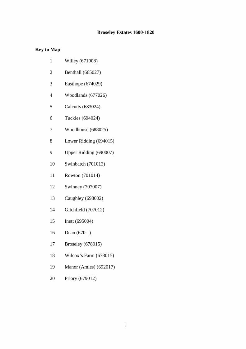
Broseley Estates 1600-1820
Key to Map
1 Willey (671008)
2 Benthall (665027)
3 Easthope (674029)
4 Woodlands (677026)
5 Calcutts (683024)
6 Tuckies (694024)
7 Woodhouse (688025)
8 Lower Ridding (694015)
9 Upper Ridding (690007)
10 Swinbatch (701012)
11 Rowton (701014)
12 Swinney (707007)
13 Caughley (698002)
14 Gitchfield (707012)
15 Inett (695004)
16 Dean (670 )
17 Broseley (678015)
18 Wilcox’s Farm (678015)
19 Manor (Amies) (692017)
20 Priory (679012)
i

Appendix VII – Broseley Estates, Landholdings and significant Landowners 1600-1820
The map overleaf approximates to OS Pathfinder 890 (SJ60/70) 2.5” to one mile,
1:25,000. Used in conjunction with the attached map the key shows the location of the
main freehold and most significant leasehold estates in and around Broseley over the near
250 year period of this work. Most of these estates had an importance for industrialisation
in Broseley as industry – mining, iron founding, ceramics manufacture – was established
on these landholdings. Undertaken initially as a secondary activity together with
agriculture eventually industry became the principal economic activity of many of the
estates. A few, such as the Amies, remained a solely agricultural holding. Some of the
estates, spatially, succeeded others and the map does not represent the estates as co-
existing at a particular interval of time. Many of the freehold estates were, on acquisition,
subdivided and/or converted to leasehold and granted to tenants. Alternatively some
experienced a reversed change in legal status with leases being purchased by or reverting
to freeholders and consolidated as large freeholdings. Some were then re-granted as
leasehold farms. The map does not attempt to define boundaries to particular estates
because it does not represent a particular interval in time. The land market in Broseley
was so fluid over the period of 220 years between 1600 and 1820 that spatially and
locationally the estates were constantly changing. The estates were constantly
experiencing subdivision and reconsolidation. For example, the inventory of William
Taylor’s Easthope Estate dated 1803 reveals a disparate range of properties – dwellings,
mines, small brickells, agricultural land, orchards and gardens – in varying condition.
However, the location of the Easthope Estate is frequently given as the parcel of land to
the rear of Woodlands Farm overlooking Ladywood and the Severn Gorge, today a few
ii
acres of fairly rough pasture. Clearly the estate recorded in 1803 must have spread far
beyond this limited core holding. As the dispersed character of the Easthope Estate was
shared by many of the estates listed on the map the locational reference given applies to
the main/core holding of the estate or the main dwelling.
1 – Willey (671008) – John Weld Snr.’s original core holding acquired in the early-
seventeenth century. Later the Weld and Weld Forester estates were extended by
acquisitions such as The Manor of Marsh, part of the Priory lands and the Caughley
Estate.1
2 – Benthall (665027) – The holding centred originally on Old Benthall village to the rear
of Benthall Hall and all lands around modern-day Spout Lane. The core of the estate
moved to the Benthall Valley when Lawrence Benthall began to realise the potential of
Benthall parish for exploitation of the lower coal measures, clay beds and manufacturing
of bricks and clay tobacco pipes.2
3 – Easthope (674029) – William Taylor’s large disparate holding with the core above
Ladywood. The inventory dated 1803 reveals a wide range of activity, industrial and
agricultural across numerous small plots.3
1 Shropshire Archives, 1224/1/30 - Samuel Parson’s map of the Plott of Willey; 1224/1/18 – Plan of the commons in Willey in 1650. 2 Public Records Office, C142/505 No. 103; SA, 1224/1/32; 1224/ Box 66 – conflict between John Weld and Lawrence Benthall over Benthall’s mining activities in Benthall Marsh and brick making elsewhere in the parish; JU Nef, The Rise of the British Coal Industry (1932) i, p. 360 3 SA, 515/5, The Shackerley Collection, pp. 61-64 ‘particulars and valuation of an estate and mines situate in the parish of Broseley and County of Salop, a property of William Taylor Esquire’ (dated 19th June 1803)
iii
4 – Woodlands (677026) – Adjacent to the Easthope Estate it possessed large accessible
coal reserves, many of the early insetts in the names of Cage, Crompton, Weld running
south from Ladywood passed under this estate.4
5 – Calcutts (683024) – From the early-eighteenth century the most valuable landholding
outside the Weld Foresters’ control. Stretching down and alongside the Calcutts Valley
from near the Coneybury, the estate included little valuable agricultural land but numerous
significant industrial undertakings – complex mine workings and a large industrial
complex near the confluence of the Calcutts Brook and the River Severn. Several maps in
the Broseley Estate Book show this complex as possessing furnaces, cannon boring mills,
coke and tar ovens, a tar distillation plant and cottage and courtyard potteries.5
6 – Tuckies (694024) – A riverside estate between the Woodhouse and the river that was
accessed along the south bank of the Severn from Jackfield and from Broseley down
Corbetts Dingle. Its main significance was coal mines that were the first in the district to
use steam pumps and a large improved timber-framed dwelling at the centre of the
holding.6 The river near this estate was used in the early-seventeenth century for the
dumping of waste material from mining and ceramic manufacture resulting in a fine for
James Clifford.7
4 SA, 1224/1/32 – Samuel Parson’s map of the Plott of Broseley, 1620 5 SA, Cooper Collection, Broseley Estate Book, Ref. 6001/2365-6 – Map of the Calcutts complex in the mid-eighteenth century. 6 AJ Mugridge, Twelve Mines in the Broseley Area (Self-published, Jackfield, 1997), pp. 32-34 7 ‘Extracts from the Registers of Much Wenlock’ (no author), Transactions of the Shropshire Archaeological Society, Vol XI (1888), p. 426
iv

7 – Woodhouse (688025) – A large productive agricultural holding south of The Tuckies.
There is evidence of surface mine workings in the form of uneven ground, bell pits and
delves in the fields to the north-west of Corbett’s Dingle.
8 – Lower Ridding (694015) – The western part of the Riddings holding with no evidence
of mining or other industrial activity accessed by the Rough Lane before the lane of the
Coalport road from old Broseley village to the bridge at Preen’s Eddy in the late-
eighteenth century.8
9– Upper Ridding (690007) – Between the Lower Ridding and the Caughley Estate
evidence of mining activity and carried two independent rail/plateways, one from Willey
furnace and leading behind Caughley Place and the Inett Farm down Tarbatch Dingle to
Willey Wharf and the other later leading from Broseley Furnace/Tileries to clay and coal
mines in the vicinity of Turner’s Yard opposite the site of Caughley Porcelain
Manufactory.9
10 - Swinbatch (701012)
11 – Rowton (701014)
12 – Swinney (707007)
The three above estates were agricultural holdings. In the late-eighteenth and early-
nineteenth centuries George Forester extended and consolidated his Willey Estate by
repurchasing leases granted on freeholdings already held by the Foresters and by
purchasing other freehold estates in the ownership of the successors to the Lacons,
Langleys and James Clifford. These acquisitions were frequently re-granted as
8 SA, 1224/3/567, 4th September 1790 agreement by George Forester to purchase the Lower Ridding from Daniel Onions for £900 to include two dwellings, barns, buildings and gardens, Orchard Meadow, Well Meadow and other pieces of land amounting to 41 acres. 9 SA, 1224/3/527 – Evidence of Upper Ridding Farm purchased by George Forester in 1790.
v

leaseholdings or even periodic tenancies occasionally with mining rights. The three above
estates were of this type and apart from some limited mining near Rowton and Swinbatch
farmhouses they were exclusively agricultural undertakings. The acquisition of these and
other holdings to the east of Broseley combined with their existing lands, gave the Forester
family a large consolidated holding stretching from riverside at Linley past Willey village
to Shirlett.10
13 – Caughley (698002) – Together with Calcutts, Easthope and the Broseley Estate a
diverse holding centred on Caughley Hall and Caughley Home Farm. In the late-
eighteenth century, it comprised a porcelain manufactory, saggar works, numerous
productive mines including Caughley and Turner’s Yard collieries, and a rail/plateway and
tramway network that linked important industrial holdings such as New Willey furnace,
Broseley Furnace and Caughley Porcelain Manufactory with clay and coal mines and the
River Severn at Willey Wharf and The Roving. From the sixteenth century in the
ownership of the extended Browne family, the Caughley Estate was acquired by George
Forester’s Trustees at the end of the first quarter of the nineteenth century and with it the
industrial undertakings leased to such as Gallimore, Turner and Banks and Onions. The
holding was consolidated and integrated into the large developing Willey estate of the
Forester family to the east of Broseley township.11
14 – Gitchfield (707012) – A small estate between Swinney, Rowton and Swinbatch and
the River Severn. It was accessed by a rail/plateway down Tarbatch Dingle and another
10 SA, 1224/3/552, dated 28th and 29th September 1790 – an agreement by Robert Bromley to sell to George Forester Swinney Hall and Swinney Farm and land; 1224/3/788-91, 800-4 – George Forester’s Trustees received Rowton from the Edwards family of Huntingdonshire. Its outbuildings include a late-sixteenth century timber-framed barn and a notable dovecote; 1224/3/675-82 – George Forester’s Trustees purchased Swinbatch Farm from John Langley in 1813. 11 SA, 1224/ Box 78 – Title deeds evidencing sale of the Caughley Estate, through the eighteenth century in the ownership of the Browne family to the Trustees of George Forester on 24th -25th March 1823.
vi

from the vicinity of Rowton and Swinbatch farms. Some relatively insignificant mining,
Gitchfield’s greatest importance in the district occurred in the period outside this work
when Exley’s roofing tile manufactory established a second tile works at riverside near to
the site of Ball’s Foundry.12
15 – Inett (695004) – An agricultural holding with mines that stood between The Riddings
and the core of the Caughley Estate. It was serviced by the rail/plateway that came over
The Riddings’ field system from New Willey ironworks leading down Tarbatch Dingle to
Willey Wharf.
16 – Dean (670---) – An estate consolidated into the Weld’s Willey Estate which focused
on the crossroads where the road from New Willey village crossed the
Broseley/Bridgnorth road and went up The Roundthorn to link with Lampas Lane. In the
sixteenth century there was evidence of mills on the Dean Brook but there is little evidence
of other industrial activity before the establishment of the New Willey ironworks upstream
from the Dean farmhouse in 1757. By this time the Dean Estate had been absorbed into
the Weld Foresters’ holdings and it was George Forester who granted the lease for the
works to be established to the shareholders of the New Willey company.
17 – Broseley (678015) – The estate was centred on Broseley Hall immediately adjacent
to All Saints Church in old Broseley village. An inventory dated 20th March 1800 in the
name of William Yalverton Davenport shows the estate to be one of diverse economic
activity with the central holding consolidated round the Upper Calcutts Valley with other
smaller holdings all over the town. There were numerous sub-lettings of plots to iron
12 SA, 1224/3/595, dated 9th October 1791 an agreement by George Forester to purchase the Gitchfield Estate for £1,925. Purchased from Samuel Manning.
vii

founders, earthenware manufacturers and miners. Significant industrial undertakings
included the Coneybury iron works and the Haycop and Bottom Coal mines. The Broseley
Estate Book of the eighteenth century contains maps that show the extent of the railways
on the upper section of the Calcutts Valley and how they served collieries and coal works
linking them to the river at Jackfield. The Estate Book also has a number of freehand
maps of the Calcutts industrial complex which is the best evidence of the scale and
diversity of the most significant integrated industrial undertaking on the south bank of the
Severn.13
18 – Wilcox’s Farm (678015) – The Wilcox Farm holding evolved into the Broseley
Estate, Broseley Hall being built in the early eighteenth century on the site of Wilcox
farmhouse, Old Broseley Hall. However, Wilcox’s Farm Estate was important in the
seventeenth century in its own right having a significant mining operation. The clearest
evidence of the mining’s importance was the ‘coal wars’ of the first decade of the
seventeenth century when Richard Wilcox and James Clifford were in dispute over matters
such as damage to mining equipment, the laying of rails and the restriction of access to
coal measures.14
19 – The Amies (692017) – An ancient agricultural holding frequently referred to,
probably erroneously, as the ancient Manor of Broseley, focused on a timber-framed house
that stood approximately three quarters of a mile north-east of old Broseley village. It was
almost certainly named after the original medieval family – The Amyas – that held the
13 SA, 515/5, The Shackerley Collection, pp. 234-241 – the survey and valuation of the Broseley Estate situate in the County of Salop, the property of William Yalverton Davenport Esquire (dated 20th March 1800) 14 SA, 1224/3/214 – property leased to the Wilcox family and known as The Old Hall until demolished in the early eighteenth century when the new hall was built and the name of the estate was changed to the Broseley Hall Estate.
viii

estate in the twelth and thirteenth centuries. In the late-eighteenth century the estate was in
the ownership of the Blythe family, a member of which was Francis Blythe Harries, the
Lord of the Manor of Benthall and proprietor of the Benthall iron works. The Amies was
purely an agricultural holding with no evidence of any industrial undertakings.15
20 – Priory (679012) – After the Dissolution this was the residue of the Wenlock Priory
lands in Broseley and acquired its name as a result. The Priory Estate and substantial
rights of common just south of Broseley Wood were acquired in the late-sixteenth century
by James Clifford of Gloucestershire. The estate was centred on the Priory, a substantial
dwelling built by Clifford immediately to the south-east of modern day Avenue Road. The
core landholding forming approximately one third of the manor was agricultural but the
estate was distributed widely throughout the district with interests down the Calcutts
Valley, on the main Priory Common and in the vicinity of The Tuckies and Woodhouse
Farm. The estate’s most important contribution to industrialisation in Broseley was that it
was responsible, through Clifford, for constructing the second oldest railway in England
that ran from old Broseley village down the Calcutts Valley to the Severn at Jackfield.
After Clifford’s death the estate descended through the female line and was fragmented
and acquired by other landowners in the district before eventually ending up in the
ownership of the Forester family.16
15 Victoria County History of Shropshire, Vol. X, p. 269-270 – Belonged to the Langley family from the fourteenth century until 1717 when it was sold to Richard Littlehales of Bridgnorth and subsequently to George Forester’s Trustees in 1813; SA, 515/4, The Shackerley Collection, pp. 315-316; 1224/1/36; 1224/3/648-656 16 SA, 1224/3/193 – James Clifford of Frampton-on-Severn, Gloucestershire acquired the former Wenlock Priory landholding; Public Records Office, C142/73 No. 80 – estate passed on Clifford’s death in 1613 to his son-in-law, John Cage and in 1620 it was sold to Francis Langley of The Tuckies; SA, 1224/3/383-384, 387-8 – George Forester acquired the Priory as part of the acquisition of the whole manor in 1795.
ix

Inventories and wills reveal much about the social structure in the town. Changes
in the character and status of landholdings also show changes in wealth ownership, social
stratification and status. They reveal the elevation of a class of cottager husbandmen who
relatively enhanced their wealth and status compared to the original substantial
freeholders. However, many experienced inverted social mobility from the second quarter
of the eighteenth century and become part of the developing urban proletariat. Towards
the end of the eighteenth century the substantial freeholders reasserted their pre-eminence
through the Weld-Foresters who enhanced the scale of the Willey Estate through
purchasing leases and freeholdings and consolidating these particular estates before re-
granting them to new tenants. Inventories/wills followed this pattern of large freeholdings
being subdivided into tenanted smallholdings before reverting or being re-purchased and
consolidated as large freehold estates (Foresters’ Willey Estate, Taylors’ Easthope Estate
and Davenport’s Broseley Estate are examples). They were then re-let as the substantial
tenant farms that exist today. Wills in the late-eighteenth century showed realty being
subdivided and devised to three or four offspring with the leases to the property being held
by non-family members. As a consequence of this process Broseley acquired much of its
present day character of large, freehold estates being let in the form of small leasehold
units.
In this process of secularisation and alienation of the Priory lands in Broseley and
district and the initial subdivision and subsequent reconsolidation of the landholdings four
individuals, Lawrence Benthall, James Clifford and John Weld Snr. and Jnr. and one
family, the Weld-Foresters are the prime movers in these extended processes of change.
Benthall, Clifford and the two Welds were largely responsible for the subdivision of the
x
Priory lands into small lettings but over the full period of 220 years of this work it is the
Weld-Foresters that become solely dominant in controlling the land market in the district.
After the Norman Conquest, Broseley was a small settlement (five tenements/hides
listed in 1087, nine inhabitants) in a clearing in Shirlett forest, deciduous woodland
forming an extension to the Long Forest which extended from the south-west end of the
Corvedale to the south bank of the Severn Gorge. The ancient village stood at the south-
eastern extremity of the present town, adjacent to the site of the church and there is
evidence of the antiquity and the early development of this part of the town from early
dwellings and the materials used to construct them – timber framing and hand-made raddle
bricks.17 The ancient Manor, held initially by Wenlock Priory,18 was Marsh (between
Broseley and Much Wenlock) and local tenants had to perform service at courts leet and
baron attached to this manor.19 Eventually, other settlements in the form of small hamlets
– Broseley itself, Benthall and Willey - gained manorial status. Before the Dissolution the
demesne land, initially held by the Priory was settled and retained by certain families,
together with other freehold and copyhold estates.20 Broseley was a wood-pasture village
with three open fields, none of which had been enclosed by 1600, where animal husbandry
combined with undeveloped industrial activity (quarrying of sandstone in Broseley Wood,
corn mills on Benthall and Dean Brooks) took place.21
17 Shropshire Archives, Forester Collection, 1224/1/32, Samuel Parsons’ map (1620), see Figure 2. 18 SA, 1224/3/214 Box 342; Victoria County History Vol X. pp. 266-268 – original lease for Wilcox’s farm, early-sixteenth century; B Trinder, Industrial Revolution in Shropshire (Chichester, Phillimore, 2000), pp. 14-15 19 SA, 1224/BR44 Thomas Smyth’s lease Saturday 24th June 1703; 1224/BR50 To William and Anna Whitmore and Robert Whitemore Jnr, butcher, 1st May 1719. 20 VCH Vol X, pp. 266-268 21 Ibid., p.259,; Ibid., p.273; SA, 1224/
xi

The Priory lands down to the sixteenth century descended through a variety of
tenancies, often linked to lives in being, including entails, reversions and remainders,
which added to the overall complexity of the land market in and around Broseley.
Although various collusive processes were used to bar entails within a general movement
towards free alienation of land, the continued primary support for the whole structure of
landholding, up to the 1540s, was provided by a large ecclesiastical institution. There was
little to suggest a desire to realise the full potential of Wenlock Abbey lands, agriculturally
or industrially.22
James Clifford, Lawrence Benthall and John Weld, in the early-seventeenth
century were examples of a new type of landlord starting to acquire wealth from wool,
corn, timber, coal and iron rather than from ancient rights and privileges that previously
had provided income through the administration of justice and lordship entitlements. This
new social grouping were rentiers, with, subordinate to them, a class of tenant farmer
involved in common husbandry and, in certain parts of the country, cottage-based
industry.23 Two of the three, Benthall and Weld, though neither recusant nor non-recusant
Catholics, were strong supporters of the King’s cause before and during the Civil Wars.
Both were sequestrated but discharged themselves through fines. Weld and Benthall
frequently clashed over matters such as rights of way to the Severn and access to detached
portions of their lands over the other’s property.24 An example of the natural conflict that
existed between the two men and between Weld and James Clifford was provided by the
22 J Alfrey, C Clark, The Landscape of Industry – Patterns of Change in the Ironbridge Gorge (London, Routledge, 1993), pp. 12-14; WF Mumford, Wenlock in the Middle Ages (Much Wenlock, E Mumford, 1977) pp. 12-87 23 C Wilson, England’s Apprenticeship: 1603-1763 (London, Longmans, 1965), pp. 8-9 24 SA, 1224/163 Memorandum of John Weld (1631) transcript by AW Phillips July 1st 1900
xii

‘Coal Wars’ of the early-seventeenth century.25 One aspect of the conflict was Benthall
and Clifford’s active encouragement of squatting miners in their acquisition of prescriptive
rights of settlement on their lands and on adjacent commons in Broseley Wood. These
squatting miners then mined the coal on their prescriptive plots and paid a royalty to the
two landholders who retained the mineral rights.26 This enraged Weld and existing
tenantry – a new supply of coal on to the market would depress the price and reduce
profitability. A further dispute existed over who should make good and who should be
responsible for damage and distress to railways and mining equipment on the land of
Wilcox’s farm.27 In addition, the incoming miners (unclear from where) were socially
divisive, brutal ruffians with little regard for normative social behaviour in an established
community.28 There was some violence and rioting on a small scale29 and entrapment of
colliers underground. Eventually the two conflicting groups accepted each other’s
existence and rights and began to live together in uneasy harmony. This tradition of two
settlements, the old village and lower town and Broseley Wood has persisted to the present
day and there are still recognisable distinctions in population density, class of occupant,
street patterns, house size and style and popular attitudes between the ‘bottom’ and the
‘top’ of the town.
25 VCH Shropshire Vol X, pp. 273,274, Hatcher, The History of the British Coal Industry Vol 1 before 1700, pp. 143.147-148; Charlesworth (ed.) Rural Social Change and Conflicts since 1500 – Rural Riots in Seventeenth Century Salop, pp. 11-13 26 JU Nef, Rise of the British Coal Industry (London, 2932), pp. 150-151; Alfrey, Clark, Landscape of Industry, pp. 115, 149-150 27 SA, 840 Box 43 – A deed for the establishment of James Clifford’s replacement rails for Wilcox and Wells’ system, 22nd September 1609; PW King, ‘First Shropshire Railways’, G Boyes (ed.) Early Railways 4: Papers from the 4th International Early Railways Conference (Sudbury, Six Martlets c. 2010), pp. 74-80; National Archives, STAC8/310/16 – depositions by various persons concerning damage by James Clifford’s overseer, Robert Prescott, to Richard Wilcox’s rails and mining equipment. 28 Nef, Rise of the British Coal Industry, pp. 150-151. MJT Lewis, Early Wooden Railways (London, 1970), pp. 95-100; Alfrey, Clark Landscape of Industry, pp. 115, 149-150 29 Ibid.
xiii

The importance of John Weld Snr and his descendants in the post-Dissolution land
market of the south-bank parishes is evidenced by primary sources. The Forester
Collection contains a large number of leases and indentures, witness to the fragmentation
of the whole plott of Broseley into small units suitable for cottage industry and animal
husbandry. This collection of leases is supported by contemporary maps of the developing
settlement of marginal land including commons. The indentures provide a clear record of
rights granted and rights retained. Other documents show the Weld-Foresters becoming
involved with the flotation of substantial industrial ventures30 and the reconsolidation of
freeholdings into large agricultural units.31 The class of cottage entrepreneurs who
evolved from the fragmentation of the plots were men of substance and their wealth is
evidenced by seventeenth- and eighteenth-century inventories.32
Weld Snr., Jnr and their descendants’ role in the economic development of
Broseley and district in the seventeenth- and eighteenth-centuries means they were the
main focus of any analysis of the development of the local land market. Their character,
attitudes and policies of expansion and consolidation of their estates were key factors in
the development of Broseley’s land holdings as locations for developing primary and
secondary manufacturing industry.33 However, both Lawrence Benthall and James
Clifford made significant contributions to the process of land management in the late-
sixteenth and early-seventeenth centuries.
Clifford was from the merchant class of Gloucestershire and came to east
Shropshire as a landholding descended to him through the female line. His Priory estate
30 SA, Box 143 Forester Collection, Leases of land minerals and mineral rights to John Wilkinson and old and new Willey Iron Company, 30th June 1757 31 SA, 1224/3/527, Swinney and Upper Ridding Farms purchased by George Forester in 1790 32 SA, 1224/BR42a – lease granted of three coal pits to William Williams and Noel Edwards 33 SA 1224/3/463 – 1224/3/613; 1224/163 Memorandum of John Weld
xiv

was that part of the local manor previously held by the Cluniac Abbey34 at Much Wenlock.
It retained its identity through continuing association with the monastic foundation after
the Dissolution. The main tenement and home farm – built by Clifford – of the estate that
stood near the church in, what are today, fields on the right-hand side of the avenue that
runs down from Willey estate lodge to Broseley Hospital.35 Clifford became the Lord of
the Manor and for a short time was the pivotal figure in the extended conflict between
entrenched tenantry and squatting miners over encroachments of rights in common. In
addition there was fierce competition between Clifford and his own tenants as to who
should retain the right to exploit the mineral resources of the manor. This feuding, the
consequence of numerous disputes between the chief land owners and the tenantry and
squatters, culminated in 1607/08 in a series of violent raids on workings, equipment and
rail/plateways by the parties to the disputes.36 That violence occurred on such a scale is
indicative of the significance of coal to Broseley in the late-sixteenth and early-
seventeenth centuries.37
Lawrence Benthall was a similar example of a landlord who was far-sighted,
ambitious and practised vigorous land and resource management. The Benthall family had
gained control of the Manor of Benthall in the sixteenth century,38 building in the process
34 SA 1224/3/195; Eyton, ‘Wenlock Priory’, pp. 167-182 35 Map references 679013 – The last section of the road from Bridgnorth down to old Broseley village 36 VCH Shropshire Vol X, pp. 273,274; Hatcher The History of the British Coal Industry Vol 1 before 1700, pp. 143, 147-148; Charlesworth (ed.) Rural Social Change and Conflicts since 1500 – Rural Riots in Seventeenth Century Salop, pp. 11-13; Nef, Rise of the British Coal Industry pp. 150-151; Lewis, Early Wooden Railways, pp. 95-100; Alfrey, Clark, Landscape of Industry, pp. 115, 149-150; SA, 840 Box 43 – A deed for the establishment of James Clifford’s replacement rails for Wilcox and Wells’ system, 22nd September 1609; King, ‘First Shropshire Railways’, pp. 74-80; NA STAC8/310/16 – depositions by various persons concerning damage by James Clifford’s overseer, Robert Prescott, to Richard Wilcox’s rails and mining equipment. 37 J Hatcher, The History of the British Coal Industry Vol 1, (London, Oxford University Press, 1993), p 260. 38 JE Auden, ‘The War Services of Some Shropshire Officers in the King’s Army’Transactions of the Shropshire Archaeological Society,, 4th Series Vol. II (1912), (Vol. XXXV), pp. 232-233 – Reference to Lawrence Benthall fortifying Benthall Hall for the King and repelling Parliamentary forces. Benthall subsequently fined £151 for supporting the King. This reveals Benthall as a pivotal figure in controlling the local developing micro-economy, particularly mining, for the cause of the King.
xv

a fine example of a late-Elizabethan manor house, in stone, which was constructed to the
south-east of the ancient medieval village. By 1600, Benthall was quarrying limestone on
his lands, coal was being mined locally in the parish and brick-making was taking place on
a small cottage-based scale.39 Benthall’s enterprise brought him into conflict with John
Weld. Weld accused him of encouraging poor families to settle and build dilapidated
cottages in Broseley and Benthall, an overspill area from Broseley Wood known as the
Mines. Benthall denied it, claiming he only recruited miners, not footloose paupers.40
During the early part of the seventeenth century, Benthall however, with considerable
foresight and business acumen not previously revealed in his business affairs, shifted the
whole centre of the community - the Benthall Valley - a mile to the east.41 The old village
was eventually abandoned and Benthall became a flourishing industrial settlement in its
own right, although today it is little more than a suburb of Broseley on its north-western
boundary. Benthall saw the potential of the Benthall Valley for the mining of coal and
ironstone and the natural slope of the valley (steep, falling 300' in little more than half a
mile) for transport of minerals down to the Severn. The land fall is precipitous in and
around the Benthall Valley and this ensured low opportunity cost and maximum profit
potential. Squatter settlements became established on both the Broseley Wood and
Benthall sides of the valley to further exploit outcropping coal seams and there was a
flourishing cottage-based industry of clay tobacco pipe manufacture, alongside agriculture
and coal mining.42
39 VCH Shropshire Vol X, pp 252-254 40 SA 1224 Box 66 John Weld’s evidence, Benthall’s response 16/11/1635 41 Map references 657027 moved to 671028 – The site of the old village lay in the field between the rear of Benthall Hall and Benthall Edge. Little or no evidence in the form of house platforms or depressed roadways. New Benthall occupied the west side of the upper Benthall Valley, today known as The Mines; Alfrey, Clark, Landscape of Industry, pp. 13, 116. 118, 123, 126, 152; VCH Shropshire Vol X, p. 249 42 SA, 1224/2/124; VCH Shropshire Vol X, p. 254; map references 664019 and 669027 – The end of Benthall Lane and The Mines, both of which had mines and clay pipe manufactories.
xvi

John Weld Snr. was a landed rentier who saw his future prosperity in the
exploitation of his estates and mineral rights by others more suited to the process than
himself. Rather than the rising capital value of his lands over time he saw the potential of
rents, fines and royalties as the basis of a ready income.43 However, apart from the fact he
was a high church Royalist44 from a London mercantile background, the most notable and
significant departure that he represents from the model of emergent seventeenth-century
gentry, is that he realised that it would be industry and not agriculture that would guarantee
the economic security of his descendants, and the developing settlement of Broseley and
its hinterland.45 Acting on his advice as regards carefully safeguarding mineral resources,
consolidating, rationalising and expanding the family estates,46 The Weld family was
joined to the Foresters of Dothill, Wellington by marriage in 1748. The Foresters
themselves owned substantial estates just north of Wellington and in the area between
Little Wenlock and Watling Street. The union of the two families meant effective control
of a large estate stretching from just north of Much Wenlock to and beyond Watling Street.
The focus of the Weld-Foresters’ land management was that part of the estate focused on
Broseley and Willey where they were largely responsible for the impetus required for the
south bank to experience its first phase of industrialisation between the early-seventeenth
and mid-eighteenth centuries.
John Weld’s ‘memorandum’ where Weld, during a bout of ill health that made him
aware of his mortality, gave unequivocal advice to his family on how they could enhance
43 SA, 1224/163 Memorandum of John Weld (1631) transcript by W Phillips July 1st 1900; Wanklyn, ‘John Weld of Willey 1585-1665:- an enterprising land owner of the early seventeenth century’ West Midlands Studies Vol III (1969) pp. 88-99; MDG Wanklyn, ‘John Weld of Willey: Estate Management 1631-1660’, Journal of the Wilkinson Society Vol 4 (1970-71), pp. 63-71 44 W Phillips (ed.), ‘The Sequestration Papers of Sir John Weld Senior and Sir John Weld Junior, Knights of Willey’, TSAS 3, Vol I, (1901), pp. 185-212 45 SA, 1224/163 Memorandum of John Weld (1631) 46 SA, 1224/BR24; 1224BR38e; 1224BR31c
xvii

their affluence through the effective management of their Willey and Broseley estates, is
particularly revealing of Weld’s good and far-sighted business sense.47 The text of the
memorandum is analysed below and shows individual entreaties revealing Weld’s keen
interest in competition and the exploitation of the coal mining potential of his estates as he
advises his family and descendants with regard to management of their inheritance.48 The
Forester Collection and the memorandum in particular reveal numerous facets of
entrepreneurial activity as well as much of the character of the people directly involved.
Several patterns can be identified. Weld was a single-minded, ruthlessly competitive
businessman, with few qualms about baulking other landowners’ opportunities for
exploiting their own mineral resources.49 For example, Weld, in the memorandum, points
out that John Corbet, a local landowner, in the vicinity of modern-day Dean Mill, cannot
access his coals, carry them by Wain, or pass them over his (Weld’s) land without express
consent (there is little indication that this would be given).50 Weld is also keen to ensure
that where Corbet’s land surrounds his own, if at all possible he should not be allowed to
appropriate his (Corbet’s) own coal.51 One Edward Harper of Willey is denied a right of
way by Weld, merely to prevent him keeping any cattle.52 Perhaps his competitive
instincts are best illustrated by his obvious antagonism towards Lawrence Benthall when
indicating that if he (Weld) can access his own coal quickly he would drain Benthall’s coal
47 SA 1224/163 Memorandum of John Weld (1631); Wanklyn ‘John Weld of Willey 1585-1665: - an enterprising landowner of the early seventeenth century’ pp. 88-99; Wanklyn, ‘John Weld of Willey: Estate Management 1631-1660’, pp. 63-71 48 The writer accessed a transcript of the memorandum, the work of AW Phillips dated July 1st 1900. Any quotations relating to comments and recommendations made by Weld come directly from the text of the transcript of the memorandum. 49 SA, 1224 Box 163 John Weld’s memorandum 1631 50 Ibid.; SA, 1224/3/463 – In 1632 John Weld Snr. acquired the lease near Dean Mill from John Corbett. The lease was assigned to Weld on 11th September jointly from John and Elizabeth Corbett and included Dean Mill Pit (colliery) and Riparian (water) Rights on Dean Brook and Mill Pond; 1224/3/464 – John Weld’s descendant, George Weld, eventually consolidated the holding at the Dean by acquiring a dam and the pool behind in 1707. 51 SA, 1224 Box 163 John Weld’s memorandum 1631 52 Ibid.
xviii

works in return for a substantial fine.53 No evidence exists whatsoever of any mutual co-
operation between the two men.
Weld is well aware of the potential of the coal, ironstone, limestone and timber
resources of his estates. The memorandum is full of references to the industrial potential
of coal, eighty years before it was first used to successfully smelt iron,54 and Weld appears
to be aware of how important it is not to ‘tip off’ his rivals as to any coal reserves they
might hold for fear of their competition in the local and export trade.55 He also seems wise
to the importance of access and securing rights-of-way under leases and indentures.56 He
warns against felling any immature timber, realising that he will need it (for props) if his
coal workings are found to be extensive and profitable, this profitability being assessed not
merely by contemporary valuation but also estimation of future wealth.57 What is
indicated in the memorandum and later leases, deeds and indentures, is the focus on
primary and secondary industry as the foundation for improved prosperity, to the
disadvantage of agriculture. Weld’s entreaties make one or two direct references to the
need to safeguard his agricultural holdings but every paragraph contains warnings as to the
need to protect mineral rights and to secure competitive advantage in the developing coal
and ironstone trades in the first half of the seventeenth century: ‘It may fall out iron may
53 Ibid. 54 Ibid. ‘I estimate any coal and ironstone in Willey Park if I can procure a constant way to the Severn will be worth (?) at least in time. (From transcript of Weld’s memorandum SA, 1224 Box 163) 55 Ibid. ‘Get not coals too near Mr Lacon’s grounds towards Linley, nor near Mr Acton’s grounds in Willey, nor in Barrow, lest it caused them to search for coals’. (From transcript of Weld’s memorandum SA, 1224 Box 163) 56 Ibid. ‘Consider if I find coals of a way to the Severn . . . I am told my coals in Willey Park may be conveyed to the Severn through my lands in Broseley and some of Francis Langley’s lands’. (From transcript of Weld’s memorandum SA, 1224 Box 163) 57 Ibid. ‘Fell no timber or wood in Rudgwood, Willey Park, Birch Leasow, Horseley Moor or Willey held or for there will be need of it if I prove to have good coal works’. (From transcript of Weld’s memorandum SA, 1224 Box 163)
xix

hereafter be made with pit coal’ – the memorandum dates to 1631 before significant
experimentation with smelting with fossil fuel by Crowley, Dudley and Clarke.58
Limestone seems less significant but at this time there was no mass production of
iron in the blast furnace where it was used as a flux. The memorandum is written in the
context of a developing proto-industrial base (agriculture with coal, clay and ironstone
mining and cottage-based brick and clay pipe manufacture) but clearly it is the industrial
potential of the leased plots that attracts most valued approbation. Animal husbandry is
also highly valued but arable farming receives little, if any, recognition. Weld is brought
to the attention of the reader as an entrepreneur whose radical management methods were
copied and extended by his descendants and eventually by other industrialists in other
areas looking to develop their own lands. The Dudley family in the late-eighteenth century
would develop their estate in the Stour Valley of south Staffordshire and north
Worcestershire in similar fashion – encouraging settlement on marginal land and commons
which were possessed of rich mineral resources, tenancies-at-will being converted to
leases and incentives in the form of royalties and securities of tenure providing impetus for
a dramatic increase in the quantity of coal mined from the ten-yard seam.59 John Weld
Snr. and Jnr., plus their descendants, notably George Weld60 (late-seventeenth, early-
eighteenth century) and later the bachelor squire, George Forester61 (late-eighteenth and
early-nineteenth centuries), implemented policies within the land market of east Shropshire
that were to the best advantage of successful exploitation of the full potential of the land
58 Ibid. ‘Broseley land may be improved by getting coals and ironstone . . . if Benthall Marsh belonged to me and I could enclose it in regard I suppose there is coal under it, it might be worth to me in time £400 at least’. (From transcript of Weld’s memorandum SA, 1224 Box 163) 59 TG Raybould, The Economic Emergence of the Black Country (Newton Abbot, David Charles, 1973), pp. 182-193 60 SA, 1224/2/511; 1224/3/510-513 61 SA, 1224/3/582-596; 1224/3/675-682; PRO, IR29/29/55, IR30/29/55; The Weld and Forester families were conjoined by marriage in 1748 and the ownership of the Willey Estate passed accordingly.
xx

and what lay under it. The deeds, maps, leases and indentures contained in the Forester
Collection show clearly identifiable patterns of land acquisition and management.62
The Weld family initially appeared as landowners in Broseley when, as part of the
initial fragmentation and secularisation of the lands of Much Wenlock Priory and the
Manors controlled by the same, John Weld Snr. acquired the Manors of Willey and
Broseley from Sir Francis Lacon in 1618, and the Manor of Marsh in the south of Barrow
parish came under his control in 1620.63 In 1620, Weld also obtained the former Priory
demesne of Broseley Manor from James Clifford’s successors.64 Only the Broseley estate
(in the Crompton, Browne and Blithe family), based on a large impressive mansion near
the church, rebuilt around 1720, remained as a significant holding outside the Welds’
control.65 These acquisitions, plus other farms, formed the basis of the Weld/Forester
estates from the mid-seventeenth century onwards. There then took place a process of
extension, filling in, and consolidation of estates where properties were acquired by
purchase and exchange from the leading landholders in Broseley, Willey, Benthall, Barrow
and Linley parishes.66 These consolidated freeholdings and leasows were then let or sub-
let to a growing body of tenants who undertook the day to day development and operation
of small-scale agricultural and proto-industrial concerns.67 This process dominated land
transactions for the next 150 years. As it continued and gathered pace, coal, clay and
ironstone output rose dramatically and began to be utilised locally rather than reserved
62 SA, 1224/3/463 through to 1224/3/938 63 SA, 1224/3/160 – 184; VCH Shropshire Vol X, pp. 267 – 268. 64 Ibid. 65 VCH Shropshire Vol X, pp. 266-271 66 SA, 1224/3/465; 1224/3/466 and 467; 1224/3/480 and 481; 1224/3/482 and 483; 1224/3/485; 1224/3/486. 487 and 488; 1224/3/511 and 512; 1224/3/519 and 520; 1224/3/527; 1224/3/602 through to 613; 1224/3/608 and 609; 1224/3/521; 1224/3/523 – all relate to purchases by the Weld Foresters of land holdings in and around Broseley 67 SA, 1224/BR50; 1224/BR53; 1224/BR64; 1224/BR44. Box 33 Forester Collection; See attached map of Broseley and District’s significant land holdings, freehold and leasehold, over the 200 years between 1600 and the early-nineteenth century and a list of the same.
xxi

exclusively for export.68 From the middle of the eighteenth century, secondary
manufacturing industry (iron, bricks, ceramic goods) began to develop. The iron industry
established seven furnace/foundry sites from 1757 and bricks, roof tiles and ceramic
products also moved from small, plot-based workshop manufactories to larger production
units predominantly but not exclusively on sites leased from the Weld/Forester family.
New Willey furnace is an example of a secondary undertaking, established on a plot south-
west of Broseley, leased by eight partners in 1757 (one of whom was John Wilkinson who
became in turn manager and proprietor).69 The Weld-Forester landholdings were at the
centre of the full secondary industrialising process that took place in Broseley in the late-
eighteenth and early-nineteenth centuries.
68 Trinder, Industrial Revolution in Shropshire, p. 19; Hatcher, The History of the British Coal Industry Vol 1, p. 553 69 SA, 1224/1/26; Box 143 Forester Collection
xxii

Appendix VIII – Landform in Broseley – Geology and Topography
The map references in the text below can be referenced into The Institute of Geological
Sciences, Geological Survey of Great Britain (England and Wales) Sheet SJ60 and parts of
SJ61, 70 and 71, Scale 1:25,000 and the more localised references into the extract from
this map attached to this appendix. The more localised references may also be linked into
OS map Pathfinder 890 (SJ60/70) (2.5” to one mile, 1:25,000) an extract from this map
forming Appendix I.
This appendix examines both the landform in Broseley and the advantages gained
from and problems presented by topography to the process of industrialisation on the south
bank of the gorge. Fortunately, the advantages were considerably more significant than
the problems. The problems were overcome by human ingenuity and considerable
investment where necessary. Those parts of the town where the advantages were greatest
and problems least developed mineral extraction first – shallow depth mines into seams
outcropping on valley sides and surface workings in the form of delves and bell pits - with
low cost exploitation. At-depth extraction in different parts of the community but largely
at the eastern margins proved to be more expensive requiring considerable investment,
frequently by iron founding partnerships and naturally came later in the town’s economic
development.
i

The stratification of Broseley reveals the town as situated on a gently dipping –
three to four degree - syncline1 of alternating beds of sandstones, shales, lime and
mudstones and
Carboniferous coal seams.2 At the foot of map SJ60 and parts of SJ61, 70 and 71 there is a
two-plane section running from 605044 (Sheinton) to 642005 (Wyke fault) and from
642005 (Wyke fault) to 728020 (Sutton Maddock).3 This shows the west side of the
district as a gentle syncline with Wenlock limestone alternating with deeper bands of
Wenlock shales. The east side is shown to be more complex from just west of The Dunge
with beds of boulder clay initially outcropping and then, moving east, Keele and Coalport
beds of sandstones, mudstones and siltstones alternating and containing the lower coal
measures. Topographically, the landform is a low, crescent-shaped ridge running south-
east to north-west around three to four hundred feet above the River Severn. The two most
prominent topographical features of the district are, firstly, the River Severn in the form of
a great north-west to south-east bend from the mouth of the Severn Gorge down to Linley.
Secondly, the north-east of the district is dominated by Benthall Edge, a Silurian limestone
escarpment extension of Wenlock Edge, with a steep 350 foot scarp slope running south-
west to north-east on the west side of Benthall.
1 The Institute of Geological Sciences, Geological Survey of Great Britain (England and Wales) Sheet SJ60 and parts of SJ61, 70 and 71, Scale 1:25,000, see cross section of strata at the margins of the map 2 Ibid., also see at the margins of the map the cross section of strata with all nine of the significant coal seams on the south bank being identified; P Toghill, The Geology of Shropshire 2nd Edition, (Marlborough, Crowood Press, 2006), pp. 176 – 180 – particularly the diagram of the cross section of the East Shropshire coalfield showing the horizontal bedding (Coalport beds) of the upper coal measures overlying and separated by a band of sulphar coal overlying the faulted and folded (about the Symon fault) lower and middle coal measures. The Symon fault divides the coalfield into two, the measures north and the measures south of the Severn gorge. The diagram also shows the stratification with alternating beds of sandstone, mudstones and thin coals (three feet maximum height of coal seams). 3 The Institute of Geological Sciences, Geological Survey of Great Britain (England and Wales) Sheet SJ60 and parts of SJ61, 70 and 71, Scale 1:25,000
ii

The Ironbridge Gorge is an example of a late Ice Age glacial spillway cut between
10,000 and 20,000 years ago through the limestone, sandstone, shale beds and coal,
ironstone and clay deposits. Before the last Ice Age the River Severn had two branches,
one rising in Staffordshire and the other on Plynlimon. The two courses conjoined and
entered the sea possibly at the Dee estuary. However, the ice sheet obstructed this means
of egress forming a large glacial lake over north Shropshire and Cheshire known as Lake
Lapworth. The rising water level found a shallow saddle at the entrance to what is now the
Ironbridge Gorge and a new course was cut down towards present-day Bridgnorth and
eventually out into the Bristol Channel. When the ice sheet retreated around 12,000 years
ago the Severn maintained this new course down to the south-west, possibly due to it
following a buried trench across Shropshire from Melverley to the Ironbridge Gorge.4 The
Severn at Ironbridge is an example of a topographical feature known as a rejuvenated river
valley. It forms the juvenile stage of a second river profile, the first being between
Plynlimon and the Leighton meanders, just north-west of the Severn Gorge. The
consequences of this rejuvenation for industrialisation in the district are that the ends of
horizontal valuable mineral beds are exposed on both sides of the river and, as a result,
when industrialisation began extraction of these minerals, particularly coal, was non-
problematic. At the same time the bed of the River Severn has the features of an upland
river with alternating shallows, rapids and deeps making it inconsistent in its function as a
means of exporting the product of the district down to the south-west.
Benthall Edge is a steep, Silurian limestone escarpment that the River Severn cuts
through at the entrance to the gorge at Ironbridge. Its extension north of the river is
Lincoln Hill and the east side of the Coalbrookdale valley. It was established around 350-
4 P Toghill, Geology of Shropshire, 2nd Edition (Marlborough, Crowood Press, 2006), pp. 240-243 – both the traditional and revisionist theories of the formation of the Severn Gorge are examined.
iii

400 million years ago as a further off-shore reef in the same facies as the Wren’s Nest
escarpment in Dudley. It provides easily workable quality limestone deposits which have
had an important role in the industrialisation of the gorge, particularly with regard to iron
smelting.5
The geology map highlights surface outcropping that has significance for
industrialisation. The two prongs of the lower coal measures outcropping in the township
and to the west of the settlement run from 661018 and 671016 south-west and north-south
respectively meeting at 672007 (coloured olive green on the map). There is further coal
outcropping in the form of a crescent shape on the dip slope of Benthall Edge curving
round into the Benthall Valley between 660028 and 671023. This coal in the west of the
district was the first to be mined in shallow or surface workings. The nine seams are
represented in a section in the bottom left-hand corner of the full map. The middle coal
measures (coloured grey on the map) outcrop in a two-pronged measure over the whole of
the township and to the east of the settlement (670026, 673026, 671013, 681014). Boulder
clay outcrops in a cylindrical-shaped deposit between the Dunge and lower Lodge Lane
(coloured light blue on the map) (684012 to 673012) and also at 687010 down to 687003
around the Willey and Caughley faults. The east of the district has very complex
outcropping with Coalport formations of mudstones, siltstones, sandstones, coal and clay
deposits, (all coloured in varying shades of brown).
The stratification and geology of the south bank was significant for early
industrialisation in Broseley for a number of reasons. Firstly, access into near horizontal
5 DA Holmes, The Workings of the Silurian Wenlock Limestone in South-East Shropshire, pp. 50-65 – unpublished survey including the quarries worked along Benthall Edge in succeeding phases; J Alfrey, C Clark, Nuffield Survey, 3rd Interim Report of the Nuffield Archaeological Survey – Benthall and Broseley Wood (Ironbridge Institute, Ironbridge Gorge Museum Trust, 1987), pp. 50-54
iv
beds, particularly those outcropping on valley sides, is straightforward and relatively low
cost with limited initial investment, certainty of location and easy drainage. An absence of
folding avoids vertical and near vertical extraction keeping costs down. Much of the early
seventeenth-century mining was by adits such as those along Ladywood, evidenced by
seventeenth-century maps6 and lettings of coal workings.7 Secondly, widespread deposits
of valuable minerals, such as coal, clay and ironstone, alternate in close proximity to each
other and could be mined together in the same undertaking. Frequently these mineral
deposits outcropped on the surface or on the sides of the river and various batches.8 Unit
costs were reduced as overheads were allocated to two or three different mineral outputs
and the final price was much more competitive. Overall, costs were lower than most
competitors which gave both comparative and absolute advantage to the Severn Gorge in
all its mining activity. Thirdly, stratification is complicated by an extensive series of
faults, based on a major fracture, the Ironbridge-Broseley fault9 running from Lincoln Hill
diagonally across the district to the River Severn near the Roving. A number of other fault
lines in the local strata – Jockey Bank, Jackfield, Corbetts, Dean Corner, Willey and
Caughley - break off this main fracture. Faulting had both negative and positive effects on
6 Shropshire Archives, 1224/1/32 Samuel Parsons’ map of the Plott of Broseley 1620, detail in extreme north of map showing river side insets. See Figure 2. 7 SA 1224/3/412, 413, 22nd May 1752 lease of ‘Hockley in the Hole’ to Thomas Blakemore with mining rights to Thomas Stephens. 8 The Institute of Geological Sciences, Geological Survey of Great Britain (England and Wales) Sheet SJ60 and parts of SJ61, 70 and 71, Scale 1:25,000 – 661019 down to 674003 and 672016 down to 674003 marked two prongs of the outcropping lower coal measures. A large crescent-shaped band outcrops between 656022 and 671023. Boulder clay outcrops in a roughly rectangular area close to The Dunge, 673012 to 684012 and 675009 to 682009. 9 The Institute of Geological Sciences, Geological Survey of Great Britain (England and Wales), Sheet SJ60 and parts of SJ61, 70 and 71 – the Broseley fault cuts diagonally across the district disrupting continuity in strata and increasing the risk attached to new mining ventures. All other faults coming off this main fault line cause similar problems off the main fault axis; SA, 1224/3/444, 445, 446 – 20th July 1785 a lease by George Forester to Thos. Stephens and Mary Hartshorne of The Tyning and ‘all coals called top coals, bottom coals, best coal, flint coal, clod coal and any other coal and ironstone on the Tyning on top of the fault’. The mention of the fault suggests it was significant in terms of locating and accessing the coals present. There was also a lease by Forester to Thos. Stephens and James Wyke, surgeon, of all coals and ironstone on the ‘great fault’ (Syner’s Hill, Hall’s Yard, Barrett’s Yard, Legg’s Hill) for 99 years. The east side of the district is complicated by this extensive faulting. The Broseley fault runs diagonally from 664041 to 711004. The numerous other faults breaking off the main fault usually at roughly 90 degrees include Dean Corner 685013 to 667000, Jockey Bank 672027 to 678033, Jackfield 674023 to 683033, Madeley 688010 to 694025 and Corbetts 686012 to 691023.
v

decision making in mining operations. It both disrupted continuity of strata, restricting
potential for extended workings and increasing the costs of viewing. Particularly on valley
sides and sloping field systems, it exposed the ends of productive seams facilitating easy
access and unhindered drainage.
The crescent-shaped spine of the town10 runs along the top of a flattened ridge.
The ridge falls steeply away to the River Severn on its north/north-eastern side and, much
less precipitously, to the Dean/Cod Brook system on its south/south-western side. The
Dean Brook in the south-east of the district is a relatively insignificant tributary of the
Severn, rising in Posenhall and entering the Severn between The Roving and Wren’s Nest.
Batches – broad or narrow, steep or gently falling valleys originally carrying vigorous
streams – run down from the Broseley ridge north-east to the Severn. The town’s
topography, particularly water courses, has significantly influenced various aspects of the
industrialising process in and around the town. The Severn, in cutting its steep-sided
gorge, exposed the ends of valuable mineral beds, facilitating low cost, easy extraction and
drainage. The river itself, despite seasonal highs and lows and alternating shallows and
deeps,11 was, for 200 years, the main focus of Broseley’s export trade, particularly in coal,
10 Map reference 679012 through to 672029 – the Broseley ridge is not particularly pronounced but it serves to define and carry the main axis of the town from the old village up to the Woodlands Estate immediately above the narrowest section of the Severn Gorge. It provides a gradient that is positive for carrying goods down to the river but problems of carriage up a lesser slope to the south-west from the valley of the Dean Brook. 11 SP Duckworth, ‘The Severn Navigation and River Wharf Sites in the Ironbridge Gorge with particular reference to the Site of Calcutts’ (Institute of Industrial Archaeology Thesis, University of Birmingham, 1988), p. 34
vi

the source of the district’s emerging micro-economy.12 The batches, highly marginal land
with virtually zero opportunity cost, provided a water supply in the form of their fast-
flowing streams to work furnace bellows and forge hammers and also sheltered, low-cost
sites for furnaces and foundries. This resulted in low unit cost production and competitive
pricing of ferrous metal goods. The near horizontal bedding of sandstones, clays, shales
and coal seams, together with the character of the topography and the significant number
of batches cutting through near horizontal strata meant that despite a relatively high water
table in the seventeenth and eighteenth centuries, drainage in all mining operations was not
a major problem. Consequently, flooding and resultant damage to mine workings and
equipment and the temporary halting of mining operations were not significant problems.
The lack of use of steam pumps in the late-eighteenth and early-nineteenth centuries in all
but the lowest lying, near river-side collieries - the Tuckies pump and Stable Hill mines for
example 13- is evidence of how easily Broseley, its suburbs and immediate hinterland were
drained by the natural landscape. However, the Bonny and Jolly pits in the Jack field,
close to the Calcutts industrial complex, had serious problems with the build-up of water,
particularly in an underground cavern and passage linking the two shafts. Failure to fill in
these workings after the cessation of mining led to a destabilisation of the surrounding
strata and finally led to the ‘slip’ of 1952 which led to the destruction and abandonment of
the greater part of old Jackfield village. This is possibly the greatest social cost imposed
by industrialisation on the communities of the south-bank parishes.
12 Ironbridge Gorge Museum Trust Library, Coalbrookdale Ironworks Account with Eustace Beard – a transcript of a sample of 47 individual accounts submitted by Beard to the Coalbrookdale Company for carriage of goods both down and up the Severn, between 26th June 1724 and 27th July 1731; DP Hussey, The Gloucester Coastal Port Books 1575-1765 (London, 1995), pp. 16-26; N Cox, DP Hussey, GJ Milne, The Gloucester Coastal Port Books 1575-1765 (Marlborough, Adam Matthews, 1998), also on CD-ROM; National Archives, E190/ Gloucester Port Books, www.gloucestershire.gov.uk/archives-catalogue - accessed 20th August 2015; M Wanklyn, ‘Industrial Development in the Ironbridge Gorge before Abraham Darby’, West Midlands Studies, Vol 15, 1982, pp. 3-7 13 Map references 692024 and 683023 – both collieries have reference to steam pumps in their names/nicknames and both, particularly the Tuckies pump situated just behind the Tuckies house at riverside, The Werps, were situated close to river level; AJ Mugridge Twelve Mines in the Broseley Area (Self Published, 1997) pp. 13-15, 33-35.
vii

viii

Bibliography
1 PRIMARY SOURCES
(a) Archives Apley Estate Office, Bridgnorth (AEO)
Calcutts Sale Particulars, 1830
The Library of Birmingham, Birmingham Archives (BA)
MS/5, MS3147/1-11/3, Box 20/21/1-76, Box 20/16, Boulton and Watt Collection 1-66, Boulton and Watt Collection, Assay Papers MS3147/, Boulton and Watt Collection, Red Letter Book MS3147/, Boulton and Watt Collection, List of Iron Furnaces in Great Britain and Ireland, compiled in Birmingham in 1825
Botfield Collection, John Ryland’s University Library, University of Manchester,
2/24/1, 2
British Library (BL) ADD.MSS.21018
The Corn Exchange, Much Wenlock (MW) The Much Wenlock Borough Collection, Q1-2/
Calendar of the Patent Rolls.1549-1551
Hereford Diocese Records (HDR)
AL19/20 Hereford Records Office (HRO)
Probate Inventories for Hereford Diocese Ironbridge Gorge Museum Trust Library (IGMTL)
Richard Ford Letter Books typed summary MSS1992/, Janet Butler Collection E2011.499 Ephemera Archives Extracts from wills for Severn Gorge parishes, 1764-1814
Letters & Papers, Foreign and Domestic of the reign of Henry VIII XX
i

Lichfield Joint Record Office (LJRO) Calendar of Wills, Lichfield and Coventry Diocese
National Archives (NA) E/190 Gloucester Port Books
STAC8/310/16 – Legal Depositions STAC8/109/8 – Legal Depositions 210/, Tithe Commission: Ordinance Survey Maps after 1841 IR29/29, Tithe Commissioners, Tithe Apportionments from 1836 SP23/105, State Papers Office, Committee for Compounding of Delinquents, 1646-1656
National Records of Scotland (NRS)
GD233/, Correspondence between Lord Dundonald and William Reynolds contained in private papers of the Earls of Dundonald 1585-1993, typed summary held at IGMT Library
Shropshire Archives (SA)
1190/, Mason Collection 515/, Estates valuation and tithe apportionment 686/, 2882/ 07239, JT Wattison Collection, records of coal and ironstone mines and coal workings and other associated workings 840 Box 14, Records of inheritance and registered deaths in 1602, 1640, 1676 840, Box 43, Accounts of coal mined on Calcutts Estate SRR/, The Shackerley Collection 1649/1, Common Place Book of Jackfield 3614/ 4044/89, Record of mid-20th century coal workings 479/, 294/, 2993/, Benthall Estate Collection 7537/2/5 and /7/8/9, communications and reports to the Broseley Board of Health 2993/P/1, P26/L, Benthall Poor Law Overseers Accounts, (microfiche) MS 1ff, Bridgnorth Borough Great Leet Book 1749-1877, NO6144/3, Broseley Baptists Congregation Records NM2533/130, Broseley Primitive Methodists Records 1649/1, Common Record Book of Jackfield and its Inhabitants 1681/, Cooper & Co. Collection 1681/, Coalbrookdale Company Correspondence 1681/132/23, 1681/133/25, Beard Family Papers 6001/, Cooper Collection, Alex Brody’s Estate Papers 6001/, Cooper Collection, Box 188 6001/, Cooper Collection, Broseley Hall Estate Book 6001/, Cooper Collection, Pitt and Cooksey 6001/17, Coalbrookdale Company Collection 1224/, Forester Collection 245/, The Horsehay Collection,
ii

SRR1781/, Letters of Gilbert Gilpin, Shackerley Estate Book Q1/2-5 and Q2/1, The Much Wenlock Borough Collection XP40/A/ and CP41/A, XP92/A/1. XP176/A/, respectively, Parish Records of Bridgnorth, Ditton Priors, Ludlow, 1750-1820 XP44/A/1, XP27/A/1, XP21/A/1, XP307/A/1, XP161/A/1, respectively, Parish Records of Broseley, Benthall, Barrow, Willey and Linley, c.16th – 19th Century XP101/A/1, XP233/A/1, XP99/A/1, respectively, Parish Records of Eaton under Heywood, Rushbury, Easthope, 1690-1820 6001/6824, Poll Books for the Borough of Wenlock 515/4, Records of tithing liability in Broseley and district 2280/, The Madeley Vestry Collection 2495/, Sprott, Stokes and Turnball Collection, 294/ Tithe Map, 1844 1224/163, 1631, John Weld’s memorandum, Transcript by AW Phillips, July 1st 1900 5709/, Wenlock Borough Quarter Sessions Order Book Darby MSS1992, 11941, Richard Ford Letter Books (transcript at Ironbridge Gorge Museum Trust Library)
Staffordshire County Records Office (SCRO)
MSS Parcel 59, Bundle 3, Scrymgeour of Aqualate Warrington Archives (WA)
WMS2, Priestley Correspondence Worcestershire Record Office (WRO)
Stour Works Accounts, Vols. 161, 167, 176
(b) Maps Baugh, R, Map of Shropshire 1808, original held at Powys Castle, Welshpool Institute of Geological Sciences, Geological Survey of Britain, Sheet SJ60 and parts of Sheets SJ61, 70 and 71 1:25,000 – Telford Greenwood, C, Greenwood, J, Map of Ironbridge Area, 1827, Ironbridge Gorge Museum Trust Library Ordnance Survey Pathfinder Sheet 890 (SJ60/70) 1:25,000, 2.5” to 1 mile, Ironbridge and Telford (South) Ordnance Survey Landranger Sheet 127 1:50,000 Stafford, Telford and Surrounding Area
iii

Shropshire Archives Map of exchange of landholdings between Onions and Harries, 1841224/1/34, Map of the Southern Commons of Broseley, mid-17th century and map of ‘several lands in the Lordshipp of Broseley’, Forester Collection SBL MSS, Maps of the Calcutts Valley and Calcutts Industrial Complex between 1720 and 1765, Broseley Estate Book, Cooper Collection SBL, MS330, f.3 1224/1/32, Samuel Parsons’ Map of the plott of Broseley, 1620, Forester Collection M14809 – Copy of map of Linley Parish Tithe Map of 1841
(c) Newspapers and Journals Aris’s Birmingham Gazette for the
6th March 1758 17th March 1758 10th March 1763 29th March 1773 30th December 1805
Eddowes Salopian Journal for the
12th August 1795 24th August 1796 30th October 1799 18th March, 1819 31st March 1821
Gentleman’s Magazine, Vol 28 (1758) Gentleman’s Magazine, Vol. 59 (1789) The London Gazette, 30th May 1732 Shropshire Magazine, (Shrewsbury, January 1959) Shrewsbury Chronicle for the
14th October 1782 18th February, 1786 13th September 1787 20th September 1787 12th January 1788 16th February 1788 13th August 1813
iv

28th April 1815 7th July, 1815
Universal Magazine Vol 83, November 1787 The Wesleyan Journal, Volume 6, July 1774 – Methodist publication concerning the itinerary and preaching records of John Wesley and other ministers
(d) Photographs and other images V.540/RAF/1461Aerial photographs, English Heritage Archive, Swindon, 1953/54 Lowry, W, after George Robertson, ‘The Calcutts Ironworks 1788’, ‘The Inside of a Smelting House at Broseley 1788’, both held by the IGMT IGMT, AE185.770, Chesham, F, ‘A View of the Mouth of a Coal Pit near Broseley, 1788’ Shropshire Archives, Holmes Smith Collection, Holmes Smith, J, ‘Old Furnaces, Broseley, 1821’ IGMT, 1986.11057, Salopian Monthly Illustrated Journal, April 1875, freehand drawing entitled ‘The Caughley Works’ (e) Other printed primary sources Andrews, CB (ed.), The Torrington Diaries, (London, 1934) Ashton, TS, ‘The Discoveries of the Darbys of Coalbrookdale’, transcript of lecture, Ironbridge Gorge Museum Trust Library, Coalbrookdale, recorded in the Hay Catalogue Book Berg, T, Berg, P (trans) RR Angerstein’s Illustrated Travel Diary 1753-1755 (London, 2001) British Patent 330, 29th January 1694 Curnock, N (ed.) The Journal of the Reverend John Wesley, Vol VI (London, 1938) Dudley, D, Mettalum Martis (London, 1665) Gregory, T, The Shropshire Gazetteer (Wem, 1824)
v
Hatchett, C, The Hatchett Diary (ed.) A Raistrick, (Truro, 1967) Houghton, AWJ, Periodic Letters on Husbandry and Trade, No 198, 15th May 1696 Hulbert, C, The History and Description of the County of Salop (Hadnall, 1837) Jessop, W, Report of W Jessop, Engineer, on a Scheme for the Improvement of the Navigation of the River Severn from Bewdley to Coalbrookdale (November, 1785)
More, S, Journal of Samuel More, 15th July 1776 (unpublished) Parliamentary Journal of the House of Commons Entry for 31st January 1777 – submission of Bill to gain approval to construct Iron Bridge
Plymley, J, A General View of the Agriculture of Shropshire 1803 Public Records Office, Eight Patents of John Wilkinson between1774 and 1808 Randall, J, Broseley (Madeley, 1877) Randall, J, Broseley and Its Surroundings (Madeley, 1879) Randall, J, The Clay Industries on the Banks of the Severn (Madeley, 1877) Randall, J, The Severn Valley (Madeley, 1878) Randall, J, The Wilkinsons (Madeley, 1876) Rathbone, H, Letters of Richard Reynolds with a Memoir of his Life (1852) Rees, U (ed.), The Cartulary of Shrewsbury Abbey (Shrewsbury, 1975) Science Museum, South Kensington (SM) Goodrich Collection Shropshire Archaeological Society (SAS) Hearth Tax Returns 1672 Smiles, S, Lives of Boulton and Watt (London, 1865)
Townson, R, ‘A Sketch of the Mineralogy of Shropshire’, Tracts and Observations in Natural History and Physiology (1799) Treadgold, T, A Practical Essay on the Strength of Cast Iron’ (1824) Woodward, J, An Essay Towards the Natural History of the Earth (1695)
vi
Young, A, Tours in England and Wales, 1776, reprint (London, 1932)
(f) Primary electronic sources www.gloucestershire.gov.uk/archives-catalogue Gloucester Port Books www.historyofparliament.org/volume/1790-1820/constituencies/wenlock Composition of the House of Commons www.archive.cheshire.gov.uk/CalmView/advanced.aspx?src=CalmView.Catalog Archives at Cheshire Record Office, Priestley Collection, correspondence relating to John Wilkinson www.nationalarchives.gov.uk National Archives
2 SECONDARY SOURCES
(a) Books, Pamphlets and Reports
Alfrey, J, Clark, C, The Landscape of Industry – Patterns of Change in the Ironbridge Gorge (London, 1993) Alfrey, J, Clark, C, (ed.), Nuffield Survey, 3rd Interim Report, Benthall and Broseley Wood, Research Paper No. 15 (Ironbridge Institute, 1987) Alfrey, J, Clark, C, (ed.), Nuffield Survey, 4th Interim Report, Broseley and Jackfield, Research Paper No. 16, (Ironbridge Institute, 1988) Arkell, T, Evans, N, Goose, When Death Do Us Part: Understanding and Interpreting the Probate Records of Early Modern England (Oxford, 2000) Ashton, TS, Iron and Steel in the Industrial Revolution (Manchester, 1924) Ashton, TS, The Industrial Revolution 1760-1830 (Oxford, 1997) Ashton, TS, Sykes, J, The Coal Industry of the Eighteenth Century (London, 1964) Atkinson, DR, Tobacco Pipes of Broseley, Shropshire (Saffron Waldon, 1975) Baring Gould, S, Book of South Wales (London, 1905)
vii

Bailey’s Western and Midland Directory (1783) Bailey’s British Directory (1784) Beattie, D, A History of Blackburn (Lancaster, 2007) Beattie, D, The Cotton Mills of Oldham (Oldham, 1983) Beeley, PR, Foundry Technology (London, 2001) Bedarida, F, A Social History of England, 1851-1990 (London, 1991) Benson, J, The Life of the Rev. John William de La Flechère, (1835) Betjeman, J, Piper, J, The Shell Guide to Shropshire (London, 1955) Bevan, A, Duncan, A, Tracing Your Ancestors in the Public Record Office (London, 1990) Birch, A, An Economic History of the British Iron and Steel Industry 1784-1879 (London, 1967) Brown, IJ, Images of England: The East Shropshire Coalfield, (Stroud, Tempus, 1999) Brown, IJ, The Mines of Shropshire, (Ashbourne, Moorland 1976) Burnett, J, A History of the Cost of Living (London, 1969) Butler, DM, The Quaker Meeting Houses of Britain (London, Friends Historical Society, 1999) Carr, EH, What is History, George Macaulay Trevelyan Lectures, January-March 1961 Chambers, JD, Population, Economy and Society in Pre-Industrial England (London, 1972) Charlesworth, A, (ed.) Rural Social Change and Conflicts since 1500 – Rural Riots in Seventeenth Century Salop (London, 1983) Chitham, E, West Bromwich – A History (Chichester, 2009) Church, RA, The History of the British Coal Industry iii (London, 1986) Clark, C, Ironbridge Gorge (London, 1993)
viii
Clark, P, (ed.), The Cambridge Urban History of Britain, Vol II (London, 1982) Clark, P, Gaskin K, Wilson, A, Population Estimates of English Small Towns 1550-1851 (Leicester, 1989) Clarkson, LA, Proto-Industrialisation: The First Phase of Industrialisation (London, 1985) Clifford, J, Aspects of Economic Development 1760-1960 (London, 1967) Corfield, PJ, Power and the Professions (London, 1995) Cossons, N, Trinder, B, The Iron Bridge: Symbol of the Industrial Revolution, 2nd Edition (Chichester, 2002) Cox, N, The Complete Tradesman: A Study of Retailing 1550-1820, (Aldershot, 2000) Daunton, MJ, Progress and Poverty – An Economic and Social History of Britain 1700-1850 (Oxford, 1995) Dawson, F, John Wilkinson, King of the Ironmasters (Stroud, 2011) Day, J, Tylecote, RF, Industrial Revolution in Metals (London, 1991) Derry, TK, Blakeway, MG, The Making of Pre-Industsrial Britain (London, 1969) De Vries, J, The Industrious Revolution: Consumer Behaviour and the Household, Economy, 1650 to the Present (Cambridge, 2008) Dickinson, HW, John Wilkinson, Ironmaster (London, 1914) Digby A, Feinstein, C, Jenkins, D, New Directions in Economic and Social History, Vol II (London, 1992)
Dyer, A, The City of Worcester in the Sixteenth Century (Leicester, 1973) Ellis, J, The Georgian Town 1680-1840 (Basingstoke, 2001) Finberg, HPR (ed.), The Agrarian History of England and Wales, Volume 1 (Cambridge, 1972) Fisher, SW, English Blue and White Porcelain of the Eighteenth Century (London, 1947) Flinn, MW, British Population Growth 1700-1850 (London, 1970)
ix

Flinn, MW, The History of the British Coal Industry, Volume II 1700-1830 (London, 1984) Flinn, MW, Origins of the Industrial Revolution (London, 1966) Forrest, HE, The Old Houses of Wenlock (Shrewsbury,1914) Gale, WKV, The British Iron and Steel Industry – A Technical History (Newton Abbot, 1967) Gale, WKV, Nicholls, CR, The Lilleshall Company Ltd – A History 1764-1964, (Ashbourne, 1979) Gelling M, HDG Foxall, The Place-Names of Shropshire Part One (1990) Gelling, M, Signposts to the Past – Placenames and the History of England (Chichester, 1998) Godden, GA, British Pottery and Porcelain (London, 1990) Godden, GA, Caughley and Worcester Porcelains (London, 1981) Godden, GA (ed.), Encyclopedia of Art Pottery (London, 1991) Grant Muter, W, The Buildings of an Industrial Community – Coalbrookdale and Ironbridge (Chichester, 1979) Harris, JR, The British Iron Industry 1700-1850 – Studies in Economic and Social History (London, 1988) Harris, JR, Industrial Espionage and Technology Transfer – Britain and France in the Eighteenth Century (London, 1998) Hatcher, J, The History of the British Coal Industry, Volume 1 – Before 1700 (London, 1993) Hayman, R, Severn (Woonton, 2012) Hayman, R, Horton, W, Ironbridge – History and Guide (Stroud, 1999) Haynes, I, Cotton in Ashton (Tameside, 1987) Herbert, T, Huggins, K, The Decorative Tile in Architecture and Interiors (London, 1995) Higgins, DA, Excavation of the Ashtree Pottery Site, Jackfield (Coalbrookdale, 1985)
x

Higgins, DA, Pipe Making in the Broseley Area: A Brief Introduction (written in 1997, awaiting publication by SCPR) Hoffman, WG, British Industry 1700-1850 (London, 1955) Hopkins, E, The Rise of the Manufacturing Town – Birmingham and the Industrial Revolution (London, 1998) Hoppitt, J, A Land of Liberty? England 1689-1727 (London, 2000) Hoskins, WG, The Making of the English Landscape (London, 1955) Hudson, P, Regions and Industries: A Perspective on the Industrial Revolution in Britain (London, 1989) Hussey, DP, The Gloucester Coastal Port Books 1575-1765 (London, 1995) Hussey, DP, Milne, GJ, Wakelin, AP, Wanklyn, MDG, The Gloucester Coastal Port Books 1757-1765: A Summary (Wolverhampton University, 1995) Hyde, CK, Technological Change and the British Iron Industry (New Jersey, 1977) Inglis, B, Poverty and the Industrial Revolution (London, 1971) Jewitt, L, Ceramic Art in Great Britain (1883) Langford, P, A Polite and Commercial People: England 1727-1783 (London, 1989) Laslett, P, The World We Have Lost – Further Explored (London, 1983) Levine, D, Wrightson, K, The Making of an Industrial Society – Whickham 1560-1765 (London, 1991) Lewis, MJT, Early Wooden Railways (London, 1970) Marryat, J, The History of Pottery and Porcelain, 1st and 2nd Editions (1850, 1857) Matthias, P, The First Industrial Nation – An Economic History of Britain 1700-1914 (London, 1969) McKendrick, N, Brewer, J, Plumb, JH, The Birth of a Consumer Society: The Commercialisation of Eighteenth Century England (London, 1982) McLeod, C, Inventing the Industrial Revolution: The English Patent System, 1660-1800 (Cambridge, 1988)
xi

Megarry, R, Wade, W, The Law of Real Property, 7th Edition (London, 2008)
Messenger, M, Coalport 1795-1926 (Woodbridge, 1995) Mugridge, AJ, A Short History – William Exley and Sons (Aqueduct, 1997) Mugridge, AJ, The Clay Tobacco Pipe (Aqueduct, 1997) Mugridge, AJ, The Site of the Dunge Brickworks (Aqueduct, 1999) Mugridge, AJ, The Village of Jackfield, Shropshire – An Introduction to its History and Industries (Aqueduct, 1997) Mugridge, AJ, Twelve Mines in the Broseley Area (Aqueduct, 1997) Mumford, WF, Wenlock in the Middle Ages (Much Wenlock, 1977) Neeson, JM, Commoners: Common Right, Enclosure and Social Change in England, 1700-1820 (Cambridge, 1993) Nef, JU, The Rise of the British Coal Industry, Volume 1 (London, 1932) Nimmo, A, Telford, T, Encyclopedia 1830 Volume 6 (1830) O’Brien, P, Quinault, R (ed.) The Industrial Revolution and British Society (Cambridge, 1993) Owen, C, The Leicestershire and South Derbyshire Coalfield 1200-1900 (Ashbourne, 1984) Pigot’s Directory of Shropshire (1828-29) Price R, British Society1680-1880 (Cambridge, 1999) Rackham, O, The History of the Countryside (London, 2004) Rackham, O, Trees and Woodland in the British Landscape (London, 2001) Raistrick, A, Dynasty of Ironfounders – The Darbys and Coalbrookdale, revised 2nd Edition (York, 1989) Raistrick, A, Quakers in Science and Industry – Quaker Contributions to Science and Industry in the Seventeenth - Eighteenth Centuries (Newton Abbot, 1971)
xii
Raybould, TJ, The Economic Emergence of the Black Country – A Study of the Dudley Estate (Newton Abbot, 1973) Rolt, LTC, Tools for the Job: A History of Machine Tools to 1950 (London, 1986) Rostow, WW, British Economy of the Nineteenth Century (London, 1948) Rostow, WW, The Stages of Economic Growth (Cambridge,1960) Rule, J, Albion’s People: English Society 1714-1815 (London, 1984) Rule, J, The Labouring Classes in Early Industrial England, 1750-1850 (London, 1986) Scarfe, N (ed.) Innocent Espionage: The La Rochefoucauld Brothers’ Tour of England in 1785 (London, 1995) Schubert, H, History of British Iron and Steel Industry c450BC – AD 1775 (London, 1957) Scrivener, H, The History of the Iron Trade: From the Earliest Records to the Present Period (London, 1967) reprint Shammas, C, The Pre-Industrial Consumer in England and America (London, 1990) Shinton, BD, Inns and Alehouses of Broseley and District (Jackfield, 1993) Singer, C, A History of Technology, Volume 3 (London, 1957) Smailes, AE, The Geography of Towns (London, 1966) Smith, SB, A View from the Iron Bridge (Ironbridge Gorge Museum Trust, 1979) Solden, NC, John Wilkinson, 1728-1808: English Ironmaster and Inventor (Lewiston, 1998) Stobart, J, Raven, N (ed.), Towns, Regions and Industries: Urban and Industrial Change in the Midlands c. 1700-1840 (Manchester, 2005) Stockdale, J, Annals of Cartmel (Lancashire, 1978) Sweet, R, The English Town 1680-1840, Government Society and Culture (London, 1999) Taylor, AJ, (ed.), Standard of Living in Britain in the Industrial Revolution (London, 1975)
xiii

Thirsk, J, (ed.), The Agrarian History of England and Wales, Vol. 5 (Cambridge, 1984)
Thomas, E, Coalbrookdale and the Darby Family – The Story of the World’s First Industrial Dynasty (York, 1999)
Thompson, EP, Customs in Common (London, 1991) Thompson, EP, The Making of the English Working Class (London, 1968) Thompson, EP and D, The Essential EP Thompson (London, 2001) Toghill, P, Geology of Shropshire (Marlborough, 2006) Trinder, B, A History of Shropshire (Chichester, 1983) Trinder, B, Barges and Bargemen: A Social History of the Upper Severn Navigation 1600-1900 (Chichester, 2005) Trinder, B, Britain’s Industrial Revolution – The Making of a Manufacturing People 1700-1870 (Lancaster, 2013) Trinder, B, The Darbys of Coalbrookdale (Chichester, 1991) Trinder, B, The Industrial Archaeology of Shropshire (Chichester, 1996) Trinder, B, The Industrial Revolution in Shropshire, 2nd Edition (Chichester, 1981) Trinder, B, The Industrial Revolution in Shropshire, 3rd Edition (Chichester, 2000) Trinder, B, The Making of the Industrial Landscape (London, 1982) Trinder, B, ‘The Most Extraordinary District in the World’: Ironbridge & Coalbrookdale (Chichester, 2005) – used to access original journals, reports and commentaries by visitors to Broseley and district in the late-eighteenth and early-nineteenth centuries. Trinder, B, Cox, J, Yeomen and Colliers in Telford (Chichester, 1980) – used to access Lichfield Joint Record Office and the Calendar of Wills for Lichfield and Coventry Diocese Archive Trinder, B, Cox N, Miners and Mariners of the Severn Gorge (Chichester, 2000) – used to access Hereford Records Office, Archive of Probate Inventories for Hereford Diocese University of Birmingham, Department of Archaeology, JF2001A – Training Excavation 2001
xiv

Upton, C, A History of Wolverhampton (Chichester, 1998) The Victoria County History of Shropshire, Vol II (London, 1973) The Victoria County History of England, Volume X, Much Wenlock and Corvedale (London, 1998) – used to access Apley Estate Office, Bridgnorth Archive and Calcutts sale particulars, 1830; National Archives, Legal Depositions, STAC8/310/16, STAC8/109/8; Staffordshire County Records Office, MSS Parcel 59, Bundle 3, Scrymgeour of Aqualate The Victoria County History of Shropshire, Vol XI, Telford (London, 1985) Ward, C, Cotters and Squatters: Housing’s Hidden History (Nottingham, 2002)
Weatherhill, L, Consumer Behaviour and Material Culture in Britain 1660-1760 (London, 1988) Weatherhill, L, The Pottery Trade in North Staffordshire 1660-1760 (Manchester, 1971) Williams, JE, The Derbyshire Miners: A Study in Industrial and Social History (London, 1962) Wilson, C, England’s Apprenticeship: 1603-1763 (London, 1965) Wood, A, The Politics of Social Conflict: The Peak Country 1520-1770 (Cambridge, 1999) Wrigley, EA, Continuity, Chance and Change – The Character of the Industrial Revolution in England (Cambridge, 1988) Wrigley, EA, Schofield, RS, The Population History of England 1541-1871: A Reconstruction (London, 1981) (b) Articles in Books and Journals Andrew, J, ‘John Wilkinson and the Improved Steam Engine’, Journal of Broseley Local History Society, No. 31, 2009 (Broseley, 2009), pp. 7-20
Auden, HM (ed.), ‘The Blakeway Family’, Transactions of the Shropshire Archaeological Society Vol. LII (1947-1948), pp. 59-78, 191-193 Auden, JE, ‘The War Services of Some Shropshire Officers in the King’s Army’ Transactions of the Shropshire Archaeological Society, 4th Series Vol. II (1912), (Vol. XXXV), pp. 215-292
xv

Barker, R, ‘Iron Ships in Green Fields (1777-1833): Wilkinson’s Legacy’, Journal of Broseley Local History Society, No. 30, 2008 (Broseley, 2008), pp. 21-34
Barker, R, ‘John Wilkinson and the Early Iron Barges’, Journal of The Wilkinson Society, No. 15 (1987), pp. 1-34 Barker, R, ‘John Wilkinson and the Paris Water Pipes, Wilkinson Studies 2, (Ironbridge, 1992) pp. 57-76 Benthall, Sir E, ‘Some Eighteenth Century Shropshire Potteries’, Transactions of the Shropshire Archaeological Society, Vol. LV(1954-1956), pp. 159-170 Birch, A, ‘The Midlands Iron Industry during the Napoleonic Wars’, Edgar Allen News (August/September 1952) Braid, D, ‘John Wilkinson’s Iron Boat’, Wilkinson’s Studies Vol 2(1992) Braid, D, ‘The Transfer of John Wilkinson’s Technology: William Wilkinson in France’, Ordnance Society Newsletter, No 9, (January 1990) Brown, ML, ‘Broseley Wagonway Routes’ (Ironbridge, 1989) Chaloner, WH, ‘John Wilkinson, Ironmaster’, History Today Vol. 1 (London, 1951), p. 64
Chaloner, WH, ‘The Hazards of Trade with France, 1776-1783’, Business History, Vol. VI (1964), pp. 79-92 Clark, P, ‘Small Towns 1700-1840’, The Cambridge Urban History of Britain, Vol. 2 1540-1840 (Cambridge, 2000), pp. 733-774 Clarke, D, ‘Joseph Priestley and the Wilkinsons’, Journal of Broseley Local History Society, No. 34, 2012 (Broseley, 2012), pp. 2-21 Clarke, N, ‘Abraham Darby and Broseley’, Journal of Broseley Local History Society, No. 31, 2009 (Broseley, 2009, pp. 2-6 Clarke, N, ‘John Wilkinson’s Railway at Willey’, Early Railways 4: Papers from the 4th International Early Railways Conference (Sudbury, 2010), pp. 85-90 Clarke, N, ‘John Wilkinson’s Transport Interests’, Journal of Broseley Local History Society, No. 30, 2008 (Broseley, 2008), pp. 3-14 Clarke, N, ‘Thomas Turner’s Transport Requirements at Caughley’, Journal of Broseley Local History Society, No. 38, 2016 (Broseley, 2016), pp. 2-10
xvi

Coleman, DC, ‘Proto-industrialisation: a concept too many’, Economic History Review, Series 2, Vol. 36 (London, 1983), pp. 435-438 Corfield, PJ, ‘Small Towns, Large Implications: Social and Cultural Roles of Small Towns in Eighteenth Century England and Wales’, Journal of Eighteenth Century Studies – 10 (London, 1987), pp. 125-138 Cornes, R, ‘A Short Topographical Account of Bridgnorth in the County of Salop’, Transactions of Shropshire Archaeological Society, Series 1, Vol. IX (1886), pp. 193-210 Cox, N, ‘The Distribution of Retailing Tradesmen in North Shropshire 1660-1750’, Journal of Regional and Local Studies Vol. 13, (1993) Cox N, ‘Imagination and Innovation of an Industrial Pioneer. The First Abraham Darby’, Industrial Archaeology Review, Volume 12 (London, 1990), pp. 127-144 Coxill, D, Lake, K ‘Coalbrookdale Coalfield’, A Pearce (ed.), Mining in Shropshire, (Shropshire, 1995), pp. 27-41 Croom, JN, ‘The Topographical Analysis of Medieval Town Plans: The Examples of Much Wenlock and Bridgnorth’, Midland History Vol. 17 (1992), pp. 16-39 Davies, R, ‘John Wilkinson, Ironmaster Extraordinary’, Journal of Broseley Local History Society (Broseley, 2001), p.39 Dawson, F, ‘The Quarrels of the Brothers Wilkinson’, Journal of Broseley Local History Society, No. 26, 2004 (Broseley, 2004), pp. 2-28 Dawson, F, ‘The Significance of the Women in John Wilkinson’s Life’, Journal of Broseley Local History Society, No. 30, 2008 (Broseley, 2008), pp. 39-44 De Vries, J, ‘The Industrious Revolution: Consumer Behaviour and the Household Economy, 1650 to the present’, The Industrious Revolution: Consumer Demand, pp. 122-123 Dewhirst, S, ‘Iron and Ironstone: James Foster and Broseley’, The Journal of Broseley Local History Society No. 28, 2006, (Broseley, 2006), pp. 21-26 Dewhirst, S, ‘Watermills on the Linley Brook’, Journal of Broseley Local History Society, No. 36, 2014 (Broseley, 2014), pp. 30-44 Dodd, JP, ‘The State of Agriculture in Shropshire 1775-1825’, Transactions of the Shropshire Archaeological Society, Vol. LV (1954-1956), pp. 1-31
xvii

Dyer, A, ‘Midlands’, The Cambridge Urban History of Britain, Vol. 2 1540-1840 (Cambridge, 2000), pp. 93-110 Edmundson, RS, ‘Benthall Pottery, Shropshire and its Salopian Art Pottery’, The Journal of the Northern Ceramic Society Vol. 19 (2002), pp. 29-31 Edmundson, RS, ‘The End of Caughley and the Beginnings of Coalport’, The Journal of the Antique Collectors Club, Volume 25, No 2 (June, 1990), pp. 19-24 Edmundson, RS, ‘The Salopian Porcelain Manufactory at Caughley: A History Based on Contemporary Documents’, The Northern Ceramics Journal, Vol. 29 (2013) Edmundson, RS, ‘Separating Caughley from Coalport’, The Journal of the Northern Ceramic Society, No 7 (1989), pp. 71-117 Edwards, I, ‘John Wilkinson, Gunfounder, 1756-1774’, (ed.) D Pratt, The Journal of the Denbighshire Historical Society Vol. 39 (Denbigh, 1990), p. 124 Edwards, I, ‘Some Notes on John Wilkinson and his relations with Boulton and Watt’, Denbighshire Historical Society Transactions, Vol. 21 (Denbigh, 1972) Elsas, M (ed.) ‘Iron in the Making: Dowlais Iron Company Letters 1782-1860’ (Cardiff, Glamorgan, 1960) ‘Extracts from the Registers of Much Wenlock’ (no author), Transactions of the Shropshire Archaeological Society, Vol XI (1888), pp. 1-88 Eyton, RW, ‘Wenlock Priory’ (reprinted from Archaeology Cambresis (1853)), Transactions of the Shropshire Archaeological Society Vol. V (1882), pp. 167-182
Furbank, M, Lee, J, Wanklyn, MDG, ‘The Much Wenlock Poor Law Records’, West Midlands Studies 6 (1973), pp. 32-38 Hancox, TC, ‘Glassmaking in Broseley’, The Journal of the Wilkinson Society, Nos 3 and 4 (Broseley, 1975, 1976), pp. 3-4 and 4-6 Hannaford, H, ‘The Pitchyard Pottery, Benthall’, Journal of Broseley Local History Society, No. 35, 2013 (Broseley, 2013), pp. 7-10 Hawes, M, ‘The Migration of Pottery Workers between Stoke-on-Trent and the Broseley Area in the Eighteenth Century’, The Journal of The Wilkinson Society, No 2 (Broseley, 1974), pp. 7-9 Hayward. L, ‘Famous Ironmaster was of Broseley descent’, Shrewsbury Chronicle, 29th October 1954
xviii
Higgins, DA, ‘Pipe Making in Benthall’, Nuffield Survey, 3rd Interim Report (Ironbridge, 1987), Appendix II Hill, MC, ‘Iron and Steel Bridges in Shropshire (1788-1901)’, Transactions of the Shropshire Archaeological Society LVI (1957-1960), pp. 104-128 ‘Historical Manuscript Commission’ (no author), transcribed by HC Maxwell Lyte in Transactions of the Shropshire Archaeological Society, Series 1, Vol. XI, (1888), pp. 403-426 Hodson, H, ‘The Iron Bridge: Its Manufacture and Construction’, The Industrial Archaeology Review, XV 1 (London, 1992), pp. 36-44 Holderness, BA, ‘Open and Closed Parishes in England’, Agricultural History Review, Vol. 20 (London, 1972), pp. 126-127
Hopkins, E, ‘Working Hours and Conditions during the Industrial Revolution: A Reappraisal’, Economic History Review Series 2, Volume 35 (London, 1982), pp. 52-56 Houghton, AWJ, ‘Caughley Porcelain Works, Near Broseley, Salop’, Industrial Archaeology 5 (London, 1968), pp. 184-187 Hudson, P, ‘Proto-Industrialisation’, Digby, Feinstein and Jenkins (ed.) New Directions in Economic and Social History, Volume II (London, 1992), pp. 11-22 Hutton, WE, ‘The Burial Place of Abraham Darby I’, Transactions of the Shropshire Archaeological Society, Vol. LIX (1969-1974), pp. 124-126 Ionides, J, ‘Thomas Farnolls Pritchard of Shrewsbury, Architect and ‘Inventor of Cast Iron Bridges’’, Journal of Broseley Local History Society, No 29, 2007 (Broseley, 2007), pp. 2-10 James, RR, ‘Two Celebrated Salopian Surgeons’, (Sir Caesar Hawkins Bart. and his brother, Pennell Hawkins)’, Transactions of the Shropshire Archaeological Society, 4th Series, Vol. VI (1916-17), pp. 107-123
Jenkins, R, ‘The Reverbatory Furnace with Coal Fuel, 1612-1719’, Transactions of the Newcomen Society XVI (London, 1934), pp. 67-81 Jones, A, Higgins, DA, Trueman, M, ‘Eleven Benthall Lane’, Ironbridge Archaeological Series 15, p. 4-5 Jones, K, Hunt M, Mallam, J, Trinder, B, ‘Holywell Lane: A Squatter Community in the Shropshire Coalfield’, Industrial Archaeology Review VI (London, 1982), pp. 163-184
xix

King, PW, ‘Sir Clemente Clarke and the Adoption of Coal in Metallurgy’, Transactions of the Newcomen Society, Volume 73 (London, 2001), pp. 33-52 King, PW, ‘The Cartel in Oregrounds Iron: Trading in the Raw Material for Steel in the Eighteenth Century’, The Journal of Industrial History 6, (London, 2003) King, PW, ‘The First Shropshire Railways’, Early Railways 4: Papers from the 4th International Early Railways Conference (Sudbury, 2010), pp. 72-82 - used to access the National Archives, Legal Depositions STAC8/310/16, STAC8/109/8 Langley, AFCC, ‘The Family of Langley of Shropshire’, Transactions of the Shropshire Archaeological Society, 2nd Series, Vol. I (1889), pp. 113-150 Lones, TE, ‘A Precis of Metallum Martis and an Analysis of Dudley’s Alleged Invention’, Transactions of the Newcomen Society XX (London, 1939-40), pp. 17-28 Luter, P, ‘Archibald Cochrane, 9th Earl of Dundonald (1748-1831): Father of the British Tar Industry’, Journal of the Broseley Local History Society, No. 28, 2006 (Broseley, 2006), pp. 2-20 Luter, P, ‘ ’British Oil’ – Developments in the Ironbridge Gorge during the Seventeenth and Eighteenth Centuries’, Journal of Broseley Local History Society, No. 27 2005, pp. 40-45 Luter, P, ‘Edward Blakeway, Entrepreneur (1718-1811), Journal of Broseley Local History Society No 35, 2013, (Broseley, 2013) pp. 2-6 Luter, P, ‘The Hornblower Saga’, Journal of Broseley Local History Society No. 26, 2004, (Broseley, 2004), pp. 28-31 Malam, JP, ‘White salt-glazed stoneware manufactured at Jackfield’, West Midlands Archaeology (1981), pp. 45-50 Mendels, FF, ‘Proto-Industrialisation: The First Phase of the Industrialising Process’, Journal of Economic History XXXII (London, 1972), pp. 241-261 Mott, RA, ‘Coalbrookdale: The Early Years’, Transactions of the Shropshire Archaeological Society, Vol. LVI (1957-1960), pp.82-93 Mott, RA. ‘The Coalbrookdale Story: Facts and Fantasies’, Transactions of the Shropshire Archaeological Society, Vol. LVIII (1965-1968), pp. 153-167 Mott, RA, ‘Dudley and the Early Coal–Iron Industry’, Transactions of the Newcomen Society XV (London, 1934-35), pp. 17-37
xx

Mott, RA, ‘The Shropshire Iron Industry’ – Lecture to the Shropshire Archaeological Society 17th May, 1958, Transactions of the Shropshire Archaeological Society, Vol. LVI (1957-1960), pp. 69-81 Nichol, JD, ‘Wynnstay, Willey and Wenlock 1780-1832 – A Study in Local Political History’, Transactions of the Shropshire Archaeological Society, Vol. LVIII (1965-1968), pp. 220-234 Oswald, A, James, RE, ‘Tobacco Pipes of Broseley, Shropshire’, Part 1, Archaeological Newsletter 5:10, pp. 187-190 Oswald, A, James, RE, ‘Tobacco Pipes of Broseley, Shropshire, Part 2, Archeological Newsletter 5:11, pp. 222-225 Pavitt, JH, ‘Wenlock Poor in the Eighteenth Century’, LC Lloyd (ed.) Wenlock 1468-1968 (Much Wenlock, 1968), pp. 37-40 Pee, R, ‘The First Iron Boat’, Shropshire Magazine (July, 1972) Pee, R, ‘The New Willey Ironworks: A Reappraisal of the Site’, Journal of The Wilkinson Society No 9 (Broseley, 1981), pp. 3-9 Pee, R, Hawes, M, ‘John Wilkinson and the Two Willey Ironworks’, Journal of The Wilkinson Society No. 16 (Broseley, 1988), pp. 3-9 Perry, S, ‘Perfectly Retired from the World – A Caughley Itinerary’, Journal of Broseley Local History Society, No. 22, 2000 (Broseley, 2000), pp. 18-34 Phillips, W (ed.) ‘The Sequestration Papers of Sir John Weld Senior and Sir John Weld Junior, Knights of Willey’, Transactions of the Shropshire Archaeological Society, Series 3, Vol. I (1901), pp. 185-212 Prestwich, J, ‘On the Geology of Coalbrookdale’, Transactions of the Geological Society of London (London, 1836), pp. 413-495 Pringle Scott, R, ‘The Trial Enigma’ Journal of The Wilkinson Society, Vol. 15 (Broseley, 1987) and Wilkinson’s Studies, Vol. 2 (1992), pp. 4-20 Raybould, TJ, ‘The Development and Organisation of Lord Dudley’s Mineral Estates 1774-1845’, The Mining Industry (1997), pp. 128-145 Rhodes, J, ‘Lead Smelting in the Severn Gorge’, Shropshire Newsletter No 41 (Shropshire, 1971)
xxi

Richards, E, ‘Margins of the Industrial Revolution’, The Industrial Revolution and British Society (Cambridge, 1993), pp. 203-228 Rose, S, ‘Proto-Industry, Women’s Work and the Household Economy in the Transition to Industrial Capitalism’, Journal of Family History, XIII (London, 1998), pp. 181-193 Rowlands, M, ‘Society in Industry in the West Midlands at the end of the Seventeenth Century’, Midland History, Volume 4 (1997), pp. 48-60 Rule, J, ‘Labour in a Changing Economy 1750-1850’, New Directions in Economic and Social History (London, 1992), pp. 83-92 Salop Mining Club Journal (Shropshire, 1973/74) Sandon, H, J and D, ‘The Old Vicarage, Benthall, Broseley, Salop, Report of an Archaeological Investigation of the Site, January 1978’, Journal of The Wilkinson Society No. 6 (Broseley, 1978), pp. 9-20 Sharman, F, ‘William Sandys and the Warwickshire Avon’, West Midlands Studies Vol. 10 (1977), pp. 2-7 Smith, J, ‘Wolverhampton Transformed 1700-1840’, The Midlands An Industrial Region – Industrialisation and Social Change, pp. 135-138
Smith, RS, ‘England’s First Rails’, Renaissance and Modern Studies IV (London, 2009), pp. 119-134
Smith, WA, ‘A Swedish View of the West Midlands in 1802-1803’, Journal of West Midlands Studies, Vol. 3 (1970), pp. 45-54 Solden, NC, ‘John Wilkinson1728-1808: English ironmaster and Inventor’, Studies in British History Vol. 49 (1998) Stevenson, J, ‘Social Aspects of the Industrial Revolution’, The Industrial Revolution and British Society (Cambridge, 1991), pp. 229-251 Stobart, J, Trinder, B, ‘New Towns of the Industrial Coalfield: Burslem and West Bromwich’, J Stobart, N Raven (ed.) Towns, Regions and Industries – Urban and Industrial Change in the Midlands c.1700-1840 (Manchester, 2003), pp. 121-132 Strachan, S, ‘Henry Powell Dunhill: A Victorian Tile Master’, Journal of The Tiles and Architectural Ceramics Society, Vol. 3 (1990) Taylor, AJ, ‘The Sub-Contract System in the British Coal Industry’, The Mining Industry (London, 1997), pp. 161-175
xxii

Taylor, P, ‘The Early River Severn Trade in ‘Broseley’ Tobacco Pipes’, The Journal of the Broseley Local History Society, No. 36 (Broseley, 2014), pp. 2-16 Thompson, EP, ‘Time, Work Discipline and Industrial Capitalism’, Past and Present 38 (London, 1967), 56-97 Thursfield, TH, ‘Early Salopian Pipes’, Transactions of the Shropshire Archaeological Society, Series 3, Vol. VII (1907), pp. 160-165 Trinder, B, ‘A Description of Coalbrookdale in 1801’, Transactions of the Shropshire Archaeological Society, Vol. LVIII (1965-1968), pp. 244-259 Trinder, B, ‘Coalport Bridge: A Study in Historical Interpretation’, The Industrial Archaeology Review Vol. 3 (London, 1979), pp. 153-155 Trinder, B, ‘Industrialising Towns’, The Cambridge Urban History of Britain, Vol. 2 1540-1840 (Cambridge, 2000), pp. 805-830 Trinder, B, ‘The First Iron Bridges’, The Industrial Archaeology Review Vol. 3 (London, 1979), pp. 112-118 Trinder, B, ‘The Open Village in Industrial Britain’, The Industrial Heritage: Transactions of the 3rd International Conference on the Conservation of Industrial Monuments (1978), Vol. 3 (Stockholm, 1981), pp. 375-376 Trinder, B, ‘Recent Research on Early Shropshire Railways’, MJT Lewis (ed.) Early Railways 2: Papers from the 2nd International Early Railways Conference (London, 2003) Trinder, B, ‘The Shropshire Coalfield’, P Clark, P Corfield (ed.), Industry and Urbanisation in Eighteenth Century England’ (Leicester, 1994) Trinder, B, ‘The Wooden Horse in the Cellar – Words and Contexts in Shropshire Probate Inventories’, When Death Do Us Part (Oxford, 2000), pp. 268-284 Trinder, B, ‘Towns and Industries: The Changing Character of Manufacturing Towns’, Towns, Regions and Industries: Urban and Industrial Change in the Midlands c. 1700-1840 (Manchester, 2005), pp. 102-120 Trinder, B, ‘Workshops and Cottages in the Ironbridge Gorge’, The Vernacular Workshop: From Craft to Industry 1400-1900 (York, 2004), pp. 173-178 Turner, W, ‘John Wilkinson’s Trade Tokens’, The Journal of the Wilkinson Society No 7 (1979), pp. 6-8, comments by P Criddle, The Journal of the Wilkinson Society No 8 (1980), p. 16
xxiii

Walker, IC, ‘Churchwarden Clay Tobacco Pipes and the Southorn Pipemaking Family of Broseley, Shropshire’, Post Medieval Archaeology (London, 1976), pp. 142-149 Wanklyn, MDG, ‘Industrial Development in the Ironbridge Gorge before Abraham Darby’, West Midlands Studies Volume 15 (1982), pp. 3-7 Wanklyn, MDG, ‘John Weld of Willey 1585-1665 – An Enterprising Landowner of the Early Seventeenth Century’, West Midlands Studies Volume 3 (1969), pp. 88-99 Wanklyn, MDG, ‘John Weld of Willley: Estate Management, 1631-1660’, Journal of the Wilkinson Society, Volume 4 (Broseley, 1970-71), pp. 63-71 Wanklyn, MDG, ‘The Impact of Water Transport Facilities on the Economies of English River Ports, c. 1660-c.1760’, Economic History Review, XLIX (1996), pp. 1-19 Wanklyn, MDG, ‘The Severn Navigation in the Seventeenth Century: The Long Distance Trade of Shrewsbury Boats’, Midland History Vol. 13 (London, 1988), pp. 34-38 Willock, J, ‘Coal – The Vital Resource at Caughley’, Journal of Broseley Local History Society, No. 25 (Broseley, 2003), pp. 16-19 (c) Theses and dissertations
Czierpka, J, ‘The Black Country as an Economic Region in the Industrial Revolution’ (unpublished MA dissertation, University of Birmingham, 2008) Duckworth, SP, ‘The Severn Navigation and River Wharf Sites in the Ironbridge Gorge with particular reference to the site of Calcutts’ (unpublished Diploma in Industrial Archaeology dissertation, The Institute of Industrial Archaeology, University of Birmingham, 1998) Hayman, R, ‘The Shropshire Wrought Iron Industry c.1600-1900: A Study of Technological Change’, (unpublished PhD thesis, University of Birmingham, 2003) Higgins, DA, ‘The Interpretation and Regional Study of Clay Tobacco Pipes: A Case Study of the Broseley District’ (unpublished PhD thesis, University of Liverpool, 1987) Hill, TG, ‘From Packhorse to Railway: Changing Transport Systems from the Seventeenth to the Nineteenth Century and their Impact upon Trade and Industry in the Shropshire Area’ (unpublished PhD thesis, University of Leicester, 1998) King, PW, ‘The Iron Trade in England and Wales, 1550-1815: The Charcoal Iron Industry and its Transition to Coke’ (unpublished PhD thesis, University of Wolverhampton, 2003)
xxiv
Lewis, SA, ‘The Historical and Geographical Study of Small Towns in Shropshire 1600-1800’ (unpublished PhD thesis, University of Leicester, 1991) Mutton, N, ‘The Foster Family: A Study of a Midland Industrial Dynasty – 1786-1899’ (unpublished PhD thesis, University of London, 1974) Rimmell, L, ‘An Archaeological Study of the Eighteenth Century Pottery Industry at Jackfield, Shropshire’(unpublished Diploma of Industrial Archaeology thesis, Institute of Industrial Archaeology, University of Birmingham, 1988) Savage, RF, Smith LD, ‘The Wagonways and Plateways of East Shropshire’ (unpublished thesis, Birmingham School of Architecture, University of Birmingham, 1965) Terry, R, ‘The Industrial History and Archaeology of the Linley Brook’ (unpublished dissertation, Ironbridge Institute, Coalbrookdale, 1989) Wakelin, AP, ‘Pre-Industrial Trade on the River Severn: A Computer-Aided Study of the Gloucester Port Books c. 1640-c.1770’ (unpublished PhD thesis, Wolverhampton Polytechnic, 1991) Walker, IC, ‘Aspects of the Clay Tobacco Pipe Industry, Appendix II (unpublished dissertation, (University of Bath, 1973) White, SA, ‘The Ceramic Industries of Jackfield, Shropshire c. 1500-1950’ (unpublished dissertation, University of Birmingham, 2005)
(d) Secondary electronic sources
www.englishheritagearchive.org.uk/ English Heritage Archive Aerial photographs https://historicengland.org.uk/research/current-research/heritage-science/Atlas-of-Rural-Settlement-in-England/ Atlas of Rural Settlement in England www.measuringworth.org/ukearncpli/ - Officer LH, What were the UK earnings and prices then? (Measuring Worth, 200) www.oxforddnb.com - Oxford Dictionary of National Biography Campbell A, ‘Cochrane, Archibald, 9th Earl of Dundonald’, (1748-1831), Chemical Manufacturer, The Oxford Dictionary of National Biography (London, 2004-2010) Harris, JR, ‘Wilkinson, John’, (1728-1808), Ironmaster and Industrialist, The Oxford Dictionary of National Biography (London, 2004-2010)
xxv

Hills, RL, ‘Hornblower, Jonathan’, (1717-1780), Engineer, and ‘Hornblower, Jonathan’, (1753-1815), Steam Engineer, The Oxford Dictionary of National Biography (London, 2004-2010) Shearman, J, Shearman, N, ‘Turner, Thomas, (1747-1809), Porcelain Manufacturer, The Oxford Dictionary of National Biography (London, 2004-2010)
xxvi
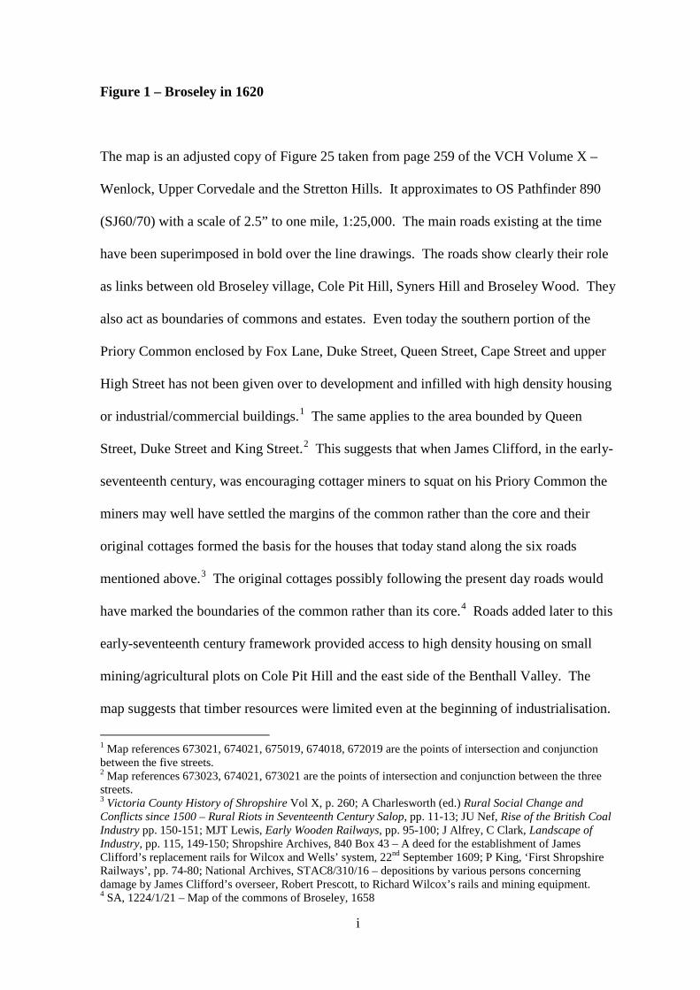
Figure 1 – Broseley in 1620
The map is an adjusted copy of Figure 25 taken from page 259 of the VCH Volume X –
Wenlock, Upper Corvedale and the Stretton Hills. It approximates to OS Pathfinder 890
(SJ60/70) with a scale of 2.5” to one mile, 1:25,000. The main roads existing at the time
have been superimposed in bold over the line drawings. The roads show clearly their role
as links between old Broseley village, Cole Pit Hill, Syners Hill and Broseley Wood. They
also act as boundaries of commons and estates. Even today the southern portion of the
Priory Common enclosed by Fox Lane, Duke Street, Queen Street, Cape Street and upper
High Street has not been given over to development and infilled with high density housing
or industrial/commercial buildings.1 The same applies to the area bounded by Queen
Street, Duke Street and King Street.2 This suggests that when James Clifford, in the early-
seventeenth century, was encouraging cottager miners to squat on his Priory Common the
miners may well have settled the margins of the common rather than the core and their
original cottages formed the basis for the houses that today stand along the six roads
mentioned above.3 The original cottages possibly following the present day roads would
have marked the boundaries of the common rather than its core.4 Roads added later to this
early-seventeenth century framework provided access to high density housing on small
mining/agricultural plots on Cole Pit Hill and the east side of the Benthall Valley. The
map suggests that timber resources were limited even at the beginning of industrialisation.
1 Map references 673021, 674021, 675019, 674018, 672019 are the points of intersection and conjunction between the five streets. 2 Map references 673023, 674021, 673021 are the points of intersection and conjunction between the three streets. 3 Victoria County History of Shropshire Vol X, p. 260; A Charlesworth (ed.) Rural Social Change and Conflicts since 1500 – Rural Riots in Seventeenth Century Salop, pp. 11-13; JU Nef, Rise of the British Coal Industry pp. 150-151; MJT Lewis, Early Wooden Railways, pp. 95-100; J Alfrey, C Clark, Landscape of Industry, pp. 115, 149-150; Shropshire Archives, 840 Box 43 – A deed for the establishment of James Clifford’s replacement rails for Wilcox and Wells’ system, 22nd September 1609; P King, ‘First Shropshire Railways’, pp. 74-80; National Archives, STAC8/310/16 – depositions by various persons concerning damage by James Clifford’s overseer, Robert Prescott, to Richard Wilcox’s rails and mining equipment. 4 SA, 1224/1/21 – Map of the commons of Broseley, 1658
i

There is little woodland existing over the full map – quite possibly no more than 20%.
This indicates that despite the origins of the settlement as a clearing at the end of the Long
Forest occupied by a warden responsible for enforcing forest laws, much clearance of
woodland has taken place (monks from the Cluniac priory at Much Wenlock fined in the
thirteenth century for assarting).5 In 1620 the township still retained three open fields –
east, west and south – and although today these fields are consolidated into numerous
unitary landholdings they still remain as largely undeveloped pastoral agricultural land.
5 PN Salop(English Place Names Society), i, 63-64
ii

iii
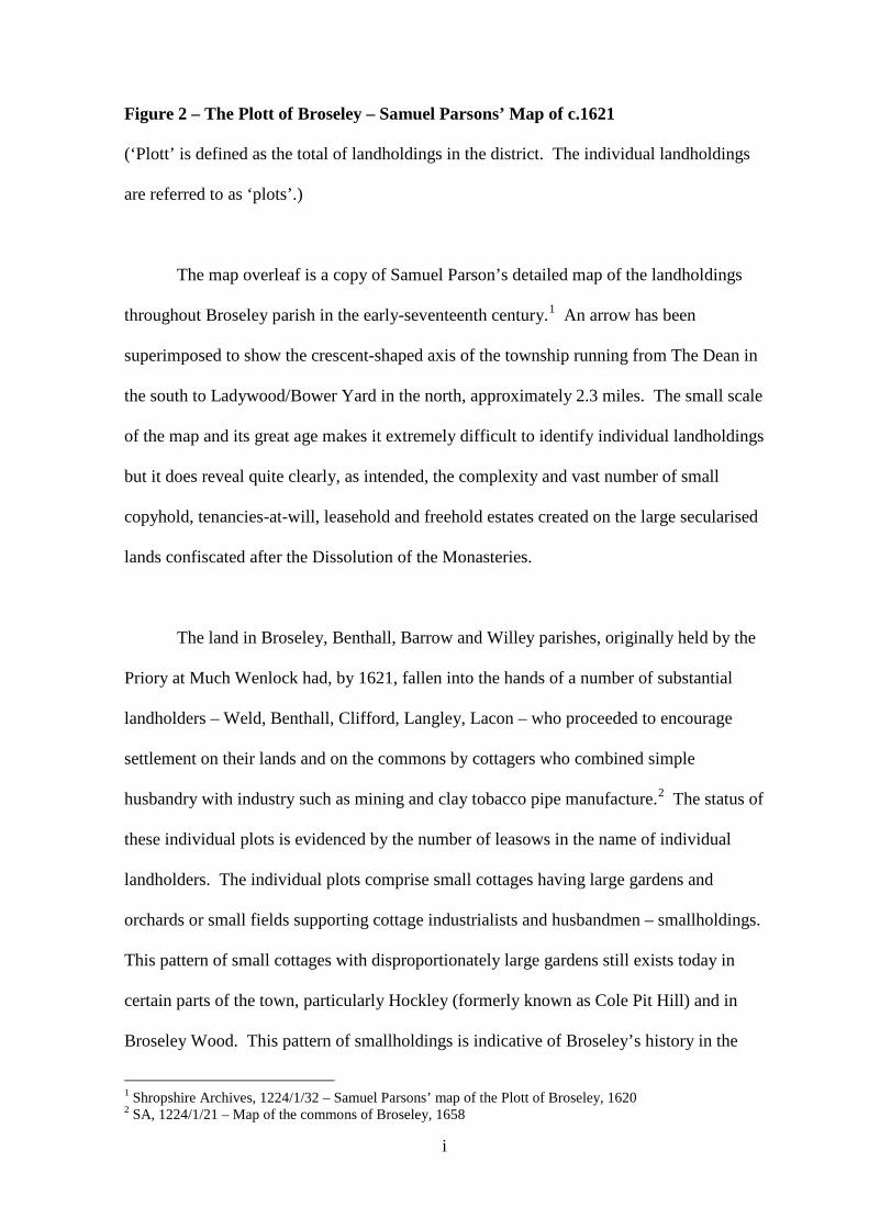
Figure 2 – The Plott of Broseley – Samuel Parsons’ Map of c.1621 (‘Plott’ is defined as the total of landholdings in the district. The individual landholdings
are referred to as ‘plots’.)
The map overleaf is a copy of Samuel Parson’s detailed map of the landholdings
throughout Broseley parish in the early-seventeenth century.1 An arrow has been
superimposed to show the crescent-shaped axis of the township running from The Dean in
the south to Ladywood/Bower Yard in the north, approximately 2.3 miles. The small scale
of the map and its great age makes it extremely difficult to identify individual landholdings
but it does reveal quite clearly, as intended, the complexity and vast number of small
copyhold, tenancies-at-will, leasehold and freehold estates created on the large secularised
lands confiscated after the Dissolution of the Monasteries.
The land in Broseley, Benthall, Barrow and Willey parishes, originally held by the
Priory at Much Wenlock had, by 1621, fallen into the hands of a number of substantial
landholders – Weld, Benthall, Clifford, Langley, Lacon – who proceeded to encourage
settlement on their lands and on the commons by cottagers who combined simple
husbandry with industry such as mining and clay tobacco pipe manufacture.2 The status of
these individual plots is evidenced by the number of leasows in the name of individual
landholders. The individual plots comprise small cottages having large gardens and
orchards or small fields supporting cottage industrialists and husbandmen – smallholdings.
This pattern of small cottages with disproportionately large gardens still exists today in
certain parts of the town, particularly Hockley (formerly known as Cole Pit Hill) and in
Broseley Wood. This pattern of smallholdings is indicative of Broseley’s history in the
1 Shropshire Archives, 1224/1/32 – Samuel Parsons’ map of the Plott of Broseley, 1620 2 SA, 1224/1/21 – Map of the commons of Broseley, 1658
i

seventeenth and early-eighteenth centuries as a proto-industrial settlement. Over its full
length the axis line passes through or touches around thirty individual plots or
landholdings, many of which were self-sufficient agricultural and/or mining undertakings.
ii