indiana's historic pathways: community … · community guide and corridor management plan ......
TRANSCRIPT

INDIANA'S HISTORIC PATHWAYS: COMMUNITY GUIDE AND CORRIDOR MANAGEMENT PLAN
Prepared by the Indiana’s Historic Pathways Committee, a project of Historic Southern Indiana/University of Southern Indiana
2
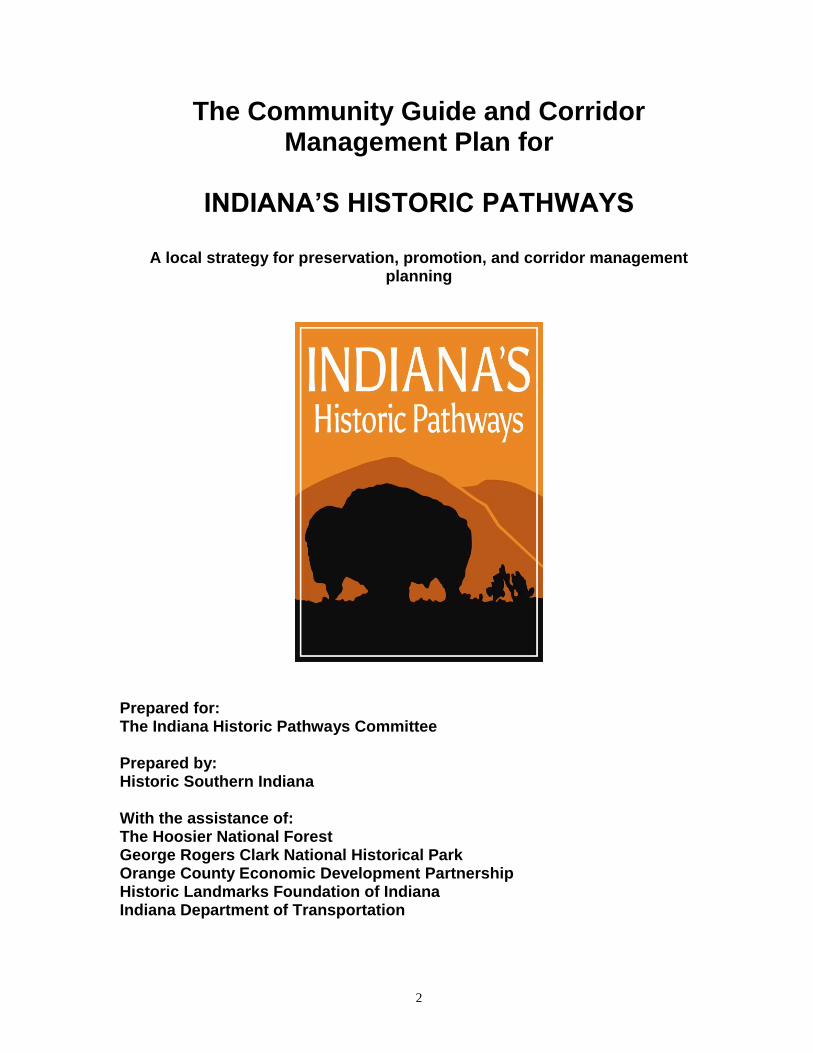
The Community Guide and Corridor Management Plan for
INDIANA’S HISTORIC PATHWAYS
A local strategy for preservation, promotion, and corridor management
planning
Prepared for: The Indiana Historic Pathways Committee Prepared by: Historic Southern Indiana With the assistance of: The Hoosier National Forest George Rogers Clark National Historical Park Orange County Economic Development Partnership Historic Landmarks Foundation of Indiana Indiana Department of Transportation

3
TABLE OF CONTENTS Page Preface 4 Section A Background Information 5 and Foreword NATIONAL SCENIC BYWAYS PROGRAM Section 1 Nomination for National Scenic Byway 7 Section 2 Byway Name and Location 7 Section 3 THE CORRIDOR MANAGEMENT PLAN 1. Maps 10 2. Intrinsic Quality Assessment 10 3. Intrinsic Quality Management Strategy 19 4. Responsibility Schedule 22 5. Development Plan 27 6. Public Participation Plan 27 7. Safety Plan 30 8. Accommodation 36 9. Visitor Experience Plan 37 10. Outdoor Advertising Compliance 39 11. Sign Plan 39 12. Marketing Narrative 40 13. Design Standards 42 14. Interpretation Plan 42 Section 4 All-American Roads Requirements and Documentation 46 Section 5 Scenic Byways Agency Certification 47 Section 6 Federal Land Management Scenic Byway Agency Certification 48 Section 7 Form Preparer 49 Appendix A History of Indiana's Historic Pathways 50 Appendix B General Review of the Road 55 Cover picture: Buffalo Trail: The Impending Storm by Albert Bierstadt. Circa1860.

4
PREFACE On October 19, 2004, Indiana’s Historic Pathways was designated as an Indiana State Scenic Byway. This had been a long journey for the byway committee members who had spent a lot of time and effort to reach this point. While expressing excitement at the accomplishment, the Indiana’s Historic Pathways Committee turned its sights to the next step: national designation as one of America’s Byways. Indiana's Historic Pathways was created and developed by a special committee of Historic Southern Indiana, a regional outreach program of the University of Southern Indiana. USI is a state university located in Evansville with over 10,000 students. The Indiana’s Historic Pathways Committee is a grass roots effort comprised of representatives from counties along the byway as well as special resource people from private, state, and federal agencies.
The proposed byway comprises two historic and interrelated trails connecting the Ohio River to the Mississippi Valley through the interior of the southern third of Indiana: (1) The Buffalo Trace, an ancient trail used by Woodland Bison to connect grasslands, salt licks, forest, and water supplies that stretched from central Kentucky across southern Indiana to Cahokia and Kaskaskia on the Mississippi. Portions of the Buffalo Trace later became a stage coach road developed after the American Revolution to connect Vincennes with the Falls of the Ohio. This road later became U.S. 150. (2) U.S. 50, one of the most important transcontinental highways, closely follows the first east-west railroad in southern Indiana, the Ohio and Mississippi, which linked Cincinnati and St. Louis in the mid-1850s.
This Corridor Management Plan represents a vision to preserve and interpret the scenic, historic, natural, and recreational resources in a climate that fosters economic development and stability. This Corridor Management Plan was adopted in November 2008. On October 16, 2009, Indiana’s Historic Pathways was designated a National Scenic Byway. For more recent information, visit us at: http://indianashistoricpathways.org http://facebook.com/indianashistoricpathways https://twitter.com/INHistPathways

5
NOMINATION FOR DESIGNATION OF SCENIC BYWAY SECTION A: BACKGROUND INFORMATION/SECTIONS
FOREWORD
Traversing the hills and farmlands of southern Indiana, Indiana's Historic Pathways are two separate but closely interrelated historical corridors. Each has profoundly influenced the people and communities through which they pass. Together they represent the region's strikingly varied land forms, its wealth of mineral and natural resources, its small and distinctive communities, and its role in national transportation and commerce. Indiana's Historic Pathways provides an essential means of joining together the geographically broad and culturally diverse region and telling its distinctive story to residents and visitors.
This Corridor Management Plan has been designed to maintain the quality of life we collectively value. Through conservation of our resources and appreciation for our history, we have the opportunity to see our vision become a reality through regional tourism, economic development, and education and outreach programs. Vision Statement
The Vision Statement for Indiana's Historic Pathways in Indiana was written by the members of Indiana's Historic Pathways Committee.
Residents and visitors enjoy and benefit from a variety of recreational and cultural activities. People are aware of, protect and preserve, and promote those special places and values that reflect their distinctive history, especially their settlement patterns, transportation, and economy. They further community vitality and offer economic and educational opportunities for present and future generations. Increasing numbers of visitors are drawn to the region's natural beauty, and people feel right at home in our friendly communities.
Mission The Mission Statement, which includes goals, was also prepared by the Indiana’s Historic Pathway Committee:
The Committee intends to preserve and protect the Byways' scenic, historic, natural, and recreational intrinsic values in a climate that promotes education and economic development opportunities.
A Corridor Management Plan for Indiana's Historic Pathways The Corridor Management Plan (CMP), for Indiana's Historic Pathways in southern Indiana will ensure that the vision becomes a reality. The CMP will establish a framework by which the future of the corridor can be effectively managed. As such, the CMP strives to pull together the many distinct resources, realities, aspirations of the Byway's communities, and assemble them into a feasible and practical program that can be implemented over time.

6
To accomplish this, the CMP identifies a series of actions to be undertaken for the benefit of Indiana's Historic Pathways corridor. Based on extensive research with and input from local communities along the Byway, these actions are intended to direct and identify specific projects. Such actions will increase the opportunities for the corridor communities to preserve the character that distinguishes the Byway and enhance opportunities for economic development and tourism. To help implement these actions, several Indiana's Historic Pathways’ task forces or sub-committees will be established. Drawn from existing organizations and representing all interested parties along the corridor, these entities will work, in conjunction with Indiana's Historic Pathways Committee, to implement corridor goals at the local level. Knowing the corridor communities' collective goals for the future and the individuals and organizations capable of and willing to carry them out, we are confident that the potential interaction and sharing of resources will help to achieve specific goals and to build a stronger corridor with a distinctive identity. The Corridor Management Plan for Indiana's Historic Pathways is designed to:
Develop a stronger sense of Indiana's Historic Pathways collaboration via linked counties, cities, towns and villages.
Assist local communities with corridor-wide issues and plans.
Provide a uniform voice endorsing corridor-wide projects.
Increase communication among Indiana's Historic Pathways communities regarding tourism and economic development initiatives.
Provide a framework by which economic development may be encouraged without compromising the quality of life enjoyed by the residents of the region.
Provide a stronger lobbying block to solicit funding for corridor-wide projects.
Fulfill the CMP requirement for designation as a national scenic byway.
Be a flexible plan that can be modified over time as necessary.
The Corridor Management Plan for Indiana's Historic Pathways is NOT designed to: Impose any regulation on a county, city, or town along the Byway.
Require the adoption of any new local ordinances or special districts.
Prohibit new construction or development.
Deny any community its right to pursue funding for local projects.
Require participation in corridor-wide projects or programs.

7
SECTION 1
Nomination For: National Scenic Byway
This is a nomination for National Scenic Byway Status by the Federal Highway Administration.
SECTION 2
Byway Name and Location: 2.1 Byway Name
Indiana's Historic Pathways 2.2 Byway Description Indiana's Historic Pathways comprise two historically interconnected routes that total 250.2 miles in length: The first pathway is U.S. 150, which encompasses portions of the old Buffalo Trace. This ancient path carved by the hooves of bison as they traveled on their annual migration to winter feeding grounds stretches from the interior of Kentucky to the Mississippi River. It enters Indiana at Clarksville and leaves the state at Vincennes. Parts of it parallel or overlap U.S. 150, which is roughly the Vincennes to New Albany stagecoach line, first developed during Indiana Territory days. One of the oldest roads in the Midwest, it has had various names—Vincennes Trace, Clarksville Trace, Harrison Road, and Kentucky Road, among others. US 150 includes the following counties: Clark, Floyd, Harrison, Washington, Orange, Martin, Daviess, and Knox. (The latter three are also part of US 50 where the two routes overlap). The second pathway is U.S. 50, which connects seven counties, stretching from Lawrenceburg on the Ohio state line to Vincennes on the Illinois state line. U.S. 50 is one of the major east-west federal highways. It links Ocean City, Maryland, with Sacramento, California, and touches fifteen states and the nation’s capital. In Indiana, it closely parallels in all but parts of Lawrence County the roadbed of the Ohio and Mississippi Railroad (later the B and O and now the CSX). The railroad was completed in the mid-1850s as part of a major inland rail connection between Cincinnati and St. Louis. This Byway stretches 131 miles westward from Lawrenceburg to Shoals, where it intersects U.S. 150. Thence the two highways extend 50 miles westward to Vincennes. Like the railroad, U.S. 50 was the first and remains the most vital east-west land corridor in southern Indiana. US 50 includes the following counties: Knox, Daviess, Martin, Lawrence, Jackson, Jennings, Ripley, and Dearborn.
Both roads share another feature: they were designed to provide overland access to the Mississippi valley from eastern terminals on the Ohio River at Cincinnati and Louisville. In turn, the roads and railroads stimulated the growth of communities and the economy of southern Indiana’s interior.
Indiana’s Historic Pathways passes through thirteen counties and numerous communities. It originates in the east in two major urban areas (Cincinnati, OH and Louisville, KY), and both routes terminate at Vincennes. Travelers along the Byway

8
experience natural landscapes of hills, valleys, and agricultural fields, as well as small town main streets, unique architecture, metropolitan communities, and river life. Indiana's Historic Pathways is predominately two-lane paved roadway under Indiana Department of Transportation management. On the Byway, 92 percent (203.1 miles) is classified as secondary and is under the jurisdiction of the state. An additional 38.8 miles are classified as primary and are also managed by the state. (In Vincennes and Washington, a total of 8.3 miles are city streets, not under state jurisdiction.) The Byway is traveled west to east as follows: In Vincennes, at the Illinois line follow 2nd Street to Vigo Street, and thence to 7th Street (Washington Avenue) to Old Highway 50. Follow Old Highway 50 to New Highway 50, and thence to Maysville Road west of Washington. Take Maysville Road to Old Highway 50 and follow it to New Highway 50 east of town. Follow US 50 east to Shoals. (1) Those choosing to go on the northeast segment continue on US 50 to Bedford, where SR 37 joins it. Take Old US 50 through Bedford (see below) to new US 50 and follow it eastward to the Ohio line northeast of Lawrenceburg. (2) Those selecting the southeast segment follow US 150 to the Paoli Pike (Old 150) at Floyd’s Knobs, take it into New Albany on State Street. Turn east on Main Street to Randolph Avenue. If coming from the west one would take State Street to Main Street to Vincennes Street (Highway 11) to Spring Street and then to Randolph Avenue due to one-way streets. Follow Randolph to Harrison Avenue to South Clark Street to Sherwood Avenue to Riverside Drive, and thence to the Falls of the Ohio State Park parking lot The Byway comprises the following segments:
1. U.S. 50 (overlaps U.S. 150 to Shoals)
SEGMENT MILEAGE CLASSIFICATION Vincennes: 2nd Street to Vigo Street .3 city/urban Vigo Street to 7th Street .3 city/urban 7th St. (Washington Ave.) to Old Highway 50 2.4 city/urban Old Highway 50 to New US Highway 50 10.8 secondary/rural Highway 50 to Maysville Road 10.8 primary/rural Washington: Maysville Rd. to Old Highway 50 .2 secondary/rural Old Highway 50 to New US Highway 50 5.3 city/urban US Highway 50 to US Highway 50/37 39.6 secondary/rural Bedford: US Highway 50/37 to Old Highway 50 1.3 primary/rural Old Highway 50 to US Highway 50(16th St.) (west bound) H Street-to15th Street 15th Street to M Street M Street to Old US 50
1.1 (east bound) primary/urban
US Highway 50(16th St.) to US Highway 50 1.9 secondary/urban US Highway 50 Bedford to Brownstown 27.2 secondary/rural US Highway 50 Brownstown 1.8 secondary/urban US Highway 50 Brownstown to Seymour 7.5 secondary/rural US Highway 50 Seymour 4.8 secondary/urban

9
US Highway 50 Seymour to North Vernon 10.9 secondary/rural US Highway 50 North Vernon 2.5 secondary/urban US Highway 50 to Junction US 421 26.8 secondary/rural US Highway 50, Junction US 421 to Aurora 12.6 primary/rural US Highway 50 Aurora to Ohio State Line 13.0 primary/urban TOTAL MILEAGE U.S. HIGHWAY 50 181.1
2. HIGHWAY 150 (overlaps U.S. 50 to Shoals)
SEGMENT MILEAGE CLASSIFICATION
Vincennes:
2nd Street to Vigo Street .3 city/urban
Vigo Street to 7th Street .3 city/urban
7th Street (Washington Ave.) to old Highway 150
2.4 city/urban
Old Highway 50/150 to New US Highway 150/50
10.8 secondary/rural
New US 150/50 to Maysville Road 10.8 primary
Washington:
Maysville Road to Old Highway 150/50 .2 secondary/rural
Old Highway 150/50 to US Highway 150/50 5.3 city/urban
US Highway 50/150 to US Highway 150 (Shoals)
19.9 secondary/rural
US Highway 150 (Shoals) to Paoli Pike 57.2 secondary/rural
New Albany/Clarksville:
Paoli Pike (State St.) to Main St. 5.9 secondary/urban
Main Street(east bound to Hwy.62) to Randolph Ave ****Highway 62 to Spring St.(one way west bound)
3.8 secondary/urban
Randolph Ave. to Harrison Ave. .4 secondary/urban
Harrison Ave. to South Clark St. .1 secondary/urban
South Clark St. to Sherwood Ave. .9 secondary/urban
Sherwood Ave. to Riverside Drive .5 secondary/urban
Riverside Drive to Falls of Ohio parking lot .3 secondary/urban
TOTAL MILEAGE US HIGHWAY 150 119.1 (see note at end of part 3)
TOTAL MILEAGE, INDIANA’S HISTORIC PATHWAYS (parts 1 and 2): 250.2 (50 miles of U.S. 50 and 150 overlap, Vincennes to Shoals; segments of the Buffalo Trace on primary and secondary roadways are included in the entries in Parts 1 and 2 above.)

10
SECTION 3
THE CORRIDOR MANAGEMENT PLAN Please Note: Whenever a specific action or activity within the CMP has a targeted date for implementation or completion, or is an action or activity currently underway, it will be noted in parentheses. Actions or activities without such notations will be assigned time goals by Indiana's Historic Pathways Committee at a later date.
1. Map Primary features and characteristics of Indiana's Historic Pathways are indicated on the attached map.
2. Intrinsic Quality Assessment 1. Overview
Indiana's Historic Pathways winds its way through the hills, farmland, and small
towns of Indiana's Ohio Valley. The Byway provides the opportunity for a consolidated interpretation of broad themes in our nation's history such as the establishment of order on

11
the trans-Appalachian frontier, settlement of the Old Northwest, the transportation revolution and early industrial development, and the transformation of the Midwestern landscape. Prominent figures such as William Henry Harrison and George Rogers Clark are linked to Indiana and its beginnings. The French founded Vincennes (Knox County) in 1732, and established a fort on the banks of the Wabash River. Clarksville (Clark County) is the oldest British-American town in the Old Northwest Territory. There is a strong German influence in many of the small towns along the Byways. The architecture is varied and traditional, with everything from French and Greek Revival to American Gothic and Colonial.
The corridor contains a number of resources that are regionally, and even nationally, significant such as the geologically unique Falls of the Ohio area and the Lost River. Three National Historic Landmarks are located within one or two miles of the Byway. These include Grouseland, the William Henry Harrison House in Vincennes; Hillforest in Aurora; and the West Baden Springs Hotel in West Baden Springs. Other resources tell a comprehensive story of human interaction with the Ohio Valley landscape from prehistoric times to the present.
2.1 Features of Each County
The cities and towns along the U.S. 50-150 corridor have preserved their heritage and
cultural traditions by maintaining the most noteworthy and treasured buildings and celebrating their history with festivals and ceremonies.
Knox County Knox County is home to Vincennes, the Indiana Territory Capitol. William Henry Harrison served as the first Indiana Territory governor and later became the ninth U.S. President. A memorial honoring Revolutionary War hero George Rogers Clark is located in Knox County. (George Rogers Clark National Historical Park)
Daviess County Daviess County sits almost entirely in a physiographic unit known as the Wabash Lowland and includes the city of Washington. Washington was the center for a railroad repair yard on the B & O Railroad starting in 1888 and is still in operation today. Coal reserves and iron ore are plentiful in the county and the construction of the Ohio and Mississippi Railroad in the 1850s made the coalfields accessible for transportation of the product. The town of Montgomery on US 50 is the center of one of the largest Amish and Mennonite settlements in the Midwest. (Amish Buggies in Daviess County)

12
Martin County Martin County is where U.S. 50 and 150 meet in Shoals, Indiana. Portions of the Hoosier National Forest and Martin State Forest are located in Martin County, along with Shoals Overlook Park and the Jug Rock, an unusual rock formation. (Jug Rock near Shoals)
Lawrence County Lawrence County offers the diverse natural beauty of Spring Mill State Park and Bluespring Caverns. Known as the “Limestone Capitol of the World,” Lawrence County quarries have provided limestone for the Empire State Building, the Pentagon and the National Cathedral (Washington, D.C.). The main town along the byway is Bedford. (Masonic Lodge in downtown Bedford)
Jackson County Jackson County is best known for its covered bridges and railroad history. The Bell Ford Covered Bridge was the only standing post-trust bridge in the world but is now in pieces awaiting reconstruction. It has 2 remaining standing bridges. The town of Seymour was named after chief engineer Henry
C. Seymour and the town was the crossroads of the North/South and East/West tracks. The Reno Brothers staged the first train robbery in the United States here. (Shieldstown
Covered Bridge, Jackson County) .
Jennings County Jennings County is home to the Muscatatuck National Wildlife Refuge, Indiana first and largest wildlife refuge. The county was also the site of one of the skirmishes with Morgan’s Raiders during the Civil War. Confederate General John Hunt Morgan led a band of troops through southern Indiana. Jennings County also has two covered bridges. North Vernon is the main town in Jennings County located along the Byway.
(Muscatatuck National Wildlife Refuge)

13
Ripley County Ripley County is home to Versailles State Park, created in the 1930s by the Civilian Conservation Corp, or CCC. The Busching Covered Bridge stands at the entrance to the park and Otter Creek Covered Bridge stands just north of Holton. Morgan’s Raiders briefly occupied the Ripley County Courthouse during the Civil War and stole the county treasury. Versailles, the county seat, is the main town located along the Byway. (Busching Covered Bridge in Versailles State Park)
Dearborn County Dearborn County was the third oldest county in the Indiana Territory. John Morgan Hunt’s soldiers destroyed several railroad bridges during the Civil War. The charming town of Aurora overlooks the Ohio River. Its downtown historic district has several notable houses and churches, including Hillforest, a house museum. Lawrenceburg has many well-preserved historic buildings and has the feel of an old river town.
(Hillforest Victorian House Mansion in Aurora)
Clark County Clark County is home to the Falls of the Ohio, a 386 million year old Devonian fossil bed and the only major natural obstruction of the Ohio River. This obstruction gave rise to the city of Louisville, Kentucky, and the Indiana towns of Jeffersonville, Clarksville, and New Albany. A state park and interpretive center marks the site. A historical marker and reconstructed cabin marks the home site of Revolutionary War hero George Rogers Clark. Clark’s
brother William met with Meriwether Lewis at this site to begin their Voyage of Discovery. The Ohio River has played an important role in the history of the towns in Clark County. The Howard Steamboat Museum, a house museum highlighting the steamboat era, is another popular tourist site. (Falls of the Ohio State Park)
Floyd County Floyd County has several historical structures standing in New Albany, including the Scribner House (1814) and Culbertson Mansion State Historic Site. Culbertson Mansion is located in Mansion Row, a historic district filled with homes of notable architecture. (Culbertson Mansion State Historic Site, New Albany)

14
Harrison County Harrison County is the home of Indiana’s first capitol, Corydon. It was also the site of the battle of Corydon, the only Civil War battle fought on Indiana soil. The battle occurred when Morgan’s Raiders crossed the Ohio River into Indiana. A commemorative marker depicts the events. US 150 crosses the northwest corner of the county. (Corydon Capitol State Historic Site)
Washington County Washington County was formed in 1813 from parts of Harrison and Clark Counties. The terrain varies from arid barrens in the west to steep hills and forests in the north and east. Numerous caves exist. The majority of the county is agricultural land. US 150 crosses the southwestern corner of the county and includes the towns of Hardinsburg and Fredericksburg. (Beck’s Mill, Washington County)
Orange County Orange County has a rich heritage. The county’s mineral springs gave rise to the French Lick Springs Hotel and the West Baden Springs Hotel. Both sites attracted the rich and famous in the early 20th century. Quakers settled in Paoli nearly 200 years ago and the Lick Creek African American Settlement was an early 19th century free black settlement. Today the county is home to a large Amish community. The Orange County Courthouse, Greek Revival in style, is Indiana’s second oldest in continuous use. A large portion of the Hoosier National Forest is located in Orange County, and the area is known for its karst topography, a land type characterized by sinkholes and underground rivers.
(Orange County Courthouse in Paoli) 2.2 The Intrinsic Qualities
Due to its length, varied topography, and distinctive history, Indiana's Historic Pathways possess features representing all six intrinsic qualities. For the purposes of the national scenic byway nomination application the Indiana’s Historic Pathways Committee has selected historic as the primary intrinsic quality due to the Byway’s rich heritage. However, for the purposes of the Corridor Management Plan and future planning, notable

15
features are listed for all six intrinsic qualities. After mapping the entire Byway and conducting a detailed inventory of resources, the Indiana's Historic Pathways Committee felt that the following types of resources made the strongest contribution to the unique appeal of the Byway. Most of the examples cited are directly on the corridor or visible to the traveler. Some are within approximately 5 miles of the road.
A. Historic
As its name implies, Indiana’s Historic Pathways has several notable historic resources that trace the settlement and development of the region and state from prehistory to the present. From the footpaths worn over time by bison and used by Native American Indians and early settlers alike to the stagecoach route, railroad, and modern highway, the Byway is, in itself, a historic resource.
There are three historic mansions along Indiana’s Historic Pathways that are open to and interpreted for the public. These grand old homes tell the stories of affluent Hoosier merchants, businessmen, and politicians. Hillforest Mansion in Aurora, built by industrialist and financier Thomas Gaff in the 1850s, is known for its unusual architecture that mimics riverboat features. William S. Culbertson, a merchant and one of Indiana’s wealthiest men at the time of his death, spared no expense in the construction of his New Albany home in 1869; Culbertson Mansion State Historic Site preserves the 22-room French Second Empire structure. Vincennes is home to Grouseland, the home of William Henry Harrison, 9th President of the United States. Harrison built the Federal-style home between 1802 and 1804 and lived there until 1812. It is a National Historic Landmark that is administered by a private foundation.
George Rogers Clark National Historical Park, also in Vincennes, is a National Park Service property. It sits on the banks of the Wabash River on the site of Fort Sackville. The park includes a memorial to the Revolutionary war hero.
The Carnegie Center for Art and History in New Albany features exhibits from regional artists and interprets the history of Floyd County. It also houses an award-winning exhibit on the Underground Railroad in the region entitled, Ordinary People, Extraordinary Courage: Men and Women of the Underground Railroad in the Indiana and Kentucky Borderland.” Vestiges of communities created by runaway slaves and free blacks are especially noteworthy in Orange and Washington counties. Nearby are the meetinghouses of the Quakers who settled the region in the early nineteenth century.
In addition to these sites, Indiana’s Historic Pathways has fourteen National Register Historic Districts that the byway actually goes through or abuts. They are: Downtown Aurora Historic District; Downtown Lawrenceburg Historic District; Downtown, State Street, and Walnut Street Historic Districts in North Vernon; Seymour Commercial Historic District; Bedford Courthouse Square Historic District; Washington Historic District; Vincennes Historic District; Paoli Historic District; and Mansion Row Historic District, East Spring Street Historic District, and Cedar Bough Historic District in New Albany. The following communities contain National Register Historic Districts that are in close proximity to the byway: Jeffersonville, Vernon, Salem, Corydon, and Mitchell. There are three National

16
Historic Landmarks: Grouseland, the William Henry Harrison Home in Vincennes; the West Baden Springs Hotel in West Baden Springs; and Hillforest, a mansion in Aurora.
Historic Resources
Fourteen National Register Historic Districts located on or abutting byway Five National Register Historic Districts in close proximity to the byway Three National Historic Landmarks 19th century Ohio and Wabash River Mansions State Historic Sites One National Park Service Site Private historic sites and museums Historic cemeteries Industrial facilities (historic and modern)
B. Natural
Natural resources abound in the region that Indiana’s Historic Pathways covers. The
Ohio and Wabash Rivers mark the entry points at Lawrenceburg, Clarksville, and Vincennes, respectively. The Hoosier National Forest covers much of the territory where the Buffalo Trace is located. Both US 50 and US 150 cut a swath through the forest. The Muscatatuck National Wildlife Refuge in Jennings County is Indiana’s first and largest wildlife refuge and is an excellent place for hiking, fishing, and viewing wildlife. The Jug Rock Nature Preserve in Martin County just outside of Shoals, features an unusual natural rock formation, a 50 foot high sandstone column, in a 34-acre nature preserve. Indiana’s Historic Pathways includes several Department of Natural Resources properties including two state parks (Falls of the Ohio State Park in Clarksville and Versailles State Park in Versailles), two state forests (Martin State Forest in Shoals and the Jackson Washington State Forest just outside of Brownstown) and three state fish and wildlife areas (Brush Creek Reservoir, Crosley State Fish and Wildlife Area, and Brownstown State Fishing Area). Because of the karst topography of the region, sections of the Lost River flows underground through much of Orange County. Lawrence County, and in particular the town of Bedford, is known for its limestone. This material has been used to build many of this country’s most notable buildings including the National Cathedral in Washington, DC and the Empire State Building. Just outside of Shoals is one of the country’s richest gypsum deposits, a key ingredient in building materials, particularly dry wall (sheetrock). Shoals is home to the only two gypsum-mining companies in the state of Indiana. Much of Daviess and Knox counties lie in an area known as the Wabash Lowland. This region is known for its coal mining and petroleum production.
Natural Resources Ohio River Wabash River The “Lost River” (National Natural Landmark) Blue River White River One major national forest One major national wildlife refuge Two state parks Two state forests

17
Three state fish and wildlife areas
C. Recreational
Again, many of the intrinsic qualities of the corridor overlap. Therefore, the state parks and wildlife refuges that are part of the natural qualities also offer recreational opportunities such as hiking, camping, fishing, biking, and horseback riding. In addition to the properties already listed, the Buffalo Trace Park in Palmyra has a large lake with boating, fishing, and picnicking facilities. There is a boat ramp and public access site to the White River in Martin County.
Recreational Resources
State outdoor recreational facilities Nature preserves Hiking trails Horseback riding trails Campgrounds Lakes, tributaries of the Ohio and Wabash rivers for fishing, boating Wildlife
D. Scenic
The topography resulting from uneven glaciation, as well as the subsequent use of
the landscape, has combined to leave the region rich in scenic resources. Indiana’s Historic Pathways winds its way through rolling, forested hills, hugs rock outcroppings, and stretches across the agricultural countryside. Some of the agricultural land is relatively flat, while some is hilly and consists of well-kept barns, cornfields, orchards, and even a few tobacco fields. Dozens of outstanding vistas can be found along the corridor and offer a variety of visual experiences. The view from the Falls of the Ohio Interpretive Center takes in 220 acres of fossil beds, a lock and dam system, and the Louisville Skyline. Lawrenceburg and Aurora both offer equally impressive views of the Ohio River. Stretches of the road in Lawrence, Martin, Orange, and Crawford Counties travel through heavily forested hilly areas with winding curves and rock outcroppings. Man-made scenic resources include the imposing architecture of the 19th century mansions and historic districts, as well as the quaint small town squares and vistas of rural villages dominated by church spires and historic courthouses.
Scenic Resources
Ohio River Wabash River Agricultural countryside "Driftless" area, the unglaciated central portion of corridor Imposing architecture (Mansion Row in New Albany, for instance) Quaint small town squares Rolling forested hills Rock outcroppings Waterfalls

18
Gorges Vistas of rural villages Spring and fall foliage
E. Archaeological
Several archaeological resources also can be found along Indiana’s Historic Pathways. The Buffalo Trace portion of the corridor is, in itself, archaeological, as remnants of the old path still exist in various forms. Other sites of note include a prehistoric village site at Pioneer Mothers Forest in Orange County. This site was a 14th century Native American Indian stockaded village. As noted before, the Falls of the Ohio is a 400 million year old Devonian fossil bed.
Archaeological
Buffalo Trace Indian settlement sites Oliver Phase People Settlement Site Antebellum African-American settlements, particularly in Orange County (Little Africa, also known as Lick Creek)
F. Cultural
Indiana’s Historic Pathways contains numerous cultural resources. Several Amish
communities are located in Crawford, Daviess, Martin, and Orange Counties. There are a number of Quaker meeting houses in Orange County. Many of the state and federal historic and natural sites include interpretation programs. The Carnegie Center for Art and History in New Albany exhibits artwork and hosts many cultural lectures and events. Several communities along the corridors host annual heritage festivals. Of special note are the Spirit of Vincennes Rendezvous, the Lotus Dickey Hometown Reunion in Paoli, and the Shoals Catfish Festival Due to uneven development and the traditional values of the people who desired to preserve a rural small town way of life, Indiana's Historic Pathways offers a unique opportunity to view changes through time in the way humans have interacted with the land in the Ohio Valley. Physical legacies from distinct periods of history and prehistory can often be found in close proximity. A vivid illustration of this is at Floyd's Knobs, on the old stagecoach trail northeast of New Albany. The viewer sees not only a historic pathway traceable to the early 1800's but also part of a distinctive limestone outcropping extending from central Kentucky well into southern Indiana. This separates an unglaciated region to the west from the Scottsburg Lowland to the east. In the distance one sees the landscape of metropolitan Louisville. The Committee hopes that residents as well as visitors will appreciate the pathway’s rich and varied resources, learn from the past and the contemporary uses of these possessions, and understand how human beings interact in their relations with each other and their use of the land.
19
Cultural
Houses of worship Annual heritage festivals, like Spirit of Vincennes Rendezvous or Lotus Dickey Hometown Reunion in Paoli Outdoor concerts in summertime. Interpretation programs at state and federal historic and natural sites. Amish and Quaker communities Museums of art and/or history Vestiges of antebellum free black and runaway slave settlements
3. Intrinsic Quality Management Strategy Preserving the Byway’s intrinsic qualities is incorporated into Indiana’s Historic Pathway Mission Statement and it is a primary goal of the Committee. The Byway will ensure that these goals are part of the Task Forces plans and goals for projects. There are many existing programs and resources available for Indiana’s Historic Pathways to use or partner with to see that the intrinsic qualities remained protected. 3.1 Existing Programs Currently there are many programs in place to protect and enhance the intrinsic qualities along Indiana's Historic Pathways. These existing programs will form the core of an overall strategy to ensure that the resources for which the Byway is being nominated to the National Scenic Byways Program are protected over time. These protected sites and management efforts include:
Locally zoned historic districts Four communities directly on the Byway have active preservation commissions with locally zoned historic districts that currently have design standards, sign regulations, preservation policies and programs, and preservation assistance. They are: New Albany, Bedford, Aurora, and Vincennes. Jeffersonville and West Baden Spring, both located within close proximity to the Byway also have preservation commissions.
Local planning and zoning Many towns, villages and counties in this corridor have little or no controls over land use, outdoor advertising, and zoning. Some notable exceptions are Dearborn and Knox counties.
The Indiana Main Street Program This statewide program, which is part of Indiana’s Office of Community and Rural Affairs, is active in nine Indiana's Historic Pathways towns: Vincennes, Washington, Bedford, Brownstown, Seymour, Vernon, Lawrenceburg, Aurora, and New Albany. There is also one county-wide Main Street program in Orange County. The Main Street program stresses four components: design, organization, promotion, and economic restructuring. Indiana has the largest Main street program in the United States.
The Hoosier National Forest Administered by the US Forest Service, Indiana's Historic Pathways intersects the Hoosier National Forest at three points on US 50 and US 150. These constitute approximately 40

20
miles mostly between Shoals and Paoli. A managed forest, the Hoosier National Forest provides a sustainable timber resource, wildlife habitat, and recreational area.
Indiana Department of Natural Resources The Indiana Department of Natural Resources protects, interprets, and manages the following properties on or near Indiana's Historic Pathways:
-Falls of the Ohio State Park -Versailles State Park -Vincennes State Historic Site
-Culbertson Mansion State Historic Site -Martin State Forest -Jackson-Washington State Forest -Starve Hollow State Recreation Area
National Park Service/Fish and Wildlife Service The National Park Service/Fish and Wildlife Service protects, manages, and interprets these properties on Indiana's Historic Pathways: -George Rogers Clark National Historic Park -Muscatatuck National Wildlife Refuge 3.2 Existing Technical Assistance In addition to the above site-specific programs, the area currently benefits from the technical assistance provided by the following organizations:
Historic Southern Indiana A program of the University of Southern Indiana, Historic Southern Indiana (HSI) has worked since its founding in 1986 to promote the historic resources of southern Indiana and their preservation. HSI has been involved with corridor initiatives since 1990. In addition, HSI also works in the areas of heritage tourism, regional history education, historic preservation, and community outreach. This program assists communities with facilitated workshops in visioning, planning, interpretation, and management strategies.
Historic Landmarks Foundation of Indiana Historic Landmarks Foundation of Indiana (HLFI) is a private nonprofit organization and is the largest statewide preservation group in the US. HLFI provides educational programs, technical bulletins, and historic preservation technical assistance to the people of Indiana. The Southern Regional Office of HLFI , located in Jeffersonville, serves many of the communities of the byway corridor. The Southeast Field Office in Aurora provides assistance to Dearborn and Ripley Counties. The Western Regional Office in Terre Haute serves communities in the western portion of the corridor. HLFI also accepts easements on significant sites and administers grant programs.
National Park Service The National Park Service provides, through the George Rogers Clark National Historical Park, interpretive programs concerning the colonial period of southern Indiana. Included in the park's interpretive and educational curriculum are programs related to the Native American populations, European migration into the region, and the military actions of the period. The park also has available for public use an excellent reference library of colonial

21
period related materials. The park can, because of its location at the western end of all both routes of the byway, be the first visitor contact point for traveling these paths eastward or the conclusion point for those traveling west. The park can, through its staff, provide expertise in the areas of interpretive signage, wayside exhibits, and preservation methods.
The United States Forest Service The United States Forest Service has provided educational programs on history and environmental awareness to local schools in southern Indiana. Summer interpretative programs are also provided at USFS campgrounds.
The Indiana Department of Natural Resources The Indiana Department of Natural Resources (DNR) manages state parks, reservoirs, forests, historic sites, and fish and wildlife populations. The DNR provides interpretive and conservation education programs and other educational opportunities.
The Indiana Department of Historic Preservation and Archaeology A division of the Indiana DNR, the Department of Historic Preservation and Archaeology oversees management of historic and cultural resources and provides technical assistance.
The Indiana Office of Tourism Development The Indiana Office of Tourism Development offers technical assistance, educational services, marketing and public relations support and has been involved with Indiana’s Historic Pathways since its inception.
Ball State University The Ball State University College of Architecture and Planning provides statewide assistance to communities in planning, design, and preservation. 3.3 Planned Programs The Committee will work to maintain these existing efforts and expand them throughout the corridor. In order to further protect the intrinsic qualities of Indiana's Historic Pathways, the Committee has identified the following programs for assistance, partnership, or potential coordination:
Environmental Programs A number of environmental organizations and programs are active in southern Indiana. The Committee will work to coordinate efforts with these organizations, solicit their expert advice, and develop mutually beneficial partnerships. A few of the many programs are: -Hoosier Environmental Council -The Nature Conservancy -Sierra Club, Jackson and Jennings County Chapters -Protect Our Woods -Hoosier Rails-to-Trails
-Boy Scouts of America: George Rogers Clark Council, Buffalo Trace Council, White River Trails Council -Girl Scouts of America: Raintree Council, Kentuckiana Council, and Tulip Trace Council

22
Indiana Heritage Trust Fund This program, supported through the sale of special license plates, provides funds for the purchase of property and easements for the public recreation and enjoyment of natural and historic sites.
Oxbow Wetland The Oxbow Wetland is an effort in Dearborn County to preserve an existing wetland. Future plans call for education and interpretation of the wetland area.
Greenway Programs The Ohio River Greenway is in development and when completed it will be an 8 mile path linking the cities of Jeffersonville, Clarksville, and New Albany. Portions have been completed to date. Dearborn Trails is a multi-use hike, bike, walk, and skate trail in the communities of Greendale, Lawrenceburg and Aurora.
Land Trust Programs The Committee will investigate the use of land trust programs as a voluntary method for protecting significant intrinsic qualities. Existing state land trust programs and national land trust programs currently operating in Indiana will be investigated. Land trusts currently operating in Indiana are: -ACRES Land Trust -Little River Wetlands Project -Sycamore Land Trust -Central Indiana Land Trust -Shirley Heinze Land Trust -Wabash Heritage Land Trust
Identification of Threatened Resources The Committee will develop a list of principal intrinsic qualities that are currently threatened and work to secure their preservation in the most efficient, practicable, political and financially feasible manner. Such sites may include threatened views, natural areas, or historic sites.
Voluntary Easement Program The Committee will investigate a voluntary easement program to secure protection of significant intrinsic qualities on private property. 4. Responsibility Schedule 4.1 Existing Committee Structure The Indiana's Historic Pathways Committee was established to promote the development of Indiana's Historic Pathways, secure its designation as a State Scenic Byway, create the CMP, and seek national designation. The Committee meets quarterly. It reviews the progress of projects and goals, sets policies, charges task forces with their responsibilities, structures partnerships and cooperative agreements and solicits support for the project. The Committee will also assist in coordinating transportation enhancement requests for corridor projects and conduct a five year review of the CMP. Historic Southern

23
Indiana organized the Committee as one of its corridor development projects. HSI will provide overall policy direction to the Committee as well as administrative and financial support. The Committee plans to seek not-for-profit status.
Indiana's Historic Pathways Committee is composed of:
County Representatives County Representatives coordinate Indiana's Historic Pathways Committee activities and projects within their counties, coordinate task force initiatives within their counties, and serve as a liaison with the local communities and governments within the county.
Task Force Chairs Task Force Chairs lead the quarterly meeting. They coordinate region-wide efforts of the various task force areas. Task force chairs will report to the Committee.
Resource Representatives Resource Representatives serve as technical and resource experts providing specialized assistance and administrative support. Representatives include individuals from: Historic Landmarks Foundation of Indiana, Indiana Department of Transportation, National Park Service, Indiana Department of Natural Resources, environmental organizations, the Hoosier National Forest, Indiana Office of Tourism Development, local planning and Main Street Programs, local and regional economic development agencies, chambers of commerce, convention and visitor bureaus, and teachers and educational administrators.
4.2 Committee Task Forces The following task forces have been identified by the Committee for the development and implementation of Indiana's Historic Pathways Corridor Management Plan. Additional task force categories or subdivision will be generated according to future need. A. Tourism and Development
-Marketing and Promotion (publish brochures, purchase ads, attract group tours, arrange magazine articles, conduct visitor research, develop/enhance the website). -Byway Identification, signage. -Media Relations (print, radio, and television coverage of events; Web site development). -Quality Control (develop rating/accreditation system--Indiana's Historic Pathways logo identification, coordinate hospitality training, coordinate development of local "loops"). -Identify Economic Development activities appropriate to the Byway and region (value-added industry, tourism-based industry, resource-based industries supportive of the corridor vision). -Promote the positive aspects of locating along the Byway (quality-of-life). -Provide examples of good corporate development "success stories".
-Distribute recommended guidelines for corridor development.

24
B. Resource Management -Protection and conservation of cultural and natural resources. -Current and Future Land Use (voluntary easements, planning, zoning). -Design and Aesthetics (landscape development, design guidelines, outdoor advertising management). -Government and Liaison (roadway management issues, local government implementation of programs).
C. Education/Public Affairs -Community Programs (Indiana's Historic Pathways Day, Photo contest). -Educational Efforts (schools, communities, journals).
-Byway Interpretation (development of interpretative guides, interpretative signage/kiosks).
4.3 Committee Organization The Committee is currently organized in the following manner:
Governing body: Historic Southern Indiana Co-Chairs: Dale Phillips and Judy Gray Committee Composition: County representatives, resource representatives (HLFI, DNR, Hoosier National Forest, Indiana Office of Tourism Development) Support: HSI will provide administrative and financial support
The Committee has established the following short-term goals:
o Designation as national scenic byway o Promotional brochure o Web site development o Newsletter o Formation of regional subcommittees o Annual public report
The Committee currently receives technical assistance and administrative support chiefly from Historic Southern Indiana. (Additional assistance has been provided by staff of George Rogers Clark National Historic Park and the Hoosier National Forest.) This organization has assisted the communities of Indiana's Historic Pathways in resource analysis, coalition building, and visioning; and has facilitated the communication between the local communities and the state and national offices developing scenic byways and corridor management planning policy. It is the goal of Indiana's Historic Pathways Committee, above all, to ensure that the Corridor Management Plan outlining Indiana's Historic Pathways vision is implemented in the most effective and efficient manner providing the greatest benefits to the people of southern Indiana. Naturally, as the Committee evolves and matures with the scenic byway, it will need to reevaluate its structure, management, and organization on a periodic basis. It will be the responsibility of the Committee Chairs, the County Representatives, Task Force Chairs, and Resource Representatives to work with Indiana's Historic Pathways Committee in this regard.

25
To facilitate implementations, sub-regional sites will be created that will not only provide a host of volunteers and tourism staff to work in that area but also serve as information centers for visitors. These are, tentatively: Lawrenceburg, Seymour, Bedford, Vincennes, Paoli, and Clarksville. The Committee will work primarily as a coordinating body. The bulk of the work will have to be done by local groups, following guidelines and assistance provided by the regional organizations and the IHP Committee. 4.4 Indiana's Historic Pathways Committee Members
Co-Chairs: Dale Phillips, Superintendent George Rogers Clark National Historical Park Vincennes, IN Judy Gray Orange County Economic Development Partnership Paoli, IN Members: Tina Stark, Director Jackson County CVB Seymour, IN Alycia Church, Executive Director Pike County Chamber of Commerce Petersburg, IN Norma Cox Orange County Tourism Task Force French Lick, IN Katy Cromer West Baden Springs, IN Frank Doughman George Rogers Clark NHP Vincennes, IN Laura Renwick, Field Coordinator Historic Landmarks Foundation of Indiana Jeffersonville, IN Mabel Hornback Paoli, IN Shyla Beam, Executive Director Vincennes/Knox County CVB Vincennes, IN

26
James Keith, Executive Director Clark-Floyd County CTB Jeffersonville, IN Angie Krieger Hoosier National Forest Bedford, IN Teena Ligman Hoosier National Forest Bedford, IN
Nancy Myers Hoosier National Forest
Tell City, IN
David Branneman, Director Lawrence County Tourism Commission Mitchell, IN Debbie Smith, Director Dearborn County CVB Lawrenceburg, IN Katherine Taul, Director Ripley County CVB Versailles, IN James W. Marshall Shoals, IN Vince Sellers, Director Daviess County Museum Washington IN Misty Weisensteiner, Director of Brand Marketing & Sales Orange County Convention & Visitors Bureau French Lick, IN Amanda Ripley Paoli, IN
Ex-officio:
Leslie Townsend, Director Historic Southern Indiana University of Southern Indiana Evansville, IN

27
Randy Walter, Scenic Byway Program Manager Indiana Department of Transportation
Indianapolis, IN John Curry INDOT – Vincennes District Vincennes, IN Brian Blackford, Development Director Indiana Office of Tourism Development Indianapolis, IN Jaime Fry, Visitor Services and Development Manager Indiana Office of Tourism Development Indianapolis, IN
5. Development Plan 5.1 Planned Projects With the exception of a few towns and cities along Indiana’s Historic Pathways, most of the Byway is rural in nature and has not experienced a lot of development. Through research and professional development opportunities the Committee plans to become better educated in the areas of design. The Committee will implement these strategies in preserving the intrinsic qualities and enhancing existing development so that it blends in with the character of the Byway. Everyone along the corridor could benefit from economic development opportunities and the committee wants to work with people in a way that the communities see the benefit of these development opportunities while maintaining the character and intrinsic qualities of the Byway. While few of the byway communities have zoning, the Committee and county representatives will work to ensure that good design standards are met.
Model Guidelines for Development in Indiana's Historic Pathways Corridor The Committee will assist local municipalities in creative view sheds, landscape development policies, sign management, and other means of ensuring that development will enhance intrinsic qualities of the corridor. This will be done in collaboration with Historic Landmarks Foundation of Indiana. 6. Public Participation Plan 6.1 Existing Initiatives The Indiana's Historic Pathways, a standing Committee of HSI, has been meeting regularly since the late summer of 1998. It includes representatives of a wide variety of interest groups and most of the counties along the corridor. Over time the Committee has fluctuated in size. New members are always welcome.
Meeting announcements, press releases, kick off celebrations, and public meetings, have ensured corridor-wide awareness of the Byway project.

28
In the late winter of 2001, the Indiana Historic Pathways Committee hosted public meetings in Bedford, Clarksville, Paoli, North Vernon and Vincennes. Plans to develop the corridor were presented to those attending. Participants were also encouraged to offer suggestions and volunteer their time working on the project. Attendance and audience enthusiasm were encouraging.
With this established focus on community participation, all involved parties recognize that the success of the byway and its potential designation as a National Scenic Byway will be dependent on the continuation of this participation process.
Indiana Legislative Support for Indiana's Historic Pathways (January--March 2002) During the 2002 session of the Indiana General Assembly, Senator Becky Skillman (now Lieutenant Governor) took the lead in seeking Senate and House resolutions supporting Indiana’s Historic Pathways and in the process raised political awareness and support for Indiana’s Historic Pathways. In transportation committee hearings, Indiana's Historic Pathways Committee representatives explained the project, citizen participation, and local benefits of tourism and economic development.
State Designation Ceremony In December 2004 a public ceremony was held at the Falls of the Ohio State Park in Clarksville to celebrate the designation of Indiana’s Historic Pathways as a State Scenic Byway. INDOT officials presented a declaration certificate.
Logo Contest (Summer 2006)
The Committee sponsored a contest to create a logo for Indiana's Historic Pathways. Special emphasis was placed on art students in high schools and colleges in the region. Both an adult and student logo was selected and these were unveiled during special kick-off ceremonies. The adult logo is now used for branding IHP programs and products.
Kick Off Celebrations (September – October 2006) Special kick-off ceremonies were held in several communities along Indiana’s Historic Pathways to notify the public of its designation as a State Scenic Byway. The new logo was unveiled as part of the kick-off ceremonies. ● Indiana's Historic Pathways Committee Quarterly Meetings (ongoing) These are held quarterly at a location geographically accessible to the entire corridor. Task forces facilitate the Committee's work and these are held more frequently between Committee meetings. Future meetings will address specific projects and work to the implement the CMP. Committee members are welcome to bring along guests who might be interested in getting involved with the Byway. 6.2 Planned Initiatives

29
Application for National Scenic Byway Designation (December 2008)
Community Planning Guide A concise manual will be prepared based on the CMP to encourage communities along the corridor to adopt one or more projects and to develop a sense of identification with other communities on the byway. ● Festivals The Committee will seek to have existing festivals incorporate awareness and promotion of Indiana's Historic Pathways in their annual planning.
Signage In cooperation with INDOT, Indiana's Historic Pathways will need to have appropriate scenic byway signs designed and installed along the corridor.
Indiana's Historic Pathways Day (annual) To celebrate national designation an annual spring event will be planned celebrating the byway, recent accomplishments, and planned initiatives. It is also intended to be an annual reminder of the mutual dependence the thirteen counties have.
Education Programs (ongoing) Recognizing that the successful management of Indiana's Historic Pathways will rest on the Committee, concerned citizens and local governments, the Committee will sponsor or facilitate educational programs on management, planning, tourism, conservation, and design. Programs may include national programs such as Your Town: Designing its Future: state programs such as the Indiana Main Street Program: and regional programs such as HSI's Special Places. Additionally, the Committee will look inward to the experiences of the communities of Indiana's Historic Pathways. Community and project leaders will be invited to share successful and innovative projects with the other communities of the byway.
American Discovery Trail (ongoing) Recognizing the shared goals for conservation and interpretation shared by Indiana's Historic Pathways and the American Discovery Trail, the Committee will work closely with the Indiana State Coordinator for the ADT to maximize the visitor experience and provision of services in the areas where the ADT and Indiana's Historic Pathways share the same corridor
Other Indiana Scenic Byways (ongoing) The Committee will work to coordinate Indiana's Historic Pathways byway efforts with the other Indiana Scenic Byways. These include the Ohio River Scenic Byway (a national scenic byway), the Indiana National Road (an All-American Road), the Whitewater Canal Scenic Byway (a state scenic byway) and the River Road Scenic Byway (a state scenic byway). Indiana’s Historic Pathways works with the other scenic byways in presenting an Indiana State Scenic Byway conference in the even numbered years.
Beautification Programs/Adopt-A-Highway Programs (ongoing) The Committee will work to coordinate existing beautification, wildflower planting, and adopt-a-highway programs. Existing local initiatives will be encouraged to focus on the Byway.
30
Indiana's Historic Pathways Online Newsletter (onging) The Committee will develop and distribute an annual publication to inform the people and communities along the corridor of events, success stories, legislative activity, and threatened resources.
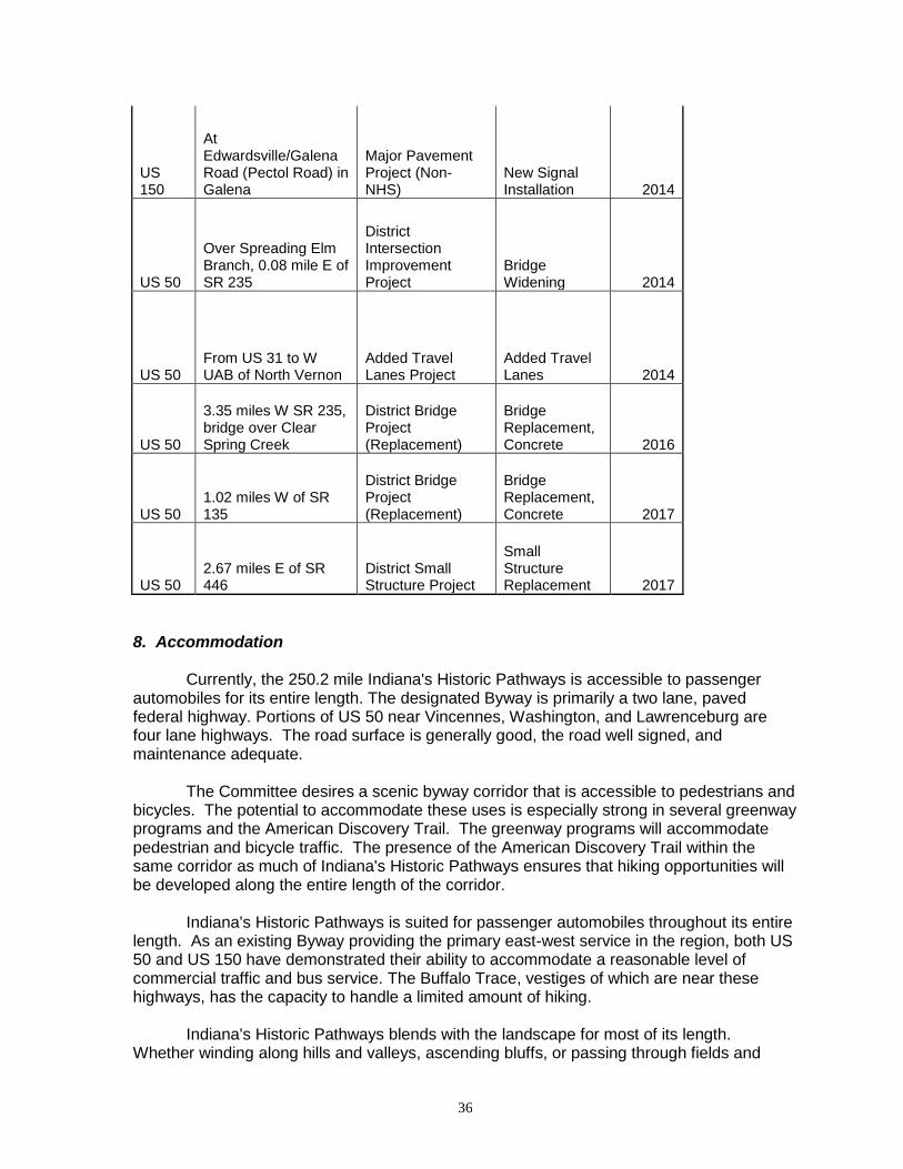
University of Southern Indiana (ongoing) While the university has been actively involved with individual communities along the Byway, the Committee will work to enhance a more formal relationship with the university to study corridor issues such as marketing, design, tourism, preservation and environmental management. The university is committed to outreach and engagement by faculty and staff and has developed a Service Learning program which could involve students in byway activities. 7. Safety Plan 7.1 Existing Policies The Indiana Department of Transportation controls access to all state roads and monitors improvement to adjacent property to ensure motor vehicle safety is maintained and enhanced. INDOT monitors accidents and safety for all state Byways in Indiana. In order to ensure the most accurate statistics, INDOT's accident report structure is based on intersection and milepost references. Accidents are reported in ten year blocks and available for detailed study and investigation at the Indiana State Police and Indiana Department of Transportation office in Indianapolis. 7.2 Planned Initiatives Local planning offices are currently working with the Committee to ensure that safety is maintained and enhanced with new development projects. Indiana's Historic Pathways Committee will further encourage the investigation of commercial strip improvements through service roads, shared drives, and enhanced pedestrian facilities. The Committee will also review the Byway to determine areas where there is no provision for passing or break down. The development of turn-outs or passing blisters will be investigated as a solution for enhancing safety without the expense or visual impact of shoulders. Turn-outs or passing blisters can further avoid potential conflicts between leisure, commercial and through traffic by allowing for passing or non-leisure vehicles. Safety and service improvements for the 250.2-mile Indiana's Historic Pathways have been planned by INDOT based on the accident report structure. Indiana’s Historic Pathways falls under the jurisdiction of two INDOT districts: Vincennes and Seymour. The following are planned road projects along U.S. 50 and U.S. 150 for the next several years for the two districts.

31
Vincennes District
Road Location Work Category Work Type Letting Date
US 50 CR 900 E (7.4 km W of US 231)
Central Office Safety Project
Flashers, Modernized 2007
US 50
IL/IN State Line to US 41/ 6th St & US 41/6th St to 7.76 mi E IL/IN State Line
District Pavement Project
HMA Overlay, Preventive Maintenance 2007
US 50 CR 900 E (7.4 km W of US 231)
Central Office Safety Project
Intersection Improvement w/ Added Turn Lanes 2007
US 150 1.1 miles E of SR 56 on US 150
District Small Structure Project
Arch Reconstruction or Repair 2007
US 50
1.33 mi N of S jct SR 37 (0.25 mi N of E Fork White River Bridge)
Geological Project (Erosion/Landside Control)
Slide Correction 2008
US 150
Bridge over Beaver Creek (0.43 mile E of US 50)
Environmental Mitigation
District Bridge Project (Replacement) 2008
US 50 at Pine St. in Loogootee
Install Loop Detector
District Pavement Project 2008
US 50 1.59 miles E of SR 257 to W jct US 231
District Pavement Project
HMA Overlay, Preventive Maintenance 2008
US 50 At SR 37 S Jct
District Maintenance Work Project (Traffic)
Traffic Signals Modernization 2008
US 50
From 7.56 miles W to 6.66 miles W of US 231
Major Pavement Project (NHS)
Median Construction 2008
US 50
Bridge over S Fork Leatherwood Creek (2.26 miles W of SR 446)
District Bridge Project (Replacement)
Bridge Replacement 2008
US 50 At SR 257, 2.19 miles E of SR 57
District Signal Project
Traffic Signals, New or Modernized 2009
US 50 from SR 37 N jct to "E" St in Bedford
District Pavement Project
HMA Overlay, Preventive Maintenance 2010

32
US 150 at S jct with SR 37
District Maintenance Work Project (Traffic)
Traffic Signals Modernization 2010
US 50 3.38 miles E of SR 650
District Small Structure Project
Small Structure Replacement 2010
US 150 From SR 56 jct to approx. 5.25 mi E jct
Major Pavement Project (Non-NHS)
Road Reconstruction (3R/4R Standards) 2010
US 150
Bridge over Lick Creek, 2.71 miles E of SR 56
Major Pavement Project (Non-NHS)
Bridge Deck Overlay 2011
US 150
Bridge over Mysterious Spring, 3.70 miles E of SR 56
Major Pavement Prject (Non-NHS)
Bridge Deck Overlay 2011
US 150
Indan Boundary Rd from 1.94 miles W of SR 37 to SR 37/56 E jct (Phase II Seg 3)
Major Pavement Project (Non-NHS)
Road Reconstruction (3R/4R Standards) 2011
US 50
6.08 miles W of SR 241 to 1.88 miles E of SR 241
District Pavement Project
PCCP Cleaning and Sealing Joints 2012
US 150
5.25 miles E of jct w/ SR 56 to approx 658 ft W of CR 225W
Major Pavement Project (Non-NHS)
Road Reconstruction (3R/4R Standards) 2012
US 150
Bridge over Branch Lick Creek, 6.65 miles E of SR 56
Major Pavement Project (Non-NHS)
Bridge Channel Correction 2012
US 50
1.33 mi N of S jct SR 37 (0.25 mi N of E Fork White River Bridge)
Geological Project (Erosion/Landside Control)
Slide Correction 2013
US 50
From the S jct with SR 37 to N jct with SR 37 (SR 450) at Bedford
Major Pavement Project (NHS)
Rubblize PCCP & HMA Overlay 2015
US 150
656 ft W of CR 225 to 0.28 mi W of jct with SR 37
Major Pavement Project (Non-NHS)
Road Reconstruction (3R/4R Standards) 2015
US 50 4.09 mile E of SR 37 to jct with SR 446
District Pavement Project
HMA Overlay, Preventive Maintenance 2015

33
US 50
Over Beaver Creek, 1.32 miles W of SR 60 and 1.74 miles W of SR 60
District Bridge Project (Replacement)
Br Repl, Comp. Cont. Pres. Conc. Box Beam 2017
US 50
Frm the E en of the Washington Bypass to 1.1 miles W of Davies/Martin CL
Major Pavement Project (NHS)
Road Reconstruction (3R/4R Standards) 2017
US 150 At SR 66
District Intersection Improvement Project
Intersection Improvement w/ Added Turn Lanes 2017
US 50
0.16 miles W of jct with SR 60 to 0.19 miles E of jct with SR 60
District Intersection Improvement Project
Intersection Improvement w/ Added Turn Lanes 2017
US 50 3.5 and 3.92 miles W of SR 60
District Small Structure Project
Culvert Clean and Repair 2017
US 150 0.53 mile E of SR 56 (E jct)
District Small Structure Project
Small Structure Replacement 2017
US 50
from 1.1 mile W of Davies/Martin County Line to the Davies/Martin CL
Major Pavement Project (Non-NHS)
Road Reconstruction (3R/4R Standards) 2021
US 50
From E Fork of White River to 0.1 mile E of US 150 S of Shoals
Major Pavement Project (Non-NHS)
Road Reconstruction (3R/4R Standards) 2021
US 50
From the Davies/Martin CL to E fork of White River
Major Pavement Project (Non-NHS)
Road Reconstruction (3R/4R Standards) 2023
US 50
From 0.1 mile E of US 150 S of Shoals to 0.1 mile E of SR 650
Major Pavement Project (Non-NHS)
Road Reconstruction (3R/4R Standards) 2025
US 50
from 0.1 mile E of SR 650 to 2.3 miles E of SR 650
Major Pavement Project (Non-NHS)
Road Reconstruction (3R/4R Standards) 2025
US 50
from 2.3 miles E of SR 650 to 0.9 miles E of Martin/Lawrence CL
Major Pavement Project (Non-NHS)
Road Reconstruction (3R/4R Standards) 2025
US 50
From 0.9 miles E of Martin/Lawrence CL to 4.0 miles E of Martin/Lawrence CL
Major Pavement Project (Non-NHS)
Road Reconstruction (3R/4R Standards) 2025

34
US 50
From 4.0 miles E of Martin/Lawrence CL to present US 50 NE of Bryantsville
Major Pavement Project (Non-NHS)
Road Reconstruction (3R/4R Standards) 2025
US 50
From Present US 50 NE of Bryantsville to SR 37
New Road Construction Project
Road Construction (New alignment) 2025
US 50
From E UAB of Bedford to jct of SR 446
Added Travel Lanes Project
Added Travel Lanes 2027
Seymour District
Road Location Work Category Work Type Letting Date
US 50 From SR 56/SR 350 to SR 1
District Pavement Project Partial 3-R 2007
US 50 0.3 miles E of Agrico Lane to US-31
District Pavement Project
PCCP Patching 2008
US 50 US 31 to Hayden Pike District Pavement Project
HMA Overlay - Preventive Maintenance 2008
US 50 At Deer Creek Rd (CR 75E)
Central Office Safety Project
Intersection Improvement 2008
US 50
Hayden Pike to SR 3/7 and from SR 3/7 to V Fork Muscatatuck River
District Pavement Project
HMA Overlay - Preventive Maintenance 2009
US 50 Cave Hill Road
Geologic Project (Erosion/Landslide Control)
Erosion Control 2010
US 50 At George Street (CSX and US 50)
Central Office Congestion Project (Minor)
Intersection Improvement - Railroad Protection & Surface 2011

35
US 50 E of US 31 at RP 109+22
District Bridge Project (New Bridge/Grade Separation)
New Bridge, Other 2011
US 50 Doughty Road
Intersection Improvement Project
Horizontal Sight Correction 2011
US 50 1.81 miles E of US 421
District Small Structure Project
Small Structure Replacement 2011
US 50 Doughty to Water Street
District Bridge Project (Rehabilitation)
Road Reconstruction (3R/4R Standards) 2011
US 50 Deer Creek Road to Jennings/Ripley CL
District Pavement Project
HMA Overlay - Preventive Maintenance 2011
US 50 0.4 miles W CR-950W
Geologic Project (Erosion/Landslide Control)
Slide Correction 2011
US 50 E of SR446 atRP 81+65
District Small Structure Project
Small Structure Replacement 2012
US 150
from 1.73 miles W of SR 335 (County Line) to 3.80 miles W of I-64
Major Pavement Project (Non-NHS)
Road Reconstruction (3R/4R Standards) 2014
US 50 At SR 235/CR 650W
District Intersection Improvement Project
Intersection Improvement 2014
US 50
Bridge over CSX RR and Railroad Avenue, 1.05 miles W of SR 56
District Bridge Project (Rehabilitation)
Bridge Deck Replacement 2014
US 50
From W UAB of North Vernon to E UAB of North Vernon
Added Travel Lanes Project
Added Travel Lanes 2014
36
US 150
At Edwardsville/Galena Road (Pectol Road) in Galena
Major Pavement Project (Non-NHS)
New Signal Installation 2014
US 50
Over Spreading Elm Branch, 0.08 mile E of SR 235
District Intersection Improvement Project
Bridge Widening 2014
US 50 From US 31 to W UAB of North Vernon
Added Travel Lanes Project
Added Travel Lanes 2014
US 50
3.35 miles W SR 235, bridge over Clear Spring Creek
District Bridge Project (Replacement)
Bridge Replacement, Concrete 2016
US 50 1.02 miles W of SR 135
District Bridge Project (Replacement)
Bridge Replacement, Concrete 2017
US 50 2.67 miles E of SR 446
District Small Structure Project
Small Structure Replacement 2017
8. Accommodation Currently, the 250.2 mile Indiana's Historic Pathways is accessible to passenger automobiles for its entire length. The designated Byway is primarily a two lane, paved federal highway. Portions of US 50 near Vincennes, Washington, and Lawrenceburg are four lane highways. The road surface is generally good, the road well signed, and maintenance adequate. The Committee desires a scenic byway corridor that is accessible to pedestrians and bicycles. The potential to accommodate these uses is especially strong in several greenway programs and the American Discovery Trail. The greenway programs will accommodate pedestrian and bicycle traffic. The presence of the American Discovery Trail within the same corridor as much of Indiana's Historic Pathways ensures that hiking opportunities will be developed along the entire length of the corridor. Indiana's Historic Pathways is suited for passenger automobiles throughout its entire length. As an existing Byway providing the primary east-west service in the region, both US 50 and US 150 have demonstrated their ability to accommodate a reasonable level of commercial traffic and bus service. The Buffalo Trace, vestiges of which are near these highways, has the capacity to handle a limited amount of hiking. Indiana's Historic Pathways blends with the landscape for most of its length. Whether winding along hills and valleys, ascending bluffs, or passing through fields and

37
villages, Indiana's Historic Pathways is an integral component of the southern Indiana scenery. Seasonality: Flooding
Portions periodically flood in Orange County between Prospect and Paoli. As a familiar aspect of life along Indiana’s Historic Pathways, INDOT and local communities quickly and efficiently respond when flooding threatens. Flood areas, typical flood periods, and recommended detours will be noted in informational publications. Seasonal and Other Traffic From late spring through early fall, slow-moving farm vehicles are commonly found on U.S. 50, especially between Vincennes and Shoals on the west and Bedford and Lawrenceburg on the east. They also use portions of U.S. 150. Amish buggies frequent portions of the corridor, especially between Washington and Loogootee on U.S. 50 and in Orange County on U.S. 150. Highway signs designate this as an Amish area for safety purposes. Coal trucks regularly travel US 50 between Shoals and the western end in Vincennes. This portion of the road contains many passing lanes for added safety. 9. Visitor Experience Plan Indiana’s Historic Pathways is mostly rural and passes through several small towns. Aesthetic intrusions are minimal although there are a few instances of urban sprawl, most notably in larger cities and towns like New Albany, Lawrenceburg, and Seymour (which is located on an exit of Interstate 65). Where possible, the Byway goes through the center of towns like Bedford and Washington where historic resources are in closer proximity as opposed to following the newer bypass. The Indiana Historic Pathways Committee understands the importance of maintaining the integrity of the byway and preserving the resources to ensure an optimum experience for visitors. The Committee, through its county representatives, will be aware of impending development that might intrude on the visitor experience and will work with the interested parties to see that intrusions are kept to a minimum or that development is done in a way that will enhance the visitor experience. 9.1 Existing Efforts The Committee has already undertaken an evaluation of the visitor experience along Indiana's Historic Pathways. As a result of the intrinsic qualities inventory, the designated Byway has been relocated in a few places to provide more scenic and historic experience for the traveler. 9.2 Planned Efforts
Commercial Strip and Service Areas Existing commercial strip areas along Indiana's Historic Pathways have been identified by the Committee for review and evaluation regarding the visitor experience. Initial efforts will focus on recognizing the necessary traveler services (gas, food, and lodging) they provide.

38
Long-range plans will identify strategies for the improvement (aesthetic and safety) of existing commercial strip areas.
Utilities The Committee will coordinate with the local utilities (for example, Cinergy/PSI, Vectren Verizon, REMC and Ameritech) to coordinate corridor projects and utility construction, and act as a liaison for community redevelopment projects. Potential associations may involve assistance in determining location of cellular communication towers and power lines necessitated by road widening or upgrades in service to ensure that scenic views are retained or enhanced, or assistance in tree maintenance or selection in utility rights-of-way.
Maintenance The Committee will work to notify INDOT of areas in which maintenance is needed, organize volunteer clean-ups of the Byway, and ensure that the corridor is maintained in a manner that is attractive.
Pull-Offs Pull-offs, roadside parks and pull-offs for interpretative facilities and scenic overlooks will be developed.
Hospitality training Recognizing the importance of hospitality to the visitor experience, the Committee has identified the need for the training of attraction and front-line employees along the corridor.
Diversity Due to the 250.2 mile length of Indiana's Historic Pathways, there are many different types of visitor experiences. Topography, settlement patterns, socio-economic regions, and physiographic regions vary significantly along the byway. Travelers along Indiana's Historic Pathways may experience quite natural areas, the cultural facilities of urbanized areas, or the excitement of riverboat gaming attractions. The Committee will structure a marketing and management scheme to ensure that visitors to Indiana's Historic Pathways appreciate the transitions and distinctive areas in a manner that is organized and logical.
Indiana's Historic Pathways Logo Endorsement Program The Committee will develop an Indiana's Historic Pathways logo endorsement program. For modern travelers accustomed to predictability of national chain restaurants and lodging, the logo program will encourage visitors to patronize locally owned businesses. The prominent display of Indiana's Historic Pathways logo at businesses, attractions and service facilities will identify project partners that support the vision of the Byway and actively participate in accomplishing the goals of Indiana's Historic Pathways. The displayed logo will assure the traveler that the facility is recognized as a quality component of the Byway and that traveler information is available from trained personnel. The logo will be a licensed trademark of the Committee.
The Working Region Working with the interpretive program the visitor experience plan will work to broaden the visitors understanding of the physical components of the regions. Industrial facilities and power plants, located along the Byway are frequently viewed as sharply contrasting to the natural environment, and so are the numerous coal trucks that frequent US 50. Agricultural vehicles and grain trucks also are present seasonally. Despite their distinctive presence,

39
such facilities are located in the region for significant and historical reasons. This plan will work to ensure that visitors understand the rich commercial, industrial, agricultural, and transportation heritage that has shaped the region since early times.
Visitor Experience The Indiana's Historic Pathways Committee plans to develop podcasts. This audio tour will enhance the driving experience by highlighting the intrinsic qualities of the Byway as well as history, culture, topography, and contemporary life. The Committee will work to ensure that the visitor experience for children along Indiana's Historic Pathways is informative, educational, and fun. 10. Outdoor Advertising Control Compliance Designation of Federal Aid Interstate and Primary routes carries with it the provision that no new billboards may be erected (existing billboards may remain or may be purchased with the use of special Federal funds). Indiana's Historic Pathways Committee will work to ensure that the character and quality of the Byway is maintained and enhanced and that the Byway does not become an advertising corridor. Having organized corridor-wide endorsement for the state and national designation, the Committee will work to ensure that the integrity of the corridor is maintained. The Committee will work to educate potential advertisers of the vision and goals of the Byway, and encourage alternate advertising in corridor publications and brochures, and through the business logo identification program discussed in Section 11 of this application. Indiana has a regulation (IC 8-23-20) which is maintained by the Office of Code Revision Indiana Legislative Services Agency with stipulations on billboard advertising. A number of local jurisdictions have existing signage and billboard policies. These policies have been collected by the Committee and are available for review. The Committee will provide assistance to all interested communities along the corridor interested in improving their sign policies or investigating alternative methods of outdoor advertising. The Committee will also review existing sign ordinances to see how effective they are at protecting the intrinsic qualities of the corridor. Indiana’s Historic Pathways has a good working relationship with the INDOT district offices which oversee the byway and will work directly with them to see that new billboards do not inundate the byway.
11. Sign Plan 11.1 Planned Program The Committee has created an Indiana's Historic Pathways logo that can be used in a sign program for the Byway. As an easily identifiable symbol appearing on brochures, interpretative panels, and participating businesses, the logo's addition to the Byway markers would assist in reinforcing the cohesiveness and continuity of the 250.2 mile Byway and assist the traveler with quick identification. The Committee will investigate funding options for such a program. Any upgrading of the existing signs will be done in coordination with INDOT. Since Indiana’s Historic Pathways encompasses two federal highways the route is easily travelled and both U.S. 50 and U.S. 150 are well signed. Byway logo signs will be placed along the corridor in key places where visitors may enter from other highways. Byway logo signs will be especially useful in those few areas along Indiana’s Historic

40
Pathways where the designated route goes through the historic or business district of a city or town instead of taking the bypass. 12. Marketing Narrative 12.1 Existing Programs Located within 500 miles of 106 million people, Indiana's Historic Pathways is an accessible destination for the leisure traveler. As a long weekend destination, the Byway offers scenic vistas, natural areas such as parks and forests, historic attractions, riverboat gaming and two major cities (Cincinnati and Louisville) with all of their activities--all at an affordable cost for budget travelers. The growing interest in travel to historic sites, cultural attractions, and rural destinations promises even greater popularity for Indiana's Historic Pathways in the near future. In fact, the TIA (Travel Industry of America) 2003 Executive Summary of the Historic/Cultural Traveler shows that 56% of the U.S. adult population included at least one cultural, arts-related, historic, or heritage activity or event on a trip in the previous year. Studies by TIA have indicated the increase in attendance at historic sites and cultural events to be indicative of a continuing trend and show these areas as one of the fastest growing segments of the tourism industry. Indiana’s Historic Pathways possesses all of the destinations noted above, and is especially rich in cultural, historic, and natural resources. The Tourism and Development task force will coordinate marketing efforts with the convention and visitor bureaus located along the Byway. The Task Force will also work with the Indiana Office of Tourism Development on marketing and public relation strategies involving the Indiana’s Historic Pathways. The Tourism and Development Task Force will ensure that current information is submitted to the America’s Byway website for travelers.
Toll Free Information (exisiting) Historic Southern Indiana offers a toll-free number for visitor services and information about southern Indiana. A visitor package tailored to Indiana's Historic Pathways has already been prepared and is available to send to interested callers. The toll-free number is 1-800-489-4474.
Website (revision complete in 2009) Information is currently listed on Historic Southern Indiana’s website at http://www.usi.edu/hsi/resources/IHP.asp. A new website will be developed for the byway in the near future.
Tear-Off Map (completed) Indiana’s Historic Pathways developed a tear-off map which is available at visitor centers and attractions. The map includes information on places of interest to the visitor located along the Byway.
Rack Card (completed) Indiana’s Historic Pathways developed a rack card that includes the logo, information about the byway, a map, and a listing of attractions. This serves as an informational piece until a promotional brochure is developed.
41
Convention and Visitor Bureaus, Tourism Agencies, and Regional Marketing Organizations (ongoing)
Communities along the Byway already market and promote themselves in travel publications and other media.
Tourism Marketing (ongoing) Indiana's Historic Pathways will be included in tourism marketing materials distributed by the Indiana Office of Tourism Development and HSI. INDOT will include Indiana’s Historic Pathways on its 2009 Indiana Travel Map. 12.2 Planned programs
Brochure (planned for 2009) Indiana's Historic Pathways Committee will develop a promotional brochure that will identify the Byway in its entirety, along with information concerning attractions, historic and cultural sites, services, and facilities, and a calendar of events.
Compact Disks, Podcasts and Global Positioning Systems (planned in 1 – 3 years) Indiana's Historic Pathways Committee will explore the possibility of developing downloadable compact disk and podcasts. The Committee will also seek to ensure that information about the features of the corridor are available on GPS providers for drivers as well as Web browsers that have travel features.
Marketing Plan (planned in 1 – 2 years) The Tourism Task Force will develop a long range detailed marketing plan for the area. This plan will address the diverse activities and attractions along the Byway in a comprehensive strategy for promotion, management, development and marketing research. The plan will also propose strategies to monitor travel trends along the Byway through the development of a visitor profile for the corridor.
FAM Tours and Orientations for Travel Agents and Consultants (begin in 2009, ongoing) Familiarization tours (FAM) will be coordinated to attract both nationally recognized travel writers and freelance writers to educate them about the opportunities along the Byway. There will also be an effort to attract media attention from major national magazines such as Midwest Living, AAA's Home and Away, American Heritage, Weekend Traveler, and Country Living. Special orientation meetings for travel agents and consultants will be held. An article on Indiana’s Historic Pathways was featured in the Ohio edition of the July/August 2008 AAA Home and Away magazine.
Media Campaign (begin in 2009, ongoing) The Indiana Office of Tourism Development will provide media relations assistance to Indiana’s Historic Pathways. The Tourism and Development Task Force plans to conduct a media campaign which will include public relations, advertising, and promotions. Future media campaigns will be designed around major events taking place along the scenic byway.

42
Press Kits (ongoing) Press kits with news releases, CD’s of digital images, maps of the Byway, listings of visitor attractions and services and other appropriate information will be assembled to provide concise and timely response to media inquiries, and to be used in media campaigns.
Package Tours (ongoing) Tour packages will be created and marketed to target audiences. Packages will be based on interpretative themes, and will be designed to extend the visitor experience along Indiana's Historic Pathways.
The American Discovery Trail (1 – 2 years) The Committee will work to coordinate marketing efforts for Indiana's Historic Pathways with those of the ADT to ensure that both nationally designated corridors may be associated with their shared corridor through southern Indiana. 13. Design Standards Recognizing that the scenic byway experience is shaped through the quality of the driving experience, the Indiana’s Historic Pathways Committee will work to ensure that the qualities of the roadway that currently make the Byway attractive and pleasant to drive will be maintained and enhanced. The Committee further recognizes that the traveler’s recreational experience and safety are mutually dependent.
The Committee has established a good working relationship with INDOT and two staff members serve on the Committee in an ex-officio capacity and regularly attend meetings. Recognizing the significant role INDOT has in maintaining a safe and efficient transportation system in southern Indiana, and further recognizing that roadway improvements and alterations can significantly affect the visitor experience along the Byway, the Committee will work with INDOT to ensure that Indiana’s Historic Pathways plans and programs reinforce the safe use of the road and to act as a liaison between INDOT and the local communities and resource representatives along the corridor that depend on the road. This partnership will enable the development of transportation improvements that meet the goals of INDOT, while also meeting the goals of Indiana’s Historic Pathways.
The Committee will coordinate with INDOT to ensure that maintenance practices,
rehabilitation, and new construction along the Byway reinforce the character of the corridor. Options for sensitive design management will be researched and implemented when possible. 14. Interpretation Plan 14.1 Overview The story of Indiana's Historic Pathways comprises three parallel themes: The People and the Land, Building Communities, and Transportation and Commerce. These provide the interpretive thread to tie the stories of the corridor together to provide visitors and residents with a bigger picture of the region's heritage. The People and the Land will relate the interaction between the natural and built environments through topography,

43
natural history, and patterns of settlement from pre-history through the French and Indian War, the American Revolution, and the Ordinances of 1785 and 1787 to the present. This will include Native American and African American communities, the Underground Railroad, migration, and ethnic settlement. Building Communities will address architecture, industry, government, politics, social history, religion, and education, focusing on the varieties in shape and texture as well as the similarities of towns and villages. Transportation and Commerce will focus on the impact of travel (especially railroads and roadways) and communication; of natural features like the Falls of the Ohio, the Buffalo Trace, the unglaciated central region (with its limestone and gypsum resources), and the Wabash Lowland, rich in coal and petroleum; of agriculture and forestry; of early to modern manufacturing; and of bridges and ferries. These three themes will provide the basis for all interpretive programs along the corridor and will be tied into ongoing marketing efforts. A detailed inventory of heritage attractions along the Byway has been compiled into a database at Historic Southern Indiana. This database can be used to identify thematic sites and provide listings of attractions and visitor services along the Byway. The educational outreach efforts of HSI will include a revised regional interpretation manual that contains interpretive materials specific to Indiana's Historic Pathways. Thematic tours will be developed that can be used as self-guided auto tours or motor coach tours with guidebooks and interpretive brochures as collateral materials. Attractive kiosks and specially designed interpretive panels will be strategically placed along the scenic byway to reinforce the three interpretive themes of the Byway. Thematic panels will contain a section with an overview of that theme along the entire Byway as well as more detailed interpretive information about the significance of the theme in that location. In this way, the story of each of the three interpretive themes will unfold for the visitor as he or she travels the Byway. In turn, this account will be linked to narratives for the two existing national byways in Indiana—the Ohio River Scenic Byway and the National Road. Both were vital channels of westward migration and trade, especially in the nineteenth century. Every effort shall be made to recognize the special needs of disabled visitors, to interpret the sites and history of Indiana's Historic Pathways for the disabled, and to follow all applicable ADA policies. 14.2 Three Interpretive Themes and Examples of Sub-themes
The People and the Land Natural history/Topography Prehistory French and Indian War The American Revolution Ordinances of 1785/1787, Indiana Territory (1800-1816) The Civil War Patterns of movement; buffalo, Indian traces, etc European settlers: upland southerners (mostly English and Irish), Germans, French African-American communities Amish and Quaker settlements

44
Building Communities Architecture Interaction of Upland Southerners, Germans, and Yankees Government and Politics
Border between slave and free states Underground Railroad
Cultural, social history—especially religion, education, and voluntary associations
Transportation and Commerce River transportation Land transportation Falls of the Ohio
Industries, Agriculture, Forestry Impact of railroads, roads Means of crossing rivers: bridges, ferries
14.3 Planned Programs
Panels and Kiosks Several pilot panels and kiosks will be located along the entire length of Indiana's Historic Pathways. These installations will be of standard design, material and finish ensuring easy recognition by the traveler. In addition to the three interpretive themes, the panels and kiosks will also provide reference maps (corridor and local), reference nearby attractions, and in locations, provide facilities for local brochures or information desks. Panels and kiosks will be developed to acquaint the traveler with the overall story of the corridor--local attractions and interpretive programs will continue to exist independently, but will be encouraged to coordinate efforts with the corridor program.
Children's Education and Interpretation Program Recognizing the appeal of Indiana's Historic Pathways as a family destination, Indiana's Historic Pathways Committee plans a Children's Education and Interpretation Program. This program will be designed for both visiting and local children using the intrinsic qualities of the region, interpreted through the three corridor themes, as an exciting discovery experience.
14. A.1 Education
Classroom Programs The Committee, working with existing education programs at Historic Southern Indiana, the Indiana Junior Historical Society, the Indiana Department of Education, Historic Landmarks Foundation of Indiana, and Indiana colleges and universities will develop classroom materials about the three interpretive themes of the corridor to coordinate with Indiana history lessons taught in the fourth grade. Lesson plans, CD Rom video, and traveling kits for use in city and county schools are being considered.

45
Field Trips Taking advantage of the rich historic, natural, and industrial sites throughout the corridor, the Committee will work to develop programs, or facilitate interaction between local schools and these facilities.
Young Adults Recognizing the special needs and interests of young adults are frequently overlooked, the Committee desires to develop programs geared to high school youth along the corridor. Such programs may include an essay or photo contest on Indiana's Historic Pathways, junior interpretation opportunities, or internships with the Committee or one of the affiliated non-profit organizations along the Corridor. The Committee will work to coordinate these programs with the history curriculum taught in the tenth and eleventh grades. 14. A.2 Interpretation
Existing Children's Programs Children's interpretation programs currently exist at numerous sites along the corridor ranging from prehistoric life to twentieth century commercial life. The Committee plans to coordinate Indiana's Historic Pathways children's interpretation with existing children's programs along the corridor. Children's interpretation programs currently exist or are in the process of development at the following sites:
o Hillforest o Culbertson Mansion State Historic Site o Falls of the Ohio State Park o Hoosier National Forest o George Rogers Clark National Historical Park o Vincennes State Historic Sites
Additional Interpretation The Committee will investigate additional interpretation formats for children such as a guidebook and audio interpretation of the Byway elaborating on the established themes. Such children's interpretation may center around a fictional character and his or her adventures through time along Indiana's Historic Pathways (possible marketing of a licensed character at selected museum attractions, and information centers could help to support the program). Additionally, activity books, educational games, and special programs can serve to make Indiana's Historic Pathways story exciting for children.
Indiana's Historic Pathways Kids In order to make Indiana's Historic Pathways interesting and educational for children, the Committee will investigate the possibility of developing an overall children's program that combines interpretation with recreational and entertainment activities along the corridor. Programs may include crafts, camping, and community service. A passport program, where children earn points for visiting historic, natural, or cultural sites along the Byway that can be redeemed for prizes (such as an ice cream treat at a local dairy stand) will be investigated as a methodology for exposing visiting children to community life along the corridor today.

46
SECTION 4 All-American Roads Requirements and Documentation Not Applicable
47
SECTION 5 State Scenic Byways Agency Certification I certify that the Byway meets the criteria and requirements for National Scenic Byways or All-American Roads. ______________________________________________________________________ Signature of State official/Title Date

48
SECTION 6 Federal Land Management Scenic Byways Agency Certification Not applicable
49
SECTION 7 Form Preparer Name: Leslie Townsend, Director Organization: Historic Southern Indiana Date: ____________________ Address: 8600 University Boulevard Evansville, Indiana 47712 Voice: 812-465-7014 Fax: 812-465-7061 E-mail: [email protected]
50
APPENDIX A HISTORY OF INDIANA'S HISTORIC PATHWAYS Like prehistoric peoples and early American settlers before them, the current residents of the Ohio Valley in southern Indiana find their lives shaped to large extent by the natural environment. Southern Indiana's soil, terrain, rivers, and climate have impacted settlement patterns and economic activities, and have even resulted in unique cultural characteristics. The fact that the Falls of the Ohio--cascading rapids caused by exposed fossil beds in the river--was the only natural break in the 981-mile-long Ohio River was largely responsible for several settlements that sprang up on both sides of the river. The Falls became a natural unloading point for cargo and emigrants, as well as an ideal location for constructing steamboats. Tributaries of the Ohio—the Blue, White, and Wabash—served in turn as channels for the movement of people and commerce in the interior part of southern Indiana. Because southern Indiana was at the edge of a series of advancing and retreating glaciers during the last ice age, the topography varies from flat, fertile farmland to craggy, forested hills. The area is also located at the intersection of four major climatic zones, making for an unusually rich environment. The Ohio Valley is the northernmost extent of many southern species of plants and animals. The extensive hardwood stands of the Eastern Woodlands are at their western-most in southern Indiana; in fact, at times in prehistory, prairie grasslands have intruded into the Ohio Valley from the north and west. The density of the forests once found in southern Indiana's hill country were described by a traveler to the region in 1818:
To travel day after day among trees of a hundred feet high, without a glimpse of the surrounding country, is oppressive to a degree which those cannot conceive who have not experience it; and it must depress the spirits of the solitary settler to pass years in this state. His visible horizon extends no farther than the tops of the trees which bound his plantation--perhaps, five hundred yards. Upwards he sees the sun, and sky, and stars; but around him an external forest from which he can never hope to emerge.
The profusion of archaeological sites in southern Indiana attests to the fact that prehistoric peoples found this rich environment especially attractive. With the waning of the last ice age, humans hunting large game animals moved into the area. As the climate began to warm about 8000 BC, population increased; mobile groups hunted smaller game, gathered plant resources, and made extensive use of river mussels, leaving the shells in large mounds along the river. Trade over a widespread area also began, and eventually exotic raw materials were traded throughout North America. About 1000 BC, native groups began manufacturing pottery, experimenting with plant cultivation, and constructing burial mounds and earthworks, which are still visible in farm fields today. Although possession of the Ohio River Valley was hotly contested during the 17th and 18th centuries, the archaeological and historical records are disappointingly silent about the inhabitants of the area and their activities. Before and after the arrival of permanent European settlers (the French, in the 1730s, and Anglo-Americans after the 1760s), native American tribes utilized the region, like much of Kentucky, for seasonal hunting. There were

51
no major Indian villages, like Kekionga near present Fort Wayne, Indiana. The first explorers and settlers found the area sparsely populated, and mainly used for hunting by the Miami and the Shawnee, late-comers to the region who have no known relationship to the prehistoric inhabitants of the area. The region was first part of French Louisiana, then claimed by the British in 1763 after the French and Indian War, and finally won by the Americans in the Revolutionary War. In 1783, the Ohio River became the southern border of the Northwest Territory of the United States of America. Clarksville, located at the Falls of the Ohio and established in 1784, was the first American town in the Old Northwest. Clark's grant consisted of 150,000 acres which was given to Revolutionary War soldiers who fought with George Rogers Clark to capture the old Northwest for the United States. Although a few settlers wandered into the region from Ohio and Kentucky, several obstacles stood in the way of settlement. A system of orderly and democratic transfer of land from the federal government to individuals had to be established; frontier government had to be provided for; and the Indian threat had to be dealt with as the Indians, determined to hold their land claims as far south as the Ohio River raided settlements in the vicinity. The Ordinances of 1785 and 1787 provided for orderly survey and sale of land and developed a system of government, which would end in statehood. Meanwhile, the Indian dilemma was resolved around the turn of the century, when the Indians began ceding additional land to the United States through the leadership of the governor of the Indiana Territory, William Henry Harrison. By 1800, the eastern section of the Northwest Territory was split off and became the state of Ohio. The remaining western section became the Indiana Territory with its capital at the Franco-American town of Vincennes; it had a population of 5,641, including the present states of Indiana, Illinois, Michigan, Wisconsin, and eastern Minnesota. Population growth in Michigan and Illinois territories led to the creation of separate territories in 1807 and 1809, and the territorial capital was moved to Corydon in 1813. Indiana was granted statehood in 1816, and it was in Corydon that the state's first constitution was drafted. Reflective of Indiana's early population, all but nine of the forty-three delegates who drafted the first constitution were from the South, and most knew first-hand the rigors of frontier life. As Robert L. Reid states in the introduction to Always A River, "the Ohio was our first interstate highway, carrying men, women, and children to new opportunities, new homes and new lives. They traveled down the river on all manner of craft, then struck out over land on horseback in wagons, or simply on foot." The emigrants who settled in the territory of Indiana reached the interior over the trails, or traces, made by Native Americans or animals. The most popular interior Route was the Buffalo Trace between Louisville and Vincennes; the old Pathway is followed by U.S. 150. Continuing transportation improvements beginning in the 1830s brought yet further changes to southern Indiana. By 1855, eighteen railroad companies had laid over fourteen hundred miles of track in Indiana. One of the most significant was the Ohio and Mississippi Railroad, which connected Cincinnati to St. Louis through southern Indiana, for years the only east-west transportation south of the National Road. By June 6, 1854, it had reached Seymour—named for Charles Seymour, who surveyed the Region for the line. The O & M reached Vincennes in 1857. It would be the major stimulus for the development of the interior towns, especially Seymour, North Vernon, Versailles, Loogootee, Washington, and Vincennes. Washington’s development in particular was linked to the railroad, as for years it was the site of a major repair shop for the line (later the B & O). The completion of this road

52
connected Indiana communities to a growing national network of rail lines—in this case, from St. Louis eastward to Baltimore.
Early state roads were in extremely poor condition and often impassable. There was no centrally planned and financed state highway system until the 1920s. What became U.S. 50 and U.S. 150 evolved from that network, as federal subsidies encouraged states to design and build a series of roads. State and national highways also stimulated the growth and development of towns and villages in the interior. A canal from the Wabash and Erie near Peru to Indianapolis and on to Evansville was finally completed in 1853, but the southern section was often inoperable and never attracted much traffic. Portions of the Byway cross the abandoned canal bed near Washington, Indiana. During the mid-nineteenth century, the Ohio River greatly influenced political history. Among the provisions of the Northwest Ordinance of 1787 was the exclusion of slavery in the area north of the Ohio River. The river consequently became the dividing line between "slave" and "free" states. Although there is quite a bit of folklore concerning the Underground Railroad in southern Indiana, a great deal of important activity occurred in helping African Americans find safe passage to the north. In the interior, especially in Orange and Washington counties, where there were many members of the Society of Friends, small black settlements emerged that died out after the Civil War. A notable example is the Little Africa (or Lick Creek) settlement near Paoli. Manufacturing in 1850 was largely tied to nearby agricultural and natural resources and was concentrated in river towns like New Albany, Jeffersonville, and Vincennes. Steam-powered factories sprang up rapidly in the 1840s and 1850s in towns along major transportation Routes, especially those with access to southwestern Indiana's coalfields. After the Civil War, the prominence of southern Indiana began to fade, and growth slowed in most communities. A subtle shift in political power had already taken place when the state capital was moved from Corydon to Indianapolis in 1824. Southern Indiana became less attractive as the land proved less suited to commercial agriculture and to railroad construction than the flatter, more fertile central and northern parts of the state. The shipping of goods via steamboat on the Ohio and the Wabash was becoming too costly and too slow for manufacturers accustomed to the relative efficiency of railroad freight service. Manufacturing, no longer tied to utilization of local resources, became concentrated in a few urban centers away from the isolated towns of southern Indiana. Towns like Jeffersonville, New Albany, and Lawrenceburg lost and never regained the prosperity they once enjoyed. In the interior, the economy suffered even more, as timber resources--heart of the lumber and furniture industries that had been plentiful—began to diminish by the 1920s. Agriculture in the "driftless area", which had never been especially profitable, lost out to commercial agriculture to the north. In the meantime, limited rail and road services in the interior aggravated the region's economic and social isolation. The only bright spots were those industries that extracted mineral resources--gypsum and especially limestone, heavily used in urban construction in the Northeast and Midwest. Another exception is in Dearborn County, where casket-making is an important industry and is one of the largest in the world. This is tied to the convergence of excellent rail, highway, and river transportation in the county. Beginning in the 1920s, state highway construction shaped the landscape. Abetted by federal tax revenues a system of federal and state roads appeared. Notable among these
53
was U.S. 50, a national east-west thoroughfare between the Chesapeake Valley and the San Francisco Bay. The only major federal highway below U.S. 40, this corridor followed the Ohio and Mississippi rail line. The idea for this Road was launched by the Federal Highway Number 50 Association in 1926, which received support from the Indiana Highway Commission. The search for routes in Indiana began a year later, and construction was commenced in 1932. (The politics of road location are amply evident in Lawrence County, where the road was completed in 1935. The highway was routed through the county seat, Bedford, rather than Mitchell to the south. Hence portions of U.S. 50 in that county do not parallel the rail line—the only instance of that along the highway in southern Indiana. The two corridors diverge at Brownstown in Jackson County and converge in the west, near Huron, in Lawrence County.)
After World War II, increasing affluence, new technology, and increasing use of the automobile reshaped the landscape and dramatically altered the character of town life, although to a lesser extent in southern Indiana than elsewhere. The small farmers who farmed the hilly, less fertile lands of southern Indiana were not able to adopt new technologies, and large areas of land, often over-utilized and depleted, were converted from farmland to state and national forests. The advent of strip mining has also altered the landscape. So have limestone and gypsum mining in the northern part of the unglaciated region of southern Indiana.
Although by the mid-1970s twelve interstate highways crossed the state, southern
Indiana had only two of those. The national trend between the 1950s and the 1970s toward expanding suburbs, declining business districts, and construction of commercial strips and shopping malls has had a limited impact on southern Indiana. A growth of regional pride and interest in local history in Indiana emerged in the 20th century. Indiana writers of the late nineteenth and early twentieth century produced literary works with a romantic, nostalgic appeal to traditional rural and small town values. In the same spirit, Hoosier artists created romantic landscapes celebrating Indiana's rural beauty. Interest in state and local history was evidenced by publication of the Indiana Magazine of History beginning in 1905, the 1916 centennial celebration, and the publication of dozens of county histories. Beginning in the 1920s, a system of state parks and museums was created, and with federal assistance, many outstanding conservation and recreational facilities were constructed during the Depression. State and federal agencies created one of the major assets of the region. State and national forests, notably Martin State Forest and Hoosier National Forest, as well as state parks and national wildlife refuges, provide employment for many and attract residents and tourists. In the 1960s, there was a growing interest in historic preservation at both the state and federal levels. The national park service added George Rogers Clark National Historic Park to its roster in the early 1960s. The people of southern Indiana continue to honor values and lifestyles they see as contrary to urban, industrial America. An attachment to rural and small-town life and a celebration of tradition are reflected in the current landscape and serve to make the area attractive to tourists who are seeking to experience the character of a place. Southern Indiana has one advantage over more developed parts of the state; it was settled first, but then growth slowed. Many very early structures were left standing, ripe for renovation in the mid-twentieth century. For example, because education in southern Indiana lagged behind the rest of the state, one-room schoolhouses in the area were not abandoned until the 1960s; as a result, many still stand and enjoy other uses.
54
Although southern Indiana has retained much of its rural and small town character, progress has occurred. On the one hand, most of the counties along Indiana’s Historic Pathways have relatively few people. Towns and villages are small in size. The largest city, New Albany, had about 37,000 residents in 2000. Vincennes, the next largest, had less than 20,000. Bedford and Seymour have about 15,000 people. Much more typical is Loogootee, with about 2,500. A vast majority of the landscape is either farmland or hilly, forested terrain. There are also modern industries, such as a huge corn processing facility on U.S. 50 near Washington, and upscale service facilities, notably the casino and hotel on the Byway in Lawrenceburg and the newly restored French Lick Hotel and West Baden Hotel located within a few miles of the Byway. Past and present intertwine. The diversity of activities and the power of the past create a series of surprising experiences for the visitor and represent ways of underscoring how special this place is for the people who live here. NOTE: Portions of this narrative have been taken from James H. Madison's The Indiana Way: A State History (Indiana University Press, 1986).

55
APPENDIX B GENERAL REVIEW OF THE ROAD
Indiana's Historic Pathways is a 250.2 mile-long Byway. Of these, 181.1 miles are on U.S. 50 from Vincennes to Lawrenceburg and 69.1 miles represent the portion of U.S. 150 from Shoals to Clarksville. (The distance from Vincennes to Shoals, where the U.S. 50 and 150 overlap, is 50 miles.) With exceptions (see Nomination Section 2, Byway Name and Location), Indiana's Historic Pathways is a two-lane paved road maintained by the Indiana Department of Transportation (INDOT). As a primary means of east-west travel in southern Indiana, the Byway functions in a number of different capacities: collector, local service, commercial, and recreational.
1. Overview: U.S 150 from Shoals to New Albany
There is limited agriculture in Martin County due to the hilly topography and thin topsoil. The county includes Martin State Forest (US 50) and portions of the Hoosier National Forest (US 150).
In Orange County, just outside Prospect, the geologically significant Lost River is visible from the road. The Lost River is about 85 miles long and its name is derived from the fact that at least 23 miles of the primary course of the river flows completely underground. The river disappears into a series of sink holes of the type that are abundant in the karstland of southern Indiana. In one square mile there are as many as 1,022 sink holes. The river slips into and out of these sink holes at various points flowing into hidden underground caverns that connect with multiple other streams, rivers, and springs
There are many interesting things to note in Orange County. The Conrad Farm is an old stagecoach stop. The Ames Chapel Church has genealogy information. Castle Knoll Farm is the old Ballard Farm and is identifiable by extensive white fencing. The Ballard family owned the West Baden Spring Hotel during the 1920s. Wilstem Guest Ranch is approached off US 150 and is an historical ranch with horseback riding and overnight accommodations available. As one enters Paoli, there is an old motel that is a vestige of early tourism in the area. The Newberry Friends Meeting House is a part of the Quaker heritage of the area. Paoli Peaks offers skiing opportunities in southern Indiana. Paoli has amenities, including three bed & breakfast, restaurants, and gas stations. Just outside of Paoli is the Pioneer Mothers Forest and the site of an archaeological dig, a rock quarry, an old drive-in theater, the Paoli Golf Course, and the Lick Creek Friends Meeting House. This area is also the site of many Amish settlements located off the main road. Amish horse drawn buggies can sometimes be seen. Old barns with advertising can also be seen in this area. The town of Chambersburg is known for its antique dealer. Just south of Paoli there is a vestige of the Buffalo Trace visible from S. R. 37.
Rego sits on the county line between Orange and Washington Counties. It has one house and one store.
As you enter Washington County the topography begins to change and is characterized more by rolling farmland.
There is a scenic vista west of Hardinsburg. Tobacco fields can be seen east of the town. The town of Fredericksburg has a wildlife museum and the highway crosses the Blue River.

56
The town of Palmyra is located just over the Harrison County border. Although there is still farmland and rolling hills, the route becomes more populated and residential. Horse farms and affluent new housing developments are evident. Palmyra has a gas station, the first since Paoli. Just past Palmyra is the Buffalo Trace Park. The park has a petting zoo, paddle and pontoon boats, picnic areas, and tennis courts.
From this point it is about 12 miles to New Albany and, as noted, the area is more heavily populated. At Greenville, about 9-mile west of New Albany, is an interesting stand of cedar trees.
The road becomes four-lane after Galena. The Huber Winery, Joe Huber Family Farm, Stumler Orchards, and The Forest Discovery Center are located nearby.
The route turns off the four-lane portion and follows the old Paoli Pike of Old US 150. The area is residential with mixed styles of housing from 1950s ranch houses to new construction. There is also an old 1950s style motel. More signage is visible and the road becomes narrow, winding, and hilly. More businesses, including an auto parts store, restaurants, and banks appear along with the residential setting.
There is a beautiful vista at the top of the Knobs with a spectacular view of Louisville and the Falls Cities area before the road descends. The term Knobs comes from the the Knobstone or Siltstone Escarpment which rises 400-500 feet above the Ohio River floodplain along the northwestern edge of New Albany, Indiana. The eroded hills along the edge of this plateau, called knobs, are the eastern edge of the Norman Upland geologic area of Indiana.
After the road crosses I-265 it becomes heavily populated with apartment complexes, strip malls, and fast food restaurants. There are also billboards and more signage as the road becomes four-lane. The road goes into downtown New Albany.
The Falls of the Ohio State Park is impressive just off the route and well worth a stop. The park is the site of 386-million-year-old fossil beds which are among the largest naturally exposed Devonian fossil beds in the world. The park features an interpretive center overlooking the fossil beds containing an exhibit gallery and video presentation.
2. US 50 from Lawrenceburg to Vincennes
The route will begin at the Ohio line and follow US 50 directly through Lawrenceburg.
In Lawrenceburg and nearby Aurora the business districts are secondary resources (off the route). Places of note include the city park and the start of the Ohio River Scenic Byway. Lawrenceburg has the feel of an old river town although there are some strip malls from Aurora to the river. The topography of this area is characterized by the Dearborn Upland. There are some limestone outcroppings. The road is four lanes.
As you head west out of Lawrenceburg and Aurora, you will find tobacco fields and antebellum homes. This area is also part of a region known as the Gore, since from 1800 to 1803 it included what became the state of Ohio. A round barn is visible from the road.
At Elrod, in Ripley County, the highway becomes 2- lane. Going into Versailles, the area is mostly agricultural with hay, corn, and soybeans. There is an old service station in Elrod.
Versailles State Park features a 230-acre lake, camping and outdoor recreation. Just past the park the road climbs steeply. There is a passing lane in the westbound

57
lane. The terrain becomes hilly, curvy, and scenic, as one enters the Muscatatuck Regional Slope.
In Versailles, the town square, while historic in nature, is off the route, and is a secondary resource. The Tyson United Methodist Church features a unique architectural style and is listed on the National Register of Historic Places. Built by Versailles native James H. Tyson, the co-founder of the Walgreen drugstore chain, as a memorial to his mother, the church is a composite image of the world’s great places and cathedrals. There is a small park area west of town. There is also a Mail Pouch barn.
In Holton a water tower and the railroad become visible from the road. There is a canopy of trees, more corn and soybean fields, and a lumber mill. Old telephone poles that run alongside the road and railroad tracks have old blue glass conductors. These run for several miles along US 50.
Butlerville, in Jennings County, is where Richard Nixon’s mother was born. Purdue University has an Ag Center in town and there is a pump house for the town’s water. The area descends gradually to the Muscatatuck River.
The Regal Rug factory is located in North Vernon. The downtown is a transportation center with US 50 and State Roads 3 and 7 crossing each other. To the west of town there are new subdivisions, a wooden railroad bridge, and the entrance to the Muscatatuck National Wildlife Refuge. This is on the border between Jennings and Jackson Counties.
In western Jennings County, one descends to the Scottsburg Lowland, which dominates the landscape of most of Jackson County.
At Seymour, US 50 crosses under I 65 and becomes 4-lane. This area has several strip malls, an outlet mall, chain restaurants, and hotels. There are also several traffic lights.
West of Seymour, on the way to Brownstown, there is an orchard. Rolling hills and agriculture marks the countryside. There is a farmer’s market.
In Brownstown, you lose sight of the railroad until Huron, southwest of Bedford. That is because U.S. 50 runs through the Lawrence County seat and does not follow the rail line, which goes through Mitchell, south of Bedford. The area just west of Brownstown is a mining region. The area is a scenic part of the Norman Upland, which includes dramatic escarpments overlooking the lowland.
Just before Bedford there is an old motel and a marker for the Old Vincennes Road. Much of the central portion of Lawrence County, including the town of Bedford, is part of the Mitchell Plain. US 50 actually runs through the town and is not a bypass. The town is noted for its many Bedford limestone buildings, both public and private.
The railroad becomes visible again near Huron, in southwest Lawrence County, where SR 60 enters US 50. This is also the beginning of the hilly, rocky, heavily forested Crawford Upland, which stretches from the northeast of Terre Haute into Kentucky. To the south, Orange, Crawford, and a portion of Harrison County are also in that region. Martin County to the west is dominated by this landscape.
There is a gypsum plant along US 50. An old cemetery is visible from the road.
The road becomes very winding and tree-covered at this point. In the spring dogwood and redbud trees bloom.
Martin State Forest is located on the north side of the road about 3 miles east of Shoals.
Shoals marks the convergence of US 50 and US 150. You cross the East Fork of the White River and just west of town is a rock formation known as the Jug Rock. The road continues to be hilly and winding until Loogootee.

58
From Loogootee the landscape becomes flat and is marked by fairly prosperous looking farms with corn and soybean fields.
Daviess County is noted for its Amish culture. There are several Amish-related businesses and restaurants both on and off the route.
Just east of Washington there is a 4-lane bypass. The old US 50 into and through Washington was once a bypass, as it skirts the center of the town and most of the important historic structures.
From Washington to Vincennes, the land is flat (Wabash Lowland) and quite fertile. Farms are relatively large. On most of the route, the railroad line is visible. The Windy Knoll Winery is located off US 50 just outside of Vincennes.
Recognizing that the scenic byway experience is shaped through the quality of the driving experience, the Committee will work to ensure that the qualities of the roadway that currently make the Byway attractive and pleasant to drive will be maintained and enhanced. Indiana's Historic Pathways Committee further recognizes that the traveler's recreational experience and safety are mutually dependent. Therefore, the Committee has established a close relationship with the Indiana Department of Transportation to ensure that Indiana's Historic Pathways plans and programs reinforce the safe use of the road, and to act as a liaison between INDOT and the local communities and resource representatives along the corridor that depend on the road. Areas of safety concern along the corridor have already been addressed through the road improvements outlined in Section 12 of the Corridor Management Plan, Highway Design and Maintenance Standards. The Committee will coordinate with INDOT to ensure that maintenance practices, rehabilitation, and new construction throughout the corridor reinforce the character of the byway.