india construction of a bridge over river yamuna at … construction of a bridge over river yamuna...
TRANSCRIPT

India Construction of a Bridge over River Yamuna at Allahabad/Naini
External Evaluator: Keishi Miyazaki (OPMAC Corporation)
Field Survey: November 2006
1. Project Profile and Japan’s ODA Loan
Map of proj
China
Pakistan New Delhi Nepal
Bhutan Project site
India
1.1. Background
Allahabad, about 600 kindustrial city along NatioAllahabad, Naini, Jhusi anwere concentrated in the AAllahabad District is surrouand its urban area is denselimited. The adjacent Nainicommunication, automobileonly traffic route connecting(Yamuna Bridge).
The existing bridge (Yamthe end of the 19th century, size and weight of the vehevening rush hour traffic bavolume on the bridge far exin India. Therefore, also outa new substitute bridge was 1.2. Objective
The project objective is t
Allahabad
ect area Naini Bridge
Bangladesh
m southeast of Delhi in Uttar Pradesh (UP) State, is a major nal Highway 2. The city is divided into the four districts of d Phaphamau. Of its 1.1 million people (1991 estimate), 65.7%
llahabad District, the administrative center of the city. As the nded by the Yamuna and Ganges rivers to the north, east and south, ly populated with residences, space for further development was District across the River Yamuna is the industrial center where , fertilizer, textile and related industry companies are located. The these two districts was the existing bridge over the River Yamuna
una Bridge) is a combined highway-railway bridge constructed at and its narrow two lanes were straining to cope with the increasing icles. As a result, congestion became chronic, with morning and cked up for 40 minutes to 1 hour. Moreover, the peak-hour traffic ceeded the transport capacity of two-lane bridges of general roads of concern over the safety of the decaying bridge, construction of urgently needed.
o construct a four-lane bridge to replace the existing old two-lane
1

bridge across the River Yamuna connecting the Allahabad District and the Naini District of Allahabad, Uttar Pradesh State, for the purposes of alleviating chronic traffic congestion and allowing the traffic to flow smoothly and at the same time improving the national highway network by connecting National Highway 2 and National Highway 27, thereby helping invigorate the regional economy. 1.3. Borrower/Executing Agency
Borrower: The President of India Executing Agency: The Ministry of Surface Transport (current Ministry of Shipping, Road Transport and Highways)
1.4. Outline of Loan Agreement
Loan Amount / Loan Disbursed Amount 10,037 million yen / 7,515 million yen
Exchange of Notes / Loan Agreement December 1993 / January 1994
Terms and Conditions -Interest Rate -Repayment Period (Grace Period) -Procurement
2.6% 30 years (10 years) General untied
Final Disbursement Date March 2005
Main Contractors J/V of Hyundai Engineering Co. Ltd. (Korea) and Hindustan Construction Co. Ltd. (India)
Consultant Services J/V of COWI Consulting Engineers and Planners AS (Denmark) and SPAN Consultants Pvt. Ltd. (India), DRC Consultants, Inc. (USA)
Feasibility Study (F/S), etc. 1990 F/S (by UP State Public Works Department) 2. Evaluation Result 2.1. Relevance 2.1.1. Relevance at the time of appraisal
The 8th Five Year Plan (1992–1997) placed emphasis on the development and improvement of infrastructure to support sustainable economic development such as energy, transport, communication and irrigation facilities as a priority objective. In particular, “widening of existing roads,” “strengthening of road pavement” and “construction and rehabilitation of large-scale bridges” were listed among items of higher priority. In the public investment plan of the 8th Five Year Plan, the amount of investment in the transport sector accounted for 12.9% of total public investment, of which the second largest share of 22.9% (3.0% of the total public investment) was allocated for roads, next to that for railway (accounting for 48.6% of the transport sector, or 6.3% of the total public investment).
2
The total road length in India was 2,037,000 km (road density: 0.62 km/km2, pavement ratio: 49.1%) as of March 1991, of which 34,000 km, or just 1.7%, consisted of national highways. Since most national highways were trunk lines connecting major cities, traffic concentrated on national highways. However, as most sections of national highways were single or two lanes, their capacity was insufficient to meet needs for transport. In addition, decaying bridges and the lack of networks connecting national highways were obstacles to smooth transport. Therefore, it was necessary to widen national highways to four lanes and to construct new or rehabilitate old bridges.
The Allahabad and Naini Districts of the City of Allahabad, the target area of this project, were respectively the administrative and industrial centers of the city. The Yamuna Bridge, the only existing bridge connecting these two districts, served as the lifeline of the city’s economic activities and people’s lives. As it was located at the junction of National Highway 2 and National Highway 27, the existing bridge (Yamuna Bridge) played a vital role in the road network in UP State. However, this bridge was a highway-railway combined bridge constructed at the end of the 19th century and safety concerns grew as the bridge aged. Moreover, as the peak-hour traffic volume on the bridge far exceeded the transport capacity of two-lane bridges of general roads in India (2,000 PCU1/hour at maximum), the narrow two-lane Yamuna Bridge was not able to meet the transport needs at that time and was causing chronic traffic congestion. There was also a limitation on the size and weight of vehicles passing over the bridge. For all of these reasons, it was of high priority to construct a new bridge over the River Yamuna and eliminate chronic traffic congestion and enable smooth road transport.
Thus, the project plan was considered relevant at the time of appraisal. 2.1.2. Relevance at the time of evaluation
One of the policy objectives stated in the 10th Five Year Plan (2002–2007) was to cope with the demand for transport necessary in achieving the GDP growth target. To this end, the reinforcement and replacement of old bridges for the purpose of ensuring safety was included in the development objectives for the road sector. In the public investment plan under the 10th Five Year Plan, the amount of investment in the transport sector accounted for 16.5% of the total public investment, of which 40% (6.7% of the total public investment) was allocated to investment in road, indicating that road transport was considered to be of primary importance in line with the railway (which accounted for 41% of the transport sector or 6.8% of the total public investment). 1 PCU (Passenger Car Unit) is a measurement unit expressed as the “equivalent number of passenger cars” calculated by multiplying the numbers of different types of vehicles passing, such as trucks, buses, motorcycles, etc. by the coefficients specified for each type.
3

Figure 1: The Role of this Project in National Highway Development Plan
The total length of national highways as of October 1996 was 66,590 km, only 2% of the total road length in India (3.34 million km). However, 40% of the road traffic volume is concentrated on national highways that carry 65% of the cargo and 80% of passengers transported on roads. As the number of registered vehicles has increased yearly by an average of 10.16% in the past five years, further increase in road traffic volume is expected for the future. Thus, national highways are still playing an important role in the domestic transport and the necessity for improvement and expansion of the existing road networks still exists. The government of India is proceeding with the “National Highway
2002–2007), an important national project aimed to widen the (total length: 5,846 km), East-West and North-South Corridors (to four-lane highways. Allahabad is situated at the junction of forms part of the Golden Quadrilateral, and National Highway North-South Corridor, and retains an important position in the doIndia.
Delhi
East-West Corridor North-South CorridorGolden Quadrilateral
K
M
A
Slinagar
Porbandar
Silchar
The Naini Bridge (new bridge) constructed in this project is thAllahabad and Naini districts which can accommodate all classindispensable as a city life line. In light of the developmeconstruction currently under way in the Naini District and the transport needs between the Allahabad District and the Naini Dnecessary.
2 The Golden Quadrilateral (GQ) is a 5,846 km trunk national highway connecMumbai, Chennai and Kolkata. The widening of the entire highway to four lanthe end of 2007. 3 The East-West Corridor is a 3,640 km trunk national highway running east-weSilchar in Assam State and Porbandar in Gujurat State. It partially overlaps wNorth-South Corridor is a 4,076 km trunk national highway running north-soutSrinagar in Kashmir State and Kanniakumari in Tami Nadu State. As of the end840 km, or 11.5% of the entire 7,300 km of the North-South and East-West Colanes and the work is underway along stretches totaling 5,055 km (69%). North-South and East-West Corridors is scheduled to be widened to four lanes.
4
llahabad
NH-2 Kolkataumbai
GoldenQuadrilateral (GQ)
C
D
GtoN2
eine
tie
si
h rB
hennai
anniakumari
North-South Corridor
evelop
olden tal lengational
7, whicmestic t
only bficationt plan
xpectedistrict,
ng the fos is sched
t across nth the G through of Octoberidors, hay 2008,
East-West Corridor
ment Plan (I and II;
Quadrilateral (GQ)2 th: 7,300 km)3, etc. Highway 2, which h forms part of the ransport network of
ridge connecting the s of vehicles and is including housing further increase in this project remains
ur major cities of Delhi, uled to be completed by
orthern India connecting olden Quadrilateral. The central India, connecting r 2006, sections totaling ve been widened to four the entire length of the

The project is recognized as relevant at the time of this ex-post evaluation. 2.2. Efficiency 2.2.1. Outputs
The main scope of this project including the construction of a four-lane cable-stayed bridge (Naini Bridge; length, 1,640 m) and approach roads (total length: 3,806 m) was implemented almost entirely as planned. In addition, based on recommendations suggested in JBIC’s study “Special Assistance for Project Implementation (SAPI) for the IT Application of Road Sector in Inscope was expanded to include installation of toll booths and monitothe weigh-in motion system and the wind and structural hea(WASHMS).
Figure 2: Project area
National Highway 27
D
Y
Yamna River
t
NainBridg(newbridg
2.2.2. Project period
The project period was scheduled from January 1994 to July 200months), which is four years and four months longer than the plann1994 to March 2000 (six years three months) or 169% of the planned of delay: (1) the delay in consultant tendering procedure, due to the tsupplementary feasibility study, detailed design, detailed design remanagement; (2) the time required for the review and finalization olarge-scale cable-stayed bridge in India; (3) the delay in the tenderinproblems in the course of the tendering procedure; and (4) the change from the Ministry of Surface Transport (current Ministry of ShippinHighways) to the National Highways Authority of India (NHAI) iproject implementation, which required time for related procedures. 2.2.3. Project cost
The project cost was 8,807 million yen (ODA loan portion: 7,5million yen less than the planned 11,904 million yen (ODA loan porti
5
Allahabad Distric
National Highway 2
d by
the
proj
ect
i e
e)
amna Bridge(old bridge)
elhi
dia (2003),” ring equipmelth monitori
Naini District
Sect
ion
cove
re
4 (ten yearsed period froperiod. The mhree-stage teview, and cf the design g of contracof the executg, Road Tra
n 1997 in th
15 million yon: 10,037 m
Kolkata
the project nt such as
ng system
Ganges River
and seven m January ain causes
ndering for onstruction of the first tors due to ing agency nsport and e midst of
en), 3,097 illion yen)

or 74% of the planned project cost. In terms of rupee, the actual cost was 3,145 million rupees (1 rupee = 2.80 yen), which is almost equal to the planned 3,217 rupees (1 rupee = 3.70 yen). This difference is a resulted of the difference in the rupee-yen exchange rate at time of planning and ex-post evaluation. 2.3. Effectiveness 2.3.1. Traffic volume
Table 1 is a comparison between the estimated and actual traffic volume on the Naini Bridge (new bridge) for 2006. The annual average daily traffic for the total of three major types of vehicles, i.e. passenger car, bus, and truck4 in 2006 was 20,765 vehicles/day, far below the estimate for the same year, achieving only 56% of the target of 37,068 vehicles/day. By type of vehicle, the traffic volume of passenger cars increased as expected, while that of buses and trucks increased respectively at a rate only 20–30% of the predicted growth rate. The low traffic growth rate of trucks seems attributable to the following factors: (1) since the 1990s, the industrial activity in the Naini District has been sluggish with the decline in the business performance of many companies; (2) in Allahabad, entry of large trucks into the city is prohibited during daytime hours and large trucks are only allowed entry into or through the roads in the city during limited hours from night through early morning; and (3) the competition between railroad freight transport and truck transport is heightening. The increase in bus traffic is thought to be affected by a more than two-fold increase in the motorcycle traffic up from 7,115 vehicles/day (traffic on the old bridge) in 1990 to 15,700 vehicle/day in 2006. In addition to the reasons described above, NHAI analyses that the overestimate of traffic volume at the time of F/S is the biggest
Table 1: Comparison between Estimated and Actual Traffic Volume for 2006
(unit: vehicles/day)Yamuna Bridge
(old bridge)Naini Bridge (new bridge)
1990 2006
Actual (reference) Estimate Actual Achievement
rate Passenger car 5,168 13,130 14,342 109%Bus 1,436 3,415 1,148 34%Truck 3,968 20,523 5,275 26%
Total 8,568 37,068 20,765 56%Note 1: The traffic volume of other vehicles on the Yamuna Bridge in
1990 was 16,610 for bicycle and rickshaw, 7,115 for motorcycle, and 889 for animal-drawn vehicles.
Note 2: The actual traffic volumes of other vehicles on the Naini Bridge in 2006 were 15,700 for motorcycle and 173 for tractor.
Note 3: In the classifications of the data on the actual traffic volumes on the Naini Bridge in 2006, “passenger car” includes jeep and three-wheeled vehicles, “bus” includes minibuses, and “truck” includes mini trucks.
Source: The actual traffic volumes on the Yamuna Bridge in 1990 and the estimated traffic volumes on the Naini Bridge for 2006 are based on F/S of this project, and the actual traffic volumes in 2006 are the results of the 48-hour simple traffic survey conducted by the JBIC evaluation mission November 9-11, 2006.
4 In F/S of this project, the traffic volume was estimated only for the three categories of passenger car, bus and truck; other types of vehicles such as motorcycles, bicycles, rickshaws and animal-drawn vehicles were excluded from estimation. In the comparison between the estimated and actual traffic volume for this evaluation, the total traffic volume of the above-mentioned three types of vehicles was used in analyzing effectiveness.
6
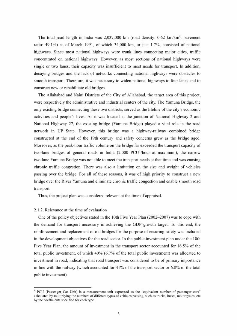
factor of the less-than-planned traffic volume in 2006. 2.3.2. Time saving
The traveling time between the Allahabad District and the Naini District (4.7 km) was shortened from 32 minutes via the Yamuna Bridge (old bridge) before the project to 5 minutes via the Naini Bridge after project completion, achieving time saving of 27 minutes (Table 2). The Yamuna Bridge is a combined bridge (the upper part is for rail and the lower part for cars) constructed at the end of the 19th century. Since the two-lane roadway was small in width, there were restrictions on weight and height of vehicles. Therefore, trucks loaded with large freight such as machinery were not permitted to cross the Yamuna Bridge (old bridge) and were forced to take a long detour taking them many kilometers away. With the completion of the Naini Bridge (new bridge), these problems were resolved. For the large trucks forced to make detours, the time saving effect of the project was even larger.
Table 2: Time Saving
Section kmBefore Project (via Yamuna
Bridge)
After Project (via Naini Bridge)
Allahabad–Naini 4.7 32 minutes
(average) 5 minutes
Source: NHAI
2.3.3. Congestion length decrease and time saving
The congestion between the Allahabad and Naini districts crossing the River Yamuna significantly decreased from 4.7 km on the Yamuna Bridge (old bridge) to 0 km (no congestion) on the Naini Bridge (new bridge) after the project completion (Table 3).
The traveling time of the same section was also reduced significantly from 32–60 minutes before the project to 5 minutes after the project. Thus, this project is considered effective in reducing the congestion length and the travel time.
Table 3: Congestion Length Decrease and Time Saving
Section Before Project (via Yamuna Bridge)
After Project (via Naini Bridge)
Allahabad– Naini
Congestion: 4.7 km Traveling time: 32–60 minutes
Congestion: 0 km Traveling time: 5 minues
Source: NHAI
2.3.4. Number of traffic accidents
According to the data on the number of traffic accidents on the Naini Bridge (new bridge) and its approach roads (by NHAI), the number of traffic accident has been decreasing every year since July 2004 when the project was completed (Table 4). However, it is reported that there are many minor accidents that are not recorded by NHAI. When including such minor accidents, the actual number would be larger than those shown in Table 4.
Table 4: Number of Traffic Accidents on the Naini Bridge and its Approach Roads
2004 2005 2006 Number of accidents (Number of fatal accidents)
10 (2)
7 (0)
2 (0)
Note: The data for 2004 is from July and the data for 2006 is up to November.
Source: NHAI
7

2.3.5. Economic internal rate of return (EIRR)
The Economic internal rate of return (EIRR) calculated at the time of planning is based on calculating the construction expense, the consulting service expense and the operation and maintenance expense as costs and the traveling expense reduction effect as benefits, assuming the project life is 15 years. As a result, EIRR was estimated at 19.9%, while the EIRR calculated in the same manner at the time of ex-post evaluation was 9.8%. The biggest factor contributing to the substantial decline from the initial EIRR estimate to that recalculated for ex-post evaluation is the reduced traffic volume, which is less than 60% of the original estimate that reduced the benefits. 2.4. Impact 2.4.1. Impact on the alleviation of traffic congestion
Before the project, the Yamuna Bridge (old bridge) was the only bridge connecting the Allahabad and Naini districts across the River Yamuna and functioned as an important community road used by local residents for commuting to the workplace or school and shopping. At the same time, as it was located at the junction of National Highway 2 and National Highway 27, the bridge was used by many freight trucks as an intrastate route and inter-state industrial transport, all of which concentrated traffic on the Yamuna Bridge (old bridge). However, because of the limited capacity of this narrow, two-lane bridge, traffic was clogged every day.
As the chronic traffic congestion caused long delays, many trucks loaded with excess freight to reduce the number of trips, which in turn often resulted in car trouble or accidents on the bridge. In the case of an accident, the bridge would close for hours or even for the day until the removal of the problem vehicle, exacerbating the traffic congestion. After the completion of the project, the transport capacity of the bridge increased substantially, with the completion of the four-lane Naini Bridge (new bridge) which was open to all vehicle. As a result, the traffic congestion that used to almost always occur on the Yamuna Bridge (old bridge) rarely occurs on the Naini Bridge (new bridge). The results of the beneficiary survey also show that the effects of reduction in traffic congestion and time saving were generated after project completion. Thus, this project is considered to have had sufficient impact on the alleviation of traffic congestion across the River Yamuna. Moreover, the completion of the
Yamuna Bridge (old bridge)
Naini Bridge (new bridge)
8

Naini Bridge (new bridge) as an alternative to the Yamuna Bridge (old bridge) that caused chronic traffic congestion and safety concern is of great significance, providing a new lifeline that ensures safe, congestion-free and smooth-flowing traffic with small risk of closure.
The vehicle portion of Yamuna Bridge (old bridge) is currently under repair, although the upper railway bridge is still in use. The lower level is exclusively for small size vehicles, motorcycles, bicycles and pedestrians. 2.4.2. Impact on the decrease in traffic accidents
It is difficult to accurately analyze the impact of this project on the decrease in traffic accidents by comparing the data before and after the project as there is no data on traffic accidents on Yamuna Bridge (old bridge) before the project nor is there any official record such as accurate figures on traffic accidents on the Naini Bridge (new bridge) after the project. According to the results of the beneficiary survey, 67% of commercial transporters said that the number of traffic accidents decreased after project completion due to the improvement of road infrastructure and reduction in traffic congestion. On the other hand, 29% of commercial transporters said the number of traffic accidents caused by over-speeding has increased. Although an accurate evaluation of the traffic accident reduction effect of the project is difficult due to the lack of data, the results of the beneficiary survey indicate that the project is effective in reducing traffic accident to some extent. 2.4.3. Impact on the revitalization of local economy
In the tourism sector, the number of tourists visiting Allahabad increased 1.7-fold in 5 years from 877. 3 million in FY1999/2000 to 1,492.7 million in FY2003/04 (Table 5). The number of beds in lodging facilities in the city also increased 2.2-fold in 6 years from 1,615 in 1998 to 3,478 in 2004 (Table 6). Allahabad, a city situated where the Ganges River and the Yamuna River join, is one of the four major Hindu holy places where many pilgrims visits from all across India. Since the statistical data on the number of tourists and the number of beds in lodging facilities for 2004 and after are not available, it is difficult to analyze the impact of this project on the tourism of the city of Allahabad. At the very least, we can say with certainty that the number of tourists and the number of beds in lodging facilities was already on the increase before the completion of the project. These increases seem be mainly attributable to the geographical and religious conditions of Allahabad as described above.
Table 5: Number of Tourists to Allahabad 1993/04 1999/00 2000/01 2003/04
No. of tourists(thousand) 1,048 8,773 10,803 14,927
Source: UP State Tourism Bureau
Table 6: Number Beds in Lodging Facilities in Allahabad
1998 2004 No. of beds in lodging facilities 1,615 3,478
Source: UP State Government
9

This project was expected to have a
positive impact in promoting industrial development in the Naini District. However, as shown in the number of registered factories in Allahabad, industrial growth has been declining after it factory numbers peaked at 318 in 2002. Activities in the manufacturing industry and industries in the city are slow and the expected effect of this project has not been realized. Among the factors behind the sluggish industrial activities is the insufficient industrial infrastructure such as power supply and the labor union issues peculiar to UP State.
Table 7: Number of Registered Factories in Allahabad
2000 2001 2002 2003 2004 2005No. of registered factories
211 206 318 195 175 177
Source: UP State Government
Table 8: Net State Domestic Product (NSDP) of Allahabad
1993/04 1998/99 2000/01 2003/04 Growth rate
NSDP (million rupees)
248.1 258.7 299.4 326.0 2.8%
Note: Above figures are constant prices based on calculations in 1993/4. The growth rate is an average of 11 years between 1993/4 and 2003/4.
Source: UP State Government
On the other hand, the Naini District, where housing developments have sprung up recently, is expected to develop as a commuter town to service the saturated Allahabad District. 2.4.4. Impact on employment creation
During the implementation phase of the project, many local people were employed for construction and other works, thus the project is considered to have a certain impact on employment creation in the short term. 2.4.5. Impact on the environment
Table 9 shows the environmental monitoring data for 2005 and 2006, collected from the environmental measuring equipment installed on the
Naini Bridge. Simple comparisons with the environmental standards of India are difficult, due to regional and category differences. However, the data is generally considered to be of a standard to satisfy the environmental standards in India (Table 10). In India, there is no standard for vibration. The
10
Table 9: Environmental Monitoring Data Noise
(dBA, 24hours) Vibration (mm/scc) CO
(µg/m3) Min. Max. Min. Max.2005 722.72 52 65 1595 23982006 837.06 48 63 141.23 2316
Note: This is the environmental monitoring data collected from the environmental measuring equipment installed on the Naini Bridge
Source: NHAI Table 10: Environmental Standards in India
CO (µg/m3) Time
weighted average
Industrial areaResidential, farming and other areas
Susceptible area
8 hours 5,000 2,000 1,0001 hour 10,000 4000 2000Noise (dBA) Time of the
day Industrial
area Commerci
al area Residential
area Quiet area
Daytime (6am-9pm) 75 65 55 50
Night (9pm-6am) 70 55 45 40
Note: There is no standard for vibration. Source: Central Pollution Control Board of the Ministry of Environment and Forests of India

environmental monitoring data of the approach roads are not available because the executing agency does not conduct monitoring on a regular basis. According to the executing agency, no specific environmental problem has been identified in the road sections covered by this project. In the beneficiary survey, a majority of the respondents answered that air pollution, noise and vibration improved after the completion of the project. Considering all these things together, this project has not generated any significant negative impact on the environment to date. 2.4.6. Social impact of land acquisition and resident relocation
In this project, a land of 31 hectares was acquired as planned, about half of this was public land. The acquisition procedure was performed properly without any major problems except for some delay in the implementation schedule. Resident relocation was not necessary. 2.4.7. Results of the beneficiary survey
In this field survey, a beneficiary survey was conducted to assess the effects of this project on the people’s lives and living environment in the target area. Surveyed were 70 general households, 50 commercial transporters and 30 small-sized companies and stores. (1) Change in means of transport
The primary mode of transport used by general households before the project was bicycle (46%), motorcycle (23%) and bus (14%), and the percentages remained relatively constant after the project; bicycle (44%), motorcycle (24%) and bus (16%). The primary mode of transportation for small-sized companies and stores has also changed little: motor cycle (50%, down from 52% pre-project) and bicycle (43%, up from 38%).
Interview survey to general households (local farmers)
(2) Improvement of access to various services
Of the surveyed households, 80% answered that access to various services improved after the project. A particularly marked improvement is recognized in the access to the public transport services, health and medical services and shopping places. On the other hand, 86% of the surveyed commercial transporters indicated increase in the frequency of transport services and 89% indicated an increase in passengers or freight after the project. It is presumed that the increase in the frequency of transport services by commercial transporters, who provide public transport services, has led to the improvement of access to public transport services for users, which in turn resulted in the increase in passengers and freight. (3) Improvement of the convenience of roads
11

With respect to the convenience of roads, 93% of general households and 87% of small-sized companies and stores said that it improved after the project. Many respondents mentioned reduction in road congestion, reduction in travel time and reduction in travel expenses (in order of response rates) as reasons for improvement. (4) Impact on the socio-economic environment
The project’s impact on the socio-economic environment was accepted positively by 84% of general households and 80% of small-sized companies and stores. In particular, rise in land prices, increase in population, advancement of land and housing development and increase in business opportunities were pointed out as favorable impact. In comparison of incomes before and after the project, commercial transporters showed an increase of 35% on average. This increase seems to be closely associated with the direct effect of the project such as the reduction in travel expenses and operation and maintenance expenses, increase in the operating/business hours resulted from shortening of driving time, and increase in passengers and freight.
Interview to a store owner
(5) Impact on the environment
A majority of the surveyed beneficiaries said that air pollution, noise, vibration and the waste situation improved after the project (the rate of those who answered “improved” was 63% for air pollution, 50% for noise, 47% for vibration, and 75% for waste). Many beneficiaries mentioned the realization of smooth traffic after the elimination of traffic congestion as a factor contributing to environmental improvement. The improvement in the waste situation was mainly due to improvements in the garbage collection and road cleaning services by the City of Allahabad. (6) Satisfaction with the project and future issues
As to the degree of satisfaction with the project, 87% of the surveyed beneficiaries answered that they were satisfied (84% of general households, 96% of commercial transporters and 80% of small-sized companies and stores answered “satisfied”). When asked about the direct negative impact of the project, some pointed to over-speeding (4%) and an increase in noise (3%), though the number was small. A few respondents also suggested traffic safety education (6%), construction of public facilities such as toilets and public drinking fountains (6%) and landscape beautification (5%).
12

2.5. Sustainability 2.5.1. Executing agency
The operation and maintenance of the project facilities are performed by National Highways Authority of India (NHAI). Initially, planning through the implementation phases were to be carried out by the Ministry of Surface Transport (currently Ministry of Shipping, Road Transport and Highways) and the Public Works Department of the Uttar Pradesh State. In 1997, however, responsibilities for the implementation, operation and maintenance of the project were transferred to NHAI. NHAI was established under the National Highways Authority of India Act (1988) as an agency in charge of construction, operation and maintenance of national highways and began operation in February 1995. At present, the length of national highways under the control of NHAI is 27,110 km, or 41%, of the total of 65,600 km national highways in India5. 2.5.1.1. Technical capacity
NAHI has engaged in construction, operation and maintenance of many major national highways in India and also has experience in the construction, operation and maintenance of cable-stayed bridges in India. There is no problem with its technical capacity. 2.5.1.2. Operation and maintenance system
The Corridor Management Headquarters is responsible for the operation and maintenance of the project facilities and, under its supervision, on-site operation and maintenance activities are managed by the Allahabad Project Implementation Unit (PIU). The actual maintenance and operation of toll booths are subcontracted by NHAI to private management consultants and operation and maintenance companies (contractors). The Allahabad PIU administers and supervises their operation and maintenance. The organizational structure of NHAI is shown in Figure 3.
Toll booths on the Naini Bridge
5 As of the end of October 2006
13
2.5.1.3. Financial status
The operation and maintenance cost of the project facilities is basically covered by the toll revenue. The tolls collected at the toll booths installed along the route covered by the project are stored at NHAI and in the national treasury together with the tolls collected from other roads in the country. These funds are allocated to the budget for the operation and maintenance of national highways under the control of NHAI. According to NHAI, the entire toll revenue of NHAI exceeds the operation and maintenance cost every year (Table 11), and there seems to be no major problem with the sustainability of operation and maintenance in terms of finance.
Table 11: Toll revenue and entire O&M cost of NHAI
(million rupees) 2002/03 2003/04 2004/05 2005/06Toll revenue 3,130 3,594 4,605 7,980
O&M cost 2,005 2,752 2,786 2,448
Source: NHAI
国道 )
Source: NHAI
庁(NHAI
総 裁
理事 (総務担当)
理事 財務担当)(
理事 (技術担当)
理事 (技術担当)
理事 (技術担当)
用地取得・不動
産管理部
環境部
計画・情報
システム部
コリドー管理
部
本総務部
財務・会計部
港湾接続道路
プロジェクト本部
黄金の四角形
プロジェクト本部
東西・南北回廊
プロジェクト本部
国道開発計画
(第3期)本部
コリドー 管理ユニット
(CMU)
プ トロジェク
実施ユニット
(PIU)
プ トロジェク
実施ユニット
(PIU)
プロジェクト
実施ユニット
(PIU)
プ ト ロジェク
実施ユニット
(PIU)
内部監査部
計画・標準化・
品質管理部
Project Implementation
Unit (PIU)
Project Implementation
Unit (PIU)
Project Implementation
Unit (PIU)
Project Implementation
Unit (PIU)
Corridor Management Unit
(CMU)
Director (in charge
of administration)
E-W
/S-W
Cor
ridor
Pr
ojec
t
Hea
dqua
rters
Plan
ning
, St
anda
rdiz
atio
n &
Q
ualit
y A
ssur
ance
D
iv.
Port
Con
nect
ivity
Pr
ojec
t
Hea
dqua
rters
NH
DP
(Pha
se II
I)
Hea
dqua
rters
Land
Acq
uisi
tion
&
Esta
te M
anag
emen
t D
iv.
Gol
den
Qua
drila
tera
l Pro
ject
H
eadq
uarte
rs
Fina
nce
&
Acc
ount
ing
Div
.
Adm
inis
tratio
n D
iv.
Inte
rnal
Aud
it D
iv.
Cor
ridor
M
anag
emen
t H
eadq
uarte
rs
Plan
ning
&
Info
rmat
ion
Syst
em
Div
.
Director (in charge
of technology)
Director (in charge
of technology)
Envi
ronm
ent D
iv.
Director (in charge
of technology)
National Highways Authority of India (NHAI)
Director (in charge
of finance)
Chairman
Figure 3: Organizational Chart of the National Highways Authority of India (NHAI)
2.5.2. Operation and maintenance status
On the Naini Bridge, weather observation devices, which check conditions and measure the weight and gradient of pylons, are set at seven positions and are monitored 24 hours from the observation equipment control room in the toll booth control building. After the completion of the project, with a view to transferring technology to India including the know-how of operation and maintenance of large-scale cable-stayed bridges, NAHI hired the Danish technical consultant who was in charge of construction management for the main portion of the project and who developed the operation and maintenance manual, as the operation and maintenance consultant Thus, NHAI established an operation and maintenance system
14

consistent also in the technical aspect. No problem has been found so far concerning operation and maintenance.
3.Feedback 3.1. Lessons Learned At the time of planning, the traffic volume should be estimated properly after close examination of the assumed conditions. 3.2. Recommendations N.A.
15
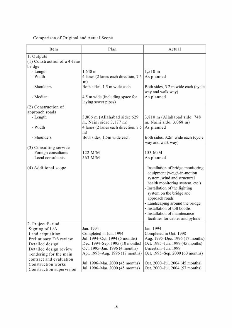
Comparison of Original and Actual Scope
Item Plan Actual
1. Outputs (1) Construction of a 4-lane bridge
- Length - Width - Shoulders - Median
1,640 m 4 lanes (2 lanes each direction, 7.5 m) Both sides, 1.5 m wide each 4.5 m wide (including space for laying sewer pipes)
1,510 m As planned Both sides, 3.2 m wide each (cycleway and walk way) As planned
(2) Construction of approach roads
- Length
- Width
- Shoulders
3,806 m (Allahabad side: 629 m, Naini side: 3,177 m) 4 lanes (2 lanes each direction, 7.5 m) Both sides, 1.5m wide each
3,810 m (Allahabad side: 748 m, Naini side: 3,068 m) As planned Both sides, 3.2m wide each (cycle way and walk way)
(3) Consulting service - Foreign consultants - Local consultants
122 M/M 563 M/M
153 M/M As planned
(4) Additional scope - Installation of bridge monitoring equipment (weigh-in-motion system, wind and structural health monitoring system, etc.)
- Installation of the lighting system on the bridge and approach roads
- Landscaping around the bridge - Installation of toll booths - Installation of maintenance
facilities for cables and pylons 2. Project Period Signing of L/A Land acquisition Preliminary F/S review Detailed design Detailed design review Tendering for the main contract and evaluation Construction works Construction supervision
Jan. 1994 Completed in Jun. 1994 Jul. 1994–Oct. 1994 (5 months) Dec. 1994–Sep. 1995 (10 months)Oct. 1995–Jan. 1996 (4 months) Apr. 1995–Aug. 1996 (17 months) Jul. 1996–Mar. 2000 (45 months) Jul. 1996–Mar. 2000 (45 months)
Jan. 1994 Completed in Oct. 1998 Aug. 1995–Dec. 1996 (17 months)Oct. 1995–Jun. 1999 (45 months)Uncertain–Jun. 1999 Oct. 1995–Sep. 2000 (60 months) Oct. 2000–Jul. 2004 (45 months) Oct. 2000–Jul. 2004 (57 months)
16

3. Project Cost Foreign currency Local currency Total ODA loan portion Exchange rate
3,768 million yen 8,136 million yen (2,199 million rupees) 11,904 million yen 10,037 million yen 1 rupee=3.70 yen (as of April 1993)
2,318 million yen 6,489 million yen (2,318 million rupees) 8,807 million yen 7,515 million yen 1 rupee=2.80 yen (1994–2004 average)
17