independent community water supply along the …
TRANSCRIPT
ATHI WATER SERVICES BOARD
INDEPENDENT COMMUNITY WATER SUPPLY ALONG THE NORTHERN COLLECTOR TUNNEL PHASE 1 TO THIKA DAM -- MURANGA WATER
SUPPLY
Resettlement Action Plan Report
November 2014
Pub
lic D
iscl
osur
e A
utho
rized
Pub
lic D
iscl
osur
e A
utho
rized
Pub
lic D
iscl
osur
e A
utho
rized
Pub
lic D
iscl
osur
e A
utho
rized
RAP Report for Murang’a Water Supply November 2014
i
CONTENTS
LIST OF TABLES IV
LIST OF FIGURES V
ACRONYMS VI
EXECUTIVE SUMMARY VII
1.0 INTRODUCTION 1
1.1 BACKGROUND OF THE PROJECT 1 1.2 PROJECT LOCATION 2 1.3 PROJECT ACTIVITIES NECESSITATING RAP STUDY 4 1.4 OBJECTIVES OF THE RAP STUDY 5 1.5 IDENTIFICATION OF PROJECT AFFECTED PERSONS 5 1.6 CUT-OFF DATE 5 1.7 METHODOLOGY 6
1.7.1 Public and stakeholder consultations 6 1.7.2 Census survey 6 1.7.3 Socio-economic baseline survey 6 1.7.4 Land and Asset Valuation 7
2.0 PROJECT DESCRIPTION 9
2.1 INTRODUCTION 9 2.2 PROPOSED INTERVENTIONS 9
2.2.1 Kiriciungu Treatment Works 9 2.2.2 Kahuti Treatment Works 10 2.2.3 Muruka–Kenol-Makuyu Pipeline 10 2.2.4 Mareira-Sabasaba-Muthithi 10 2.2.5 Kaharati-Iganjo Pipeline 10 2.2.6 Rwathia - Mukangu pipeline 11 2.2.7 Kayahwe – Kambirwa Pipeline 11
2.3 CONSTRUCTION PERIOD 13 2.4 PROJECT COST 13
3.0 POLICY AND LEGAL FRAMEWORK 14
3.1 POLICY FRAMEWORK 14 3.1.1 Land policy 14 3.1.2 World Bank Operational Policy 4:12 Involuntary Resettlement 14 3.1.3 World Bank Guidelines on Involuntary Resettlement - Eligibility for benefits 16
3.2 LEGAL FRAMEWORK 17 3.2.1 The Constitution of Kenya 17 3.2.2 The National Land Commissions Act 2012 17 3.2.3 The Land Act 2012 18 3.2.4 Land Acts Repealed by the Land Act 2012 22 3.2.5 The Land Registration Act 2012 22 3.2.6 The Land and Environment Court Act 2011 23
RAP Report for Murang’a Water Supply November 2014
ii
3.3 COMPARISONS BETWEEN KENYAN LAW AND WB INVOLUNTARY RESETTLEMENT POLICY 24
4.0 SOCIO-ECONOMIC BASELINE CONDITONS 25
4.1 BACKGROUND 25 4.2 ADMINISTRATIVE UNITS AND POPULATION 25
4.2.1 PAP Unit 26 4.2.2 Marital Status 27 4.2.3 Religion 27 4.2.4 Education 28 4.2.5 Income and expenditure 29 4.2.6 Housing 31 4.2.7 Sources of energy for lighting and cooking 31 4.2.8 Access to water 32 4.2.9 Toilet facilities 33 4.2.10 Health 33 4.2.11 Land tenure and ownership 35 4.2.12 Land use 36 4.2.13 Livestock inventory 38
4.3 PERCEPTIONS AND SUPPORT OF THE PROPOSED PROJECT 38 4.4 PROBLEMS AFFECTING PEOPLE IN THE AREA 39
5.0 PUBLIC CONSULTATIONS AND PARTICIPATION 41
5.1 BACKGROUND 41 5.1.1 Objectives of the Public Consultations 41
5.2 STAKEHOLDER ENGAGEMENT 42 5.2.1 Key informant interviews 42 5.2.3. Public meetings 49
5.5 DISCLOSURE OF THE RAP 51 5.5.1 Disclosure of the RAP Report by AWSB 51
6.0 IMPACTS OF THE PROJECT 52
6.1 INTRODUCTION 52 6.2 ELIGIBILITY CRITERIA FOR COMPENSATION AND RESETTLEMENT 52 6.3 PROJECT IMPACTS 53
6.3.1 Loss of land 53 6.3.2 Loss of structures 53 6.3.3 Loss of crops, trees and vegetation cover 53 6.3.4 Impact on public infrastructure 54
6.4 RAP IMPLEMENTATION BUDGET 55 6.4.1 Administrative Costs for Implementing the RAP 55
7.0 INSTITUTIONAL ARRANGEMENTS 57
7.1 OVERVIEW 57 7.2 ATHI WATER SERVICES BOARD 57 7.3 COUNTY GOVERNMENT OF MURANG’A 58 7.4 NATIONAL GOVERNMENT ADMINISTRATION 58 7.5 PAP REPRESENTATIVES 59 7.6 GRIEVANCE MECHANISMS 60

RAP Report for Murang’a Water Supply November 2014
iii
7.6.1 General Information 60 7.6.2 Expected Grievances 60 7.6.3 Proposed Grievance Mechanism 61
7.7 IMPLEMENTATION SCHEDULE 63 7.7.1 Mobilisation of RAPIC 63 7.7.2 Compensation and relocation 64
8.0 MONITORING AND EVALUATION 67
8.1 RAP MONITORING FRAMEWORK 67 8.2 PROJECT MONITORING PLAN 68
9.0 CONCLUSION AND RECOMMENDATIONS 70
9.1 CONCLUSION 70 9.2 RECOMMENDATIONS 70
10.0 APPENDICES 71
RAP Report for Murang’a Water Supply November 2014
iv
LIST OF TABLES Table 1-1: Administrative units covered by the project ...................................................... 2 Table 4-1: Population in the project area ........................................................................... 25 Table 4-2: Housing conditions ........................................................................................... 31 Table 4-3: Sources of energy for cooking and lighting ...................................................... 32 Table 4-4: Mode of water treatment .................................................................................. 33 Table 4-5: Health Indicators – Murang’a District .............................................................. 34 Table 4-6: Existing land use within the proposed project study area ................................ 36 Table 4-7: Land use systems in drylands ............................................................................ 37 Table 4-8: Reason for keeping the livestock ...................................................................... 38 Table 5-1: Summary of discussions with key stakeholders within Murang’a County ....... 42 Table 5-2: Public consultation meetings during ESIA and RAP ........................................ 49 Table 5-3: Photo log of various meetings held during the RAP study ............................... 50 Table 6-1: RAP budget ....................................................................................................... 55 Table 7-1: Identified Institutions ....................................................................................... 57 Table 7-2: Monitoring and Evaluation Indicators .............................................................. 58 Table 7-3: RAP Implementation schedule ......................................................................... 66
RAP Report for Murang’a Water Supply November 2014
v
LIST OF FIGURES Figure 1-1: Location of Murang’a County within Kenya ................................................ 3 Figure 1-2: Map of Muranga County ................................................................................ 4 Figure 3-1: Land Acquisition as per the Land Act 2012 ................................................ 21 Figure 4-1: Age of the PAPs............................................................................................. 26 Figure 4-2: PAP Unit ........................................................................................................ 26 Figure 4-3: Affected property .......................................................................................... 27 Figure 4-4: Marital Status of PAPs .................................................................................. 27 Figure 4-5: Religion .......................................................................................................... 28 Figure 4-6: Distance to the nearest primary school ....................................................... 28 Figure 4-7: Highest education level ................................................................................ 29 Figure 4-8: Primary income sources ............................................................................... 30 Figure 4-9: Monthly income ............................................................................................ 30 Figure 4-10: Sources of drinking water ........................................................................... 32 Figure 4-11: Volume of water used by household per day ............................................ 33 Figure 4-12: Main illnesses suffered from in the past 4 months ................................... 34 Figure 4-13: Distance from the homestead to health service provider ........................ 35 Figure 4-14: Time to the health service provider........................................................... 35 Figure 4-15: Category of land tenure .............................................................................. 36 Figure 4-16: Types of agricultural crops produced in the last season ........................... 37 Figure 4-17: Type of livestock kept ................................................................................. 38 Figure 4-18: Source of awareness .................................................................................... 39 Figure 4-19: Problems affecting people in the area ....................................................... 40 Figure 7-1: Proposed Grievance Mechanism .................................................................. 63
RAP Report for Murang’a Water Supply November 2014
vi
ACRONYMS AIDS Acquired Immune Deficiency Syndrome AWSB Athi Water Services Board BoQ Bills of quantity DCC Deputy County Commissioner ECD Early Childhood Development EMCA Environmental Management and Coordination Act EMP Environmental Management Plan ESIA Environmental and Social Impact Assessment HIV Human Immunodeficiency Virus KAWASCO Kahuti Water and Sanitation Company Km Kilometres Km2 Square Kilometres Ksh Kenya Shillings LM Lower Midland m Metres m3 Cubic Metres mm Millimetres M&E Monitoring and Evaluation MUWASCO Murang’a Water and Sewerage Company MUSWASCO Murang’a South Water and Sewerage Company NEMA National Environmental Management Authority NGOs Non-Governmental Organizations oC Degrees Celsius OP Operational Policy
PAPs Project Affected Persons RAP Resettlement Action Plan RAPIC RAP Implementation Committee RPF Resettlement Policy Framework TA Tropical Alpine Zone TWSB Tana Water Services Board UH Upper Highlands UM Upper Midland WaSSIP Water and Sanitation Services Improvement Project WB World Bank
RAP Report for Murang’a Water Supply November 2014
vii
EXECUTIVE SUMMARY 1. Introduction Athi Water Services Board (AWSB) herein referred to as the Proponent in conjunction with Tana Water Services Board (TWSB), has proposed to improve the water supply in Muranga County through a project known as Independent Community Water Supply along the Northern Collector Tunnel Phase 1 to Thika Dam - Muranga Water Supply. This is part of AWSB strategy to address the water needs of the communities living along and downstream of the proposed Northern Collector Tunnel Phase 1. This will complement the efforts of TWSB in provision of water to these communities. The Northern Collector Tunnel Phase 1 Project includes river diversion weir and related intake hydraulic structures at Maragua, Gikigie and Irati River as well as construction of river outlet at Githika River which will convey the additional water to Thika dam. The tunnel is approximately 11.8km long and of 3m finished internal diameter with an average depth of 100m. The tunnel will be within Kigumo and Kangema Sub-Counties in Muranga County. The objective of this project is to increase water supply in Nairobi County by 121,000m3/day. The proposed Muranga Water Supply Project is one of the components under the Water and Sanitation Services Improvement Project (WaSSIP) funded by World Bank. The proposed Muranga Water Supply project is located within Muranga County in Kangema, Kiharu, Kandara, Kigumo and Muranga South Sub-Counties. This Resettlement Action Plan (RAP) was triggered by the findings of the Environmental and Social Impact Assessment Study (ESIA) that determined that the project was going to cause some displacements. The World Bank Operational Policy 4.12 on Involuntary Resettlement also requires that a Resettlement Action Plan be undertaken for projects of such nature. Project activities necessitating the RAP study Resettlement has been necessitated by the proposed acquisition of a 6 meter pipeline corridor for construction of the water pipelines and land for Kiricuingu Treatment Plant. The RAP was conducted along the following pipelines: • Rwathia – Mukangu Pipeline; • Kiriciungu Pipeline; and • Kayahwe – Kambirwa Pipeline.

RAP Report for Murang’a Water Supply November 2014
viii
Objectives of the study The main objectives of this RAP were: • Identification of Project Affected Persons (PAPs); • Collection of qualitative and quantitative baseline socio-economic data of PAPs; • Establishment of entitlements to PAPs; • Collection of preferences for relocation / resettlement and compensation; • Development of a Resettlement Action Plan (RAP) Report. Identification of Project Affected Persons A total of 461 asset owners with assets within the 6m wayleave and in the proposed Kiriciungu treatment plant are expected to be affected by the Murang’a Water Supply project. Cut-off date The cut-off date for eligibility for entitlement by PAPs was the date of last day of enumeration and valuation i.e. 10th November 2014 for Rwathia – Mukangu and Kiriciungu pipeline and 9th December 2015 for Kayahwe – Kambirwa pipeline. Methodology The following methods were used to carry out the RAP Study • Public and stakeholder consultations; • Census survey; • Socio-economic survey; • Land and Asset Valuation. 2. Project Description The components to be constructed under this project include: 1. Muruka–Kenol-Makuyu Pipeline – 34Km 2. Mareira-Sabasaba-Muthithi Pipeline – 16.5Km 3. Kaharati-Iganjo Pipeline – 6.5Km 4. Rwathia - Mukangu pipeline – 27Km 5. Kayahwe – Kambirwa Pipeline – 12Km 6. Kahuti II Water Treatment Plant – 4,000m3/day 7. Kiriciungu Water Treatment Plant – 4,000m3/day

RAP Report for Murang’a Water Supply November 2014
ix
3. Policy and legal framework The following policy frameworks were reviewed • Land policy; • World Bank Operational Policy 4:12 Involuntary Resettlement. The following Legal framework • Constitution of Kenya; • The National Land Commissions Act 2012; • The Land Act 2012; • The Land Registration Act 2012; • The Land and Environment Court Act 2011; and • Land Acts repealed by the Land Act, 2012. 4. Socio-economic baseline conditions According to the census survey, 50.7% of the PAPs are female while 49.3% are male. About 93% of the affected persons are land owners, 4% are tenants and 3% are structure owners. For these PAP units, the most affected property is crops at 43.9%, land at 38.4% and trees at 16.6%. Others include residential structures and sanitation facilities. Most of the PAPs have attained secondary and basic primary education and are therefore considered literate. About 83.0% of the PAPs are in the informal employment while 17.0% are formally employed. The primary source of income for the PAPs at 79.2% is farming. Majority of the PAPs (90.2%) earn an income of less than Ksh 10,000 followed by those earning between Ksh 10,000 and Ksh 19,000 at 9.2%. Land tenure in Kenya is classified into three categories, namely; – public land, community land and private land. The most common land tenure system in the project area is private holding at 92.3%, public land at 7.3% and 0.4% being community land. 5. Public consultations and participation Public and stakeholder consultations were held during the scoping studies as shown in chapter 5. Some of the used raised were: • That the water project is long overdue. More water should be provided to the
community since they are currently using borehole water which is insufficient,
RAP Report for Murang’a Water Supply November 2014
x
expensive and with high fluoride content; • Would the water also be used for irrigation? They were informed that the water
being provided was for drinking purposes only; • They requested that the valuation exercise should be done well and
compensation money released as soon as possible. They also suggested that the compensation money should be paid before commencement of construction works.
• The community complained that people use the pipeline wayleaves as footpaths which has led to insecurity as thieves take the advantage to steal properties from peoples’ homesteads. They were advised to fence off these areas to avoid these cases;
• The community suggested that the water service providers should immediately start doing the connections so that immediately the project is over, they can be supplied with water;
• The community wanted to know who will be responsible for compensation when pipes burst and destroy their properties. They were informed that this will be the responsibility of the water service providers;
• They also inquired on the ownership of the project after the completion phase. They were told that the project will be handed over to the respective water service providers;
• The youth should be considered for employment during the construction phase. Disclosure of the RAP Disclosure should be done by submitting a copy of the RAP Report in a form, manner, and language that is understandable to the PAPs. The Deputy County Commissioner officer is central in the disclosure process and his/her office will provide support during the disclosure process. In addition this report proposes the following be disclosed to the household heads and their spouses only: • Inventory of assets; and • Proposed compensation figures 6. Impacts of the project Some of the anticipated project impacts include: • Loss of land; • Loss of structures; • Loss of crops, trees and vegetation cover; and • Impact on public infrastructure.

RAP Report for Murang’a Water Supply November 2014
xi
RAP Implementation Budget The total compensation budget is Ksh 35,764,082. Administrative Costs for Implementing the RAP should be made for the running of the various arms of the implementation committee. 7. Institutional arrangements for implementation In the implementation of the RAP, a cross organizational approach will be adopted. This will be to ensure smooth implementation and division of roles in line with organizational mandate. Institutions identified and their respective mandates are as presented below:
Institution Department involved Overall role in the implementation of RAP
AWSB • Community Development and Environmental Experts
• Company lawyer
• Payment of Cash compensation to PAPs; • Check on the compliance of the
procurement procedures in relation to Kenyan Laws;
• Management and monitoring of payment of compensation;
• Verification of ownership claims.
National Government Administration
• Deputy County Commissioner
• Chief and Assistant Chiefs
• Initial verification of ownership claims at the village level in liaison with AWSB before confirmation by County Land Officials i.e. County Lands Officer and County Surveyor;
• Disclosure and Valuation of the Valuation report;
• Facilitation of election of PAP representatives
The County Government
• County Minister for Lands
• Physical Planner
• Ensure that there is no further encroachment on the wayleave after the cut-off date;
• Help in verification of leasehold titles; • Co-ordinating and mobilizing identified
departments at the County offices. PAP Representatives • PAP representative
• Collect views of the PAPS and present them
to the RAPIC; • Help in confirmation of the asset inventory; • Debrief the PAPs on deliberations of the
RAPIC; • Coordinate the payment of the
compensation.
RAP Report for Murang’a Water Supply November 2014
xii
8. Monitoring and Evaluation Both internal and external monitoring will be undertaken. The monitoring exercise will begin immediately after the sensitization of the PAPs until the end of the construction period. Towards the end of the project, a RAP expert will be procured to undertake external monitoring. 9. Conclusion This study findings show that the proposed Murang’a Water Supply Project is likely to impact approximately 461 persons and as such, this RAP was prepared as a plan to mitigate the impacts of resettlement. The study also proposes that collaboration between AWSB, National Government Administration and Murang’a County Government staff would be adequate to implement the proposals under this RAP. The overall objective of the project is good and its positive impacts can be enhanced by ensuring that the identified PAPs are adequately compensated with the aim of improving their livelihoods or restoring their livelihoods to the pre-impact standards.
RAP Report for Murang’a Water Supply November 2014
1
1.0 INTRODUCTION 1.1 Background of the Project Athi Water Services Board (AWSB) herein referred to as the Proponent in conjunction with Tana Water Services Board (TWSB), has proposed to improve the water supply in Muranga County through a project known as Independent Community Water Supply along the Northern Collector Tunnel Phase 1 to Thika Dam - Muranga Water Supply. This is part of AWSB strategy to address the water needs of the communities living along and downstream of the proposed Northern Collector Tunnel Phase 1. This will complement the efforts of TWSB in provision of water to these communities. The Northern Collector Tunnel Phase 1 Project includes river diversion weir and related intake hydraulic structures at Maragua, Gikigie and Irati River as well as construction of river outlet at Githika River which will convey the additional water to Thika dam. The tunnel is approximately 11.8km long and of 3m finished internal diameter with an average depth of 100m. The tunnel will be within Kigumo and Kangema Sub-Counties in Muranga County. The objective of this project is to increase water supply in Nairobi County by 121,000m3/day. The proposed Muranga Water Supply Project is one of the components under the Water and Sanitation Services Improvement Project (WaSSIP) funded by World Bank. The components to be constructed under this project include: 1. Muruka–Kenol-Makuyu Pipeline – 34Km 2. Mareira-Sabasaba-Muthithi – 16.5Km 3. Kaharati-Iganjo Pipeline – 6.5Km 4. Rwathia - Mukangu pipeline – 27Km 5. Kayahwe – Kambirwa Pipeline – 12Km 6. Kahuti II Water Treatment Plant – 4,000m3/day 7. Kiriciiungu Water Treatment Plant – 4,000m3/day This Resettlement Action Plan (RAP) was triggered by the findings of the Environmental and Social Impact Assessment Study (ESIA) that determined that the project was going to cause some displacements. The World Bank Operational Policy 4.12 on Involuntary Resettlement also requires that a Resettlement Action Plan be undertaken for projects of such nature.
RAP Report for Murang’a Water Supply November 2014
2
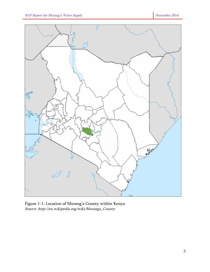
1.2 Project Location The proposed Muranga Water Supply project is located within Muranga County in Kangema, Kiharu, Kandara, Kigumo and Muranga South Sub-Counties. The administrative units covered by the project are shown in Table 1-1 below. Table 1-1: Administrative units covered by the project Sub-County Division Location Kangema Kanyenyaini Kanyenyaini
Rwathia Muringaine Muguru
Iyego Iyego Gacharaigu
Kiharu Kahuro Kahuhia Weithega Gikindu
Kandara Muruka Muruka Nguthuru Gatitu
Ruchu Githumu Gituru
Muranga South Makuyu Makuyu Kamahuha
Kigumo Kigumo Muthithi Githima Mariira
Figure 1-1 shows the location of Muranga County within Kenya while Figure 1-2 is a general map of Muranga County.
RAP Report for Murang’a Water Supply November 2014
3
Figure 1-1: Location of Murang’a County within Kenya Source: http://en.wikipedia.org/wiki/Muranga_County

RAP Report for Murang’a Water Supply November 2014
4
Figure 1-2: Map of Muranga County Source: Muranga County Website 1.3 Project activities necessitating RAP study Resettlement has been necessitated by the proposed acquisition of a pipeline corridor for construction of the water pipelines and land for Kiricuingu Treatment Plant. The RAP was conducted along the following pipelines: • Rwathia – Mukangu Pipeline; • Kiriciungu Pipeline; and • Kayahwe – Kambirwa Pipeline. The rest of the pipelines i.e. Muruka–Kenol-Makuyu Pipeline, Mareira-Sabasaba-Muthithi pipeline and Kaharati-Iganjo Pipeline will pass through road reserves therefore no RAP will be undertaken for these sections. From the field survey, a total of 461 individual asset owners are to be affected by the proposed Murang’a Water Supply Project, 250 of these assets had their corresponding owners enumerated. The World Bank Involuntary Resettlement Policy states the following as a footnote to section 3.4.6 on policy requirements:

RAP Report for Murang’a Water Supply November 2014
5
In addition to this numerical guidance, project planners and the Bank should also determine the “significance” of a project by evaluating the severity of adverse impacts on disadvantaged groups (for example, female-headed households, the poorest, isolated communities, including those without title to assets, and pastoralists). Any project that has adverse impacts on disadvantaged groups or ethnic, religious and linguistic minorities, or which affects the poorest and most marginalized communities who do not have the capacity to absorb such impacts, should be considered significant, requiring a full resettlement plan. Based on the number of persons and the nature of affected assets, a Full Resettlement Action Plan (RAP) Report has been prepared for the project. 1.4 Objectives of the RAP Study The main objectives of this RAP were: • Identification of Project Affected Persons (PAPs); • Collection of qualitative and quantitative baseline socio-economic data of PAPs; • Establishment of entitlements to PAPs; • Collection of preferences for relocation / resettlement and compensation; • Development of a Resettlement Action Plan (RAP) Report. 1.5 Identification of Project Affected persons A total of 461 asset owners with assets within the 6m wayleave and in the proposed Kiriciungu treatment plant are expected to be affected by the Murang’a Water Supply project. The PAPs are classified as either • Land owners; • Structure owners; and • Tenants 1.6 Cut-off date The cut-off date for eligibility for entitlement by PAPs was the date of last day of enumeration and valuation i.e. 10th November 2014 for Rwathia – Mukangu and Kiriciungu pipeline and 9th December 2015 for Kayahwe – Kambirwa pipeline. Persons who encroach on the area after the cut-off-date are not entitled to claim compensation or any other form of resettlement assistance. Fixed assets such as built structures or planted trees after this date will not be compensated. This date was communicated to the PAPs during the several public meetings held within the project area.
RAP Report for Murang’a Water Supply November 2014
6
1.7 Methodology 1.7.1 Public and stakeholder consultations Consultations with the communities were conducted in the project area with the help of the local administration especially the chiefs and assistant chiefs. The discussions during these public meetings were centered on key emerging issues relating to the project as well as the communities. Given the large size of the project area, a total of thirteen (13) meetings were held at location levels within the project area. Minutes of meeting and attendance sheets are presented in Appendix 1 of this report. 1.7.2 Census survey A Census was conducted from 18 October to 19 November 2014. The main aim of this exercise was to: • Identify the Project Affected Persons (PAPs) living or practicing any activity within
the wayleave due for construction of the pipeline; • Identify property owned by each PAP; • Collate information on preferred compensation modes by each PAP Unit. During the census, enumerators from within the project area were trained and used for enumeration exercise. They were guided by a village elder who introduced them to the PAPs. For cases where a PAP was not available for enumeration, the RAP team sought responses from the respondent left behind by the PAP or a member of the household above the age of 18 years. The enumerators went back to enumerate those who were not found during the census date. 1.7.3 Socio-economic baseline survey (a) Household survey In order to establish the current living conditions of the PAPs within the project area, household surveys were conducted, it involved primary data collection through administration of questionnaires. The objectives of the household survey were as follows:

RAP Report for Murang’a Water Supply November 2014
7
• To identify the PAPs in terms of the different entitlements in relation to land
owners and asset owners; • To prepare a socio-economic profile of PAPs; • To assess incomes and identify productive activities; • To identify possible vulnerable groups. Data collected from the household survey included: • Sources of income and occupation of the Project Affected Persons. • Marital status of the PAPs and the number of household members who would be
affected by the project. • Levels of education of the household head and other members of the household. • Employment status of PAPs. (b) Key informant interviews
One-on-one interviews with county and national government agencies and institutions in the project area were undertaken i.e. from Kangema, Kiharu, Kandara, Kigumo and Murang’a South Sub-Counties. These interviews were conducted to augment and confirm data and information obtained using the other tools and methodologies. The main objectives of the above exercise were to: • Introduce the consultancy team and the scope of work; • Obtain more information about the project area; • Obtain views of the local area administration on the project; • Collect baseline information from the project area; • Organise for a public sensitization meeting. (c) Data analysis Microsoft Excel was used for data entry and analysis. Data collected from the household survey was triangulated with information from site surveys, observations by the sociologist and key informant interviews. 1.7.4 Land and Asset Valuation The Land and asset survey was conducted from 18 October to 9 December 2014 to establish the land, structures, hedges, crops and trees of the PAPs that would be affected by the construction of the water project. The valuer was guided by respective

RAP Report for Murang’a Water Supply November 2014
8
village elders or guides appointed by respective Chiefs. Full Replacement Cost method was used to determine the value of the affected land, structures, houses, trees and crops and compared with recommended rates from the Ministry of Agriculture.
RAP Report for Murang’a Water Supply November 2014
9
2.0 PROJECT DESCRIPTION 2.1 Introduction The proposed Murang’a Water Supply Project involves the construction of the following components: 1. Kiriciiungu Water Treatment Plant; 2. Kahuti II Water Treatment Plant; 3. Muruka–Kenol-Makuyu Pipeline; 4. Mareira-Sabasaba-Muthithi; 5. Kaharati-Iganjo Pipeline; 6. Rwathia - Mukangu pipeline; and 7. Kayahwe – Kambirwa Pipeline. 2.2 Proposed Interventions
2.2.1 Kiriciungu Treatment Works The proposed treatment plant will be located in a 2 acre piece of land in Kiruga area, Kandara Sub-County. The treatment plant will be next to Kiriciungu River. This treatment plant will be constructed to improve the water quality to Kandara town/Ruchu location. The population to benefit from this intervention is 40,000 persons. There is an existing weir which was supplying raw water to residents. This means therefore that intake works will be retained and there will be no additional abstraction. The construction of Kiriciungu Treatment Works involves: • 3-No treated Water transmission pipeline approximately DN 160-300mm; • Construction of 4000m³/day vertical water treatment plant each consisting of 6 no.
sedimentation tanks, 4 no. Filter units, 150m³ clear water tank and 48m³ elevated backwash tank;
• Pump house/air blower room and Generator’s room; • Chlorination building; • Administration Building; • Staff Houses; • Sludge Drying Beds; • Fencing of the treatment Work site and putting up a gate; • Power mains supply and Electrical works; • Ancillary works at the treatment works consisting of access roads, site drainage and

RAP Report for Murang’a Water Supply November 2014
10
water supply; and • Associated tie-in works to the existing distribution system 2.2.2 Kahuti Treatment Works The proposed Kahuti treatment plant will be located near the banks of South Mathioya River. There is an existing treatment works including intake works at the proposed site. This project will therefore utilise the existing intake works. The construction of Kahuti Treatment Works involves: • 1-No treated Water transmission pipeline approximately 12km of DN 160-300mm; • Construction of 4000m³/day vertical water treatment plant each consisting of 6 no.
sedimentation tanks, 4 no. Filter units parralel to the existing one; • Ancillary works at the treatment works consisting of access roads, site drainage and
water supply; and • Associated tie-in works to the existing distribution system. 2.2.3 Muruka–Kenol-Makuyu Pipeline This is an extension of the Kandara bulk water project and will serve Muruka Location, Kenol, Makuyu Location, Kabati Sub-location and Gitura Sub-location to serve a total of 124,000 people. The pipeline length is 34 km of 10 inch PVC pipes. The entire line is within the road reserve. Encroachment is minimal except in few places where there are fences, crops and temporary structures within centres. 2.2.4 Mareira-Sabasaba-Muthithi This will involve extension of Kandara Bulk water pipeline from Mareira tank to Muthithi tank to enable Maragua Town, Kaharati and kahumbu locations receive water supply. A total of 46,000 people will benefit. The length of the pipeline is 16.5 km of 10’’ PVC pipes. The pipeline will be constructed along the road reserve from Mareira to Muthithi. 2.2.5 Kaharati-Iganjo Pipeline This proposed pipeline starts at Kaharati through Kamahuha and terminates at Iganjo centre. It is expected to serve people of Kamahuha location. This will benefit 5,000 People. The pipeline length is 6.5kms of 8 inches uPVC pipes. It will also pass through the existing road reserves. The way leave is clear except for a few sections with maize plantations.

RAP Report for Murang’a Water Supply November 2014
11
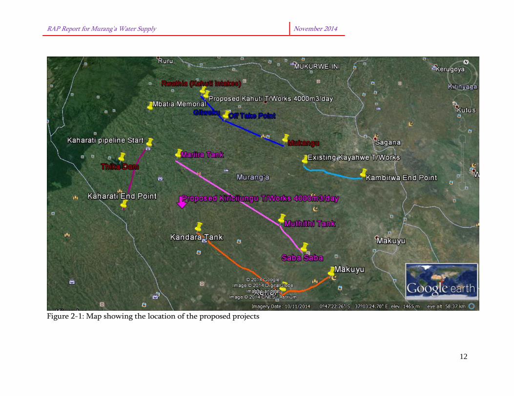
2.2.6 Rwathia - Mukangu pipeline The proposed project comprises a supply line from Rwathia to Mukangu in Kangema sub-county. It will also have a branch at Gitweku to augment supply in Weithaga, Gitie, Kahuti and the surrounding areas. The line will start from the proposed Kahuti treatments work. Part of the pipeline will be located along South Mathioya River and part of it along the road. The topography of the area is steep and hilly with the main cash crop being tea. This pipeline along South Mathioya River will affect private farms which will require a Resettlement Action Plan (RAP). 2.2.7 Kayahwe – Kambirwa Pipeline The Projects consist of construction of a 11km gravity system from Kayahwe to Kambirwa market and three main distribution lines, Kambirwa – Muthigiriri (9.8km), Kambirwa – (8.4km) and Kambirwa – Kambirwa (8.2km). It starts from the existing Kayahwe Treatments works and will be located along Kayahwe River and through peoples land crossing Murang’a-Kaharati road to Kambirwa market. The terrain of the area is rugged with shrubs. This pipeline will involve compensation as it will affect people’s lands and assets. The population expected to benefit from this project is about 15,000 persons. The target area includes Kambirwa Market, Itaru-ini area (by Sagana River), Mirira and Muthigiriri Market. Figure 2-1 shows the location of these components.
RAP Report for Murang’a Water Supply November 2014
12
Figure 2-1: Map showing the location of the proposed projects

13
2.3 Construction Period The works are estimated to be completed within a Construction period of 18 months with 12 months defect liability period during which the contractor is expected to maintain the system and carry out repair works which may occur to the satisfaction of the AWSB. 2.4 Project Cost From the bill of quantities, the proposed Murang’a Water Supply is envisaged to cost Ksh 749,882,570.56. The breakdown is as shown in Table 2-1below: Table 2-1: Project Cost
Murang’a Water Supply No. Description Amount (Ksh) 1 Preliminary and General 28,490,425.00 2 Dayworks 3 Kiriciungu 320,745,394.30 4 Kahuti 332,475,608.48 Bill of Quantities Total 681,711,427.78 Contingencies 10% of Bill of Quantity Total 68,171,142.78 Total 749,882,570.56

14
3.0 POLICY AND LEGAL FRAMEWORK 3.1 Policy Framework 3.1.1 Land policy The principles stated in the policy, reflect a reaction to the emphasis over the last 50 years on individual ownership of land. It adopts the position that individual tenure and customary tenure should co-exist and benefit from equal guarantees of tenure security. It reflects, especially in its discussion of the need for constitutional change, a conviction of the need for land reform, stressing that the current distribution of land is inequitable and arguing that the constitution should not protect private property rights that have been acquired in “an illegitimate manner.” In Section 3.2, land policy is linked to constitutional reforms; regulation of property rights is vested in the government by the Constitution with powers to regulate how private land is used in order to protect the public interest. The Government exercises these powers through compulsory acquisition and development control. Compulsory acquisition is the power of the State to take over land owned privately for a public purpose. However, the Government must make prompt payment of compensation. Section 3.6 under land issues requiring special intervention asserts that “Land rights of minority communities shall be protected through a law to be passed specifically to secure their rights as individuals and groups and recognition of their resource management systems to ensure sustainability.” It further states, “Land rights of vulnerable groups (namely subsistence farmers, pastoralists, hunters and gatherers, agricultural labourers, unskilled workers, unemployed youth, persons with disabilities, persons living with HIV and AIDS, orphans, slum and street dwellers and the aged.) shall be addressed by creating a system for identifying, monitoring and assessment, resettling them, facilitating their participation in decision making over land and land based resources, and protecting their land rights”. Relevance: This policy document will come in handy for areas where there will be need for compulsory land acquisition, the client will be required to compensate for the land as to acquire land from the respective owners after ascertaining the ownership of the land. 3.1.2 World Bank Operational Policy 4:12 Involuntary Resettlement The World Bank safeguard policy on involuntary resettlement, Operational Policy (OP 4.12) establishes guidelines for land acquisition and compensation of people affected by the project. Key principles and policy objectives of OP 4:12 can be summarised as:
15
• To minimise or avoid involuntary resettlement where feasible and to explore all
viable alternative project designs; • To conceive and implement resettlement activities as sustainable development
programs where affected people are provided with sufficient investment resources and opportunities to share in project benefits;
The above shall be carried out through consulting affected persons and let them have opportunities to participate in planning and execution of resettlement programs. This is to assist the Project affected persons (PAPs) where resettlement is necessary, to improve their livelihood and living standards, income earning capacity and production levels, or at least to restore them in a manner that maintains sustainability of resettlement programs. The Compensation framework should be based on: • For agricultural land, land of equal productive use or potential, prepared to a
similar level and located in the vicinity of the affected land; • For residential land, land of equal size and use, with similar infrastructure and
services and located in the vicinity of affected land; • For structures, full replacement cost to purchase or build new structures of a
similar size and quality to affected houses and other affected structures; • Subsidies to assist AP with costs associated with the transition period in the
resettlement site e.g., moving costs, living allowance, business losses lost production etc.
Where agricultural land is not available, compensation is paid in cash at replacement costs based on market rates. All land compensation, whether paid in land or in cash, should include the cost of any registration or transfer taxes. For structures, the calculation of replacement costs should be based on non-depreciated market values; should include labour and contractors’ fees; and should be reduced by the value of salvage materials. Resettlement programmes affect not only individuals and households who are displaced, but also members of existing host communities to which they are relocated. Displaced people should be socially and economically integrated into host communities; and, steps should be taken to minimise adverse impacts on host communities caused by influx of displaced households. Community participation involving displaced people and the host communities should be carried out throughout planning and implementation of resettlement programmes. Consultations should provide all affected people with comprehensive and timely information about their options and rights; and, effective opportunities to express needs and preferences make choices among acceptable alternatives and communicate concerns. Particular attention should be paid to the participation of vulnerable groups, namely the poor, elderly, women and children, indigenous groups and ethnic minorities.
16
Resettlement programmes should be built around development strategy that targets initiatives aimed at improving or at least restoring the economic base for those affected. In addition to the replacement of the effected assets, replacement programmes should consider requirements to assist affected people to restore living standards related to, among others: losses that cannot be easily evaluated or compensated in monetary terms, e.g., common pool resources, loss of customers; alternative non-farm economic and employment strategies where affected people do not receive sufficient land to continue farming; new economic activities made possible by the project; training, credit, extension services and other incentives to support alternative and new economic opportunities; and, the provision of infrastructure and services sufficient to meet direct and induced population growth at resettlement sites. 3.1.3 World Bank Guidelines on Involuntary Resettlement - Eligibility for benefits World Bank set some criteria for eligibility of displaced persons in the following three groups are entitled to compensation for loss of land or other assets taken for project purposes: • Those who have formal legal rights to land or other assets (including customary
and traditional rights recognized under the law of the Country); and • Those who do not have formal legal rights to land or other assets at the time
census begins but have a claim to such legal rights, provided that such claims are recognized by the laws of the country or become recognized through a process identified in the resettlement plan. The absence of legal title to land or other assets is not, in itself, a bar to compensation for lost assets or other resettlement assistance. Displaced persons in these two groups are also entitled to compensation for loss of other assets such as structures and crops, and to other resettlement assistance.
A third group of displaced persons are those who have no recognizable legal right or claim to the land they are occupying are not entitled to compensation for loss of land under this policy. However they are entitled to resettlement assistance in lieu of compensation for land, as necessary, to achieve the objectives set out in this policy, if they occupy the project area prior to a cut-off date established by the Borrower and acceptable to the Bank. All such displaced persons are entitled to compensation for loss of assets other than land, in particular, structures and crops. Persons who encroaches the area after the above “cut-off” date are not entitled to compensation or other form of assistance. Relevance: The project is financed by World Bank which has set standards in dealing with project initiated resettlement. Therefore, the study was also guided by WB Involuntary Resettlement Policy OP 4.12.

17
3.2 Legal Framework
3.2.1 The Constitution of Kenya The Constitution of Kenya categorises land as follows: • Public Land; • Community Land; • Private Land. The Constitution also provides that the National Land Commission shall recommend a National Land Policy to the National Government while Parliament shall revise and enact legislation to ensure implementation of the issues outlined in it. Section 40 of the Constitution of Kenya recognizes and protects the right to private property including land. However, Section 40(3) (b) provides that the State may take possession of private land if this is necessary for public purpose or in public interests. Section 40(3) of the Constitution allows for the deprivation of private property on condition that: • results from an acquisition of land or an interest in land or a conversion of an
interest in land, or title to land, in accordance with Chapter Five; or • is for a public purpose or in the public interest and is carried out in accordance
with this Constitution and any Act of Parliament that : o requires prompt payment in full, of just compensation to the person; and o allows any person who has an interest in, or right over, that property a
right of access to a court of law. Relevance: This provision is a very important aspect in land management in that it is the instrument by which land is availed for various development needs including infrastructure. The detailed procedures for acquisition are elaborated under the Land Act, 2012. 3.2.2 The National Land Commissions Act 2012 This is an Act of Parliament to make further provision as to the functions and powers of the National Land Commission, qualifications, and procedures for appointments to the commission; to give effect to the objects and principles of devolved government in land management and administration, and for connected purposes. The mandate of the Commission, as provided for in the Act, Pursuant to Article 67(2) of the Constitution, shall be:

18
• To manage public land on behalf of the national and county governments; • To recommend a national land policy to the national government; • To advise the national government on a comprehensive programme for the
registration of Title in land throughout Kenya; • To conduct research related to land and the use of natural resources, and make
recommendations to appropriate authorities; • To initiate investigations, on its own initiative or on a complaint, into present or
historical land injustices, and recommend appropriate redress; • To encourage the application of traditional dispute resolution mechanisms in
land conflicts; • To assess tax on land and premiums on immovable property in any area
designated by law; and • To monitor and have oversight responsibilities over land use planning
throughout the country; • On behalf of, and with the consent of the national and county governments,
alienate public land; • To monitor the registration of all rights and interests in land; • To ensure that public land and land under the management of designated state
agencies are sustainably managed for their intended purpose and for future generations;
• Develop and maintain an effective land information management system at national and county levels;
• Manage and administer all unregistered trust land and unregistered community land on behalf of the county government; and
• Develop and encourage alternative dispute resolution mechanisms in land dispute handling and management.
Relevance: The National Land Commission will come in handy in cases of grievance solving mechanisms. It will also help to initiate investigations, on its own initiative or on a complaint, into present or historical land injustices that might relate to the project implementation. The commission also monitors and has oversight responsibilities over land use planning throughout the country and will intervene should the proposed project go contrary to the land use plans. 3.2.3 The Land Act 2012 This is an Act of Parliament intended to give effect to Article 68 of the Constitution, to revise, consolidate and rationalize land laws; to provide for the sustainable administration and management of land and land based resources, and for connected purposes.
19
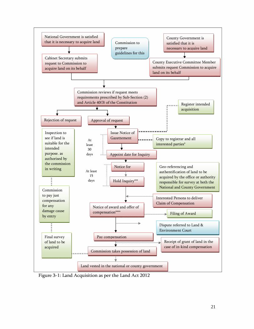
a) Principles and values to guide land management and administration Parts 1 and 2 of section 4 of the Act outline the main guiding principles in land management and administration, binding to all land actors including state officers. These principles are to be applied when enacting, applying or interpreting any provisions of this Act; and when making or implementing public policy decisions. In discharging their functions and exercising of their powers under this Act, the Commission and any State officer or Public officer shall be guided by the following values and principles: • Equitable access to land; • Security of land rights; • Sustainable and productive management of land resources; • Transparent and cost effective administration of land; • Conservation and protection of ecologically sensitive areas; • Elimination of gender discrimination in law, customs and practices related to
land and property in land; • Encouragement of communities to settle land disputes through recognized local
community initiatives; • Participation, accountability and democratic decision making within
communities, the public and the Government; • Technical and financial sustainability; • Affording equal opportunities to members of all ethnic groups; • Non-discrimination and protection of the marginalized; • Democracy, inclusiveness and participation of the people and • Alternative dispute resolution mechanisms in land dispute handling and
management. b) Acquisition of Private Land for Public Use Section 110 (1) of the Act provides that land may be acquired compulsorily under this if the Commission certifies, in writing, that the land is required for public purposes or in the public interest as related to and necessary for fulfilment of the stated public purpose. In such an acquisition, this Act, in section 111(1) provides that just compensation shall be paid promptly in full to all persons whose interests in the land have been determined. The procedure for land acquisition is laid out in Part VIII of the Act. The procedure can be summarised as outlined in Figure 3-1 overleaf. Elements for consideration under this procedure include the following: • The Act requires that the owners, residents and their spouses should also be
notified; as opposed to just the owners; • The inspector would also have to get the consent of the occupier and give them
20
not less than seven days’ notice to enter the premises; • The Commission shall have the power of a court to summon and examine
witnesses and compel the production and delivery to the Commission of documents of title to the land;
• Separate award of compensation to every person. An award is final and conclusive evidence of the size of the land, the value in the opinion of the Commission and the amount of compensation payable, whether or not the person attends the inquiry;
• Regulations and rules pertaining to this process are yet to be gazetted; • Section 107 (4) allows for circumstances where the acquiring authority may
proceed with land acquisition at Stage 1; • The Commission shall make rules to regulate assessment of just compensation; • The Act does not explicitly state when the inspection will be done. Whether it is
before approval of the request for compulsory acquisition or before serving the notice for acquisition.
• The Commission may postpone an inquiry or adjourn the hearing of an inquiry from time to time for sufficient cause.
c) Compensation in respect of public right of way Section 149 of the lands act states that compensation shall be payable to any person for the use of land, of which the person is in lawful or actual occupation, as a communal right of way and, with respect to a wayleave. The compensation shall be for any damage suffered in respect to trees crops and buildings, in cases of private land, it will be based on the value of the land as determined by a qualified valuer. The Act goes further to state that Compensation relating to a wayleave or communal right of way shall not be paid to a public body unless there is a demonstrable interference of the use of the land by that public body. The act further states that, the duty to pay compensation payable under this section shall lie with the State Department, county government, public authority or corporate body that applied for the public right of way and that duty shall be complied with promptly.
21
Figure 3-1: Land Acquisition as per the Land Act 2012
County Government is satisfied that it is necessary to acquire land
Cabinet Secretary submits request to Commission to acquire land on its behalf
National Government is satisfied that it is necessary to acquire land
County Executive Committee Member submits request Commission to acquire land on its behalf
Commission to prepare guidelines for this
Commission reviews if request meets requirements prescribed by Sub-Section (2) and Article 40(3) of the Constitution
Approval of request Rejection of request
Issue Notice of Gazettement
Hold Inquiry***
Commission takes possession of land
Notice of award and offer of compensation****
Inspection to see if land is suitable for the intended purpose. as authorised by the commission in writing Notice for
Inquiry
Copy to registrar and all interested parties*
Geo-referencing and authentification of land to be acquired by the office or authority responsible for survey at both the National and County Government
Land vested in the national or county government
Register intended acquisition
Commission to pay just compensation for any damage cause by entry
At least 30
days
Interested Persons to deliver Claim of Compensation
Appoint date for Inquiry
At least 15
days
Pay compensation Receipt of grant of land in the case of in-kind compensation
Filing of Award
Dispute referred to Land & Environment Court
Final survey of land to be acquired

22
3.2.4 Land Acts Repealed by the Land Act 2012 The following Acts were in effect in 2010 but have since been repealed through the Land Act 2012: • The Wayleaves Act, Cap 292; • The Land Acquisition Act, Cap 295 Relevance: The new Land acts will therefore guide AWSB in the land acquisition process in line with the Kenyan legislation. 3.2.5 The Land Registration Act 2012 This is an Act of Parliament intended to revise, consolidate and rationalize the registration of titles to land, to give effect to the principles and objects of devolved government in land registration, and for connected purposes. a) Land Registry Section 7(1) of the Act provides for establishment of a land registry in each registration unit which shall keep registers of the following regarding land: • A land register, in the form to be determined by the Commission; • The cadastral map; • Parcel files containing the instruments and documents that support subsisting
entries in the land register. • Any plans which shall, after a date appointed by the Commission, be geo-
referenced; • The presentation book, in which shall be kept a record of all applications
numbered consecutively in the order in which they are presented to the registry; • An index, in alphabetical order, of the names of the proprietors; and • A register and a file of powers of attorney. b) Maintenance of documents, including land title deeds Further, section 9 (1) provides that the Registrar shall maintain the register and any document required to be kept under this Act in a secure, accessible and reliable format. These documents include: • Publications, or any matter written, expressed, or inscribed on any substance by
means of letters, figures or marks, or by more than one of those means, that may be used for the purpose of recording that matter;

23
• Electronic files; and • An integrated land resource register. The register, as provided for in part 2 of section 9, shall contain the following particulars; • Name, personal identification number, national identity card number, and
address of the proprietor; • In the case of a body corporate, name, postal and physical address, certified copy
of certificate of incorporation, personal identification numbers and passport size photographs of persons authorized and where necessary attesting the affixing of the common seal;
• Names and addresses of the previous proprietors; • Size, location, user and reference number of the parcel; and • Any other particulars as the Registrar may, from time to time, determine. Relevance: These provisions are essential to the RAP as it is expected that the documentation for the affected land parcel will have to be updated in line with the laws of Kenya to show the changes due to the easement acquired by the AWSB. 3.2.6 The Land and Environment Court Act 2011 This is an Act of Parliament to give effect to Article 162 (2) (b) of the Constitution; to establish a superior court to hear and determine disputes relating to the environment and the use and occupation of, and title to, land, and to make provision for its jurisdiction functions and powers, and for connected purposes. The principal objective of this Act is to enable the Court to facilitate the just, expeditious, proportionate and accessible resolution of disputes governed by this Act. Section 13 (2) (b) of the Act outlines that in exercise of its jurisdiction under Article 162 (2) (b) of the Constitution, the Court shall have power to hear and determine disputes relating to environment and land, including disputes: • Relating to environmental planning and protection, trade, climate issues, land
use planning, title, tenure, boundaries, rates, rents, valuations, mining, minerals and other natural resources;
• Relating to compulsory acquisition of land; • Relating to land administration and management; • Relating to public, private and community land and contracts, chooses in action
or other instruments granting any enforceable interests in land; and • Any other dispute relating to environment and land.

24
Section 24 (2) also states that the Chief Justice shall make rules to regulate the practice and procedure, in tribunals and subordinate courts, for matters relating to land and environment. However, the physical offices of this Court are yet to be established. As such, section 30 (1) states that all proceedings relating to the environment or to the use and occupation and title to land pending before any Court or local tribunal of competent jurisdiction shall continue to be heard and determined by the same court until the Environment and Land Court established under this Act comes into operation or as may be directed by the Chief Justice or the Chief Registrar. Relevance: In case of any disputes relating to compensation if not solved at the project level can be forwarded to the Land and Environment Court 3.3 Comparisons between Kenyan Law and WB Involuntary Resettlement Policy Kenyan law allows for compensation for loss of land or assets to owners in the event of involuntary resettlement. The WB Policy on involuntary resettlement however has a wider criteria for eligibility of compensation to include “…..those who have no recognisable legal right or claim to the land they are occupying…” This report therefore recognises both asset owners and tenants regardless of the fact that they do not have any legally accepted instruments as per Kenyan Law. There are similarities between key precepts of the World Bank Policy 4.12 and Kenyan legislation. The legislation recognizes the imperative need to offer compensation to those whose land is affected by government activities, such as compulsory acquisition where such land is envisaged to be used for the public good. The scope of coverage of Kenyan legislation and the World Bank Policy 4.12 differs as well. The World Bank Safeguards favour a policy of avoidance or minimization of involuntary resettlement and recommends the design of appropriate mitigation provision in case avoidance or minimization is not possible. The Kenya system recognizes only title holders as bonafide property owners while under WB OP 4.12, lack of legal title is no bar in extending assistance and support to those affected by the project development. To abide by the requirements of the WB OP 4.12 the proponent must take the provisions of this policy while undertaking the RAP.
25
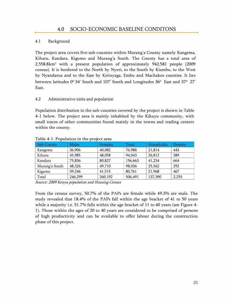
4.0 SOCIO-ECONOMIC BASELINE CONDITONS 4.1 Background The project area covers five sub-counties within Murang’a County namely Kangema, Kiharu, Kandara, Kigumo and Murang’a South. The County has a total area of 2,558.8km2 with a present population of approximately 942,581 people (2009 census). It is bordered to the North by Nyeri, to the South by Kiambu, to the West by Nyandarua and to the East by Kirinyaga, Embu and Machakos counties. It lies between latitudes 0o 34’ South and 107’ South and Longitudes 36o East and 37o 27’ East. 4.2 Administrative units and population Population distribution in the sub-counties covered by the project is shown in Table 4-1 below. The project area is mainly inhabited by the Kikuyu community, with small traces of other communities found mainly in the towns and trading centers within the county. Table 4-1: Population in the project area
Sub-County Males Females Total Households Density Kangema 36,906 40,082 76,988 21,814 443 Kiharu 45,985 48,058 94,043 26,812 389 Kandara 75,836 80,827 156,663 41,234 664 Murang’a South 48,326 49,710 98,036 25,562 292 Kigumo 39,246 41,515 80,761 21,968 467 Total 246,299 260,192 506,491 137,390 2,255
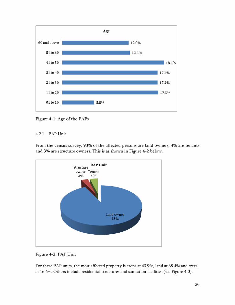
Source: 2009 Kenya population and Housing Census From the census survey, 50.7% of the PAPs are female while 49.3% are male. The study revealed that 18.4% of the PAPs fall within the age bracket of 41 to 50 years while a majority i.e. 51.7% falls within the age bracket of 11 to 40 years (see Figure 4-1). Those within the ages of 20 to 40 years are considered to be comprised of persons of high productivity and can be available to offer labour during the construction phase of this project.
26
Figure 4-1: Age of the PAPs
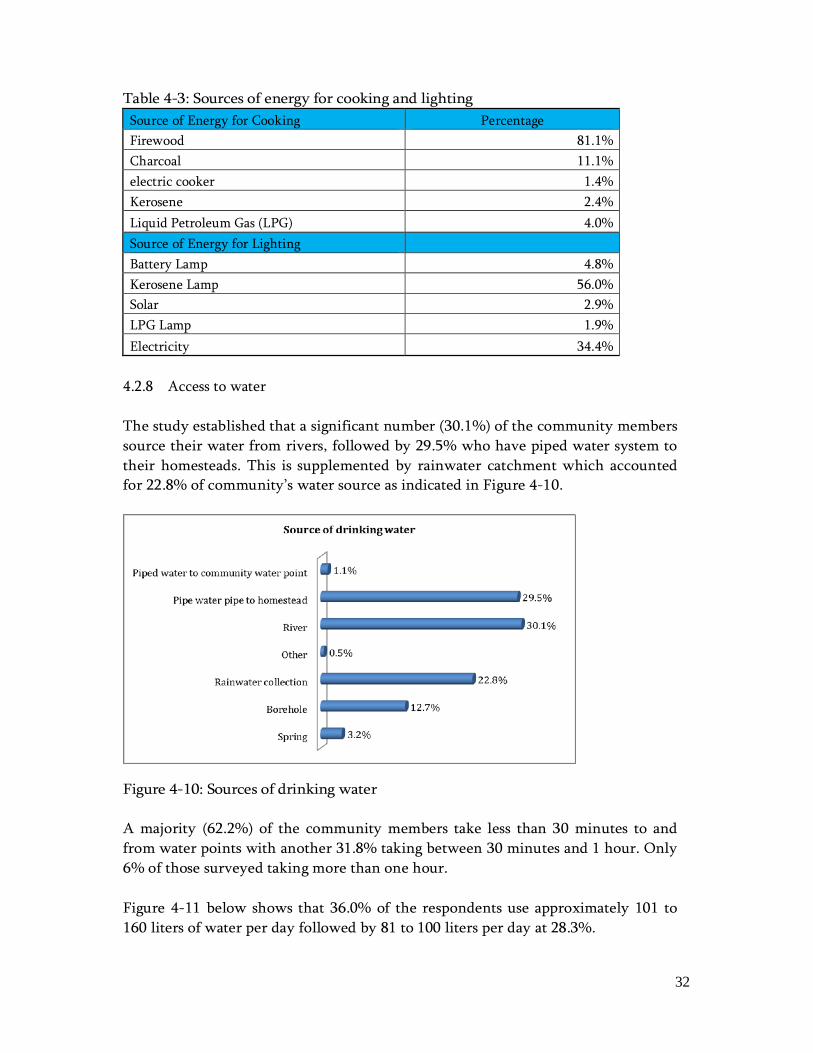
4.2.1 PAP Unit From the census survey, 93% of the affected persons are land owners, 4% are tenants and 3% are structure owners. This is as shown in Figure 4-2 below.
Figure 4-2: PAP Unit For these PAP units, the most affected property is crops at 43.9%, land at 38.4% and trees at 16.6%. Others include residential structures and sanitation facilities (see Figure 4-3).

27
Figure 4-3: Affected property 4.2.2 Marital Status From the census survey, 54.2% of the PAPs were married while 38.8% were single.
Figure 4-4: Marital Status of PAPs 4.2.3 Religion In Murang’a Country, Christianity is the largest religion at 82.5% where 47.4% are Protestants, 23.3% are Catholics and about 11% Muslims. From the census survey, approximately 72.0% of the PAPs are Protestants and 26.2% are Catholics as shown in Figure 4-5. Only 1.3% are Muslims.

28
Figure 4-5: Religion 4.2.4 Education Murang’a County has 1080 Early Childhood Development (ECD) centres with total enrolment of 31,944 pupils and 1,127 teachers. The teacher/pupil ratio is 1:28. The county has 634 primary schools, 6,324 teachers, total enrolment of 214,986 and a transition rate of 70%. The teacher/pupil ratio is 1:34. From the socio-economic survey undertaken during the ESIA study, most primary schools are 1 to 1.4km away from the homesteads which is a reasonable distance for most of the pupils. Figure 4-6 shows how the respondents responded to the question on the distance to the nearest primary school.
Figure 4-6: Distance to the nearest primary school

29
The county has 292 secondary schools, 3,206 teachers and a total enrolment of 84,874 students. This represents a gross enrolment of 71.04%. The county has one university (Murang'a University College), one science and technology institute (Michuki Technical Traning Institute), forty eight youth polytechnics, three accredited colleges and four non accredited colleges. All these are middle level institutions where the youth who don’t get opportunities to join the universities go and get skills suitable for the labour market. The county’s literacy level stands at 70.1%, where literacy level for male is 73.9% and female is 66.7%. This implies most of the county population can make informed decisions on matters affecting their socio-economic livelihoods. From the census survey, 51.3% of the PAPs had attained secondary level education while 41.3% had attained primary level of education translating to a high literacy levels among the PAPs. See Figure 4-7.
Figure 4-7: Highest education level 4.2.5 Income and expenditure About 83.0% of the PAPs are in the informal employment while 17.0% are formally employed. The primary source of income for the PAPs at 79.2% is farming; this is followed by salaried employment at 11.6% then trading and farm labour at 4.6% and 4.1% respectively. Construction work accounts for 0.5% only (Figure 4-8).

30
Figure 4-8: Primary income sources Majority of the PAPs (90.2%) earn an income of less than Ksh 10,000 followed by those earning between Ksh 10,000 and Ksh 19,000 at 9.2% (Figure 4-9). This shows that the income levels in the area are generally low.
Figure 4-9: Monthly income According to the Welfare Monitoring Survey of 1997, people living below poverty line in Murang’a were about 39% of the total population. The hardest hit groups are the women, unemployed youth, widows and orphans, neglected retired old people, the street children and those living in marginal areas of the County.

31
4.2.6 Housing Characteristics of housing for the community was assessed in terms of roofing, walls and floor to determine the quality of housing available for the use within the community. The results are as shown in Table 4-2. Table 4-2: Housing conditions
Roofing Percentage Thatched 0.8% Corrugated Iron Sheets 95.8% Tiles 0.2% Other 0.2%
Walls Mud 12.1%
Stone 47.1% wooden 6.0% iron sheets 10.0% Bricks 11.5% Other 6.7%
Floor Earth 32.9%
Cement 62.7% Wooden 0.2% Other 4.2%
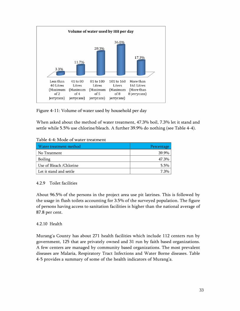
4.2.7 Sources of energy for lighting and cooking The main source of energy for cooking available as per Table 4-3 is firewood with a percentage of 81.1%which is locally available, 11.1% charcoal, 4% Liquid Petroleum Gas (LPG), 2.45 and electric cooker at 1.4% which is the least source of energy used by the respondents. The main source of energy for lighting at a percentage of 56% used by most of the respondent is kerosene which is bought from local venders, this followed by electricity at a 34.4%. The least used source of energy for lighting by the respondents at a 2.9% is LPG Lamp. From the analysis, it’s evident that the residents within Murang’a County use electricity, kerosene and firewood as the most popular sources of energy for lighting and cooking respectively, this implies that more money is spent as the energy alternative above are expensive, this leaves the residents with limited resources to use for water and other family needs.
32
Table 4-3: Sources of energy for cooking and lighting Source of Energy for Cooking Percentage Firewood 81.1% Charcoal 11.1% electric cooker 1.4% Kerosene 2.4% Liquid Petroleum Gas (LPG) 4.0% Source of Energy for Lighting Battery Lamp 4.8% Kerosene Lamp 56.0% Solar 2.9% LPG Lamp 1.9% Electricity 34.4%
4.2.8 Access to water The study established that a significant number (30.1%) of the community members source their water from rivers, followed by 29.5% who have piped water system to their homesteads. This is supplemented by rainwater catchment which accounted for 22.8% of community’s water source as indicated in Figure 4-10.
Figure 4-10: Sources of drinking water A majority (62.2%) of the community members take less than 30 minutes to and from water points with another 31.8% taking between 30 minutes and 1 hour. Only 6% of those surveyed taking more than one hour. Figure 4-11 below shows that 36.0% of the respondents use approximately 101 to 160 liters of water per day followed by 81 to 100 liters per day at 28.3%.
33
Figure 4-11: Volume of water used by household per day When asked about the method of water treatment, 47.3% boil, 7.3% let it stand and settle while 5.5% use chlorine/bleach. A further 39.9% do nothing (see Table 4-4). Table 4-4: Mode of water treatment Water treatment method Percentage No Treatment 39.9% Boiling 47.3% Use of Bleach /Chlorine 5.5% Let it stand and settle 7.3%
4.2.9 Toilet facilities About 96.5% of the persons in the project area use pit latrines. This is followed by the usage in flush toilets accounting for 3.5% of the surveyed population. The figure of persons having access to sanitation facilities is higher than the national average of 87.8 per cent. 4.2.10 Health Murang'a County has about 271 health facilities which include 112 centers run by government, 125 that are privately owned and 31 run by faith based organizations. A few centers are managed by community based organizations. The most prevalent diseases are Malaria, Respiratory Tract Infections and Water Borne diseases. Table 4-5 provides a summary of some of the health indicators of Murang’a.
34
Table 4-5: Health Indicators – Murang’a District Crude Birth Rate (CBR) 26/1,000 Crude Death Rate (CDR) 9/1,000 Life Expectancy 55years Infant Mortality Rate (IMR) 29/1000 Under 5 Mortality Rate 69/1000 Total Fertility Rate 5.1 HIV Prevalence Rate 17% Doctor/Patient Ratio 1:30,000
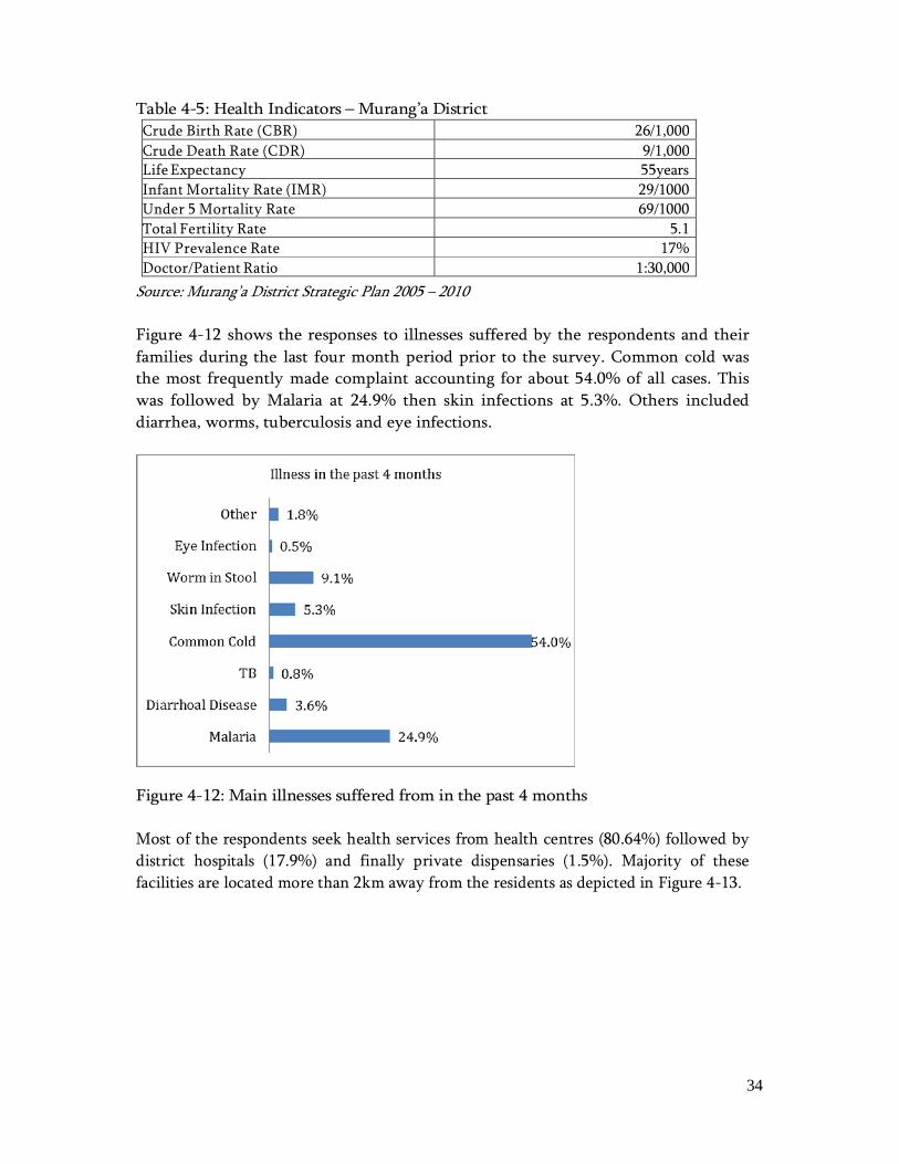
Source: Murang’a District Strategic Plan 2005 – 2010 Figure 4-12 shows the responses to illnesses suffered by the respondents and their families during the last four month period prior to the survey. Common cold was the most frequently made complaint accounting for about 54.0% of all cases. This was followed by Malaria at 24.9% then skin infections at 5.3%. Others included diarrhea, worms, tuberculosis and eye infections.
Figure 4-12: Main illnesses suffered from in the past 4 months Most of the respondents seek health services from health centres (80.64%) followed by district hospitals (17.9%) and finally private dispensaries (1.5%). Majority of these facilities are located more than 2km away from the residents as depicted in Figure 4-13.

35
Figure 4-13: Distance from the homestead to health service provider About 68% of the respondents take between 30 minutes to 1 hour to reach a health service provider while walking. The rest at 16% each take less than 30 minutes and more than 1 hour respectively as per Figure 4-14. The transport means is mostly the respondents own at 61.8%, through public or hired transport (38%) or through help from neighbours (0.2%).
Figure 4-14: Time to the health service provider 4.2.11 Land tenure and ownership Land tenure in Kenya is classified into three categories, namely; – public land, community land and private land. Figure 4-15 below shows that the most common land tenure system in the project area is private holding at 92.3%, public land at 7.3% and 0.4% being community land.

36
7.3%
92.3%
0.4%Public Land Private Land Community Land
Land ownwership
Figure 4-15: Category of land tenure Respondents were asked whether they were the owners of land where they reside. 97.9% of the respondents own land where they reside. Land tenants were notably few at 1.7% while squatters were 0.4%. Majority of the respondents at 78% had the intention of subdividing the land in future while 22% did not. 4.2.12 Land use The Project area has a wide land use because of its wide Agro Ecological Zone range; from Tropical Alpine Zone (TA) on the highlands to LM4 (see Table 4-6 below) on the low lands. The forests occupy the highest grounds while cash crops like tea, coffee and macadamia follow the forests in that order. Horticultural crops and subsistence crops like maize and beans are found in the mid and lower zones of the project study area. Table 4-6: Existing land use within the proposed project study area
Agro-ecological Zone Current land use TA Tropical alpine UHO Forest Zone UH1 Carrots, Cabbage, Maize, Pears, Plums LH1 Tea, Dairy, I. potatoes, Cut flower UM1 Tea, Coffee, Dairy, Maize, Beans, Poultry, potatoes UM2 Coffee-main, Dairy, Maize, Macadamia, Bananas, Poultry,
Avacado, Cut flower. UM3 Coffee (marginal), Bananas, Maize, Beans, Mangoes,
French beans, Tomatoes. UM4 Maize, Beans, Sunflower, Mangoes, Asian Vegetables. LM3 Maize, Beans, Cotton, Mangoes. LM4 Cotton (marginal), Maize, Beans
37
Drylands in the proposed Project study area are basically semi-arid areas. These are in the Agro-ecological Zone IV. Most of the crops grown here are the drought resistant or varieties that are early maturing. Some horticulture farming is practiced along riverbeds while mangoes are becoming the preferred fruit tree. Uncontrolled sand harvesting and quarrying is rampant in these lands and are causing a negative impact in environmental conservation. Table 4-7 below shows the land use type in drylands. Table 4-7: Land use systems in drylands Ecological Zone Land tenure Land use type LM4 Private ownership Maize, beans, pigeon peas, cassava,
sweet potatoes, yams, mangoes, bush land and mining.
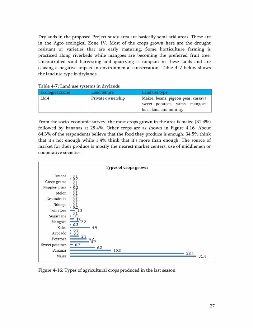
From the socio-economic survey, the most crops grown in the area is maize (31.4%) followed by bananas at 28.4%. Other crops are as shown in Figure 4.16. About 64.3% of the respondents believe that the food they produce is enough, 34.5% think that it’s not enough while 1.4% think that it’s more than enough. The source of market for their produce is mostly the nearest market centers, use of middlemen or cooperative societies.
Figure 4-16: Types of agricultural crops produced in the last season

38
4.2.13 Livestock inventory The respondents were asked what type of livestock they keep. About 32.9% said that they keep cows, 26.5% said that they keep poultry and 23.1% said that they keep goats. Other livestock that were mentioned as shown in Figure 4-17 include calves, bulls, sheep, pigs, rabbits, bees and oxen.
Figure 4-17: Type of livestock kept The reasons for keeping these animals especially cattle and goats/sheep were for milk, manure and meat production and (see Table 4-8). Table 4-8: Reason for keeping the livestock Cattle Percentage Sheep/Goat Percentage Meat production 18.2% Meat production 27.6% Milk Production 36.8% Milk Production 24.0% Manure production 38.1% Manure production 36.8% Savings 6.8% Savings 11.6% Draught power 0.1% Total 100 100
4.3 Perceptions and support of the Proposed Project During the socio-economic survey exercise, a question on the community’s awareness and perception of the proposed project was asked. About 59.1% of the persons within the project area noted that they were aware of the proposed project while 40.9% were not aware.
39
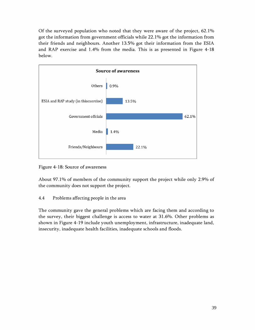
Of the surveyed population who noted that they were aware of the project, 62.1% got the information from government officials while 22.1% got the information from their friends and neighbours. Another 13.5% got their information from the ESIA and RAP exercise and 1.4% from the media. This is as presented in Figure 4-18 below.
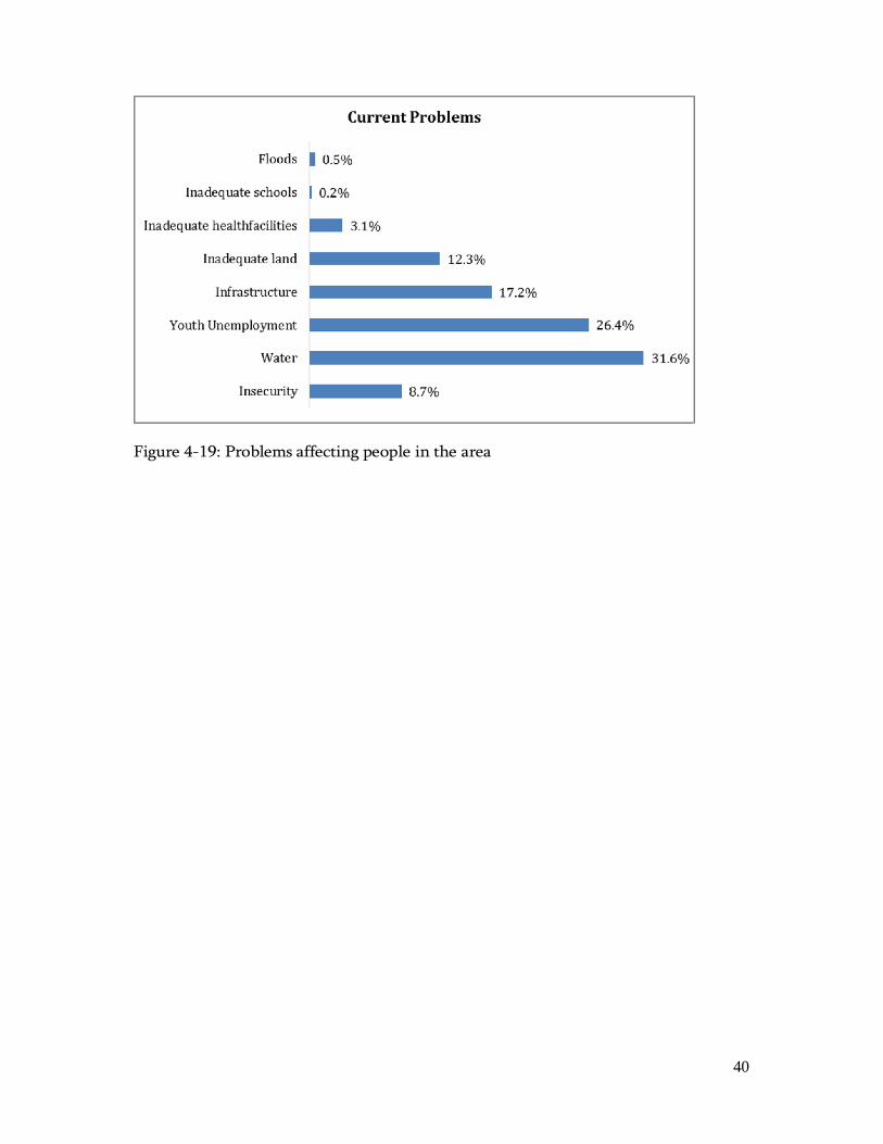
Figure 4-18: Source of awareness About 97.1% of members of the community support the project while only 2.9% of the community does not support the project. 4.4 Problems affecting people in the area The community gave the general problems which are facing them and according to the survey, their biggest challenge is access to water at 31.6%. Other problems as shown in Figure 4-19 include youth unemployment, infrastructure, inadequate land, insecurity, inadequate health facilities, inadequate schools and floods.
40
Figure 4-19: Problems affecting people in the area
41
5.0 PUBLIC CONSULTATIONS AND PARTICIPATION 5.1 Background Public consultation in the RAP process is undertaken to disseminate information to interested and affected parties (stakeholders), solicit their views and consult on resettlement and compensation issues. The provisions in WB OP 4.12 requiring consultation and disclosure have equivalents in Kenyan Constitution but the WB procedures are more stringent therefore the RAP shall adhere to the WB operational policy OP 4.12. For disclosure, the WB policy on Involuntary Resettlement (OP 4.12) recommends the following: • Condition of appraisal: borrower provides the Bank with (acceptable) draft
Resettlement Action Plan (RAP) or Resettlement Policy Framework (RPF) and makes it available at a place accessible to displaced persons and local NGOs, in a form, manner, and language that are understandable to them.”
• Bank discloses draft RAP/RPF in Infoshop; • After final RAP/RPF approved by Bank, both Bank and Borrower disclose again
in same way. 5.1.1 Objectives of the Public Consultations The specific objectives of the consultation process under this RAP were to: • Make the resettlement process participatory and transparent; • Facilitate the development of appropriate and acceptable entitlement options; • Increase the effectiveness and sustainability of income restoration strategies, and
improve coping mechanisms. • Minimise the risk of poor co-ordination by all affected institutions through
establishment of communication channels as early as the RAP Study phase; • Providing a platform for future consultation by:
o Reducing conflict through early identification of contentious issues; o Improving transparency and accountability of decision making; o Facilitating participation to increase public confidence in the RAP process; o Identifying local leaders with who further dialogue can be continued in
subsequent stages of the project.

42
5.2 Stakeholder engagement In summary, public and stakeholder engagement was done through: • Key informant interviews; and • Public meetings 5.2.1 Key informant interviews Key informant interviews were held with several Sub-County heads within Kangema, Kiharu, Kandara, Kigumo and Murang’a South Sub-Counties. A summary of the discussions are as shown in Table 5-1 below. The consultation list is as shown in Appendix 2. Table 5-1: Summary of discussions with key stakeholders within Murang’a County
Name Title Comments Response 1. Kandara Sub-County 1.J.K.Nyamumbo Sese
Deputy County Commissioner (DCC)
-Provide a main pipeline and leave distribution to peoples homesteads to be run by community based water service providers; -Emphasized that the water to be supplied should be treated thoroughly as the current water is turbid and unfit for consumption; -People running the CDF funded projects to be given a layout plan of the pipeline for better planning in laying of distribution pipelines to peoples homesteads; -Requested for rehabilitation of the current existent pipelines in the area.
-As per the Water act 2002, the provision of water services is done by the local Water Service Providers. -The water to be supplied will be treated. The Kahuti Treatment Plant is being rehabilitated while a new water treatment plant is proposed in Kiriciungu. -The designs for the projects are available on request. -The request may be considered in the future.
2.Lydiah.W.Mwangi
District Agriculture Officer (D.A.O)
-Expressed concern on challenges faced by Murang’a South Water and Sanitation Company (MUSWASCO) in water supply in the area, she proposed more facilitation of service providers to ensure sustainability of the water supply service;
-The Water Company will be involved during the construction phase of the project to ensure smooth transition.
43
Name Title Comments Response -Valuation to be done perfectly to avoid complains from the public; -Fully supports the project as it would be beneficial to the public.
-A competent valuer has been sourced by AWSB to undertake valuation of the affected parcels and assets.
3.Beatrice Gicheha Sub county administrator
-Fully supports the project as long as the people of Kandara sub-County are getting water for consumption.
4.P.M.Munyambu Sub county water officer
-Fully supports the project especially the construction of the Kiriciungu treatment plant as the water currently being provided to the people is turbid and unsafe for drinking; -Requested for rehabilitation of pipeline network currently existent in Kandara; -Focus to be given generally in all parts not only in Kenol and Makuyu.
-The request may be considered in the future. -A pipeline from Muruka through Kenol to Makuyu will be constructed under this project.
5.D.K.Waweru Sub county fisheries officer
-Fully supports the project as the water being supplied currently is inadequate to meet the needs of the people; -Public has been informed that there’s a lot of water especially around Ngararia but they don’t know where the water goes to as there’s inconsistency in water supply.
-The proposed project will increase water distribution within the County which was lacking before. This will ensure that the locals can easily get connected.
6. George Karuru Sub-County Public Health Officer
-Gave the most common diseases in the sub-county i.e. URTI, UTI, skin diseases, diarrhea and eye infections.
-The project will decrease incidences of water borne diseases as the water supplied will be safe for drinking.
7.Julius Mungai Technical manager: MUSWASCO
-Proposed changes to the Kaharati-Iganjo line that it should pass through Sabasaba
-The Sabasaba area will be served by the Mareira-Muthithi line.

44
Name Title Comments Response 8.John Macharia Engineering
Assistant: MUSWASCO
as it would best serve the people there who have very little water; -Were not aware of the project plans of the Mareira-Muthithi line; -Wondered whether the board will use new lines or rehabilitate the old ones; -They need the project scope plans for better planning; -AWSB could offer assistance in the funding of distribution pipelines because their funds are currently low; -Muruka-Kenol-Makuyu line should at least be extended to reach Makuyu town; -Fully supports the project and it would be good as it goes according to the proposed plan and are pleased with the way AWSB started off with the project.
-Mareira-Muthithi line is part of the Murang’a water supply project -The board will construct new lines. -The Water Company will be involved fully during the construction phase of the project. -The line has been designed to terminate at Makuyu.
2. Murang’a South Sub-County 1.Wesley Koech DCC -Fully supports the project as
it will increase water supply in many areas especially in growing towns such as Kenol where water is mostly salty; -Proposed for more facilitation of water supply service providers to ensure efficiency.
-The request may be considered in the future.
2.Benson Muhia Sub county administrator
-Fully supports the project as long as the people of his district get safe water for drinking; -Suggested that after the proposed project has been successful sewers should be constructed in Kenol.
-This is a good proposed and it will be raised with Tana Water Services Board for consideration.
3.John.K.Mwangi Sub county fisheries officer
-Supports the project as it is a good idea to give back to the

45
Name Title Comments Response community; -Requested for more water for pond maintenance.
-The proposed project is mainly for domestic use only.
4.Saamuel.M.Rwigi Sub county water officer
-Proposed change of the Kaharati-Iganjo line to pass through Sabasaba as the people there are in desperate need of the water due to its inadequacy; -Muruka-Kenol-Makuyu line to be extended to serve people of Karimiri, Murang’a TCC, Ciombo and finally towards Kabiti and Makuyu town; -Fully supports the project and requests for the layout plan for better planning on his side.
-The Sabasaba area will be served by the Mareira-Muthithi line. -The line has been designed to terminate at Makuyu. Extensions can be done by the Water Service Providers in future.
3. Kigumo Sub-County 1.Mr.Langat Assistant
County Commissioner
-Fully supports the project as it will improve the livelihoods of the people; -Pledges to fully support the project to ensure its successful completion.
2.Fredrick.K.Munyua
Sub county administrator
-Fully supports the project; -Inquired whether the pipelines will reach Sabasaba as there’s none there; -Involve the County government and Community based organizations in the project as they could partner up in laying of pipelines to people’s homesteads.
-The Sabasaba area will be served by the Mareira-Muthithi line. -The County Government is fully aware of the project and is in support of the project. -As per the Water act 2002, the provision of water services is done by the local Water Service Providers -The local communities will be informed in laying of pipes since this will create employment for the locals.
3.David.N.Gichoni Sub county water officer
-Suggested that the line should also pass through Sabasaba as the area is
-The Sabasaba area will be served by the Mareira-Muthithi line.
46
Name Title Comments Response currently receiving very little water as compared to other places; -Major areas in Kigumo haven’t been covered especially Kahumba which is the driest part in Kigumo; -Doesn’t see the importance of distributing water into the Muthithi tank instead that water should be taken to Sabasaba.
-This will be considered in future. -This line is being layed to ensure to ensure that the people of Sabasaba get access to clean water.
4.John.N.Ndurungo
Sub county fisheries officer
-Fully supports the project; -Requested for integration of water supply with aquaculture as the water from aqua culture is used in people’s farms as fertilizer; -Requests for supply of water for a hatchery of catfish because most farmers are switching from tilapia to catfish.
-The current project is being done to meet the demands for domestic use.
5.Rewel M Kariuki Sub-County Health Research Informative Officer
-Gave the most common diseases in the sub-county i.e. URTI, UTI, skin diseases, diarrhea, eye infections and accidents inclusive of injuries; -He gave a website where all the disease prevalence’s in the county are posted (www.dhis2kenya.go.ke).
-The project will help in reducing the incidences of water borne diseases in the sub-county.
4.Kiharu Sub-County 1.Richard Onyango
Assistant County Commissioner
-The ACC is aware and supports the project being undertaken.
2.Mary Chege DAO -Requested for future purposes to be given a detailed layout plan of the projects in order to get a clearer perspective; -Fully supports the project especially areas around Kenol and Makuyu.
-The design reports including the project layout are available and can be shared with her office.

47
Name Title Comments Response 3.Edward lelgo DCC -It’s the project that will spur
socioeconomic growth of Murang’a; -Water coverage around Kiharu Sub-County should be equal in terms of water provision; -People to be given prior notice before their lands are pegged.
-The project will ensure the percentage water coverage in Kiharu increases. -The affected farmers have been sensitized through public meetings and they will be informed through the Chief’s office when the survey and pegging works will be undertaken.
4.Danson Chege Sub county fisheries officer
-Fully supports the project and should the water be in excess could be used in ponds.
5. Daniel Ng’ang’a Managing Director: MUWASCO
-They serve Kiharu Sub-county with a population of 60,000 people. They have managed to serve 80% of this population; -Parts of Kayahwe-Kambirwa line will pass through private property which will require compensation -Ensure proper consultations are done with the affected persons; -Pipeline will pass through sloping ground in some sections and might cause soil erosion if the soil is not properly compacted. This may lead to pollution of Kayahwe river.
-Valuation will be undertaken to ensure that the affected persons are adequately compensated. -The affected farmers have been sensitized through public meetings which were organized by the area chiefs. -Mitigation measures will be proposed in the ESIA Report to ensure that soils are protected.
5.Kangema Sub-County 1.Miriam .W.Tilas DCC -Communities would be
more receptive to the project if they received the news from their administrators; -People at the intake should be given consideration by being supplied with water too.
-Public meetings have been held through the local administration to sensitize the community on the project. -The people around the intakes will receive water.
48
Name Title Comments Response 2.Zachary Ngatia Sub county
administrator -Highly supported the project as it would be a positive added value to the sub-county; -MCA to be involved in the project in a political good will basis; -Suggested that water kiosks be built in order to create some job opportunities and management be under the community.
-The MCAs have been consulted widely on this project. -This suggested may be considered in future.
3. Bernard Ndome
Sub county Agricultural officer
-In support of the project; -The dominant crops within Kangema Sub-county includes coffee, tea, fruit trees (ovacado, passion fruits, tree tomato), beans, cabbages and tomatoes; -People might use the domestic water for irrigation as they are in need of irrigation water. Irrigation is important as it reduces crop seasonality and improves diversity. There are two irrigation projects in the area although one is non-functional.
-People will be sensitized during the public meetings not to use the water for irrigation.
4. Ephantus Kamau General Manager: Kahuti Water and Sanitation Company
-They cover the larger part of Kangema Sub-county and parts of Kiharu Sub-county; -They are in support of the project and they appreciate it. -The community should be properly briefed on the project and how compensation will be done so that they don’t feel ambushed. -Land for clear water tank at Kahuti treatment works should be quickly addressed.
-The affected farmers have been sensitized through public meetings which were organized by the area chiefs. Valuation will be done by a valuer to ensure that the affected persons are adequately compensated. -Negotiations are ongoing with the land owner at the clear water tank at Kahuti treatment works. This will ensure acquisition of the land on a willing-buyer-willing-seller basis.
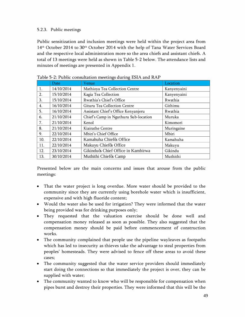
49
5.2.3. Public meetings Public sensitization and inclusion meetings were held within the project area from 14th October 2014 to 30th October 2014 with the help of Tana Water Services Board and the respective local administration more so the area chiefs and assistant chiefs. A total of 13 meetings were held as shown in Table 5-2 below. The attendance lists and minutes of meetings are presented in Appendix 1. Table 5-2: Public consultation meetings during ESIA and RAP
Date Venue Location 1. 14/10/2014 Mathioya Tea Collection Centre Kanyenyaini 2. 15/10/2014 Kagia Tea Collection Kanyenyaini 3. 15/10/2014 Rwathia’s Chief’s Office Rwathia 4. 16/10/2014 Gituru Tea Collection Centre Githimu 5. 16/10/2014 Assistant Chief’s Office Kenyanjeru Rwathia 6. 21/10/2014 Chief’s Camp in Nguthuru Sub-location Muruka 7. 21/10/2014 Kenol Kimomori 8. 21/10/2014 Kiairathe Centre Muringaine 9. 22/10/2014 Mbiri’s Chief Office Mbiri 10. 22/10/2014 Kamahuha Chief’s Office Kamahuha 11. 22/10/2014 Makuyu Chief’s Office Makuyu 12. 23/10/2014 Gikindu’s Chief Office in Kambirwa Gikindu 13. 30/10/2014 Muthithi Chief’s Camp Muthithi
Presented below are the main concerns and issues that arouse from the public meetings: • That the water project is long overdue. More water should be provided to the
community since they are currently using borehole water which is insufficient, expensive and with high fluoride content;
• Would the water also be used for irrigation? They were informed that the water being provided was for drinking purposes only;
• They requested that the valuation exercise should be done well and compensation money released as soon as possible. They also suggested that the compensation money should be paid before commencement of construction works.
• The community complained that people use the pipeline wayleaves as footpaths which has led to insecurity as thieves take the advantage to steal properties from peoples’ homesteads. They were advised to fence off these areas to avoid these cases;
• The community suggested that the water service providers should immediately start doing the connections so that immediately the project is over, they can be supplied with water;
• The community wanted to know who will be responsible for compensation when pipes burst and destroy their properties. They were informed that this will be the
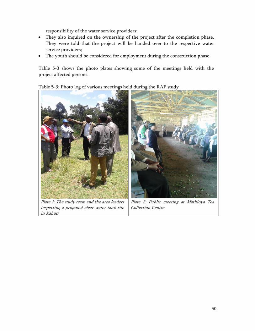
50
responsibility of the water service providers; • They also inquired on the ownership of the project after the completion phase.
They were told that the project will be handed over to the respective water service providers;
• The youth should be considered for employment during the construction phase. Table 5-3 shows the photo plates showing some of the meetings held with the project affected persons. Table 5-3: Photo log of various meetings held during the RAP study
Plate 1: The study team and the area leaders inspecting a proposed clear water tank site in Kahuti
Plate 2: Public meeting at Mathioya Tea Collection Centre
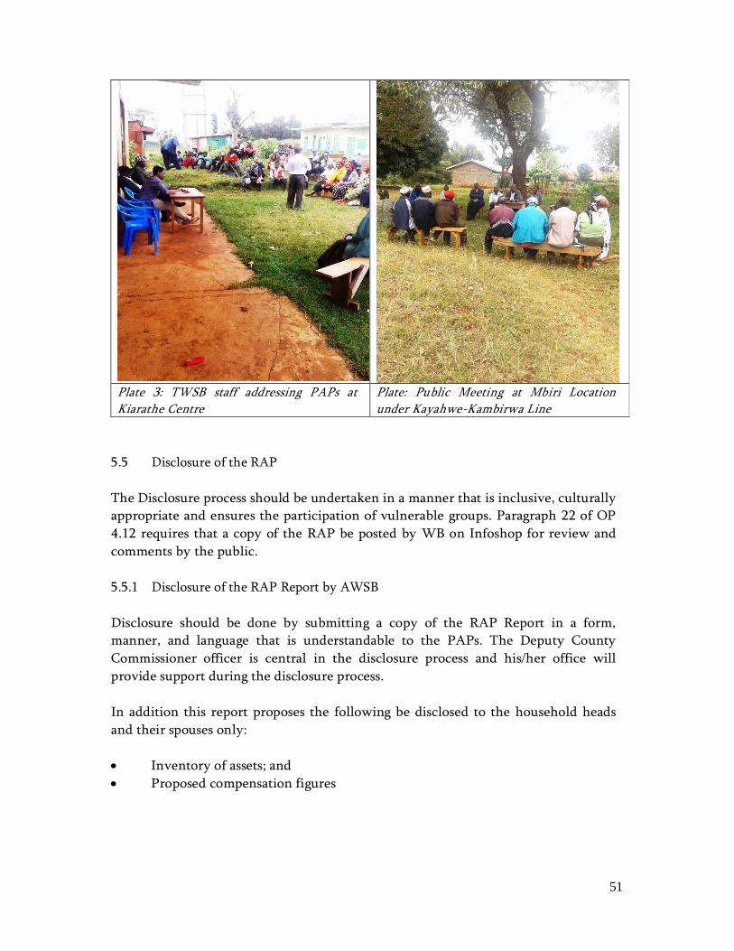
51
Plate 3: TWSB staff addressing PAPs at Kiarathe Centre
Plate: Public Meeting at Mbiri Location under Kayahwe-Kambirwa Line
5.5 Disclosure of the RAP The Disclosure process should be undertaken in a manner that is inclusive, culturally appropriate and ensures the participation of vulnerable groups. Paragraph 22 of OP 4.12 requires that a copy of the RAP be posted by WB on Infoshop for review and comments by the public. 5.5.1 Disclosure of the RAP Report by AWSB Disclosure should be done by submitting a copy of the RAP Report in a form, manner, and language that is understandable to the PAPs. The Deputy County Commissioner officer is central in the disclosure process and his/her office will provide support during the disclosure process. In addition this report proposes the following be disclosed to the household heads and their spouses only: • Inventory of assets; and • Proposed compensation figures

52
6.0 IMPACTS OF THE PROJECT 6.1 Introduction The project may have a negative impact to persons living along the proposed water pipelines in terms of loss of assets, source of livelihoods/ revenue and disruption of services in the project area. It is therefore imperative that the OP 4.12 triggered by this project be followed to the letter during the compensation process. 6.2 Eligibility Criteria for Compensation and Resettlement PAPs eligible for resettlement and compensation were determined as per World Bank Policy on Involuntary Resettlement (O.P. 4.12). The policy provides guidelines which categorizes PAPs that are eligible for compensation as follows:
I. Those who have formal legal rights to land (including customary and traditional rights recognized under the laws of the country);
II. Those who do not have formal legal rights to land at the time the census
begins but have a claim to such land or assets provided that such claims are recognized under the laws of the country or become recognized through a process identified in the resettlement plan;
III. Those who have no recognizable legal right or claim to the land they are
occupying. Persons covered under (I) and (II) are provided compensation for the land they lose, and other assistance. Persons covered under (III) are provided resettlement assistance in lieu of compensation for the land they occupy, and other assistance, as necessary, if they occupy the project area prior to a cut-off date established at the beginning of the study. Persons who encroach on the area after the cut-off date are not entitled to compensation or any other form of resettlement assistance. The basis of the enumeration, valuation, and compensation within this report is therefore based on the World Bank Policy

53
6.3 Project Impacts Some of the anticipated project impacts include: • Loss of land; • Loss of structures; • Loss of crops, trees and vegetation cover; and • Impact on public infrastructure. 6.3.1 Loss of land The proposed project will have minimal impact on land due to the fact that there will be limited acquisition of land from PAPs, most of the water pipelines pass through river riparian and road reserves, however easement will be acquired where the water pipeline is laid in peoples farms. This includes pipelines within Rwathia – Mukangu, Kayahwe – Kambirwa and Kiriciungu. Adequate compensation has been allowed to the persons who will surrender the easement for the project. Recommendation • Adequate compensation for the land to be affected by the project. 6.3.2 Loss of structures A total of 3 structures i.e. two houses and a goat pen are expected to be affected by the proposed water project. The structures are within Kayahwe-Kambirwa pipeline. Recommendation • Compensation at Full Replacement Cost for the affected structures before
commencement of works within the section in question; • Provision of a three month notice to structure owners after payment of
compensation to relocate their structures; • Provision of a notice of two months to tenants before the demolition exercise
so as to source for alternative rental units; • Provision of opportunity to salvage the remains from demolition of the PAPs
structures. 6.3.3 Loss of crops, trees and vegetation cover The crops, trees and other vegetation cover grown along the proposed water pipeline route are expected to be affected by the project. The major crop to be affected is tea which is predominant in the area. Trees include eucalyptus and fruit trees such as avocado and bananas.

54
Recommendation • Compensation at the current market value for the affected trees and crops
before commencement of works. 6.3.4 Impact on public infrastructure The Project’s land acquisition will result in the loss of a number of public assets. These public assets play an important role in the community and their loss will be felt. Water, power and roads are expected to be affected by the water pipelines. Water service lines run the risk of water contamination should the water lines be broken exposing the water to pathogens. Affected power lines pose a danger to the people working on the project and those living nearby thus the relocation of the power lines should carried solely by Kenya Power. The roads within the project area may be affected as some pipelines may cut across or move along the existing roads. This may cause some inconveniences to the public during the construction phase. Recommendation • Relocation of the power lines should be done by Kenya Power to ensure it does
not pose a safety hazard; • Notice should be given to all beneficiaries of public utilities to allow them to
plan for the disruptions; • The Bills of quantity (BoQ) for the project should include provisional sum for
reestablishment of these services to the existing beneficiaries; • Reestablishment of all these services should be done with constant
communication and involvement of the service providers; • The existing utilities should not be decommissioned until the new pipelines are
established and connected to the existing system.

55
6.4 RAP implementation budget The total compensation budget is as shown in Table 6-1. Table 6-1: RAP budget
Pipeline Location Number of PAPs Amount (Ksh)
Rwathia – Mukangu Pipeline
Kenyanyeini – Gitugu 43 1,223,072
Rwathia 78 4,535,890
Kiairathe 97 3,285,321
Kenyanjeru 26 1,614,341
Kanorero – Gakira - Gitweku 84 8,049,503
Sub-total 328 18,708,127
Kiriciungu
Kiriciungu Pipeline 18 2,407,718
Kiriciungu Treatment Plant 4 2,972,521
Sub-total 22 5,380,239
Kayahwe – Kambirwa Pipeline
Kayahwe 105 8,196,548
BPTs (Tank Sites)
6 BPTs 6 1,776,116
Total 461 34,061,030
Miscellaneous 5% of compensation cost 1,703,052
Grand Total 35,764,082
6.4.1 Administrative Costs for Implementing the RAP Annual budgetary arrangements should be made for the running of the various arms of the implementation committee. Budgetary arrangements should include the following: • Resettlement staff salaries and benefits; • Office capital investment costs and running expenses; • Implementation Committee capacity building, especially for community
representatives; • Logistical costs for travel to meetings and field visits to both the departure and
receiving sites. These costs include, fuel costs for staff, and logistical costs for inclusion of implementation committee members and the independent evaluation panel;
• Resettlement preparation costs;
56
• Public participation costs for activities such as social surveys, public meetings, interest group meetings and / or workshops etc;
• Logistical costs for grievance handling and resolution; • Financial auditing costs; • Monitoring and Evaluation costs; • Allowance for land adjudication, survey, and subdivision for the affected land
parcels whose ownership instruments are outdated.
57
7.0 INSTITUTIONAL ARRANGEMENTS 7.1 Overview In the implementation of the RAP, a cross organizational approach will be adopted. This will be to ensure smooth implementation and division of roles in line with organizational mandate. Institutions identified and their respective mandates are as presented in Table 7-1 below: Table 7-1: Identified Institutions
Institution Responsibility Athi Water Services Board Facilitation and Implementation of the RAP report County Government of Murang’a Facilitation of the RAP report and assisting in
verification of claims National Government Administration Assisting in verification of claims and provision of
security during payment of compensation. 7.2 Athi Water Services Board Athi Water is one of the eight Water Boards under the Ministry of Environment, Water and Natural Resources created to bring about efficiency, economy and sustainability in the provision of water and sewerage services in Kenya. The roles and responsibilities of AWSB will include but not be limited to the following: • Payment of cash compensation to PAPs; • Check on the compliance of the procurement procedures in relation to Kenyan
Laws; • Co-ordination of stakeholder participation; • Management and monitoring of payment of compensation; • Preparation of internal monthly audit reports. In undertaking the above, AWSB will be responsible for implementing compensation activities and it will therefore be its responsibility to undertake regular internal monitoring of the process. The objectives of internal monitoring and evaluation will be: • To ensure that the compensation process is implemented with utmost
transparency; • To verify that funds for implementation of the RAP are provided in a timely
manner and in amounts sufficient for their purposes. The Internal monitoring process should entail the following regarding the process: • Accomplishment to-date;

58
• Objectives attained and not attained during the period; • Problems encountered, and; • Suggested options for corrective actions. The monitoring and evaluation of the RAP will be done against the indicators presented in Table 7-2. Table 7-2: Monitoring and Evaluation Indicators
Process Indicators Project input, public participation and monitoring
Setting up of Compensation unit Start and progress disclosure and consultation events Formation of Grievance Resolution Committee Monitoring reports
Output indicators Delivery of entitlements Number of households compensated and assisted
Amount of compensation disbursed Impact Indicators Long term impacts Changes in housing.
Changes in water and sanitation. Changes in land holding. Changes in occupation. Changes in income and expenditure. Pace of income against change in expenditure. Changes in vulnerable households and women headed households
7.3 County Government of Murang’a The County Government of Murang’a will be tasked with the job of: • Verifying ownership documents; • Ensure that there is no further encroachment on the wayleave after the cut-off
date; • Member of RAP Implementation Committee (RAPIC); • Disclosure of the Valuation report; • Facilitation of election of PAP representatives. 7.4 National Government Administration The current administrative framework for the national government starts with the County Commissioner to the Assistant Chief. Below is the breakdown of levels of administration is as follows. • County Commissioner Head of Counties;
59
• Deputy County Commissioner Head of Sub-County; • Assistant County Commissioner Head of Division; • Chief Head of Location; • Assistant Chief Head of Sub Location; • Village Elders Operate under Chief and Assistant
Chiefs within villages. The roles of the Assistant County Commissioner in the implementation of this report are: • Co-ordinating and mobilizing identified departments at County level to
participate in the implementation of the RAP report especially the Chiefs; • Provision of security during implementation of the RAP; • Disclosure of the Valuation report; • Facilitation of election of PAP representatives The Chief and Assistant Chiefs will be responsible for the following: • Initial verification of ownership claims at the village level in liaison with
AWSB before confirmation by County Land Officials i.e. County Lands Officer and County Surveyor;
• Certification of agreements between land owners and family members with regards to the compensation exercise;
• Verification of sale and resolution of grievances for cases where land parcels were sold without a written sale agreement to facilitate compensation;
• Organising public sensitization and mobilization drives during disclosure by AWSB and compensation;
• Participating in dispute resolution. 7.5 PAP Representatives These are persons in the RAPIC to represent the PAPs. PAP representatives from the community should be elected by PAPs to represent them in the RAPIC. The roles of a PAP representative are to: • Collect views of the PAPS and present them to the RAPIC; • Help in confirmation of the asset inventory; • Debrief the PAPs on deliberations of the RAPIC; • Coordinate the payment of the compensation.

60
7.6 Grievance Mechanisms 7.6.1 General Information Grievance mechanisms are important to the resettlement process as they allow for RAP implementers to identify disputes in good time and allow for them to be resolved in a transparent and accountable manner. A well established and validated grievance mechanism can also promote good relations between the project proponent and the affected community thus reducing the risk of hostilities and delays on the construction program, both before and after the contractor takes possession of the site. Compensation based disputes are also likely to occur during and after the RAP implementation program, hence it is critical to establish this system prior to implementation of the resettlement program. Section 4 (2) (h) of the Land Act 2012 on the guiding values and principles under the Act is on “encouragement of communities to settle land disputes through recognized local community initiatives”. The grievance mechanism proposed under this RAP aims at incorporation of a locally based grievance mechanism. 7.6.2 Expected Grievances Considering the nature of resettlement and as informed by the findings of the field studies, the type of grievances that may arise include: • Grievances between two PAPs from the same family (nuclear and extended); • Grievance between two PAPs from different families; • Grievance between PAPs and the RAP implementers; • Grievance between PAPs and AWSB or the County Government of Murang’a
with regard to land ownership and the related instruments. Grievances between PAPs may occur when there is a dispute over land and asset ownership. They may also occur over the receipt or use of compensation payment. Such cases may arise between neighbours, siblings or spouses. These kinds of disputes are best resolved at the local level to avoid time delays that may arise if people move to court. It would also help to manage the risk of loss of social capital due to bad relationships among family members and neighbours. Grievances between PAPs and RAP implementers may arise if PAPs feel they are not adequately involved in the implementation process. Lack of perceived
61
transparency may lead to feelings of mistrust and misinformed judgments on both sides. Some PAPs may also feel that the proposed compensation is not equal to their initial investment or just based on their current situation. Such grievances may require calls for witnesses, unbiased parties or technical evaluations prior to proposing a solution. Local mechanisms may not have the capacity to meet all these requirements and would therefore require some form of support. Some grievances may also occur that are outside of the direct control of the RAPIC and would require intervention at national or county policy level. These include disputes that require policy interpretation or investigations prior to a conclusive resolution. In such cases, the RAPIC may require legal interpretation on certain aspects. 7.6.3 Proposed Grievance Mechanism The following grievance mechanism is proposed for the implementation of this RAP: a) Level One: Local Committee A Local Grievance Committee constituted of the following members will be formed at the local level: • Chairman: Area Chief • Secretary: Village Elder • Members: three PAP representatives consisting of a man, a woman and a youth
(18 to 30 years). This committee will sit at the Chiefs office. The following procedure is proposed: • A PAP registers a grievance and within one working day, the committee
members are alerted of the case; • The affected person is immediately informed of the next date of the scheduled
hearing. Depending on the case load, a maximum of 7 working days should be given between the date that a case is recorded and the date when the hearing is held;
• The committee meets once every seven calendar days to deal with emerging cases. At these meetings, hearings with the affected persons and related witnesses will be held;
• The committee will communicate its judgement to the affected persons within 3 working days;
62
• If no resolution is met or the PAP is not satisfied with the judgement, the case is moved to the next level by the committee. This will be done within 5 working days of the hearing.
b) Level Two: Project Committee A Project Level Committee constituted of the following members will be formed at the local level: • Chairman: Chief Executive Lands Housing and Urban Development; • Secretary: Deputy County Commissioner (DCC); • Representative from AWSB; • Representative from Water Service Provider; • Members: three PAP representatives consisting of a man, a woman and a
youth. This committee will sit once a month at the County Government Office. The following procedure is proposed: • A grievance is logged at the County Government Office and within five
working days, a notice is sent out to all the interested parties informing them of the date of the hearing;
• A hearing will then be held within thirty days of the grievance being raised; • In the event that investigations and technical witnesses are required, a
maximum of thirty (30) calendar days will be taken prior to a hearing being held;
• The committees decision will be communicated in writing within 5 working days of the date of the hearing;
• If the committee does not resolve an issue, the affected persons are free to go to the Land and Environment Court.
A flow chart of this process is presented in Figure 7-1 overleaf.
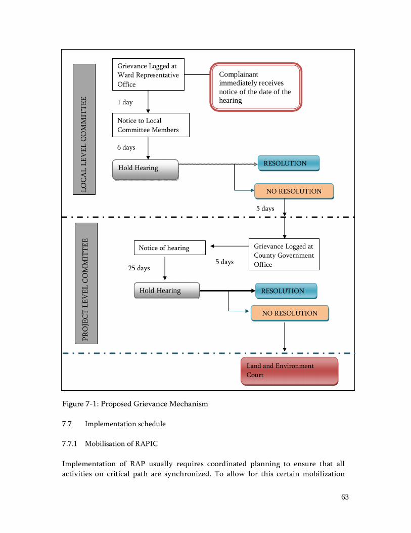
63
Figure 7-1: Proposed Grievance Mechanism 7.7 Implementation schedule 7.7.1 Mobilisation of RAPIC Implementation of RAP usually requires coordinated planning to ensure that all activities on critical path are synchronized. To allow for this certain mobilization
Grievance Logged at Ward Representative Office
Complainant immediately receives notice of the date of the hearing
Notice to Local Committee Members
1 day
6 days
Hold Hearing RESOLUTION
LOCA
L LE
VEL
CO
MM
ITTE
E
NO RESOLUTION
5 days
Notice of hearing Grievance Logged at County Government Office
NO RESOLUTION
5 days
Hold Hearing
25 days
RESOLUTION
PRO
JECT
LEV
EL C
OM
MIT
TEE
Land and Environment Court
64
activities have to be conducted before compensation can be paid thus allowing for relocation of persons and clearance of the wayleave for the contractor. Disclosure activities should also occur prior to signing of any agreements with PAPs thus promoting the principle of “prior informed consultations / consent”. This RAP already proposes disclosure mechanisms as outlined in chapter 5 of this report. Prior community sensitization and awareness is also aimed at smoothing the process of vacating the right of way on timely manner to allow subsequent stages of the project. As such the following mobilisation activities should take place: • Sensitization of the PAPs; • Disclosure of RAP study findings; • Election of PAP representatives; • Constitution of a RAPIC including writing of appointment letters with clear
terms of reference for every RAPIC member; • Establishment and institution of a grievance mechanism including writing of
appointment letters with clear terms of reference for every member; • Determination of administrative costs for RAP implementation; • Determination of an allocation plan to allow for smooth cash flow throughout
the RAP implementation process. This is likely to require coordination within the higher levels of National and County Government;
• Confirmation of the RAP implementation schedule with requisite timelines as informed by all the mobilisation activities outlined above;
• Design and institution of an M and E programme. 7.7.2 Compensation and relocation The following activities shall be carried out during this Phase: • AWSB draws up offer documents for PAPs; • Solving of grievances; • Conduct of monitoring and evaluation; • Serving of notices to move; • Payment of compensation; • Closedown audit. All of the activities above may commence but not be concluded until all the grievances are solved. However there are those activities that are on critical path and therefore cannot occur in good time unless well planned for. For example, notices to move should only be done when agreements have been made with majority if not all of the PAPs. There may also be some activities that are affected whenever the pipeline is
65
realigned or redesigned. In such a case, the RAPIC would be called upon to re-evaluate. This will require an update of the RAP report. Should such a case happen as a minimum, the following have to be done at PAP unit level: • PAP sensitization; • Preparation of a land and asset form; • Valuation of affected assets; and • Signing of agreements with the PAPs An outline of the proposed implementation schedule is as presented in Table 7-3 overleaf.

66
Table 7-3: RAP Implementation schedule Activity Duration in Months
1 2 3 4 5 6 Duration in weeks
1 2 3 4 1 2 3 4 1 2 3 4 1 2 3 4 1 2 3 4 1 2 3 4 Mobilization 1. Sensitization of the PAPs;
2. Disclosure of RAP study findings;
3. Election of PAP representatives;
4. Constitution of a RAPIC
5. Establishment and institution of a grievance mechanism
6. Determination of administrative costs for RAP implementation;
7. Determination of an allocation plan
8. Confirmation of an RAP implementation schedule
9. Design and institution of an M and E programme.
Compensation 10. AWSB draws up offer documents for PAPs;
11. Solving of grievances; 12. Conduct M and E;
13. Serving of notices to move;
14. Payment of compensation; 15. Closedown audit. Close down audit will be undertaken at the at 15 months since the project construction period is 18 months

67
8.0 MONITORING AND EVALUATION 8.1 RAP Monitoring Framework To adhere to OP 4.12, the Project will be required to monitor and report on the effectiveness of RAP implementation, including the disbursement of compensation, the effectiveness of public consultation and participation activities and the sustainability of the Project’s livelihood restoration and development efforts. Inspections and audits will be used, where relevant, to verify compliance and progress toward the desired outcomes. Qualified and experienced external experts will be retained to verify the Project’s monitoring information. Finally, the Project will document monitoring results, implement corrective and preventive actions where necessary and follow up on these actions to ensure their effectiveness. Monitoring and Evaluation (M&E) involves the development of a system through which information regarding resettlement activities of PAPs is analyzed by the implementing agency or other tasked independent monitors to ensure objectivity and success of the whole RAP process. The RAP monitoring helps to evaluate the success of resettlement through the study of specific performance indicators for a reasonable period of time after the resettlement activities have been completed. This process is also important in gauging the implementation of the mitigation measures for potential negative impacts highlighted in the environmental management plan (EMP) in the ESIA Report prepared for this project. The process is important in measuring project inputs, outputs and outcomes of resettlement activities and for evaluating resultant resettlement impacts. The RAP will develop a monitoring plan which will include both internal and external monitoring. A resettlement framework with performance indicators will be developed to help in monitoring the RAP process. The monitoring framework will also offer a schedule on which monitoring will be conducted and this will run for a minimum of six months after completion of the RAP process. The RAP team will work closely with the external monitoring independent resettlement specialist. The monitoring and evaluation process will check to ensure that compensation is done in the right manner and that all eligible PAPs are adequately compensated according to the compensation procedures and market rates. A list of performance indicators which will be tabled include: • Input indicators e.g. sources and amounts of funding for various RAP
activities

68
• Output indicators that concern activities and services which are produced
• Inputs e.g. payment of compensation for loss of property • Public participation indicators e.g. creation of RAPIC 8.2 Project Monitoring Plan Monitoring will be initiated at an early stage in the resettlement process and will continue until the project is commissioned, during this period, the intensity of the process will vary. For example, before and immediately after compensation, monitoring will be fairly intense, while one year later the frequency of the monitoring will have reduced. The Project’s monitoring plan will have two key components; namely: • Performance monitoring; and • Impact monitoring. Performance monitoring and impact monitoring are components of internal monitoring. It is the responsibility of the RAPIC and Resettlement Committee to conduct regular internal monitoring of the resettlement performance indicators and to correct where necessary. The monitoring should be a systematic evaluation of the activities of the operation in relation to the specified criteria of the condition of approval. In undertaking the same, Project Implementation Unit will be responsible for implementing resettlement and compensation activities and it will therefore be their responsibility to undertake regular internal monitoring of the process. The objective of internal monitoring and supervision will be: • To verify that the valuation of assets lost or damaged, and the provision
of compensation, resettlement and other rehabilitation entitlements, has been carried out in accordance with the resettlement policies provided by the Government of Kenya, and World Bank.
• To oversee that the RAP is implemented as designed and approved; • To verify that funds for implementation of the RAP are provided by the
Project authorities in a timely manner and in amounts sufficient for their purposes, and that such funds are used in accordance with the provisions of the RAP. The main internal indicators which will be monitored regularly will include:
o Entitlements monitoring-This evaluates the status of entitlement and ensures that they are in accordance with the approved policy

69
and that the assessment of compensation is carried out in accordance with agreed procedures;
o Payment of compensation to the PAPs in the various categories is made in accordance with the level of compensation described in the RAP;
o Public information and public consultation and grievance procedures are followed as described in the RAP;
o Restoration of affected public facilities and infrastructure are completed prior to construction.
70
9.0 CONCLUSION AND RECOMMENDATIONS 9.1 Conclusion This study findings show that the proposed Murang’a Water Supply Project is likely to impact approximately 461 persons and as such, this RAP was prepared as a plan to mitigate the impacts of resettlement. The study also proposes that collaboration between AWSB, National Government Administration and Murang’a County Government staff would be adequate to implement the proposals under this RAP. The overall objective of the project is good and its positive impacts can be enhanced by ensuring that the identified PAPs are adequately compensated with the aim of improving their livelihoods or restoring their livelihoods to the pre-impact standards. 9.2 Recommendations In a bid to reduce project impacts that will directly affect project sustainability it is recommended that: • The pipeline route should be earmarked on the edge of the road reserve
only after confirmation of the actual road reserve and its availability to avoid future unwanted inconveniences during project implementation or maintenance of the road.
• The route should also avoid structures as much as possible. • Confirmation with the County land offices will be done before the final
compensation. • The community should be fully involved and integrated in the
management and planning of the project to make them own the whole process.
LIST OF APPENCICES
Appendix 1: Minutes of Meetings and Attendance List Appendix 2: Stakeholder Consultation List

Appendix 1: Minutes of Meetings and Attendance List

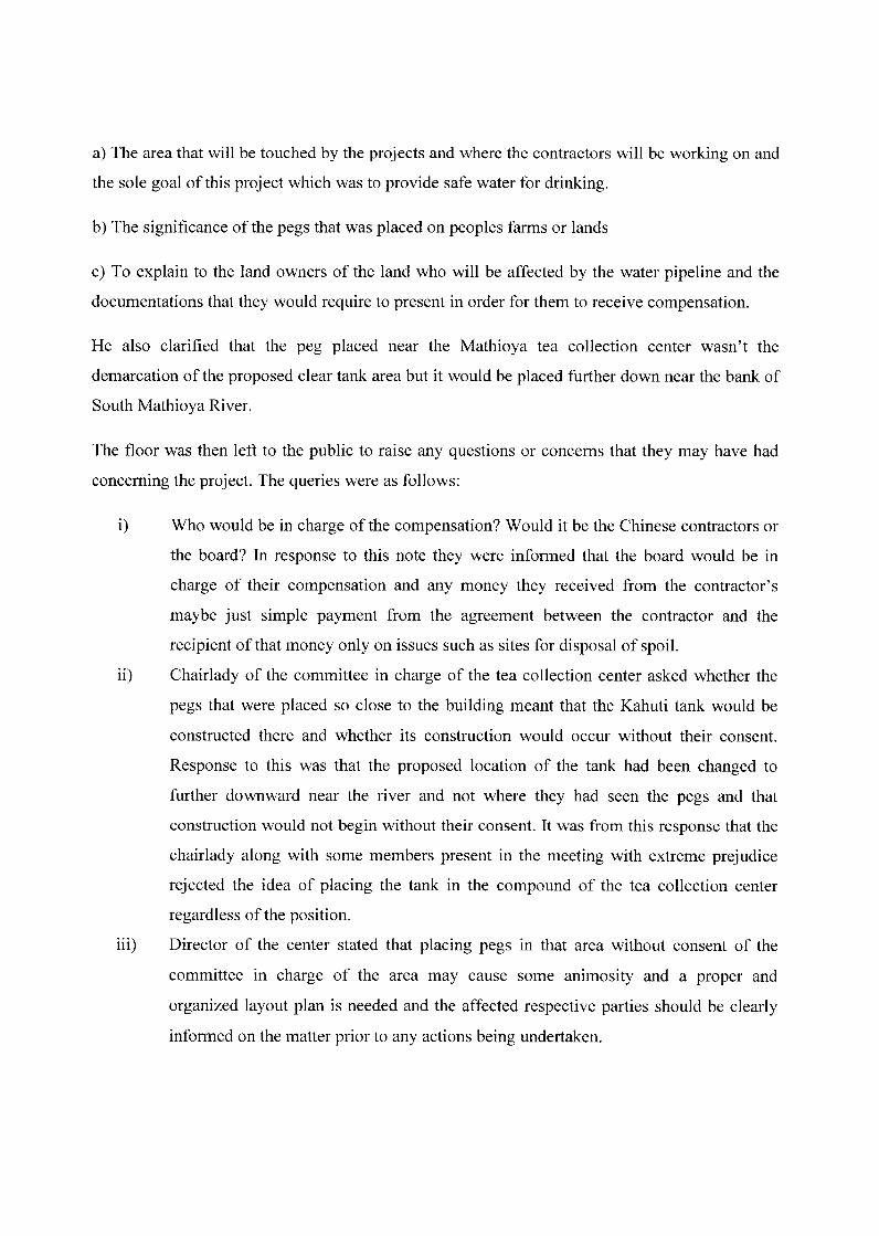
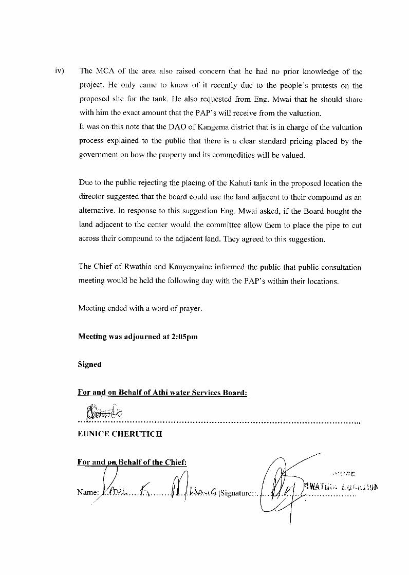
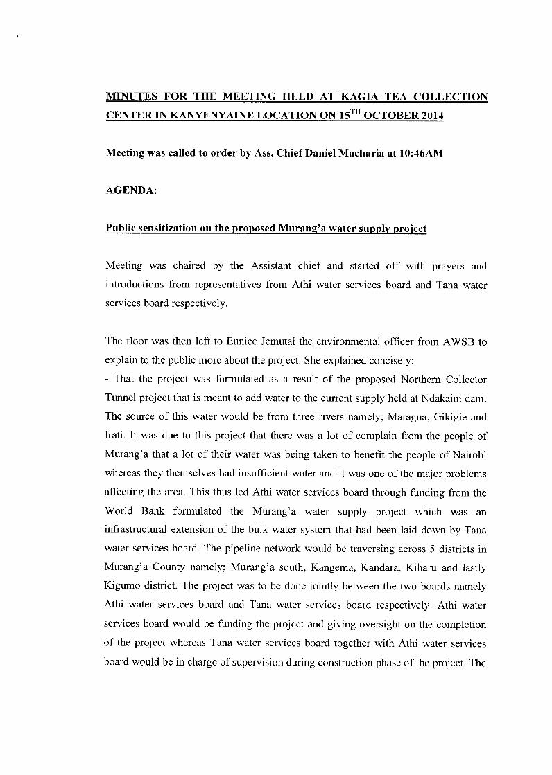


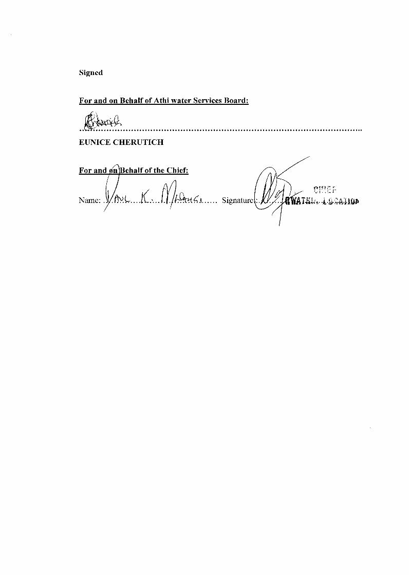

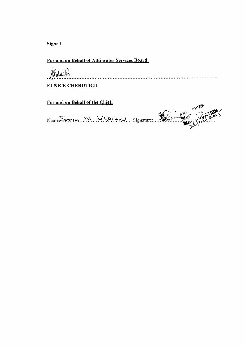


Appendix 2: Stakeholder Consultation List