inadvertent discovery of an underground culvert, city of
TRANSCRIPT

Volume 2015 Article 105
2015
Inadvertent Discovery of an Underground Culvert, City of Seguin, Inadvertent Discovery of an Underground Culvert, City of Seguin,
Guadalupe County, Texas Guadalupe County, Texas
Paul M. Matchen
Follow this and additional works at: https://scholarworks.sfasu.edu/ita
Part of the American Material Culture Commons, Archaeological Anthropology Commons,
Environmental Studies Commons, Other American Studies Commons, Other Arts and Humanities
Commons, Other History of Art, Architecture, and Archaeology Commons, and the United States History
Commons
Tell us how this article helped you.
This Article is brought to you for free and open access by the Center for Regional Heritage Research at SFA ScholarWorks. It has been accepted for inclusion in Index of Texas Archaeology: Open Access Gray Literature from the Lone Star State by an authorized editor of SFA ScholarWorks. For more information, please contact [email protected].

Inadvertent Discovery of an Underground Culvert, City of Seguin, Guadalupe Inadvertent Discovery of an Underground Culvert, City of Seguin, Guadalupe County, Texas County, Texas
Creative Commons License Creative Commons License
This work is licensed under a Creative Commons Attribution 4.0 International License.
This article is available in Index of Texas Archaeology: Open Access Gray Literature from the Lone Star State: https://scholarworks.sfasu.edu/ita/vol2015/iss1/105

Inadvertent Discovery of an Underground Culvert,
City of Seguin, Guadalupe County, Texas
By:
Paul M. Matchen
with contributions by:
S. Elizabeth Valenzuela
Prepared for:
City of Seguin
205 North River Street
Seguin, Texas 78155
Prepared by:
TRC Environmental Corporation
505 East Huntland Drive, Suite 250
Austin, Texas 78752


Inadvertent Discovery of an Underground Culvert City of Seguin, Guadalupe County, Texas
By:
Paul M. Matchen
with contributions by:
S. Elizabeth Valenzuela
Prepared for:
City of Seguin 205 North River Street
Seguin, Texas 78155
Prepared by:
TRC Environmental Corporation 505 East Huntland Drive, Suite 250
Austin, Texas 78752
Paul M. Matchen, Principal Investigator TRC Technical Report No. 180854.3
Antiquities Permit #7251
August 2015


Inadvertent Discovery of an Underground Culvert
Technical Report No. 180854.3 iii
EXECUTIVE SUMMARY
In May 2012, the City of Seguin (City) proposed to undertake street improvements, which included the
replacement of water, sewer, and storm sewer lines including installation of four discharge structures
replacing existing structures. This project was to be funded entirely by the City. In order to meet its legal
responsibilities under existing state guidelines, including the Antiquities Code of Texas 1977 [revised
1987], Title 9, Chapter 191, VACS, Art. 6145-9, the City conducted a cultural resources file search for the
proposed APE. This project was also permitted under a United States Army Corps of Engineers (USACE)
Nationwide Permit (#12—Utility Installation). As such, any cultural resource efforts fall under Section 106
guidelines of the National Historic Preservation Act. A cultural resources site file search was performed
by TRC for the project APE in 2012. A THC consultation letter was submitted on May 18, 2012. TRC
received a response from THC (No Survey Required. Project May Proceed.) on June 15, 2012.
On February 10, 2015, City of Seguin (City) encountered a previously unknown underground drainage
structure within this project area during the construction a new 6x6 ft. box culvert under Court Street/U.S.
Highway 90 Alternate approximately 250 ft. east of the intersection of Bauer St. and E. Court St. in Seguin,
TX. The structure was made of limestone conglomerate rubble and transitioned to hand-made brick on
both ends. The location is approximately 300 ft. west of the recorded site 41GU30 – Grafenstein Site (a
prehistoric lithic scatter) – which is plotted on the west bank of King’s Branch. Upon discovery, the City
stopped work immediately and contacted TRC cultural resources staff to contact Texas Historical
Commission (THC) on what steps should be taken in regards to this inadvertent discovery.
Jeff Durst and Bill Martin (THC) were contacted on February 11, 2015 to discuss how this resource should
be handled. It was unclear whether this would be treated as a historic structure (THC History Programs) or
an archeological resource (because it was discovered below surface). Skipper Scott (archeologist, United
USACE Fort Worth District) was also contacted as this effort was permitted under USACE jurisdiction.
As the information was being reviewed, news came from the project engineer on February 12, 2015 that
there was potential health and safety hazard as water was seeping into the underground culvert from the
natural springs that fed the drainage. At that time, pumps were able to handle the water seepage but the
future success of this effort was uncertain. We were advised by the engineer that we should visit the project
location within the next day or two to ensure access. After some deliberation, it was decided by both THC
and USACE that the culvert would be considered an archeological issue but would also be reviewed by
THC History Programs.
TRC’s environmental staff visited the project location on February 13, 2015 to examine the structure and
assess the potential impacts as a result of box culvert construction efforts. Given the materials used in its
construction, it was estimated that the structure had been built sometime around late 19th to early 20th
century timeframe. Archival research was performed to investigate structure function and historical
significance. TRC concludes that this structure is most likely a drainage culvert that served to drain local
spring water and collected storm water away from the existing transportation corridor (E. Court street and
the adjacent neighborhood streets). No connections were found to aspects of historical significance (i.e.,
persons, setting, architecture, or historic research value), hence, this structure was deemed not eligible for
nomination to the National Register of Historic Places. Due to safety concerns, the City, upon approval by
the USACE and THC, filled the void with a reversible, flowable fill (i.e., grout) before continuing the box
culvert installation.

City of Seguin, Guadalupe County, Texas
iv Technical Report No. 180854.3
This page intentionally left blank.

Inadvertent Discovery of an Underground Culvert
Technical Report No. 180854.3 v
TABLE OF CONTENTS
Executive Summary ..................................................................................................................................... iii
Table of Contents .......................................................................................................................................... v
List of Appendicies ....................................................................................................................................... v
1.0 Introduction ....................................................................................................................................... 1
2.0 General Structure Description ........................................................................................................... 1
3.0 Impacts .............................................................................................................................................. 2
4.0 Discussion of the Function of the Underground Structure ................................................................ 2
5.0 Conclusion ........................................................................................................................................ 4
LIST OF APPENDICIES
Appendix A: Figures
Appendix B: Letter Report for Site Investigations Summary of Architectural Feature, Court Street
Tunnel, Guadalupe County, Texas, by S. Elizabeth Valenzuela

City of Seguin, Guadalupe County, Texas
vi Technical Report No. 180854.3
This page intentionally left blank.

Inadvertent Discovery of an Underground Culvert
Technical Report No. 180854.3 1
1.0 INTRODUCTION
This report serves as a summary of events, conversations, and views surrounding the discovery of a
subterranean drainage structure (41GU175) by the City of Seguin during box culvert construction along E.
Court Street in Seguin, Texas. Also included is a brief discussion regarding structure age, function, and our
thoughts on the historical information provided by Waldo Troell. Figures referenced within the report are
presented in Appendix A. In addition, TRC Environmental Corporation (TRC) asked S. Elizabeth
Valenzuela (Valenzuela Preservation Studio, LLC) to conduct a field visit and compose a brief synopsis of
the architectural aspects and supporting information based on her observations (Appendix B).
On February 10, 2015, City of Seguin (City) encountered a previously unknown underground drainage
structure while building a new 6x6 ft. box culvert under Court Street/U.S. Highway 90 Alternate
approximately 100 ft. east of the intersection of Bauer St. and E. Court St. in Seguin, TX (Figures 1 and 2).
The tunnel is constructed of limestone conglomerate rubble and transitions to hand-made brick on both
ends. The location is approximately 300 ft. west of the recorded site 41GU30 – the Grafenstein Site (a
prehistoric lithic scatter) – which is plotted on the west bank of King’s Branch. Upon discovery, the City
stopped work immediately and contacted TRC Planning, Permitting, and Licensing staff to contact Texas
Historical Commission (THC) on what steps should be taken in regards to this inadvertent discovery.
This project is permitted under a United States Army Corps of Engineers (USACE) Nationwide Permit
(#12—Utility Installation). As such, any cultural resource efforts fall under Section 106 guidelines of the
National Historic Preservation Act in addition to those under the Antiquities Code of Texas (Section
191.0525). A cultural resources site file search was performed by TRC for the project APE in 2012. A
THC consultation letter was submitted on May 18, 2012. On June 15, 2012,TRC received a response from
THC (No Survey Required. Project May Proceed.).
Jeff Durst and Bill Martin (THC) were contacted on February 11, 2015 to discuss how this resource
(41GU175) should be investigated. It was unclear whether this would be treated as a historic structure (THC
History Programs) or an archeological resource (because it was discovered below surface). Skipper Scott
(archeologist, United USACE Fort Worth District) was also contacted as this effort was permitted under
USACE jurisdiction. As the information was being reviewed, news came from the project engineer on
February 12, 2015 that there was potential health and safety hazard as water was seeping into the
underground culvert from the natural springs that fed the drainage. At that time, pumps were able to handle
the water seepage but the future success of this effort was uncertain. We were advised by the engineer that
we should visit the project location within the next day or two to ensure access. After some deliberation, it
was decided by both THC and USACE that the culvert would be considered an archeological issue but
would also be reviewed by THC History Programs.
2.0 GENERAL STRUCTURE DESCRIPTION
TRC staff, led by Paul M. Matchen, visited the project location on February 13, 2015 to examine the
structure and assess the potential impacts as a result of box culvert construction efforts (Figures 3 through
8). The structure is oriented with overhead arch construction measuring approximately 60 ft. to 70ft in
length and 48 inches in diameter. Each end of the structure is curved at a 30 to 45 degree angle (curving
west on the north end; east on the south end). Each end of the culvert is capped using modern machine-
made brick (Figure 9). The structure was built with a combination of hand-made brick (soft mortar) and

City of Seguin, Guadalupe County, Texas
2 Technical Report No. 180854.3
conglomerate rubble (dry stacked). Specifically, sections of the north and south ends of the tunnel (20 ft.
spans) were constructed with hand-made brick, while the central span (approximately 25 ft. in length) is
constructed of conglomerate rubble (dry stacked). In addition, the south end of the tunnel (approximately
10-15 ft.) was cleaved at some point in the past to accommodate a 4-x-4 ft. concrete box culvert (Figure
10). Given the materials used in its construction we estimated that this structure had been built sometime
around late 19th to early 20th century timeframe.
3.0 IMPACTS
The new box culvert is being installed semi-parallel to the underground culvert. After close examination,
the old culvert (41GU175) appears to be situated between the new culvert footprint and the current drainage
structure, a 48-inch diameter reinforced concrete pipe (RCP), also oriented parallel (Figure 11). Any
impacts to the structure will likely occur on the western wall of the culvert as the close proximity of the
culvert may undermine its structural stability. At the north end of the old culvert, the RCP can be seen
through a hole in the brickwork on the upper arch of east wall the structure (Figure12). Due to safety
concerns, TxDOT has recommended that the City fill the void with "flowable fill" before continuing the
box culvert installation.
Most of this information was communicated to the THC staff as well as to Skipper Scott (archeologist,
United USACE Fort Worth District).
4.0 DISCUSSION OF THE FUNCTION OF THE UNDERGROUND STRUCTURE
After the structure had been examined, there were several discussions over the next week between TRC,
USACE, and THC regarding the function and significance of this structure. Its general appearance and
setting (a transportation corridor that spans a natural drainage) was similar in design/construction to other
bridge culverts observed all over the United States (especially in the Eastern United States) during this
period (later 19thC –early 20th--see references section below). Given this, our initial interpretation was that
it is a historic culvert (most likely built by the City) to direct spring water and storm water from the City.
Information provided via email from Waldo Troell, a TxDOT archeologist and descendent of Seguin
resident, Henry Troell (mill owner, operator, and prominent business man) to other TxDOT staff and later
distributed to City employees suggested that this structure may in fact be part of a mill race that channeled
water to milling locations where water turbines/wheels powered various machinery (e.g., gins, milling
stones, power generators). An excerpt of email communication from Waldo Troell, February 10, 2015,
reads:
“… (I)t is not a culvert, but a mill race (it channeled the water into the water wheel). US
90 Business/ Court Street use to be called Mill Street due to the mills located on this road.
A check of the site atlas shows the recorded site 41GU30, Grafenstein mill located adjacent
to this tunnel. This is interesting to me as my Great-Great-Grandfather Heinrich (Henry)
Troell built this mill around 1874 (140 years ago).
He sold this mill around 1878 or 1879 to build larger mills elsewhere in Seguin.
Eventual(ly) Grafenstein purchased this mill in the 1880's and it became known as the
Grafenstein Mill. Some information is known about Henry's later lager (sic) industrial mills
(equipment used and barrels produced per day) but little is known about this first one which
Inadvertent Discovery of an Underground Culvert
Technical Report No. 180854.3 3
was the type of small grist mills built from1850-1880. When he sold the corn and wheat
mill it also consisted of a cotton gin and a press saw mill that I assume all were powered
by the water wheel.
While historical accounts seldom mention the wife's role, it is recorded that during the
harvest season that Henry's wife Johanna Woehler Troell would take a shift to run the mill
operation so it could function 24 hours a day.
The tunnel construction is interesting as one could probably determine the Seguin brick
maker (I think there were three operating at different times (several hand-made brick
makers 1850'-1880s, and one manufactured brickmaker-1890's to 20th century). The rock
construction does not appear to be German mason work, but it is recorded that Henry
sometimes employed African Americans for mason construction, so if may be a southern
mason type of work.”
Waldo Troell also provided THC with excerpts from a family history publication focusing on the Henry
Troell Family that outlined the construction and general location of at least four milling operations from
the 1870s through the early 1900s (Hardy 1995) in Seguin. TRC reviewed this information and used it as
the basis for corroborating the Troell Mill locations and investigating any direct linkage of the old culvert
to these milling operations.
In general, TRC was able to find supporting documentation through historical research (Sanborn Maps,
GLO maps, and historical photographs) of the location and operation of four milling operations.
Henry Troell’s 1st mill was situated on River lots 2 and 3 located in block 60 in the Seguin. These lots
were purchased in 1873 and 1870 respectively). Troell also built his residence, a concrete house at the
south end of Cherry Street overlooking the River and his grist mill operation (Seguin Map 1839). Although
TRC was unable to locate any maps showing the location of this grist mill, Hardy states that the mill was
located on the Guadalupe River at the foot (southern end) of Cherry Street (3:1995). When his interests
were partially sold in 1878, it they included a cotton gin and press saw mill, corn and wheat mill. This mill
was eventually sold to the Grafenstein family, and referred to as Grafenstein Mill thereafter.
Cherry Street ends short of the Guadalupe River approximately 3 city blocks or 2000 ft. (a little over a 1/3
mile) southeast from the discovered culvert. Because this mill was situated on the Guadalupe River, there
was little need for additional water to be channeled to turbine/wheels from higher elevations thousands of
feet away.
Henry Troell’s 2nd mill was originally built and operated by the Saffold Family, but was purchased by
Troell from Thad B. Miller in 1879. This property (4 2/3 acres) located next to the Miller Bridge, an iron
truss bridge, included a grist mill and cotton gin (Figure 13; Hardy 7:1995). Over the years, Troell added
electric power generating components to the operation through the early 1900s (Hardy 9:1995). He
eventually sold it to the City in 1907. TRC was able to locate this mill/power plant on multiple Sanborn
Maps. Figure 14 shows the mill, Seguin Electric Light and Water Company’s Power Plant, drawn on the
1916 Seguin Sanborn Map. It notes the location as 1 ½ miles south of the courthouse, which is near the
southern end of Guadalupe Street. This mill powering two water wheels was situated on the River and had
water diverted to it with help of a dam that Troell engineered at that location. As above, there is little need
supplementary water source in the form of a mill race given its proximity to the Guadalupe River.

City of Seguin, Guadalupe County, Texas
4 Technical Report No. 180854.3
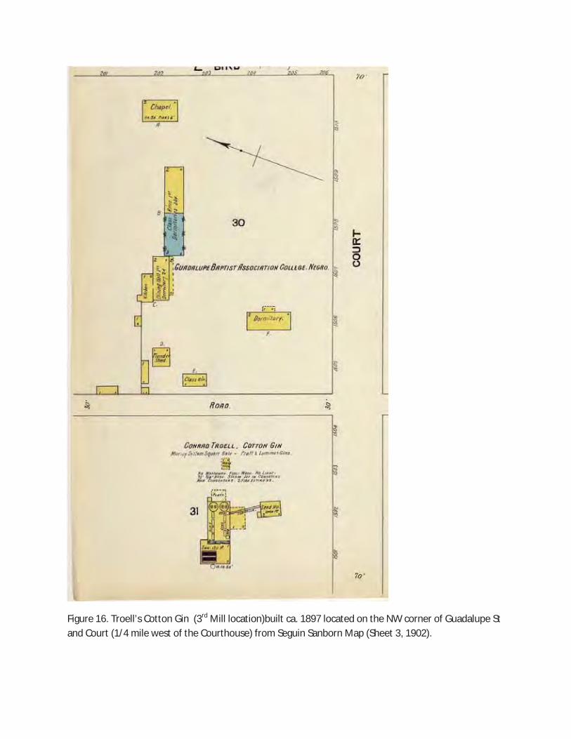
Henry Troell’s 3rd mill, a cotton gin, was built between 1897 and 1898 at the corner of Guadalupe and
Court Streets, approximately ¼ mile west of the courthouse (i.e., 3/4 mile west of the discovered culvert).
Hardy’s publication (7:1995) includes a map (41:1995) plotting the mill on the northeast corner of this
intersection, but the 1902 Seguin Sanborn map (Sheet 3) shows Troell’s Cotton Gin on the northwest lot
and the Seguin Baptist Association College on the northeast corner (Figure 15). This mill was powered by
steam engine (as noted in the 1902 Sanborn Map), which was common by the early 20th century. Thus,
there was little need for a mill race.
Henry Troell’s 4th mill was situated 3.5 miles west of Seguin in the area of Erskine’s Ferry on the
Guadalupe River. This mill was established in 1902 with business partner, Edgar Nolte, and called Seguin
Milling and Power Company (Hardy 9:1995). It prospered for many years after Troell’s retirement in 1907
and death in 1921 (Figure 16).
TRC found no historic maps that show either the location of a mill at Bauer and E. Court St. or the existence
of this drainage structure. However, on both the 1930 and 1945 Seguin Sanborn Maps, a concrete bridge is
shown in the location of the tunnel (See Valenzuela attachment). This bridge does not show up on the 1924
Sanborn map. It is likely that the box culvert modification observed at the southern end of the old culvert
during the TRC field visit is associated with the construction of this concrete bridge between 1924 and
1930.
5.0 CONCLUSION
These cultural resources investigations were being conducted in fulfillment of requirements under existing
state guidelines (Antiquities Code of Texas of 1977 [revised 1987], Title 9, Chapter 191, VACS, Art. 6145-
9) for Antiquities Code permit #7251. Archeologists were tasked to determine if cultural resources were
present inside the APE and secondly to determine if these cultural resources constitute historic properties
as defined by the National Historic Preservation Act of 1966, and the Antiquities Code of Texas.
The investigator must attempt to assess resource eligibility for nomination to the NRHP. According to the
National Historic Preservation Act of 1966 (Section 106), a Federal agency must assess any potentially
harmful action upon resources that are or could be listed on the NRHP. Federal Regulations (36 CFR 60.4)
lists four criteria to be used when evaluating properties for nomination to the NRHP. Those eligible should
include properties:
a. That are associated with events that have made a significant contribution to the broad patterns
of our history; or
b. That are associated with the lives of persons significant in our past; or
c. That embody the distinctive characteristics of a type, period or method of construction, or that
possess high artistic values, or that represent a significant and distinguishable entity whose
components may lack individual distinction; or
d. That has yielded, or may be likely to yield, information important in prehistory or history.
The criteria for determining the eligibility of a prehistoric or historic cultural property for designation as an
SAL are presented in Chapter 191, Subchapter D, Section 191.092 of the Texas Antiquities Code. These
criteria are similar to the criteria used in assessing the eligibility of a property for inclusion in the NRHP:

Inadvertent Discovery of an Underground Culvert
Technical Report No. 180854.3 5
Sites, objects, buildings, artifacts, implements, and locations of historical, archeological, scientific, or
educational interest including those pertaining to prehistoric and historical American Indians or aboriginal
campsites, dwellings, and habitation sites, their artifacts and implements of culture, as well as archeological
sites of every character that are located in, on, or under the surface of any land belonging to the State of
Texas or to any county, city, or political subdivision of the state are state archeological landmarks and are
eligible for designation (Section 191.092(a)).
For the purposes of assessing the eligibility of a historic property for designation as an SAL, a historic site,
structure, or building has historical interest if the site, structure, or building:
• [W]as the site of an event that has significance in the history of the United States or the State of
Texas;
• [W]as significantly associated with the life of a famous person;
• [W]as significantly associated with an event that symbolizes an important principle or ideal;
• [R]epresents a distinctive architectural type and has value as an example of a period, style, or
construction technique; or,
• [I]s important as part of the heritage of a religious organization, ethic group, or local society
(Section 191.092(b)).
Given all of this information, TRC concludes that this resource (site 41GU175) is most likely a drainage
culvert that served to drain local spring water and collected storm water away from the existing
transportation corridor (E. Court street and the adjacent neighborhood streets). Furthermore, we have found
no evidence that the culvert functioned as a millrace as the settings for these historically documented milling
operations did not seem to necessitate their need.
No connections were found to aspects of historical significance (i.e., persons, setting, architecture, or
historic research value), hence, this structure was deemed not eligible for nomination to the National
Register of Historic Places. Due to safety concerns, the City, upon approval by the USACE and THC, filled
the void with a reversible, flowable fill (i.e., grout) before continuing the box culvert installation.

City of Seguin, Guadalupe County, Texas
6 Technical Report No. 180854.3
This page intentionally left blank.

APPENDIX A:
Figures

Figure 1. Confidental Information.

Figure 2. Confidental Information.

�
�
Figure�3.��Exterior�view�of�existing�RCP�and�box�culvert�construction�on�north�side�of�E.�Court�Street� (looking�south).�
�
Figure�4.�View�of�culvert�installation�under�E.�Court�St,�looking�southeast.�

�
Figure�5.�Exterior�view�of�existing�RCP�on�south�side�of�E.�Court�Street�(looking�north).�
�
�
Figure��6.�View�of�conglomerate�rubble�course�in�central�portion�of�culvert,�looking�north.�

�
Figure�7.�View�of�Rubble�brick�course�transition�in�culvert,�looking�south.�
�
Figure�8.�View�of�brick�course�on�western�side�of�culvert.�

�
Figure��9.�View�of�capping�with�moder�machineͲmade�brick�at�north�end�of�culvert.�
�
Figure�10.�View�of�modification�of�southern�end�to�accommodate�box�culvert�(ca.�1925Ͳ1930).�

Figure 11. Confidental Information.

�
Figure��12.�View�of�northeastern�culvert�segment�where�RCP�base�runs�parallel�to�on�east�side.�
�


�
Figure�14.Seguin�Electric�Light�and�Water�Co.�Power�Plant�(Troell’s�2nd�Mill�location)�along�the�Guadalupe� River�(located�1�½�miles�south�of�Courthouse);�Seguin�Sanborn�Map�(Sheet�13,�1916).�

�
Figure�15.�Miller�Bridge�at�the�2nd�Mill�location�Seguin�Electric�Light�and�Water�Company�Power�Plant.�
�
�
Figure�16.�Troell’s�Cotton�Gin��(3rd�Mill�location)built�ca.�1897�located�on�the�NW�corner�of�Guadalupe�St� and�Court�(1/4�mile�west�of�the�Courthouse)�from�Seguin�Sanborn�Map�(Sheet�3,�1902).�
�

�
�
Figure��17.��Photo�looking�west�at�4th�Mill�Seguin�Milling�and�Power�company�(located�3.5�miles�west�of� the�Courthouse�at�Erskine’s�Ferry;�Guadalupe�River�in�background.�

APPENDIX B:
Letter Report for Site Investigations Summary of Architectural Feature, Court Street
Tunnel, Guadalupe County, Texas,
By:
S. Elizabeth Valenzuela
�
LETTER�REPORT� FOR��
SITE�INVESTIGATIONS�SUMMARY�OF�ARCHITECTURAL�FEATURE��� COURT�STREET�TUNNEL�
GUADALUPE�COUNTY,�TEXAS�
�
TRC�MSA�#:��AUSͲVPSͲ0813� Task�Order�#�3�
�
�
�
�
�
�
�
� �
�
Report�Author:� S.�Elizabeth�Valenzuela,�Valenzuela�Preservation�Studio,�LLC�for�TRC�
�
February�24,�2015�
�

�
Table�of�Contents�
Site�Assessment�Summary�............................................................................................................................ �2�
Physical�Description�Of�Architectural�Feature�.............................................................................................. �2�
Brief�Historic�Context�Of�Architectural�Feature�............................................................................................ �7�
Summary�............................................................................................................................... ........................�8�
�
List�of�Figures� � Figure�1.��View�of�roughͲcut�stacked�conglomerate�at�west�wall�of�tunnel�(VPS�2015).�.............................�3�
Figure�2.��Connection�between�conglomerate�and�brick�masonry�tunnel�wall�(VPS�2015).�........................�4�
Figure�3.��View�of�tunnel�looking�south�illustrating�transition�between�brick�masonry�walls�and�the�castͲ concrete�walls�of�the�architectural�feature.�Turn�in�tunnel�visible�at�end�of�castͲconcrete�segment�(VPS� 2015).�............................................................................................................................... .............................�6�
Figure�4.��1902�Sanborn�map�of�Joseph�Swonkas�Cotton�Gin�and�Brick�Works�(Sanborn�Fire�Insurance� Company�Map,�1902)�............................................................................................................................... .....�9�
Figure�5.��1912�Sanborn�Map�of�Seguin�Vitrified�Paving�and�Faced�Paving�Company�and�the�Joseph�Sonka� Cotton�Gin�and�Brick�Works�(Sanborn�Fire�Insurance�Company�Map,�1912).�............................................�10�
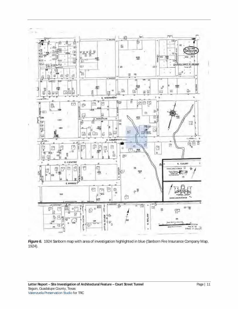
Figure�6.��1924�Sanborn�map�with�area�of�investigation�highlighted�in�blue�(Sanborn�Fire�Insurance� Company�Map,�1924).�............................................................................................................................... ..�11�
Figure�7.��1930�Sanborn�map�with�area�of�investigation�highlighted�in�blue�(Sanborn�Fire�Insurance� Company�Map,�1930).�............................................................................................................................... ..�12�
�
� �
� �

�
�
SITE�ASSESSMENT�SUMMARY� S.� Elizabeth� Valenzuela,� Preservation� Specialist� for� Valenzuela� Preservation� Studio,� LLC� (VPS),� participated�in�a�site�visit�with�TRC�Environmental�Corporation,�Inc.�(TRC)�on�February�13,�2015�to�assess� a�historicͲage�architectural� feature�uncovered�during�construction�of�drainage�upgrades�by�the�City�of� Seguin.�Construction�crews�encountered�a�historicͲage�underground�drainage�channel�during�boring�for� a�new�concrete�box�culvert�below�US�90ͲA�(Court�Street).��
PHYSICAL�DESCRIPTION�OF�ARCHITECTURAL�FEATURE� Coordination�efforts�with�the�Texas�Historical�Commission�(THC)�have�resulted�in�the�classification�of�the� architectural�feature�as�a�historic�structure.�The�feature,�located�approximately�9'Ͳ0"�below�US�90ͲA,� runs�an�estimated�distance�of�120'Ͳ0"�roughly�parallel�to�the�creek�bed�north�and�south�of�the�roadway.� The�feature�consists�of�four�distinct�construction�materials�and�techniques.�The�northernͲmost�segment� is�an�estimated�7’Ͳ0”�circular�tube�constructed�of�8"�(length)�x�4"�(width)�x�2�3/4"�(height)�brick�masonry� with�a�lime�mortar.�While�the�brick�color�varies,�the�majority�are�buffͲcolored.�The�brick�are�brittle�to�the� touch�and�appear�to�date�to�the�lateͲnineteenth�to�earlyͲtwentieth�century�due�to�quality�of�the�brick� and�brickͲmaking�size�and�technique.��The�integrity�of�the�northern�segment�of�the�tunnel�has�been� compromised�by�the�installation�of�a�round�concrete�pipe�(RCP)�that�is�visible�along�a�portion�of�the�east� side�of�the�brick�tunnel.��The�north�end�of�the�tunnel�has�been�capped�by�a�modern�red�brick�masonry� wall.�A�portion�of�the�tunnel�south�of�the�brick�masonry�segment�is�constructed�of�stacked�conglomerate� that�has�settled�in�some�locations�(Figure�1).��The�center�section�of�the�tunnel�again�features�a�brick� masonry�tube�similar�in�dimension�and�construction�to�the�northern�segment.�The�two�materials�are� roughly�keyed�into�each�other�and�portions�of�this�connection�have�been�reinforced�with�a�Portland� cement�mortar�(Figure�2).�Beyond�the�second�section�of�brick�masonry�walls,�the�tunnel�is�constructed� of�cast�concrete�walls�and�a�vaulted�ceiling�and�floor�(Figure�3).�The�castͲconcrete�section�follows�the� same�line�for�a�short�distance�and�then�turns�at�an�approximately�45Ͳdegree�angle�to�the�east.�The� southernͲmost�segment�is�capped�by�a�modern�red�brick�masonry�wall,�similar�in�material�and� construction�to�the�end�wall�at�the�northern�entrance�to�the�tunnel.�
�
ȱ �

�
�
�
Figure�1.��View�of�roughͲcut�stacked�conglomerate�at�west� wall�of�tunnel�(VPS�2015).�
� Letter�Report�–�Site�Investigation�of�Architectural�Feature�–�Court�Street�Tunnel� Page�|�3� Seguin,�Guadalupe�County,�Texas� � � Valenzuela�Preservation�Studio�for�TRC�

�
Figure�2.��Connection�between�conglomerate�and�brick� masonry�tunnel�wall�(VPS�2015).�
�
� Letter�Report�–�Site�Investigation�of�Architectural�Feature�–�Court�Street�Tunnel� Page�|�4� Seguin,�Guadalupe�County,�Texas� � � Valenzuela�Preservation�Studio�for�TRC�

�
� �
� Letter�Report�–�Site�Investigation�of�Architectural�Feature�–�Court�Street�Tunnel� Page�|�5� Seguin,�Guadalupe�County,�Texas� � � Valenzuela�Preservation�Studio�for�TRC�

�
�
�� �
Figure�3.��View�of�tunnel�looking�south�illustrating�transition between�brick�masonry�walls�and�the�castͲconcrete�walls�of
the�architectural�feature.�Turn�in�tunnel�visible�at�end�of� castͲconcrete segment (VPS 2015).
� Letter�Report�–�Site�Investigation�of�Architectural�Feature�–�Court�Street�Tunnel� Page�|�6� Seguin,�Guadalupe�County,�Texas� � � Valenzuela�Preservation�Studio�for�TRC�

�
BRIEF�HISTORIC�CONTEXT�OF�ARCHITECTURAL�FEATURE� VPS�Preservation�Specialist�conducted�a�limited�review�of�primary�and�secondary�research�materials�in� an�effort�to�place�the�architectural�feature�within�an�appropriate�historic�context.�It�is�estimated�that�the� brick�masonry�tunnel�was�constructed�postͲ1870�due�to�the�consistency�of�size�and�quality�of�the�brick.� The�section�of�stacked�conglomerate�could�date�to�an�earlier�period�of�the�midͲnineteenth�century.�The� southern�segment�of�the�tunnel,�constructed�of�castͲconcrete,�is�estimated�to�date�from�ca.�1940� improvements�to�the�roadway�as�documented�through�the�review�of�Sanborn�maps�and�newspaper� articles�from�this�time�period.���
The�architectural�feature�is�located�along�natural�springs�north�of�the�Guadalupe�River,�along�US�90ͲA� (Court�Street)�between�Bauer�Street�and�N.�Gravel�Street.�The�parcel�was�set�aside�as�“acre”�or�“farm”� lots�reserved�for�livestock�and�gardens1 .�Early�settlers�of�the�city�of�Seguin�developed�the�use�of�natural� cements�and�concrete�for�residential�and�commercial�structures�in�response�to�available�local�building� materials�(conglomerate�and�other�cement�rock�deposits)�and�under�the�influence�of�Dr.�John�Esten� Park.�Dr.�Park,�trained�as�a�medical�doctor�and�chemist,�helped�to�identify�the�raw�materials�necessary� for�the�development�of�hydraulic�cement�in�the�Seguin�region.�He�is�credited�with�the�construction�of� numerous�concrete�walled�structures�in�Seguin�during�the�midͲnineteenth�century2 .��
Primary�construction�techniques�of�structures�in�Seguin�transitioned�from�concrete�to�brick�masonry� after�the�arrival�of�the�railroad�in�late�1875.�Sanborn�maps�indicate�at�least�one�brick�yard�(Joseph� Shonkas�Cotton�Gin�and�Brick�Yard)�was�located�near�Seguin�as�early�as�1891.�A�1902�Sanborn�map� illustrates�the�evolution�of�the�ca.�1890�brick�yard�to�a�brick�factory�housing�brick�manufacturing� equipment,�a�kiln,�and�a�drying�shed�(Figure�4).�By�1912,�a�larger�brick�manufacturing�plant,�the�Seguin� Vitrified�Paving�and�Faced�Brick�Company,�was�located�4�½�miles�west�of�the�court�house�(Figure�5),�in� addition�to�expanded�facilities�of�the�Joseph�Sonka�(sp)�Cotton�Gin�and�Brick�Works.���
The�section�of�East�Court�Street�under�investigation�first�appears�on�Sanborn�Maps�in�1924�(Figure�6).�A� creek�is�shown�bisecting�the�parcel�and�flows�perpendicular�to�East�Court�Street.�A�residence�is�located� west�of�the�creek�and�the�Seguin�Steam�Laundry�is�located�east�of�the�creek.�No�architectural�features� are�noted�in�the�location�of�the�historicͲage�tunnel.�However,�a�6"�water�pipe�is�located�at�the�center�of� the�roadway,�running�west�to�east.�By�1930,�a�concrete�bridge�is�illustrated�on�Sanborn�maps�at�this� location�(Figure�7).�
Court�Street�was�incorporated�as�part�of�State�Highway�3�in�1939�by�the�Texas�Highway�Department.� Additional�research�indicates�that�a�number�of�public�works�projects�were�also�undertaken�by�the�Public� Works�Administration�and�the�Works�Projects�Administration�in�Seguin�in�1939.�These�projects�included� an�expenditure�of�$519,000�for�a�20,000Ͳfoot�storm�sewer�system,�28,000Ͳfoot�sanitary�sewer� extensions,�and�$18,000Ͳfoot�water�main�extensions3 .�Review�of�primary�and�secondary�research�is�
������������������������������������������������������������ 1�Hauser,�Vincent�Paul.�A�Survey�of�the�Technologies�Contributing�to�the�Concrete�Era�of�Seguin,�Texas�in�the�MidͲ Nineteenth�Century.�Master's�Thesis,�University�of�Texas�at�Austin,�1980,�47.� 2�Ibid,�54Ͳ58� 3�The�Bryan�Eagle.�“Seguin�Enjoys�Improvements�Worth�$750,000�But�Keeps�Tax�Rate�Down,�Makes�No�Increase�On� Bonded�Debt,”�November�21,�1939,�8.� � Letter�Report�–�Site�Investigation�of�Architectural�Feature�–�Court�Street�Tunnel� Page�|�7� Seguin,�Guadalupe�County,�Texas� � � Valenzuela�Preservation�Studio�for�TRC�

�
currently�being�undertaken�to�attempt�to�tie�in�the�construction�of�the�historic�structure�with�these� public�works�and�transportation�improvement�projects.��
SUMMARY� After�limited�archival�research�and�field�investigations,�it�appears�that�the�historic�structure�under� investigation�is�related�to�floodͲcontrol�measures�and�infrastructure�improvements�along�US�90ͲA�(Court� Street)�as�an�attempt�to�divert�the�flow�of�a�natural�spring�and�creek�underneath�the�roadway.�It�does� not�appear�to�be�a�mill�run�or�related�to�any�manufacturing�purpose�at�this�location.�It�appears�to�have� been�constructed�during�at�least�three�time�periods,�with�the�stacked�conglomerate�stone�section�the� earliest,�the�brick�sections�coming�next,�and�the�cast�concrete�segment�last.�It�appears�the�earliest� construction�of�the�tunnel�could�date�to�as�early�as�the�midͲnineteenth�century�with�additional� segments�constructed�during�the�early�twentieth�century.��� �
� Letter�Report�–�Site�Investigation�of�Architectural�Feature�–�Court�Street�Tunnel� Page�|�8� Seguin,�Guadalupe�County,�Texas� � � Valenzuela�Preservation�Studio�for�TRC�

�
�
Figure�4.��1902�Sanborn�map�of�Joseph�Swonkas�Cotton�Gin�and�Brick�Works�(Sanborn�Fire�Insurance�Company� Map,�1902)�
� Letter�Report�–�Site�Investigation�of�Architectural�Feature�–�Court�Street�Tunnel� Page�|�9� Seguin,�Guadalupe�County,�Texas� � � Valenzuela�Preservation�Studio�for�TRC�

�
�
Figure�5.��1912�Sanborn�Map�of�Seguin�Vitrified�Paving�and�Faced�Paving�Company�and�the�Joseph�Sonka�Cotton� Gin�and�Brick�Works�(Sanborn�Fire�Insurance�Company�Map,�1912).�
� �
� Letter�Report�–�Site�Investigation�of�Architectural�Feature�–�Court�Street�Tunnel� Page�|�10� Seguin,�Guadalupe�County,�Texas� � � Valenzuela�Preservation�Studio�for�TRC�
�
�
Figure�6.��1924�Sanborn�map�with�area�of�investigation�highlighted�in�blue�(Sanborn�Fire�Insurance�Company�Map,� 1924).�
� �
� Letter�Report�–�Site�Investigation�of�Architectural�Feature�–�Court�Street�Tunnel� Page�|�11� Seguin,�Guadalupe�County,�Texas� � � Valenzuela�Preservation�Studio�for�TRC�

�
Figure�7.��1930�Sanborn�map�with�area�of�investigation�highlighted�in�blue�(Sanborn�Fire�Insurance�Company�Map,� 1930).�
� �
� Letter�Report�–�Site�Investigation�of�Architectural�Feature�–�Court�Street�Tunnel� Page�|�12� Seguin,�Guadalupe�County,�Texas� � � Valenzuela�Preservation�Studio�for�TRC�

�
REFERENCES�CITED�
Hauser,�Vincent�Paul.��A�Survey�of�the�Technologies�Contributing�to�the�Concrete�Era�of�Seguin,�Texas�in� the�MidͲNineteenth�Century.��Master’s�Thesis,�University�of�Texas�at�Austin.�
“Seguin�Enjoys�Improvements�Worth�$750,000�But�Keeps�Tax�Rate�Down,�Makes�No�Increase�on�Bonded� Debt,”�The�Bryan�Eagle,�November�21,�1939.�
Sanborn�Fire�Insurance�Maps.�Seguin,�Texas.�1902Ͳ1930.�
� �
� Letter�Report�–�Site�Investigation�of�Architectural�Feature�–�Court�Street�Tunnel� Page�|�13� Seguin,�Guadalupe�County,�Texas� � � Valenzuela�Preservation�Studio�for�TRC�