improving habitats along delta...
TRANSCRIPT

DRAFT, January 20, 2016—Please Do Not Cite or Quote
Delta Stewardship Council
Improving Habitats along Delta Levees:
A Review of Past Projects and Recommended Next Steps
Jessica Davenport, Darcy Austin, Jahnava Duryea, Daniel Huang, Daniel Livsey
January 2016
Proposed Final Draft

DRAFT, January 20, 2016—Please Do Not Cite or Quote
i
Improving Habitats along Delta Levees:
A Review of Past Projects and Recommended Next Steps
TABLE OF CONTENTS
TABLE OF CONTENTS ..................................................................................................................................... i
ACRONYMS AND ABBREVIATIONS ................................................................................................................ v
Author Contributions ................................................................................................................................... vi
Acknowledgments ....................................................................................................................................... vi
EXECUTIVE SUMMARY ................................................................................................................................ vii
I. BACKGROUND ....................................................................................................................................... 3
Historical Habitats of the Delta ........................................................................................................ 3
Habitat Loss and Species Impacts .................................................................................................... 4
Restoration Mandates in the Delta .................................................................................................. 6
Mitigation Requirements ................................................................................................................. 7
Constraints to Implementing Levee-Related Habitat Projects ....................................................... 10
II. PURPOSE AND APPROACH .................................................................................................................. 12
Definition of Levee-Related Habitat Types ..................................................................................... 13
Information Gathering ................................................................................................................... 15
Research Objectives ....................................................................................................................... 15
III. ANALYSIS ............................................................................................................................................. 18
Analytical Challenges ..................................................................................................................... 18
Considerations to Guide Future Projects ........................................................................................ 19
Native Fish Requirements ................................................................................................. 20
Bird Requirements ............................................................................................................ 22
Refining Project Goals and Design in Light of Delta-Specific Constraints ...................................... 22
Design Considerations for Setback Levees ....................................................................... 22

DRAFT, January 20, 2016—Please Do Not Cite or Quote
ii
Design Considerations for Adjacent Levees ...................................................................... 24
Design Considerations for Extra-wide Levees ................................................................... 25
Design Considerations for Planting Benches and Planting Vegetation on Levees ........... 26
Cost Analysis .................................................................................................................................. 27
On-Site Riparian Habitat Improvement ............................................................................ 27
Off-Site Mitigation Banks .................................................................................................. 29
Adjacent and Setback Levees ............................................................................................ 31
IV. RECOMMENDED NEXT STEPS ............................................................................................................. 32
V. FINAL REMARKS .................................................................................................................................. 40
LITERATURE CITED ...................................................................................................................................... 42
APPENDIX 1. LESSONS LEARNED FROM PAST PROJECTS AND THE INTERVIEW PROCESS .......................... 51
Lessons Learned – Channel Margin Habitat and Shaded Riverine Aquatic Habitat ...................... 51
Lessons Learned – Seasonal Floodplain Habitat ............................................................................ 54
Lessons Learned – Riparian Habitat ............................................................................................... 55
APPENDIX 2. RECOMMENDATIONS REGARDING THE USE OF ADAPTIVE MANAGEMENT ......................... 60
Step 1 – Define/Redefine the Problem ........................................................................................... 60
Step 2 – Establish Goals and Objectives ......................................................................................... 60
Step 3 – Model Linkages between Objectives and Proposed Actions ............................................ 61
Step 4 – Select Action(s) (research, pilot, or full-scale) and Develop Performance Measures ....... 62
Step 5 – Design & Implement Actions ............................................................................................ 63
Step 6 – Design and Implement Monitoring Plan .......................................................................... 64
Step 7 – Analyze, Synthesize, and Evaluate ................................................................................... 65
Step 8 – Communicate Current Understanding ............................................................................. 66
Step 9 – Adapt ................................................................................................................................ 67
APPENDIX 3. INTERVIEW QUESTIONS ......................................................................................................... 68
APPENDIX 4. HABITAT IMPROVEMENT PROJECTS REVIEWED .................................................................... 70
DRAFT, January 20, 2016—Please Do Not Cite or Quote
iii
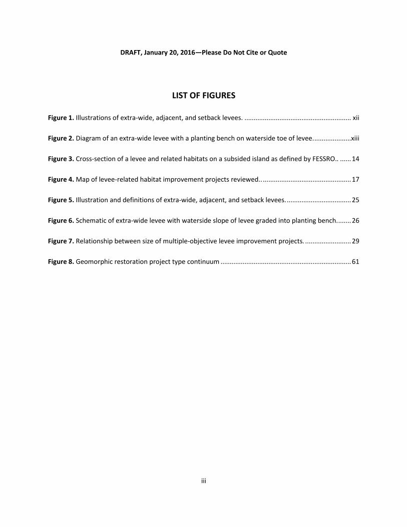
LIST OF FIGURES
Figure 1. Illustrations of extra-wide, adjacent, and setback levees. .......................................................... xii
Figure 2. Diagram of an extra-wide levee with a planting bench on waterside toe of levee. ....................xiii
Figure 3. Cross-section of a levee and related habitats on a subsided island as defined by FESSRO.. ...... 14
Figure 4. Map of levee-related habitat improvement projects reviewed.. ................................................ 17
Figure 5. Illustration and definitions of extra-wide, adjacent, and setback levees. ................................... 25
Figure 6. Schematic of extra-wide levee with waterside slope of levee graded into planting bench. ....... 26
Figure 7. Relationship between size of multiple-objective levee improvement projects. ......................... 29
Figure 8. Geomorphic restoration project type continuum ....................................................................... 61
DRAFT, January 20, 2016—Please Do Not Cite or Quote
iv
LIST OF TABLES
Table 1. Principal considerations for Delta levee structures and related habitats. ................................... xiv
Table 2. Costs of Multi-Objective Levee Improvement Projects with On-Site Habitat Improvement ....... 28
Table 3. DWR Bulk Credit Program Costs. .................................................................................................. 30
Table 4. DWR and CDFW Off-Channel Habitat Mitigation and Enhancement Projects. ............................ 31
Table 5. Cost of adjacent and setback levees in the Delta. ........................................................................ 32

DRAFT, January 20, 2016—Please Do Not Cite or Quote
v
ACRONYMS AND ABBREVIATIONS
CDBW California Division of Boating and Waterways CDFW California Department of Fish and Wildlife CEQA California Environmental Quality Act CESA California Endangered Species Act CRP Cosumnes River Preserve CVFPP Central Valley Flood Protection Plan CVP Central Valley Project DISB Delta Independent Science Board DLHAC Delta Levees and Habitat Advisory Committee DLIS Delta Levee Investment Strategy DMI Dredged Material Island DWR California Department of Water Resources EIR Environmental Impact Report ESA Endangered Species Act ETL Engineering Technical Letter FESSRO FloodSAFE Environmental Stewardship and Statewide Resources Office FL Fork Length IAV Invasive Aquatic Vegetation IEP Interagency Ecological Program ITP Incidental Take Permit IWM Instream Woody Material MAST Management, Analysis, and Synthesis Team MHHW Mean Higher High Water MLLW Mean Lower Low Water MOU Memorandum of Understanding MWL Mean Water Level NGO Non-governmental Organization NMFS National Marine Fisheries Service NRRSS National River Restoration Science Synthesis NWR National Wildlife Refuge O&M Operations and Maintenance PRBO Point Reyes Bird Observatory RD Reclamation District SAFCA Sacramento Area Flood Control Agency SAIL Salmonid/Steelhead/Sturgeon Assessment Indicators by Life Stages SAM Standardized Assessment Methodology SAV Submerged Aquatic Vegetation SWP State Water Project SWRCB State Water Resources Control Board TNC The Nature Conservancy USACE United States Army Corps of Engineers USFWS United States Fish and Wildlife Service
DRAFT, January 20, 2016—Please Do Not Cite or Quote
vi
Author Contributions
The development of this paper was designed and supervised by Jessica Davenport and Darcy Austin.
Monitoring reports and cost information were collected by Daniel Livsey and Daniel Huang, who also
conducted expert interviews. Reports, data, and literature were analyzed by Jahnava Duryea, Daniel
Livsey and Daniel Huang. All five authors contributed to writing the manuscript.
Acknowledgments
This report would not have been possible without the inspiration and support of numerous colleagues.
Carl Wilcox of the California Department of Fish and Wildlife (CDFW) identified the need for a review of
the effectiveness of past habitat projects related to state levee investments. Cindy Messer of the Delta
Stewardship Council (Council) served as the executive sponsor for the project. Dan Ray, Cindy Messer,
Dustin Jones, Rainer Hoenicke, Lauren Hastings and Maggie Christman of the Council and Larry Roth of
Arcadis all provided valuable input during the development of the report.
We are extremely grateful for the guidance provided by our advisory committee: Gilbert Cosio, MBK
Engineers; Campbell Ingram, Delta Conservancy; Dave Mraz and Bryan Brock, California Department of
Water Resources (DWR); Chris Neudeck, Principal Engineer, KSN, Inc.; Ramona Swenson, ESA PWA;
Michael Tucker, NOAA Fisheries; and Carl Wilcox, CDFW.
We would also like to thank the following people for their insightful comments on various drafts: Brian
Atwater, U.S. Geological Survey (USGS); Peter Buck, Sacramento Area Flood Control Agency (SAFCA);
Gilbert Cosio, MBK Engineers; William Darsie, KSN, Inc.; Jim Starr, Anna Burkholder and Mark Philipp,
CDFW; and Charles Tyson, Jennifer Hogan, and Randy Mager, DWR.
Finally, we wish to express our sincere gratitude to those who gave interviews and provided monitoring
reports and cost data for past projects. Interviewees include several of our advisory committee
members, as well as Jon Burau and Fred Feyrer, USGS; Carson Jeffres and John Durand, UC Davis; Jeff
Hart, Hart Restoration, Inc.; Sara Sweet and Judah Grossman, The Nature Conservancy; Brian Mulvey,
Judy Soutier, and Alicia Kirchner, U.S. Army Corps of Engineers; Julie Rentner, River Partners; Lori Smith
and Eric Hopson, U.S. Fish and Wildlife Service; Kim Forrest, CDFW; Anitra Pawley, DWR; KC Sorgen,
SAFCA; and Trevor Kennedy and Kari Burr, Fishery Foundation of California.

DRAFT, January 20, 2016—Please Do Not Cite or Quote
vii
EXECUTIVE SUMMARY
This review of habitat improvements along Delta levees was conducted to support the
development of the Delta Stewardship Council’s (Council) Delta Levee Investment Strategy (DLIS), which
focuses on flood risk reduction as the primary purpose of State levee investments. The report is
intended to provide guidance to the Council to ensure that those investments also contribute to long-
term improvement of river corridors, with net benefits for fish and wildlife.
The Council must ensure that the DLIS helps to implement the Delta Reform Act and the Delta
Plan. The Delta Reform Act of 2009 established the Council and defined its mission: to achieve the
coequal goals of water supply reliability for California and ecosystem restoration in the Delta, in a
manner that protects and enhances the values of the Delta as an evolving place (Water Code section
85054). The Delta Plan includes 14 regulatory policies, including one that calls for levee projects to
incorporate habitat benefits, where feasible, and another requiring the use of the best available science
and adaptive management. This report is intended to support the application of best available science
and adaptive management to habitat improvements along Delta levees.
It should be noted that levee-related habitat improvements alone are not expected to provide
all the ecosystem benefits needed by native species. These projects take place within the larger context
of ecosystem restoration in the Delta and Suisun Marsh, which will require more natural functional
flows, restoration and conservation of a wide range of habitat types1, improved water quality, and the
management of nonnative invasive species. Nevertheless, given its significant role in Delta levee
1 The tradeoff associated with protecting productive farmland behind levees that also provides important
terrestrial or seasonal wetland habitat versus breaching levees in order to restore aquatic habitat is an important
issue. It will be addressed in the Delta Levee Investment Strategy, but it is beyond the scope of this paper.

DRAFT, January 20, 2016—Please Do Not Cite or Quote
viii
investments, the State must ensure that these habitat projects are part of a program that provides a net
benefit for aquatic species in the Delta.
Restoration Mandates and Constraints
In addition to the Delta Reform Act, other previous legislative mandates require Delta levee
projects to provide habitat improvements. Water Code section 12314(c) instructs the California
Department of Fish and Wildlife (CDFW) to consider the value of riparian and fisheries habitat along
riverine corridors. Water Code sections 12314(d) and 12987(d) require that state-funded Delta Levees
Special Flood Control Projects, designed to improve Delta levees, must be consistent with a net long-
term habitat improvement program and have a net benefit for aquatic species in the Delta.
In addition, levee construction and maintenance frequently results in impacts to habitat that
must be mitigated according to the requirements of multiple regulatory agencies. Generally, regulatory
agencies prefer that mitigation occurs on-site with in-kind functions. Due to various constraints, off-site
mitigation was often used for projects in the Delta Levee Program, such as creation of marsh and
riparian forest in the interior portions of islands, when habitat impacts were large during levee repair.
When habitat impacts were relatively small, the RDs have satisfied their mitigation obligation through
the purchase of bank credits (e.g., DWR’s Bulk Credit Program).
Improvement of habitat along levees, whether for mitigation or enhancement, is challenging
due to a range of regulatory and liability constraints. For example, the current nationwide policy of the
U.S. Army Corps of Engineers (USACE) requires removal of trees and most shrubs from a “vegetation-
free zone” on and around levees under their jurisdiction, and also prevents planting of most vegetation
other than grasses within this zone. Federal legislation (Public Law 113-121, the Water Resources
Reform and Development Act of 2014) required reevaluation of this policy by November 2015, but the
reevaluation process had not yet been funded as of December 2015. In the meantime, the USACE allows
local sponsors to apply for a variance, but the procedures for obtaining one are burdensome. Moreover,
local sponsors responsible for USACE levees face a liability risk if they do not meet USACE engineering
standards, i.e., they may not be eligible for rehabilitation assistance if their levees fail. Despite these
DRAFT, January 20, 2016—Please Do Not Cite or Quote
ix
constraints, it still possible to improve habitats along levees, especially in the waterside area beyond the
vegetation-free zone (Figure 2).
Purpose and Approach
The purpose of this paper is to explore the question of how to ensure that future State levee
investments, which are primarily aimed at flood risk reduction, also contribute to fulfilling the two State-
level environmental mandates described above: 1) achieving the coequal goals, particularly with respect
to ecosystem restoration; and 2) providing a net benefit for aquatic species in the Delta. The paper
provides a review of past projects, summarizes lessons learned from monitoring reports and through
interviews with experts about which habitat designs may provide greater benefits to target native
species, and provides guidance to ensure that project effectiveness can be better evaluated in the
future. The paper also provides information about the costs of multi-benefit projects that combine levee
construction and habitat improvements, as well as the costs of projects that improve habitats along
levees but do not involve levee construction, e.g., projects that use riparian plantings to stabilize levee
slopes and provide erosion control.
To collect the information required for our review of the effectiveness of habitat improvements
along Delta levees, we conducted interviews with experts and, through coordination with other agencies
and stakeholders, obtained project descriptions and associated monitoring reports and cost
information. Project effectiveness was evaluated in terms of the project’s stated objectives,
performance measures, monitoring, and results, and whether or not a project could be shown to benefit
target species.
Summary of Analysis
Our review of habitat projects found that the majority of reports used vegetation monitoring as
a means of measuring success. Vegetation coverage is an indicator of habitat and is widely used as one
of the ways to track progress in ecosystem restoration. However, the Delta is a highly altered
ecosystem, and the relationships between vegetation coverage and benefits to target species are more
complex than in systems that are closer to their historical ecological structure and function. Therefore,

DRAFT, January 20, 2016—Please Do Not Cite or Quote
x
research and monitoring related to fish and wildlife response, as well as vegetation monitoring, is
needed to determine whether projects are providing benefits to target species. Because fish and wildlife
monitoring data were not available for most projects and existing data are inconsistent across projects,
we were unable to compare the effectiveness of different types of habitat improvement projects.
Instead, this report summarizes lessons learned from monitoring reports and through interviews with
experts about which habitat designs may provide greater benefits to target native species.
Similarly, we experienced problems trying to accurately assess the costs of different habitat
options associated with levee/habitat enhancement projects. Cost information for the habitat
component of levee projects is rarely broken out from the risk reduction component (i.e., levee
construction or habitat improvements), making it impossible to cleanly parse out and compare costs of
different types of habitat improvements. As a result, our analysis presents the total costs of projects
(i.e., the cost of not only the habitat component, but also the construction of the flood risk reduction
component) broken down broadly into different habitat enhancement project types, such as setback
levee projects versus projects involving riparian planting within levee riprap.
Summary of Project Design Considerations
Despite our inability to draw firm conclusions regarding the effectiveness of different habitat
improvement designs, our review of project monitoring reports did result in some observations
regarding effectiveness that can inform the design of future projects. We examined four main levee
structural modifications and related habitats: setback levees, adjacent levees, extra-wide levees, and
planting benches (Figure 1, Figure 2, and Table 1).

DRAFT, January 20, 2016—Please Do Not Cite or Quote
xi
Measuring Project Effectiveness and Lessons Learned Monitoring the response of fish and wildlife to habitat improvement projects is an essential part of determining whether the projects are providing benefits to target species. Our review of monitoring reports from past habitat improvement projects confirmed the value of monitoring programs that measured project effectiveness in terms of both the amount of established structure (e.g., vegetation or woody material) and the wildlife response (e.g., use of habitat enhancement features by target species). One of the primary lessons learned from this review is that habitat improvement techniques that have been shown to be highly effective in other systems may have beneficial, neutral, or even deleterious impacts on wildlife in the Delta. For example, although instream woody material (IWM) has been shown to benefit salmonids in other ecosystems, along the lower Sacramento River, high-density IWM increased occupation of invasive predatory fish by 20-fold while decreasing occupation of Chinook salmon fry by about 75% compared to control sites that lacked high-density IWM (FISHBIO 2015). However, IWM in low to medium densities correlated with enhanced occupation of salmonids and decreased invasive predatory fish (FISHBIO 2015). Another important lesson is that planting riparian vegetation can be beneficial to native fish, even along levees protected by rock revetments. Along the lower American River, multiyear post hoc snorkel surveys indicated that out-migrating juvenile salmonids utilized riprapped reaches with riparian habitat and channel margin enhancements (e.g., shallow benches and IWM) at nearly the same frequency as control sites (i.e., “natural” non-riprapped levee slopes) (Fishery Foundation 2006). These types of observations, learned directly from wildlife response monitoring, can provide the basis for developing Delta-specific best practices that maximize the potential for effective habitat restoration efforts.
Setback levees, constructed several hundred feet behind an existing levee, restore wide
contiguous swaths of seasonal floodplain habitat by allowing reestablishment of natural riverine
processes. In many parts of the Delta, however, particularly where islands are deeply subsided, setback
levees are often infeasible because placing the huge amount of fill needed to bring the land up to
floodplain elevation would be prohibitively expensive. Adjacent levees, constructed immediately behind
an existing levee, often involve leaving the existing levee in place to protect the new levee from erosion.
Adjacent levees, however, do not follow the conceptual model of providing ecosystem benefits through
reestablishment of floodplain processes, and have not been monitored adequately to determine

DRAFT, January 20, 2016—Please Do Not Cite or Quote
xii
whether there are positive benefits to native species in the Delta. Given the high cost of setback levees
where Delta islands are at subtidal elevations and the uncertain ecological benefits of adjacent levees,
expanding or modifying existing levees into “extra-wide” levees may be a more cost-effective option and
may be more likely to be supported by landowners because they require less land conversion. Extra-
wide levees (sometimes referred to as habitat levees) allow the levee to be graded to create a gradual
waterside slope on which riparian, shaded riverine aquatic, and tidal marsh habitat can be established
(Figure 2). In lieu of or in combination with an extra-wide levee or an adjacent levee, a planting bench on
the waterside levee slope may be installed to provide the appropriate depths and elevations for
establishing channel margin habitat. These benches may be stabilized with riprap (broken rock) covered
with a mixture of soil and rocks that can support tidal marsh and/or riparian vegetation.
Figure 1. Illustrations of extra-wide, adjacent, and setback levees.
DRAFT, January 20, 2016—Please Do Not Cite or Quote
xiii
Figure 2. Diagram of an extra-wide levee with a planting bench on waterside toe of levee. 1
Vegetation management zone (VMZ) in the diagrams is the same as the “vegetation-free zone” defined in the USACE’s national policy, described above. Note that the riprap placed in planting bench along waterside levee slope for erosion control is also designed to prevent levee damage from burrowing mammals. Adapted from DWR 2014.
DRAFT, January 20, 2016—Please Do Not Cite or Quote
xiv
Table 1. Principal considerations for Delta levee structures and related habitats.
Setback levee Adjacent levee Extra-wide levee Planting bencha
Definition
A levee constructed several hundred feet behind an existing levee which allows for removal of a portion of the existing levee and creation of additional floodplain connected to the channel.
A levee constructed immediately behind an existing levee. It may not necessarily result in removal of the existing levee.
A levee that has been widened to shift the regulated levee prism landward, creating more space for habitat improvement next to the channel and enhancing flood protection.
A terrace that creates a stable structure for establishing vegetation.
Habitat Benefits
Restores wide contiguous swaths of seasonal floodplain habitat by allowing reestablishment of natural riverine processes.
May not achieve same ecosystem benefits as a setback levee, since it does not allow natural riverine processes to fully reestablish.
May not achieve same ecosystem benefits as a setback levee, but may provide more benefits than an adjacent levee since it allows for a gradual waterside slope on which riparian, shaded riverine aquatic, and tidal marsh habitat can be established.
May be installed on waterside levee slope to provide appropriate depths and elevations for establishing shaded riverine aquatic habitat.
Constraints/ Opportunities
b
Foundation of a setback levee and the land between original levee and new setback levee should be no lower than intertidal elevation in order to achieve floodplain habitat; cost of fill is prohibitive for setback levees on deeply subsided islands.
Useful when maintaining an existing levee in a highly erosive environment is more expensive in the long-term than shifting the prism of the levee landward (e.g., Twitchell Island levees).
By shifting the regulated levee prism landward, construction of an extra-wide levee creates more options for habitat improvement on waterside slope.
Planting benches may be infeasible in locations with especially high water velocity and steep bathymetric gradients on waterside slope because of erosion issues.
Land Conversion Considerations
c
Required setback distance for habitat benefits is generally several hundred feet and would require substantial conversion of dry land to seasonal floodplain.
Requires less conversion of land than setback levees, but more than an extra-wide levee.
Requires less conversion of land than setback levees and adjacent levees.
Planting benches inherently replace shallow and intertidal habitats.
a Planting benches can be installed as a standalone feature along the waterside slope of a traditional Delta levee, or in
association with construction of an adjacent levee or extra-wide levee. b All levees face a common constraint related to soil type: Peat soils make for poor, unstable foundations for a new levee.
Options to stabilize peat soils (e.g., soil compaction) are expensive. In addition, all habitat improvements that increase vegetation cover also increase the risk of attracting burrowing animals (e.g., beavers) that can undermine levee integrity. c Land converted from levee-protected dry land to seasonal floodplain can often still be used for some types of farming and
recreation.

DRAFT, January 20, 2016—Please Do Not Cite or Quote
xv
Cost Analysis
The main objective of the cost analysis was to determine the incremental cost of incorporating
habitat improvement components into levee construction projects, either through the creation of
habitat features on-site (e.g., creation of a habitat bench) or through acquisition of habitat credits from
a mitigation bank. We assessed cost ranges of multi-objective levee projects that included both risk
reduction aspects and habitat improvements using data provided to us by California Department of
Water Resources (DWR) staff. In the past, Delta levee construction projects that incorporated habitat
elements on-site generally involved planting of trees within riprap. The costs for these multi-objective
projects ranged from approximately $1,400 to $5,200 per linear foot ($7 million to $26 million per linear
mile). Based on the cost data available for these projects, we were unable to differentiate the costs of
restoring the riparian habitat from the costs associated with the engineering design and construction of
the levee improvement work. The levee improvement work is usually the fundamental driver of the
costs of these projects, and the scale of construction work will be different depending on engineering
design considerations. As such, the total cost of a multi-objective project is not a good indicator of the
cost of the habitat restoration component.
DWR staff also provided data on two pilot-scale on-site riparian habitat enhancements along
levees whose costs ranged from $80 to $200 per linear foot; in comparison, off-site mitigation credits
from a mitigation bank at the edge of the Delta cost $61 per linear foot. Credits purchased from this
same bank cost $62,295 to $120,000 per acre2 for riparian forest and freshwater marsh habitat, while
the cost of off-channel habitat created in the interior Delta islands ranged from $45,000 to $563,800 per
acre.
2 Also includes required buffer acreage that comprises the mitigation bank.

DRAFT, January 20, 2016—Please Do Not Cite or Quote
xvi
Recommended Next Steps
Based on the findings of the review, we recommend taking several steps to improve habitat
project siting and ensure that project siting and effectiveness can be better evaluated in the future:
1. Develop appropriate performance measures as part an adaptive management plan. As
required by Delta Plan Policy G P1, habitat improvement projects along levees should have
adaptive management plans that include appropriate performance measures, including fish and
wildlife response, to assess effectiveness in providing benefits to target species.
2. Track the incremental cost of habitat improvements. DWR has recognized the importance of
breaking down the costs of multi-benefit projects into habitat and flood risk reduction
components. The Council supports DWR’s proposal to make such a cost breakdown a
requirement for receiving grant funding.
3. Carefully consider the tradeoffs associated with on-site and off-site mitigation. Destruction of
shaded riverine aquatic habitat and emergent vegetation by placement of bank erosion control
riprap along key migratory corridors for salmon should be mitigated on-site or at least
elsewhere along the same corridor. If habitat is created in areas of the Delta that are not along
these corridors, then the mitigation would not be expected to provide the same ecological
benefits to salmon. However, if constraints or other considerations prevent the establishment of
habitat mitigation on-site, then off-site mitigation may be the best option to mitigate for habitat
impacts during levee repairs and rehabilitation, especially if it facilitates the creation of larger
and more interconnected habitat patches.
4. Use landscape-scale planning to guide project location and design. As landscape-scale
restoration planning is conducted in the Delta, as recommended in the Delta Plan, it will provide
a framework for siting and designing projects to increase habitat connectivity and function. For
example, efforts should be made to link together fragmented patches of habitat to build
towards large contiguous habitat corridors.
5. Measure fish and wildlife response through a standardized regional monitoring program. By
establishing a regional monitoring framework (similar to the CDFW-led Interagency Ecological
DRAFT, January 20, 2016—Please Do Not Cite or Quote
xvii
Program Tidal Wetlands Monitoring Project Work Team framework), instead of developing
monitoring protocols on a project-by-project basis, it will become easier to compare results
across projects and improve understanding of the effectiveness of different habitat
improvement options. Regional monitoring also supports program-level adaptive management
and a landscape-scale approach, as described above. Additional and long-term funding is
needed for this programmatic monitoring.
6. Use the Delta Levees and Habitat Advisory Committee (DLHAC) to discuss incorporation of
effective habitat improvement components into levee projects. The DLHAC is a regular
standing meeting between DWR, CDFW, Delta RDs, and other Delta stakeholders. We envision
that the Delta Science Program could become involved with the DLHAC, or a subcommittee
thereof, to consult on habitat project siting and design.
None of the recommendations we have made in this report are novel; in one form or another,
they have been previously suggested by other agencies or Delta stakeholders. Implementing them,
however, will take leadership, persistence, and adequate long-term funding. Council staff looks forward
to working together with our colleagues to address the issues raised in this paper.
DRAFT, January 20, 2016—Please Do Not Cite or Quote
1
INTRODUCTION
The Delta Stewardship Council (Council) has undertaken the development of a Delta Levees
Investment Strategy (DLIS) to guide future State investments in flood risk reduction. While investing in
levee improvements to reduce risk, the State has both an opportunity to increase floodplain and riparian
habitats in the Delta and an obligation to mitigate adverse environmental impacts of levee projects and
provide a net benefit to terrestrial and aquatic species.
The Council must ensure that the DLIS helps to implement the Delta Reform Act and the Delta
Plan. The Delta Reform Act of 2009 established the Council and defined its mission: to achieve the
coequal goals. As stated in the California Water Code, “‘Coequal goals’ means the two goals of providing
a more reliable water supply for California and protecting, restoring, and enhancing the Delta
ecosystem. The coequal goals shall be achieved in a manner that protects and enhances the unique
cultural, recreational, natural resource, and agricultural values of the Delta as an evolving place” (Water
Code section 85054). The Delta Reform Act required the Council to develop the Delta Plan and defined
certain types of projects and programs to be “covered actions” regulated by the Delta Plan. The Delta
Plan includes 14 regulatory policies, including one that calls for levee projects to incorporate habitat
benefits, where feasible, and another requiring the use of the best available science and adaptive
management.
The primary goal of this report is to support the DLIS by suggesting steps needed to improve the
effectiveness of habitat improvements related to levee projects in the Delta. Levee-related habitat
improvement projects in this report are defined as habitat restoration, enhancement, and/or mitigation
projects that were implemented in association with levee projects in the Delta region (i.e., legal Delta,
Suisun Marsh, and lower Sacramento and San Joaquin Rivers). The recommended next steps are based
upon: 1) a review of levee-related habitat improvement projects conducted in the Delta region, 2)
interviews with staff from regional, state and federal agencies, universities, non-governmental
organizations, and consulting firms, 3) review of relevant literature, and 4) principles of best available
science and adaptive management.

DRAFT, January 20, 2016—Please Do Not Cite or Quote
2
Our review of habitat projects found that the majority of reports used vegetation monitoring as
a means of measuring success. Of the fifteen projects for which monitoring reports were available,
twelve had data on vegetation, six had fish data, and three had bird data (see table in Appendix 4). This
finding was not unexpected because, prior to the adoption of the Delta Plan in 2013, adaptive
management, including monitoring and assessment of project effectiveness for fish and wildlife, was not
required or funded for every levee-related habitat project in the Delta. Vegetation coverage is an
indicator of habitat and is widely used as one of the ways to track progress in ecosystem restoration.
However, the Delta is a highly altered ecosystem and the relationships between vegetation coverage
and benefits to target species are more complex than in systems that are closer to their historical
ecological structure and function. Therefore, research and monitoring related to fish and wildlife
response, as well as vegetation monitoring, is needed to determine whether projects are providing
benefits to target species.
It should be acknowledged that levee-related habitat improvements alone are not expected
provide all the ecosystem benefits needed by native species. These projects take place within the larger
context of ecosystem restoration in the Delta and Suisun Marsh, which will require more natural
functional flows, restoration and conservation of a wide range of habitat types3, improved water quality,
and the management of non-native invasive species, as stated in the Delta Plan. Nevertheless, given its
significant role in Delta levee investments, the State must ensure that these habitat projects are part of
a program that provides a net benefit for aquatic species in the Delta. Our hope is that this review will
be helpful in identifying data gaps, clarifying future needs, and providing recommendations for
3 The tradeoff associated with protecting productive farmland behind levees that also provides important
terrestrial or seasonal wetland habitat versus breaching levees in order to restore aquatic habitat is an important
issue. It will be addressed in the Delta Levee Investment Strategy, but it is beyond the scope of this paper.
DRAFT, January 20, 2016—Please Do Not Cite or Quote
3
enhancing the adaptive management process for habitat improvements undertaken within the context
of flood risk reduction.
I. BACKGROUND
Recommendations for future levee-related habitat improvements should be guided in part by an
analysis of how historical habitats functioned; therefore we provide a summary of the historical habitats
of the Delta and subsequent habitat loss and species impacts since Euro-American settlement in the
mid-19th century. Numerous other stressors impact the Delta ecosystem such as water diversions, dam
construction in the Delta watershed, and discharge of nutrients and toxic substances (Luoma et al.
2015). We focus the discussion below on past habitat changes as levee-related habitat is the primary
focus of this review.
Historical Habitats of the Delta
Located in Northern California, the San Francisco Estuary is the largest estuary on the west coast
of North and South America, receiving runoff and snowmelt from 40% of California’s landmass (Brown &
Michniuk 2007). The Delta is the inland, freshwater portion of the estuary where two major watersheds,
the Sacramento River in the north and the San Joaquin River in the south, converge on their way to the
sea. Early European visitors to the Sacramento Valley described riparian forests ranging from narrow
bands to stands several miles wide (Thompson 1961). Large sediment loads allowed for the formation of
natural levees up to 20 feet above the floodplain and created suitable conditions for the establishment
and successional development of structurally diverse riparian communities.
Large, continuous corridors of riparian vegetation (approximately 800,620 acres) were present
along major and minor rivers throughout the Central Valley (Katibah 1984). Valley foothill riparian, a
historically critical habitat, naturally occurred above tidal influence and had a mixed canopy of large,
mature trees (e.g., willow, cottonwood, sycamore, and oak) with a dense understory (Whipple et al.
2012). Riparian areas have been identified as the most critical habitat type in all of California for land
birds (passerines and near-passerines) (Manley & Davidson 1993; DeSante & George 1994) and indeed,
it is one of the most productive habitats for all forms of wildlife (Faber 2003). Mature stands of trees
DRAFT, January 20, 2016—Please Do Not Cite or Quote
4
provide nesting habitat for desirable species such as Swainson’s hawks and white-tailed kites (Dixon et
al. 1957), and are utilized by great blue herons and double-crested cormorants for interspecies,
communal nesting colonies. Additionally, they support a diversity of neotropical migrant songbirds (e.g.,
grosbeaks, orioles, flycatchers, warblers, vireos) by providing foraging areas where the birds can glean or
catch insects on the wing.
The mosaic of varied habitats within the flood basins of the north Delta, tidal islands of the
central Delta, and distributary rivers of the south Delta once supported an immense diversity of fish and
wildlife. Through complex seasonal fluctuations in water temperature, droughts, and floods the Delta
provided refuge for vast populations of salmon, Delta smelt, and millions of birds migrating along the
Pacific Flyway. Historical landscapes in the Delta included tidal and non-tidal freshwater emergent
wetland, willow thickets, willow riparian scrub or shrub, valley foothill riparian, grassland, and many
more unique habitat complexes (Whipple et al. 2012).
Habitat Loss and Species Impacts
Since the mid-19th century the Delta landscape has been altered dramatically. During the Gold
Rush, hydraulic mining activities drastically impacted watersheds, choking off tributaries and river
channels with sediment. The tidal islands of the central Delta were “reclaimed” in the latter part of the
century by draining the wetlands and dredging material from natural sloughs to build up levee-
protected islands for agriculture.
The Delta has supplied water for agricultural, urban, and wildlife uses throughout the state
through the Central Valley Project (CVP) since 1958 and through the State Water Project (SWP) since
1968. The CVP and SWP are the nation’s largest water storage and conveyance systems (DWR 2015b),
composed of a complex system of dams, reservoirs, and water diversions that alter hydrologic regimes
in the Delta. At present, 83% of California’s native freshwater fish populations are imperiled or extinct,
largely due to the impacts of invasive species, agricultural impacts, and dams (Moyle et al. 2011).
The central Delta is a patchwork of heritage communities and agricultural islands protected by
engineered levees and crisscrossed with a network of sloughs and channels. Along major river reaches in

DRAFT, January 20, 2016—Please Do Not Cite or Quote
5
the Lower Sacramento River Conservation Planning Area — designated in the Draft Central Valley Flood
System Conservation Strategy, which includes the northwestern portion of the Delta — DWR estimates
that revetment exists on 60% of riverbanks, covering a stretch of 130 miles (DWR 2015c). The leveed
channels lack the bathymetric complexity of natural riverine systems and were essentially designed to
flush sediment, convey water, and provide flood protection for the adjacent islands (Burau 2007). The
altered ecosystem of the Delta, with reduced flow and turbidity, higher temperatures, high contaminant
loads, and invasive aquatic vegetation (IAV) provide conditions that support an undesirable, non-native
fish assemblage (Nobriga et al. 2005; Brown & May 2006; Brown & Michniuk 2007; Grimaldo et al.
2012).
Many of the levees are heavily riprapped on the water side and devoid of significant vegetation,
with the exception of some invasive annual grasses and weeds. Where vegetation remains, naturally
established riparian vegetation or tule beds exist in discontinuous, narrow bands. Over 95% of the
riparian habitat along the Sacramento River has been lost, greatly reducing the river’s ability to support
wildlife populations that will continue to be viable in the long term (Katibah 1984). Habitat loss and
fragmentation have negatively impacted many bird species in the Delta. In the absence of high marsh
vegetation for cover, many species are more vulnerable to predators. Riprapping along levees also
adversely impacts native aquatic species by providing habitat that benefits invasive piscivorous fish
more than native Chinook salmon (FISHBIO 2015).
The extent and character of Delta habitats have been altered dramatically over the past 150
years, but remain essential to important ecological functions in the watershed. They form the basis for
terrestrial and aquatic food webs, provide essential wildlife habitat and migratory corridors, shade and
cool water, filter nonpoint source pollution, and improve water quality. The fragmented remnants of
habitat types that once dominated the historical Delta continue to support a variety of threatened and
endangered species. As the importance of these habitats in supporting fish and wildlife species has
become more widely recognized, support has grown for restoring riparian corridors and recovering
some of the functions that have been lost or degraded.

DRAFT, January 20, 2016—Please Do Not Cite or Quote
6
Restoration Mandates in the Delta
Legislation passed in 1988 significantly increased funding for Delta levees while mandating no
net loss of fish or wildlife habitat in the Delta and providing funds to mitigate past losses. Water Code
sections 12314(d) and 12987(d) require that the expenditures of the state-funded Delta Levees Special
Flood Control Projects Program (Special Projects Program) “are consistent with a net long-term habitat
improvement program.” The Special Projects Program must also provide a net benefit for aquatic
species in the Delta, as determined by California Department of Fish and Wildlife (CDFW). These
programs, which have been in place for over twenty years, have resulted in many habitat improvement
projects.
Delta levees and ecosystem restoration received additional funding and attention in the CALFED
era. The CALFED Record of Decision was finalized in 2000, committing state and federal agencies to work
together to achieve four interrelated objectives: water supply reliability, water quality, ecosystem
restoration, and levee system integrity. The levee objective promoted an integrated approach, stating,
“Improve Bay-Delta levees to provide flood protection, ecosystem benefits and protection of water
supplies needed for the environment, agriculture and urban uses.”
When the Delta Reform Act of 2009 replaced CALFED with the Council and its mandate to
develop and approve the Delta Plan, the commitment to interagency cooperation to achieve multiple
objectives, including flood risk reduction and ecosystem restoration, in the Delta was retained. As
mentioned above, the Delta Reform Act established the coequal goals, as well as several objectives
regarding habitat in the Delta, including the following:
● “Restore large areas of interconnected habitats within the Delta and its watershed by 2100”
● “Establish migratory corridors for fish, birds, and other animals along selected Delta river
channels;” and
● “Restore habitat necessary to avoid a net loss of migratory bird habitat and, where feasible,
increase migratory bird habitat to promote viable populations of migratory birds.”

DRAFT, January 20, 2016—Please Do Not Cite or Quote
7
In 2013, the Council approved the Delta Plan, which includes 14 policies with regulatory
authority. One of those policies, ER P4, promotes the expansion of riparian habitat in levee projects. The
policy also requires the evaluation of the feasibility of setback levees in several specific geographic
locations within the Delta, including along the Sacramento River between Freeport and Walnut Grove,
the San Joaquin River from the Delta boundary to Mossdale, the north and south forks of the
Mokelumne River, Paradise Cut, Steamboat Slough, and Sutter Slough, as well as urban levee
improvement projects in the cities of West Sacramento and Sacramento.
The Delta Reform Act established a self-certification process for demonstrating consistency with
the Delta Plan. This means that state and local agencies proposing to undertake a qualifying action,
called a “covered action” in the Act, must submit to the Council, a written certification of consistency
with detailed findings as to whether the covered action is consistent with the Delta Plan. Generally
speaking, the lead CEQA agency determines whether that plan, program, or project is a covered action
and certifies consistency, but a funding or approving agency may also determine whether a project is a
covered action and certify consistency.
Mitigation Requirements
Mitigation for impacts to riparian habitat is a legal process overseen by multiple regulatory
agencies. Senate Bill (SB) 34 mandated that the Delta Levees Program, which includes the Delta Levees
Subventions Program and Special Projects Program, results in no net long-term loss of riparian, fisheries,
and wildlife habitat (Water Code sections 12314(d) and 12987(c)). In 1992, the California Resources
Agency (now the California Natural Resources Agency), DWR, the Reclamation Board (now the Central
Valley Flood Protection Board), and the California Department of Fish and Game (now California
Department of Fish and Wildlife) entered into a memorandum of understanding (MOU) to direct the
implementation of the no net long-term loss of habitat policy established by SB 34 (DWR 1992). This
agreement provided CDFW with the authority and responsibility to approve mitigation plans for each
levee project under the Subventions and Special Projects Programs. The MOU also calls for mitigation of
unavoidable habitat impacts to mitigate on-site, with off-site measures explored if on-site measures are
deemed impractical. This MOU was later amended in response to the passage of Assembly Bill 360 in
DRAFT, January 20, 2016—Please Do Not Cite or Quote
8
1996, which called for “net long-term habitat improvement” (as defined in Water Code section 12310),
instead of merely avoiding habitat loss.
The revised MOU called for each levee project under the Subventions or Special Projects
Program to include a habitat improvement program component developed in coordination with CDFW.
For mitigation of habitat loss, the mitigation requirements could be achieved by constructing new
habitat and protecting it with a conservation easement, or by using habitat credits from an existing
habitat area or mitigation bank. Often it is difficult to impossible to obtain a conservation easement for
habitat placed within the levee prism due to a suite of issues, including: concerns that such habitat could
very easily be destroyed if there is a need for emergency levee repairs; complications in maintaining
existing easements and right-of-ways; and coordination complexities since the levees are often owned
by a multitude of different landowners. As a result, mitigation for impacts to riparian vegetation on
levees may occur off-site (e.g., interior of the island).
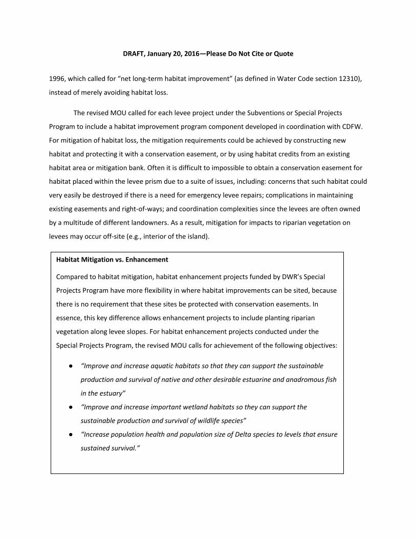
Habitat Mitigation vs. Enhancement
Compared to habitat mitigation, habitat enhancement projects funded by DWR’s Special
Projects Program have more flexibility in where habitat improvements can be sited, because
there is no requirement that these sites be protected with conservation easements. In
essence, this key difference allows enhancement projects to include planting riparian
vegetation along levee slopes. For habitat enhancement projects conducted under the
Special Projects Program, the revised MOU calls for achievement of the following objectives:
● “Improve and increase aquatic habitats so that they can support the sustainable
production and survival of native and other desirable estuarine and anadromous fish
in the estuary”
● “Improve and increase important wetland habitats so they can support the
sustainable production and survival of wildlife species”
● “Increase population health and population size of Delta species to levels that ensure
sustained survival.”

DRAFT, January 20, 2016—Please Do Not Cite or Quote
9
The United States Fish and Wildlife Service (USFWS) and the National Marine Fisheries Service
(NMFS) also may impose mitigation requirements related to the federal Endangered Species Act (ESA),
which is intended to prevent and avoid impact, or “take”, to threatened and endangered species. Under
ESA, “take” of protected species can include impacts to their habitat, so USFWS and NMFS have the
authority to mandate mitigation for impacts to loss of that habitat (e.g., riparian forest, which
represents habitat for numerous threatened and endangered bird species). Similarly, CDFW has
authority to mandate mitigation if impacts to that habitat will result in “take” of California Endangered
Species Act (CESA) protected species.
CDFW also administers the Streambed Alteration Agreements Program under sections 1601 to
1606 of the California Fish and Game Code. CDFW has jurisdiction over the bed and channel, and to the
top of the bank of all streams, extending laterally to the upland edge of adjacent riparian vegetation,
and may require mitigation for impacts to riparian habitat through the Streambed Alteration Agreement
Program.
Other agencies have mandates to protect riparian habitats on the basis of protecting beneficial
uses of water. The United States Army Corps of Engineers (USACE), which is authorized to enforce the
federal “no net wetland loss” policy, can mandate mitigation for impacts to riparian habitats that are
also jurisdictional wetlands under the federal Clean Water Act. The State Water Resources Control
Board (SWRCB) is currently developing a Wetland and Riparian Protection Policy, as directed by the
State Water Board’s Resolution 2008-0026. A key purpose of the Wetland Riparian Protection Policy is to
ensure “no net loss” of these two habitat types, because of their recognized value to protect beneficial
uses of waters of the State. The language of this resolution calls for the SWRCB to develop a statewide
policy to protect riparian areas through a watershed-based approach.
The California Environmental Quality Act (CEQA) review process requires projects to disclose
impacts from their construction and operation. The CEQA process requires assessments of the effects of
a project on a wide variety of resources including forestlands, essential fish habitat, and habitats that
DRAFT, January 20, 2016—Please Do Not Cite or Quote
10
are considered rare natural communities by CDFW (e.g., certain types of riparian forest). Avoidance,
minimization, and mitigation measures are often included in CEQA documents if the review process
reveals that a project may have significant impacts on these or other key resources.
Delta Plan Policy G P1 requires that projects that are deemed covered actions under the Delta
Plan include mitigation measures equivalent to or exceeding those listed in the Delta Plan Program
Environmental Impact Report (EIR). This EIR contains several mitigation measures particularly germane
to mitigation related to levee construction impacts on riparian and aquatic habitat. For example,
Biological Resources Mitigation Measure 4-3 states that “where substantial loss of habitat for fish and
wildlife species is unavoidable, compensate for impacts by preserving in-kind habitat.” while Biological
Resources Mitigation Measure 4-4 states “protect, restore and enhance connectivity of habitats,
including but not limited to wetland and riparian habitats that function as migration corridors for
wildlife species.”
Mitigation requirements and ratios are determined by the regulatory agencies. For the Delta
Levees Program, CDFW follows a set of standard mitigation ratios for riparian forest, scrub shrub,
freshwater marsh, and shaded riverine aquatic habitat.
Constraints to Implementing Levee-Related Habitat Projects
Implementation of levee-related habitat projects faces various regulatory and liability-related
constraints, due in part to the need to balance flood risk reduction and habitat improvement. As part of
the 2017 Central Valley Flood Protection Plan (CVFPP) Update, DWR has drafted a Central Valley Flood
System Conservation Strategy (DWR 2015c), including a Levee Vegetation Management Strategy, which
explains the need for vegetation management:
“Levee vegetation management is particularly important because levee
vegetation can impede visibility and accessibility for inspections and flood fighting, and
in some limited cases, it may pose an unacceptable threat to levee integrity. In channel
areas in between State Plan of Flood Control (SPFC) levees, the floodplain and channel
may provide opportunities for important riparian and wetland habitat, as well as

DRAFT, January 20, 2016—Please Do Not Cite or Quote
11
agricultural operations. However, land uses in these areas also need to be managed to
maintain the channel’s ability to convey high flows during flood events. Finally, invasive
plants can adversely affect operations and maintenance (O&M) of the SPFC and are a
documented stressor on the species, habitats, and ecosystem processes targeted by this
Conservation Strategy. Management of invasive species, and eradication of them where
feasible, reduces O&M needs by increasing channel capacity and provides important
ecosystem benefits.”
Although levee vegetation management is widely acknowledged to be important, there is
considerable controversy regarding the current nationwide policy of the USACE to require removal of
trees and most shrubs to establish a “vegetation-free zone” on and around levees under their
jurisdiction, and also to prevent planting of most vegetation other than grasses within this zone. Federal
legislation (Public Law 113-121, the Water Resources Reform and Development Act of 2014) requires
reevaluation of this policy by November 2015. This effort may result in an update to the USACE
Engineering Technical Letter (ETL) 1110-2-583, Guidelines for Landscape Planting and Vegetation
Management at Levees, Floodwalls, Embankment Dams and Appurtenant Structures (2014), which
states that vegetation on the levee and within 15 feet of the levee toe does not meet USACE engineering
standards, but the reevaluation process has not yet been funded. In the meantime, the USACE allows
local sponsors to apply for a variance. Local sponsors responsible for USACE levees face a liability risk if
they do not meet USACE engineering standards, i.e., they may not be eligible for rehabilitation
assistance if their levee fails. In 2011, USACE adopted the System-Wide Improvement Framework Policy
(SWIF), which was intended to enable USACE to work collaboratively with resource agencies and levee
sponsors to transition existing levees to Corps standards while maintaining rehabilitation assistance and
adhering to the ESA and other federal environmental laws. However, the procedures for obtaining a
variance from the ETL remain burdensome.
DWR and others engaged in levee repairs have been relying upon California’s Central Valley
Flood System Improvement Framework (Framework), signed in 2009 by participants in the California
Levees Roundtable, a group of high-level representatives of federal, state and local flood management

DRAFT, January 20, 2016—Please Do Not Cite or Quote
12
and resource agencies, to guide their project design. The State’s levee vegetation management strategy
described in the 2012 CVFPP and Conservation Framework is built on concepts in the California Levees
Roundtable Framework. DWR’s draft Levee Vegetation Management Strategy for the 2017 CVFPP
Update supports removing high risk trees near the top of the levee while retaining lower waterside
vegetation to reduce risk while avoiding widespread loss of habitat that would be difficult if not
impossible to mitigate. For new levees, the draft Levee Vegetation Management Strategy suggests
alternative approaches to providing shaded riverine aquatic habitat, such as construction of planting
berms located beyond the regulated levee prism, described in further detail below.
In addition to regulatory constraints and liability concerns, levee habitat projects are
constrained in some cases by lack of interest or capacity on the part of local reclamation districts (RDs).
According to Delta flood management experts, many RDs do not want habitat on their levees given the
increased risk associated with biological hazards (e.g., burrowing beavers) and uncertainties regarding
ongoing cost of maintenance of the habitat. One way to address these concerns would be for
landowners to donate or sell easements to state agencies if those agencies agree to construct and
maintain habitat on their land. Projects would need to be designed to reduce the risk of burrowing by
animals (e.g., by placing riprap at the toe of the levee beneath the soil used to create planting berms),
and earmark a portion of the funding for long term maintenance and monitoring of habitat.
II. PURPOSE AND APPROACH
The purpose of this paper is to explore the question of how to ensure that future State levee
investments, which are primarily aimed at flood risk reduction, also contribute to fulfilling the two
environmental mandates described above: 1) achieving the coequal goals, particularly with respect to
ecosystem restoration; and 2) providing a net benefit for aquatic species in the Delta. The paper
provides a review of past projects, summarizes lessons learned from monitoring reports and through
interviews with experts about which habitat designs may provide greater benefits to target native
species, and provides guidance to ensure that project effectiveness can be better evaluated in the
future. The paper also provides information about the costs of multi-benefit projects that combine levee

DRAFT, January 20, 2016—Please Do Not Cite or Quote
13
construction and habitat improvements, as well as the costs of projects that improve habitats along
levees but do not involve levee construction, e.g., projects that use riparian plantings to stabilize levee
slopes and provide erosion control.
Definition of Levee-Related Habitat Types
In order to conduct the review of levee-related habitat projects, Council staff needed to
determine which habitat types to include and how they would be defined. We reviewed the typology
developed by the FloodSAFE Environmental Stewardship and Statewide Resources Office (FESSRO) of
the California Department of Water Resources (DWR) for the Delta Levees Program. The mission of the
Delta Levees Program’s habitat enhancement is to restore and enhance sustainable and diverse
habitats, particularly shaded riverine aquatic, channel margin, wetlands, riparian forest, scrub shrub,
and uplands, in a mosaic that benefits the overall ecological health of the Delta and its native species.
FESSRO characterized several of those different levee-related habitat types in a diagram (Figure 3),
including: freshwater marsh (tidal and non-tidal); shaded riverine aquatic; and riparian habitat, including
riparian forest and scrub shrub. For the purposes of this report, we use the same habitat classifications
and definitions as FESSRO.
DRAFT, January 20, 2016—Please Do Not Cite or Quote
14
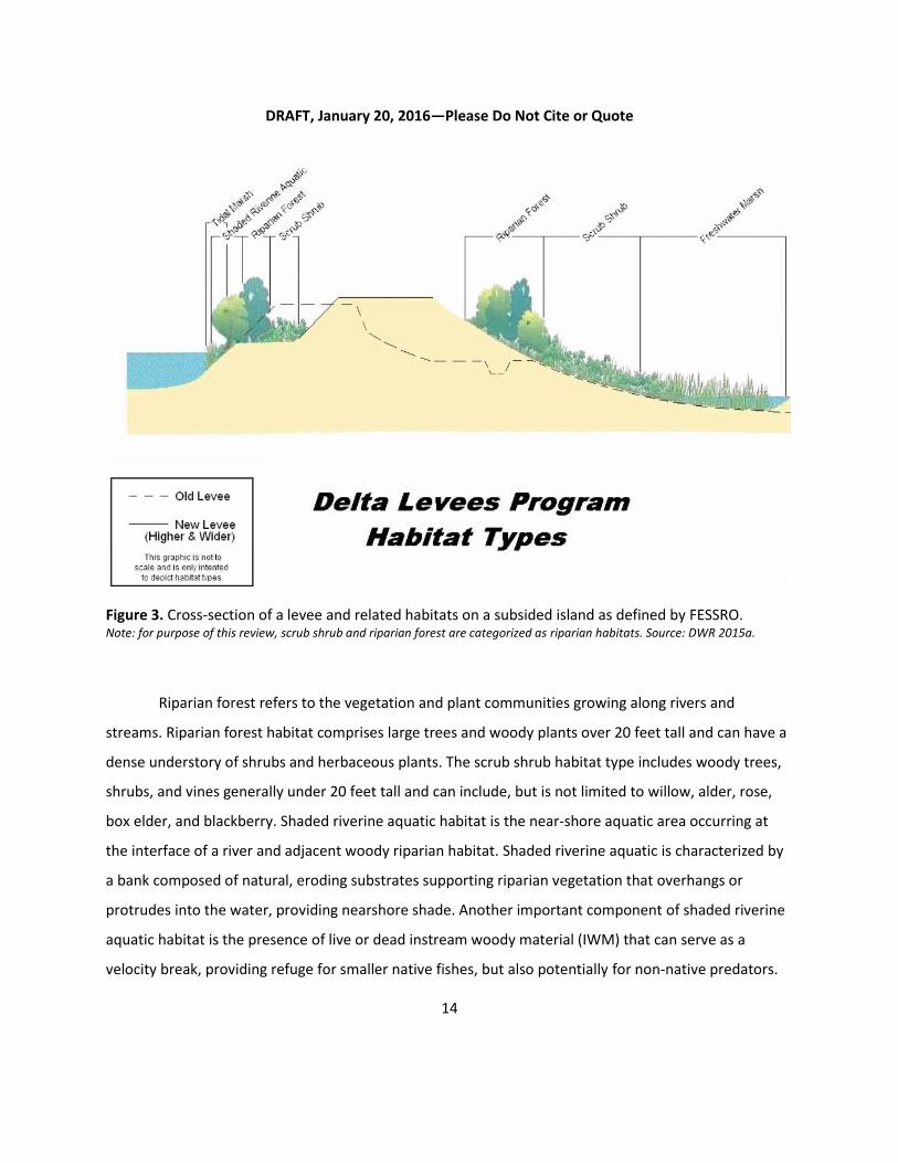
Figure 3. Cross-section of a levee and related habitats on a subsided island as defined by FESSRO. Note: for purpose of this review, scrub shrub and riparian forest are categorized as riparian habitats. Source: DWR 2015a.
Riparian forest refers to the vegetation and plant communities growing along rivers and
streams. Riparian forest habitat comprises large trees and woody plants over 20 feet tall and can have a
dense understory of shrubs and herbaceous plants. The scrub shrub habitat type includes woody trees,
shrubs, and vines generally under 20 feet tall and can include, but is not limited to willow, alder, rose,
box elder, and blackberry. Shaded riverine aquatic habitat is the near-shore aquatic area occurring at
the interface of a river and adjacent woody riparian habitat. Shaded riverine aquatic is characterized by
a bank composed of natural, eroding substrates supporting riparian vegetation that overhangs or
protrudes into the water, providing nearshore shade. Another important component of shaded riverine
aquatic habitat is the presence of live or dead instream woody material (IWM) that can serve as a
velocity break, providing refuge for smaller native fishes, but also potentially for non-native predators.

DRAFT, January 20, 2016—Please Do Not Cite or Quote
15
Freshwater marsh habitat describes both tidal and non-tidal areas and is generally characterized as a
relatively shallow aquatic area (typically less than 4.5 feet deep) with emergent vegetation like tules,
bulrushes, and cattails. Tidal marsh may occur along the levees of slower moving water from one foot
below mean lower low water (MLLW) up to mean higher high water (MHHW) where emergent
vegetation such as cattails and tules grow (Atwater & Hedel 1976). Channel margin habitat (sometimes
referred to by FESSRO as “Fish Friendly Levee Habitat”) provides soft bank substrates across a range of
elevations that include tidally submerged benches to seasonally-inundated riparian habitat (i.e., shaded
riverine aquatic). Channel margin habitat provides shallower depths and slower velocity than in the
adjacent channel, which provides Delta-specific rearing and outmigration habitat for juvenile salmonids.
Information Gathering
Through coordination with other agencies and stakeholders we obtained descriptions of
completed levee-related habitat improvement projects and associated monitoring reports conducted
within the Delta to evaluate project effectiveness. Information about fifteen levee-related habitat
improvement projects (mapped in Figure 4) was obtained through a query of 16 interviewees and 14
additional contacts provided by interviewees. The interviews covered a variety of topics, including
project components, pre- and post-construction monitoring to evaluate project effectiveness, the cost
of incorporating habitat improvement into projects, the use of adaptive management in making post-
construction decisions, and lessons learned that can inform other similar efforts in the Delta (see
Appendix 1 for details). Council staff also requested and compiled cost data information for habitat
improvement projects associated with levee projects from various sources, including DWR, USACE,
USFWS, consultants, and nongovernmental organizations. We looked at habitat enhancement projects,
in which habitat improvements were incorporated where levee construction work occurred, as well as
habitat mitigation projects that occurred off-site.
Research Objectives The majority of the projects evaluated were planned prior to the adoption of the Delta Plan
regulations (2013), which require ecosystem restoration projects that are covered actions to have

DRAFT, January 20, 2016—Please Do Not Cite or Quote
16
adaptive management plans; therefore, we do not assess whether or not the project used an adaptive
management framework. Rather, project effectiveness is considered in terms of 1) the project stated
objectives, performance measures, monitoring, and results and 2) whether or not a project could be
shown to benefit aquatic and/or terrestrial species.
The main objective of the cost analysis was to determine the incremental cost of incorporating
habitat improvement components into levee construction projects, either through the creation of
habitat features on-site (e.g., creation of a habitat bench) or through acquisition of habitat credits from
a mitigation bank.

DRAFT, January 20, 2016—Please Do Not Cite or Quote
17
Figure 4. Map of levee-related habitat improvement projects reviewed. These projects were implemented by
various state and federal agencies. Numerals indicate project number in Table A5.1. Symbols following numerals indicate if project has reports pertaining to: vegetation (V), fish (F), birds (B), water quality (W), and hydrology (H) monitoring and/or budgetary data ($). Project references 27-34 are approximately located.

DRAFT, January 20, 2016—Please Do Not Cite or Quote
18
III. ANALYSIS
Analytical Challenges
Council staff’s review could not compare the effectiveness of different types of habitat
improvement projects due to the inconsistent or insufficient level of appropriate fish and wildlife
monitoring data across projects to evaluate the effects of a habitat project on target species.
Determining net benefit to species would require, in the near term, evidence of increased occupancy of
restored habitat by the target species, and, over the long term, evidence of a relationship between
increased availability of habitat and population growth of the target species. The general lack of this
type of monitoring data from levee-related habitat projects in the Delta is due in part to a lack of
available funds to pay for species response monitoring for projects undertaken by the Delta Levees
Program.
Through our interview process, we were informed that monitoring of wildlife response is rarely
required (an exception is the Natomas Basin Conservancy), and that post-construction monitoring is
largely limited to regulatory compliance monitoring. This compliance monitoring typically takes place
over a three to five year period and documents the successful initial establishment of planted vegetation
and control of invasive weeds at the site (if sites fail to achieve the target for survival of planted
vegetation, or if sites exceed a defined threshold of cover by invasive weeds, these issues must be
remediated in order for the mitigation site to be considered in compliance).
Despite our inability to draw conclusions regarding the effectiveness of different habitat
improvement designs, our review of project monitoring reports resulted in some observations regarding
effectiveness that can inform future projects (for details, see Appendix 1, Lessons Learned). Later in this
report, we summarize our observations and provide guidance for future monitoring and research
projects to reduce some of the key uncertainties associated with these levee-related habitat projects.
In our costs analysis review we were unable to specifically isolate the costs of habitat
improvements for multi-objective projects. Cost information for the habitat component of these
projects is rarely broken out from the risk reduction component (i.e., levee construction or

DRAFT, January 20, 2016—Please Do Not Cite or Quote
19
rehabilitation), making it impossible to isolate costs of the habitat improvements. We did break out
average total costs of different habitat improvement project types (e.g., riparian enhancement projects
versus mitigation banks). However, since these cost figures include total project costs (which may
include the costs of construction for general levee improvements), there is a large amount of variance in
cost estimates for different types of habitat improvements.
Considerations to Guide Future Projects
Habitat improvement projects should be viewed as an opportunity to conduct studies that
serve to fill crucial information gaps (Brown 2003; Herbold et al. 2014; Block et al. 2001). Although
vegetation performance measures are an important component of baseline monitoring, more wildlife
response monitoring is needed to confirm benefits to wildlife, especially aquatic species. Wildlife
response monitoring is generally limited to presence or absence data for a species. Presence or
abundance of a species within a habitat is generally assumed to reflect a net benefit to individuals or
populations; however, further studies are needed to confirm this assumption and determine the extent
to which habitat plays a role in survival especially across the life stages of migratory fishes (e.g.,
Rosenfeld 2003). Furthermore, fundamental questions, such as what scale of habitat areas is needed to
outweigh adverse edge effects within each target habitat, remain undefined. These scale questions must
be considered for effective restoration, including what is the effective riparian forest width and area
needed to enhance ecological value for bird habitat and terrestrial species? Another fundamental
question could be asked for shaded riverine aquatic habitat in the Delta—would it provide significant
water temperature benefits to native fish? Much of the Delta has wide, deep channels with abundant
flow from tidal exchange; it is unknown whether relatively narrow widths of shade within those wide
channels can provide appreciable cooling benefits to fish (Greenberg et al. 2012).
Provided below are some considerations needed when designing habitat along levees for the
benefit of native fish and avian species. A more complete analysis of the needs of these species is
provided in Appendix 1, Lessons Learned from Past Projects and Research Studies.

DRAFT, January 20, 2016—Please Do Not Cite or Quote
20
Native Fish Requirements
The monitoring reports we received pertaining to the effects of channel margin improvements
focused almost exclusively on salmonid response. As such, we limited the focus of the following
discussion regarding native fish requirements to salmonids. Past habitat enhancement projects have
likely benefited other native fish species too (e.g., splittail, tule perch, Delta smelt, longfin smelt,
Sacramento pikeminnow, sturgeon), so we encourage future levee-related habitat projects to consider
monitoring a broader suite of fish species beyond salmonids.
1. Importance of improved channel margin habitat for native fish, especially juvenile salmon
Channel margin habitat with overhanging riparian vegetation (i.e., shaded riverine aquatic),
slower water velocities and soft bank substrates provide important habitat for migrating juvenile
salmon. Calmer, shallow waters provide a habitat for small juvenile salmon where they can rest and
feed, and find refuge from larger, predatory fish. Shaded riverine aquatic habitat can provide an
important source of food to the aquatic system as insects fall off riparian vegetation overhanging the
river (Murphy and Meehan 1991; Smokorowski and Pratt 2006), while vegetation debris entering the
river (e.g., falling leaves, woody debris) can also contribute to the aquatic foodweb. The overhanging
vegetation also provides cover for small native fish from predation by birds.
Shaded riverine aquatic habitat also provides water temperature cooling benefits along narrow
channels of the Delta; many native fish like salmon and smelt can be temperature impaired during the
late spring and summer months and the beneficial microclimates that this habitat provides could be
increasingly important with climate change. A recent study indicates that if all trees were removed from
levees Delta, water temperatures would increase by 0.2°F Delta-wide and up to 7°F within narrower
channels; along deeper and wider channels, however, the cooling benefits decrease (Greenberg et al.
2012).
The placement of riprap within channel margin habitat has been linked to degradation in habitat
suitability for juvenile salmon in the Delta. Non-native fish predators can hold in the gaps of the riprap
and ambush smaller fish as they move to and from nearshore habitat (McLain and Castillo 2009). As a

DRAFT, January 20, 2016—Please Do Not Cite or Quote
21
result, areas of the Delta that have been riprapped are associated with lower salmon counts during fish
surveys than areas with sandy or muddy substrates, either because salmon are avoiding riprapped
habitat or because they are suffering high predation loss (Schmetterling et al. 2001; Garland et al. 2002;
McLain and Castillo 2009).
Although the importance of restored channel margin habitat for juvenile salmonids is widely
viewed as critical for restoring populations, recent acoustic fish telemetry surveys indicate that
migrating salmonids may not effectively utilize established or restored channel margin habitat because
we do not fully understand the influence of such factors as the length, depth, bank slope, vegetative
make up (tules to willows), and location on habitat utilization (Jon Burau, pers. comm. 2015). Habitat
utilization studies are needed to determine the influence of these factors on the suitability of channel
margin habitat enhancements in improving survival and condition of juvenile salmonids emigrating from
the Delta.
2. Importance of providing the appropriate density of IWM.
Placing IWM is a common technique in salmon habitat restoration projects for areas such as the
Pacific Northwest. Larger IWM (> 4 inches diameter) have been found to benefit juvenile Chinook
salmon since it creates refuge from faster flow velocities and provides daytime cover for them from
avian and fish predators (Zanjanc 2013). However, adding more IWM does not necessarily create better
habitat for juvenile salmon. A study conducted along the lower Sacramento River showed that in areas
with IWM in low and medium densities, Chinook salmon fry occupation increased by two- to three-fold;
however, in areas with a “high density” of IWM, occupation by Chinook salmon fry dropped 75% as
presence of non-native predatory fish increased twenty-fold. In the Delta where there are many species
of introduced, warmwater fish predators, high densities of IWM may simply create more spots for them
to hide and ambush small native fish. Further study of how IWM density, size, and location affects non-
native predatory fish and native aquatic species along river corridors and tidally-influenced Delta
channels must be conducted before we assume IWM will invariably provide a net benefit to aquatic
species.

DRAFT, January 20, 2016—Please Do Not Cite or Quote
22
Bird Requirements
Larger riparian or marsh areas with connectivity between habitats will benefit avian species by
providing protection, food resources, and nesting areas. The width of riparian habitat along the river
channels of the Delta has decreased dramatically and is now measured in feet instead of miles. In
general, riparian corridors that are a minimum of 100 meters (109 yards) wide are needed to provide
foraging and nesting opportunities for neotropical migrant birds (e.g., orioles, flycatchers, warblers, and
vireos). Riparian bird populations are typically more successful in areas with larger habitat patches that
are not isolated from one another and located away from urban areas. Conversely, increased nest
predation is often associated with smaller, isolated riparian patches.
Refining Project Goals and Design in Light of Delta-Specific Constraints
We advise caution when applying lessons learned from other parts of the Central Valley and
elsewhere to the Delta, due to the Delta’s unique ecological and hydrodynamic setting and highly
altered physical state. The best locations for restoring more natural functional flows to create wetland
habitats are in flood bypasses, such as the Yolo Bypass, and other areas ranging from intertidal to upland
elevations on the outer edges of the Delta, because of the constraints to natural overbank flooding on
subsided islands in the central Delta.
Design Considerations for Setback Levees
Setback levees enable reestablishment of natural riverine processes necessary for establishing
sustainable riparian habitats and can provide broad areas of floodplain habitat that benefit aquatic and
terrestrial target species (Stromberg et al. 2007; Shafroth et al. 2010; Golet et al. 2013). Planning of
setback levees as a habitat restoration option should consider the Delta-specific constraints discussed
below and utilize indices that integrate floodplain inundation frequencies and life-cycles of target
species such as the integrative method for quantifying floodplain habitat developed by Matella and Jagt
(2014).
The draft Central Valley Flood System Conservation Strategy (DWR 2015c) lists several factors
that should be considered when determining if a setback levee is appropriate for a given location. One
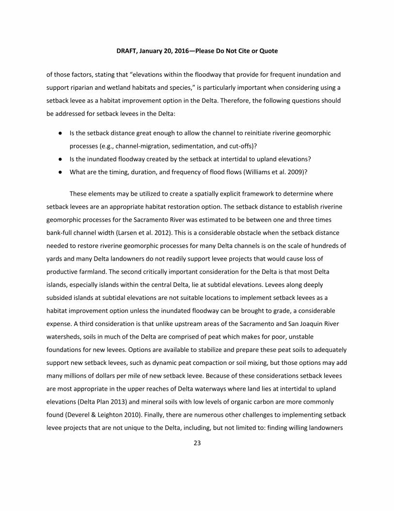
DRAFT, January 20, 2016—Please Do Not Cite or Quote
23
of those factors, stating that “elevations within the floodway that provide for frequent inundation and
support riparian and wetland habitats and species,” is particularly important when considering using a
setback levee as a habitat improvement option in the Delta. Therefore, the following questions should
be addressed for setback levees in the Delta:
● Is the setback distance great enough to allow the channel to reinitiate riverine geomorphic
processes (e.g., channel-migration, sedimentation, and cut-offs)?
● Is the inundated floodway created by the setback at intertidal to upland elevations?
● What are the timing, duration, and frequency of flood flows (Williams et al. 2009)?
These elements may be utilized to create a spatially explicit framework to determine where
setback levees are an appropriate habitat restoration option. The setback distance to establish riverine
geomorphic processes for the Sacramento River was estimated to be between one and three times
bank-full channel width (Larsen et al. 2012). This is a considerable obstacle when the setback distance
needed to restore riverine geomorphic processes for many Delta channels is on the scale of hundreds of
yards and many Delta landowners do not readily support levee projects that would cause loss of
productive farmland. The second critically important consideration for the Delta is that most Delta
islands, especially islands within the central Delta, lie at subtidal elevations. Levees along deeply
subsided islands at subtidal elevations are not suitable locations to implement setback levees as a
habitat improvement option unless the inundated floodway can be brought to grade, a considerable
expense. A third consideration is that unlike upstream areas of the Sacramento and San Joaquin River
watersheds, soils in much of the Delta are comprised of peat which makes for poor, unstable
foundations for new levees. Options are available to stabilize and prepare these peat soils to adequately
support new setback levees, such as dynamic peat compaction or soil mixing, but those options may add
many millions of dollars per mile of new setback levee. Because of these considerations setback levees
are most appropriate in the upper reaches of Delta waterways where land lies at intertidal to upland
elevations (Delta Plan 2013) and mineral soils with low levels of organic carbon are more commonly
found (Deverel & Leighton 2010). Finally, there are numerous other challenges to implementing setback
levee projects that are not unique to the Delta, including, but not limited to: finding willing landowners

DRAFT, January 20, 2016—Please Do Not Cite or Quote
24
to provide land; complications in protecting existing structures and utilities; and maintaining access for
mineral rights holders.
Design Considerations for Adjacent Levees
Adjacent levees (see Figure 5 for definition) cost more, on average, than typical levee
improvement projects because they require a substantial amount of fill, and like setback levees, also
require stabilization of soil foundations. In addition, while setback levees have been shown to benefit
ecosystems in other regions (DWR 2015c), adjacent setback levees: 1) do not follow the conceptual
model of how setback levees provide ecosystem benefits and 2) have not been monitored adequately to
indicate whether or not there are positive benefits to native wildlife in the Delta.
Although there is a lack of monitoring data to definitively show if adjacent levees provide
benefits to native Delta species, construction of an adjacent levee can make sense in situations where
continuing to maintain an existing levee is more expensive in the long term than shifting the prism of the
levee landward. An example of such a situation occurred with levees on Twitchell Island along the San
Joaquin River. The waterside slopes of these levees required armoring from riprap because of the highly
erosive forces (i.e., boat wakes from large shipping vessels and waves resulting from long wind fetch)
along this stretch of the San Joaquin River; however, the rock riprap needed to be constantly replaced as
the riverbank is naturally very steep and the rocks would eventually slide off the levee to the bottom of
the river bed (Chris Neudeck, personal communication 2015). During the mid-2000’s, the Delta Levees
Program helped fund construction of an adjacent levee along a short stretch of the existing levee on
Twitchell Island as a more cost-effective flood risk reduction measure. In addition, DWR and CDFW staff
helped incorporate habitat enhancement aspects into this project with the intended goal of creating
riparian habitat and providing channel margin habitat for Delta fish. The levees along the San Joaquin
River on Twitchell Island are not identified by the Delta Plan (i.e., Delta Plan Policy ER P4) as areas where
setback levees should be considered to benefit Delta habitat. However, in similar future circumstances,
where adjacent or setback levees are determined to be the most effective option for providing flood risk
reduction, we recommend that such projects integrate habitat enhancement features to the maximum
extent possible. Since we still have considerable knowledge gaps regarding the potential benefits that
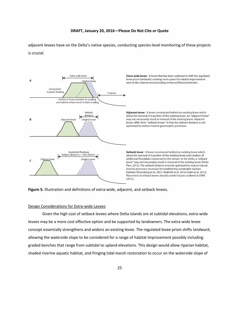
DRAFT, January 20, 2016—Please Do Not Cite or Quote
25
adjacent levees have on the Delta’s native species, conducting species-level monitoring of these projects
is crucial.
Figure 5. Illustration and definitions of extra-wide, adjacent, and setback levees.
Design Considerations for Extra-wide Levees
Given the high cost of setback levees where Delta islands are at subtidal elevations, extra-wide
levees may be a more cost effective option and be supported by landowners. The extra-wide levee
concept essentially strengthens and widens an existing levee. The regulated levee prism shifts landward,
allowing the waterside slope to be considered for a range of habitat improvement possibly including
graded benches that range from subtidal to upland elevations. This design would allow riparian habitat,
shaded riverine aquatic habitat, and fringing tidal marsh restoration to occur on the waterside slope of
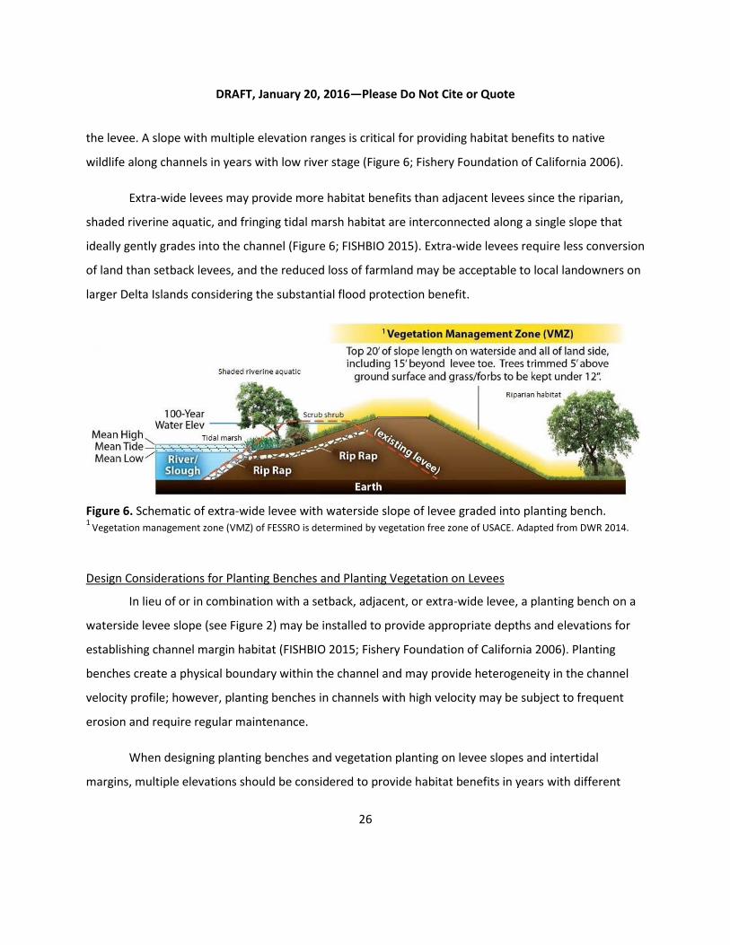
DRAFT, January 20, 2016—Please Do Not Cite or Quote
26
the levee. A slope with multiple elevation ranges is critical for providing habitat benefits to native
wildlife along channels in years with low river stage (Figure 6; Fishery Foundation of California 2006).
Extra-wide levees may provide more habitat benefits than adjacent levees since the riparian,
shaded riverine aquatic, and fringing tidal marsh habitat are interconnected along a single slope that
ideally gently grades into the channel (Figure 6; FISHBIO 2015). Extra-wide levees require less conversion
of land than setback levees, and the reduced loss of farmland may be acceptable to local landowners on
larger Delta Islands considering the substantial flood protection benefit.
Figure 6. Schematic of extra-wide levee with waterside slope of levee graded into planting bench. 1
Vegetation management zone (VMZ) of FESSRO is determined by vegetation free zone of USACE. Adapted from DWR 2014.
Design Considerations for Planting Benches and Planting Vegetation on Levees
In lieu of or in combination with a setback, adjacent, or extra-wide levee, a planting bench on a
waterside levee slope (see Figure 2) may be installed to provide appropriate depths and elevations for
establishing channel margin habitat (FISHBIO 2015; Fishery Foundation of California 2006). Planting
benches create a physical boundary within the channel and may provide heterogeneity in the channel
velocity profile; however, planting benches in channels with high velocity may be subject to frequent
erosion and require regular maintenance.
When designing planting benches and vegetation planting on levee slopes and intertidal
margins, multiple elevations should be considered to provide habitat benefits in years with different

DRAFT, January 20, 2016—Please Do Not Cite or Quote
27
river stages. A survey of the Lower American River found that out-migrating juvenile salmonids utilized
riprap reaches with riparian habitat and channel margin enhancement (e.g., IWM) nearly as much as
“natural” (i.e., non-riprapped) levee slopes (Fishery Foundation of California 2006). However, in years
with very low flow, river stage fell to an elevation below the channel-margin enhancement projects. Use
of these areas by out-migrating juvenile salmonids fell by about 83% while use of natural levee slopes
fell by only 20%. Years with very high river stages may also prove problematic for channel-margin
enhancement projects conducted at a limited range of elevations; when river stages are high the
enhancement site could occur at depths too great for native aquatic and/or terrestrial species to utilize
the habitats (Fishery Foundation of California 2006).
In locations with especially high water velocity and steep bathymetric gradients at the
waterside levee-slope, planting vegetation on the levee slope and within the intertidal zone may be
a more feasible habitat enhancement option than planting benches. This method has been
effectively applied in at least three locations within the Delta (Grand Island, King Island, and Canal
Ranch). Ballast buckets have been successfully implemented by Jeff Hart to establish tule marsh at
Grand Island (Hart 2006) and alders have been successfully planted on a waterside bench at Canal
Ranch (EA Engineering, Science, and Technology 1996). Planting on and near existing levees is
generally inexpensive; however, no wildlife related monitoring to date has been conducted at these
sites to determine habitat benefits to terrestrial and/or aquatic wildlife.
Cost Analysis
On-Site Riparian Habitat Improvement
DWR provided cost information for Delta levee construction projects that incorporated habitat
elements on-site (Table 2). Generally these projects involved enhancement of riparian habitat on the
levees through planting of trees within bank erosion control materials (e.g., riprap), with an average of
approximately 600 trees planted per linear mile, while mitigation requirements for habitat impacts
during these levee projects were satisfied through purchases of mitigation credits. The total costs for
these projects (i.e., the sum of both the flood risk reduction and habitat enhancement elements of the
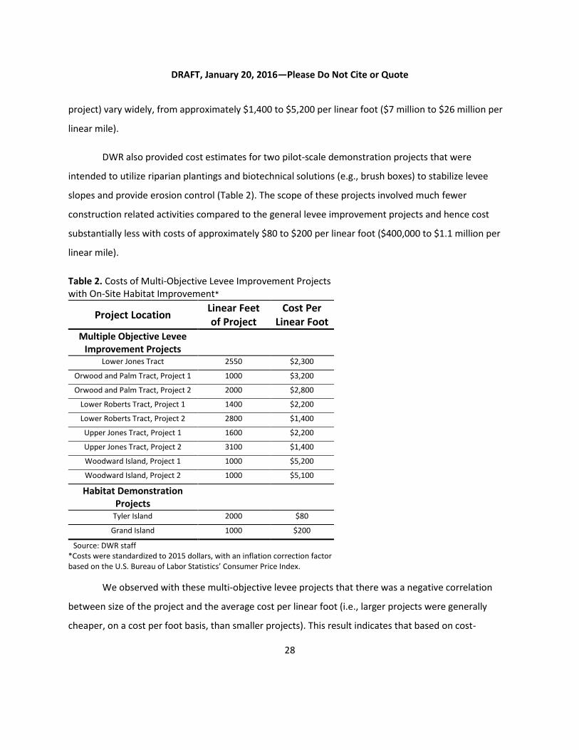
DRAFT, January 20, 2016—Please Do Not Cite or Quote
28
project) vary widely, from approximately $1,400 to $5,200 per linear foot ($7 million to $26 million per
linear mile).
DWR also provided cost estimates for two pilot-scale demonstration projects that were
intended to utilize riparian plantings and biotechnical solutions (e.g., brush boxes) to stabilize levee
slopes and provide erosion control (Table 2). The scope of these projects involved much fewer
construction related activities compared to the general levee improvement projects and hence cost
substantially less with costs of approximately $80 to $200 per linear foot ($400,000 to $1.1 million per
linear mile).
Table 2. Costs of Multi-Objective Levee Improvement Projects with On-Site Habitat Improvement*
Project Location Linear Feet of Project
Cost Per Linear Foot
Multiple Objective Levee Improvement Projects
Lower Jones Tract 2550 $2,300
Orwood and Palm Tract, Project 1 1000 $3,200
Orwood and Palm Tract, Project 2 2000 $2,800
Lower Roberts Tract, Project 1 1400 $2,200
Lower Roberts Tract, Project 2 2800 $1,400
Upper Jones Tract, Project 1 1600 $2,200
Upper Jones Tract, Project 2 3100 $1,400
Woodward Island, Project 1 1000 $5,200
Woodward Island, Project 2 1000 $5,100
Habitat Demonstration Projects
Tyler Island 2000 $80
Grand Island 1000 $200
Source: DWR staff *Costs were standardized to 2015 dollars, with an inflation correction factor based on the U.S. Bureau of Labor Statistics’ Consumer Price Index.
We observed with these multi-objective levee projects that there was a negative correlation
between size of the project and the average cost per linear foot (i.e., larger projects were generally
cheaper, on a cost per foot basis, than smaller projects). This result indicates that based on cost-

DRAFT, January 20, 2016—Please Do Not Cite or Quote
29
effectiveness, it is preferable to restore larger amounts of habitat in fewer projects instead of many
smaller projects (see Figure 7). However, site specific considerations and levee condition can influence
this and make the costs of restoring riparian habitat on levees highly variable.
Figure 7. Relationship between size of multiple-objective levee improvement projects* and total cost of project. *These projects all include on-site habitat improvements within the levee prism.
Off-Site Mitigation Banks
In 2012, DWR established the Bulk Credit Program which provides off-site mitigation credits for
RDs participating in the Delta Levees Program. DWR purchased a large quantity of these mitigation
credits through Westervelt Ecological Services’ Cosumnes Floodplain Mitigation Bank, located near the
confluence of the Cosumnes and Mokelumne Rivers. These mitigation credits include shaded riverine
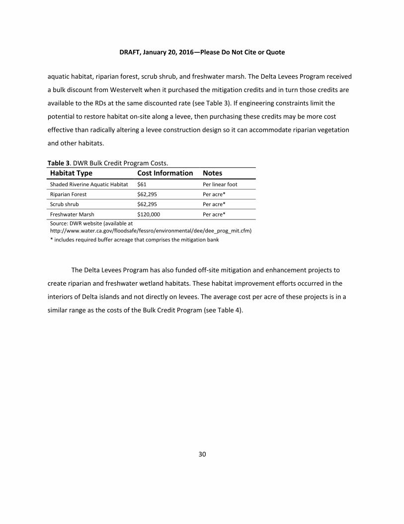
DRAFT, January 20, 2016—Please Do Not Cite or Quote
30
aquatic habitat, riparian forest, scrub shrub, and freshwater marsh. The Delta Levees Program received
a bulk discount from Westervelt when it purchased the mitigation credits and in turn those credits are
available to the RDs at the same discounted rate (see Table 3). If engineering constraints limit the
potential to restore habitat on-site along a levee, then purchasing these credits may be more cost
effective than radically altering a levee construction design so it can accommodate riparian vegetation
and other habitats.
Table 3. DWR Bulk Credit Program Costs.
Habitat Type Cost Information Notes
Shaded Riverine Aquatic Habitat $61 Per linear foot
Riparian Forest $62,295 Per acre*
Scrub shrub $62,295 Per acre*
Freshwater Marsh $120,000 Per acre*
Source: DWR website (available at http://www.water.ca.gov/floodsafe/fessro/environmental/dee/dee_prog_mit.cfm)
* includes required buffer acreage that comprises the mitigation bank
The Delta Levees Program has also funded off-site mitigation and enhancement projects to
create riparian and freshwater wetland habitats. These habitat improvement efforts occurred in the
interiors of Delta islands and not directly on levees. The average cost per acre of these projects is in a
similar range as the costs of the Bulk Credit Program (see Table 4).

DRAFT, January 20, 2016—Please Do Not Cite or Quote
31
Table 4. DWR and CDFW Off-Channel Habitat Mitigation and Enhancement Projects*
Project Location
Acreage Total Cost
(in millions) Price per acre (in thousands)
Created Habitat Types
Bradford Island 50 $2.2 $45.0 Freshwater marsh; Scrub shrub; Riparian forest
Sherman Island (Parcel 11)
5.67 $0.77 $135.6 Riparian forest: Freshwater marsh; Scrub shrub
Decker Island 26 $14.7 $563.8 Tidal freshwater marsh; Riparian forest
Source: DWR staff *Costs were standardized to 2015 dollars, with an inflation correction factor based on the U.S. Bureau of Labor Statistics’ Consumer Price Index.
Adjacent and Setback Levees
As described previously, adjacent levees involve constructing a new levee in close proximity to
or immediately adjoining an existing levee, while setback levees involve constructing a new levee behind
an existing levee at a sufficient distance to allow for the reestablishment of natural riverine processes. In
the mid-2000’s, DWR constructed adjacent levees along the southern portions of Sherman Island and
Twitchell Island at an average cost of approximately $1,000 to $2,200 per linear foot or $5.5-11.4 million
per linear mile (in 2015 dollars). However, due to unique circumstances, some costs typically associated
with these types of levee projects were not included in this cost assessment. First, the land where these
particular projects took place was owned by DWR, so the cost of purchasing the land was not
incorporated. Second, berms were placed on the landward toe of the levee many years prior to the
construction of the adjacent levee, which helped stabilize the normally unstable peat soil. The cost of
constructing these berms are unknown and was not included as costs for these adjacent levee projects.
Third, these adjacent levees were constructed next to the existing levee, decreasing the volume of fill
and contributing to major savings in materials costs compared to constructing a setback levee.
Planned setback levees in the Delta are expected to be significantly more expensive than the
adjacent levees undertaken in the past. The total cost of the proposed setback levee in West
Sacramento (Southport Project) is predicted to cost an average of $12,700 per linear foot or $67 million
per linear mile (USACE 2014), while preliminary cost estimates (RD 1601 2014) place the estimate for
future construction of setback levees along the southern portion of Twitchell Island around
approximately $4,300 per linear foot ($23 million per linear mile). The cost of the setback levee for the

DRAFT, January 20, 2016—Please Do Not Cite or Quote
32
Southport Project is substantially larger than DWR’s past Delta adjacent levee projects because it
includes the cost of land acquisition in an urban area, and the newly constructed levees will be fully
setback from the existing levees.
Table 5. Cost of adjacent and setback levees in the Deltaa
Adjacent/Setback Levee Location
Status Linear Feet
Total Cost (in millions)
Cost per Linear Foot (in thousands)
Sherman Island Implemented 6,000 $12.9 $2,200b
Twitchell Island Implemented 2,400 $2.5 $1,000b
Southport (West Sacramento) Planned 29,300 $373.7 $12,700c
Twitchell Island Planned 20,380 $88.0 $4,300d
a Costs were standardized to 2015 dollars, with an inflation correction factor based on the U.S. Bureau of Labor Statistics’ Consumer Price Index. b Source: DWR staff c Source: USACE 2014 d Source: RD 1601, 2014
Of all the habitat improvement options considered, setback levees generally are one of the most
expensive options when all cost considerations are taken into account. Site-specific considerations may
make setback levee projects economically prudent. For example, USACE determined that the cost of
constructing the setback levee for the Southport Project would be cheaper than retrofitting the existing
levee (e.g., installation of slurry cutoffs, seepage walls, and stability berms), in part because the total
length of the new setback levee would be shorter than the existing levee. Also, the original adjacent
levee project at Twitchell Island constructed during the early 2000’s was determined to be cheaper than
continuing to maintain the existing levee, because the cost of regularly placing riprap to protect the
levee from boat wake erosion became prohibitive.
IV. RECOMMENDED NEXT STEPS
Based on the findings of the review, we suggest taking the following steps to improve the siting and
design of future restoration, enhancement, and mitigation projects and ensure that effectiveness can be
clearly evaluated in the future. We note that long-term steady sources of funding and dedicated staff
DRAFT, January 20, 2016—Please Do Not Cite or Quote
33
resources for monitoring and adaptive management will be necessary to assess and improve the
performance of habitat projects over time.
1. Develop appropriate performance measures as part an adaptive management plan.
An adaptive management framework building on past successes and experiences in the Delta is
an integral part of resource management planning. For successful outcomes, future multi-objective
projects should be planned, designed and executed based on the adaptive management framework,
which incorporates the best available science into the decision making process. As defined in the Delta
Reform Act, adaptive management is “a framework and flexible decision making process for ongoing
knowledge acquisition, monitoring, and evaluation leading to continuous improvements in management
planning and implementation of a project to achieve specified objectives” (Water Code section 85052).
Delta Plan Policy G P1 calls for habitat restoration projects to use best available science and develop
adaptive management plans with documented resources for implementation. The definitions for “best
available science” and “adaptive management” are documented in the Delta Plan’s Appendix 1A and 1B,
respectively.
Additionally, future habitat improvement projects must be strategically located and planned
considering the best available predictive and conceptual models (e.g., Standardized Assessment
Methodology [SAM]; Management, Analysis, and Synthesis Team [MAST]; Salmonid/Steelhead/Sturgeon
Assessment Indicators by Life Stages [SAIL]) for target species (native and invasive) and future scenarios
of changes in sea level, sediment supply, and infrastructure that will determine the long-term efficacy
and sustainability of habitat management (Stralberg et al. 2011; Swanson et al. 2015).
Levee investments and habitat improvements are complex issues in the Delta and they are
closely linked to the coequal goals of providing a more reliable water supply for California and restoring
the Delta ecosystem. Hundreds of millions of State dollars will be spent on future levee improvements
and maintenance, as well as habitat enhancement and associated monitoring in the Delta. It will be
essential to select appropriate performance measures, including fish and wildlife response, to assess
effectiveness in providing benefits to target species. By identifying quantifiable criteria at the outset of a
project, we will be better able to measure success.
DRAFT, January 20, 2016—Please Do Not Cite or Quote
34
2. Track the incremental cost of habitat improvements.
Accurate cost accounting of the habitat element of levee projects is necessary to better
understand how funds have been invested to improve habitat in the Delta. Costs could be segregated by
bidding construction and habitat components separately following the practice of the Sacramento Area
Flood Control Agency (SAFCA). SAFCA does not bid/solicit levee improvements and habitat improvement
projects in the same bid package allowing them to segregate costs and giving them flexibility in selecting
the most qualified and experienced contractors to implement the habitat improvement component of a
multi-objective project.
DWR has recognized the importance of breaking down these costs into habitat and flood risk
reduction components in order to make more informed decisions in how to disburse state funds for the
Delta Levees Program. In the future, DWR intends to make such a cost breakdown a requirement for
receiving grant funding. We support this proposed requirement of the Delta Levees Program because it
will enable DWR to better assign how state investments in Delta levees are being disbursed and if
restoration objectives are being realized.
3. Carefully consider the tradeoffs associated with on-site and off-site mitigation.
During our review, we observed that on-site mitigation and enhancement of channel margin
habitat for Delta levee projects is challenging. RDs, whose chief responsibility is protecting their island
from flooding, have to be willing to not only allow vegetation to become established along or adjacent
to their levees, but also committed for the long-term to maintain it. Multiple regulatory hurdles (e.g.,
Section 408 permits for alteration of USACE project levees and Section 404 permits needed for wetland
fill when constructing shallow water benches) can make incorporating habitat components into levee
rehabilitation projects challenging, costly, and time-consuming. Conservation easements are not
typically issued for habitat located within the levee prism based on concern that such habitat could very
easily be destroyed if there is a need for emergency levee repairs; as a result, habitat mitigation typically
cannot occur on levees because of requirements that such mitigation projects be protected into
perpetuity through an easement. Additionally, design of habitat components on levees is constrained
DRAFT, January 20, 2016—Please Do Not Cite or Quote
35
because ultimately it cannot compromise flood-water conveyance by changing the performance or
reliability of the channel to safely carry flood flows or by impairing levee structure.
Our review indicated there have been successful examples where on-site habitat improvements
have been incorporated into flood risk reduction projects, including the use of planting benches, made
possible by the cooperation of willing landowners. Planting benches allow the use of biotechnical
options and natural materials such as brush bundles and tule plantings to protect the waterside slopes
of levees from wind wave erosion. Such approaches help minimize the need for frequent maintenance
of riprap, soften the shoreline to benefit aquatic species, and provide structural protection for levees.
Off-site mitigation, such as creation of marsh and riparian forest in the interior portions of
islands, was often used for projects in the Delta Levees Program when habitat impacts were large during
levee repair. When habitat impacts were relatively small, the RDs have satisfied their mitigation
obligation through the purchase of bank credits (e.g., DWR’s Bulk Credit Program). Generally, regulatory
agencies prefer that mitigation occurs on-site with in-kind functions. If constraints or other
considerations prevent the establishment of habitat mitigation on-site, then off-site mitigation may be
the best option to mitigate for habitat impacts during levee repairs and rehabilitation, especially if it
facilitates the creation of larger and more interconnected habitat patches.
Assessing whether the mitigation projects are effectively mitigating the impacts of lost habitat is
challenging. In order to address that question fully, obtaining baseline monitoring data prior to removal
of habitat and additional monitoring of mitigated habitat is needed. Questions of scale and location
must be considered when implementing habitat mitigation. Area is not necessarily the best measure for
habitat quality. For example, removal of a large contiguous (e.g., 200 acre) habitat cannot be adequately
mitigated by many smaller mitigation sites (e.g., twenty 10 acre sites), because of the increased impact
of edge effects and the loss of ecological functions that may only occur in larger-sized habitat patches.
Planning of habitat improvement sites should consider life history requirements of native
species. For example, the mainstem Sacramento River, Sutter Slough, and Steamboat Slough are key
migratory corridors for Sacramento Valley Chinook salmon. As described in the Central Valley Salmon
DRAFT, January 20, 2016—Please Do Not Cite or Quote
36
and Steelhead Recovery Plan, the first principle in salmonid conservation is to promote functioning,
diverse, and interconnected habitats necessary for the viability of those species (NMFS 2014). Given the
extensive loss of upriver spawning grounds and extreme modification of Delta habitats, care is needed
to minimize the impacts of future levee projects and focus channel margin enhancement to protect and
restore key migratory corridors. Degradation of channel margin habitat (e.g., removal of shaded riverine
aquatic habitat and emergent vegetation by placement of bank erosion control riprap) along these
migratory corridors for salmon should be mitigated on-site or at least elsewhere along the migratory
corridor. If shaded riverine aquatic habitat is created in areas of the Delta that are not along major
salmon migratory corridors, then the mitigation would not be expected to provide the same ecological
benefits to salmon.
4. Use landscape-scale planning to guide project location and design.
Correct spatial structure and patterns are critical prerequisites for restoring and maintaining
desired ecosystem processes and functions, and for providing appropriate habitat for native species.
Available opportunities and resources are often limited for habitat improvements and although habitat
improvement actions at smaller scales produce benefits, planning for ecosystem restoration should
always consider the larger spatial scales and landscape. In general, larger and more complex habitats
will serve to benefit a wider array of wildlife (Brown 2003; Herbold et al. 2014). Furthermore, studies
have shown that fragmented habitats provide considerably lower benefits than large contiguous habitat
patches, since small areas of habitat are more prone to edge effects (e.g., increased predation risk or
pollution from adjacent parcels). Although planning and implementation of restoration at a landscape
scale can present formidable challenges, it also presents great opportunities to improve the overall
health of the Delta ecosystem.
The Delta Plan calls for development of landscape-scale conceptual models, led by the Delta
Science Program in collaboration with other agencies, academic institutions, and stakeholders. The
current regulatory framework and constraints on project funding often place short-term benefits, such
as a need to mitigate for an individual project, before long-term benefits of connectivity and
appropriateness of scale. Landscape ecology provides a set of tools for assessing and prioritizing habitat

DRAFT, January 20, 2016—Please Do Not Cite or Quote
37
improvement opportunities. Projects should not be undertaken independently of one another; once
priority areas are identified, smaller projects can be sited so that they build incrementally towards
establishing continuous corridors of riparian forest.
5. Measure fish and wildlife response through a standardized regional monitoring program.
Much of the project monitoring we evaluated focused on parameters such as survival rate of
planted trees or other indices that can be measured quickly and inexpensively. Three years of post-
project vegetation management (e.g., irrigation and weed-control efforts) and compliance monitoring to
verify that projects were constructed as designed and permitted is typical in this system. While
vegetation coverage is an indicator of habitat, and is widely used as one of the ways to track progress in
ecosystem restoration, the Delta is a highly altered ecosystem and the relationships between vegetation
coverage and benefits to target species are more complex than in systems that are closer to their
historical ecological structure and function. Additionally, data from past restoration projects along the
Sacramento River indicate that short-term monitoring (i.e., three years of compliance monitoring)
conducted until management efforts cease tends to overestimate the survival of native trees and
shrubs, so is an unreliable predictor of overall restoration success (Moore et al. 2011).Therefore,
research and monitoring focusing on fish and wildlife response, as well as vegetation monitoring, is
needed to determine whether projects are actually providing benefits to target species.
One of the challenges in promoting effective monitoring programs in levee-related habitat
projects is that the amount of funding allotted for monitoring efforts is typically low. Monitoring is often
short term (e.g., three years or less) which may not capture the response of the site to a range of
environmental conditions (e.g., drought or flood). Additionally, benefits to fish and wildlife may be
difficult to measure on a per-project basis. For instance, many species display marked variation in
abundance and distribution influenced by distant riverine disturbances or intermittent large-scale
processes (flooding, etc.) that cannot be captured without cumulative, long-term monitoring (Golet et
al. 2008).

DRAFT, January 20, 2016—Please Do Not Cite or Quote
38
Collecting fish and wildlife response monitoring data at sites before and after habitat
improvement efforts and concurrently at control sites is the most ideal monitoring approach, because it
makes it possible to isolate the effects of the habitat improvement work from other variables (e.g.,
drought). Such an approach is not possible for projects that have already been implemented and did not
have effectiveness monitoring from the start. Going back and monitoring these past projects though is
still highly recommended, especially since it will reveal insights about the evolution of levee habitat
projects in the years and decades following construction and the responses of fish and wildlife to mature
restoration sites.
Establishing Delta-wide monitoring protocols would allow us to better understand what has
been learned from these projects and determine how they can be better designed in the future.
Appropriate performance measures and response indicators should be determined prior to
groundbreaking, preferably during the infancy of a project. Additional data may be necessary for a
complete analysis, but without baseline performance measures there is no standard by which to judge
progress. Furthermore, the use of a standardized suite of ecological indicators makes a retrospective
evaluation of habitat improvement project success a feasible option (Golet et al. 2013). In addition to
Delta-wide monitoring protocols, a standard framework for reporting would allow for the development
of a centralized database, making it easier to compare results across projects and improve
understanding of the effectiveness of different habitat improvement options.
Standardized Fish Monitoring
Benefits for native fish and to channel margin habitat are often ostensibly a main driver in the
design of mitigation and restoration projects in the Delta. However, monitoring of threatened and
endangered native fish can be particularly challenging because it requires obtaining incidental take
permits (ITPs) from CDFW, as well as Section 7 permits from the federal wildlife agencies (USFWS and
NMFS). The permitting process is time-intensive and may play a role in preventing necessary monitoring
from being conducted to assess the effects of levee projects. In response, we recommend that a State-
supported regional monitoring program, supplied with the necessary listed fish species ITPs, track fish
response to levee-related habitat projects. Such a monitoring program is being developed by the IEP
DRAFT, January 20, 2016—Please Do Not Cite or Quote
39
Tidal Wetland Monitoring Project Work Team to assess future tidal marsh projects, especially the
response of fish species to tidal marsh restoration. Concurrently, DWR is building upon the work of the
Tidal Wetland Monitoring Project Work Team and will seek to implement a similar monitoring program
for assessing levee-related habitat projects. One key benefit of a regional monitoring program is that
species-based or more advanced physical habitat monitoring could be funded and implemented by
experienced agency scientists and/or consultants to collect long-term monitoring data.
Standardized Bird Monitoring
An objective of the Delta Reform Act is to increase habitat to support viable populations of
migratory birds. In order to determine progress towards this objective, wide-scale monitoring of bird
responses to habitat projects is needed. As such, we recommend that bird surveys use a peer reviewed
standardized methodology across multiple projects. One example of such a program is the multi-tiered,
integrated monitoring program implemented in 1995 by the Point Reyes Bird Observatory (PRBO, now
Point Blue Conservation Science) and The Nature Conservancy (TNC). That program evaluated the
efficacy of restoration activities at the Cosumnes River Preserve (CRP), an important area supporting a
wide diversity of avifauna that was once abundant in the Central Valley (Gaines 1974). Information was
collected on habitat usage (in both restored and adjacent riparian habitat), species richness, diversity,
and demographic parameters to assess the health of the songbird community. Detailed, long-term
monitoring efforts such as this are needed to assess linkages between population trends, riparian
restoration, and localized flood regimes.
6. Use the Delta Levees and Habitat Advisory Committee (DLHAC) to discuss incorporation of
effective habitat improvement components into levee projects.
The DLHAC is a regular standing meeting between DWR, CDFW, Delta RDs, and other Delta
stakeholders. The DLHAC, or a subcommittee thereof, could provide a venue for agencies and RDs to
collaborate on the design, adaptive management, and performance of levee-related habitat projects.
We envision that the Delta Science Program can become involved with the DLHAC to advise on project

DRAFT, January 20, 2016—Please Do Not Cite or Quote
40
design and support the RDs integrating adaptive management into levee project planning and
maintenance.
V. FINAL REMARKS None of the recommendations we have made in this report are novel; in one form or another, they
have been previously suggested by other agencies and/or Delta stakeholders. Implementing them,
however, will take leadership, persistence, and adequate long-term funding. Aside from calling for
tracking of the cost of habitat improvements in levee projects (as mentioned previously, FESSRO staff
have committed to doing so in the future), the recommendations in this report either are related to
promoting best available science or adaptively managing projects (see Appendix 2 for more details).
Recently, some progress has occurred that would help implement the next steps identified in this
review. This includes the following:
● Delta Science Program provides adaptive management and science liaisons who will work with
agencies and project proponents to inform habitat improvement project designs based on best
available science and adaptive management at an individual project scale.
● Delta Conservancy and Delta Science Program are leading an effort to develop landscape-scale
conceptual models for different regions of the Delta and Suisun Marsh. These conceptual
models will help guide future restoration designs and will be vetted through a process that
solicits input from both the regulatory and wildlife agencies as well local stakeholders.
● The Delta Independent Science Board is currently drafting a report on how adaptive
management in the Delta can be improved.
● CDFW is leading an effort to develop a framework for regional monitoring of restored tidal
wetlands in the Delta and Suisun Marsh; it is expected to be completed in 2016. DWR experts
are closely involved in this effort and once it is completed, they plan on building upon the
foundation of this framework and adapting it as necessary to assess levee-related habitat
projects that affect channel margin habitat (e.g., setback levee projects). The eventual goal is to
implement a regional monitoring program guided by the monitoring framework to look back at
DRAFT, January 20, 2016—Please Do Not Cite or Quote
41
past levee projects as well as provide monitoring support for future levee-related habitat
projects. The major benefit of monitoring the status of projects implemented in years or
decades past would that it would provide insights into how these habitat improvement projects
function once they are fully mature.
Overall, a long-term commitment to and funding for adaptive management is needed to address the
issues identified in this report. As the DLIS guides State investments in Delta levees to achieve flood risk
reduction, there will be a concurrent effort to undertake habitat improvements to address the impacts
of levee construction on wildlife habitats and native species. We look forward to working collaboratively
with other agencies and stakeholders to ensure that the State makes wise investments in Delta levees
and associated habitats and makes progress toward achieving the coequal goal of ecosystem restoration
in the Delta.

DRAFT, January 20, 2016—Please Do Not Cite or Quote
42
LITERATURE CITED When possible, a URL has been included for resources available online.
Atwater, B., and C. Hedel. 1976. Distribution of seed plants with respect to tide levels and water salinity in the natural tidal marshes of the northern San Francisco Bay Estuary, California. US Geological Survey. 106 pp. http://pubs.usgs.gov/of/1976/0389/report.pdf
Block, W. M., A. B. Franklin, J. P. Ward, Jr., J. L. Ganey, and G. C. White. 2001. Design and implementation of monitoring studies to evaluate the success of ecological restoration on wildlife. Restoration Ecology 9(3):293–303. http://onlinelibrary.wiley.com/doi/10.1046/j.1526-100x.2001.009003293.x/abstract
Brown, L. R. 2000. Fish Communities and Their Associations with Environmental Variables, Lower San Joaquin River Drainage, California. Environmental Biology of Fishes 57(3):251–269. http://dx.doi.org/10.1023/A%3A1007660914155
Brown, L. R. 2003. Will Tidal Wetland Restoration Enhance Populations of Native Fishes? San Francisco Estuary and Watershed Science 1(1):42. http://www.escholarship.org/uc/item/2cp4d8wk
Brown, L. R., and J. T. May. 2006. Variation in Spring Nearshore Resident Fish Species Composition and Life Histories in the Lower San Joaquin Watershed and Delta. San Francisco Estuary and Watershed Science 4(2):15. http://www.escholarship.org/uc/item/09j597dn
Brown, L. R., and D. Michniuk. 2007. Littoral fish assemblages of the alien-dominated Sacramento–San Joaquin Delta, California, 1980–1983 and 2001–2003. Estuaries and Coasts 30(1):186–200. http://dx.doi.org/10.1007/BF02782979
Burau, J., A. Blake, and R. Perry. 2007. Sacramento/San Joaquin River Delta regional salmon outmigration study plan: Developing understanding for management and restoration. 172 pp. http://www.science.calwater.ca.gov/pdf/workshops/workshop_outmigration_reg_study_plan_011608.pdf
California Department of Boating and Waterways. 2006. Egeria densa Control Program: Second Addendum to 2001 Environmental Impact Report with Five-Year Program Review and Future Operations Plan. Edited by California Department of Boating and Waterways. Sacramento, California. 205 pp. http://www.dbw.ca.gov/PDF/Egeria/EIR/eirAdd2.pdf
Crain, P. K., K. Whitener, and Peter B. Moyle. 2003. Use of a restored central California floodplain by larvae of native and alien fishes. American Fisheries Society Symposium. p. 125–140. https://watershed.ucdavis.edu/pdf/crg/Crain_et_al2004.pdf
Delta Independent Science Board. 2015. Flows and Fishes in the Sacramento–San Joaquin Delta, Research Needs in Support of Adaptive Management. Sacramento, CA. 37 pp. http://deltacouncil.ca.gov/docs/delta-isb-s-final-report-flows-and-fishes-Sacramento–San-joaquin-delta-research-needs-support
DeSante, D. F., and T. L. George. 1994. Population trends in the landbirds of western North America. Studies in Avian Biology 15:173–190.

DRAFT, January 20, 2016—Please Do Not Cite or Quote
43
http://www.birdpop.org/docs/pubs/DeSante_and_George_1994_Population_Trends_in_the_Landbirds_of_Western_NA.pdf
Deverel, Steven J., and David A. Leighton. 2010. Historic, Recent, and Future Subsidence, Sacramento–
San Joaquin Delta, California, USA. San Francisco Estuary and Watershed Science 8(2).
http://www.escholarship.org/uc/item/7xd4x0xw
Deverel, S. J., C. E. Lucero, and S. Bachand. 2015. Evolution of Arability and Land Use, Sacramento–San
Joaquin Delta, California. San Francisco Estuary and Watershed Science 13(2).
http://www.escholarship.org/uc/item/5nv2698k
Dixon, J. B., R. E. Dixon, and J. E. Dixon. 1957. Natural history of the white-tailed kite in San Diego County, California. Condor: 156–165. https://sora.unm.edu/sites/default/files/journals/condor/v059n03/p0156-p0165.pdf
[DWR] California Department of Water Resources. 2014. Delta Levees Special Flood Control Projects Solicitation Package for Multi-benefit projects. 25 pp. http://www.water.ca.gov/floodsafe/fessro/deltalevees/special_projects/docs/special_PSP2014.pdf
DWR. 2015a. Delta Levees Program Significant Habitat Types. Accessed June 3, 2015. http://www.water.ca.gov/floodsafe/fessro/environmental/dee/dee_habitat.cfm
DWR. 2015b. State Water Project. Accessed June 3, 2015. http://www.water.ca.gov/swp/.
DWR. 2015c. Central Valley Flood System Conservation Strategy (Draft). Sacramento, CA. 208 pp. http://www.water.ca.gov/conservationstrategy/cs_new.cfm
DWR. 1992. Memorandum of Understanding by and between the California Department of Water Resources, the Reclamation Board, California Department of Fish and Game, and the Resources Agency Regarding SB 34 Fish and Wildlife Protection. Sacramento, CA. 7 pp. http://www.water.ca.gov/floodsafe/fessro/deltalevees/subventions/docs/four_agency_mou.pdf
EA Engineering, Science, and Technology. 1996. Negative Declaration and Initial Study for the Beaver Slough Habitat Improvement Project Canal Ranch Tract Reclamation District 2086. Sacramento, CA: Prepared for: Murray, Burns, and Kienlen. 222 pp.
Ecosystem Restoration Program. 2003. ERP Projects Evaluation Phase 2 Report. 72 pp. https://nrm.dfg.ca.gov/FileHandler.ashx?DocumentID=5061
Ecosystem Restoration Program. 2014. Conservation Strategy for Restoration of the Sacramento–San Joaquin Delta, Sacramento Valley, and San Joaquin Valley Regions. 261 pp. https://nrm.dfg.ca.gov/FileHandler.ashx?DocumentID=31232
England, A. S. , M. K. Sogge, and M. Naley. 1990. Design and biological monitoring of wetland and riparian habitats created with dredged-materials. Sacramento, CA: United States Army Corps of Engineers; United States Fish and Wildlife Service. 74 pp.
ESRP (Endangered Species Recovery Program). 2012. Brush Rabbits Captured Census (unpublished figure).

DRAFT, January 20, 2016—Please Do Not Cite or Quote
44
Estep, J. A., and S. Teresa. 1992. Regional Conservation Planning for the Swainson’s Hawk (Buteo Swainsond) in the Central Valley of California. In Wildlife 2001: Populations, edited by Dale R McCullough and Reginald H Barrett, 775–789. Springer Netherlands. http://dx.doi.org/10.1007/978-94-011-2868-1_59
Faber, P.M. 2003. California Riparian Systems: Processes and Floodplains Management, Ecology, and Restoration. 2001 Riparian Habitat and Floodplains Conference Sacramento, California. http://www.rhjv.org
Feyrer, F.. 2003. Ecological segregation of native and alien larval fish assemblages in the southern Sacramento–San Joaquin Delta. American Fisheries Society Symposium. p. 67–80. http://www.water.ca.gov/aes/docs/Feyrer_2004.pdf
Feyrer, F., and M. P. Healey. 2003. Fish community structure and environmental correlates in the highly altered southern Sacramento–San Joaquin Delta. Environmental Biology of Fishes 66(2):123–132. http://link.springer.com/article/10.1023/A%3A1023670404997
FISHBIO. 2014. Sacramento River Bank Protection Project Long-Term Aquatic Monitoring Fish Sampling and Habitat Characterization Fiscal Years 2011 through 2015 (Annual Report 2014). Prepared for: United States Army Corps of Engineers. 107 pp.
Fishery Foundation of California. 2006. Survey of the Lower American River SAFCA Restoration Sites 2003–2005, Final Report. Prepared for: Sacramento Area Flood Control Agency. 55 pp.
Gaines, D. 1974. A new look at the nesting riparian avifauna of the Sacramento Valley. California. West. Birds 5(3):61–80. https://sora.unm.edu/sites/default/files/journals/wb/v05n03/p0061-p0080.pdf
Gardali, T., A. L. Holmes, S. L. Small,N. Nur, G. R. Geupel, and G. H. Golet. 2006. Abundance Patterns of Landbirds in Restored and Remnant Riparian Forests on the Sacramento River, California, USA. Restoration Ecology 14(3):39–403. http://onlinelibrary.wiley.com/doi/10.1111/j.1526-100X.2006.00147.x/
Garland, R. D., K. F. Tiffan, D. W. Rondorf, and L. O. Clark. 2002. Comparison of Subyearling Fall Chinook Salmon's Use of Riprap Revetments and Unaltered Habitats in Lake Wallula of the Columbia River. North American Journal of Fisheries Management 22(4):1283–1289. http://dx.doi.org/10.1577/1548-8675(2002)022<1283:COSFCS>2.0.CO;2
Gewant, D., and S. M. Bollens. 2012. Fish assemblages of interior tidal marsh channels in relation to environmental variables in the upper San Francisco Estuary. Environmental Biology of Fishes 94(2):483–499. http://link.springer.com/article/10.1007%2Fs10641-011-9963-3
Gillilan, S., K. Boyd, T. Hoitsma, and M. Kauffman. 2005. Challenges in developing and implementing ecological standards for geomorphic river restoration projects: a practitioner's response to Palmer et al. (2005). Journal of Applied Ecology 42(2):223–227. http://onlinelibrary.wiley.com/doi/10.1111/j.1365-2664.2005.01021.x/abstract
Golet G. H., D. L. Brown, E. E. Crone, G. R. Geupel, S. E. Greco, K. O. Holl, D. E. Jukkola, G. M. Kondolf, E. W. Larsen EW, F. K. Ligon. 2003. Using Science to Evaluate Restoration Efforts and Ecosystem Health on the Sacramento River Project, California. In: California Riparian Systems: Processes and

DRAFT, January 20, 2016—Please Do Not Cite or Quote
45
Floodplain Management, Ecology and Restoration, 2001 Riparian Habitat and Floodplains Conference Proceedings, Faber PM (Ed). Riparian Habitat Joint Venture: Sacramento, California; 368–385.
Golet, G. H., T. Gardali, C. A. Howell, J. Hunt, R. A. Luster, W. Rainey, M. D. Roberts, J. Silveira, H. Swagerty, and N. Williams. 2008. Wildlife Response to Riparian Restoration on the Sacramento River. San Francisco Estuary and Watershed Science 6(2):1–26. http://repositories.cdlib.org/jmie/sfews/vol6/iss2/art1/
Golet, G. H., D. L. Brown, M. Carlson, T. Gardali, A. Henderson, K.D. Holl, C. A. Howell, M. Holyoak, J. W. Hunt, G. M. Kondolf, E.W. Larsen, R. A. Luster, C. McClain, C. Nelson, S. Paine, W. Rainey, Z. Rubin, F. Shilling, J. Silveira, H. Swagerty, N. M. Williams, and D. M. Wood. 2013. Successes, Failures and Suggested Future Directions for Ecosystem Restoration of the Middle Sacramento River, California. San Francisco Estuary and Watershed Science 11(3):29. http://www.escholarship.org/uc/item/0db0t6j1
Golet, G. H., M. Carlson, T. Gardali, A. Henderson, K. D. Holl, C. A. Howell, M. Holyoak, G. M. Kondolf, E. W. Larsen, C. McClain, T. Minear, C. Nelson, S. Paine, W. Rainey, H. Schott, F. Shilling, and D. M. Wood. 2011. Using Ecological Indicators to Evaluate Ecosystem Integrity and Assess Restoration Success on the Middle Sacramento River.
Greenberg, J. A., E. L. Hestir, D. Riano, G. J. Scheer, and S. L. Ustin. 2012. Using LiDAR Data Analysis to Estimate Changes in Insolation Under Large-Scale Riparian Deforestation. JAWRA Journal of the American Water Resources Association 48(5):939–948. http://onlinelibrary.wiley.com/doi/10.1111/j.1752-1688.2012.00664.x/abstract
Griggs, F. T. 2009. California Riparian Habitat Restoration Handbook. River Partners. 83 pp. http://www.water.ca.gov/urbanstreams/docs/ca_riparian_handbook.pdf
Grimaldo, L., R. E. Miller, C. M. Peregrin, and Z. Hymanson. 2012. Fish Assemblages in Reference and Restored Tidal Freshwater Marshes of the San Francisco Estuary. San Francisco Estuary and Watershed Science 10(1):21. http://www.escholarship.org/uc/item/52t3x0hq
Grimaldo, L. F., A. R. Stewart, and W. Kimmerer. 2009. Dietary Segregation of Pelagic and Littoral Fish Assemblages in a Highly Modified Tidal Freshwater Estuary. Marine and Coastal Fisheries 1(1):200 –217. http://dx.doi.org/10.1577/C08-013.1
Guisan, A., and N. E. Zimmermann. 2000. Predictive habitat distribution models in ecology. Ecological Modelling 135(2–3):147–186. http://dx.doi.org/10.1016/S0304-3800(00)00354-9
Hanford Applied Restoration and Conservation. 2012. Sherman Island Mayberry Slough Reclamation District 341 Levee Setback Habitat Project Waterside Construction and Planting Maintenance and Monitoring Final Monitoring Report. Sonoma, CA: Prepared for: Reclamation District 341 and California Department of Water Resources. 30 pp.
Hart, J. 2006. Task VI Draft Report: Project Evaluation for Sustainable Restoration Technologies for Bay/Delta Tidal Marsh and Riparian Habitat (Calfed 2002 P12) and East Delta Habitat Corridor

DRAFT, January 20, 2016—Please Do Not Cite or Quote
46
(Georgiana Slough) (Project #99-B106) and East Delta Habitat Corridor (Georgiana Slough) (Project #99-B106). Walnut Grove, CA: Hart Restoration. 62 pp.
Herbold, B., D. M. Baltz, L. Brown, R. Grossinger, W. Kimmerer, P. Lehman, P. Moyle, M. Nobriga, and C. A. Simenstad. 2014. The Role of Tidal Marsh Restoration in Fish Management in the San Francisco Estuary. San Francisco Estuary and Watershed Science 12(1):1–6. http://escholarship.org/uc/item/1147j4nz
Holl, K. D. , and E. E. Crone. 2004. Applicability of Landscape and Island biogeography Theory to Restoration of Riparian Understorey Plants. Journal of Applied Ecology 41(5):922– 933. http://onlinelibrary.wiley.com/doi/10.1111/j.0021-8901.2004.00949.x/full
Katibah, E. F. 1984. A brief history of riparian forests in the Central Valley of California. In California riparian systems: ecology, conservation, and productive management, edited by Richard E. Warner and Kathleen M. Hendrix, 23-29. Berkeley, CA. p. 23–29. http://publishing.cdlib.org/ucpressebooks/view?docId=ft1c6003wp&brand=ucpress
Kimmerer, W. 2004. Open Water Processes of the San Francisco Estuary: From Physical Forcing to Biological Responses. San Francisco Estuary and Watershed Science 2(1):142. http://www.escholarship.org/uc/item/9bp499mv
Kondolf, G. M., S. Anderson, R. Lave, L. Pagano, A. Merenlender, and E. S. Bernhardt. 2007. Two Decades of River Restoration in California: What Can We Learn? Restoration Ecology 15(3):516–523. http://onlinelibrary.wiley.com/doi/10.1111/j.1526-100X.2007.00247.x/abstract
Larsen, E W, E. H. Girvetz, and A. K. Fremier. 2006. Assessing the Effects of Alternative Setback Channel Constraint Scenarios Employing a River Meander Migration Model. Environmental Management 37(6):880–897. http://link.springer.com/article/10.1007/s00267-004-0220-9
Laymon, S. A., and M. D. Halterman. 1989. A proposed habitat management plan for yellow-billed cuckoos in California. Forest Service General Technical Report PSW-110:272–277. http://www.fs.fed.us/psw/publications/documents/psw_gtr110/psw_gtr110_f_laymon.pdf?
Little, C. 2012. Pace Preserve (N003) 2011–2012 Annual Report Prepared for City of Stockton, Community Development. Rancho Cordova, CA: Prepared by: Center for Natural Lands Management.
Luoma, S. N., and J. N. Moore. 2015. Challenges Facing the Sacramento–San Joaquin Delta: Complex, Chaotic, or Simply Cantankerous? San Francisco Estuary and Watershed Science 13(3). http://escholarship.org/uc/item/3nd0r71d
Manley, P, and C. Davidson. 1993. Assessing risks and setting priorities for neotropical migratory birds in California. US For. Serv., San Francisco, Calif. 105 pp.
Matella, M. K., and K. Jagt. 2014. Integrative Method for Quantifying Floodplain Habitat. Journal of Water Resources Planning and Management 140(8):06014003. http://ascelibrary.org/doi/abs/10.1061/(ASCE)WR.1943-5452.0000401

DRAFT, January 20, 2016—Please Do Not Cite or Quote
47
Matern, S. A., P. B. Moyle, and L. C. Pierce. 2002. Native and Alien Fishes in a California Estuarine Marsh: Twenty-One Years of Changing Assemblages. Transactions of the American Fisheries Society 131(5):797–816. http://dx.doi.org/10.1577/1548-8659(2002)131<0797:NAAFIA>2.0.CO;2
May, J. T., and L. R. Brown. 2002. Fish Communities of the Sacramento River Basin: Implications for Conservation of Native Fishes in the Central Valley, California. Environmental Biology of Fishes 63(4):373-388. http://link.springer.com/article/10.1023%2FA%3A1014964318485
McLain, J., and G. Castillo. 2009. Nearshore Areas Used by Fry Chinook Salmon, Oncorhynchus tshawytscha, in the Northwestern Sacramento-San Joaquin Delta, California. San Francisco Estuary and Watershed Science 7(2):12. http://www.escholarship.org/uc/item/4f4582tb
McClain, C. D., K. D. Holl, and D. M. Wood. 2001. Successional models as guides for restoration of riparian forest understory. Restoration Ecology 19(2):280–289. http://onlinelibrary.wiley.com/doi/10.1111/j.1526-100X.2009.00616.x/full
Moore, P. L., K. D. Holl, and D. M. Wood. 2011. Strategies for Restoring Native Riparian Understory Plants Along the Sacramento River: Timing, Shade, Non-native Control, and Planting Method. San Francisco Estuary and Watershed Science 9(2):1–15. http://escholarship.org/uc/item/7555d3b4
Moyle, P. B., P. K. Crain, K. Whitener, and J. Mount. 2003. Alien Fishes in Natural Streams: Fish Distribution, Assemblage Structure, and Conservation in the Cosumnes River, California, U.S.A. Environmental Biology of Fishes 68(2):143–162. https://watershed.ucdavis.edu/pdf/crg/Moyle_et_al2003.pdf
Moyle, P. B. 2002. Inland fishes of California: Univ of California Press. 517 pp. http://www.ucpress.edu/book.php?isbn=9780520227545
Moyle, P. B., J. Katz, and R. M. Quiñones. 2011. Rapid decline of California’s native inland fishes: A status assessment. Biological Conservation 144(10):2414–2423. http://www.sciencedirect.com/science/article/pii/S0006320711002291
Murphy, M. L., and W.R. Meehan. 1991. Stream Ecosystems. In Influences of forest and rangeland management on salmonid fishes and their habitats, edited by M. L. Murphy, 17–46. American Fisheries Society Special Publication. p. 17-46. https://fisheries.org/shop/x51015xm
National Marine Fisheries Service. 2014. Recovery Plan for the Evolutionarily Significant Units of Sacramento River Winter-run Chinook Salmon and Central Valley Spring-run Chinook Salmon and the Distinct Population Segment of California Central Valley Steelhead. Sacramento, CA: California Central Valley Area Office, July 2014. 406 pp. http://www.westcoast.fisheries.noaa.gov/publications/recovery_planning/salmon_steelhead/domains/california_central_valley/final_recovery_plan_07-11-2014.pdf
Nobriga, M. L., F. Feyrer, R. D. Baxter, and M. Chotkowski. 2005. Fish community ecology in an Altered River delta: Spatial patterns in species composition, life history strategies, and biomass. Estuaries 28(5):776–785. http://link.springer.com/article/10.1007%2FBF02732915
Nur, N. 2002. Tidal Marsh Song Sparrows of San Francisco Bay. Quarterly Journal of PRBO Conservation Science 128:4. http://www.pointblue.org/uploads/assets/observer/observer128.pdf

DRAFT, January 20, 2016—Please Do Not Cite or Quote
48
Nur, N., G. Ballard, and G. R. Geupel. 2005. The response of riparian bird species to vegetation and local habitat features in the Central Valley, California: a multi-species approach across spatial scales. . In Monitoring songbirds in the Sacramento Valley (1993–2003): population health, management information, and restoration evaluation, edited by T. Gardali, S.L. Small, N. Nur, G. R. Geupel, G. Ballard and A.L. Holmes. PRBO unpublished report, contribution #1233.
Nur, N., J. K. Wood, K. Lindquist, C. A. Howell, and G. R. Geupel. 2006. Trends in Avian Abundance and Diversity in Restored and Remnant Riparian Habitat on the Cosumnes River, 1995 to 2005. A Report to the California Bay-Delta Authority Ecosystem Restoration Program. PRBO Conservation Science, Petaluma, CA. https://watershed.ucdavis.edu/pdf/crg/reports/PRBO_AubundanceStudy_Nuretal2006.pdf
Palmer, M. A., E. S. Bernhardt, J. D. Allan, P. S. Lake, G. Alexander, S. Brooks, J. Carr, S. Clayton, C. N. Dahm, J. Follstad Shah, D. L. Galat, S. G. Loss, P. Goodwin, D. D. Hart, B. Hassett, R. Jenkinson, G. M. Kondolf, R. Lave, J. L. Meyer, T. K. O'Donnell, L. Pagano, and E. Sudduth. 2005. Standards for ecologically successful river restoration. Journal of Applied Ecology 42(2):208–217. http://onlinelibrary.wiley.com/doi/10.1111/j.1365-2664.2005.01004.x/abstract
RD 1601. 2014. RD 1601 Twitchell Island Levee Improvement Project San Joaquin River Reach: Draft Environmental Impact Report. Prepared by AECOM, September 2014. 87 pp.
Reever, M., K. J. Roger, L. Sheley, and T. J. Svejcar. 2006. Successful adaptive management-the integration of research and management. Rangeland Ecology & Management 59(2):216–219. http://www.fs.usda.gov/Internet/FSE_DOCUMENTS/stelprdb5366601.pdf
River Partners. 2008. 2008 Final Report for the Monier Lifetile Levee Planting: Vierra Unit Restoration San Joaquin River National Wildlife Refuge Stanislaus County, California. Modesto, CA. Prepared for: Monier Lifetile.
River Partners. 2014. Restoration Performance Report Ecosystem Restoration and Floodwater Attenuation Project (also Hagemann III Project) San Joaquin River National Wildlife Refuge. Modesto, CA 45 pp.
Robinson, A. H., S. M. Safran, J. Beagle, R. M. Grossinger, J. Grenier, G. Letitia, and R. A. Askevold. 2014. A Delta Transformed: Ecological Functions, Spatial Metrics, and Landscape Change in the Sacramento–San Joaquin Delta. Richmond, CA: San Francisco Estuary Institute - Aquatic Science Center. 154 pp. http://sfei.org/projects/delta-landscapes-project
Rockriver, A. 2008. Decker Island Fish Monitoring Program Final Report. Prepared for: California Department of Fish and Game. 45 pp.
Roni, P., K. Hanson, and T. Beechie. 2008. Global Review of the Physical and Biological Effectiveness of Stream Habitat Rehabilitation Techniques. North American Journal of Fisheries Management 28(3):856–890. http://dx.doi.org/10.1577/M06-169.1
Seavy, N. E, and C. A Howell. 2010. How can we improve information delivery to support conservation and restoration decisions? Biodiversity and Conservation 19(5):1261–1267. http://link.springer.com/article/10.1007%2Fs10531-009-9752-x

DRAFT, January 20, 2016—Please Do Not Cite or Quote
49
Smokorowski, K. E., and T. C. Pratt. 2007. Effect of a change in physical structure and cover on fish and fish habitat in freshwater ecosystems – a review and meta-analysis. Environmental Reviews 15(NA):15–41. http://dx.doi.org/10.1139/a06-007
Sommer, T. R., M. L. Nobriga, W. C. Harrell, W. Batham, and W. J. Kimmerer. 2001. Floodplain rearing of juvenile chinook salmon: evidence of enhanced growth and survival. Canadian Journal of Fisheries and Aquatic Sciences 58(2):325–333. http://www.nrcresearchpress.com/doi/abs/10.1139/f00-245
Sommer, T.R., W.C. Harrell, R. Kurth, F. Feyrer, S. C. Zeug, and G. O’Leary. 2004. Ecological patterns of early life stages of fishes in a large river-floodplain of the San Francisco Estuary. American Fisheries Society Symposium 39:111-123. http://www.water.ca.gov/aes/docs/Sommer_et_al_2004.pdf
Stillwater Sciences. 2011. Year Three Monitoring Report for Bradford Island Tract 19: 50-Acre Mitigation Parcel Final Report. Berkeley, CA: Prepared for: Reclamation District 2059. 119 pp.
Stralberg, D., M. Brennan, J. C. Callaway, J. K. Wood, L. M. Schile, D. Jongsomjit, M. Kelly, V. T. Parker, and S. Crooks. 2011. Evaluating tidal marsh sustainability in the face of sea-level rise: a hybrid modeling approach applied to San Francisco Bay. PloS one 6(11):e27388. http://www.ncbi.nlm.nih.gov/pmc/articles/PMC3217990/pdf/pone.0027388.pdf
Swanson, K. M., J. Z. Drexler, C. C. Fuller, and D. H. Schoellhamer. 2015. Modeling Tidal Freshwater Marsh Sustainability in the Sacramento–San Joaquin Delta Under a Broad Suite of Potential Future Scenarios. San Francisco Estuary and Watershed Science 13(1):21. http://www.escholarship.org/uc/item/9h8197nt
Thompson, K. 1961. Riparian Forests of the Sacramento Valley, California. Annals of the Association of American Geographers 51 (3):294-315. http://dx.doi.org/10.1111/j.1467-8306.1961.tb00380.x
USACE, (U.S. Army Corps of Engineers). 2014. West Sacramento Project General Reevaluation Report. Sacramento, CA: U.S. Army Corps of Engineers. 194 pp. http://www.spk.usace.army.mil/Portals/12/documents/civil_works/WestSac/GRR%20-%20July%202014/West%20Sacramento%20GRR%20July%202014.pdf
Viers, J. H., G. Fogg, D. Smart, A. K. Fremier, A. L. Nichols, K. Phillips, R. A. Hutchinson, A. D'Elia, C. Stockert, A. Whipple, C. Jeffres, N. Corline, and A. Willis. 2015. Denier Restoration Biophysical Monitoring 2014 Annual Report. Davis, CA: Center for Watershed Sciences, UC Davis.https://watershed.ucdavis.edu/files/biblio/UCD-CRG3_%202014%20annual%20report%201-7-2015.pdf
Whipple, A, R. M. Grossinger, D. Rankin, B. Stanford, and R. A. Askevold. 2012. Sacramento–San Joaquin Delta Historical Ecology Investigation: Exploring Pattern and Process. Richmond, CA. p. 225. http://www.sfei.org/documents/sacramento-san-joaquin-delta-historical-ecology-investigation-exploring-pattern-and-proces
Wiens, J. A., D. Stralberg, D. Jongsomjit, C. A. Howell, and M. A. Snyder. 2009. Niches, models, and climate change: Assessing the assumptions and uncertainties. Proceedings of the National Academy of Sciences 106(Supplement 2):19729–19736. http://www.pnas.org/content/106/Supplement_2/19729.abstract
DRAFT, January 20, 2016—Please Do Not Cite or Quote
50
Wilcove, D. S. 1985. Nest Predation in Forest Tracts and the Decline of Migratory Songbirds. Ecology 66(4):1211–1214. http://dx.doi.org/10.2307/1939174
Wilcove, D. S., C. H. McLellan, and A. P. Dobson. 1986. Habitat fragmentation in the temperate zone. Conservation Biology 6:237–256. http://www.fws.gov/southwest/es/documents/R2ES/LitCited/LPC_2012/Wilcove_et_al_1986.pdf
Williams, P. B., E. Andrews, J. J. Opperman, S. Bozkurt, and P. B. Moyle. 2009. Quantifying Activated Floodplains on a Lowland Regulated River: Its Application to Floodplain Restoration in the Sacramento Valley. San Francisco Estuary and Watershed Science 7(1):25. http://www.escholarship.org/uc/item/1sn8r310
Yoshiyama, R. M., F. W. Fisher, and P. B. Moyle. 1998. Historical Abundance and Decline of Chinook Salmon in the Central Valley Region of California. North American Journal of Fisheries Management 18(3):487–521. http://dx.doi.org/10.1577/1548-8675(1998)018<0487:HAADOC>2.0.CO;2
Yuill, B., D. Lavoie, and D. J. Reed. 2009. Understanding Subsidence Processes in Coastal Louisiana. Journal of Coastal Research 10054:23–36. http://www.bioone.org/doi/pdf/10.2112/SI54-012.1
Zajanc, D., S. Kramer, N. Nur, and P. Nelson. 2013. Holding behavior of Chinook salmon (Oncorhynchus tshawytscha) and steelhead (O. mykiss) smolts, as influenced by habitat features of levee banks, in the highly modified lower Sacramento River, California. Environmental Biology of Fishes 96(2-3):245–256. http://dx.doi.org/10.1007/s10641-012-0060-z

DRAFT, January 20, 2016—Please Do Not Cite or Quote
51
APPENDIX 1. LESSONS LEARNED FROM PAST PROJECTS AND THE INTERVIEW PROCESS
Although we could not assess project effectiveness for several of the projects reviewed, many
general lessons were gleaned from these efforts. Lessons learned derived from project reviews and the
interview process are summarized below by habitat type.
Lessons Learned – Channel Margin Habitat and Shaded Riverine Aquatic Habitat
Of the fifteen projects reviewed, twelve projects improved or restored riparian habitat and
seven improved or restored shaded riverine aquatic habitat (see Appendix 4). We reviewed both small
and large-scale levee improvement projects, ranging from projects that affected just 700 linear feet to
those that were over two linear miles in size. All of the projects that implemented riparian or shaded
riverine aquatic habitat improvement objectives had performance measures related to vegetation
success measured by percent survival, percent cover, and/or growth. Four projects also measured fish
occupancy and two projects measured fish and bird occupancy. All riparian habitat enhancement
projects met vegetation related performance targets.
In applying the Standardized Assessment Methodology (SAM) to USACE’s Sacramento River
Bank Protection Project (SRBPP) emergency repair sites with and without bank revetment, modeling
outcomes indicated a net loss of habitat that required mitigation measures such as the installation of
IWM and riparian cover to provide shaded riverine aquatic habitat for salmonids. These recent projects,
informed by a robust, site-specific model highlight the value of modeling links between project
objectives and design and implementation actions. Many habitat restoration projects could benefit from
this type of predictive model during the planning phase.
Importance of Vegetated Banks for Salmonids
Habitat features of levee repair sites along the Sacramento and Bear Rivers and Steamboat,
Sutter, and Cache Sloughs were evaluated to determine which features promote salmonid use and
should be incorporated into future levee projects to maximize habitat value. Habitat utilization by
salmonids was compared between mitigated and unmitigated levee repair sites and naturalized sites
that had not been riprapped and were dominated by naturally established native riparian and emergent
DRAFT, January 20, 2016—Please Do Not Cite or Quote
52
vegetation. Mitigated sites were post-2006 emergency levee repair sites that incorporated habitat
mitigation features (e.g., waterside planting benches) and unmitigated sites represented typical levee
repairs that consisted of rock revetment without additional habitat enhancement. Boat electrofishing
surveys showed no differences in the fish community composition between mitigated sites and
naturalized sites. However, habitat occupancy of Chinook salmon fry was significantly higher at
naturalized sites than at unmitigated sites with riprap only. Analysis of gastric contents suggested that a
high proportion of juvenile salmonids actively used the mitigated levee repair sites not only as a
migratory corridor, but also for rearing and foraging (FISHBIO 2014). In addition to providing foraging
benefits for small fishes, vegetated channels play an important role in predator avoidance (Gewant &
Bollens 2012).
Impacts of Riprapped Banks on Juvenile Salmonids
Riprapped banks without instream or overhead cover along the Lower American River showed
the lowest occupancy by Chinook salmon juveniles during their critical rearing period and outmigration
in the spring (Fishery Foundation of California 2006). Similarly, a study by McLain & Castillo (2009) in the
Northwestern Delta documented reduced densities of Chinook salmon fry observed along riprapped
levees compared to shallow beaches along levees. Fish predators, like introduced bass, are also
associated with riprap because they can hold in the gaps of the riprap and ambush smaller fish (e.g.,
juvenile salmon) as they try to utilize nearshore habitat.
In areas of the Delta that are prone to high erosion (e.g., a result of boat wakes or high water
velocities) levees may need to be riprapped to provide adequate flood risk reduction, in spite of the
impacts to native fish. In such circumstances, it is still possible to enhance the nearshore levee habitat
for native fish species by providing ample vegetative cover. Snorkel surveys of channel margin
enhancement sites along the Lower American River found that riprapped sampling units with high
vegetative cover had similar juvenile Chinook salmon densities to un-rocked units with similar cover
values during high river stages (Fishery Foundation of California 2006). After a few years of vegetative
growth, enhanced channel margins with large IWM and a scalloping of the rocked bank edge show
relatively high utilization by young salmon (Fishery Foundation of California 2006).

DRAFT, January 20, 2016—Please Do Not Cite or Quote
53
Importance of Restoring Channel Margin Habitat across a Range of Elevations
River stage plays a crucial role in determining the habitat usage of channel margin enhancement
sites by salmonids. The amount of cover available in enhanced rocked (riprapped) sites and non-rocked
sites decreased greatly when river flows and stage fell below 2000 cubic feet per second (cfs) and 18
feet, respectively (Fishery Foundation of California 2006). On the rocked mitigation sites, waterside
planting benches were exposed during low flows making the habitat unavailable and resulting in a
significant decrease in fish densities (Fishery Foundation of California 2006). This result suggests that
more attention needs be given to create multiple depths of near-shore bathymetry during the design
phase of channel margin enhancement projects.
Importance of Soft Substrates and Gently Sloping Banks for Salmonids
Juvenile Chinook salmon and steelhead were found in greater numbers over sand/silt substrate
rather than substrate composed predominantly of large rock, and preferred areas with gently sloping
banks (FISHBIO 2014). Additionally, areas with these habitat characteristics significantly reduce
occupancy by smallmouth bass (Micropterus dolomieu), one of the most abundant introduced predatory
species, greater than 150 mm (5.9 in) fork length (FL) (FISHBIO 2014). Inversely, smallmouth bass was
found to be ten times more prevalent over rocky substrate compared to areas with sand/silt substrate
and more prevalent along shores with steeply sloping banks.
Importance of Using Appropriate Amount of IWM
Habitat features such as low- or medium-density submerged vegetation or IWM encourage
habitat use by Chinook salmon fry and juveniles. Nearshore habitat use by Chinook fry increased by two-
and three-fold with the presence of IWM in low and medium densities, respectively. The presence of
high density IWM did not significantly influence occupancy probability of juvenile Chinook salmon;
however, high density IWM negatively affected the use of habitat by fry by about 75% compared to
similar sites that lacked high-density IWM. This may be related to the finding that habitat use of the
piscivorous smallmouth bass increases by 20-fold with increasing density of IWM in nearshore habitats
compared to locations lacking IWM (FISHBIO 2014). In this study area, naturalized sites have the largest

DRAFT, January 20, 2016—Please Do Not Cite or Quote
54
amount of high-density woody material, but other habitat characteristics (e.g., substrate, depth, current
velocity) at these sites substantially reduce occupancy by smallmouth bass (FISHBIO 2014).
Influence of Habitat Characteristics on Salmonid Outmigration Behavior
A recent acoustic study on emigrating Chinook salmon and steelhead smolts in the Sacramento
River found the movement pattern of salmon smolts to be more influenced by habitat variables than
they were for steelhead smolts (Zanjanc 2013). Steelhead smolts interacted less with nearshore habitat
features and may be responding to large-scale environmental cues and channel bottom features. For
salmon smolts, the probability of holding (remaining at a site for ≥ 1hour) increased as fine substrates
increased (indicative of decreased velocities) and holding time increased with greater IWM size and
density (Zanjanc 2013). However, spatial and temporal factors (e.g., release location, flow, day/night)
had a considerably greater influence on holding behaviors than habitat variables.
Importance of Anticipating Tree Mortality
Depending on how readily native vegetation will establish naturally on a site, plantings could be
spaced to allow for natural colonization. However, in many cases monitoring required on waterside
planting benches must meet USACE section 404 permitting requirements or stated shaded riverine
aquatic habitat project goals. Typically, this means that more plantings must be made during the
contracted maintenance period to achieve stated shaded riverine aquatic goals and compensate for tree
mortality. Tree loss to beaver damage is fairly common in Delta levee enhancement projects.
Frequently, every planted tree needs a large cage constructed of strong materials to protect it from
beavers.
Lessons Learned – Seasonal Floodplain Habitat
Setting back levees can create seasonal floodplain habitat between the old levee and the new
levee that provides valuable habitat for native species. Although none of the projects we reviewed
involved setting back levees in a manner that would restore a natural floodplain corridor, studies in the
Yolo Bypass have demonstrated the value that seasonal floodplains can have for rearing juvenile
DRAFT, January 20, 2016—Please Do Not Cite or Quote
55
salmonids. Recaptured juvenile Chinook salmon that reared in the floodplain habitat of Yolo Bypass
were found to have higher growth rates than their counterparts that were released into the adjacent
river channel concurrently (Sommer et al. 2001). Increased growth rates are thought to have resulted
from higher prey availability and would contribute to higher survival rates during outmigration to the
ocean. After spending several weeks on a flooded rice field in 2013, juvenile Chinook salmon
experienced a five-fold weight gain and were seven times more likely to be successful during
outmigration than juvenile salmon that remained in the river channel and navigated the perilous Delta.
As much upstream habitat has been blocked by dams and native fishes have evolved with seasonal
inundation of floodplains in the early spring, this habitat is more important than ever.
Lessons Learned – Riparian Habitat
Restoration and habitat enhancement is vital if we wish increase the chances of survival for
target species at the population level, but where should our efforts be focused and how much is
needed? State agencies need to continue to convene workshops to elicit advice from wildlife experts,
consultants, and restoration practitioners to determine priority sites within the management area that
will benefit most from habitat improvement efforts. From an ecological standpoint, any diverse natural
habitat should be preserved. Legacy and existing habitat is more developed and structurally complex
than most enhancement projects would be able to achieve; therefore, it is usually cheaper to preserve
this habitat, if feasible, given the construction, planting, and maintenance costs of enhancement
projects. The current riparian forest habitat in the Delta is highly fragmented and only a small fraction of
what formerly existed in the historical Delta remains (Whipple et al. 2012). If populations of native
species that depend on riparian habitat are to recover, both protection of existing habitat and creation
of new riparian habitat are necessary. Habitat projects that increase connectivity along important
migratory corridors are expected to provide greater benefits for native terrestrial and aquatic species
than creating habitat that is isolated from other patches of like habitat.
Importance of Vegetation Structure and Assemblage

DRAFT, January 20, 2016—Please Do Not Cite or Quote
56
Canopy closure is another factor that contributes to the complexity of a habitat. In riparian
forest restoration experiments along the Sacramento River, four of seven native understory species had
greater survival under low-light conditions (i.e., greater canopy cover) and canopy cover was more
effective than grass-specific herbicide at reducing the amount of non-native understory vegetation
(Moore et al. 2011). Native understory species that are light-tolerant should be planted along with
overstory species during initial restoration efforts and shade-loving species can be introduced into
restoration sites with well-established canopies post hoc. Few native understory species have been
found to naturally colonize restoration sites where only overstory trees and shrubs were planted (Holl
and Crone 2004; McClain et al. 2011).
Studies investigating bird habitat relationships in riparian areas of the Central Valley and along
the Sacramento River verify the importance of an understory composed of diverse vegetation that
contributes to the overall structural complexity of a forest. The abundance of several species of
landbirds were highly correlated to cover of blackberry (Rubus spp.), mugwort (Artemesia douglasiana),
and herbs (Nur et al. 2004). The dense and shrubby understory is favored for nesting by the western
yellow-billed cuckoo (ERP 2014), yellow-breasted chat (CDFW 2005), least Bell’s vireo (Olson & Gray
1989, ERP 2014), common yellowthroat (Nur et al. 2005), and the California yellow warbler. Findings
such as these should help direct restoration planting design to include a diverse understory.
Importance of Successional Stage of Riparian Forest in Utilization by Avian Species
Many restoration sites, although varying in trajectory in vegetation characteristics as they
mature, show a sigmoidal bird response representing an initial rapid increase in bird abundance or
diversity followed by a plateau (Nur et al. 2006). Nesting activities are dependent on the successional
stage of the riparian habitat and the maturation of preferred woody shrubs or trees. Newly restored
areas can provide ideal nesting sites for species that favor early to mid-successional riparian habitats,
such as least Bell’s vireos (Golet et al. 2011). After sites have had time to mature (ten or more years)
they more closely mimic the complexity found in legacy forest patches (Golet et al. 2008) preferred by
raptors, herons, and neotropical migrant songbirds.
DRAFT, January 20, 2016—Please Do Not Cite or Quote
57
For riparian restoration projects, species numbers and richness (i.e., number of species present)
tends to increase as succession continues on a site and mature canopies develop (Gardali et al. 2006;
Golet et al. 2008). A study comparing restoration sites of different ages, as well as agricultural and
remnant riparian sites, along the middle Sacramento River stretch from Red Bluff to Colusa, showed a
similar pattern of species richness of landbirds increasing as restoration sites matured (Golet et al.
2008). On Venice Cut and Donlon Islands, which were created via deposition of dredged materials,
marsh and riparian vegetation established through natural colonization; this process resulted in the
creation of 81 acres of shallow water, wetland, and upland (riparian) habitat, and continued to develop
over a three-year monitoring program (England et al. 1990). Subsequent surveys found that 122 species
of birds began to utilize the habitats, with abundance increasing as acreage and quality of vegetative
cover developed (England et al. 1990).
The northern tip of Decker Island in the western Delta was restored in 2000 (14 acres) and 2004
(12 acres) as a multi benefit project, creating a mosaic of aquatic and terrestrial habitat, while supplying
excavated material to nearby islands for levee rehabilitation. Native trees, shrubs and grasses were
planted to provide freshwater emergent wetland and riparian habitat for wildlife. Bird surveys
conducted several years after project completion (2007-2008) found higher bird densities (number of
birds detected per acre) for almost all species at the restoration site than for the reference site. The
reference site was an adjacent, non-restored area on the island consisting of upland pasture and valley
foothill riparian habitats while the restoration site contained freshwater emergent wetland and newly
planted riparian habitat. Concurrent surveys were also conducted in a remnant mature, late
successional valley foothill riparian habitat on Elk Slough in the northern Delta. Over time, with the
establishment and maturation of tree plantings, species richness at the restoration site has been
increasing but is still lower than that of Elk Slough. This is expected as the newly established riparian
vegetation in the restored area will take time to mature and achieve similar ecological functions as an
area of late successional forest. The increase in species richness at the restoration site is attributed to
the arrival of cavity nesting birds now able to utilize mature trees.
Importance of Habitat Connectivity and Patch Size

DRAFT, January 20, 2016—Please Do Not Cite or Quote
58
In designing any restoration site, the nature of adjacent habitats and connectivity between the
areas needs to be taken into consideration. A study comparing restoration sites of different ages, as well
as agricultural and remnant riparian sites along the Sacramento River, showed an increase in avian
abundance not only at restoration sites, but also in adjacent remnant forest patches, suggesting that
positive spill-over effects may be occurring (Golet et al. 2008). A long-term monitoring study in the
Cosumnes River Preserve (CRP) demonstrated linkages between population trends of riparian songbirds
and flooding events on the adjacent floodplain (Nur et al. 2006).
Riparian length by width class is one type of metric used to determine life history support status
for riparian wildlife (Robinson et al. 2014). In general, riparian habitat benefits to target species scale
with riparian habitat corridor size (Golet et al. 2003; Golet et al. 2013; Gardali et al. 2006; England et. al.
1990). For example, stretches of riparian forest that represent “optimal” habitat (> 500 meters (547
yards)) for the endangered yellow-billed cuckoo have decreased by 91% (Robinson et al. 2014). A
“suitable” habitat patch for the yellow-billed cuckoo has been defined as 101-198 acres of willow-
cottonwood (riparian) forest 100 meters (109 yards) wide or greater, with at least 2.47 acres of dense
nesting habitat per pair (Laymon & Halterman 1989). The majority of riparian habitat existing today is of
“unsuitable” width (<109 yards) to support the yellow-billed cuckoo (Laymon & Halterman 1989). In
general, riparian corridors a minimum of 109 yards wide are needed to provide foraging and nesting
opportunities for neotropical migratory birds (Golet et al. 2011).
Aside from protecting large areas of continuous habitat for the benefit of avian species,
management and enhancement projects should aim to provide connectivity between habitats and lower
perimeter-to-area ratios to reduce negative edge effects such as increased nest predation. The density
of three subspecies of song sparrow found in the San Francisco Bay estuary, including the Suisun song
sparrow, were greater in larger marshes that were not isolated from each other and not adjacent to
urban areas (PRBO 2002). Additionally, Suisun song sparrow nests were the least successful and
experienced the highest levels of predation in isolated marsh habitats with higher perimeter-to-area
ratios. Although habitat improvement projects tend to be completed in small sections over time as

DRAFT, January 20, 2016—Please Do Not Cite or Quote
59
funding becomes available, landscape-level features should be considered whenever possible in
conservation planning.
Importance of Considering Physical and Biological Factors when Restoring Riparian Habitat
Restoration of riparian vegetation requires an understanding of local site characteristics. A few
key criteria to consider include the following: topography, soil types, depth to groundwater, location,
and extent of native and non-native plant species (Stillwater Sciences 2011). A mosaic of riparian habitat
plantings can be established and maintained when multiple physical (e.g., topography, soil types, depth
to groundwater, location) and biological factors (e.g., extent of native and non-native plant species,
plant specific needs) are considered (Griggs 2009). Riparian habitat plantings in the San Joaquin River
National Wildlife Refuge (NWR) were planned based upon field elevations, observed depth to water
table, and habitat needs of the target species. This planning helped with the success of the San Joaquin
River NWR riparian restoration project in providing a measurable benefit for its key target species, the
endangered riparian brush rabbit (Sylvilagus bachmani riparius) (River Partners 2003; River Partners
2014; ESRP 2012).
Given suitable elevations and soil inundation levels, recruitment of riparian vegetation can also
occur naturally. Riparian tree species naturally established on islands constructed within Delta channels
using dredged material in elevation zones of 0.0 to 3-3.5 feet above Mean Water Level (MWL); these
trees were inundated daily but also exposed for more than half the time (England et al. 1990). Willow
(Salix spp.) development was rapid on these islands, tending to occur at higher elevations and growing
most readily on or near peat soils (England et al. 1990).
DRAFT, January 20, 2016—Please Do Not Cite or Quote
60
APPENDIX 2. RECOMMENDATIONS REGARDING THE USE OF ADAPTIVE MANAGEMENT
Recommendations given in this section follow “A Nine Step Adaptive Management Framework”
presented in Appendix C of the Delta Plan. It is worthwhile to note that while it may be inappropriate to
require an adaptive management plan for every situation, larger-scale or programmatic restoration
efforts should employ adaptive management so that we can learn from these efforts and improve the
scientific basis of management practices. Adaptive management liaisons in the Delta Science Program
can guide practitioners through the steps of the adaptive management cycle that are appropriate for
specific projects.
Step 1 – Define/Redefine the Problem
Defining a problem clearly sets the foundation for effective adaptive management. This step
needs to be addressed at the outset of a project and all parties involved should come to consensus
about what the problem is. Having a clear definition of the problem early on will give managers and
practitioners a better idea of the types and level of collaboration necessary to address the problem
effectively.
Step 2 – Establish Goals and Objectives
After the problem has been carefully articulated, the goals and objectives of the project need to
be established. In order to determine whether a project is having the intended effects, it is important to
set objectives that can be assessed by measurable outcomes. Goals may be site-specific, but should take
into account ecological and species targets for prioritizing actions. Gillilan et al. 2015 proposed using
specific terminology for channel alteration projects based on resulting ecosystem function and
geomorphic variability (see Figure 8). Restoration, enhancement, and erosion control and containment
are a subset of terms applicable to stream and river bank improvement efforts.

DRAFT, January 20, 2016—Please Do Not Cite or Quote
61
Figure 8. Geomorphic restoration project type continuum from Gillilan et al. 2015
Step 3 – Model Linkages between Objectives and Proposed Actions
Conceptual, quantitative, computer, and simulation/predictive models can help establish the
mechanisms behind causal relationships, identify key uncertainties, and view potential outcomes of
various options. Conceptual models can explain why an action will achieve an objective based on best
available science. The application of models alone should not determine proposed actions, but rather
provide additional support when used in conjunction with practitioner expertise, field experience, and
scientific research. Project scope and budgetary concerns along with the availability and sophistication
of appropriate models will determine which models will be used.

DRAFT, January 20, 2016—Please Do Not Cite or Quote
62
Determining habitat quality indices for species of interest is necessary to quantitatively rank
potential sites based on the benefits they offer. Conservation efforts and site prioritization should be
informed by habitat distribution models for species of concern. Conceptual models can provide insight
into the benefits for target species at different life stages and times of year. Based on the needs of
target species from their conceptual model, we can develop the actions to create the appropriate
habitat to support them. The implementation of a project should generate scientific questions and test
hypotheses to help improve the conceptual models and reduce uncertainty.
If a goal of the project is to create or enhance habitat for Delta smelt, Chinook salmon,
steelhead, or sturgeon, the IEP conceptual models (i.e., Management, Analysis, and Synthesis Team
[MAST] or Salmonid/Steelhead/Sturgeon Assessment Indicators by Life Stages [SAIL]) should be
consulted to model linkages between objectives and proposed actions. Levee construction and repair
mitigation measures to offset environmental impacts along the Sacramento River can be evaluated on a
per-species basis using the Standardized Assessment Methodology (SAM). This predictive model was
developed by Stillwater Sciences for the Corps of Engineers' Sacramento River Bank Protection Project
(SRBPP) emergency repair sites (some of which are included in this review). The model identifies and
quantifies the response of threatened and endangered fish species at each life stage to a variety of bank
protection measures, including setback levees, planted benches, installed wood, vertical extent of bank
armor, rock sizes, rock clusters, fish groins, launchable riprap, and various biotechnical treatments
(Stillwater Sciences 2015). By ranking the quality and quantity of habitat variables (e.g., bank slope,
floodplain availability, bank substrate size, instream structure, aquatic vegetation, and overhanging
shade), the SAM can assess species response for each season, target year, and life stage. In this way,
agency staff and consultants can determine what design components to employ to best avoid, minimize,
or compensate for project impacts.
Step 4 – Select Action(s) (research, pilot, or full-scale) and Develop Performance Measures
There are three levels of action to consider carefully when planning a restoration project:
research, pilot, and full-scale. Even if the intended action is a full-scale restoration, what you know
about the cause-and-effect relationships in the system should determine what type of action is
DRAFT, January 20, 2016—Please Do Not Cite or Quote
63
appropriate. If not much is known about the system and there is high uncertainty that taking a specific
action or set of actions will result in the expected outcome, more research should be done. If there are
informed hypotheses regarding the potential outcome despite large knowledge gaps, a pilot study could
be conducted to test those assertions. Additionally, if project costs are high or may produce irreversible
effects, it would be wise and appropriate to conduct a pilot-study prior to undertaking full-scale
implementation. If there is a high degree of certainty that taking an action will result in a desired
outcome that addresses the problem, a full-scale restoration project could be implemented. Planning
should be well-documented throughout the entire process.
Determining the effectiveness of a project is very difficult if adequate performance measures
are not put into place. Performance measures should consist of a set of metrics to objectively evaluate
whether restoration practitioners have achieved their project objectives and target goals. The absence
of agreed-upon indicators and an overall framework for evaluation makes it difficult to assess
performance (Kleinschmidt et al. 2003). Appropriate indicators should be developed and an effective
monitoring program to obtain those data should be determined prior to groundbreaking, preferably at
the beginning of a project. In retrospect, additional data may be necessary for a complete analysis, but
without baseline performance measures, there is no yardstick to judge progress. In an effort to better
understand what has been learned from projects and determine how they can be better designed in the
future, Delta-wide monitoring protocols should be established. Furthermore, the use of a standardized
suite of ecological indicators makes a retrospective evaluation of restoration success a feasible option
(Golet et al. 2008).
Step 5 – Design & Implement Actions
The design of project actions should be planned alongside the development of monitoring plans
to be effective. Establishing monitoring plans during the evolution of project design will result in more
focused monitoring and informative data collection. An assessment of habitat quality is essential if in-
kind mitigation is to occur. Existing habitat should be assessed using standardized vegetation mapping
techniques to assess its quality and extent.

DRAFT, January 20, 2016—Please Do Not Cite or Quote
64
Choosing a restoration site and determining the scale of a project should target locations with
ecologically meaningful characteristics, rather than being based on river mile or ownership boundaries
(Seavey et al. 2012). For every restoration or enhancement project there are site-specific considerations
that will determine what type of project is possible and how it should be designed. If restoration efforts
are to result in the desired communities of plants and wildlife, many factors must be taken into account
including, but not limited to: elevation, land use history, soil types, moisture content, wave wash, flood
regime, residence time, nutrient and detritus supplies, water depth, groundwater supply, hydrograph,
predators, and invasive species. Considering that the origin of materials used to construct most Delta
levees is unknown, pre-construction evaluation of the soil conditions on-site is important. Similarly, as
levees are subject to many hydrological forces including river flow/stage, tides, boat wakes, and wind
fetch, an evaluation of hydrological and erosional factors should be made. Techniques from projects
that have shown increased usage by target species in the past should inform future project design.
Step 6 – Design and Implement Monitoring Plan
Despite widespread agreement in the scientific community regarding the importance of
monitoring in evaluating restoration success, most projects have little or no monitoring (Golet et al.
2008). When projects are designed to meet permit or regulatory requirements, compliance monitoring
is usually conducted for three to five years to ensure that the habitats created achieve success criteria
through survival and vigor of planted species and ensure that non-native invasive weeds are kept below
established thresholds. Based on compliance monitoring alone, it is difficult to determine how levee
projects with habitat enhancement components are impacting wildlife, yet funding for monitoring of
wildlife response is often unavailable, particularly for small-scale projects.
From the figures we have been provided for this review, it appears that the considerable bulk of
project funds go to construction costs while only a small percentage (< 2% in some cases) go to post-
project activities such as monitoring and assessment. In a previous review of 44 river restoration
projects in California, interviewees who served as project managers stated that lack of funding (48% of
respondents) and lack of staff or time (32% of respondents) were the main constraints for monitoring
DRAFT, January 20, 2016—Please Do Not Cite or Quote
65
(Kondolf et al. 2007). If we are to effectively learn from these projects, additional funds are needed to
invest in post-project monitoring, especially over the long term.
Step 7 – Analyze, Synthesize, and Evaluate
Timely analysis of monitoring data is necessary to evaluate the effectiveness of actions as they
progress and while adaptive management is still possible. Too often the analysis, synthesis, and
evaluation of monitoring data is either not conducted or done immediately after the construction of a
project. Analysis of management actions typically compares responses between treatments over time
and against controls (if any). It follows that determining whether these success criteria have been met
requires the development of an assessment protocol and suitable indicators (Step 4). In and of
themselves, the development of such metrics could be a costly objective (Gillilan et al. 2005; Palmer et
al. 2005), but they would emerge as a matter of course if there were a concerted effort to design
restoration projects as experiments.
Adaptive management experiments are generally implemented at a larger scale than those used
for traditional scientific experiments (Morghan et al. 2006). Management sites often comprise
heterogeneous units with varied land-use histories, making it difficult to partition equivalent
experimental units into a statistically significant set of replicates (Walters 1986). Resource and personnel
limitations, time constraints, and lack of funding can make it difficult to conduct adaptive management
experiments at the management scale, but this is what is necessary to determine effectiveness. The
opportunistic development of smaller experimental plots within a restoration site can make
experimental adaptive management a viable option for most projects.
Despite heavy investment in restoration projects, including $500 million funded by the CALFED
Bay-Delta Ecosystem Restoration Program (ERP) from 1996 to 2005, the effectiveness of these projects
remains largely unevaluated (Kondolf et al. 2007). Even with a clear lack of measurable objectives, over
half of interviewed restoration managers stated that their projects were completely successful (52%)
and many claimed that their projects were partially successful (36%) (Kondolf et al. 2007). The success of
restoration efforts is difficult to measure as they tend to be judged using a mixture of financial indices

DRAFT, January 20, 2016—Please Do Not Cite or Quote
66
and generalized, subjective measures including cost-effectiveness, stakeholder satisfaction, visual
aesthetics, infrastructure protection, risk-reduction, increased recreational opportunities, community
outreach, and contribution to the advancement of restoration science (learning success) (Palmer et al.
2005). Most restoration practitioners emphasize the need for standardized metrics to evaluate success.
Step 8 – Communicate Current Understanding The design of habitat restoration and enhancement projects can benefit greatly through
consultation with researchers. Agency managers and scientists with years of expertise in different
systems need to come together to determine the best strategies for projects in the Delta. Sophisticated
hydrodynamic, elevation, and species-specific models should inform management practices and
determine the most suitable sites for improvement. Improving science communication is essential if we
are to distill the importance of scientific findings for resource managers and decision-makers.
Coordinated efforts and forums like the IEP, the Delta Restoration Network (DRN), and the Delta
Plan Interagency Implementation Committee (DPIIC) are good examples of agencies working
collaboratively to facilitate the exchange of information and identify critical science actions needed to
benefit the Delta. Given the extent of restoration projects that have been undertaken in and around the
Delta, a database of restoration projects would be helpful for restoration practitioners and agency
managers alike.
California is one of the forerunners of river restoration in terms of number of projects and
overall investment, yet the state lacks a comprehensive catalog documenting the design,
implementation, monitoring, and evaluation of restoration efforts (Kondolf et al. 2007). Even following a
positive evaluation of their projects, restoration practitioners often only disseminate information in
internal agency reports or report summaries for funders (Kondolf et al. 2007). In order to inform
investments and improve future projects, we need a web-based catalog that would be easy to access for
the broader scientific community, state agencies, non-governmental organizations (NGOs), and
stakeholders. Many efforts to understand the extent of California restoration projects by compiling
summary databases or interviewing restoration practitioners have faced substantial difficulties in their

DRAFT, January 20, 2016—Please Do Not Cite or Quote
67
data gathering phases (Kondolf et al. 2007). The National River Restoration Science Synthesis (NRRSS)
effort compiled a database of 4,023 stream restoration projects by mining existing databases and
requesting agency records. Data fields included project year, location, basin size, project size,
objective(s), responsible agency and contact information, planning and construction dates, project
activities, monitoring components, and record source (Kondolf et al. 2007).
Step 9 – Adapt
When project results are beneficial, design techniques and lessons learned through
implementation can be applied elsewhere (taking into account site-specific considerations). If
appropriate performance measures (Step 4) and monitoring plans (Step 6) were developed and project
actions do not achieve the intended results, this provides the opportunity to adapt and re-evaluate.
Experience and best judgment will dictate whether to continue down the established path, redefine the
problem and set new goals and objectives, or modify management actions to achieve the original goals.
DRAFT, January 20, 2016—Please Do Not Cite or Quote
68
APPENDIX 3. INTERVIEW QUESTIONS From May to August 2015 scientists and engineers from government agencies (California
Department of Fish and Wildlife, California Department of Water Resources, National Marine Fisheries
Service, U.S. Geological Survey, U.S. Army Corps of Engineers, Sacramento Area Flood Control Agency),
non-governmental organizations (The Nature Conservancy and River Partners), UC Davis, and consulting
firms with experience in levee-related habitat improvement projects were interviewed. The goals of the
interview process included:
1. Develop a list of levee-related habitat improvement projects that have been conducted, are
ongoing, or are planned;
2. Collect documentation, including project descriptions, monitoring reports and cost data, on
levee-related habitat improvement projects; and
3. Determine general lessons learned from habitat improvement efforts.
Interview questions included:
Project description
● What levee-related projects is the interviewee aware of?
○ When was the project(s) conducted?
○ What was the target habitat(s)?
○ What were the stated performance measures?
○ What agencies, companies, or institutions were involved?
○ Was the project(s) for enhancement, restoration, or on-site/off-site mitigation?
Project Duration
● What were the start and end dates for the project(s)?
○ What were the original and actual completion dates?
○ What was the duration of monitoring?

DRAFT, January 20, 2016—Please Do Not Cite or Quote
69
Budget
● What were the original and final costs of the project?
● What amount of the project was related to habitat improvements?
● What was the monitoring budget?
● Were there any unforeseen costs?
● How was the project funded?
● Who can we contact for additional project budgetary information?
Monitoring
● Is monitoring data available for the project?
● If so, what monitoring was conducted and are the reports (digital or hard copy) available?
● Who may we contact for project monitoring data?
General lessons learned
● What general lessons were learned from the project?
● Were there any complications and/or difficulties in project implementation?
● Were there any unintended consequences and/or benefits?

DRAFT, January 20, 2016—Please Do Not Cite or Quote
70
APPENDIX 4. HABITAT IMPROVEMENT PROJECTS REVIEWED
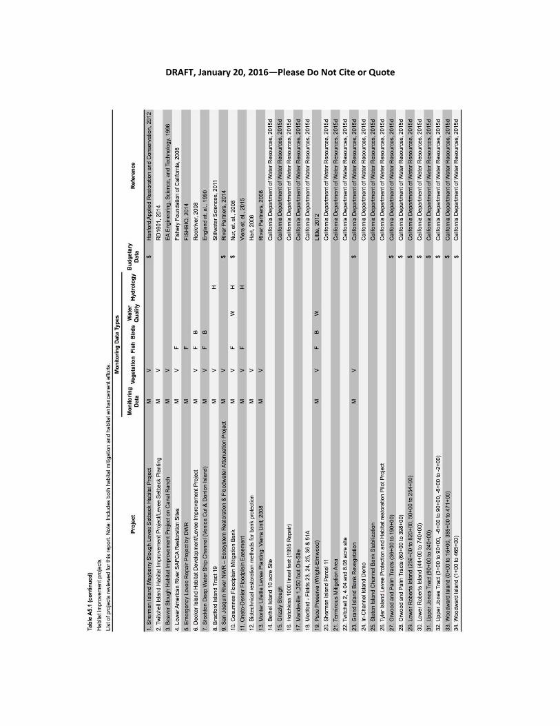
DRAFT, January 20, 2016—Please Do Not Cite or Quote
71