implementation of natural heritage systems
TRANSCRIPT

MICROSOFT
Implementation of Natural Heritage Systems
Recommendations for Prince Edward County
Copyright © Anna Froehlich, 2012
A report submitted to the School of Urban and Regional Planning inconformity with the requirements for the degree of Master of Urban and Regional Planning (M.PL.)
Queen’s University Kingston, Ontario
Canada July 2012

Acknowledgements
I would like to thank my supervisor Graham Whitelaw for his guidance, optimism and patience
throughout this process; my friends and office mates at SURP for putting up with putting up with
conversations late in the year about changing my topic to cognitive mapping of children’s
perceptions of urban cows; and especially my parents for their constant support and
encouragement.
I would also like to thank Jo-Anne Egan and the planning department at Prince Edward County
for introducing me to this topic and encouraging my interest.

iii | P a g e
Executive Summary
Natural Heritage Systems (NHS) planning is a science based holistic and strategic approach to
natural heritage conservation. As opposed to traditional conservation approaches which focus on
protected areas and maintaining ecological health, NHS takes a landscape level approach,
integrating planning for public and private lands, and includes a strong focus on stewardship and
restoration (MNR 2002).
The Provincial Policy Statement (PPS) is the document which sets out provincial priorities and
requirements for municipalities. The PPS (MAH 2005, p.33) defines Natural Heritage Systems
as “a system made up of natural heritage features and areas, linked by natural corridors which are
necessary to maintain biological and geological diversity, natural functions, viable populations of
indigenous species and ecosystems. These systems can include lands that have been restored and
areas with the potential to be restored to a natural state.” Wetlands, woodlands, valleylands,
significant wildlife habitat and habitat of endangered species, fish habitat and ANSIs (Areas of
Natural and Scientific Interest) are listed in the PPS as features and areas which should make up
the Natural Heritage System (MAH 2005).
Natural Heritage Systems are often planned and designed at a regional scale, using MNR eco-
districts or other larger regional landscape feature as a planning area in order to benefit from
ecological boundaries. These landscape scale systems often include several, or parts of several
different municipalities and other political or jurisdictional boundaries. This presents challenges
for the implementation and management of these systems once they have been designed through
scientific analysis and multi-stakeholder consultation.

iv | P a g e
The purpose of this report is to examine some of these challenges by looking at the different
approaches that have been taken in Ontario for writing NHS policy into municipal planning
documents. In particular these findings will be used to provide recommendations and policy
options for implementing NHS planning in the municipality of Prince Edward County (PEC)
where NHS data and modeling has already been done through a project prepared by the Ministry
of Natural Resources (MNR) and municipal and community stakeholders.
Method
In order to study these jurisdictional and implementation problems and to develop
recommendations for Prince Edward County, three Ontario case studies were selected, each with
some form of Natural Heritage Strategy already in place. For each case study location a
document analysis was carried out for each of the principle environmental planning documents.
This analysis was supported by supplementary planning documents, technical papers, and
provincial Natural Heritage guidelines and reports.
A literature review, conducted prior to the selection of the case studies, included a review of
academic literature on systems based conservation planning, Ontario provincial policy
Research Question
How can the municipality of Prince Edward County (PEC) implement the Natural Heritage
Systems planning and mapping scenario for Ecodistrict 6-E15 prepared by MMR and
stakeholders? What options and best practices learned from other Ontario Natural Heritage
Systems Plans are relevant to implementation in Prince Edward County?

v | P a g e
documents, and review of policy documents from three case study municipalities. These sources
were used, along with the case studies, to answer specific questions about the implementation of
Natural Heritage Systems. The question criteria were selected partially based on the academic
literature written on implementation of environmental areas planning, and partially on the
requirements of Prince Edward County.
The Categories examined for each case study plan include:
1. Vision – What is the overall stated purpose of the NHS?
2. Features – What features and areas are included in the NHS?
3. Boundaries – How are Boundaries delineated?
4. Land Use Designations – How do NHS Designations interact with previous zoning/land
designations?
5. Implementation – What studies or tests are required if alteration is to be permitted?
6. Public Participation – How extensive was public involvement in the creation of the plan?
7. Adaptive management and monitoring – Is there a review/monitoring framework?
8. Mapping and communication – How clear/accessible are the maps/schedules?
Overview of Findings
Recommendations
The following recommendations were formed after analyzing the three case studies to
provide suggestions for Prince Edward County when writing their NHS policies.
Vision
The current OP discusses the need for an ecosystem approach, but this could be better
defined and elaborated on with specific discussion of the need for connectivity to
preserve ecosystem services.
vi | P a g e
Features
Include Environmentally Sensitive Areas (ESAs) which were previously designated but
may no longer specifically fall within the PPS categories.
Use the MNR data mapping and the MARXAN analysis to evaluate significant
woodlands within the County.
Boundaries
Exact boundaries may be determined on a case by case basis where they do not align with
existing landscape features such as roads or waterways.
Clear requirements for buffer distances for specific features and areas should be
prominently included.
Incorporate interactive NHS layers to the County GIS would allow concerned land
owners easy access to information and to help show the bigger picture.
Land Use Designations
Creating meaningful categories combining individual types of features and areas both
simplifies policies and helps to communicate NHS principles. Consider using “Core
Natural Areas” and “Natural Linkage Areas” or “Supporting Natural Areas” rather than
simply Category A and B.
State very clearly that nothing in the NHS plan is intended to impact existing normal
farm practices.

vii | P a g e
Implementation
Include a technical appendix that explains the scientific rational behind decisions as well
as a specific list of the information and studies that may/shall be required as part of an
EIA.
Include different levels of EIA depending on the size of the project of the type of feature
Public Participation
Involve the community and agricultural groups early to ensure understanding of the goals
and impacts of NHS and to avoid misinformation.
Share the data collected (except for sensitive/confidential information such as the
location of species at risk) and educate landowners as to the value and functions of their
land.
Adaptive management and monitoring
Educate community and naturalist groups about natural heritage systems and provide
them with the tools and organisational structure (ie. a centralised database) to be able to
contribute to keeping data up to date.
Mapping/Communication
Integrate NHS mapping with the Counties GIS. Include layers showing proposed core
and core areas as well as layers for individual features and areas so that people are able to
see how these interact.
Use the MNR MARXAN tool for evaluating land use planning projects. Make this data
along with the “preferred scenario” available to stakeholders and the public.

Table of Contents
Acknowledgements ......................................................................................................................... ii
Executive Summary ....................................................................................................................... iii
Chapter 1: Introduction ................................................................................................................... 1
Topic Overview ........................................................................................................................... 1
Research Problem and Structure of Report ................................................................................. 2
Natural Heritage Systems Literature Review .............................................................................. 4
Regional Scale Conservation Planning .................................................................................... 4
Definitions of Natural Heritage and NHS ............................................................................... 5
Foundations of NHS ................................................................................................................ 6
Controversies of NHS .............................................................................................................. 7
Summary .................................................................................................................................. 8
Environmental Planning and the Ontario Provincial Policy Statement .................................... 10
Prince Edward County .............................................................................................................. 12
Context and Brief Environmental Profile .............................................................................. 12
Current policies in place and status of OP review ................................................................. 14
Background on Natural Heritage Systems Project ................................................................ 15
Chapter 2: Research Method and Research Framework ............................................................... 17
Literature Review ...................................................................................................................... 18
Case Studies .............................................................................................................................. 18
Evaluation Criteria and Analysis Framework ........................................................................... 19
Case Study Criteria and Analysis Framework .......................................................................... 23
Limitations of Research Methods and Study Parameters ......................................................... 28
Chapter 3: Case Studies ................................................................................................................ 29
Case Study Selection Rationale................................................................................................. 29
Case Study Summaries .............................................................................................................. 30
Oak Ridges Moraine .............................................................................................................. 30
Region of Waterloo ............................................................................................................... 33
City of Kingston .................................................................................................................... 35
Chapter 4: Case Study Analysis .................................................................................................... 37
Introduction ............................................................................................................................... 37

Vision ........................................................................................................................................ 38
Features ..................................................................................................................................... 42
Boundaries ................................................................................................................................. 46
Land Use Designations.............................................................................................................. 50
Implementation.......................................................................................................................... 54
Public Participation ................................................................................................................... 58
Adaptive management and monitoring ..................................................................................... 62
Mapping/Communication.......................................................................................................... 65
Chapter 5: Recommendations and Conclusions ........................................................................... 79
Summary ................................................................................................................................... 79
Recommendations ..................................................................................................................... 80
Conclusions ............................................................................................................................... 83
Works Cited .................................................................................................................................. 85
Appendices
Appendix A: Provincial Policy Statement (PPS) 2005 Natural Heritage Sections ................... 89
Appendix B: Bellville Intelligencer News Article .................................................................... 91
Appendix C: Ministry of Natural Resources Components of Collaborative NHS Design ....... 93
Appendix D: ORM Adjacent Lands Tables .............................................................................. 94
List of Maps and Figures
Figure 1: Natural Area Supporting Core and Linkage Function
Figure 2: Prince Edward County
Figure 3: Research Framework
Figure 4: Case Study Locations in Southern Ontario
Figure 5: Oak Ridges Moraine Planning Area
Figure 6: Waterloo Regional Municipality
Figure 7: The City of Kingston and the Cataraqui Natural Heritage Study Boundaries
Figure 8: Oak Ridges Moraine Conservation Plan Land Use Map
Figure 9: Waterloo Regional Official Plan Greenlands Network
Figure 10: City of Kingston Official Plan Schedule 7-A: Natural Heritage Area ‘A’
Figure 11: City of Kingston Official Plan Schedule 8-A: Natural Heritage Area ‘B’

List of Common Acronyms
ANSI – Area of Natural and Scientific Interest
CA – Conservation Authority
CRCA- Cataraqui Region Conservation Authority
KNHFs – Key Natural Heritage Features
MAH – Ministry of Municipal Affairs and Housing (Ontario)
MNR – Ministry of Natural Resources (Ontario)
NHS – Natural Heritage System
OP – Official Plan
ORM - Oak Ridges Moraine
ORMCP – Oak Ridges Moraine Conservation Plan
PEC – Prince Edward County
PPS – Provincial Policy Statement
WRM – Waterloo Regional Municipality

Chapter 1: Introduction
1 | P a g e
Chapter 1: Introduction
Topic Overview
Human development is causing fragmentation of the natural landscape at an unprecedented rate
and scale. When natural areas become isolated and separated by roads, agricultural fields and
developed lands, the natural processes essential to the health of the ecosystem are unable to
function. These processes include the hydrologic cycle, nutrient cycling and the movement and
gene flow of wildlife and plant species (Anderson and Jenkins, 2006; Beier and Noss, 1998;
Environment Canada 2005).
Southcentral Ontario, which is defined by the Ontario Ministry of Resources (OMNR) as
including all of the area roughly south of the French River (MNR 2002, p.1), is the most densely
populated area of Canada. Through the policies of the Provincial Policy Statement (PPS), the
Ontario government has encouraged the creation of Natural Heritage Systems which are
recognized and designated connected networks of core areas of natural habitat and natural
corridor linkages. The PPS includes wetlands, woodlands, valleylands, significant wildlife
habitat and habitat of endangered species, fish habitat and ANSIs (Areas of Natural and
Scientific Interest) as features and areas which should make up the Natural Heritage System
(MAH 2005).
Natural Heritage Systems are often planned and designed at a regional scale, using MNR eco-
districts or other larger regional landscape feature as a planning area in order to benefit from
ecological boundaries. These landscape scale systems often include several, or parts of several
different municipalities and other political or jurisdictional boundaries. This presents challenges

Chapter 1: Introduction
2 | P a g e
for the implementation and management of these systems once they have been designed through
scientific analysis and multi-stakeholder consultation.
Research Problem and Structure of Report
While there is a large body of literature and numerous case studies written about the design and
effectiveness of Natural Heritage Systems and landscape scale conservation projects (Anderson
and Jenkins, 2006; Beier and Noss, 1998; Schwartz, Mark, 1997; Eagles, 1984), there is far less
available about the implementation of these systems (Eagles, 1984; Anderson and Jenkins, 2006,
MNR, 2010). Eagles (1984) discusses the importance of effective implementation stating that “a
plan is only as good as its implementation […]. A plan is implemented only when it is feasible
and acceptable.” This report is intended to help inform policy options for implementing Natural
Heritage Systems in Prince Edward County (PEC) by looking at what has previously been done
in three other Ontario municipalities which have already incorporated Natural Heritage System
scientific and environmental data into their policy and planning tools. The three regions
considered as case studies are the Oak Ridges Moraine, the Region of Waterloo, and the City of
Kingston. By reviewing the Official Plans and Natural Heritage System reports from these
municipalities, this report will build an inventory of the implementation options and best
practices which could be used by Prince Edward County to develop an effective Natural Heritage
System policy.
While there are general conclusions or options presented in the analysis chapter, more specific
recommendations are directed toward providing options for the municipality of Prince Edward
County, particularly considering how the scientific knowledge and data available to
environmental scientists can be incorporated into the planning policies and stewardship
initiatives which create change on the ground. Prince Edward county was selected as the focus

Chapter 1: Introduction
3 | P a g e
of this report because I am familiar with the work being done in the region as I worked for the
municipality over the past spring and summer. Furthermore, the County is currently in the
processes of reviewing their Official Plan and this research is timed to have the potential to
contribute to that process.
The report is divided into five chapters
Chapter 1 introduces the report and the context of Natural Heritage Systems planning in
Ontario. It also provides a brief literature review to provide context to the issue.
Chapter 2 sets out the methodology used for this report and introduces the analysis
criteria.
Chapter 3 provides background and rational for the three case study plans and
jurisdictions.
Chapter 4 presents the analysis of the three case studies.
Chapter 5 synthesises the information from the previous chapter and provides
recommendations and conclusions for implementing Prince Edward County’s Natural
Heritage Strategy.
Research Question
How can the municipality of Prince Edward County implement the Natural Heritage Systems
planning and mapping scenario for Ecodistrict 6-E15 prepared by MMR and stakeholders?
What options and best practices learned from other Ontario Natural Heritage Systems Plans
are relevant to implementation in Prince Edward County?

Chapter 1: Introduction
4 | P a g e
Natural Heritage Systems Literature Review
Ontario’s current Natural Heritage Systems approach is based on both science and policy which
has been evolving since the beginning of the environmental movement. Many of the foundations
come from the work done in the 1980s on Environmentally Sensitive Area planning in Ontario
(Eagles, 1984). The greater emphasis on linkages and corridors in Natural Heritage Systems
Planning allows for the potential for a more systems focussed approach and for an increased
ability to coordinate existing protected areas and consider impacts across different scales.
Regional Scale Conservation Planning
Traditionally, large scale landscape and biodiversity conservation has mainly been achieved
through the creation of publicly owned and maintained parks or reserves (Anderson and Jenkins,
2006). This is largely still the case, however there is an increasing understanding of the need to
connect these discreet protected areas where remaining natural habitat exists in order to allow for
the movement of species and for the functioning of natural systems (Beier and Noss 1998,
Anderson and Jenkins 2006, Eagles 1984, Ontario Ministry of Natural Resources 2010).
Ecological corridors of natural habitat connecting larger “core” areas of habitat have been
proposed as a way to maintain connection and to allow for wildlife movement (Anderson and
Jenkins 2006, Eagles 1984). It is often impossible and impractical for government agencies to
purchase the land required to maintain these connections, both in terms of management and
because much of the land is already owned by private landowners. Managing this network of
natural habitats through a combination of the incorporation of development controls into
planning legislation and through education and stewardship initiatives can be more effective and
realistic than outright ownership of protected areas (Bocking 2005).

Chapter 1: Introduction
5 | P a g e
Definitions of Natural Heritage and NHS
Natural Heritage Systems Planning is a strategy for designing and protecting networks of natural
habitat within a fragmented landscape. It is an attempt to determine how to best organize and
protect the natural landscape that remains, that is threatened, or that is in need of rehabilitation,
in order to allow for species movement and for ecological function. It is a science based a
systems approach which allows planners and policy makers to look at protected natural areas as a
whole, rather than as isolated pockets of left over space or simply as separate features or areas.
The Provincial Policy Statement (MAH 2005, p. 33) defines Natural Heritage Systems as “a
system made up of natural heritage features and areas, linked by natural corridors which are
necessary to maintain biological and geological diversity, natural functions, viable populations of
indigenous species and ecosystems. These systems can include lands that have been restored and
areas with the potential to be restored to a natural state.”
While the professional discourse in Ontario usually refers to Natural Heritage Systems, most of
the academic literature is focused on the role of corridors in linking larger core areas of natural
habitat (Anderson and Jenkins 2005). The literature tends to differentiate larger and smaller
corridor scales by discussing landscape or ecological corridors vs. linear or wildlife corridors
(Anderson and Jenkins 2006). Corridor projects range from multi-national (Yukon to
Yellowstone (Y2Y) corridor in the United States and Canada, the Terai Arc landscape of India
and Nepal) to regional (Veluwe region in the Netherlands (Anderson and Jenkins 2006), Oak
Ridges Moraine (Whitelaw and Eagles 2006) and other Eco-district projects in Ontario (MNR
2002)) to very small specific areas such as a Natural Heritage System plan within a subdivision
(Posen, 2011).
Chapter 1: Introduction
6 | P a g e
Discussion of scale is also an important factor in the literature. Natural Heritage Systems is one
of the first land use policy frameworks that is able to take into account the role of smaller
networks within larger networks. Eagles (1984) discusses how a better understanding of “scale”
and “the hierarchical relationships of environmental issues from continental to local in size and
importance” is one of the achievements of the development of the ecological philosophy and
environmental management (p.6). Natural Heritage Systems takes this even further by
considering physical connections at different scales.
Foundations of NHS
The theories and applications of Natural Heritage Systems are not new. They are based on a
large body of both science and policy which have developed over the past 60 years with the rise
of the ecological movement and ecosystem management thinking (Grumbine1994, Anderson and
Jenkins 2006). In particular, the theoretical basis is strongly tied to the field of landscape
ecology (Forman 2005) and the work that has been done on planning and management of
Environmentally Sensitive Areas both in Ontario, Canada and internationally (Eagles 1984).
Landscape Ecology considers the relationships among features of the landscape. It “moves
beyond the species to focus on entire landscapes and how their structure influences species and
ecosystem processes” and “explicitly recognizes that a landscape is an integrated system, and
that you cannot fully understand one piece if you ignore the other pieces to which it is
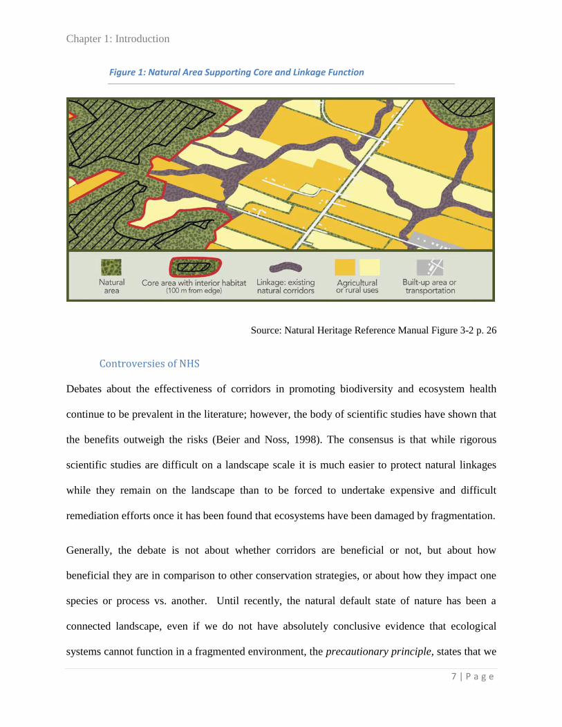
connected” (Anderson and Jenkins 2006, 14). Landscape ecology considers all landscapes,
whether pristine natural environments or modified environments to be structurally composed of
three elements: patches or fragments, corridors, and a background matrix which is the most
prevalent habitat type (Anderson and Jenkins 2006, 14-15). Figure 1 illustrates this matrix-core-
corridor model of Natural Heritage Systems.
Chapter 1: Introduction
7 | P a g e
Figure 1: Natural Area Supporting Core and Linkage Function
Source: Natural Heritage Reference Manual Figure 3-2 p. 26
Controversies of NHS
Debates about the effectiveness of corridors in promoting biodiversity and ecosystem health
continue to be prevalent in the literature; however, the body of scientific studies have shown that
the benefits outweigh the risks (Beier and Noss, 1998). The consensus is that while rigorous
scientific studies are difficult on a landscape scale it is much easier to protect natural linkages
while they remain on the landscape than to be forced to undertake expensive and difficult
remediation efforts once it has been found that ecosystems have been damaged by fragmentation.
Generally, the debate is not about whether corridors are beneficial or not, but about how
beneficial they are in comparison to other conservation strategies, or about how they impact one
species or process vs. another. Until recently, the natural default state of nature has been a
connected landscape, even if we do not have absolutely conclusive evidence that ecological
systems cannot function in a fragmented environment, the precautionary principle, states that we

Chapter 1: Introduction
8 | P a g e
have “a duty to prevent harm, when it is within our power to do so, even when all the evidence is
not in” (Canadian Environmental Law Association). The government of Ontario Natural
Heritage Reference Manual for Natural Heritage Policies of the Provincial Policy Statement,
2005 endorses the precautionary principle stating that “to protect the ecological function and
biodiversity of natural heritage systems and the health and integrity of natural heritage features
or their associated ecological functions for the long term, planning authorities should apply
decision-making approaches that incorporate the precautionary approach where appropriate” (s.
2.2, p. 8).
Corridor projects are often difficult for the public to understand and accept because they are less
tangible than discrete designated protected areas and are often overlaid across an existing
landscape of public and private land already layered with earlier policy and land use
designations. Grumbine 1994 writes that “implementation of ecosystem management requires a
“seismic shift” in the mindset of humans” (34), however the importance of landscape
connectivity is gaining attention, and the number of corridor projects is increasing (Anderson and
Jenkins 2006). As of yet, however, there are still relatively few examples of projects which have
been fully implemented (Anderson and Jenkins, 2006). Every landscape system is different and
exists within a different socio-political context. This means that corridor projects are still very
much experimental, both in terms of the best scientific knowledge and in terms of the policy and
planning/protection context.
Summary
The natural world is a complex and interconnected system with infinite relationships between
different ecosystems, habitats and species. Natural Heritage Systems Planning attempts to look at
protected natural areas as a whole, rather than as isolated pockets of left over space. Natural

Chapter 1: Introduction
9 | P a g e
Heritage Systems Planning takes a landscape ecology approach, identifying core areas of natural
significance and connecting them through linkages and corridors to ensure the ability of
interconnected ecological systems and feedbacks to continue to function.
Natural heritage features and areas provide numerous economic, environmental and social
benefits which are crucial to the survival of all species, including humans. Collectively, they
contribute to the conservation of biodiversity and to the maintenance of the quality of air, land
and water and provide many ecological functions including the provision of habitat, hydrological
functions, nutrient and energy cycling and storage, succession and disturbance functions,
reproduction and dispersal, landscape linkages and others. These benefits of conserving natural
heritage occur at local, regional and broader scales and so connections between these different
areas at different scales must be maintained for them to fulfil their functions.
Natural Heritage System Planning is based on four conservation biology principles: maintaining
biological diversity, avoiding habitat fragmentation, promoting corridors and linkages, and
maintaining a water balance that sustains ecosystems (MAH 2008a). Accomplishing these four
goals requires alternatives to traditional single purpose management models aimed at optimizing
production of one resource or system and building in resilience and flexibility to change and
natural cycles of growth, release and reorganization across multiple scales and interconnected
systems (Resilience Alliance). Strengthening the natural heritage system is probably currently
one of the most effective land use planning tool to deal with global environmental problems such
as climate change and invasive species. If the natural systems are healthy and include

Chapter 1: Introduction
10 | P a g e
redundancy and overlap, they will better be able to absorb change and disturbance without losing
the ability to function and regenerate.
Environmental Planning and the Ontario Provincial Policy Statement
The Provincial Policy Statement (PPS) is the document that sets out the provincial priorities for
land use planning and coordinates planning direction and policy between municipalities. All
Municipal Official Plans must be consistent with the PPS and approved by the province before
they gain authority. The current PPS was updated in 2005.
The PPS includes several sections on the environment, natural heritage, and natural hazards. In
particular, section 2.1 states that “the diversity and connectivity of natural features in an area,
and the long-term ecological function and biodiversity of natural heritage systems, should be
maintained, restored or, where possible, improved, recognizing linkages between and among
natural heritage features and areas, surface water features and ground water features.”
It further states that development and site alteration shall not be permitted in:
a. significant habitat of endangered species and threatened species;
b. significant wetlands in Ecoregions 5E, 6E and 7E; and
c. significant coastal wetlands;
and that unless it has been demonstrated that there will be no negative impacts on the natural
features or their ecological functions, development and site alteration shall not be permitted in:
a. significant wetlands in the Canadian Shield north of Ecoregions 5E, 6E and 7E;
b. significant woodlands south and east of the Canadian Shield;
c. significant valleylands south and east of the Canadian Shield;
d. significant wildlife habitat; and
e. significant areas of natural and scientific interest.
Fish habitat is also protected from development and site alteration in accordance with provincial
and federal requirements. As well, section 2.1.6 regulates development and site alteration on

Chapter 1: Introduction
11 | P a g e
adjacent lands to these identified features and areas in order to protect them from negative
impacts. Section 2.2 discusses water quality and quantity, and section 3.1 covers policies on
development and permitted and restricted uses of hazard lands.
The Natural Heritage Reference Manual for Natural Heritage Policies of the Provincial Policy
Statement, 2005 (MNR 2010) provides explanation and expansion on the policies set out in the
PPS. It elaborates on the principles of Natural Heritage and Systems Planning and includes
guidelines and tools for municipalities.

Chapter 1: Introduction
12 | P a g e
Prince Edward County
Figure 2: Prince Edward County
Source: Prince Edward County online GIS
Context and Brief Environmental Profile
Prince Edward County (Figure 2) is a predominantly rural municipality on the North Shore of
Lake Ontario located roughly 60 km west of Kingston, directly South of Bellville and Trenton.
It has an area of just over 1000 square kilometers, and the unusual shoreline topography in the
region gives this near island municipality over 800km of shoreline. The County is separated
from mainland Ontario by Bay of Quinte, which remains a “Great Lakes Area of Concern”
despite significant clean up progress since the 1980s (Bay of Quinte Remedial Action Plan).
The population in 2011 was just over 26,000 people, however the County also has a sizable
seasonal population not included in this count (County of Prince Edward Planning Department,

Chapter 1: Introduction
13 | P a g e
2011). There are two main towns, Picton and Wellington, and a number of smaller hamlets and
settlement areas throughout the seven wards.
There are several rare and threatened habitats within the County, including alvars, grasslands,
shorelines with uncommon sand dune systems, unique geology, crater lakes and cold-water
streams. Water quality and quantity is an issue, as the entire county is considered a vulnerable
recharge area because of the fractured limestone bedrock, and parts of the County experience
groundwater shortages in the late summer (Dillon Consulting 2004).
There is already an extensive network of protected and conservation areas, including three
popular Provincial Parks, a provincial Nature Reserve, several Conservation Areas maintained
by Quinte Conservation, and three National Wildlife Conservation Areas. There are also
numerous provincially and locally significant wetlands, ANSIs, and a mapped inventory of
Environmentally Sensitive Areas, however there is little discussion about how these areas
interact and (do or do not) connect.
Agriculture is a very important industry in the County, and many of the farmers are excellent
stewards of their land and committed to the best environmental practices, however, the way in
which designation as part of the NHS would be understood, both in terms of current land use and
potential future land value is likely to be one of the most important factors in successful
implementation of a county NHS.
Tourism is also increasingly becoming a main industry, and visitors are largely attracted by the
unspoiled natural amenities, picturesque agricultural landscape, vineyards, and excellent
beaches. This growth of the tourism sector is creating an increasing demand for cottage and
retirement properties and is leading to an increased demand for rural severances. While overall

Chapter 1: Introduction
14 | P a g e
population growth in the county has been limited (20 year growth rate of 10.5%) (Prince Edward
County Planning Department, 2011 p. 12), this trend of newcomers settling in rural areas rather
than in the towns is leading to fragmentation of remaining natural areas and creating pressure
where formerly there was no great demand for development.
Current policies in place and status of OP review
The current Official Plan was adopted by council in 1993 and was last consolidated in 2006 after
the seven formerly lower tier municipalities in the county were amalgamated under a single tier
County Council (Corporation of the County of Prince Edward 2012). Provincial regulation
requires municipal official plans to be updated every 5 years, and the County’s current official
plan has several areas where it needs to be updated to meet with current provincial policy. In
particular, the 1993 OP does not provide any policy for the protection of wildlife habitat, except
for blue heron rookeries and osprey nesting sites, or areas designated as ANSIs. It does not have
policies for designating or protecting significant woodlands and valleylands, and it does not
include specific information or regulations for protecting fish habitat or habitat of endangered
species in accordance with the Fisheries Act and the Endangered Species Act.
It does, however, place a strong emphasis on the importance of a healthy natural environment to
the identity and future wellbeing of the County. The 1993 OP “vision” states that “as a result of
increased environmental awareness and the desire for linking economic growth with
environmental sustainability, the management and preservation of the County's natural resources
will play a prominent role in the evolution of the community” (Prince Edward County OP, Part II
s. 2.2.1).

Chapter 1: Introduction
15 | P a g e
Other concepts featured in the OP are the importance of a healthy natural environment to the
“sense of place” in the County, the adoption of an “ecosystem approach, which takes into
account an area's relationship to the surrounding environment and its links with other resources”
(1.1.2) and avoiding actions which will lead to the need for remedial restoration due to mistakes
made in the present.
The County is currently in the process of conducting an Official Plan Review and creating a new
document to guide the development of the County over the next 20 years (Corporation of the
County of Prince Edward 2012).
Background on Natural Heritage Systems Project
The MNR, in consultation with stakeholders, is in the process of completing a Natural Heritage
Systems mapping exercise for ecodistrict 6E-15 which includes Prince Edward County, as well
as the North Shore of Lake Ontario reaching nearly to Kingston. The project uses sophisticated
computer modelling (MARXAN) and mapping of natural features, which are analyzed at
different scales based on watershed catchment areas and soil class, to provide high levels of
detailed data. With this model it is possible to measure how losses to the natural heritage system
will impact the whole, and how other areas could be rehabilitated in order to mitigate this loss. It
also provides insight into corridors and linkages between core areas of natural habitat and can
help prioritize locations for conservation, rehabilitation and naturalization and land acquisition.
Having this data and being able to display it clearly in graphic form makes it much easier to
approach landowners and communicate the value of their land, how it fits into the larger picture,
and which ecological functions it provides. The tool has excellent potential to be used for

Chapter 1: Introduction
16 | P a g e
education and to promote stewardship activities, as well as to be used for providing data when
making land use planning decisions.
There was initially some skepticism regarding the study and its purpose in the county, both in
Council and the community (see Appendix B), however there were also local staff and
community members who have worked extremely hard to support this project. As of the fall of
2012 the MNR project has now been completed and the final report is available on the County
Official Plan Update website as Addendum 2.1 to the Issues paper on Natural Environment
(Report of the Prince Edward County and Neighbouring Communities Working Group).

Chapter 2: Research Method and Research Framework
17 | P a g e
Chapter 2: Research Method and Research Framework
This report primarily uses case study based document analysis to analyse and compare the
different approaches three Ontario jurisdictions have taken to design and implement landscape
scale conservation strategies. The three cases will be used to consider different options that could
be taken in Prince Edward County and provide recommendations for policy direction for
integrating their Natural Heritage data with their current Official Plan Review. Using a
qualitative approach allows for an in depth and somewhat flexible analysis of the key policy
documents in order to draw out their similarities and differences and understand the strengths
and weaknesses of each case (Yin 2009, p.4). By using a combination of a literature review,
review of Ontario provincial policy documents, and review of policy documents from three case
study municipalities/regions, triangulation is built in both through the three case studies
themselves and through the three different information sources (Yin 2009, p.114).
This chapter will briefly provide some further detail on the data collection methods used before
introducing the data analysis method and specific criteria questions through which the three
cases are examined. The following research methods framework (Figure 3) describes the process
that was followed from beginning to the completion of the report.

Chapter 2: Research Method and Research Framework
18 | P a g e
Figure 3: NHS Research Method Framework
Literature Review
The first step in the research process was to conduct a literature review to acquire a foundation in
the scientific background of Natural Heritage Systems design and in some of the controversies
around corridor planning (see Chapter 1). The review included academic, scientific and policy
literature as well as policy white papers and government publications for more specific
information to Ontario. The literature review also helped provide a general understanding of
some of the major trends in conservation planning and begin to see patterns in the history of
conservation planning in Ontario.
Case Studies
The three case study locations were chosen after completion of the literature review based on
their contribution to Natural Heritage Planning in Ontario and their comparability to Prince
Recommendations for
Prince Edward County
Evaluation/ Comparison of plans based on Criteria
Development of
Analysis Criteria
Background Research on Case Studies
Analysis of Case Study
Natural Heritage Plans
Selection of Case Studies
City of
Kingston
Region of
Waterloo
Oak Ridges
Moraine
Literature review
Summer work experience in
Prince Edward County

Chapter 2: Research Method and Research Framework
19 | P a g e
Edward County. All three are located in Southern Ontario and fall under the same provincial
policy framework as PEC and they include both regional examples and smaller municipalities.
The consideration of three different cases was decided on as a manageable number while still
providing enough breadth for comparisons of the different approaches taken in each
municipality. Guidance on case study research methods was taken from Yin’s (2009) Case Study
Research Design and Methods, fourth edition. The case study method was selected because it
allows for an indepth understanding of the specifics of each case, including the processes that
lead to the adoption of particular policies (Yin 2009, p.17). The case studies will each be
introduced in detail in the following chapter (3).
Evaluation Criteria and Analysis Framework
While there are several criteria frameworks available for the design of Natural Heritage systems
(Eagles 1984, Environment Canada 2005, Ministry of Natural Resources 2010, Posen 2011),
there is much less available for evaluating the efficacy of their implementation. Based on the
review of key literature including academic research and provincial policy documents, including
the PPS and the Natural Heritage Reference Manual, criteria were developed based on an
understanding of the essential elements of a NHS plan. The criteria were set up in order to ensure
that the three case studies were analyzed consistently to allow for an analysis of the different
options and precedents used in these three cases. These results were then analysed to consider
which options were most appropriate in the context of Prince Edward County and what data or
organizational infrastructure the County may require to successfully implement the project.
For each case study municipality or region, the natural heritage plans were read in detail with
particular attention to each of the questions set out in the following analysis criteria table.

Chapter 2: Research Method and Research Framework
20 | P a g e
Case Study Criteria and Analysis Framework
Criteria Questions Data Source References
Vision How are NHS dealt with in (OP) vision statement?
What is the stated overall purpose of the
NHS?
o Wildlife movement? What species is
it designed for? How? Why?
o Ecological functions? What
functions? How? Why?
o Recreation/cultural heritage values?
Official Plan/Regional
Plan
vision statements
Anderson and Jenkins. 2006. pp. 29-35
MNR. 2010. Natural Heritage
Reference Manual. pp. 12, 108-111
MNR. 2002. A Natural Heritage
System for the Ontario Ministry of
Natural Resources, Southcentral
Region. pp. 12-14
Features What features and areas are included within the
NHS?
How are core areas identified vs. corridor areas?
Are there different protection requirements for
different components of the NHS? (ie, wetlands,
woodlands, wildlife habitat etc.)
How far do the PPS Natural Heritage
requirements go toward forming the NHS?
Official Plans/Regional
Plans
Provincial Policy
Documents
NHS project technical
reports
Anderson and Jenkins. 2006. pp. 35-50
Eagles, 1984. The Planning and
Management of Environmentally
Sensitive Areas. pp. 45-59.
MAH 2005. Provincial Policy
Statement. s. 2.1
MNR. 2010. Natural Heritage
Reference Manual. pp. 37-105
Boundaries How are boundaries delineated?
Fixed boundaries?
o How were they determined?
Buffer zones?
General area designation?
Official Plans/Regional
Plans
NHS project technical
reports
MNR. 2010. Natural Heritage
Reference Manual. pp. 37-105
Eagles, 1984. pp. 59-60
Designations How do NHS designations interact with previous
zoning/land designation (ie. prime ag, rural,
settlement area etc.)?
Separate overlay?
Official Plans/Regional
Plans
NHS project technical
MNR. 2010. Natural Heritage
Reference Manual. pp. 21-34, 112-
132.
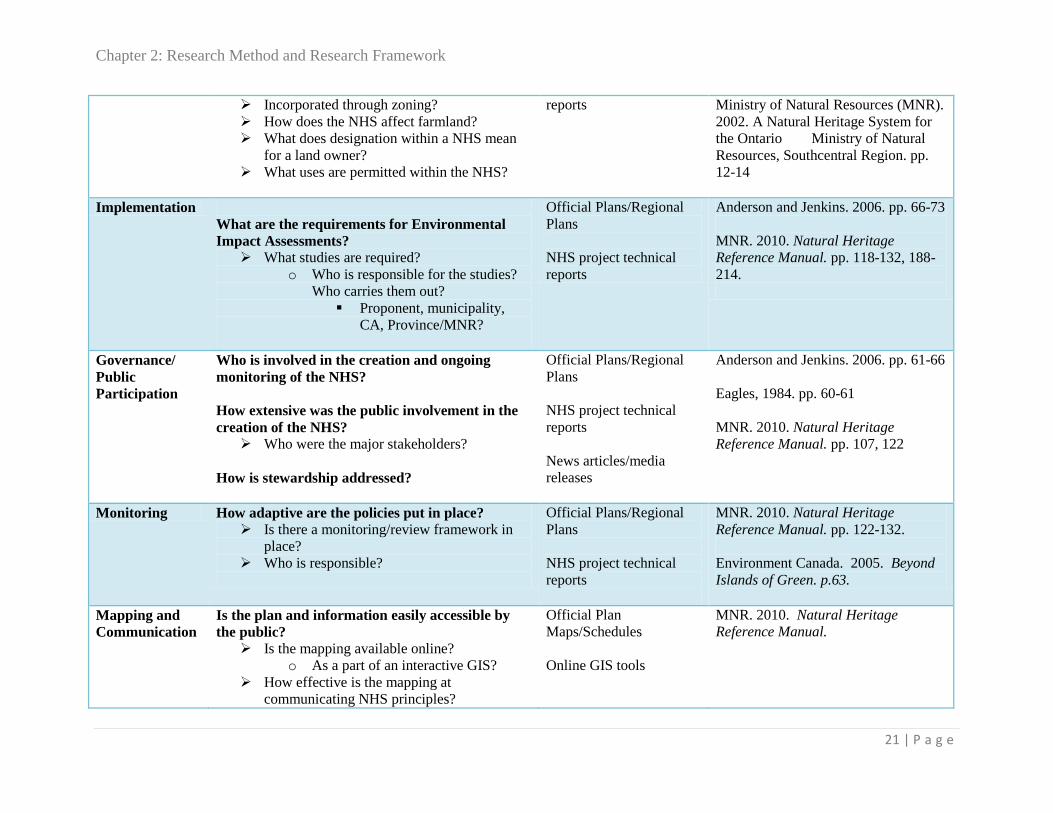
Chapter 2: Research Method and Research Framework
21 | P a g e
Incorporated through zoning?
How does the NHS affect farmland?
What does designation within a NHS mean
for a land owner?
What uses are permitted within the NHS?
reports Ministry of Natural Resources (MNR).
2002. A Natural Heritage System for
the Ontario Ministry of Natural
Resources, Southcentral Region. pp.
12-14
Implementation
What are the requirements for Environmental
Impact Assessments?
What studies are required?
o Who is responsible for the studies?
Who carries them out?
Proponent, municipality,
CA, Province/MNR?
Official Plans/Regional
Plans
NHS project technical
reports
Anderson and Jenkins. 2006. pp. 66-73
MNR. 2010. Natural Heritage
Reference Manual. pp. 118-132, 188-
214.
Governance/
Public
Participation
Who is involved in the creation and ongoing
monitoring of the NHS?
How extensive was the public involvement in the
creation of the NHS?
Who were the major stakeholders?
How is stewardship addressed?
Official Plans/Regional
Plans
NHS project technical
reports
News articles/media
releases
Anderson and Jenkins. 2006. pp. 61-66
Eagles, 1984. pp. 60-61
MNR. 2010. Natural Heritage
Reference Manual. pp. 107, 122
Monitoring How adaptive are the policies put in place?
Is there a monitoring/review framework in
place?
Who is responsible?
Official Plans/Regional
Plans
NHS project technical
reports
MNR. 2010. Natural Heritage
Reference Manual. pp. 122-132.
Environment Canada. 2005. Beyond
Islands of Green. p.63.
Mapping and
Communication
Is the plan and information easily accessible by
the public?
Is the mapping available online?
o As a part of an interactive GIS?
How effective is the mapping at
communicating NHS principles?
Official Plan
Maps/Schedules
Online GIS tools
MNR. 2010. Natural Heritage
Reference Manual.


Chapter 2: Research Method and Research Framework
23 | P a g e
Case Study Criteria and Analysis Framework
Vision
Official Plans set the overall direction for planning and development and the vision statement or
overall goal section of a plan identifies the planning authority’s commitment to protecting
natural heritage, sets the tone, and emphasizes the priorities of the plan (MNR 2010). Anderson
and Jenkins (2006) discuss the importance of considering the multiple objectives an ecological
corridor or network needs to serve. They write that “it is often difficult to justify the
establishment of corridors that serve biodiversity protection exclusively” (29) and in the case of
writing implementable policies for land use planning this is particularly relevant in terms of
identifying issues that are important to multiple stakeholder groups in order to strengthen
community support for the plan.
For each case study, the plans were examined to answer the following questions:
How are NHS dealt with in (OP) vision statement?
What is the stated overall purpose of the NHS?
o Wildlife movement? What species is it designed for? How? Why?
o Ecological functions? What functions? How? Why?
o Recreation/cultural heritage values?
Features
Features are the individual areas or landforms that are designated as protected areas within the
Natural Heritage System. Depending on the existence or rarity of different types of habitat each
jurisdiction may include different types of features or classify similar features as requiring
different levels of protection. The PPS (MAH 2005) sets out the natural heritage features and

Chapter 2: Research Method and Research Framework
24 | P a g e
areas which are provincially “afforded various levels of protection when development or site
alteration is being contemplated in or adjacent to these resources” (MNR 2010, 37). Anderson
and Jenkins (2006) talk about width, connectivity, and quality as being the three essential
elements of natural heritage corridors or networks (35-36) and emphasize that identifying
features and areas alone may not create a complete, functional or resilient system without also
identifying the relationships between the discrete features within the system.
What features and areas are included within the NHS?
How are core areas identified vs. corridor areas?
Are there different protection requirements for different components of the NHS? (ie,
wetlands, woodlands, wildlife habitat etc.)
How far do the PPS Natural Heritage requirements go toward forming the NHS?
Boundaries
The edges of features and designations are usually where disputes and ambiguities occur and so
the way in which boundaries are defined and delineated has a large impact on how policies are
enforced. In some cases only general areas may be designated with exact boundaries to be
determined on a case by case basis, in others, detailed mapping may be done to set out exact
delineations of the edges of features and areas. Often a buffer may be required between
development and the edge of a protected feature and the distance criteria this is based on often
vary. Considering edge effects and policies for adjacent lands is also very important when
defining feature boundaries as some species are sensitive to edge disturbances and rely on
interior habitat. (Anderson and Jenkins 2006). Including buffer areas and considering adjacent
land uses can enhance habitat area free of edge effects.

Chapter 2: Research Method and Research Framework
25 | P a g e
How are boundaries delineated?
o Fixed boundaries?
How were they determined?
o Buffer zones?
o General area designation?
Designations
Natural Heritage Systems are rarely applied in pristine and uninhabited areas. Very often there
are already several layers of existing designations across the landscape, from existing zoning, to
private property, to other previous environmental designations often governed by other levels of
government. For example, “the identification of linkages in agricultural areas would indicate an
intention for both interests to be achieved in the working landscape, for example, through good
farm practices and stewardship” (MNR 2010, 34). The ways in which these different regulations
interact and how this is understood by government, property owners, and the public can be one
of the major obstacles to acceptance and respect of the plan.
How do NHS designations interact with previous zoning/land designation (ie. prime ag,
rural, settlement area etc.)?
o Separate overlay?
o Incorporated through zoning?
How does the NHS affect farmland?
What does designation within a NHS mean for a land owner?
What uses are permitted within the NHS?

Chapter 2: Research Method and Research Framework
26 | P a g e
Implementation
In most NHS plans, the particular tests or study that needs to be done before development or
alteration is allowed within a designated area are set out. The specifics of what studies are
required, what each one entails and who is responsible for carrying it out and interpreting the
results can vary.
What studies are required?
o Who is responsible for the studies? Who carries them out?
Proponent, municipality, CA, Province/MNR?
Governance/ Public Participation
The process of creating the NHS has a large impact on how it is received by land owners,
developers, and the general public. If a community feels a sense of ownership over the plan and
that it reflects their values and priorities it is much more likely to be effective and beneficial.
Anderson and Jenkins (2006) emphasize that “corridors are complex and long-term initiatives
that require support from diverse sectors of society” and that “successful corridor initiatives have
well-defined leadership, strong institutional coalitions and broad public support” (61). Who is
involved in the creation and ongoing monitoring of the NHS?
How extensive was the public involvement in the creation of the NHS?
o Who were the major stakeholders?
How is Stewardship addressed?
Monitoring
Neither the natural systems being protected nor the political systems under which the plan was
created are static, and as more data is collected changes can be made to improve and refine the

Chapter 2: Research Method and Research Framework
27 | P a g e
plan. Anderson and Jenkins (2006) write that “because corridors and other landscape elements
are dynamic, it will be necessary to define and monitor a few strategic indicators relevant to
corridor integrity – especially those corresponding to connectivity and habitat quality – as a basis
for making future adjustments to corridor design” (46).
A Monitoring and review framework allows for this flexibility and helps to ensure that updates
are made. The NHS Reference Manual (MNR 2010) recommends conducting and updating a
natural heritage inventory to support the five-year review of official plans (108).
How adaptive are the policies put in place?
Is there a monitoring/review framework in place?
Who is responsible?
Mapping and Communication
While the policies and text of the plan provide the teeth and set the level of protection for the
NHS, without a map of the features, areas and connections it is very difficult to visualize the
purpose of connecting corridors and to justify decisions that have been made. Land owners want
to be able to look at a map and determine what policies affect their property. Effective mapping
is very important.
Is the plan and information easily accessible by the public?
o Is the mapping available online?
o As a part of an interactive GIS?
How effective is the mapping at communicating NHS principles?

Chapter 2: Research Method and Research Framework
28 | P a g e
Limitations of Research Methods and Study Parameters
This research is an attempt to better understand Natural Heritage Systems planning in Ontario. It
is by no means a comprehensive overview or a guide to best practices, simply an attempt to tease
out some of the different options being tried in the province. It is also not intended to provide
direction on the scientific or design of natural heritage systems but is limited to looking at policy
writing and implementation.
Many other municipalities in Ontario have also implemented a systems approach to natural
heritage protection and several may be further ahead, however, these three case studies were
selected as a reasonable number given the scope and time constraints of the project. The
geographical area of all case studies is limited to Southcentral Ontario so that the same
overarching provincial policies apply in all cases.
Using three case studies consolidates information from a triangulated set of sources. By looking
at both the plans themselves and at supporting technical and process related documentation
recommendations will be generalizable to Natural Heritage projects beyond only the Prince
Edward County example.

Chapter 3: Case Studies
29 | P a g e
Chapter 3: Case Studies
Case Study Selection Rationale
The three case studies selected for this report were chosen because each offers specific strengths
and lessons to draw from and to compare with the specifics of Prince Edward County. All three
are located in the Southcentral Ontario region, and fall under same overarching requirements
based on the Ontario Provincial Policy Statement (PPS). Figure 4 shows the locations of the case
study municipalities within Southern Ontario and in relation to each other.
Figure 4: Case Study Locations in Southern Ontario
The case studies also help to present a larger picture of the evolution of landscape scale
conservation planning in Ontario and were selected partially due to their influence on
environmental planning legislation. While the actual plans being considered were all created

Chapter 3: Case Studies
30 | P a g e
within the last decade, Waterloo and the Oak Ridges Moraine were both projects that grew from
some of the leading research that has been occurring in Ontario since the 1960s, in particular
watershed based planning in the case of the ORM, and Environmentally Sensitive Area (ESA)
planning in the waterloo region (Eagles 1981; Whitelaw et al., 2006). Kingston was included is
order to have a municipal Official plan to compare with the other two regional scale plans. In
addition, the Natural Heritage Planning that was used in the Kingston OP followed a similar
methodology to the mapping done by the MNR in Prince Edward County. By looking at these
three plans, the objective was to draw out some of the differences and some of the strengths and
weaknesses that may be found in the different approaches.
Case Study Summaries
Oak Ridges Moraine
The Oak Ridges Moraine is a 160 kilometer long accumulation of sand and gravel formed by the
intersection of two glaciers during the Pleistocene (MAH 2002). It reaches from the Trent River
in the east, around the end of Lake Ontario, North of Toronto, and runs into the Niagara
Escarpment in the west (Whitelaw and Eagles, 2006). The Moraine runs through the most
populated area in Canada and its natural spaces create one of the only continuous corridors
through Southern Ontario. The Moraine hosts a unique ecosystem with a wide diversity of plant
and animal species, including species at risk, but it is the role of the Moraine in the hydrology of
the region that has been at the core of the argument for the importance of its protection (Bocking
2005, Whitelaw and Eagles, 2006).
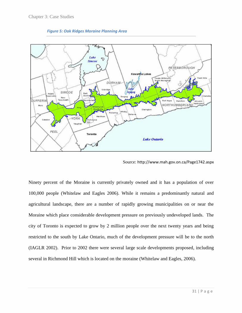
Chapter 3: Case Studies
31 | P a g e
Figure 5: Oak Ridges Moraine Planning Area
Source: http://www.mah.gov.on.ca/Page1742.aspx
Ninety percent of the Moraine is currently privately owned and it has a population of over
100,000 people (Whitelaw and Eagles 2006). While it remains a predominantly natural and
agricultural landscape, there are a number of rapidly growing municipalities on or near the
Moraine which place considerable development pressure on previously undeveloped lands. The
city of Toronto is expected to grow by 2 million people over the next twenty years and being
restricted to the south by Lake Ontario, much of the development pressure will be to the north
(IAGLR 2002). Prior to 2002 there were several large scale developments proposed, including
several in Richmond Hill which is located on the moraine (Whitelaw and Eagles, 2006).
Chapter 3: Case Studies
32 | P a g e
Studies were first done in the 1970’s to try to understand its hydrological significance of the
ORM for Lake Ontario and Lake Simcoe (IAGLR 2002). Since then there have been several
attempts to legislate protection for the Moraine but it wasn’t until the 1990’s that the expansion
of Toronto and major developments planned for communities located within the Moraine really
started to threaten the natural systems and connectivity of the ecosystem (Whitelaw and Eagles
2006, IAGLR 2002).
In 1989, David Crombie’s Royal Commission on the Future of the Toronto Waterfront (RCFTW)
identified the Moraine as an essential element of the Toronto bioregion, as it contains the
headwaters of the city’s watercourses (Bocking 2005). The topography and the geology of the
Moraine, mainly complex layering of sand and gravel, make the area an important groundwater
recharge area (IAGLR 2002). This understanding of the Moraine as an important aquifer raised
the profile of the Moraine and in 1990 the provincial government declared it to be “of provincial
significance.” This designation meant that land use decisions affecting the moraine were no
longer exclusively the concern of municipalities (Bocking 2005). To help coordinate between
the three regional governments and over a dozen municipalities on the moraine, in 1991 a
technical committee was created by the Ontario Ministry of Natural Resources, Ministry of
Environment and Minister of Municipal Affairs to help in creating a long-term development
strategy and a regional approach to land use planning (MNR 1991, IAGLR 2002). This strategy
was completed in 1994 but was never implemented and individual municipalities continued to
support development as it brought economic growth and opportunity (IAGLR 2002). It wasn’t
until the late 1990’s that the protection of the moraine caught on in the public realm and was
picked up as an important issue by the media (Whitelaw 2005).

Chapter 3: Case Studies
33 | P a g e
The Oak Ridges Moraine Conservation Act was passed in 2001 by the government of Ontario,
giving authority to a regional land use plan which placed extensive restrictions on new
development within the 190,000 hectares of the Moraine. The ORM Conservation Plan is an
overarching policy document which sets out provincially mandated regulations that must be
adopted by the municipalities within the plan boundaries. The document can be tailored to the
specific needs and priorities of each municipality, however municipal official plan and zoning
by-laws must conform to the overall requirements of the plan.
Region of Waterloo
The Waterloo Regional Plan was completed in 2009 to coordinate growth and development in
the three urban municipalities of Cambridge, Kitchener and Waterloo, and the four rural
townships of North Dumfries, Wellesley, Wilmot and Woolwich. It covers an area of 1369
square kilometers and contains a population of 534,900. The Waterloo region is one of the
fastest growing areas in Ontario, and according the region’s website by 2031 the area is expected
to reach a population of over 700,000 (region of waterloo.ca).
The main page of the Regional Official Plan website sets out the broad goals of the Plan:
A fixed border between rural and urban areas;
Directing growth to make better use of land within the built up areas of the Region;
Increasing transportation choice, including the creation of a rapid transit system;
Protecting our drinking water and significant environmental areas; and
Increasing the quality of life of citizens in Waterloo Region.
(Region of Waterloo 2010)
Figure 6: Waterloo Regional Municipality

Chapter 3: Case Studies
34 | P a g e
Source: http://maps.region.waterloo.on.ca/locator/locator.htm
As a component of the Regional Plan, in 2007, the Region developed an Environmentally
Sensitive Landscapes (ESLs) framework designed to “protect significant ecological systems - not
just individual environmental features.” The Regional Municipal website defines ESLs as areas
“that have significant environmental features, such as wetlands, rivers and creeks, groundwater
recharge areas and the habitat of endangered and threatened species. They also include farms,
villages, small towns and outdoor recreation areas” (region of waterloo). There are currently four
areas within the region identified as Environmentally Sensitive Policy Areas (ESPA) which
together cover just over 15,000 hectares where harmful activities or development is restricted.
This approach is so far unique in the province and was one of the first in Canada (Region of
Waterloo 2010). These designated ESLs are incorporated within the larger Greenlands network
that is organized throughout the region.

Chapter 3: Case Studies
35 | P a g e
The plan was approved by the Minister of Municipal Affairs and Housing in December 2010, but
the entire regional plan has been under appeal before the OMB since January 2011, in part due to
issues related to Regional Recharge Areas, Protected Countryside, Core Environmental Features
and Aggregates. It is expected that hearings on these issues will be scheduled for late 2012
(Region of Waterloo 2010).
City of Kingston
The City of Kingston’s most recent Official Plan came into effect in 2010 and was the first
Official Plan for the amalgamated City of Kingston that included the former Kingston and
Pittsburgh Townships. The consolidated Official Plan incorporated the data collected by the
Cataraqui Region Conservation Authority’s Central Cataraqui Regional Natural Heritage Study
(CCRNHS) completed in 2006. The planning area for the CA study included all of the land
within Kingston’s municipal boundary as well as Loyalist Township directly to the east of the
city. The study identified and evaluated a system of natural features and areas, including
wetlands, woodlands, valleylands and significant wildlife areas and created a database to
organize and communicate this information.
Figure 7: The City of Kingston and the Cataraqui Natural Heritage Study
Boundaries

Chapter 3: Case Studies
36 | P a g e
Source: http://www.cataraquiregion.on.ca/management/Figure1studyarea.pdf
The Kingston Official Plan was selected as a case study location because it is located close to
Prince Edward County, and there are many environmental similarities between the two regions.
Both are situated on the North Eastern shore of Lake Ontario and have similar geological and
climatic conditions. Considering a recent municipal strategy also provides a different perspective
from the previous regional case studies. In addition the methodology used for designing the NHS
is similar to the computer modeling which was done by the MNR in Prince Edward County’s
Ecodistrict 6E-15 project.

Chapter 4: Case Study Analysis
37 | P a g e
Chapter 4: Case Study Analysis
Introduction
The following section sets out the analysis of the three case study plans based on the criteria and
questions set out in the methods chapter. Each plan was examined to determine how Natural
Heritage Systems Planning was incorporated in the plan vision, what natural features and areas
were included, how boundaries were defined and determined, how Natural Heritage interacts
with other land use designations, and what protection measures were required by the plan.
Where available, discussion of public participation in the plan creation and monitoring and
review policies were also considered. Finally the Natural Heritage maps or schedules included
as part of the plans were also analysed to evaluate their clarity and effectiveness in
communicating Natural Heritage Systems principles.
Each section is organized with a summary table to provide examples of the type of language used
in the plan, and to highlight key sections, and then data from each case study is summarised. This
is followed by a brief discussion of some of the strengths and weaknesses of each plan, for each
of the criteria areas.
Chapter 4: Case Study Analysis
38 | P a g e
Vision
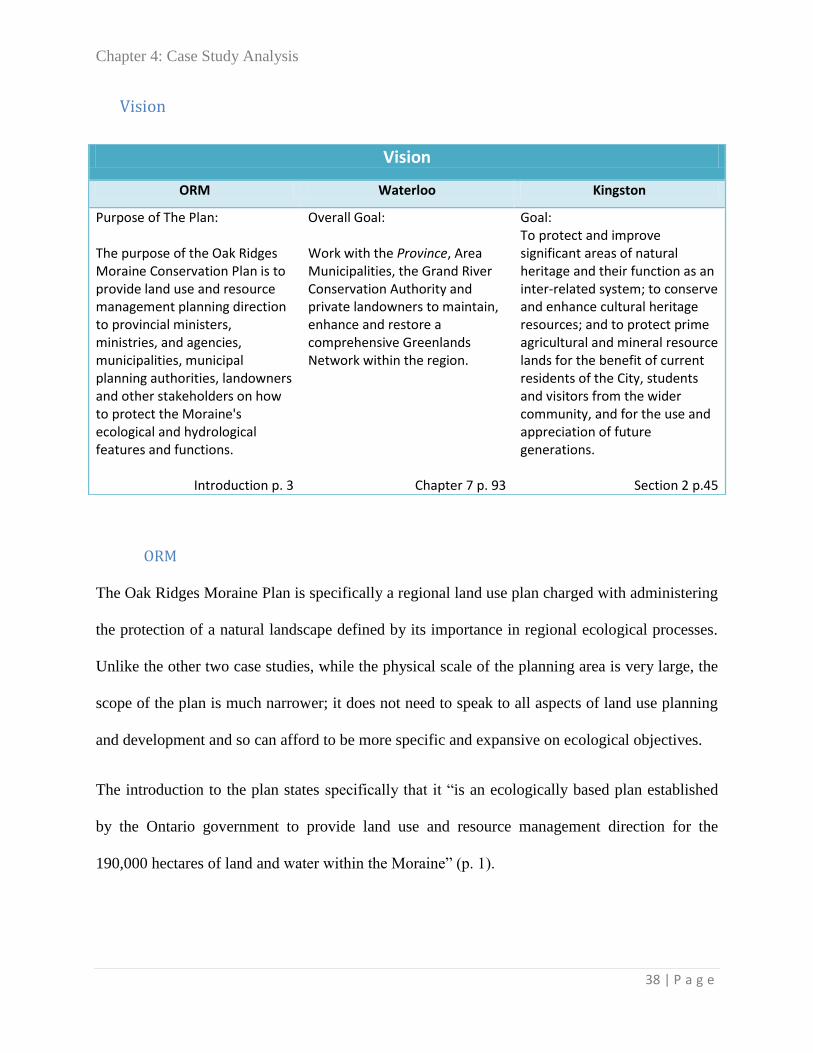
ORM
The Oak Ridges Moraine Plan is specifically a regional land use plan charged with administering
the protection of a natural landscape defined by its importance in regional ecological processes.
Unlike the other two case studies, while the physical scale of the planning area is very large, the
scope of the plan is much narrower; it does not need to speak to all aspects of land use planning
and development and so can afford to be more specific and expansive on ecological objectives.
The introduction to the plan states specifically that it “is an ecologically based plan established
by the Ontario government to provide land use and resource management direction for the
190,000 hectares of land and water within the Moraine” (p. 1).
Vision
ORM Waterloo Kingston
Purpose of The Plan: The purpose of the Oak Ridges Moraine Conservation Plan is to provide land use and resource management planning direction to provincial ministers, ministries, and agencies, municipalities, municipal planning authorities, landowners and other stakeholders on how to protect the Moraine's ecological and hydrological features and functions.
Introduction p. 3
Overall Goal: Work with the Province, Area Municipalities, the Grand River Conservation Authority and private landowners to maintain, enhance and restore a comprehensive Greenlands Network within the region.
Chapter 7 p. 93
Goal: To protect and improve significant areas of natural heritage and their function as an inter-related system; to conserve and enhance cultural heritage resources; and to protect prime agricultural and mineral resource lands for the benefit of current residents of the City, students and visitors from the wider community, and for the use and appreciation of future generations.
Section 2 p.45

Chapter 4: Case Study Analysis
39 | P a g e
The vision, goals and objectives of the plan are very clearly set out at the front of the document
where they are easy to find, and explain in clear and simple terms why natural areas should be
protected. In addition to setting out the plan’s objectives a vision statement is also included
which helps to clarify what these goals and objectives intend to achieve. Rather than solely
listing tasks and prohibitions, the vision provides a sense of what achievement of these goals will
look like.
This idea of using natural areas to create form and structure to the region helps solidify the
concept of this very large diverse area as a unique landscape unit.
The goals and objectives discuss both the importance of protecting ecological processes and for
the importance of preserving public recreational access, “for present and future generations”
(Plan Objectives, p. 4).
Waterloo
The Waterloo Regional Plan is a document meant to coordinate growth and development across
a large region containing several municipalities, including both major urban centres and rural
townships. While conservation of natural land and resources is only one of the mandates of this
plan, it is clearly indicated as a priority through the use of strong language and prominent
inclusion in the vision statement. The first page of the document states:
The Vision for the Oak Ridges Moraine
The Ontario government's vision for the Oak Ridges Moraine is that of "a continuous band of
green rolling hills that provides form and structure to south-central Ontario, while protecting
the ecological and hydrological features and functions that support the health and well-being
of the region's residents and ecosystems". (Introduction p. 3)

Chapter 4: Case Study Analysis
40 | P a g e
The key elements of the Regional Growth Management Strategy are: big picture
environmental planning; a Countryside Line; reurbanization; transportation choice,
including the creation of a rapid transit system; targeted development in greenfield areas;
and quality of life initiatives. (Introduction p.1)
Environmental planning is listed as the first key element overall, but NHS planning is mainly
discussed in detail in Chapter 7, which specifically sets out the policy framework for the
“Greenlands Network” to protect “environmental features and ecological functions from adverse
environmental impacts.” The plan states that Chapter 7 “provides policies related to the natural
environment through the conservation and enhancement of the region’s sensitive natural areas
and native biodiversity, and the promotion of informed stewardship.” (Introduction p. 7)
The plan specifically emphasises a landscape approach and includes as an objective, to
“maintain, enhance or, wherever feasible, restore landscape level linkages among environmental
features” (Chapter 7 p.93).
The Greenlands Network is defined as environmental features and the linkages among
them. The Greenlands Network, and the ecological functions it provides, contributes to
maintaining the environmental health of Waterloo Region and the Grand River watershed.
This Plan contains policies to maintain, enhance or, wherever feasible, restore the Greenlands
Network. Such action is necessary to counteract the negative effects of fragmentation which
can result in a loss of ecological integrity and the degradation of natural biodiversity. Such
action is also necessary to maintain biological and geological diversity, viable populations
of native species and ecosystems, and make possible adaptation in response to actual or
expected effects of climate change.
Chapter 7 p.1

Chapter 4: Case Study Analysis
41 | P a g e
Kingston
The overall goals are set out in the introductory chapter, and natural heritage planning is first
introduced as objective “ j.” “an ecosystem approach to protecting the natural heritage system”
(Section 2 p.22). While the discussion of Natural Heritage is given a less prominent position
within the plan objectives, it is introduced in the context of a systems and ecosystem approach.
Chapter 6 of the Kingston OP details the municipality’s policies on The Environment and
Energy. Section 6.1 specifically addresses the Natural Heritage System.
Strengths and weaknesses
The Oak ridges Moraine Plan has the most clearly defined vision for what a successful natural
heritage system would look like when it is preserved and protected. The Waterloo Regional Plan
is well organized, environmental planning is stated up front as a goal and priority and the
specific section on “Greenlands” includes strong statements about ecological processes and the
need to maintain, enhance and restore” connectivity between natural features. Kingston’s plan
does not feature environmental planning in quite as prominent a place early and clearly in the
plan, but it does a very good job of emphasizing the inter-related components of natural area
planning and often references and refers to provincial regulations and best-practice guidelines.
The natural heritage system is important for its natural features and their functions which
contain animal and plant habitat areas, for the natural resources, such as water, which
sustains animal and human health and activity, and for its value as a recreational and tourist
resource. These interrelated features and functions that support life and environmental
health have been evaluated as a system, and consist of core areas linked by landforms and
habitats.
Section 6.1 p.195
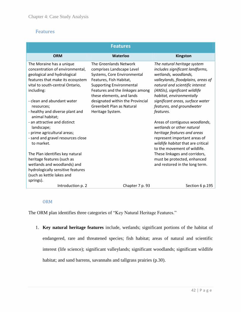
Chapter 4: Case Study Analysis
42 | P a g e
Features
ORM
The ORM plan identifies three categories of “Key Natural Heritage Features.”
1. Key natural heritage features include, wetlands; significant portions of the habitat of
endangered, rare and threatened species; fish habitat; areas of natural and scientific
interest (life science); significant valleylands; significant woodlands; significant wildlife
habitat; and sand barrens, savannahs and tallgrass prairies (p.30).
Features
ORM Waterloo Kingston
The Moraine has a unique concentration of environmental, geological and hydrological features that make its ecosystem vital to south-central Ontario, including: - clean and abundant water u resources; - healthy and diverse plant and u animal habitat; - an attractive and distinct u u landscape; - prime agricultural areas; - sand and gravel resources close u to market. The Plan identifies key natural heritage features (such as wetlands and woodlands) and hydrologically sensitive features (such as kettle lakes and springs).
Introduction p. 2
The Greenlands Network comprises Landscape Level Systems, Core Environmental Features, Fish Habitat, Supporting Environmental Features and the linkages among these elements, and lands designated within the Provincial Greenbelt Plan as Natural Heritage System.
Chapter 7 p. 93
The natural heritage system includes significant landforms, wetlands, woodlands, valleylands, floodplains, areas of natural and scientific interest (ANSIs), significant wildlife habitat, environmentally significant areas, surface water features, and groundwater features. Areas of contiguous woodlands, wetlands or other natural heritage features and areas represent important areas of wildlife habitat that are critical to the movement of wildlife. These linkages and corridors, must be protected, enhanced and restored in the long term.
Section 6 p.195

Chapter 4: Case Study Analysis
43 | P a g e
2. Hydrologically sensitive features include permanent and intermittent streams; wetlands;
kettle lakes; and seepage areas and springs (p.34).
3. Landform conservation areas “are designed to maintain significant landform features
such as steep slopes, kames, kettles, ravines and ridges in their natural undisturbed form”
(p. 40).
Many of these are the features required by the PPS, however, the ORM plan increases the
specificity of some of some categories and includes identification of particular landforms
hydrologic features found within the planning region.
Waterloo
The Waterloo Regional Plan includes several types of features and areas within the Greenlands
Network, some of which are specifically designed to create and maintain linkages and promote a
systems approach to environmental planning. These are divided into categories of Landscape
Level Systems, Core Environmental Features, Fish Habitat, and Supporting Environmental
Features which include “the linkages among these elements, and lands designated within the
Provincial Greenbelt Plan as Natural Heritage System” (p. 93).
Landscape Level Systems include areas designated as Environmentally Sensitive Landscapes;
Significant Valleys; Regional Recharge Areas; and areas overlapping with the Provincial
Greenbelt Natural Heritage System (p. 96).
The Core Environmental Features designation applies to lands that meet the criteria as:
(a) Significant Habitat of Endangered or Threatened Species;
(b) Provincially Significant Wetlands;
(c) Environmentally Sensitive Policy Areas; (ANSIs)
(d) Regionally Significant Woodlands; or
(e) Environmentally Significant Valley Features. (p. 104)

Chapter 4: Case Study Analysis
44 | P a g e
The Supporting Environmental Features category allows for flexibility and a way to protect
features that do not meet Provincial criteria for requiring protection but which are considered to
“play an important role in maintaining the ecological functions provided by the Greenlands
Network” (p. 111).
Discussion of Hazardous lands and hazardous sites is also included within the section on the
Greenlands network (p.115).
Kingston
Kingston’s municipal Official Plan separates features and areas into two categories.
Natural Heritage “A” features which include the following:
provincially significant wetlands;
locally significant wetlands;
areas of natural and scientific interest (ANSIs);
fish habitat and riparian corridors;
significant coastal wetlands; and,
significant habitat of endangered and threatened species (Section 6 p. 196)
And Natural Heritage “B” features which include:
significant woodlands;
significant valleylands;
significant wildlife habitat;
unevaluated wetlands;
environmentally significant areas as historically mapped in the former Township of
Pittsburgh and not considered significant under the current Provincial Policy definition of
natural heritage system; and,
linkages and corridors. (Section 6 p. 197).
These very closely follow the requirements set out in the PPS, but also includes areas that have
been locally evaluated or have local natural or cultural significance.

Chapter 4: Case Study Analysis
45 | P a g e
Strengths and weaknesses
All three plans include the features and areas required by the PPS for the protection of Natural
Heritage (section 2.1), however, in all three cases additional features or areas have been defined
in order to meet specific needs. Both Waterloo and Kingston include categories specifically
designed to maintain linkages between natural areas. The entire ORM is administered as a
landscape scale corridor, so individual designations of smaller scale linkages are less necessary
in that context.
Both Kingston and Waterloo also include provisions for protecting previously designated areas
which may no longer meet the current criteria but which were previously evaluated as having
environmental significance.

Chapter 4: Case Study Analysis
46 | P a g e
Boundaries
ORM
Unlike the other two plans which correspond to political jurisdictions, the general boundaries of
the Oak Ridges Moraine Conservation plan are based on geology and natural ecological features.
The Southern boundary follows the 245 m (above sea level) contour from the Town of
Richmond Hill to the boundary with the Municipality of Clarington. These boundaries have been
precisely defined by the Surveyor General, and detailed maps are available at a fine scale,
however, very specific boundary determinations and for specific features or areas within the
Moraine are made on a site by site basis after an Environmental Impact Study. The Plan states
that “The Plan of the Boundary of the Oak Ridges Moraine Area provides the information for
establishing the boundary on the ground by a Licensed Ontario Land Surveyor, under
instructions for the Surveyor General for the Province of Ontario” (Introduction p.7).
Boundaries
ORM Waterloo Kingston
The Plan of the Boundary of the Oak Ridges Moraine Area provides the information for establishing the boundary on the ground by a Licensed Ontario Land Surveyor, under instructions for the Surveyor General for the Province of Ontario.
Introduction p.6
Interpretation of the boundaries of Landscape Level Systems and Core Environmental Features, as required to support the review of development applications, will be achieved through the completion of Environmental Impact Statements or other appropriate studies.
Chapter 7 p. 94
The boundaries of the Environmental Protection Area result from the Council-endorsed Central Cataraqui Region Natural Heritage Study (2006), which acknowledged that the boundaries are approximate, and are to be more specifically delineated in consultation with the Cataraqui Region Conservation Authority or Ministry of Natural Resources, as appropriate, on a site specific basis.
Section 3 p.111

Chapter 4: Case Study Analysis
47 | P a g e
These instructions include detailed requirements for buffer zones, called “minimum area of
influence” and “minimum vegetation protection zone” which are set out for each category of
feature or area and which are based on scientific understanding about conservation ecology (see
Appendix C).
In addition to the direction within the plan itself, a comprehensive set of Technical Papers are
available from Ministry of Municipal Affairs and Housing (MAH 2008b) which provide further
direction and explain the rational and the science behind specific policies and regulations. The
first paper in the series is “Identification of Key natural Heritage features” and its purpose is “To
provide definitions and technical criteria to assist in the identification and delineation of key
natural heritage features (KNHFs) as identified in the Oak Ridges Moraine Conservation Plan
(ORMCP).”
Waterloo
The Waterloo Regional Plan states that “Interpretation of the boundaries of Landscape Level
Systems and Core Environmental Features, as required to support the review of development
applications, will be achieved through the completion of Environmental Impact Statements or
other appropriate studies” (CITE)
The Waterloo Plan includes a technical appendix, “The Greenlands Network Implementation
Guideline,” that sets out the requirements of an Environmental Impact Statement that must be
used to determine exact boundaries within the Greenlands network. The implementation
guideline includes information on “formalising principles for the delineation of boundaries of
environmental features, delineating buffers, linkages, and expanded definitions of terms.”
Chapter 4: Case Study Analysis
48 | P a g e
The Plan also discusses the importance of watershed boundaries “as the regionally ecologically
meaningful scale for planning” and says that “in collaboration with the Province, Area
Municipalities and the Grand River Conservation Authority, [the Region] will undertake
watershed studies both to minimize adverse environmental impacts, including cross-
jurisdictional and cross-watershed impacts, and to maintain, enhance or, wherever feasible,
restore the Greenlands Network” (P. 111)
Kingston
Kingston’s OP refers to the NHS Reference Manual for the background to justify the
determination of boundaries. It states that “The Province of Ontario’s “Natural Heritage
Reference Manual” specifies the adjacent lands for each category of natural heritage features
and areas, and these buffer areas are intended to protect specific features and functions as
mapped” (P??). Section 6 (p. 199) of the plan sets out these requirements:
In the review of any development or site alteration, an environmental impact assessment
will be required as follows, unless otherwise directed by the Cataraqui Region
Conservation Authority:
a. within 120 metres of a provincially significant wetland;
b. within 30 metres of a locally significant wetland;
c. within 30 metres of fish habitat, which for the purposes of this Plan are shown
as Environmental Protection Areas on Schedule 3;
d. within 50 metres of an area of natural and scientific interest (ANSI);
e. within 50 metres of significant habitat of endangered and threatened species;
and,
f. within 50 metres for significant woodlands, valleylands and significant wildlife
habitat.
In addition, the Plan includes a buffer along all shoreline areas: “The City seeks to protect the
shoreline ecology by way of a natural area setback of 30 metres or a “ribbon of life” adjacent to
the water” (section 2 p.46).

Chapter 4: Case Study Analysis
49 | P a g e
Strengths and weaknesses
All three plans leave the exact determination of boundaries to environmental impact studies at
the property level, while providing a set of more general guidelines for making decisions at this
level. The Natural Heritage Reference Manual (2010) sets out many of the standards for
“adjacent lands” and the required buffers, however, individual municipalities and plans are
allowed to go above and beyond provincial guidelines. Kingston’s plan relies heavily on the
provincial standards, usually simply referring to the relevant section in the provincial document
that contains the required information. Waterloo and ORM both include a separate technical
document which provides more detailed guidelines for identifying and delineating the exact
locations and boundaries of natural features and areas, as well as elaboration on the scientific
rationale for requirements of the plan.

Chapter 4: Case Study Analysis
50 | P a g e
Land Use Designations
ORM
The ORM Plan is organizes land use into four separate designations, each with different levels of
regulations and restrictions. Natural Core Areas make up 38% of the area of the Moraine and
consist of the areas with the “greatest concentrations of key natural heritage features which are
critical to maintaining the integrity of the Moraine as a whole” (MAH 2002, 4). Natural Linkage
Areas (24% of the Moraine), preserve corridors of open space and natural habitat between
Natural Core Areas and also protect land along rivers and streams. Very limited development is
allowed within these designations. The Plan specifies that “only existing uses and very restricted
new resource management, agricultural, low intensity recreational, home businesses,
transportation and utility uses are allowed in these areas” (MAH 2002, 4). Limited aggregate
extraction is also permitted in Natural Linkage Areas, but not in Natural Core Areas.
Land Use Designations
ORM Waterloo Kingston
The Plan divides the Moraine into four land use designations: Natural Core Areas (38% of the Moraine), Natural Linkage Areas (24% of the Moraine), Countryside Areas (30% of the Moraine) and Settlement Areas (8% of the Moraine).
Introduction P. 4
The Greenlands Network is a layered approach to environmental protection comprised of Landscape Level Systems, Core Environmental Features and Supporting Environmental Features. Each layer contains policies that provide appropriate protection to areas of environmental significance.
Chapter 7 P.1
Areas of greatest significance are categorized as Natural Heritage “A” features. These areas are not intended for development or site alteration and are designated as environmental Protection Areas
Chapter 6 p. 195

Chapter 4: Case Study Analysis
51 | P a g e
Thirty percent of the Moraine is designated as Countryside where typical rural and agricultural
uses are allowed. Existing rural hamlets and established rural communities are also included in
this designation. The Countryside Area designation also created a buffer between more intensive
development and the protected natural areas while protecting prime agricultural soils for farming
(MAH 2002). In each of these three designations there are very restrictive policies for creating or
developing new lots outside of a few areas where exceptions have been permitted for existing
municipalities which are still required to conduct impact studies prior to this development being
allowed (MAH 2002, 5).
The fourth designated land use type is that of Settlement Areas which are limited to 8% of the
Moraine’s area (MAH 2002). These areas include the existing settlements and communities
regulated by municipal land use plans. While the municipalities remain responsible for land use
planning within their jurisdiction, official plans and development approvals are required to
conform to the Oak Ridges Moraine Conservation Plan (MNR, 2001). The plan states that “this
is in keeping with the provincial land use planning system within which municipalities are
responsible for implementing provincial policy through their official plans and when making
decisions on development applications.
Waterloo
The Waterloo Plan discusses the Greenlands Network as “a layered approach to environmental
protection” where “each layer contains policies that provide appropriate protection to areas of
environmental significance” (Chapter 7 P.1). The plan separates features and areas with
Chapter 4: Case Study Analysis
52 | P a g e
designations as Landscape Level Systems, Core Environmental Features and Supporting
Environmental Features.
The plan specifies that “Area Municipalities will designate and zone Landscape Level Systems
and Core Environmental Features in their official plans and zoning by-laws respectively to
regulate the use of land within these areas in conformity with the policies in Sections 7.B and
7.C.” (p94)
While it is acknowledged that as a layered system where other designations and policies are
simultaneously applicable, the plan clearly states that “The designation of lands as Landscape
Level Systems will not affect agricultural uses and associated normal farm practices as defined
in applicable Provincial legislation and regulations in conformity with approved Area Municipal
official plans and zoning by-laws, and statutes, policies and regulations of other government
agencies, including agricultural drainage through municipal or agreement drains.” (P.96)
Kingston
Kingston divides NH features into either Natural Heritage A or B. When a site is designated as a
Natural Heritage “A” feature, “no new land division that results in the creation of a new lot will
be granted except for lands that are to be held by land trusts, public agencies, or for conservation
purposes” (6.1.25.) For features or Areas within the Natural Heritage B designation “no land
division that results in the creation of a new lot will be granted if it results in negative impacts on
the feature or function, except for lands that are to be held by land trusts, public agencies, or for
conservation purposes” (6.1.26.).
The Plan also discusses requirements to adjacent lands as a separate category: “Where a site is on
adjacent lands to either a Natural Heritage “A” feature or a Natural Heritage “B” feature, no land

Chapter 4: Case Study Analysis
53 | P a g e
division that results in the creation of a new lot will be approved unless the ecological function
of the adjacent lands has been evaluated and it has been demonstrated that there will be no
negative impacts on the natural heritage features and areas, or on their ecological functions.”
(Section 6 p. 201).
Strengths and weaknesses
All three plans group some types of features or areas together under a wider designation through
which to apply specific policies and protection measures. Kingston’s plan literally takes the
different features or areas required under the PPS and groups them into either category A or B.
Protection is specific to the area and buffer around each feature. Waterloo is similar with Core
Environmental Features, however the Landscape Level systems designation allows for a broader
protection of an area which may include space between features or areas and which may include
agricultural land and hamlets. The ORM has a somewhat different approach where the entire
planning area is separated into four designations which are not specific to the boundaries of
particular features or areas but rather to the land use previously in the area and to the quality and
sensitivity of the natural environment in a particular location. Specific features are taken into
account within this blanket approach.
Chapter 4: Case Study Analysis
54 | P a g e
Implementation
ORM
The implementation section refers to the part of the plan that actually sets out what information
and studies a proponent is required to provide to meet the requirements of the plan. The ORMCP
sets out the steps that are to be taken to properly complete an EIA:
A natural heritage evaluation shall (p. 30-31),
demonstrate that the development or site alteration applied for will have no adverse
effects on the key natural heritage feature or on the related ecological functions;
identify planning, design and construction practices that will maintain and, where
possible, improve or restore the health, diversity and size of the key natural heritage
feature and its connectivity with other key natural heritage features;
in the case of an application relating to land in a Natural Core Area, Natural Linkage
Area or Countryside Area, demonstrate how connectivity within and between key natural
heritage features will be maintained and, where possible, improved or restored before,
during and after construction;
specify the dimensions of the required minimum vegetation protection zone and provide
for the maintenance and, where possible, improvement or restoration of natural self-
sustaining vegetation within it;
in the case of a key natural heritage feature that is fish habitat, ensure compliance with
the requirements of the Department of Fisheries and Oceans (Canada).
an analysis of land use, soil type, slope class and vegetation type, using criteria
established by the Government of Ontario.
Waterloo
The Waterloo Regional Plan differentiates between three types of Environmental Impact Study
(P. 6 implementation guidelines):
1. A Comprehensive Environmental Impact Statement is a landscape scale (usually a
watershed or sub-watershed) study which typically precedes development. It is normally carried

Chapter 4: Case Study Analysis
55 | P a g e
out by government agencies to identify environmental features for protection, delineate potential
development areas and recommend development setbacks in order to maintain the ecological
sustainability of the Greenlands Network in the area. This process helps to establish the
appropriate type, scale and location of development.
2. A Full Environmental Impact Statement is an area or site-specific study carried out in
accordance with the approved Guideline to address potential adverse environmental impacts
anticipated to arise from a development application, and to identify means to enhance or restore
elements of the Greenlands Network.
3. A Scoped Environmental Impact Statement is an area or site-specific study where the
impacts of the proposed development or site alteration upon an element of the Greenlands
Network are expected to be limited in area and/or scope, or where other environmental studies
fulfilling the requirements of an Environmental Impact Statement have been previously prepared.
Terms of Reference are scoped by staff in consultation with EEAC and other agencies and the
applicant.
Kingston
Kingston’s Official plan includes a detailed technical appendix that sets out the requirements for
an EIA. The EIA document shall (from OP Appendix A):
a) be prepared by a qualified person who has been educated in, and has current knowledge of,
biology, ecology, landscape ecology and any other relevant fields of study, as required (the
professional shall also have an understanding of the natural heritage system of the Cataraqui
Region);
b) be consistent with the intent of the Provincial Policy Statement;
c) for areas on and immediately adjacent to the site, include descriptions and clearly legible,
scaled maps of the existing land uses, and the proposed development and site alteration,
including all proposed buildings, structures, driveways and parking areas, and sources of human
intrusion, light, noise, dust, etc.;
d) illustrate the precise location of all of the natural heritage features and areas on, or adjacent
(as defined by the PPS and supporting documents) to the site on clearly legible, scaled maps;
e) provide a thorough field inventory of flora and fauna and related habitat (which is to be
completed during the growing season, and preferably in more than one of spring, summer, and
fall - additional field work may be required during the winter for specific attributes, for example,
deer wintering yards), as well as relevant information on soils and geology, slope, hydrology,
and hydrogeology;

Chapter 4: Case Study Analysis
56 | P a g e
f) include the best information available from others (as recorded in reports and databases, or as
identified via personal communication) regarding the items listed in (d) and (e) above;
g) review the ecological functions of the natural heritage features and areas identified above,
including the habitat needs of species that utilize adjacent lands (as defined by the PPS and
supporting documents), and an assessment of how the site contributes to the natural heritage
system of the area (e.g. subwatershed) and the Cataraqui Region;
h) discuss the significance, as defined in the PPS, of the natural heritage features and areas and
ecological functions identified in (d), (e), (f), and (g) above, and assess any apparent trends in the
ecological health of same;
i) predict the positive and negative impacts of the proposed development or site alteration on the
various attributes of the environment on and adjacent to the site, such as habitat, vegetation, soil,
surface water features, groundwater features, air, and any other relevant attributes, taking into
consideration the sensitivity of the attributes, impacts both during and after construction, and
where appropriate, the role of flooding and erosion hazards;
j) predict the cumulative impacts of the proposal and any other existing or known future
proposals in the vicinity;
k) evaluate the significance of all predicted positive and negative impacts on the environment;
l) recommend extents of land where: (1) disturbance must be avoided, and (2) disturbance must
be limited, in order to maintain the natural heritage features and areas and ecological functions
of the area, supported by a detailed rationale;
m) explore opportunities for enhancement of the natural heritage system;
n) discuss the merits of alternative development options, and recommend feasible and cost-
effective measures that could be implemented to avoid or mitigate the predicted negative impacts
of the selected option (e.g. timing of work, fencing, erosion and sediment control, pathway
routing, etc.);
o) where appropriate, outline a program through which the mitigation measures and the long-
term impacts associated with the proposal can be monitored and assessed; and
p) conclude with an independent opinion by the qualified person as to whether or not the
proposed development or site alteration is appropriate, and is consistent with the intent of the
Provincial Policy Statement.

Chapter 4: Case Study Analysis
57 | P a g e
Strengths and Weaknesses
All three of the case studies include discussion of enhancing or improving ecological function
and connection rather than only discussion of mitigation. Kingston’s OP also includes a clause
on predicting cumulative effects.
ORM includes the basic structure and components of a NH evaluation within the body of the
plan and then provides the necessary background and detailed rationale in the technical paper
series. Waterloo provides the rational for the three classes of environmental assessment with
brief descriptions of what each entails. Kingston’s official plan lists the components of an EIA
in greater detail in the body of the plan.

Chapter 4: Case Study Analysis
58 | P a g e
Public Participation
ORM
The ORM Conservation Plan came about after many years of public and private advocacy about
the importance of protecting the Ecosystem of the Moraine. In 1991 a technical advisory
committee was created by the Ontario Ministry of Natural Resources, Ministry of Environment
and Minister of Municipal Affairs to coordinate between the three regional governments and
over a dozen municipalities on the moraine and to help in creating a long-term development
strategy and a regional approach to land use planning (MNR 1991, IAGLR 2002). This strategy
was completed in 1994 but was never fully implemented (IAGLR 2002). An advisory panel was
appointed after the passage of the Oak Ridges Moraine Protection Act, 2001, with members
drawn from key stakeholder groups and worked closely with an inter-ministry team of Ontario
government officials. This panel developed a series of recommendations which were
incorporated into a public consultation document – Share Your Vision for the Oak Ridges
Moraine. During the summer of 2001 day-long stakeholder sessions and evening public meetings
were held in in Uxbridge, Caledon East, Vaughan and Cobourg, which were attended by more
than 2,000 people. In addition nearly 600 written submissions were sent via website e-mail, mail
and the Environmental Bill of Rights registry. After these meetings and consultation the
Advisory Panel and the Inter-Ministry Team met to finalize their findings and recommendations,
which were used to form the basis of the Plan (ORM plan p. 2).

Chapter 4: Case Study Analysis
59 | P a g e
Waterloo
The first page of the Regional Plan emphasizes that “establishing a Greenlands Network requires
co-operation among agencies, private landholders and the wider community” (p.1). In order to
continue with implementation of the plan, the “Regional Council will maintain an Ecological and
Environmental Advisory Committee to advise the Region in the review of development
applications, policy proposals and other matters, in accordance with terms of reference adopted
and periodically reviewed by Regional Council” (p.95).
The website of the Regional Government also discusses public participation and promotes
stewardship on the Environmentally Sensitive Landscapes webpage:
How can the public get involved?
The policies in the Regional Official Plan are also designed to encourage stewardship of ESL
lands. Things like new tax assessment practices are being considered, and technical assistance
and financial incentive and recognition programs are being offered to make it easier for
landowners, as well as volunteers and community organizations, to protect and enhance
property or environmental features within an ESL.
An implementation plan will be developed for each ESL with help from the community. The
Laurel Creek Headwaters ESL Public Liaison Committee has been set up with members who
are private property owners in ESLs, as well as other people with interest and expertise in land
stewardship. This committee will serve as a model for future ESL Public Liaison Committees
by:
Developing tools to enhance natural features and connections;
Promoting responsible land stewardship;
Assessing possible impacts of activities such as recreational use water extraction
proposals;
Exploring options to acquire conservation lands;
Addressing relevant concerns of residents and property owners within the ESL; and
Investigating opportunities to provide incentives and recognition for good land
stewardship
(http://www.regionofwaterloo.ca/en/abouttheenvironment/environmentallysensitivelandscapesesls.asp)

Chapter 4: Case Study Analysis
60 | P a g e
Kingston
Kingston Official Plan was created following the requirements of the PPS and the Planning act
for public consultation. The foreword to the Official Plan explains:
Prior to adoption and in accordance with the provisions of The Planning Act and after
giving required notice, a formal Open House was held by the City on June 8, 2009 for the
purpose of making adequate information available to the public regarding the Official
Plan. The Open House was followed by a formal Statutory Public Meeting, also held in
accordance with the provisions of The Planning Act, by the Planning Committee at its
meeting of June 18, 2009 for the purpose of giving the public an opportunity to make
representations in respect of the Official Plan. (Foreword p. 1)
This is quite formally stated and simply makes it clear that the minimum requirements have been
met, however later in the plan more emphasis is given to the role and priority given to promoting
stewardship in the region: “The Official Plan recognizes the stewardship responsibilities that
result from two UNESCO (United Nations Educational Scientific and Cultural Organization)
inscriptions. UNESCO inscribed the Rideau Canal and associated fortifications as a World
Heritage Site in 2007 and the Frontenac Arch as a UNESCO Biosphere Reserve in 2002, as
shown on Schedule 1” (Context p. ii).
Public consultation was also incorporated into the Cataraqui Region Natural Heritage Study. The
study webpage emphasizes that “public consultation was key throughout the process.” The study
was managed by a technical steering committee, and a separate advisory committee represented
the interests of environmental groups, woodlot owners, agriculture and developers and the
general public. In addition, there were two rounds of public consultation meetings which

Chapter 4: Case Study Analysis
61 | P a g e
provided eight opportunities for public comment. This process was overseen by the Cataraqui
Region Conservation Authority which served as a study consultant.
The website further discusses that “this study provides recommendations for stewardship
initiatives to maintain and enhance the natural heritage system. In fact, the study helps identify
priority locations for stewardship and rehabilitation efforts.”
Strengths and weaknesses
Environmental Stewardship is identified as a key aspect in the success of the implementation of
NHS planning in all three case study plans. Kingston’s OP meets the Provincial requirements set
out in the planning act and follows with some sentences promoting their commitment to
stewardship but does not go much further than that. There are no specific requirements or
commitments entrenched in the plan however that doesn’t necessarily mean there are no other
stewardship initiatives occurring.
Waterloo maintains an Ecological and Environmental Advisory Committee and the region is
testing a format for an ESL Public Liaison Committee made up of property owners or other
interested stakeholders within the ESL.
Having a continued public involvement and stewardship plan as a written part of the
implementation section of the plan is important; however it is difficult to make this an effective
policy on paper when it very much depends on dedication and sustained interest from
stakeholders.

Chapter 4: Case Study Analysis
62 | P a g e
Adaptive management and monitoring
ORM
The introduction to the ORM plan includes a section titled “Review and Amendment.” It states
that:
The Plan shall be reviewed every 10 years to determine whether any revisions should be
made. During a review, the Minister shall consult with affected ministries, public bodies
and municipalities and ensure that the public is given an opportunity to participate. The
10-year review cannot consider removing land from the Natural Core Areas or the
Natural Linkage Areas (p.7).
The final section of the plan also provides more detail on what the 10 year review will
accomplish and what power reviewers will have to change the plan. In particular, guidelines are
provided for considering changes to boundaries of settlement areas, for including new, updated,
or corrected information; and to reflect changed or new priorities of the Ontario government.
In addition, this final section sets out Provincial obligations for technical support in updating and
maintaining maps and for establishing partnerships with municipalities and stakeholders for to
create a network to collect, summarize and evaluate performance indicator data to:
assess changes in the ecological integrity of the Moraine;
assess the effectiveness of the policies of the Plan in achieving the Plan's vision and
objectives;
help identify improvements that would address problems encountered in implementing
the Plan (Implementation p. 9-10)

Chapter 4: Case Study Analysis
63 | P a g e
Waterloo
Chapter 10 of the Regional Official Plan addresses fulfilling consultation and implementation
roles. It states that “the Region’s goal in the public consultation process is to collaborate with
individuals, groups and agencies to achieve, whenever possible, mutually satisfactory solutions
to planning issues” (Chapter 10 p. 148). This chapter also addresses monitoring and updating of
data:
The Region will continue to develop financial and/or information collection and sharing
arrangements with the Province, Area Municipalities, the Grand River Conservation
Authority and other stakeholders to provide for the development and maintenance of
comprehensive and integrated region-wide demographic, environmental, economic, land
use, housing and social databases. These databases will be used to monitor the
effectiveness of the policies in this Plan, and where feasible, information from these
databases will be made available to the public. (Chapter 10 p. 159)
Kingston
Section 1.1 of the OP explains that “This Official Plan is intended to guide development in
Kingston until 2026, but it will be reviewed every five years in accordance with the requirements
of the Planning Act and may be amended by the City to reflect changing circumstances or new
priorities for resource protection, growth or redevelopment.”
This refers to the municipal planning document, however, and does not necessarily make
provision for review of the data backing the NHS. There is no specific mention of review of

Chapter 4: Case Study Analysis
64 | P a g e
NHS data in the OP Section 9, Administration and Implementation, which discussed monitoring,
review and updating for other aspects of the Plan.
The Cataraqui Study provided up-to-date data as of 2006, and it acknowledges that “mapping
updates will be necessary as new data become available to ensure that the municipalities have the
most accurate information. It is suggested that “new information/data should be shared between
the implementation partners as it becomes available” and that sources of data might include:
Environmental Impact Statements;
Environmental Assessments or Class EAs;
Resource and biological inventories;
Subwatershed Plans;
Assessment records and development proposals; and
Contributions from area field naturalists. (S. 6.2 p. 50)
However, the Cataraqui study was a specific project overseen by a team of experts and the
assertion that “regular maintenance of the database and mapping should be the responsibility of
the municipalities” means that the recommendation that the mapping be updated every five
years, and the database on an annual basis may be difficult to reliably and regularly continue.
Strengths and weaknesses
The ORMCP specifies that the 10 year review cannot remove land from Natural Core or Natural
Linkage Areas. This is very significant, however, it may be difficult to enforce if at the 10 year
review opinions have changed at the provincial level. Waterloo discusses the necessity of
updating data and mapping and intends to form partnerships with municipalities and stakeholders
to make this a continuous process. Kingston’s Official Plan does not specifically address
updating of data, only updating of the plan every 5 years as required.

Chapter 4: Case Study Analysis
65 | P a g e
Mapping/Communication
ORM
The Oak Ridges Moraine has been mapped in great detail and the boundaries of natural features
and areas, and of the four land use designations are well defined to a high level of accuracy.
Several versions of the map are available online at different scales, from an overview map to
1:100,000 scale maps designed to be printed in sections. Additional maps are available detailing
the Moraine boundaries, vulnerable aquifers and specific areas and adjacent areas.
The overview map uses the four land use designations rather than displaying individual features
or areas. This means that the entirety of the planning area is covered rather than having to think
about specific regulations for different types of features and needing to calculate buffers for
adjacent lands. It is possible to zoom in to a high level of detail on the online maps.


Chapter 4: Case Study Analysis
67 | P a g e
Figure 8: Oak Ridges Moraine Conservation Plan Land Use Map


Chapter 4: Case Study Analysis
69 | P a g e
Waterloo
Waterloo’s Greenlands Network map shows the locations of significant valleys, environmentally
sensitive landscapes, and core environmental features. All core environmental features,
including wetlands, forest, and environmentally sensitive policy areas are displayed using the
same colour. The effect is that aside from the Environmentally Sensitive Landscapes which
cover a large land area and are identifiable as core areas of natural habitat, it is difficult to
identify a network, in the sense of core areas and linkages. The core environmental features seem
to be scattered across the landscape with few large connected areas.
Waterloo regional Municipality also has a GIS tool publicly available online, and it includes
layers for “wooded areas” and for lakes and streams, however, there are no layers specific to
natural heritage and it is more an address and service locator than a tool for land use analysis.


Chapter 4: Case Study Analysis
71 | P a g e
Figure 9: Waterloo Regional Official Plan Greenlands Network


Chapter 4: Case Study Analysis
73 | P a g e
Kingston
Kingston’s NHS is mapped as Schedules 7 and 8 of the official plan. Schedule 7 shows location
of sensitive species, ANSIs, wetlands and riparian habitat. Within the plan document it is
explained that “significant habitat of endangered and threatened species – for purposes of
illustration Natural Heritage “A” features are shown on Schedule 7 as circles” (Section 6 p. 196).
This allows the general locations to be identified in order for potential development or projects
within these locations to take precautions while still maintaining confidentiality as to the exact
locations of species at risk.
Schedule 8 includes woodlands, valleylands, unevaluated wetlands, environmentally sensitive
areas, and linkages and corridors. Both schedules 7 and 8 are broken into three separate maps for
the central, North-East and North-West areas of the city in order to be able to display the
necessary detail at a 1:60,000 scale that remains printable on conventional printers.
The City of Kingston does maintain a public GIS, however it is oriented toward finding services
and does not include natural heritage layers.


Chapter 4: Case Study Analysis
75 | P a g e
Figure 10: City of Kingston Official Plan Schedule 7-A: Natural Heritage Area ‘A’

Chapter 4: Case Study Analysis
76 | P a g e
Figure 11: City of Kingston Official Plan Schedule 8-A: Natural Heritage Area ‘B'
Chapter 4: Case Study Analysis
77 | P a g e
Strengths and weaknesses
The use of land use categories in the Oak Ridges Moraine Plan allows for a very clear
representation of the sensitive natural areas and provides a sense of continuity and connectedness
of natural area. In contrast, Waterloo’s approach of identifying individual features gives the
impression of a very fragmented landscape.
Kingston’s Natural Heritage mapping is perhaps more conceptual, but does a good job of
displaying the interconnectedness of different features. Even separated onto two maps of the
three case studies it probably does the best job of displaying NHS principles.. By including
dotted lines showing the planned locations of corridors and linkages, which incorporate several
different classes of features and areas, it is possible to visualise and understand the vision for
natural corridors within the municipal boundaries.


Chapter 5: Recommendations and Conclusions
79 | P a g e
Chapter 5: Recommendations and Conclusions
Summary
The case studies analyzed in the previous chapter present a range of options available to PEC and
other municipalities for incorporating their NHS data and design into official municipal land use
policy. The following chart presents a summary of some of the strengths of each of the three
approaches.
Summary of Strengths
Oak Ridges Waterloo Kingston
Vision Very clear and detailed
Vision, Goals and
Objectives
Well organized,
environmental
integrity given
prominence in vision
statement
Includes discussion of
ecological function
Features Incorporated into a
comprehensive land use
classification. Includes
specific features unique
to the region.
Includes categories for
Landscape Level
Systems and
Supporting
Environmental
Features.
Includes provision for
historically designated
Environmentally
Sensitive Areas (ESA)
Boundaries Extensive technical
support and scientific
rationale
Includes a brief but
clear technical
appendix
Refers to provincial
best practices
Designations Comprehensive
approach with all land
area incorporated
within one designation
or other.
Environmentally
Sensitive Landscape
(ESL)
Includes linkages and
corridors as a protected
designation
Implementation Uses strong language.
Technical appendices
provide background
and instruction.
Discusses different
levels of EIA
Requires discussion of
predicted cumulative
effects

Chapter 5: Recommendations and Conclusions
80 | P a g e
Summary of Strengths Cont’d.
Oak Ridges Waterloo Kingston
Participation Extensive public debate
and media interest lead
to the formation of the
plan.
Opportunities for
stewardship discussed
as well as partnerships
with municipalities,
stakeholders and
landowners.
Monitoring Partnerships with
academic institutions,
extensive ongoing
research.
Ten year review does
not allow for removing
land from Natural Core
Areas.
Databases will be kept
and maintained by the
region but shared and
updated by
municipalities,
stakeholders and the
CA. These will be
used to monitor the
effectiveness of
policies.
Cataraqui Study makes
suggestions for using
sources including
EIAs, Subwatershed
Plans, Assessment
records etc., for
maintaining and
updating data
inventories and
mapping.
Mapping Comprehensive
approach, high level of
detail.
Environmentally
Sensitive Landscapes
clearly identify regions
designated as
particularly valuable
and vulnerable.
Displays linkages and
corridors in a way that
displays NHS
principles
Recommendations
From the analysis of the three case studies and from data gathered in the literature review, the
following are suggestions for Prince Edward County to consider when writing the Natural
Heritage policies for the updated Official Plan.
Vision
Prince Edward County already has a strong vision for the future development of the
County, which is largely based on an appreciation for the unique natural environment and
amenities. The current OP discusses the need for an ecosystem approach, but this could

Chapter 5: Recommendations and Conclusions
81 | P a g e
be better defined and elaborated on with specific discussion of the need for connectivity
to preserve ecosystem services.
Features
Kingston and Waterloo include Environmentally Sensitive Areas (ESAs) which were
previously designated but may no longer specifically fall within the PPS categories. This
is also relevant for PEC and it is recommended that these areas be included in the NHS
even if the original rationale for their designation is unavailable.
Using the MNR data mapping and the MARXAN analysis evaluate significant
woodlands within the County.
Boundaries
Similar to all three case studies exact boundaries may be determined on a case by case
basis where they do not align with existing landscape features such as roads or
waterways.
Clear requirements for buffer distances should be prominently included. Consider a table
similar to the Oak Ridges Moraine Plan (see Appendix D).
Including interactive NHS layers to the County GIS would allow concerned land owners
easy access to information and would help show the bigger picture. This could help
minimise disputes and disagreement.
Land Use Designations
Creating meaningful categories combining individual types of features and areas both
simplifies policies and helps to communicate NHS principles. Consider using “Core

Chapter 5: Recommendations and Conclusions
82 | P a g e
Natural Areas” and “Natural Linkage Areas” or “Supporting Natural Areas” rather than
simply Category A and B.
Agricultural land is extremely important in the County. Very clearly stating that nothing
in the NHS plan is intended to impact existing normal farm practices. Consider including
a clause similar to Kingston’s OP: Nothing in this Section is intended to limit the ability of
existing agricultural uses to continue. Existing agricultural uses and normal farm practices
occurring on adjacent lands to the natural heritage features and areas are not subject to the
requirement for an environmental impact assessment. (S. 6.1.13 p. 199)
Implementation
Include a technical appendix that explains the scientific rational behind decisions as well
as a specific list of the information and studies that may/shall be required as part of and
EIA.
Including different levels of EIA depending on the size of the project of the type of
feature or area may be helpful so that there are options for property owners interested in a
porch addition that are different than the requirements for a subdivision or golf course.
Public Participation
Involvement of community and agricultural groups should be done early to ensure that
this is understood and misinformation about the impacts of designation within an NHS
does not become a contentious issue.
Share the data collected (except for sensitive/confidential information such as the
location of species at risk) and educate landowners as to the value and functions of their
land.
Chapter 5: Recommendations and Conclusions
83 | P a g e
Adaptive management and monitoring
Prince Edward County is a small municipality with limited resources and a busy planning
department, however, there are several very active and knowledgeable community groups
dedicated to protecting and exploring the County’s natural heritage. Educating these
groups about the Natural Heritage systems and providing them with the tools and
organisational structure (ie. a centralised database) to be able to contribute to keeping
data up to date would be an excellent way to both maintain records and to create a sense
of ownership toward the project.
Mapping/Communication
Integrate NHS mapping with the Counties GIS. Include layers showing proposed core
and core areas as well as layers for individual features and areas so that people are able to
see how these interact. In addition it will be clear that core areas nearly exclusively
already occur in environmentally protected areas.
Use the MNR MARXAN tool for evaluating land use planning projects. Make this data
along with the “preferred scenario” available to stakeholders and the public.
Conclusions
The science, data and sophisticated computer modeling that has been completed for Prince
Edward County puts the municipality in an excellent position to create a Natural Heritage
System that meets provincial best practices and that will go a long way toward protecting the
health and integrity of the natural ecosystem. Converting this data into policy that can be

Chapter 5: Recommendations and Conclusions
84 | P a g e
understood and consistently applied through planning legislation is an important next step to
achieving a healthy environment moving into the future.
Natural Heritage Systems planning is a way to move beyond maintaining discrete protected areas
of natural habitat to creating policy that better reflects the complex interconnected nature of
natural cycles and processes. The emphasis on linkages and corridors in NHS planning allows
for a more systems focussed approach and for an increased ability to coordinate existing
protected areas and consider impacts across different scales.

Works Cited
85 | P a g e
Works Cited
Anderson and Jenkins. 2006. Applying Nature’s Design: Corridors as a strategy for biodiversity
conservation. Colombia University Press, New York: NY.
Bay of Quinte Remedial Action Plan. <http://www.bqrap.ca/>
Beier, and Noss. 1998. “Do Habitat Corridors Provide Connectivity?” Conservation Biology,
12:6, 1241-1252.
Bocking, Stephen. 2005. Protecting the rain barrel: Discourses and the roles of science in a
suburban environmental controversy, Environmental Politics, 14:5, 611-628. Available
online: http://dx.doi.org/10.1080/09644010500257896 (Accessed December 2011)
Cataraqui Conservation Area. 2006. Central Cataraqui Region Natural Heritage Study Final
Report. Report received by City of Kingston Council on August 22, 2006, and by
Loyalist Township Council on December 4, 2006.
City of Kingston. 2010. “Appendix A: Guidelines for Environmental Impact Assessments.” City
of Kingston Official Plan.
City of Kingston. 2010. “Section 6: The Environment and Energy.” City of Kingston Official
Plan.
Corporation of the County of Prince Edward. 2012. Planning Services
http://www.pecounty.on.ca/government/planning_services/official_plan_review.php
(Last updated 2012-07-27).
County of Prince Edward Planning Department. 2011. “Growth 2031” Official Plan Review
Issues Papers. (Available online
http://www.pecounty.on.ca/government/planning_services/official_plan_review.php)
Dillon Consulting Ltd. 2004. Quinte Regional Groundwater Study.
Dramstad, Olson and Forman. (1996) Landscape Ecology Principles in Landscape Architecture
and Land-Use Planning. Island Press
Eagles, 1984. The Planning and Management of Environmentally Sensitive Areas. Longman
Group ltd., New York: NY.
Eagles, Paul. 1981 “Environmentally Sensitive Area Planning in Ontario, Canada.”
Journal of the American Planning Association, 47:3, 313-323

Works Cited
86 | P a g e
Environment Canada. 2005. Beyond Islands of Green: A Primer for Using Conservation
Science to Select and Design Community based Nature Reserves. Environment Canada,
Downsview, Ontario.
Fisher, JR and Alexander, D. 1993. “The symbolic landscape of the Oak Ridges Moraine: its
influence on conservation in Ontario, Canada.” Environments, 22:1, 100.
Forman, Richard T. T. 1995. “Some general principles of landscape and regional ecology”
Landscape Ecology, 10:3, 133-142.
Hanski, I and Gilpin, M. 1991. Metapopulation Dynamics: Brief history and conceptual domain.
Biological Journal of the Linnean Society, 42:3-16.
Harrison, Susan and Bruna, Emilio. 1999 “Habitat Fragmentation and Large-Scale Conservation:
What Do We Know for Sure?” Ecography, 22: 3, 225-232
Ministry of Municipal Affairs and Housing (MAH). 2008 a. Natural Heritage System.
http://www.mah.gov.on.ca/Page1733.aspx (Last modified March 05, 2008.)
Ministry of Municipal Affairs and Housing (MAH). 2008 b. Oak Ridges Moraine Conservation
Plan Technical Papers. http://www.mah.gov.on.ca/Page4807.aspx
Ministry of Municipal Affairs and Housing (MAH). 2005. Provincial Policy Statement.
Toronto, ON: Queens Printer for Ontario.
Ministry of Municipal Affairs (MAH) 2002. Oak Ridges Moraine conservation plan.. Available
from www.mah.gov.on.ca/scripts/index.asp (accessed December 2006).Grumbine,
Edward R. 1994. “What Is Ecosystem Management?” Conservation Biology, 8:1, 2738.
Blackwell Publishing for Society for Conservation Biology.
Ministry of Municipal Affairs, (MAH) 2001. Oak Ridges Moraine Conservation Act. Toronto.
Available from www.www.mah.gov.on.ca/scripts/index.asp (accessed December 2006).
Ministry of Natural Resources (MNR). March 2010. Natural Heritage Reference Manual for
Natural Heritage Policies of the Provincial Policy Statement, 2005. Second Edition.
Toronto: Queen’s Printer for Ontario.
Ministry of Natural Resources (MNR). 2002. A Natural Heritage System for the Ontario
Ministry of Natural Resources, Southcentral Region.
Ministry of Natural Resources (MNR). 1991. Implementation guidelines: provincial interest on
the Oak Ridges Moraine area of the Greater Toronto Area.

Works Cited
87 | P a g e
No Author. 2009. 6E-15 Natural Heritage System Project Terms of Reference, Draft Version
October 28, 2009.
Tomalty, Ray et al. 1994. “Ecosystem Planning for Canadian Urban Regions.”
Intergovernmental Committee on Urban and Regional Research (ICURR).
Posen, Jamie. 2011. Greening the Greenfield: Planning natural Heritage Systems in New
Subdivisions. A report submitted to the School of Urban and Regional Planning in partial
fulfillment of the requirements for the degree of Master of Urban and Regional
Planning (M.PL.). Queen’s University, Kingston, Ontario, Canada.
Region of Waterloo. 2010. Environmentally Sensitive Landscapes (ESLs).
http://www.regionofwaterloo.ca/en/abouttheenvironment/environmentallysensitiveland
capesesls.asp
Region of Waterloo. 2010. Region of Waterloo Greenlands Network Implementation guideline.
Report: P-10-007.
Region of Waterloo. 2010. “Chapter 7: The Greenlands Network.” Regional Official Plan.
Resilience Alliance. 2002. Key Concepts. http://www.resalliance.org/index.php/key_concepts
Report of the Prince Edward County and Neighbouring Communities Working Group. August 2011.
Our Land: Healthy – Vibrant – Valued: A Natural Heritage System for Prince Edward County
and Neighbouring Communities. Available online http://www.pecounty.on.ca/
government/planning_services/pdf/Addendum21ANaturalHeitageSystemReport.pdf.
Schwartz, Mark W. 1997. Conservation in Highly Fragmented Landscapes. Chapman and
Hall, New York, NY.
Whitelaw, Graham S. and Eagles, Paul F. J. 2006. “Planning for Long, Wide Conservation
Corridors on Private Lands in the Oak Ridges Moraine, Ontario, Canada.” Conservation
Biology, 21; 3, 675–683.
Whitelaw, Graham. 2005. The Role of Environmental Movement Organizations in Land Use
Planning: Case Studies of the Niagara Escarpment and Oak Ridges Moraine Process.
Doctoral Thesis, University of Waterloo. Waterloo, ON.
Yin, Robert K. 2009. Case Study Research Design and Methods, fourth edition. Sage series on
Applied Social Research Methods, vol. 5. Thousand Oaks, CA: Sage.

Appendices
89 | P a g e
Appendices
Appendix A: Provincial Policy Statement (PPS) 2005 Natural Heritage Sections
2.0 Wise Use and Management of Resources
Ontario's long-term prosperity, environmental health, and social well-being depend on protecting
natural heritage, water, agricultural, mineral and cultural heritage and archaeological resources
for their economic, environmental and social benefits.
Accordingly:
2.1 Natural Heritage
2.1.1 Natural features and areas shall be protected for the long term.
2.1.2 The diversity and connectivity of natural features in an area, and the long-term ecological
function and biodiversity of natural heritage systems, should be maintained, restored or, where
possible, improved, recognizing linkages between and among natural heritage features and
areas, surface water features and ground water features.
2.1.3 Development and site alteration shall not be permitted in:
a. significant habitat of endangered species and threatened species;
b. significant wetlands in Ecoregions 5E, 6E and 7E; and
c. significant coastal wetlands.
2.1.4 Development and site alteration shall not be permitted in:
a. significant wetlands in the Canadian Shield north of Ecoregions 5E, 6E and 7E;
b. significant woodlands south and east of the Canadian Shield;
c. significant valleylands south and east of the Canadian Shield;
d. significant wildlife habitat; and
e. significant areas of natural and scientific interest
unless it has been demonstrated that there will be no negative impacts on the natural features or
their ecological functions.
2.1.5 Development and site alteration shall not be permitted in fish habitat except in accordance
with provincial and federal requirements.
2.1.6 Development and site alteration shall not be permitted on adjacent lands to the natural
heritage features and areas identified in policies 2.1.3, 2.1.4 and 2.1.5 unless the ecological

Appendices
90 | P a g e
function of the adjacent lands has been evaluated and it has been demonstrated that there will be
no negative impacts on the natural features or on their ecological functions.
2.1.7 Nothing in policy 2.1 is intended to limit the ability of existing agricultural uses to
continue.
2.2 Water
2.2.1 Planning authorities shall protect, improve or restore the quality and quantity of water by:
a. using the watershed as the ecologically meaningful scale for planning;
b. minimizing potential negative impacts, including cross-jurisdictional and cross-watershed
impacts;
c. identifying surface water features, ground water features, hydrologic functions and
natural heritage features and areas which are necessary for the ecological and
hydrological integrity of the watershed;
d. implementing necessary restrictions on development and site alteration to:
1. protect all municipal drinking water supplies and designated vulnerable areas; and
2. protect, improve or restore vulnerable surface and ground water, sensitive surface
water features and sensitive ground water features, and their hydrologic functions;
e. maintaining linkages and related functions among surface water features, ground water
features, hydrologic functions and natural heritage features and areas;
f. promoting efficient and sustainable use of water resources, including practices for water
conservation and sustaining water quality; and
g. ensuring stormwater management practices minimize stormwater volumes and
contaminant loads, and maintain or increase the extent of vegetative and pervious
surfaces.
2.2.2 Development and site alteration shall be restricted in or near sensitive surface water
features and sensitive ground water features such that these features and their related hydrologic
functions will be protected, improved or restored.
Mitigative measures and/or alternative development approaches may be required in order to
protect, improve or restore sensitive surface water features, sensitive ground water features, and
their hydrologic functions.
Appendices
91 | P a g e
Appendix B: Bellville Intelligencer News Article
The following article was published in the Bellville Intelligencer in 2009. Since then opinions in
the county have changed toward greater acceptance and the project has now successfully been
completed with support and participation from the County. The article is still relevant, however,
to communicate some of the attitudes, issues and debates that remain present within the general
public and to emphasise the importance of education and exposure of NHS ideas.
County wavers on MNR program, worried about effect
on landowners
Collecting data on municipality's landscape
Updated 3 years ago
Prince Edward County council is split down the middle over the implementation of a
Ministry of Natural Resources program to collect data on the landscape of the
municipality.
Ken Durst, a planning and information management supervisor with the MNR's
Peterborough district, told council Monday night the Ministry would like to partner
with the municipality in a Natural Heritage Systems Analysis project.
"It allows us to look at things from a spatial context, allows us to analyze a
tremendous number of data linkers," he said. "It is a geographic information system
that helps identify natural heritage systems across the landscape. It produces data
steps and mapping of a network of natural areas, regional connections and local
linkages based on goals set by a team of local people."
Under the provincial policy statement, natural heritage features include all significant
wetlands, fish habitat, woodlands, valleyland, habitat of endangered and threatened
species, wildlife habitat and areas of natural and scientific interest which are
important for their environmental and social values as a legacy of the natural
landscapes of an area.
A number of councillors questioned the use of collected data and expressed
concerns it would limit what landowners could do with their property.
"My concern is it's going to handcuff landowners with what they can or cannot do
with their own land if they happen to own a woodlot," said Coun. Kevin Gale. "There
are so many barriers for people who own land and I don't want to tell them what to

Appendices
92 | P a g e
do with their land except pay the taxes every year. Quite frankly, when the people
from Queen's Park are sitting there telling us the way it's going to be and they don't
even know what a woodpecker is, that's a thorn in my claw."
Coun. Peggy Burris' attempt to have the matter deferred back to the planning
committee was struck down by a tie vote and minutes later, a motion to support the
project in principle was also defeated by an 8-8 count.
Prince Edward's manager of planning Jo-Anne Egan told council the project would
provide the municipality with valuable information.
"A 10-minute presentation doesn't do justice for the concept and I think it would be a
very valuable tool to develop the data and be able to share it," she said. "What we
have is the MNR coming to us saying, we have resources, we have money, we have
time and we're going to be developing this data for you that we will share.
"We need a natural heritage strategy and it will potentially be part of the official plan
update. It will help us become more knowledgeable about what we have and how to
use it."
Durst said the ministry has a team of 12 to 14 professionals working on the project
and the municipality would be expected to provide a staff member to attend
meetings for up to eight days over the 18-month duration of the project.
"In my mind, Prince Edward County has very little to lose in this process," he said.
"We're committed to doing the modeling with our district personnel."
Burris said she could not support the project without consulting with potential
stakeholders. "I still have concerns and maybe it will be a good thing but I would like
to hear from the OFA and the agricultural committee first," she said. "It's just so that
the people with the most to lose, or perhaps the most to win, have an opportunity to
comment."
Egan said despite the motion being struck down by council, she will attempt to
arrange a presentation by the MNR for all interested parties.
Copyright © 2012 Belleville Intelligencer
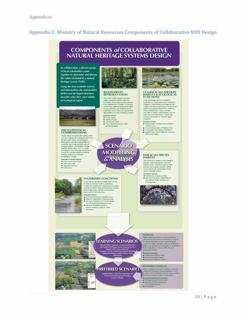
Appendices
93 | P a g e
Appendix C: Ministry of Natural Resources Components of Collaborative NHS Design

Appendices
94 | P a g e
Appendix D: ORM Adjacent Lands Tables
KEY NATURAL HERITAGE FEATURES, HYDROLOGICALLY SENSITIVE FEATURES AND AREAS OF NATURAL
AND SCIENTIFIC INTEREST (EARTH SCIENCE): MINIMUM AREAS OF INFLUENCE AND MINIMUM
VEGETATION PROTECTION ZONES
(Oak Ridges Moraine Conservation Plan P. 42)