impacts of the 2003 southern california wildfires on four species
TRANSCRIPT

Impacts of the 2003 Southern California Wildfires on Four Species Listed as
Threatened or Endangered Under the Federal Endangered Species Act:
Quino checkerspot butterfly Mountain yellow-legged frog
Coastal California gnatcatcher Least Bell's vireo
Monica Bond and Curt Bradley Center for Biological Diversity
Photo of Quino checkerspot butterfly from Cleveland National Forest

2
Executive Summary
In October 2003, more than a dozen wildfires swept across southern California, burning over 740,000 acres. About 95 percent of the fire burned in chaparral and coastal sage scrub. In this report, we analyze the effects of the 2003 wildfires on four species listed as threatened or endangered under the federal Endangered Species Act. The coastal California gnatcatcher, least Bell's vireo, Quino checkerspot butterfly, and southern California mountain yellow-legged frog are found only in southwestern California, and their habitats were all impacted by the fires.
Our analysis used GIS data provided by the U.S. Forest Service, U.S. Fish and Wildlife Service, and California Department of Fish and Game to analyze the potential effects of the 2003 wildfires on known occurrences, modeled habitat, and designated critical habitat for each of the four species throughout its range. We documented that the wildfires burned 19% of critical habitat and 27% of known occurrences of the Quino checkerspot butterfly; 12% of modeled habitat for mountain yellow-legged frog; 4% of known occurrences, 16% of critical habitat, and 28% of modeled habitat for the California gnatcatcher; and 3% of critical habitat and 2% of modeled habitat for least Bell's vireo.
While we recognize that fire is a natural and important ecological disturbance in southern California, burned habitat can be rendered temporarily unsuitable for some species until vegetation re-grows. In addition, the response of organisms to fire can be complicated by invasion of non-native species as well as past and ongoing degradation, fragmentation, and isolation of habitat patches due to urban sprawl and associated infrastructure. We hope that the information provided in the report will prove useful in re-evaluating baseline conditions for these species in the wake of the 2003 fires, and will assist in determining the cumulative effects of current and future development projects and large-scale habitat conservation plans.

3
Table of Contents
Introduction . . . . . . . . . . . . . . . . . . . . . . . . . . . . . . . . . . . . . . . . . . . . . . . . . . . . 4 Methods . . . . . . . . . . . . . . . . . . . . . . . . . . . . . . . . . . . . . . . . . . . . . . . . . . . . . . 6 Species Accounts
Quino checkerspot butterfly . . . . . . . . . . . . . . . . . . . . . . . . . . . . . . . . . 8 Mountain yellow-legged frog . . . . . . . . . . . . . . . . . . . . . . . . . . . . . . . . 9
Coastal California gnatcatcher . . . . . . . . . . . . . . . . . . . . . . . . . . . . . 10 Least Bell's vireo . . . . . . . . . . . . . . . . . . . . . . . . . . . . . . . . . . . . . . . . . . 12
Local Impacts of 2003 Wildfires . . . . . . . . . . . . . . . . . . . . . . . . . . . . . . . . . . . 14 Regional Impacts of 2003 Wildfires . . . . . . . . . . . . . . . . . . . . . . . . . . . . . . . 16 Discussion . . . . . . . . . . . . . . . . . . . . . . . . . . . . . . . . . . . . . . . . . . . . . . . . . . . . . 20 Management and Legal Implications . . . . . . . . . . . . . . . . . . . . . . . . . . . . . . . 22 Literature Cited . . . . . . . . . . . . . . . . . . . . . . . . . . . . . . . . . . . . . . . . . . . . . . . . 24 Appendix A: Excerpts from the San Bernardino National Forest's Resource and Biological Assessment for Threatened and Endangered Plants and Animals: Old and Grand Prix Fires BAER report . . . . . . . . . . . . . . . . . . . . . . . . . . . . . . . . . . . . . . . . . . . . . 27 Appendix B: Excerpts from A Summary of Affected Flora and Fauna in the San Diego County Fires of 2003. . . . . . . . . . . . . . . . . . . . . . . . . . . . . . . . . . . . . . . . . . . . . . . . 35 Appendix C: Excerpts from the Los Padres National Forest's BAER Plan: Wildlife and Fisheries Report and Assessment for the Piru Fire, November 2003. . . . . . . . . . . . . . . . 37 Appendix D: Maps of burn severity, modeled habitat, and species occurrences . . . . 38
Acknowledgements
We thank the U.S. Forest Service for providing digital burn severity maps, U.S. Fish and Wildlife Service for species occurrence and critical habitat data, and the California Department of Fish and Game's California Wildlife Habitat Relationships Program for their assistance with habitat modeling. Finally, we are grateful to C. Cabañero and B. Nowicki for peer-reviewing this report.

4
Introduction The southern California landscape has been shaped by fire over millennia. Fire is a natural disturbance event upon which many ecosystems depend, creating wildlife habitat and forage, nourishing the soil, and perpetuating the native plant communities that evolved with fire. Southern California is also a hotspot of biological diversity, much of which is threatened by past and ongoing fragmentation, degradation, and outright destruction of native habitat. Human-caused changes in the environment resulting from urbanization, fire suppression, domestic livestock grazing, and spread of invasive species, as well as changing climate conditions, have altered the role of fire in this landscape, often leading to changes in fire effects on native species. The effects of wildfire on animals vary spatially and temporally, by habitat type and by species. Wildfires do not necessarily permanently destroy habitat, but moderate and high severity fire can drastically alter habitat until vegetation re-grows, and may change the vegetative structure and succession for the long-term. However, natural re-colonization of burned habitat can be complicated by a variety of factors, including the isolation of habitat patches by urbanization and roads, which may prevent some species from re-establishing in isolated patches after fire, and the invasion of non-native species following fire, which can result in permanent type-conversion of habitat. Individuals that are dispersal- limited or depend upon late-successional habitats may have difficulty finding new suitable habitat after fire, particularly very large wildfire and where there has been extensive habitat loss and fragmentation (Morrison 2003). In remaining habitat, there may be crowding effects, resulting in increased competition for resources, susceptibility to predation and nest parasitism, and other density-dependent effects. Direct and indirect effects of fire can be compounded by drought and disease, such as West Nile Virus which has been identified in San Diego County (Morrison 2003).
In coastal scrub, fire can be followed by invasion of non-native vegetation such as barley (Hordium spp.), foxtail fescue (Vulpia myuros), red brome (Bromus madritensis spp. rubens), and other Mediterranean grasses (Stephenson and Calcarone 1999). These invasions have led to increased fire frequencies and ultimately resulted in type conversion of many shrub-dominated habitats to non-native grassland (Minnich and Dezzani 1998). Riparian habitats are impacted by fire as well. Arundo (Arundo donax), or giant reed, is a large perennial invasive grass that forms dense thickets in riparian areas and supports few native wildlife species (Stephenson and Calcarone 1999). Arundo thickets are highly flammable and known to carry wildfire along riparian corridors, which normally are relatively resilient to fires (R. Minnich, UC Riverside, pers. comm.). Thus, the invasion of non-native species influences the responses of native species to wildfire.
In October 2003, more than a dozen wildfires swept across southern California, burning a total of 743,026 acres (Table 1). The vegetation types most affected by the fires were chaparral and coastal sage scrub. Approximately 90 to 95 percent of the area burned was in these two shrubland vegetation types (Stephens 2003).

5
Table 1. Extent of 16 Wildfires in Southern California, 2003.
Source: USFWS
NAME AREA PERIMETER ACRES HECTARES
Roblar2 1,9584,782 25,900 4,840 1,958Otay/Mine 180,888,971 70,610 44,699 18,089Coyote 7,563,7735 57,261 18,691 7,564Locust 7,676,888 15,581 1,897 768Lytle 3,397,052 13,518 839 340Mountain 41,776,323 35,583 10,323 4,178Pass 9,930,544 21,652 2,454 993Paradise 226,691,779 119,352 56,017 22,669Old 185,843,352 101,022 45,923 18,584Grand Prix 370,299,736 206,684 91,503 37,030Padua/Grand Prix 42,304,784 46,161 10,454 4,230Cedar 1,115,389,031 281,836 275,619 111,539Simi 435,265,077 216,061 107,557 43,527Piru 257,871,499 99,965 63,722 25,787Verdale 34,348,830 42,131 8,488 3,435 TOTALS: 743,026 300,691
A number of species in southern California have been federally listed as endangered or threatened due to extensive habitat loss in the region. The U.S. Fish and Wildlife Service ("USFWS") is charged with ensuring the conservation of these species under the Endangered Species Act. The agency also has the authority to issue incidental take permits for private or federal projects that might adversely affect listed species — provided the projects either individually or cumulatively do not jeopardize the continued existence of those species. At least four of these federally listed species may have been locally impacted by the recent wildfires: the Quino checkerspot butterfly (Euphydryas editha quino) and coastal California gnatcatcher (Polioptila californica californica), both occurring primarily in coastal sage scrub, and the least Bell's vireo (Vireo bellii pusillus) and southern California mountain yellow-legged frog (Rana muscosa), both riparian obligates. Each of these species has a highly restricted range, occurring only in limited microhabitats within rapidly dwindling vegetation communities of southwestern California. Thus, the fires had the potential to impact these species more than other species with larger ranges.
The objective of this report is to assess the potential landscape-scale effects of the 2003 wildfires on these four species to determine how the baseline conditions for each has changed, with respect to amount of habitat available. This information will prove useful for the USFWS in cumulative analyses of "take" of these species during current and future development projects.

6
Methods To provide background on how the 2003 wildfires were likely to affect habitat suitability and availability in the short-term, we conducted a literature review and summarized response to fire of individuals and populations of the four species of concern. Sources included published studies, USFWS listing determinations and recovery plans, and Burned Area Emergency Response ("BAER") reports.
We were interested in investigating both the local and region-wide impacts of the wildfires on each of the four species of concern. We obtained any available reports on the individual 2003 fires that analyzed impacts to these species. We also conducted our own region-wide analysis of the fires on suitable habitat, designated critical habitat, and point locations for the four species of concern.
Local Impacts of 2003 Fires For local impacts, we reported assessments from three BAER reports. Completed reports
available to the public at the time of this analysis included the Simi-Verdale-Piru; Grand Prix-Old; Padua; and Cedar-Otay-Paradise fire complexes. BAER reports are developed by the U.S. Forest Service ("USFS") and Department of the Interior to assess impacts of fire and to prescribe post-fire restoration measures. These reports also provide summary data on each individual fire complex regarding effects on locally occurring sensitive, threatened, and endangered species.
Regional Impacts of 2003 Fires For the region-wide analysis, various sources of GIS data were collected and imported for use in ArcGIS 8.3 (ESRI Inc., Redlands, California). GIS layers representing designated critical habitat, as well as the locations of species occurrences were supplied by the Carlsbad office of the USFWS. Burn severity GIS data for the Grand Prix-Old, Cedar-Otay-Paradise, and the Simi-Verdale-Piru fire complexes were supplied by the U.S. Forest Service, Region 5. These data included low, moderate, and high burn severities for all vegetation types. A Multi-source Land Cover Data (2002 v2) GIS coverage created by the California Department of Forestry and Fire Protection was downloaded from the state of California’s website (http://gis.ca.gov/data_index.epl) for use in our habitat modeling analysis described below. This coverage is a mosaic of the best available land cover data for the state, with a 100-meter cell size for our area of interest.
We used the California Wildlife Habitat Relations ("CWHR") program (Version 8: California Department of Fish and Game) to model suitable habitat for the mountain yellow-legged frog, coastal California gnatcatcher, and least Bell's vireo. The CWHR program is the standard classification system for wildlife habitat modeling in California. To create species-specific land cover maps we clipped the land cover data to the range boundaries for each species (available in CWHR). Utilizing the Bioview tool, which links species-specific data available in CWHR with land cover data, we created Dbase tables that rank the different land covers for their value to each species based on habitat code, size class, and cover. These tables were joined to the clipped land cover GIS data to create coverages with habitat ranking values that ranged from 0–100, with 100 being optimal habitat. For a given species, the CWHR program computes the habitat suitability rankings for foraging, cover, and reproduction as integers: 0 for no suitability, 33 for low suitability, 66 for medium suitability, and 100 for high suitability (CWHR User's Manual). The program then computes the arithmetic mean of the 3 values and we categorized

7
the habitat as follows: < 33 = low suitability; 34–66 = medium suitability; and 67–100 as high suitability. We report amounts of these habitats that burned in the 2003 fires.
Burn severity coverages for the Grand Prix-Old, Cedar-Otay-Paradise, and the Simi-Verdale-Piru fire complexes were re-projected and merged into a single coverage that had a uniform burn severity code (1 = unburned, 2 = low severity, 3 = moderate severity, 4 = high severity, 5 = unburned). The suitable habitat coverage was intersected with the burn severity coverage. For the CWHR modeled habitat fire analysis, we conducted a frequency on the burn severity and habitat ranking values, and summarized the acres.
For the USFWS species occurrence fire analysis, locational data had been recorded as circles encompassing probable location. Different circle sizes, ranging from 160 to 500 meters in diameter, represented the confidence of the location reflected as a precision code (PCODE). We utilized PCODE1 (160 m diameter) and PCODE 2 (500 m diameter), the most accurate locations. Because some circles overlapped different fire severities, we intersected the circles with the fire severity map to determine the acreage of each occurrence circle in each severity class. The acreages of the occurrence circles were summed and divided by the total acres of all confidence circles to get an estimate of the number of locations in each burn severity class. Because the different precision codes had different sized circles, separate computations were conducted for each.
Results are presented in both tabular and spatial format.

8
Species Accounts
Below, we have summarized data on life history, habitat use, and any known effects of wildfire on each of the four species of concern. We also summarized local impacts of three of the fire complexes, based on BAER and other available reports.
Quino checkerspot butterfly The Quino checkerspot butterfly occurs in topographically diverse, open, woody canopy landscapes of coastal California from south of Ventura County, and inland valleys south of the Tehachapi Mountains (USFWS 2003). The historic distribution extended from the westernmost slopes of the Santa Monica Mountains, the Los Angeles plain, and the Tranverse Ranges to the edge of the upper Anza-Borrego desert, and south to El Rosario in Baja California, Mexico (USFWS 2003). The current range of the species includes southern San Diego and western Riverside counties and northern Baja California Norte, Mexico (USFWS 2003). Urban and agricultural development, invasion of non-native species, habitat fragmentation and degradation, and other human-caused disturbances have resulted in substantial losses of habitat and declines in habitat suitability through the species' historic range (USFWS 2003). The butterfly apparently has been extirpated from Los Angeles, Orange, and San Bernardino counties (USFWS 2000).
The Quino checkerspot butterfly can occupy meadows, grasslands, coastal sage scrub, chamise chaparral, open red shank chaparral, open juniper woodland, and semi-desert scrub (USFWS 2003). Suitable habitat appears to contain loamy soils with high clay content or with cryptogamic crusts; sparse to moderate shrub cover; low to moderate levels of nonnative vegetation compared to non-occupied habitat; and ridges, rounded hilltops, or other topographic features within approximately 0.8 km (USFWS 2000; 2003). Primary constituent habitat elements are found in undeveloped areas that support various types of open-canopy woody and herbaceous plant communities including, but not limited to, plant communities that provide populations of host plant and nectar sources for the butterfly. The primary host plants upon which Quino deposit their eggs include dwarf plantain (Plantega erecta), woolly plantain (P. patagonica), white snapdragon (Antirrhinum coulterianum), and thread- leaved bird's beak (Cordylanthus rigidus), with dwarf plantain being both the most common and the most commonly used as a host (67 Fed. Reg. 2002 at 18361). Dwarf plantain is often associated with cryptogamic crusts and fine-textured clay soils. Owl's clover (Castilleja exserta) is an important pre-diapause secondary host plant. Adult Quino frequently take nectar from lomatium, goldenstar, yarrow, fiddleneck, goldfields, popcorn flower, gilia, California buckwheat, onion, and yerba santa.
The Quino checkerspot butterfly flies slowly, close to the ground, and tends to avoid flying over objects taller than about 2 meters (7 feet) high (USFWS 2003). Quino, particularly males, are often observed on hilltops and ridgelines (USFWS 2003). Reproduction depends heavily on precipitation patterns. Mating occurs during the adult active season, in March and April (depending on weather), and the female lays her eggs at the base of the host plant, where the larvae later feed on leaves (Ballmer et al. 2000). The larvae can live for several years briefly breaking and re-entering diapause over and over before reaching matur ity, depending on precipitation (Ballmer et al. 2000).
Distribution of the Quino checkerspot butterfly is patchy at several scales, exhibiting a typical metapopulation structure. Local habitat patches are comprised of smaller patches of larval host plants, all within the flight range of adults (up to 200 meters/660 feet) (USFWS 2003). A local population of 100 adults and prediapause larvae could be supported by a matrix

9
of 150–200 micro-patches of 20 or more P. erecta plants (USFWS 2003). Linkage of suitable habitat patches by adult dispersal areas is crucial to metapopulation persistence, and long-term persistence of the species may depend on maintaining connectivity between metapopulations.
Quino conservation needs include protection and management of landscape connectivity, including habitat patches and intervening dispersal areas; habitat restoration and enhancement; and establishment of a captive breeding and release program (USFWS 2003). Restoration and enhancement of habitat includes removing cattle or sheep and implementing weed control where habitat is currently grazed and planting Plantago and removing invasive vegetation in agricultural and other degraded habitats (USFWS 2003). Quino recovery units and habitat complexes that have been identified by the USFWS include: 1) Northwest Riverside Recovery Unit, containing the Gavilan Hills habitat complex; 2) Southwest Riverside Recovery Unit, containing the Warm Springs Creek and Skinner/Johnson habitat complexes; 3) South Riverside Recovery Unit, containing the Oak Mountain/Vail Lake, Sage Road/Billygoat Mountain, and Brown Canyon habitat complexes; 4) South Riverside/North San Diego Recovery Unit, containing the Silverado and Dameron Valley/Oak Grove habitat complexes; 5) Southwest San Diego Recovery Unit, containing the San Diego National Wildlife Refuge, containing Otay Lakes, Otay Foothills, Otay Mesa, Marron Valley, and Tecate Habitat complexes; and 6) Southeast San Diego Recovery Unit, containing the Jacumba Peak habitat complex (USFWS 2003). Little data are published about the direct and indirect impacts of fire on Quino checkerspot butterfly populations, nor on Quino host and nectar plants. The Recovery Plan (page 30) states that "a combination of naturally occurring events (e.g. drought, cold-snaps, flood, and fire), exacerbated by ongoing human-caused habitat destruction and degradation (development, agriculture, and grazing), resulted in the apparent extirpation of formerly resilient Quino checkerspot butterfly populations in Orange County. " Wildfire is apparently a natural perturbation that can directly extirpate a population of Quino, but the habitat patch might be re-colonized depending upon its distance from a source population. Based on research on bay checkerspot butterflies (E. e. bayensis), dispersal areas greater than 2 kilometers (1.2 miles) distant do not appear likely to be used by adults belonging to the same metapopulation.
Mountain yellow -legged frog The southern California mountain yellow-legged frog occurs in the mountains of southern
California at elevations of 1,200–7,500 feet (370–2,290 meters) (USFWS 2002). The mountain yellow-legged frog historically occurred in an estimated 166 creeks and drainages in the San Gabriel, San Bernardino, and San Jacinto Mountains (USFWS 2001). Currently, the mountain yellow-legged frog is known from only seven locations in portions of the San Gabriel, San Bernardino, and San Jacinto mountains, all at least partially on public lands (USFWS 2002). The population on Palomar Mountain identified in USFWS (2002) is now extirpated (Jennings and Hays 1994; D. Holland, pers. comm.).
In southern California, highly aquatic mountain yellow-legged frogs occupy perennial rocky, shaded streams with cool water from springs and snowmelt, in ponderosa pine, montane hardwood-coniferous forests, and montane riparian habitat types (CDFG 1988).
Some factors adversely affecting the species include non-native predators, mining, recreational activities, water diversions, and possibly contamination from roads (USFWS 2002; D. Holland, pers. comm.). The primary anthropogenic threats to this species are thought to be the increasing spread of nonnative predatory fish and amphibians (i.e., trout and bullfrog), loss of breeding pools as a result of siltation or declining surface water, and disturbance of individuals

10
and egg masses by recreation and land use activities (USFWS 2001). Ongoing activities on National Forest System lands that are affecting mountain yellow-legged frogs include roads and trails, recreation facilities, and some small-scale mining and prospecting operations (USFWS 2001).
Mountain yellow-legged frogs have experienced a dramatic population decline over the past 40 years. This decline was not well documented, but the species was abundant in the Sierra Nevada and many southern California streams prior to the late 1960s (Jennings and Hayes 1994). Jennings and Hayes (1994) suggested that mountain yellow-legged frogs have been extirpated from 99% of their historic range in southern California. All of the remaining populations appear to be very small. On the Angeles National Forest, small populations of mountain yellow-legged frogs occur in the San Gabriel Mountains in the following locations: Bear Gulch, Devil’s Canyon, Little Rock Creek, South Fork of Big Rock Creek, and Vincent Gulch. In the San Jacinto mountains of the San Bernardino National Forest, a single known population occurs in Fuller Mill Creek, although the species was detected in Dark Canyon as late as 1998 and adults were detected in Hall Canyon in 1995. In the San Bernardino Mountains, mountain yellow-legged frogs were rediscovered in the East Fork of City Creek in 1998 (USFWS 2002 at 44382). In the 2002 Final Rule listing the species as endangered, the USFWS estimated the current population in southern California to be about 79 adults (Fed. Reg. 67 at 44384).
The potential risk to populations from large wildfires and post-fire flooding is a major management concern (USFWS 2001). Little data are published on effects of fire on this species. No dead mountain yellow-legged frogs were observed during the BAER surveys after the Old and Grand-Prix fires, and some frogs, particularly adults, may be able to find over-wintering refuge in bedrock crevices in the stream channels or in other sites far enough from the stream to survive increased flows and loss of water quality (USFS 2003). However, individuals could have been directly killed by the fire (USFS 2003). Individuals might also be displaced downstream or die during the first big rains as a result of high steam flows, and sediment and ash delivery to aquatic habitats. Pools can also fill with sediment, smothering riparian vegetation and benthic organisms and resulting in total loss of some pool habitat and other pools becoming smaller and shallower and thus dry up from evaporation (USFS 2003).
Coastal California gnatcatcher Coastal California gnatcatchers occur primarily in southern California on coastal slopes.
The species ranges from southern Ventura County southward through Los Angeles, Orange, Riverside, San Bernardino, and San Diego Counties and into northwestern Baja California, generally at elevations of below 3,000 feet (Atwood and Bontrager 2001; USFWS 2001).
Within its U.S. distribution, the California gnatcatcher is an obligate resident of Diegan, Riversidian, and Venturan subassociations of coastal sage scrub (Atwood and Bontrager 2001). Although California gnatcatcher nest territories can include or be located within non-sage scrub habitats, these habitats are most often utilized after nesting, when territories are typically larger for foraging or dispersal (Campbell et al. 1998). Non-breeding home ranges may be up to 80 percent larger than territories defended during the nesting season (Atwood and Bontrager 2001). The use of non-sage scrub habitat may be most common on the edges of coastal sage scrub, scrub that is marginal or poor in certain resources, scrub that is heavily invaded by nonnative plant species, or where California gnatcatchers occur in high densities adjacent to productive non-sage scrub (Campbell et al. 1998). Larger patches can more consistently support breeding gnatcatchers, and non-nesting home ranges are significantly larger than nesting territories (Atwood et al. 1998; Famolaro and Newman 1998; Preston et al. 1998; Atwood and Bontrager

11
2001). A cautious estimate of habitat that can support a pair of breeding gnatcatchers in the long term is at least 20 hectares (~50 acres).
Most juvenile coastal California gnatcatchers disperse less than 2 kilometers (1.2 miles) from the natal territory, with mean reported dispersal distances between 1.1 and 3.2 kilometers (0.7 and 2.0 miles) (Galvin 1998; Atwood and Bontrager 2001). Dispersal probably occurs in random directions from the natal site (Galvin 1998). Dispersing coastal California gnatcatchers appear able to pass through intensively modified anthropogenic landscapes for at least short distances (Bailey and Mock 1998).
As long ago as 1981, it was recognized that 85–90 percent of coastal sage scrub has been lost to development and land conversion (Westman 1981). The amount of coastal sage scrub available to California gnatcatchers has continued to decrease after the listing of this species (USFWS 2001). Temporary or permanent conversion of coastal sage scrub to other vegetation types results in a loss of habitat for coastal California gnatcatchers (USFS 2003).
In 1993, the USFWS estimated that approximately 2,562 pairs of coastal California gnatcatchers remained in the United States. Of these, 30 pairs occurred in Los Angeles County, 757 pairs occurred in Orange County, 261 pairs occurred in Riverside County, and 1,514 pairs occurred in San Diego County (USFS 2003). In 1997, the total number of coastal California gnatcatchers in the United States was estimated at 2,899 pairs, with two-thirds occurring in San Diego County (USFWS 1996), after accounting for all gnatcatcher pairs authorized for take (USFWS 2001). Since listing, many additional gnatcatchers have been lost. The Center for Biological Diversity ("CBD") has compiled a database entitled Summary of Authorized Impacts to the Coastal California Gnatcatcher. This database tracks gnatcatcher take authorized by the USFWS. To date CBD has recorded authorized take of 832 gnatcatcher pairs via individual biological opinions, at least 236 additional pairs through the “Proposed Special Rule to Authorize Take of the California Gnatcatcher” pursuant to Section 4(d) of the ESA, and at least 212 pairs through the California Natural Communities Conservation Planning (“NCCP”) process. Some NCCPs authorize take of large amounts of habitat and "all associated gnatcatcher pairs" without quantifying the number of pairs authorized for take, and therefore 212 pairs is an underestimate of take authorized to date. Authorized take is itself only a subset of actual take, as permits are never obtained for many actions that harm or kill individual gnatcatchers, and gnatcatchers may also be harmed by events such as the 2003 wildfires. Thus, CBD has documented take of at least 1,280 pairs of gnatcatchers since listing.
High fire frequencies and invasions of non-native grasses are serious problems in coastal California gnatcatcher habitat (USFS 2000). Coastal sage scrub is a highly flammable vegetation type, and maintaining mature stands in fire-prone areas near the wildland-urban interface is a significant management challenge (Beyers and Wirtz 1997). Fire is the most serious threat to coastal California gnatcatcher populations on national forests, especially as public use of these lands increases (USFS 2000). Coastal sage scrub appears to be unsuitable habitat for California gnatcatchers for several years after fire. Total shrub cover is an important factor in determining habitat suitability for coastal California gnatcatchers (Beyers and Wirtz 1997). The species is most abundant in mature sage scrub stands, where woody perennial plant canopy cover is greater than 40 percent (Beyers and Wirtz 1997). However, coastal California gnatcatchers will forage in recently burned sites, and pairs have been observed establishing territories within 3 years after fire in burned areas on coastal sites (Wirtz et al. 1997). The speed of shrub regrowth appears to affect the rate at which coastal California gnatcatchers reoccupy burned areas, and inland sites are slower to recover than coastal sites (Wirtz et al. 1997).
Fire has been identified as detrimental to habitat quality for permanent residents of coastal sage scrub due to a reduction in the structural heterogeneity of vegetation (Stanton 1986).

12
Mock and Bolger (1992) found that areas used by breeding gnatcatchers had not burned for at least 15–20 years. Beyers and Wirtz (1997) found that total shrub cover on plots in California gnatcatcher home ranges averaged greater than 55 percent at four sites and 43.8 percent at one site. The study also found that recently burned coastal sage scrub vegetation is not used by California gnatcatcher for breeding unless it is adjacent to unburned patches, and regrowing sage scrub will be recolonized once total shrub cover approaches 50 percent, which takes a minimum of 4–5 years. Beyers and Peña (1995) also reported that sites used by gnatcatchers averaged more than 50 percent shrub cover, and recently burned sites were not used by the species. Wirtz et al. (1997) documented that fire significantly reduces density of gnatcatchers, although the few gnatcatcher pairs that were able to establish territories on burned areas have similar reproductive rates. Frequent fires (fire return intervals of less than 5–10 years) also increase the probability of conversion from coastal scrub to nonnative grasslands, especially in drier inland areas (USFS 2003). Thus, fire can cause temporary reductions in gnatcatcher use of coastal sage scrub.
Least Bell's vireo Least Bell’s vireo, a small neotropical migrant, was historically widespread and abundant in riparian woodlands of the Central Valley and low-elevation riverine valleys of California and northern Baja California (USFS 2003). Its historical breeding range extended from near Red Bluff in Tehama County south through the San Joaquin Valley and Sierra Nevada foothills, the inner southern Coast Range from Santa Clara County south to approximately San Fernando, and the southern California coastal and interior valleys west of the deserts to the Mexican border; populations also were found in the Owens Valley and Death Valley and scattered oases and canyons throughout the Mojave Desert (USFWS 1998). Populations in Owens Valley, Death Valley, Sacramento and San Joaquin Valleys, the Sierra Nevada foothills, and Tehama County have been extirpated (USFWS 1998). Vast portions of these areas are no longer available for recolonization or expansion because of habitat destruction. Least Bell’s vireo currently occupies a very small fraction of its former range (USFWS 2001). The species’ breeding distribution is currently restricted to eight California counties: Kern, San Diego, San Bernardino, Riverside, Ventura, Los Angeles, Santa Barbara, and Imperial. Designated critical habitat occurs in six of these counties (USFWS 1998). Breeding populations are concentrated in San Diego, Santa Barbara, and Riverside Counties. The northern limit of breeding populations is the Santa Ynez River in Santa Barbara County (USFS 2000). Least Bell’s vireos winter in southern Baja California, Mexico. Least Bell’s vireos are usually found at elevations below 2,000 feet (610 meters), although individuals have been reported up to 4,200 feet (1,280 meters), primarily in desert areas (USFS 2003). Least Bell’s vireo is an obligate low-elevation riparian species during the breeding season. It inhabits dense, low-elevation, willow-dominated riparian habitats with lush understory vegetation in the immediate vicinity of watercourses (USFWS 1986). The most important structural habitat characteristic for least Bell’s vireos is a dense shrub understory approximately 2−10 feet (0.6−3.0 meters) above ground (USFS 2003). Habitat elements essential for conservation of least Bell's vireo can be described as riparian woodland vegetation that generally contains both canopy and dense shrub layers and includes some associated upland habitats, preferably where flowing water exists (USFWS 1998; 2001). Suitable breeding habitat consists of an overstory of willows, cottonwoods, sycamores, or oaks, with an open midstory, and a dense shrubby understory of willow, mule fat scrub, and one or more herbaceous species. Canopy cover is generally greater than 50 percent with occasional small openings. Most areas that support least Bell’s vireo populations are in early stages of

13
succession where woody vegetation is generally 5−10 years old (USFS 2003). Least Bell’s vireos nest primarily in willows but also use a variety of shrubs, trees, and vines (USFWS 1986). Nests are generally located within 3 feet (1 meter) of the ground. Least Bell’s vireos forage in riparian and adjacent upland habitats (USFWS 1986). In California, fledglings have been reported to disperse 1 mile (1.6 kilometers) from their natal site by the time a second brood was produced (Gray and Greaves 1984). Most fledglings that survive apparently return to breed at their natal site (Brown 1993). Adult least Bell’s vireos often exhibit strong breeding site fidelity, and nest sites are sometimes located within 3.3 feet (1 meter) of the previous year’s nest (USFS 2003). Northernmost breeding populations of least Bell’s vireo typically begin leaving the breeding grounds in August and September, and most birds leave by early October (USFS 2003). Spring migrants begin arriving at their breeding grounds by early to mid-March; northernmost populations of Bell’s vireo arrive by early May (USFS 2003). Least Bell’s vireos exhibit strong territoriality. Territory sizes vary depending on habitat extent and quality, population density, and nesting stage. In California, reported territory sizes of least Bell’s vireos were 0.5−4.0 acres (0.2−1.6 hectares) and 0.7−3.2 acres (0.3−1.3 hectares) (see citations in USFS 2003). Least Bell’s vireos home ranges vary in size from 0.5–4.5 acres (0.2−1.8 hectares), and a few may be as large as 10 acres (4.0 hectares) (USFWS 2001). In the last several decades, least Bell’s vireo has undergone a precipitous decline in numbers, attributed primarily to extensive loss and degradation of breeding habitat, as well as brood parasitism by brown-headed cowbird (USFS 2003). Habitat loss, habitat degradation, and nest parasitism by brown-headed cowbirds were identified as the biggest threats to least Bell’s vireo populations in southern California (USFWS 1998). When the least Bell’s vireo was federally listed in 1986, the statewide population was estimated at 300 pairs. In 1996, the population had increased to 1,346 (USFWS 1998); in 2000, the population had increased to 2,000 pairs (USFWS 2001), probably due to an intensive cowbird removal program (USFWS 1998). In addition to an increase in population size, it appears that least Bell’s vireos are expanding their range and recolonizing sites that have been unoccupied for years (USFWS 1998). Riparian vegetation, especially willows, generally recovers quickly after fires, with good shrub cover levels returning within a couple of years (USFS 2003). However, substantially higher than normal flows and sediment movement are expected to occur and there is a high likelihood that the riparian vegetation at the least Bell’s vireo nest sites may be scoured out of stream channels (USFS 2003). The higher the precipitation levels, the more severe the effects will be. If drought occurs for 1–2 years after a fire, impacts may not be as severe, but even average rainfall amounts are expected to result in substantial increases in sediment and erosion (USFS 2003).

14
Local Impacts of 2003 Wildfires The scale, severity, and pattern of the 2003 southern California wildfires may exacerbate problems for native endangered and threatened fauna, due to extensive past and ongoing habitat fragmentation, invasion of non-native vegetation that may follow fire, and erosion or siltation of aquatic and riparian habitats within and downstream from burned areas. With such extensive acreages burned, particularly in San Diego County, it is not clear where there were adequate refugia for some species within or near the fire (Morrison 2003). Below, we summarize the effects of the fires from available BAER reports, on the Old-Grand Prix, the Piru, and the Cedar-Otay-Paradise fire complexes.
Old and Grand-Prix Fire, San Bernardino County Mountain yellow-legged frog — Table 9 in Appendix A shows that of the 5,389 acres of modeled MYLF habitat within 15 drainages in the Old/Grand Prix Fire area, acres were almost evenly split between the high (1,714 ac), moderate (1,593) and low (1,456) burn severity categories. Thus, a total of 88% of modeled habitat within the perimeter of this fire was burned. Coastal California gnatcatcher — Table 15 in Appendix A displays the burn severity effects on California gnatcatcher habitat affected during the fires, although it is not stated whether this includes modeled, occupied, or critical habitat. Approximately 76% of the mapped habitat (including FS and non-FS lands) burned at moderate or low severities or did not burn at all. Less than 24% of the mapped habitat burned at high severity (and none of that contains known occurrences). A total of 26,779 acres of gnatcatcher habitat burned in the Old and Grand-Prix fires; 6,353 acres burned at high severities. Least Bell's vireo — Table 17 in Appendix A displays the acres of modeled and occupied habitat within each watershed that burned during the fires. It appears that approximately 25% burned at high severity; the rest burned at low/moderate severity or did not burn. The areas that burned at high severity likely experienced losses of suitable habitat. Approximately 75% burned at low or moderate severity levels, or did not burn at all (water and rock areas). Within those areas, it is likely that some of the riparian vegetation did not burn at all; in some areas, some patchy underburning probably occurred. Substantially higher than normal flows and sediment movement are expected to occur after the fire, and there is a high likelihood that the riparian vegetation at the least Bell’s vireo nest sites may be blown out of stream channels. A total of 3,055 acres of least Bell's vireo habitat burned in the Old and Grand-Prix fires; 760 acres at high severity, 1,005 acres at moderate severity, and 1,047 acres at low severity.
Cedar-Otay-Paradise Fire, San Diego County Quino checkerspot butterfly — Areas of particular concern are within the Cedar fire (Otay Mesa and Rancho Jamul populations). Tables in Appendix B demonstrate that 45.9% of quino occurrences and 21% of quino habitat burned in the San Diego County fires. Coastal California gnatcatcher — The extensive scale of the fire been a source of concern because many non-migratory species appear to be highly sensitive to habitat loss and habitat fragmentation, and particularly susceptible to isolation effects of habitat fragmentation; colonization of habitat islates appears limited by urban and residential "matrix." Also, the

15
Crestridge Reserve, with the Lakeside Archipelago of hilltops, was intended in part to provide a stepping-stone corridor for CSS avifauna species; much of its vegetation burned in the Cedar fire, and potentially severed north-south coastal sage scrub connectivity for the foreseeable future. Tables in Appendix B show that 13.9% of coastal California gnatcatcher occurrences burned and 27.7% of habitat burned. Least Bell's vireo — Of the three San Diego fires, the Paradise Fire is of greatest concern for these species (although the impacts to riparian species throughout the County warrant attention.). The San Luis Rey river corridor was notable for containing the highest densities of riparian nesting birds in San Diego County, including the federally endangered Least Bell's Vireo. Fire related concerns to riparian species pertain to loss of habitat (e.g., loss of riparian vegetation due to burning, as well as potential loss of habitat due to increased runoff and scouring of drainages). Loss of habitat quality may occur if direct and indirect fire effects facilitate the invasion of non-native vegetation in drainages. About 3% of least Bell's vireo occurrences and 10.2% of habitat burned in the fires (see tables in Appendix B)
Piru Fire, Ventura County Least Bell's vireo — Designated critical habitat for the least Bell’s vireo occurs in portions of Reasoner Canyon, which is within the Dominguez sub-watershed (see Appendix C). Burn intensity within the designated critical habitat for the least Bell’s vireo was light to moderate. With the light to moderate burn intensities, it should be expected that the habitat will recover relatively quickly. No specific information on acreages or occurrences burned was provided in the Piru report.
16
Regional Impacts of 2003 Wildfires We determined acreage of both CWHR modeled habitat and designated critical habitat that were burned at low, medium, and high severities. We also determined how many known occurrences recorded by the USFWS burned at each of the severity classes.
This analysis was conducted at a coarse scale, and there are several caveats regarding the best GIS data available. Burn severity is generally averaged across a cell, so fine-scale differences in vegetation burn severities cannot be detected. Actual occupancy both pre- and post-fire is unknown. In other words, lack of a known occurrence does not necessarily indicate that an individual was not present in an area; conversely, a known occurrence does not indicate that the site was occupied at the time of the fire. At a statewide scale, CWHR species distribution layers are relatively coarse, and can be somewhat inaccurate at a regional or local scale, although they represent the best means available to create a range boundary using the suitability rankings of the vegetation map. Given these caveats, the following analysis provides a rough idea of the potential extent of impact of the 2003 wildfires on each of the four species of concern throughout their respective ranges.
CWHR Modeled Habitat To generate the amount of medium and high suitability CWHR modeled habitat that was
burned in the fires, we divided the total burned acreage of habitat ranked at >33 suitability values, by total acreage of all habitat ranked at >33 suitability values. Habitat ranked at 34–66 was considered medium suitability habitat, and habitat ranked >66 was considered high suitability. No CWHR modeled habitat was available for the Quino checkerspot butterfly because the CWHR program includes only vertebrates.
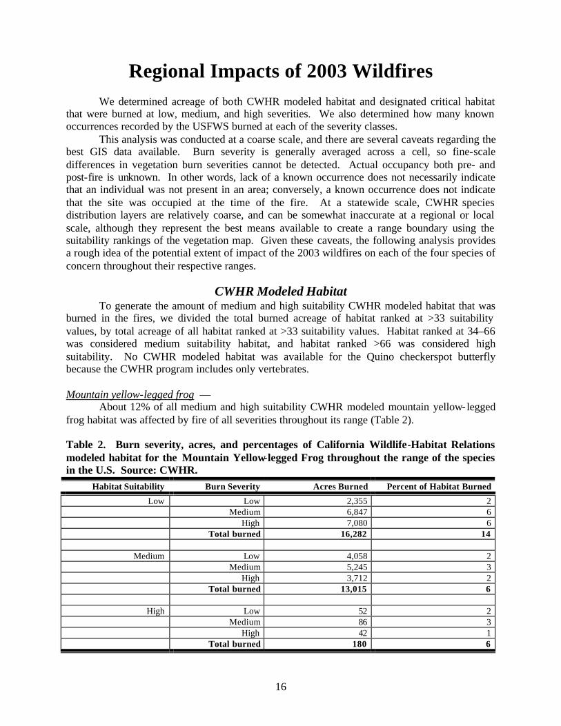
Mountain yellow-legged frog —
About 12% of all medium and high suitability CWHR modeled mountain yellow-legged frog habitat was affected by fire of all severities throughout its range (Table 2). Table 2. Burn severity, acres, and percentages of California Wildlife-Habitat Relations modeled habitat for the Mountain Yellow-legged Frog throughout the range of the species in the U.S. Source: CWHR.
Habitat Suitability Burn Severity Acres Burned Percent of Habitat Burned
Low Low 2,355 2 Medium 6,847 6 High 7,080 6 Total burned 16,282 14
Medium Low 4,058 2 Medium 5,245 3 High 3,712 2 Total burned 13,015 6
High Low 52 2 Medium 86 3 High 42 1 Total burned 180 6

17
Coastal California gnatcatcher — About 28% of all medium and high suitability CWHR modeled California gnatcatcher
habitat throughout the range of the species was affected by fire of all severities, including about 14% of highly suitable habitat (Table 3). Table 3. Burn severity, acres, and percentages of California Wildlife-Habitat Relations modeled habitat for the Coastal California Gnatcatcher throughout the range of the species in the U.S. Source: CWHR.
Habitat Suitability Burn Severity Acres Burned Percent of Habitat Burned
Low Low 18,034 3 Medium 57,077 9
High 3,768 0.61 Total 78,879 13
Medium Low 23128 7 Medium 23191 7
High 608 0.17 Total 46927 14
High Low 4292 10 Medium 1531 4 High 64 0.16
Total 5886 14
Least Bell's vireo —
A total of about 2% of high suitability CWHR modeled least Bell's vireo habitat was affected by fire of all severities throughout its range (Table 4). The CWHR program generated no low or medium suitability habitat for this species. Table 4. Burn severity, acres, and percentages of California Wildlife-Habitat Relations modeled habitat for the Least Bell's Vireo throughout the range of the species in the U.S. Source: CWHR.
Habitat Suitability Burn Severity Acres Burned Percent of Habitat Burned
High Low 151 1 Medium 59 0.46 High 1 0.01 Total burned 211 2
18
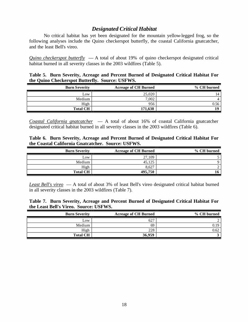
Designated Critical Habitat No critical habitat has yet been designated for the mountain yellow-legged frog, so the following analyses include the Quino checkerspot butterfly, the coastal California gnatcatcher, and the least Bell's vireo. Quino checkerspot butterfly — A total of about 19% of quino checkerspot designated critical habitat burned in all severity classes in the 2003 wildfires (Table 5). Table 5. Burn Severity, Acreage and Percent Burned of Designated Critical Habitat For the Quino Checkerspot Butterfly. Source: USFWS.
Burn Severity Acreage of CH Burned % CH burned
Low 25,020 14 Medium 7,002 4
High 956 0.56 Total CH 171,638 19
Coastal California gnatcatcher — A total of about 16% of coastal California gnatcatcher designated critical habitat burned in all severity classes in the 2003 wildfires (Table 6). Table 6. Burn Severity, Acreage and Percent Burned of Designated Critical Habitat For the Coastal California Gnatcatcher. Source: USFWS.
Burn Severity Acreage of CH Burned % CH burned
Low 27,109 5 Medium 45,125 9
High 8,627 2 Total CH 495,750 16
Least Bell's vireo — A total of about 3% of least Bell's vireo designated critical habitat burned in all severity classes in the 2003 wildfires (Table 7). Table 7. Burn Severity, Acreage and Percent Burned of Designated Critical Habitat For the Least Bell's Vireo. Source: USFWS.
Burn Severity Acreage of CH Burned % CH burned
Low 627 2 Medium 69 0.19
High 228 0.62 Total CH 36,959 3

19
Species Occurrences
Occurrence data from the USFWS were used for all species but the mountain yellow-legged frog, for which no occurrence data were available. Quino checkerspot butterfly — About 28% of all known Quino checkerspot butterfly occurrences were burned in the fires. Most of the occurrences burned in low-severity fire (25%), while 2% of occurrences were burned in medium severity fire and 1% burned in fire of unknown severity (Table 8). Table 8. Percent of Quino Checkerspot Butterly Occurrences Burned by Low, Medium, and High Severity Fire. Source: USFWS.
Total number of occurrences
Estimated Number of occurrences in fire Fire severity % of occurrences in fire
611 150 Low 25 11 Medium 2 7 Unknown1 1
1 Mountain Fire
Coastal California gnatcatcher — About 4% of all known coastal California gnatcatcher occurrences were burned in the fires (Table 9). Most of the occurrences burned in medium and low-severity fire (2% in each), while 0.04% burned at high severity and 0.08% burned at unknown severity during the Pass Fire. Table 9. Percent of Coastal California Gnatcatcher Occurrences Burned by Low, Medium, and High Severity Fire. Source: USFWS.
Total number of occurrences
Estimated Number of occurrences in fire Fire severity % of occurrences in fire
3,226 58 Low 2 69 Medium 2 1 High 0.04 3 Unknown1 0.08
1 Pass Fire Least Bell's vireo — About 0.09% of all known least Bell's vireo occurrences were burned in the fires, all at low severity (Table 10). Table 10. Percent of Least Bell's Vireo Occurrences Burned by Low, Medium, and High Severity Fire. Source: USFWS. Total number of occurrences
Estimated Number of occurrences in fire Fire severity % of occurrences in fire
1,756 2 Low 0.09 0.03 Medium 0.00
20
Discussion
This analysis focused on the Quino checkerspot butterfly, mountain yellow-legged frog, coastal California gnatcatcher, and least Bell's vireo because these species are highly endangered, their range is restricted to specialized habitats in southwestern California, and their habitats were affected by the 2003 wildfires.
The Quino checkerspot butterfly was once thought to be extinct, and now is only found in western Riverside County and southern San Diego County. Roughly 2,000 pairs of both least Bell's vireos and coastal California gnatcatchers are thought to currently exist in the U.S. The southern California mountain yellow-legged frog is one of the most endangered amphibians in the country, with surveys indicating about 79 adult frogs remaining throughout its range (Fed. Reg. 67 at 44384). Therefore, it is imperative that the local and region-wide impacts of the 2003 wildfires be investigated, and that baseline conditions be updated to reflect any impacts to these species.
Our analysis for the entire range of the Quino checkerspot butterfly found that a total of 19% of designated critical habitat (Table 5) and about 27% of all known USFWS occurrences (Table 8) were burned in the 2003 wildfires. The Cedar-Otay-Paradise fire report to the BAER team found that 45.9% of Quino occurrences and 21% of Quino habitat in San Diego burned in the Cedar-Otay-Paradise fires alone (see Appendix B). Little is published about direct effects of fire on Quino populations, but the recovery plan for the species noted that fire may have extirpated the species from Orange County. Therefore, the impacts of the fire on the Quino checkerspot butterfly may have been severe.
About 12% of all medium and high suitability CWHR modeled mountain yellow-legged frog habitat (Table 2) throughout the range of the southern California distinct population segment were burned in the 2003 fires. About 12% of all CWHR modeled highly suitable habitat burned, with about 3.46% having burned in high-severity fire. The Old/Grand-Prix fire BAER report found that about 88% of all modeled habitat in the 15 drainages within the perimeter of that fire was burned (see Appendix A), suggesting serious local impacts. Recent surveys have documented mountain yellow-legged frogs in only 7 creeks and drainages in the San Gabriel, San Jacinto, and San Bernardino Mountains. The species is also threatened with indirect post- fire effects, including erosion and siltation into breeding pools. The few remaining occurrences of the mountain yellow-legged frog in southern California are at risk of extinction, and any activities that result in disturbance to the species or harm to its eggs could jeopardize the continued survival of the population segment (Fed. Reg. 67 at 44387).
Our analysis documented that about 52,824 acres of all medium and high suitability CWHR modeled gnatcatcher habitat within the U.S. range of the species burned at moderate and high severities in the 2003 wildfires (Table 3). About 28% of this gnatcatcher habitat burned overall, from low to high severity (Table 3). About 16% of California gnatcatcher designated critical habitat was burned at all severities (Table 6). About 4% of all known coastal California gnatcatcher occurrences from the USFWS database were burned in the fires (Table 9), although surveys for the species are usually only conducted on private lands for individual development projects, so the occurrence numbers are unknown and our analysis may be an underestimate. The Cedar-Otay-Paradise fire report to the BAER team found that 13.9% of coastal California gnatcatcher occurrences and 27.7% of habitat in San Diego County alone was burned (see Appendix C). California gnatcatchers do not appear to utilize recently burned habitats for breeding. Given the rapid past and ongoing loss of gnatcatcher habitat in the range of the species due to urbanization, as well as the rapid degradation of remaining habitat patches due to edge

21
effects, isolation, and fragmentation and the projected future loss of habitat under several HCP/NCCPs within the range of the gnatcatcher, the loss (although temporary) of about 15% of its habitat from the 2003 fires is a major change in the baseline status of the species. As noted in the Cedar-Otay-Paradise fire report, some of the habitat burned was intended as stepping-stones to connect larger patches of habitat. Thus, indirect impacts of the fire include increased isolation of remaining suitable habitat patches.
The effects of the 2003 wildfires appeared to be slightly less severe for the least Bell's vireo than for the other three species. Our analysis found that about 2% of high suitability CWHR modeled least Bell's vireo habitat (Table 4) and 3% of least Bell's vireo designated critical habitat (Table 7) were affected by fire of all severities throughout its current U.S. range. About 0.09% of known USFWS occurrences were burned in the fires. However, localized impacts may have been greater: about 3% of least Bell's vireo occurrences and 10.2% of habitat in San Diego County burned in the Cedar-Otay-Paradise fires (see Appendix B). The USFWS stated in 1986 that no other passerine species in California is known to have declined as dramatically as the least Bell's vireo. While its numbers have been increasing in recent years, the loss of 10% of its habitat in San Diego County indicates that localized impacts must be investigated. In addition, the USFS has noted that least Bell’s vireo nest sites may be scoured out of stream channels during heavy precipitation events following the fires, so the vireo is susceptible to indirect post- fire impacts.
The Center for Biological Diversity hopes that the information provided in this report will prove useful in re-evaluating the baseline conditions for these species in the wake of the 2003 southern California wildfires, and will assist in determining the cumulative effects of current and future development projects.

22
Management and Legal Implications
The four species discussed in this report are managed under a number of federal and state laws including the Endangered Species Act (16 U.S.C. §§ 1531 et seq., “ESA”) and the California Environmental Quality Act (Pub. Res. Code §§ 21000 et seq., “CEQA”). Here, we review the requirements of the ESA and CEQA relating to supplemental environmental review when the baseline status of a species or the underlying environmental conditions undergo changes subsequent to project approval. As discussed below, the October 2003 fires changed the baseline status of species and/or the underlying environmental circumstances such that supplemental environmental review will be needed and legally required under the ESA and CEQA. Under Section 7 of the ESA, federal agencies must insure that activities they conduct, authorize, or fund will not jeopardize the continued existence of any listed species or adversely modify its critical habitat. 16 U.S.C. § 1536(a)(2). Any federal agency undertaking such a project (known as the “action agency”) must consult with the USFWS, the federal agency charged with regulatory oversight of the species discussed in this report, on the impacts of its actions on listed species. Through this process, known as “consultation,” USFWS issues a document known as a Biological Opinion (“BiOp”). The BiOp sets forth the baseline status of each listed species that will be impacted by a project, the impact that the project will have on the species, and, if USFWS concludes that the project will not jeopardize the continued survival and recovery of the species in the wild or adversely modify its critical habitat, the terms and conditions under which the project may proceed. 16 U.S.C. § 1536(b). If certain conditions are met subsequent to issuance of the BiOp, the action agency must re- initiate consultation with USFWS to ensure that the project will not jeopardize the species or adversely modify its critical habitat in light of the new information. 50 C.F.R.§ 402.16. One of the conditions triggering the need for re- initiation of consultation is “If new information reveals effects of the action that may affect listed species or critical habitat in a manner or to an extent not previously considered.” 50 C.F.R.§ 402.16(b).
Supplemental environmental analysis is required under state law, as well. CEQA requires that state and local agencies fully disclose, analyze, avoid, and mitigate the environmental impacts of projects that they approve, fund, or carry out. Pub. Res. Code §§21000 et seq.; 14 Cal. Code Regs. §§ 15000 et seq. (“CEQA Guidelines”). For projects that may have a significant impact on the environment, the lead agency must prepare an Environmental Impact Report prior to its approval of the project. CEQA Guidelines § 15065. When certain conditions are met subsequent to project approval, the lead agency must conduct supplemental environmental review. Events triggering supplemental environmental review include when “substantial changes occur with respect to the circumstances under which the project is being undertaken which will require major revisions in the environmental impact report,” and when “new information, which was not known and could not have been known at the time the environmental impact report was certified as complete, becomes available.” CEQA Guidelines § 15162. When either of these events has occurred, the lead agency must conduct supplemental environmental review prior to issuing its next discretionary approval for the project. The National Environmental Policy Act (“NEPA”), a federal statute analogous to CEQA, contains similar requirements for actions authorized, funded, or carried out by federal agencies.
Our GIS analysis documents that the wildfires burned 19% of critical habitat and 27% of known occurrences of the Quino checkerspot butterfly; 12% of modeled habitat for mountain yellow-legged frog; 4% of known occurrences, 16% of critical habitat, and 28% of modeled

23
habitat for the California gnatcatcher; and 3% of critical habitat and 2% of modeled habitat for least Bell's vireo. Because the overall status of these species has been substantially altered by the fires, previous environmental review of anthropogenic impacts on these species have likely been rendered out of date and legally inadequate. Supplemental environmental review taking into account these potential local and landscape- level effects of the October 2003 wildfires should be conducted for previously approved projects occurring within the range of these species. Environmental review for future projects that may affect these species must fully consider the impacts of the wildfires as well.

24
Literature Cited Atwood, J. L and D. R. Bontrager. 2001. California Gnatcatcher: Polioptila californica. The Birds of North America, No 574. Atwood, J.L., S. H. Tsai, C. A. Reynolds, and M. R. Fugagli. 1998. Distribution and population size of California gnatcatchers on the Palos Verdes Peninsula, 1993–1997. Western Birds 29:340–350. Bailey, E. A. and P. J. Mock. 1998. Dispersal capability of the California Gnatcatcher: a landscape analysis of distribution data. Western Birds 29:351–360. Ballmer, G. D. Hawks, K. Osborne, and G. Pratt. 2000. The Quino checkerspot butterfly. Quino Workshop Publication. Beyers, J. L. and G. C. Peña. 1995. Characteristics of coastal sage scrub in relation to fire history and use by California gnatcatchers. Pages 153–4 in Weise, D. R. and R. E. Martin (tech. coords.). The Biswell Symposium: Fire Issues and Solutions in Urban Interface and Wildland Ecosystems. USDA Forest Service General Technical Report SPW-159, Pacific Southwest Research Station, Albany, CA. Beyers, J. L. and W. O. Wirtz II. 1995. Vegetative characteristics of coastal sage scrub sites used by California gnatcatchers: Implications for management in a fire-prone ecosystem. Pages 81-89 in J. M Greenlee (ed.). Proceedings -- Fire Effects on Rare and Endangered Species and Habitats Conference, Nov. 13–16, Coeur d'Alene, ID, International Association of Wildlife Fire. California Department of Fish and Game (CDFG). 1988. California's Wildlife, Amphibians, and Reptiles, Mountain Yellow-legged Frog. California Wildlife Habitat Relationships System. Campbell, K. F., R. A. Erickson, W. E. Haas, and M. A. Patten. 1998. California gnatcatcher use of habitats other than coastal sage scrub: Conservation and management implications. Western Birds 29:421–433. Famolaro, P. and J. Newman. 1998. Occurrence and management considerations of California Gnatcatchers along San Diego County highways. Western Birds 29:447–452. Galvin, J. P. 1998. Breeding and dispersal biology of the California gnatcatcher in central Orange County. Western Birds 29:323–332. Jennings, M. R. and M. P. Hayes. 1994. Amphibian and Reptile Species of Special Concern in California. Final Report to the California Department of Fish and Game, Rancho Cordova, CA. Minnich, R. A. and R. J. Dezzanni. 1998. Historical decline of coastal sage scrub in the Riverside-Perris Plain, California. Western Birds 29:366–391.

25
Morrison, S. 2003. Birds. Pages 15–17 in A Summary of Affected Flora and Fauna in the San Diego County Fires of 2003. San Diego County Biological Resource Researchers. Preston, K. L, P. J. Mock, M. A. Grishaver, E. A Bailey, and D. F. King. 1998. California Gnatcatcher territorial behavior. Western Birds 29:242–257. Stanton, P. A. 1986. Comparison of avian community dynamics of burned and unburned coastal sage scrub. Condor 88:285–289. Stephens, S. L. 2003. Statement submitted to U. S. House of Representatives Resources Subcommittee on Forests and Forest Health at December 5, 2003 Field Hearing on Recovering from the Fires: Restoring and Protecting communities, Water, Wildlife and Forests in Southern California. Stephenson, J. R. and G. M. Calcarone. 1999. Southern California Mountains and foothills assessment: habitat and species conservation issues. USDA Forest Service General Technical Report GTR-PSW-172, Pacific Southwest Research Station, Albany, CA. U.S. Fish and Wildlife Service (USFWS). 1986. Endangered and threatened wildlife and plants: determination of endangered status for the least Bell’s vireo. 51 FR 16483, March 2, 1986. USFWS. 1996. Biological Opinion on the effects of implementing the 4(d) special rule for the Coastal California Gnatcatcher. Carlsbad Fish and Wildlife Field Office, Carlsbad, California. USFWS. 1998. Draft recovery plan for the least Bell's vireo. Portland, OR. USFWS. 2000. Quino checkerspot butterfly (Euphydryas editha quino). Year 2000 survey protocol. Portland, OR. USFWS. 2001. Biological and conference opinions on the continued implementation of Land and Resource Management Plans for the four southern California National Forests, as modified by new interim management direction and conservation measures. U.S.D.I., Fish and Wildlife Service, Carlsbad, CA. USFWS. 2002. Determination of endangered status for the southern California distinct vertebrate population segment of the mountain yellow-legged frog (Rana muscosa). 67 Fed. Reg. 44382–44392. USFWS. 2003. Recovery plan for the Quino checkerspot butterfly (Euphydryas editha quino). U.S. Forest Service (USFS). 2003. Resource and Biological Assessment for Threatened and Endangered Plants and Animals – Old and Grand Prix Fires. Westman, W. E. 1981. Factors influencing the distribution of species of California coastal sage scrub. Ecology 62:439–455.

26
Wirtz, W. O. II, A. L. Mayer, M. M. Raney, and J. L. Beyers. 1997. Effects of fire on the ecology of the California gnatcatcher, Polioptila californica, in California sage scrub communities. Pages 91–96 in J. M Greenlee (ed.). Proceedings -- Fire Effects on Rare and Endangered Species and Habitats Conference, Nov. 13–16, Coeur d'Alene, ID, International Association of Wildland Fire.

27
Appendix A Excerpts from the San Bernardino National Forest's Resource and Biological
Assessment for Threatened and Endangered Plants and Animals: Old and Grand Prix Fires BAER report
Coastal California Gnatcatcher: Current Status and Post-Fire Observations : There are no known occurrences of California gnatcatcher within the fire area on NFS lands. However, modeled habitat for California gnatcatcher within the fire area on NFS lands does occur. In addition, designated critical habitat for California gnatcatchers occurs on NFS lands within the burn perimeter of the Old/Grand Prix Fire. There are a number of records for California gnatcatchers on non-FS lands within the burn perimeter and critical habitat on non-FS lands burned. Nineteen records exist for California gnatcatchers on non-FS lands within the burn perimeter: four of those are in moderate severity areas and the rest are in low severity areas. Another seven records exist outside the fire perimeter in downstream alluvium/riparian habitat that will likely experience higher flows and sediment delivery. Immediate Fire Effects: Table 15 displays the burn severity effects on California gnatcatcher habitat affected during the fires. Approximately 76% of the mapped habitat (including FS and non-FS lands) burned at moderate or low severities or did not burn at all. Less than 24% of the mapped habitat burned at high severity (and none of that contains known occurrences).
Table 15. Coastal Gnatcatcher Habitat and Burn Severity (acres)
Watershed High Low
Moderate
Rock
Grand Total
Cable Creek 49
1 229
8 788 3577
City Creek 1022 1058 2080
Cucamonga Canyon
445 641 7 1093
Deer Creek 1542
2510 4052
Elder Gulch 19
9 404 602 Etiwanda Canyon
891
3744 223 4858
Lower Cajon Canyon 15 15 Lower Lytle Creek
459 400 856 1715
Lower Santa Ana River 21 1 489 511 Middle Lytle Creek
356
1861 432 377 3026
Middle Santa Ana 1 98 47 146 Plunge Creek 25 325 581

28
7 Waterman Canyon
669 832 3022 4523
Grand Total 6353
12384 7665 377 26779
Since this species stays in the habitat year-round, they could have been present when the fire was burning. If California gnatcatchers occur undetected in the fire area, individuals may have been able to abandon the area without negative impacts. However, the extreme fire behavior associated with this fire may have resulted in individuals unable to escape due to the fast-moving, explosive nature of the fire. During post- fire surveys, a number of dead animals were discovered: many were burned, others appeared to have died from lack of oxygen. Since the fire occurred after nesting season, direct losses of brooding adults, eggs, and chicks are not believed to have occurred. Potential Post-Fire Effects: All of the occurrence records for California gnatcatchers (burned and unburned) are located in downstream/downslope areas that will likely experience higher flows and sediment delivery. Increased debris flows may result in further losses of nesting and foraging habitat. Additional impacts to habitat on non-FS lands may occur as a result of measures to protect property from flooding and debris flows. If California gnatcatchers were present in the critical or modeled habitat during fire suppression activities, it is possible that they could have been hit by water or retardant dropped by helicopters or airtankers. Injuries or death could have resulted from the impact of water or retardant. Determination of Effects: It is my determination that fire suppression and rehabilitation activities may have adversely affected California gnatcatchers and their critical habitat. Emergency Consultation has been initiated for this incident. Least Bell's Vireo: Current Status and Post-Fire Observations : There are two records for least Bell’s vireo within the burn perimeter, both in Little Sand Canyon (one on NFS lands at T1N R3W Section 18, and one on non-federal lands at T1N R3W section 19). Two other records for least Bell’s vireos exist for Cajon Canyon which is outside of the fire perimeter: one on non-FS lands (T2N R6W Section 12) is likely outside the post- fire effects area; another on non-FS lands (T2N R5W Section 19) may be within the area of potential downstream post- fire effects. Immediate Fire Effects: There is modeled habitat for least Bell’s vireo in many of the drainages in the burned area. Suitable nesting habitat existed prior to the fire in many of the drainages mapped with modeled habitat. Table 17 displays the acres of modeled and occupied habitat within each watershed that burned during the fires. From the analysis below, it appears that approximately 25% burned at high severity; the rest burned at low/moderate severity or did not burn. The areas that burned at high severity likely experience losses of suitable habitat. Approximately 75% burned at low or moderate severity levels, or did not burn at all (water and rock areas). Within those areas, it is likely that some of the riparian vegetation did not burn at all; in some areas, some patchy underburning probably occurred.
Table 17. Least Bell’s Vireo Habitat and Burn Severity (acres)

29
Watershed High Low Moderate Rock Water Grand Total Cable Creek 13 39 20 72 City Creek 138 146 284 Cucamonga Canyon 8 29 11 48 Elder Gulch 11 12 23 Etiwanda Canyon 4 20 8 31 Lower Lytle Creek 7 7 Lower Santa Ana River 2 2 Middle Lytle Creek 133 91 48 178 449 Middle Santa Ana 3 13 16 Mojave River Forks 667 426 1,093 Plunge Creek 246 51 297 Silverwood Lake 188 108 64 64 424 Waterman Canyon 20 91 196 307 Grand Total 760 1,047 1,005 178 64 3,055
These acres are based on the fire perimeter and do not take into account islands of unburned within the perimeter (cloudiness prevented satellite imagery needed to make those maps). Typically, many of the drainage bottoms do not burn or burn in patchy patterns with the result of some riparian vegetation surviving in tact. As such, the numbers ... are likely overestimates of the habitat that actually burned. It is not possible to determine the degree of the overestimate at this point. Since the Old/Grand Prix fire occurred so late in the season, it is unlikely that least Bell’s vireos would still be in the area but, instead, would have already migrated out of the area. If least Bell’s vireos occur undetected in the fire area, it is possible that they were able to abandon the area without negative impacts. Since the fire occurred after nesting season, direct losses of adults, eggs, and chicks would not have occurred. Potential Post-Fire Effects: Some suitable nesting habitat for least Bell’s vireos burned during the fire while other areas of suitable nesting habitat within the burn perimeter did not burn. Riparian vegetation, especially willows, generally recovers quickly after fires with good shrub cover levels returning within a couple of years. However, substantially higher than normal flows and sediment movement are expected to occur (Tables 4 and 5) and there is a high likelihood that the riparian vegetation at the least Bell’s vireo nest sites may be blown out of stream channels. The degree of effects will vary depending on precipitation amount: the higher the precipitation levels, the more severe the effects will be. If the drought cycle cont inues for 1 – 2 years after the fire, impacts may not be as severe. However, even average rainfall amounts are expected to result in substantial increases in sediment and erosion in Little Sand Canyon will be 28 times normal, and it will be 12 times normal in Cajon Creek. Under these conditions, scouring of riparian vegetation may occur. Determination of Effects: It is my determination that fire suppression and suppression rehabilitation actions may have least Bell’s vireos. Emergency Consultation has been initiated for these actions. Critical habitat or has been designated for this species; however, none occurs on the SBNF and none was affected by the suppression efforts associated with this fire.

30
Effects of BAER Treatments: Even if least Bell’s vireos occur undetected within the modeled habitat, the BAER watershed treatments are not expected to have any impacts to this species. Treatments would occur after nesting season has been completed and after the time that the birds have migrated out of the area. Thus, no disturbance would occur from those treatments. Additionally, no alterations of riparian habitat will occur under the proposed BAER treatments. The treatment to monitor invasive [sic] for establishment of invasive plant species in the Old/Grand Prix Fire, especially in riparian zones, would occur in some suitable least Bell’s vireo habitat. Because monitoring would need to occur during the blooming period, it may be necessary to enter the riparian zones during the least Bell’s vireo nesting season. Training monitors on how to survey without disturbing vireos and their habitats would help reduce any potential inadvertent disturbance or losses of individuals. Despite precautions, the occasional entry of botanists in the vireo habitat does pose a small disturbance threat to this species. However, the short-term nature of the monitor entries is unlikely to result in abandonment of nests or territories, or loss of individuals. Determination of Effects: It is my determination that implementation of BAER treatments may affect least Bell’s vireo. Critical habitat is designated for this species; however, none occurs on the SBNF. Endangered Species Act Section 7 Consultation is not required for this action. Instream and floodplain treatments, especially those using machinery, may result in temporary adverse impacts such as disturbances, channel alterations, and soil compaction. Use of heavy equipment in those areas should be avoided.
Mountain Yellow-legged Frog Current Status and Post-Fire Observations : The southern California mountain yellow legged-frog (MYLF) is federally listed as endangered. This species was once widely distributed in numerous streams throughout southern California, but is now found in less than 1% of their historic range and is found to occur in fewer than eight locations, all within the Angeles and San Bernardino National Forests. City Creek provides habitat for the only remaining population of MYLF known to exist in the entire San Bernardino Mountain Range. Discovered in 1998, MYLFs were only found above the Hwy 330/E. Fork City Creek Bridge until 2003 surveys when tadpoles and juveniles were found throughout the 1 ½-mile stretch below the bridge, extending down into main stem City Creek. The presence of brown trout in the lower portion of City Creek (near and below the confluence of the two forks) may prevent long-term establishment of MYLFs in that portion of the stream reach. A barrier above the confluence keeps the upper portion free of brown trout. In southern California, mountain yellow-legged frogs inhabit perennial mountain streams (i.e., streams that contain plunge pools or backwaters year-round, although not necessarily flowing year-round) with steep gradients—often in the chaparral belt—but may range up into small meadow streams at higher elevations (64 FR 71714, USDI Fish and Wildlife Service 2001). Mountain yellow-legged frogs are seldom found more than two or three jumps from water (Stebbins 1985). Highly aquatic, they occupy rocky shaded streams with cool waters originating from springs and snowmelt.

31
In September of this year, the Bridge Fire burned through a portion of the drainage where the frog occurs, but during the Old Fire, the entire upper portion of the watershed inhabited by the frog in the main stem and East Fork of City Creek was burned. Immediate Fire Effects: Of the 5,389 acres of modeled MYLF habitat within 15 drainages in the Old/Grand Prix Fire area, acres were almost evenly split between the high (1714 ac), moderate (1593) and low (1456) burn severity categories (Table 9). Some of the modeled habitat is considered suitable for this species but some still needs to be evaluated for suitability. No dead MYLFs were observed during the BAER surveys; however, individuals certainly could have been lost as a result of the fire. Frogs were observed in East Fork City Creek (11 metamorphs, 1 adult and one tadpole possibly MYLF). The adult frog observed on November 5, 2003 appeared to have singed hind feet. The injury looked like it was healed: it is unknown whether it burned during the Old fire and started healing in the week between the fire and the capture. It may have been injured during the September Bridge fire or it may have been unrelated. The fire burned most of the riparian areas in the upper watershed including the upper reaches of the MYLF population; however, riparian areas in the vicinity of the Hwy 330/E. Fork City Creek Bridge were more intact with patches of unburned vegetation.
Table 9. Mountain Yellow-Legged Frog Habitat and Burn Severity (acres) Occupied Modeled Watershed High Total High Low Moderate Rock Water Total Grand Total Cable Creek 124.7 42.3 53.6 220.5 220.5 City Creek 157.6 157.6 859.4 136.1 523.1 1518.6 1676.2 Cucamonga Canyon 1.9 83.5 85.4 85.4 Deer Creek 70.6 254.5 316.9 64.9 706.9 706.9 Etiwanda Canyon 9.2 157.9 148.3 315.4 315.4 Holcomb Creek 2.4 89.4 91.8 91.8 Lower deep Creek 38.3 38.3 38.3 Middle Lytle Creek 81.6 53.0 60.3 168.5 363.3 363.3 Middle Santa Ana 89.9 5.9 95.8 95.8 Mojave River Forks 26.3 0.8 27.2 27.2 Plunge Creek 257.5 64.8 146.4 468.7 468.7 Silverwood Lake 8.1 12.1 198.4 218.5 218.5 Upper Deep Creek 19.9 207.3 284.7 512.0 512.0 Upper Lytle Creek 10.7 57.2 53.0 193.2 314.2 314.2 Waterman Canyon 178.3 233.3 0.4 412.0 412.0 Grand Total 157.6 157.6 1714.1 1456.1 1592.7 426.6 199.3 5388.8 5546.4
Potential Post-Fire Effects: Most of the City Creek watershed experienced high burn severity in the Old/Grand Prix fires. The post- fire effects in City Creek are exacerbated by the fact that the lower portion of the E. and W. Forks of City Creek and part of the main City Creek stem burned in September during the Bridge fire.

32
It is expected that City Creek will have dramatic increases in post-fire stream flows (4 times the normal discharge the first year following the fire) and sediment loading (32 times normal sediment loading the first year following the fire). High sediment loading can result in filling of pool habitats, filling of interstitial spaces, and of smothering riparian vegetation and benthic organisms. Aquatic organisms in City Creek face a high risk of localized extirpation. It is possible that some frogs, particularly adults, may be able to find over-wintering refuge in bedrock crevices in the stream channels or in other sites far enough from the stream to survive increased flows and loss of water quality. Post-fire changes can affect individuals in all stages of development (eggs, larval stages, and adults). It is likely that the many of the MYLFs in City will be displaced downstream or die during the first rainy season as a result of high steam flows, and sediment and ash delivery to aquatic habitats. Additionally, in portions of the creek that completely burned over, the lack of riparian vegetation may lead to changes in water temperature, evaporation rates, and water quantity/availability. The combination of these effects poses a significant threat to this important MYLF occurrence. Post-fire effects are expected to be significant for MYLFs, especially for non-mobile lifestages. Where individuals occur downstream in any of the water courses that are expected to experience sediment- loading, ash flows, scouring, debris flows, channel rerouting, etc., they could be killed or injured during storm events. Post-fire changes in sediment delivery and water flow amounts can result in significant changes to pool and stream morphology. Pools are expected to fill with sediment, resulting in total loss of some pool habitat and other pools becoming smaller and shallower. Shallower, smaller pools are more likely to dry up completely due to evaporation. High flows may eventually scour out the pools. These changes will probably result in reduced habitat availability and habitat quality. In addition, a reduction in habitat availability may fragment the suitable MYLF habitat, isolating individuals within this occurrence and making them more susceptible to predation during movement. In addition, MYLF habitat quality is expected to be affected by changes in riparian vegetation. Reduced vegetation cover in riparian areas may result in reduced overwintering opportunities for MYLF, at least within the first two years after the fire until riparian vegetation has recovered. Effects of vegetation removal and soil changes as a result of fire in the City Creek drainage will no doubt result in higher peak stream flows and sediment delivery. Changes in water temperatures are expected in areas where riparian vegetation burned leaving the streams more exposed. Effects of Fire Suppression and Suppression Rehabilitation Activities: No retardant drops were made in MYLF occupied habitat. No handlines or other suppression activities are known to have occurred in E. Fork City Creek during the Old/Grand Prix fire (some activities did occur in the September Bridge fire). It is unlikely that MYLF were injured during the suppression phase of the Old/Grand Prix fire. While no dead frogs or tadpoles were observed during post-suppression surveys, it is possible that some losses did occur. Determination of Effects: It is my determination that fire suppression and suppression rehabilitation actions may have affected mountain yellow-legged frogs. Emergency Consultation has been initiated for these actions. Critical habitat has not been proposed or designated for this species. Effects of BAER Treatments:

33
a) Mountain Yellow-Legged Frog Recovery Treatment : The proposed species treatment for MYLF would provide protection for this species from localized extinction due to post-fire run-off and sediment flows. It is possible that many or all of the MYLFs in City Creek will be pushed downstream into unsuitable habitats or killed during the first rainy season as a result of high flows, and sediment and ash delivery to aquatic habitats. On November 3, 2003 MYLF specialists were contacted by Old/Grand Prix BAER team members to discuss the possible need to collect MYLFs from City Creek and place them in a holding facility. People and agencies contacted included: USFWS, Jesse Bennett; USGS, Adam Backlin; CDFG, Raul Rodriguez; Riverside Corona RCD, Kerwin Russell. On November 4, 2003 the BAER Biological Specialists (Robin Eliason, Scott Eliason, Kathie Meyer, and Ann Carlson) met with USFWS, (Jesse Bennett and Matt McDonald), USGS (Adam Backlin), Riverside Corona RCD (Kerwin Russell, Dick Zimbal and Sue Hoffman), and several field biologists to discuss options for protection of MYLF in City Creek through the first few years following the fire. Discussion focused on alternatives of action and no-action. It was concluded that taking a collection of frogs and keeping them in captivity through at least the first year after the fire was needed as insurance that this population would not be entirely lost should a large storm event occur. While direct intervention of endangered species occurrences is generally not desirable, in this case due to the importance of this occurrence, it is a necessary measure to ensure the persistence of this population. It was also decided that keeping frogs in more than one holding facility would be desirable if a suitable facility could be located. The Riverside-Corona RCD facility was reviewed by the group and with some modification could potentially be suitable (Russ Smith, L.A. Zoo should be brought in to make recommendations if this facility is to be used). Another option for a holding facility is the San Diego Zoo, although it is not known if they can hold juveniles and adults, they can hold tadpoles. Risks to frogs that will be minimized by placing them in a holding facility versus natural or artificial streams include: 1) less chance of disease; 2) less chance of movement out of the habitat; and 3) less chance of predation. Collection, handling, and release of mountain yellow-legged frogs (of all ages) would pose a slight risk of injury or death, although the probability is not very high because well-trained biologists would conduct this effort. Use of standard sterilization techniques for all equipment is standard protocol and would help reduce the probability of impacts. USGS biologists have the permit to handle and move frogs. USFWS will supervise and assist the collection. USFS will assist with collection and safety of persons working in the fire area. If frogs survive in City Creek for the first 1 – 2 years following the fire, USFWS, USGS, and the SNBF will determine the fate of the frogs in captivity. It is unlikely that these frogs would be released back into the wild over an existing population. On November 5, 2003, collection of 11 metamorphs and 1 tadpole took place. The collection was lead by USFWS and USGS. Frogs were transported to the L.A. Zoo for holding. No mortality occurred during collection, transport or placement at the Zoo. Key Contacts for the treatment include: Jesse Bennett and Matt MacDonald (USFWS 760.431.9440), Adam Backlin (USGS 949.215.3390), and Russ Smith (L.A. Zoo). The recovery effort was performed under
34
the take authority of USGS’s 10a1A permit. A second recovery effort, if conducted, will likewise be done under that authority. In order to ensure enough genetic diversity to make recovery viable, it is critical that more individuals be collected and held for the future release effort. Restoration of an extirpated population (if extirpation occurs) with only 11 or 12 individuals is poor management and would not ensure the viability of this critically important occurrence. Determination of Effects: It is my determination that an emergency exists for Southern California mountain yellow-legged frog as a result of expected post-fire effects that will potentially: 1) degrade occupied habitat, making it unsuitable and inhospitable for several years after the fire and 2) extirpate local populations of MYLF through high flows and excessive sediment transport through City Creek. The recommended treatment to mitigate the emergency is the MYLF recovery treatment (described above in Section III-A). It is also my determination that BAER Treatment for MYLF recovery may adversely affect mountain yellow-legged frogs. However, I have also determined that this species is at risk of local extinction and no-action may result in extirpation of this species from the City Creek drainage. Endangered Species Act Section 7 Consultation with U.S. Fish and Wildlife Service is required for this project and has been initiated through Emergency Consultation. Critical habitat has not been proposed or designated for this species. Emergency Determination for MYLF: It is my determination that an emergency exists for southern California mountain yellow-legged frogs as a result of expected post- fire effects that will potentially: 1) degrade occupied habitat, making it unsuitable and inhospitable for several years after the fire, and, 2) extirpate local populations of frogs through high flows and excessive sediment loading to stream channels.

35
Appendix B Excerpts from A Summary of Affected Flora and Fauna in the San Diego County Fires of
2003, a report to the BAER Program, available at http://www.baerteam.net/severity/. Quino Checkerspot Butterfly Areas of concern are within the Cedar fire (Otay Mesa and Rancho Jamul populations). Immediate concerns: Monitoring of affected Quino populations this spring and summer, and monitoring of Quino hostplant recovery (e.g. Plantago erecta and Castellija exserta). Long term issues: Consideration of butterfly ranching on site to augment populations in the burned area, continued monitoring of Quino and hostplant populations and possible seeding to enhance populations of native's [sic] hostplants. Coastal California Gnatcatcher Coastal Sage Scrub/Chaparral/Grassland mosaic species of potential concern include the California Gnatcatcher (federally threatened, Rufous-crowned Sparrow and the Greater Roadrunner. Concerns relate to the extensive scale of the fire. Many of the non-migratory species appear to be highly sensitive to habitat loss and habitat fragmentation, and particularly susceptible to isolation effects of habitat fragmentation; colonization of habitat islates appears limited by urban and residential "matrix". Also, the Crestridge Reserve, with the Lakeside Archipleago of hilltops, was intended in part to provide a stepping-stone corridor for CSS avifauna species; much of its vegetation burned in the Cedar fire, and potentially severing north-south CSS connectivity for the foreseeable future. Least Bell's Vireo Riparian species of particular concern include the Southwestern Willow Flycatcher and the Least Bell's Vireo. Of the three San Diego fires, the Paradise Fire is of the most concern for these species (although the impacts to riparian species throughout the County warrant attention.). The San Luis Rey river corridor was notable for containing the highest densities of riparian nesting birds in San Diego County, including the federally endangered Least Bell's Vireo. The largest breeding population in California of the federally endangered Southwestern Willow Flycatcher is found in this corridor. These are among the factors that contributed to the designation of the upper San Luis Rey River as an "Area of High Ecological Significance" by the United States Forest Service. Fire related concerns to riparian species pertain to loss of habitat (e.g., loss of riparian vegetation due to burning, as well as potential loss of habitat due to increased runoff and scouring of drainages). Loss of habitat quality may occur if direct and indirect fire effects facilitate the invasion of non-native vegetation in drainages. Recommendations:
• Continue monitoring where pre-fire datsets exist • Assess viability of NCCP reserve network for focal species, e.g., California Gnatcatcher;
model habitat recovery in terms of habitat suitability for the focal species. • Monitor focal bird species for West Nile Virus infection; characterize population impacts. • Monitor and manage invasion of non-native species in critical habitat areas for focal
species.
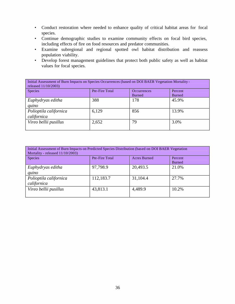
36
• Conduct restoration where needed to enhance quality of critical habitat areas for focal species.
• Continue demographic studies to examine community effects on focal bird species, including effects of fire on food resources and predator communities.
• Examine subregional and regional spotted owl habitat distribution and reassess population viability.
• Develop forest management guidelines that protect both public safety as well as habitat values for focal species.
Initial Assessment of Burn Impacts on Species Occurrences (based on DOI BAER Vegetation Mortality - released 11/10/2003) Species Pre-Fire Total Occurrences
Burned Percent Burned
Euphydryas editha quino
388 178 45.9%
Polioptila californica californica
6,129 856 13.9%
Vireo bellii pusillus
2,652 79 3.0%
Initial Assessment of Burn Impacts on Predicted Species Distribution (based on DOI BAER Vegetation Mortality - released 11/10/2003) Species Pre-Fire Total Acres Burned Percent
Burned Euphydryas editha quino
97,798.9 20,493.5 21.0%
Polioptila californica californica
112,183.7 31,104.4 27.7%
Vireo bellii pusillus
43,813.1 4,489.9 10.2%

37
Appendix C Excerpts from the Los Padres National Forest's BAER Plan: Wildlife and Fisheries Report
and Assessment for the Piru Fire, November 2003. Least Bell’s Vireo (Vireo bellii pusillus) D. Findings/Observations Designated critical habitat for the least Bell’s vireo occurs in portions of Reasoner Canyon, which is within the Dominguez sub-watershed. This designated habitat occurs both on private and National Forest lands. Burn intensity within the designated critical habitat for the least Bell’s vireo was light to moderate. E. Values at Risk Least Bell’s vireo critical habitat. II. Emergency Determination The fire will negatively affect some of the riparian areas in the short term. III. Discussion/Summary/Recommendations The least Bell’s vireo has not been recorded from within the Piru Fire perimeter and the closest record is approximately 10 miles southeast of Reasoner Canyon, on the Santa Clara River (LPNF GIS). This species winters from Baja California to northern Nicaragua, with most birds leaving the breeding area by September (Brown 1993). It is unlikely that any birds were in the area of the fire this late in the season and if present would have fled the burn. With the light to moderate burn intensities found in the designated habitat within Reasoner Canyon, it should be expected that the habitat should recover relatively quickly. Riparian plant species have adaptations to fluvial disturbances that allow survival and reestablishment following fires. This contributes to the rapid recovery of many streamside habitats (Dwire and Kauffman in press). The effects of the fire on the least Bell’s vireo designated critical habitat are minimal. There is no recommended emergency rehabilitation for this habitat. .
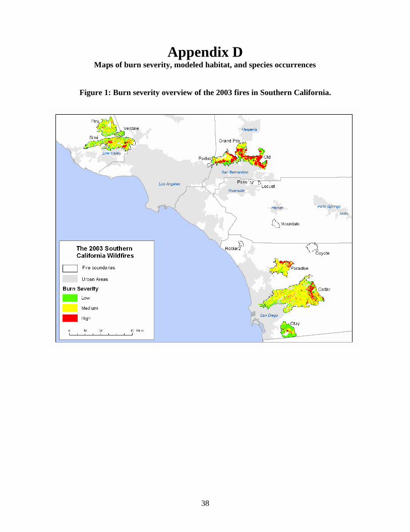
38
Appendix D Maps of burn severity, modeled habitat, and species occurrences
Figure 1: Burn severity overview of the 2003 fires in Southern California.

39
Figure 2: Critical habitats of species in this report.

40
Figure 3: Coastal California gnatcatcher CWHR modeled habitat.

41
Figure 4: Least Bell’s vireo CWHR modeled habitat.

42
Figure 5: Mountain yellow-legged frog CWHR modeled habitat.

43
Figure 6: Quino checkerspot butterfly occurrences.

44
Figure 7: Coastal California gnatcatcher occurrences.

45
Figure 8: Least Bell’s vireo occurrences.

46
Figure 9: Remaining yellow-legged frog populations in Southern California.