immap aid-ofda-g-10-00127 1stqtr 2012 reportpdf.usaid.gov/pdf_docs/pa00kmg3.pdf · nutrition...
TRANSCRIPT

Grant: # AID‐OFDA‐G‐10‐00127 Report: 2012‐Q1
GRANT PROGRESS REPORT Period Covered in this Report: 1 January 2012 to 31 March 2012 Organization: Information Management and Mine Action Programs [iMMAP] Mailing Address: 1400 16thStreet, NW, Suite 210, Washington, DC 20036 Date: 31 March 2012 Contact: Joseph M. Donahue Telephone: +1 [202] 729‐6794 E‐Mail: [email protected] Program Title: Common Operating Picture for Humanitarian Coordination Country/Region: Afghanistan Total Dollar Amount of Grant: $3,906,120.00 Total Period of Performance of Grant: 11 July 2010–28 February 2013
GOAL[S]
Afghanistan is in the midst of a complex humanitarian crisis. Natural disaster events, coupled with growing insecurity throughout the country, increase the challenges faced by Afghans in accessing basic services, including education, health care, livelihoods, and economic opportunities. Humanitarian access to vulnerable populations is impeded by insecurity, natural disasters, difficult terrain, and climatic conditions.
In the reporting period the Country has experienced snow precipitation above the normal in terms of coverage and duration of meteorological events. This has resulted in an increase in the mortality of the most vulnerable groups due to extreme cold and avalanches, and could lead to a delay in the agricultural season.
This project aims to provide the humanitarian community and relevant government actors with effective methods for reliably capturing, reporting, sharing, and analyzing information concerning the humanitarian situation according to baseline indicators, as well as safety and security information.
The overall goal of the project is to provide a common operating picture concerning humanitarian coordination and security, and this will be achieved by meeting the objectives as listed below.

Grant: # AID‐OFDA‐G‐10‐00127 Report: 2012‐Q1
ASSOCIATED OBJECTIVES OF THE GRANT
The project objectives are:
1. Improve the safety and security of humanitarian field operators.
2. Enhance and integrate current databases of humanitarian projects and activities and support distribution of related information in near real‐time.
3. Provide a Common Operating Picture of humanitarian data and baseline indicators of the humanitarian situation.
4. Identification of hazardous areas and populations‐at‐risk.
5. Improvements in currently available datasets.
iMMAP has maintained its OASIS system in Afghanistan since the beginning of 2009. As of 31 March 2012, OASIS is used by over 100 organizations with more than 200 OASIS installations, and approximately 150 trained users. Thirteen new installations have been implemented for seven partners in the reporting period, including key humanitarian actors like UNHCR and UN‐OCHA.
It is very difficult to estimate the number of people in these organizations that directly benefit from use of the OASIS system. This depends very much upon the size of the organization and how OASIS is used to conduct operations management, security analysis and minefield status analysis. Field planners and security officers may have influence on only ten people, but in larger organizations, field planners and security officers can influence the movements of hundreds of employees.
Currently 2,371 printed maps have been distributed to over 170 humanitarian organizations since the beginning of the project, while 263 digital maps were made available on websites such iMMAP, OCHA and/or the clusters. During this reporting period 403 hardcopy maps were distributed and 26 new maps were posted to the iMMAP website.
Please note that iMMAP conducted part of the work reported here with funding provided by the Office of Weapons Removal and Abatement [PM/WRA], U.S. Department of State. While the PM/WRA project focuses upon the Humanitarian Mine Action [HMA] community, the OFDA funding allows a much wider reach throughout the broader humanitarian community. One major focus of the OFDA grant is to identify populations at risk to various disasters, and this report will demonstrate progress in those areas.
PM/WRA funding ceased in May 2011 with the successful conclusion of that project, and therefore all work conducted from this date is fully OFDA funded.
Information management tools and solutions provided to the humanitarian community originally under the PM/WRA grant are now updated to develop new synergies in the context of the OFDA grant, enhancing continuity and sustainability between programs.

Grant: # AID‐OFDA‐G‐10‐00127 Report: 2012‐Q1
SUB‐SECTOR: COORDINATION
INDICATOR 1
Number of organizations coordinating relief operations, and through these entities, the number of implementing organizations coordinated through these efforts and reported upon through this project.
In the current reporting period the protracted humanitarian crisis in Afghanistan continues, with no abatement in the number of people affected by conflict and continuing large numbers of small quick onset emergencies. iMMAP has continued to provide time critical information products to a variety of humanitarian actors to improve the humanitarian community’s overall situational knowledge, improve response planning decision making and to improve coordination in assessment and response planning. Key information products developed and disseminated by iMMAP, whether they be static maps or a dynamic common operating picture, have been used by humanitarian decision makers in the field, at regional, national, headquarter and donor capitals.
In particular, iMMAP information products were key to the development of flood contingency plans and other programs for Disaster Risk Reduction and Response.
Through this project, information management support is currently provided to five Clusters groups directly involved in relief operations and the inter‐cluster coordination mechanism:
1. Food Security and Agriculture Cluster (FSAC)
2. Nutrition Cluster
3. Protection Cluster
4. Education Cluster
Examples of the work undertaken during the reporting period for the clusters include:
Food Security and Agriculture Cluster:
o Production of maps that communicate the drought response, 3W, access and actual response of FSAC partners.
o Continued participation in the Early Warning Information Working Group of the FSAC and further production of flood early warning products.
o Participation in the Data Harmonization Working Group
o Data management for the crop assessment and food security households assessment
o Activation of the stand‐by partnership with Food Security and Agriculture Cluster [FSAC] for the deployment of an Information Management Officer

Grant: # AID‐OFDA‐G‐10‐00127 Report: 2012‐Q1
o Activation of a the stand‐by partnership with FAO Emergency Response and Communication Unit [ERCU] for the deployment of an Information Management Officer
o Participation in the Flood Contingency Plan
Nutrition Cluster:
o Capacity development of new UNICEF Information Manager.
o iMMAP products were included in a Nutrition Cluster Flood Contingency Plan,
o Continuing support for the further improvement and development of the Nutrition Cluster database and information gathering processes.
Protection Cluster:
o Continuing support to UNHCR and IOM for the development of an IDP tracking system and the IDP profiling process (Fig. 1,2).
o Completion of UNHCR people tracking module in Oasis.
o MOU under discussion for the activation of a stand by partnership.
o Support to NRC for humanitarian access mapping of their areas of intervention (Fig. 3)
Fig. 1

Grant: # AID‐OFDA‐G‐10‐00127 Report: 2012‐Q1
Fig. 2
Fig. 3
SUB‐SECTOR: INFORMATION MANAGEMENT

Grant: # AID‐OFDA‐G‐10‐00127 Report: 2012‐Q1
INDICATOR 1
Number of organizations utilizing common information management services.
OASIS is used by 100 organizations with more than 200 OASIS installations, and approximately 150 trained OASIS users. On average, iMMAP has between three and four new clients and approximately ten OASIS installations and five newly trained OASIS users every month.
In the current reporting period OASIS and the overall services of information management provided by iMMAP are being officially used by five Cluster groups [FSAC, Nutrition, Education, Protection, WASH], as well as the Inter‐Cluster Coordination body. The information management products developed by iMMAP are playing a key role in the the planning for and response to the current drought .
Also, other Cluster Lead organizations, such as the International Organization for Migration [IOM are using OASIS to integrate their priorities for intervention with the overall contingency plan for emergency response] and UNHCR [people movement tracking] are using OASIS to bring together agency specific programmatic information with the common operating picture delivered through OASIS.
During Q1 2012 several new partnerships were developed, improving Information Management services to organizations working in Disaster Risk Reduction in six provinces. The key humanitarian actors involved in the partnership are NRC, IMC, Medair, ACF and Solidarites.

Grant: # AID‐OFDA‐G‐10‐00127 Report: 2012‐Q1
INDICATOR 2
Number of information products made available through common information management services that are utilized by clients.
New datasets obtained and made available to clients via maps and OASIS, not including datasets reported upon during the previous reporting period, include the following products:
Coordination Mechanism Information Products Made Available
Food Security and Agriculture Cluster
3W for flood preparedness and response
FSAC response to drought
UNHCR and IOM Updated figures on natural disasters‐affected IDPs
Security analysis, UNDSS, UNMACCA, other humanitarian partners
Security incidents 2008‐2012. Local (civilian) population targeted in security incidents 2008‐2012 Humanitarian access to program areas for the Northern Region (NRC)
WASH Cluster WASH interventions implemented and ongoing by Medair
Disaster Risk Reduction and Response [Inter‐cluster coordination]
Natural disaster profiling for the provinces of Daykundi, Bamyan, Samangan, Badakhshan, Takhar and Baghlan) done by Medair, ACF and Solidarites
WFP data on assistance provided to flood‐affected people from 2007 to 2012
Currently 2,371 printed maps have been distributed to over 170 humanitarian organizations since the beginning of the project, while 263 digital maps have been made available on a website such iMMAP, OCHA and/or the clusters. During this reporting period 403 printed maps
In support of OFDA partners, at headquarters and in the field, iMMAP has produced regional, provincial and district maps. These maps will assist in disaster response, improved cluster coordination and risk reduction planning.

Grant: # AID‐OFDA‐G‐10‐00127 Report: 2012‐Q1
OBJECTIVE ONE OUTPUTS AGAINST INDICATORS
Improve the safety and security of humanitarian field operators.
NARRATIVE
As of 31 March 2012 there were more than 90,000 historical security incidents entered and mapped using the OASIS tool. This database allows humanitarian actors to obtain updated and historical information concerning the security situation in their areas of operation. The database is unique in the humanitarian community as it allows users to view spatial relationships with other layers such as roads, thereby providing the user with an overview of where hot spots are located over a specified time period. This allows field personnel to know what to expect in specific areas before they deploy there.
Since the beginning of the project humanitarian partners have been provided with near real time update of the security situation through OASIS and customized maps. This product has also been included in the Consolidated Appeal for Afghanistan 2012 and is now distributed on a monthly basis through OCHA [http://ochaonline.un.org/afghanistan] (Fig. 4).
Fig. 4

Grant: # AID‐OFDA‐G‐10‐00127 Report: 2012‐Q1
Information regarding landmine contamination and clearance activities is still provided via OASIS. Therefore, humanitarian actors have access to information regarding cleared areas and hazardous areas in their areas of operations.
Below is a list of current and new OASIS clients, data partners and agencies that have been supplied with mapping support:
Q 1 2012 New Oasis Clients Action Contre la Faim [ACF] Catholic Relief Services [CRS] Medair Norwegian Refugee Council [NRC] United Nations High Commission for Refugees [UNHCR]
Previous Oasis Clients
Acted Afghanistan National Disaster Management Authority [ANDMA] Afghan Technical Consultants [ATC] Afghan Women's Educational Center [AWEC] Afghanistan Civil Support Service [ACSS] Afghanistan Information Management Systems [AIMS] Aga Khan Foundation [AKF] Canadian International Development Agency ‐ Canadian Program Support Unit Care International Caritas Germany ClearPath International [CPI] Danish Demining Group [DDG] Deloitte [supporting USAID projects] Demining Agency for Afghanistan [DAFA] Dyncorp Education Cluster [various members] EOD Technology European Union Police Mission in Afghanistan [EUPOL Afghanistan] Ex‐Med Focus Humanitarian Assistance [FOCUS] Food Security and Agriculture Cluster [FSAC] [various members] Food and Agriculture Organisation [FAO] G4S Afghanistan Halo Trust [HT] Helvetas Independent Election Commission [IEC] of Afghanistan International Assistance Mission [IAM] International Foundation for Electoral Systems [IFES] International Organization for Migration [IOM] International Relief and Development [IRD] ‐ Human Resources and Logistical Services program [HRLS]
International Relief and Development [IRD] ‐ Strategic Provincial Roads [SPR] International Rescue Committee [IRC] Madera

Grant: # AID‐OFDA‐G‐10‐00127 Report: 2012‐Q1
Mercy Corps Mines Advisory Group [MAG] Mine Clearance Planning Agency [MCPA] Mine Detection and Dog Centre [MDC] MineTech International Nutrition cluster [various members] Office for Weapons Removal and Abatement [WRA] Afghanistan Organisation for Mine Clearance & Afghan Rehabilitation [OMAR] Oxfam GB Oxfam Novib RONCO Consulting Corporation Save the Children [SC] Shelter Cluster [various members] Sicuro Group Solidarites Swedish Committee for Afghanistan Swiss Development Cooperation [SDC] ‐ Swiss Cooperation Office Afghanistan [SCO‐A] Swiss Foundation for Mine Action [FSD] United Nations Children's Fund [UNICEF] Education United Nations Development Program [UNDP] ‐ Enhancing Legal and Electoral Capacity for Tomorrow [ELECT]
United Nations Development Program [UNDP] Country Office [CO] United Nations Mine Action Coordination Centre Afghanistan [MACCA] United Nations Office for the Coordination of Humanitarian Affairs [UN‐OCHA] United Nations Office for Drugs and Crime [UNODC] United States Embassy USAID’s Capacity Development Program [CDP] UXB International War Child Holland World Conservation Society [WCS] World Food Program Education World Food Program – Global GeoPortal World Vision
PROJECTIONS
In the current reporting period the OASIS user base has been expanded to include agency‐specific database requirements, such as IOM and UNHCR.
The participative work implemented with humanitarian partners and the Cluster groups has allowed the identification of specific unmet needs. At the Cluster level new methods for data gathering and standardization between needs and response plans have been developed [e.g. for UNHCR, WFP], including components of training for information management staff in the United Nations, and other humanitarian partners [e.g. for UNICEF, NRC, Medair, IMC].
Other humanitarian partners have identified needs in terms of greater understanding of security conditions for the northern provinces: customized security maps, web based

Grant: # AID‐OFDA‐G‐10‐00127 Report: 2012‐Q1
applications to access OASIS and to tracking applications so that organizations can track vehicle movements are being considered for the next phase of the project [e.g. CARE]
OBJECTIVE TWO OUTPUTS AGAINST INDICATORS
Enhance and integrate current databases of humanitarian projects and activities and support distribution of related information in near real‐time.
NARRATIVE
The key to getting new users to access data through OASIS is the provision of timely and reliable information flowing through the system.
iMMAP currently has four dedicated data entry staff, and one data entry clerk seconded by Deloitte. A Geographic Information Systems [GIS] Officer has been hired to improve the data collection, standardization and interoperability through OASIS.
An information management officer has implemented an information management gap assessment for OFDA partners in the central and Northern provinces. This included extensive headquarter (Kabul), regional and field work in order to determine, physical, organizational, policy, process and product gaps in information use, development and management.

Grant: # AID‐OFDA‐G‐10‐00127 Report: 2012‐Q1
OBJECTIVE THREE OUTPUTS AGAINST INDICATORS
Provide a Common Operating Picture of humanitarian data and baseline indicators of the humanitarian situation.
NARRATIVE
The iMMAP Afghanistan OASIS team has established a large network of OASIS clients and as such a large number of data sharing opportunities, which contribute to building the Common Operating Picture [COP], ranging from Explosive Remnants of War [ERW] and the HMA environment in Afghanistan to topographic maps [incorporates 1:250,000, 1:100,000 and 1:50,000 American topographic maps, as well as Russian topographic map series], satellite imagery, high resolution town imagery, accurate elevation data, settlement lookups, water sources, snow cover, soils, land cover, health facilities, military and security locations, etc., are all essential information to properly plan activities in the field.
To ensure appropriate data gathering and dissemination, relationships have been developed with:
United States Geological Survey [USGS, supplied aerial photography for Afghanistan];
Famine Early Warning System [FEWS];
United Nations Food and Agriculture Organization [UNFAO];
World Food Programme [WFP]
Afghanistan National Disasters Management Authority [ANDMA];
Afghanistan Central Statistics Office [CSO];
Afghanistan Information Management Services [AIMS]
Information Technology for Humanitarian Assistance Cooperation and Action [ITHACA, snow cover data]
In this reporting period, iMMAP has focused on the interoperability of the Common Operating Picture developed in the previous phases of the action with the activities of the Cluster groups, especially through the Inter‐Cluster Coordination body for the emergency response. The primary aim of this activity was to provide simultaneously a platform to share main findings and strategies among a wide variety of humanitarian actors and raise awareness on current security in remote areas to evaluate the options to access vulnerable communities.

Grant: # AID‐OFDA‐G‐10‐00127 Report: 2012‐Q1
PROJECTIONS
In the development of the collaborative OASIS platform, iMMAP has implemented both top‐down and bottom‐up approaches to the Common Operating Picture.
Bottom‐up developments have been implemented to increase the involvement of humanitarian actors with the existing coordination mechanisms, especially the Cluster groups. iMMAP has developed specific modules in OASIS to allow for integration of existing databases and excel spreadsheets with the OASIS interface. Agency‐specific data have been shared with the wider OASIS user community or kept within the agency [this is decided according to agency requirements]. The OASIS‐based databases that have been developed are:
Compass Integrated Security Solutions: An incident database was developed which tracks International Security Assistance Force [ISAF] and Compass‐specific incidents. Compass provides logistics convoys for ISAF, and this dataset is currently not reported in any unclassified format to the wider humanitarian community. This database equips the company with better analysis capabilities, which directly helps avoid unnecessary risks to their business activities. Compass has agreed to share most of this information with all OASIS users, and the data was made available.
Helvetas: An OASIS‐based projects database was developed to help Helvetas in their information management capacity. OASIS keeps track of Helvetas projects, and associated reporting requirements.
International Organization for Migration [IOM]: An OASIS‐based Non‐food Items [NFI] distribution database and IDP database were developed to help IOM in their humanitarian activities. OASIS provides responsive reports of available non‐food items in their various warehouse locations. It also provides better communication between the main office in Kabul and a number of field offices. The database also tracks the number of IDPs served by IOM in relation to natural disaster events.
CARE: An OASIS‐based database for important CARE locations was developed for the CARE security office. This helps the security office track CARE personnel locations as well as improve information management capacity.
The “Emergency Response Management (ERM) Consortium”: Medair, ACF and Solidarites: a common database on disaster risk profiling is currently under development. The main aim of the ERM Consortium is to provide community risk mapping and periodic monitoring to activate proper options for disaster mitigation and response.
ClearPath International [CPI]: a database to evaluate the impact of the CPI program on people affected by disabilities has been implemented.
International Medical Corps [IMC]: a database for the IMC DRR program in the Eastern Region is currently under development

Grant: # AID‐OFDA‐G‐10‐00127 Report: 2012‐Q1
Norwegian Refugee Council [NRC]: iMMAP provides technical advice and mapping capacity for the humanitarian access database implemented by NRC.
A top‐down approach has been used in cases where several implementing partners must harmonize their actions in order to coordinate emergency response at the country level.
FSAC: Information on impact assessment, governmental reports on food shortages, market prices, and hotspots of food insecurity are collected, standardized and distributed to all the partners of the action through OASIS.
Nutrition Cluster: An OASIS‐based database was implemented to keep track of records and analyze data on patients admitted to health facilities under the OTP program which targets malnutrition for very vulnerable groups. It also provides the identification of hotspots of malnutrition and/or high mortality rates in order to facilitate the coordination of the response in the framework of the Drought Response Plan.
Protection Cluster: An OASIS‐module for data entry has been developed in order to facilitate the tracking of IDPs movements and the classification of the reasons of displacements [e.g. natural disasters vs. conflict].
Education Cluster: 3W and assistance to identify humanitarian versus development components have been provided.
The results obtained by both approaches highlight the flexibility and the interoperability of OASIS as a collaborative platform for developing a Common Operating Picture, while the decision on what approach should be used in different situations comes from the knowledge of the context where humanitarian actors are involved.
A new version of OASIS has been released.

Grant: # AID‐OFDA‐G‐10‐00127 Report: 2012‐Q1
OBJECTIVE FOUR OUTPUTS AGAINST INDICATORS
Identification of hazardous areas and populations at risk.
NARRATIVE
In this reporting period an extensive effort has been made to fill the existing gaps in terms of information management for the identification of hazardous areas and populations at risk, as well as to support the coordination of humanitarian response with specific attention to enhancing the safety of relief operators.
Flood maps: Following a request from the Early Warning and Information Working Group [EWIWG] of the Food Security and Agriculture Cluster [FSAC], iMMAP has produced a bi‐weekly flood hazard scenario with information on estimated settlements and population potentially affected by flood (Fig. 5). The new format of the flood hazard maps was discussed with relevant actors of the humanitarian community traditionally involved in Disaster Risk Reduction and Response and is now produced and distributed through the FSAC and UN‐OCHA.
Fig. 5
In order to support the humanitarian Clusters in the preparation of Flood Contingency Plans, a set of maps has been developed to show the estimated quantitative dimension of the potential impact of flood hazard on health facilities, education facilities, irrigated and intensively cultivated land and settlements (Fig. 6‐12).

Grant: # AID‐OFDA‐G‐10‐00127 Report: 2012‐Q1
Fig. 6
Fig. 7

Grant: # AID‐OFDA‐G‐10‐00127 Report: 2012‐Q1
Fig. 8
Fig. 9

Grant: # AID‐OFDA‐G‐10‐00127 Report: 2012‐Q1
Fig. 10
Recent data have been also collected from key actors (ex. WFP) traditionally involved in programs to assist vulnerable households affected by flood.
Fig. 11

Grant: # AID‐OFDA‐G‐10‐00127 Report: 2012‐Q1
Fig. 12
Following initial information activities, the Food Security and Agriculture Cluster [FSAC] started an initiative to define regional flood contingency plans with special attention on the impact of flood hazard on livelihoods and the identification of options for mitigation and response.
The main aims of the workshops are:
• Validate with the humanitarian community working in the provinces the information on flood prone areas and characterize the diversity of livelihoods in the most affected areas
• Mapping options for mitigation and response
• Identify and map gaps in the humanitarian response to flood hazard (e.g. gap in geographic coverage, consistency between livelihoods affected and mitigation/response options)
Three regions will be covered by these workshops: the Northern Region (with the provinces of Balkh, Samangan, Jawzjan, Faryab and Sari Pul), the Wester Region (with the provinces of Hirat, Badghis, Ghor, Faryab and Farah) and the Eastern Region1 (with the provinces of Nangarhar, Kunar, Nuristan and Laghman). In order to support the FSAC with this initiative iMMAP has been deeply involved with all the phases of the workshop including its preparation, implementation and data analysis. A set of regional and provincial maps has been developed to support the participative mapping and validation of flood prone areas done by the humanitarian organizations attending the workshops. 1 Due to security concerns, the workshop was rescheduled for May 6-7.

Grant: # AID‐OFDA‐G‐10‐00127 Report: 2012‐Q1
These maps were developed using a participatory approach showing contributions from the informants on potentially flooded areas, livelihood zones, administrative boundaries, population density, land cover, and security situation. In order to facilitate the participation of humanitarian actors a practical guide with instructions and suggestions on how to implement a participative mapping and validation was developed and distributed to the facilitators of the workshops (Fig. 13).
Fig. 13
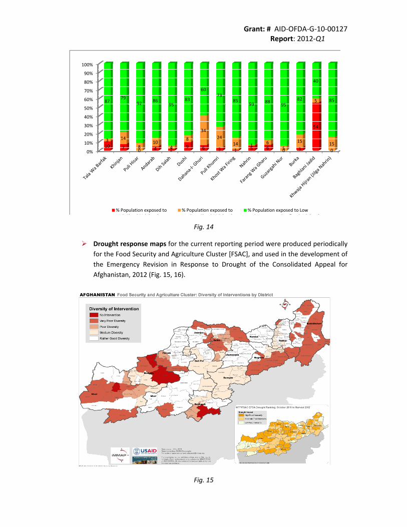
In the framework of the FSAC Flood Contingency Plan a specific analysis was required by FAO in order to identify and quantify the population potentially exposed to the worst case scenario of flood hazard. Population density at district level (CSO 2011‐2012) was intersected with the flood model and settlements data to identify populated areas at risk of flood (Fig. 14).
Grant: # AID‐OFDA‐G‐10‐00127 Report: 2012‐Q1
0%
10%
20%
30%
40%
50%
60%
70%
80%
90%
100%
10 7 0 4 29 6 3 1 5 6 0 3
54
0
3 14
810
4
8
3424
14 1 65
15
5
15
8779
92 8695
83
6073
8593 88 95
82
40
85
% Population exposed toHi h Fl d Ri k ( )
% Population exposed toM di Fl d Ri k ( )
% Population exposed to Lowd N d fl d i k ( )
Fig. 14
Drought response maps for the current reporting period were produced periodically for the Food Security and Agriculture Cluster [FSAC], and used in the development of the Emergency Revision in Response to Drought of the Consolidated Appeal for Afghanistan, 2012 (Fig. 15, 16).
Fig. 15

Grant: # AID‐OFDA‐G‐10‐00127 Report: 2012‐Q1
Fig. 16
Emergency Food Security Assessment Maps: More than thirty humanitarian organizations [FAO, WFP, FEWSNET, UNICEF, IOM, and NGOs etc] were involved in an extensive drought impact assessment in areas identified as priorites by the FSAC. Assessment outcome, planned response, actual response and response gap maps were prepared and disseminated through the Cluster mailing lists and OASIS (Fig. 16).

Grant: # AID‐OFDA‐G‐10‐00127 Report: 2012‐Q1
PROJECTIONS
In the current reporting period several activities have been undertaken to harmonize the Flood Contingency Plan and monitor the drought response.
iMMAP facilitated the integration of information on different options for mitigation and disaster response mechanisms developed by the Cluster groups. Using the information management gap assessment, constraints to proper decision making were identified and prioritized through a participative discussion carried out with OCHA, ANDMA and the Cluster groups.
Information Management tools and techniques contributed substantially to an overall enhanced understanding of the situation for the end user, especially Clusters, ANDMA, MAIL and MRRD.
OBJECTIVE FIVE OUTPUTS AGAINST INDICATORS
Improvements in currently available datasets.
NARRATIVE
iMMAP has collated, cleaned and error‐checked multiple datasets from various sources. The new datasets exclusive to this reporting period are:
Drought response, planned and implemented activities Updated drought affected areas Flood scenario at regional level for participative validation with humanitarian actors FSAC Flood 3W WFP areas of assistance to flood‐affected population 2007 to 2012 WASH activities, implemented and ongoing, in the Northern Provinces targeted by Medair
Most of these layers are constantly updated as new sources of data are developed, and remain a work‐in‐progress.

Grant: # AID‐OFDA‐G‐10‐00127 Report: 2012‐Q1
Appendix A: iMMAP Afghanistan Organizational Chart