im d3.4 future internet technologies roadmap for transport and mobility-final report v1.0
Post on 12-Sep-2014
744 views
DESCRIPTION
TRANSCRIPT

Multimodality for people and goods in urban areas
FP7 . CP 284906
D3.4 – Future Internet Technologies
Roadmap for Transport and Mobility
Final report
March 2012 Editor: Thierry Nagellen/FT
License
This work is licensed under the Creative Commons Attribution-NonCommercial- NoDerivs 2.0 License.
To view a copy of this license, visit http://creativecommons.org/licenses/by-sa/3.0/ or send a letter to Creative
Commons, 171 Second Street, Suite 300, San Francisco, California, 94105, USA.
Project co-funded by the European Commission within the Seventh Framework Programme (2008-2013)
Copyright by the partners of the Instant Mobility Consortium
Project funded by the European Commission under the 7th European Framework
Programme for RTD - ICT theme of the Cooperation Programme.

Instant Mobility WP3 Use Case Scenarios
Future Internet Technologies Roadmap for Transport and Mobility – final report 2
Instant Mobility WP3.2
Future Internet Technologies Roadmap for Transport and Mobility
final report
WP3.2 Futur Internet Technologies Roadmap for Transport and Mobility – final report
Authors
T. Nagellen, D. Ferrer, C Peña
Short Description
This deliverable provides a completed analysis of Future Technologies which will be useful for innovative transport services and usable for future trials .
Dissemination level (select)
PU Public
Date
March 1st 2012
Status
Deliverable (final version 1.0)
Contributions by:
Internal review by
Internally accepted by
Paul Kompfner (WP3 leader)
Date of acceptance March 9th 2012
Document history
Version Date Author /Reviewer Description
V0.1 18 Feb 2012 Thierry Nagellen Deliverable content table and template
V0.2 29 Feb 2012 Thierry Nagellen Analysis of Lead Scenario 1 & 2
V0.3 1 Mar 2012 Cristina Pena Comment on Table of Content + evaluation
V0.4 5 Mar 2012 Thierry Nagellen Analysis of Lead Scenario 3
V0.5 7 Mar 2012 David Ferrer Analysis on Lead Scenarios 4
V0.6 7 Mar 2012 Cristina Pena Comment on lead Scenario analysis
V0.7 9 Mar 2012 Thierry Nagellen Analysis on Lead Scenario 5 / Conclusion
V0.8 9 Mar 2012 Thierry Nagellen Abstract

Instant Mobility WP3 Use Case Scenarios
Future Internet Technologies Roadmap for Transport and Mobility – final report 3
Deliverable Abstract (1 page)
The objective of this document is a common understanding of how some technologies will contribute to improve transport and mobility services and provide a rich set of functional characteristics in line with the project’s general goal of innovative and Future Internet‐driven urban mobility.
The procedure followed to achieve this goal started from a cross analysis of the initial scope of five Lead Scenarios, using the first technological framework as defined in “Future Internet Technologies Roadmap for Transport and Mobility – preliminary report”.
All thirty-seven elementary services defined during the first six months are reevaluated through their main functionalities and based on how main Future Internet technologies would be relevant and bring innovation in a near future.
The last step focus on the main technical areas which should be the most relevant in future trials, especially to deliver in a relative short term added value to transport and mobility stakeholders and their customers. It refers also to three innovative application scenarios on which Instant Mobility is now focusing its efforts for specific prototypes.
This document enlightens what are the main technical challenges for concrete trials and how ICT market could propose better alternatives in the following years.

Instant Mobility WP3 Use Case Scenarios
Future Internet Technologies Roadmap for Transport and Mobility – final report 4
Table of Content
1. INTRODUCTION .......................................................................................................................................... 5
1.1 WHAT WILL THE FUTURE INTERNET OF SERVICES FOR TRANSPORT AND MOBILITY LOOKS LIKE AND HOW TO MAKE SMART
MOBILITY THE PROMISE OF THE CURRENT DECADE? ..................................................................................................................... 5 1.2 HOW TO READ THIS DOCUMENT ...................................................................................................................... 6
2. INTERNET FOR TRANSPORT AND MOBILITY SERVICES.............................................................................. 7
2.1 IMPACT ON FUTURE INTERNET TECHNOLOGIES ON INSTANT MOBILITY LEAD SCENARIOS ............................................ 8 2.2 LEAD SCENARIO 1 – MULTIMODAL TRAVEL MADE EASY ....................................................................................... 9
2.2.1 End to end itinerary planning comparison description (today, future) .......................................... 10 2.2.2 Real-time itinerary planning comparison description (today, future) ............................................ 10 2.2.3 Continuously updated travel time information comparison description (today, future) ............... 10 2.2.4 Disrupted service assistant comparison description (today, future) .............................................. 11 2.2.5 Interchange and en-route assistant comparison description (today, future) .................................. 11 2.2.6 On-the-spot POI & tourism information comparison description (today, future).......................... 11 2.2.7 Ticketless mobile fare payment comparison description (today, future) ........................................ 12
2.3 LEAD SCENARIO 2 – THE SUSTAINABLE CAR ..................................................................................................... 13 2.3.1 Personalized route guidance comparison description (today, future) ........................................... 14 2.3.2 Itinerary booking service comparison description (today, future) ................................................. 14 2.3.3 Real-time traffic and route information comparison description (today, future) ........................... 14 2.3.4 Car-sharing plus comparison description (today, future) .............................................................. 15 2.3.5 Ride sharing comparison description (today, future) ..................................................................... 15 2.3.6 Congestion Charging comparison description (today, future) ....................................................... 15 2.3.7 Parking assistance comparison description (today, future) ........................................................... 16
2.4 LEAD SCENARIO 3 – THE COLLECTIVE TRANSPORT ............................................................................................. 18 2.4.1 Floating passenger data collection comparison description (today, future) .................................. 18 2.4.2 Demand responsive service coordination comparison description (today, future) ........................ 19 2.4.3 Flexible schedule adaptation comparison description (today, future) ........................................... 20 2.4.4 Adaptive collective transport priority comparison description (today, future) .............................. 21 2.4.5 Ticketless fare collection comparison description (today, future) ................................................. 21 2.4.6 Driver and passenger security monitoring comparison description (today, future) ...................... 21 2.4.7 Taxi sharing comparison description (today, future) ..................................................................... 22
2.5 LEAD SCENARIO 4 – TRUCKS AND THE CITY ..................................................................................................... 23 2.5.1 Load sharing & balancing comparison description (today, future) ............................................... 24 2.5.2 Loading/unloading zone booking comparison description (today, future)..................................... 24 2.5.3 Goods supply chain visibility comparison description (today, future) ........................................... 25 2.5.4 Automated access control & security check comparison description (today, future) .................... 25 2.5.5 Dynamic time/place drop point comparison description (today, future) ........................................ 25 2.5.6 Traffic zone control comparison description (today, future).......................................................... 25 2.5.7 Green corridors comparison description (today, future) ............................................................... 26 2.5.8 Real time traffic optimized route navigation comparison description (today, future) ................... 26 2.5.9 Eco-driving support comparison description (today, future) ......................................................... 27
2.6 LEAD SCENARIO 5 – ONLINE TRAFFIC AND INFRASTRUCTURE MANAGEMENT ......................................................... 28 2.6.1 Traffic control in the cloud comparison description (today, future) .............................................. 28 2.6.2 Cooperative traffic signal control comparison description (today, future) .................................... 29 2.6.3 Area-wide optimisation strategies comparison description (today, future) ................................... 29 2.6.4 Traffic-adaptive demand management comparison description (today, future) ............................ 30 2.6.5 Demand-responsive parking management comparison description (today, future) ....................... 30
3. FUTURE INTERNET TECHNOLOGIES: MAIN ISSUES FOR NEXT TRIALS .................................................... 31
3.1 CROWDSOURCING SERVICES ......................................................................................................................... 31 3.2 SOCIAL NETWORKS ..................................................................................................................................... 31 3.3 FROM DATA TO INFORMATION ..................................................................................................................... 32 3.4 SECURITY AND PRIVACY SERVICES .................................................................................................................. 32
4. CONCLUSION ............................................................................................................................................ 34

Instant Mobility WP3 Use Case Scenarios
Future Internet Technologies Roadmap for Transport and Mobility – final report 5
1. Introduction
1.1 What will the Future Internet of Services For transport and mobility looks like and how to make smart mobility the promise of the current decade?
Transport and mobility are fundamental and vital for the economy and for Europe. Efficient and sustainable transport and mobility is essential for participating competitively in the world economy, supporting the prosperity of Europe. Transport and mobility has grown substantially over the past decades, expanding infrastructure and involving more and more Information and Communication Technologies. Nevertheless, it is widely acknowledged that Internet of Services is not so present to change quickly how people and goods are travelling and to deeply modify environmental, social and economic consequences. Technological innovation can support the transition to more efficient and sustainable transportation system, by focusing on two main areas: improving innovative services for travelers and drivers, enhancing collaboration between all actors to build a real-time smart effectiveness. to continuously inform decision making on why or how to travel or transport.
The integration of ICT in the transportation system (infrastructure, vehicles and traffic management) is one of the main topics suggested to build future smart mobility in Europe. This should succeeding the technical wave of intelligent transport systems (ITS) involving making transport systems intelligent through the use of ICT (with the term smart mobility in particular wireless communication systems). Future Internet of Services is not an end in itself, but rather a means to answer the challenge of 2020 transport objective that is resource -efficient, environmentally-friendly and seamless across all transport modes for the benefit of citizens, the economy and society.
80% of the European population lives in urban areas and large cities. Their citizen’s mobility needs often result into a number of problems, such as traffic congestion, increased pollution levels and/or greenhouse gas emissions, or excessive travelling time and energy consumption. Intelligent Transportation Systems (ITS) and further adoption of vehicle-to-vehicle (V2V) and vehicle-to-infrastructure (V2I) technologies tackle largely these problems. But deployment of such technologies and their associated infrastructures require lots of time when Internet is deployed overall and mobile Internet use is growing so fast. In a near Future, Transport and Mobility services will be Social, Local and Mobile12 or SoLoMo.
Social: optimization of all transportation means and green transport is a common concern for all citizens in any situation there are: travelers or drivers. They will share the same objective: travel in the best conditions and But vehicles will also build a new type of social network not dedicated to people but as smart resources which could apply some rules and manage automatically some actions, typically as living organisms of traffic or multimodal solutions. People and vehicles will be characterize by profiles and manage themselves their own access rights.
1 SoLoMo Blog Loic Le Meur (Fr)
2 SoLoMo Eric Schmidt Google

Instant Mobility WP3 Use Case Scenarios
Future Internet Technologies Roadmap for Transport and Mobility – final report 6
New tools, devices and services will appear to support an ad-hoc community into dedicated area.
Local: in transport and mobility area there are several dimensions for local. Local is localization in real-time including smart monitoring of your position. Local is also related to a dedicated geographical area because based on your type of vehicle, you are not interested in transport and traffic events in the same places and you will not be aware of transport issues which are not related to your own situation. You will be part of a local crowd where many people share the same objective.
Mobile: by definition in transport area people and vehicle are moving so expected services will be mobile and follow you as traveler or driver with an automatic adaptation to your context, including the use of the best communication technologies to keep you connected. Seamless mobile technologies are a key part of Future Internet transport infrastructure using the best part of existing networks but also in association with all fixed networks which are supporting road infrastructures.
1.2 How to read this document
This document is the result of previous works achieved in Instant Mobility project and tries to explain how Future Internet technologies will bring innovation for new services in the Transport and Mobility area.
We used the Instant Mobility initial approach based on five Lead Scenarios which were detailed into more than thirty-five elementary services. These services where discussed with professional partners not so confident with new technologies but who brought their vision of expected services to improve their own business or to better deliver services to their customers. The whole description of these elementary services is available in the public document “Instant Mobility Use Case scenarios definition and analysis – preliminary report”.
To enlighten these services with a technical view we used the technical elements describe in “Future Internet Technologies Roadmap for Transport and Mobility – preliminary report” and propose to evaluate, for each elementary services, how technologies could bring new developments in a near future.
To conclude this document, we decided to focus on the main technical areas which should be the most relevant in future trials, especially to deliver in a relative short term added value to transport and mobility stakeholders and their customers. To illustrate this approach, we are also referring to three innovative application scenarios on which Instant Mobility is now focusing its efforts for specific technologies and enablers which are not common to some other business area.
We expect that this document will clarify what are the next trials challenges to enhance some new ICT-oriented ecosystems to support Transport and Mobility business.

Instant Mobility WP3 Use Case Scenarios
Future Internet Technologies Roadmap for Transport and Mobility – final report 7
2. Internet for Transport and Mobility Services
The “Instant Mobility” project is developing and exploring a concept for transforming the mobility of persons and goods in the future through application of advanced Internet technologies. This document presents a characterization of five lead scenarios selected for analysis for their important potential of enhancement with Future Internet (FI).
It also provides a detailed description and functional analysis of the individual types of Instant Mobility services derived from the lead scenarios. It specifies service capability, service components, actors and their roles, data flows and databases of each service in the five lead scenarios. Interactions and combinations of these services within the scenarios are also described.
The five scenarios are named:
Multimodal travel made easy
The sustainable car
Collective transport 2.0
Trucks and the city, and
Online traffic & infrastructure management.
Multi-modal travel made easy offers a traveler seamlessly a wide range of travel and transport options, according to the user’s preferences, for all the stages of a trip that may use various modes including public transport, car and non-motorised means, e.g. bicycles.
The sustainable car provides travelers who choose the use a car for at least part of their journey with the best route i.e. that with least delay, least CO2, shortest travel time or lowest cost etc. via a number of interactive online information services based on future internet technologies.
Collective transport 2.0 expresses a vision where transport operators in the future will use Internet to sense passengers’ presence at stops and to register their destination, to offer innovative online services flexibly matching the vehicles, timetables and routes to the actual demand.
Trucks and the city shows how Internet based services can manage commercial vehicle deliveries and routing, organize drivers’ shifts and synchronize vehicle movements and goods pickup and reception.
Online traffic and infrastructure management puts traffic management and control online, offering a greater flexibility and performance of the current functions of today’s traffic management, enables direct vehicle-to-traffic system interaction, and allows new possibilities for local, sector and wide area optimization.
In the document “Instant Mobility Use Case scenarios definition & analysis – preliminary report” we elaborate on several elementary services which contribute to the five lead scenarios. The developed methodology proposes thirty-seven basic components with their related actors.

Instant Mobility WP3 Use Case Scenarios
Future Internet Technologies Roadmap for Transport and Mobility – final report 8
We propose in this document to evaluate how future services will take benefits from Internet at service level and associated ICT technolgogies (mainly connectivity, seamless management of things, location and large amount of data),.
To illustrate this approach, we consider location and traffic information services. They are originally based on GPS technologies and introduce at a large scope into the automotive industry without any support of Internet: satellite technologies, on-board devices with no network connectivity. Maps and Location services providers had improved their services including traffic information which is almost in real-time now. But precision of position is deeply associated to satellite network quality and availability of maps is depending of accuracy of data from few providers.
In the same time, a new wave of mobile devices appears (smartphones) which provide more than 3G connectivity with Internet access especially through small applications. These devices host location services especially because GPS chipsets were embedded but Internet access supports up to date information as maps, traffic or Points of Interest. The first services are emerging now where users can add new information and share some additional content (new Point of Interest, Traffic information…)
We can analyze that GPS and location services take now benefits from Internet whereas they could continue to evolve without it.
The scale we use is the following to evaluate impact of Internet and Information and Communication Technologies on Transport and Mobility services:
1: no impact 2: minor impact 3: major impact
Following these rules, GPS and l;ocation services would have a note of 3 because of: Internet will enhance information sharing ICT will bring new real-time technologies based on mobiles and satellite technologies
We propose in the following sections to quantify these notations for the 37 elementary services.
2.1 Impact on Future Internet technologies on Instant Mobility Lead Scenarios Based on previous document ““Future Internet Technologies Roadmap for Transport and Mobility – preliminary report” we have identified the following criteria to evaluate some technological impact on elementary services
Always-on connectivity
Accuracy of data
Computational resources
NFC technologies
Location based services
Sensors technologies We use these criteria to evaluate the thirty-seven services and provide a functional analysis based on how these services are delivered today (if they exist) and what technological improvements are expected to launch a new ecosystem of service in a near future.

Instant Mobility WP3 Use Case Scenarios
Future Internet Technologies Roadmap for Transport and Mobility – final report 9
2.2 Lead Scenario 1 – Multimodal travel made easy
Nr. Service name ICT Criteria Short description
1a End-to-end itinerary planning
2: connectivity is required to prepare itinerary
Traveller can choose preferred modes; online service provides optimised end-to-end itineraries, e.g. quickest, cheapest, least Green house Gas (GHG) modes.
1b Real-time itinerary monitoring
3: location based services are required
Online service monitors execution of itinerary on all modes, calculates actual versus planned service quality, identifies and notify service incidents and degradation as support services.
1c Continuously updated travel time information
3: real-time location and always-on connectivity + at least all vehicles with sensors/actuators
Service provides continuous journey/arrival time estimate based on real reported journey times of all connected travellers.
1d Disrupted service assistant
3: always on connectivity is essential
Service detects disruption to any part of planned itinerary, identifies and offers best alternatives to traveller
1e Interchange & en route assistance
2: connectivity is the main criteria especially for en-route assistance
For multi-modal trips, provides specific information and guidance at mode-to-mode interchanges, and during each leg informs about stops/stations, connections etc.
1f On-the-spot POI & tourism information
2: connectivity is the main criteria
During the journey, service delivers relevant point-of-interest (POI) or tourism information, at the right spot.
1g Special-needs travel support
1: no ICT issue Service for travellers with reduced mobility, guiding along fully accessible transport means and arranging for real-time support as needed, e.g. interchange. It will offer voice (for blind) or text (for deaf) information.
1h Ticketless mobile fare payment
3: NFC technologies are key, interoperability between systems also
Online service offers single account payment for multiple journey legs, so no need to purchase tickets; especially valuable for tourists and occasional users. Proof of payment provided via traveller’s handset.
1i Bicycle sharing 1: ICT are not critical Online service informs of bike and docking space availability, and allows multi payment on single account. It can accept reports of defective equipment etc.

Instant Mobility WP3 Use Case Scenarios
Future Internet Technologies Roadmap for Transport and Mobility – final report 10
2.2.1 End to end itinerary planning comparison description (today, future)
Service today (if it exists) Service in future (with Instant Mobility)
Providing static information on route, timetable, characters of vehicle, capacities, price, as well as geographic information;
Should be usable in any situation including mobility
Itinerary planning tools only cover limited modes of transport. For example, a public transport trip planner may not cover local train services.
Interoperability between actors and common data models are expected with the associated business models (distributed value)
Itinerary planning tools are based on timetable and do not take into account effective current travel time and position of means of transportation.
Accuracy of data should be useful especially for short end-to end itinerary. Collection of real-time data is required based on sensors networks and inter-operability
Current services may not take into account personal preference, travel history and special needs.
Security technologies would assume privacy rules to encourage users to share profiles.
2.2.2 Real-time itinerary planning comparison description (today, future)
Service today (if it exists) Service in future (with Instant Mobility)
Tentative in informing travellers about disruptions exist, but not in a systematic and well-structured way, Multimodal service does not include tailored information about real time schedule of public transport such as bus, tramway
Requires multicast technologies to deliver in real-time the right information to the associated users. It could be associated to publish-subscribe mechanisms to initiate dynamically multicasting, proposing subscription to several sources to avoid interoperability concerns. Local computational resources would be useful to display correctly information In a complete dynamic system, could be the result of mash-up technologies..
Some services propose geo-localization of self-service bike stations but with no possibility to propose an alternate station in case the closest one would not be available for the purpose of the traveller.
Computational resources and new models and algorithms are required to manage in real-time data analysis for a large number of users
2.2.3 Continuously updated travel time information comparison description (today, future)
Service today (if it exists) Service in future (with Instant Mobility)
The route planners do not take in account the information provided by reliable forecasts of traffic systems which considers traffic demand strategies.
Interopoerability between the different systems is required and more data would be available based on sensors deployment (users’ mobiles, vehicles, road infrastructure). New models and computational resources are required to

Instant Mobility WP3 Use Case Scenarios
Future Internet Technologies Roadmap for Transport and Mobility – final report 11
aggregate all data and provide real-time analysis
There are many applications of route planners and many navigation systems.
New providers should support profiles definition following privacy rules. Users would be able to switch easily from one profile to another
The forecasts time of arrival of the current trip planner or navigation systems do not give an accurate time of arrival calculation.
Travellers and vehicles should contribute if they are always connected and be able to share their own data through anonymous mechanisms.
2.2.4 Disrupted service assistant comparison description (today, future)
Service today (if it exists) Service in future (with Instant Mobility)
Detection of disruption to any part of planned itinerary
Seamless and always-on connectivity is required and events management is key to avoid large traceability systems
Identification of best alternatives Real-time data from several providers would be available and secure user’s profile management would ease key criteria for alternatives
2.2.5 Interchange and en-route assistant comparison description (today, future)
Service today (if it exists) Service in future (with Instant Mobility)
No wide-spread indoor positioning systems and services are available
Short range radio technologies or improvement of current GPS technologies would support indoor geolocation. Mobile handsets should also evolve to integrate ad-hoc chipsets (multi radio frequency capabilities)
Outdoor navigation is limited until the entrance of indoor places (e.g. shopping malls, exhibitions, airports, metro station, etc...)
Always-on and seamless connectivity is required between networks which are not currently manageable in a common way
Location based services are limited indoor Indoor maps would be available and describe through collaborative processes involving visitors
2.2.6 On-the-spot POI & tourism information comparison description (today, future)
Service today (if it exists) Service in future (with Instant Mobility)
POI displayed on maps based on user search and geographical references (service pull).
Secure user’s management profile would support filtering information
Aggregation of different reviews and comments
New content as 3D Augmented reality would be available

Instant Mobility WP3 Use Case Scenarios
Future Internet Technologies Roadmap for Transport and Mobility – final report 12
2.2.7 Ticketless mobile fare payment comparison description (today, future)
Service today (if it exists) Service in future (with Instant Mobility)
Not existing NFC technologies but also interoperability between systems are required.

Instant Mobility WP3 Use Case Scenarios
Future Internet Technologies Roadmap for Transport and Mobility – final report 13
2.3 Lead Scenario 2 – The sustainable car
Nr. Service name ICT Criteria Short description
2a Personalised route guidance
3: always-on connectivity + accuracy of traffic data + computational resources
This service is enhanced with real-time recommendations for avoiding congestion, while interacting with a service that optimises each individual trip while optimising the overall traffic system.
2b “itinerary booking” service
2: computational resources to book itinerary
This online service allows drivers to reserve “slots”, departing at arranged time and following recommended route, and receiving limited traffic signal priority. Internet service pools all requests and allocates itineraries.
2c Real-time traffic & route information
2: computational resources and interoperability between data providers
Probe vehicle data from all fleets are gathered on internet, integrated with other sensor data to give real-time traffic conditions over full road network. Online traffic info services are available to drivers, and support other travel services.
2d Car sharing plus 3: always-on connectivity + accuracy of data
Online service to locate, book and pay for a shared vehicle (small or large car; electric car; scooter; van…) for short-term use; may be offered as “mobility service” by vehicle manufacturer; may receive eco-incentive. The service can be delivered via mobile handset.
2e Ride sharing 1: no technical issue, information management
Requests and offers of ride sharing from various social-networks are combined in online database, and mashed-up together to give greatest choice of time, location, type of person etc.
2f Congestion charging
2: accuracy of data collection Online service to monitor users’ vehicles and apply variable charges according to location, time of day, vehicle type etc; can include negative charges, i.e. bonus for avoiding congested times and locations. It can be combined with service to suggest eco-friendly alternative easy to travel.
2g Parking assistance 2: location of parking lot with M2M technologies
Online services to provide parking space availability, booking, guidance and payment. Also social-network

Instant Mobility WP3 Use Case Scenarios
Future Internet Technologies Roadmap for Transport and Mobility – final report 14
crowd-sourcing service to notify real-time availability of on-street parking spaces.
2.3.1 Personalized route guidance comparison description (today, future)
Service today (if it exists) Service in future (with Instant Mobility)
Autonomous route guidance systems which can receive real time traffic information.
Future Technologies will enable 2-way real-time connectivity to support collection of events from all mobile devices and support real-time traffic management and provide one to one solutions.
Autonomous route guidance systems which can calculate new itinerary in case of traffic trouble.
New models and algorithms will support personal dynamic itinerary to avoid route issue and congestion of overall traffic. Based on local policies requirements may be forwarded to drivers.
Local privacy rules will enable anonymous mechanisms and define personal profiles and rights for every travelers.
2.3.2 Itinerary booking service comparison description (today, future)
Service today (if it exists) Service in future (with Instant Mobility)
Booking services exist for collective transport, tourism, specific business applications.
Real-time connectivity and new models and algorithms will support new booking services and associated business models for private, individual or public transport.
No specific itinerary booking service exists for private transport.
Based on social networks available for every travellers and drivers, private vehicles including corporate or professional fleets will propose new modalities to travel. On-board smart systems would emphasize trust between third parties to enhance car sharing adoption.
Nowadays, examples can be found of optimised route-finders with respect to user preferences, profile and traffic conditions.
Based on real-time data collection from all transport stakeholders, route optimization will be supported by peer to peer mechanisms using local knowledge of traffic conditions. Using on-board smart devices, route-finders would collaborate to identify the best itinerary.
Vehicle data are not available for this kind of internet-based services.
Vehicle data will be available for dynamic itinerary allocation and would be correlated with travellers/drivers data using real-time events and habits stored in local profiles.
2.3.3 Real-time traffic and route information comparison description (today, future)
Service today (if it exists) Service in future (with Instant Mobility)

Instant Mobility WP3 Use Case Scenarios
Future Internet Technologies Roadmap for Transport and Mobility – final report 15
Traffic and route information are based on road infrastructure information systems without any data from vehicles
Sensors in vehicles will provide two-ways connectivity to anticipate and monitor in real-time traffic status. New routes will be proposed to avoid congestion and could be associated to new business models
Online traffic info services are broadcasted Public data will be provided by all stakeholders and new algorithms will manage predictive and real-time analysis of traffic congestion to propose the best itineraries.
2.3.4 Car-sharing plus comparison description (today, future)
Service today (if it exists) Service in future (with Instant Mobility)
Pre-planning: Online service to locate, book and pay for a shared vehicle (small or large car; electric car; scooter; van…)
Public data and interoperability between all stakeholders will provide a real-time up-to-date status of available fleet. Payment will be done automatically when getting into the vehicle (service traceability)
The service is delivered via small apps or internet
New interfaces and services will be available for drivers to share easily their vehicles. Based on vehicles profiles, some vehicles are automatically part of the available fleet and drivers will be located and inform in rela-time.
2.3.5 Ride sharing comparison description (today, future)
Service today (if it exists) Service in future (with Instant Mobility)
Ridesharing services already exist. Some web sites provides such services
All transportation means would be available through a common traveller service as modality would be less important than delay and environmental impact.
The user has to fill a form with departure and arrival point then he can check matching itineraries.
Local profiles would collaborate with services profiles hosted by service providers. Local policy rules would lead how services providers could access some personal data to deliver the best route.
The user has to check regularly for matching itineraries on the ridesharing site. Once the itinerary accepted, the user has no more information in case of an event occur.
Models and algorithms will provide real-time itineraries and update them based on full-time itinerary monitoring. Road infrastructures and networks of nomadic devices will provide this collaborative monitoring. Furthermore, the service will contact the users when matching itineraries would not followed the initial criteria used for route definition (time, price, …)
2.3.6 Congestion Charging comparison description (today, future)
Service today (if it exists) Service in future (with Instant Mobility)

Instant Mobility WP3 Use Case Scenarios
Future Internet Technologies Roadmap for Transport and Mobility – final report 16
Charging area. It is a well-defined and delimited zone, typically the town centre, historical areas, critical road segments. The zone is fixed and delimited by infrastructure like gates and signs.
Based on all events collected from road infrastructure and nomadic devices, charging area will be monitored in real-time and traffic jam anticipated. New transportation means will be proposed to avoid congestion phenomenon. By means of their on-board terminals, drivers will always receive new information about the restricted area and their relative position and relevant new route
Fixed price: daily, weekly, monthly, annual subscription or simply “per trip”. Exemptions for people with special needs or local residents are available but still in a fixed way. Usually done with cash for buying stickers at self-service machines, kiosks and shops. Subscriptions available also on websites. In some cases it is possible to pay with a phone call or SMS.
New business models and incentives will be supported based on your local profiles and transport habits. Seamless payment: the default method for paying will be ticketless and independent from your nomadic devices (on-board device, mobile handset…
Cameras with Automatic Number Plate Recognition, gates, magnetic loops, traffic policemen are used to detect vehicles violating the restricted area.
Infrastructure sensors and your personal devices will contribute together to a secure system to avoid any traffic issue.
2.3.7 Parking assistance comparison description (today, future)
Service today (if it exists) Service in future (with Instant Mobility)
On-line parking space reservation is today available, e.g. for parking spaces near airports. You enter the parking lot operator’s website, select when you want to check-in and when you want to check-out, provide vehicle information for identification and sometimes pay a reservation fee.
All parking spaces provide parking lots status as public data. Parking space booking will not need pre-trip planning but real-time booking will be common service. Collaborative parking spaces monitoring will propose the best solution which could split your travel into several modalities to reach your destination, depending on traffic issues and parking spaces congestion. Payment and prices are related to the relevant proposal you validate.
Information on parking space availability is provided to drivers through signs outside the parking lot.
Parking lots availability will be delivered in real-time based on road-infrastructure sensors. Dynamic online booking will be monitored when you arrive close to your destination and based on the expected arrival. time Location of the most relevant parking lots will be based on your local profile (nomadic devices) Vehicles which are leaving a parking lot will immediately provide information to the social network of vehicles looking for
Vehicles social networks do not exist On-board smart systems will define a vehicle social

Instant Mobility WP3 Use Case Scenarios
Future Internet Technologies Roadmap for Transport and Mobility – final report 17
network which will refer all available parking lots and share information with all vehicles in the same area. The relevant area is dynamically managed based on traffic conditions and estimated delay to reach right street/right place.

Instant Mobility WP3 Use Case Scenarios
Future Internet Technologies Roadmap for Transport and Mobility – final report 18
2.4 Lead Scenario 3 – The collective transport
Nr. Service name ICT Criteria Short description
3a Floating passenger data collection
2: deployment of sensors Sensors at stops and passengers’ mobile devices provide location and destination information; when mashed up with route and service information this enables real-time operational optimisation.
3b Demand-responsive service coordination
2: interoperability between information providers
Online service to receive passengers’ requests and optimise operators’ offer for demand-responsive transport (e.g. taxis, dial-a-ride, special transport services).
3c Flexible schedule adaptation
3: computational resources Based on real-time vehicle monitoring, operator uses online passenger demand information to adapt service route and timetable, and to inform passengers of service modification.
3d Adaptive collective transport priority
3: algorithms and modelization + computational resources
Internet service adapts traffic light timing to offer green light to bus & other collective vehicles, provides speed recommendation to vehicle driver.
3e Ticketless fare collection
2: some existing technologies (not only NFC but 2D barcodes) + interoperability
Operator uses Internet to collect fares via users’ mobile devices, and to connect to mobile ticket inspectors. E-ticket payments are mashed up with passengers’ other mobility services and added to monthly account; internet used for inter-operator payment clearing.
3f Driver & passenger security monitoring
3: mobile broadband always-on connectivity + computational resources
Real-time or stored video of vehicle interior is sent wirelessly to web service that automatically identifies problems (driver or passenger) and alerts security services.
3g Taxi sharing 2: computational resources to match demands/offers
Taxis can pick up and drop off additional passengers along the route through online service to match potential users with actual shared taxi availability (location and destination, number of places etc.)
2.4.1 Floating passenger data collection comparison description (today, future)

Instant Mobility WP3 Use Case Scenarios
Future Internet Technologies Roadmap for Transport and Mobility – final report 19
Service today (if it exists) Service in future (with Instant Mobility)
The real passenger density and distribution is estimated based on measurements done by passenger counting gates, or using the ticketing system.
Sensors embedded into infrastructure as well as mobiles devices acting as sensors will provide an accurate knowledge of passengers distribution.
Predictions on the evolution of the service in the next hour is difficult, with no clear correlation between measured data and planned journeys.
Using personal profiles embedded into their mobiles devices (including on-board devices for vehicles) + historical data collected because of new anonymous mechanisms will provide the relevant set of data to better predict traffic conditions for dedicated journeys.
New models and algorithms will support local and central calculation. Local calculation for local prediction based on central calculation for more general prediction.
Passengers are not integrated as information sources to detect disruptions, raise alerts, etc.
Electronic nomadic devices will include several types of sensors. New infrastructures will enable real-time collection of data/events based on local profiles of passengers.
Systems and applications will be able to detect automatically what could happen using public and anonymous data provide by passengers, cities and other stakeholders from the transport value chain.
Sudden congestion and traffic disruption are hard to detect, quite impossible to predict
If Future Internet technologies are able to collect data from 25 or 40% of passengers AND vehicles, new real-time algorithms will propose new routes without congestion.
Applications will be able to capture anonymously location of on going passengers and vehicles and manage how many people should use each transportation means to avoid congestion.
2.4.2 Demand responsive service coordination comparison description (today, future)
Service today (if it exists) Service in future (with Instant Mobility)

Instant Mobility WP3 Use Case Scenarios
Future Internet Technologies Roadmap for Transport and Mobility – final report 20
Service today (if it exists) Service in future (with Instant Mobility)
The collective transport service is modulated a priori based on a daily (peak hours, night…), weekly (week-ends…) or annual (holidays, special events…) basis. It is not possible to add additional resources on a short term basis to face an unpredicted attendance.
Based on a social network approach including local profiles of passengers, and real-time data provided by sensors embedded into nomadic devices, collective transport will take benefit of real-time data as well as historical data.
Based on new algorithms, some real-time adaptation of itineraries will improve effectiveness of public transport.
When a collective transport is not able to provide passengers with the requested QoS, there is no possible alternative.
Public data will provide the knowledge of all transportation means status, including personal vehicles.
Based on local profiles of passengers and historical data, multimodal transport solution will be proposed automatically to avoid congestion in collective transport.
On-board devices and real-time monitoring of all collective transports will provide a real-time status. Based on passengers requests on the forcoming itinerary, new algorithms and models will propose alternative solutions for people on-board and people at the next stations.
2.4.3 Flexible schedule adaptation comparison description (today, future)
Service today (if it exists) Service in future (with Instant Mobility)
Public transport operators plan fixed service routes based on historical data. Public transport operators plan fixed timetables based on historical data.
Historical data will be public data. Anonymous mechanisms and generalization of travellers profiles will deeply improve knowledge of citizens habits. New models will bring more granularity into timetables and monitor alternative routes along the day Based on real-time location tracking, real-time timetables will be available
Passengers may wait for long time to have public transport arriving without knowing the reason and duration for delay.
Passengers will share their travel habits based on local profiles and new privacy tools. They will be able to declare in real-time where they want to go. Algorithms and models related to several multimodal services will propose in real-time alternative solutions using public data of transport stakeholders.
Passengers may wait for long to have public transport arriving although he/she may see many busses/trams etc. with full of passengers on board unable to stop for
Real-time tracking of collective transport vehicles as well as on-board passengers will rpvide a public knowledge of expected delays. Real-time tracking of all vehicles will provide traffic

Instant Mobility WP3 Use Case Scenarios
Future Internet Technologies Roadmap for Transport and Mobility – final report 21
him/her. knowledge to avoid traffic congestion and define priorities for some transportation means. Based on existing connectivity of other vehicles, alternative multimodal solutions will be proposed.
2.4.4 Adaptive collective transport priority comparison description (today, future)
Service today (if it exists) Service in future (with Instant Mobility)
Internet service adapts traffic light monitoring.
Need of actuators for all traffic lights and new models and algorithms to manage in real-time new traffic light sequences. Need also information about other vehicles (sensors and connectivity) for area where no dedicated collective transport lanes are available
Collective transport vehicles monitoring Need a real-time 2-ways connectivity to manage all vehicles in rela-time and anticipate on congestion. Interopoerability between Information Systems is also required when several companies are operating in the same area
2.4.5 Ticketless fare collection comparison description (today, future)
Service today (if it exists) Service in future (with Instant Mobility)
Payment and proof of payment. Mainly with paper tickets, minor use of smartcards, SMS, bar code on traveller’s mobile terminal.
Digital payment need new NFC technology and interoperability between providers: transport, services, bank. New Businees models will appear based on the impact on the value chain Connectivity everywhere is also required (radio and wired) to exchange and validate in real-time payment process.
Access control to transport means Gates (e.g. subway) that open by smartcard or ticket insertion, bar code reading; often only human visual check from ticket inspectors. Smart cards or hard keys for car or bike sharing.
If some technologies are deployed (wired access for NFC gates) mobile technologies are required for any vehicle and anywhere. Traceability and interoperability is a key technological factor to ensure trust into the system.
Pricing Most of the times, ticket prize is only roughly proportional to travel length. Green credits According to local policies, people may get tax discounts or other kinds of credits for using collective transport. Very often it is required to subscribe to services
New Business Models requiring accuracy of all transport data and traceability of how people are travelling will appear, especially to include incentive mechanisms (bundle of prices depending time, delay and environmental quality of your transportation mean)
2.4.6 Driver and passenger security monitoring comparison description (today, future)
Service today (if it exists) Service in future (with Instant Mobility)
Not available today Video on-board requires high bandwidth connectivity anywhere and new on-board devices.

Instant Mobility WP3 Use Case Scenarios
Future Internet Technologies Roadmap for Transport and Mobility – final report 22
On-board authentication systems are connected to third parties in real-time Vehicles embedded sensors and personal devices are independent parts of the same collaborative secure system.
2.4.7 Taxi sharing comparison description (today, future)
Service today (if it exists) Service in future (with Instant Mobility)
Taxi companies may have difficult to arrange a taxi when a booking request is received since all taxis have been occupied or booked.
All professional fleets are available for vehicle sharing. Interoperability between fleet management system is enhanced by new Business Models (incentive to share, urban toll based on real-time monitoring of traffic and environmental impact)
Pre-booking taxis, passenger needs to give the pick-up location
Based on traveller real-time location and fleet management tools, real-time booking is the rule
Passengers may wait for long to have a taxi arriving, he/she may see many taxis with only one passenger on board but not stop for him/her.
Vehicles monitoring will propose the closer vehicle or any other multimodal solution. New algorithms will manage itinerary, delays and fulfilment of vehicles

Instant Mobility WP3 Use Case Scenarios
Future Internet Technologies Roadmap for Transport and Mobility – final report 23
2.5 Lead Scenario 4 – Trucks and the City
Nr. Service name ICT Criteria Short description
4a Load sharing & balancing
2: interoperability between providers
Online exchange to mash up cargo requests with available transport, eliminating empty trips. May be combined with special “city logistics” vehicles. This kind of services addresses the need of transport management.
4b Loading/unloading zone booking
3: interoperability + computational resources
Online reservation service for on- or off-road loading/unloading spaces. Includes space availability info, fee payment if needed, physical access control and enforcement. This kind of services addresses the need of terminal management.
4c Goods supply chain visibility
2: interopoerability Total visibility of the Goods Supply Chain has the purpose to enhance the performance of all distribution and pick up operations in the city zone. The service is an enabler for many of the other services in the scenario.
4d Automated access control & security check
3: connectivity and interoperability
The automated access control & security check is a service for streamlining the inbound traffic to hubs such as ports and terminals by eliminating the need of manual checking and authorization of access rights to restricted zones for goods, vehicle and driver.
4e Dynamic time/place drop point
3: always-on connectivity + availability of sensors (accuracy of data)
The aim is to increase the flexibility in the delivery of goods by launching a service that dynamically points out the right time and place for delivering every single package.
4f Traffic zone control 2: some technologies are available but need improvement
The service will automatically control that the vehicles entering a specific zone is allowed to be there. If not allowed in the zone,

Instant Mobility WP3 Use Case Scenarios
Future Internet Technologies Roadmap for Transport and Mobility – final report 24
appropriate measures will be taken;
4g Green corridors 3: connectivity + accuracy of data + computational resources
A green corridor is a concept referring to a number of dynamic (based on need, availability and capacity) features which provide a virtual environment for green transport through/within the city to/from hubs and harbours.
4h Real time traffic optimized route navigation
3: accuracy of data + computational resources
The service will provide a route optimized to minimize e.g. average mission duration, average mileage, fuel consumption, pollution,.., via the on-board unit and the collection of information from various sources.
4i Eco-driving support 2: modelization + accuracy of data
Online community and service to monitor truck drivers’ fuel use and provide recommendations or reducing consumption based on peers’ performance; managers can monitor consumption in real time and compare with other drivers, and provide incentives for improved performance. This kind of services addresses and encourages CO2 consciousness by driver.
2.5.1 Load sharing & balancing comparison description (today, future)
Service today (if it exists) Service in future (with Instant Mobility)
Online exchange portals exist today. Cargo owners post their transport needs several days in advance, and willing transporters bid for the contract.
Interopoerability between stakeholders will appear based on new security tools (management of policy rules)
2.5.2 Loading/unloading zone booking comparison description (today, future)
Service today (if it exists) Service in future (with Instant Mobility)
Procurement office/material planner or cargo receiver sometimes communicates preferred delivery times. Booking services are rarely used. No integration with transporters transport management systems are available
Interopoerability between transport operators in real-time will appear based on always-on connecitivity of vehicles. Real-time tracking of the fllet (vehicles as sensors) will ease real-time booking services
On-site navigation support today is normally just an oral instruction at the gate (if there is
On-site location and real-time connectivity will provide last minute information.

Instant Mobility WP3 Use Case Scenarios
Future Internet Technologies Roadmap for Transport and Mobility – final report 25
a gate) to follow the signs to gate NN Sensors networks in loading/unloading zone will contribute to a better management of available sots.
2.5.3 Goods supply chain visibility comparison description (today, future)
Service today (if it exists) Service in future (with Instant Mobility)
Today actors in a supply-chain almost only communicates with such other actors in the supply-chain which they have a direct business relation with. This means that a lot of useful information which can be used to make e.g. transport and production processes more efficient and effective is not communicated to all stakeholders who are interested in the information.
Real-tim traceability is required based on Internet of Things and real-time location monitoring Interopoerability between stakeholders will be enhanced by public data. New algorithms and models are required to retrieve information in a fully distributed systems (discovery services)
The cargo receives bar code tags. The tags are scanned at nodes in the transport chain. The consumer and other stakeholders can verify that cargo has passed the node but can not see exactly where cargo is
Beyond passive connectivity (tags) always-on connectivity for vehicles and on-board systems to evaluate shipment and location traceability will give a real-time visibility of supply-chain
2.5.4 Automated access control & security check comparison description (today, future)
Service today (if it exists) Service in future (with Instant Mobility)
Each driver stops at terminal gate and identifies him or herself. He presents all freight information (paper forms) to the security staff at the gate
New on-board systems will support digital authentication and anticipate vehicle arrival. Real-time location traceability and connecitivity will support fllet monitoring for automated access. Vehicles as sensors and sensors in docks private area will support this traceability.
2.5.5 Dynamic time/place drop point comparison description (today, future)
Service today (if it exists) Service in future (with Instant Mobility)
Today goods can be delivered to an address or to a pick-up point. The address or pick-up point does however have to be defined in advance, when the goods is ordered.
Profiles of customer with dedicated access rights will provide real-time information about delivery point.
On-board system and connectivity will provide relevant information to drivers.
New interfaces are required to provide information in a safety way for drivers
2.5.6 Traffic zone control comparison description (today, future)
Service today (if it exists) Service in future (with Instant Mobility)
Today there are zones with restrictions such as environmental zones or urban
Vehicles as sensors as sensors in dedicated areas will provide real-time information (public data

Instant Mobility WP3 Use Case Scenarios
Future Internet Technologies Roadmap for Transport and Mobility – final report 26
zones only allowed for delivery during certain times of the day. There is however no automatic way of controlling that these zone rules are obeyed and there is usually little risk of being caught.
for traffic)
New algorithms will deliver new routes to anticipate real-time restrictions
Real-time location of each vehicles will support new monitoring services to decrease environmental risk
Today the driver has to see the sign indicating a restricted zone in order to know that it is there. If the sign is missed, the driver can unintentionally enter a zone where the truck is not allowed and risk getting fined.
On-board systems with new interfaces will inform in real-time drivers and propose alternative routes.
This requires new algorithms to anticipate traffic flow and potential risks for some areas.
2.5.7 Green corridors comparison description (today, future)
Service today (if it exists) Service in future (with Instant Mobility)
Today there are zones with restrictions such as environmental zones or urban zones only allowed for delivery during certain times of the day. There is however no automatic way of controlling that these zone rules are obeyed and there is usually little risk of being caught.
Vehicles as sensors and sensors on road infrastructure and traffic lights will support this new services
Complex algorithms are required to manage in real-time traffic conditions and environmental conditions.
Public data for traffic including criteria for dedicated fleets are required (interoperability between all stakeholders)
2.5.8 Real time traffic optimized route navigation comparison description (today, future)
Service today (if it exists) Service in future (with Instant Mobility)
Real time traffic information based on data gathered from vehicles and infrastructure can be much more accurate and detailed than what today is available. This constitutes better decision support and can result in a more optimized route planning.
Real-time information about traffic will be available (vehicles as sensors and sensors on road infrastructure)
Public data will be share between all transport stakeholders
Route planning using real time traffic information can be much more efficient than what is available today. Vehicles and infrastructure continuously reporting e.g. average speed can help make decisions to avoid for example congested road sections.
New algorithms are required to manage in real-time traffic information and new itineraries.
Private Fleet Management systems are detached from any centralized traffic management server and do not allow
Public data will be shared between the stakeholders to provide a global overview of traffic.

Instant Mobility WP3 Use Case Scenarios
Future Internet Technologies Roadmap for Transport and Mobility – final report 27
dynamic reconfiguration of missions. Vehicles as sensors is a baseline to provide an accurate view of real-time traffic.
2.5.9 Eco-driving support comparison description (today, future)
Service today (if it exists) Service in future (with Instant Mobility)
Fleet manager does not know a driver’s driving style is.
New on-board systems requiring openness of on-board connectivity will appear. Historical data will be used to analyze driving habits. Real-time location will contribute to a deep analysis of routes profiles to provide eco-driving recommendation
Fleet manager cannot accurately estimate operation cost.
Connectivity on-board and new algorithms will provide accurate information on main criteria and cost impacts
Driver is unaware of energy consumption due to: - Vehicle condition - Inefficient deceleration - Excessive speed and acceleration; - Wrong gear and engine speed; - Poor anticipation of road condition; - Poor anticipation of traffic condition;
New on-board systems will support technical monitoring of vehicles. New on-board sensors are required (automotive sector)
Driver is not motivated to save energy. Public data on eco-driving will support eco-driving profile

Instant Mobility WP3 Use Case Scenarios
Future Internet Technologies Roadmap for Transport and Mobility – final report 28
2.6 Lead Scenario 5 – Online Traffic and Infrastructure Management
Nr. Service name ICT Criteria Short description
5a Traffic control in the cloud
3: connectivity, deployment of sensors/actuators, computational resources, Virtual Data Centers, Platform as a Service, Notification services,
Traffic control operations are hosted in the Internet, in secure virtual traffic signal controllers and virtual traffic centre, leaving local systems the task of providing safety controls and communications. Virtual components and data are accessible anywhere to authorised personnel, while local units guarantee reliability.
5b Cooperative traffic signal control
3: connectivity, deployment of sensors/actuators, computational resources, IPv6, IP mobility, no NATs, multicast, notification services, location services, smart devices,
Ad-hoc networks are created in the cloud between clusters of vehicles and the traffic management infrastructure, offering drivers a recommended speed to avoid stopping, and adapting the traffic signals to the real demand, in real time.
5c Area-wide optimisation strategies
3: accuracy of data, Big Data Analysis, Complex Event Processing,
Large amounts of data on vehicle movements and on traffic control measurements and predictions are mashed up in a comprehensive optimisation process, and self-learning strategies are applied to achieve least emissions, least delay etc.
5d Traffic-adaptive demand management
2: Location services, complex event processing.
City-wide traffic demand is managed through adaptive physical control and pricing enabled by online services. Targeted flows are achieved through varying permitted vehicle flows and adaptive pricing
5e Demand-responsive parking management
3: Internet of Things, location services, notification services.
Online service for controlling availability of parking spaces and their price, coupled with driver guidance to balance demand across available parking supply.
2.6.1 Traffic control in the cloud comparison description (today, future)
Service today (if it exists) Service in future (with Instant Mobility)
Frequently, the cities that use adaptive & distributed control techniques, does not cover all the intersections in the city.
Sensors networks for road infrastructures are required as well as vehicles as sensors.

Instant Mobility WP3 Use Case Scenarios
Future Internet Technologies Roadmap for Transport and Mobility – final report 29
Many cities use the Plan selection control schemes (according to a calendar).
New algorithms are required to manage in real-time traffic lights depending of traffic status. Actuators networks are required to have two-ways communication and apply new policy to all traffic components. New computational resources are required for traffic components
Buses in Trondheim use virtual loops along fixed paths to ask for priority through mobile networks (GPSR). Utopia optimizes the signalling based on local hardware.
Vehicles as sensors will support this service for dedicated fleet. Connectivity for all vehicles is also required to take into account all traffic in real-time.
2.6.2 Cooperative traffic signal control comparison description (today, future)
Service today (if it exists) Service in future (with Instant Mobility)
Static green waves (without speed recommendations) can often not be formed or do not achieve optimal capacity over both directions as they cannot influence the speed of the vehicles while they are driving in the green wave and the shape of the platoons.
Vehicles as sensors is required as well as new algorithms to manage dynamically green waves. More on board sensors are quired to monitor vehicles Profiles have to be defined per vehicles to identify statistical and individual routes and organize green waves (new algorithms are required with computational resources)
Intersections are unaware of approaching traffic and are thus unable to determine at which times turning movements can best be served so as to minimise delay of traffic flow on all approaches.
Vehicles as sensors and/or sensors on road infrastructure are required. Public data will provide common view of all vehicles contributing to a specific traffic. New algorithms and computational resources are required to manage traffic in real-time.
Intersections are unaware of the clearance times, minimum green times and amber times that are actually needed
Vehicles as sensors provide accurate data Computational resources and new algorithms are required for local execution (peer-to-peer approach from one intersection to the next one)
2.6.3 Area-wide optimisation strategies comparison description (today, future)
Service today (if it exists) Service in future (with Instant Mobility)
There are many types of networks, which use various available sources regarding traffic measurements. Very few of these networks are integrated, and there is not a common way to share this data.
Public data from all stakeholders are required. New models and algorithms are required to manage different types of data. New computational resources will support large amount of data and associated operations. Conenctivity for vehicles and infrastructure is the baseline to collect all data.
There are many projects and services whose aim is to collect data in a unique data bank.
Common public data system including a common data model could be useful
Instant Mobility WP3 Use Case Scenarios
Future Internet Technologies Roadmap for Transport and Mobility – final report 30
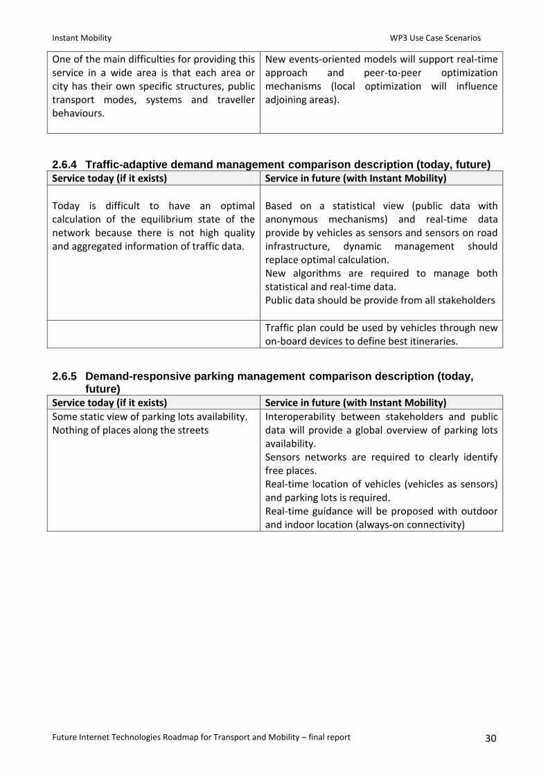
One of the main difficulties for providing this service in a wide area is that each area or city has their own specific structures, public transport modes, systems and traveller behaviours.
New events-oriented models will support real-time approach and peer-to-peer optimization mechanisms (local optimization will influence adjoining areas).
2.6.4 Traffic-adaptive demand management comparison description (today, future)
Service today (if it exists) Service in future (with Instant Mobility)
Today is difficult to have an optimal calculation of the equilibrium state of the network because there is not high quality and aggregated information of traffic data.
Based on a statistical view (public data with anonymous mechanisms) and real-time data provide by vehicles as sensors and sensors on road infrastructure, dynamic management should replace optimal calculation. New algorithms are required to manage both statistical and real-time data. Public data should be provide from all stakeholders
Traffic plan could be used by vehicles through new on-board devices to define best itineraries.
2.6.5 Demand-responsive parking management comparison description (today, future)
Service today (if it exists) Service in future (with Instant Mobility)
Some static view of parking lots availability. Nothing of places along the streets
Interoperability between stakeholders and public data will provide a global overview of parking lots availability. Sensors networks are required to clearly identify free places. Real-time location of vehicles (vehicles as sensors) and parking lots is required. Real-time guidance will be proposed with outdoor and indoor location (always-on connectivity)

Instant Mobility WP3 Use Case Scenarios
Future Internet Technologies Roadmap for Transport and Mobility – final report 31
3. Future Internet technologies: main issues for next trials
3.1 Crowdsourcing services In a world where reaching and connecting with consumers gets increasing complex every single day, Internet is driving a new trend for searching and retrieving information which is crowdsourcing.
“Crowdsourcing is a distributed problem-solving and production process that involves outsourcing tasks to a network of people, also known as the crowd. This process can occur both online and offline.”3 In the case of Transport and Mobility services, crowdsourcing will be supported by all transport resources: vehicles, drivers, travellers, road infrastructures especially using Internet of Things technologies based on sensors and actuators and all ICT technologies required for connectivity.
The required interoperability between all professional actors is the first pillar of the expected collective intelligence to complete business-related tasks that companies could usually perform but deliver only pieces of information to transport users.
The idea of soliciting travellers and drivers inputs seems not really new but the way theses services are developed today provide only from time to time few information and people are more consumer than producer of information, especially for traffic issues. If people are involved in multimedia content production, there are not providing some basic data that are relevant for transport and mobility services. This is the second pillar which requires easiness and automaticity, but always following privacy rules.
The complexity of Transport and Mobility area is represented by a fully distributed system with a very complex and extended value chain. But in the same time, Information and Communication technologies have also distributed computational resources in small components and provide a well-defined connectivity. These distributed powerful resources are the third pillar which will support Transport and Mobility crowdsourcing services.
3.2 Social Networks Internet has largely supported online social networks for which websites are commonly used. These websites are known as social sites. Social networking websites function like an online community of users. Depending on the website in question, many of these online community members share common interests in different subjects. Once you are granted access to a social networking website you can begin to socialize. This socialization may include reading the profile pages of other members and possibly even contacting them.
The friends that you can make are just one of the many benefits to social networking online. Another one of those benefits includes diversity because the internet gives individuals from all around the world access to social networking sites and their related shared contents. This means that although you are in the Italy, you could develop an online friendship with someone in Denmark or Spain. Not only will you make new friends, but you just might learn and share things about local issues.
3 http://en.wikipedia.org/wiki/Crowdsourcing

Instant Mobility WP3 Use Case Scenarios
Future Internet Technologies Roadmap for Transport and Mobility – final report 32
As mentioned, social networking often involves grouping specific individuals or organizations together but few enterprises could really take benefits from these communities of users or consumers.
While there are a number of social networking websites that focus on particular interests, there are few which are focusing on Transport and Mobility concerns. Some of them appear recently more through small applications on devices and to share a very specific need: traffic information, car-sharing… No concrete community exists to share all transportation concerns and habits.
New interfaces are available to interact easily with devices but developments are required to merge human interaction with small business process automation which could be hosted by several type of devices (personal devices, on-board devices).
3.3 From Data to information Internet is the best support today to publish and share data that everyone could provide. In the Transport area lots of types of data are available and real-time technologies will increase a lot the number of data that transport stakeholders could exploit to improve services.
There is no common format for traffic data, fleet management data, location of vehicles or people, payment data and define an interoperable standard will take lots of time.
Internet, based on cloud services, could host all these data in their respective format and new models and algorithms will be able to extract relevant information for transport area depending of the service objective.
Mapreduce4 approach splits the main problem into smaller sub-problems (map step) and then manages a solution based on the collection of answers from the sub-problems (reduce step). For the transport area, we have to consider small geographical areas as sub-problems and some dedicated fleet or traffic flows as some other sub-problems. Some populations of travelers or vehicles could also be sub-problems so stakeholders could manage some of traffic or multimodal services in a similar approach that peer-to-peer.
Mechanisms based on publish/subscribe approach will support this new model and each actors will be able to provide public data for traffic or environmental impact as well as part of potential multimodal service.
These new technologies required new computational resources to analyze and apply locally some rules and operations.
Public data modalities should be defined during trials especially to evaluate business models impact.
3.4 Security and privacy services As future services include real-time location and need to share lots of data the two main topics regarding security and privacy are:
Access right management
Anonymous mechanisms These two critical technical issues could be completed by strong mechanisms to avoid networks attack as all people and vehicles will be connected.
In a first step, Future Internet technologies will provide profiles management tools where profiles will be associated to different transport services or how people expect to use differently services
4 http://code.google.com/intl/fr/edu/parallel/mapreduce-tutorial.html

Instant Mobility WP3 Use Case Scenarios
Future Internet Technologies Roadmap for Transport and Mobility – final report 33
depending of the context. Based on this set of profiles, access rights will be managed cooperatively locally, as close as possible of the users, and in a central way for large numbers of citizen using the same type of profile. This dual approach will enable new policy rules and support some automated actions based on access right delegation.
Anonymous mechanisms is a more challenging issue especially because to manage this services close to the user ICT technologies required computational resources which are not really available today. Some technologies are available to manage anonymous mechanisms in a central way but this approach required strong network security and certified third parties.
Future Internet technologies are quite far to support repudiation services where citizen will be able to define how long the data they agree to provide will survive in the network before to disappear.

Instant Mobility WP3 Use Case Scenarios
Future Internet Technologies Roadmap for Transport and Mobility – final report 34
4. Conclusion
How can we expect to use these Future Internet technical issues for innovative application scenarios of Instant Mobility project? And what Future Internet technologies will be really usable for next trials in the following five years? Hereunder are some guidelines on how some of these problems could be solved or evolved in the next years and what are the main technical challenges which will not be available soon or need strong improvements.
It will be feasible in the next five years to build and launch services based on people as sensors, especially using smartphones as smart devices, Citizen will be part of the same social network of travelers but without strong security and privacy warranties. The future trials should demonstrate how applications managing local profiles could bring a first privacy firewall and services will be launched only following opt-in mechanisms. Trustworthy third-parties are required for trial to ensure security of data.
Based on automotive development cycle, it is difficult to expect a massive approach of “vehicle as sensors” except if new on-board devices emerge on the market. If these devices are additional devices, they should not integrate vehicle monitoring functionalities and green services as eco-driving or “pay as you drive” would not be launched based on engine characteristics and monitoring. As connectivity is always available in lots of professional fleet, especially for trucks, this type of services could appear earlier in this area.
Lots of trials manage sensors for road infrastructure but existing and envisaged technologies with short range mobile devices required lots of investment by related stakeholders. The emerging market of Machine-to-Machine using simcards could be copied for trials to decrease investment and cover larger areas. As citizens would use the same technologies, it could be useful to manage infrastructures information and travelers data through the same technology. In this case, real-time monitoring would not be feasible as 3G network latency is between 2 and 3 seconds when using data flows. But from user point of view it could be satisfactory. In the next 2 years with 4G networks deployment and native IP sessions for mobile devices, latency should decrease around 0,2 second (packet-switching) which is much more reasonable for trial.
As travelers are often moving from indoor to outdoor, especially when using metro in large cities, seamless connectivity is required to emulate always-on connectivity. Lots of trials are on-going for public wifi roaming including mesh technologies. We can expect that in the next three years, these technologies will be much more available in large cities and main multimodal areas as rail stations or airports and really provide seamless and always-on connectivity. These technologies could be also available in some open city areas but should not include seamless access to 4G networks.
Few smart devices are available on the market with computational and storage capabilities to really distribute operations to several entities. Some crowdsourcing technologies will be manageable using cloud technologies and taking benefits of on-demand resources. But, centralized data will require some algorithms which are not distributed. New approach as MapReduce should be available in five years and should encourage stakeholders to share information as they would manage their own operation and be more trustful in the whole system.
Social Networks are available today but require systematically human interfaces and are not able to manage elementary business processes or set of rules. Social networks weakness is also that access rights management tools are poor. New social networks tools will appear in the next five years to allow things to put them dynamically in an ad-hoc network and manage some operations

Instant Mobility WP3 Use Case Scenarios
Future Internet Technologies Roadmap for Transport and Mobility – final report 35
processing. These machine-oriented social networks will be monitor through human social networks to deliver automatically expected services based on an Internet of Things environment.
This type of service should be simulated for next trials.