ilrs governing board materials (april 07, 2006) · 2012-08-06 · ilrs governing board meeting...
TRANSCRIPT
ILRS Governing Board Meeting
April 07, 200612:00 - 15:00
Austria Center ViennaSplinter Meeting Room 4 Yellow Level
Vienna, Austria

ILRS Governing Board Meeting | Vienna, Austria | April 07, 2006
1
ILRS Governing Board Meeting
Austria Center Vienna
Splinter Meeting Room 4 Yellow Level
Friday, April 7, 2006 12:00 – 15:00
Agenda
1. Opening Remarks (5 min.) W. Gurtner
2. ILRS Status/Action Items (15 min.) M. Pearlman/C. Noll
3. Reports from Working Groups (5 min. each) WG Chairs
Analysis R. Noomen/G. Appleby
Data Formats and Procedures W. Seemueller
Missions H. Kunimori/P. Shelus
Networks and Engineering G. Kirchner/U. Schreiber
Signal Processing G. Appleby
Transponder Ad hoc Working Group U. Schreiber
4. New ILRS Orbit Product (5 min.) R. Noomen
5. Restricted Tracking (ICESat, ALOS) (10 min.) W. Gurtner/H. Kunimori
6. Galileo Support (5 min.) W. Gurtner
7. Laser Retroreflector Meeting Summary (5 min.) M. Pearlman
8. Laser Relativity Satellite (LARES) MOU (5 min.) W. Gurtner
9. GGOS Activities (10 min.) M. Pearlman
10. 15th International Laser Ranging Workshop (5 min.) B. Greene
11. New Business W. Gurtner/WG Chairs
12. Other Business W. Gurtner
ILRS Governing Board Meeting | Vienna, Austria | April 07, 2006
2
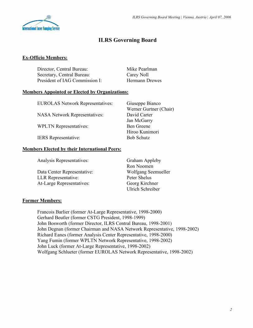
ILRS Governing Board
Ex-Officio Members:
Director, Central Bureau: Mike Pearlman Secretary, Central Bureau: Carey Noll President of IAG Commission I: Hermann Drewes
Members Appointed or Elected by Organizations:
EUROLAS Network Representatives: Giuseppe Bianco Werner Gurtner (Chair)
NASA Network Representatives: David Carter Jan McGarry
WPLTN Representatives: Ben Greene Hiroo Kunimori
IERS Representative: Bob Schutz Members Elected by their International Peers:
Analysis Representatives: Graham Appleby Ron Noomen
Data Center Representative: Wolfgang Seemueller LLR Representative: Peter Shelus At-Large Representatives: Georg Kirchner
Ulrich Schreiber Former Members:
Francois Barlier (former At-Large Representative, 1998-2000) Gerhard Beutler (former CSTG President, 1998-1999) John Bosworth (former Director, ILRS Central Bureau, 1998-2001) John Degnan (former Chairman and NASA Network Representative, 1998-2002) Richard Eanes (former Analysis Center Representative, 1998-2000) Yang Fumin (former WPLTN Network Representative, 1998-2002) John Luck (former At-Large Representative, 1998-2002) Wolfgang Schlueter (former EUROLAS Network Representative, 1998-2002)
ILRS Governing Board Meeting | Vienna, Austria | April 07, 2006
3
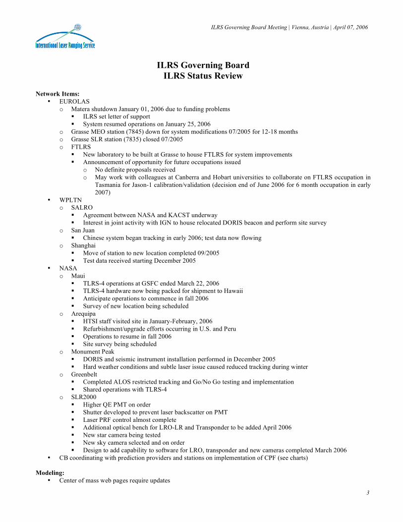
ILRS Governing Board
ILRS Status Review Network Items:
• EUROLAS o Matera shutdown January 01, 2006 due to funding problems
ILRS set letter of support System resumed operations on January 25, 2006
o Grasse MEO station (7845) down for system modifications 07/2005 for 12-18 months o Grasse SLR station (7835) closed 07/2005 o FTLRS
New laboratory to be built at Grasse to house FTLRS for system improvements Announcement of opportunity for future occupations issued
o No definite proposals received o May work with colleagues at Canberra and Hobart universities to collaborate on FTLRS occupation in
Tasmania for Jason-1 calibration/validation (decision end of June 2006 for 6 month occupation in early 2007)
• WPLTN o SALRO
Agreement between NASA and KACST underway Interest in joint activity with IGN to house relocated DORIS beacon and perform site survey
o San Juan Chinese system began tracking in early 2006; test data now flowing
o Shanghai Move of station to new location completed 09/2005 Test data received starting December 2005
• NASA o Maui
TLRS-4 operations at GSFC ended March 22, 2006 TLRS-4 hardware now being packed for shipment to Hawaii Anticipate operations to commence in fall 2006 Survey of new location being scheduled
o Arequipa HTSI staff visited site in January-February, 2006 Refurbishment/upgrade efforts occurring in U.S. and Peru Operations to resume in fall 2006 Site survey being scheduled
o Monument Peak DORIS and seismic instrument installation performed in December 2005 Hard weather conditions and subtle laser issue caused reduced tracking during winter
o Greenbelt Completed ALOS restricted tracking and Go/No Go testing and implementation Shared operations with TLRS-4
o SLR2000 Higher QE PMT on order Shutter developed to prevent laser backscatter on PMT Laser PRF control almost complete Additional optical bench for LRO-LR and Transponder to be added April 2006 New star camera being tested New sky camera selected and on order Design to add capability to software for LRO, transponder and new cameras completed March 2006
• CB coordinating with prediction providers and stations on implementation of CPF (see charts) Modeling:
• Center of mass web pages require updates

ILRS Governing Board Meeting | Vienna, Austria | April 07, 2006
4
ILRS Status Review
(continued) Analysis and Data Issues:
• Benchmark evaluation on GA and GRGS solutions underway; acceptance imminent • All reports from CDDIS issue quantity values in passes (not pass segments) and minutes of data (normal points times
bin size) • Update of data archives with older data (BE-B, -C, GEOS-1, -2, -3, PEOLE, DIADEM-1C, -1D) underway • Update of eccentricity files with new data from ITRF underway
Mission Items:
• TOPEX o Satellite maneuvering failure in October 2005 o SLR tracking ceased as of December 2005
• Cryosat o Launch failure on October 8, 2005
• ALOS o Launch on January 24, 2006; tracking to commence 90 days after launch o Restricted tracking test conducted 02/27-03/03/2006 on Ajisai for individual stations by JAXA
Participants: Mt. Stromlo, Zimmerwald, Herstmonceux, Riga, Koganei, Simosato, Greenbelt, Hartebeesthoek, Monument Peak, Yarragadee
• Galileo o GIOVE-A (GSTB v2/A) launched December 26, 2005 o GIOVE-B (GSTB v2/B) launch scheduled for April 16, 2006 o Prediction generation process being implemented by ESA (both TIRV and CPF) o Tentative 3-week tracking campaign on GIOVE-A scheduled to commence on April 24, 2006
• GPS satellites o Dialog with various agencies continues on reflectors on GPS-III satellites o Study underway at GSFC on hollow cube technology; D. Arnold working on array performance studies o INFN-LNF (Istituto Nazionale di Fisica Nucleare-Laboratori Nazionali di Frascati) in Italy also planning to test
hollow cubes o Meeting on retroreflector array issues held April 6, 2006
• GP-B o Liquid helium nearly depleted o SLR tracking to continue until June 1, 2006
• ANDE o Tracking request approved by Governing Board February 2006 o Launch from Space Shuttle, earliest would be mission 3 after return to flight (2006+)
• OICETS o Tracking request approved by Governing Board February 2006 o Launched August 23, 2005 o Start of SLR tracking soon
• MicroSCOPE o Tracking request approved by Governing Board March 2006 o Launch planned for March 2009 o Additional information on retroreflector array design needed
Reports:
• ILRS 2003-2004 annual report printed and distributed; online version available on ILRS Web site • Proceedings from 14th International Workshop on Laser Ranging in San Fernando printed and distributed; final
versions available on ILRS Web site • All 2005 ILRS station report cards issued by SGT

ILRS Governing Board Meeting | Vienna, Austria | April 07, 2006
5
ILRS Status Review
(continued) Site Surveys:
• Analysis of survey data from Hawaii, Arequipa, and GSFC in process • Closeout survey of Haleakala performed by HTSI in late 2004; analysis underway • South African survey report completed by IGN • Shanghai survey report in process • IERS Co-Location Working Group Meeting to be held at EGU on April 7, 2006
ILRS Web Site:
• New versions of report card charts developed and available through ILRS Web site (linked to report cards); example shown here
• New plots of station performance now fully integrated into ILRS Web site structure (under Stations and linked to report cards); examples shown here o Station performance charts since last year and since 2000
• Plot of groundtrack of last seven days of geodetic satellite data available and updated daily (under Stations and What’s New)
• Began prototype of new ILRS Satellite section; design shown here Meetings:
• EGU 2006, Vienna Austria: o April 4: ILRS AWG meeting o April 4: GGOS Steering Committee meeting o April 5: ILRS DFPWG meeting o April 5: IERS combination product meeting o April 6: GPS retroreflector array meeting o April 6: GGOS Ground Networks and Communication Working Group o April 7: ILRS MWG meeting o April 7: ILRS GB meeting o April 7: IERS WG on Co-Location meeting
• May 8-12, 2006: IGS Workshop in Darmstadt, Germany • May 23-26, 2006: 2006 Joint Assembly, Baltimore MD, USA • October 8-9, 2006: GGOS Workshop, Munich Germany • October 9-13, 2006: IAG Symposium on Geodetic Reference Frames, Munich, Germany • October 16-20, 2006: 15th International Workshop on Laser Ranging, Canberra, Australia • December 11-15, 2006: Fall AGU in San Francisco, CA • April 15-20, 2007: EGU, Vienna Austria • July 2-13, 2007: IUGG General Assembly, Perugia, Italy
Other Items:
• GGOS o Ground Networks and Communications Working Group is actively working on network designs o Network design simulations started; status report given at GN&C WG meeting held on April 5, 2006 at EGU
• INDIGO o User assessment performed to identify existing commonalities and opportunities in the IAG services (IGS, ILRS,
IVS) o Survey of IAG service central bureaus and Web sites performed o Need AC “logs” for ILRS analysis centers to document analysis strategies, techniques, models, parameters o Web site established http://indigo.nasa.gov
ILRS Governing Board Meeting | Vienna, Austria | April 07, 2006
6
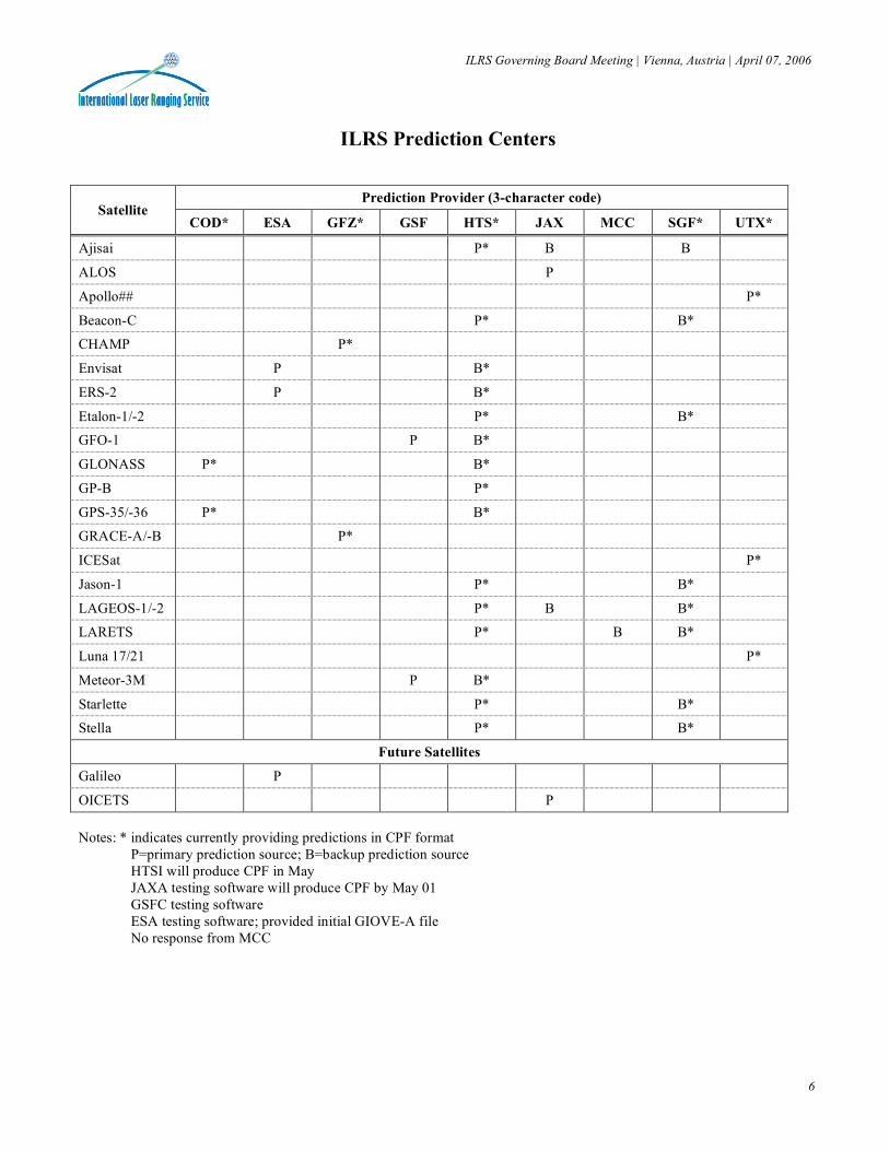
ILRS Prediction Centers
Prediction Provider (3-character code) Satellite
COD* ESA GFZ* GSF HTS* JAX MCC SGF* UTX*
Ajisai P* B B
ALOS P
Apollo## P*
Beacon-C P* B*
CHAMP P*
Envisat P B*
ERS-2 P B*
Etalon-1/-2 P* B*
GFO-1 P B*
GLONASS P* B*
GP-B P*
GPS-35/-36 P* B*
GRACE-A/-B P*
ICESat P*
Jason-1 P* B*
LAGEOS-1/-2 P* B B*
LARETS P* B B*
Luna 17/21 P*
Meteor-3M P B*
Starlette P* B*
Stella P* B*
Future Satellites
Galileo P
OICETS P Notes: * indicates currently providing predictions in CPF format P=primary prediction source; B=backup prediction source HTSI will produce CPF in May JAXA testing software will produce CPF by May 01 GSFC testing software ESA testing software; provided initial GIOVE-A file No response from MCC
ILRS Governing Board Meeting | Vienna, Austria | April 07, 2006
7
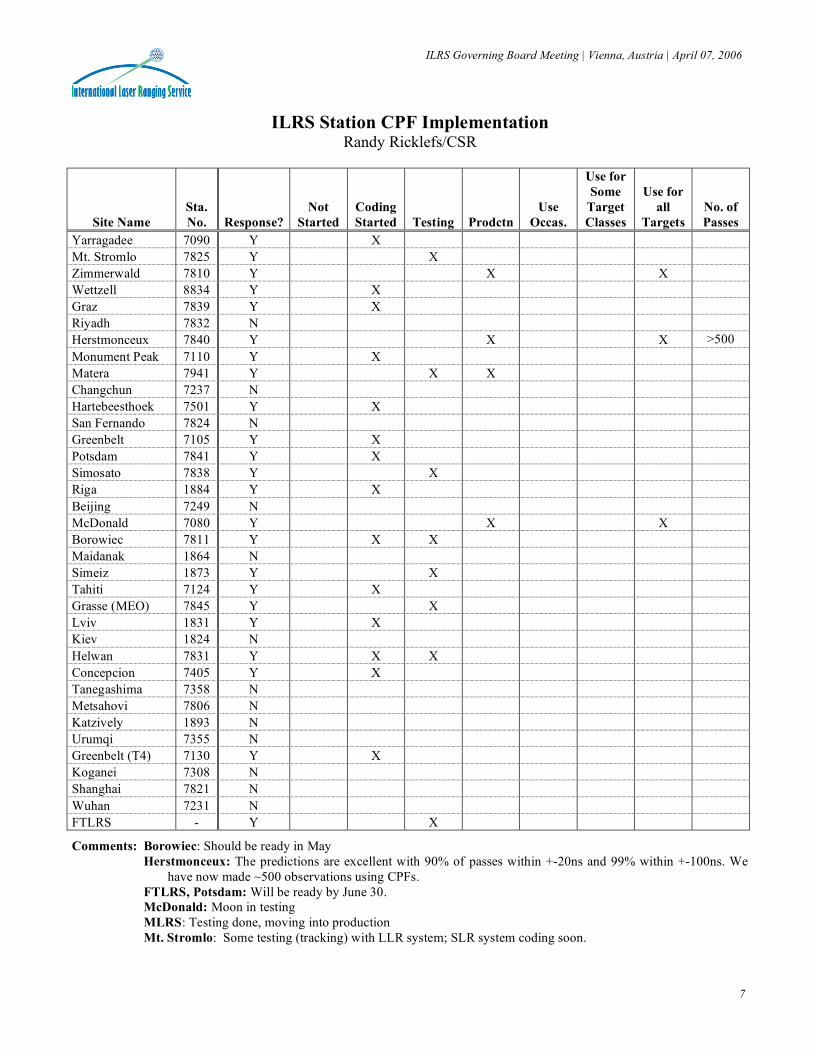
ILRS Station CPF Implementation Randy Ricklefs/CSR
Site Name Sta. No. Response?
Not Started
Coding Started Testing Prodctn
Use Occas.
Use for Some
Target Classes
Use for all
Targets No. of Passes
Yarragadee 7090 Y X Mt. Stromlo 7825 Y X Zimmerwald 7810 Y X X Wettzell 8834 Y X Graz 7839 Y X Riyadh 7832 N Herstmonceux 7840 Y X X >500 Monument Peak 7110 Y X Matera 7941 Y X X Changchun 7237 N Hartebeesthoek 7501 Y X San Fernando 7824 N Greenbelt 7105 Y X Potsdam 7841 Y X Simosato 7838 Y X Riga 1884 Y X Beijing 7249 N McDonald 7080 Y X X Borowiec 7811 Y X X Maidanak 1864 N Simeiz 1873 Y X Tahiti 7124 Y X Grasse (MEO) 7845 Y X Lviv 1831 Y X Kiev 1824 N Helwan 7831 Y X X Concepcion 7405 Y X Tanegashima 7358 N Metsahovi 7806 N Katzively 1893 N Urumqi 7355 N Greenbelt (T4) 7130 Y X Koganei 7308 N Shanghai 7821 N Wuhan 7231 N FTLRS - Y X
Comments: Borowiec: Should be ready in May Herstmonceux: The predictions are excellent with 90% of passes within +-20ns and 99% within +-100ns. We
have now made ~500 observations using CPFs. FTLRS, Potsdam: Will be ready by June 30. McDonald: Moon in testing MLRS: Testing done, moving into production Mt. Stromlo: Some testing (tracking) with LLR system; SLR system coding soon.
ILRS Governing Board Meeting | Vienna, Austria | April 07, 2006
8
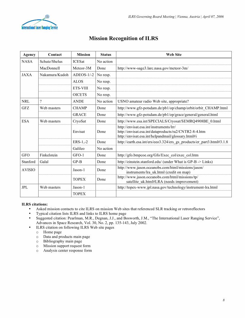
Mission Recognition of ILRS
Agency Contact Mission Status Web Site
NASA Schutz/Shelus ICESat No action
MacDonnell Meteor-3M Done http://www-sage3.larc.nasa.gov/meteor-3m/
JAXA Nakamura/Kudoh ADEOS-1/-2 No resp.
ALOS No resp.
ETS-VIII No resp.
OICETS No resp.
NRL ? ANDE No action USNO amateur radio Web site, appropriate?
GFZ Web masters CHAMP Done http://www.gfz-potsdam.de/pb1/op/champ/orbit/orbit_CHAMP.html
GRACE Done http://www.gfz-potsdam.de/pb1/op/grace/general/general.html
ESA Web masters CryoSat Done http://www.esa.int/SPECIALS/Cryosat/SEMRQ4908BE_0.html
Envisat Done http://envisat.esa.int/instruments/lrr/ http://envisat.esa.int/dataproducts/ra2/CNTR2-8-4.htm http://envisat.esa.int/helpandmail/glossary.html#i
ERS-1,-2 Done http://earth.esa.int/ers/eeo3.324/ers_gs_products/er_part3.html#3.1.8
Galileo No action
GFO Finkelstein GFO-1 Done http://gfo.bmpcoe.org/Gfo/Exec_col/exec_col.htm
Stanford Galal GP-B Done http://einstein.stanford.edu/ (under What is GP-B -> Links)
AVISIO Jason-1 Done http://www.jason.oceanobs.com/html/missions/jason/ instruments/lra_uk.html (credit on map)
TOPEX Done http://www.jason.oceanobs.com/html/missions/tp/ satellite_uk.html#LRA (needs improvement)
JPL Web masters Jason-1 http://topex-www.jpl.nasa.gov/technology/instrument-lra.html
TOPEX ILRS citations:
• Asked mission contacts to cite ILRS on mission Web sites that referenced SLR tracking or retroreflectors • Typical citation lists ILRS and links to ILRS home page • Suggested citation: Pearlman, M.R., Degnan, J.J., and Bosworth, J.M., “The International Laser Ranging Service”,
Advances in Space Research, Vol. 30, No. 2, pp. 135-143, July 2002. • ILRS citation on following ILRS Web site pages
o Home page o Data and products main page o Bibliography main page o Mission support request form o Analysis center response form
ILRS Governing Board Meeting | Vienna, Austria | April 07, 2006
9
ILRS Governing Board Meeting Remaining Action Items
EGU, Vienna Austria (April 26, 2005): 1. CB will contact the IAG Outreach to suggest that the IAG make its participants aware of the issue of service recognition
issue in publications, papers, reports, and presentations. • Developed similar citation format for posting on service Web sites; added citation to ILRS homepage; IGS and IVS
have similar wording on their Web sites. (Done) • IGS, IVS, ILRS, and IDS continue work a joint activity to:
o Jointly request that the IAG take positive action (Web site notice, messages to the community, etc) to activate its community;
o Consider contacting relevant journals and journal referees to help enforce this citation. 2. CB will check if the local ties have been measured for the Riyadh and Changchun SLR stations.
• Noll contacted both stations in January and September 2005 • Changchun reports plans made but no survey yet • Survey activity under consideration in Riyadh in conjunction with a possible DORIS installation
3. CB should browse all existing mission Web sites and search for references to the service and information about the role of SLR for the mission; if not found, have webmasters add it. • Webmasters contacted; summary of results provided separately here
4. A subgroup of technology and science representatives should write a white paper on the future vision for SLR. (assigned 04/2005) • See ILRS poster and paper presented at IAG meeting, Cairns 08/2005
5. Bianco should make sure Pavlis has looked at the MLRO two-color data. (assigned 04/2005) 6. Appleby will provide station signal strength regimes to the CB for placement in the site logs with perhaps a separate table
automatically updated/extracted and linked to the CoM pages on the ILRS Web site. The information is not in the site log now so the format will have to be modified. (assigned 04/2005)
7. An ILRS orbit product committee should be formed and develop a plan for the new product (Noomen). (assigned 04/2005)
8. Review data analysis/station feedback capabilities within the ILRS. • Gurtner will look at the existing list of data problems (previously maintained by V. Husson) on the ILRS Web site
and see if the webpage can be re-activated and updated on a regular basis. • A committee will be formed to work on the specifications and needs for a “Call for Proposal” to handle data analysis
and feedback (Gurtner, Pearlman, Noomen). (assigned 04/2005) 9. ALOS issues:
• JAXA will prepare a station test plan for review by the CB. (assigned 04/2005) • JAXA is managing station qualification activity
Eastbourne UK (October 10, 2005): 1. Examine the issue of the internal SLR reference frame. (Noomen) (assigned 11/2005) 2. Examine the eccentricity files to see if they could serve as a source for the list of key information. (Noomen) (assigned
11/2005) 3. CB will contact both the Prediction Centers and the Stations to begin the Consolidated Prediction Format (CPF) process.
(assigned 11/2005) (Done) o Message sent to prediction providers (12/7/2005)
• CPF predictions now provided by UTX, CODE, NSGF, HTSI, GFZ • GSFC currently working on format • Received no feedback from MCC, ESA, JAXA
o Message sent to stations (12/9/2005) 4. Gurtner will write a letter to Hiroo Kunimori to ascertain the ALOS status and planned procedures. (assigned 11/2005)
(Done) o JAXA contacted stations directly to arrange and validate tracking procedures o JAXA conducted test campaign 02/27-03/03/2006
5. Pearlman will circulate a copy of VLBI 2010 to the GB members. (assigned 11/2005; done 12/2005) 6. Consolidate the presentations to AUSLIG into a 1 hour talk (assigned 11/2005)
ILRS Governing Board Meeting | Vienna, Austria | April 07, 2006
10
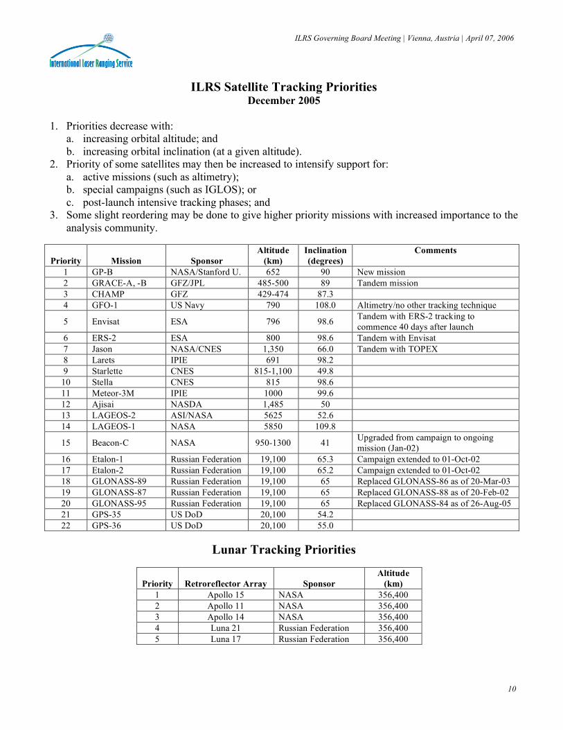
ILRS Satellite Tracking Priorities
December 2005 1. Priorities decrease with:
a. increasing orbital altitude; and b. increasing orbital inclination (at a given altitude).
2. Priority of some satellites may then be increased to intensify support for: a. active missions (such as altimetry); b. special campaigns (such as IGLOS); or c. post-launch intensive tracking phases; and
3. Some slight reordering may be done to give higher priority missions with increased importance to the analysis community.
Priority
Mission
Sponsor Altitude
(km) Inclination (degrees)
Comments
1 GP-B NASA/Stanford U. 652 90 New mission 2 GRACE-A, -B GFZ/JPL 485-500 89 Tandem mission 3 CHAMP GFZ 429-474 87.3 4 GFO-1 US Navy 790 108.0 Altimetry/no other tracking technique
5 Envisat ESA 796 98.6 Tandem with ERS-2 tracking to commence 40 days after launch
6 ERS-2 ESA 800 98.6 Tandem with Envisat 7 Jason NASA/CNES 1,350 66.0 Tandem with TOPEX 8 Larets IPIE 691 98.2 9 Starlette CNES 815-1,100 49.8 10 Stella CNES 815 98.6 11 Meteor-3M IPIE 1000 99.6 12 Ajisai NASDA 1,485 50 13 LAGEOS-2 ASI/NASA 5625 52.6 14 LAGEOS-1 NASA 5850 109.8
15 Beacon-C NASA 950-1300 41 Upgraded from campaign to ongoing mission (Jan-02)
16 Etalon-1 Russian Federation 19,100 65.3 Campaign extended to 01-Oct-02 17 Etalon-2 Russian Federation 19,100 65.2 Campaign extended to 01-Oct-02 18 GLONASS-89 Russian Federation 19,100 65 Replaced GLONASS-86 as of 20-Mar-03 19 GLONASS-87 Russian Federation 19,100 65 Replaced GLONASS-88 as of 20-Feb-02 20 GLONASS-95 Russian Federation 19,100 65 Replaced GLONASS-84 as of 26-Aug-05 21 GPS-35 US DoD 20,100 54.2 22 GPS-36 US DoD 20,100 55.0
Lunar Tracking Priorities
Priority
Retroreflector Array
Sponsor Altitude
(km) 1 Apollo 15 NASA 356,400 2 Apollo 11 NASA 356,400 3 Apollo 14 NASA 356,400 4 Luna 21 Russian Federation 356,400 5 Luna 17 Russian Federation 356,400

Tahiti
Arequipa
San Juan
Greenbelt
McDonaldMonument Peak
Haleakala
Herstmonceux
Riyadh
Helwan
Riga
San Fernando Matera
Potsdam
GrazGrasse
Zimmerwald
Mendeleevo
Kiev
Simeiz
KatzivelyMaidanak
Borowiec
KunmingWuhan
ShanghaiSimosato
Koganei
Komsomolsk
Beijing
YarragadeeMt. Stromlo
Changchun
INTERNATIONAL LASER RANGING SERVICE (ILRS) NETWORK IN 2005 Q4
Hartebeesthoek
09/15/2005
Metsahovi
120°105°90° 165°150°135°75°60°45°30°15°0°-15°-30°-45°-60°-75°-90°-105°-120°-135°-150°-165°
0°
30°
45°
60°
75°
-15°
-30°
-45°
-60°
-75°
15°
Concepción
Stafford
Lviv
Tanegashima
Urumqi
ILRS system in 2005Operational system in 2005 Q4Colocated GPS receiverNew ILRS system in 2006ILRS system no longer contributing since 2005Prospective Laser SystemMobile Systems: FTLRS (France) TROS (China)
Wettzell
Ajaccio
*
* *
*
*
**
* *
*
**
**
**
* *
*
**
**
**
**
*
*
***
**
**
*Wrightwood

ILRS Governing Board Meeting | Vienna, Austria | April 07, 2006
12
ILRS Quarterly Report Card (Table 1a, 01/01/2005-12/31/2005)
ILRS Governing Board Meeting | Vienna, Austria | April 07, 2006
13
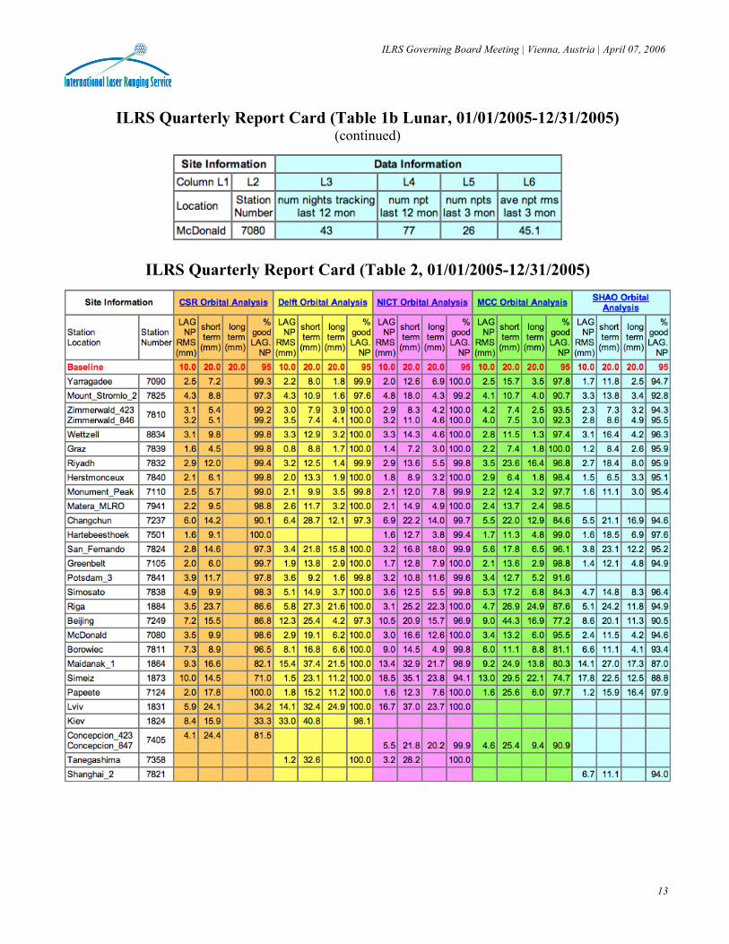
ILRS Quarterly Report Card (Table 1b Lunar, 01/01/2005-12/31/2005)
(continued)
ILRS Quarterly Report Card (Table 2, 01/01/2005-12/31/2005)

ILRS Quarterly Report Card Charts (01/01/2005-12/31/2005)
Number of Passes:
Normal Point Yield:
Minutes of Data and Data Quality:

ILRS Governing Board Meeting | Vienna, Austria | April 07, 2006
15
Total Passes by Satellite (01/01-12/31/2005)
Total Passes by Station (01/01-12/31/2005)

ILRS Governing Board Meeting | Vienna, Austria | April 07, 2006
16
Groundtrack of Last Seven Days of Geodetic Satellite Data

ILRS Station Performance Charts
RMS (past year) RMS (since 2000) Calibration RMS (past year) Calibration RMS (since 2000)
System Delay (past year) System Delay Observations per Normal Point
(past year) Observations per Normal Point
(since 2000)
Full-Rate Observations per Pass
(past year) Full-Rate Observations per Pass
(since 2000)

ILRS Station Meteorological Data Charts
Temperature (past year) Temperature (since 2000) Humidity (past year) Humidity (since 2000)
Pressure (past year) Pressure (since 2000)
ILRS Governing Board Meeting | Vienna, Austria | April 07, 2006
19
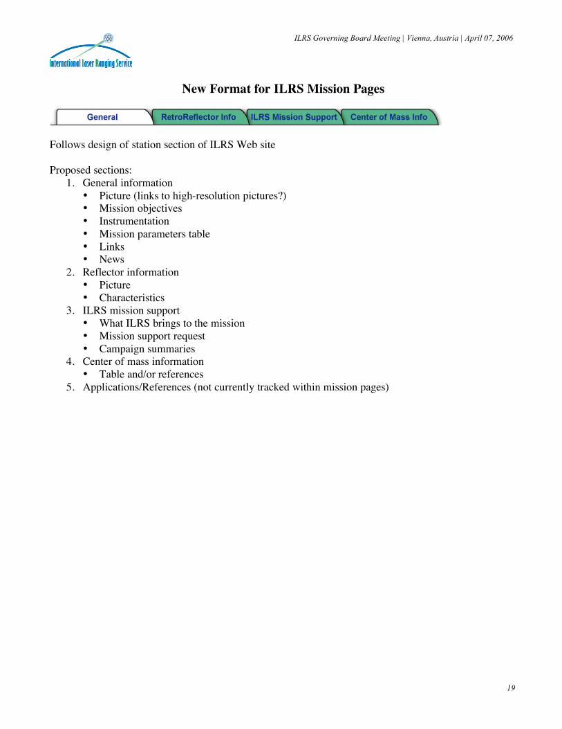
New Format for ILRS Mission Pages
Follows design of station section of ILRS Web site Proposed sections:
1. General information • Picture (links to high-resolution pictures?) • Mission objectives • Instrumentation • Mission parameters table • Links • News
2. Reflector information • Picture • Characteristics
3. ILRS mission support • What ILRS brings to the mission • Mission support request • Campaign summaries
4. Center of mass information • Table and/or references
5. Applications/References (not currently tracked within mission pages)

ILRS Governing Board Meeting | Vienna, Austria | April 07, 2006
20
Global Geodetic Observing System (GGOS)
Ground Networks and Communications Working Group
Status Update - April 2006 Mike Pearlman/CfA
Goals and Objectives The Ground Networks and Communications Working Group is working toward the implementation of properly designed and structured ground-based geodetic networks to materialize the reference systems to support sub-mm global change measurements over space, time and evolving technologies. The WG is working with the IAG measurement services (the IGS, ILRS, IVS, IDS and IGFS) to develop a strategy for building, integrating, and maintaining the fundamental network of instruments and supporting infrastructure in a sustainable way to satisfy the long-term (10-20 year) requirements identified by the GGOS Science Council. At the moment, the Working Group is examining options for 1 mm and 0.1 mm/yr reference frame stabilities. Activities Planned and Underway Activities of the Working Group include the investigation of the status quo and the development of a plan for full network integration to support improvements in terrestrial reference frame establishment and maintenance, Earth orientation and gravity field monitoring, precision orbit determination, local deformation monitoring, and other geodetic and gravimetric applications required for the long-term observation of global change. This integration process includes the development of a network of fundamental stations with as many colocated techniques as possible, with precisely determined intersystem vectors. This network would exploit the strengths of each technique and minimize the weaknesses where possible. The final design of the GGOS network must take into consideration all of the applications including the geometric and gravimetric reference frames, EOP, POD, geophysics, oceanography, etc. We will first consider the TRF, since its accuracy influences all other GGOS products. Early steps in the process are:
1. Define the critical contributions that each technique provides to the TRF, POD, EOP, etc; 2. Characterize the improvements that could be anticipated over the next ten years with each technique; 3. Understand the present error sources for each technique (instrument and modeling) and how these errors sources
propagate into the analysis products; 4. Using simulation techniques, quantify the improvement in the TRF, Earth orientation and other key products as
stations are added and station capabilities (co-location, data quantity and quality) are improved; The Working Group is assuming that the GNSS and the DORIS Networks will be at least as robust as they are presently and that planned upgrades in the ground systems and the satellites will come to fruition. Some augmentation is also assumed where the present networks would be significantly enhanced with additional stations. SLR and VLBI are presently investigating the size and density of the networks that will be required to satisfy their individual requirements. We are still in the process of integrating the role of gravity field measurements within the context of the integrated network. In a next step, we will examine the current infrastructure in-place, for the analysis of the network-collected data, investigate their adequacy to meet the envisioned future network realizations and the product quality and latency vis-à-vis the GGOS goals, and suggest appropriate actions.

ILRS Governing Board Meeting | Vienna, Austria | April 07, 2006
21
Global Geodetic Observing System (GGOS)
Ground Networks and Communications Working Group Status Update - April 2006
(continued) Related to the above, is the question of data and product communications. This needs to be examined once we have a firm idea of the networks of the next decade and the product availability requirements. Our detailed investigation will ensure that the data will reach the analysis centers with minimal delays, and the products will be expeditiously disseminated to the public and the users. In addition to these questions, we will examine the need and possible improvements of communication links between geodetic and other GEOSS-related networks, e.g. oceanographic, atmospheric, seismic, etc., to make sure that data and results from each of these can be made available to all users with minimal effort and delays. A preliminary discussion of items 1 and 2 above is included in our Poster paper from the IAG Cairns meeting: M. Pearlman, et al, “GGOS Working Group on Networks, Communication, and Infrastructure” (http://cddis.gsfc.nasa.gov/docs/GGOS_IAG_0508.pdf) Meetings During 2005, the Working Group met at EGU in April, IAG in August, and AGU in December. The next meeting is scheduled for EGU on April 6, 2006. The progress of the SLR and VLBI simulations will be reviewed along with the long term plans for the GNSS and DORIS networks, and the role and scope of the gravity field and tide gauge measurements in the integrated network. The agenda for the meeting is attached. Member List of the Working Group • IGS: Angelyn Moore, Norman Beck • ILRS: Mike Pearlman, Werner Gurtner • IVS: Chopo Ma, Zinovy Malkin • IDS: Pascal Willis • IGFS: Rene Forsberg, Steve Kenyon • ITRF and Local Survey: Zuheir Altamimi, Jinling Li • IERS Technique Combination Research Centers: Marcus Rothacher • IAS (future International Altimetry Service): Wolfgang Bosch • Data Centers: Carey Noll • Data Analysis: Erricos Pavlis, Frank Lemoine, Frank Webb, John Ries, Dirk Behrend

ILRS Governing Board Meeting | Vienna, Austria | April 07, 2006
22
Global Geodetic Observing System (GGOS)
Ground Networks and Communications Working Group Meeting
Austria Center Vienna, Room SM3 April 6, 2006, 17:30 – 20:00
Agenda
Review of Working Group Charter Status of Network Satellite Laser Ranging
• What should the technology and infrastructure look like in 10 years? • What TRF requirements does the technique satisfy? • What network is required to satisfy the TRF requirements?
Very Long Baseline Interferometry
• What should the technology and infrastructure look like in 10 years? • What TRF requirements does the technique satisfy? • What network is required to satisfy the TRF requirements?
GNSS
• What should the technology and infrastructure look like in 10 years? • What TRF requirements does the technique satisfy? • What changes in the network are anticipated over the next 10 years?
DORIS
• What should the technology and infrastructure look like in 10 years? • What TRF requirements does the technique satisfy? • What changes in the network are anticipated the next 10 years?
Gravity Field
• What type of gravity data are available now, where and with what coverage (spatial+temporal)? • Who controls the data archival and dissemination? • Which data level is freely available, L0, L1, L2,... define what these levels of processing. • Which gravity-measuring efforts are in-place and how and who runs them? • What do the current permanent gravity networks look like now
(describe all types)? • How many absolute gravimeters are there, who owns them and controls them, what are the end-product, and what is
the deployment plan? • How many super-conducting gravimeters are there, who owns them and controls them, what are the end-product, and
what is (if any) the enhancement/expansion plan? • How best could we incorporate these gravity networks into our overall activity on a "Global Geodetic Observing
System" network design? • What are expected to be the future requirements and how did you arrive at these? • Describe on-going or planned, global and regional programs for each type of gravity measurements: surface,
airborne, shipborne, space missions. • Should all fiducial reference geodetic observatories have a gravimeter or a program of gravimeter occupations at
regular intervals? • What is the mechanism (if any) that coordinates gravity measuring campaigns of any type, and how and who initiates
them?
ILRS Governing Board Meeting | Vienna, Austria | April 07, 2006
23
Global Geodetic Observing System (GGOS)
Ground Networks and Communications Working Group Meeting
Austria Center Vienna, Room SM3 April 6, 2006, 17:30 – 20:00
Agenda
(continued)
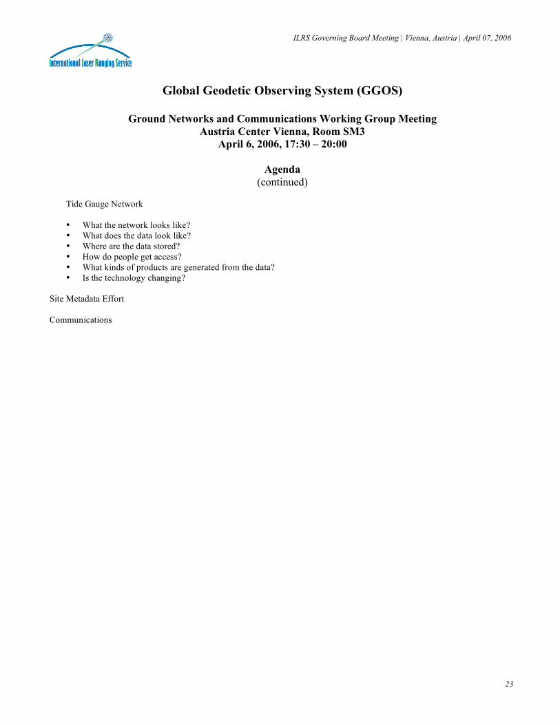
Tide Gauge Network • What the network looks like? • What does the data look like? • Where are the data stored? • How do people get access? • What kinds of products are generated from the data? • Is the technology changing?
Site Metadata Effort Communications