il power portfolio 2015 - planetek italia · il power portfolio 2015 026-610-0. 2 ... easy to start...
TRANSCRIPT

Il Power Portfolio 2015
Pk
m0
26-6
10-1
.0

2
The Geospatial Power Portfolio

3
Capture Process Share Deliver
Making Sense of the Dynamically Changing World
Complete coverage of the geospatial information life cycle
Photogrammetry GIS
Remote Sensing
Data Management
Compression
Data Publishing
and Streaming
Desktop
Web
Smart Client
Mobile

4
PRODUCER SUITE:
ERDAS IMAGINE
GeoMedia
5
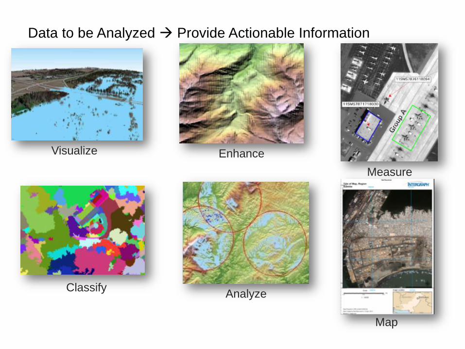
Data to be Analyzed Provide Actionable Information
Analyze
Measure
Enhance
Map
Visualize
Classify

6
Aerial imagery
Point Cloud
Vector
Radar
Satellite Hyperspectral
Thermal Elevation
Variety of raw data Intelligent Data

7
Point Clouds

ERDAS Imagine
9
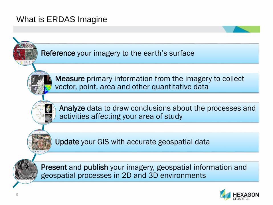
What is ERDAS Imagine
Reference your imagery to the earth’s surface
Measure primary information from the imagery to collect vector, point, area and other quantitative data
Analyze data to draw conclusions about the processes and activities affecting your area of study
Update your GIS with accurate geospatial data
Present and publish your imagery, geospatial information and geospatial processes in 2D and 3D environments

10
ERDAS IMAGINE and IMAGINE Photogrammetry Overview
• A powerful authoring platform to turn your geospatial data into actionable
information. A proven leader in Remote Sensing, Photogrammetry, Radar &
Point Cloud Analysis.

11
What’s New in IMAGINE Photogrammetry
• From Satellite Stereo Pair to 3D Point Cloud
• DEM Editing performance enhancements
• ORIMA and Pro600 improvements

12
Spatial Modeler SDK
• With IMAGINE 2015 we’ve made it easier for ourselves and 3rd parties to
extend IMAGINE into new markets and new applications.

13
What’s new in Spatial Modeler
• Dozens of new operators, including Image Chain LUT manipulation and
Object Based operators, Point Cloud Volume Operators and Atmospheric
Correction and Radar Operators
• Model Execution now In IMAGINE Essentials

14
What’s new in Point Cloud Suite
• Volumetrics interactive, in Spatial Modeler
• Point Cloud Compression and Streaming from the Cloud
• Point Cloud Reproject
15
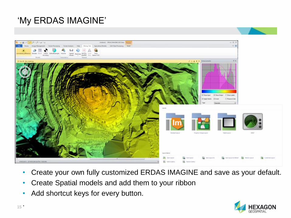
‘My ERDAS IMAGINE’
• Create your own fully customized ERDAS IMAGINE and save as your default.
• Create Spatial models and add them to your ribbon
• Add shortcut keys for every button.
.

16
Zonal Change Detection
• Optimized Object Based Parcel Change Detection
• Simple workflow for setting up and running change detection
• Streamlined Quality Review process Includes Reporting
17
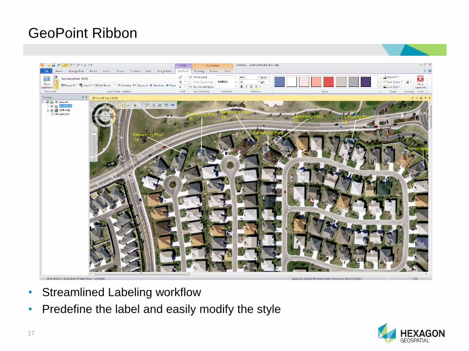
GeoPoint Ribbon
• Streamlined Labeling workflow
• Predefine the label and easily modify the style

18
Hexagon Content Connection
• Connect to Hexagon WMS Content and use as a Basemap.
• Tree View of Service Layers in Contents Window

19
Image Chain
• Preview and open Raster as an Image Chain (Spatial Model)
• Seamlessly switch between, MS, Pan, Relief, Pseudo color and Thematic
• Emulates ER Mapper real-time enhancement to find subtle nuances in the data
GeoMedia
22
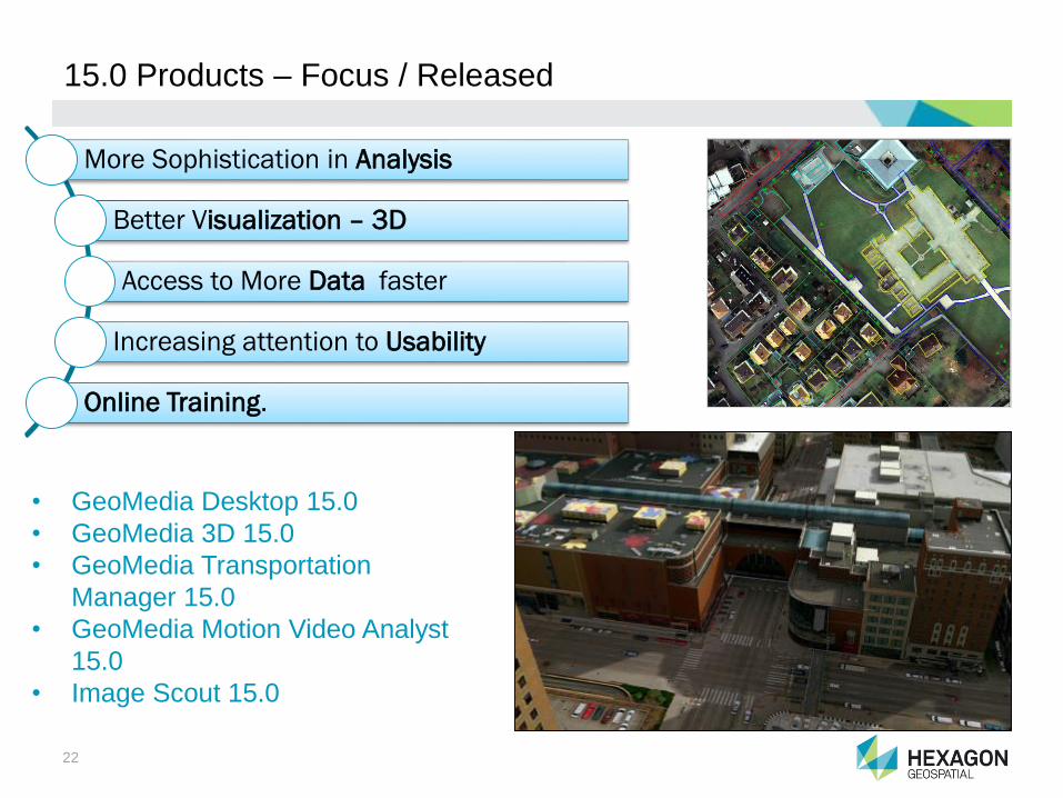
15.0 Products – Focus / Released
• GeoMedia Desktop 15.0
• GeoMedia 3D 15.0
• GeoMedia Transportation
Manager 15.0
• GeoMedia Motion Video Analyst
15.0
• Image Scout 15.0
More Sophistication in Analysis
Better Visualization – 3D
Access to More Data faster
Increasing attention to Usability
Online Training.

23
GeoMedia Overview
• Comprehensive, dynamic GIS
• Extracts maximum value from geospatial data
• Integrating it to present clear, actionable information.
Screenshot
24
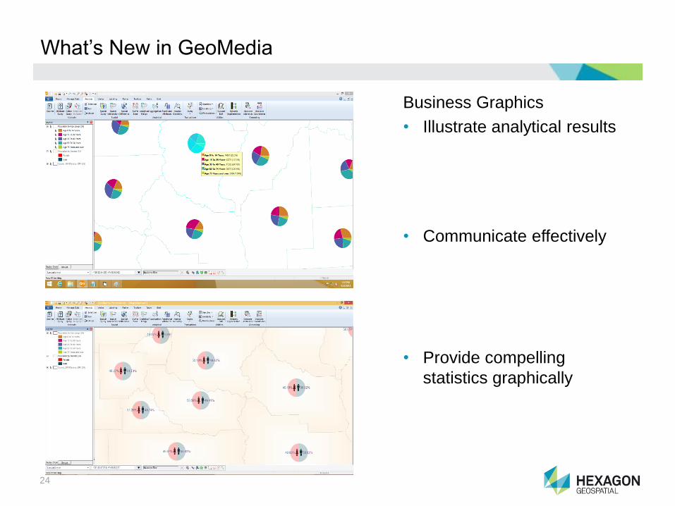
What’s New in GeoMedia
Business Graphics
• Illustrate analytical results
• Communicate effectively
• Provide compelling
statistics graphically

25
Labeling
Picture
What’s New in GeoMedia
Usability Improvements
• Labeling Reuse
• Rigorous Re-Projection
• Better Table interface (Data
View)
• Improved ERDAS APOLLO
interface
• Easier Navigation
26
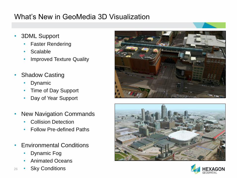
What’s New in GeoMedia 3D Visualization
• 3DML Support
• Faster Rendering
• Scalable
• Improved Texture Quality
• Shadow Casting
• Dynamic
• Time of Day Support
• Day of Year Support
• New Navigation Commands
• Collision Detection
• Follow Pre-defined Paths
• Environmental Conditions
• Dynamic Fog
• Animated Oceans
• Sky Conditions

27
GeoMedia Desktop – Release Benefits
Attribute Customer Impact (So what?)
Business Graphics for Thematic Display
Make decisions more quickly and with confidence based on
clear and easily understood thematic displays using the well
know forms of pie charts and bar charts
3D environmental effects (shadowing, fog, …)
Communicate 3D urban plans more realistically by modeling
time of year and day, thus enabling design (or demolition)
choices to be made confidently and ideas to be easily
communicated to other departments and the public.
Usability Improvements (Label reuse, Data Window, Map
View navigation,…)
Save significant time in building complex labeling schemes
by saving and distributing the definitions, quickly navigate to
appropriate locations in the map, and quickly and easily pull
data out to external programs such as Excel.
More and Improved Data Access (FGDB Export, Rigorous
reprojection of imagery, included SQL Server Spatial Data
Server)
Easily take data to and from other departments now with
FGBD data, SQL Server native types now supported so that
the GIS data is more nearly an enterprise asset instead of a
departmental one.
New Training Materials (videos, self-paced tutorials sample
data)
Easy to start new employees with GeoMedia through a full
set of e-training introduction courses
28

Erdas Apollo

30
ERDAS APOLLO Overview
• A comprehensive enterprise data management solution that helps
organizations catalog, publish, and deliver large volumes of geospatial data
to desktop, web and mobile applications.
31
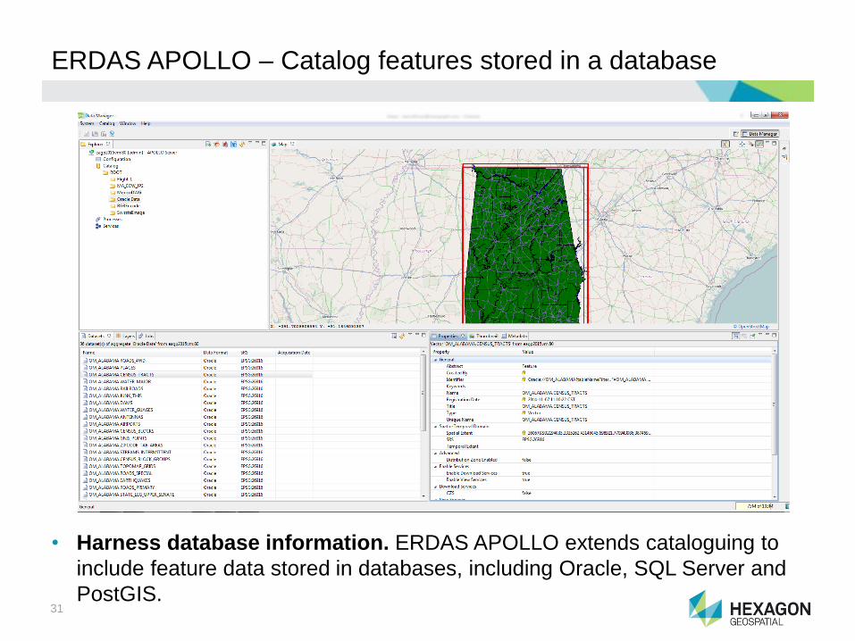
ERDAS APOLLO – Catalog features stored in a database
• Harness database information. ERDAS APOLLO extends cataloguing to
include feature data stored in databases, including Oracle, SQL Server and
PostGIS.

32
ERDAS APOLLO – Catalog and deliver point cloud data
• Unlock your LiDAR data. Extend the reach of large repositories of LiDAR
data stored in the enterprise. Catalog and manage large point cloud files,
and stream over the internet into end-user applications.
33
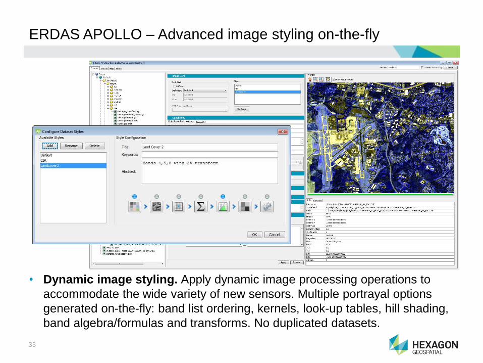
ERDAS APOLLO – Advanced image styling on-the-fly
• Dynamic image styling. Apply dynamic image processing operations to
accommodate the wide variety of new sensors. Multiple portrayal options
generated on-the-fly: band list ordering, kernels, look-up tables, hill shading,
band algebra/formulas and transforms. No duplicated datasets.

34
ERDAS APOLLO – Release Benefits
Attribute Customer Impact (So what?)
Catalog and serve features stored in database
Harness database information, and create a single
source of truth for discovering geospatial assets
within your enterprise.
Catalog and deliver point cloud dataExtend the reach of your LiDAR data streaming
data directly into your end-user applications.
Dynamic image styling
Distribute imagery from a wide variety of sensors,
dynamically styled according to the needs of all of
your users.

Enhanced Compression Wavelet (ECW)

36
ECW Technologies Overview
• High-performance image-compression format that reduces terabyte-sized
imagery files to five-to-ten percent of their original size, while retaining full
visual quality. Delivers lightning-fast display performance, and enables
faster processing and transfer of imagery.

37
ECW – GeoCompressor
• GeoCompressor is a simple, standalone product that performs:
• ECW/JP2 image compression and mosaicking
• Point cloud optimization to HPC format, which compresses LiDAR data to
10-20% of its size, and prepares it for streaming from ERDAS APOLLO.
Key features:
• Transcode from 100’s of image
formats & LAS/LAZ for HPC
• Perform basic image mosaicking
• Region update for ECW (v3)
• Command-line and GUI wizard
• 64-bit application, supported on
Windows & Linux platforms
GeoCompressor Professional
GeoCompressor Advantage
500 gigapixel file size limitation.
Concurrent licensing only.
ECW (v3) Region updates. Point cloud (HPC)
optimization. Unlimited compression.
Concurrent licensing only.
GeoCompressor Essentials
ECW/JP2 image compression. Image
mosaicking. 250 gigapixel file size
limitation. Node-locked licensing only.
38
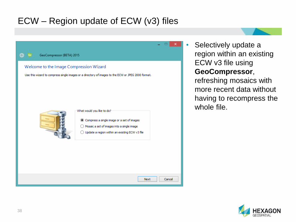
ECW – Region update of ECW (v3) files
• Selectively update a
region within an existing
ECW v3 file using
GeoCompressor,
refreshing mosaics with
more recent data without
having to recompress the
whole file.
39
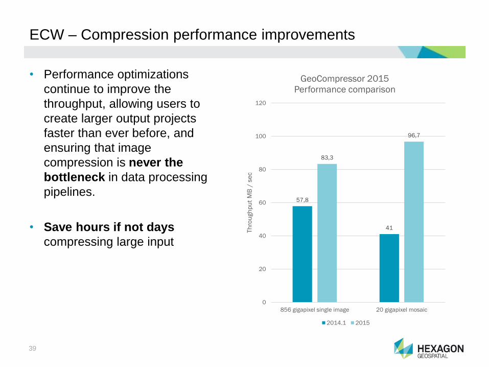
ECW – Compression performance improvements
• Performance optimizations
continue to improve the
throughput, allowing users to
create larger output projects
faster than ever before, and
ensuring that image
compression is never the
bottleneck in data processing
pipelines.
• Save hours if not days
compressing large input
57,8
41
83,3
96,7
0
20
40
60
80
100
120
856 gigapixel single image 20 gigapixel mosaic
Th
rou
gh
pu
t M
B /
se
c
GeoCompressor 2015
Performance comparison
2014.1 2015

40
ECW – Release Benefits
Attribute Customer Impact (So what?)
Simple, standalone GeoCompressor productCreate focused, high-throughput workflows using
purpose-built tools.
Region update of ECW (v3) files
Easily refresh your compressed mosaics and data
holdings as new up-to-date imagery comes
available.
Compression performance improvements
Create larger output projects faster than ever
before, and eliminate image compression as a
bottleneck in data processing pipelines.

41

GeoMedia Smart Client

43
GeoMedia Smart Client Overview
• Easily create and deploy highly focused, geospatial business workflows
• High-end vector data capture, query and analysis tools, large-format printing
• Advanced geo-caching for high performance, disconnected mobile editing

44
GeoMedia Smart Client – Share your maps with the public
• Configure and deploy your
public facing map out of the
Smart Client administrator
• Easy integration to your
existing web page
• Accessible on all devices
• Integration to Workflow
Manager to create easy to
use business workflows

45
GeoMedia Smart Client – Extract business graphics from GIS
• Gain even deeper insights
from sophisticated analyses
in GeoMedia Smart Client
• Bar charts and pie charts
• Heat Maps
• Symbol clustering
• Extract relevant business
knowledge from rich GIS
data
• Increasing visibility and
understanding

46
GeoMedia Smart Client – Release Benefits
Attribute Customer Impact (So what?)
Modern user interface Shortens learning curve. Easier to understand
Share your maps with the public Do more, faster, and with less redundancy
Include maps into Workflow ManagerInvolve other parties in your business workflows
and streamline within your GIS
Extract business graphics from GISExtract relevant business knowledge from rich GIS
data

GeoMedia Geospatial SDI

48
Web GIS Overview
• Hexagon Geospatial’s Web GIS integrates the power of GeoMedia
WebMap, Geospatial SDI and Geospatial Portal products to provide:
• Real-time, web-based enterprise data access and sophisticated analysis
• Flexible, secured solutions based on standards
• Full-featured, multilingual, customizable web application

49
Geospatial Portal for Consumers
• Make simple yet powerful
client for GeoMedia
WebMap
• Configure and deploy your
website with three clicks
and no coding required
• Enjoy 2D and 3D
visualizations in a modern
layout based on optimized
user experience
• Enable your public websites
for desktop and mobile
users
50
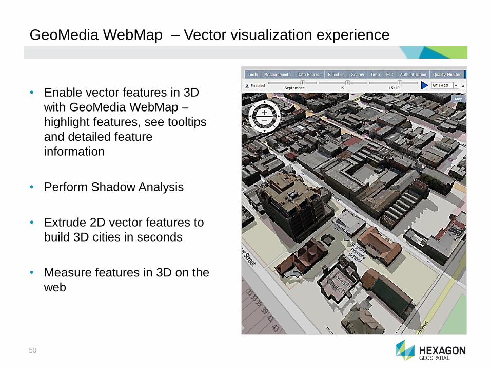
GeoMedia WebMap – Vector visualization experience
• Enable vector features in 3D
with GeoMedia WebMap –
highlight features, see tooltips
and detailed feature
information
• Perform Shadow Analysis
• Extrude 2D vector features to
build 3D cities in seconds
• Measure features in 3D on the
web

Strumenti Mobile

52
Mobile Alert – Truly location-based
• Single app is available and
localized worldwide,
dynamically changes based
on location
• Subscribing organization
defines the categories, icons
and screen text for their
purposes and users
• Allows for more than one
subscribing organization in
the same geographic area;
user simply “swipes” to each
wheel of categories

53
Mobile MapWorks Overview
• Tablet-based app for field personnel and crews, supporting a variety of field-
based workflows against enterprise GIS data
• Allows customers to see, edit and update their asset information, in the field
• Works on the same devices (iOS and Android tablets) that you use in every
day life. Simple and intuitive requiring little training and makes new users
more productive

54
Mobile MapWorks – Disconnected workflows
• Perform field-based workflows,
editing and querying while
disconnected
• Offline vector cache
• All editing is stored in OGC
compliant database,
GeoPackage
• Graphic indicator displays loss
of connectivity and cached
offline edits.
• Synchronization is automatic
or manual, which help in
controlling service costs

55
Mobile MapWorks – Mobile Platform
• Build unique iOS and
Android apps for yourself
with the Mobile Platform
• Access to rendering
technologies including
myVR
• Same capabilities of the
Mobile MapWorks products
including offline vector
caching
• Integration with WebGIS
product line allows
customers to have app to
their websites

56
Mobile MapWorks– Release Benefits
Attribute Customer Impact (So what?)
Map Navigation using GPSNever lose you location context in the base
map; quickly center you position
Capture Geometry using Device GPSMore accurate capture of feature geometry
than using touch screen gestures
U&C Data Model SupportNavigate your utility network to find the
assets that are part of a work order
Offline Vector CachePerform field inspection workflows even in
areas of little or no connectivity

57
Risorse Web
Sito web
www.planetek.itwww.hexagongeospatial.com
Canali You Tube
Planetek Italiahttps://www.youtube.com/planetekitaliaHexagon Geospatialhttps://www.youtube.com/channel/UCXDMxjPTHCqn0M5pbxM7HBg
58
Risorse web
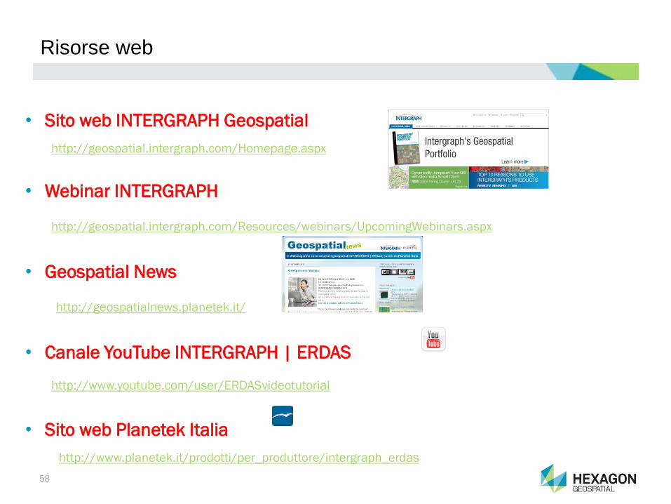
• Sito web INTERGRAPH Geospatial
http://geospatial.intergraph.com/Homepage.aspx
• Webinar INTERGRAPH
http://geospatial.intergraph.com/Resources/webinars/UpcomingWebinars.aspx
• Geospatial News
http://geospatialnews.planetek.it/
• Canale YouTube INTERGRAPH | ERDAS
http://www.youtube.com/user/ERDASvideotutorial
• Sito web Planetek Italia
http://www.planetek.it/prodotti/per_produttore/intergraph_erdas